


Languages
Pages
Legal


SECTION III COMMUNITY ANALYSIS
CHAPTER 9 LOCAL UNITS ANALYSIS
This chapter discusses each township and city in Marquette County. The mitigation projects listed in the Local
Units Analysis chapter were identified and prioritized by the local units of government (LUG) during meetings
and conversations with elected officials and staff as part of the update process. The Action Plan, that follows,
identifies countywide mitigation strategies and actions.
It is noteworthy that a webpage dedicated to hazard mitigation for Marquette County has been established as
part of the 2015 Plan update. The site will be a porthole to educational materials including the adopted Hazard
Mitigation Plan. The site will also house maps displaying information pertinent to hazard mitigation planning,
such as structures and flood plain data. Local units of government and the public are encouraged to use
information from the website to assist in local hazard mitigation efforts.
Where applicable, hazards that are more likely to occur are identified for each township or city and are
represented by icons. The following figure defines what each icon means.
Flooding
Subsidence
Rip Currents
Explosions
Wildfire
Erosion
Dam Failure
FIGURE 1 HAZARD SYMBOLS
hmp.mqtco.org

Champion Township
Champion Township lies near the center of Marquette County.
Most of the township’s population is in the historic mining
town of Champion. Few people live in the rest of the
township, especially in the north, where access is difficult.
Although flooding hazards were not identified during the
update process, the history of this hazard type is prevalent in
the Township. The Dead River Flood (May 2003) began in
northern Champion Township when the plug for the newly-
redesigned Silver Lake Dam gave way, releasing nine billion
gallons of water into the Dead River. The dam has since been
rebuilt.
The long, thin shape of the township causes it to cross
several watersheds, including the Dead, Escanaba and
Yellow Dog Rivers. The upper reaches of the Dead River are
within the dam inundation zone for Silver Lake. The effects of
the 2003 dam breach there were dramatic within Champion
Township. A new mile-long channel, sandbars, and eroded
cut banks were created, and debris was spread over a wide
area of the Dead River floodplain. While most of Champion
Township is covered by forest, and much of the township’s
land is owned by paper companies, there are relatively few
jack pines.
Champion Township Mitigation Projects:
1. Truck capable of accessing off road areas, substandard seasonal
roads
2. Need for dry hydrant on Wolf Lake Road, Section 21 stream
crossing
3. Need for brush truck for brush fires beyond structure fires
Figure 2 Poor Access

Chocolay Township
Chocolay Township lies southeast of the city of Marquette, extending
southward from the Lake Superior shore. Most of the township’s
population lies in the northwest corner, centered on the historic center of
Harvey. Many people also live along the Lake Superior shore in the
western half of the township.
Both floods and fires are real threats to Chocolay Township. The mouth of
the Chocolay River in Harvey often is blocked by ice during spring break-
up. In the past, dynamite has been used to free the flow of the river.
Historically, coastal flooding and erosion has occurred along the Lake
Superior shore, but current lake levels are low.
The sand ridges paralleling Lake Superior are
ideal large jack pine habitat. The pines, Lake
Superior, and easy access to Marquette via M-
28 make this area a favored place to live,
enhancing the fire danger. Many expensive
homes along Lake Superior are in the jack
pine zone. Surprisingly, no large fires have
occurred in this area recently, perhaps
because with a relatively large population, no
fires go unnoticed.
Chocolay Township Mitigation Projects:
1. Additional water sources are needed. Water access is restricted
especially in northeast and southern portions of the Township
2. Dredge the mouth of the Chocolay River and protect the nearby
lift station
3. Educate the public about why construction should not be taking
place in hazard zones
Hazards more likely
to occur in Chocolay
Township:
Figure 3 Residential Area in Jack Pine Forest

City of Ishpeming
The City of Ishpeming is Marquette County’s second-largest community,
and is near the geographic center of the county. Founded in 1870 as an
iron-mining town, the city’s residential and commercial building stock
reveals evidence of the boom and bust cycle of mining, including unique
buildings used in historic mining operations. The City includes a portion of
the workings of the current Tilden Mine.
Portions of Ishpeming were built up from cedar marshes and special storm
water drainage has been recently constructed (Partridge Creek Project) to
help resolve ground water problems. Mining, lumbering, and other
commercial activities have increased sedimentation in rivers and
lakes. Much of the City’s water delivery infrastructure is old and
deteriorated.
Hazards more likely
to occur in
Ishpeming City
Figure 4 Frozen Pipe Repair
City of Ishpeming Mitigation Projects:
1. Dredge the Carp River
2. Replace old/failing water supply and delivery infrastructure
with sustainable new infrastructure designed to withstand
cold weather events, minimize leakage, and provide
potable drinking water
3. Dredge Lake Bancroft, Lake Bacon, and other local lakes to
ease flooding and sedimentation problems
4. Solution need for too much storm water in sanitary sewer
(inflow and infiltration) in Eighth Addition and Cleveland
Location
Figure 5 Sinkhole Repair

City of Marquette
The City of Marquette is the largest community and county seat of
Marquette County. Many of the facilities here are of regional
importance, including Northern Michigan University, the Presque
Isle power plant, the Presque Isle ore docks, and the Marquette
Branch Prison.
The primary natural hazard within the City of Marquette is the
threat of flooding, mainly on the Dead River. The City of
Marquette participates in the National Flood Insurance Program.
The City was seriously affected by the 2003 dam breach on the
Dead River, which resulted in another
dam collapse at Tourist Park, washout of
the bridge approaches on Lakeshore
Boulevard, and flooding of the Presque
Isle power plant. Closure of the power
plant, in turn, forced the Empire and
Tilden mines to shut down for lack of
sufficient power.
In addition to the natural hazards, the
City is also subject to infrastructure,
technical, and human-health hazards
due to the existence of two coal-fired
power plants, a chemical laboratory at
Northern Michigan University, and an
extensive transportation network that is
integrated through a high-density
population area.
Hazards more likely to
occur in Marquette City:
City of Marquette Mitigation Projects:
1. Protect Hawley Street lift station from flooding, especially
from storm surges off Lake Superior
2. Shoreline restoration and road relocation–Lakeshore Blvd
3. Additional erosion control needed at Presque Isle Park
Figure 6 Lakeshore Blvd Closure
City of Negaunee
The City of Negaunee is the fifth largest community in Marquette
County and home to Michigan’s first iron mine, the Jackson Mine.
Remnants of inactive mines and the workings of the Tilden and Empire
mines occupy much of the city. Large areas have been declared
“caving grounds,” areas where the ground above underground mines
has collapsed or is in danger of collapsing.
City of Negaunee Mitigation Projects:
1. Identify and locate mining shafts and develop an
evaluation system to rate their level of security, seek
opportunity to improve security
2. Replace old/failing water supply and delivery
infrastructure with sustainable new infrastructure
designed to withstand cold weather events, minimize
leakage, and provide potable drinking water
Hazards more likely
to occur in
Negaunee City
Figure 7 Jackson Mine
Figure 9 Entrance to Old Town Negaunee
Figure 8 Need for Fencing at Old Mine Shafts

Ely Township
Ely Township lies west and southwest of the city of Ishpeming.
Historically, population was centered around several mine locations (e.g.,
Diorite, Greenwood), but more recent growth has focused on the County
Road 581 corridor. This area of population growth intersects one of the
county’s major concentrations of jack pine, increasing fire risk. This
hazard was realized during the Black River Falls Fire. The fire occurred
on May 20, 2009. It was started when high winds knocked a dead Jack
Pine down onto a power line, ultimately consuming 806 acres. The
Township Supervisor reported that nearly 75% of the houses are now
rebuilt.
Wildfire is a serious problem for much of the township.
The Michigan DNR has designated the outwash plains
of southern Ely Township as one of two fire zones in
Marquette County receiving special attention.
Ely Township
participates in the
National Flood
Insurance Program.
The long, thin shape
of the township
causes it to cross
several watersheds,
including the
Escanaba and Carp
Rivers. On the upper reaches of the Escanaba, Greenwood Reservoir, a
1088-acre impoundment created by Cleveland Cliffs, represents the greatest
flood threat to township residents. There have been concerns over gasoline
contamination in one of the water supplies used by Ely Township. The
contamination is being monitored.
Ely Township Mitigation Projects:
1. Vegetation Maintenance. Clearing vegetation along utility and
road right of ways. The Black River Falls fire began from
vegetation falling on a power line. Removing vegetation would
minimize this potential fire starting risk.
2. Larger culvert on bridge needed on Co Rd CP
Figure 10 Black River Falls Fire
Hazards more
likely to occur in
Ely Township
Figure 11 Dead Jack Pine Near Power Line

Ewing Township
Ewing Township is Marquette County’s most remote township; to reach it from other parts of the county,
drivers must leave the county and go through the unincorporated community of Rock in Delta County. None of
the roads are paved, a source of irritation for the township’s 126 residents.
The dominant drainage feature of Ewing Township is the Escanaba River, which serves as the township’s
western boundary. Swimming Hole Creek flows into the Escanaba River within the township, draining the Cyr
Swamp to the north.
Despite the proximity of Marquette County’s largest river,
Ewing Township has few flooding problems, according to
the township supervisor. While between 25 and 30 camps
lie within the floodplain, the majority of township’s
permanent residents live away from the river. No current
critical infrastructure lies within the floodplain, but the
township’s former dump adjoins it.
Ewing Township Mitigation Projects:
1. Drainage solutions needed on N end of Airport Road and
County Road DH
2. Sprinkler system needed in basement of Township Hall
Figure 12 Airport Road

Forsyth Township
Forsyth Township is in southern Marquette County. Several communities
lie within its boundaries: Gwinn, Princeton, Austin, Little Lake, and most of
K.I. Sawyer. Much of the southern part of the township is occupied by the
Cyr Swamp. The Middle and East branches of the Escanaba River drain
most of the area, and represent the greatest flood risk.
Forsyth Township participates in the National Flood Insurance Program.
Of the various communities, Gwinn is most at risk from flooding. The town
lies at the confluence of the Middle and East branches of the Escanaba
River, and is accessible only by bridges over the branches.
Wildfire is a serious problem for much of the
township. The Sands Plains extend south
into Forsyth Township and are covered with
jack pine forests. The Michigan DNR has
designated the Sands Plains as one of two
fire zones in Marquette County receiving
special attention. In the early 1990s, the
residential area of K.I. Sawyer was evacuated
because of the threat of a wildfire. New
residential development continues to
encroach upon jack pine forests.
Forsyth Township Mitigation Projects:
1. Raise bridge over the East Branch Escanaba River on
Southgate Drive
2. Protect township transfer station on Depot Road from flooding
3. Additional and upgraded firefighting equipment is needed to
help alleviate access issues
Hazards more likely
to occur in Forsyth
Township
Figure 13 Escanaba River, Forsyth Township

Humboldt Township
Humboldt Township lies in the southwestern part of the county. The mainstay of its economy was iron mining,
but the Humboldt Mine shut down in the early 1980s. A recent mining project in the region has reopened the
Humboldt mill for use as a resource processing facility.
The Escanaba and Michigamme rivers flow through Humboldt Township, and each river has had a history of
flooding in the area. In addition, the Black River and other tributaries of the Escanaba and Michigamme
systems flow through the township. The topography is dominated by rocky knobs and wetlands, but some of
the land was high and fertile enough for marginal farming in the early 20th century.
Humboldt Township Mitigation Projects:
1. Raise Wolf Lake Road in its crossing of the Escanaba River
floodplain
2. Propane powered generators are a need
Figure 14 Wolf Lake Road Bridge

Ishpeming Township
Ishpeming Township lies to the west and north of the City of Ishpeming.
It has two main clusters of residential development, one in West
Ishpeming, a suburban community near US-41, and the other a series
of largely seasonal residences to the north along the Dead River
Storage Basin. Both areas face some flooding threat. In 2003,
approximately ten township residents were flooded along the Dead
River Storage Basin flood event when the dam broke.
Hazards more likely
to occur in
Ishpeming Township
Ishpeming Township Mitigation Projects:
1. Improve culverts on Cooper Lake Road
Figure 15 Flooding along the Dead River Storage Basin

Marquette Township
Marquette Township lies to the west and north of the City of Marquette. Most of the population lives in
Trowbridge Park and adjacent areas just west of the city limits. The majority of the township is unpopulated,
and includes rocky shorelines along Lake Superior.
Flood-prone areas of the township are along low-lying portions of the Lake Superior shore. The northern part
of the township is largely forested, with some jack pine forests as part of the mix.
Marquette Township Mitigation Projects:
1. Establish a permanent water source for firefighting in the
northern part of the township, somewhere along County Road
550. Fire officials thought that the Lindberg gravel pit south of
Sugar Loaf would be a possibility
2. Additional tanker turnouts needed

Michigamme Township
At the far west end of Marquette County lies
Michigamme Township. The dominant feature
of the township is Lake Michigamme, a popular
vacation spot. The town of Michigamme lies at
the west end of the lake.
Michigamme Township participates in the
National Flood Insurance Program. Flooding
occurs along the shores of Lake Michigamme,
the Peshekee River which flows south into the
lake, and the Michigamme River, which flows
south out of the lake toward Republic. .
Michigamme Township Mitigation Projects:
1. Additional pump stations are needed on the levees and
break walls at the wastewater plant. Estimated cost is
$15,000 per unit
2. More break walls are needed along the Lake Michigamme
shore to protect adjacent properties
3. Wastewater system improvements are needed
4. Private road ordinance is needed
Figure 17 Lift Stations on the Shore of Lake Michigamme
Figure 16 Breakwall along North Shore of Lake Michigamme
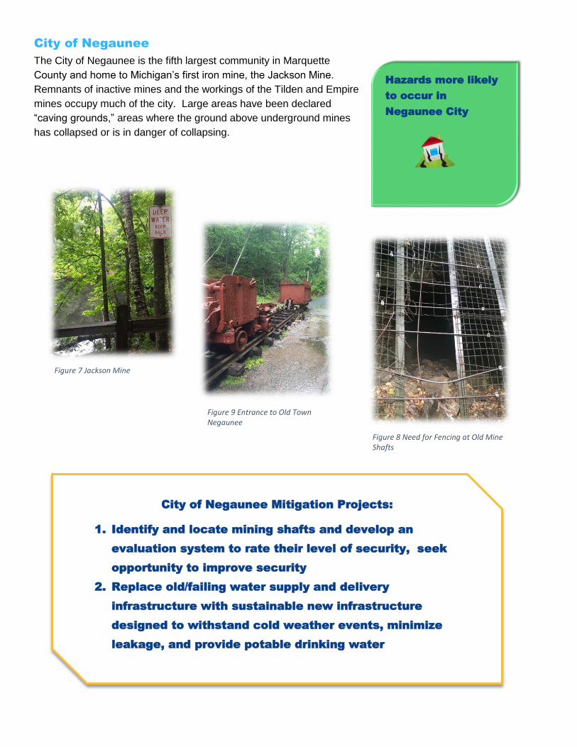
Negaunee Township
Negaunee Township is located between the cities of Negaunee and
Marquette. With easy access from US-41, the township has been
growing. One area of growth is along the Dead River Storage Basin, a
reservoir on the Dead River formed by the Hoist Dam. The Carp River
meanders across the southern part of the township.
Flood-prone areas are mostly near the Carp River and the Dead River
Storage Basin. In the wake of the 2003 flood, Negaunee Township passed
an ordinance requiring elevation surveys and construction only above
legally-designated elevations along the Dead River. Figure 12 below
shows the positive application of such thinking earlier saved the property of one property owner during the
2003 flood.
Hazards more likely
to occur in
Negaunee Township
Negaunee Township Mitigation Projects:
1. Raise the Carp River Bridge on Heritage Drive
2. Culvert or drainage solution needed where Carp River crosses M-
35
3. Flood proofing or movement of structures in the flood zone along
Dead River Storage Basin near the Dead River Storage Basin
Figure 19 Need for Culvert, M-35/Carp River Crossing
Figure 18 A Home Saved by Proper Consideration of Floodplains, Dead River Storage Basin
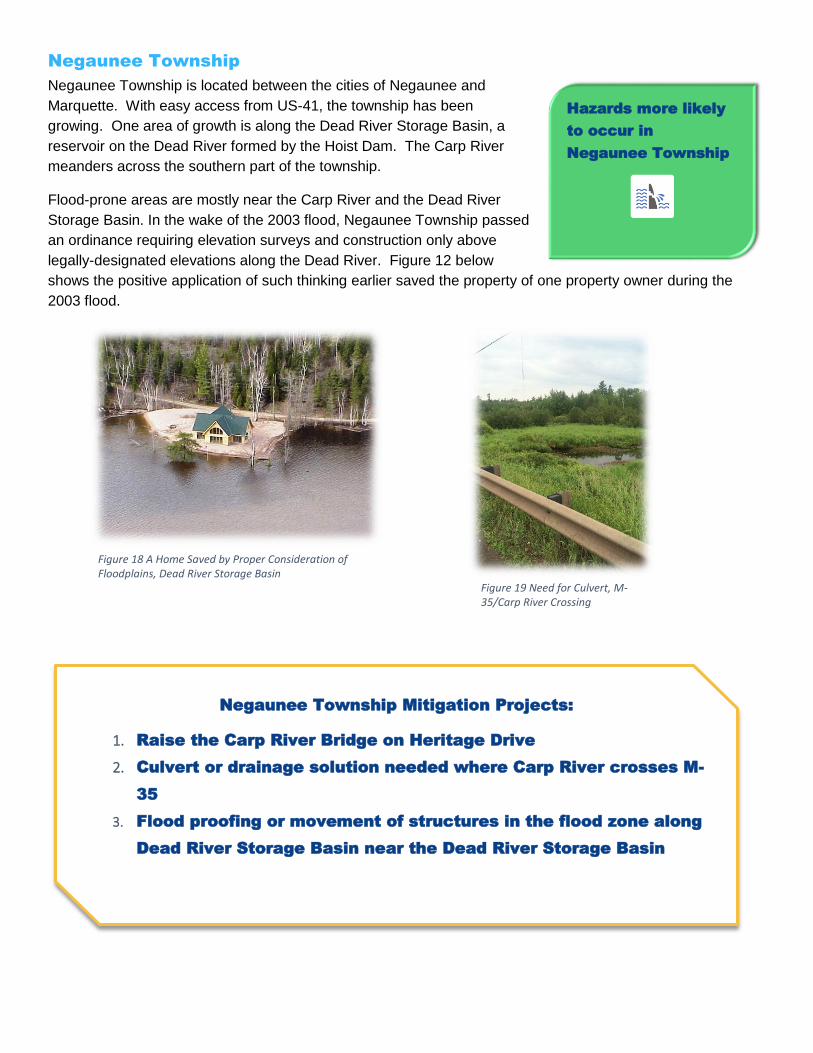
Powell Township
Powell Township is in northernmost Marquette County. The core community of the township is Big Bay. The
township participates in the National Flood Insurance Program, and has Zone “A” maps of floodplains.
Powell Township Mitigation Projects:
1. Insure stability of Lake Independence dam on the Iron River
2. Some access issues–private road ordinance needed
Figure 20 Dam on the Iron River outlet of Lake Independence

Republic Township
Republic Township is in the southwest corner of Marquette County. The core communities of the township are Republic, South Republic, and Witch Lake. The township participates in the National Flood Insurance Program, and has Zone “A” maps of floodplains.
Identified Mitigation Projects:
1. Dry hydrants needed
2. Hawk Road – raise road from hollow, passed dam, back to
the intersection of 601
3.Raise the level of River Road, so that it is less likely to be
flooded by the Michigamme River
Figure 21 River Road Showing Flooding Vulnerability
Hazards more likely
to occur in Republic
Township

Richmond Township
Richmond Township lies near the center of Marquette County. The
township’s landscape is dominated by the Empire iron mine, whose pits and
slag piles have significantly modified the terrain since topographic maps of
the area were compiled in the 1950s. Much of the mine area was estimated
to be in a floodplain.
Sands Township
Sands Township lies south of the City of Marquette. The dominant landscape
feature is the Sands Plains, a large outwash plain, forested with jack pines.
Wildfires are the top natural hazard in Sands Township.
Despite the dry conditions favored by jack pines, Sands Township does have a
flood threat. Most of the township can be characterized as upland, the source
of tributaries to the Escanaba, Carp, and Chocolay river systems.
Richmond Township Mitigation Projects:
1. Road improvements– heavy mine truck impact
Sands Township Mitigation Projects:
1. Additional/alternate water sources needed
2. Tree trimming along power lines needed
Hazards more likely
to occur in Sands
Township
Figure 22 Mine Truck, Richmond Township

Skandia Township
In eastern Marquette County, Skandia Township straddles the watershed divide between rivers flowing to Lake Superior and those flowing to Lake Michigan. Despite the relatively high elevation of the township, much of it is swampy. Skandia and West Branch Townships have established a joint evacuation center for their residents to be located at the Skandia Township Hall. The evacuation center needs a generator.
Skandia Township Mitigation Projects:
1. Purchase generator for pump house located near the
intersection of US 41 and M 94 E
2. Purchase generator for the Skandia- West Branch Township
Evacuation Center

Tilden Township
Tilden Township lies just to the south of the City of Ishpeming. The
dominant feature of the township is the Tilden Mine, an open pit iron mine.
Nearby is the old mining community of National Mine, where much of the
township’s population lives. Ely Creek runs alongside the major
thoroughfare in this historic community. While flood-prone properties are
mainly in the northern part of the township, the southern half of Tilden
Township is heavily forested with jack pines.
Tilden Township Mitigation Projects:
1. Improve the bridge over Ely Creek on County Road PCC
2. Dry hydrants needed in Charlie Lakes area
3. Dredge Ely Creek alongside County Road 476, National Mine
Figure 24 County Rd PCC Bridge over Ely Creek Figure 23 Ely Creek Flowing Past Houses in National Mine
Hazards more
likely to occur in
Tilden Township

Turin Township
Turin Township lies in the southeast corner of Marquette County, bordering Alger and Delta counties. Only
152 people live in the township, which encompasses much of the Cyr Swamp. The Michigan Department of
Natural Resources is the largest landowner in the township.
Much of Turin Township is low-lying. Its flood prone areas are along County Roads 444 and RM, which is also
where most of Turin Township's population lives. Although the township is heavily forested, relatively few jack
pines are found there.
Turin Township Mitigation Projects:
1. Improve culverts along County Road RM

Wells Township
Wells Township is in southernmost Marquette County. The core communities of the township are Northland,
Arnold, and Watson.
Drainage in Wells Township is to the Escanaba and Ford rivers. The Escanaba is fairly large and forms the
eastern boundary of the township. Relatively little settlement is found along its banks, but a few camps are
sprinkled along its length. Jack pines are relatively rare among the many trees of Wells Township.
Wells Township Mitigation Projects:
1. Improve drainage along County Road 557 in Section 19.
2. Improve the crossing of County Road 426 over Erie Creek, near
Arnold
These two roads are the critical links between Wells Township
and the rest of the region
Figure 25 Wells Township Figure 26 Inadequate Drainage

West Branch Township
West Branch Township lies southeast of the City of Marquette. It is largely rural, but takes in a small portion of
the former K.I. Sawyer Air Force Base, which has a more urban character. Roughly half of the township’s
population lives in the one square mile of K.I. Sawyer within the township’s boundaries. Most hazard zones
are in the eastern half of the township, where most residents outside of K.I. Sawyer live.
The township lies at the headwaters of the Chocolay River system, with many tributaries crossing the area.
Unlike neighboring Sands and Forsyth townships, West Branch Township has relatively few jack pine forests.
West Branch Township Mitigation Projects:
1. Purchase generator for the Skandia- West Branch Township
Evacuation Center
2. Improve ditching and build up the roadbed of Engman Lake
Road. Wiseman Creek flows alongside the road and has a
shallow riverbed
Top Related