


Languages
Pages
Legal


Survey Says…We're Not in South Carolina Anymore: A Discussion From Both Sides of the “New” SC-NC Boundary Line

• South Carolina’s entire border with North Carolina has been surveyed just once during its 349-year history
• Series of surveys conducted in pieces between 1735 and 1815 – Mapping disrupted by wars and a lack of money
• Portions of the border have been surveyed two other times – 1905 survey between North Carolina’s Scotland
County and South Carolina’s Marlboro County – 1928 survey, between North Carolina’s Brunswick
and Columbus counties and South Carolina’s Horry County

• 1735 o Surveyors used magnetic compasses and a 65-foot chain to begin
measuring the line between SC and NC. o They got from the coast to Richmond County, marking trees with a knife
to signify the boundary.
• 1815 o Surveyors finish the surveying. o This was the last time the entire borders of the two states were set out.

• Original survey only mentioned marked trees that no longer existed
• After the survey of 1772, South Carolina reissued land grants – Several years of research in county
courthouses to find the records. – Those records and the original survey
documents provided information needed to reconstruct the border


• May 24, 1772 – William Moultrie took a
break from surveying the South Carolina-North Carolina border to visit little Charlotte Town
• He described as having five or six houses, “very ordinary built of logs”
• 240 years later…a lot has changed


• South Carolina spent $10 million and 12 years fighting Georgia over 3,000 acres of mostly uninhabited islands and 10,000 acres of water along the Savannah River
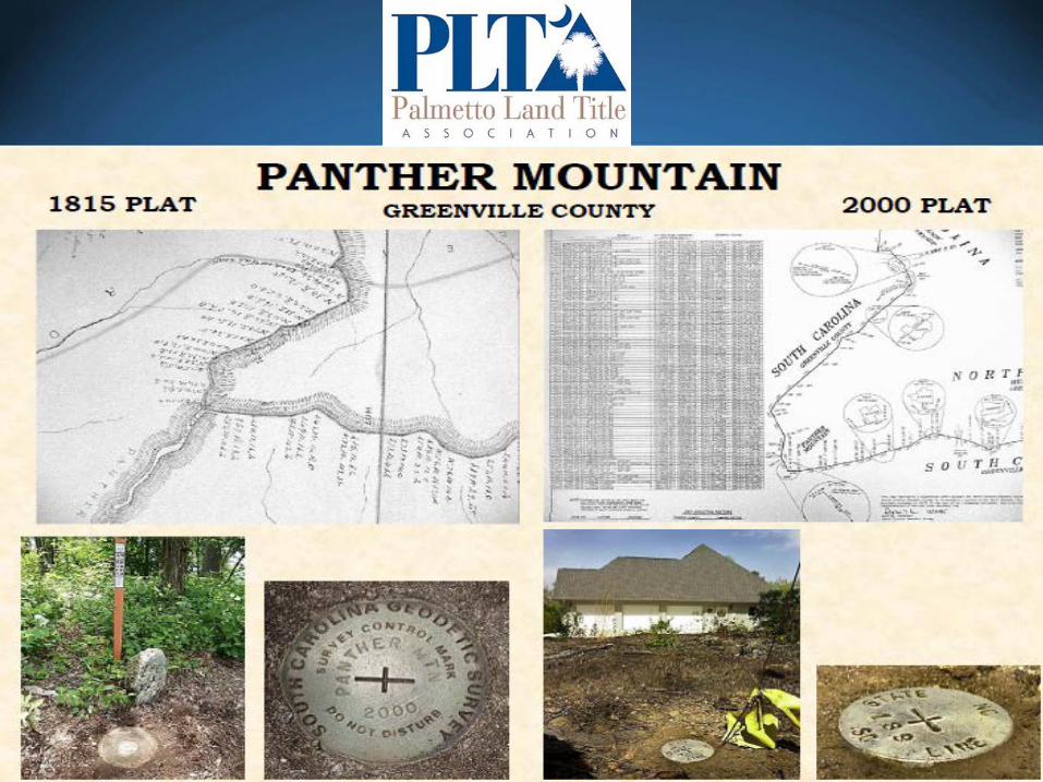
• To avoid a similar fight, South Carolina and North Carolina have been working quietly since 1994 on resurveying their border
• To avoid having to get congressional approval of the border, the states had to retrace their original boundary from the 1700s

• Officials say they are not “moving” the boundary but merely reestablishing it
• Officials sent letters to 93 property owners saying they could be affected by new survey – Mix of homeowners and business owners – More than half now in North Carolina – Roughly 30 replied with letters of concern

• Helms property – Thought she lived in Clover/York County, SC – Researchers say she actually lives in Gaston
County, NC • New address • New phone number • New taxing authority • New utility companies • New voter registration • New school districts
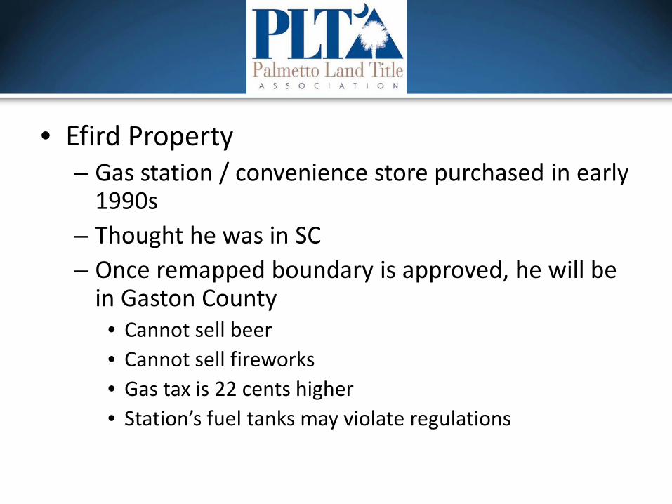
• Efird Property – Gas station / convenience store purchased in early
1990s – Thought he was in SC – Once remapped boundary is approved, he will be
in Gaston County • Cannot sell beer • Cannot sell fireworks • Gas tax is 22 cents higher • Station’s fuel tanks may violate regulations

• Lawmakers’ options – Redraw the state line around affected property
owners • Could require Congressional approval • Not favored
– Work with North Carolina to pass laws that would grandfather property owners
• To alleviate burdens

• Focus on “human interest” aspects – Certainly understandable but…
• What about… – TITLE ISSUES?? – Mortgages vs. Deeds of Trust – Tenancies by the Entireties
• SC doesn’t recognize – Foreclosures
• NC – mostly non-judicial procedure used • SC – judicial foreclosure (except for certain timeshares)

• Situs rule – Law in the state where real property is located
controls – How does this affect properties that owners
thought they were in one state but now will be in another?

• Mapping and research finished in May 2013 • Joint Boundary Commission has met twice since then
to discuss legal “next steps” • NCLTA and NC RE Section formed ad hoc committee
to draft, review, & revise proposed legislation • PLTA working with SC Attorney General’s office on
SC’s draft legislation • PLTA & NCLTA working together to adopt consistent
legislation – ALTA had joined to liaise between PLTA & NCLTA
Top Related