


Languages
Pages
Legal

3418
3419
100
1245
1243
1903
1901
1902
1241
99
99
99
1904
1904
99
4282
1246
164164164 1905
98
1246
1
2
DP 762777
DP 763785
DP 76
5707
DP 762775
DP 760432
DP 760497
DP 760497
DP 760497
DP 760497
DP 763786
DP 763787
DP 760498
DP 760663
DP 766969
DP 1144186
DP 1144186
DP 762763
DP 763790
DP 762764DP 762764
DP 763788
DP 763788
DP 760675DP 760675
DP 760675
DP 763789
DP 763789
9494
4848
4747
4646
4444
43 43
4242
4141
3939
3838
3737
3636
3535
3434
3333
3232
3131
2929
2828
2727
2626
2525
2424
2323
2222
2121
1919
1818
1717
1616
1515
1414
1313
12
11
12
11
0909
0808
0707
0606
0505
0404
0303
0202
0101
9999
9898
9696
9595
503000mE(MGA)
510
500 540
540
530
530
520
520
510
500
33º 30' 00"33º 30' 00"
33º 00' 00"33º 00' 00"
10'
20' 20'
10'
10' 20'
10' 20'
503000mE 543000mE
543000mE
01
4528 46
4645
44
44
42
42
41
41
39
39
38
38
37
37
36
36
35
35
34
34
33
33
32
32
31
31
29
2928
27
27
26
26
25
25
24
24
23
23
22
22
21
21
19
19
18
18
17
17
16
16
15
15
14
1413
1312
12
11
11
09
09
08
08
07
07
06
06
05
05
04
04
02
02
01
141º 00' 00" 141º 30' 00"
141º 30' 00"141º 00' 00"
6297000mN(MGA)
6345000mN6345000mN
6297000mN
6330
63406340
6330
63206320
63106310
63006300
WENTWORTH 125kmCOOMBAH 35km
NAGAELA HOMESTEAD 4km
RENMARK 120km
VJ
VH
WJ
WH
2020
00
40
20
40
004020
4020
4060
40
60
40
60
40
60
80
40
60
60
80
100
40
80
40
60
60
60
80
60
60
80
60
80
80
80
60
60
40
60
80
60
80
8040
60
80
60
60
40
60
80
80
80
80
80
60
60
80
60
80
60
80
80
40
40
80
6060
60
80
60
60
60
80
60
60
60
60
60
60
40
80
60
60
40
60
40
80
80
40
60
80
80
60
60
80
60
60
80
80
60
80
80
40
80
60
80
40
60
60
60
40
60
60
40
60
60
80
60
40
80
40
40
80
100
80
60
60
60
80
80
60
80
60
80
40
40
60
40
40
60
80
60
80
80
40
60
40
80
80
60
80
60
80
80
60
40
40
40
80
60 60
60
80
40
60
60
80
80
60MOUNT
MASSIDON
OLD MANPLAINWATERHOLES
HALF WAYPIPE
STEWARTS DAM
WITCHETTYTANK
YARIMBATANK
IRONSTONETANK
SOUTHTANK
THREE BYTWO TANK
BOUNDARYTANK
CANEGRASSDAM
NEW DAMRAYS DAM
HOWARDSDAM
BLUEBUSHDAM
YANKYDOODLETANK
DINNERTIMETANK
MAXS DAM
TRIANGLEDAMSALTBUSH DAM
QUONDONGTANKSEAWOODS
TANK
PLAINTANK
ROUNDCRYSTALDAM
SNAKEDAM
TOP DAM
CRYSTALDAM
HORSESHOEDAM
CHARLIES DAM
MIDDLEDAM
DINNERTIMEDAM
LIGNUMDAM
PAREEDAM
TWOTANKS
SUNSETDAM
CORNERTANK
WHITEWATERHOLEDAM
ROUNDDAM
OPIESTANK
LITTLEDAM
SQUARETANK
MALLEYTANK
ROBINSONSDAM
GAITERSDAMOAK DAM WINNEBAGA
TANKBLUEYSDAM
RED DAM NAPPERSTANK
OLDBLUEYSDAM
ALBERTSDAM
COOMBESDAM
ARGUMENTATANK
WOOLCUNDATANK
CORONATIONDAM
SANDSTONEWATERHOLEST PATRICKS
DAM
KEVINSTANK
HOUSETANK
DARKIESTANK
BUTCHERSTANK
COOMBSTANK
OLDSTATION
TANK ROUNDTANK
JIMSHOLE
WhiteLake
SaltLake
RONSHOLE
NORTH EAST BOUNDARY FIRETRAIL
EAST
FIR
ETRA
IL
CANOPUS FIRE TRAIL
NORTH BOUNDARY FIRETRAIL
NORTH BOUNDARY FIRETRAIL
SOUTH BOUNDARY FIRETRAIL
WEST
FIR
ETRA
IL
EAST
BOUN
DARY
FIRET
RAIL
NORTH ELEPHANT TRACK
SOUTHELEPHANT
TRACK
JUBILEE TRACK
CANOPUS FIRETRAIL
CANOPUS TRACK
TARAW
I RD
T AR A
WIRO
AD
OLD
SHIRE
R D
WEST
BO
UNDA
RY
FIRET
RAIL
SPRING TRACK
PIPEL
INETR
ACK
SOUTH EAST BOUNDARY FIRETRAIL
NANYA
ROAD
BELVEDERE
ROA D
SPRINGWOOD ROAD
SPRINGWOOD ROAD
yards
yards
yards
yardsyards
yards
yards
yardsyards
yards
yards
yards
yards
yards
yards
yards
yards
amenities block
yards
Nanya
Tararra
Ennisvale
Belvedere
Tarawi
TARAWINATURE
RESERVE
landing ground
landing ground
61
99
89
53
81
84
77
7779
82
84
82
82
69
62
79
61
49
84
64
5453
5368
56
30
62
41
84
83
83
47
86
82
84
62
82
55
43
39
52
82
56
28
6666
85
82
83
64
81
89
66
62
67
67
58
87
83
66
5664
6434
45
6164
6283
46
45
bore
bore
bore
bore
bore
bore
borebore
bore
bore bore
bore
bore
bore
bore
bore
bore
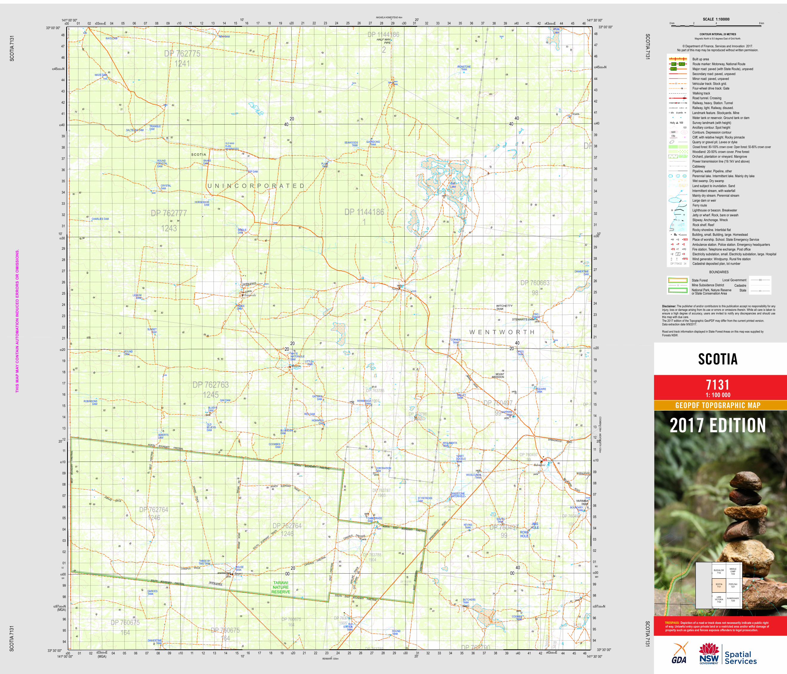
S C O T I A
RFS
W E N T W O R T H
U N I N C O R P O R A T E D
landing ground
THIS
MAP M
AY C
ONTA
IN A
UTOM
ATIO
N IN
DUCE
D ER
RORS
OR
OMISS
IONS
.
SCOTIA
7131
20/10/2017SC
OTIA
7131
SCOT
IA 713
1
SCOTIA 7131SCOTIA 7131
2017 EDITION
1: 100 000GEOPDF TOPOGRAPHIC MAP
Depiction of a road or track does not necessarily indicate a public rightof way. Unlawful entry upon private land or a restricted area and/or wilful damage ofproperty such as gates and fences exposes offenders to legal prosecution.TRESPASS:
BUCKALOW7132
MIDDLECAMP7232
SCOTIA7131
POPILTAH7231
LAKEVICTORIA
7130BUNNERUNGEE
7230
Local GovernmentState ForestCadastreMine Subsidence District
National Park, Nature Reserveor State Conservation Area
BOUNDARIES
SCALE 1:1000000 km 8 km 42
Built up areaRoute marker: Motorway, National RouteMajor road: paved (with State Route), unpavedSecondary road: paved, unpavedMinor road: paved, unpavedVehicular track: Stock grid.Four-wheel drive track: GateWalking trackRoad tunnel. CrossingRailway, heavy. Station. TunnelRailway, light. Railway, disused.Landmark feature. Stockyards. MineWater tank or reservoir. Ground tank or damSurvey landmark (with height)Ancillary contour. Spot heightContours. Depression contourCliff, with relative height. Rocky pinnacleQuarry or gravel pit. Levee or dykeClosed forest: 80-100% crown cover. Open forest: 50-80% crown coverWoodland: 20-50% crown cover. Pine forestOrchard, plantation or vineyard. MangrovePower transmission line (19.1kV and above)CablewayPipeline, water. Pipeline, otherPerennial lake. Intermittent lake. Mainly dry lakeWet swamp. Dry swampLand subject to inundation. SandIntermittent stream, with waterfallMainly dry stream. Perennial streamLarge dam or weirFerry routeLighthouse or beacon. BreakwaterJetty or wharf. Rock, bare or awashSlipway. Anchorage. WreckRock shelf. ReefRocky shoreline. Intertidal flatBuilding, small. Building, large. HomesteadPlace of worship. School. State Emergency ServiceAmbulance station. Police station. Emergency headquartersFire station. Telephone exchange. Post officeElectricity substation, small. Electricity substation, large. Hospital
silo yards
Holly 169123
176r1000
Lauren
ZZ
W S SESA P EFS T PO
HRFS Wind generator. Windpump. Rural fire station
M1 A32B72
State
Cadastral deposited plan, lot numberDP 779432 34
The publisher of and/or contributors to this publication accept no responsibility for anyinjury, loss or damage arising from its use or errors or omissions therein. While all care is taken toensure a high degree of accuracy, users are invited to notify any discrepancies and should usethis map with due care.The 2017 edition of the Topographic GeoPDF may differ from the current printed version.Data extraction date 9/9/2017.Road and track information displayed in State Forest Areas on this map was supplied byForests NSW.
© Department of Finance, Services and Innovation 2017.No part of this map may be reproduced without written permission.
CONTOUR INTERVAL 20 METRESMagnetic North is 9.0 degrees East of Grid North.
Disclaimer:
Top Related