


Languages
Pages
Legal


Samples from
INDIAN GEOGRAPHY

crackIAS.com 9
PHYSIOGRAPHY OF INDIA
Overview
Imagine that you were born in Israel or Nepal. There are huge
number of countries in the world that are either completely a desert
or mountainous or simply plains. India is a blessed country. There
are only a very few countries in the world which are geographically
as blessed as India. You don’t need to go anywhere else; a travel
across India will give you an experience of almost all physiographic/
geographical features on earth. A journey thru Physiography of India
will show you the geographical features of India; and you must try
to relate every feature to its vegetation/ people/ their lifestyles and
the economy of that place.
Covering an area of more than 32 Lakhs Sq. km, India is the 7th largest country in the
world.
Area-wise (in Million Sq Km)
Russia
→ Canada
→ USA
→ China
→ Brazil
→ Australia
→ India
17 10 9.8 9.6 8.5 7.7 3.28
It has a land frontier of about 15,200 km. The total length of the coastline of the
mainland and Islands (Lakshdweep and Andaman & Nicobar Islands) is 7,516 km.
Tropic of cancer divides India in almost 2 equal parts. The southern half coinciding with
peninsular India lies in tropical zone, and the northern half, somewhat continental in nature,
belongs to sub-tropical zone.
Tropic of cancer passes through 8 states of India (Gujarat, Rajasthan, M.P., Chhattisgarh,
Jharkhand, W.B, Tripura and Mizoram)
Countries having a common border with India are Afghanistan, Pakistan, China,
Bhutan, Nepal, Myanmar, and Bangladesh. Sri Lanka is separated from India by a narrow
channel of sea formed by the Palk Strait and the Gulf of Mannar. Total 7 countries have
common border with India.
Longitudinal Extent (mainland) 8o4’N - 37o6’ N 3,214 km
Latitudinal Extent (mainland) 68o7’E - 97o25’ E 2,933 km
India lies entirely in the northern hemisphere. India belongs to Eastern Hemisphere as
it is situated to east of Prime Meridian. It occupies south cenral peninsula of Asian continent
It has 2 time zones: 82o30’ E forms standard Meridian
EXTREME POINTS OF INDIA
Northernmost Dafdar in Taghdumbash Pamir near Beyik Pass in J&K 37°05’N 74°40’E
Southernmost Indira point 6°45'N 93°49'E
Westernmost West of Ghuar Mota, Gujarat 68°34'E 23.67N 68.52E
Easternmost Kibithu, Arunachal Pradesh 96°30'E 28°01′N 97°24′E
Indira Point (N 6°45' E 93°49') - Southernmost point of Indian Territory. Located on
Great Nicobar. Indonesia lies few kilometers away from Indira Point. Great Channel

crackIAS.com 10
separates India from Indonesia. Indira Point is also known as Parsons Point or Pygmalion
Point
Order of countries sharing border with India (in decreasing order of border length)
Bangladesh – China – Pakistan – Nepal – Myanmar – Bhutan – Afghanistan.
Its total land frontier is 15200 kms.
Maritime boundary – 6100 kms; it is 7516 km if we include Andaman and Nicobar and
Lakshadweep.
Kanyakumari – Southernmost point of Indian Mainland.
Where the Himalayan mountains stand today, the region was under marine conditions about
60 crore years ago. On the other hand, Peninsula dates back as far as 380 crore years.
With the opening of Suez canal (in year 1869), the distance of India and Europe has been
reduced by 7000 Km.
Indian Subcontinent was originally part of Gondwana continent.
MAJOR PHYSIOGRAPHIC REGIONS
Three Major Structural components –
(1) The Great Mountains of North.
(2) The Northern Plains Subdivisions:-
(a) Great Plains
(b) Thar Desert
(3) The great peninsular plateau – Having Subdivisions.
(a) Central Highlands
(b) Peninsular Plateaus
(c) Coastal Plains
Islands of Andaman & Nicobar and Lakshadweep form the fourth division of India.
Area wise these subdivisions can be arranged as – Peninsular Plateaus, Northern Mts.,
Great Plains, Central Highlands, Coastal Plains, Thar Desert and Islands.
GREAT MOUNTAIN WALL OF NORTH
Trans Himalyas
From Pamir Knot (The roof of the world) run several mountain ranges. Kunlun run into
Tibet, Karakorum enters Kashmir and runs S-E and includes the Plateau of Aksai Chin. It
extends further east, known as Kailas Range in Tibet. Pamir is the connecting link
between the Himalayas and the high ranges of Central Asia.
Karakoram contains K2 (Godwin Austin), second highest peak in the world. Karakoram
pass is situated in Karakoram Range.
Baltoro and Siachin are some of the glaciers in this area. Length wise glaciers of
Karakoram are – Siachen (in Nubra valley), Hispar, Biafo and Baltoro.
To the south of Karakoram lie two parallel ranges – Ladakh and Zaskar.
Indus originates beside Kailash. Flows between Ladakh and Zaskar ranges from south-east
to north-west. Indus forms deepest gorge of this region in Gilgit.
Nanga Parbat overlooks Indus in the North.
The Himalyas
Himalayas emerged out of the Tethys Sea in three different phases. The first phase
commenced about 120 million years ago, when the great Himalayas were formed. The
formation was completed about 70 million years ago. The second phase took place about 25

crackIAS.com 11
to 30 million years ago when the Middle Himalayas were formed. The Shiwaliks were
formed about 2- 20 million years ago.
Himalayas run for a distance of 2500 km (over 22o longitudes) between Indus and
Brahmputra. Width of Himalayas varies from 400 km in the west to 150 km in the east.
Himalayas are wide in the west and narrow towards the east. The height of the eastern half
is greater than the western half.
Wider in west because of many parallel and oblique ranges.
Himalayas in J&K and H.P. are called us western Himalaya. In Uttarakhand and Nepal are
known as central Himalayas and in W.B., Sikkim, Bhutan and Arunachal Pradesh they are
known as Eastern Himalayas.
Mountains along the eastern boundary of India are called Purvanchal. These are less
spectacular them Himalaya. They are of medium height and comprise the Patkai Bum, and
Naga Hills in the north and Mizo hills in the south.
The Greater Himalyas
Greater Himalayas or Himadri are the northern most and loftiest of all.
Mt. Everest or Sagarmatha (8848 m) is the highest peak of the world, located in Nepal.
Tibetans call it Chomlungma
Kanchanjunga is the second highest peak of Himalaya and lies in Sikkim.
Namcha Bharwa (located in China) is an important peak in east overlooking the
Brahmputra where this range takes a sudden turn (like a hairpin) towards south to enter
India.
The area where Himalayas stand today together with the northern plains of India was
occupied by a Sea, called ‘Tethys’.
Tethys was elongated and shallow sea sandwiched between two giant masses ‘the
Angaraland’ in the north and ‘the Gondwanaland’ in the south.
Tethys stretched from the present Indo-Burmese border in the east and covered the vast
area including western Asia, North eastern and central parts of Africa before it joined the
South Atlantic Ocean in the Gulf of Guinea.
As the Himalaya began to gain in height, the rivers and the other agents of denudation
became increasingly active in eroding them, and carrying huge amounts of silt deposits in
the shrinking Tethys. Thus Northern plains or Indo-Gangetic Plains formed.
Himalayas are not an effective water divide as the rivers like Indus, Satluj and
Brahmputra cut gorges through it in order to turn towards south.
crackIAS.com 12
MAJOR MOUNTAIN RANGES OF INDIA
Middle/ Lesser Himalyas
To the south of Great Himalayas, known as the Himachal. All the important hill stations
such as Dalhousie, Dharamshala, Shimla, Mussoorie, Nainital – Darjelling.
Southernmost ranges of Himalayas are called Shivaliks – made up of unconsolidated
deposits of rivers are prone to earthquakes and landslides.

crackIAS.com 13
Shiwalik result of deposition of Indo-Brahm river (hypothetical) sediments at foothills
of Middle Himalayas.
Himalayas have “ridge-and-valley-topography”. The most outstanding valleys are the
valley of Kashmir and the Karewas, the Kangra and Kulu valley in Himachal Pradesh; the
Dun valley; the Bhagirathi Valley (near Gangotri) and the Mandakini Valley (near
Kedarnath) in Uttarakhand and the Kathmandu Valley in Nepal.
Shiwaliks is an almost unbroken succession of low hills except for a gap of 80-90 km which
is occupied by the valley of the Tista River. The Churia Ghat Hills of Nepal also form parts
of the Shiwalik Range.
Ranges of the Middle Himalayas are as follows:-
o Kashmir Section : Pir Panjal and Dhaola Dhar (Punjab Himalayas)
o Himachal Section : Mussorie and NagTiba (Punjab Himalayas)
o Nepal Section : Mahabharat Range (Nepal Himalyas)
o Assam Section : Assam Himalyas
The arrangement of different ranges in Himalayas is classified according to the
name of that region:
a. Between Indus and Sutlej : Kashmir Himalayas
b. Between Sutlej and Kali : Himachal in west + Kumaon in East
c. Between Kali and Tista : Nepal Himalayas
d. Between Tista and Brahmaputra : Assam Himalayas
e. Kashmir + Himachal Himalayas make Punjab Himalayas

crackIAS.com 14
NORTHERN PLAINS
Length is about 3000 km from Indus to Brahmaputra; width varies from 150 km (Assam) to
400 km (Allahabad).
It slopes south east, from Punjab towards W. Bengal.
There are primarily 5 divisions of Plains:-
Punjab Plains
Indus and its tributaries make these plains, with 5 Doabs (area between two rivers).
Punjab derives its name from 5 river waters. These are (from south to north):-
o BIST: Between Sutlaj & Beas
o BARI: Between Beas & Ravi
o RACHNA: Between Ravi & Chenab
o CHAJ: Between Chenab & Jhelum
o SIND SAGAR: Between Jhelum & Indus
Placed from South to North, these rivers are: Sutlej, Beas, Ravi, Chenab, Jhelum and Indus
Northern hilly region has enormous gullying, resulting into badlands called Chos
Less than one-third of the Indus basin is located in India (J&K, H.P & Punjab)
Haryana Plains
Act as a water divide of Indian Plains (Ambala distt.). These separate the Indus system
from the Ganga system. Drained by River Yamuna (tributary of Ganga).
The outcrops of Aravalli in the southern part have broken the monotony of these plains.
This region is called Bhavani Bangar
Ganga Plains
Ganga after rising from Gangotri enters Northern plains at Haridwar, Yamuna joins it at
Allahabad.
Plains are dominated by the confluence of cones of the tributaries of Ganga.
These consist of three sub-divisions, namely (from west to east): Rohailkhand Plains, Awadh
Plains and Bihar Plains.
West Bengal Delta
Delta formed by Ganga, Brahmaputra and Damodar.
Largest and fastest growing delta of the world and it is also the most fertile delta.
Important for Jute and Rice cultivation. Three crops of rice per year.
The marshes here are important for Sundari trees (Sunderbans)
Brahmaputra Plains
Lie in Assam, these plains are prone to floods, earthquakes and gullying

crackIAS.com 15
LATITUDINAL DIVISIONS OF NORTHERN PLAINS
Bhabar
A Narrow, Continuous belt along the foothills of Shivaliks, from Indus to Tista
Consists of degraded materials- pebbles. It’s a porous zone.
Rivers are lost here after emerging from Himalayas
Consists of alluvial cones and inter-cones
Terai
Region (in Uttar Pradesh) where rivers re-emerge after being lost in Bhabar region
Consists of wetlands and marshes. Rice cultivation practiced here
Fertile soils, only soil having nitrates in India.
In Assam, this region is called Duars, useful for tea cultivation
Bhangar
Alluvial Terraces along the river floodplains; consists of calcareous Kankars.
Known by different names in different regions
Barind : West Bengal
Bhur : Aeolian deposits in upper Ganga-Yamuna doab
Dhaiya : Punjab (highly gullied)
Dharos & Dhands : Indus (long & narrow)
Khadar
New alluvium in floodplains of rivers.
Highly fertile soils consisting of ox-bow lakes and meanders

crackIAS.com 16
THE DETAILED DESCRIPTION OF PHYSIOGRAPHIC REGIONS OF INDIA IS AS
FOLLOWS:
REGION 1: KASHMIR
Relief: mountainous, rugged topography with parallel and oblique ranges interspersed by
river valleys.
Rivers: Jhelum, Chenab and Ravi. Jhelum cuts through Pir Panjal and makes Baramula
Pass
Lakes: Wular (Ox-bow lake of R.Jhelum), Dal

crackIAS.com 17
Ranges: Shiwalik, Dhaola Dhar and Pir Panjal of Middle Himalayas, and Inner Himalayas i.e.
Great himalyas.
Peaks:Nanga Parbat (8126 m)
Passes: Zozila, Banihal, Burzil, Bara Lacha La
Vegetation: Alpine in north to Montane sub Tropical and Temperate in South
Forested Area: J&K– 20% of total geographical area that falls within territory of india
National Parks: Dachigam, Kishtwar, Salim Ali
Tribes: Gujjars & Bakarwals – (They Experience Transhumanes)
Tourism Places: Amarnath, Gulmarg (Ski resort), Srinagar
HEPs: Salal, Dul Hasti, Uri
Tilted beds of Lake Deposits called KAREWAS are found on the flanks of Pir Panjal Range
REGION 2: KARAKORAM, LADAKH AND BALTISTAN
Result of Collision between Peninsula and Eurasian Plate. Outcome was Trans-Himalayas
Ranges (Ladakh & Zaskar Range) and Karakoram Range. Karakoram uplifted before the
rise of Himalayas.
Relief : General Elevation is more than 5000m (Ladakh Plateau – 5300 m)
Peaks : K2 (8611m), Godwin Austin, Gasherbrum
Rivers : Indus basin (tributaries Shyok & Gilgit join from north, Zaskar from
south)
Lakes : Pangong, Salt Lake, Tso Morari.
Plains : Aksai Chin, Deosai, Baltistan
Passes : Karakoram, Aghil
Siachen : World’s longest Glacier (72 km) and highest battlefield in the world Glacier
Forest : Devoid of any forest (Cold desert)
Single strategic road from Srinagar to Leh passes through Zojila Pass
Most of it occupied as CoK (China occupied Kashmir) & PoK (Pakistan occupied Kashmir)
REGION 3: KUMAON & HIMACHAL
Narrow Longitudinal Valleys called DUNES between Shiwaliks and Middle Himalayas, for
example Dehradun, Kothridun (Kumaon Himalayas), Patlidun (All in Uttranchal)
Covers the states of Himachal Pradesh and Uttarkhand
Highly Forested (HP-24%, Uttarakhand > 60%)
National Parks: Valley of Flowers, Jim Corbett, Nanda Devi (All in Uttranchal); Great
Himalayan & Pin Valley (in HP)
Tribes: Gaddis (H.P.), Bhotias (Garhwal & Kumaon)
Peaks: Nanda Devi, Kamet.
Pilgrimage: Gangotari, Yamunotari, Badrinath, Kedarnath
Tourism: Kullu, Manali, Shimla, Dehra Dun, Mussorie, Nainital

crackIAS.com 18
HEPs: Naptha Jakri (Satluj in H.P.), Tehri (Bhagirathi in Uttarakhand), Thein (Ravi in H.P.)
REGION 4, 5, 16: EASTERN HIMALAYAS, PURVANCHAL, MEGHALAYA PLATEAU
Younger, bolder and steeper than Western Himalayas with abrupt rise
Protruding of hard peninsular rocks into Eurasian plate, therefore syntaxial (knee like)
bending. Himalayas turn to north-south direction over here
Distinction between parallel ranges is lost here, therefore Narrower than Western
Himalayas
Important Ranges/ hills:-
o Dafla, Miri, Abor and Mishmi in E.Himalayas
o Patkai Bum, Naga, Mizo, Barail, Rengma, Mikir in Purvanchal
o Garo, Khasi, Jaintia in Meghalya Plateau
Peaks – Kanchenjunga (8598m), Namcha Barwa (7756m)
Rivers: Dihang, Dibang, Lohit, Subansiri and Surma (All tributaries of Brahmputra)
Passes – Diphu Pass (Tri-junction of India, China and Myanmar), Bomdila, Nathu la,
Jelepla
Lakes – Loktak ( Manipur with floating island)
HEP – Loktak Lake HEP
Mynsynram receives more than 1000 cm rainfall annually.
Highly Forested (Arunachal Pradesh > 94%)
National Parks: Namdapha, Keibul Lamjao, Dampa, Nokrek.
Agriculture: Jhum (Shifting) Cultivation, Rice in Surma Valley
Population density of Tripura > 300 persons/ sq. km because deltaic plains of Bangladesh
extend here.
Tribes – Garo, Khasi & Jantia (Meghalaya); Kuki (Manipur), Nagas, Lushai (Mizoram);
Chakmas (Tripura), Abors (A.P.); Lepchas (Sikkim)
Literacy – Low in Arunachal. High in Tripura and Mizoram
REGION 12 – ARAVALLI REGION/ HILLS
Fold mountain- Highly dissected, denuded, a Relic mountain. Av. Elevation 800-900 m
Senile stage of landform development. Older than Himalayas
Broader in south as compared to north.
Elevation goes on decreasing from south to north, quite pronounced in Udaipur. Gurusikar
(in south): highest peak near Mt. Abu.
Extends from Delhi Ridge to Ahmedabad from N-E direction to S-W direction.
North of Ajmer, divide into several parallel ranges separated by longitudinal valleys: Delhi
ridge and Ambala ridge.
Acts as Gangetic water divide.
Nakki Lake: Mt. Abu – famous for tourism
Rivers: Luni and its small tributaries flow westward, and Banas and its feeders flow
eastward
Aravallis are parallel to SW monsoon and fall in the zone of subsidence; therefore, scanty
rainfall & low humidity. High seasonal variation in rainfall
Rain fall: Southern side faces more rainfall (broader)
Vegetation– southern side– moist and dry deciduous to dry deciduous and thorny in north.
Western face fairly rainy and forested. North of Ajmer– devoid of forest cover
crackIAS.com 19
REGION 13: CENTRAL VINDHYAN UPLANDS
Location: Aravallis in west, Vindhayan Range in south & plains in north.
Vindhyan Range continues as Bhander and Kaimur hills in east. Forms watershed between
Ganga system & Southern rivers
Malwa plateau rolls down to north & finally merges with Gangetic Plains. Highly dissected
by river valleys of Tributaries of Chambal: Sind, Betwa & Ken, therefore forming Badlands
Majority of it lies in M.P.
Tribes: Bhils, Kol, Gond
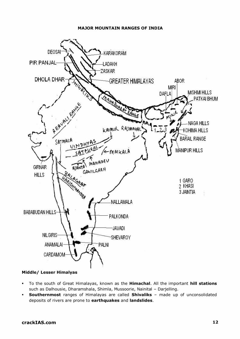
REGION 14: KHANDESH & SATPURA – MAIKALA RANGE
Satpuras are Fold Mountains. Known by different names at different sections. From west
to east, it names as Rajpipla, Gawligarh and Mahadeo Hills
Mahadeo Hills forms the highest portion. Dhupgarh Peak (1350m) near Panchmarhi
(hill station) in M.P. is highest peak of Satpuras. Tapi rises from here.
Maikala Range/ Amarkantak Plateau: Wet Forested Region is the source of many rivers
like Narmada, Son, Mahanadi, and Wainganga.
Rivers:
o Narmada & Tapi – west flowing
o Son – biggest Tributary of Ganga from south
o Wainganga – major tributary of Godavari
Highly forested area with national parks: Pench, Kanha, and Satpura.
REGION 17, 18: KACHCHH & KATHIAWAR, GUJARAT PLAINS
Mineral oil & Natural Gas – commercial production along western Gujarat plains. Kalol,
Ankaleshwar, Gandhar are important ones

crackIAS.com 20
KACHCHH KATHIAWAR GUJARAT PLAINS
Consists of Great Rann along north.
Little Rann on coast & south east.
Prone to earthquakes & floods
Rivers: Luni & Banas
Wild Ass Sanctuary
Central Tableland with Highest
point: Mt. Girnar. Radial drainage pattern
Gir National Park: Asiatic Lion
(only place in the world for
Asiatic lion)
Alluvial Plains
Drained by
Sabarmati, Mahi,
Narmada & Tapi
REGION 23, 24, 26: DECCAN LAVA PLATEAU INCLUDING KARNATAKA & TELENGANA-
RAYALSEEMA PLATEAUS
Extends from Vindhyas to the southern tip of Peninsula.
It is triangular in shape and is widest in the north.
Important Ranges in the northern part are Satmala, Ajanta, Balaghat & Harishchandra.
Western Ghats lies on the western side of plateau.
Deccan Plateau is highest along its western edge and gently slopes towards the Bay of
Bengal in the east.
Towards its south lies the Karnataka Plateau. The western part of this plateau is called
Malnad while the eastern is called Maidan. Western part is higher and more rugged.
Baba Budan Hills is an important Range along Karnataka Plateau.
It lies in the rain shadow zone of Western Ghats, therefore, severely prone to droughts
Important rivers of this region are – Krishna, Tungabhadra, Penneru and Cauvery
Tank irrigation is widely practiced here
Towards the South-East lies the Telengana-Rayalseema Plateau which is a low plateau,
highly dissected and denuded. River Krishna divides it into two parts- Telengana in north
and Rayalseema in south.
It is also a drought prone area, lying in the rain shadow of Karnataka Plateau.
Twin cities of Hyderabad and Secundrabad lie in the Telengana region.
REGION 25: WAINGANGA AND MAHANADI BASINS
Here lie the river valleys of Wainganga, Mahanadi and Indravati (a tributary of Godavari).
Chitrakoot Falls lie on Indravati.
It includes Dandkarnaya Plateau - Highly forested, denuded and undeveloped region
(Bastar, Kalahandi and Koraput districts) of India.
Chattisgarh Plains also lie here
National Parks: Tadoba, Nawegaon, Indravati
Important Mines: Dilli Rajhara, Bastar, Bailadila, Balaghat
REGION 28, 22 & 27: WESTERN & EASTERN GHATS & SOUTHERN HILL COMPLEX
Western Ghats
Form a continuous barrier from north to south, almost parallel to the Arabian Sea.
General altitude is 900-1100 m. These are higher in their southern part
Known as Sahyadri in Maharashtra and Karnataka, Nilgiris in T.N., Anaimalai and
Palni-Cardamom Hills in Kerala and Tamil Nadu.

crackIAS.com 21
Collectively Nilgiris, Anamalai Hills & Palni-Cardamom Hills form Southern Hills Complex.
Nilgiris is the meeting point of Western Ghats, Eastern Ghats and Southern Hill Complex.
Doda Beta (2637m) is the highest peak of Nilgiris. Udagamandalam (ooty) is a hill station
located in Nilgiris (Tamil Nadu). Temperate forests called Sholas are found here.
Anai Mudi (2,695m) is the highest peak of Western Ghats. It is located in Anamalai Hills
and falls in Kerala.
Famous hill station of Kodaikanal (T.N) lies in Palni Hills. The source of Periyar River lies
in Cardamom Hills. Periyar Lake is also situated here.
Eastern Ghats
Form a discontinuous line of hills parallel to E.Coast
Known by different names at different places –
o Northern Circars in north of Godavari
o Palkonda & Nallamala between Godavari & Palar Rivers
o Shevaroy & Javadi as T.N hills
As opposed to Western Ghats, E. Ghats are higher in northern part. Mahendra Giri
(1501m) is the highest peak of E.Ghats, lying in Orissa.
Western Ghats Eastern Ghats
Higher average elevation than E. Ghats. Higher in
Southern part
Source of many rivers. Act as a water divide
High rainfall (>200cm). higher in south
Greater HEP potential. Many waterfalls
Water falls in Western Ghats
Higher in northern part Not a source of any river
Less rainfall (<200cm). higher in north
Lesser potential
Water falls in Eastern Ghats

'>
-J 5
z
>
c
n
<ll-'-1\ -
L {
BAGHELKHAND ?7 / RAJMAHAL HIIL1V\ !'
CHOTANAGPUR PL.\.\
f\ (,,.
"' " PACHPATMALI & GANDMARDHAN UILLS
' _.,,
SAH'YADRIS
\
BABABUDAN MOUNTAIN RANGES
& PLATEAUS
NILGIRIS
IV IV
'V
m >c: U)
>z c
z c:')
m U)
0 "''I
'V m
.... z U)
c:
..,
.... z .... >

crackIAS.com 23
REGION 19, 20, 21, 29, 30 AND 31: COASTAL PLAINS
West Coastal Plain
Extend from Gujarat to Kerala.
Known as Konkan in the north (Daman to Goa), Kanara in Karnataka and Malabar in the
Kerala.
Plains are narrower in the north (Goa & Karnataka) and wider in south (Kerala)
Jog Falls/ Gersoppa Falls (on R. Sharavati) on Karnataka Coast are the Highest in India.
In Kerala, coast has salt water lakes called Lagoons or Backwaters or Kayals. Important
Lakes here are Ashtamudi and Vembanad
Lowlands during rains merge together to form Patlas; are used for cultivation
East Coastal Plains
Coastal strip along Bay of Bengal is broader as compared to the western coast.
Known as Utkal Plains (in Orissa); wide and deltaic (Mahanadi & Brahamani delta). Chilka
lagoon is located here
Andhra Plains: Deltaic (Godavari & Krishna delta) in middle. Kolleru lake lies here
Coromandal Coast (Tamil Nadu) in south; Deltaic (Cauvery delta); Pulicat lake lies here
Western Coastal Plains Eastern Coastal Plains
Formed by submergence of western side of
Western Ghats. Retrograded coastline Less in width due to subsisdence. Continental
Shelf is wide because of the same reason
Rivers are smaller, swift and more erosive.
Form estuaries.
Rainfall: 200-400 cm (SW Monsoon)
Less prone to cyclones
Not prone to floods except Narmada estuary
because of swiftness and small lengths of rivers
More contribution to marine food
Prospects of Wave Energy
More no. of Natural Harbours
Ports important for import purposes
Formed by alluvium brought by rivers like
Mahanadi, Godavari, Krishna & Cauvery.
Prograded coastline
Wider coast & narrower shelf due to
emergence
Rivers are longer, gradual and less erosive.
Form deltas.
Rainfall: 100-200 cm (SW & NE Monsoon)
More prone to cyclones
Prone to floods because of gradual lengths,
deltaic formations & long lengths of rivers
Less contribution
Prospects of OTEC (Ocean Thermal
Energy Conversion)
Lesser no.
Ports important for export purposes
crackIAS.com 24
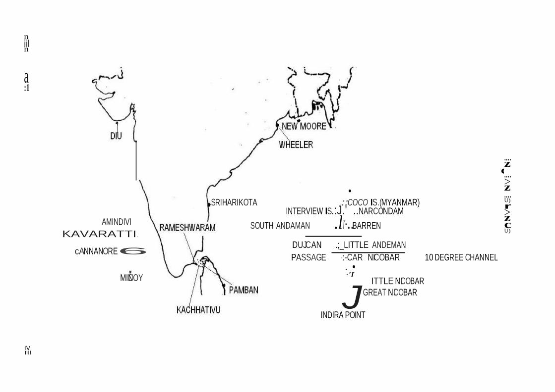
REGION 32, 33: ISLAND GROUPS
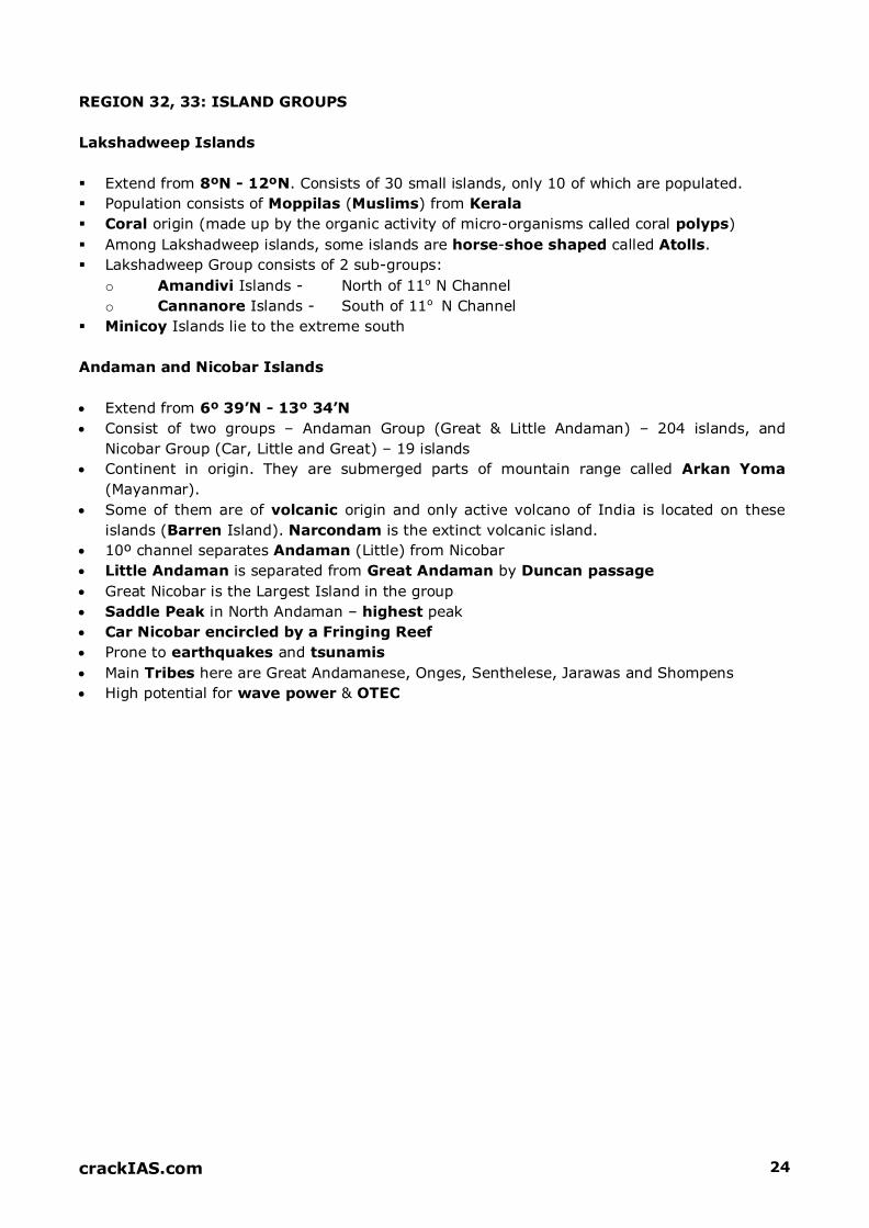
Lakshadweep Islands
Extend from 8ºN - 12ºN. Consists of 30 small islands, only 10 of which are populated.
Population consists of Moppilas (Muslims) from Kerala
Coral origin (made up by the organic activity of micro-organisms called coral polyps)
Among Lakshadweep islands, some islands are horse-shoe shaped called Atolls.
Lakshadweep Group consists of 2 sub-groups:
o Amandivi Islands - North of 11o N Channel
o Cannanore Islands - South of 11o N Channel
Minicoy Islands lie to the extreme south
Andaman and Nicobar Islands
Extend from 6º 39’N - 13º 34’N
Consist of two groups – Andaman Group (Great & Little Andaman) – 204 islands, and
Nicobar Group (Car, Little and Great) – 19 islands
Continent in origin. They are submerged parts of mountain range called Arkan Yoma
(Mayanmar).
Some of them are of volcanic origin and only active volcano of India is located on these
islands (Barren Island). Narcondam is the extinct volcanic island.
10º channel separates Andaman (Little) from Nicobar
Little Andaman is separated from Great Andaman by Duncan passage
Great Nicobar is the Largest Island in the group
Saddle Peak in North Andaman – highest peak
Car Nicobar encircled by a Fringing Reef
Prone to earthquakes and tsunamis
Main Tribes here are Great Andamanese, Onges, Senthelese, Jarawas and Shompens
High potential for wave power & OTEC
c
n iil n
a :1
AMINDIVI
KAVARATTI.
·cANNANORE6
• SRIHARIKOTA .::COCO IS.(MYANMAR)
INTERVIEW IS.:J.' ..NARCONDAM
SOUTH ANDAMAN .lr-..BARREN
DUJCAN .;_LITTLE ANDEMAN
PASSAGE ·:-CAR NICOBAR 10 DEGREE CHANNEL • •
.... z .... >z .... U)
r >z c U)
MIN'ICOY ·'I
ITTLE NICOBAR
JGREAT NICOBAR
INDIRA POINT
IV Ill

crackIAS.com 26
LETS PRACTICE: LAST 10 YEARS UPSC QUESTIONS
Which of the following hills are found where
the Eastern Ghats and the Western Ghats
meet? a. Anaimalai Hills
b. Cardamom Hills
c. Nilgiri Hills d. Shevoroy Hills
Ans. C
Which one of the following is the
appropriate reason for considering the
Gondwana rocks as most important of rock
systems of India?
a. More than 90% of limestone reserves of
India are found in them
b. More than 90% of India's coal reserves are found in them
c. More than 90% of fertile black cotton
soils are spread over them d. None of the reasons given above is
appropriate in this context Ans. B
Consider the following pairs: (Place of
Pilgrimage: Location
1. Srisailam: Nallamala Hills
2. Omkareshwar: Satmala Hills
3. Pushkar: Mahadeo Hills Which of the above is / are correctly
matched?
a. 1 only
b. 2 and 3 only c. 1 and 3 only
d. 1, 2 and 3 Ans. A
Which one of the following pairs of islands is
separated from each other by the 'Ten
Degree Channel'?
a. Andaman and Nicobar b. Nicobar and Sumatra
c. Maldives and Lakshadweep
d. Sumatra and Java Ans. A
Consider the following pairs: Hills Region
1. Cardamom Hills: Coromandel Coast
2. Kaimur Hills: Konkan Coast
3. Mahadeo Hills: Central India
4. Mikir Hills: North-East India
Which of the above pairs are correctly
matched?
a. 1 and 2
b. 2 and 3
c. 3 and 4 d. 2 and 4 Ans. C If there were no Himalayan ranges, what
would have been the most likely geographical impact on India?
1. Much of the country would experience
the cold waves from Siberia.
2. Indo - Gangetic plain would be devoid of
such extensive alluvial soil. 3. The pattern of monsoon would be
different from what it is at present. Which of the statements given above is /
are correct?
a. 1 only
b. 1 & 3 only
c. 2 & 3 only
d. 1, 2 & 3 only
Ans. D Where were Shevaroy Hills located?
a. Andhra Pradesh
b. Karnataka
c. Kerala
d. Tamil Nadu
Ans. D When you travel in Himalayas, you will see
the following:
1. Deep gorges
2. U - turn river courses
3. Parallel mountain ranges
4. Steep gradients causing land-sliding Which of the above can be said to be the
evidences for Himalayas being young fold
mountains?
a. 1 and 2 only
b. 1, 2 and 4 only
c. 3 and 4 only
d. 1, 2, 3 and 4
Ans. D

crackIAS.com 27
Which one of the following is the correct
sequence of the given hills starting from the
north and going towards the south?
a. Nallamalai Hills - Nilgiri Hills - Javadi
Hills - Anaimalai Hills
b. Anaimalai Hills - Javadi Hills - Nilgiri Hills
- Nallamalai Hills
c. Nallamalai Hills - Javadi Hills - Nilgiri
Hills - Anaimalai Hills
d. Anaimalai Hills - Nilgiri Hills - Javadi Hills
- Nallamalai Hills Ans. C
Consider the following:
1. Mahadeo Hills
2. Sahyadri Parvat
3. Satpura Range What is the correct sequence of the above
from the north to the south?
a. 1, 2, 3
b. 2, 1, 3
c. 1, 3, 2
d. 2, 3, 1 Ans. C
Match List I with List II and select the correct answer using the code given below
the lists: List I (Valley) List II (State)
A. Markha Valley
B. Dzukou Valley
C. Sangla Valley
D. Yumthang Valley
1. Sikkim
2. Himachal Pradesh
3. Jammu and Kashmir
4. Nagaland a. A-2, B-4, C-3, D-1
b. A-3, B-1, C-2, D-4
c. A-2, B-1, C-3, D-4
d. A-3, B-4, C-2, D-1 Ans. D
Consider the following statements:
1. Assam shares a border with Bhutan and
Bangladesh.
2. West Bengal shares a border with
Bhutan and Nepal.
3. Mizoram shares a border with
Bangladesh and Myanmar. Which of the statements given above is/are
correct?
a. 1, 2 and 3 b. 1 and 2, only
c. 2 and 3, only
d. 1 and 3, only Ans. A Between which of the following was the
ancient town of Takshaila located?
a. Indus and Jhelum
b. Jhelum and Chenab
c. Chenab and Ravi
d. Ravi and Beas
Ans. A Which one of the following pairs is not
correctly matched? Monastery: State a. Dhankar Monastery: Himachal Pradesh
b. Rumtek Monastery: Sikkim c. Tabo Monastery: Himachal Pradesh
d. Kye Monastery: Arunachal Pradesh Ans. D Which one of the following statements is
NOT correct?
a. The Western Ghats are relatively higher
in their northern region
b. The Anai Mudi is the highest peak in the
Western Ghats
c. Tapi river lies to the south of Satpura d. The Narmada and the Tapi river valleys
are said to be old rift valleys Ans. A In which State is the Guru Shikhar Peak
located?
a. Rajasthan
b. Gujarat
c. Madhya Pradesh
d. Maharashtra Ans. A
crackIAS.com 36
INDIAN RIVER SYSTEM
Overview
Rivers are the most critical component of a geographical
ecosystem. After starting from mountainous regions, they flow
through the country influencing everyone’s life who come across
them. They are so important that they are equated with goddess in
Hindu religion. In earlier times, they were the cradle for civilisation
and the most prosperous kingdoms evolved around rivers. Today,
they play a very important role in people’s lives and economies.
India is a blessed country as far as rivers are concerned. Every part
of India has some of world’s most important rivers.
Himalayan Rivers are formed by melting snow & glaciers and flow throughout year.
Deccan Rivers are rain-fed and therefore fluctuate in volume. Many of these are non-
perennial. Coastal streams, especially on the west coast are short in length and most of
them are non-perennial.
The streams of inland drainage basin of western Rajasthan are few and far apart. Most of
them are of an ephemeral character.
About 77% of drainage is towards Bay of Bengal and rest is towards Arabian Sea.
Bhagirathi and Alaknanda join at Dev Prayag to form the River Ganga. Ganga traverses
through Uttarakhand, Uttar Pradesh, Bihar and West Bengal.
Indus rises near Mansarovar in Tibet and finally falls in the Arabian Sea near Karachi.
Indus is known as Shiquan in Tibet
Son is the largest tributary of Ganga from south. Gandhi Setu on Son River near Patna is
highest bridge in Asia.
Brahmaputra is known as Tsangpo in Tibet, Dihang in Arunachal & Jamuna in Bangladesh.
Near Passighat the Debang and Lohit join the river Brahmaputra crosses into Bangladesh
downstream of Dhubri.
It becomes Padma after meeting Ganga & finally discharges as Meghna in Bay of Bengal.
Principal tributaries of Brahmaputra are Subansiri, Jia Bhareli, Dhansiri, Puthimari, Pagladiya
and the Manas.
Barak River, the Head Stream of Meghna, rises in the hills in Manipur. It continues in
Bangladesh till the combined Ganga - Brahmputra join it near Bhairab Bazar.
Lohit makes delta in reverse when it joins Brahmaputra from south. Majuli (Assam) in
Brahamputra is the largest Riverine Island in the world. It has been declared world heritage
site by UNESCO.
Chambal is known for its Badland topography
Dhaunadar Falls or Marble Falls lie on River Narmada near Jabalpur
Godavari has the second largest river basin covering 10 per cent of the area of India.
A few rivers in Rajasthan do not drain into the sea. Few of them drain into the Salt lakes
while others like Luni, Machhu, Rupen, Saraswati, Banas and Ghaggar are lost in the desert.
Narmada forms traditional boundary between North and South India, and drains M.P.,
Gujarat and Maharashtra. Existing irrigation projects in the Narmada are Matiyari, Rani
Avantibai Sagar, Barna, Tawa and Sukta- all in Madhya Pradesh, and Karjan project in
Gujarat. Important Projects under implementation are Kolar, Man, Omkareshwar,
Maheshwar and Sardar Sarovar.

crackiAS.com 37
·:I ··::·J West Rowing
D East Flowing
.
• Tapi drains M.P, Maharashtra and Gujarat. Kakrapara, Utsai are major projects, alongwith
Hatnur Dam in Maharashtra and Ukai Dam in Gujarat. Tapi is known as the twin or hand
made of Narmada
• The Godavari River has a drainage area in six states- Maharashtra, Andhra Pradesh,
Karnataka, Madhya Pradesh, Chattisgarh and Orissa. It has "Sriramsagar project" in
Nizamabad District. Aruthur Cotton, Trimbakeshwar are Waterfalls on it. Godavari is called
as Ganga of South or Bridh Ganga.
INDIA
RIVER BASINS
West Flowing Rivers Group 1: rivers in Kuchchh, Saurashtra and river Luni
\ ../
•
West Flowing Rivers Group 2:rivers south ofTapi
EastFlowing Rivers Group 1:rivers between Mahanadi and Pennar
East Flowing Rivers Group 2: rivers between Pennarand Kanniyakumari

crackIAS.com 38
IMPORTANT RIVERS OF INDIA
REMARKS SOURCES IMPORTANT TRIBUTARIES
INDUS SYSTEM
Indus
Snow ranges of Himalayas
at an attitude of 5000 m in
Tibet, near Mansarover
Lake.
The Zanskar is its left bank tributary in
Ladakh. In the plains, its left bank tributary
is the Chenab which itself has four major
tributaries, namely, the Jhelum, the Ravi, the
Beas and the Sutlej. Its principal right bank
tributaries are the Shyok, the Gilgit, the
Kabul, the Gomal and the Kurram.
The Indus River is a major river in Asia which flows through Pakistan, India and Tibet.
After flowing for >700 km in India, flows in Pakistan
Originating in the Tibetan Plateau in the vicinity of Lake Mansarovar, the river runs a
course through the Ladakh region of Jammu and Kashmir, towards Gilgit and Baltistan and
then flows in a southerly direction along the entire length of Pakistan to merge into the
Arabian Sea near the port city of Karachi in Sindh.
The total length of the river is 3,180 km (1,980 mi).
It is Pakistan's longest river.
The river is the 21st largest river in the world in terms of annual flow.
The Indus forms the delta of Pakistan and India mentioned in the Vedic Rigveda as Sapta
Sindhu and the Iranian Zend Avesta as Hapta Hindu (both terms meaning "seven rivers").
Jhelum
The river Jhelum rises from
Verinag Spring situated at
the foot of the Pir Panjal in
the south-eastern part of
the valley of Kashmir in
India.
The Neelum River, the largest tributary of
the Jhelum, joins it, at Domel Muzaffarabad,
as does the next largest, the Kunhar River
of the Kaghan valley.
It flows through Srinagar and the Wular Lake before entering Pakistan through a deep
narrow gorge.
It also connects with rest of Pakistan and Azad Kashmir on Kohala Bridge east of Circle
Bakote. It is then joined by the Poonch River, and flows into the Mangla Dam reservoir in
the district of Mirpur.
The Jhelum enters the Punjab in the Jhelum District. From there, it flows through the plains
of Pakistan's Punjab, forming the boundary between the Chaj and Sindh Sagar Doabs.
It ends in a confluence with the Chenab at Trimmu in District Jhang.
The Chenab merges with the Sutlej to form the Panjnad River which joins the Indus River
at Mithankot.
Chenab
Bara Lacha La Pass;
originating from H.P, it goes
towards north to enter J&K
& then turns towards south
Also called Chandrabhaga. The total
length of the Chenab is approximately 960
kilometres.
It flows from the Jammu region of Jammu and Kashmir into the plains of the Punjab,
forming the boundary between the Rechna and Jech interfluves (Doabs in Persian).
It is joined by the Jhelum River at Trimmu and then by the Ravi River Ahmedpur Sial.
It then merges with the Sutlej River near Uch Sharif, Pakistan to form the Panjnad or
the 'Five Rivers', the fifth being the Beas River which joins the Sutlej near Ferozepur,

crackIAS.com 39
India.
The Chenab then joins the Indus at Mithankot.
Ravi Near Rohtang Pass (Bara
Bhangal)
Buddha Nala
It flows into the south-west, near Dalhousie, and then cuts a gorge in the Dhauladhar
Range, before entering the Punjab plain near Madhopur and Pathankot.
It then flows along the Indo–Pak border for 80 kilometres (50 mi) before entering Pakistan
and joining the Chenab River.
The total length of the river is about 725 kilometres.
Ujh River is another major tributary of the Ravi River.
Beas
Near Rohtang Pass
The chief tributaries are Parbati, Bain,
Banganga, Luni and Uhal. The Sutlej
continues into Pakistani Punjab and joins
the Chenab River at Uch near Bahawalpur
to form the Panjnad River; the latter in
turn joins the Indus River at Mithankot. The
waters of the Beas and Sutlej rivers are
allocated to India under the Indus Waters
Treaty between India and Pakistan.
The river rises on the southern face of Rohtang Pass in Kullu.
Near Reh in Kangra District it divides into three channels, which reunites after passing
Mirthal, 1,000 feet above sea-level.
After touching the Jullundur district for a few miles the river forms the boundary between
Amritsar and Kapurthala district.
Finally the Beas joins the river Satulej at the south-western boundary of Kapurthala
district of Punjab after a total course of 290 miles.
Satluj Mansarover – Rakas Lakes
The Sutlej is the longest of the five rivers that flow through the historic crossroad region of
Punjab in northern India and Pakistan.
It is the easternmost tributary of the Indus River.
The waters of the Sutlej are allocated to India under the Indus Waters Treaty between
India and Pakistan, and are mostly diverted to irrigation canals in India.
There are several major hydroelectric projects on the Sutlej, including the 1,000 MW
Bhakra Dam, the 1,000 MW Karcham Wangtoo Hydroelectric Plant, and the 1,530 MW
Nathpa Jhakri Dam.
From north to south, these are Indus, Jhelum, Chenab, Ravi, Beas and Satluj
GANGA SYSTEM
Ganga consists
of 2
headstreams
Alakananda & Bhagirathi. Yamuna, Ram Ganga, Ghaghara, Kosi,
Burhi Gandak, Damodar, Son.
Ganga after entering Bangladesh, the main branch of the Ganges is known as the Padma.
The Padma is joined by the Jamuna River, the largest distributary of the Brahmaputra.
Further downstream, the Padma joins the Meghna River, the second largest distributary of
the Brahmaputra, and takes on the Meghna's name as it enters the Meghna Estuary, which
empties into the Bay of Bengal.
The Ganges Delta, formed mainly by the large, sediment-laden flows of the Ganges and

crackIAS.com 40
Brahmaputra rivers, is the world's largest delta, at about 59,000 km2 (23,000 sq mi).
Only the Amazon and Congo rivers have a greater average discharge than the combined
flow of the Ganges, the Brahmaputra, and the Surma-Meghna river system.
Yamuna Yamunotri Chambal, Sind, Betwa, Ken.
Starting catchment area of river lies in Himachal Pradesh, and an important tributary
draining the Upper Catchment Area is the Tons, Yamuna's largest and longest tributary.
Other tributaries in the region are the Giri, Rishi Ganga, Kunta, Hanuman Ganga and
Bata tributaries, which drain the Upper Catchment Area of the vast Yamuna basin.
After passing the Sikh pilgrimage town of Paonta Sahib, it reaches Tajewala in Yamuna
Nagar district, of Haryana, where a dam built in 1873, is the originating place of two
important canals, the Western Yamuna Canal and Eastern Yamuna Canal, which irrigate
the states of Haryana and Uttar Pradesh.
The Yamuna also creates natural state borders between the Himachal Pradesh and
Uttarakhand states, and further down between the state of Haryana and Uttar Pradesh.
Ramganga Near Nainital in Garhwal Distt.
The Ramganga River flows to south west from Kumaun Himalaya.
It is a tributary of the river Ganges, originates from the high altitude zone of 800m-
900m.
Ramganga flows by the Corbett National Park near Ramnagar of Nainital district from
where it descends upon the plains.
Bareilly and Badaun city of Uttar Pradesh is situated on its banks.
Ghaghra From Central Himalyas In Nepal it is known as Narayani.
Ghaghara is a perennial trans-boundary river originating on the Tibetan Plateau near Lake
Mansarovar.
It cuts through the Himalayas in Nepal and joins the Sarda River at Brahmaghat in
India.
Together they form the Ghaghra River, a major left bank tributary of the Ganges.
With a length of 507 kilometres it is the largest river in Nepal.
It is the largest tributary of the Ganges by volume and the second longest tributary of the
Ganges by length after Yamuna.
Kosi From Tibet Nepal Border Arun and Tamur.
The Kosi River drains the southern slopes of the Himalayas in Nepal and is formed by three
main streams: the Tamur Koshi originating from Mt. Kanchenjunga in the east, Arun
Koshi from Mt. Everest in Tibet, and Sun Koshi from Mt. Gosainthan farther west.
From their confluence north of the Chatra Gorge onwards, the Kosi River is also known as
Saptakoshi.
After flowing through the Chatra Gorge the Sapta Kosi is controlled by the Koshi Barrage
before it drains into the Gangetic plain.
Son Amarkantak Plateau Rihand, Gopat, North Koel
The Son parallels the Kaimur hills, flowing east-northeast through Uttar Pradesh,
Jharkhand and Bihar states to join the Ganges just above Patna.
Geologically, the lower valley of the Son is an extension of the Narmada Valley, and the
Kaimur Range an extension of the Vindhya Range.
Dehri on sone is the major town situated on Son River.
Chambal Near Mhow (M.P) in Janapao
Hills in Vindhayas
Banas (from Aravallis), Parbati and Kali
Sindh
The Chambal River is a tributary of the Yamuna River in central India, and forms part of
the greater Gangetic drainage system.
The river forms the boundary between Rajasthan and Madhya Pradesh before turning
southeast to join the Yamuna in Uttar Pradesh state.

crackIAS.com 41
The Chambal and its tributaries drain the Malwa region of northwestern Madhya Pradesh,
while its tributary, the Banas, which rises in the Aravalli Range, drains southeastern
Rajasthan.
From west to east, Rivers are Ramganga, Gomti, Sarda, Ghaghra, Gandak and Kosi
From west to east, Rivers are Banas, Chambal, Kali Sindh, Parbati, sind, Betwa, Ken & Son
BRAHAMPUTRA SYSTEM
Brahmaputra Rises from Chema-Yungdung
glacier in Tibet
Dibang & Lohit from south; Subansiri,
Tista & Manas from north.
It flows southwest through the Assam Valley as Brahmaputra and south through
Bangladesh as the Jamuna (not to be mistaken with Yamuna of India).
In the vast Ganges Delta it merges with the Padma, the main distributary of the Ganges,
then the Meghna, before emptying into the Bay of Bengal.
The average depth of the river is 124 feet (38 m) and maximum depth is 380 feet (120 m).
The river is prone to catastrophic flooding in spring when the Himalayan snows melt.
It is a classic example of a braided river and is highly susceptible to channel migration and
avulsion.
This river is often called Tsangpo-Brahmaputra River.
PENINSULAR RIVERS (WEST FLOWING)
Narmada Amarkantaka Plateau, Shahdol
district (M.P.)
Burhner, Tawa (biggest), Sher, Dudhi,
Barna, Hiran, Lohar
The Narmada is 5th longest river in the Indian subcontinent.
It forms the traditional boundary between North India and South India.
It is the one of the rivers in India that flows in a rift valley, flowing west between the
Satpura and Vindhya ranges.
It flows through the states of Madhya Pradesh and Maharashtra, then along the border
between Madhya Pradesh and Maharashtra and the border between Madhya Pradesh and
Gujarat and in Gujarat.
Tapi
Multai in Betul (M.P.) Purna River (Major tributary), Girna
River, Panzara, Waghur, Bori, Aner,
Kolar. Amravati, Betul, Veghai
The Tapti River is one of the major rivers of peninsular India.
The river rises in the eastern Satpura Range of southern Madhya Pradesh state, and flows
westward, draining Madhya Pradesh's Nimar region, Maharashtra's Kandesh and east
Vidarbha regions in the northwest corner of the Deccan Plateau and south Gujarat, before
emptying into the Gulf of Cambay of the Arabian Sea, in the Surat District of Gujarat.
The river, along with the northern parallel Narmada River, forms the boundaries between
North and South India.
The Western Ghats or Sahyadri range starts south of the Tapti River near the border of
Gujarat and Maharashtra.
Luni
Emerges from Annasagar
(Ajmer). Only salty river in
India.
Patki, Jojri, Sukri.
The Luni is a river of western Rajasthan state, India.
It originates in the Pushkar valley of the Aravalli Range, near Ajmer and ends in the

crackIAS.com 42
marshy lands of Rann of Kutch in Gujarat, after travelling a distance of 495 km.
It is first known as Sagarmati, then after passing Govindgarh, it meets its tributary Sarsuti,
which originates from Pushkar Lake, and from then on it gets its name Luni.
Sabarmati Rises from the Jai Samand lake
of Udaipur
Sabar, Hathmathi, Vakul.
The Sabarmati River is a river in western India and one of the biggest rivers of north
Gujarat.
River Sabarmati is one of the major West flowing river of Gujarat
It meets the Gulf of Cambay of Arabian Sea after travelling 371 km from the origin.
The Sabarmati basin has a maximum length of 300 km. and maximum width of 105 km.
The catchment area lies in Rajasthan and Gujarat State.
Mahi
Vindhayas Drains Gujarat Plains, parts of M.P &
Rajasthan. Empties into Gulf of
Khambhat
The Mahi is a river in western India.
It rises in Madhya Pradesh and, after flowing through the Vagad region of Rajasthan,
enters Gujarat and falls into the sea.
It has given its name to the Mahi Kantha agency of Bombay, and also to the mehwasis,
marauding highlanders often mentioned in Arabian chronicles.
PENINSULAR RIVERS (EAST FLOWING)
Mahanadi Dandkaranaya near Sihawa in
Raipur District (Chhatishgarh)
Sheonath, Hasdo, Mand.
Like many other seasonal Indian rivers, the Mahanadi too is a combination of many
mountain streams and thus its precise source is impossible to pinpoint.
However its farthest headwaters lie 6 km from Pharsiya village 442 m above sea level
south of Nagri town in Dhamtari district of Chhattisgarh.
The hills here are an extension of the Eastern Ghats and are a source of many other
streams which then go on to join the Mahanadi.
Brahmini Sorrow of Orissa
The Brahmani is a major seasonal river in the Odisha state of Eastern India.
The Brahmani is formed by the confluence of the Sankh and South Koel rivers, and flows
through the districts of Sundargarh, Kendujhar, Dhenkanal, Cuttack and Jajapur.
Together with the rivers Mahanadi and Baitarani, it forms a large delta before entering
into the Bay of Bengal at Dhamra.
Godavari
From Trambak plateau in Nasik
.
From north– Penganga, Wardha,
Wainganga, Indravati and Sabari
(arranged west to east). Parvara &
Manjra join from south. Others are
Pranahita, Kinnerasani, Sileru, Bindusar,
Moosi, Taliperu
The Godavari is a river in the south-central India.
It starts in the western state of Maharashtra and flows through the southern state
Andhra Pradesh before reaching the Bay of Bengal.
It forms one of the largest river basins in India.
With a length of 1465 km, it is the second longest river in India, after the The Ganges, and
the longest in southern India.
It flows east across the Deccan Plateau into the Bay of Bengal near Yanam and Antarvedi
in East Godavari district of Andhra Pradesh.
crackIAS.com 43
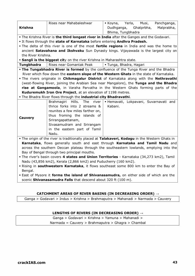
Krishna
Rises near Mahabaleshwar Koyna, Yerla, Musi, Panchganga,
Dudhganga, Ghatprbha, Malprabha,
Bhima, Tungbhadra
The Krishna River is the third longest river in India after the Ganges and the Godavari.
It flows through the state of Karnataka before entering Andhra Pradesh.
The delta of this river is one of the most fertile regions in India and was the home to
ancient Satavahana and Ikshvaku Sun Dynasty kings. Vijayawada is the largest city on
the River Krishna.
Sangli is the biggest city on the river Krishna in Maharashtra state.
Tungbhadra Rises near Gomantak Peak Tunga, Bhadra, Hagari
The Tungabhadra River is formed by the confluence of the Tunga River and the Bhadra
River which flow down the eastern slope of the Western Ghats in the state of Karnataka.
The rivers originate in Chikmagalur District of Karnataka along with the Nethravathi
(west-flowing River, joining the Arabian Sea near Mangalore), the Tunga and the Bhadra
rise at Gangamoola, in Varaha Parvatha in the Western Ghats forming parts of the
Kuduremukh Iron Ore Project, at an elevation of 1198 metres.
The Bhadra River flows through the industrial city Bhadravathi.
Cauvery
Brahmagiri Hills. The river
thrice forks into 2 streams &
reunites a few miles farther on,
thus froming the islands of
Srirangapattanam,
Sivasamudram and Srirangam
in the eastern part of Tamil
Nadu.
Hemavati, Lokpavani, Suvarnavati and
Kabani.
The origin of the river is traditionally placed at Talakaveri, Kodagu in the Western Ghats in
Karnataka, flows generally south and east through Karnataka and Tamil Nadu and
across the southern Deccan plateau through the southeastern lowlands, emptying into the
Bay of Bengal through two principal mouths.
The river's basin covers 4 states and Union Territories - Karnataka (34,273 km2), Tamil
Nadu (43,856 km2), Kerala (2,866 km2) and Puducherry (160 km2).
Rising in southwestern Karnataka, it flows southeast some 800 km to enter the Bay of
Bengal.
East of Mysore it forms the island of Shivanasamudra, on either side of which are the
scenic Shivanasamudra Falls that descend about 320 ft (100 m).
CATCHMENT AREAS OF RIVER BASINS (IN DECREASING ORDER) →
Ganga > Godavari > Indus > Krishna > Brahmaputra > Mahanadi > Narmada > Cauvery
LENGTHS OF RIVERS (IN DECREASING ORDER) →
Ganga > Godavari > Krishna > Yamuna > Mahanadi >
Narmada = Cauvery > Brahmaputra > Ghagra > Chambal

crackIAS.com 44
COMPARISON OF HIMALAYAN AND PENINSULAR RIVERS
HIMALAYAN RIVERS PENINSULAR RIVERS
1. These are antecedent rivers i.e. these
flowed before the rise of Himalayas and kept
cutting them with time, as evident from the
existence of deep gorges.
1. These are consequent rivers i.e. these
start flowing after the rise of peninsular
landmasses. There are no deep gorges
here.
2. Characterised by waterfalls, rapids,
cataracts etc. Therefore have a pronounced
relief.
2. These have graded profiles and lack
these characteristics.

crackIAS.com 45
3. These have meandering courses, thereby
forming the Ox-bow lakes
3. Linear & straight courses with
smooth long profiles. Hard rocks prevent
any sort of meandering.
4. These rivers have large basins
Indus > 11 lac sq km
Ganga > 10 lac sq km
Brahmaputra > 5 lac sq km
Indus Basin
Brahmaputra Basin
Ganga Basin
4. Comparatively smaller basins
Narmada / Tapi < 1 lac sq. km
Godavari / Krishna 2-3 lac sq km
Mahanadi
Godavari
Krishna
5. These are in Young stage. These make V-
shaped valleys because of their high erosive
power
5. These are in Mature stage of
development. These have subdued
gradient with lateral erosion and
shallow valleys.
6. Erosive power is high due to their young
age, thus carry huge sedimentary load. These
have resulted in great alluvial deposits,
forming the North Indian Plains. The
sediment load is further added due to soft
nature of sedimentary rocks that make
Himalayas.
6. Hard rocks of peninsula made up of
volcanic extrusions restrict the erosive
power of rivers. Further the gradual
slope of Deccan plateau and lesser
erosive power result in low amount of
sediment loads
7. These are perennial rivers due to high
rainfall and snow melt from snow covered
peaks of Himalayas.
7. These are seasonal rivers due to less
rainfall in their catchment areas. Even
the big rivers like Godavari and Krishna
dry up in summers. The lesser rainfall is
because these rivers emanate from the
points which lie on the leeward side of
Western Ghats.
8. These carry high value vis-à-vis irrigation 8. These are not that good for irrigation

crackIAS.com 46
due to their perennial nature. A network of
canals has been laid in the northern plains of
Punjab, Haryana, UP and Bihar to fetch their
potential. This has led to the green revolution
in these areas making them the granary of
India.
purposes owing to their seasonal
nature.
9. More navigable owing to their flat
topography and perennial nature. This is true
in the middle and lower courses of these
rivers and not in the upper course where
these rivers have steep slopes. National
Waterway-1 links Allahabad – Haldia
covering a distance of 1620 km. national
Waterway-2 links Sadia–Dubri.
9. Less navigable due to their seasonal
nature and lesser quantity of water
in rivers to support big vessels. Also the
gradient of peninsula is steeper than
the northern plains that support the
navigational facilities.
10.These have high HEP potential- perennial
nature and steep slopes. Indian Himalayan
Region (IHR), also known as the water tower
of the world, hold potential of 1,48,700
MW
10.West flowing rivers have more potential
due to more water and steep slopes.
11.HEP development lesser compared to
peninsula; of huge potential, just around
22.4% has been utilized
11.More, because of greater economic
development & more demand.

47 crackiAS.com
INDIA RIVERS
\
I I
)
CkllT UIJ!iA "'ALP RA g"ft ---+ _...-.-"' :
crackIAS.com 48
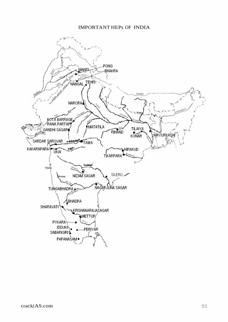
IMPORTANT HYDROELECTRIC PLANTS IN INDIA
Overview
God has gifted the nature with bountiful of features and brains to humans to use them to their
benefit. HEPs or Multipurpose Projects (not just electricity generation) on rivers is a beautiful
example of this. Since time immemorial, humans have used the rivers for various purposes like
irrigation, generation of power etc. using innovative techniques. Did you watch the movie –
Mohanjodaro – featuring Rithik Roshan; you will find the answer!
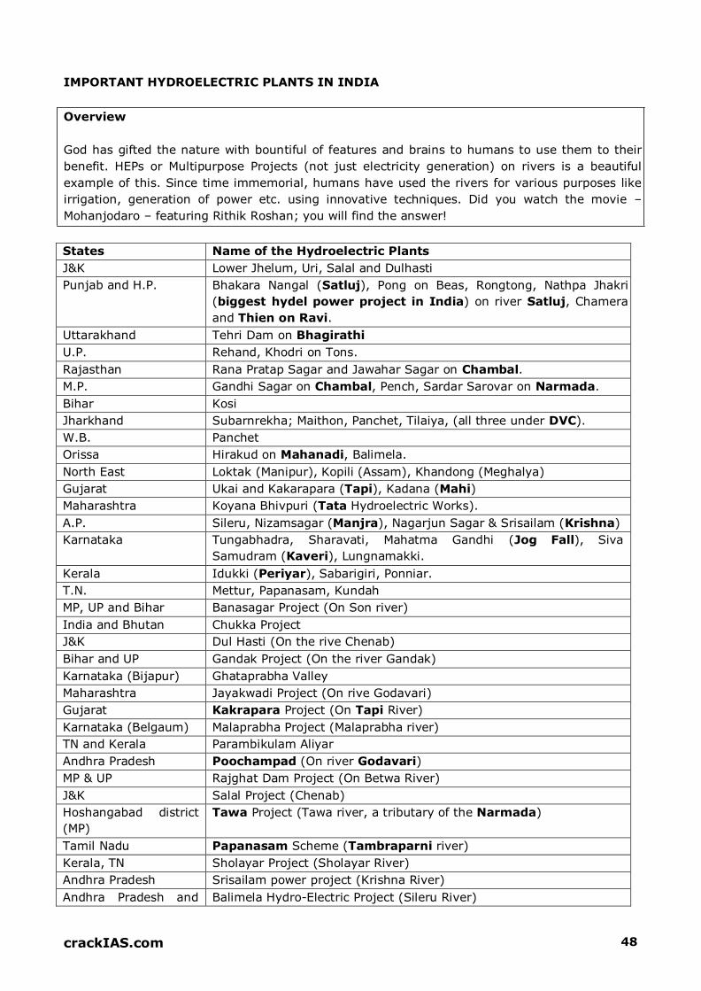
States Name of the Hydroelectric Plants
J&K Lower Jhelum, Uri, Salal and Dulhasti
Punjab and H.P. Bhakara Nangal (Satluj), Pong on Beas, Rongtong, Nathpa Jhakri
(biggest hydel power project in India) on river Satluj, Chamera
and Thien on Ravi.
Uttarakhand Tehri Dam on Bhagirathi
U.P. Rehand, Khodri on Tons.
Rajasthan Rana Pratap Sagar and Jawahar Sagar on Chambal.
M.P. Gandhi Sagar on Chambal, Pench, Sardar Sarovar on Narmada.
Bihar Kosi
Jharkhand Subarnrekha; Maithon, Panchet, Tilaiya, (all three under DVC).
W.B. Panchet
Orissa Hirakud on Mahanadi, Balimela.
North East Loktak (Manipur), Kopili (Assam), Khandong (Meghalya)
Gujarat Ukai and Kakarapara (Tapi), Kadana (Mahi)
Maharashtra Koyana Bhivpuri (Tata Hydroelectric Works).
A.P. Sileru, Nizamsagar (Manjra), Nagarjun Sagar & Srisailam (Krishna)
Karnataka Tungabhadra, Sharavati, Mahatma Gandhi (Jog Fall), Siva
Samudram (Kaveri), Lungnamakki.
Kerala Idukki (Periyar), Sabarigiri, Ponniar.
T.N. Mettur, Papanasam, Kundah
MP, UP and Bihar Banasagar Project (On Son river)
India and Bhutan Chukka Project
J&K Dul Hasti (On the rive Chenab)
Bihar and UP Gandak Project (On the river Gandak)
Karnataka (Bijapur) Ghataprabha Valley
Maharashtra Jayakwadi Project (On rive Godavari)
Gujarat Kakrapara Project (On Tapi River)
Karnataka (Belgaum) Malaprabha Project (Malaprabha river)
TN and Kerala Parambikulam Aliyar
Andhra Pradesh Poochampad (On river Godavari)
MP & UP Rajghat Dam Project (On Betwa River)
J&K Salal Project (Chenab)
Hoshangabad district
(MP)
Tawa Project (Tawa river, a tributary of the Narmada)
Tamil Nadu Papanasam Scheme (Tambraparni river)
Kerala, TN Sholayar Project (Sholayar River)
Andhra Pradesh Srisailam power project (Krishna River)
Andhra Pradesh and Balimela Hydro-Electric Project (Sileru River)

crackIAS.com 49
Orissa
Meghalaya Umiam Project (Umiam River)
MULTIPURPOSE PROJECTS OF INDIA
Location Of Dams
Special Features (Note The Purposes Served)
Bhakra Nangal (Satluj)
Bhakra
Nangal
Joint venture of Punjab, Haryana and Rajasthan. 2 dams – Bhakra
and Nangal. Power houses with combined installed capacity of
1204 MW.
Bhakra canal system of irrigation.
One of the highest Gravity Dams in the world (226m).
Huge reservoir (Gobind Sagar Lake in Bilaspur District of
Himachal Pradesh).
Damodar Valley Project (Damodar)
Tilaiya (R. Barakar)
Maithon (R. Barkar)
Konar (Konar
River)
Panchet Hill (R.
Damodar)
Damodar also called as River of sorrow, or sorrow of Bengal,
Tributary of Hugli; drains the Chotanagpur plateau.
This was the First multipurpose river project in India.
In 1948 – Project executed on the model of TVA (Tennessee Valley
River Project) of USA.
Durgapur Barrage – created for the storage of irrigation water.
Bakaro and Durgapur Thermal Power Stations are the important
link to DVC Power Station System, another purpose is Flood
control
Hirakund (Mahanadi)
Hirakund (in
Sambalpar Distt),
Orrisa
One of the longest dams in the world (4,801m long)
Two other dams on Mahanadi are at Tikrapara and Naraj.
3 canals have been taken out for irrigation.
It also provides for navigation facility besides power generation.
Rihand (Tributary Of Son)
Mirzapur Distt U.P Most important multipurpose project in U.P.
Gobind Ballabh Pant Sagar is largest man made reservoir in
India.
Chambal
Gandhinagar (M.P)
Rana Pratap Sagar
(Rajasthan)
Jawahar Sagar
(Rajasthan)
Gandhinagar – long masonry gravity dam.
Rana Pratap masonry dam at Rawat Bhata.
Jawahar Sagar is also called Kota Dam
Gandak
Balmikinagar
(Bihar)
Joint venture of U.P. and Bihar, though Nepal also get irrigation
and power facilities.
Tungbhadra (Tributary Of Krishna River)
Mallapur, Bellary
distt. (Karnataka).
Joint undertaking of Andhra Pradesh and Karnataka.
Masonry Dam.
crackIAS.com 50
Kosi
Hanumannagar Kosi – Sorrow of Bihar
Object of Project – irrigation, flood control, power generation,
land reclamation, fishing and navigation.
Narmada Valley
Sardar Sarovar
Project on lower
Narmada Valley in
Gujarat. Narmada
Sagar Dam Project
at Narmada in
Madhya Pradesh.
Joint venture of Madhya Pradesh, Gujarat and Maharashtra,
Rajasthan is Beneficiary States.
Most controversial project in India.
Narmada has the largest no. of tributaries.
Nagarjunasagar Projcet (River Krishna)
Nalgonda Distt.
(Andhra Pradesh)
Lal Bahadur Canal had been taken off from it besides the Jawahar
Canal
Tehri Project Confluence Of Bhagirathi And Bhilganga
Garhwal District
(Uttarakhand)
One of the controversial projects in India.
crackiAS.com 51
(
·
IMPORTANT HEPs OF INDIA
'
..,/
..... /
SILERU /

crackIAS.com 52
LETS PRACTICE: LAST 10 YEARS UPSC QUESTIONS
Which one of the following pairs is not
correctly matched? (Dam/ Lake River) a. Govind Sagar: Satluj
b. Kolleru Lake: Krishna
c. Ukai Reservoir: Tapi d. Wular Lake: Jhelum
Ans. D
Consider the following rivers:
1. Vamsadhara
2. Indravati
3. Pranahita
4. Pennar
Which of the above are tributaries of
Godavari?
a. 1, 2 and 3
b. 2, 3 and 4
c. 1, 2 and 4
d. 2 and 3 only Ans. D
Consider the following rivers:
1. Barak
2. Lohit
3. Subansiri
Which of the above flows / flow through
Arunachal Pradesh?
a. 1 only
b. 2 and 3 only
c. 1 and 3 only
d. 1, 2 and 3 Ans. B
The Narmada River flows to the west, while
most other large peninsular rivers flow to
the east. Why?
1. It occupies a linear rift valley
2. It flows between the Vindhyas and the
Satpuras
3. The land slopes to the west from Central
India Select the correct answer using the codes
given below: a. 1 only
b. 2 and 3
c. 1 and 3
d. None Ans. A
Consider the following pairs: (Tributary
River: Main River)
1. Chambal: Narmada
2. Sone: Yamuna
3. Manas: Brahmaputra Which of the pairs given above is/ are
correctly matched? a. 1, 2 & 3
b. 1 & 2
c. 2 & 3 only d. 3 only Ans. D On which one of the following rivers is the
Tehri Hydropower Complex located?
a. Alakananda
b. Bhagirathi c. Dhauliganga
d. Mandakini Ans. B Where the Tapovan and Vishnugarh
Hydroelectric Projects located?
a. Madhya Pradesh
b. Uttar Pradesh
c. Uttarakhand
d. Rajasthan Ans. C With which one of the following rivers is the
Omkareshwar Project associated? a. Chambal
b. Narmada
c. Tapi
d. Bhima
Ans. B Rivers that pass through Himachal Pradesh
are a. Beas and Chenab only
b. Beas and Ravi only
c. Chenab, Ravi and Sutluj only
d. Beas, Chenab, Ravi, Sutluj and Yamuna Ans. D
With reference to the River Luni, which one of the following statements is correct?
a. It flows into Gulf of Khambhat
b. It flows into Gulf of Kuchchh

crackIAS.com 53
c. It flows into Pakistan and merges with a
tributary of Indus
d. It is lost in the marshy land of the Rann
of Kuchchh Ans. D
Consider the following statements:
1. There are no east flowing rivers in
Kerala
2. There are no west flowing rivers in
Madhya Pradesh
Which of the above statements is / are correct?
a. 1 only b. 2 only
c. Both 1 & 2
d. Neither 1 nor 2 Ans. D
Which one of the following rivers does not
originate in India?
a. Beas b. Chenab
c. Ravi d. Sutlej
Ans. D
At which one of the following places do two
important rivers of India originate; while
one of them flows towards north and
merges with another important river flowing
towards Bay of Bengal, the other one flows
towards Arabian Sea?
a. Amarkantak
b. Badrinath c. Mahabaleshwar
d. Nasik Ans. A
Which one of the following rivers originates
at Amarkantak?
a. Damodar
b. Mahanadi
c. Narmada
d. Tapti Ans. C
Assertion (A): River Kalinadi is an east-
flowing river in the southern part of India.
Reason (R): The Deccan Plateau is higher
along its western edge and gently slopes
towards the Bay of Bengal in the east.
Ans. D Which one of the following statements is
NOT correct? a. Mahanadi River rises in Chhattisgarh
b. Godavari River rises in Maharashtra
c. Cauvery River rises in Andhra Pradesh
d. Tapti River rises in Madhya Pradesh Ans. C From north towards south, which one of the
following is the correct sequence of the
given rivers in India?
a. Shyok - Spiti - Zaskar – Satluj
b. Shyok - Zaskar - Spiti - Satluj
c. Zaskar - Shyok - Satluj - Spiti
d. Zaskar - Satluj - Shyok - Spiti Ans. B Match List I with List II and select the
correct answer using the code given below
the lists: List I (Town), List II (River nearer
to it)
A. Betul B. Jagdalpur
C. Jabalpur
D. Ujjain 1. Indravati
2. Narmada
3. Shipra
4. Tapti
a. A-1, B-4, C-2, D-3
b. A-4, B-1, C-2, D-3
c. A-4, B-1, C-3, D-2
d. A-1, B-4, C-3, D-2 Ans. B Which of the following pairs are correctly
matched? (Waterfalls: River)
1. Kapildhara Falls: Godavari
2. Jog Falls: Sharavati
3. Sivasamudram Falls: Cauvery Select the correct answer using the code
given below: a. 1 & 2 only
b. 2 & 3 only c. 1 & 3 only
d. 1, 2 & 3 Ans. B

crackIAS.com 54
For which one of the following, is Satara
well-known?
a. Thermal power plant
b. Wind energy plant
c. Hydro-electric plant d. Nuclear power plant
Ans. B
Gandhi Sagar Dam is a part of which one of
the following? a. Chambal Project
b. Kosi Project
c. Damodar Valley Project
d. Bhakra Nagal Project Ans. A
Lake Sambhar is nearest to which one of the
following cities of Rajasthan?
a. Bharatpur
b. Jaipur
c. Jodhpur d. Udaipur Ans. B Which one among the following major
Indian cities is most eastward located? a. Hyderabad
b. Bhopal
c. Lucknow
d. Benguluru (Bangalore) Ans. C

crackIAS.com 55
Top Related