


Languages
Pages
Legal

DEVELOPMENT PLAN REVIEWDiscussion Paper
Rural City of Murray Bridge
February 2013

3DEVELOPMENT PLAN REVIEW 2013
Context
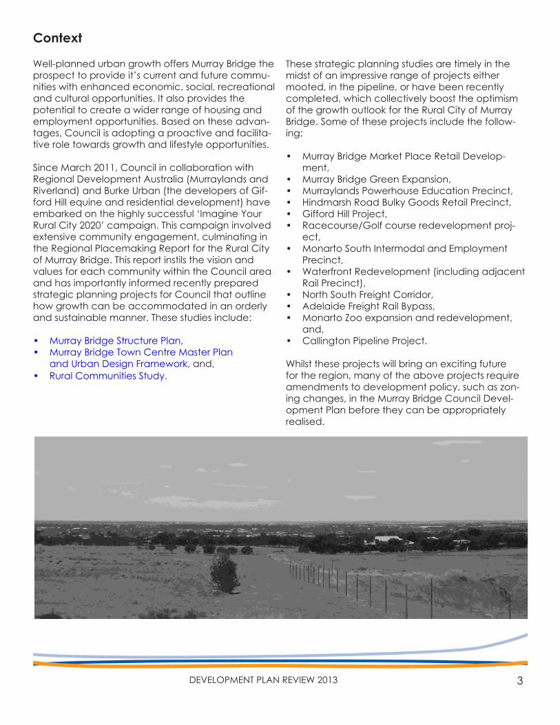
Well-planned urban growth offers Murray Bridge the prospect to provide it’s current and future commu-nities with enhanced economic, social, recreational and cultural opportunities. It also provides the potential to create a wider range of housing and employment opportunities. Based on these advan-tages, Council is adopting a proactive and facilita-tive role towards growth and lifestyle opportunities.
Since March 2011, Council in collaboration with Regional Development Australia (Murraylands and Riverland) and Burke Urban (the developers of Gif-ford Hill equine and residential development) have embarked on the highly successful ‘Imagine Your Rural City 2020’ campaign. This campaign involved extensive community engagement, culminating in the Regional Placemaking Report for the Rural City of Murray Bridge. This report instils the vision and values for each community within the Council area and has importantly informed recently prepared strategic planning projects for Council that outline how growth can be accommodated in an orderly and sustainable manner. These studies include:
• Murray Bridge Structure Plan,• Murray Bridge Town Centre Master Plan
and Urban Design Framework, and,• Rural Communities Study.
These strategic planning studies are timely in the midst of an impressive range of projects either mooted, in the pipeline, or have been recently completed, which collectively boost the optimism of the growth outlook for the Rural City of Murray Bridge. Some of these projects include the follow-ing:
• Murray Bridge Market Place Retail Develop-ment,
• Murray Bridge Green Expansion,• Murraylands Powerhouse Education Precinct, • Hindmarsh Road Bulky Goods Retail Precinct, • Gifford Hill Project, • Racecourse/Golf course redevelopment proj-
ect, • Monarto South Intermodal and Employment
Precinct, • Waterfront Redevelopment (including adjacent
Rail Precinct), • North South Freight Corridor, • Adelaide Freight Rail Bypass, • Monarto Zoo expansion and redevelopment,
and, • Callington Pipeline Project.
Whilst these projects will bring an exciting future for the region, many of the above projects require amendments to development policy, such as zon-ing changes, in the Murray Bridge Council Devel-opment Plan before they can be appropriately realised.
4 RURAL CITY OF MURRAY BRIDGE
To address this issue, Council is currently undertak-ing a ‘review’ of its Development Plan in order to:
• address the strategic planning issues relating to the Rural City of Murray Bridge and its commu-nity,
• set priorities to achieve orderly and efficient development, and,
• Implement the key recommendations of Coun-cil’s strategic planning documents and relevant targets and policies outlined within ‘The Plan-ning Strategy for South Australia’.
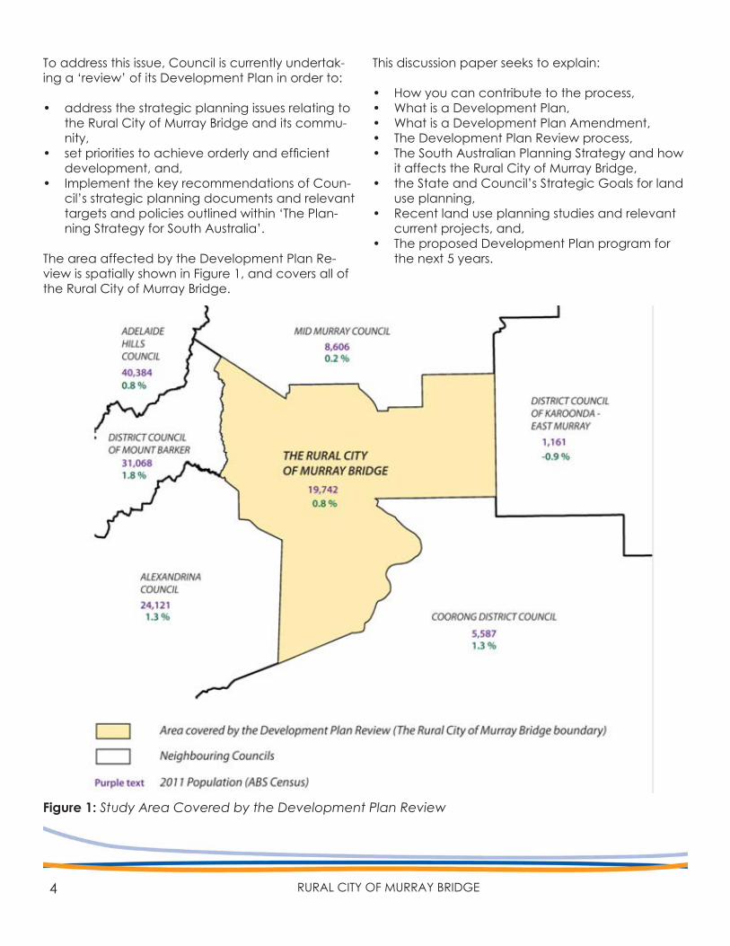
The area affected by the Development Plan Re-view is spatially shown in Figure 1, and covers all of the Rural City of Murray Bridge.
Figure 1: Study Area Covered by the Development Plan Review
This discussion paper seeks to explain:
• How you can contribute to the process,• What is a Development Plan,• What is a Development Plan Amendment,• The Development Plan Review process,• The South Australian Planning Strategy and how
it affects the Rural City of Murray Bridge,• the State and Council’s Strategic Goals for land
use planning,• Recent land use planning studies and relevant
current projects, and,• The proposed Development Plan program for
the next 5 years.
5DEVELOPMENT PLAN REVIEW 2013
How to Make a Submission
This Discussion Paper for the ‘Development Plan Review’ aims to provide appropriate information to allow you to comment further on what changes you believe should be made to the Murray Bridge Council Development Plan to ensure that the com-munity’s vision can be translated into policies for the Development Plan.
The proposed Development Plan Amendment pro-gram for the next five years is detailed in Section 7 for your comment.
Written submissions on the Development Plan Re-view discussion paper can be provided by letter, fax or email addressed to Council by 5pm Monday, 8 April 2013.
Any person who makes a written submission has the opportunity to support their proposals at a public hearing to be held at the Mobilong Committee Meeting Room in the Local Government Centre, Seventh Street, Murray Bridge on Wednesday, 17th April 2013 at 5pm.
Written submission should clearly indicate whether you wish to be heard in support of your submission at the public hearing. If no submissions request to be heard at the public meeting, a meeting will not be held on that night.
Written submission should be addressed to:
Development Plan Review 2013Rural City of Murray BridgePO Box 421, Murray Bridge SA 5253Email:[email protected]: 08 8532 2766
If you have any queries about the Development Plan Review process or the recommendations con-tained within this discussion paper, please contact either of Council’s Senior Policy Planners Daniel Her-rmann on 8539 1121 or Mabel John on 8539 1151.

6 RURAL CITY OF MURRAY BRIDGE
7DEVELOPMENT PLAN REVIEW 2013
Contents
Context 3
How to Make a Submission 5
1. Introduction 81.1 What is a Development Plan? 91.2 What is a Development Plan Amendment? 91.3 The Purpose of a Development Plan Review 10
2. Previous Development Plan Review 11
3. The Planning Strategy for South Australia 143.1 30 Year Plan for Greater Adelaide 153.2 Murray Mallee Region Plan 16
4. The Vision for the Rural City of Murray Bridge 174.1 Imagine Your Rural City 2020 184.2 Community Plan 2012-2020 184.3 Strategic Plan 2011-2015 19
5. Council’s Strategic Growth Studies 205.1 Murray Bridge Structure Plan 225.2 Murray Bridge Town Centre Master Plan & Urban Design Framework 245.3 Rural Communities Study 26
6. Primary Production and Environmental Sustainability 296.1 Primary Production 306.2 The Interface Between Primary Production and Township Areas 306.3 River Murray Flood Plain 316.4 Environmental Sustainability 32
7. Proposed Development Plan Amendment Program 33
8 RURAL CITY OF MURRAY BRIDGE
1. INTRODUCTION
9DEVELOPMENT PLAN REVIEW 2013
1.1 What is a Development Plan?
The Murray Bridge Council Development Plan is the key planning policy tool used for the assessment of development applications within the Rural City of Murray Bridge. Any activity that constitutes ‘Devel-opment’ must be granted Development Approval via a development application before the activity can commence. Different zones and policy areas have been established over the Council area, which contain ‘guidelines’ as to what can be de-veloped on a piece of land, as well as setting out what the ‘desired character’ for particular areas should achieve. For example, specific zones may exist for residential development, for industry, for shopping or for open space or community facili-ties. There is also a set of ‘general’ land use policies within the Development Plan that are applicable across the entire Council area.
The Murray Bridge Council Development Plan:
• informs the community about how an area is expected to be developed,
• informs neighbours as to the kinds of develop-ment they can expect in their neighbourhood,
• informs applicants as to the type of develop-ment that is encouraged (and not encouraged) in an area, and,
• provides the basis against which development assessment decisions are made (the zones, maps and policies provide the detailed criteria against which development applications for the relevant area are assessed).
The current Murray Bridge Council Development Plan can be accessed via the following link:
Murray Bridge Council Development Plan
The Murray Bridge Council Development Plan also forms an integral part of Council’s Strategic Plan-ning Framework, which is discussed further in Sec-tion 4.3 (Strategic Plan).
The policies within the Development Plan can only be changed via a ‘Development Plan Amend-ment’; a process that involves detailed investiga-tions to inform rezoning processes and other plan-ning policy changes.
1.2 What is a ‘Development Plan Amendment’?
Development Plans need to be updated regularly to ensure they reflect the needs of the community, the economy and the environment. Development Plans are updated through a formal legislative ‘De-velopment Plan Amendment’ (DPA) process, set out in the Development Act 1993.
A DPA can be initiated by either Council or the Minister of Urban Development and Planning. Ulti-mately, the Minister must approve all DPA’s. A DPA may also relate to a specific parcel or parcels of land, such as land defined within a particular zone, or may also relate to ‘general’ policies that apply to the entire Council area.
The need to change the Development Plan starts with an idea or concept that may have arisen from any number of sources such as, direction from State Government strategic planning aspirations, strate-gic planning recommendations identified by Coun-cil, a suggestion or request made from Council or community and the need to improve a policy that is identified by Council as inadequate.
The time within which a DPA may take will depend on the complexity of the subject matter or scope. Generally, a DPA process will typically take be-tween 12-18 months to complete due to legislative timeframes and extensive time required by Council to undertake investigations in support of a DPA.
10 RURAL CITY OF MURRAY BRIDGE
DEVELOPMENT PLAN REVIEW FLOW CHARTSection 30 of the Development Act 1993
REVIEW INITIATIONJune 2012
UNDERTAKE INVESTIGATIONS & PREPARATION OF DISCUSSION PAPER
COMMUNITY CONSULTATION of DISCUSSION PAPER
7 February ‐ 8 April 2013
PUBLIC HEARING(for those who requested
in their submission)17 April 2013
PREPARE DRAFT STRATEGIC DIRECTIONS
REPORT (SDR)Incorporate consultation
ENDORSEMENT OF DRAFT SDR by COUNCIL
(with any amendments)May2013
ENDORSED REPORT FURNISHED to MINISTER
FOR PLANNINGMay 2013
AGREEMENT BETWEEN COUNCIL and MINISTERfor steps set out within
the SDR
IMPLEMENTATION of the SDR
Development Plan Amendments & other
DEVELOPMENT PLAN AMENDMENTS
subject to community consultation
1.3 The Purpose of a Development Plan Review
The Rural City of Murray Bridge initiated the current Development Plan Review in June 2012.Each Council is legislatively required to review their Development Plan to ensure it is consistent with the Planning Strategy for South Australia which sets out targets and policies for planning sustainable growth, environmental sustainability and social inclusiveness for the State. This requirement is set out in Section 30 of the Development Act 1993.
The review also takes into consideration Council’s recent strategic studies and community consulta-tion undertaken through the ‘Imagine Your Rural City 2020’ campaign. These studies include:
• Regional Placemaking Report,• Murray Bridge Structure Plan,• Murray Bridge Town Centre Master Plan & Urban
Design Framework (TCMP), and,• Rural Communities Study.
One of the main roles of the Development Plan review is to identify what Council’s priorities are to change the Development Plan through DPA’s to ensure it is appropriately aligned to the strategic directions of Council and the Planning Strategy for South Australia and that it reflects the community’s needs and social values.
To this effect, a DPA program has been prepared for the review, which details the scope of each DPA identified as a priority and approximate timing of the DPA. This has been included in Section 7 for comment.
The feedback from this consultation and the infor-mation gleaned from previous studies will inform Council’s ‘Strategic Directions Report’ (SDR) that must be presented to the Minister for Planning taking into account the feedback received from consultation.
The final SDR is intended to outline a strategic vision for growth in the council area by means of a pro-gram of Development Plan Amendments (DPAs) to translate the strategic vision into new policies within the Murray Bridge Council Development Plan.Agreement from the Minister in relation to the proposed strategic directions and Development Plan Amendment program (for the next 5 years) will need to be received before Council can com-mence any new Development Plan Amendment process to rezone land.
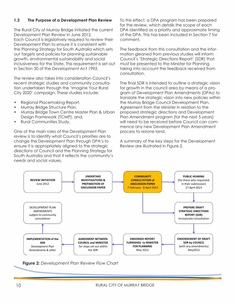
A summary of the key steps for the Development Review are illustrated in Figure 2.
Figure 2: Development Plan Review Flow Chart
11DEVELOPMENT PLAN REVIEW 2013
PLAN REVIEW2. PREVIOUS DEVELOPMENT
12 RURAL CITY OF MURRAY BRIDGE
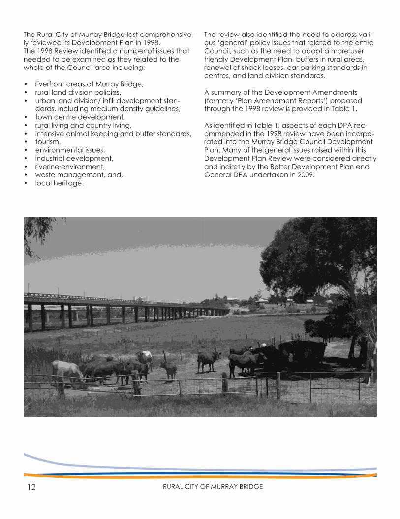
The Rural City of Murray Bridge last comprehensive-ly reviewed its Development Plan in 1998.The 1998 Review identified a number of issues that needed to be examined as they related to the whole of the Council area including:
• riverfront areas at Murray Bridge,• rural land division policies,• urban land division/ infill development stan-
dards, including medium density guidelines,• town centre development,• rural living and country living,• intensive animal keeping and buffer standards,• tourism,• environmental issues,• industrial development,• riverine environment,• waste management, and,• local heritage.
The review also identified the need to address vari-ous ‘general’ policy issues that related to the entire Council, such as the need to adopt a more user friendly Development Plan, buffers in rural areas, renewal of shack leases, car parking standards in centres, and land division standards.
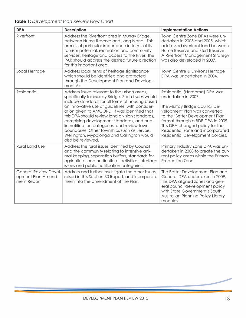
A summary of the Development Amendments (formerly ‘Plan Amendment Reports’) proposed through the 1998 review is provided in Table 1.
As identified in Table 1, aspects of each DPA rec-ommended in the 1998 review have been incorpo-rated into the Murray Bridge Council Development Plan. Many of the general issues raised within this Development Plan Review were considered directly and indiretly by the Better Development Plan and General DPA undertaken in 2009.
13DEVELOPMENT PLAN REVIEW 2013
DPA Description Implementation ActionsRiverfront Address the Riverfront area in Murray Bridge,
between Hume Reserve and Long Island. This area is of particular importance in terms of its tourism potential, recreation and community services, heritage and access to the River. The PAR should address the desired future direction for this important area.
Town Centre Zone DPAs were un-dertaken in 2003 and 2005, which addressed riverfront land between Hume Reserve and Sturt Reserve. A Riverfront Management Strategy was also developed in 2007.
Local Heritage Address local items of heritage significance which should be identified and protected through the Development Plan and Develop-ment Act.
Town Centre & Environs Heritage DPA was undertaken in 2004.
Residential Address issues relevant to the urban areas, specifically for Murray Bridge. Such issues would include standards for all forms of housing based on innovative use of guidelines, with consider-ation given to AMCORD. It was identified that this DPA should review land division standards, complying development standards, and pub-lic notification categories, and review town boundaries. Other townships such as Jervois, Wellington, Mypolonga and Callington would also be reviewed.
Residential (Narooma) DPA was undertaken in 2007.
The Murray Bridge Council De-velopment Plan was converted to the ‘Better Development Plan’ format through a BDP DPA in 2009. This DPA changed policy for the Residential Zone and incorporated Residential Development policies.
Rural Land Use Address the rural issues identified by Council and the community relating to intensive ani-mal keeping, separation buffers, standards for agricultural and horticultural activities, interface issues and public notification categories.
Primary Industry Zone DPA was un-dertaken in 2008 to create the cur-rent policy areas within the Primary Production Zone.
General Review Devel-opment Plan Amend-ment Report
Address and further investigate the other issues raised in this Section 30 Report, and incorporate them into the amendment of the Plan.
The Better Development Plan and General DPA undertaken in 2009, this DPA aligned zones and gen-eral council development policy with State Government’s South Australian Planning Policy Library modules.
Table 1: Development Plan Review Flow Chart
14 RURAL CITY OF MURRAY BRIDGE
PLANNING STRATEGYPLANNING STRATEGY3. THE SOUTH AUSTRALIAN
15DEVELOPMENT PLAN REVIEW 2013
The Planning Strategy for South Australia outlines the direction for land use change and develop-ment within South Australia, and is a spatial repre-sentation of the key aspirations and targets from South Australia’s Strategic Plan.
The South Australian Planning Strategy has changed significantly since 1998. The State Gov-ernment have introduced various volumes cover-ing different geographic areas of the State. Two volumes are relevant to the Rural City of Murray bridge are the 30-Year Plan for Greater Adelaide (2010) and the Murray Mallee Region Plan (2011). The changes brought about by these two volumes identify the importance of the current Develop-ment Plan Review to ensure that it is consistent with the Strategy as well as Council and Community desired strategic actions. Key directions relevant to Council within each volume are summarised in this section.
3.1 30-Year Plan for Greater Adelaide
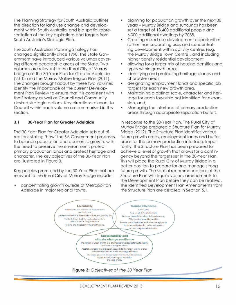
The 30-Year Plan for Greater Adelaide sets out di-rections stating ‘how’ the SA Government proposes to balance population and economic growth, with the need to preserve the environment, protect primary production lands and protect heritage and character. The key objectives of the 30-Year Plan are illustrated in Figure 3.
Key policies promoted by the 30-Year Plan that are relevant to the Rural City of Murray Bridge include:
• concentrating growth outside of Metropolitan Adelaide in major regional towns,
• planning for population growth over the next 30 years – Murray Bridge and surrounds has been set a target of 13,400 additional people and 6,000 additional dwellings by 2038,
• Creating mixed-use development opportunities rather than separating uses and concentrat-ing development within activity centres (e.g. the Murray Bridge Town Centre), and including higher density residential development,
• allowing for a larger mix of housing densities and types within growth areas,
• Identifying and protecting heritage places and character areas,
• designating employment lands and specific job targets for each new growth area,
• Maintaining a distinct scale, character and heri-tage for each township not identified for expan-sion, and,
• Managing the interface of primary production areas through appropriate separation buffers.
In response to the 30-Year Plan, The Rural City of Murray Bridge prepared a Structure Plan for Murray Bridge (2012). The Structure Plan identifies various future growth areas, employment lands and buffer areas for the primary production interface. Impor-tantly, the Structure Plan has been prepared to achieve a level of growth that allows for a contin-gency beyond the targets set in the 30-Year Plan. This will place the Rural City of Murray Bridge in a better position to prepare for and manage strong future growth. The spatial recommendations of the Structure Plan will require various amendments to the Development Plan before they can be realised. The identified Development Plan Amendments from the Structure Plan are detailed in Section 5.1.
Figure 3: Objectives of the 30 Year Plan
16 RURAL CITY OF MURRAY BRIDGE
3.1 Murray Mallee Region Plan
The Murray Mallee Region Plan sets out land use policy directions to manage the changes that are forecast within the region. Of particular concern are changes in population and climate, which are having, and will continue to have, significant im-pact on the demand for services and infrastructure, the natural environment, the character of commu-nities and the economic prosperity of the region.The Plan provides a vision for the region and identi-fies the following aims for the Rural City of Murray Bridge:
• Murray Bridge is recognised as a major Regional City/Centre within the region,
• Industrial growth to be promoted within Murray Bridge based on its key Strategic location,
• Targeted economic development opportunities within the Council area include intensive live-stock production and processing and dairying along the River Murray corridor, and,
• Strengthening the heritage and township char-acter of Callington.
The Plan also identifies 12 key principles to achieve the vision for the broader region:
Environment and Culture• Principle 1: Recognise, protect and restore the
region’s environmental assets.• Principle 2: Create conditions for the region
to become resilient to the impacts of climate change.
• Principle 3: Protect people, property and the environment from exposure to hazards.
Population and Settlements• Principle 4: Identify and protect places of heri-
tage and cultural significance, and desired town character.
• Principle 10: Strategically plan and manage the growth of towns.
• Principle 11: Design towns to provide safe, healthy, accessible and appealing environ-ments.
• Principle 12: Provide residential land for a supply of diverse, affordable and sustainable housing to meet the needs of current and future resi-dents and visitors.
Economic Development• Principle 6: Retain and strengthen the economic
potential of primary production land.• Principle 7: Reinforce the region as a preferred
tourism destination.• Principle 8: Provide and protect serviced and
well-sited industrial land to meet projected de-mand.
• Principle 9: Focus commercial development in key centres and ensure it is well sited and de-signed.
Infrastructure & Service Provision• Principle 5: Protect and build on the region’s
strategic infrastructure.
17DEVELOPMENT PLAN REVIEW 2013
PLANNING STRATEGYRURAL CITY OF MURRAY BRIDGE
4. THE VISION FOR THE
18 RURAL CITY OF MURRAY BRIDGE
The vision that has been developed for the Rural City of Murray Bridge through the Imagine Your Rural City 2020 campaign, the Community Plan and Strategic Plan must also be taken into account when considering the key strategic directions within the Planning Strategy for South Australia.
4.1 Imagine Your Rural City 2020
In March 2011, Council, in collaboration with Re-gional Development Australia (Murraylands and Riverland) and Burke Urban, embarked on the Imagine Your Rural City 2020 campaign. This com-munity engagement program included a series of visioning workshops with the community, one-on-one interviews, site analysis and the ‘walk the beat’ process. Engagement with the community was criti-cal in understanding the needs and aspirations, as well as mobilising and inspiring the community, and fostering a partnership approach between Council, the community and Burke Urban.
The workshops were an important forum in reach-ing an endorsed Place Essence (Community Vision) and Place Making Principles for Murray Bridge and other rural communities throughout the Council area.
This process initially resulted in the development of three reports:
Lay of the Land Report:An analysis of the Rural City of Murray Bridge includ-ing the physical and social background and the values and context for the Placemaking Report.
Community Values Report:Capturing the ‘wisdom of the community’ from community visioning workshops and translating this wisdom into a practical guide for Council and stakeholders to better understand the needs and the aspirations of the community.
Regional Placemaking Report:Findings from the Lay of the Land and Community Values reports are analysed. The report provides a vision (place essence) and place principles for each township within the Council area, drawing from findings in the first two stages, which provide a foundation for a series of strategies and actions (small wins and big wins) to achieve the vision.
4.2 Community Plan 2012-2020
The Rural City of Murray Bridge’s Community Plan aims to balance competing pressures for econom-ic, environmental and community sustainability in order to build places and communities that meet and support current and future residents’ needs and desired quality of life.The shared vision for the Community Plan was borne out of the Imagine Your Rural City 2020 com-munity engagement process.
The vision for the Plan is:
“The Rural City of Murray Bridge is an enterpris-ing and innovative community. It looks to the future with confidence, secure in the knowledge that decisions made today have helped to cre-ate a place of opportunities”.
This vision is underpinned by five guiding principles:
• Enterprising & innovative – actively seeking out new ways of doing business.
• Caring and welcoming – embracing the knowl-edge and wisdom of people of all walks of life.
• Healthy and active – caring for our people and our environment.
• Connected – connection that is more than just physical.
• A resilient place – will stand the test of time.
Importantly, the Community Plan identifies the Development Plan Review as a key project that will help make the vision a reality. The strategic growth studies that help inform future Development Plan Amendments are also identified as key projects, which are discussed in greater detail in Section 5.
19DEVELOPMENT PLAN REVIEW 2013
4.3 Strategic Plan 2011-15
In May 2012 Council adopted amendments to its Strategic Plan 2011-15 that were guided by the Vi-sion and Principles of the Rural City of Murray Bridge Community Plan 2012-20. The Strategic Plan forms part of Council’s Strategic Planning Framework, which was adopted in May 2012. The Murray Bridge Council Development Plan also forms part of the Framework. Figure 4 illustrates Council’s Strategic Planning Framework.
The Strategic Plan articulates Council’s strategic priorities for the next four years. It reflects the aspi-rations of the community, provides direction for Council officers and elected members in the devel-opment of future strategies, policies and plans, and recognises the imperative to prepare for and man-age growth as identified in the 30 Year Plan. The Development Plan Review will ensure that the Development Plan aligns with and support the fol-lowing objectives of Council’s Strategic Plan:
Economic• Objective 1.1: Attract new enterprises and
increase support for existing commercial, retail, construction and manufacturing, primary indus-try and tourism enterprises.
• Objective 1.2: Improve regional and local infra-structure (for growth).
• Objective 1.3: Develop vibrant and sustainable business and education precincts.
Environment• Objective 2.1: Improve conservation and en-
hancement of natural environs and manage for climate change.
• Objective 2.2: Improve the quality and diversifi-cation of the built environment.
• Objective 2.3: Preserve local heritage and char-acter of built environs.
• Objective 2.4: Improve the management and use of water and energy resources.
• Objective 2.5: Minimise the environmental im-pact of waste.
• Objective 2.6: Improve the management and use of the River Murray flood plain.
Social• Objective 3.1: Maintain adequate and appro-
priate open space for present and future gen-erations.
• Objective 3.3: Foster cohesive and self support-ing urban and rural communities.
• Objective 3.4: improve community health, safety and well being.
• Objective 3.5: Maintain support for the estab-lishment of appropriate land use and transport options that achieve community sustainability.
• Objective 3.6: Recognise and celebrate our cultural heritage.
Governance• Objective 4.1: Improve community and stake-
holder engagement.• Objective 4.3: Improve organisational perfor-
mance and the quality of service delivered.
Figure 4: Council’s Strategic Planning Framework
20 RURAL CITY OF MURRAY BRIDGE
PLANNING STRATEGYGROWTH STUDIES 5. COUNCIL’S STRATEGIC
21DEVELOPMENT PLAN REVIEW 2013
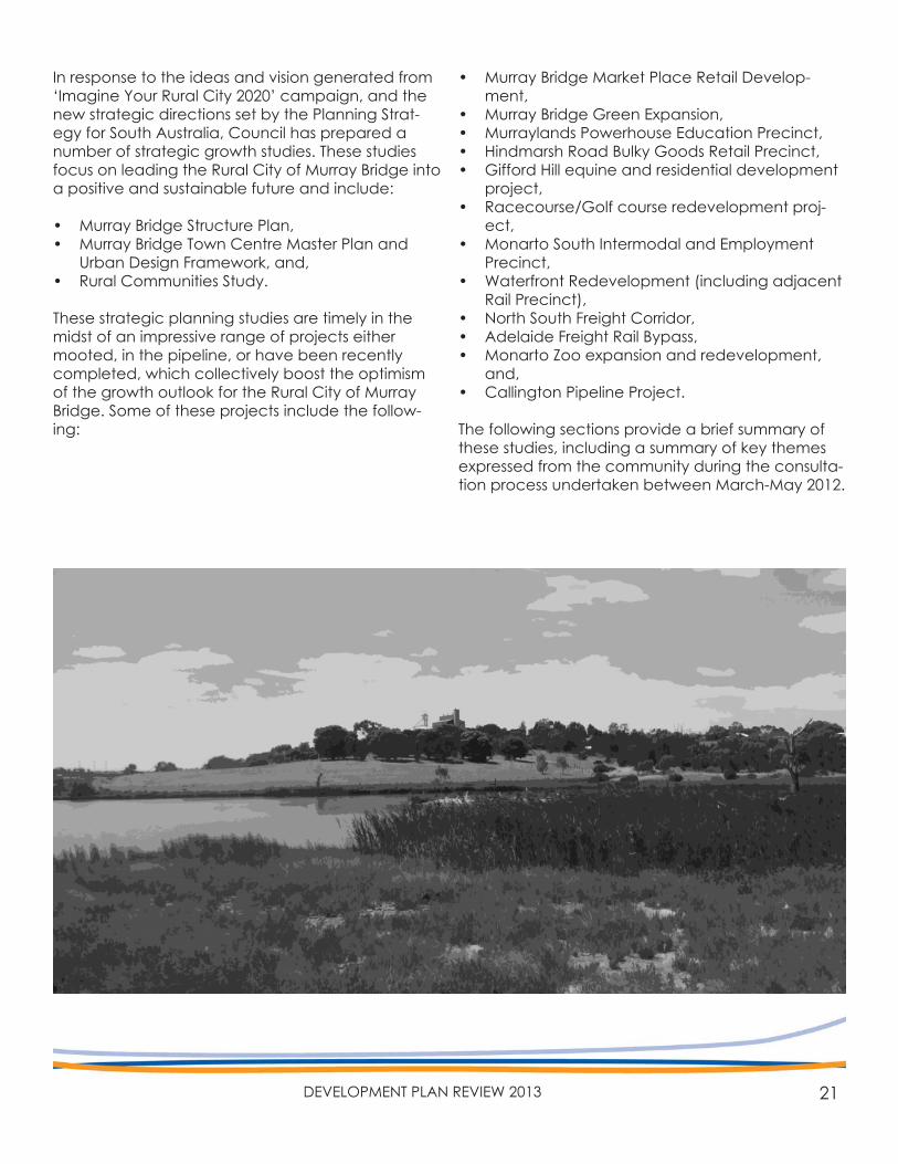
In response to the ideas and vision generated from ‘Imagine Your Rural City 2020’ campaign, and the new strategic directions set by the Planning Strat-egy for South Australia, Council has prepared a number of strategic growth studies. These studies focus on leading the Rural City of Murray Bridge into a positive and sustainable future and include:
• Murray Bridge Structure Plan,• Murray Bridge Town Centre Master Plan and
Urban Design Framework, and,• Rural Communities Study.
These strategic planning studies are timely in the midst of an impressive range of projects either mooted, in the pipeline, or have been recently completed, which collectively boost the optimism of the growth outlook for the Rural City of Murray Bridge. Some of these projects include the follow-ing:
• Murray Bridge Market Place Retail Develop-ment,
• Murray Bridge Green Expansion,• Murraylands Powerhouse Education Precinct,• Hindmarsh Road Bulky Goods Retail Precinct,• Gifford Hill equine and residential development
project, • Racecourse/Golf course redevelopment proj-
ect,• Monarto South Intermodal and Employment
Precinct,• Waterfront Redevelopment (including adjacent
Rail Precinct),• North South Freight Corridor,• Adelaide Freight Rail Bypass,• Monarto Zoo expansion and redevelopment,
and,• Callington Pipeline Project.
The following sections provide a brief summary of these studies, including a summary of key themes expressed from the community during the consulta-tion process undertaken between March-May 2012.
22 RURAL CITY OF MURRAY BRIDGE
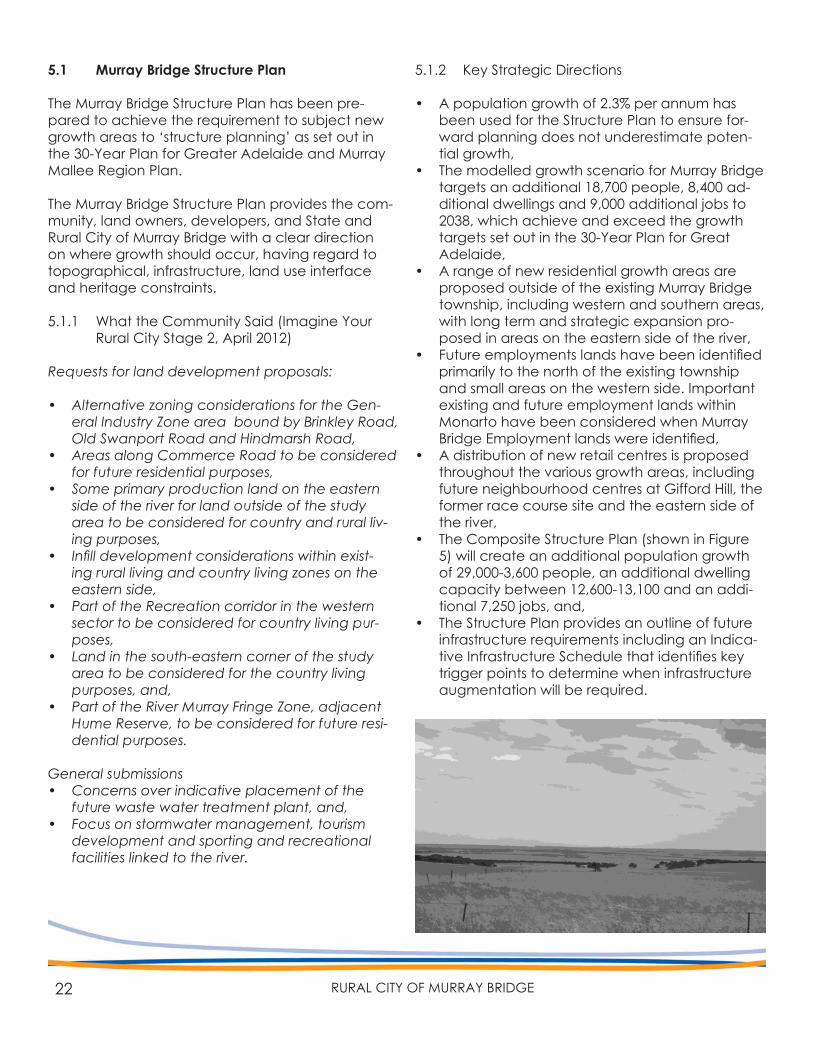
5.1 Murray Bridge Structure Plan
The Murray Bridge Structure Plan has been pre-pared to achieve the requirement to subject new growth areas to ‘structure planning’ as set out in the 30-Year Plan for Greater Adelaide and Murray Mallee Region Plan.
The Murray Bridge Structure Plan provides the com-munity, land owners, developers, and State and Rural City of Murray Bridge with a clear direction on where growth should occur, having regard to topographical, infrastructure, land use interface and heritage constraints.
5.1.1 What the Community Said (Imagine Your Rural City Stage 2, April 2012)
Requests for land development proposals:
• Alternative zoning considerations for the Gen-eral Industry Zone area bound by Brinkley Road, Old Swanport Road and Hindmarsh Road,
• Areas along Commerce Road to be considered for future residential purposes,
• Some primary production land on the eastern side of the river for land outside of the study area to be considered for country and rural liv-ing purposes,
• Infill development considerations within exist-ing rural living and country living zones on the eastern side,
• Part of the Recreation corridor in the western sector to be considered for country living pur-poses,
• Land in the south-eastern corner of the study area to be considered for the country living purposes, and,
• Part of the River Murray Fringe Zone, adjacent Hume Reserve, to be considered for future resi-dential purposes.
General submissions• Concerns over indicative placement of the
future waste water treatment plant, and,• Focus on stormwater management, tourism
development and sporting and recreational facilities linked to the river.
5.1.2 Key Strategic Directions
• A population growth of 2.3% per annum has been used for the Structure Plan to ensure for-ward planning does not underestimate poten-tial growth,
• The modelled growth scenario for Murray Bridge targets an additional 18,700 people, 8,400 ad-ditional dwellings and 9,000 additional jobs to 2038, which achieve and exceed the growth targets set out in the 30-Year Plan for Great Adelaide,
• A range of new residential growth areas are proposed outside of the existing Murray Bridge township, including western and southern areas, with long term and strategic expansion pro-posed in areas on the eastern side of the river,
• Future employments lands have been identified primarily to the north of the existing township and small areas on the western side. Important existing and future employment lands within Monarto have been considered when Murray Bridge Employment lands were identified,
• A distribution of new retail centres is proposed throughout the various growth areas, including future neighbourhood centres at Gifford Hill, the former race course site and the eastern side of the river,
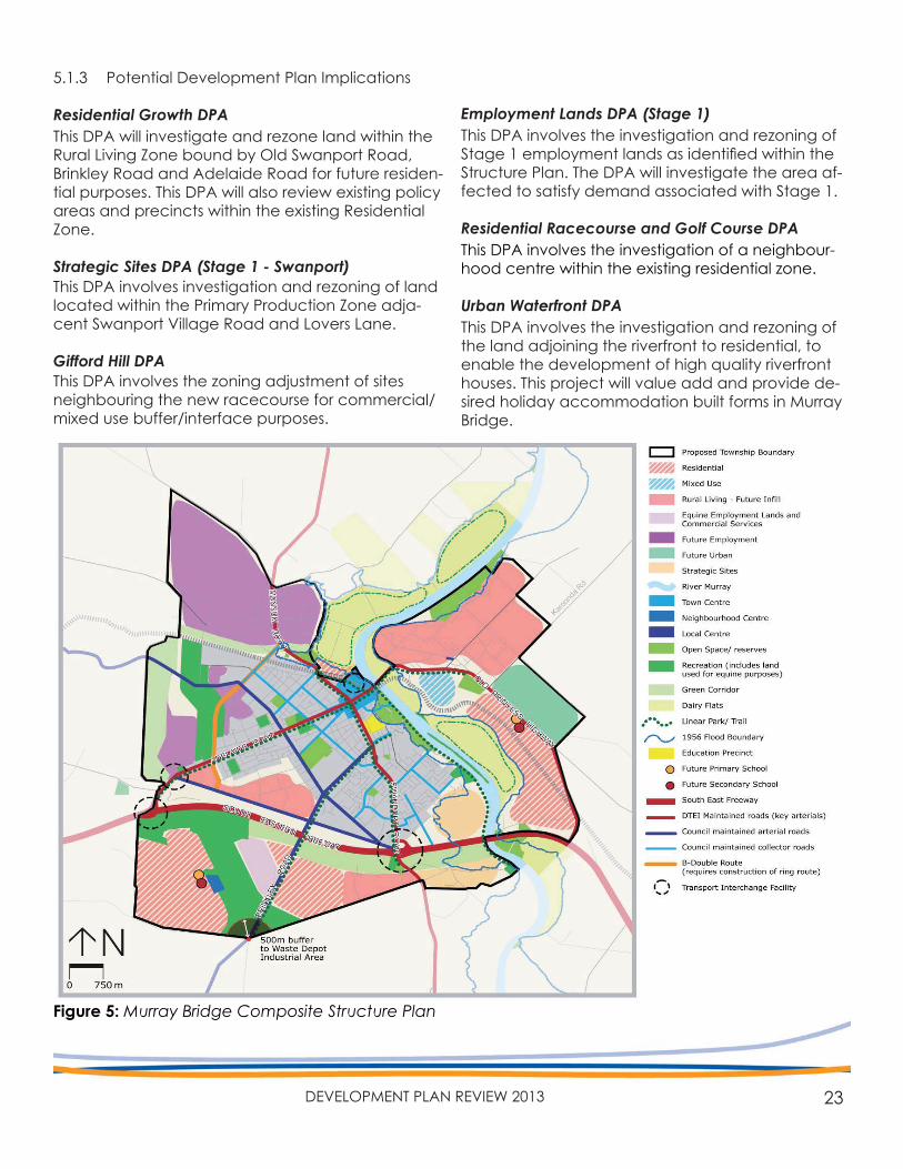
• The Composite Structure Plan (shown in Figure 5) will create an additional population growth of 29,000-3,600 people, an additional dwelling capacity between 12,600-13,100 and an addi-tional 7,250 jobs, and,
• The Structure Plan provides an outline of future infrastructure requirements including an Indica-tive Infrastructure Schedule that identifies key trigger points to determine when infrastructure augmentation will be required.
23DEVELOPMENT PLAN REVIEW 2013
61
Figure 15.8: Structure Plan
STRUCTURE PLAN 15
1. The recreation and employment area band in
the vicinity of Bremer Road will be the subject
of future investigations. These investigations
will determine a) the need for recreation/open
space land in this area; b) whether any additional
housing such as low density Country Living can
be accommodated based on achieving SEA Gas
requirements, the considerations of EPA licensed
facilities in the broader locality, and the impact
on the proposed freight bypass (consideration of
noise and traf c ow issues).
2. The width of the buffer along the southern edge
of the South Eastern Freeway will be subject
to future investigations to determine the most
appropriate width based on land fragmentation
issues, visual amenity considerations and noise
attenuation measures.
3. Land along the northern boundary of the Freeway
is currently within a Rural Landscape Protection
Zone. In instances where land remains white,
there is no intent to consider a future land use
change.
4. The proposed residential land adjacent to the
Regional Town Centre Zone will need to address
contamination, railway interface & industry
infrastructure issues, impacts from T & R Pastoral
meat processing facility, the outcomes of the
RCMB Open Space Strategy and stormwater &
ooding issues.
5.1.3 Potential Development Plan Implications
Residential Growth DPAThis DPA will investigate and rezone land within the Rural Living Zone bound by Old Swanport Road, Brinkley Road and Adelaide Road for future residen-tial purposes. This DPA will also review existing policy areas and precincts within the existing Residential Zone.
Strategic Sites DPA (Stage 1 - Swanport)This DPA involves investigation and rezoning of land located within the Primary Production Zone adja-cent Swanport Village Road and Lovers Lane.
Gifford Hill DPAThis DPA involves the zoning adjustment of sites neighbouring the new racecourse for commercial/mixed use buffer/interface purposes.
Employment Lands DPA (Stage 1)This DPA involves the investigation and rezoning of Stage 1 employment lands as identified within the Structure Plan. The DPA will investigate the area af-fected to satisfy demand associated with Stage 1.
Residential Racecourse and Golf Course DPAThis DPA involves the investigation of a neighbour-hood centre within the existing residential zone.
Urban Waterfront DPAThis DPA involves the investigation and rezoning of the land adjoining the riverfront to residential, to enable the development of high quality riverfront houses. This project will value add and provide de-sired holiday accommodation built forms in Murray Bridge.
Figure 5: Murray Bridge Composite Structure Plan
24 RURAL CITY OF MURRAY BRIDGE
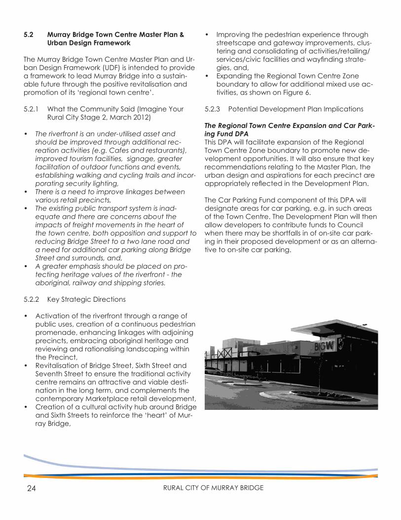
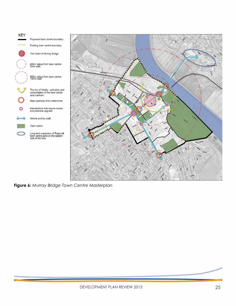
5.2 Murray Bridge Town Centre Master Plan & Urban Design Framework
The Murray Bridge Town Centre Master Plan and Ur-ban Design Framework (UDF) is intended to provide a framework to lead Murray Bridge into a sustain-able future through the positive revitalisation and promotion of its ‘regional town centre’.
5.2.1 What the Community Said (Imagine Your Rural City Stage 2, March 2012)
• The riverfront is an under-utilised asset and should be improved through additional rec-reation activities (e.g. Cafes and restaurants), improved tourism facilities, signage, greater facilitation of outdoor functions and events, establishing walking and cycling trails and incor-porating security lighting,
• There is a need to improve linkages between various retail precincts,
• The existing public transport system is inad-equate and there are concerns about the impacts of freight movements in the heart of the town centre, both opposition and support to reducing Bridge Street to a two lane road and a need for additional car parking along Bridge Street and surrounds, and,
• A greater emphasis should be placed on pro-tecting heritage values of the riverfront - the aboriginal, railway and shipping stories.
5.2.2 Key Strategic Directions
• Activation of the riverfront through a range of public uses, creation of a continuous pedestrian promenade, enhancing linkages with adjoining precincts, embracing aboriginal heritage and reviewing and rationalising landscaping within the Precinct,
• Revitalisation of Bridge Street, Sixth Street and Seventh Street to ensure the traditional activity centre remains an attractive and viable desti-nation in the long term, and complements the contemporary Marketplace retail development,
• Creation of a cultural activity hub around Bridge and Sixth Streets to reinforce the ‘heart’ of Mur-ray Bridge,
• Improving the pedestrian experience through streetscape and gateway improvements, clus-tering and consolidating of activities/retailing/services/civic facilities and wayfinding strate-gies, and,
• Expanding the Regional Town Centre Zone boundary to allow for additional mixed use ac-tivities, as shown on Figure 6.
5.2.3 Potential Development Plan Implications
The Regional Town Centre Expansion and Car Park-ing Fund DPAThis DPA will facilitate expansion of the Regional Town Centre Zone boundary to promote new de-velopment opportunities. It will also ensure that key recommendations relating to the Master Plan, the urban design and aspirations for each precinct are appropriately reflected in the Development Plan.
The Car Parking Fund component of this DPA will designate areas for car parking, e.g. in such areas of the Town Centre. The Development Plan will then allow developers to contribute funds to Council when there may be shortfalls in of on-site car park-ing in their proposed development or as an alterna-tive to on-site car parking.
25DEVELOPMENT PLAN REVIEW 2013
Figure 6: Murray Bridge Town Centre Masterplan
26 RURAL CITY OF MURRAY BRIDGE
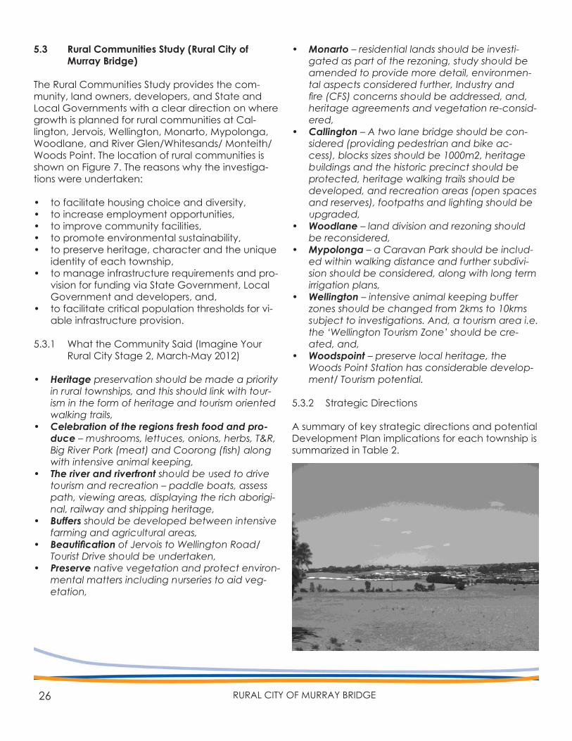
5.3 Rural Communities Study (Rural City of Murray Bridge)
The Rural Communities Study provides the com-munity, land owners, developers, and State and Local Governments with a clear direction on where growth is planned for rural communities at Cal-lington, Jervois, Wellington, Monarto, Mypolonga, Woodlane, and River Glen/Whitesands/ Monteith/ Woods Point. The location of rural communities is shown on Figure 7. The reasons why the investiga-tions were undertaken:
• to facilitate housing choice and diversity,• to increase employment opportunities,• to improve community facilities,• to promote environmental sustainability,• to preserve heritage, character and the unique
identity of each township,• to manage infrastructure requirements and pro-
vision for funding via State Government, Local Government and developers, and,
• to facilitate critical population thresholds for vi-able infrastructure provision.
5.3.1 What the Community Said (Imagine Your Rural City Stage 2, March-May 2012)
• Heritage preservation should be made a priority in rural townships, and this should link with tour-ism in the form of heritage and tourism oriented walking trails,
• Celebration of the regions fresh food and pro-duce – mushrooms, lettuces, onions, herbs, T&R, Big River Pork (meat) and Coorong (fish) along with intensive animal keeping,
• The river and riverfront should be used to drive tourism and recreation – paddle boats, assess path, viewing areas, displaying the rich aborigi-nal, railway and shipping heritage,
• Buffers should be developed between intensive farming and agricultural areas,
• Beautification of Jervois to Wellington Road/ Tourist Drive should be undertaken,
• Preserve native vegetation and protect environ-mental matters including nurseries to aid veg-etation,
• Monarto – residential lands should be investi-gated as part of the rezoning, study should be amended to provide more detail, environmen-tal aspects considered further, Industry and fire (CFS) concerns should be addressed, and, heritage agreements and vegetation re-consid-ered,
• Callington – A two lane bridge should be con-sidered (providing pedestrian and bike ac-cess), blocks sizes should be 1000m2, heritage buildings and the historic precinct should be protected, heritage walking trails should be developed, and recreation areas (open spaces and reserves), footpaths and lighting should be upgraded,
• Woodlane – land division and rezoning should be reconsidered,
• Mypolonga – a Caravan Park should be includ-ed within walking distance and further subdivi-sion should be considered, along with long term irrigation plans,
• Wellington – intensive animal keeping buffer zones should be changed from 2kms to 10kms subject to investigations. And, a tourism area i.e. the ‘Wellington Tourism Zone’ should be cre-ated, and,
• Woodspoint – preserve local heritage, the Woods Point Station has considerable develop-ment/ Tourism potential.
5.3.2 Strategic Directions
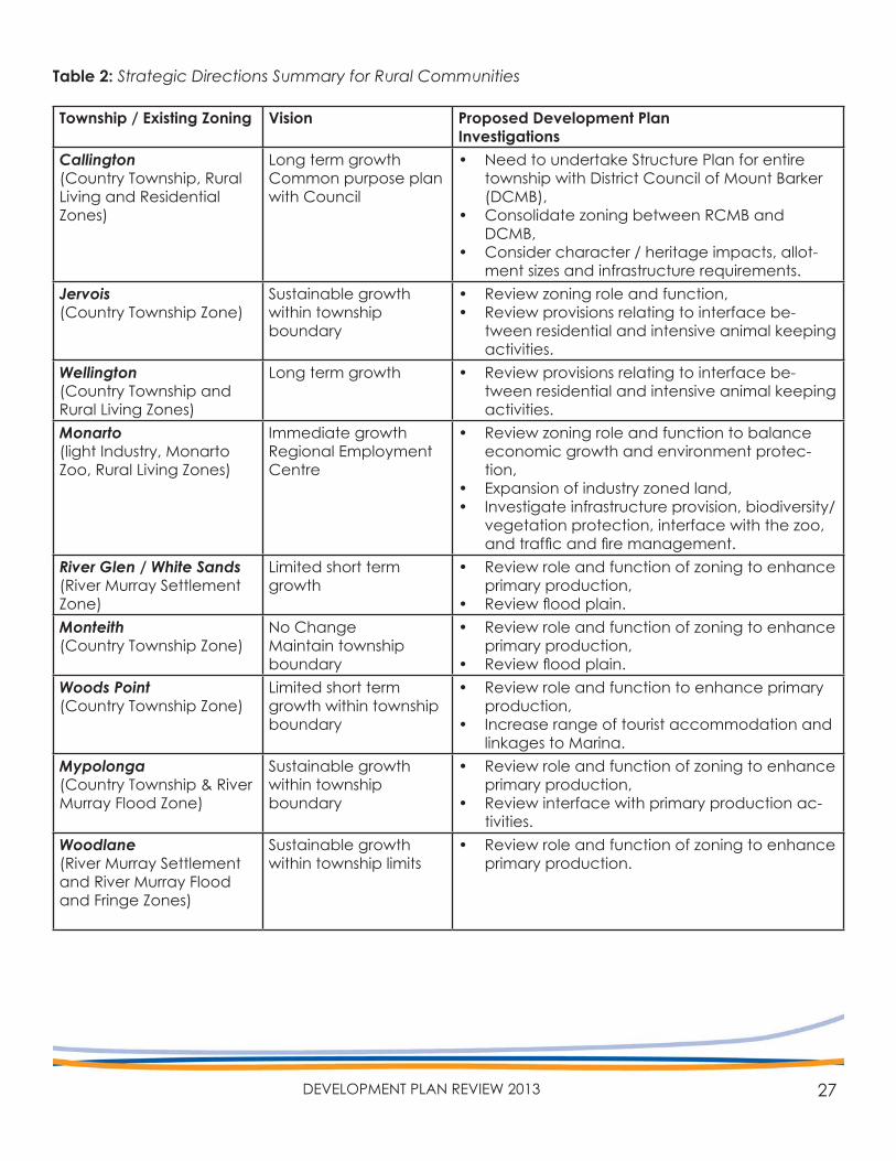
A summary of key strategic directions and potential Development Plan implications for each township is summarized in Table 2.
27DEVELOPMENT PLAN REVIEW 2013
Township / Existing Zoning Vision Proposed Development PlanInvestigations
Callington(Country Township, Rural Living and Residential Zones)
Long term growthCommon purpose plan with Council
• Need to undertake Structure Plan for entire township with District Council of Mount Barker (DCMB),
• Consolidate zoning between RCMB and DCMB,
• Consider character / heritage impacts, allot-ment sizes and infrastructure requirements.
Jervois(Country Township Zone)
Sustainable growth within townshipboundary
• Review zoning role and function,• Review provisions relating to interface be-
tween residential and intensive animal keeping activities.
Wellington(Country Township and Rural Living Zones)
Long term growth • Review provisions relating to interface be-tween residential and intensive animal keeping activities.
Monarto(light Industry, Monarto Zoo, Rural Living Zones)
Immediate growthRegional Employment Centre
• Review zoning role and function to balance economic growth and environment protec-tion,
• Expansion of industry zoned land,• Investigate infrastructure provision, biodiversity/
vegetation protection, interface with the zoo, and traffic and fire management.
River Glen / White Sands(River Murray Settlement Zone)
Limited short term growth
• Review role and function of zoning to enhance primary production,
• Review flood plain.Monteith(Country Township Zone)
No ChangeMaintain township boundary
• Review role and function of zoning to enhance primary production,
• Review flood plain.Woods Point(Country Township Zone)
Limited short term growth within township boundary
• Review role and function to enhance primary production,
• Increase range of tourist accommodation and linkages to Marina.
Mypolonga(Country Township & River Murray Flood Zone)
Sustainable growth within townshipboundary
• Review role and function of zoning to enhance primary production,
• Review interface with primary production ac-tivities.
Woodlane(River Murray Settlement and River Murray Flood and Fringe Zones)
Sustainable growth within township limits
• Review role and function of zoning to enhance primary production.
Table 2: Strategic Directions Summary for Rural Communities
28 RURAL CITY OF MURRAY BRIDGE
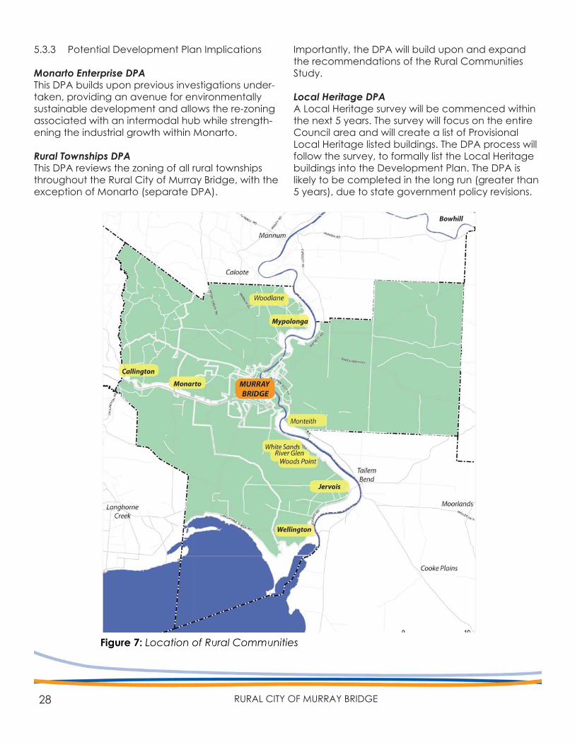
5.3.3 Potential Development Plan Implications
Monarto Enterprise DPAThis DPA builds upon previous investigations under-taken, providing an avenue for environmentally sustainable development and allows the re-zoning associated with an intermodal hub while strength-ening the industrial growth within Monarto.
Rural Townships DPAThis DPA reviews the zoning of all rural townships throughout the Rural City of Murray Bridge, with the exception of Monarto (separate DPA).
Importantly, the DPA will build upon and expand the recommendations of the Rural Communities Study.
Local Heritage DPA A Local Heritage survey will be commenced within the next 5 years. The survey will focus on the entire Council area and will create a list of Provisional Local Heritage listed buildings. The DPA process will follow the survey, to formally list the Local Heritage buildings into the Development Plan. The DPA is likely to be completed in the long run (greater than 5 years), due to state government policy revisions.
Figure 7: Location of Rural Communities
29DEVELOPMENT PLAN REVIEW 2013
AND ENVIRONMENTALSUSTAINABILITY
6. PRIMARY PRODUCTION
30 RURAL CITY OF MURRAY BRIDGE
The Planning Strategy for South Australia, the vision for the Rural City of Murray Bridge and strategic growth studies all highlight opportunities for growth within the Rural City of Murray Bridge. However, it is critical that growth ensures that the primary production industry, which underpins the region’s economy, remains viable and sustainable in the long term future. Environmental sustainability and primary production viability are interrelated and will continue to depend on each other. This section seeks to discuss the key issues facing primary pro-duction and environmental sustainability in a Devel-opment Plan context.
6.1 Primary Production
Spatially, a significant majority of the Council area is both used and zoned for ‘Primary Production’ pur-poses. The region’s economy is underpinned by the primary production industry, particularly when value adding industries are taken into account. It is criti-cal that primary production activities continue to remain viable within the Rural City of Murray Bridge, while facing future challenges brought about by economic uncertainty, climate change and urban encroachment.
The planning policies within the Primary Production Zone have been recently updated through a DPA that affected all zones and policy areas within the Council, which was undertaken in 2009. A compre-hensive review of the Primary Production Zone was last undertaken in 2008, which generally identified and created the policy areas that are currently within the Development Plan.
A review of the Primary Production Zone policies identifies that existing and potential primary pro-duction activities within the Rural City of Murray Bridge can be established or operate without un-reasonable constraint from the Development Plan policy. Most policies are consistent with the current policy standards set by the State Government. Council do not have immediate plans to undertake a comprehensive review of the Primary Production Zone policies.
The State government and Regional Development Australia are currently undertaking studies in iden-tifying rural industry trends and primary production priority areas, which is likely to inform future review and investigations surrounding Primary Production Zone policies and how they apply across the State.
6.1.1 Potential Development Plan Implications
Council will undertake minor amendments to Land Division policies within the Primary Production Zone as part of a proposed ‘high priority’ DPA, detailed in Section 7 (eg. Strategic Sites DPA. The intent of these amendments will be to minimise ambiguity and speculation surrounding the division of primary production land into small allotments.
The loss of primary production land will also need to be investigated and appropriately justified as part of any DPA concerning growth.
6.2 The Interface Between Primary Production and Township Areas
Managing the interface between primary produc-tion activities and urban areas and townships is extremely important to ensure that primary produc-tion remains viable and urban amenity is not unduly compromised. This was an important issue raised in various community submissions during the com-munity consultation of the Rural Communities Study and Murray Bridge Structure Plan. Further, protect-ing the ‘right to farm’ has become increasingly important.
The Murray Bridge Council Development Plan cur-rently contains general policies relating to ‘inter-face between land uses’. These policies generally promote:
• Identification of appropriate separation distanc-es between primary production and sensitive land uses,
• Protection of primary production use from urban encroachment, and,
• The need for urban development and sensitive uses to consider the impacts of adjoining land uses.
31DEVELOPMENT PLAN REVIEW 2013
In addition, the Environment Protection Authority have also prepared document titled ‘Guidelines for separation distances’ (2007). This document recommends separation distances to be applied during the assessment of development applications to ensure that incompatible land uses are located in a way that minimises impacts caused by noise, odour, polluting air emissions and/or water polluting activities.
General policies relating to the interface between land uses and urban encroachment within the Development Plan are likely to be updated in the future as ‘best practice’ standards evolve and technology advances. However, it is most likely that such policy changes will be initiated by State Government.
6.3.1 Potential Development Plan Implications
Each of the proposed DPAs relating to urban growth initiated by Council over the next 5 years will importantly need to consider and appropriately manage rural interface issues with primary produc-tion activities (e.g. Rural Townships DPA).
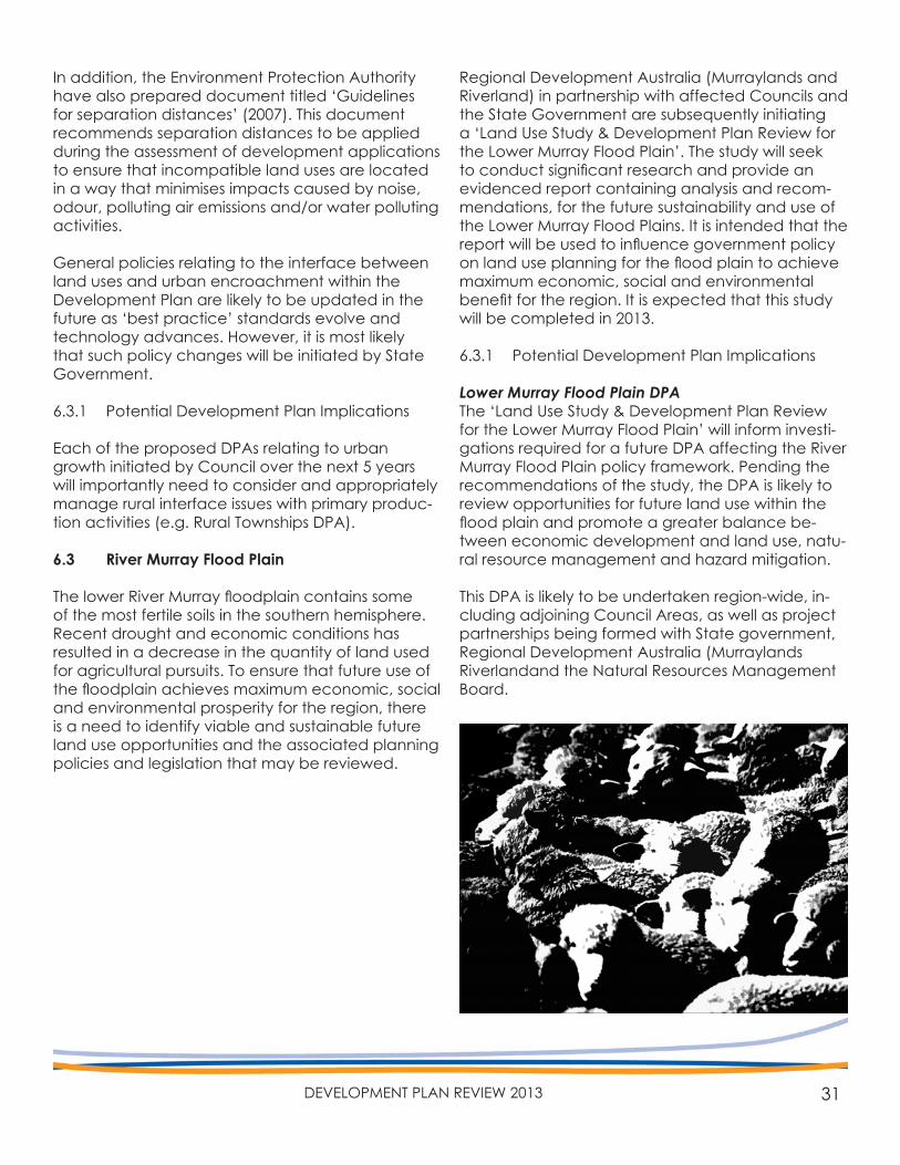
6.3 River Murray Flood Plain
The lower River Murray floodplain contains some of the most fertile soils in the southern hemisphere. Recent drought and economic conditions has resulted in a decrease in the quantity of land used for agricultural pursuits. To ensure that future use of the floodplain achieves maximum economic, social and environmental prosperity for the region, there is a need to identify viable and sustainable future land use opportunities and the associated planning policies and legislation that may be reviewed.
Regional Development Australia (Murraylands and Riverland) in partnership with affected Councils and the State Government are subsequently initiating a ‘Land Use Study & Development Plan Review for the Lower Murray Flood Plain’. The study will seek to conduct significant research and provide an evidenced report containing analysis and recom-mendations, for the future sustainability and use of the Lower Murray Flood Plains. It is intended that the report will be used to influence government policy on land use planning for the flood plain to achieve maximum economic, social and environmental benefit for the region. It is expected that this study will be completed in 2013.
6.3.1 Potential Development Plan Implications
Lower Murray Flood Plain DPAThe ‘Land Use Study & Development Plan Review for the Lower Murray Flood Plain’ will inform investi-gations required for a future DPA affecting the River Murray Flood Plain policy framework. Pending the recommendations of the study, the DPA is likely to review opportunities for future land use within the flood plain and promote a greater balance be-tween economic development and land use, natu-ral resource management and hazard mitigation.
This DPA is likely to be undertaken region-wide, in-cluding adjoining Council Areas, as well as project partnerships being formed with State government, Regional Development Australia (Murraylands Riverlandand the Natural Resources Management Board.
32 RURAL CITY OF MURRAY BRIDGE
6.4 Environmental Sustainability
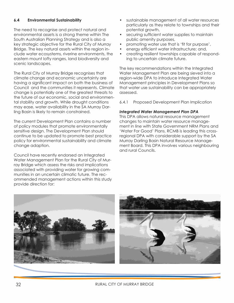
The need to recognise and protect natural and environmental assets is a strong theme within The South Australian Planning Strategy and is also a key strategic objective for the Rural City of Murray Bridge. The key natural assets within the region in-clude water ecosystems, riverine environments, the eastern mount lofty ranges, land biodiversity and scenic landscapes.
The Rural City of Murray Bridge recognises that climate change and economic uncertainty are having a significant impact on both the business of Council and the communities it represents. Climate change is potentially one of the greatest threats to the future of our economic, social and environmen-tal stability and growth. While drought conditions may ease, water availability in the SA Murray Dar-ling Basin is likely to remain constrained.
The current Development Plan contains a number of policy modules that promote environmentally sensitive design. The Development Plan should continue to be updated to promote best practice policy for environmental sustainability and climate change adaption.
Council have recently endorsed an Integrated Water Management Plan for the Rural City of Mur-ray Bridge which assess the risks and implications associated with providing water for growing com-munities in an uncertain climatic future. The rec-ommended management actions within this study provide direction for:
• sustainable management of all water resources particularly as they relate to townships and their potential growth,
• securing sufficient water supplies to maintain public amenity purposes,
• promoting water use that is ‘fit for purpose’,• energy efficient water infrastructure; and,• creating resilient townships capable of respond-
ing to uncertain climate future.
The key recommendations within the Integrated Water Management Plan are being sieved into a region-wide DPA to introduce Integrated Water Management principles in Development Plans so that water use sustainability can be appropriately assessed.
6.4.1 Proposed Development Plan Implication
Integrated Water Management Plan DPAThis DPA allows natural resource management changes to maintain water resource manage-ment in line with State Government NRM Plans and ‘Water For Good’ Plans. RCMB is leading this cross-regional DPA with considerable support by the SA Murray Darling Basin Natural Resource Manage-ment Board. This DPA involves various neighbouring and rural Councils.
33DEVELOPMENT PLAN REVIEW 2013
PLAN AMENDMENTPROGRAM
7. PROPOSED DEVELOPMENT
34 RURAL CITY OF MURRAY BRIDGE
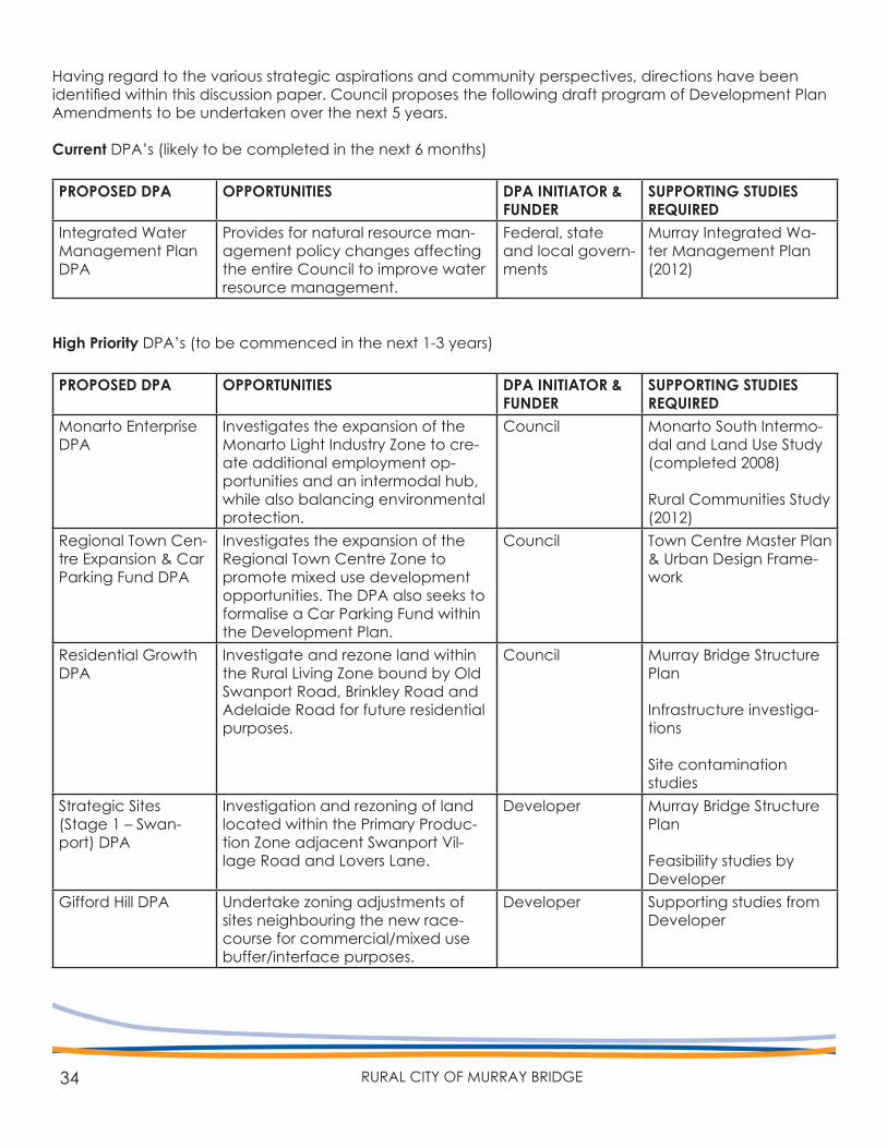
Having regard to the various strategic aspirations and community perspectives, directions have been identified within this discussion paper. Council proposes the following draft program of Development Plan Amendments to be undertaken over the next 5 years.
Current DPA’s (likely to be completed in the next 6 months)
PROPOSED DPA OPPORTUNITIES DPA INITIATOR & FUNDER
SUPPORTING STUDIES REQUIRED
Integrated Water Management Plan DPA
Provides for natural resource man-agement policy changes affecting the entire Council to improve water resource management.
Federal, state and local govern-ments
Murray Integrated Wa-ter Management Plan (2012)
High Priority DPA’s (to be commenced in the next 1-3 years)
PROPOSED DPA OPPORTUNITIES DPA INITIATOR & FUNDER
SUPPORTING STUDIES REQUIRED
Monarto Enterprise DPA
Investigates the expansion of the Monarto Light Industry Zone to cre-ate additional employment op-portunities and an intermodal hub, while also balancing environmental protection.
Council Monarto South Intermo-dal and Land Use Study (completed 2008)
Rural Communities Study (2012)
Regional Town Cen-tre Expansion & Car Parking Fund DPA
Investigates the expansion of the Regional Town Centre Zone to promote mixed use development opportunities. The DPA also seeks to formalise a Car Parking Fund within the Development Plan.
Council Town Centre Master Plan & Urban Design Frame-work
Residential Growth DPA
Investigate and rezone land within the Rural Living Zone bound by Old Swanport Road, Brinkley Road and Adelaide Road for future residential purposes.
Council Murray Bridge Structure Plan
Infrastructure investiga-tions
Site contaminationstudies
Strategic Sites (Stage 1 – Swan-port) DPA
Investigation and rezoning of land located within the Primary Produc-tion Zone adjacent Swanport Vil-lage Road and Lovers Lane.
Developer Murray Bridge Structure Plan
Feasibility studies by Developer
Gifford Hill DPA Undertake zoning adjustments of sites neighbouring the new race-course for commercial/mixed use buffer/interface purposes.
Developer Supporting studies from Developer
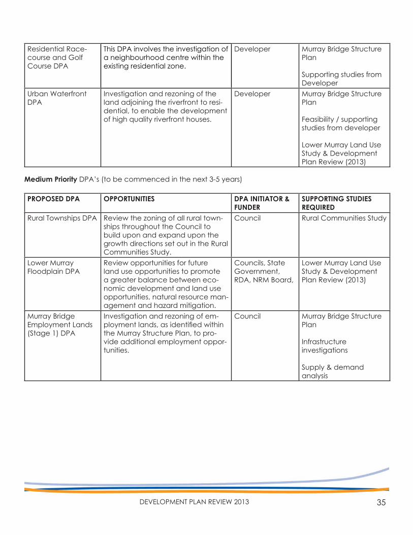
35DEVELOPMENT PLAN REVIEW 2013
Residential Race-course and Golf Course DPA
This DPA involves the investigation of a neighbourhood centre within the existing residential zone.
Developer Murray Bridge Structure Plan
Supporting studies from Developer
Urban Waterfront DPA
Investigation and rezoning of the land adjoining the riverfront to resi-dential, to enable the development of high quality riverfront houses.
Developer Murray Bridge Structure Plan
Feasibility / supporting studies from developer
Lower Murray Land Use Study & Development Plan Review (2013)
Medium Priority DPA’s (to be commenced in the next 3-5 years)
PROPOSED DPA OPPORTUNITIES DPA INITIATOR & FUNDER
SUPPORTING STUDIES REQUIRED
Rural Townships DPA Review the zoning of all rural town-ships throughout the Council to build upon and expand upon the growth directions set out in the Rural Communities Study.
Council Rural Communities Study
Lower MurrayFloodplain DPA
Review opportunities for future land use opportunities to promote a greater balance between eco-nomic development and land use opportunities, natural resource man-agement and hazard mitigation.
Councils, State Government, RDA, NRM Board,
Lower Murray Land Use Study & Development Plan Review (2013)
Murray Bridge Employment Lands (Stage 1) DPA
Investigation and rezoning of em-ployment lands, as identified within the Murray Structure Plan, to pro-vide additional employment oppor-tunities.
Council Murray Bridge Structure Plan
Infrastructureinvestigations
Supply & demandanalysis
36 RURAL CITY OF MURRAY BRIDGE
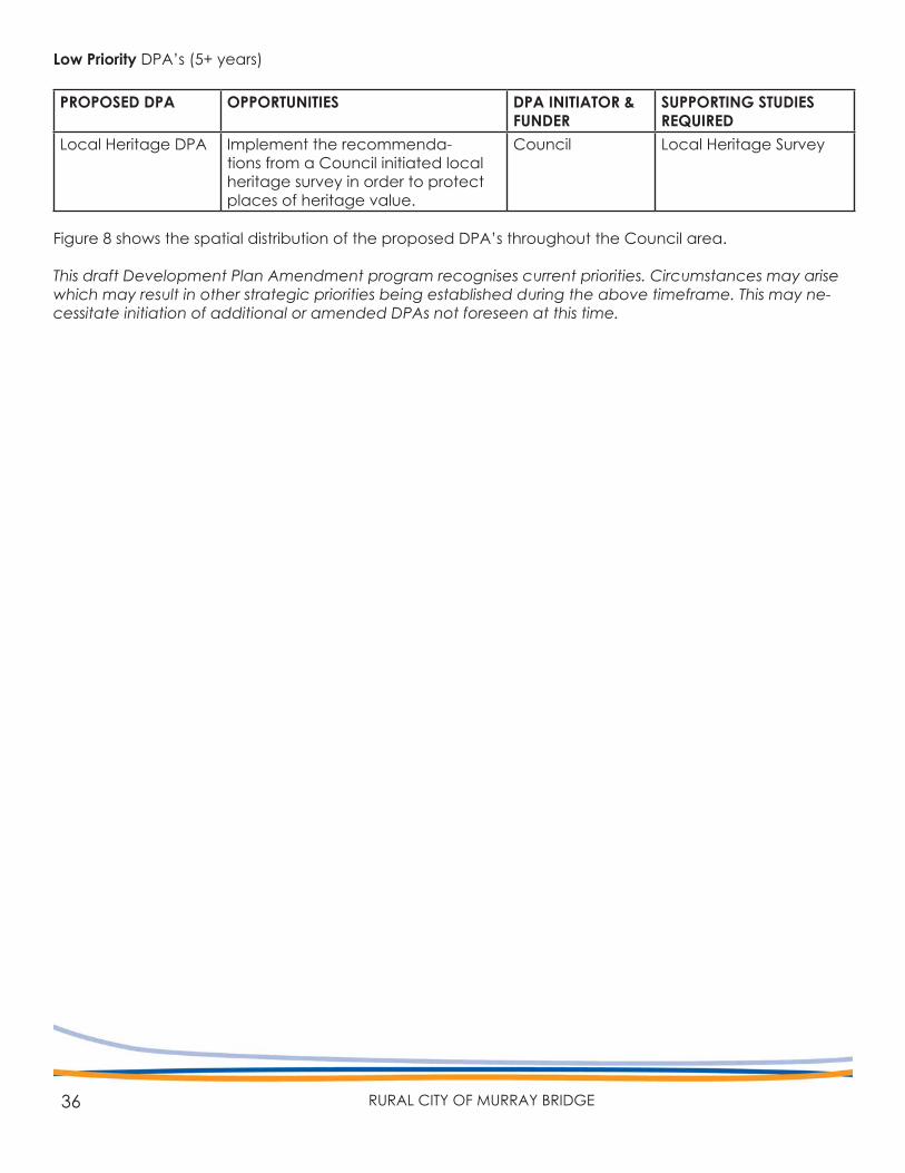
Low Priority DPA’s (5+ years)
PROPOSED DPA OPPORTUNITIES DPA INITIATOR & FUNDER
SUPPORTING STUDIES REQUIRED
Local Heritage DPA Implement the recommenda-tions from a Council initiated local heritage survey in order to protect places of heritage value.
Council Local Heritage Survey
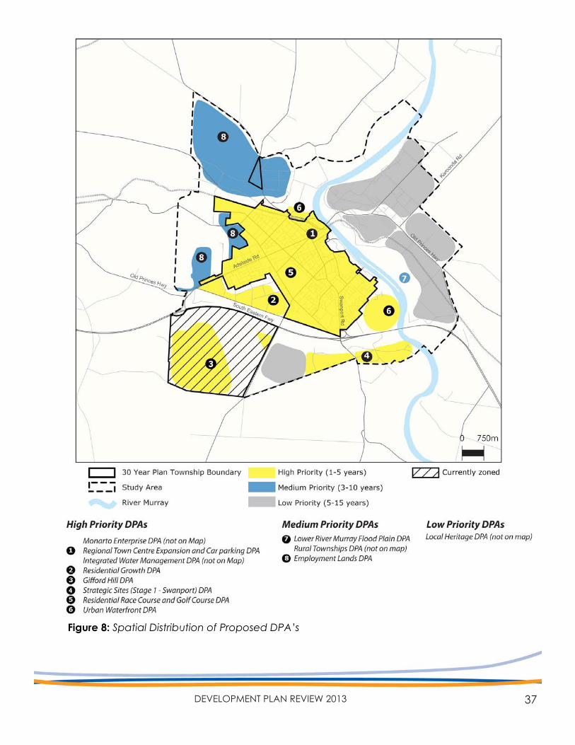
Figure 8 shows the spatial distribution of the proposed DPA’s throughout the Council area.
This draft Development Plan Amendment program recognises current priorities. Circumstances may arise which may result in other strategic priorities being established during the above timeframe. This may ne-cessitate initiation of additional or amended DPAs not foreseen at this time.
37DEVELOPMENT PLAN REVIEW 2013
Figure 8: Spatial Distribution of Proposed DPA’s
RURAL CITY OF MURRAY BRIDGE
Written submission should be addressed to:
Development Plan Review 2013Rural City of Murray BridgePO Box 421, Murray Bridge SA 5253Email: [email protected]: 08 8532 2766
Consultation closes 5pm Monday, 8 April 2013
Council thanks Krista Jensen (volunteer Urban Design Project Officer) for the pho-tography contained within this document
For further information about this document, please contact Council’s Policy Planners:
Mabel John p: 8539 1151 e: [email protected] Herrmann p: 8539 1121 e: [email protected]
Top Related