


Languages
Pages
Legal


National Spatial Data Infrastructure Training Program
Requirements Analysis Summary Report July 1, 2006 Submitted by: Lynda Wayne, GeoMaxim
Report prepared as part of the National Spatial Data Infrastructure (NSDI)
Training Program Development effort sponsored by the Federal Geographic Data Committee (FGDC) and the USGS National Geospatial Program Office (NGPO).
I Program Coordination and Requirements Analysis 2. Requirements Analysis
Milestone 1: NSDI Training Program Requirements Analysis Report Report, updates and supporting materials available at:
http://www.fgdc.gov/training/nsdi-training-program/workspace/requirements-analysis/

July 1, 2006
NSDI Training Program Requirements Analysis Summary Report
Table of Contents Executive Summary ......................................................................................................1 Requirement Analysis Participants................................................................................4 Methodology..................................................................................................................5 Application of Findings ..................................................................................................7 General Requirements
FGDC/NGPO Administration ...................................................................................8 USGS Geospatial Liaisons ......................................................................................8 Regional and Local Government (URISA) ...............................................................9 State Government....................................................................................................9 Tribal Community.....................................................................................................9
Curriculum Content .......................................................................................................10 Curriculum Outline ...................................................................................................11
Training Delivery ...........................................................................................................12 Training Module Priority ................................................................................................13 Curriculum-specific Learning Objectives and FAO Issues.............................................15
NSDI Overview ........................................................................................................15 Geospatial One-Stop ...............................................................................................18 Geospatial Metadata................................................................................................19 RAMONA .................................................................................................................20 Web Services...........................................................................................................20 Geospatial Data Management: Best Practices ........................................................21 NSDI Standards Overview .......................................................................................21 NSDI Data Themes and The National Map Implementation ....................................22 Spatial Data Infrastructures and Governance ..........................................................23 Federal Partnership Opportunities ...........................................................................25 Enterprise Architecture ............................................................................................27
Appendix: FAO Requirement Analyses Supporting Documents....................................28

July 1, 2006
NSDI Training Program Requirements Analysis page 1
Executive Summary The National Spatial Data Infrastructure (NSDI) Training Program Requirements Analysis was performed in two parts. Part one focused on the identification of the Federal Geographic Data Committee (FGDC) and the USGS National Geospatial Program Office (FGDC/NGPO) Administration programmatic requirements with regard to scope, schedule, and implementation methods. Part two focused on the identification of the NSDI-related training needs of several key Focus Audience Organizations (FAOs). FGDC/NGPO Administration Training Program Requirements The NSDI Training Program Manager met with members of the FGDC/FGDC/NGPO Administration October 24, 2005 at USGS Headquarters in Reston VA to review the NSDI Training Program Workplan (vers. August 2005), a draft curriculum outline, and an initial list of Subject Matter Experts (SMEs). FGDC/FGDC/NGPO Administrators discussed specific content, SME assignments, and schedule requirements. The information was then revised via a series of email discussions and document reviews.
Four key Administrative program requirements emerged: 1. The NSDI Curriculum Outline should be reorganized to directly reflect the following
components of the FGDC/NGPO mission statement:
• Geospatial Data Discovery and Access
• Geospatial Data Integration
• NSDI Institutional Elements
• USGS Geospatial Data Products. 2. Training materials are to be optimally developed for online learning but may be initially
formatted for classroom delivery if technical skills and tools are not adequate and/or available.
3. Initial training modules should be available from the FGDC website by August 31, 2006.
4. The NSDI Program Project Manager should make every effort to maximize content development and technical implementation support and minimize the amount of time and effort required of Subject Matter Experts.
NSDI Focus Audience Organization NSDI Training Program Requirements: The Focus Audience Organization (FAO) NSDI Training Program Requirements extended from October 2005 to May 2006. Focus Audience Organization: Period of Review: USGS Geospatial Liaisons October-December 2005 Local/Regional Community (URISA) January – February 2006 State Government Community (NSGIC) February – March 2006 Tribal Community March – May 2006 The method of analysis varied with each FAO. The USGS Geospatial Liaisons were able to build upon existing efforts to identify a broader set of Liaison training needs. The Program Knowledge component of this broader study identified priority NSDI Training topics and provided a framework for collecting module-specific Learning Objectives and Liaison-specific training requirements. The Local/Regional Community established a Working Group, through the Urban and Regional Information Systems Association (URISA), that participated in a

July 1, 2006
NSDI Training Program Requirements Analysis page 2
series of FGDC facilitated telecons and exercises that identified training priorities, learning objectives, and methods for distributing training. The State Government Community identified a single National States GIS Council (NSGIC) representative to work with FGDC to draft a set of training requirements for initial review by a small Working Group, then full review by the NSGIC community. The FGDC Tribal Coordinator took the lead with the Tribal Community and presented key members of the tribal community with a set of questions and ranking exercises developed by the Training Program Project Manager. The training requirements of the Academic Community were extracted from the Geographic Information Science and Technology (GI & ST) Body of Knowledge developed by the University Consortium for Geographic Information Science (UCGIS) and soon to be published by the American Association of Geographers (AAG).
Four general FAO training requirements emerged as primary: 1. The core module for each NSDI component must emphasize and make clear the
benefits of stakeholder participation:
• How will participation in the NSDI, geodata.gov, standards, etc. benefit my organization?
• What return on investment will my organization realize by participating in the NSDI?
2. NSDI programs must be presented in logical manner that outlines each program’s role in building and maintaining the NSDI and provides a clear picture as to how the programs relate to one another:
• How is The National Map (TNM) different from Framework Data and the NSDI Data Themes?
• How is Geospatial One-Stop different from the NSDI Clearinghouse and the TNM Viewer?
3. The NSDI must be presented as a National vs. Federal initiative and provide specific guidance for building collaborative SDIs at the state, local, and tribal levels that support and build upon the National SDI:
• How can I coordinate with neighboring communities to address local geospatial data issues and contribute to national data collections?
• How are my data needs recognized in the standards development process? 4. One standard model for Training Distribution is not feasible. Instead, a variable model
should be developed to present alternative scenarios of participant (fed, state, local, tribal, other) roles and responsibilities. The Tribal Community expressed special concerns regarding long-distance travel and the importance of presenting information in familiar context and environment.
A unique theme emerged from the priorities and learning objectives expressed by each of the FAOs during the individual Requirement Analyses:
USGS Geospatial Liaisons Theme: Communications Liaisons consistently referred to the need for ‘a clear consistent message’ to support them in promoting the NSDI and engaging stakeholders. Specific references were made to the need for programmatic information that 1) outlines the purpose, key objectives and methods for stakeholder participation for each NSDI initiatives and 2) provides a clear ‘big picture’ of how the initiatives relate in support of the NSDI.

July 1, 2006
NSDI Training Program Requirements Analysis page 3
Local/Regional Government via URISA Theme: Implementation URISA expressed the need to provide practical methods for NSDI implementation. Special emphasis was placed on ‘capacity building’ in the areas of: building regional collaborations, making the business case to decision-makers, applying standards to data development and the use of success stories to provide a clear-road map to NSDI implementation at the local level. State Government via NSGIC Theme: Policy NSGIC emphasized the need for a better understanding of NSDI policies that can support State coordination with local/regional government and, increasingly, the private sector, in the development of NSDI enabled data resources. Many of the NSGIC learning objectives were derived from questions about: governance of the NSDI, the impact of NSDI on local/state policies and resources, and roles and responsibilities with respect to data integration, security, and access. Tribal Community Theme: Cultural Values The Tribal community highlighted the importance of understanding and respecting cultural values. Training requirements expressed by the tribal respondents included the need to: provide training at tribal facilities preferably using tribal instructors, address issues relating to the protection of culturally sensitive data, and support the tribes in building internal NSDI capacity and a voice as an NSDI stakeholder.
Application of the Training Program Requirement Analysis Findings The Training Program priorities suggested by the FAOs were used to both update the Curriculum Outline and to prioritize the development of module content. The Learning Objectives suggested by the FAOs were compiled and are provided as a resource to the Subject Matter Experts (SMEs) for use in developing module-specific content. Community-specific training requirements that address the role of the FAO and cultural sensitivities are provided for those providing training to the FAO. Discussions and exercises relative to training delivery were used to develop an NSDI Training Delivery Conceptual Model in which State GIS Coordinators are identified as best able to fill the critical role of logistical support.
July 1, 2006
NSDI Training Program Requirements Analysis page 4
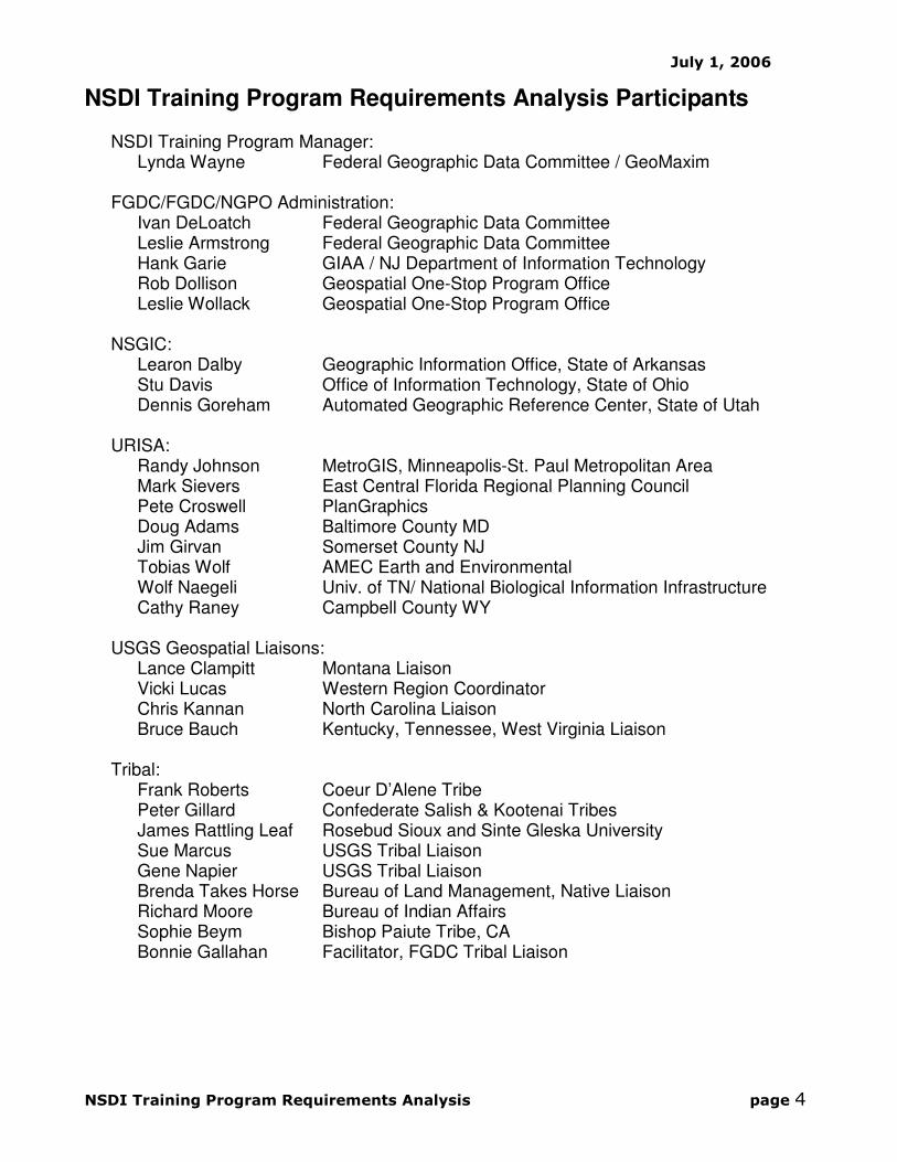
NSDI Training Program Requirements Analysis Participants NSDI Training Program Manager:
Lynda Wayne Federal Geographic Data Committee / GeoMaxim FGDC/FGDC/NGPO Administration:
Ivan DeLoatch Federal Geographic Data Committee Leslie Armstrong Federal Geographic Data Committee Hank Garie GIAA / NJ Department of Information Technology Rob Dollison Geospatial One-Stop Program Office Leslie Wollack Geospatial One-Stop Program Office
NSGIC:
Learon Dalby Geographic Information Office, State of Arkansas Stu Davis Office of Information Technology, State of Ohio Dennis Goreham Automated Geographic Reference Center, State of Utah
URISA: Randy Johnson MetroGIS, Minneapolis-St. Paul Metropolitan Area Mark Sievers East Central Florida Regional Planning Council Pete Croswell PlanGraphics Doug Adams Baltimore County MD Jim Girvan Somerset County NJ Tobias Wolf AMEC Earth and Environmental Wolf Naegeli Univ. of TN/ National Biological Information Infrastructure Cathy Raney Campbell County WY
USGS Geospatial Liaisons:
Lance Clampitt Montana Liaison Vicki Lucas Western Region Coordinator Chris Kannan North Carolina Liaison Bruce Bauch Kentucky, Tennessee, West Virginia Liaison
Tribal:
Frank Roberts Coeur D’Alene Tribe Peter Gillard Confederate Salish & Kootenai Tribes James Rattling Leaf Rosebud Sioux and Sinte Gleska University Sue Marcus USGS Tribal Liaison Gene Napier USGS Tribal Liaison Brenda Takes Horse Bureau of Land Management, Native Liaison Richard Moore Bureau of Indian Affairs Sophie Beym Bishop Paiute Tribe, CA Bonnie Gallahan Facilitator, FGDC Tribal Liaison

July 1, 2006
NSDI Training Program Requirements Analysis page 5
Methodology The initial phase of the Requirements Analysis identified the FGDC/FGDC/NGPO Administration program requirements and refined the:
• Workplan approach
• Curriculum outline
• Subject Matter Expert (SME) identity, roles and responsibilities. The second phase of the Requirements Analysis identified the Focus Audience Organization (FAO) program requirements. Methods varied slightly with each group but generally addressed:
• Curriculum module ranking
• Curriculum module-specific learning objectives
• Special training needs and interests. The methods employed with each group are outlined below.
FGDC/FGDC/NGPO Administration
The NSDI Training Program Manager met with the FGDC/FGDC/NGPO Administration October 24, 2005 at USGS Headquarters in Reston VA. The NSDI Training Program Workplan (August 2005) was reviewed and an initial curriculum outline and list of Subject Matter Experts was presented. Administrators reviewed the materials with the Program Manager and established specific schedule requirements and expectations. Revisions to the Training Program Workplan and the Curriculum Outline were finalized via follow-up email correspondence.
USGS Geospatial Liaisons
The NSDI Training Program Manager met with the ‘Liaisons’ Functions Team’ during the NSGIC Annual Meeting held in Rochester NY, October 2005. The Liaisons’ Function Team had already performed a Liaison Training Needs Analysis and developed a table of results. While many of the Liaison training needs related to business practices, e.g. contracting methods and outreach skills, the ‘Program Knowledge’ section of the table highlighted NSDI components upon which the liaisons felt formalized training was needed. This prior work played a significant role in organizing the USGS Geospatial Liaisons Requirements Analysis.
A form was developed for each of the ‘Program Knowledge’ topics to capture specific liaison instructional needs including.
• an abstract that outlined the key topics the module should address,
• questions the module must answer,
• preferred methods for training implementation and
• special, module-related, liaison needs/interest

July 1, 2006
NSDI Training Program Requirements Analysis page 6
The form was completed for each of the Liaison specified ‘Program Knowledge’ topics by members of the Liaisons’ Function Team. The forms were then reviewed by the Regional Geographers and submitted to the NSDI Training Program Manager for compilation and extraction of NSDI Training Module-specific learning objectives. A draft report was presented to the Liaisons’ Function Team for review and the final information presented to the USGS Geospatial Liaisons at the NSGIC Midyear Meeting held in Annapolis MD, March 2006.
Regional and Local Government (URISA)
The NSDI Training Program Manager distributed a request for participation in the URISA NSDI Training Program Analysis Working Group via the URISA listserver in January 2006. Eight URISA members responded and participated in a series of telecons and exercises that addressed:
• the proposed curriculum content
• critical issues and questions the modules must address
• methods for distributing training delivery in cooperation with local and state governments
A summary report was generate by the NSDI Training Program Manager after each telecon and distributed to the Working Group participants for review via email. Working Group comments/corrections were incorporated and reviewed at the next telecom. URISA generated questions that the NSDI Training Program must address were compiled into a summary document. Three telecons were held between January 24 and February 28.
State Government (NSGIC)
The NSDI Training Program Manager contacted the NSGIC President, Tony Spicci, in January 2006 to discuss a method of approach to solicit NSGIC NSDI Training Requirements. Mr. Spicci and the NSGIC Board of Directors appointed 3 members to the NSGIC Training Requirements Working Group. The NSDI Training Program Manager and NSGIC Member, Mr. Learon Dalby (AR GIO), reviewed the documents developed during both the USGS Geospatial Liaisons and URISA Training Requirements Analysis and generated a draft NSGIC NSDI Training Requirements document that outlined:
• NSDI terms and definitions
• NSGIC questions that must be addressed by the NSDI Training Program
• Special interests/requirements The draft document was circulated among the NSGIC NSDI Training Program Working Group members and all comments/suggestions compiled by Mr. Dalby. Mr. Dalby circulated the completed document to the NSGIC membership via email, presented core components to the NSGIC membership during the NSGIC Midyear Meeting in Annapolis and held an open discussion for final input during the NSGIC meeting. Membership comments were compiled by Mr. Dalby into the NSGIC NSDI Training Program Requirements Analysis final report.

July 1, 2006
NSDI Training Program Requirements Analysis page 7
Tribal Community
After reviewing the documents developed by the other FAOs with the FGDC Training Coordinator and Tribal Liaison, Bonne Gallahan, the NSDI Training Program Manager developed a set of questions and ranking exercises for distribution to key members of the geospatial tribal community. Ms. Gallahan, coordinated input from the tribal community and the NSDI Training Program manager compiled the responses and extracted the tribal training requirements.
Application of Findings Curriculum Changes The Requirement Analysis resulted in the identification of new training modules, e.g. Geospatial Collaboration, and needed revisions to existing training modules. These changes are reflected in the revised Curriculum Outline presented on page 11. Module Prioritization FAO interest level for each training module was determined by both ranking exercises and the number of learning objectives identified for the topic. This information was assessed with other factors including the availability of existing training materials and the primacy of core modules to determine the relative priority of each module. A table of results is presented on pages 13 and 14. Module Development The primary purpose of the Requirements Analysis is to provide SMEs insights into the NSDI training expectations and desires of the FAOs. As such, the Requirements Analysis should serve as an initial roadmap for training module content development. The learning objectives outlined for each module should be considered baseline requirements and expanded upon with the SME’s own insights. NSDI Training Delivery The discussions held and exercises performed with each of the FAOs yielded critical information about training delivery options and illustrated the wide variation in training capacity within each of the FAOs. This information was used to develop the NSDI Training Distribution Conceptual Model presented on page 12.
The community-specific training requirements extracted during the Requirements Analysis identify cultural sensitivities and reflect the specific work objectives of the FAOs. As such they provide insight into the needs of the specific community and should be used to tailor training content and delivery to FAO and FAO-related organizations.

July 1, 2006
NSDI Training Program Requirements Analysis Summary Report page 8
General Requirements
FGDC/FGDC/NGPO Administration General Requirements
FGDC/FGDC/NGPO Administrative representatives suggested that the curriculum be re-organized around the following key NSDI implementation initiatives as established by the FGDC/NGPO Strategic Plan (vers. Oct 2005):
• Geospatial Data Discovery and Access
• Geospatial Data Integration
• NSDI Institutional Elements
• USGS Geospatial Data Products
Administrators stressed the importance of developing NSDI Online Learning capabilities. However, it was recognized the development of an Online Learning System (OLS) and the formatting of materials for the OLS would require additional research, skills, and technological resources. It was decided to proceed with traditional classroom presentation materials development and initiate a parallel OLS research and development effort with the understanding that as OLS format and content requirements were developed they would be incorporated into the development of new materials and guide the conversion of existing training materials. As a step toward online learning, Administrators requested the development of an NSDI Training Program page as part of the FGDC website redesign. The initial page design (http://www.fgdc.gov/training) includes basic information about the objectives of the NSDI Training Program and links to available training resources including the Metadata Curriculum, training documents, Metadata Training Calendar and Metadata Trainer Registry. Training resources for other NSDI components will be added as available. A password-protected NSDI Training Program workspace was established in June 2006 to house the Requirement Analysis reports and supporting documents (see Appendix). Initial NSDI training modules, as proposed by the Training Module Priorities presented on page 13, should be made available from the FGDC website by August 31, 2006. As training materials development proceeds, Administrators expressed concern as to the burden that would be placed on Subject Matters Experts (SMEs). It was emphasized that the NSDI Program Project Manager should make every effort to maximize content development and technical implementation support and minimize the amount of time and effort required of Subject Matter Experts.
USGS Geospatial Liaisons General Requirements
The forms returned by the Liaisons for each of the curriculum module topics consistently referenced the need for ‘a clear consistent message’ to support them in effectively communicating information about the NSDI and engaging stakeholders. Specific references were made to the need for programmatic information that 1) outlines the purpose, key objectives and methods for stakeholder participation for each NSDI initiatives and 2) provides a clear ‘big picture’ of how the initiatives relate to one another in collaborative support of the NSDI.

July 1, 2006
NSDI Training Program Requirements Analysis Summary Report page 9
Regional and Local Government (URISA) General Requirements
URISA expressed the need to focus on training that enabled NSDI implementation. Specific reference was made as to the need for practical methods, case studies, step-by-step procedures and mentoring. Special emphasis was placed on ‘capacity building’ in the areas of: building regional collaborations, making the business case to decision-makers, applying standards to data development and the use of success stories to provide a clear-road map to NSDI implementation at the local level.
State Government (NSGIC) General Requirements
NSGIC emphasized the need for a better understanding of NSDI policy. There was strong interest in supporting the State role as coordinator of NSDI enabled data resources developed by local/regional government and, increasingly, the private sector. Many of the NSGIC learning objectives were derived from questions about: governance of the NSDI, the impact of NSDI on local/state policies and resources, and roles and responsibilities with respect to data integration, security, and access.
Tribal Community General Requirements
The Tribal community highlighted the importance of understanding and respecting cultural values. Tribal respondents submitted questions about the impact of NSDI participation on tribal data management practices and obligations to share internal data with other organizations. Training requirements expressed by the tribal respondents included the need to: provide training at tribal facilities preferably using tribal instructors, address issues relating to the protection of culturally sensitive data, and support the tribes in building internal NSDI capacity and a voice as an NSDI stakeholder.

July 1, 2006
NSDI Training Program Requirements Analysis Summary Report page 10
Curriculum Content The Curriculum Outline presented on the next page was developed with the FGDC/FGDC/NGPO Administration and revised to reflect the interest areas of the FAOs. The curriculum is organized into the four FGDC/NGPO Program Tracks:
• Geospatial Data Discovery and Access
• Geospatial Data Integration
• NSDI Institutional Elements
• USGS Geospatial Data Products Individual training modules are included for each track. These modules are specified as either Core or Target modules. Core modules provided the core information basic to the topic and a general audience. Target modules expand upon the Core content and are intended for a specific audience. Individuals training Target modules are expected to incorporate the Core module into their training or require Core content training and/or knowledge as a pre-requisite to the Target training. The overarching NSDI Overview module is intended to address each of the Program Tracks and provide a comprehensive view of the NSDI. NSDI Overview is considered a prerequisite for any Core module training in the same manner as described above for the Target module training. The Curriculum Outline is a planning document and is expected to change as SMEs are enlisted into the program development process. The current content is based upon user requirements only and does not reflect expertise in the individual subjects. SMEs are asked to carefully review the content and work with the NSDI Training Program Manager to revise each module so that it addresses and expands upon the user requirements within a structure that best suits the module subject. The actual organization of curriculum content will change slightly with the implementation of online learning specifications such as the Sharable Content Object Reference Model (SCORM). SCORM requires the development of ‘small, reusable, learning objects’ that can be mixed and match to build custom content. To implement SCORM, curriculum content must be broken down into smaller topic areas than represented in the NSDI Curriculum Overview presented on the following page. Once these smaller units are developed, the proposed NSDI Online Learning site can provide access to standardized training modules and the ability to build custom training modules for specific communities such as the FAOs.

NSDI Training Program Tracks
NSDI Training Program Requirements Analysis Summary Report page 11
◙ National Spatial Data Infrastructure (NSDI) Overview
National Geospatial Data Products
Geospatial Data Discovery and Access
Geospatial Data
Integration NSDI Institutional
Elements
core target core target core core target
◙ Discovery
and Access
via geodata.gov
Publish to
geodata.gov
and the marketplace
Establish a
metadata
collection / node.
Steward a
geodata.gov community
◙ Value of
Geospatial Metadata
Metadata
Standard
Metadata
Creation and
Tools
Metadata
Implementat
ion
Other:
◙ TNM Viewer and Catalog
◙ RAMONA
Best
Practices for
Geospatial
Data Managemnt
Geospatial Bluebook
◙ NSDI
Standards Overview
◙ NSDI
Data
Themes
Standards
and TNM
Implementation
Hydro & NHD
Ortho & NDOP
Elev. & NED
Transport
Cadastral
Geodetic
Admin Units
SDI and Governance
Geospatial
Collaboration
◙ Federal
Partnership Opportunities
CAP
Enterprise Architecture
National
Atlas
?
DLGs ?
DRGs ?
Topographic Maps
?
other ?
NSDI Training Program Curriculum Outline
target
Core training:
• manager/outreach focus
• should include NSDI Overview
Target training:
• technical focus
• should include NSDI Overview
• should include Core content
◙ indicates USGS Liaison requested content
* as defined by the FGDC/NGPO Strategic Plan (Oct 2005, pg
17)
◙ Web
Services
Data Access
Standard
National
Grid
Framework Base Stnd.
50 States
◙ Project
Homeland
◙Contribute
to TNM
GSDI
◙other

July 1, 2006
NSDI Training Program Requirements Analysis Summary Report page 12
Training Delivery Each of the FAOs was asked to address the issue of training delivery. Most participants were willing to assume a role in the training delivery process but could not commit to a specific role. Instructors and subject area experts exist at all levels of government and private sector and the Training Delivery process must be flexible enough to utilize all available trainers. A Training Delivery plan cannot be determined until the NSDI Training Program is more fully developed and stakeholders have a better understanding of the roles and responsibilities. Further discussion is needed. However, discussions with each of the FAOs make clear that the NSGIC representatives / State Geospatial Coordinators serve a critical role in information dissemination among the NSDI Stakeholders. It would be beneficial to the NSDI Training Program to build upon this information network. In addition, recent discussions with the National Geospatial Technology Extension Network (NGTEN) indicate strong interest in utilizing state Geospatial Extension Specialists to support NSDI Training delivery The following conceptual model outlines draft roles and responsibilities and proposes that State Geospatial Coordinators serve as the key point of contact for NSDI Training Delivery. While not all State Coordinators will have the resources to support the model, it does provide a general direction for further discussion.
Training
Requests:
• collect and
document
• forward to State
Geo Coordinator
State Government
USGS Geospatial
Liaisons Local/Regional Gov
Tribal Community
Federal Agencies
Geospatial
Extension
Specialists
Training
Logistics:
• compile requests
• locate facility
• secure sponsor
• enlist instructor
State Geospatial
Coordinators
Training Sponsor
Fund, as needed:
• facility
• materials
• travel
State Government
Local/Regional Gov
Tribal Community
Federal Agencies
Training
Delivery
• develop training
materials
• lead instruction
State Government
USGS Geospatial
Liaisons Local/Regional Gov
Tribal Community
Federal Agencies
Geospatial
Extension
Specialists
NSDI Training Delivery Conceptual Model

July 1, 2006
NSDI Training Program Requirements Analysis Summary Report page 13
Training Module Priority Prioritization of the training modules was based upon:
• FAO input
• FGDC/FGDC/NGPO Administrative input
• Availability of existing training materials
• Curriculum organizational structure, i.e. Core vs. Target
Priority One Modules: � existing training material resource available or under contract for development � effort will be used to pilot effort and establish guidelines � available for the web application by August 31, 2006
Value of Geospatial Metadata Core Module Geospatial Metadata Standards Target Module Metadata Creation and Tools Target Module Metadata Implementation Target Module Framework Base Standard Target Module
Priority Two Modules: � core modules and modules of significant interest to FAOs � available for the web application by March 29, 2007
NSDI Overview Core Module
Discover and Access via Geospatial One-Stop Core Module Steward a geodata.gov Community Target Module NSDI Standards Overview Core Module National Grid Target Module NSDI Data Theme Standards and TNM Implementation
Core Module
Data Theme: Hydrography and NHD Target Module
SDI and Governance Core Module Building Geospatial Collaborations Target Module Federal Partnership Opportunities Core Module Cooperative Grants Program Target Module 50 States Initiative Target Module Enterprise Architecture Core Module
Web Services Target Module

July 1, 2006
NSDI Training Program Requirements Analysis Summary Report page 14
Priority Three Modules:
� modules with significant available materials � available for the web application December 31, 2007
Publishing to geodata.gov and the Marketplace Target Module Data Access Standard Target Module Data Theme: Orthophotography and NDOP Target Module Data Theme: Elevation and NDEP Target Module
Data Theme: Transportation Target Module Data Theme: Cadastral Target Module Data Theme: Geodetic Target Module Data Theme: Administrative Units Target Module Global Spatial Data Infrastructure Target Module Contribute to the National Map Target Module
Project Homeland Target Module
Priority Four Modules: � availability to be determined
Establish a Metadata Collection / Node Target Module
Best Practices for Geospatial Data Management Target Module National Geospatial Data Products Core Module National Atlas Target Module DLGs Target Module DRGs Target Module DEMs Target Module Topographic Maps Target Module
RAMONA Core Module

July 1, 2006
NSDI Training Program Requirements Analysis Summary Report page 15
Curriculum-specific Learning Objectives and FAO Issues The Learning Objectives presented below were generated by the FAOs using exercises such as “What are the ten questions the NSDI Training Program must answer?” The results were compiled for each FAO, converted from question format to Learning Objective statement format, and merged to reduce redundancy. The Learning Objectives are intended for use by the Subject Matter Experts as they develop the content for their assigned training modules. Most of the FAO Learning Objectives are compiled at the topic level and it is the responsibility of the SMEs to determine the specific topic module within each topic that the objective best applies. It should be noted that the FAO Learning Objectives below represent an initial inventory and the SME must apply his or her knowledge and experience to expand the learning objectives to fully address the topic. All SMEs are encouraged to review the source Requirements Analysis documents developed with each FAO to gain greater insight into the expectations of these target communities. Special attention should be given the Module-specific worksheets developed by the USGS Liaisons and the UCGIS Geographic Information Science and Technology Body of Knowledge (GI S&T BoK). SME feedback to the GI S&T BoK is strongly encouraged and will greatly support improved alignment of the instructional initiatives. See the Appendix for a listing of source documents and access instructions.
NSDI Overview
General Learning Objectives:
After competing the training, the student will be able to: Purpose of the NSDI
• outline the key objectives of the NSDI
• explain Circular A-16 and the organizations to which it applies
• describe differences in the type of data needed by local, state and federal governments and the private sector
• apply the NSDI vision to their own community or organization
• explain potential for the NSDI to support rural communities and communities without a central organization
Status of the NSDI
• outline the status and measures by which NSDI implementation ‘success’ will be determined
• identify available NSDI data and services NSDI Membership

July 1, 2006
NSDI Training Program Requirements Analysis Summary Report page 16
• identify the NSDI stakeholders and their roles and responsibilities
• access information about stakeholder contact information, websites and other resources
• explain how the NSDI is managed
• explain the role of the USGS Geospatial Liaisons in supporting state and regional NSDI implementation
• identify their state/regional USGS Geospatial Liaison and develop cooperative agreements to support and house the liaison
Value of NSDI Participation – Make the Business Case
• make the business case for NSDI participation to technical implementers and decision makers
• identify cost-recovery opportunities and direct cost-savings associated with NSDI participation
• explain how stakeholder participation enhances the NSDI
• outline the benefits of consistency and modularity across levels of data
• extend benefits of local expenditures to the region community
• leverage local spending into increased federal support
• build and access data in direct support of economic development, environmental quality, and other community objectives
Funding the NSDI
• describe the NSDI opportunities to recover resources or reduce costs associated with participation
• identify federal and state resources to support NSDI implementation
How to Participate in the NSDI
• list the opportunities for various stakeholders to participate in the NSDI
• explain the process for becoming an NSDI stakeholder
• describe methods for contributing to the NSDI
• outline policy and technology requirements for NSDI participation
• identify models for state/local participation and integration
• integrate and prioritize NSDI participation within existing workflows
• identify guidelines and other resources that support NSDI participation
• outline the line of communications state and local governments should use to alert the federal government to new or on-going initiatives at the state level
Key Components of the NSDI
• describe the key components of the NSDI
• explain how The National Map Geospatial One-Stop, Framework, GIS for the Nation, NSDI Standards, Geospatial Metadata and the 50 States Initiative interrelate, enable partnerships and support the building of the NSDI
• explain how NSDI components relate to state and local governments
FAO-specific Issues:

July 1, 2006
NSDI Training Program Requirements Analysis Summary Report page 17
USGS Geospatial Liaisons: Learning Objectives:
• effectively promote the advancement of the NSDI to partners
• direct partners to specific programs (metadata, geodata.gov, TNM, etc.) to address their specific NSDI implementation quest
Liaison Training:
• should be standard component of new liaison training
• requires management provide a clear, consistent, message as to the relationship among FGDC/NGPO programs and their individual contributions toward building the NSDI.
State Government via NSGIC:
Learning Objectives:
• explain how the state role in the NSDI relates to the NSGIC State Coordination Model
Tribal Community:
Learning Objectives:
• identify opportunities and locate resources for increased tribal participation
• identify opportunities to support tribal GIS software access and purchases
• explain the relationship between the NSDI and the Environmental Justice Program (cleanup mitigation)
• improve the collection of and access to data and metadata on traditionally used and occupied areas specific to tribes in AK who have no land base
• assess the effect of NSDI Participation and Geospatial Data Integration on Tribal Sovereignty and limits to data sharing
UCGIS GI S&T Body of Knowledge:
Knowledge Area: Organizational and Institutional Aspects Unit: OI6 Coordinating organizations
Topic: OI6-1 Federal agencies and national and international organizations and programs

July 1, 2006
NSDI Training Program Requirements Analysis Summary Report page 18
Geospatial Data Discovery and Access Modules
Geospatial One-Stop (GOS)
General Learning Objectives: After competing the training, the student will be able to:
Purpose of Geospatial One-Stop
• make the business case for GOS participation
• explain the relationship among GOS, TNM, and the NSDI Clearinghouse
• explain the status of GOS and short-term and long-term objectives
Features of Geospatial One-Stop
• demonstrate GOS user features and operations including: - user registration - data search - participation within data communities - geospatial data marketplace
• identify and access geodata.gov data and resources of value to state and local governments
Publishing to Geospatial One-Stop
• outline the technical, content, standards and policy requirements for GOS participation
• describe the critical components of a metadata collection
• select the appropriate technology to build and maintain a metadata collection
• outline the steps to publish a metadata collection within geodata.gov
• explain the metadata harvesting process and schedule for harvesting
• access and interpret harvesting and usage reports and messages
• access technical support to resolve problems with metadata harvesting and validation and/or publisher registration
• explain the security and access protocols employed by geodata.gov
• employ methods to protect culturally sensitive information
• identify funding resources to support metadata collection development and GOS participation
FAO-specific Issues
USGS Geospatial Liaisons: Learning Objectives:
• guide partners in establishing a GOS data community
• guide partners through GOS publisher registration
• demonstrate the value and operation of GOS. Liaison Training Program:
• should be standard component of new liaison training

July 1, 2006
NSDI Training Program Requirements Analysis Summary Report page 19
UCGIS GI S&T Body of Knowledge: Knowledge Area: Organizational and Institutional Aspects
Unit: OI6 Coordinating organizations Topic: OI6-1 Federal agencies and national and international organizations and programs
Geospatial Metadata
General Learning Objectives: After competing the training, the student will be able to: Define Metadata
• define metadata and explain examples of metadata
• list common metadata file formats
• explain the role of metadata within the NSDI
Value of Metadata
• make the business case for metadata implementation Metadata Best Practices
• outline ways in which metadata can be used for in-house data and project management and preserve institutional memory
• map metadata elements to the data development workflow
• explain the value and use of templates and methods for creating templates
• compare the benefits and shortcomings of minimal metadata
• compare the benefits and shortcomings of robust metadata
• develop contract language that specifies metadata as a data deliverable
• explain options for building metadata collections
• discuss metadata management requirements
• outline GOS and TNM metadata requirements Metadata Standards
• utilize the CSDGM Workbook to document data in accord with the Content Standard for Geospatial Metadata (CSDGM)
• create metadata that will transition to the ISO metadata standard
• explain what is meant by ‘compliance’
• describe methods for validating metadata for compliance Metadata Tools
• locate and assess available metadata tools Metadata Training and Education
• identify metadata training opportunities and educational resources

July 1, 2006
NSDI Training Program Requirements Analysis Summary Report page 20
FAO-specific Issues
USGS Geospatial Liaisons: Learning Objectives:
• direct others to information about the metadata standard, profiles and extensions
• direct others to information about available metadata tools
• direct others to online metadata resources
• direct others to metadata training opportunities Liaison Training:
• should be standard component of new liaison training
UCGIS GI S&T Body of Knowledge: Knowledge Area: Geospatial Data
Unit: GD12 Metadata, standards, and infrastructures Topic: GD12-1 Metadata
RAMONA
General Learning Objectives: After competing the training, the student will be able to:
• explain how RAMONA can be used for planning and tracking the components of the NSDI
• effectively utilize RAMONA to support NSDI development
• explain the role of metadata within RAMONA
• download and enhance metadata created within RAMONA within their own metadata editor environment
FAO-specific Issues
USGS Geospatial Liaisons: Learning Objectives:
• resolve the liaison’s role in promoting and supporting RAMONA
• guide partners to state-specific RAMONA websites Liaison Training:
• should be standard component of new liaison training
Web Services
General Learning Objectives: After competing the training, the student will be able to:
• differentiate the use and capabilities among web service technologies such as WMS, WFS, ArcAXL, Image Service, Geographic Web Services, etc.
• describe the protocols commonly used to make metadata available on the web including ArcIMS, Z39.50, OAI-PMH, Web Accessible Folder (WAF), CS-W, etc.

July 1, 2006
NSDI Training Program Requirements Analysis Summary Report page 21
• explain the application of Geography Markup Language (GML) and Web Feature Server Sharing
• explain how OGC services work
• explain how these services are employed or can be employed within GOS, TNM and RAMONA
FAO-specific Issues
USGS Geospatial Liaisons: Learning Objectives:
• discern the use of specific technologies by partners
• provide partners guidance on harvest and publish of data and metadata based upon the platform and services they employ
Liaison Training Program:
• should be component of new liaison training program
• should be component of liaison continuing-education
Geospatial Data Integration
Best Practices for Geospatial Data Management
General Learning Objectives: After competing the training, the student will be able to:
� identify best management practices and case studies for optimizing geospatial data management
� locate respected resources on topics important to successful use of geospatial technology and management of geospatial data
� explain security measures that can be employed to limit access to and protect sensitive data
FAO-specific Issues
UCGIS GI S&T Body of Knowledge: Knowledge Area: Organization and Institutional Aspects
Unit: OI5 Managing the GI System operations and infrastructure
NSDI Standards Overview
General Learning Objectives: After competing the training, the student will be able to:
• make the business case for compliance with NSDI standards
• provide an overview of NSDI standards and their status
• identify the communities to which NSDI standards must, should and could apply
• explain the role of NSDI standards in accessing and contributing NSDI data
• outline the NSDI standards process

July 1, 2006
NSDI Training Program Requirements Analysis Summary Report page 22
• explain the relationship of NSDI standards to other standards such as ANSI and ISO
• describe trends and outlooks for standards development
• develop product specifications from NSDI standards
• access NSDI standards online
• build capacity to implement NSDI standards
• identify tools and resources that support standards implementation
FAO-specific Issues
USGS Geospatial Liaisons: Learning Objectives:
• identify contacts for NSDI standards technical and policy support Liaison Training Program:
• should be component of new liaison training program
• should be component of liaison continuing-education
UCGIS GI S&T Body of Knowledge: Knowledge Area: Geospatial Data
Unit: GD12 Metadata, standards, and infrastructures Topic: GD12-2 Content Standards
Knowledge Area: Organizational and Institutional Aspects Unit: OI5 Institutional and interinstitutional aspects
Topic: OI5-2 Adoption of Standards
NSDI Data Themes and The National Map Implementation
General Learning Objectives: After competing the training, the student will be able to: Program Information
• list the NSDI data themes, status, and TNM products developed for key themes
• identify pertinent data content standards
• identify the primary users of NSDI compiled data sets
• explain the relationship between NSDI Data Themes, Framework Data, The National Map and GIS for the Nation
• explain the relationship between Imagery for the Nation and the Orthoimagery NSDI data theme
• make the business case to fund and prioritize NSDI Data Theme compliance and TNM contribution
• outline the data development, maintenance, and integration process, roles and responsibilities
• explain how modularity and consistency will be addressed across levels of data development (i.e. city, county, state and federal)
• identify technological trends and applications that may require changes to the data themes

July 1, 2006
NSDI Training Program Requirements Analysis Summary Report page 23
Theme Specific
• integrate NSDI standards into actual thematic data layers
• identify the baseline requirements for NSDI theme compliance and utility
• locate or develop a compliance ‘checklist’ for specific data themes
FAO-specific Issues
USGS Geospatial Liaisons: Learning Objectives:
• guide partners through the USGS program requirements and funding mechanisms
Liaison Training Program:
• should be component of new liaison training program
• should be component of liaison continuing-education
State Government via NSGIC: Learning Objective:
• utilize the resources of the 50 States Initiative to build framework data
UCGIS GI S&T Body of Knowledge: Knowledge Area: Organizational and Institutional Aspects
Unit: OI6 Coordinating organizations Topic: OI6-1 Federal agencies and national and international organizations and programs
NSDI Institutional Elements
Spatial Data Infrastructures and Governance
Spatial Data Infrastructures General Learning Objectives:
After competing the training, the student will be able to:
• describe the key components of an SDI
• explain the relationships between regional SDI, the NSDI and the GSDI
• initiate a regional or thematic SDI
FAO-specific Issues
UCGIS GI S&T Body of Knowledge: Knowledge Area: Organizational and Institutional Aspects
Unit: OI5 Institutional and interinstitutional aspects Topic: OI5-1 Spatial data infrastructures
Knowledge Area: Geospatial Data Unit: GD12 Metadata, standards, and infrastructures
Topic: GD12-6 Spatial Data Infrastructures

July 1, 2006
NSDI Training Program Requirements Analysis Summary Report page 24
Geospatial Collaborations General Learning Objectives:
After competing the training, the student will be able to:
• list the objectives of a geospatial collaboration
• list the defining characteristics of successful geospatial collaborative efforts
• identify mechanisms for building and funding regional geospatial collaborations
• list the tangible and intangible benefits for regional collaboration
• discuss variations in collaborative level, e.g. local to local, local to region, local to state, local to federal, region to region, region to state, region to federal, state to state, state to federal
• outline the process for developing regional geospatial collaborations
• explain the concept of ‘internal business collaboration’ and methods for elevating collaborative issues out of management and up to policy makers
• effectively engage the private sector in geospatial collaborations
• access research, guidance documents, contacts and other resources that can support the creation and sustenance of successful geospatial collaborative efforts
• identify and support an effective Champion for the collaborative effort
• provide a critical review of the ’10 Ways to Support GIS Without Selling Data’ document published by the Open Data Consortium
FAO-specific Issues
Local/Regional Government via URISA: Learning Objectives:
• Develop methods for local/regional governments to build capacity for regional collaboration where the state is not able to lead
Note: SME is strongly encouraged to read the URISA telecon summaries for additional insights (see appendix).
UCGIS GI S&T Body of Knowledge: Knowledge Area: Organizational and Institutional Aspects
Unit: OI3 Organizational structures and procedures Topic: OI3-2 Organizational models for coordinating GI systems and/or program participants and stakeholders
Unit: OI6 Coordinating organizations Topic: OI6-2 State and regional coordinating bodies

July 1, 2006
NSDI Training Program Requirements Analysis Summary Report page 25
Governance of the NSDI General Learning Objectives:
After competing the training, the student will be able to:
• identify the NSDI stakeholders
• explain the roles, responsibilities and authority of each stakeholder with regard to policy and planning
• outline methods for stakeholders to raise issues and affect the process
FAO-specific Issues
Local/Regional Government via URISA: Learning Objectives:
• identify contacts within the federal government that can facilitate NSDI coordination among local/regional governments
• establish a line of communication to inform federal agencies of new or on-going initiatives at the local level
State Government via NSGIC: Learning Objectives:
• identify an NSDI authority to which state government can take NSDI issues
Federal Partnership Opportunities
NSDI Partnership Program General Learning Objectives:
After competing the training, the student will be able to:
• explain the NSDI Partnership Program and benefits to participation
• outline the participant requirements and expected outcomes
• identify methods for creating partnership agreements and accessing model agreements
• locate existing state NSDI partnership agreements
• identify resources and federal funding opportunities that support Partnership participation
• explain the relationship of the 50 State Initiatives to the NSDI Partnership Program
• explain the role of the private sector in the Partnership Program
FAO-specific Issues
State Government via NSGIC: Learning Objective:
� identify tools and other federal resources that can support state coordinators in evangelizing about the NSDI and its importance to local government

July 1, 2006
NSDI Training Program Requirements Analysis Summary Report page 26
Tribal Community: Learning Objective:
� methods to encourage and support participation by the Indigenous Mapping Network, Tribal Colleges and BIA
The National Map Partnership General Learning Objectives:
After competing the training, the student will be able to:
• explain the current and future role of the TNM within GOS
• explain the general findings of US Circular 1271
• outline the process for establishing and harvesting a new TNM site
• explain the access to and cost recovery rights for data produced under a cooperative agreements with the federal government
FAO-specific Issues
USGS Geospatial Liaisons: Learning Objectives:
• implement new TNM partnerships
• guide partners in the ‘scaling down’ of TNM Liaison Training Program:
• should be component of new liaison training program
• should be component of liaison continuing-education
Homeland Security General Learning Objectives:
After competing the training, the student will be able to:
• list the Homeland Security initiatives in which the FGDC/NGPO participates including ODP, HSIP, FGDC Homeland Security Working Group, and NSGIC Emergency committee
• explain the role, objectives, and leadership of each initiative
• explain the relationships among the initiatives
• outline opportunities and requirements for participation within each initiative
FAO-specific Issues
USGS Geospatial Liaisons: Learning Objectives:
• guide partners toward Homeland Security program enrollment Liaison Training Program:
• should be component of new liaison training program

July 1, 2006
NSDI Training Program Requirements Analysis Summary Report page 27
CAP General Learning Objectives:
After competing the training, the student will be able to: � access information about current and past CAP initiatives � develop a viable CAP initiative � successfully complete the CAP proposal/application process � coordinate and successfully execute a CAP initiative
FAO-specific Issues
Tribal Community: Learning Objectives:
• identify support for tribal internships and on-site training that does not require travel
Geospatial Enterprise Architecture
General Learning Objectives: After competing the training, the student will be able to:
• identify the key components of the Geospatial Enterprise Architecture
• access the systems, software, protocols and other technical resources required to integrate with the Geospatial Enterprise Architecture

July 1, 2006
NSDI Training Program Requirements Analysis Summary Report page 28
Appendix: Supporting Documents The following support documents are available from the NSDI Training Program Requirements Analysis online workspace at: http://www.fgdc.gov/training/nsdi-training-program/workspace/requirements-analysis/
NSDI Training Program Requirements Analysis Summary • Full Report (June 30, 2006 vers.)
• Executive Summary (June 30, 2006 vers)
Focus Audience Organization (FAO) Requirements Analysis Documents: USGS Geospatial Liaisons
• Requirements Analysis Summary Report
• Requirements Analysis Summary Presentation (PPT) Module-specific liaison requirements and learning objectives
• NSDI Overview
• Geospatial Metadata
• Geospatial One-Stop
• NSDI Standards Overview
• NSDI Data Themes
• Homeland Security
• The National Map
• RAMONA
• Web Services Local / Regional Government: URISA
• January 24, 2006 Telecon Summary
• February 7, 2006 Telecon Summary
• February 28. 2006 Telecon Summary
• Ten Questions the NSDI Training Program Must Answer Summary State Government: NSGIC
• NSGIC Training Requirements Summary Tribal Community
• Tribal Community Training Requirements Summary
• Tribal Community Compiled Values
• Tribal Community Participation Exercise (blank form)
Academic Community
• UCGIS Geographic Information Science and Technology (GI S&T) Body of Knowledge (March 19, 2006 DRAFT)
Top Related