


Languages
Pages
Legal


OSTST 2014 Konstanz, Germany 1
Recent Advances in NOAA
Altimetry Outreach & Education
Laury Miller1, John Lillibridge1, Eric
Leuliette1, Walter Smith1, Karen Marks1,
& Lori Brown2
1. NOAA Laboratory for Satellite Altimetry
2. StormCenter Communications, Inc.
OSTST 2014 Konstanz, Germany
Talk Outline
•New Satellite Altimetry Web Pages (Jason Program,
Sea Ice, Bathymetry, Sea Level Rise)
•NOAA View
•NOAA Science on a Sphere
•Bottom Topography From Altimetry in MH370 Search
Area

OSTST 2014 Konstanz, Germany
Jason Program Web Pages

OSTST 2014 Konstanz, Germany
Resilient Coastal Communities and Economies:
The U.S. Coast Guard (USCG) Search & Rescue (SAROPS) uses Jason-derived surface currents to
plan search patterns for life saving operations. Knowing the currents allows the USCG to
narrow-down search zones, improving response times, saving lives, property, and operational
costs.
End Users – Federal and state agencies, and private companies.
Search and Rescue
Off-Shore Operations
Off-shore oil platform operators rely on high current warnings based on Jason data to avoid
accidents during sensitive operations, such as lowering or raising drill strings. Knowing the
predicted paths of energetic ocean “eddies” allows operators to schedule activities to reduce the
risk of a major equipment accident or environmental disaster.
End Users – oil industry and private oceanographic service providers.
Oil Spill Response
Information on surface currents, collected by the Jason satellites, are used to predict the
movement of oil spills, making it possible to respond quickly and effectively.
End users – Federal agencies (e.g., NOAA, FEMA, EPA), state agencies, and private oceanographic
service providers.
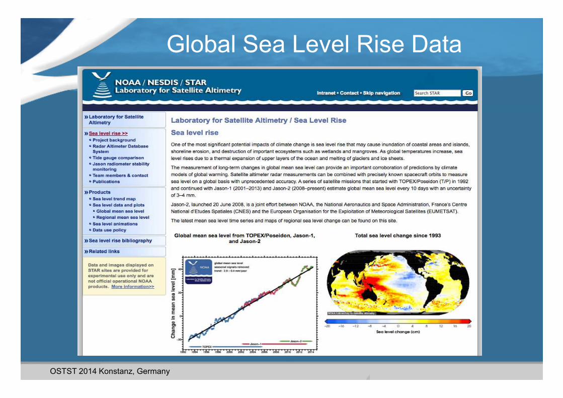
Global and Regional Sea Level Rise
The now 22 year record of altimetry data shows sea level rising at about 3 mm/year, nearly
twice as fast as during the last century. The global rate of sea level rise has been estimated to
be approximately 2/3 due to ice melt and 1/3 due to ocean warming (i.e., thermal expansion).
These increases place coastal and low lying communities at risk during storm surge.
End Users – Federal, state, and local coastal managers, IPCC, academia, U.S. Navy.
Jason-derived surface currents are used by recreational and commercial fishermen to
minimize fish search time and boat operating costs. In addition, the fishing sector also uses
maps of the seafloor (bathymetry) that are produced with data collected by Jason.
End Users – commercial ocean service providers, commercial and recreational fishermen.
Fishing Services
Energy Siting Purposes
Jason-derived surface currents are used in the siting of off-shore facilities, like oil platforms
and ocean wind power farms.
End Users – Federal agencies (e.g., NOAA, Department of Energy, Bureau of Ocean Energy
Management), State agencies, and private oceanographic service providers.
NATIONAL OCEANIC & ATMOSPHERIC ADMINISTRATION Please contact Sierra Jones ([email protected] and 202.482.6140) with any questions.
The Earth’s oceans and atmosphere are inextricably linked. Only from space can we observe the vast oceans on a global scale and
monitor critical changes in ocean currents, sea surface height, and heat storage. Since 1992, U.S. and European partners have
jointly developed and operated the series of ocean altimetry satellites to provide precise, continuous global measurements:
Jason-2 is the satellite currently on orbit; Jason-3 is scheduled for launch in March 2015 to provide uninterrupted data continuity.
These data, in conjunction with data from current and next-generation geostationary and polar-orbiting satellites, are used
operationally by government agencies and the private sector, to make more accurate weather predictions over land and ocean,
from hurricane intensity forecasting to inter-annual events such as El Niño and La Niña. The bottom line? Ocean weather models
in some cases will be substantially degraded and in others – such as those used in search & rescue and oil spill response - cease
functioning if altimetry observations are not available, putting lives and property at risk. The following are some of the
applications and end users that depend on the ocean weather models that data from Jason makes possible:
Jason Ocean Altimetry: Benefits to the Nation
For more information, please visit: http://www.ospo.noaa.gov/Operations/Jason2
Jason data used to map surface currents are also used in ecosystem models to help scientists
and policy makers understand how changes in the environment affect fish stocks. NOAA’s
National Marine Fisheries Service (NMFS) uses sea surface height to provide essential data on
ocean fronts and eddies to identify and forecast habitat to help understand and protect
species of interest like the northern fur seal, Loggerhead turtles, and Pacific albacore tuna.
End Users – NMFS, State agencies, Sea Grant Institutions, management councils.
Fisheries and Trust Species Management
Healthy Oceans:
Weather – Ready Nation:
The National Hurricane Center uses Jason data to derive ocean heat content to improve
hurricane intensity forecasting as much as 3 days in advance. This improved information aids in
planning evacuations, thus saving lives and property. (Image: ocean heat content map based on
Jason data shows Katrina intensifying to Category 5 hurricane when passing over Loop Current).
End Users – National Weather Service (NWS), Federal Emergency Management Agency
(FEMA), Department of Homeland Security (DHS), U.S. Navy, news organizations, state and
local disaster managers.
Hurricane Forecasting
The NWS uses Jason observations to initialize seasonal El Niño/La Niña forecasts which provide
early warnings of droughts in some regions and excessive precipitation elsewhere. Persistent El
Niño conditions can cause weaker than normal upwelling and lower biological production.
These conditions can affect Pacific Ocean ecosystems and valuable West Coast fisheries.
End Users – NWS, DHS, U.S. Navy, Department of the Interior, news organizations, State and
local disaster managers, agriculture sector, Federal and State wildfire fighting agencies.
El Niño/La Niña Seasonal Forecasting
High Wave Warnings
The NWS provides operational high wave warnings in the open ocean based in part on Jason
observations that save lives and property.
End Users – USCG, U.S. Navy, NWS, commercial ship operators, cruise ship operators,
commercial fisherman, offshore oil platform operators, Federal and State coastal
managers.
Ocean Hypoxia Dead Zones
Multi-decade declines in oxygen (hypoxia) have been observed in the coastal waters off the
West Coast and Gulf of Mexico, causing serious disruption to the marine environment. The
phenomena are influenced by air and water-borne pollution and changing ocean circulation
patterns monitored and investigated with ocean models initialized with Jason observations.
End Users – Federal and State coastal managers, academia, Sea Grant Institutions.
Jason Users

OSTST 2014 Konstanz, Germany
Sea Ice Program Web Pages

OSTST 2014 Konstanz, Germany
Bathymetry Program Web Pages

OSTST 2014 Konstanz, Germany
Sea Level Rise Web Pages
OSTST 2014 Konstanz, Germany
Global Sea Level Rise Data

OSTST 2014 Konstanz, Germany
Global Mean Sea Level Series

OSTST 2014 Konstanz, Germany
Global Sea Level Rise Maps

OSTST 2014 Konstanz, Germany
Ireland
Wales
France
Jason on NOAAView
OSTST 2014 Konstanz, Germany
Ireland
Wales
France
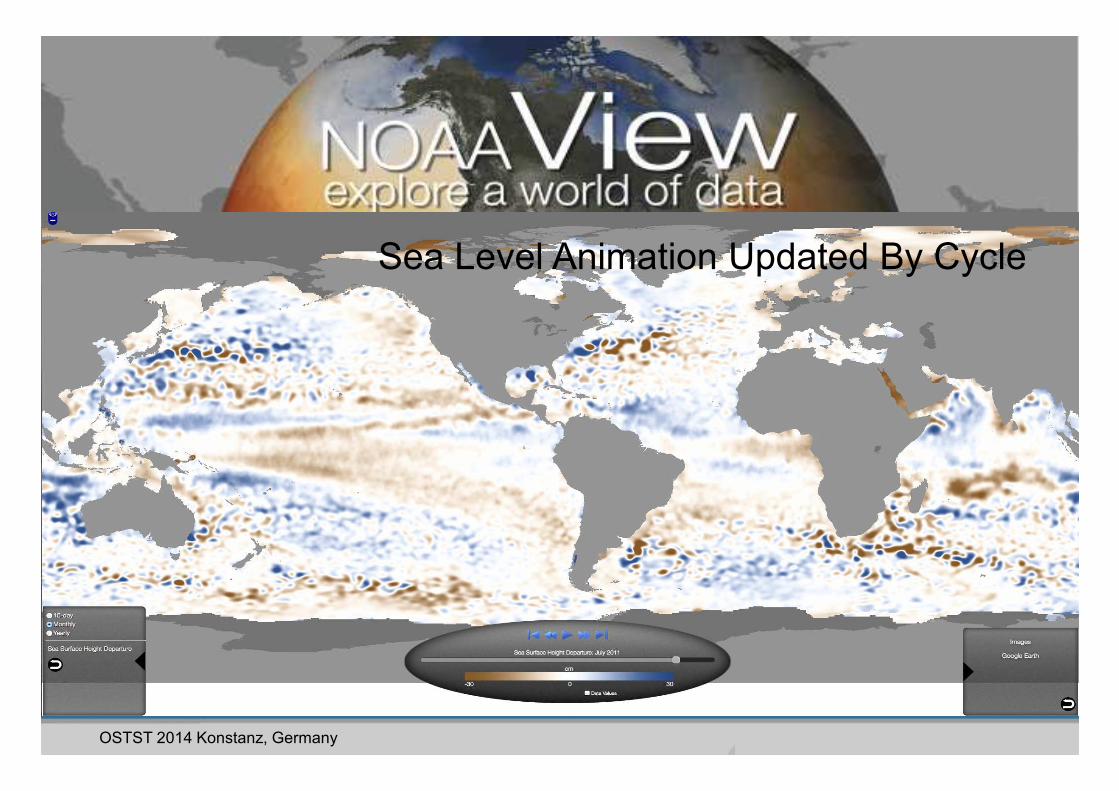
Sea Level Animation Updated By Cycle
OSTST 2014 Konstanz, Germany
Ireland
Wales
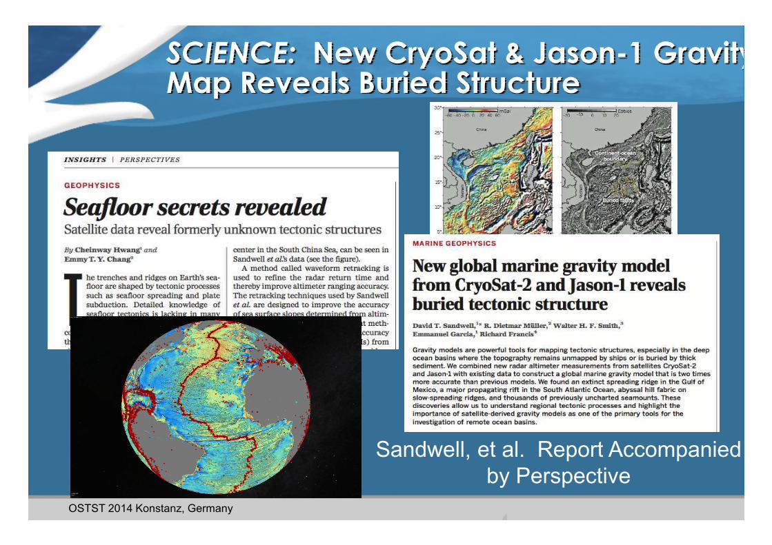
SCIENCE: New CryoSat & Jason-1 Gravity Map Reveals Buried Structure
Sandwell, et al. Report Accompanied
by Perspective

OSTST 2014 Konstanz, Germany
SCIENCE Gravity Article on FACEBOOK
Ireland
Wales
France

OSTST 2014 Konstanz, Germany
NOAA/NWS Jason-2 Wave Warnings on TWITTER
Near real-time comparison with
WAVEWATCH III model (green
contours) shows excellent
agreement.
End Users: USCG, U.S. Navy,
commercial ship operators,
recreational boaters, fishermen,
offshore rig operators, Federal &
State managers.
Jason-2 SWH with 62.9 ft
max @ 0514 UTC
Ireland
57’
51’
WWW.TWITTER.COM/NWSOPC
Wales
France

OSTST 2014 Konstanz, Germany
NOAA Science on a Sphere
Presentations by LSA’s Walter
Smith
• 4 Projector system developed/maintained by NOAA
• Used in 100 science centers in 18 Countries, 63 in US
• 476 Ocean, atmosphere & model data sets in library

OSTST 2014 Konstanz, Germany
• Smith and Marks, Eos
Trans AGU, 27 May
2014
• Satellite altimeter
data provides broad
area coverage.
• Only 5% area
surveyed by ships
• Article reported in
Science & Nature
Geoscience & many
news outlets
Bottom Topography in Malaysia Airlines MH370
Search Area From Satellite Altimetry

OSTST 2014 Konstanz, Germany
EOS MH370 Featured in SCIENCE Magazine &
Nature Geoscience Editorials

OSTST 2014 Konstanz, Germany
19
EOS MH370 Article Media Attention

OSTST 2014 Konstanz, Germany
Thank You!

OSTST 2014 Konstanz, Germany
Regional Mean Sea Level Series
OSTST 2014 Konstanz, Germany
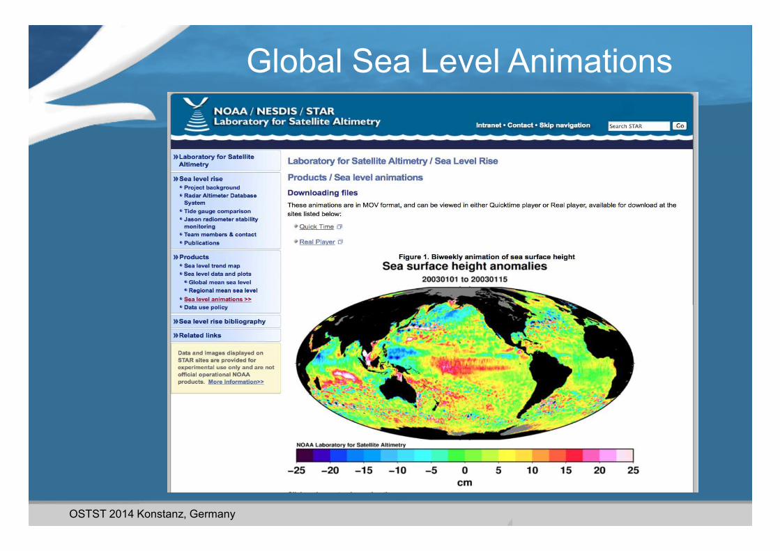
Global Sea Level Animations
OSTST 2014 Konstanz, Germany
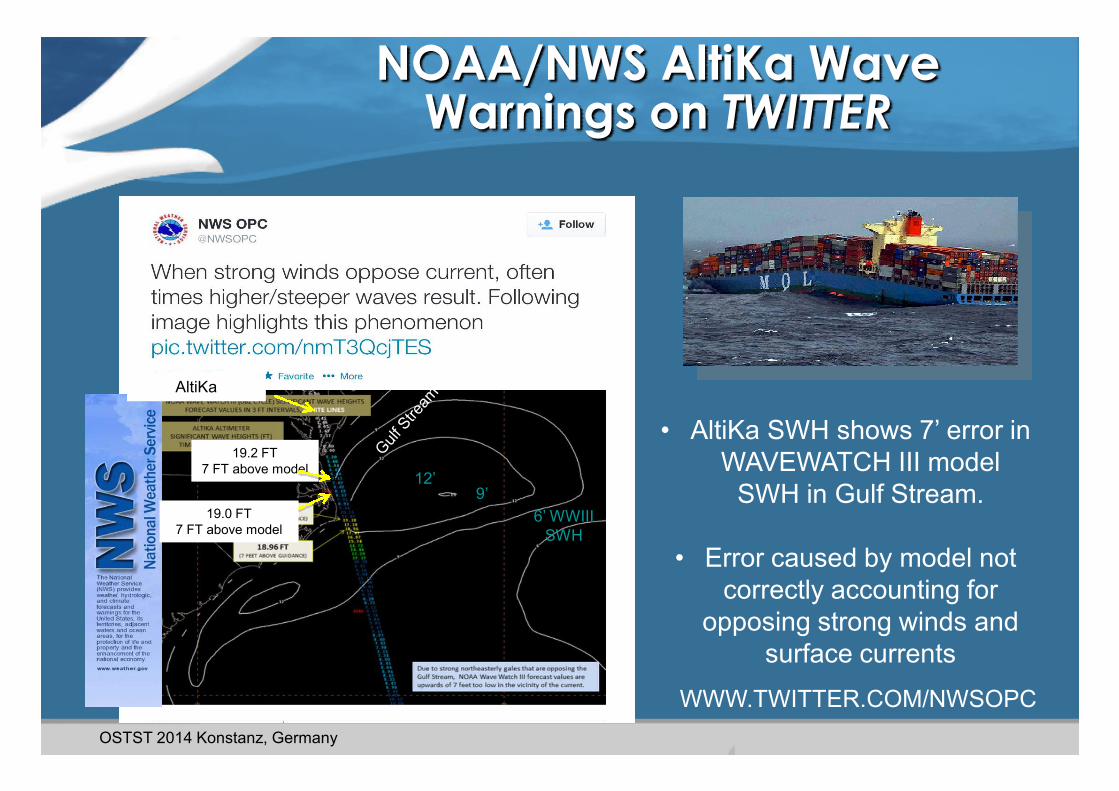
NOAA/NWS AltiKa Wave Warnings on TWITTER
• AltiKa SWH shows 7’ error in
WAVEWATCH III model
SWH in Gulf Stream.
• Error caused by model not
correctly accounting for
opposing strong winds and
surface currents
WWW.TWITTER.COM/NWSOPC
19.2 FT
7 FT above model
19.0 FT
7 FT above model
12’9’
6’ WWIII
SWH
AltiKa

OSTST 2014 Konstanz, Germany
NOAA LSA Science on a Sphere
Presentations by Walter Smith on Plate Tecttonics
and Oceanography to high school science
teachers, students, science fairs.
Top Related