


Languages
Pages
Legal

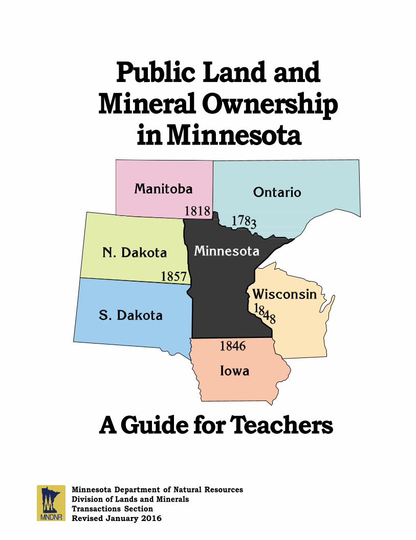
Public Land and Mineral Ownership
in Minnesota
A Guide for Teachers
Minnesota Department of Natural Resources Division of Lands and Minerals Transactions Section Revised January 2016

Preface
This publication is written to provide an understanding of public land
ownership in Minnesota to high school teachers and other people interested in
public land history and management. It is intended to be used as a resource to
supplement discussions on Minnesota’s history, government or geography.
The statistics used in this report are based on what is deemed the most reliable
resource for the information presented. However, the statistics are often only an
“educated guess,” since there is no comprehensive inventory, past or present, of
publicly-owned lands.
Land was used by both the federal and state governments as a means to
encourage settlement in the state and the development of the state’s resources.
Individuals and families were able to obtain lands through hard work and small
payments, a goal that brought many immigrants to the state.
The story of land ownership also includes tales of fraudulent acts, scandals,
corrupt practices, legislative investigations, and lawsuits. Nevertheless,
Minnesota is different from many states in that while there were large
conveyances of the publicly owned lands, there was also a recognition of the
need to conserve lands and the revenue generated from the lands and minerals to
benefit future generations.
Preface i
Table of Contents Preface ............................................................................................................. i
Table of Contents .............................................................................................. ii
Figures............................................................................................................. iii
Introduction ................................................................................................................ 1
Origins of Federal Ownership ................................................................................... 5
The Public Land Survey ............................................................................................ 8
Federal Land Grants .................................................................................................10
Federal Land Grants to Individuals ............................................................. 11
Federal Land Grants to Railroads ..................................................................... 12
Federal Land Grants to the State of Minnesota ............................................... 13
Minnesota’s Use and Conveyance of the Federal Lands ................................ 14
Federal and State Acquisitions of Land ................................................................. 16
Forests ................................................................................................................ 16
Parks ................................................................................................................... 17
Boundary Waters Canoe Area Wilderness ....................................................... 18
Tax-Forfeited Lands ........................................................................................... 19
Other Acquired Lands ....................................................................................... 20
Mineral Rights ................................................................................................... 21
The State of Minnesota’s Mineral Rights ........................................................ 21
Severed Minerals Interest Law ......................................................................... 23
Determination of Severed Minerals Ownership .............................................. 24
Land Ownership Statistics ....................................................................................... 25
Bibliography ...................................................................................................... 26
Table of Contents ii
Figures
Figure 1. Major Rivers and Watersheds of Minnesota ................................................. 1
Figure 2. Indian Reservations in Minnesota ................................................................ 2
Figure 3. State-owned Lands Administered by DNR and County
by land type, 2000 ....................................................................................................... 3
Figure 4. Federal Land Ownership as a percent of county land area ............................. 4
Figure 5. State Land Ownership including trust fund, acquired, and
tax-forfeited lands as a percent of county land area ...................................................... 4
Figure 5A. Public Land Ownership including federal and state lands .......................... 4
Figure 6. Minnesota under the Claims of England and Spain Territorial
Division from 1763–1783 This map shows the boundary between
the Spanish and English land claims in what is now Minnesota during
the years of 1763–1783 ............................................................................................... 5
Figure 7. Fort Snelling located at the meeting of the Minnesota and
Mississippi rivers. Twin Cities metropolitan area ........................................................ 6
Figure 8. Dates of the Minnesota Boundary Establishment Areas
(are labeled as they are named today) .......................................................................... 6
Figure 9. Public Land Survey Units ............................................................................. 9
Figure 10. Conveyance of Land in Minnesota by the Federal Government ................. 10
Figure 11. Wabasha Reservation ................................................................................ 12
Figure 12. The Chippewa National Forest is located in northern Cass
and western Itasca counties ....................................................................................... 16
Figure 13. Voyageurs National Park is located along the Canadian border in
northern St. Louis County and a small part of Koochiching
County. It is the only national park in Minnesota ....................................................... 17
Figure 14. The Boundary Waters Canoe Area Wilderness is bordered
on the north by Canada’s Quetico Provincial Forest Reserve ..................................... 18
Figure 15. State-owned Mineral Rights by Land/Mineral Class, 2000 ....................... 22
Figures iii
Section 1
Introduction
Within the boundaries of Minnesota there are about 51.2
million acres of land and approximately 2.6 million acres of
water. Minnesota is the twelfth largest state in the United States
and ranks fourth in the nation for size in water.
Voyageur’s Highway (Rainy River - Pigeon River - Grand Portage Connection
About three-fourths of the land surface is owned by
individuals and corporations. The remainder is owned by
governmental units. The federal government owns about 3.4
million acres (7% of the land area) and the state
government owns about 8.5 million acres (17% of the land area).
The state, which also owns a large amount of the area covered
by water, is the largest landowner in Minnesota. (See Figure 3.)
Red River Watershed
Red River
Lake Superior
Watershed
Major Rivers
Mississippi River
Watershed
Mississippi River
St. Croix River
Watersheds
Lake Superior
Mississippi River
Red River
Sioux River
Sioux River Watershed
Figure 1 – Major rivers and watersheds of Minnesota.
1 Section 1 – Introduction
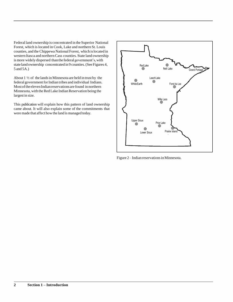
Federal land ownership is concentrated in the Superior National
Forest, which is located in Cook, Lake and northern St. Louis
counties, and the Chippewa National Forest, which is located in
western Itasca and northern Cass counties. State land ownership
is more widely dispersed than the federal government’s, with
state land ownership concentrated in 9 counties. (See Figures 4,
5 and 5A.)
About 1 ½ of the lands in Minnesota are held in trust by the
federal government for Indian tribes and individual Indians.
Most of the eleven Indian reservations are found in northern
Minnesota, with the Red Lake Indian Reservation being the
largest in size.
This publication will explain how this pattern of land ownership
came about. It will also explain some of the commitments that
were made that affect how the land is managed today.
Figure 2 – Indian reservations in Minnesota.
2 Section 1 – Introduction
Land Types Trust fund
Acquired
Consolidated conservation
Tax forfeited
Volstead
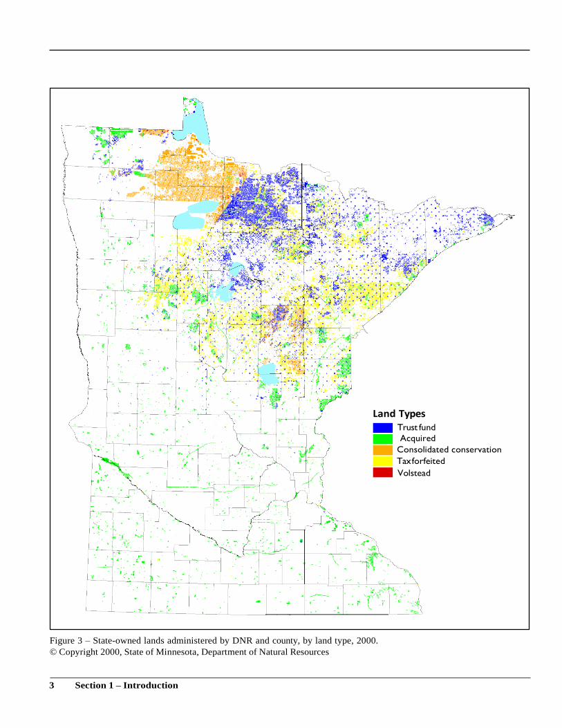
Figure 3 – State-owned lands administered by DNR and county, by land type, 2000.
© Copyright 2000, State of Minnesota, Department of Natural Resources
3 Section 1 – Introduction
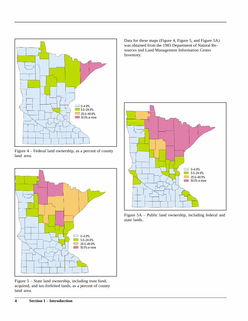
Data for these maps (Figure 4, Figure 5, and Figure 5A)
was obtained from the 1983 Department of Natural Re-
sources and Land Management Information Center
Inventory.
Figure 4 – Federal land ownership, as a percent of county
land area.
Figure 5A – Public land ownership, including federal and
state lands.
Figure 5 – State land ownership, including trust fund,
acquired, and tax-forfeited lands, as a percent of county
land area.
4 Section 1 – Introduction
0–4.9% 5.0–24.9%
25.0–49.9%
0–4.9%
5.0–24.9%
25.0–49.9%
0–4.9% 5.0–24.9%
25.0–49.9%
Section 2
Origins of Federal Ownership
Most of the land in Minnesota has at one time been owned by the
federal government. The federal government’s ownership was
acquired through treaties between the government and foreign
nations and between the government and Indian tribes.
It was accepted among the European countries that discovery
gave title of the land to the government that was represented by
the individual making the discovery. These countries also
recognized the Indians’ right to the lands they used and
occupied.
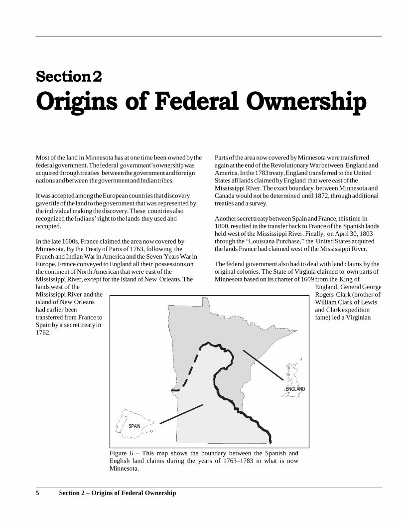
In the late 1600s, France claimed the area now covered by
Minnesota. By the Treaty of Paris of 1763, following the
French and Indian War in America and the Seven Years War in
Europe, France conveyed to England all their possessions on
the continent of North American that were east of the
Mississippi River, except for the island of New Orleans. The
lands west of the
Mississippi River and the
island of New Orleans
had earlier been
transferred from France to
Spain by a secret treaty in
1762.
Parts of the area now covered by Minnesota were transferred
again at the end of the Revolutionary War between England and
America. In the 1783 treaty, England transferred to the United
States all lands claimed by England that were east of the
Mississippi River. The exact boundary between Minnesota and
Canada would not be determined until 1872, through additional
treaties and a survey.
Another secret treaty between Spain and France, this time in
1800, resulted in the transfer back to France of the Spanish lands
held west of the Mississippi River. Finally, on April 30, 1803
through the “Louisiana Purchase,” the United States acquired
the lands France had claimed west of the Mississippi River.
The federal government also had to deal with land claims by the
original colonies. The State of Virginia claimed to own parts of
Minnesota based on its charter of 1609 from the King of
England. General George
Rogers Clark (brother of
William Clark of Lewis
and Clark expedition
fame) led a Virginian
Figure 6 – This map shows the boundary between the Spanish and
English land claims during the years of 1763–1783 in what is now
Minnesota.
5 Section 2 – Origins of Federal Ownership
army in 1778 to establish control over an area that included
those parts of Minnesota east of the Mississippi River. This
claim was ceded to the United States in 1784.
After acquiring the land claims from England, France and the
original colonies, the federal government started to negotiate
treaties with the Indian tribes. The federal government recognized
the Indian tribes as having a possessory right to the land - a right
to the land they occupied. Through treaties or federal legislation,
the Indians’ right to occupy specified lands were transferred to
the federal government. Sometimes certain rights, such as
hunting and fishing, were reserved to the Indians in the treaties. In
some treaties reservations were also created, with areas of land set
aside to be held in trust for the Indians and managed for them by
the United States.
By the early 1800s, bands of the Dakota tribe dominated
southern and west central Minnesota and bands of the Objiwe
tribe dominated northern and east central Minnesota. The first
Indian treaty affecting land in Minnesota was signed by Lt.
Zebulon M. Pike and the Dakota in 1805. It provided for the
cession of two tracts of land that were going to be used to
establish military posts. One tract of land was nine miles square
at the mouth of the St. Croix River. The other tract started from
below the confluence of the St. Peter’s River (later renamed the
Minnesota River) and the Mississippi River, went up the
Mississippi to include St. Anthony Falls, and extended nine
miles each side of the river. This tract became the site of Fort
Snelling.
Major land cessions by the Dakota occurred in treaties signed in
1837 and 1851. Many of these treaty provisions were revised by
Congress following the Dakota outbreak of 1862. Major land
cessions by the Objiwe occurred in treaties signed between
1837 and 1866. After completing these agreements with the
Indians, the federal government opened many of the lands for
settlement.
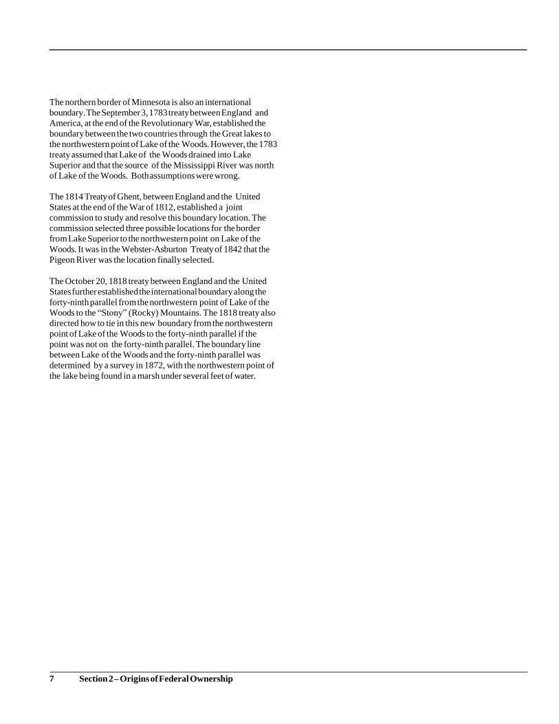
Minnesota’s Boundaries Minnesota’s boundaries were established as a result of
international treaties and the admittance of the states to the union.
The southern border for Minnesota was established in 1846,
when Iowa was admitted to the union. The eastern border of
Minnesota was established in 1848, upon the entrance of
Wisconsin to the union. The Enabling Act of February 26, 1857,
by which the U.S. Congress authorized Minnesota to form a state
constitution, established the western border of the state.
Figure 8 – Dates of Minnesota boundary establishment. Areas
are labeled as they are named today.
Figure 7 – Fort Snelling. Located at the meeting of the Minnesota and
Mississippi rivers.
6 Section 2 – Origins of Federal Ownership
The northern border of Minnesota is also an international
boundary. The September 3, 1783 treaty between England and
America, at the end of the Revolutionary War, established the
boundary between the two countries through the Great lakes to
the northwestern point of Lake of the Woods. However, the 1783
treaty assumed that Lake of the Woods drained into Lake
Superior and that the source of the Mississippi River was north
of Lake of the Woods. Both assumptions were wrong.
The 1814 Treaty of Ghent, between England and the United
States at the end of the War of 1812, established a joint
commission to study and resolve this boundary location. The
commission selected three possible locations for the border
from Lake Superior to the northwestern point on Lake of the
Woods. It was in the Webster-Asburton Treaty of 1842 that the
Pigeon River was the location finally selected.
The October 20, 1818 treaty between England and the United
States further established the international boundary along the
forty-ninth parallel from the northwestern point of Lake of the
Woods to the “Stony” (Rocky) Mountains. The 1818 treaty also
directed how to tie in this new boundary from the northwestern
point of Lake of the Woods to the forty-ninth parallel if the
point was not on the forty-ninth parallel. The boundary line
between Lake of the Woods and the forty-ninth parallel was
determined by a survey in 1872, with the northwestern point of
the lake being found in a marsh under several feet of water.
7 Section 2 – Origins of Federal Ownership
Section 3
The Public Land Survey
Ownership of land has different meanings in different cultures.
For some societies, land is only owned by the tribe or by the
government and not by individuals. Sometimes the boundaries
of land ownership are not well defined, and only through
possession or fighting are claims laid to an area. The land
ownership philosophy in the United States and in Minnesota is
based on the idea that you can identify boundaries of land, and
that individuals and governmental entities can own specific,
identifiable pieces of the land.
In order to open up all the land for settlement that it had
acquired, the federal government recognized the need for an
orderly system of conveying the land to Revolutionary soldiers,
other individuals, and companies. Therefore, the
U.S. Congress adopted the Land Ordinance of 1785. This
ordinance created what became known as the United States
Public Land Survey.
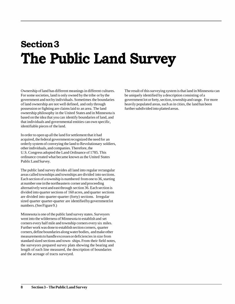
The public land survey divides all land into regular rectangular
areas called townships and townships are divided into sections.
Each section of a township is numbered from one to 36, starting
at number one in the northeastern corner and proceeding
alternatively west and east through section 36. Each section is
divided into quarter sections of 160 acres, and quarter sections
are divided into quarter-quarter (forty) sections. Irregular
sized quarter quarter-quarter are identified by government lot
numbers. (See Figure 9.)
Minnesota is one of the public land survey states. Surveyors
went into the wilderness of Minnesota to establish and set
corners every half mile and township corners every six miles.
Further work was done to establish section corners, quarter
corners, define boundaries along water bodies, and make other
measurements to handle excesses or deficiencies in size from
standard sized sections and town- ships. From their field notes,
the surveyors prepared survey plats showing the bearing and
length of each line measured, the description of boundaries
and the acreage of tracts surveyed.
The result of this surveying system is that land in Minnesota can
be uniquely identified by a description consisting of a
government lot or forty, section, township and range. For more
heavily populated areas, such as in cities, the land has been
further subdivided into platted areas.
8 Section 3 – The Public Land Survey
9 Section 3 – The Public Land Survey
1 m
ile
6 m
iles
Sect
ion
Quart
er
Sect
ions
Tow
nsh
ip
Figu
re 9
– P
ub
lic
lan
d s
urv
ey
un
its.
Section 4
Federal Land Grants
Land has often been used by governments to encourage its
citizens to take certain action. Payments of money and
exemptions from taxation are other tools used to encourage
some types of activities. Alternatively, fines and high taxes
are used to discourage some activities.
Since colonial times in this country, the conveyance of land has been used to encourage settlement, construction of new industries, development of schools and universities, construction of roads and bridges, drainage of land for agriculture, and construction of public buildings. Land ownership has been used as a means of encouraging settlement and development of this country rather than as a source of revenue for the federal government.
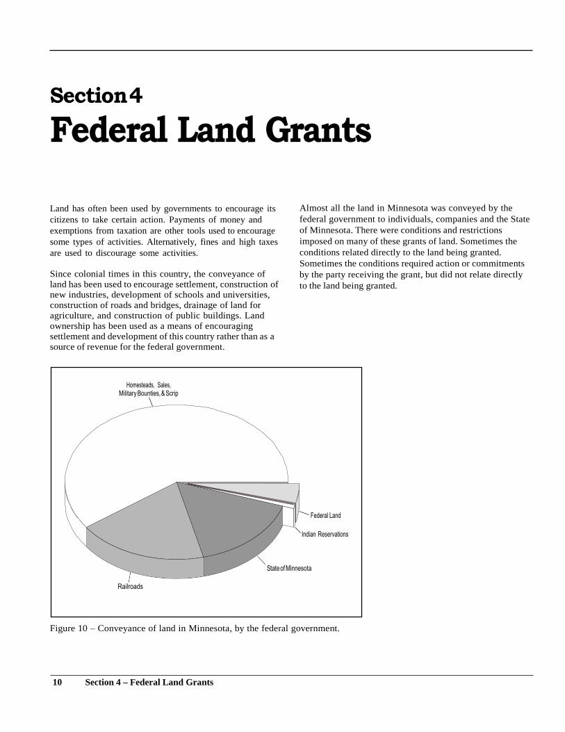
Almost all the land in Minnesota was conveyed by the
federal government to individuals, companies and the State
of Minnesota. There were conditions and restrictions
imposed on many of these grants of land. Sometimes the
conditions related directly to the land being granted.
Sometimes the conditions required action or commitments
by the party receiving the grant, but did not relate directly
to the land being granted.
Figure 10 – Conveyance of land in Minnesota, by the federal government.
10 Section 4 – Federal Land Grants
Federal Land Grants to Individuals Over half of the total lands in the state were conveyed from the
federal government directly to individuals and companies. The
initial policy was that the public land would only be sold
through a public auction with a minimum price per acre. Also,
the lands could not be offered for sale until the lands had been
surveyed. The land was not to be settled or timber cut until the
land was sold. The Indians’ rights of occupancy had to be
conveyed to the federal government before the land was sold;
this was generally done through treaty.
The first sale of public land in Minnesota took place in
1848 at the land office in St. Croix Falls. The minimum
price was $1.25 per acre.
Settlers and lumbermen started entering the new territories before
the land was available to be sold. The amount of activity was so
high that the U.S. Congress created a right of “preemption”
through the “Log Cabin Bill” of 1841, which provided a right to
a settler to purchase land to the exclusion of all other people.
The person had to be either the head of a family, a widow, or a
single man more than 21, and had either to be a citizen of the
U.S. or declared their intent to become a citizen. Settlers were
required to inhabit and improve the land and build a dwelling. It
was required that they swear in an affidavit that the land was for
their own use and benefit. If they met these requirements, they
had the right to purchase the land at $1.25 per acre. The amount
of land could not exceed 160 acres. This law applied to lands in
Minnesota starting in 1854.
Approximately nine million acres of land were sold in
Minnesota through public sales and preemption.
A major federal land policy was decided during the Civil War.
It was the “Homestead Act of May 20, 1862.” Land was free if
you resided on and cultivated the land for five years. To qualify,
you needed to be either the head of a family or more than 21,
and either a citizen of the U.S. or had declared your intent to
become a citizen. Title to the land was obtained after the
payment of fees and the submission of proof that you had resided
and cultivated the land for five years. The amount of land was
limited to 160 acres if the land had been subject to sale at a
minimum price of $1.25 per acre, and the amount of land was
limited to 80 acres if the land had been subject to sale at a
minimum price of $2.50 per acre. It was also possible to
purchase the land at the minimum price at any time after six
months from the date of filing intent to homestead the land.
The effect of the Homestead Act was the settlement and
cultivation of large areas of Minnesota. It is estimated that more
than 11 million acres of land were conveyed under this law.
Another sizeable amount of land was conveyed through
military bounties. Soldiers participating in any war between the
Revolutionary War and the Mexican War received a grant of
public land in return for their services. The grants were issued
through warrants, a document stating that the holder had the right
to acquire a specific amount of vacant land anywhere in the
nation. Most of the warrants were sold rather than being used by
the soldier, and the price was often quite low. It is estimated that
about six million acres of land in Minnesota were claimed by
military bounties.
There was widespread abuse of the land acquisition laws in the
areas valuable for timber or minerals. Timber companies
preceded farmers in claiming preemption of lands. People were
hired to claim land under the homestead act and pay for it at the
minimum rate after six months. Those people would then
convey the land to the lumber or mining company. Fictitious
names were used as well as people’s names being used without
their knowledge or permission.
One of the large timber companies obtained thousands of acres
of land containing pine using the St. Paul and Chicago
telephone directories. Names of persons listed in the directories
were fraudulently used to file preemption claims. An
investigation in 1904 found that some local land officers
knowingly accepted these false claims and received payment of
$25 per claim for doing so.
The federal government also conveyed the right to claim other
public land as part of the terms of some treaties with the Indians.
The United States issued scrip, which was a document showing
that the holder was entitled to select a certain amount of public
land.
The largest issuance of scrip in Minnesota occurred because of
the Wabasha Reservation. This reservation was set aside by
treaty in 1830 for Dakota mixed breeds.
11 Section 4 – Federal Land Grants
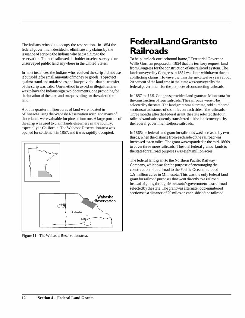
The Indians refused to occupy the reservation. In 1854 the
federal government decided to eliminate any claims by the
issuance of scrip to the Indians who had a claim to the
reservation. The scrip allowed the holder to select surveyed or
unsurveyed public land anywhere in the United States.
In most instances, the Indians who received the scrip did not use
it but sold it for small amounts of money or goods. To protect
against fraud and unfair sales, the law provided that no transfer
of the scrip was valid. One method to avoid an illegal transfer
was to have the Indians sign two documents, one providing for
the location of the land and one providing for the sale of the
land.
About a quarter million acres of land were located in
Minnesota using the Wabasha Reservation scrip, and many of
those lands were valuable for pine or iron ore. A large portion of
the scrip was used to claim lands elsewhere in the country,
especially in California. The Wabasha Reservation area was
opened for settlement in 1857, and it was rapidly occupied.
Federal Land Grants to Railroads To help “unlock our icebound home,” Territorial Governor
Willis Gorman proposed in 1854 that the territory request land
from Congress for the construction of one railroad system. The
land conveyed by Congress in 1854 was later withdrawn due to
conflicting claims. However, within the next twelve years about
20 percent of the land area in the state was conveyed by the
federal government for the purposes of constructing railroads.
In 1857 the U.S. Congress provided land grants to Minnesota for
the construction of four railroads. The railroads were to be
selected by the state. The land grant was alternate, odd numbered
sections at a distance of six miles on each side of the railroads.
Three months after the federal grant, the state selected the four
railroads and subsequently transferred all the land conveyed by
the federal government to those railroads.
In 1865 the federal land grant for railroads was increased by two-
thirds, when the distance from each side of the railroad was
increased to ten miles. The grant was expanded in the mid-1860s
to cover three more railroads. The total federal grant of lands to
the state for railroad purposes was eight million acres.
The federal land grant to the Northern Pacific Railway
Company, which was for the purpose of encouraging the
construction of a railroad to the Pacific Ocean, included
1.9 million acres in Minnesota. This was the only federal land
grant for railroad purposes that went directly to a railroad
instead of going through Minnesota’s government to a railroad
selected by the state. The grant was alternate, odd-numbered
sections to a distance of 20 miles on each side of the railroad.
Figure 11 – The Wabasha Reservation area.
12 Section 4 – Federal Land Grants
Wabasha
Federal Land Grants to the State of Minnesota
A long term practice in England was followed by the colonial
government in this country. Tracts of land were set aside for the
support of schools. When Minnesota was created as a territory
in 1849, sections 16 and 36 of every township were reserved for
the purpose of being applied to the schools in the territory. In
1851, at the request of the territorial legislature, the U.S.
Congress reserved from sale 72 sections of land for the support
of a university in the territory.
By the Enabling Act of February 26, 1857, the U.S.
Congress authorized the Territory of Minnesota to form a
constitution and state government. The Enabling Act provided
for the following grants of land, totaling about three million
acres, to the state:
(1) Sections 16 and 36 of every township for the use of
schools. If any part of a Section 16 or 36 had already been
sold or disposed of or was reserved for an Indian reservation,
then other lands would be granted. (These alternative lands are
called “indemnity” school lands.)
(2) Seventy-two sections of land for use and support of a
state university.
(3) Ten sections of land for the completion of public
buildings, or the erection of other public buildings, at the seat
of government.
(4) All salt springs within the state, provided that they did
not exceed 12 in number, along with six sections of land
adjoining or contiguous to the salt springs. The use or sale of the
salt spring lands was to be as directed by the state legislature.
The Enabling Act also provided that 5% of the proceeds
from all federally owned lands within the state, after deducting
expenses, would be paid to the state for the use of making roads
and internal improvements as directed by the state legislature.
The acceptance of this grant of lands by the State of
Minnesota was also conditioned on Minnesota agreeing to:
At the time the state was admitted to the union, the state also
received the ownership of the beds of navigable waters. There is
no list of the navigable waters in Minnesota. It is a factual test as
to whether the waters were used or usable as of 1858 as a
highway for commerce, whether by steamboat, sail vessel,
flatboat or canoe.
The Morrill Act of 1862 provided another land grant for
education purposes. To establish colleges of agriculture and
mechanic arts, each state was granted an amount of land based on
the number of members of its congressional delegation.
Minnesota had two senators and two representatives, and the state
received a total of 94,439 acres.
A grant that ended up to be about 4.7 million acres happened in
1860, when the U.S. Congress granted Minnesota all the swamp
and overflowed waters in the state that had not been previously
reserved or conveyed. The money from the sale of the lands was
to be used to construct levees and drains. Only 15 states received
this land grant. Minnesota chose the option of identifying the
swamp lands by the plats and field notes of the government
surveys.
In 1866, upon recognition of the applicability of a 1841 federal
law for new states, Minnesota received half a mil- lion acres of
land to be used for internal improvements. In 1870 the U.S.
Congress granted an additional 72 sections of land to the state
for the university. Minnesota had won its argument that the 1857
grant of lands was in addition to the 1851 grant of lands for the
university.
(1) Not interfere with the sale of lands within the state by
the United States or with any regulation that the U.S. Congress
found necessary to secure title to the lands.
(2) Not impose a tax on any United States owned
lands.
(3) Not tax nonresidents higher than residents.
These conditions remain in Minnesota’s Constitution and
are irrevocable without the consent of the United States.
13 Section 4 – Federal Land Grants
Minnesota’s Use and Conveyance of the Federal Lands
Minnesota’s system of managing its lands was somewhat
different from the federal government’s. The lands the state
received from the federal government were often sold for cash,
rather than given away for free upon settlement. There was the
recognition of conserving some land, or some interests in the
land, and the revenue from sales of the land.
Minnesota’s original Constitution included provisions on the
lands conveyed from the federal government to the state for the
purpose of schools. The school lands could only be disposed of
by public sale, a condition that is still found in the state’s
Constitution. A permanent fund was created for the money from
the use and sale of the lands. The principal of the fund is
preserved, and only interest earned on the fund may be used
each year. As of 2015, the permanent school fund is valued at
$1.1 billion.
The first sale of school lands was in 1862. The lands in the
southern part of the state that were valuable for agriculture were
sold more quickly than the lands in the northern part of the state.
About two-thirds of the 2.9 million acres of school lands were
sold.
Valuable timber was located on many of the school lands, and
laws were passed to assess and sell timber separately from the
land. Unfortunately, thousands of acres of school lands were
illegally stripped of the timber, and often the value of the timber
was not correctly determined. The state probably lost millions
of dollars before new laws stopped the trespasses, provided for
more inspections, and improved the timber sale procedures.
The federal government granted swamp land to the state with the
condition that the money from the sale of the lands be used to
drain the lands. Instead of following this requirement, the state
granted about 2.8 million acres of the 4.7 million acres of swamp
lands to the railroads. Specific grants of swamp lands were also
made for the Stevens Seminary in McLeod County, the Madelia
and Sioux Falls Wagon Road, and the Cannon River
Manufacturing Association. Swamp lands were also granted for
an insane asylum, a state prison, three normal schools, and an
institute for the education of the deaf, dumb and blind at
Faribault.
The federal government took no action to stop the manner in
which the state granted swamp lands. The practice was halted by
an amendment to the state’s Constitution in 1891. After that
time, the swamp lands were sold in the same manner as the
school lands. Money from the sale of the swamp lands was
placed into a permanent trust fund that eventually merged with
the permanent school fund. About three-fourths of the swamp
lands were sold or given away.
The 10 sections of land granted for public buildings and the
lands granted for internal improvements were sold in the same
manner as the school lands. Money from the sale of the lands
granted for public buildings was used to complete the state
capitol building. Almost all the internal improvement lands
were sold, with the revenue used to liquidate state railroad
bonds issued in 1858 to fund railroad construction. The
remaining money from the sale of internal improvement lands
was deposited into a permanent fund that eventually merged
with the permanent school fund.
The University of Minnesota was established by the territorial
legislature in 1851. A permanent fund was created for the
revenue from the use and sale of any lands that the United States
would grant to the territory for the support of a university. The
principal of the fund was to be preserved and only interest
earned on the fund used each year.
Early management of the University created debts from
purchasing land and constructing buildings at higher costs than
authorized. About a third of the lands granted in 1851 to support
the university were sold and other lands were leased to pay off
the debts. The remaining lands were transferred in 1868 to the
Commissioner of State Land for management, and the lands from
the second federal grant to the university also were transferred to
this state office for management. Money from the sale or lease of
the lands is invested in the permanent university fund, with the
interest made available for use each year. About a third of the
university lands from the two land grants remain in state
ownership and are managed by the Department of Natural
Resources. As of 2015, the permanent university fund is valued at
$540 million.
The 94,439 acres granted for an agricultural and mechanic arts
college were sold, with the money deposited into a permanent
fund that eventually merged with the permanent university fund.
14 Section 4 – Federal Land Grants
There were no restrictions on the sale or use of the 46,080
acres of salt spring lands granted in 1857. The Belle Plaine
Salt Company was granted 7,643 acres of salt spring lands,
but it failed to find any salt spring water of commercial
value. The remaining salt spring lands were turned over to
the University in 1873 to manage. The proceeds were used
to support the geological and natural history survey and the
preparation of geological reports. The proceeds are now
used to support endowed chairs at the Duluth campus and
tuition for Indian students at the Morris campus.
15 Section 4 – Federal Land Grants
Section 5
Federal and State Acquisitions of Land
Land policy began to change at the end of the 1800s. Starting
with the forests and mineral interests, the policy became one of
keeping certain lands and mineral interests that remained in
government ownership. By the 1920s, there was a recognition of
the need to conserve public lands for recreational use and
wildlife protection. During the depression of the 1930s, lands
came into public ownership due to the economy, and the
governments also purchased lands to help economic recovery.
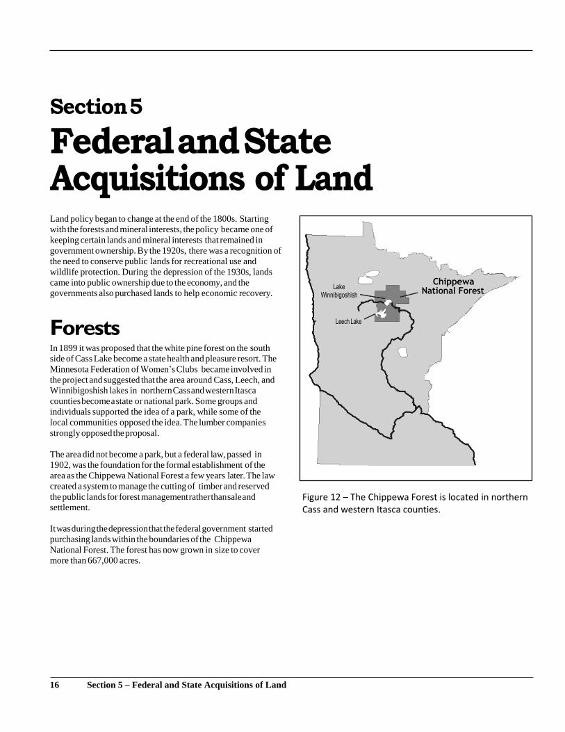
Forests In 1899 it was proposed that the white pine forest on the south
side of Cass Lake become a state health and pleasure resort. The
Minnesota Federation of Women’s Clubs became involved in
the project and suggested that the area around Cass, Leech, and
Winnibigoshish lakes in northern Cass and western Itasca
counties become a state or national park. Some groups and
individuals supported the idea of a park, while some of the
local communities opposed the idea. The lumber companies
strongly opposed the proposal.
The area did not become a park, but a federal law, passed in
1902, was the foundation for the formal establishment of the
area as the Chippewa National Forest a few years later. The law
created a system to manage the cutting of timber and reserved
the public lands for forest management rather than sale and
settlement.
It was during the depression that the federal government started
purchasing lands within the boundaries of the Chippewa
National Forest. The forest has now grown in size to cover
more than 667,000 acres.
Figure 12 – The Chippewa Forest is located in northern Cass and western Itasca counties.
16 Section 5 – Federal and State Acquisitions of Land
Chippewa
In 1902 more than 500,000 acres of federal land in Lake and
Cook counties were withdrawn from sale and settlement. The
lands had been identified as another area that should be
preserved for forest management since the lands were hilly and
rocky and not good for settlement. President Theodore
Roosevelt established this area as the Superior National Forest
in 1909.
The land acquisition program for the Superior National Forest
started in 1926, and sizeable areas were added in St. Louis, Lake
and Cook counties. Today, the Superior National Forest covers
about three million acres of water and land. The Boundary
Waters Canoe Area Wilderness (BWCAW) is located within the
boundaries of the Superior National Forest.
Outside of the BWCAW, the federal lands within the national
forests are managed for timber growth and harvesting, and the
lands and waters are available for recreation. While the federal
government’s land ownership is concentrated within these two
national forests, the State of Minnesota, as well as private
individuals and companies, own and manage land within the
boundaries of the forests.
The first state forest reserve was in 1902. It was started with a
donation of 991 acres of land in Cass County from widow of
former Governor John S. Pillsbury. The law under which the
donation was made allowed her to designate a public education
institution to receive two-thirds of the money from the use of the
land. The University of Minnesota was the designated
beneficiary. The lands are now part of the Pillsbury State Forest.
It was in the 1930s and 1940s that the State of Minnesota
established most of its state forests. Today, the Department of
Natural Resources manages state-owned lands within the
boundaries of 58 state forests. The 3.2 million acres of state-
owned lands managed for forest purposes include school lands,
swamp lands, university lands, consolidated conservation
lands, and acquired lands.
Parks The State of Minnesota established its first state park in 1891. The
United States granted the state all federally-owned lands within
Itasca State Park that had not been sold. Lumber companies
owned almost 9,000 acres within the new park. Logging
continued on the privately-owned lands for many years as the
lands were slowly purchased by the state.
17 Section 5 – Federal and State Acquisitions of Land
There was a gradual development of the state park system, with a
more rapid expansion in the 1930s through the 1950s. Today, the
Department of Natural Resources manages 306,000 acres of state-
owned lands within the boundaries of 75 state parks and state
recreation areas and eight waysides.
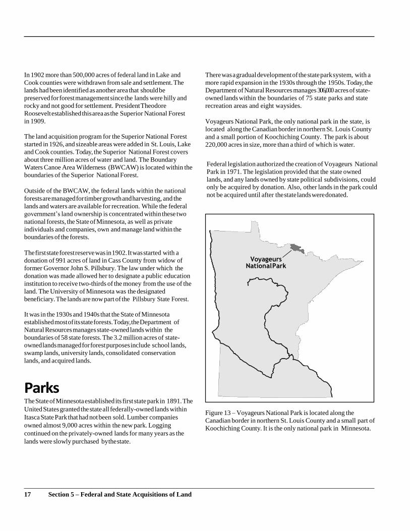
Voyageurs National Park, the only national park in the state, is
located along the Canadian border in northern St. Louis County
and a small portion of Koochiching County. The park is about
220,000 acres in size, more than a third of which is water.
Federal legislation authorized the creation of Voyageurs National
Park in 1971. The legislation provided that the state owned
lands, and any lands owned by state political subdivisions, could
only be acquired by donation. Also, other lands in the park could
not be acquired until after the state lands were donated.
Figure 13 – Voyageurs National Park is located along the
Canadian border in northern St. Louis County and a small part of
Koochiching County. It is the only national park in Minnesota.
Voyageurs
National Park
The State of Minnesota enacted legislation in 1971 that donated
the state owned lands to the federal government for the park. The
legislation provided that the donation offer was only good for
five years; if a park was not established, the lands would remain
as state lands. The donation also provides that the lands will
revert to the state if they are no longer used for national park
purposes. State bonds were issued to make payments that
compensated the trust funds and local taxing districts for the
donation of the state lands. Voyageurs National Park was
formally established in 1975.
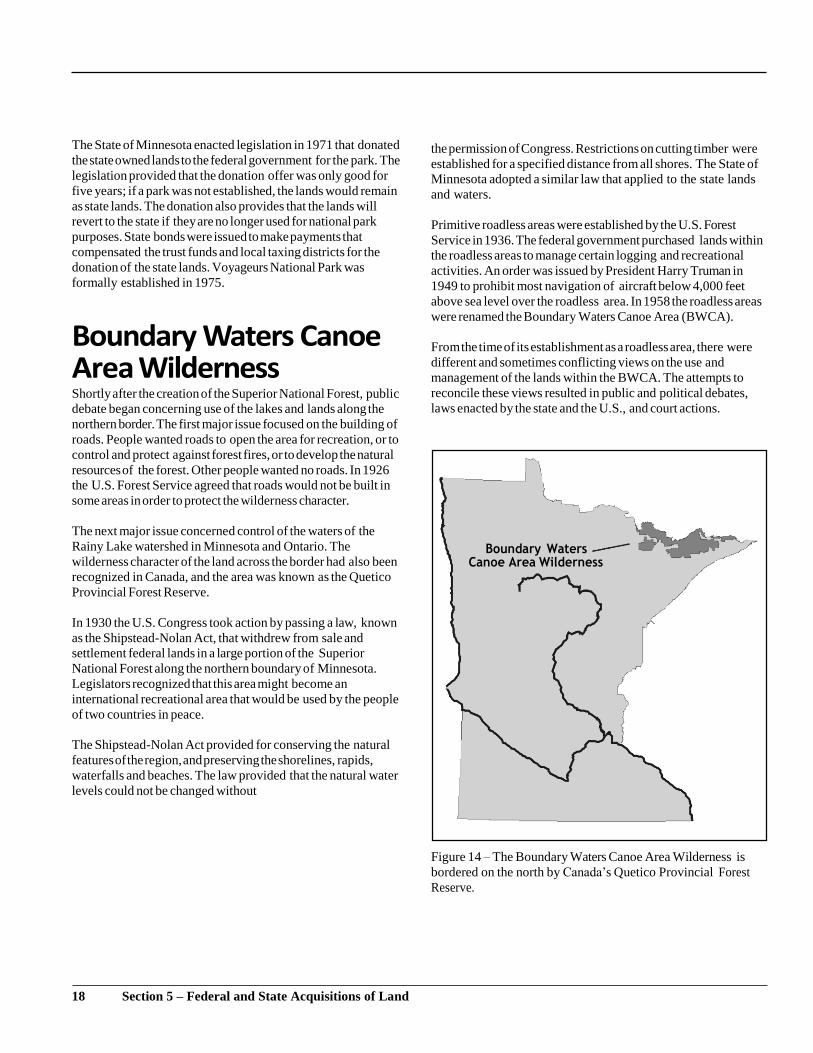
Boundary Waters Canoe Area Wilderness Shortly after the creation of the Superior National Forest, public
debate began concerning use of the lakes and lands along the
northern border. The first major issue focused on the building of
roads. People wanted roads to open the area for recreation, or to
control and protect against forest fires, or to develop the natural
resources of the forest. Other people wanted no roads. In 1926
the U.S. Forest Service agreed that roads would not be built in
some areas in order to protect the wilderness character.
The next major issue concerned control of the waters of the
Rainy Lake watershed in Minnesota and Ontario. The
wilderness character of the land across the border had also been
recognized in Canada, and the area was known as the Quetico
Provincial Forest Reserve.
In 1930 the U.S. Congress took action by passing a law, known
as the Shipstead-Nolan Act, that withdrew from sale and
settlement federal lands in a large portion of the Superior
National Forest along the northern boundary of Minnesota.
Legislators recognized that this area might become an
international recreational area that would be used by the people
of two countries in peace.
The Shipstead-Nolan Act provided for conserving the natural
features of the region, and preserving the shorelines, rapids,
waterfalls and beaches. The law provided that the natural water
levels could not be changed without
the permission of Congress. Restrictions on cutting timber were
established for a specified distance from all shores. The State of
Minnesota adopted a similar law that applied to the state lands
and waters.
Primitive roadless areas were established by the U.S. Forest
Service in 1936. The federal government purchased lands within
the roadless areas to manage certain logging and recreational
activities. An order was issued by President Harry Truman in
1949 to prohibit most navigation of aircraft below 4,000 feet
above sea level over the roadless area. In 1958 the roadless areas
were renamed the Boundary Waters Canoe Area (BWCA).
From the time of its establishment as a roadless area, there were
different and sometimes conflicting views on the use and
management of the lands within the BWCA. The attempts to
reconcile these views resulted in public and political debates,
laws enacted by the state and the U.S., and court actions.
Figure 14 – The Boundary Waters Canoe Area Wilderness is
bordered on the north by Canada’s Quetico Provincial Forest
Reserve.
18 Section 5 – Federal and State Acquisitions of Land
In 1978 the U.S. Congress established the area as the Boundary
Waters Canoe Area Wilderness. Its size is close to one million
acres. The wilderness classification means that humans are to
be only visitors and the area is to be protected and preserved for
its natural values. The federal government has now purchased
most of the private (non-state) lands remaining within the
BWCAW.
Tax-forfeited Lands A basic land policy is that local governments may assess a
property tax on most privately-owned lands to provide revenue
for public services such as roads, schools and public buildings.
Failure to pay property tax will result in the forfeiture of
ownership of the property to the state.
During the first few decades of the state’s history, there were
forfeitures when the owners could not pay the taxes because their
crops were destroyed or their businesses failed due to economic
depressions. After forfeiture, the state’s goal was to return the
land to private ownership. The original landowner was
encouraged to buy back the land that forfeited. Also, another
party could pay the taxes and penalties to acquire the land.
The amount of land forfeiting for taxes started to increase
tremendously in the 1920s. An agricultural depression preceded
the major business depression that started in 1929. In
northwestern Minnesota, lands forfeited because of high taxes
assessed to cover the cost of constructing ditches to drain the
lands. In northeastern Minnesota, marginal agricultural lands
where the timber had been removed were taxed at rates far above
the market value of the land. As taxes increased, more
landowners stopped paying taxes. This resulted in a heavier tax
burden being placed on the remaining taxpayers.
From 1925 to 1935, the Minnesota legislature passed a series of
“bargain counter” tax laws. The laws tried to provide relief by
giving the right to pay up delinquent taxes at very low prices.
The laws also provided for forfeiture of the property to the state
after a specified time. These efforts were not successful. Some
people found it better not to pay the taxes; they would be able to
recover title to the property by paying much less than the
original taxes. By 1935 there were millions of acres of tax
delinquent land, with the delinquencies concentrated in
northern and central Minnesota. The bargain counter laws had
failed to return the lands to private ownership and the state’s title
to the land was questioned.
Major revisions of the tax forfeiture laws occurred in 1935. The
procedures for tax forfeiture and administration of the tax
forfeited land were changed. If the land forfeited for nonpayment
of taxes, it would forfeit to the State of Minnesota in trust for the
taxing districts.
It is estimated that between six and eight million acres of land
forfeited for taxes between 1926 and 1950. A large portion of
those lands has been sold. Today, there are about 2.8 million
acres of tax forfeited lands, with the amount fluctuating due to
new tax forfeitures, land sales, and land transfers. Generally, the
surface and timber of the tax forfeited lands are managed by the
counties, and the mineral rights are managed by the Minnesota
Department of Natural Resources.
A significant portion of the tax forfeited lands in seven northern
counties became consolidated conservation area lands. These
lands were established due to a law concerning drainage ditches.
A small number of people could petition their local government
to construct a drainage ditch. All property owners were assessed
for payment of the ditch, whether or not they had requested the
ditch. Many property owners did not make their ditch payments
so the counties could not pay the amounts due on bonds issued to
cover the cost of constructing the ditches. The state assumed the
obligation to pay the bond debts between 1929 and 1933. In
return for relieving the counties of the debt, the state took title to
lands that forfeited within the ditch areas.
The approximately 1.6 million acres of consolidated
conservation area lands are managed by the Department of
Natural Resources. Unlike the tax forfeited lands, these state
owned lands are not held in trust for the taxing districts, although
the counties do receive a portion of the revenue from the lands.
The federal government also authorized the assessment of ditch
costs for some unsold federal lands within drainage districts.
The State of Minnesota purchased some of these lands in 1961.
19 Section 5 – Federal and State Acquisitions of Land

Other Acquired Lands A federal law passed in 1933 authorized the purchase of
submarginal agricultural lands. More than 200,000 acres were
acquired by the federal government. Many of these federally-
owned lands are under a long term lease to the state for wildlife,
forestry and other conservation purposes. The State of Minnesota
also purchased some of these lands from the United States.
Additional land acquisitions by the United States include the
Pipestone National Monument, the Grand Portage Monument,
and wildlife and fish refuges.
The State of Minnesota’s land acquisition program has not been
as large as the federal government’s. State acquisitions are usually
for small areas, such as a state park or public access site. The
Department of Natural Resources has acquired and continues to
acquire lands for parks, scientific and natural areas, forests, fish
and wildlife management, trails, public accesses, and other
public purposes. The Department of Transportation acquires land
for highway purposes.
Camp Ripley, in Morrison County, is managed by the
Minnesota Department of Military Affairs. A small portion of
state land is used for the state capitol, state office buildings, the
State Fair, the Minnesota Zoo, and the state university system.
The University of Minnesota owned lands are primarily used for
its campuses and related educational purposes, with the
University also owning some scattered lands elsewhere in the
state, such as the Glensheen mansion in Duluth.
20 Section 5 – Federal and State Acquisitions of Land
Section 6
Mineral Rights
Land is sometimes most valuable for the mineral resources
located on the land. Speculation for iron ore was a significant
factor in land acquisitions in Minnesota. Fortunes were made
and lost over who acquired lands on the state’s three major iron
ranges.
Just as the right to remove timber can be sold without selling the
land, mineral rights can be sold and owned separately from the
surface interests. Most often separate mineral ownership happens
when the surface is sold and the seller keeps the mineral rights.
Once owned separately, mineral rights may be sold or
transferred to others in the same manner as the surface.
In some countries, all mineral rights are owned the government
even if the surface of the land is owned by companies and
individuals. In Minnesota the federal government did not
usually retain mineral rights when it granted land to the state, the
railroads, and individuals. The state, railroads, companies, and
individuals received the mineral rights to the lands they obtained
from the federal government.
Throughout the state’s history, there has been a lot of speculation
in the existence of valuable minerals in different areas of the
state. Even if no valuable minerals were known to exist on a
piece of land, the mineral rights were often separated from the
surface interests by private sellers in case valuable minerals were
discovered in the future. It was a common practice for the
timber, railroad, and mining companies to reserve minerals when
transferring the surface interests to other parties. Timber
companies would often remove the timber, transfer the mineral
interests to another company while retaining surface ownership,
and let the surface forfeit for nonpayment of taxes.
The State of Minnesota’s Mineral Rights The State of Minnesota did not reserve mineral rights when it
started to sell and convey its lands. In 1888 State Auditor
William Braden reported to the legislature that he was refusing
to sell state lands in the iron range area of St. Louis, Lake and
Cook counties. He believed that laws should be changed to
reserve all mineral rights to the state. Auditor Braden also
proposed that laws be changed to authorize the state to lease the
minerals and receive a payment per ton of ore mined. In 1889
the Minnesota Legislature authorized the reservation of mineral
rights when certain state lands were sold in the counties of
Cook, Lake and St. Louis. It was still possible for the state to sell
the mineral rights with the land in these counties because the
reservation of mineral rights was discretionary.
In 1901 it became mandatory that the state reserve the mineral
rights upon the sale of any land that had been acquired by the
state due to an act of the U.S. Congress, except for the lands
granted to aid in the construction of railroads. The policy of
reserving mineral rights has now been extended to most of the
other lands owned by the state, such as tax forfeited lands and
consolidated conservation area lands.
The state’s policy of reserving mineral rights when it sells the
land means that the state owns more mineral rights than surface
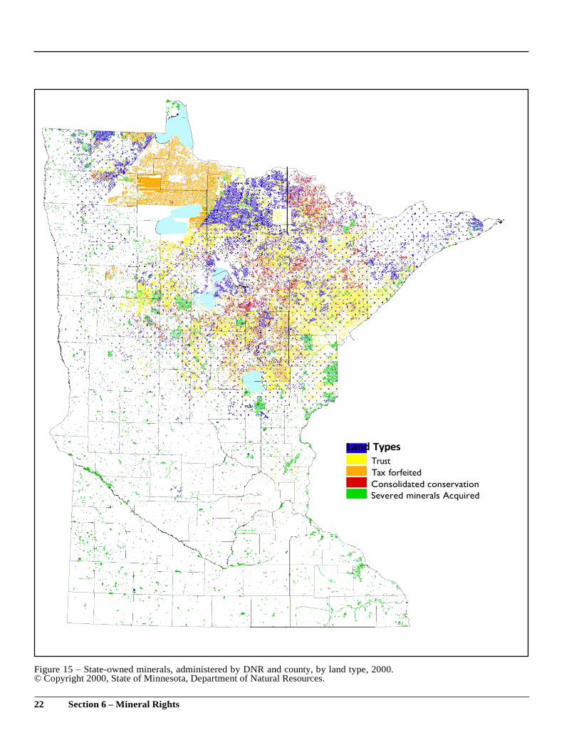
rights. It is estimated that the state owns approximately 12
million acres of mineral rights, which are about 24% of the
mineral rights in the state. (See Figure 15.) The exact amount of
mineral rights owned by the state is not known due to the lack of
clarity in some tax forfeiture records and the lack of a
comprehensive state inventory of all lands that have ever
forfeited for taxes.
21 Section 6 – Mineral Rights
Land Types
Trust
Tax forfeited
Consolidated conservation
Severed minerals Acquired
Figure 15 – State-owned minerals, administered by DNR and county, by land type, 2000. © Copyright 2000, State of Minnesota, Department of Natural Resources.
22 Section 6 – Mineral Rights

The state’s policy of reserving mineral rights upon the sale of
lands also includes the policy to never sell state-owned mineral
rights. The state may lease its lands and mineral rights for
mineral exploration and development. In some areas, such as the
BWCAW, the state is prohibited by state law from leasing
minerals under almost any circumstance. In some areas, such as
an airport, the state does not offer mineral rights for leasing due to
the use of the surface of the land.
The Minnesota Department of Natural Resources has the
authority to lease most of the state owned mineral rights.
Revenue from the state mineral leases is distributed based on the
type of land which is leased. For example, eighty percent of the
revenue from mineral leasing of tax forfeited lands and tax
forfeited minerals is returned to the counties in which the leased
lands are located. This eighty percent is distributed three-ninths
to the county, two-ninths to the town or city and four-ninths to
the school district. Fifty percent of the mineral lease revenue
from consolidated conservation area lands is distributed to the
counties in which the leased lands are located. More than 80%
of the principal of the permanent school fund is from revenues
from state mineral leases and mining taxes.
Some of the remaining permanent university lands are located on
the Mesabi Iron Range and contain valuable deposits of
taconite. Mining of taconite from permanent university lands in
the last five years has resulted in the payment of $21.5 million to
the permanent university fund. Since July of 1992, state mineral
lease revenue from the mining of university trust fund lands is
split between a mineral research account of the permanent
university fund and the Iron Range Scholarship account of the
permanent university fund. The annual interest from this revenue
is used for mineral research (including mineral related
environmental research) at the Natural Resources Research
Institute in Duluth and Coleraine, and for scholarships for
freshmen on the four campuses of the University of Minnesota.
The Iron Range Scholarship Program is the fastest growing
scholarship program at the University of Minnesota, with a total
$31.5 million in scholarships awarded since 1995.
Severed Mineral Interests Law The practice of separating mineral ownership from surface
ownership resulted in the speculative interests escaping taxation.
Unless the minerals were being mined or known to exist, the
mineral interests owned separately from the surface interests
were usually not taxed and so the mineral interests did not forfeit
for nonpayment of taxes.
Over the years the ownership of severed minerals became very
obscure or fractionalized. Some interests had been transferred
through several companies. Some interests remaining in
families for several generations had been divided among so
many descendants of the original party to the severance that their
fractional interests had become extremely small. It was also
quite common that the conveyance of severed mineral interests
was not placed of public record in the county courthouse. The
obscure ownerships were requiring expensive title searches to
deter- mine the current owners of the mineral rights.
The Minnesota Legislature addressed this issue and the issue of
taxation of the mineral interests in the 1970s. Parties that own
mineral interests separate from the surface interests are now
required to be identifiable in the county records. They must file
a statement of ownership and pay an annual tax. The failure to
pay the annual tax will result in forfeiture to the state. Numerous
mineral rights owners have decided not to pay the annual tax.
This has resulted in the forfeiture of over half a million acres of
severed mineral interests to the state.
Failure to file the statement of severed mineral ownership will
also result in forfeiture of the mineral interests to the state. In
order for the severed mineral interests to completely forfeit, the
state must bring an action in court. To bring the action, the state
needs to do a title search to find the last owner of record who
should have filed the statement.
23 Section 6 – Mineral Rights
Determination of Severed Minerals Ownership In order to find out if and what mineral rights are owned
separately from surface interests, it is necessary to review the
document for the land transfer that separated the mineral
ownership. There is a broad range of possibilities: specific
minerals might be covered, such as “all iron ore and coal,” or
the mineral separation may simply say “all minerals and
mineral rights.” There is no depth level between surface and
mineral rights (unless the document separating the surface and
mineral ownership specifies a depth). One person may own the
surface, and if another person owns the taconite, the taconite
owner may mine the taconite that appears on and below the
surface of the property.
The issue of what rights are associated with mineral ownership
are also affected by the document that separated the mineral
ownership. The issue of what mineral rights ownership means in
Minnesota has never been addressed by the Minnesota Supreme
Court. The general rule that has developed in other parts of the
country is that, unless otherwise stated in the severance deed,
mineral rights ownership carries with it the right to use as much
as the surface as may be reasonably necessary to reach and
remove the minerals. This means that the mineral owner has a
right of entry or access to explore for and mine minerals on and
beneath the surface of the land. Generally, it is recognized that
the surface owner would be paid for any damages to the surface
that occurred because of the mining activities.
24 Section 6 – Mineral Rights
Section 7
Land Ownership Statistics
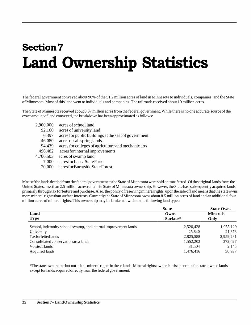
The federal government conveyed about 96% of the 51.2 million acres of land in Minnesota to individuals, companies, and the State
of Minnesota. Most of this land went to individuals and companies. The railroads received about 10 million acres.
The State of Minnesota received about 8.37 million acres from the federal government. While there is no one accurate source of the
exact amount of land conveyed, the breakdown has been approximated as follows:
2,900,000 acres of school land
92,160 acres of university land
6,397 acres for public buildings at the seat of government
46,080 acres of salt spring lands
94,439 acres for colleges of agriculture and mechanic arts
496,482 acres for internal improvements
4,706,503 acres of swamp land
7,000 acres for Itasca State Park
20,000 acres for Burntside State Forest
Most of the lands deeded from the federal government to the State of Minnesota were sold or transferred. Of the original lands from the
United States, less than 2.5 million acres remain in State of Minnesota ownership. However, the State has subsequently acquired lands,
primarily through tax forfeiture and purchase. Also, the policy of reserving mineral rights upon the sale of land means that the state owns
more mineral rights than surface interests. Currently the State of Minnesota owns about 8.5 million acres of land and an additional four
million acres of mineral rights. This ownership may be broken down into the following land types:
Land
Type
State
Owns
Surface*
State Owns
Minerals
Only
School, indemnity school, swamp, and internal improvement lands 2,520,428 1,055,129
University 25,840 21,373
Tax forfeited lands 2,825,588 2,959,281
Consolidated conservation area lands 1,552,202 372,627
Volstead lands 31,504 2,145
Acquired lands 1,476,416 50,937
*The state owns some but not all the mineral rights in these lands. Mineral rights ownership is uncertain for state-owned lands
except for lands acquired directly from the federal government.
25 Section 7 – Land Ownership Statistics
Section 8
Bibliography
The Minnesota Historical Society Press has several publications covering topics discussed in this publication . William Folwell’s
History of Minnesota, is a commonly available resource that will provide answers to many of the discussion and research
topics. There are a multitude of books on some of the topics, such as Thomas Jefferson or Voyageurs National Park.
Newspapers and magazines will be a source for some of the topics, such as wetlands and the Boundary Waters Canoe Area
Wilderness. The county auditor, land commissioner, and recorder, are sources of information for some of the research topics
concerning the county in which the student lives.
One of the best sources for detailed information on the history of public land ownership is Minnesota Lands: Ownership,
Use and Management of Forest and Related Lands, published by the American Forestry Association. Unfortunately, it
may be difficult to find in most library systems. (A copy is available in the Department of Natural Resources’ library in St.
Paul.)
The following sources were consulted:
Section 1 – Introduction Land Management Information Center, Minnesota State Planning Agency. 1983. Minnesota Public Lands, 1983. St.
Paul: Minnesota State Planning Agency.
United States General Accounting Office. 1996. Land Ownership: Information on the Acreage, Management, and Use of
Federal and Other Lands. Washington, D.C. Document No. GAO/RCED-96–40, March 1996.
Section 2 – Origins of Federal Ownership Berthel, Mary Wheelhouse. 1963. Minnesota Under Four Flags. St. Paul: Minnesota Historical Society Press.
Dana, Samuel Trask, John H. Allison, and Russell N. Cunningham.1960. Minnesota Lands: Ownership, Use and Management of Forest and Related Lands. Narberth: The Livingston Publishing Company.
Malone, Dumas. 1970. Jefferson The President: First Term 1801–1805. Boston: Little, Brown & Company.
Section 3 – The Public Land Survey Muehrcke, Phillip C. 1978. Map Use. Madison: J P Publications.
Section 4 – Federal Land Grants Dana, Samuel Trask, John H. Allison, and Russell N. Cunningham. 1960. Minnesota Lands: Ownership, Use and Management of Forest and Related Lands. Narberth: The Livingston Publishing Company. Folwell, William Watts. Revised edition, 1961. A History of Minnesota. St. Paul: Minnesota Historical Society Press. Malone, Dumas. 1970. Jefferson The President: First Term 1801–1805. Boston: Little, Brown & Company.
Orfield, Matthias Nordberg. 1915. Federal Land Grants to the States with Special Reference to Minnesota. Minneapolis:
Bulletin of the University of Minnesota, March 1915.
Pardee, John Stone. 1931. The Children’s Heritage, Duluth: Minnesota Arrowhead Association.
26 Section 8 – Bibliography
Section 5 – Federal and State Acquisitions of Land
Barlowe, Raleigh. 1951. Administration of Tax-Reverted Lands in the Lake States. East Lansing: Michigan State College,
Department of Agricultural Economics, Technical Bulletin 225, December 1951.
Dana, Samuel Trask, John H. Allison, and Russell N. Cunningham. 1960. Minnesota Lands: Ownership, Use and
Management of Forest and Related Lands. Narberth: The Livingston Publishing Company.
Minnesota State Planning Agency. 1974. Toward a Plan for the Perimeter of Voyageurs National Park. St. Paul:
Minnesota State Planning Agency.
Proescholdt, Kevin. 1984. After the Shouting Stopped: Implementation of the Boundary Waters Canoe Area Wilderness
Act. Published by Kevin Proescholdt.
Treuer, Robert. 1979. Voyageur County: A Park in the Wilderness. Minneapolis: University of Minnesota Press.
Section 6 – Mineral Rights Folwell, William Watts. Revised edition, 1961. A History of Minnesota. St. Paul: Minnesota Historical Society Press.
27 Section 8 – Bibliography
For more information, contact: Department of Natural
Resources Division of Lands and Minerals
500 Lafayette Road
St. Paul, MN 55155-4045
651-259-5959 Metro area
1-888-MINNDNR (1-888-646-6367) Toll-free in Minnesota TTY: 651-296-5484
Metro area
1-800-657-3929 Toll-free in Minnesota
Information on other educational publications may be found on our web site:
www.dnr.state.mn.us
©1997, 2000, 2005, 2016
State of Minnesota Department of Natural Resources Permission is
required for reproduction. Exception: classroom use.
Equal opportunity to participate in and benefit from the programs of the Minnesota
Department of Natural Resources is available to all individuals regardless of race, color,
creed, religion, national origin, sex, marital status, status with regard to public assistance,
age, sexual orientation, or disability. Discrimination inquiries should be sent to MN-DNR,
00 Lafayette Road, St. Paul, MN 55155-4031 or the Equal Opportunity Office, Department
of the Interior, Washington, D.C.
30340.
This information is available in an alternative format upon request.
Top Related