


Languages
Pages
Legal


PORT ACCESS ROUTE STUDY
APPROACHES TO Los Angeles – Long Beach and in the Santa
Barbara Channel
DOCKET #USCG-2009-0765
September 2011

2
TABLE OF CONTENTS
I. INTRODUCTION
II. BACKGROUND
A. Statutory Authority
B. Definition of Terms
C. Study Area
D. History
III. THE STUDY
A. Development
B. Concerns
C. Summary of Comments Received
IV. Options Considered
V. FINAL RECOMMENDATION
VI. CONCLUSION

3
I. INTRODUCTION
Vessel traffic has been bypassing the Santa Barbara
Channel Traffic Separation Scheme (TSS) and opting for
routes south of San Miguel, Santa Rosa, Santa Cruz and
Anacapa Islands (Channel Islands) when approaching and
departing from the San Pedro Channel. Vessels which have
traditionally used the established TSS in the Santa Barbara
Channel to access ports in Los Angeles - Long Beach, have
shifted to transit in the area south of the Channel
Islands. This is due, in part, to the California Air
Resources Board (CARB) regulation that applies to U.S. and
foreign flagged ocean going vessels. The regulation
requires the use of low sulfur cleaner fuels within 24
nautical miles (nm) of the California coastline.
In response to the changes in vessel traffic patterns
the Coast Guard has conducted a Port Access Route Study
(PARS) to evaluate the continued applicability of and the
need for modifications to current vessel routing in the
approaches to Los Angeles–Long Beach and the Santa Barbara
Channel. The comments and views of interested stakeholders
have been considered throughout the study process. The
primary purpose of the study was to reconcile the need for

4
safe access routes with other reasonable waterway uses, to
the extent practical. The goal of the study was to help
reduce the risk of marine casualties and increase the
efficiency of vessel traffic in the study area. The
recommendations of the study may lead to future rulemaking
action or appropriate international agreements.
The study assessed whether the creation of, or
modification to, a vessel routing system is necessary to
increase the predictability of vessel movements, which may
decrease the potential for collisions, oil spills, and
other events that could threaten the marine environment.
II. BACKGROUND
A. Statutory Authority:
Section 4(c) of the Ports and Waterways Safety Act
(PWSA), (P.L. 95-474, 33 U.S.C. 1223), authorizes the
Secretary of Transportation to designate necessary fairways
and traffic separation schemes (TSS’s) to provide safe
access routes for vessels proceeding to and from U.S. ports
or other places subject to the jurisdiction of the United
States. The authority to designate necessary fairways and
traffic separation schemes is granted to the Commandant of
the Coast Guard under 33 U.S.C. 1223(c), and recognizes the
paramount right of navigation over all other uses in the
designated areas. The PWSA requires the Coast Guard to

5
undertake a study of the potential traffic density and the
need for safe access routes for vessels in any area for
which a fairway or TSS is proposed or otherwise considered.
The PWSA also authorizes the Coast Guard to adjust the
location or limits of designated fairways and/or TSS’s in
order to accommodate the needs of users which cannot be
reasonably accommodated otherwise.
B. Definition of Terms:
The following definitions should help the reader to
understand terms used throughout this document:
Area to be avoided or ATBA means a routing measure
comprising an area within defined limits in which either
navigation is particularly hazardous or it is exceptionally
important to avoid casualties and which should be avoided
by all vessels, or certain classes of vessels.
Fairway means a lane or corridor in which no
artificial island or structure, whether temporary or
permanent, will be permitted so that vessels using U.S.
ports will have unobstructed approaches.
Marine Environment, as defined by the Ports and
Waterways Safety Act, means the navigable waters of the
United States and the land resources therein and
thereunder; the waters and fishery resources of any area
over which the United States asserts exclusive fishery

6
management authority; the seabed and subsoil of the Outer
Continental Shelf of the Unites States, the resources
thereof and the waters superjacent thereto; and the
recreational, economic, and scenic values of such waters
and resources.
Precautionary area means a routing measure comprising
an area within defined limits where vessels must navigate
with particular caution and within which the direction of
traffic flow may be recommended.
Recommended track means a route which has been
specially examined to ensure so far as possible that it is
free of dangers and along which vessels are advised to
navigate.
Regulated Navigation Area or RNA means a water area
within a defined boundary for which regulations for vessels
navigating within the area have been established under 33
CFR part 165.
Separation Zone or separation line means a zone or
line separating the traffic lanes in which vessels are
proceeding in opposite or nearly opposite directions; or
from the adjacent sea area; or separating traffic lanes
designated for particular classes of vessels proceeding in
the same direction.

7
Traffic lane means an area within defined limits in
which one-way traffic is established. Natural obstacles,
including those forming separation zones, may constitute a
boundary.
Traffic Separation Scheme or TSS means a routing
measure aimed at the separation of opposing streams of
traffic by appropriate means and by the establishment of
traffic lanes.
Vessel routing system means any system of one or more
routes or routing measures aimed at reducing the risk of
casualties; it includes traffic separation schemes, two-way
routes, recommended tracks, areas to be avoided, no
anchoring areas, inshore traffic zones, roundabouts,
precautionary areas, and deep-water routes.
C. Study Area:
The study area was the geographic area with a
northern boundary at 34° 30’ N; a western boundary at 121°
00’ W; a southern boundary at 33° 15’ N; and an eastern
boundary along the shoreline. This area encompasses the
Santa Barbara Channel, the approaches to Los Angeles-Long
Beach and the approach to the San Pedro Channel from the
Pacific Ocean; particularly the area south of San Miguel,
Santa Rosa, Santa Cruz and Anacapa Islands; north of San

8
Nicholas, Santa Barbara, and Santa Catalina Islands where
an increase in vessel traffic has been identified.
D. History:
From 1993 through 1996, the Coast Guard conducted a
PARS to analyze vessel routing measures in the approaches
to California ports. We published the study results in the
Federal Register on October 25, 1996 (61 FR 55248). The
study recommended shifting the southern approach lanes of
the existing TSS off San Francisco westward (seaward) and
extending the existing approach in the Santa Barbara
Channel 18nm to the northwest from Point Conception to
Point Arguello. The study also concluded no changes to the
TSS in the immediate approaches to Los Angeles-Long Beach
were necessary at that time. Following the PARS results a
Notice of Proposed Rulemaking (NPRM) was posted in the
Federal Register on June 17, 1999, announcing the Coast
Guard’s intention to adjust the TSS’s as noted above(64 FR
32451). The final rule was published on July 31, 2000,
implementing the recommended changes to the TSS’s (65 FR
46603).
In 1995, the Ports of Los Angeles and Long Beach
initiated major port improvement projects. These projects
are completed and included the following:

9
Lengthening of the Los Angeles Approach Channel to
extend approximately 3.5nm beyond the Los Angeles
breakwater.
Deepening of the Los Angeles Approach Channel to a
project depth of 81 feet.
A slight shift of the Long Beach Approach to a 355
degree True inbound course.
Deepening of the Long Beach Approach Channel to a
project depth of 69 feet.
The Coast Guard published a notice of study in the
Federal Register (64 FR 12139, March 11, 1999) which
announced we would conduct a PARS for the approaches to Los
Angeles-Long Beach. The Coast Guard published a notice of
study results in the Federal Register on May 19, 2000 (65
FR 31856). The PARS evaluated the potential effects of
port improvement projects on navigational safety and vessel
traffic management efficiency. It concluded that
modifications to the TSS in the approaches to Los Angeles-
Long Beach and the Precautionary Area were necessary to
facilitate safety of vessel traffic in the approaches to
the Ports of Los Angeles and Long Beach. The rule amended

10
the existing TSS in the approaches to Los Angeles–Long
Beach by:
Expanding the Precautionary Area approximately
2.2nm to the south;
Shifting the western traffic lane approximately
2.2nm south; and
Shifting the southern traffic lane
approximately 3 miles to the west.
III. THE STUDY
A. Development:
In March 2010, the Eleventh Coast Guard District
initiated a PARS for the approaches to the ports of Los
Angeles and Long Beach. A Federal Register Notice (USCG-
2009-0765) announced the study and solicited comments. The
notice contained a list of potential study topics and a
list of questions to help focus responses.
Fourteen letters and six studies were received in
response to the published notice of study. The Eleventh
Coast Guard District also held public meetings in Oxnard
and San Pedro California to allow for comments in person.
These meetings were announced in the Federal Register and
conducted at the Port Hueneme Harbor District office on

11
October 13th, 2010 and at the Port of Los Angeles
Administration Building on October 14th, 2010. From
comments received we identified a list of concerns
expressed during the course of the study, which are listed
below:
(a) Establishing traffic lanes south of the
Channel Islands will standardize commercial
shipping or recreational traffic through the
Navy’s Point Mugu Sea Range.
(b) Current vessel traffic threatens whale
species due to ship strikes.
(c) Pollutants emitted by commercial vessels
increase the risk of cancer for California
residents.
(d) There is a possibility that with the new
International Maritime Organization (IMO)
Emission Control Area (ECA) standards taking
effect in 2012 vessel transit patterns may again
be affected.

12
Comments also encouraged finding optimal solution(s)
that reduce the risk of marine accidents while minimizing
risks to wildlife and sensitive areas.
We considered information presented in various studies
and data collected both in-house and by other organizations
on vessel traffic patterns, density, and risks. U.S. Coast
Guard sources included the latest Waterways Analysis and
Management System (WAMS) report, covering the Santa Cruz
Channel and the Santa Barbara Channel, and vessel transit
statistics from VTS Los Angeles. WAMS are conducted by the
U.S. Coast Guard to determine the need for updates to Aids
to Navigation and their continued applicability in the
navigable waters of the U.S.
B. Concerns
In this part of the study we will present the
following:
Concerns.
Summary of comments received
Concern (a):
Establishing traffic lanes south of the Channel
Islands will standardize commercial shipping or
recreational traffic through the Navy’s Point Mugu Sea
Range.
Summary of comments received:

13
Comments on this issue were received from the Naval
Air Warfare Center Weapons Division Point Mugu, Department
of the Air Force 30th Space Wing, County of Ventura Board of
Supervisors, Ventura County Board of Supervisors Third
District, and the Regional Defense Partnership for the 21st
century (RDP-21).
The Point Mugu Sea Range is the nation’s largest
air/sea test bed for missiles, free-fall weapons and
electronic warfare systems. The sea range spans 36,000
square miles and is the largest and most heavily used range
in the United States. It is instrumental in the
development of weapons that are capable of defending our
nation and winning wars. One example of the military
success the sea range brings the United States is the
Tomahawk cruise missile, which was tested within the safe
confines of the sea range. The creation of a standardized
vessel routing system that transits though this sea range
will impede the process to conduct time sensitive defense
evaluations and mission critical training. The Chief of
Naval Operations (CNO) is mandated under Title 10 U.S. Code
Section 5062 with the responsibility to ensure the
readiness of the nation’s naval forces. Full battle group
fleet exercises involving aircraft, surface ships, and
submarines are conducted in the sea range without being

14
affected by the flow of commercial vessels. Interested
parties believe any attempt to create a new TSS within the
sea range would disrupt the navy’s ability to effectively
train forces, test and evaluate munitions, and provide for
the security of the nation.
The United States Air Force 30th Space Wing has also
expressed concern with establishing a new TSS. The Air
Force believes creating a shipping lane west of the Channel
Islands would have “great impacts” on the civil and
military spacelift mission. Working with the Department of
Defense, National Reconnaissance Office, NASA and
Department of Commerce the Air Force places a variety of
satellites into polar orbit. Boosters and fairings from
the rockets may impact areas where shipping lanes would be
placed. Delays in launching or rescheduling due to vessel
traffic could result in significant additional costs to the
tax payers.
Ventura County could be affected by the interference
of vessels in the sea range as its economy thrives on the
Navy’s existence in the area. If the Navy were to explore
new options for missile testing, jobs could be lost.
Recommendations from submitted comments mentioned
establishing an ATBA or precautionary area within the sea
range to keep commercial traffic other than oil tankers

15
out. Oil tankers have historically transited 50nm off the
coast by industry agreement. This separates them from
faster moving container vessel traffic using the IMO
approved Recommended Tracks through the Monterey Bay
National Marine Sanctuary and the TSS through the Santa
Barbara Channel. The low number of oil tanker transits
through the sea range is manageable for the Navy and Air
Force to conduct operations with minimal disruption.
Another comment recommended waiting to see how the
proposed amendments to the CARB regulation would affect
vessel traffic if the low sulfur requirements are extended
out to 24nm from the Channel Islands. The PARS may be
premature as any recommendation for a TSS could change once
vessels are required to comply with a new CARB standard.
As stated in the introduction the CARB regulation applies
24nm from the mainland of California not from the Channel
Islands. If the CARB regulation is amended to apply within
24nm of the Channel Islands, it could influence vessels to
return to using the current TSS in the Santa Barbara
Channel, as the incentive to avoid the low sulfur fuel
regulation will diminish.
Concern (b):
Current vessel traffic threatens whale species due to
ship strikes.

16
Summary of comments received:
We received comments on this issue from the Channel
Islands Marine Sanctuary Advisory Council, Channel Islands
National Marine Sanctuary, National Marine Fisheries
Service, Center for Biological Diversity, Cascadia Research
Collective, and the Environmental Defense Center.
The Santa Barbara Channel contains some of the most
biologically diverse waters on the planet and is home to a
number of marine mammal species listed in the Endangered
Species Act. Within these waters is the Channel Islands
National Marine Sanctuary which is host to the densest
seasonal population of blue whales in the world. The Santa
Barbara TSS passes directly through the sanctuary and puts
endangered marine mammals at risk. The channel’s abundant
marine life plays an important role in the feeding patterns
of migratory whales and is the reason why the impact of
vessel traffic and speed need to be considered during the
PARS. Ship strikes on whales off the California coast,
specifically in the Santa Barbara TSS, are a concern, and
noise pollution can be a contributing factor. Cavitation
created by collapsing air bubbles off transiting vessels
propellers can mask biologically important sounds whales
use to communicate, forage and navigate, thus increasing
risks from predators and collisions with large vessels.

17
Recommendations from comments included a speed
restriction through areas of known whale locations. It has
been suggested through studies that slower moving vessels,
10-12 knots, will not only increase survivability of whales
in the event of a strike but also give them time to detect
and avoid. Vessel speeds in the 10-12 knot range create
less cavitation and less interference with marine mammal
communication. This speed reduction proposal would be
established in areas where whales congregate, namely in the
Santa Barbara TSS.
Research by the National Marine Fisheries Service and
the Channel Islands National Marine Sanctuary indicates a
single TSS south of the Channel Islands would appear to
minimize the overall risk of ship strikes on whales.
Although it would increase the risk for fin whales, it
would reduce the risk for blue and humpback whales. A
route just south of the northern Channel Islands produces
the smallest increase in risk for fin whales, while still
decreasing the risk for blue and humpback whales.
Suggested changes to the current Santa Barbara Channel TSS
are to move it away from known whale feeding grounds and
areas of high concentration. Where this cannot happen,
such as around oil platforms, consider narrowing the
shipping lanes to minimize impact on the whale habitat.

18
This would decrease the amount of traffic coming into
contact with endangered marine life and the national marine
sanctuary. Research indicates reducing the width of the
Santa Barbara TSS, to move it away from the 200 meter
isobath, could reduce the impact on marine life. Extending
the TSS further west and away from known areas of high
whale density like Santa Lucia Bank could help to avoid
whale strikes. The Cascadia Research Collective commented
that creating ATBA’s on the west and south side of San
Miguel Island would protect known whale concentrations.
Concern (c):
Pollutants emitted by commercial vessels increase the
risk of cancer for California residents.
Summary of comments received:
We received comments from the Center for Biological
Diversity, the Santa Barbara Air Pollution Control
District, and the California Air resource Board.
Over 40% of the nitrogen oxides (NOx) emissions in the
Santa Barbara County Air pollution Control District are
contributed by large ships traveling through the Santa
Barbara Channel. The CARB has conducted modeling that
quantifies excess cancer risk from diesel particulate
matter from ocean-going vessels transiting along the coast
of California. According to CARB’s modeling, the

19
population of coastal areas in Santa Barbara County have a
probability of 50 in a million excess cancer risk offshore
and 10-20 in a million excess cancer risk onshore. The
California Environmental Quality Act sets risk thresholds
at 10 in a million for excess cancer risk. The proximity
of the TSS, speed of ocean going vessels, and type of fuel
used by commercial shipping are all major factors of
influence on the pollutants emitted. Also, wind patterns
off of Santa Barbara County are known to bring heavy
onshore flow. The onshore flow carries with it the air
pollutants from the Santa Barbara Channel thus increasing
the health risks for county residents.
Recommended options for consideration are to shift the
traffic lanes south of the islands, slow vessel speeds to
10-12 knots and require commercial vessels to use a cleaner
fuel. Emission reduction estimates by the Santa Barbara
Air pollution Control District show dramatic decreases in
pollutants with implementation of speed requirements. It
is estimated that mandating vessels to transit the TSS at a
speed of 12 knots could potentially cut hazardous airborne
pollutant emissions by an average of 65%.
To further help reduce air pollutant emissions,
California’s ocean going vessel clean fuel regulation
requirements, established by CARB in July of 2009, mandate

20
the use of cleaner fuels in main engines, auxiliary
engines, and auxiliary boilers within 24nm of the
California Coastline. The CARB regulation requires the use
of marine gas oil, which averages .3% sulfur, or the use of
marine diesel oil with a .5% sulfur limit. CARB has
proposed an amendment to the regulation which will extend
the clean fuel requirement in southern California out 24nm
from the Channel Islands including San Nicolas and San
Clemente Island.
The IMO’s Emission Control Area (ECA), proposed in
2008, was agreed upon in March of 2010. The ECA proposal
was initiated by the member states of the IMO in order to
reduce emissions of nitrogen oxides (NOx), sulfur oxides
(SOx), and fine particulate matter (PM2.5). The waters off
the North American coastline, out to 200nm, will have
strict emissions standards beginning in 2012 with full
enforcement in 2015. The ECA requires the use of low
sulfur fuel with sulfur emission levels of .1% or 1,000
parts per million (ppm). This is expected to reduce PM and
SOx emission levels by more than 85% and significantly
improve respiratory health. The Environmental Protection
Agency has estimated that annual benefits by 2020 will show
an average reduction of 10,000 premature deaths, nearly

21
4,000 emergency room visits, and 4.9 million cases of acute
respiratory symptoms.
Concern (d):
There is a possibility the new IMO Emission Control
Area standards beginning implementation in 2012, may affect
vessel transit patterns.
Summary of comments received:
Comments on this issue were received from the Naval
Air Warfare center Weapons Division, and the Department of
the Air Force 30th Space Wing.
The incentive for vessels to bypass the Santa Barbara
Channel TSS may diminish with the IMO implementation of the
North America ECA. The ECA will extend out to 200nm, well
beyond the 24nm CARB requirement for the use of low sulfur
fuel. When all commercial vessels are required to use a
low sulfur fuel when in U.S. waters they may return to
previous traffic patterns, i.e. using the Santa Barbara
TSS; however, it is too early to tell what the effects will
be.
The Navy recommendation on this issue is to wait and
see how ECA implementation affects vessel routing. Vessel
traffic patterns could return to the Santa Barbara Channel
TSS as commercial vessels will no longer have incentive to

22
bypass it. A new TSS should not be recommended through the
sea range before it is clear what the ECA’s impact will be.
IV. Options Considered
After reviewing the comments submitted to the docket
and vessel traffic patterns the following options were
considered.
Option 1: Status Quo (No Change)
The current vessel routing measure has historically
provided for the safe navigation of vessels en route to and
from the ports of Los Angeles and Long Beach. Prior to
July 2009, most container cargo vessels transiting between
Los Angeles-Long Beach and Oakland used the Santa Barbara
Channel TSS. Tankers carrying crude oil, black oil, or

23
other persistent liquid cargo in bulk were the predominant
vessels transiting the waters south of the Channel Islands,
as they typically transit 50nm offshore by industry
agreement. The current pattern of vessels transiting south
of the Channel Islands may return to historical patterns of
using the Santa Barbara Channel TSS after the ECA begins
implementation in 2012. By 2015 the IMO standards will
match the CARB fuel requirements. If vessel traffic returns
to historical patterns, the Santa Barbara Channel TSS
continues to serve as a safe and effective route for
shipping.
Option 2: Create western traffic lanes south of the
Channel Islands

24
By creating western traffic lanes we improve
visibility and predictability for vessels transiting south
of the Channel Islands. The increase of vessel traffic in
the waters south of the Channel Islands has caused concern
for mariners and government agencies. Taking into
consideration the concerns for safety at sea, and the
potential for devastating environmental impacts should two
vessels collide, the Harbor Safety Committee in Los Angeles
and Long Beach voted to establish a voluntary western
approach that extended from the precautionary area in the
San Pedro Channel to the limits of the Vessel Traffic
Service reporting area. (see option 5). The voluntary
traffic lane is not IMO approved; however, it has been
effective for predicting and managing vessel traffic in the
limited area it covers. If vessels continue to transit
south of the Channel Islands after the Emission Control
Area begins implementation in 2012, an IMO approved TSS
will establish a predictable route for these vessels.
There are economic, safety and security concerns with
establishing traffic lanes through the Navy Sea Range as
noted in the comments section of the study; however vessels
have been transiting through this area since July 2009
without significant impacts being reported.

25
Option 3: Eliminate the existing Santa Barbara traffic
lanes and create a new TSS south of the Channel Islands.
Many commercial vessels use Port Hueneme including car
carriers, tankers and container ships. Port access routes
such as the Santa Barbara Channel traffic lanes provide a
means for safe navigation in and out of Port Hueneme.
Eliminating a predictable traffic route for these vessels
in a sensitive marine environment could result in marine
casualties and irregular traffic patterns with potential
for increased impacts on marine mammals.

26
Option 4: Reduce the width of the separation zone from
2nm to 1nm in the Santa Barbara Channel TSS, keeping the
northern outbound lane in its current position and moving
the southern inbound lane 1 nm toward the northern lane.
This option would move the inbound lane further away
from the Channel Islands and the marine life that feeds in
the area. Research indicates higher concentrations of
whales within the 200 meter isobar. Shifting the southern
lane away from these areas by moving it further to the
north may help to reduce the number of ship strikes on
whales. Technological advances in navigation systems since
the TSS was originally established allow for the separation
zone between the lanes to be reduced to 1 nautical mile
with minimal impact on the risk of vessel collisions.

27
Option 5: Establish a TSS for the voluntary traffic
lanes endorsed by the Harbor Safety Committee
In response to the number of vessels opting to transit
south of the Channel Islands the Harbor Safety Committee in
Los Angeles and Long Beach voted to create a 26nm voluntary
traffic lane that extended to a 40 nautical mile radius
from the VTS to near the eastern boundary of the Navy Sea
Range. The voluntary lane has helped to organize vessel
traffic approaching or departing the ports of Los Angeles
and Long Beach in an area that is vital for vessel traffic

28
predictability. As vessels leave the 25nm VTS monitoring
zone, and the voluntary traffic lane, they are on their own
to continue safe navigation. Creating a TSS to match the
voluntary traffic lanes will provide international approval
for this routing scheme. As long as vessels continue to use
this route, it will provide vessel traffic predictability
in the area. Since vessels using this route are likely to
transit through the Navy Sea Range it may be beneficial to
extend these voluntary lanes to provide a well defined
route for vessels transiting south of the Channel Islands
and further enhance predictability of vessel traffic
through this area.
V. FINAL RECOMMENDATION:
The Coast Guard has thoroughly reviewed the comments
and recommendations received for the PARS Approaches to Los
Angeles Long Beach and Santa Barbara Channel. Under the
PWSA the intent for conducting a PARS is to provide safe
access routes for vessel traffic proceeding to and from
ports or places that fall under jurisdiction of the United
States. After a thorough review of existing and potential
traffic patterns and comments received the Coast Guard
recommends the following changes to the TSS which are a
combination of options 2 and 4.
29
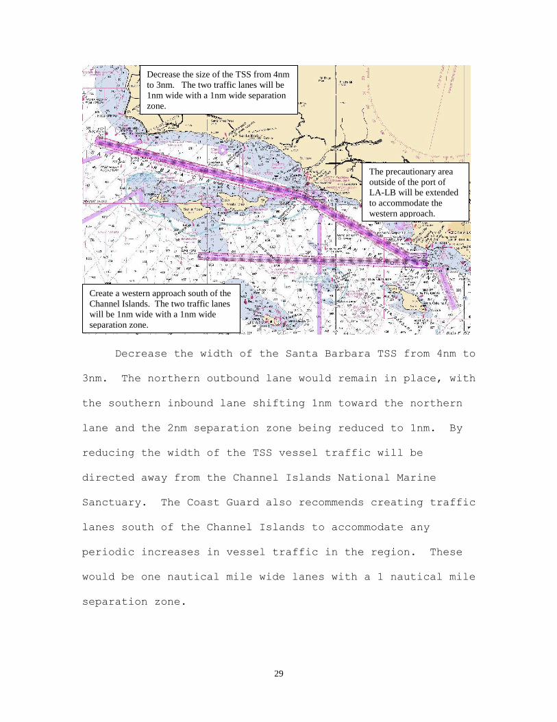
Decrease the width of the Santa Barbara TSS from 4nm to
3nm. The northern outbound lane would remain in place, with
the southern inbound lane shifting 1nm toward the northern
lane and the 2nm separation zone being reduced to 1nm. By
reducing the width of the TSS vessel traffic will be
directed away from the Channel Islands National Marine
Sanctuary. The Coast Guard also recommends creating traffic
lanes south of the Channel Islands to accommodate any
periodic increases in vessel traffic in the region. These
would be one nautical mile wide lanes with a 1 nautical mile
separation zone.
Decrease the size of the TSS from 4nm
to 3nm. The two traffic lanes will be
1nm wide with a 1nm wide separation
zone.
Create a western approach south of the
Channel Islands. The two traffic lanes
will be 1nm wide with a 1nm wide
separation zone.
The precautionary area
outside of the port of
LA-LB will be extended
to accommodate the
western approach.

30
The Coast Guard believes the proposed modifications
will provide well defined traffic corridors to facilitate
the safety of navigation while helping to preserve the
marine environment. A proposed TSS south of the Channel
Islands may at times see increased use above historical
norms and thus operations in the Point Mugu Sea Range may be
impacted, but a well defined traffic route will increase
predictability for vessel traffic passing through the range.
Keeping a TSS through the Santa Barbara Channel gives
vessels the option of avoiding Navy operations in the Sea
Range south of the Channel Islands.
The voluntary traffic lanes approved by the Los Angeles
– Long Beach Harbor Safety Committee have worked well to
keep vessels on a predictable course for a limited transit
distance. The lanes extend approximately 26nm from the end
of the VTS monitoring zone to the eastern boundary of the
Navy sea range. The lack of defined traffic lanes for
vessels transiting south of the Channel Islands presents a
potential safety concern for the Coast Guard. The waters
south of the Channel Islands can become congested with
vessel traffic heading to and departing from the ports of
Los Angeles and Long Beach. By extending the voluntary
lanes and establishing a TSS south of the Channel Islands we
can establish organized, predictable commercial shipping

31
routes. This increased predictability should make it easier
for the Navy to conduct training and missile tests by
providing well defined traffic lanes for vessels in an area
already laden with shipping traffic. Currently, the waters
south of the Channel Islands can have numerous inbound and
outbound vessels spanning a width of 10nm through the sea
range. By establishing a TSS, the impacted waters of the
navy sea range will be reduced to a 3nm wide by 50nm long
rectangle.
Many vessels transiting south of the Channel Islands
are doing so for economic reasons. The higher cost and wear
on the vessels engines when using low sulfur fuel make it
practical to use the less expensive higher sulfur fuel when
given a choice. By taking the quickest route out past 24nm
and transiting south of the Channel Islands vessels are
saving money; however, they also add roughly 13nm to their
trip between San Francisco and Los Angeles. As the ECA
begins to take effect in 2012 and all vessels are required
to use low sulfur fuel it may no longer be an economic
advantage to transit south of the Channel Islands; however,
if current vessel traffic patterns don’t change after the
ECA is implemented a TSS south of the islands will keep
vessels on a predictable course and facilitate their safe
transit. Also, a future speed restriction in the existing

32
TSS could create economic advantages for vessels to once
again shift out of the TSS. In any eventuality, we have
learned that a TSS in the southern area promotes safe
navigation no matter the reason for increased traffic.
While many comments proposed a speed restriction the
Coast Guard doesn’t have that authority here. The authority
and responsibility to promulgate speed restrictions to
protect a marine species rests with the National Oceanic and
Atmospheric Administration (NOAA). The PWSA, the only
relevant authority under which the USCG can control vessel
movement (or issue speed restrictions) is intended to
protect the vessel, shore facilities and the marine
environment from vessel damage and casualties, e.g.,
collisions, allisions or groundings that may damage the
vessel and result in an oil or hazardous material release.
Coast Guard authority to enforce the Endangered Species
Act (ESA) and Marine Mammal Protection Act (MMPA) is limited
to regulations that implement or further our enforcement of
a substantive regulation or requirement in the statute.
That enforcement authority does not extend to promulgating a
speed restriction to protect marine species. Our authority
under those statutes is limited to assisting with
enforcement of regulations that NMFS/NOAA may establish to
protect marine mammals and endangered species.

33
VI. CONCLUSION
The Port Access Route Study provides an evaluation of
the continued applicability and the need for modifications
to the current vessel routing system. At the conclusion of
our PARS we identified recommendations that could enhance
the safety aspect of current vessel routing. Creating a TSS
south of the Channel Islands, to accommodate our safety
concerns for vessels using the alternate approaches to Los
Angeles and Long Beach, would keep vessel traffic on a
predictable course. Modifying the Santa Barbara Channel
TSS could reduce the interaction of whales and ships. The
proposed modifications will need to follow the federal
rulemaking process to be implemented. This process would
include consultations with the National Marine Fisheries
Service in accordance with the Endangered Species Act. A
notice of proposed rulemaking would invite public comment
on the proposal. Any proposed modifications would also
require approval by the IMO.
Top Related