


Languages
Pages
Legal


Masaki Katsumata (JAMSTEC)Masaki Katsumata (JAMSTEC)KunioKunio YoneyamaYoneyama, Shuichi Mori (JAMSTEC), Shuichi Mori (JAMSTEC)PIs of piggyPIs of piggy--bag missions, incl. Yugo bag missions, incl. Yugo KanayaKanaya (JAMSTEC)(JAMSTEC)
YMC science and planning workshop @ CCSR, Singapore / Jan.28YMC science and planning workshop @ CCSR, Singapore / Jan.28--30, 201530, 2015
Photo by Photo by Dr. Dr. DjamalDjamal KhelifKhelifffrom WProm WP--3D during CINDY/DYNAMO3D during CINDY/DYNAMO
Planned observation by R/V Mirai:Planned observation by R/V Mirai:in 2017/18 and in 2015in 2017/18 and in 2015
Mirai equipsMirai equips-- CC--band dualband dual--pol. radarpol. radar: pre: pre--installedinstalled, brand, brand--new new -- radiosonderadiosonde and and CTDCTD:: enable 3enable 3-- / 6/ 6-- hourly obs.hourly obs.-- piggypiggy--bag instrumentsbag instruments::
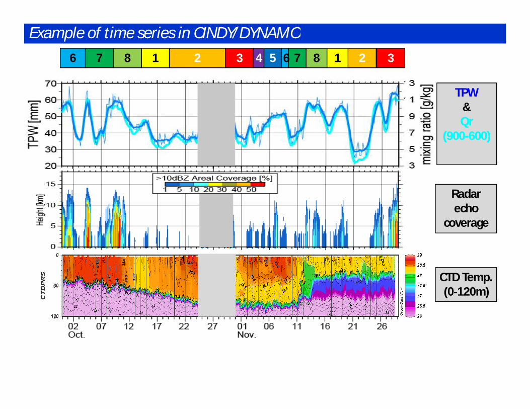
Example of time series in CINDY/DYNAMO
CTD Temp.(0-120m)
2 31876 2 3187654
Radar echo
coverage
TPW&QrQr
(900(900--600)600)

Estimate of particle shape (H/V ratio)Schematic of dual-pol obs.
Web of NOAA/NWSweb of NOAA/NWS
New & key equipment: C-band dual-polarized radar
RR @ sfc disdrometer
H-Only Dual-Pol
RR fr
om R
adar
web of NIED, Japan
wet snowwet snow
graupelgraupel
Rowe and Houze (2014)
Benefit(1): better estimate rainrate Benefit(2): hydrometer identification

Mirai radarReflectivity1230UTC
Metop/AVHRRIR image1156UTC
PPI (horizontal map) RHIs (vertical cross section)
Z
ZDR
KDP
C-POL “First Image”: 1218Z on 06 Jun. 2014 Katsumata (2014) (in Japanese)

Intensive Observation off and on Sumatra by JAMSTEC in 2017/2018Purpose: Study of precipitation mechanism off and on Sumatra, with focus on the relationship with
1) local atmospheric circulation associated with the Maritime Continent,2) MJO, and3) IOD (SST condition over the oceanic upwelling region).
Period: Dec 2017 - Jan 2018
Location: R/V MIRAI on station off SumatraLand-based Site at Bengkulu
Observations: R/V Mirai C-band Polarimetric Doppler radar, Radiosonde, Surface Meteorology,CTD + water sampling, LADCP, etc.
Bengkulu X-band Polarimetric Doppler radar, Radiosonde, Surface Meteorology, etc.
Remarks: Decision to the R/V Mirai cruise proposal is in pending.EAR is operated at Kototabang by Kyoto University. Additional obs will be done there.In conjunction this cruise, another oceanographic cruise as part of IIOE-2 will be carried out.
RAMA, TAO/TRITONRadar Radiosonde
DEC Mean Rainfall (TRMM, 1998-2012)
Mirai
BengkuluLand-based siteEAR site

R/V Mirai Pre-YMC Cruise in 2015
11/05 lv Sekinehama11/06 ar/lv Hachinohe11/22 ar off Sumatra 12/18 lv off Sumatra12/20 ar Jakarta
Bengkulu
< Atmospheric Measurements >1) C-band dual-pol. scanning Doppler Radar2) Ka-band VP cloud radar3) Radiosonde (3-hrly)4) Surface Meteorology5) Skin SST (Radiometer, Seasnake)6) GPS water vapor7) Disdrometer8) Ceilometer9) Mie / Raman Lidar10) Videosonde (20-30 times)11) Sky Radiometer12) Solar Tracker & Telescope / Optical Spectrum Analyzer13) MAX-DOAS (NO2, AOD)14) High Volume Air Sampler & Gas Analyzers
< Oceanographic Measurements >1) CTD (6- or 3-hrly)
+ water sampling (Nutrients, DO, Chl-a)+ LADCP
2) Underway CTD (prior to on-station obs)3) Ocean surface turbulence (6-hrly, TBD)4) Shipboard ADCP5) Sea Surface Monitoring (T, S, DO, Chl-a, etc.)
< Others >1) Sea Skater Sampling (10 times)
On-board Personnel fromJAMSTEC, JAXA, Indonesia (BPPT and/or BMKG),Univ. Tokyo, Univ. Toyama, Yamaguchi Univ., Kochi Univ.

RainfallTRMM/PR
Off Sumatra
Diurnal migrationof
precipitation
(Mori et al. MWR 2004)
Schematics of diurnal migrationg precip. system
Coastal heavy-rain system, migrating diurnally Mori et al. (2004)

Land-based site(s) (Details under discussion)
R/V Mirai• Soundings• Dual-pol. radar• Oceanic profilers (CTD etc.)• Piggy-bag instruments
Buoy(s)• Oceanic profiles• Surface Met
2D schematics of observation in Nov. / Dec. 2015
diurnalpropagatingcloud
Air-sea interaction
upwelling /ocean mixing
radiosonde
Videosonde/HYVIS

Candidate Position for “Station”
+
Candidate vessel station: 50 km from coast
(within radar range)
R=100kmCandidate land-site:
Benkulu
Helps by Indonesian Agencies are essential to get permission

Aerosols: remote/in-situ obs. on R/V Mirai
parameters instruments Priority (tbc)
AOD & its vertical profile Mie Lidar/ Skyradiometer/ MAX-DOAS
H
Black carbon (BC) SP2 H
Fluorescent bioaerosolparticles
WIBS H
Rainwater(BC, bioaerosol)
Sampling H
CO (Pollution tracer), O3, NO2, etc.
NDIR, UV abs, MAX-DOAS
H
CN number density CPC M
Particle size distribution OPC L
Water soluble ions/metal High-Vol air sampler
L
1. Elucidate spatio-temporal variation & origins (Forest Fires/Industrial) 2. Identify “Seeds” of clouds/rain (Cloud Condensation Nuclei/ Ice Nuclei)
High BC concentrations:
likely from Forest Fires
MAX-DOAS
SP2 (black carbon)
Preliminary Black carbon obs. by SP2 (MR14-01/02, Jan/Feb 2014)
High eff. NebulizerHigh eff. Nebulizer bioaerosol
Taketani, Miyakawa et al.In preparation
Below cloud rain water sampling
“Single-Particle” characterization
offline post-analysis
In-situ analysis
(also In-situ)

R/V Mirai Pre-YMC Cruise in 2015
11/05 lv Sekinehama11/06 ar/lv Hachinohe11/22 ar off Sumatra 12/18 lv off Sumatra12/20 ar Jakarta
Bengkulu
< Atmospheric Measurements >1) C-band dual-pol. scanning Doppler Radar2) Ka-band VP cloud radar3) Radiosonde (3-hrly)4) Surface Meteorology5) Skin SST (Radiometer, Seasnake)6) GPS water vapor7) Disdrometer8) Ceilometer9) Mie / Raman Lidar10) Videosonde (20-30 times)11) Sky Radiometer12) Solar Tracker & Telescope / Optical Spectrum Analyzer13) MAX-DOAS (NO2, AOD)14) High Volume Air Sampler & Gas Analyzers
< Oceanographic Measurements >1) CTD (6- or 3-hrly)
+ water sampling (Nutrients, DO, Chl-a)+ LADCP
2) Underway CTD (prior to on-station obs)3) Ocean surface turbulence (6-hrly, TBD)4) Shipboard ADCP5) Sea Surface Monitoring (T, S, DO, Chl-a, etc.)
< Others >1) Sea Skater Sampling (10 times)
On-board Personnel fromJAMSTEC, JAXA, Indonesia (BPPT and/or BMKG),Univ. Tokyo, Univ. Toyama, Yamaguchi Univ., Kochi Univ.

Overview of “YMC (Years of Maritime Continent)”

Surface Met.
“ Sea Snake” SSST
“ ISAR” SSST
Shipboard ADCP
CTDO + LADCP
Water Sampling(Sal, DO, Nuts, etc.)
Micro Structure Profiler
Disdrometer
GPS for TPW
Surface Water (T/S/DO)
Vapor
Surface
Ocean
WindC-band Scanning Dual-Pol. Radar
XCTD / UCTD
Temp.
Radiosonde
VP cloud radar
Planned observation on R/V MIRAI in Nov. / Dec. 2015
aerosol
HYVIS /Videosonde
aerosol
gas
Rain / Cloud
Ceilometer
VP Mie Lidar w / Raman Obs.

Experimental instruments / platforms
Wave Glider New shallow-profiling float
• 定点観測期間に試験機材の展開・回収作業を実施• 展開・回収のタイミングは未定• 機材状況等により、緊急に作業を行うこともあり得る

Aerosols: remote/in-situ obs. on R/V Mirai
parameters instruments Priority (tbc)
AOD & its vertical profile Mie Lidar/ Skyradiometer/ MAX-DOAS
H
Black carbon (BC) SP2 H
Fluorescent bioaerosolparticles
WIBS H
Rainwater(BC, bioaerosol)
Sampling H
CO (Pollution tracer), O3, NO2, etc.
NDIR, UV abs, MAX-DOAS
H
CN number density CPC M
Particle size distribution OPC L
Water soluble ions/metal High-Vol air sampler
L
1. Elucidate spatio-temporal variation & origins (Forest Fires/Industrial) 2. Identify “Seeds” of clouds/rain (Cloud Condensation Nuclei/ Ice Nuclei)
High BC concentrations:
likely from Forest Fires
MAX-DOAS
SP2 (black carbon)
Preliminary Black carbon obs. by SP2 (MR14-01/02, Jan/Feb 2014)
High eff. NebulizerHigh eff. Nebulizer bioaerosol
Taketani, Miyakawa et al.In preparation
Below cloud rain water sampling
“Single-Particle” characterization
offline post-analysis
In-situ analysis
(also In-situ)

Measurements of Airborne and Waterborne Particles over Coastal Sea of MC
Rain water collection
High-efficiency Aerosolization Device
“Single-Particle” airborne measurementsBlack carbon
Sea-saltBiological
Airborne(in-situ)
Single-Particle SootPhotometer (H)
Waveband Integrated Bioaerosol Sensor (H)
Waterborne(post-analysis)
Convection over Coastal Sea of MC
Land breeze(anthropogenic?)
Rain water sampling
Total aerosols as seeds of cloud droplets
CCN-activeaerosols
parameters instrument Priority (tbc)
AOD and its profile Mie Lidar/ Skyradiometer/ MAX-DOAS
H
Black carbon (BC) SP2 H
Fluorescent bioaerosolparticles
WIBS H
CO (Pollution tracer), O3 NDIR, UV abs H
Impurity in Rainwater(for BC, bioaerosol)
Sampling H
Water soluble ions/metal HV air sampler L
CN number density CPC M
Below cloud
List of instruments

Overview of “YMC (Years of Maritime Continent)”

CTD/LADCPoceanic mixed
layer
Wave Glider + T-ChainSfcMet / Ocean Skin
Temp.
X-band dual-pol. Radar4D structure of precip.
System
GPM-Core
Expected special observation in Nov/Dec 2015
Videosonde/HYVIS (with Yamaguchi Univ.)
in-situ microphysics
Radiosondeambient
P/T/RH/Wind
Land-based site
RAMA buoyFar-field
met./ocean status
R/V Mirai
JAXA Ka-band radar(on R/V Mirai)
vertical structure of Rain
C-band dual-pol. Radar4D structure of precip.
system
Targetting land, coastal and oceanic rain
and their transitionby ship- and land-based instruments

Focused 1-D Processes and Measurements @ Mirai “Supersite”
Free atmosphereRadiosonde (PTU, wind)
Lidar (Vapor)GPS (Vapor)
Atmos. mixed layerRadiosonde (PTU, wind)
Lider (aerosol, vapor)Aesorol measurements
Wind Profiler (wind) … ?
Oceanic mixed layer CTD / UCTD (TS)
ADCP / LADCP (UV(W))TurboMAP (e)
CTD Chain @ Wave Glider (TS, 0-10m)
Clouds and PrecipitationDual-pol radar (3D, hydrometer & wind)
VP radars (detail 2D, rain & cloud)Lidar (cloud & aerosol))
Videosonde (microphysics)
HEAT / MOMENTUM FLUX

Fundaments:• Focusing “atmos-ocean-land interaction via precipitating system”• Designing observation for “observation-based process study” (not just a
supplement of, or just a validation of, numerical models) • Enabling by limited resources for observations
Concept:• Simplifying the target process
--> focusing 2D (x-z) processes, extend 3D (x-y-z) if possible• Select target area to allow approximating 2D process
• Long (near-) straight coastline• Hopefully N-S direction (orthogonal to prevailing zonal wind in tropics)
• Align platforms on the line orthogonal to coastline• Including following unresolved target and their interactions:
• Nature and variation of diurnal signal• Migrating precipitating system• Oceanic surface (mixed) layer
• Processes in atmospheric / oceanic boundary (mixed/surface) layer• Cloud microphysics and aerosols• Coastal upwelling
Katsumata (JAMSTEC): Concept to link Mirai and other platforms
Sciences and Operations of R/V Mirai MR15-04 Cruise

Basic Target: Coastal Heavy-Rain System Ogino et al. (2013)
Annual Rain (TRMM)Ra
in (m
m/y
ear)
Distance from coastline (km)
Annual Rainfall, distance from coast Cumulative Areal Rain
Cum
ulat
ed ra
infa
ll (%
)
年間降水量(mm)
海岸線を中心に鋭いピーク海岸線±300km
3000mm以上は沿岸域のみ:物理的意味?

RainfallTRMM/PR
Off Sumatra
Diurnal migrationof
precipitation
(Mori et al. MWR 2004)
Schematics of diurnal migrationg precip. system
Coastal Heavy-Rain System: Diurnal cycle and migration Mori et al. (2004)
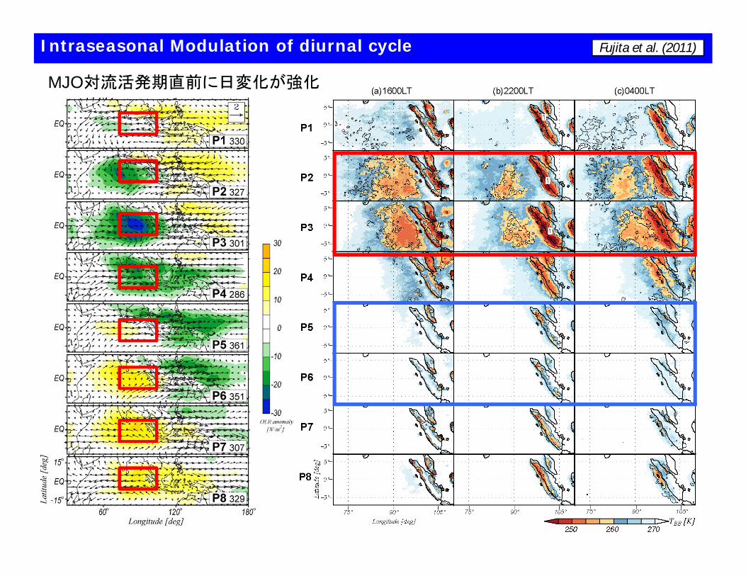
Intraseasonal Modulation of diurnal cycle Fujita et al. (2011)
MJO対流活発期直前に日変化が強化

Oceanic Variations
Nov
Dec
Monthly Averaged SST
11-12月はスマトラ近傍の湧昇の衰退期IODの衰退期でもある。
Eko, private comm.
Katsumata et al. (2014)
海面付近の日変化雨による冷却→大気からの影響
Bellenger et al. (2010)
海洋日変化の強弱と降水雲の日変化パターンが連動

Schematics of observation in 2D cross section during Stationary Observation Period
湧昇
偏波レーダー降水雲の構造
ビデオゾンデ/HYVIS微物理構造
ラジオゾンデ大気環境場の構造
CTD/採水分析/LADCP海洋混合層成層構造
Wave Glider + T-Chain海洋極表層構造
RAMAブイ網海洋構造、背景場

95E
5S
インドネシアEEZ外の場合(5S95Eブイ近傍?)
Benkuluから50kmBenkulu
(想定中の陸上サイト)
RAMAブイ
Candidate Position for “Station”
インドネシアEEZ
http://www.seaaroundus.org/eez/
Top Related