


Languages
Pages
Legal


®
OGC-EPRI Conflation Webinar
Carl Reed, PhD CTO
Open Geospatial Consortium October 16, 2014
© 2013 Open Geospatial Consortium

OGC ®
Copyright (c) 2014 Open Geospatial Consortium http://www.opengeospatial.org.
Who am I?
• I am a geographer who could not get the hang of manual cartography so in 1969 I started to use computers to make maps and have been a geospatial tech geek ever since.

OGC ®
The Power of Geography
• The great integrator, the power of map overlay, mashups, etc
© 2014 Open Geospatial Consortium 3
geosphere.gsapubs.org
Lancaster University
Bermuda Conservation

OGC ®
However
• Different spatial reference systems • Different Accuracies • Different Scales • Different semantics • Different classification systems • Incompleteness of source materials • Collected for different use cases • And the list goes on
© 2014 Open Geospatial Consortium 4

OGC ®
The “simple case”
• Use case for emergency response: Create a seamless digital map of the transportation network between two counties in two adjacent states – Different road classifications – Different street names – Edge match issues – Scale differences
© 2013 Open Geospatial Consortium 5

OGC ®
And another simple case
• Same theme but from two different sources – conflate the two datasets to create a higher quality product.
© 2014 Open Geospatial Consortium 6
University of California Santa Barbara

OGC ®
Conflation: Definition
• The process of unifying two or more separate datasets, which share certain characteristics, into one integrated all-encompassing result (OGC)
• Combining map data from separate sources to create data that is better than either source on its own (OpenStreetMap wiki)
• The process of combining geographic information from overlapping sources so as to retain accurate data, minimize redundancy, and reconcile data conflicts. – Longley, Paul A. et al (2001). Geographic Information Systems and
Science
© 2014 Open Geospatial Consortium 7

OGC ®
© 2014 Open Geospatial Consortium 8

OGC ®
Many aspects of conflation
• Vertical
• Horizontal – Edge match
• Attributes – Semantics – Vocabularies – Ontologies – Data models
• Visualization
© 2014 Open Geospatial Consortium 9

OGC ®
Difficulty of conflation depends on many factors
• Complexity of representation • Volume and accuracy of the datasets involved. • Specifically, incompleteness and inaccuracy of the original
datasets, different reference systems, distinct generalizations and representations of reality, semantic issues of terminology and classification, various scales, and different purposes, as well as various time frames – Goodchild and Raubal, 2009
© 2014 Open Geospatial Consortium 10
From Geoinformatics (Digitális Tankönyvtár) www.tankonyvtar.hu

OGC ®
Solution requires
• Metadata!
• Agreement on conflation rules – Coordinate reference system – Quality – Feature matching – Geometry matching – Attribute Matching – Selection rules – Accuracy
© 2014 Open Geospatial Consortium 11

®
OGC Standards Relevant to Conflation
© 2014 Open Geospatial Consortium

OGC ®
OGC Web Services Standards
© 2014, Open Geospatial Consortium
Web Map Service (WMS) Web Feature Service (WFS) Web Coverage Service (WCS) Catalogue (CSW) Geography Markup Language (GML) Web Processing Service (WPS) Web Coverage Processing Service GeoSPARQL
The GeoWeb is enabled by OGC standards:
The Geospatial Web is about the complete integration and use of location at all levels of the internet and the web.
Dr. Carl Reed CTO OGC

OGC ®
Copyright (c) 2014, Open Geospatial Consortium 14
OGC Web Map Service (WMS) Standard
• Simple HTTP interface for requesting geo-registered map images from one or more distributed geospatial databases. A WMS request defines the geographic layer(s) and area of interest to be processed. The response is one or more geo-registered map images (returned as JPEG, PNG, etc) that can be displayed in any browser application.
– Thousands of implementations
• Easy to implement – http://clearinghouse1.fgdc.gov/scripts/ogc/ms.pl?version=1.1.1&
request=map&srs=EPSG:4326&bBox=-180,-90,180,90& width=400&height=200&format=JPEG&styles=BLACK& layers=boundary,coastline,elevation,lakes,rivers&
• An ISO Standard

OGC ®
Copyright (c) 2014, Open Geospatial Consortium 15
Web Feature Service Interface Standard
• Specifies the behaviour of a service that provides transactions on and access to geographic features in a manner independent of the underlying data store. The standard specifies discovery operations, query operations, locking operations, transaction operations and operations to manage stored parameterized query expressions.
http://www.ibm.com/developerworks/data/library/techarticle/dm-0810kleoppel/
http://nationalmap.gov/framework.html

OGC ®
Multiple thematic
data layers
GetFeature request:
Web Feature Service (WFS) gets operable feature data from multiple servers
Cities
Borders Elevation
Each layer is data, not merely a view:
Country is: _ Name: Italy _ Population: 57,500,000 _ Area: 301,325 sq km . . .
© 2014 Open Geospatial Consortium

OGC ®
Geography Markup Language: Representing Geographic Features
Another Information Community’s Schema Highway is: _Pavement thickness _Right of way _Width …. Cell transm. Platform is: _Location _No. of antennas _Elevation ….
One Information Community’s Schema Road is: _Width _Lanes _Pavement type …. Cell tower is: _Owner _Height _Licensees ….
(an instance of Road in one IC’s schema)
Mayberry’s Cell Tower
(an instance of Cell Transm. Platform in another IC’s schema)
Mayberry Road
GML Support for complex geometries, spatial and temporal reference systems, topology, units of measure, metadata, feature and coverage
visualization. Backward compatible
GML defines a data encoding in XML that allows geographic data and its attributes to be moved between disparate systems Version 3.3 advances interoperability on all fronts!!
© 2014, Open Geospatial Consortium

OGC ®
Copyright (c) 2014 Open Geospatial Consortium http://www.opengeospatial.org.
Web Processing Service 1.0
• Designed to standardize the way that geospatial calculations, such as polygon overlay, are made available to the Internet. WPS can describe any calculation (i.e. process) including all of its inputs and outputs, and trigger its execution as a Web Service.
• Supports simultaneous exposure of processes via GET, POST, and SOAP
• Integrated with Hadoop and MapReduce for Big Data analytics

OGC ®
OGC Web Processing Service (WPS)
WPS GetCapabilities Execute DescribeProcess
Algorithms Repository
…
…
Algorithm 1
Data Handler Repository
…
…
Data Handler A
Communication over the web using HTTP
WPS-client
Web Processing Service
© 2014 Open Geospatial Consortium

OGC ®
Simple Symbology Conflation Display Feature Data with different Symbols
…
Fire Incident
Commercial Facility Fire
Forest Fire
Grassland Fire
Hotspot Fire
Unknown Friendly Neutral Hostile Violent Activities: Arson Fire
Map Viewer Client
Map Viewer Client
Features (GML) Maps (GIF,PNG,JPG) Metadata (XML) Styles (SLD), Symbols (CGM,SVG)
Emergency Management Data Sources (Regional, International, National, State, Local)
Transportation
Cadastral
Incidents
WFS WMS CSW CSW
Intelligence
Critical Infrastructure
Population
Cultural Features
Env. Conditions
Emergency Management Symbol Sets
Emergency Management
Maps
User Community “A” User Community “Y”
© 2014 Open Geospatial Consortium

®
OGC Activities Related to Conflation
© 2013 Open Geospatial Consortium

OGC ®
The OGC Interoperability Program (IP)
• A global, collaborative, hands-on engineering, prototyping and testing designed to rapidly deliver – Running code implementations – Engineering Reports – Change Requests – Demonstration in real world scenarios
• Sponsors and Participants work together. – Sponsors provide requirements, use / business cases and funding
– Participants work with sponsors to define and/or refine standards to solve a given interoperability problem
Copyright © 2014 Open Geospatial Consortium

OGC ®
Types of OGC-IP Initiatives
OGC Testbed
OGC Interoperability
Experiment
OGC Pilot
Purpose Develop new standards & refine existing specs
Refine & extend existing standards
Test existing standards in operational environment
Project Management
OGC IP Team OGC Members OGC IP Team
Sponsorship Yes No Yes
Participation OGC Members OGC Members & approved non-Members
Members & operational partners
The OGC Interoperability Program (OGC Document 05-127r5) http://portal.opengeospatial.org/files/?artifact_id=45656
Copyright © 2014 Open Geospatial Consortium

OGC ®
GOS-TP Goal & Objectives Completed 2002
• Implement a vertical slice of GOS, testing the assumptions made in the broader GOS objectives using the Road Transportation theme.
• Primary Objectives: – Test assumption that Unified
Modeling Language (UML) model can be successfully expressed as a physical schema
– Test assumption that Federal, State, Local, and/or Tribal data can be translated to a schema different from their local, native schema
– Pilot a portal-based system implementing metadata, data access (including translation/semantic mediation), and web mapping
UML Model
UGAS Tool
GML Application Schema (SchemaGlobal)
GML Application Schema (SchemaLocal)
Oregon Node
California Node CIPI/Other
Nodes
“User” Site
DOT Portal Node
Jackson County Node
Siskiyou County Node

OGC ®
GOS-TP Operational Context
Oregon Node
California Node
CIPI/Other Nodes
“User” Site
DOT Portal Node
Jackson County Node
Siskiyou County Node
Client Browser
Registry & Portrayal Services
Data Services

OGC ®
DOT Portal Node
GOS-TP Technical Architecture
Oregon Node
WFS-X
WMSSLD
Jackson County Node
WFS-X
WMSSLD
Siskiyou County Node
WFS
WMSSLD
WOS
California Node
WFS
WMSSLD
WRS WRS CG
WMS CG
WFS CG
WOS CG
User Browser
WFS Web Feature Service WFS-X Web Feature Service, Translating WMS Web Map Service SLD Styled Layer Descriptor WRS Web Registry Service WOS Web Object Service
Acronyms

OGC ®
OWS 5 Conflation Study
• Describes the process of conflation, outlines a framework for conflation and conflation rules services within a service oriented architecture, and describes the implementation of conflation services during the testbed
© 2014 Open Geospatial Consortium 27

OGC ®
Semantic Mediation OGC Web Services Phase 9 Test bed (2012)
California National Guard
Monterey Airport Field operator
NGA model - Local Topographic
Data Store (LTDS)
Prefers USGS model - The National Map
(TNM)
Prefers
Mediate
© 2014, Open Geospatial Consortium

OGC ®
Semantic Mediation Operational Prototype Development in OWS-9
© 2012 Open Geospatial Consortium 29
© 2014, Open Geospatial Consortium

OGC ®
OWS-9 Cross Community Interoperability (CCI) Conflation with Provenance
• Describes the architecture of a WPS capable of conflating two datasets while capturing province information about the process. Also provides information about defining and encoding conflation rules and about encoding provenance information using the W3C PROV recommendation.
© 2014 Open Geospatial Consortium 30

OGC ®
OWS-10 Cross-Community Interoperability (CCI) 2013
• Increase Geospatial community interoperability by building on CCI OWS-9 work in semantic mediation, volunteer geographic information (VGI), provenance and data quality, and Global Gazetteer. Explore the potential of interoperability in the hydrology domain utilizing semantic mediation and ontologies to more easily share and visualize geospatial data.
© 2014 Open Geospatial Consortium 31

OGC ®
Virtual Global Gazetteer (attribute conflation)
• The access to linked data information provided by these gazetteers was achieved by GeoSPARQL enabling these gazetteers using semantic mapping components (provided by Image Matters LLC) mapping RDBMS and WFS data to knowledge representation (RDF) on the fly
© 2014 Open Geospatial Consortium 32

OGC ®
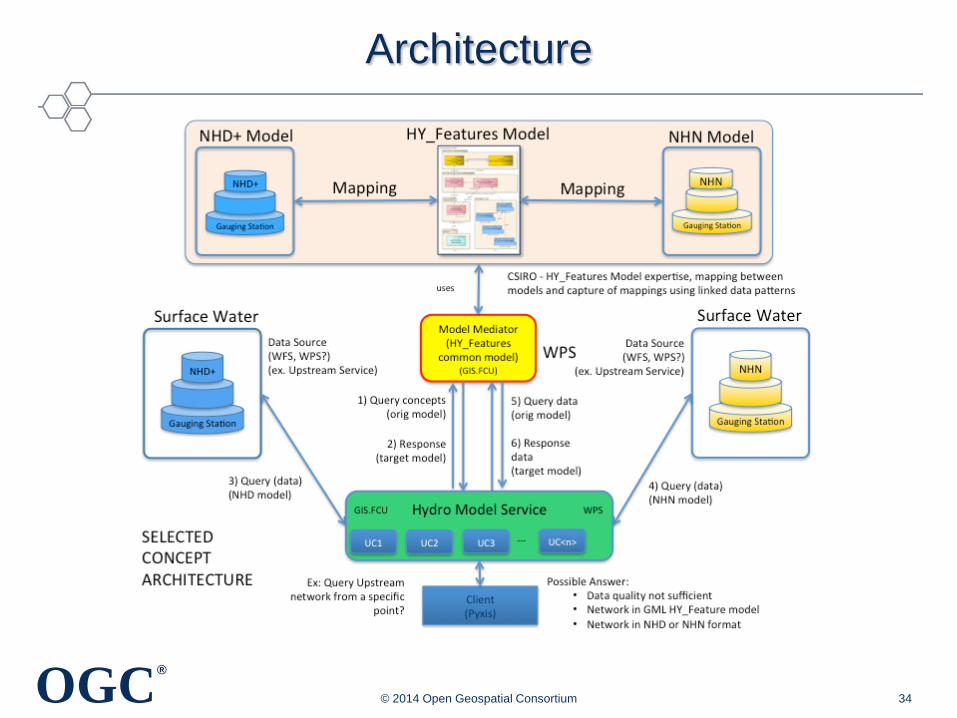
Cross Community Interoperability (CCI) Hydro Model Interoperability
• Defining best practices for supporting interoperability among the National Hydrographic Network (NHN) of Canada, the National Hydrographic Dataset Plus (NHD+) of United States, and the OGC HY_Features model developed and proposed by the World Meteorological Organization (WMO)
© 2014 Open Geospatial Consortium 33
Hydro Model Service
Hydro Data Services
Xlink-enabled Mediation Service
OWL-enabled Meidation Serivce
WS
DL
(Web
se
rvic
e op
erat
ions
)
SP
AR
QL/
Geo
SP
AR
QL
endp
oint
Hydro Mediation Services
OG
C W
PS
FCU.GIS Hydro Model Web Test
ClientPyxis
NHNSQ
L
NHD+SQ
L
NHN
OG
C W
FS
NHD+
OG
C W
FS
Retrieval /Storage
Transaction
Mediation (xlink inference
/semantic mediation)
Hydro Modeling Clients
Invocation /Data retrieval
Data retrieval
Data retrieval
OGC ®
Architecture
© 2014 Open Geospatial Consortium 34

®
An example of non-OGC Conflation Research and
Activities
© 2013 Open Geospatial Consortium

OGC ®
Widespread sharing and seamless integration of distributed urban geospatial data: Los Angeles test bed
© 2014 Open Geospatial Consortium 36

®
Where could EPRI and OGC collaboration have significant
impact on conflation?
© 2013 Open Geospatial Consortium

OGC ®
Smart Cities/Energy
• Use Case: Many Smart City and Smart Energy workflows require integration of crowd sourced, in situ-sensor, and other near real time sources of new content (satellite or UAV) with existing geospatial data sources to enhance decision making and provide real time situational awareness. – Response to natural disasters – Reduce energy consumption – Increase effectiveness of planning and maintenance – Integration of alternative energy sources – Etc.
© 2014 Open Geospatial Consortium 38

OGC ®
OGC Interoperability Initiatives
• Rapidly capture requirements
• Marshall technology resources (EPRI and OGC members, data, software, etc)
• Agile and rapid development of “demonstratable” prototypes
• Engineering reports, webinar, videos, etc
• All in 6 to 9 months
© 2014 Open Geospatial Consortium 39

®
Example use cases from the Energy Sector
© 2013 Open Geospatial Consortium

OGC ®
Solar Energy Production Potential Analysis
Source : LGV Hamburg, Fa. simuPLAN

OGC ®
Electric Car Charging, Austria
© 2014 Open Geospatial Consortium 42

OGC ®
Wind data visualisation example with UAV camera recorded ground overlay

OGC ®
3d and sensors Common Scents – City Sense
• Workflow of crowd sourced sensor input, Open Street Map, data fusion, and modelling that generates a 3d visualization. Uses numerous OGC standards
Copyright © 2013 Open Geospatial Consortium

OGC ®
Netherlands: Energy Neutral Cities project
• OGC CityGML & NetCDF for energy neutral cities – http://www.3dpilot.nl/?p=92
Copyright © 2013 Open Geospatial Consortium

®
Copyright (c) 2012 Open Geospatial Consortium http://www.opengeospatial.org.
Thank you for your attention
Carl Reed [email protected]
Top Related