


Languages
Pages
Legal


NI43-101 Technical Report on the Tuscarora Project
Elko County, Nevada, USA
Prepared by
Darren W. Lindsay, B.Sc.(hons.), P.Geo.
Prepared for
Buccaneer Gold Corp.
Suite 902, 357 Bay Street,
Toronto ON M5H 2T7
TEL: 001 (416) 366‐4227
Effective Date
February 29, 2016

NI43-101 Technical Report on the Tuscarora Project Page i
The effective date of this report titled “NI43-101 Technical Report on the Tuscarora
Project, Elko County, Nevada, USA,” is February 15th, 2016. It has been prepared for
Buccaneer Gold Corporation by Darren W Lindsay, P.Geo who is a qualified person as
defined by NI43-101.
Signed this XXth day of March, 2016.
Darren W Lindsay, P.Geo (#30145, APEGBC)

NI43-101 Technical Report on the Tuscarora Project Page ii
Table of contents
1 Summary ........................................................................................................... 1
2 Introduction ....................................................................................................... 6
3 Reliance on Other Experts ................................................................................... 6
4 Property Description and Location ....................................................................... 7
4.1 Property Location.......................................................................................... 7
4.2 Property Description ..................................................................................... 9
5 Accessibility, Climate, Local Resources, Infrastructure and Physiography ............. 13
5.1 Accessibility ................................................................................................ 13
5.2 Climate ...................................................................................................... 14
5.3 Physiography .............................................................................................. 14
5.4 Infrastructure and Local Resources .............................................................. 14
6 History ............................................................................................................. 15
6.1 Local History .............................................................................................. 15
6.2 Property History.......................................................................................... 15
7 Geological Setting and Mineralization ................................................................. 18
7.1 Regional Geology ........................................................................................ 18
7.2 Local Geology ............................................................................................. 19
7.3 Property Geology ........................................................................................ 22
8 Deposit Types .................................................................................................. 24
9 Exploration ...................................................................................................... 25
10 Drilling .......................................................................................................... 25
11 Sample Preparation. Analyses and Security ...................................................... 25
12 Data Verification ............................................................................................ 28
13 Mineral Processing and Metallurgical Testing ................................................... 29
14 Mineral Resource Estimates ............................................................................ 29
15 Mineral Reserve Estimates .............................................................................. 29
16 Mining Methods ............................................................................................. 29
17 Recovery Methods ......................................................................................... 29

NI43-101 Technical Report on the Tuscarora Project Page iii
18 Project Infrastructure ..................................................................................... 29
19 Market Studies and Contracts ......................................................................... 29
20 Environmental Studies, Permitting and Social or Community Impact ................. 29
21 Capital and Operating Costs ........................................................................... 29
22 Economic Analysis .......................................................................................... 30
23 Adjacent Properties ........................................................................................ 30
24 Other Relevant Data and Information .............................................................. 30
25 Interpretation and Conclusions ....................................................................... 30
26 Recommendations ......................................................................................... 30
27 References and Abbreviations ......................................................................... 32
28 Certificate of Qualifications ............................................................................. 35
List of Figures
Figure 4-1: Location of the Tuscarora Property, Tuscarora Mining District, NW Elko County, Nevada (G.Sterling). ...................................................................................... 8
Figure 4-2: Tuscarora Property claim map with Tuscarora Property boundary (G.Sterling). ................................................................................................................ 11
Figure 7-1: Local geology of the Tuscarora Mining District. ............................................ 21
Figure 7-2: Tuscarora Property Geology .......................................................................... 23
Figure 8-1: Conceptual low sulfidation epithermal model for the Tuscarora Property (Robert et al, 2007. ................................................................................................... 24
Figure 9-1: Notice of Exploration drill pad locations, Navajo Zone, Tuscarora Property. .................................................................................................................................... 26
List of Tables
Table 4-1: Tuscarora Property list of claims; all of these claims were registered September 3rd, 2014 and are in good standing. ....................................................... 9
Table 4-2: Summary of permits for the Tuscarora Project. ............................................. 13
Table 6-1: History of the property area of the Tuscarora Project. ................................. 16
Table 6-2: Reported drill intercepts of select target zones in the Tuscarora Property (McCusker memo, 1998). ........................................................................................... 17
Table 26-1: Recommended work program ....................................................................... 31

NI43-101 Technical Report on the Tuscarora Project Page 1
1 Summary
The Tuscarora Property is located approximately 65km (40 mi.) north-northwest of Elko,
in NW Elko County, Nevada, within the Tuscarora Mining District. The Property comprises
24 unpatented lode claims situated in sections 2 and 3, Township 39 North, Range 51
and section 35, Township 40 North, Range 51 East, Elko County, Nevada. The claims are
roughly centered at 116º 13’ 05” West longitude and 41º 18' 17” North latitude or
565711m E, 4573061m N.
Buccaneer Gold Corp (“Buccaneer”) entered into a non-Binding Letter of Intent (“LOI”)
with Novo Resources Corp (Novo”) to purchase and joint venture an undivided 50%
interest in the Property by making a cash payment of CAD$400,000 and providing Novo
with up to 4,000,000 common shares of capital stock in Buccaneer and completing a
$500,000 private placement into Novo. The LOI is to form the basis of a definitive
agreement and subscription agreement in respect of the transaction. The transaction is
targeted completion date is March 11th, 2016.
The Property is currently optioned to Novo’s wholly owned subsidiary, Novo Resources
(USA) Corp. (“Novo USA”), pursuant to an exclusive Exploration Lease and Option to
Purchase Agreement with each of Nevada Eagle LLC and Platoro West Incorporated
(together the “Owners”) (having an effective date of November 7, 2014); Novo USA has
the right to explore and develop the Property, and to acquire a 100% interest in the
Property (subject to a 2% net smelter return royalty retained by the Owners).
The Tuscarora volcanic field is the largest example of Eocene age magmatism in Nevada,
having formed between ~39.9 and 39.3 Ma, which in part corresponds to the 40 – 37 Ma
age of gold mineralization in the Carlin Trend, representing the strongest period of gold
mineralization known in the Basin and Range Province (Henry et al., 1998; Castor et al.,
2003). The most intense magmatism occurred to the southeast in an area of ~450 km²
that encompasses at least five major volcanic centers including the Mount Blitzen volcanic
center (Figure 7-1); the Tuscarora Mining District lies along the southeast side of Mount
Blitzen. The geology of the Mount Blitzen volcanic center has been variably mapped as a
stratovolcano, a caldera, and a volcano-tectonic graben, which indicates the complex
volcano-magmatic nature of this feature (Henry et al., 1998). This volcanic center is
thickly filled with dacitic domes, dacitic air-fall and pyroclastic ash-flow tuffs, and re-
worked epiclastic deposits (Henry et al., 1998).
The Tuscarora mining district lies approximately 35kms northeast of the north end of the
Carlin Trend, approximately 20kms southwest of the Jerritt Canyon deposit, and
approximately 50kms east-northeast of the Midas deposit. The district clearly displays Ag

NI43-101 Technical Report on the Tuscarora Project Page 2
and Au mineralization associated with low sulfidation epithermal quartz-adularia veins
and stockwork veinlets associated with igneous activity and numerous structures formed
along the southeast margin of Mount Blitzen. Immediately north of the Tuscarora
Property occurs the northern silver-rich portion of the precious metals district; it is typified
by veins with high Ag:Au ratios (>100), strong base metal mineralization, and typically
displays narrow alteration selvages around quartz-carbonate veins hosted mostly in
intrusive dacite. In contrast the southern gold-rich portion of the district, including the
historic Dexter Mine and the Tuscarora Property, has relatively low Ag:Au ratios (<15),
contains almost no base metals, underwent local boiling, and displays widespread
silicification and adularization along with stockwork veining and vug-fills in tuffs and fine-
grained epiclastic rocks. Both zones have relatively high As and Sb, and low Bi, Te, and
W, but the northern silver zone has distinctively high Ca, Pb, Mn, Zn, Cd, Tl, and Se,
whereas the southern gold zone has high Hg and Mo (Boden et al., 1993; Castor et al.,
2003).
Two known mineralized zones occur on the Property, the southern extension of the
Navajo Vein and the East Pediment. In general, higher grade historical intercepts are
associated with narrow zones of strong silica/adularia alteration up to several meters wide
(Jones, 1999). Mapping and sampling of the Dexter Pit immediately north and adjacent
to the Tuscarora Property and Navajo Vein zone by Zahony (1988) indicated the
possibility of two gold mineralizing events, an earlier pyritic event in tuffaceous rocks,
and a later veining event temporally associated with the porphyritic dacite intrusives; of
note, strong gold grades were obtained in both steep and flat veins.
Placer gold was discovered in the Tuscarora district in 1867 and production from silver-
gold lode deposits began in 1876 (Boden et al., 1993). Total historical precious metal
production is approximately 204,000 ounces of gold and 7.5 million ounces of silver from
quartz veins and quartz stockwork mineralization; additionally, 300,000 ounces of placer
gold has been reported prior to 1990 (Cruson, 1995; Castor and et al., 2003).
Of the reported historical production in the Tuscarora area, 25,000 ounces of gold and
200,000 ounces of silver were mined from the Dexter Mine between 1989 and 1990
through a joint venture between the operator Horizon Gold Shares Inc., Fisher-Watt Gold
Company Inc. and Chevron Resources Co. (Cruson, 1995; Horizon Gold Shares Inc.
Report in American Mines Handbook, 1990; Castor et al., 2003). This provides a total
historical production from all references of approximately 65,000 ounces of gold and
300,000 ounces of silver mined from the Dexter Mine. Which is located immediately north
of the Navajo Zone of interest of the Tuscarora Project.

NI43-101 Technical Report on the Tuscarora Project Page 3
Table 1-1: History of the property area of the Tuscarora Project. Year Company Work
2015 Novo Resources Corp Migratory bird survey; permitting
2014 Nevada Eagle LLC and Platoro
West Incorporate
Ground lapsed and restaked
2012/13 Wolfpack Gold Corp Permitting and reclamation
2010/11 Golden Predator Mines US Inc. Reclamation work
2009 Golden Predator Mines US Inc. Permitting and reclamation
2008 Golden Predator Mines US Inc. permitting
2008 Canyon Resources Ltd Aerial photography
2007 Canyon Resources Ltd Geophysics?
2005 Terraco Gold Corp 4 RC holes (2,920 feet)
2003 Terraco Gold Corp CSMAT survey
2001 Franco Nevada Mining Corp Inc Permitting (PoO)
2000 Franco Nevada Mining Corp Inc Internal estimation
1998/9 Newcrest Resources Inc RC Drilling (27,000); some core drilling
1997 Newcrest Resources Inc RC drilling (1800 feet); petrography
1996 Newcrest Resources Inc Mapping, RC drilling (12,000 feet)
1995 Newcrest Resources Inc Compilation and targeting, drilling
The results of the exploration works undertaken were to outline a number of exploration
zones of interest among and/or on trend of historic mining activities. These include but
are not limited to the Modoc Vein zone, the Dexter Stockwork Zone, the Grand Prize Vein
zone, the Navajo Vein Zone, and the East Pediment Zone. A total of ten historic drill holes
have defined the East Pediment Zone and 61 historic drill holes have defined the South
Navajo Vein Zone. Historic drill results of interest for the Tuscarora Project include the
following:
Table 1-2: Reported drill intercepts of select target zones in the Tuscarora Property (McCusker memo, 1999).
Zone HoleID Interval
(ft)
Interval
(m)
Gold Grade
(g/t)
year
Navajo/South Navajo Vein TCN2 5 1.5 30 1995
Navajo/South Navajo Vein TCN3 5 1.5 5.3 1995
Navajo/South Navajo Vein TN38 5 1.5 180 1998
Navajo/South Navajo Vein TN40 5 1.5 19 1998
Navajo/South Navajo Vein TN54 5 1.5 51 1998
East Pediment TN57 10 3.0 28.2 1998
East Pediment TN63 5 1.5 4.6 1998

NI43-101 Technical Report on the Tuscarora Project Page 4
In conclusion, the Property consists of 24 contiguous unpatented claims covering
approximately two square kilometers. The claims are in good standing. These claims
cover a geological environment that is permissible for the formation of low sulfidation
epithermal quartz adularia vein precious metal deposits. Historical mining operations
north of the Property exploited narrow high grade vein and lower grade stockwork vein
mineralized zones of these types of mineral systems. Previously completed exploration
consisted of numerous drill programs (reverse circulation) resulting in gold and silver
values that indicate the potential to form an economic deposit. The historical exploration
has outlined an exploration target named the Navajo Vein and Navajo Vein South
Extension which trends across the Tuscarora Property. A second target area of similar
style of mineralisation that has received less historical work is called the East Pediment
zone. Due to the abundance of alluvium and the lack of systematic geochemical and
geophysical exploration, there is potential for the discovery of additional ‘blind’ targets.
Reviews of historical reports, data and geology suggest that the Tuscarora Property
requires additional work to both confirm historical results as well as fully evaluate the
potential for epithermal gold–silver deposits.
The existence of epithermal alteration and mineralization with strong precious metals
grades in the historical record indicates the potential for the Tuscarora Property to host
deposits of economic interest. Accordingly it is recommended that a limited but
aggressive exploration program be conducted to confirm the historical data at the Navajo
Zone.
Key objectives would be to confirm the high grades previously reported, understand the
alteration zonation around mineralization of interest, and confirm geological controls
(structures and lithologies). This information should then be used to evaluate the Navajo
and East Pediment zones for deposit potential.
The following exploration program is recommended:
(a) Drill evaluate/confirm the historical drill results.
(b) Create a geological map of the property including known veins, structures and alteration patterns. Alteration mineralogy should be determined with certainty using a Terraspec mineral analyser or equivalent.
After confirmation of historical data follow up drilling to evaluate Navajo and East
Pediment could be undertaken as well as using the confirmed target model signature to
evaluate the remainder of the property for additional ‘blind’ mineralisation potential. A

NI43-101 Technical Report on the Tuscarora Project Page 5
gridded soil sampling program should be considered, first over the Navajo and East
Pediment zones to confirm signatures and then expanded across the property to identify
additional targets masked by the quaternary sediments.
Detailed magnetics (and/or VTEM), gradient resistivity, and detailed gravity could be used
to define or refine mineralisation controls and define additional and/or deeper mineralized
structures.
Table 1-3: Recommended work program Activity Units Unit Cost
(est.)
Cost Estimate
(US$)
*CDN$
Geological compilation 1 report 10,000 10,000
drilling 1500 m 90 135,000
assays 1000 samples 25 25,000
Geologist/geotech/terraspec 15 days 1000 15,000
Access/permitting permits 15,000
SubTotal 200,000
Contingency 10% 20,000
Total Estimated Cost 220,000 305,800
*current forex US$1.00 = CAD$1.39

NI43-101 Technical Report on the Tuscarora Project Page 6
2 Introduction
This Technical Report on the geology and mineralization of the Tuscarora Property (“the
Property”) was prepared by Darren W. Lindsay, B.Sc.(hons), P.Geo (APEGBC) (the
“Author”) at the request of Mr. Paul Zyla, President and Chief Executive Officer for on
behalf of Buccaneer Gold Corp. (“Buccaneer”) to comply with technical reporting and
disclosure requirements set out under National Instrument (“NI”) 43-101. Buccaneer is a
TSX-V listed exploration company with interests in the Banso and Muoso mining leases
within the Kibi Gold Belt in eastern Ghana.
The Property comprises 24 unpatented lode claims situated in sections 2 and 3, Township
39 North, Range 51 and section 35, Township 40 North, Range 51 East, Elko County,
Nevada.
This report documents the exploration history of the Property. The information and data
used in the preparation of this report was sourced from the private files of Novo Resources
Corp (“Novo”) and publicly accessible academic papers and government sources.
Additional information including a preliminary property evaluation report was provided by
Buccaneer. Citations are provided throughout the report where this information has been
referenced.
This Report was completed under the supervision of qualified person (QP) Darren Lindsay
(P.Geo; APEGBC) strictly on a fee for service basis and who currently holds the position
of CEO of Castle Peak Mining Ltd. Mr. Lindsay was onsite for a property and data review
during the period of February 10th, 2016 accompanied by Mr. Geoff Sterling, consulting
geologist to Novo Resources Corp.
The metric system is used for all units of measure and all dollar amounts are in Canadian
(CAD) funds unless otherwise stated. Grid references are based on the UTM WGS84
datum Zone 11N projection coordinate system unless otherwise noted. Other
abbreviations frequently used are included within the references section (Section 27).
3 Reliance on Other Experts
The author of the preliminary property evaluation, Mr. Robert J. Casaceli, was consulted
prior to the preparation of this report. Mr. Casaceli was consulted due to his history in
the area, he had been on, or near the Tuscarora property several times while doing
regional exploration in the area several times over many years. References to these
discussions are appropriately referenced in the report. The author is responsible for all
sections of the Report.

NI43-101 Technical Report on the Tuscarora Project Page 7
The Report contains information obtained from a review of relevant reports, including NI
43-101 reports, non-NI 43-101 compliant technical reports and non-technical reports,
maps, technical data and interpretations provided by Novo and Buccaneer and are cited
throughout the Report. The author has relied upon information including public
information, internal reports, maps, opinions and/or statements provided by Novo in-
house experts to form interpretations and conclusions relevant to the Report.
Reference to the compliance or non-compliance with NI 43-101 standards of historical
information and data referred to in this Report are made where appropriate. The author
does not offer any opinion concerning legal, title, environmental, political or other non-
technical issues that may be relevant to the Report.
This report expresses opinions regarding exploration and development potential for the
project, provides conclusions and recommendations based on the information available
at the time of reporting. These opinions and recommendations are intended to serve as
guidance for future advancement of the property, and should not be construed as a
guarantee of success.
The author’s professional fees for this Report are not dependent upon any prior or future
engagement or understanding resulting from the conclusions or recommendations of the
Report. These fees are set at normal commercial rates within the exploration industry for
this type of work.
4 Property Description and Location
4.1 Property Location
The Property is located approximately 65km (40 mi.) north-northwest of Elko, in NW Elko
County, Nevada, within the Tuscarora Mining District (Figure 4-1). The Property
comprises 24 unpatented lode claims situated in sections 2 and 3, Township 39 North,
Range 51 and section 35, Township 40 North, Range 51 East, Elko County, Nevada. The
property is roughly centered at 116º 13’ 05” West longitude and 41º 18' 17” North latitude
or 565711m E, 4573061m N.

NI43-101 Technical Report on the Tuscarora Project Page 8
Figure 4-1: Location of the Tuscarora Property, Tuscarora Mining District, NW Elko County,
Nevada (G.Sterling).

NI43-101 Technical Report on the Tuscarora Project Page 9
4.2 Property Description
The Property comprises 24 unpatented lode claims situated in sections 2 and 3, Township
39 North, Range 51 and section 35, Township 40 North, Range 51 East, Elko County,
Nevada (Table 4-1, Figure 4-2).
Table 4-1: Tuscarora Property list of claims; all of these claims were registered September 3rd, 2014 and are in good standing. Areas are approximate. Claim BLM # Area
(sq.km.)
Expiry
Date
Claim BLM # Area Expiry Date
TN 1 1105496 0.084 08/2016 TN 13 1105508 0.084 08/2016
TN 2 1105497 0.084 08/2016 TN 14 1105509 0.084 08/2016
TN 3 1105498 0.084 08/2016 TN 19 1105510 0.063 08/2016
TN 4 1105499 0.080 08/2016 TN 20 1105511 0.063 08/2016
TN 5 1105500 0.084 08/2016 TN 21 1105512 0.063 08/2016
TN 6 1105501 0.080 08/2016 TN 22 1105513 0.084 08/2016
TN 7 1105502 0.080 08/2016 TN 23 1105514 0.084 08/2016
TN 8 1105503 0.080 08/2016 TN 24 1105515 0.084 08/2016
TN 9 1105504 0.084 08/2016 TN 25 1105516 0.084 08/2016
TN 10 1105505 0.080 08/2016 TN 26 1105517 0.084 08/2016
TN 11 1105506 0.084 08/2016 TN 27 1105518 0.054 08/2016
TN 12 1105507 0.084 08/2016 TN 28 1105519 0.042 08/2016
Approximate total area 2.0 sq.km.
Buccaneer entered into a non-Binding Letter of Intent (“LOI”) with Novo to purchase and
joint venture an undivided 50% interest in the Property by making a cash payment of
$400,000 and providing Novo with up to 4,000,000 common shares of capital stock in
Buccaneer and completing a $500,000 private placement into Novo. The LOI is to form
the basis of a definitive agreement and subscription agreement in respect of the
transaction. The transaction is targeted completion date is March 11th, 2016.
The Property is currently optioned to Novo’s wholly owned subsidiary, Novo Resources
(USA) Corp. (“Novo USA”), pursuant to an exclusive Exploration Lease and Option to
Purchase Agreement with each of Nevada Eagle LLC and Platoro West Incorporated
(together the “Owners”) (having an effective date of November 7, 2014); Novo USA has
the right to explore and develop the Property, and to acquire a 100% interest in the
Property (subject to a production royalty retained by the Owners).

NI43-101 Technical Report on the Tuscarora Project Page 10
Novo represents that (i) the Option Agreement is in good standing, (ii) Novo is not in
default of any provision thereof, (iii) upon the payment of US$75,000 to the Owners, it
will have exercised its option under the Option Agreement and then hold a 100% interest
in the Property (subject to a production royalty retained by the Owners), and (iv) that
the claims forming the Property are in good standing. The royalty to the Owners on
culmination of the agreement is a 2% Net Smelter Return Royalty (“NSR”).
Details of the proposed transaction include:
1. Cash payment to Novo of $400,000, 2. Payment to Novo of cash equivalent of $200,000 by providing up to 4,000,000
common shares of Buccaneer, and 3. Completing a private placement into Novo of $500,000 by purchasing units priced
at $0.62 per unit. A unit is to consist of one common share and one half (1/2) of one common share purchase warrant; a full warrant can be used to purchase one common share at a price of $0.93 for a period of two years unless criteria of an accelerated expiry are met.
4. Novo agrees to use US$75,000 to complete the underlying option to purchase with the Owners,
5. Novo agrees to use $45,000 of the proceeds towards an agreed upon work program after which all the costs on the Property are to be split equally by both parties.
The aforementioned items are to be completed concurrently with the proposed definitive
agreement.
Select details of the proposed definitive agreement include:
1. As long as the undivided participating interest of Novo USA is at least 50% in the joint venture they will be the operators,
2. Failure to financially contribute to an agreed upon program will result in the dilution of that parties interest in the joint venture,
3. Upon a party being diluted to 10% interest the joint venture will cease and the 10% interest will convert to a 2% net smelter returns royalty interest of which 1% may be purchased at any time for C$1,000,000.
4. Buccaneer will pay a termination fee of $25,000 if it solely elects not to proceed with the Transaction, other than by way of terminating the LOI pursuant to the provisions allowable within the agreement.

NI43-101 Technical Report on the Tuscarora Project Page 11
Figure 4-2: Tuscarora Property claim map with Tuscarora Property boundary (G.Sterling).

NI43-101 Technical Report on the Tuscarora Project Page 12
Obligations
Upon the completion of the purchase by Novo USA and subsequently by Buccaneer and
initiation of the joint venture, a transfer fee will be payable equal to US$10 per claim to
register Buccaneer as having an interest in the claims. An annual maintenance fee of
US$155 per lode claim is payable annually by September 1st. The claims need to be
maintained in good standing with both the Bureau of Land Management and Elko County.
A Plan of Operation or Notice of Exploration must be supplied to the Bureau of Land
Management (“BLM”) with a copy to the Division of Minerals of the Commission on Mineral
Resources with a bond payment made based on the proposed disturbance an amount not
to exceed $30 per acre. Additionally, an annual report, on or before April 15 of each year,
is to be submitted relating to the status and production of all mining operations and
exploration projects in which the operator has engaged and identifying each acre of land
affected and land reclaimed by that mining operation or exploration project through the
preceding calendar year, and shall pay to the Division a fee of (a) one dollar and fifty
cents for each acre of public land administered by a federal agency; and (b) five dollars
and fifty cents for each acre of privately owned land, which has been disturbed by mining
operations or exploration projects engaged in by the operator and not reclaimed.
To the best of the author’s knowledge the previous operator, Wolfpack Gold Corp,
completed reclamation of the site covered by the current claims. Novo currently holds an
approved Notice of Exploration that allows for disturbance for access roads and up to 6
drill pads totaling less than one acre of disturbance; and has a bond in place with the
appropriate departments.
Back-in rights, royalties
Pursuant to the underlying Novo USA agreement, on the fulfillment of the option to
purchase agreement the Owners will hold a 2% NSR in the property.
Environmental liabilities
This section is extracted from the preliminary evaluation by R. Casaceli, 2016.
A few pertinent issues were encountered during the review that all concerned parties should be
made aware of. First, in conducting a general environmental science search for studies carried-out
in the Tuscarora district, an MS Thesis on the Geochemistry of Arsenic, Manganese, and Iron in the
Dexter Pit Lake, Tuscarora, Nevada (C.P. Newman, 2014) was found. This study concludes that the
Dexter pit lake is leaching As, Mn, and Fe from the wall rocks and lake sediments and may influence
the dissolved As concentrations in down-gradient groundwater. The presence of either of these
elements in nearby groundwater may be linked to periodic chemical changes in the pit lake that
are linked to the physical limnology of the lake, and although adsorption of As if occurring, this

NI43-101 Technical Report on the Tuscarora Project Page 13
process is not likely a major factor in this lake, or others like it throughout the Great Basin. The
situation is mitigated at the Dexter pit lake owing to the significant carbonate component of wall
rock there. Note that the pit lake is close to, but not on, the Novo Resources property in question,
but the lake would need to be monitored regularly should an extended project be carried-out here
to be able to point to an exterior source should pit lake conditions create a measurable discharge
of As into groundwater on the Novo Resources property.
A second issue to be aware of is the presence of Sage Grouse on the property, which necessitates
ongoing monitoring of bird populations and the possibility of the need to construct and maintain
watering stations (leks) per BLM specifications.
Note that historical work had exceeded the permitted disturbance allowed by their Plan
of Operation. Subsequent operators endeavored to reclaim the disturbance to below the
amount in the approved plan. To the best of the author’s knowledge full reclamation was
completed by the previous owner of the area under the current claims.
Factors that may affect access
Comment by R. Casaceli, 2016 paraphrased:
Historically and currently, certain numbers of local townspeople in Tuscarora have been very
sensitive to any mining or exploration operations in and around the district and hometown. This is
a common issue in old Nevada mining towns, where people have been attracted to buy homes in
quiet rural areas, only to find that mining companies with valid mineral rights may decide to
establish exploration and/or mining programs that may disturb the tranquil atmosphere that they
bought into. Sometimes these people are very aggressive in their efforts to stop such operations.
Table 4-2: Summary of permits for the Tuscarora Project. Permit # Name Date(s) Status
NVN-93944 Notice of Exploration May18, 2015 active
To the best of the author’s knowledge, there are no other significant factors or risks that
may affect access, title, or the right to perform work on the property.
5 Accessibility, Climate, Local Resources, Infrastructure and Physiography
5.1 Accessibility
The Tuscarora Property is located in Elko County, Nevada, approximately 100km north of
the town of Elko by road. The property is most easily accessed from Elko by traveling
north on State Highway 225 for 70km to the Lone Mountain Junction, traveling west on
State Highway 226 for 40km to the Midas-Tuscarora junction and continuing a further
ten kilometers to the community of Tuscarora, Nevada. Travel time from Elko is

NI43-101 Technical Report on the Tuscarora Project Page 14
approximately one hour along well-surfaced roads. Elko is serviced by regular daily flights
through Salt Lake City, Utah.
5.2 Climate
The Tuscarora region is semi-arid desert with an average annual precipitation of 12.5 in.
(31.8 cm). Temperature variations for the area range from a –40oF (-40C) to a maximum
of 108oF (42C), with average temperatures of 16oF (-8C) in winter and 84oF (28C) in
summer. The operating season for exploration is deemed to be all year round.
5.3 Physiography
The Tuscarora property covers the southeast flank of Mt. Blitzen within the Tuscarora
Mountains. The property covers a gentle, south-sloping hillside to the east, southeast and
south of the Tuscarora town site. Elevations range from 5900ft (1800m) to 6560ft
(2000m) above sea level.
Vegetation in the Tuscarora area is typical of northern Nevada and consists of grasslands,
sagebrush and other desert plants on the lower slopes and valleys. Shadscale, white sage
and greasewood occur with sagebrush on the drier slopes and hills. The area is
predominantly open, grass-covered range land. Sparse pinyon pine trees grow at higher
elevations.
5.4 Infrastructure and Local Resources
Elko is the nearest full service commercial center. The property area is sparsely populated
with the town of Tuscarora within and immediately adjacent to the property boundaries.
The town is connected to the state power grid and has a piped water supply. The principal
economic activity in the immediate property area is ranching.
Tuscarora is a historic mining district dating back to the 1860’s. The Carlin Trend, 30 km
to the south, is an active mining area dating to 1900. Gold is currently being recovered
from large mining operations at Gold Quarry, Carlin and Betze-Post south of the Tuscarora
property, from the Jerritt Canyon operations 15 km east of Tuscarora and from
underground operations at Midas 35 km west of Tuscarora. All of these operations are
generally supported out of Elko as a mining center. It is anticipated that sufficient
infrastructure and manpower would be available locally to support an exploration,
development, or mining operation at the Tuscarora property.

NI43-101 Technical Report on the Tuscarora Project Page 15
6 History
The section is select excerpts of material from Casaceli (2016) and a summary of material
from the previous technical report (Ristorcelli and Goodall, 2003), and references therein.
6.1 Local History
Placer gold was discovered in the Tuscarora district in 1867 and production from silver-
gold lode deposits began in 1876 (Boden et al., 1993). Total historical precious metal
production is approximately 204,000 ounces of gold and 7.5 million ounces of silver from
quartz veins and quartz stockwork mineralization; additionally, 300,000 ounces of placer
gold has been reported prior to 1990 (Cruson, 1995; Castor and et al., 2003).
Initial lode deposit discoveries include silver-rich lode vein deposits on Beard Hill, 5km
southwest of Tuscarora town. A Mr. W.O. Weed, started mining small, rich, discontinuous
silver lodes on the east side of Mount Blitzen in 1871, eventually leading to the discovery
of the N70E-trending Grand Prize bonanza vein within 2kms NNW of the town in 1876;
within a year shafts as deep as 500 feet had been sunk (Paher, 1970). Eventually, the
above veins along with the Castile Mountain, Modoc, Navajo, Belle Isle, Independence,
and Six Mile deposits roughly formed a NE-trending zone of mineralization ~10kms long
by ~2kms wide from which the majority of the silver ounces of the district were extracted
in period of 1876 to 1900. Near the end of that period, exploitation of the low-silver,
relatively higher grade gold zone was begun in the southern part of the district. The
Dexter mine located immediately SSW of town produced about 40,000 ounces of gold
and 100,000 ounces of silver between 1897 and 1935 (Nolan, 1936; LaPointe et al.,
1991). Underground mining at the Dexter moved outward from higher grade silver and
gold quartz-adularia veins into a broader silicified and adularized zone of lower grade
stockwork quartz-adularia veinlets mixed with lesser quartz veins of the same
composition. This same style of mineralization and alteration was later mined in 1988-
1990 as an open pit up to 100m deep by Horizon Gold Shares Inc.
6.2 Property History
Companies that have explored for precious metals in this district include: Cyprus Mines
Corporation, Northern Dynasty, Standard Magnesia, Duval, Shell Oil, Hecla Mining
Company, Jedediah Minerals Company, Cruson & Pansze, Alma American, Corona Gold,
Granges Exploration Ltd, Freeport McMoran Gold Company, Silver Standard Resources
Inc., Horizon Gold Corporation, Chevron Fischer Watt, Pecos Exploration Company,
Tuscarora Gold Mines Inc., Tuscarora Associates, Battle Mountain Gold, Newcrest
Resources Inc, Newmont Mining Corp, Franco-Nevada Mining Corp Inc, and Terraco Gold
Corp. (Randol Gold Directory 1988; Randol Mining Directory 1990-91; Western Mining
History, 1998; Ristorcelli and Goodall, 2003).

NI43-101 Technical Report on the Tuscarora Project Page 16
In the last twenty years the property has generally had one underlying owner from which
numerous companies have leased or optioned the ground. This is summarized below and
in Table 6-1. Newcrest Resources Inc. started acquiring land in the district in 1994. They
undertook exploration activities and expanded the land package up until 1999 at which
time they sold the Property to Franco Nevada Mining Corp Inc. At some time in 2002/2003
the property was optioned by Terraco Gold Corp of Vancouver, Canada. In late 2005/early
2006 the property reverted to Franco Nevada (by then called Newmont Capital Corp after
its merger with Newmont Mining Corp). The property was optioned to Canyon
Resources/CR Nevada Corp in late 2006. Golden Predator Mines US Inc then acquired the
option from Canyon Resources in February 2008. As of January 2012 Golden Predator
had completed it’s option with Canyon Resources (by then Atna Resources after a merger)
and was then responsible for the outstanding obligations of the underlying option
agreement with Newmont. In mid-2012 Seabridge Gold and Golden Predator Corp
assigned their Nevada assets to a newly formed company, Wolfpack (Nevada) Gold. There
is a lack of clarity in the document record at this point in time as it appears that Wolfpack
(Nevada) was to terminate the option with Newmont early in 2013; in the end Wolfpack,
the parent company, sold Wolfpack (Nevada) to Timberline Resources in late 2014 – from
that point on there is no mention of the Tuscarora Property. To the best of the author’s
knowledge, full reclamation of historical disturbance was completed, bonds returned and
the claims were relinquished. Subsequently re-staked by Nevada Eagle LLC and registered
in early September 2014 then optioned to Novo Resources Corp’s US subsidiary. By early
2015 Novo Resources Corp initiated activities for the permitting of a drill program.
Table 6-1: History of the property area of the Tuscarora Project. Year Company Work
2015 Novo Resources Corp Migratory bird survey; permitting
2014 Nevada Eagle LLC and Platoro
West Incorporate
Ground lapsed and restaked
2012/13 Wolfpack Gold Corp Permitting and reclamation
2010/11 Golden Predator Mines US Inc. Reclamation work
2009 Golden Predator Mines US Inc. Permitting and reclamation
2008 Golden Predator Mines US Inc. permitting
2008 Canyon Resources Ltd Aerial photography
2007 Canyon Resources Ltd Geophysics?
2005 Terraco Gold Corp 4 RC holes (2,920 feet)
2003 Terraco Gold Corp CSMAT survey
2001 Franco Nevada Mining Corp Inc Permitting (PoO)
2000 Franco Nevada Mining Corp Inc Internal estimation

NI43-101 Technical Report on the Tuscarora Project Page 17
1998/9 Newcrest Resources Inc RC Drilling (27,000); some core drilling
1997 Newcrest Resources Inc RC drilling (1800 feet); petrography
1996 Newcrest Resources Inc Mapping, RC drilling (12,000 feet)
1995 Newcrest Resources Inc Compilation and targeting, drilling
For additional historical work and ownership please see “Progress Report on the
Tuscarora District, Elko County, Nevada” by Mr. M.G.Cruson (1995).
The results of the exploration works undertaken were to outline a number of exploration
zones of interest among and/or on trend of historic mining activities. These include but
are not limited to the Modoc Vein zone, the Dexter Stockwork Zone, the Grand Prize Vein
zone, the Navajo Vein Zone, and the East Pediment Zone. A total of ten historic drill holes
have defined the East Pediment Zone and 61 historic drill holes have defined the South
Navajo Vein Zone. Historic drill results of interest for the Tuscarora Project include the
following:
Table 6-2: Reported drill intercepts of select target zones in the Tuscarora Property (McCusker memo, 1999).
Zone HoleID Interval
(ft)
Interval
(m)
Gold Grade
(g/t)
year
Navajo/South Navajo Vein TCN2 5 1.5 30 1995
Navajo/South Navajo Vein TCN3 5 1.5 5.3 1995
Navajo/South Navajo Vein TN38 5 1.5 180 1998
Navajo/South Navajo Vein TN40 5 1.5 19 1998
Navajo/South Navajo Vein TN54 5 1.5 51 1998
East Pediment TN57 10 3.0 28.2 1998
East Pediment TN63 5 1.5 4.6 1998
An historical, non-NI 43-101 compliant, estimate for the Dexter mine open-pit, located
adjacent to the Tuscarora Property, contained proven+probable reserves of 561,000 tons
@ 0.061 opt Au and 1.97 opt Ag at a strip ratio of 2:1, with recovery of 74%Au and ~
35% Ag from heap leaching and a Merrill-Crowe processing plant (Tuscarora Gold Mines
Joint Venture Reports in Randol Gold Directory 1988; Randol Mining Directory
1990/1991). To the best of the Author’s knowledge a qualified person has not done
sufficient work to classify the historical estimate as a current mineral resource; and
neither Buccaneer nor Novo is treating the historical estimate as a current mineral
resource.

NI43-101 Technical Report on the Tuscarora Project Page 18
More recent history, 1999 and 2000, indicates at least two internal, non-NI 43-101
compliant, resource estimations were undertaken for use as internal guidance for
continued exploration efforts. The latter of the two focused on the mineralisation in the
South Navajo Area and was completed by Franco Nevada Mining Corp. Inc.
Of the reported historical production in the Tuscarora area, 25,000 ounces of gold and
200,000 ounces of silver were mined from the Dexter Mine between 1989 and 1990
through a joint venture between the operator Horizon Gold Shares Inc., Fisher-Watt Gold
Company Inc. and Chevron Resources Co. (Cruson, 1995; Horizon Gold Shares Inc.
Report in American Mines Handbook, 1990; Castor et al., 2003). This provides a total
historical production from all references of approximately 65,000 ounces of gold and
300,000 ounces of silver mined from the Dexter Mine. Which is located immediately north
of the Navajo Zone of interest of the Tuscarora Project.
7 Geological Setting and Mineralization
The geology section has been summarized directly from a number of reports: regional
geology from Gustin et al, 2015, local and property geology from Coats, 1987, Hennigh,
1997, and McCusker, 1999.
7.1 Regional Geology
Northeastern Nevada is underlain by carbonate and siliciclastic marine sedimentary rocks
that record a passive continental margin setting throughout most of Early Paleozoic time.
From Late Proterozoic through Late Devonian time, a number of eustatic sea level cycles
occurred which correspond with easterly retrograding and westerly prograding of the
carbonate platform (Cook and Corboy, 2004). During sea level lows, debris flows and
turbidites accumulated in slope and basinal environments and also resulted in karst
formation in platform interior shelf lagoons and supratidal flats. During much of this time,
the shelf edge was located near the Carlin gold trend.
At the end of the Devonian, the continental margin was affected by the Antler Orogeny,
during which deeper-water siliciclastic rocks of the Roberts Mountains allochthon were
emplaced over coeval slope-facies rocks along the Roberts Mountains thrust fault. To the
east of the allochthon, the Antler Orogeny is manifested by thick accumulations of
foreland-basin sediments of latest Devonian through Mississippian age that were shed
eastward off of the Roberts Mountains allochthon. Pennsylvanian and Permian strata in
the eastern Great Basin reflect the formation of several shallow basins between the Antler
highland to the west and the continental margin to the east.

NI43-101 Technical Report on the Tuscarora Project Page 19
In Jurassic time, rocks throughout northeastern Nevada and westernmost Utah were
affected by the Elko Orogeny (Thorman et al., 1991). The Elko Orogeny resulted in
metamorphism and deformation of primarily Lower Paleozoic strata over a large area.
Manifestations of the deformation include weak to strong, near-bedding-parallel foliation,
northeast-trending folds, east-southeast-trending stretching lineations, and older-over-
younger and younger-over-older layer-parallel faults. The Elko Orogeny is presumed to
be approximately coeval with Jurassic plutonism in eastern Nevada (Thorman et al.,
1991).
A number of episodes of extension and magmatic activity took place in the Great Basin
during the Cenozoic Era, including Eocene volcanism and normal faulting and mid-
Cenozoic low-angle listric normal faulting. Rocks as young as 7 Ma in the eastern Great
Basin are tilted up to 50° to the east, suggesting that low-angle normal faulting continued
until fairly recently (Mueller et al., 1999). High-angle basin and range faulting, resulting
in the familiar pattern of alternating mountain ranges and valleys, has continued to the
present.
Gold deposits and prospects in the eastern Great Basin are widely spaced and generally
small to moderate in size; many are of the sediment-hosted type that is more prolific and
well documented in the Carlin and Cortez trends to the west. The mineralizing events
took place approximately 30 to 40 million years ago throughout the region, with ages
progressively younger to the south, and more or less coeval with several pulses of felsic
to intermediate volcanism. Gold is also associated with mid-Jurassic intrusions in the
region.
7.2 Local Geology
The Tuscarora volcanic field is the largest example of Eocene age magmatism in Nevada,
having formed between ~39.9 and 39.3 Ma, which in part corresponds to the 40 – 37 Ma
age of gold mineralization in the Carlin Trend, representing the strongest period of gold
mineralization known in the Basin and Range Province (Henry et al., 1998; Castor et al.,
2003). The most intense magmatism occurred to the southeast in an area of ~450 km²
that encompasses at least five major volcanic centers including the Mount Blitzen volcanic
center (Figure 7-1); the Tuscarora Mining District lies along the southeast side of Mount
Blitzen. The geology of the Mount Blitzen volcanic center has been variably mapped as a
stratovolcano, a caldera, and a volcano-tectonic graben, which indicates the complex
volcano-magmatic nature of this feature (Henry et al., 1998). This volcanic center is
thickly filled with dacitic domes, dacitic air-fall and pyroclastic ash-flow tuffs, and re-
worked epiclastic deposits (Henry et al., 1998).

NI43-101 Technical Report on the Tuscarora Project Page 20
The oldest rocks in the area, crop out approximately 2kms north of the town of Tuscarora,
are chert and quartzite of the Ordovician Valmy Formation. This sedimentary basement
is overlain by up to 1,500m of Eocene Mt. Blitzen and Pleasant Valley volcanic rocks which
are composed of dacitic to andesitic flows, dacitic domes, pyroclastic flows, breccias, ash
flows and tuffaceous sedimentary rocks. These are intruded by porphyritic biotite-
hornblende dacite. Overlying these rocks are up to 150m of Tertiary to Quaternary-age
alluvium gravels and lacustrine deposits which thicken southward.
The base of the volcanic sequence is a thick moderately-welded, latitic, lithic and pumice
lapilli tuff. The tuff becomes more fine-grained upward gradationally with no apparent
depositional breaks. The tuff is overlain by volcaniclastic and sedimentary rocks that vary
greatly in thickness, continuity, and distribution. Sedimentary rocks in this sequence
range from siltstone to conglomerate, and are made up of mostly reworked volcanic rocks
and some clasts of Paleozoic quartzite, chert, and shale. The volcaniclastic rocks in the
sequence include clast-rich breccia and fine pumiceous ash-flow tuffs. The sequence is
unconformably overlain by dacitic lava flows. The volcanic sequence consistently dips 10°
to 45° southeast, except where disrupted by faulting. In the vicinity of the dacite
intrusions, sedimentary rocks are deformed and layering is dipping in a variety of
directions. The volcanic rocks are intruded by porphyritic biotite-hornblende dacite dikes,
sills, and small stocks. These intrusions contact the lithic-pumice lapilli tuff along faults.
Contacts are marked by clay-rich rubble zones.
The Tuscarora mining district lies approximately 35kms northeast of the Carlin Trend,
approximately 20kms southwest of the Jerritt Canyon deposit, and approximately 50kms
east-northeast of the Midas deposit. The district clearly displays Ag and Au mineralization
in low sulfidation epithermal quartz-adularia veins and stockwork veins associated with
dacitic intrusives and structures formed along the southeast margin of Mount Blitzen.
Immediately north of the Tuscarora Property occurs the northern silver-rich portion of
the precious metals district; it is typified by veins with high Ag:Au ratios (>100), strong
base metal mineralization, and typically displays narrow alteration selvages around
quartz-carbonate veins hosted mostly in intrusive dacite. In contrast the southern gold-
rich portion of the district, including the historic Dexter Mine and the Tuscarora Property,
has relatively low Ag:Au ratios (<15), contains almost no base metals, underwent local
boiling, and displays widespread silicification and adularization along with stockwork
veining and vug-fills in tuffs and fine-grained epiclastic rocks. Both zones have relatively
high As and Sb, and low Bi, Te, and W, but the northern silver zone has distinctively high
Ca, Pb, Mn, Zn, Cd, Tl, and Se, whereas the southern gold zone has high Hg and Mo
(Boden et al., 1993; Castor et al., 2003).

NI43-101 Technical Report on the Tuscarora Project Page 21
Figure 7-1: Local geology of the Tuscarora Mining District.

NI43-101 Technical Report on the Tuscarora Project Page 22
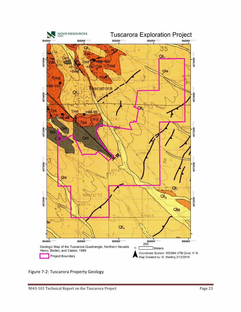
7.3 Property Geology
The Tuscarora property is located about two kilometres southeast of the Mt. Blitzen
volcanic center, a basin bounded by a ten km wide circular fault zone. The property is
covered with quaternary alluvium that has been subdivided into five units by Henry et al.
(1999) with the depth of alluvium increasing towards the southeast. Underlying the
alluvium is an inferred basement of undivided heterogeneous mix of siltstone and chert
with minor sandstone. The sedimentary units are overlain by a dacite ashflow tuff unit.
This unit has only been identified in a deep drill hole in the Dexter Pit immediately to the
north and adjacent to the Tuscarora Property; it has been described as moderately
welded, commonly brecciated and pervasively propyllitically altered (Henry, et al., 1999).
Overlying the ashflow tuff is a unit of volcaniclastic sedimentary rocks and tuff that forms
a northeast trending, southeast dipping sequence between the Mt.Blitzen volcanic center
and the Quaternary alluvium. They are generally described as white, massive to laminated
tuffaceous sandstones and siltstones (Henry, et al., 1999). These units are all, except for
the alluvium, cut by irregular porphyritic dacitic intrusions and dikes and are the most
common vein host in the area.
Northwest to north-northwest trending, steep westerly dipping structures radiate out
from the Mt.Blitzen volcanic center and are inferred to cut the geological sequence on
the Property. Later north-south and east-west structures cut and offset geology and
mineralization as inferred from limited drilling.
Two known mineralized zones occur on the Property, the southern extension of the
Navajo Vein and the East Structure. In general, higher grade historical intercepts are
associated with narrow zones of strong silica/adularia alteration up to several meters wide
(Jones, 1999). Mapping and sampling of the Dexter Pit immediately north and adjacent
to the Tuscarora Property and Navajo Vein zone by Zahony (1988) indicated the
possibility of two gold mineralizing events, an earlier pyritic event in tuffaceous rocks,
and a later veining event temporally associated with the porphyritic dacite intrusives; of
note, strong gold grades were obtained in both steep and flat veins.
NI43-101 Technical Report on the Tuscarora Project Page 23
Figure 7-2: Tuscarora Property Geology

NI43-101 Technical Report on the Tuscarora Project Page 24
8 Deposit Types
The Tuscarora District hosts epithermal veins in volcano-sedimentary rocks. The most
likely targets on the Property are low sulfidation epithermal Au-Ag veins. There is potential
for discovering extensions to known veins north of the Property and new discoveries
under alluvial cover (Figure 8-1).
These low-sulfidation quartz-adularia epithermal deposits are relatively common in
Nevada and include such deposits as Midas, Sleeper, and Round Mountain. These types
of deposits can include disseminated, stockwork and vein deposits. In addition to the vein
hosted gold-silver mineralization previously exploited in the Tuscarora District, Henry, et
al. (1999) suggests the area hosts the potential for Carlin-type deposits within Paleozoic
rocks at depth. He suggests that this is supported by the observation that the Tuscarora
District lies between the large Carlin-type deposits of the Carlin Trend and Independence
Trend; additionally, Paleozoic rocks are exposed within the Mt Blitzen volcanic center.
Given the conceptual depth to appropriate host rock types it would not be expected that
this style of mineralization would be of economic interest at this time.
Figure 8-1: Conceptual low sulfidation epithermal model for the Tuscarora Property (Robert et
al, 2007.

NI43-101 Technical Report on the Tuscarora Project Page 25
9 Exploration
Previous exploration by Newcrest Mining Ltd., Franco Nevada Mining Corp Inc and
Terraco Energy Corporation, and the compilation of historical work by Novo was discussed
in Section 6.0. Also a detailed summary of the historical work is provided in the previous
technical report by Ristorcelli and Goodall, Mine Development Associates, “Technical
Review, Tuscarora Project, Elko County, Nevada: NI 43-101 Report prepared for Terraco
Energy Corporation “ (2003). These data were utilized by the author to determine that it
is prudent to advance the understanding and potential of the Property. Novo nor
Buccaneer has undertaken any exploration work on the property to date.
Since the property was optioned by Novo a significant effort has been undertaken to
compile and evaluate accessible data leading to the submission and acceptance of a
Notice of Exploration to undertake a limited exploration program with the initial objective
to confirm historical results on the property (Figure 9-1). In order to support this
exploration proposal Novo has relied on the reclamation activities and community surveys
completed by a previous land holder, Wolfpack Gold. Novo has completed a migratory
bird survey (2015) to support its proposed work program and provide guidance as to
potential restrictions with the timing of the proposed work program.
10 Drilling
Buccaneer nor Novo has conducted any drilling on the property. Historical drilling
presented in section 6.0 and subsequent drilling by Franco Nevada Mining Corp Inc (2000)
and Terraco Energy Corporation (2005) cannot be verified beyond the presence of
reclaimed drill pads, various internal reports and historical data as no sample rejects, drill
chip boards nor core records are in existence, to the best of the author’s knowledge.
11 Sample Preparation. Analyses and Security
A portion of the historical QA/QC, pre-2003, is reported in “Technical Review, Tuscarora
Project, Elko County, Nevada: NI 43-101 Report prepared for Terraco Energy
Corporation” by Ristorcelli and Goodall, 2003.
No QA/QC data is available for work done by Franco Nevada Mining or Terraco Energy
Corporation.

NI43-101 Technical Report on the Tuscarora Project Page 26
Figure 9-1: Notice of Exploration drill pad locations, Navajo Zone, Tuscarora Property.

NI43-101 Technical Report on the Tuscarora Project Page 27
The author, on behalf of Buccaneer Gold Corp, collected four rock samples from stockpiles
on the property thought to be from later mining stages of the Dexter Pit that are thought
to be representative of expected epithermal style mineralization, both disseminated pyrite
associated as well as quartz-adularia vein style mineralization. To the best of the author’s
knowledge there is no outcropping mineralization on the Property and that these samples
are representative of mineralization in the immediate area of the Property.
These samples were taken directly by the author or under the direct supervision of the
author. The samples were under the direct control of the author and were hand delivered
to ALS Global in Elko Nevada where they were logged in for analysis. Samples were
crushed to 70% passing 2mm, a 1kg split was taken and pulverized to better than 85%
passing 75 microns. A split of 50g was analyzed for gold by fire assay and AAS finish.
Silver and 47 additional elements were analyzed using ICP-MS after a four acid digestion.
The detection limits were 5ppb for gold and 2ppb for silver.
ALS Global is an ISO accredited analytical laboratory using industry standard analytical
techniques and equipment and is an independent laboratory and independent of
Buccanneer Gold Corp.
Results for these samples are presented in section 12.0

NI43-101 Technical Report on the Tuscarora Project Page 28
12 Data Verification
An initial review was completed by the author in February 2016 of the available data, and
verified in discussions with representatives of Novo Resources. The author also completed
a review of the available maps, reports and data prior to the completion of this report. A
field review was completed on February 10th, 2016 in order to confirm the presence and
general locations of the historical drill pads in the Navajo Zone and East Pediment Zone.
No review of drill chips or core was undertaken as these records no longer exist to the
best of the Owners or Novo knowledge. Substantial snow cover prevented examination
of pits and trenches on adjoining properties; there are no mineralization exposures on
the Property to the best of the author’s knowledge except for mineralization in stockpiles
and waste dumps from historical mining activities.
The conceptual exploration model was reviewed, in modeling software (LeapfrogGeo),
against the compiled historical dataset with no discrepancies observed.
Table 12-1: Samples collected from representative mineralization from local stockpiles.
Table 12-2: Sample results
Results of the grabs samples from stockpiles located on the Property and inferred to be from mineralized material from the Dexter Mine are indicative of mineralisation previously described. Based on the pathfinder elements they appear to be more representative of the northern silver rich zone as described by Boden et al. (1993). This is expected as the Dexter pit lies north of the Navajo target which would be targeting higher gold grades and bonanza style shoots.
Sample Easting (m) Northing (m) Brief description
16TTR-001 0564778 4573236 White to smoky vein material; qtz-adularia, some vuggy texture, 2% disseminated vfg silvery sulfides
16TTR-002 0564778 4573236 Silicified tuffaceous rock with very fine disseminated sulfides t/o 5-7%
16TTR-003 0564780 4573242 Massive to semi massive pyrite (vfg) in altered tuff
16TTR-004 0564783 4573248 Silicified tuff, vfg dissem sx with mm sx vnlets t/o quartz and adularia and breccia texture
Sample Ag (g/t)
Au (g/t)
Sb (ppb)
As (ppm)
Se (ppm)
Mo (ppm)
Ba (ppm)
Cd (ppm)
Zn (ppm)
16TTR-001 40.7 0.322 24.1 200 3.5 1.72 1170 0.071 24.8
16TTR-002 3.21 0.064 6.38 178 2.0 2.79 1520 0.085 39.7
16TTR-003 207 0.518 61.4 576 5.8 105.5 269 0.315 98.3
16TTR-004 11.0 0.157 15.8 254 1.5 4.33 524 0.038 9.9

NI43-101 Technical Report on the Tuscarora Project Page 29
13 Mineral Processing and Metallurgical Testing
Not applicable.
14 Mineral Resource Estimates
Not applicable.
15 Mineral Reserve Estimates
Not applicable.
16 Mining Methods
Not applicable.
17 Recovery Methods
Not applicable.
18 Project Infrastructure
Not applicable.
19 Market Studies and Contracts
Not applicable.
20 Environmental Studies, Permitting and Social or Community Impact
Novo has an approved Notice of Exploration, case file NVN-93944, from the Bureau of
Land Management and has submitted the required bond for the proposed exploration
disturbance. Included requirements are the restriction of work period to 10:00am to
sundown between March 1 and May 15 due to proximity of Greater Sage Grouse leks.
Additional surveys would be required for additional disturbance with strict criteria with
respect to migratory bird breeding between March 15 and July 31.
Archaeology surveys are also required, however, to the best of the author’s knowledge
those previously completed by Wolfpack Gold (Nevada) are adequate for use during the
proposed program.
Novo received the required migratory bird survey report from Stantec Consulting Services
on July 7, 2015. To the best of the author’s knowledge this report supports the proposed
Notice of Exploration.
21 Capital and Operating Costs
Not applicable.

NI43-101 Technical Report on the Tuscarora Project Page 30
22 Economic Analysis
Not applicable.
23 Adjacent Properties
An immediately adjacent, to the northwest, package of Patents covers most of the
historical small pits, Dexter Mine, shafts and adits (Figure 4-1). To the best of the author’s
knowledge no work has been undertaken on these patents in the recent past. A limited
number of additional claims to the north and west of the Patent ground cover historical
showings and placer areas.
24 Other Relevant Data and Information
The Author of this Technical Report is not aware of any other relevant data or information concerning this report.
25 Interpretation and Conclusions
The geological environment is permissible for the formation of low sulfidation epithermal
quartz adularia precious metal deposits. Historical mining operations north of the Property
exploited narrow high grade vein and lower grade stockwork vein mineralized zones of
these types of mineral systems. Previously completed exploration consisted of numerous
drill programs (reverse circulation) resulting in gold and silver values that indicate the
potential to form an economic deposit. The historical exploration has outlined an
exploration target named the Navajo Vein and Navajo Vein South Extension which trends
across the Tuscarora Property. A second target area of similar style of mineralisation that
has received less historical work is called the East Pediment zone. Due to the abundance
of alluvium and the lack of systematic geochemical and geophysical exploration, there is
potential for the discovery of additional ‘blind’ targets. Reviews of historical reports, data
and geology suggest that the Tuscarora Property requires additional work to both confirm
historical results as well as fully evaluate the potential for epithermal gold–silver deposits.
26 Recommendations
The existence of epithermal alteration and mineralization with strong precious metals
grades in the historical record indicates the potential for the Tuscarora Property to host
deposits of economic interest. Accordingly it is recommended that a limited but
aggressive exploration program be conducted to confirm the historical data at the Navajo
Zone.

NI43-101 Technical Report on the Tuscarora Project Page 31
Key objectives would be to confirm the high grades previously reported, understand the
alteration zonation around mineralization of interest, and confirm geological controls
(structures and lithologies). This information should then be used to evaluate the Navajo
and East Pediment zones for deposit potential.
The following exploration program is recommended:
(c) Drill evaluate/confirm the historical drill results.
(d) Create a geological map of the property including known veins, structures and alteration patterns. Alteration mineralogy should be determined with certainty using a Terraspec mineral analyser or equivalent.
After confirmation of historical data follow up drilling to evaluate Navajo and East
Pediment could be undertaken as well as using the confirmed target model signature to
evaluate the remainder of the property for additional ‘blind’ mineralisation potential. A
gridded soil sampling program should be considered, first over the Navajo and East
Pediment zones to confirm signatures and then expanded across the property to identify
additional targets masked by the quaternary sediments.
Detailed magnetics (and/or VTEM), gradient resistivity, and detailed gravity could be used
to define or refine mineralisation controls and define additional and/or deeper mineralized
structures.
Table 26-1: Recommended work program Activity Units Unit Cost
(est.)
Cost Estimate
(US$)
*CAD$
Geological compilation 1 report 10,000 10,000
drilling 1500 m 90 135,000
assays 1000 samples 25 25,000
Geologist/geotech/terraspec 15 days 1000 15,000
Access/permitting permits 15,000
SubTotal 200,000
Contingency 10% 20,000
Total Estimated Cost 220,000 305,800
*current forex US$1.00 = CAD$1.39

NI43-101 Technical Report on the Tuscarora Project Page 32
27 References and Abbreviations
Boden, D.R., Struhsacker, E.M., and Wright, B.A., 1993, Structurally controlled volcanism
and contrasting types of mineralization, Tuscarora mining district and vicinity,
Nevada [abs.]: Geological Society of America Abstracts with Programs, v. 25, no.
6, p. 11.
Castor, S. B., Boden, D.R., Henry, C.D., Cline, J. S., Hofstra, A. H. , McIntosh, W.C.,
Tosdal, R.M., and Wooden, J.P., 2003, The Tuscarora Au-Ag District: Eocene
Volcanic-Hosted Epithermal Deposits in the Carlin Gold Region, Nevada: Economic
Geology, vol. 98, p. 339-366.
Coats, Robert R., (1987), Geology of Elko County, Nevada; Nevada Bureau of Mines and
Geology Bulletin 101.
Cook, H.E. and J.J. Corboy, 2004, Great Basin Paleozoic Carbonate Platform: Facies,
Facies Transitions, Depositional Models, Platform Architecture, Sequence
Stratigraphy, and Predictive Mineral Host Models. U.S. Geological Survey Open-
File Report 2004-1078 Field Trip Guidebook—Metallogeny of the Great Basin
Project, August 17—22, 2003.
Cruson, Michael G., 1995, Progress Report on the Tuscarora District Elko County, Nevada;
Cruson and Pansze, Geologists.
Gustin, M.M., Smith, M.T., and G.L. Simmons, 2015, Updated Technical Report and
Estimated Mineral Resources for the Kinsley Project Elko and White Pine Counties,
Nevada, U.S.A.
Hennigh, Quinton, (1997), The Tuscarora Project – 1996; internal report. Newcrest
Resources Ltd.
Henry, C.D., Boden, D.R., and Castor, S.B., 1998, Geology and mineralization of the
Eocene Tuscarora volcanic field, Elko County, Nevada, in Tosdal, R.M., ed.,
Contributions to the Au metallogeny of northern Nevada, U.S. Geological Survey
Open-File Report 98-338, p. 279-290.
Henry, C.D., Boden, D.R., and Castor, S.B., 1999, Geological Map of the Tuscarora
Quadrangle, Northern Nevada. Nevada Bureau of Mines and Geology.
Jones, D. compiler, 1999, Tuscarora Prospect – Preliminary Examination, Newcrest Mining
Ltd.
LaPointe, D.D., Tingley, J.V., Jones, R.B., 1991, Mineral resources of Elko County,
Nevada: Nevada Bureau of Mines and Geology Bulletin 106, 236 p.
McCusker, R. T., (1999), 1998 Tuscarora Summary Report, internal report. Newcrest
Resources Ltd.
Mueller, K. J., Cerveny, P. K., Perkins, M. E, and Snee, L. W., 1999, Chronology of
polyphase extension in the Windermere Hills, northeast Nevada: Geological Society
of America Bulletin, v. 111, no. 1, p. 11 – 27.

NI43-101 Technical Report on the Tuscarora Project Page 33
Newman, C.P., 2014, Geochemistry of Arsenic, Manganese, and Iron in the Dexter Pit
Lake, Tuscarora, Nevada; Univ of Michigan, MS Thesis, 171 p.
Nolan, T.B., 1936, The Tuscarora mining district, Elko County, Nevada: University of
Nevada Bulletin, v. 30 and Nevada Bureau of Mines and Geology Bulletin 25, 36 p.
Paher, S. W., 1970, Nevada Ghost Towns and Mining Camps, Howell-North Books, San
Diego, California, p. 194-202.
Randol International, 1990, Horizon Gold Shares Inc. Report: American Mines Handbook,
p. 107.
Randol International, 1988, Tuscarora Gold Mines Joint Venture Reports: Randol Gold
Directory, p. II-153.
Randol International, 1990/1991, Tuscarora Gold Mines Joint Venture Reports: Randol
Mining Directory, p. 253-254.
Ristorcelli, S., and Goodall, G., 2003, Mine Development Associates, Technical Review,
Tuscarora Project, Elko County, Nevada: NI 43-101 Report prepared for Terraco
Energy Corporation, 63 pages, including appendices.
Robert, F., Brommecker, R., Bourne, B.T., Dobak, P.J., McEwan, C.J., Rowe, R.R., Zhou,
X., 2007, Models and Exploration Methods for Major Gold Deposit Types in
"Proceedings of Exploration 07: Fifth Decennial International Conference on
Mineral Exploration" edited by B. Milkereit, 2007, p. 691-71.
Thorman, C. H., Brooks, W. E., Ketner, K. B., Snee, L. W., and Zimmerman, R. A., 1991,
Late Mesozoic-Cenozoic tectonics in northeastern Nevada, in G. L. Raines, R. E.
Lisle, R. W. Schafer, and W. H. Wilkinson, eds., Geology and ore deposits of the
Great Basin: Symposium proceedings, Geological Society of Nevada, p. 25-45.
Western Mining History, 1998, Tuscarora Deposit; from: USGS Mineral Resources Data
System (MRDS); mrdata.usgs.gov/mrds.
Zahony, S., 1989. Internal memorandum. Chevron Resources Company.

NI43-101 Technical Report on the Tuscarora Project Page 34
LIST OF ABBREVIATED TERMS
“Au” gold
“Az” azimuth
“CAD$” Canadian dollars
“cm” centimeters
“°” degree
“g” or “gm” gram
“Ga” billion of years ago
“g/m3” grams per cubic metre
“GPS” global positioning system
“g/t” grams per tonne
“ha” hectare
“kg” kilogram
“km” kilometre
“m” metre
“mi” mile
“m3” cubic metres
“Ma” millions of years ago
“oz” ounce
“ppb” parts per billion
“ppm” parts per million
“RC” reverse circulation
“sq km” square kilometres
US$ United States dollars
“UTM” Universal Transverse Mercator
“WGS 84” World Geodetic Survey 1984

35
28 Certificate of Qualifications
I, Darren Wesley Lindsay certify that: I reside at 1162 Wendel Place, North Vancouver, Canada and act as a consulting geologist and am employed as President and CEO by Castle Peak Mining Ltd. This certificate applies to the technical report entitled “NI43-101 Technical Report on the
Tuscarora Project, Elko County, Nevada”; dated March XX, 2016.
I am a member of the Association of Professional Engineers and Geoscientists of British Columbia (APEGBC, member # 30145). I am also a member of the Society of Economic Geologists. I graduated from the University of British Columbia with an H.B.Sc. in Geology in 1998. I have practiced my profession continuously since 1998 in the field of Exploration and Economic Geology; employed in mineral exploration, nationally and internationally. As a result of my experience and qualifications, I am a Qualified Person as defined in National Instrument 43-101 Standards of Disclosure for Mineral Projects (NI43-101). I have visited the Tuscarora Project from February 9th through 11th, 2016. I have prepared and am responsible for all sections of this report. I am independent of Buccaneer Gold Corp. as independence is described by Section 1.5 of NI 43–101. I am not a director or officer of, and I do not beneficially hold any shares of Buccaneer Gold Corp or Novo Resources Corp. I hold no direct interest in the Tuscarora Property as a result of any prior involvement with the Property. I have read NI 43–101 and the sections of the technical report for which I am responsible have been prepared in compliance with that Instrument. I am not aware of any material fact or material change with respect to the subject matter of the Report that is not disclosed in the Report which, by its omission, makes the Report misleading. Respectfully submitted this XXth day of March, 2016. Darren W. Lindsay, P.Geo.
Top Related