


Languages
Pages
Legal


RMS 15.093ISBN 978-1-925217-31-5
M4 Smart MotorwayVolume 6Appendix G: Contamination Appendix H: Non-Aboriginal Heritage
March 2015

Appendix G Contamination
M4 Smart Motorway Appendix G Review of Environmental Factors
M4 MANAGED MOTORWAY - CONCEPT DESIGN & ENVIRONMENTAL ASSESSMENT
DESKTOP CONTAMINATED SOILS INVESTIGATION REPORT
NB11510-ESG-RP-0041
Revision B - Final
8 March 2013
Document history and status
Revision Date issued Reviewed by Approved by Date approved Revision type
Rev A 28/2/2013 Michael Stacey / M. Faust
Amanda Hunter 8/3/2013 Draft
Rev B 19/3/2013 M. Faust M. Faust 19/3/2013 Final
Distribution of copies
Revision Copy no Quantity Issued to
A 1 1 RMS Project Manager
B 1 1 RMS Project Manager
Printed: 3 February 2015
Last saved: 03/02/2015 11:55
File reference number NB11510-ESG-RP-0041
Author: Amanda Hunter
Project Manager: Matt Faust
Name of organisation: Sinclair Knight Merz
Name of project: M4 Managed Motorway
Name of document: Desktop contaminated soils investigation report
Document revision: Final
Project number: NB11510

M4 Managed Motorway – Concept Design & Environmental Assessment
Desktop contaminated soils investigation report
March 2013 PAGE i
Contents
1. Introduction 1
1.1 Purpose of the preliminary site investigation 1
1.2 Objectives of the preliminary site investigation 1
2. Site Information 2
2.1 Site identification 2
2.2 Site zoning and land use 2
2.3 Acid sulphate soils risk 2
2.4 Hydrogeology 2
2.5 Sensitive environments 4
3. Site History 6
3.1 Historical aerial photography 6
3.2 NSW OEH contaminated site register 7
3.3 Site history summary 10
3.4 Integrity assessment 11
4. Site Inspection 12
4.1 Potential areas of concern 13
5. Conclusions and Recommendations 15
5.1 Key findings of the assessment 15
5.2 Summary 16
5.3 Further assessment and investigations 16
6. References 17
7. Limitation Statement 18
Figures 19

M4 Managed Motorway – Concept Design & Environmental Assessment
Desktop contaminated soils investigation report
March 2013 PAGE 1
1. Introduction
1.1 Purpose of the preliminary site investigation
Roads and Maritime Services (RMS) engaged Sinclair Knight Merz Pty Ltd (SKM) under
Professional Services Contract (PSC) number 09.2166.2109-0049 to develop the concept design
and undertake a review of environmental factors (REF) of the M4 Managed Motorway Project
between Strathfield and Lapstone. The project primarily involves the implementation of ITS
infrastructure and systems including civil works, to manage the flow of traffic on the M4
Motorway.
This report has been prepared in accordance with Section 3.3 of the PSC and SKM’s proposal to
provide a desktop contaminated soils investigation report at ramp and widening locations as part of
the M4 Managed Motorways project (referred to herein as the site).
This report was prepared in parallel with the geotechnical background review to assess potential
contamination issues at the site that may have arisen from past and/or present activities undertaken
on/and or adjacent to the site which may represent a constraint to the design and construction of the
respective project elements. The format for this report generally follows the guidelines as published
in the following documents:
NSW EPA (2000) Contaminated Sites: Guidelines for Consultants Reporting on Contaminated
Sites (NSW EPA, 2000)
National Environmental Protection Council (1999) National Environment Protection Measure
(Assessment of Site Contamination) Measure 1999 (NEPC, 1999)
Australian Standard AS 4482.1-2005 Guide to the investigation and sampling of sites with
potentially contaminated soil. Part 1: Non-volatile and semi-volatile compounds (AS 4482.1-
2005).
1.2 Objectives of the preliminary site investigation
Specifically, the objectives of this report are to:
Identify past and present potentially contaminating activities
Identify potential contamination types and location
Discuss the site conditions
Provide a preliminary assessment of site contamination
Assess the need for further investigations

M4 Managed Motorway – Concept Design & Environmental Assessment
Desktop contaminated soils investigation report
March 2013 PAGE 2
2. Site Information
2.1 Site identification
The site encompasses 16 interchanges. Each interchange comprises of eastbound and westbound on
and off-ramps. The project site also includes three locations along the 42 kilometres of the
motorway between Homebush Bay Drive, Homebush, and Russell Street, Emu Plains, NSW where
lane widening is proposed to widen the M4 Motorway. The Australian Map Grid coordinates of the
approximate centre of the site are 310339 m E, 6258436 m S. A site layout plan is shown in Figure
1.
2.2 Site zoning and land use
The site travels through nine council areas, each with separate Local Environmental Plans (LEP).
According to Penrith City Council (LEP 2010), Parramatta City Council (LEP 2011), Strathfield
City Council (LEP 2012), Burwood City Council (LEP 2012), City of Canada Bay Council (LEP
2008), and Auburn City Council (LEP 2010) the site is classified as SP2 Infrastructure (classified
road), according to Blue Mountains City Council the site is classified as Regional Transport
Corridor (road), and according to Blacktown City Council (BLEP 1988) and Holroyd City Council
(LEP 1991) the site is classified as 5B Special Uses (arterial road and arterial road widening).
2.3 Acid sulphate soils risk
Acid Sulfate Soil (ASS) Risk Maps from the NSW Natural Resource Atlas database were reviewed
to ascertain the presence of ASS on the site. Based on this information, areas of ASS risk could
occur in the following area:
A high probability of occurrence of ASS is present within the soils of the Duck River,
approximately 130 metres downstream of the site. The Duck River runs underneath the M4
Motorway at Silverwater. The James Ruse Drive interchange is the closest interchange in
relation to Duck Creek. Duck Creek is located approximately one kilometre east of the James
Ruse Drive interchange.
2.4 Hydrogeology
The direction of groundwater flow could not be definitively assessed based on current information,
although the surrounding topography suggests that groundwater would flow towards the waterways
flowing across and adjacent to the site i.e. Haslams Creek, Duck River, Parramatta River, Coopers
Creek, Ropes Creek, Blaxland Creek, Finlaysons Creek, Pendle Creek, South Creek, Byrnes Creek,
Girraween Creek, Blacktown Creek, Eastern Creek, Angus Creek, Claremont Creek, Surveyors
Creek, Nepean River, School House Creek and Jamison Creek.
A search with the NSW Natural Resources Atlas database identified no registered groundwater
wells within the site. Forty-seven wells were registered within an approximate 500m radius of the
site. Information on the 47 wells is summarised in Table 1.

M4 Managed Motorway – Concept Design & Environmental Assessment
Desktop contaminated soils investigation report
March 2013 PAGE 3
Table 1 - Registered NRA Boreholes
Borehole ID. Licence No. Easting Northing Bore Usage
GW102644 10BL150044 320777.00 6251514.00 Monitoring Bore
GW102645 10BL150044 321082.00 6251735.00 Monitoring Bore
GW102646 10BL150044 320826.00 6251638.00 Monitoring Bore
GW102649 10BL150044 320958.00 6251456.00 Monitoring Bore
GW102650 10BL150044 320957.00 6251517.00 Monitoring Bore
GW102659 10BL150044 320908.00 6251424.00 Monitoring Bore
GW102652 10BL150044 320982.00 6251549.00 Monitoring Bore
GW102654 10BL150044 320880.00 6251547.00 Monitoring Bore
GW102656 10BL150044 320929.00 6251640.00 Monitoring Bore
GW102657 10BL150044 320881.00 6251485.00 Monitoring Bore
GW102660 10BL150044 320856.00 6251423.00 Monitoring Bore
GW100682 10BL156675 317571.00 6254064.00 Monitoring Bore
GW104955 10BL160497 317457.00 6254735.00 Monitoring Bore
GW104594 10BL160497 317448.00 6254936.00 Monitoring Bore
GW104953 10BL160497 317448.00 6254950.00 Monitoring Bore
GW105353 10BL161910 317071.00 6254914.00 Monitoring Bore
GW105354 10BL161910 317019.00 6254897.00 Monitoring Bore
GW105352 10BL161910 317032.00 6254860.00 Monitoring Bore
GW110398 10BL160282 315109.00 6254988.00 Monitoring Bore
GW110404 10BL160282 315010.00 6254993.00 Monitoring Bore
GW110399 10BL160282 315306.00 6255074.00 Monitoring Bore
GW110397 10BL160282 315067.00 6255015.00 Monitoring Bore
GW110403 10BL160282 315067.00 6255036.00 Monitoring Bore
GW110402 10BL160282 315149.00 6255077.00 Monitoring Bore
GW110396 10BL160282 315243.00 6255114.00 Monitoring Bore

M4 Managed Motorway – Concept Design & Environmental Assessment
Desktop contaminated soils investigation report
March 2013 PAGE 4
Borehole ID. Licence No. Easting Northing Bore Usage
GW110401 10BL160282 315241.00 6255134.00 Monitoring Bore
GW110400 10BL160282 315277.00 6255143.00 Monitoring Bore
GW111322 10BL601807 315874.00 6254859.00 Monitoring Bore
GW111323 10BL601807 315887.00 6254883.00 Monitoring Bore
GW111324 10BL601807 315863.00 6254886.00 Monitoring Bore
GW107832 10BL165697 308411.00 6256578.00 Monitoring Bore
GW110312 10BL602119 298563.00 6258108.00 Monitoring Bore
GW110314 10BL602119 298594.00 6258058.00 Monitoring Bore
GW028414 10BL02050 298648.00 6259670.00 Irrigation Bore
GW111099 10BL604059 293656.00 6260246.00 Monitoring Bore
GW111101 10BL604059 293674.00 6260255.00 Monitoring Bore
GW110460 10BL603104 293689.00 6259099.00 Monitoring Bore
GW110463 10BL603104 293697.00 6259081.00 Monitoring Bore
GW110461 10BL603104 293652.00 6259091.00 Monitoring Bore
GW110459 10BL603104 293666.00 6259094.00 Monitoring Bore
GW110462 10BL603104 293664.00 6259083.00 Monitoring Bore
GW108906 10WA109509 287656.00 6259328.00 Recreation
(Groundwater)
GW108486 10WA109577 284119.00 6260164.00 Recreation
(Groundwater)
GW110277 10WA112723 283490.00 6261975.00 Domestic Stock
GW110215 10BL152347 282640.00 6261310.00 Domestic Stock
GW075122 10CA117219 282492.00 6262071.00 Monitoring Bore
GW075123 10CA117219 282488.00 6262078.00 Monitoring Bore
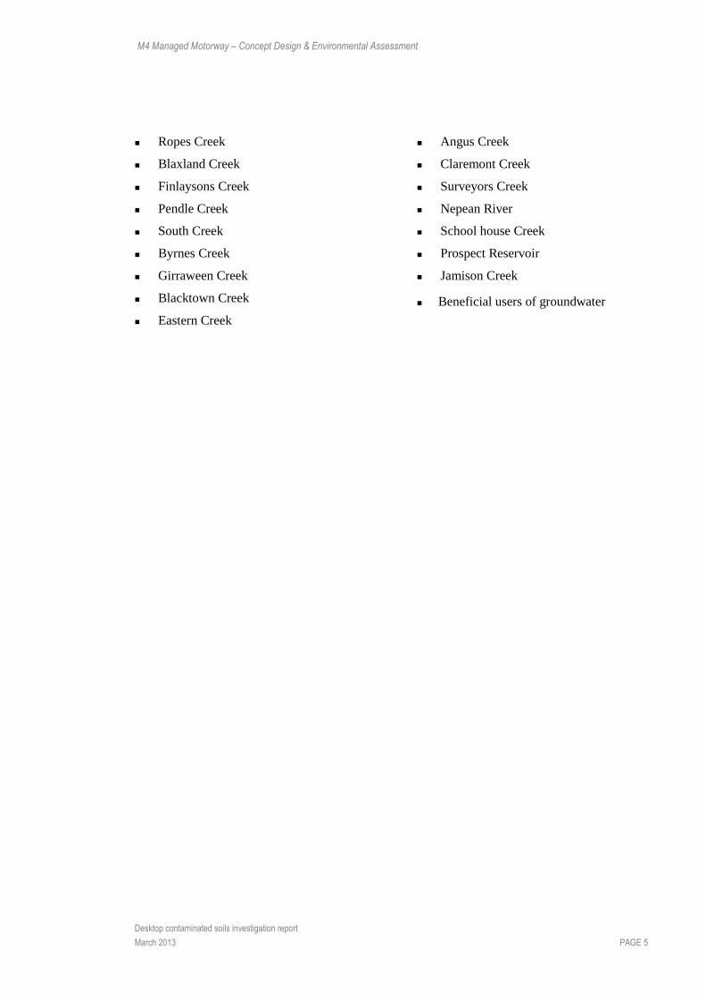
2.5 Sensitive environments
Based on the available information, sensitive environments which could be potentially impacted by
contamination within the site (if present) are detailed below:
Haslams Creek
Duck River
Parramatta River
Coopers Creek
M4 Managed Motorway – Concept Design & Environmental Assessment
Desktop contaminated soils investigation report
March 2013 PAGE 5
Ropes Creek
Blaxland Creek
Finlaysons Creek
Pendle Creek
South Creek
Byrnes Creek
Girraween Creek
Blacktown Creek
Eastern Creek
Angus Creek
Claremont Creek
Surveyors Creek
Nepean River
School house Creek
Prospect Reservoir
Jamison Creek
Beneficial users of groundwater

M4 Managed Motorway – Concept Design & Environmental Assessment
Desktop contaminated soils investigation report
March 2013 PAGE 6
3. Site History
Several sources were investigated to determine the history of land use at and adjacent to the site.
The following details the sources of historical information reviewed and a summary of information
provided by each of the respective sources:
NSW Roads and Traffic Authority: Historical aerial photographs (1943)
NSW Land and Property Management Authority, Land and Property Information Division
(LPI): Historical aerial photographs (1956 to 1975)
NSW Contaminated Sites Register.
3.1 Historical aerial photography
Historical aerial photographs from the NSW Land and Property Management Authority, Land and
Property Information Division were reviewed for the years: 1943, 1956, 1965 and 1975. The
findings of the historical aerial photograph investigation are summarised in Table 2.
Table 2 - Historical Aerial Photography Review
Date of Aerial
Photography Subject Site Surrounding Area
1943
In 1943 the site was not yet constructed. The extent of the photo series is from Homebush Bay to Prospect Reservoir.
The surrounding area is predominately rural residential land use, peppered with industrial/commercial sites close to the route of the M4 Motorway. As the route for the M4 Motorway moves further west the land use becomes increasingly rural and less residential, with subdivisions of land appearing to be used for agricultural purposes. At the eastern end of the route the land appears to be subdivided for residential uses. Throughout the route there is sparse tree cover with large areas of open space/vacant land. There appears to be a large quarry in Auburn adjacent to Duck River. Rosehill racecourse is also visible. The Great Western Highway is apparent throughout most of the imagery, which appears to be well established, with a railway parallel for most of the route. There is a large woodland in the Blacktown/Prospect area.
1956
In 1956 the site was not yet constructed. The extent of the photo series is from Homebush Bay to Emu Plains.
From Emu Plains to Minchinbury the land is predominately rural with signs of agricultural land use. Pockets of residential areas also exist. Additionally in this area there are large areas of forest and several dams. From Minchinbury to Parramatta the land is largely agricultural, with a large forest area around the Prospect Reservoir. To the east of the reservoir, south of the M4 route, there is a large land disturbance, potentially representing a landfill. Within Prospect and south through the site the area is high density residential land use with some pockets of agriculture. There is another large land disturbance of ground in Holroyd, south of the site, possibly indicating a landfill, industry or quarry. In Rosehill, the racecourse is

M4 Managed Motorway – Concept Design & Environmental Assessment
Desktop contaminated soils investigation report
March 2013 PAGE 7
Date of Aerial
Photography Subject Site Surrounding Area
apparent with a large industrial site adjacent to the Duck River. East of Rosehill the land use is again high density residential which continues into Silverwater, Newington and Homebush West. Within this area there are also several quarries/ brick pits. The future Sydney Olympic Park (SOP) site is currently the Homebush Abattoirs (i.e. industry) with The Brick Pit to the north.
1965
In 1965 the site was not yet constructed. The extent of the photo series is from Homebush Bay to Emu Plains.
A bridge has been constructed over the Nepean River in Emu Plains, as part of the Great Western Highway, which can be seen throughout the photo series. The land use in the western end of the route has become increasingly residential; however rural land use and areas of forest remain dominant. A large area of land has been disturbed immediately south of the site, which appears to be a quarry. The large land disturbance east of Prospect Reservoir has increased in size; however the forest surround the reservoir remains intact. As the route moves east the land use continues to become more high density residential, with more industrial sites adjacent to the route. Moving east through Greystanes the route travels through a golf course. In Holroyd the land disturbance has become more established and is potentially a brick pit. The large industrial site north of the route has now extended south of Duck River near to the railway. At the future Sydney Olympic Park site the Brick Pit and abattoirs are still operational, with a large area of land north of the SOP site filled in to form an industrial site.
1975
In 1975 the M4 Western Motorway (M4) had been constructed from Russel Street, Emu Plains to the Prospect Highway, including a bridge spanning the Nepean River. After the Prospect Highway the M4 connects to the existing route of the Great Western Highway. The route appears to be relatively well established. The extent of the photo series is from Silverwater to Emu Plains.
At the western end of the M4, to the north of the route, the land use is medium density residential with large areas of agricultural land use. To the south of the M4 the land use is agricultural and forest. In Claremont Meadows a large cleared area of land to the north of the M4 indicates the presence of a landfill. Approximately 500 m to the south of the M4 in Minchinbury a large quarry has been established. The forest to the north of Prospect Reservoir remains. North of the Prospect Reservoir the M4 joins the Great Western Highway and continues east to Sydney through high density residential land use and industrial areas.
3.2 NSW OEH contaminated site register
A search of the NSW OEH Contaminated Sites Register (under Section 58 of the Contaminated
Land Management Act 1997) indicated that there are 38 sites within two kilometres either side of
the site that are either regulated or have been notified. Table 3 describes these sites in relation to
the subject site.

M4 Managed Motorway – Concept Design & Environmental Assessment
Desktop contaminated soils investigation report
March 2013 PAGE 8
Table 3 - Notices for land adjacent to the site
Suburb Notified Site Address Notified Activity Location
Auburn 1 Manchester Road Main Train Facility Approximately 0.9 km south-east of James Ruse Drive interchange
Eastern Creek M4 Motorway Eastbound Caltex Service Station Approximately 1.2 km west of Reservoir Road Ramp
Eastern Creek M4 Motorway Westbound Caltex Service Station Approximately 0.8 km west of Reservoir Road interchange
Eastern Creek Old Walgrove Road Pioneer Road Services Approximately 1.95 km south-west of M7 Motorway interchange
Emu Heights 126 Old Bathurst Road 7-Eleven Service Station Approximately 1.7 km north of Russel Street interchange
Emu Heights 132 Old Bathurst Road Woolworths Caltex Service Station
Approximately 1.9 km north of Russel Street interchange
Emu Plains 283 Great Western Highway Woolworths Caltex Service Station
Approximately 0.5 km north of Russel Street interchange
Granville 154-160 Parramatta Road 7-Eleven Service Station Approximately 0.6 km south-east of Church Street interchange
Granville 15-17 Berry Street Australand Approximately 0.5 km south-west of James Ruse Drive interchange
Granville 144 Parramatta Road Caltex Service Station Approximately 0.7 km south-east of Church Street interchange
Granville (regulated)
2B Factory Street Evans Deacon Industry Approximately 1.3 km south of James Ruse Drive interchange
Granville 23 Elizabeth Street Old Granville Depot Approximately 1.3 km south of Church Street interchange
Greystanes 73 Ettalong Road Mobil Service Station Approximately 1.1 km south-west of Cumberland Highway interchange
Homebush 334-336 Parramatta Road Caltex Service Station Approximately 0.2 km south-west of Homebush Bay Drive interchange
Homebush Bay Corner Pondage Link and WSN Auburn Waste and Approximately 1.0 km north-

M4 Managed Motorway – Concept Design & Environmental Assessment
Desktop contaminated soils investigation report
March 2013 PAGE 9
Suburb Notified Site Address Notified Activity Location
Hill Road Recycling Centre east of Hill Road interchange
Homebush West Mandemar Avenue Ford Landfill Approximately 0.7 km south of Homebush Bay Drive interchange
Jamisontown (regulated)
92 Mulgoa Road 7-Eleven Service Station Approximately 1.0 km north-east of Mulgoa Road interchange
Jamisontown 126 Mulgoa Road BP Service Station Approximately 0.6 km north-east Mulgoa Road interchange
Merrylands 295-197 Merrylands Road 7-Eleven Service Station Approximately 1.8 km south-west of Church Street interchange
Merrylands 148-150 Woodville Road Caltex Service Station Approximately 1.4 km south of Church Street interchange
Merrylands 1-7 & 9-11 Neil Street Former Stockfeed Manufacturing Site
Approximately 1.4 km south-west of Church Street interchange
Merrylands 11-19 Centenary Road St Vincent De Paul Society (other petroleum)
Approximately 1.7 km south-east of Cumberland Highway interchange
Merrylands West 3 Centenary Road Former Mobil Service Station
Approximately 1.9 km south-east of Cumberland Highway interchange
Minchinbury 815 Great Western Highway Mobil Service Station Approximately 1.1 km north-west of M7 Motorway interchange
Parramatta Corner Pitt & Macquarie
Streets
Coleman Oval Embankment
Approximately 1.5 km north-west of Church Street interchange
Pendle Hill 217 Wentworth Avenue 7-Eleven Service Station Approximately 1.7 km north-west of Cumberland Highway interchange
Penrith 229-231 Mulgoa Road Caltex Service Station Approximately 1.0 km north-east of Mulgoa Road interchange
Prospect 354 Flushcombe Road Mobil Service Station Approximately 0.8 km north-east of Reservoir Road Ramp
Rosehill 9 Devon Street Shell Oil Refinery Approximately 1.7 km north of James Ruse Drive and

M4 Managed Motorway – Concept Design & Environmental Assessment
Desktop contaminated soils investigation report
March 2013 PAGE 10
Suburb Notified Site Address Notified Activity Location
(regulated) Silverwater Road interchanges
Rosehill (regulated)
Devon Street James Hardie Building Products
Approximately 1.2 km north-west of James Ruse Drive interchange
Silverwater 103-105 Silverwater Road Unspecified Industry Approximately 0.6 km north of Silverwater Road interchange
Silverwater Carnarvon Street Silverwater Landfill Approximately 0.4 km north of the site
Sydney Olympic Park (regulated)
Shane Gould Avenue Aquatic Centre Carpark (Landfill)
Approximately 0.7 km north-west of Homebush Bay Drive interchange
Sydney Olympic Park (regulated)
Bicentennial Drive Bicentennial Park (Landfill)
Approximately 1.1 km north of Homebush Bay Drive interchange
Sydney Olympic Park (regulated)
Kronos Hill, Kevin Coombes Avenue
Former Haslams Creek Landfill
Approximately 1.6 km north-east of Hill Road interchange
Sydney Olympic Park (regulated)
Sarah Durack Avenue Former State Sports Centre Landfill
Approximately 0.6 km north of Homebush Bay Drive interchange
Sydney Olympic Park (regulated)
Kronos Hill, Kevin Coombes Avenue
Haslams Creek South Area 3 Landfill
Approximately 1.6 km north-east of Hill Road interchange
Wentworthville 2 Rawson Road Unspecified Industry Approximately 0.3 km east of Cumberland Highway interchange
3.3 Site history summary
The historical aerial photography review indicated that construction of the site from Emu Plains to
the Prospect Highway began in the 1970s. Since the 1940s the western end of the site and
surrounding land has developed from agricultural and rural residential land use with large pockets
of forest, to a low to medium density residential landscape. The eastern end of the site and
surrounding land has remained as residential land use since the 1950s with increasing residential
density and the development of industrial and commercial centres. Heavy industry has been
dominant in the eastern end of the route near Homebush Bay since the 1950s.
Currently, there are 38 notices for land within the surrounding suburbs of the subject site; Auburn,
Eastern Creek, Emu Plains, Granville, Greystanes, Homebush, Jamisontown, Merrylands,
Minchinbury, Parramatta, Pendle Hill, Penrith, Prospect, Rosehill, Silverwater, Sydney Olympic
M4 Managed Motorway – Concept Design & Environmental Assessment
Desktop contaminated soils investigation report
March 2013 PAGE 11
Park, and Wentworthville. Seven of these sites present a moderate risk with respect to
contamination, while the remaining sites present low risks with respect to contamination due to the
proximity of the sites to the M4 Motorway, potential contamination types and migration pathways.
3.4 Integrity assessment
Historical and site information was sourced from NSW Government departments with no known
interest in the site. SKM have relied on the accuracy of the documentation provided and our
experience in historical document interpretation. Whilst there is a small margin for error in
interpretation, SKM consider the information presented in this assessment to be suitable for use.

M4 Managed Motorway – Concept Design & Environmental Assessment
Desktop contaminated soils investigation report
March 2013 PAGE 12
4. Site Inspection
The following site description is based on observations made during a site inspection conducted on
26 February 2013 by two SKM field engineers. The site inspection was undertaken to ground truth
information gathered from the desktop review and targeted areas of potential concern (i.e. the seven
moderate risk sites identified from the NSW OEH Contaminated Sites Register) and the aerial
photograph review.
The Australand industrial site is currently a “Toll In 2 Store” storage facility. The site
includes a warehouse, office building, and carpark. The topography is generally flat with a
slight decline towards the M4 Motorway.
The Caltex Service Station at Homebush on Parramatta Road generally appeared to be in a
good operational condition.
Duck River is currently and has historically been surrounded by industrial sites.
Considering the industrial history of the areas adjacent to Duck River and the lack of
environmental controls associated with these historical operations, sediments within the
river could contain elevated contaminant concentrations. With limited access at Rosehill,
signs of fill and general rubbish were evident along the river banks. At the time of the site
inspection the direction of the river flow was towards the M4 Motorway.
Former Ford Landfill has been capped and is now gated as Ford Remediation Site. In the
north-west corner of the Remediation Site there is a leachate treatment plant that services
the former landfill. Anecdotal evidence suggests that the treatment plant is monitored
weekly. The site appears to be in good condition with no obvious signs of leaching,
staining or vegetation dieback. The site lies adjacent to a drainage channel which flows
towards the M4 Motorway.
The NSW EPA notified sites listed Silverwater landfill on Carnarvon Street, Silverwater,
however during the site inspection there was no obvious location for this site. Carnarvon
Street runs parallel to the M4 Motorway and drainage flows away from the site towards
Parramatta River.
The former landfill at the States Sports Centre in Sydney Olympic Park functions as a
sporting complex and large parkland and appears to be in good condition and well
maintained. No obvious signs of leaching, staining or vegetation dieback were evident.
Topography slopes slightly towards the M4 Motorway.
The unspecified industrial site on Rawson Road in Wentworthville appears to be a former
carpark which is currently vacant land. The site is grassed with potential areas of fill at the
back eastern corner of the site. General debris and rubbish litter the site. Topography of
the area is gently sloping towards the M4 Motorway.

M4 Managed Motorway – Concept Design & Environmental Assessment
Desktop contaminated soils investigation report
March 2013 PAGE 13
Access and visibility to Hanson Quarry was limited. Stockpiling of materials and several
fuel storage facilities were visible in the entrance yard which is approximately 800m from
the M4 corridor. Topography sloped gently both north and south.
The M4 road corridor of the site appeared to be in good condition with no obvious signs of
contamination. However, there is the potential for localised point sources of contamination to
exist along the road corridor associated with spills and leaks from vehicles and exhaust
particulate deposition.
4.1 Potential areas of concern
Table 4 outlines potential areas of concern as identified from the information review and site
inspection. A risk rating has been allocated for these areas outlining anticipated levels of risk of
contamination being present beneath the respective construction elements.
Table 4 - Potential Areas of Concern
Potential Area
of Concern
Location
Relative to
Site
Potentially
Affected
Ramp
Potential
Contamination
Sources
Potential
Contaminants
of Concern
Risk
Rating
Australand Industrial Site– Granville
500 m south-west
James Ruse Drive
Chemical storage/useage and on-site activities
Metals, hydrocarbons
Low
Caltex Service Station – Homebush
200 m south Homebush Bay Drive
Fuel storage Metals, hydrocarbons
Moderate
Duck River – Silverwater
Underneath the site
James Ruse Drive
Historical activities Metals, hydrocarbons, PCB, nutrients
Moderate
Ford Landfill – Homebush West
700 m south Homebush Bay Drive
Waste, leachate, gas
Metals, hydrocarbons, pesticides, PCB, asbestos, nutrients, methane
Moderate
Landfill – Silverwater
400 m north Silverwater
Road Waste, leachate, gas
Metals, hydrocarbons, pesticides, PCB, asbestos, nutrients, methane
Low

M4 Managed Motorway – Concept Design & Environmental Assessment
Desktop contaminated soils investigation report
March 2013 PAGE 14
Potential Area
of Concern
Location
Relative to
Site
Potentially
Affected
Ramp
Potential
Contamination
Sources
Potential
Contaminants
of Concern
Risk
Rating
Former Landfill – Sydney Olympic Park
300 m north-west
Homebush Bay Drive
Waste, leachate, gas
Metals, hydrocarbons, pesticides, PCB, asbestos, nutrients, methane
Low
Industrial Site – Wentworthville
300 m east Cumberland
Highway
Chemical storage/useage and on-site activities
Metals, hydrocarbons
Low
Hanson Quarry – Eastern Creek
500 m south
Lane widening between
Roper Rd and M7 Motorway
Fuel storage/ useage and on-site activities
Metals, hydrocarbons
Low

M4 Managed Motorway – Concept Design & Environmental Assessment
Desktop contaminated soils investigation report
March 2013 PAGE 15
5. Conclusions and Recommendations
5.1 Key findings of the assessment
Following a review of the available historical and government records and a site inspection, the key
findings of this desktop contaminated soils investigation include:
Duck River has a high probability of being underlain by ASS. If the widening of the site
involves excavation into these soils/sediments the presence/absence of these materials would
need to be quantified and managed accordingly.
Sensitive environments which could be potentially impacted by contamination within the site
(if present) include all major rivers and waterways over which the site crosses.
Since the 1940s the western end of the site and surrounding land has developed from
agriculture and rural residential land use, to medium density residential landscape.
The eastern end of the site and surrounding land has remained as residential land use since the
1940s with increasing residential density and the development of industrial and commercial
premises.
Heavy industry has been dominant at the eastern end of the route near Homebush Bay since
the 1950s.
Of the 39 sites identified across the project as potential areas of concern, only eight were
considered to pose a moderate risk with respect to contamination. These eight sites were
visually assessed during a site inspection.
Hanson Quarry poses a low risk with regards to contamination due to the distance from the
proposed lane widening, and the nature of the proposed construction activities (i.e. lane
widening into existing median).
The Ford Remediation Site poses a moderate risk with respect to contamination as it lies
adjacent to a drainage channel flowing towards the site. This channel may represent a
migration pathway for the migration of contaminated surface water and sediments from this
site (if present) to the respective construction elements.
The Caltex service station on Parramatta Road is considered a moderate risk with regards to
contamination. The service station appears to be in good operational condition; however the
current state of the underground storage tanks could not be visually assessed. Additionally, the
service station is slightly up gradient of the site and is located in close proximity to the
proposed upgrade of the Homebush Bay Drive on-ramp.
Heavy industry lines the banks of Duck River which flows to and from Parramatta River
underneath the motorway. The historical industrial land use adjacent to Duck River and the
lack of environmental controls associated with these historical operations, sediments within the
river could contain elevated levels of contaminants. Similarly, all sediment in waterways
underneath the site could potentially represent a sink of contamination from contaminating
activities within their respective catchments. If construction activities involves disturbance of
M4 Managed Motorway – Concept Design & Environmental Assessment
Desktop contaminated soils investigation report
March 2013 PAGE 16
the sediments of waterways, the risk of exposure to receptors (if contamination is present)
could be increased if not managed appropriately.
The road corridor of the site appeared to be in good condition with no obvious signs of
contamination. However, there is the potential for localised point sources of contamination to
exist along the road corridor associated with spills and leaks from vehicles and exhaust
particulate deposition.
5.2 Summary
In conclusion, despite the low to moderate rating of the potential areas of concern across the site,
risk of contamination impacting upon construction activities will be increased if excavation works
take place within these areas. Where excavation works are to be undertaken within moderate risk
areas, the project Construction Environmental Management Plan (CEMP) should detail
contingency measures to manage potentially contaminated materials if suspected and/or
encountered. At the time of the preparation of this report, it is not recommended that a detailed
Stage 2 investigation be undertaken within the identified risk areas.
Based on the above information, SKM consider that contamination is unlikely to represent a
significant constraint to the proposed construction elements (i.e. significant contamination is not
present that would require construction elements to be relocated or redesigned). However, if
contamination is present, it would need to be adequately managed to remove and/or reduce the risk
to workers and receiving environments.
5.3 Further assessment and investigations
At the time of the preparation of this report, it is not recommended that a detailed Stage 2
investigation be undertaken within the identified risk areas. However, once design concepts have
been further developed, targeted investigations can be proposed, based on footprints and areas of
disturbance and earthworks that are proposed.
Additionally, where excavation works are to be undertaken in areas of high ASS probability,
testing should be undertaken during the detail design phase of the project to assess the
presence/absence of ASS and if present, these soils will need to be managed in accordance with an
ASS management plan.
SKM also recommends waste classification should be undertaken for any material which are
excavated and removed from the site.

M4 Managed Motorway – Concept Design & Environmental Assessment
Desktop contaminated soils investigation report
March 2013 PAGE 17
6. References
Auburn City Council (2010) Auburn Local Environmental Plan, Auburn City Council, Sydney
Australian Standard AS 4482.1-2005 Guide to the investigation and sampling of sites with
potentially contaminated soil. Part 1: Non-volatile and semi-volatile compounds (AS 4482.1-2005)
Blacktown City Council (1988) Blacktown Local Environmental Plan, Blacktown City Council,
Sydney
Holroyd City Council (1991) Holroyd City Council Local Environmental Plan, Holroyd City
Council, Sydney
National Environmental Protection Council (1999) National Environment Protection Measure
(Assessment of Site Contamination), NEPC
NSW Land and Property Management Authority (2007), Historical aerial photographs, Land and
Property Information Division, Australia
NSW Environmental Protection Agency (2000), Contaminated Sites: Guidelines for Consultants
Reporting on Contaminated Sites, NSW EPA, Sydney
Parramatta City Council (2011), Parramatta Local Environmental Plan, Parramatta City Council,
Sydney
Penrith City Council (2010) Penrith Local Environmental Plan, Penrith City Council, Sydney
Roads and Traffic Authority (2011) From the skies: Aerial photographs of Sydney in 1943, RTA,
Sydney

M4 Managed Motorway – Concept Design & Environmental Assessment
Desktop contaminated soils investigation report
March 2013 PAGE 18
7. Limitation Statement
The sole purpose of this report is to present the findings of a limited phase one environmental due
diligence carried out by SKM for the Client in connection with the M4 Managed Motorway
Project. This report was produced in accordance with and is limited to the scope of services set out
in the contract between SKM and the Client. That scope of services, as described in this report, was
developed with the Client.
The scope of services was not intended to provide a definitive or quantitative investigation of the
environmental impacts, performance and compliance of the subject sites. Environmental
conditions may exist at the sites that are beyond the scope of our investigations and this report.
The findings presented in this report are professional opinions based solely upon information and
data provided or made available by the Client [or otherwise available in the public domain]
including:
a) visual observations of each site and its vicinity,
b) documentation made available by RMS.
SKM has relied upon and presumed that this data is accurate and representative of the
environmental conditions at the sites. Except as otherwise stated in the report, SKM has not
attempted to verify the accuracy or completeness of any such information. If the information is
subsequently determined to be false, inaccurate or incomplete or if site conditions change beyond
the above dates then it is possible that our conclusions as expressed this report may change.
SKM has prepared this report in accordance with the usual care and thoroughness of the consulting
profession and by reference to applicable auditing procedures and practice at the date of issue of
this report. For the reasons outlined above, however, no other warranty or guarantee, whether
expressed or implied, is made as to the data, observations and findings expressed in this report.
Except as specifically stated in this report, SKM make no statement or representation of any kind
concerning the suitability of the sites for any purpose or the permissibility of any use. Use of the
site for any purpose may require planning and other approvals and, in some cases, EPA and
accredited site auditor approvals. SKM offer no opinion as to the likelihood of obtaining any such
approvals, or the conditions and obligations which such approvals may impose, which may include
the requirement for additional environmental investigations and/or works.
This report should be read in full and no excerpts are to be taken as representative of the findings.
No responsibility is accepted by SKM for use of any part of this report in any other context.
This report has been prepared on behalf of and for the exclusive use of the Client, and is subject to
and issued in accordance with the contract between SKM and the Client. SKM accepts no liability
or responsibility whatsoever for or in respect of any use of or reliance upon this report by any third
party.

M4 Managed Motorway – Concept Design & Environmental Assessment
Desktop contaminated soils investigation report
March 2013 PAGE 19
Figures

RussellStreet
MulgoaRoad
MamreNorthern Road
Road RoperRoad M7 & Wallgrove
RoadReservoir
Road ProspectHighway
Cumberland Highway Coleman
Street BurnettStreet Church
Street James RuseDrive
SilverwaterRoad
HillRoad Homebush
Bay Drive
Proposed ramp modification works S1
C:A1
L1E 0,000 A3
M4 control line 0 1 2 3 4 Kilometres SHEET
GDA 1994 C
MOO
GR
ADIN
ZAT
oE
nSY
eS
T
5E
6M
TIT LE
PENRITH GL ENBRO O K ST MARYS BLACKTOWN
MINCHINBURY ORCHARD
Figure 1 - M4 Managed Motorway Project HILLS PARRAMATTA PROJECT
WE THE RILL PARK CONCORD M4 Managed Motorway
RCL
oIE aNT ds and Maritime Services
DRAW N LW
PRONJEC
BT1 # 1510
MA P # REV VER
CHECK JC
DAT 6E /03/2013 NB11510_GIS_F004_r1v1
COPYRIG HT : The concepts and inform ation contained in this document are the intellectual property of Sinclair Knight Merz. Use or copying of the document in w hole or in part without written permission of Sinclair Knight Merz constitutes an infringement of copyright.
1 1DISCLAIMER : Sinclair Knight M erz does not warrant that this document is definitive nor free of error and does not accept liability for any loss caused or arising from reliance upon information provided herein. NSW SPATIAL - G IS MAP file : I:\NBIF\Projects\NB11510\Technical\Spatial\GIS\GIS_Directory\ArcMap\Figures\TechnicalReports\Geotech\NB11510_GIS_F004_r1v1.mxd

Appendix H Non-Aboriginal Heritage
M4 Smart Motorway Appendix H Review of Environmental Factors

M4 Smart Motorways Project
Non-Aboriginal Heritage Assessment and Statement of Heritage
Impacts
Report to Jacobs on behalf of NSW Roads and Maritime Services
November 2014
Artefact Heritage
ABN 73 144 973 526
Lvl 1/716 New South Head Rd
Rose Bay 2029
PO BOX 772 Rose Bay
NSW Australia 2029
+61 2 9025 3958
+61 2 9025 3990
www.artefact.net.au

M4 Smart Motorways Project: Non-Aboriginal Heritage Assessment
artefact.net.au Page i
Document history and status
Revision Date issued Reviewed by Approved by Date approved Revision type
Draft 13 October 2014 Nicole Cook
Draft 27 November Nicole Cook
Printed:
Last saved: 28 November 2014 09:29 AM
File name: M4 Smart Motorways Project Non-Aboriginal Heritage Assessment
Author: Adele Anderson/Sandra Wallace
Project manager: Sandra Wallace
Name of organisation: Artefact Heritage
Name of project: M4 Smart Motorways
Name of document: Non-Aboriginal Heritage Assessment and Statement of Heritage Impacts
Document version: Draft

M4 Smart Motorways Project: Non-Aboriginal Heritage Assessment
artefact.net.au Page ii
Executive summary
Artefact Heritage was commissioned by Jacobs, on behalf of NSW Roads and Maritime Services (Roads
and Maritime), to prepare a preliminary non-Aboriginal heritage assessment for the M4 Smart Motorway
Project (the proposal). This assessment will form part of the Review of Environmental Factors (REF) for
the proposal.
The aims of this study were to assess the impacts of the proposal on items of heritage significance,
outline opportunities and constraints on the proposed development regarding non-Aboriginal heritage,
and recommend if further action is required to fulfil statutory heritage obligations.
The study area includes seven sections of the M4 Motorway (M4) corridor between Pitt Street, Parramatta
and Lapstone (at the base of the Blue Mountains), including on and off ramps, and arterial road
approaches and intersections adjacent to the ramps. These sections are shown in Figures 2-9.
The project involves the introduction of a Managed Motorway system to the existing M4 Motorway
between the Pitt Street overpass at Mays Hill (just west of the Church Street interchange) and the Great
Western Highway at Lapstone. A “Managed Motorway” is the term used to describe a system that brings
together complementary technologies to create a fully managed road environment that maximises the
performance of the road infrastructure. These technologies include communication systems and
coordinated traffic management tools.
The project involves provision of a comprehensive Managed Motorway system in addition to some minor
infrastructure upgrades. In summary, the project comprises:
Installation and operation of traffic management and on-road traffic information systems, including
ITS infrastructure and other supporting elements
Minor infrastructure upgrades to support the new traffic management and on-road traffic information
systems as follows:
Improvements to entry ramps – Improvements to the motorway entry ramps for the following:
Burnett Street (eastbound), Coleman Street (eastbound), Cumberland Highway (westbound and
eastbound), Prospect Highway (westbound and eastbound), Reservoir Road (westbound and
eastbound), M7 Westlink (westbound and eastbound), Wallgrove Road (westbound and
eastbound), Roper Road (eastbound), Mamre Road (westbound and eastbound), The Northern
Road (westbound and eastbound), Mulgoa Road (westbound and eastbound) and Russell Street
(eastbound)
Improvements to exit ramps – Improvements to the motorway exit ramps for the following roads:
Coleman Street (westbound), Cumberland Highway (eastbound and westbound), Reservoir Road
M4 Smart Motorways Project: Non-Aboriginal Heritage Assessment
artefact.net.au Page iii
(eastbound and westbound), Mamre Road (eastbound), The Northern Road (westbound and
eastbound), and Russell Street (westbound)
Improvements to interchanges and arterial roads – Minor realignment of kerbs and extra road
pavement at all interchanges and arterial road intersections
Localised motorway widening – Provision of two additional lanes within the existing road median
between the M7 Westlink and Roper Road interchanges
Power and communications cabling and connections to support new Intelligent Traffic System (ITS)
infrastructure, including Variable Message Signage (VMS), Variable Speed Limit Signage (VSLS) and
Closed Circuit Television (CCTV), vehicle detection systems and communications and power.
Minor adjustments to services such as electricity, gas, water and wastewater
Installation of temporary construction facilities, including construction compounds
Fifteen heritage listed items are located in the vicinity of the study area. The proposed works would
generally be confined to the existing road corridors of the M4 Motorway and arterial roads and would
have no physical and minor visual impact on the majority of the adjacent heritage items. Potential
heritage impacts of the proposal are minor, as follows:
The proposed VMS on Reservoir Road would have a minor visual impact on the bushland within the
curtilage of Prospect Reservoir and surrounding area. However, this would have minimal impact on
the heritage significance of the item and would be an acceptable impact.
Where works are proposed outside the existing road corridors they are largely limited to areas that have
already been subject to significant disturbance through the construction of the motorway and adjacent
arterial roads. Therefore, the proposal is unlikely to have any impacts on intact archaeological material.
On the basis of background research and a site inspection and adhering to all statutory obligations, the
following recommendations have been made with regard to non-Aboriginal heritage.
No other permits or approvals would be required for the proposed works.

M4 Smart Motorways Project: Non-Aboriginal Heritage Assessment
artefact.net.au Page iv
Contents
Executive summary ....................................................................................................................................... ii
Contents ....................................................................................................................................................... iv
Figures ........................................................................................................................................................ viii
Tables ............................................................................................................................................................ x
1.0 Introduction ........................................................................................................................................ 1
1.1 Background ................................................................................................................................... 1
1.2 The study area .............................................................................................................................. 1
1.3 The proposed development .......................................................................................................... 1
1.4 Report authorship .......................................................................................................................... 3
2.0 Legislative requirements ................................................................................................................... 5
2.1 Relevant legislation ....................................................................................................................... 5
3.0 Methodology ...................................................................................................................................... 7
3.1 Statutory heritage listings .............................................................................................................. 9
3.1.1 World Heritage List ................................................................................................................ 9
3.1.2 National Heritage List ............................................................................................................ 9
3.1.3 The State Heritage Register .................................................................................................. 9
3.1.4 Section s170 Registers ......................................................................................................... 9
3.1.5 Local planning instruments ................................................................................................. 10
3.2 Non-statutory heritage listings ..................................................................................................... 13
3.3 Summary of heritage items ........................................................................................................ 13
4.0 Historical context ............................................................................................................................. 24
4.1 Early European settlement .......................................................................................................... 24
4.2 The arrival of the railway and subsequent development ............................................................ 26
4.3 The construction of the M4 .......................................................................................................... 28
5.0 Heritage listed items ........................................................................................................................ 29
5.1 Rowing course, Nepean River .................................................................................................... 29
5.1.1 History and description ........................................................................................................ 29

M4 Smart Motorways Project: Non-Aboriginal Heritage Assessment
artefact.net.au Page v
5.1.2 Heritage significance ........................................................................................................... 29
5.1.3 Statement of heritage impact .............................................................................................. 29
5.1.4 Mitigation measures ............................................................................................................ 30
5.1.5 Summary ............................................................................................................................. 30
5.2 ‘Mamre’ (Mamre Road intersection) ............................................................................................ 31
5.2.1 History and description ........................................................................................................ 31
5.2.2 Heritage significance ........................................................................................................... 31
5.2.3 Statement of heritage impact .............................................................................................. 32
5.2.4 Mitigation measures ............................................................................................................ 34
5.2.5 Summary ............................................................................................................................. 35
5.3 St Bartholomew’s Church and Cemetery (Prospect Highway intersection) ................................ 35
5.3.1 History and description ........................................................................................................ 35
5.3.2 Heritage significance ........................................................................................................... 36
5.3.3 Statement of heritage impact .............................................................................................. 36
5.3.4 Mitigation measures ............................................................................................................ 38
5.3.5 Summary ............................................................................................................................. 38
5.4 Former Prospect Post Office (Prospect Highway intersection) ................................................... 39
5.4.1 History and description ........................................................................................................ 39
5.4.2 Heritage significance ........................................................................................................... 40
5.4.3 Statement of heritage impact .............................................................................................. 40
5.4.4 Mitigation measures ............................................................................................................ 41
5.4.5 Summary ............................................................................................................................. 41
5.5 ‘Bridestowe’ and Hicks’ Dairy (Prospect Highway and Reservoir Road intersection) ................ 42
5.5.1 History and description ........................................................................................................ 42
5.5.2 Heritage significance ........................................................................................................... 42
5.5.3 Statement of heritage impact .............................................................................................. 43
5.5.4 Mitigation measures ............................................................................................................ 43
5.1.5 Summary ............................................................................................................................. 43
5.6 Prospect Reservoir and surrounding area (Reservoir Road intersection) .................................. 44
M4 Smart Motorways Project: Non-Aboriginal Heritage Assessment
artefact.net.au Page vi
5.6.1 History and description ........................................................................................................ 44
5.6.2 Heritage significance ........................................................................................................... 44
5.6.3 Statement of heritage impact .............................................................................................. 45
5.6.4 Mitigation measures ............................................................................................................ 46
5.6.5 Summary ............................................................................................................................. 46
5.7 ‘Essington’ (Burnett Street intersection) ...................................................................................... 47
5.7.1 History and description ........................................................................................................ 47
5.7.2 Heritage significance ........................................................................................................... 48
5.7.3 Statement of heritage impact .............................................................................................. 48
5.7.4 Mitigation measures ............................................................................................................ 48
5.7.5 Summary ............................................................................................................................. 48
5.8 ‘The Wattles’ (Burnett Street intersection) .................................................................................. 49
5.8.1 History and description ........................................................................................................ 49
5.8.2 Heritage significance ........................................................................................................... 50
5.8.3 Statement of heritage impact .............................................................................................. 50
5.8.4 Mitigation measures ............................................................................................................ 52
5.8.5 Summary ............................................................................................................................. 52
5.9 Milestones between Parramatta and Greystanes (Cumberland Highway intersection and
Burnett Street intersection) ..................................................................................................................... 53
5.9.1 History and description ........................................................................................................ 53
5.9.2 Heritage significance ........................................................................................................... 53
5.9.3 Statement of heritage impact .............................................................................................. 53
5.9.4 Mitigation measures ............................................................................................................ 55
5.9.5 Summary ............................................................................................................................. 55
5.10 Parramatta West Public School and Former Headmaster’s house (Burnett Street intersection)55
5.10.1 History and description ........................................................................................................ 55
5.10.2 Heritage significance ........................................................................................................... 55
5.10.3 Statement of heritage impact .............................................................................................. 56
5.10.4 Mitigation measures ............................................................................................................ 56
M4 Smart Motorways Project: Non-Aboriginal Heritage Assessment
artefact.net.au Page vii
5.10.5 Summary ............................................................................................................................. 56
5.11 ‘Boori’ (Burnett Street intersection) ............................................................................................. 57
5.11.1 History and description ........................................................................................................ 57
5.11.2 Heritage significance ........................................................................................................... 57
5.11.3 Statement of heritage impact .............................................................................................. 58
5.11.4 Mitigation measures ............................................................................................................ 59
5.11.5 Summary ............................................................................................................................. 59
5.12 ‘Carrington’ (Burnett Street intersection) ..................................................................................... 59
5.12.1 History and description ........................................................................................................ 59
5.12.2 Heritage significance ........................................................................................................... 60
5.12.3 Statement of heritage impact .............................................................................................. 60
5.12.4 Mitigation measures ............................................................................................................ 61
5.12.5 Summary ............................................................................................................................. 61
6.0 Archaeological potential .................................................................................................................. 62
6.1 Parramatta Historical Archaeological Landscape Management Study (PHALMS) .................... 62
6.1.1 AMUs within the study area ................................................................................................ 62
6.2 Potential archaeological resources outside the PHALMS study area......................................... 63
7.0 Overall Statement of Heritage Impact ............................................................................................. 65
8.0 Recommendations .......................................................................................................................... 66
9.0 References ...................................................................................................................................... 67

M4 Smart Motorways Project: Non-Aboriginal Heritage Assessment
artefact.net.au Page viii
Figures
Figure 1: Study area ...................................................................................................................................... 4
Figure 2: Section one of the study area (Penrith) ....................................................................................... 16
Figure 3: Section two of the study area (The Northern Road) .................................................................... 17
Figure 4: Section three of the study area (Mamre Road). .......................................................................... 18
Figure 5: Section four of the study area (Roper Road) ............................................................................... 19
Figure 6: Section five of the study area (M7 INterchange) ......................................................................... 20
Figure 7: Section six of the study area (Rservoir Road and Prospect HIghway) ........................................ 21
Figure 8: Section seven of the study area (western half) (Cumberland Highway) ..................................... 22
Figure 9: Section seven of the study area (eastern half) (Burnett Street and Pitt Street) .......................... 23
Figure 10: Rowing course, Nepean River in relation to the proposal ......................................................... 30
Figure 11: Mamre heritage curtilages in relation to the proposal................................................................ 33
Figure 12: View from near the proposed location of the VMS toward Mamre Homestead (obscured by
trees) (© Google Maps). ...................................................................................................................... 34
Figure 13: View from beside Mamre Road approach to M4 toward Mamre house. ................................... 34
Figure 14: Trees that screen views from Mamre toward the M4. ............................................................... 34
Figure 15: St Bartholomew’s Church .......................................................................................................... 36
Figure 16: St Bartholomew’s Church and Cemetery in relation to the proposal ......................................... 37
Figure 17: View from St Bartholomew’s cemetery toward M4 .................................................................... 38
Figure 18: Former Prospect Post Office ..................................................................................................... 40
Figure 19: Former Propsect Post Office in relation to proposal. ................................................................. 41
Figure 20: ‘Bridestowe’ (I 64) and Hicks’ Dairy (I 65) in relation to the proposal. ....................................... 43
Figure 21: The Prospect Reservoir and surrounding area heritage item in relation to the proposal .......... 47
Figure 22: Essington in relation to the study area ...................................................................................... 49
Figure 23: ‘The Wattles’ in 2002 (Holroyd City Council Heritage Item Inventory Sheet) ............................ 50

M4 Smart Motorways Project: Non-Aboriginal Heritage Assessment
artefact.net.au Page ix
Figure 24: ‘The Wattles’ in relation to the proposal. ................................................................................... 51
Figure 25: Thick shrubbery along eastern side of ‘The Wattles’ curtilage, between the house and the on-
ramp. ................................................................................................................................................... 52
Figure 26: Milestone to the west of Bridge Road in relation to the proposal .............................................. 54
Figure 27: Milestone to west of Cumberland Highway in relation to proposal ............................................ 54
Figure 28: Parramatta West Public School (I 13) and Former Headmaster’ House (I 58) in relation to the
proposal. .............................................................................................................................................. 57
Figure 29: ‘Boori’ (I 65) in relation to the proposal. ..................................................................................... 58
Figure 30: Footpath between ‘Boori’ and M4 corridor, with brick wall and trees along the northern
boundary of the item. .......................................................................................................................... 59
Figure 31: ‘Carrington’ (I 85) in relation to the proposal. ............................................................................ 61
Figure 32: PHALMS map showing AMU 2889 in relation to the study area boundary ............................... 64
M4 Smart Motorways Project: Non-Aboriginal Heritage Assessment
artefact.net.au Page x
Tables
Table 1: NSW heritage assessment criteria .................................................................................................. 9
Table 2: LEP details for heritage items in the vicinity of the study area ..................................................... 12
Table 3: Summary of heritage items in the vicinity of the study area ......................................................... 15
Table 4: Summary table for Rowing course, Nepean River ........................................................................ 30
Table 5: Summary table for Mamre ............................................................................................................ 35
Table 6: Summary table for St Bartholomew’s Chruch and Cemetery ....................................................... 38
Table 7: Summary table for Former Prospect Post Office .......................................................................... 41
Table 8: Summary table for ‘Bridestowe’ and Hicks’ Dairy ......................................................................... 43
Table 9: Summary table for Prospect Reservoir and surrounding area ..................................................... 46
Table 10: Summary table for Essington ...................................................................................................... 48
Table 11: Summary table for ‘The Wattles’ ................................................................................................. 52
Table 12: Summary table for the milestones near the Cumberland Highway and Bridge Road, Westmead
............................................................................................................................................................ 55
Table 13: Summary table for Parramatta West Public School and Former Headmaster’s House ............. 56
Table 14: Summary table for ‘Boori’ ............................................................................................................ 59
Table 15: Summary table for ‘Carrington’ ................................................................................................... 61
Table 16: Details for AMU 2889 extracted from the State Heritage Inventory entry for the AMU .............. 63

M4 Smart Motorways Project: Non-Aboriginal Heritage Assessment
artefact.net.au Page 1
1.0 Introduction
1.1 Background
Artefact Heritage was commissioned by Jacobs, on behalf of NSW Roads and Maritime Services (Roads
and Maritime), to prepare a preliminary non-Aboriginal heritage assessment for the M4 Managed
Motorway Project (the proposal). This assessment will form part of the Review of Environmental Factors
(REF) for the proposal.
The aims of this study were to assess the impacts of the proposal on items of heritage significance,
outline opportunities and constraints on the proposed development regarding non-Aboriginal heritage,
and recommend if further action is required to fulfil statutory heritage obligations.
1.2 The study area
The study area includes seven sections of the M4 Motorway (M4) corridor between Pitt Street, Parramatta
and Lapstone (at the base of the Blue Mountains), including on and off ramps, and arterial road
approaches and intersections adjacent to the ramps (Figure 1).
The study area falls within the local government areas (LGAs) of Holroyd, Blacktown, and Penrith.
1.3 The proposed development
The project involves the introduction of a Managed Motorway system to the existing M4 Motorway
between the Pitt Street overpass at Mays Hill (just west of the Church Street interchange) and the Great
Western Highway at Lapstone. A “Managed Motorway” is the term used to describe a system that brings
together complementary technologies to create a fully managed road environment that maximises the
performance of the road infrastructure. These technologies include communication systems and
coordinated traffic management tools.
The project involves provision of a comprehensive Managed Motorway system in addition to some minor
infrastructure upgrades. In summary, the project comprises:
Installation and operation of traffic management and on-road traffic information systems, including
ITS infrastructure and other supporting elements
Minor infrastructure upgrades to support the new traffic management and on-road traffic information
systems as follows:

M4 Smart Motorways Project: Non-Aboriginal Heritage Assessment
artefact.net.au Page 2
Improvements to entry ramps – Improvements to the motorway entry ramps for the following:
Burnett Street (eastbound), Coleman Street (eastbound), Cumberland Highway (westbound and
eastbound), Prospect Highway (westbound and eastbound), Reservoir Road (westbound and
eastbound), M7 Westlink (westbound and eastbound), Wallgrove Road (westbound and
eastbound), Roper Road (eastbound), Mamre Road (westbound and eastbound), The Northern
Road (westbound and eastbound), Mulgoa Road (westbound and eastbound) and Russell Street
(eastbound).
Improvements to exit ramps – Improvements to the motorway exit ramps for the following roads:
Coleman Street (westbound), Cumberland Highway (eastbound and westbound), Reservoir Road
(eastbound and westbound), Mamre Road (eastbound), The Northern Road (westbound and
eastbound), and Russell Street (westbound)
Improvements to interchanges and arterial roads – Minor realignment of kerbs and extra road
pavement at all interchanges and arterial road intersections
Localised motorway widening – Provision of two additional lanes within the existing road median
between the M7 Westlink and Roper Road interchanges
Power and communications cabling and connections to support new Intelligent Traffic System (ITS)
infrastructure, including Variable Message Signage (VMS), Variable Speed Limit Signage (VSLS) and
Closed Circuit Television (CCTV), vehicle detection systems and communications and power.
o Variable Message Signage (VMS): Additional VMS would be installed to complement the
existing VMS system. The locations and number of signs would vary along the M4
Motorway and would generally be dependent upon the need to provide motorists with
information. A number of different types of VMS would be installed ranging from large six
metre wide monochrome or colour VMS, to smaller VMS capable of displaying
information using a range of colours.
o Variable Speed Limit Signage (VSLS): On the mainline M4 Motorway the VSLS would be
installed on the Lane Use Management System (LUMS) above each lane. On the entry
ramps the VSLS would be standalone structures.
o Closed Circuit Television (CCTV): The existing CCTV system would be augmented to
provide enhanced coverage of the M4 Motorway. The location and number of CCTV
cameras would depend upon line of sight distances and the type of CCTV technology
deployed. The cameras may be installed on stand-alone poles or other infrastructure
such as bridges or LUMS gantries.

M4 Smart Motorways Project: Non-Aboriginal Heritage Assessment
artefact.net.au Page 3
o Vehicle detections systems: Generally in-pavement vehicle detectors would be located at
500 metre intervals along the mainline motorway, although at known incident and
bottleneck locations, such as downstream of a merge location (at an entry ramp or lane
drop) the distance between in-pavement detectors would be less than this. These
systems may also be installed in maintenance/emergency bays.
Minor adjustments to services such as electricity, gas, water and wastewater
Installation of temporary construction facilities, including construction compounds
1.4 Report authorship
Archaeologist Adele Anderson wrote this report with management input from Principal Archaeologist Dr
Sandra Wallace. The project was directed by Dr Sandra Wallace and the site inspection undertaken by
Adele Anderson and Sam Gibbins.

M4 Smart Motorways Project: Non-Aboriginal Heritage Assessment
artefact.net.au Page 4
Figure 1: Study area

M4 Smart Motorways Project: Non-Aboriginal Heritage Assessment
artefact.net.au Page 5
2.0 Legislative requirements
2.1 Relevant legislation
There are several items of State legislation that are relevant to the current study. A summary of these
Acts and the implications for the proposed development follow.
The NSW Heritage Act 1977
The NSW Heritage Act 1977 (the Heritage Act) is the primary piece of State legislation affording
protection to items of environmental heritage (natural and cultural) in NSW. Under the Heritage Act, ‘items
of environmental heritage’ include places, buildings, works, relics, moveable objects and precincts
identified as significant based on historical, scientific, cultural, social, archaeological, architectural, natural
or aesthetic values. State significant items are listed on the NSW State Heritage Register (SHR) and are
given automatic protection under the Heritage Act against any activities that may damage an item or
affect its heritage significance.
The Heritage Act also protects 'relics', which can include archaeological material, features and deposits.
Section 4(1) of the Heritage Act (as amended 2009) defines ‘relic’ as follows:
“relic means any deposit, artefact, object or material evidence that:
(a) relates to the settlement of the area that comprises New South Wales, not being
Aboriginal settlement, and
(b) is of State or local heritage significance.”
Section 139(1) of the Heritage Act states that:
“A person must not disturb or excavate any land knowingly or having reasonable cause to
suspect that the disturbance or excavation will or is likely to result in a relic being discovered,
exposed, damaged or destroyed unless the disturbance or excavation is carried out in
accordance with an excavation permit.”
Permits to disturb or excavate ‘relics’ are issued by the NSW Heritage Council or a Delegate of the NSW
Heritage Council under Section 140 (for relics not protected by an SHR listing) or Section 60 (for relics
protected by an SHR listing) of the Heritage Act. Exceptions or exemptions to these permits may be
applicable under certain conditions.
The Heritage Act also requires all government agencies to identify and manage heritage assets in their
ownership and control. Under Section 170 of the Heritage Act, government agencies must establish and

M4 Smart Motorways Project: Non-Aboriginal Heritage Assessment
artefact.net.au Page 6
keep a register which includes all items of environmental heritage listed on the SHR, an environmental
planning instrument, or which may be subject to an interim heritage order that are owned, occupied or
managed by that government body. Under Section 170A of the Heritage Act all government agencies
must also ensure that items entered on its register are maintained with due diligence in accordance with
State Owned Heritage Management Principles approved by the NSW Minister for Planning &
Infrastructure on advice of the NSW Heritage Council.
The Environmental Planning and Assessment Act 1979
The Environmental Planning and Assessment Act 1979 (the EP&A Act) establishes the framework for
cultural heritage values to be formally assessed in the land use planning and development consent
process. The EP&A Act requires that environmental impacts are considered before land development;
this includes impacts on cultural heritage items and places as well as archaeological sites and deposits.
State Environmental Planning Policy (Infrastructure) (ISEPP) 2007
In 2007, the ISEPP was introduced in order to streamline the development of infrastructure projects
undertaken by state agencies, including Roads and Maritime. Generally, where there is conflict between
the provisions of the ISEPP and other environmental planning instruments, the ISEPP prevails. Under the
ISEPP, development for the purpose of a road or road infrastructure facilities may be carried out by a
public authority without consent on any land. The ISEPP overrides the controls included in the LEPs and
DCPs, and Roads and Maritime is required to consult with the relevant local councils only when
development “is likely to have an impact that is not minor or inconsequential on a local heritage item
(other than a local heritage item that is also a State heritage item) or a heritage conservation area”. When
this is the case, Roads and Maritime must not carry out such development until it has:
Had an assessment of the impact prepared.
Given written notice of the intention to carry out the development, with a copy of the assessment, to
the council for the area in which the heritage item or heritage conservation area (or the relevant part
of such an area) is located.
Taken into consideration any response to the notice that is received from the council within 21 days
after the notice is given (ISEPP Clause 14).

M4 Smart Motorways Project: Non-Aboriginal Heritage Assessment
artefact.net.au Page 7
3.0 Methodology
Statutory registers provide legal protection for heritage items. In NSW the Heritage Act, and the EP&A Act
give legal protection. The SHR, the s170 registers, and heritage schedules of LEPs are statutory listings.
Places on the National Heritage List are protected under the Commonwealth Environment Protection and
Biodiversity Conservation Act 1999. In addition, a number of the heritage items are also listed on non-
statutory heritage registers. Listings on these registers do not have any statutory implications, but further
demonstrate the recognised heritage value of the items.
Previously identified heritage items in the study area were located through a search of heritage registers.
This search was undertaken on the 1 March 2013 and included the following heritage registers:
World Heritage List – The World Heritage List is maintained by the United Nations Educational,
Scientific and Cultural Organisation (UNESCO) and includes items of international heritage
significance.
National Heritage List - The National Heritage List has been established to list places of outstanding
heritage significance to Australia. It includes natural, historic and Indigenous places.
State Heritage Register - The SHR is a list of places and objects of particular importance to the
people of NSW and is administered by the Heritage Branch of the Department of Planning and
Infrastructure. The register lists a diverse range of over 1500 items, in both private and public
ownership. To be listed, an item must be deemed to be of heritage significance for the whole of NSW.
Section 170 Registers – Section 170 (s170) Registers are created by government bodies and are
registers of all heritage listed items that are owned, occupied or managed by those bodies.
Penrith LEP 2010 – The Penrith LEP 2010 includes a schedule and maps of local heritage items
within the LGA.
Blacktown LEP 1988 / Draft LEP 2013 – The Blacktown LEP 1988 and Draft LEP 2013 each include
a schedule of local heritage items within the LGA. The Draft LEP (currently on public exhibition) also
includes maps of heritage items within the LGA.
Holroyd LEP 2013 – The Holroyd LEP 2013 includes a schedule and maps of local heritage items
within the LGA. The Draft LEP also includes maps of heritage items within the LGA.
Register of the National Estate - The Register of the National Estate (RNE) is a list of natural,
Indigenous and historic heritage places throughout Australia. It was originally established under the
Australian Heritage Commission Act 1975. Under that Act, the Australian Heritage Commission

M4 Smart Motorways Project: Non-Aboriginal Heritage Assessment
artefact.net.au Page 8
entered more than 13,000 places in the register. Following amendments to the Australian Heritage
Council Act 2003, the RNE was frozen on 19 February 2007, and ceased to be a statutory register in
February 2012. The RNE is now maintained on a non-statutory basis as a publicly available archive
and educational resource.
Register of the National Trust - The Register of the National Trust was established in 1949 and is
maintained by the National Trust of Australia. It is a non-statutory register.
A site survey was conducted to ground truth the desktop assessment and to allow an accurate
assessment of potential heritage impacts. The site survey was undertaken by Archaeologists Sam
Gibbins and Adele Anderson (Artefact Heritage) on 28 March 2013. The survey included physical
inspections of all heritage listed items located in close proximity to the study area. A photographic record
was kept, with photographs taken of all heritage items and potential archaeological sites.
Where existing statements of heritage significance were not available for the heritage items, brief
statements of significance have been prepared as part of this assessment, in accordance with the NSW
Heritage Assessment Guidelines. These guidelines are included in the NSW Heritage Manual and are
founded on the NSW heritage assessment criteria, which aim to minimise ambiguity and maintain
consistency in the assessment process. The criteria encompass the four values identified in the Australia
ICOMOS Burra Charter: historical significance, aesthetic significance, scientific significance, and social
significance. They also include consideration of rarity and representativeness values. The criteria are
summarised in Table 1 below. The heritage assessment guidelines also include two thresholds (state or
local) for assessing the relative level of significance of heritage items.
Criteria Description
A – Historical
Significance
An item is important in the course or pattern of the local area’s cultural or
natural history.
B – Associative
Significance
An item has strong or special associations with the life or works of a person, or
group of persons, of importance in the local area’s cultural or natural history.
C – Aesthetic
Significance
An item is important in demonstrating aesthetic characteristics and/or a high
degree of creative or technical achievement in the local area.
D – Social Significance
An item has strong or special association with a particular community or cultural
group in the local area for social, cultural or spiritual reasons.
E – Research Potential
An item has potential to yield information that will contribute to an
understanding of the local area’s cultural or natural history.
F – Rarity An item possesses uncommon, rare or endangered aspects of the local area’s
cultural or natural history.

M4 Smart Motorways Project: Non-Aboriginal Heritage Assessment
artefact.net.au Page 9
Criteria Description
G – Representative An item is important in demonstrating the principal characteristics of a class of
NSWs (or the local area’s):
- cultural or natural places; or
- cultural or natural environments.
Table 1: NSW heritage assessment criteria
3.1 Statutory heritage listings
3.1.1 World Heritage List
No sites in or near the study area are included on the World Heritage List.
3.1.2 National Heritage List
No sites in or near the study area are included on the National Heritage List.
3.1.3 The State Heritage Register
Five items in the vicinity of the study area are listed on the SHR, as follows:
‘Mamre’ – Mamre Road, St Marys.
Prospect Reservoir and surrounding area – Reservoir Road, Prospect.
St Bartholomew’s Anglican Church and Cemetery – Ponds Road, Prospect.
Prospect Post Office (former) – 23 Tarlington Place, Prospect.
‘Essington’ – 2, 4, 6, 8 Bridge Road, Westmead.
Maps of the SHR curtilages of these five items are provided in Figures 4, 7 and 9.
3.1.4 Section s170 Registers
Three items in the vicinity of the study area are listed on the s170 Registers of government agencies
(Figures 4 and 7). These are as follows:
Mamre (Department of Planning and Infrastructure)
Prospect Reservoir – operational lands (Sydney Water)
Prospect Post Office (former) (Department of Planning and Infrastructure)

M4 Smart Motorways Project: Non-Aboriginal Heritage Assessment
artefact.net.au Page 10
3.1.5 Local planning instruments
Thirteen items within or near the study area are listed on local planning instruments. Details for these
listings are provided in Table 2 and maps of their curtilages are shown in Figures 2-9.

M4 Smart Motorways Project: Non-Aboriginal Heritage Assessment
artefact.net.au Page 11
Listing Suburb Item Address Lot/DP LEP item
number
Significance
(according to
LEP listing)
Penrith LEP 2010 Penrith Rowing course Nepean River n/a 2260148 Local
Penrith LEP 2010 Orchard Hills Mamre 181–275 Mamre
Road
Lot 1, DP 530579 2260228 State
Blacktown LEP
1988/Draft LEP 2013
Prospect Church & cemetery – St
Bartholomew’s
Ponds Road Lots 221 224, DP 812455
and Lot 1, DP 325874
I63 (Draft LEP
2013)
State
Blacktown LEP
1988/Draft LEP 2013
Prospect Old Post Office Cottage 23 Tarlington
Place
Lot 140, DP 1003460 I66 (Draft LEP
2013)
State
Blacktown LEP
1988/Draft LEP 2013
Prospect House – Bridestowe 568 Reservoir
Road
Lot C, DP 374323 I64 (Draft LEP
2013)
Local
Blacktown Draft LEP
2013
Prospect Hicks Dairy Reservoir Road Part Lot 19, DP 802753 I65 (Draft LEP
2013)
Local
Holroyd LEP 2013 Wentworthville “Essington”, late
Victorian/Federation
residence, garden setting
and trees
2,4,6,8 Bridge
Road
Lot 57B, DP 357142, Lot
58 DP 33085 and Lot 1
DP 34635
23 (LEP 1991)
I546 (Draft LEP
2012)
State
Holroyd LEP 2013 South
Wentworthville
“The Wattles”,
Victorian/Georgian residence
245 Great
Western Highway
Lot 100 DP 878926 67 (LEP 1991)
I98 (Draft LEP
2012)
Local

M4 Smart Motorways Project: Non-Aboriginal Heritage Assessment
artefact.net.au Page 12
Listing Suburb Item Address Lot/DP LEP item
number
Significance
(according to
LEP listing)
Holroyd LEP 2013 Greystanes Milestone group, Parramatta
to Greystanes (one
milestone is located within
study area, and one
immediately outside it)
Great Western
Highway
n/a 68 (LEP 1991)
I26 (Draft LEP
2012)
Local
Holroyd LEP 2013 Granville Parramatta West Public
School, c. 1887
Railway Street Lot 407, DP 729082 and
Lot 2, DP 1113697
132 (LEP 1991)
I13 (Draft LEP
2012)
Local
Holroyd LEP 2013 Mays Hill Former Headmaster’s House
– Parramatta West Public
School
59b Franklin
Street
Lot 1 DP 1113697 42 (LEP 1991)
I58 (Draft LEP
2012)
Local
Holroyd LEP 2013 Merrylands “Boori”, Victorian Italianate
residence and grounds
20 Ledger Road Lot 10 DP 712035 94 (LEP 1991)
I65 (Draft LEP
2012)
Local
Holroyd LEP 2013 Parramatta “Carrington”, Victorian
Italianate residence and
grounds
8 Ledger Road Lot 1 DP 613256 93 (LEP 1991)
I85 (Draft LEP
2012)
Local
Table 2: LEP details for heritage items in the vicinity of the study area
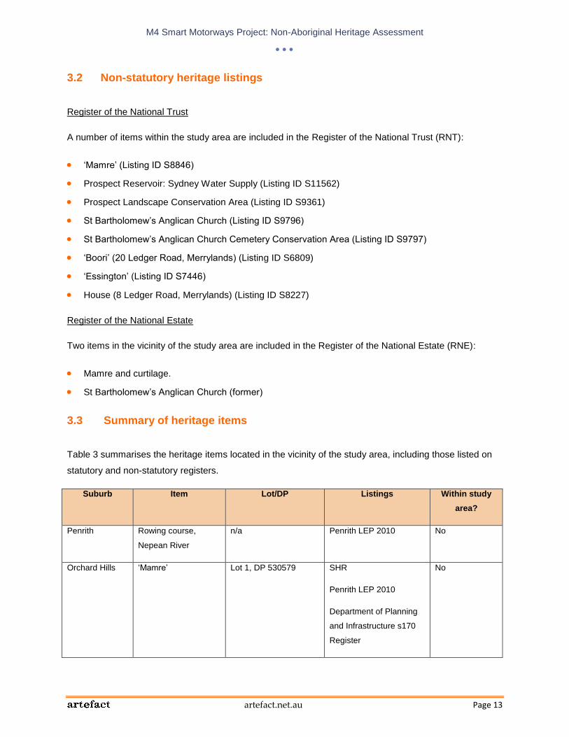
M4 Smart Motorways Project: Non-Aboriginal Heritage Assessment
artefact.net.au Page 13
3.2 Non-statutory heritage listings
Register of the National Trust
A number of items within the study area are included in the Register of the National Trust (RNT):
‘Mamre’ (Listing ID S8846)
Prospect Reservoir: Sydney Water Supply (Listing ID S11562)
Prospect Landscape Conservation Area (Listing ID S9361)
St Bartholomew’s Anglican Church (Listing ID S9796)
St Bartholomew’s Anglican Church Cemetery Conservation Area (Listing ID S9797)
‘Boori’ (20 Ledger Road, Merrylands) (Listing ID S6809)
‘Essington’ (Listing ID S7446)
House (8 Ledger Road, Merrylands) (Listing ID S8227)
Register of the National Estate
Two items in the vicinity of the study area are included in the Register of the National Estate (RNE):
Mamre and curtilage.
St Bartholomew’s Anglican Church (former)
3.3 Summary of heritage items
Table 3 summarises the heritage items located in the vicinity of the study area, including those listed on
statutory and non-statutory registers.
Suburb Item Lot/DP Listings Within study
area?
Penrith Rowing course,
Nepean River
n/a Penrith LEP 2010 No
Orchard Hills ‘Mamre’ Lot 1, DP 530579 SHR
Penrith LEP 2010
Department of Planning
and Infrastructure s170
Register
No

M4 Smart Motorways Project: Non-Aboriginal Heritage Assessment
artefact.net.au Page 14
Suburb Item Lot/DP Listings Within study
area?
RNE
RNT
Prospect Church & cemetery –
St Bartholomew’s
Lots 221 224, DP
812455 and Lot 1, DP
325874
SHR
Blacktown LEP
1988/Draft LEP 2013
RNE
RNT
Yes
Prospect Old Post Office
Cottage
Lot 140, DP 1003460 SHR
Blacktown LEP
1988/Draft LEP 2013
Department of Planning
and Infrastructure s170
Register
No
Prospect House – Bridestowe Lot C, DP 374323 Blacktown LEP
1988/Draft LEP 2013
No
Prospect Hicks Dairy Part Lot 19, DP 802753 Blacktown Draft LEP
2013
No
Prospect Prospect Reservoir
and surrounding area
Lot 7 DP 1015294
Part Lot 1 DP
1062094
Lot 2 DP 1062094
Lot 304 DP 1122291
Lot 2 DP 218194
Part Lot 1 DP 270644
Part Lot 18 DP
270644
Part Lot 8 DP 270644
Lot 1 DP 832281
Lot 2 DP 832281
Lot 4 DP 832281
SHR
Sydney Water s170
Register
RNT

M4 Smart Motorways Project: Non-Aboriginal Heritage Assessment
artefact.net.au Page 15
Suburb Item Lot/DP Listings Within study
area?
Lot 1 DP 845354
Lot 5 DP 861815
Prospect Prospect Landscape
Conservation Area
Reservoir Road (Part
Of Cumberland Plain
Remnant Communities
Landscape
Conservation Area)
RNT Unknown (RNT
listing does not
provide a
specific
curtilage)
Wentworthville “Essington”, late
Victorian/Federation
residence, garden
setting and trees
Lot 57B, DP 357142,
Lot 58 DP 33085 and
Lot 1 DP 34635
SHR
Holroyd LEP 2013
RNT
No
South
Wentworthville
“The Wattles”,
Victorian/Georgian
residence
Lot 100 DP 878926 Holroyd LEP 2013 Yes
Greystanes Milestone group,
Parramatta to
Greystanes (one
milestone is located
within study area and
one immediately
outside it)
n/a Holroyd LEP 2013 Yes (one of the
milestones in
the group)
Granville Parramatta West
Public School, c.
1887
Lot 407, DP 729082
and Lot 2, DP 1113697
Holroyd LEP 2013 No
Mays Hill Former Headmaster’s
House – Parramatta
West Public School
Lot 1 DP 1113697 Holroyd LEP 2013 No
Merrylands “Boori”, Victorian
Italianate residence
and grounds
Lot 10 DP 712035 Holroyd LEP 2013
RNT
No
Parramatta “Carrington”, Victorian
Italianate residence
and grounds
Lot 1 DP 613256 Holroyd LEP 2013
RNT
No
Table 3: Summary of heritage items in the vicinity of the study area

M4 Smart Motorways Project: Non-Aboriginal Heritage Assessment
artefact.net.au Page 16
Figure 2: Section one of the study area (Penrith)

M4 Smart Motorways Project: Non-Aboriginal Heritage Assessment
artefact.net.au Page 17
Figure 3: Section two of the study area (The Northern Road)

M4 Smart Motorways Project: Non-Aboriginal Heritage Assessment
artefact.net.au Page 18
Figure 4: Section three of the study area (Mamre Road).

M4 Smart Motorways Project: Non-Aboriginal Heritage Assessment
artefact.net.au Page 19
Figure 5: Section four of the study area (Roper Road)

M4 Smart Motorways Project: Non-Aboriginal Heritage Assessment
artefact.net.au Page 20
Figure 6: Section five of the study area (M7 INterchange)

M4 Smart Motorways Project: Non-Aboriginal Heritage Assessment
artefact.net.au Page 21
Figure 7: Section six of the study area (Rservoir Road and Prospect HIghway)
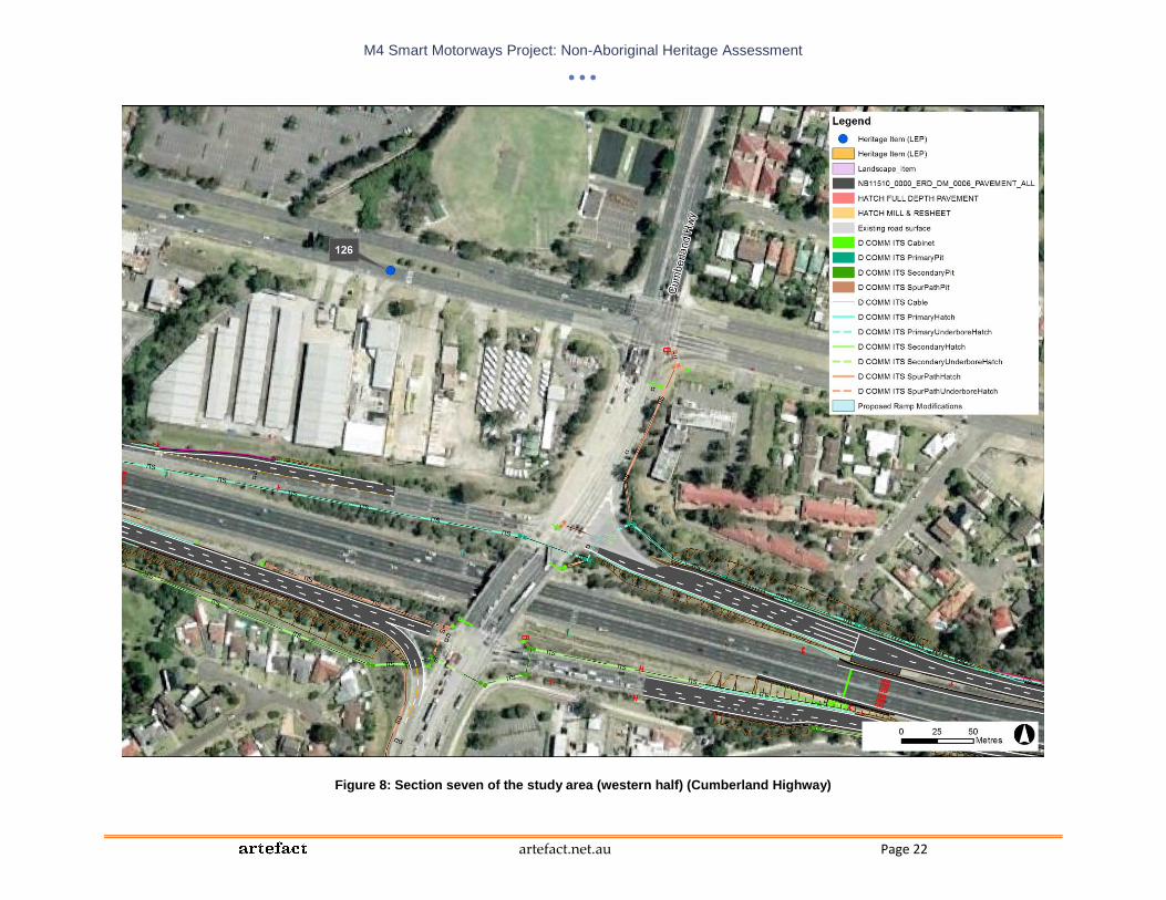
M4 Smart Motorways Project: Non-Aboriginal Heritage Assessment
artefact.net.au Page 22
Figure 8: Section seven of the study area (western half) (Cumberland Highway)
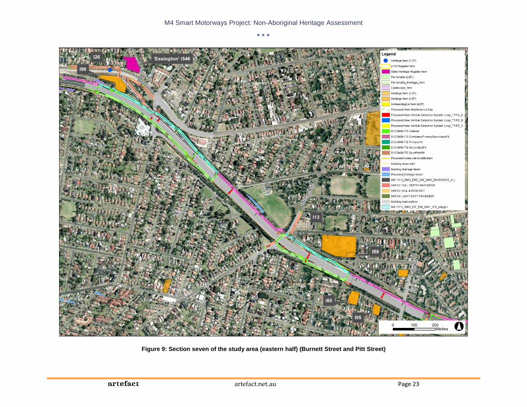
M4 Smart Motorways Project: Non-Aboriginal Heritage Assessment
artefact.net.au Page 23
Figure 9: Section seven of the study area (eastern half) (Burnett Street and Pitt Street)

M4 Smart Motorways Project: Non-Aboriginal Heritage Assessment
artefact.net.au Page 24
4.0 Historical context
4.1 Early European settlement
Exploration to the west of Sydney Cove began soon after first settlement, as it was found that the
sandstone soils of coastal Sydney were unsuited to cultivation and it was necessary to find more fertile
land.
In 1788, a government farm was established on the banks of the Parramatta River at Parramatta (initially
named Rose Hill). A government house was built near the farm, which prompted the development of the
town of Parramatta, which was laid out in 1790. Initially the river was the main form of transport to and
from Parramatta, but an overland track between Parramatta and Sydney was cleared through the bush
between 1789 and 1791. This track formed the basis for ‘the road to Parramatta’, which was laid out in
1797. By the early 19th century, Parramatta Road was a major thoroughfare for the colony (Wotherspoon
2010a, 2010b).
A track leading west from Parramatta to the Nepean River was also developed during 1788 and 1789. In
1815, William Cox led the construction of the Great Western Road from the Nepean River through the
Blue Mountains, with a ferry crossing of the river at Emu Plains. In December 1817, Cox also completed
the construction of the section of the Great Western Road between Emu Plains and Parramatta, which
was named the Great Western Highway in 1928.
During the early 19th century, scattered rural settlement developed at other locations along the route of
the present-day M4. Small land grants were made to former convicts in areas with better soils, such as at
Prospect and along creeks and rivers, in order to establish steady food supplies for the colony. These
small farms initially cultivated grain and other crops. Larger grants further from the rivers and creeks were
made to prominent and wealthy individuals such as military officers, officials and merchants, who used
some of their land for farming but most for grazing (Kass 2005:18). Small villages began to develop along
the main roads, including Parramatta Road and the Great Western Road.
Parramatta
Following that laying out of the town in 1790, Parramatta developed into a major centre and small farming
settlements were established in several nearby areas at Prospect Hill, The Ponds and the Northern
Boundary (North Parramatta) in 1791 and 1792 (Kass et al 1996:36).
During the late 19th and early 20th centuries a number of land grants were made in the area of
Parramatta through which the M4 now passes. The earliest of these were grants made in 1793 to John
Macarthur (Elizabeth Farm, Rosehill) and John Harris (Experiment Farm, Harris Park). Macarthur and

M4 Smart Motorways Project: Non-Aboriginal Heritage Assessment
artefact.net.au Page 25
Harris both built houses on their properties, which were actively farmed. In 1806 a large grant was made
to a merchant, Garnham Blaxcell, to the south of Parramatta Road, between Woodville Road and Clyde
Street. Blaxcell did not reside on or farm his land, but used it as collateral for his commercial enterprises.
When Blaxcell’s finances began to fail he mortgaged the property to Sir John Jamieson, who took up
ownership when Blaxcell fled the colony in 1817 (Dictionary of Sydney entries for ‘Rosehill’, ‘Granville’
and ‘Harris Park’).
Holroyd
Within the Holroyd LGA, the M4 passes through the suburbs of Westmead, Wentworthville and
Greystanes.
The area that is now Westmead was first cleared in 1791 and was originally part of the Parramatta
Government Farm. Small land grants were made in the area over the next decade, but these were
resumed in 1810 to form part of the Government Domain.
The suburb of Wentworthville is named after D’Arcy Wentworth, who was a surgeon on a convict ship in
the Second Fleet. Wentworth received a grant of land in 1810, to which he added further land in the
following years, acquired a total of 2,750 acres.
The suburb of Greystanes is named after a historical home located on Prospect Hill, which was built c.
1840 by Nelson Lawson, the third child of Lieutenant William Lawson. The house was demolished on
1946. The land on which Greystanes was located was originally granted to Lieutenant William Cummings
in 1799, before being acquired by William Lawson in approximately 1810. It was from this land that
William Lawson, Gregory Blaxland and William Charles Wentworth set out on their successful crossing of
the Blue Mountains in 1813 and discovered the Bathurst Plains. The Lawson family crypt still exists at St.
Bartholomew’s Church, Prospect (Holroyd Council website http://www.holroyd.nsw.gov.au/your-
city/city/history/suburb/).
Blacktown
Within the Blacktown LGA, the M4 passes through the area of Prospect. Governor Phillip chose the site
of Prospect Hill for a number of relatively small land grants in 1791 and 1792. The site of Prospect
Reservoir was later included within the largest grants in the area, which were made to William Lawson
(500 acres) and John Barbyn (1200 acres). William Lawson had a residence named Veteran Hall built on
his grant during the early 19th century (demolished in 1929).
The settlement at Prospect Hill had a varied success, with only six of the original 20 settlers remaining in
the area by 1798. By the 1820s, most of the land subject to the 1790s Grants had been cleared for
agricultural purposes. This land was used for cereal cultivation for the next 50 years. By 1828 around 350
residents lived in the Prospect Hill area. However, with the collapse of cereal grain production across the
Cumberland Plain in the 1860s, farming moved to the rearing of livestock in the 1870s. Most of the small

M4 Smart Motorways Project: Non-Aboriginal Heritage Assessment
artefact.net.au Page 26
early farms and dwellings in the vicinity had been removed. The Prospect Reservoir site appears to have
been used for grazing and stock holding paddocks in the latter half of the 19th century. A number of
quarries were also operating in the wider area during this period (Sydney Water Corporation 2005:11-12).
The Lawson family extended their land holding in the second half of the 19th century, and by the early
1880s much of the land around Prospect Hill was included in large landholdings.
Penrith
In Penrith, the early settlement pattern was shaped by small land grants to former convicts and free
settlers who established small farms. A small number of larger estates were also established, mainly in
the Mulgoa Valley south of Penrith and along South Creek to the east of Penrith.
In the mid-19th century, the town of Penrith was beginning to develop and St Mary’s was also evolving into
a small economic centre. However, the population of the district remained low (Fox & Associates 1987).
4.2 The arrival of the railway and subsequent development
The arrival of the railway in the 1850s prompted more rapid subdivision and development in areas along
the route of the railway line. Between Strathfield and Parramatta, the rail line roughly followed a similar
route to Parramatta Road and encouraged increased development in the area around the road and
railway line; while to the west of Parramatta the railway line was located up three kilometres to the north
of the Great Western Road and stimulated the development of town centres to the north of the main road.
The Sydney to Parramatta railway was completed in 1855, with stations built at various locations along
the line in the following years.
Parramatta
The Sydney to Parramatta railway initially terminated on Dog Trap Road (now Woodville Road) at a
station named Parramatta Junction, before the railway was extended into Parramatta proper in 1860. The
arrival of the railway encouraged subdivision and industrial development in the area around the present-
day M4. In the 1860s the Jamieson estate began to be subdivided, while Harris Park was subdivided from
1870. In 1880, Elizabeth Farm was sold to Septimus A Stephen, who subdivided it under the name
‘Rosehill’.
In 1880, the name Granville was given to the area known as Parramatta Junction. Five years later, the
Municipality of Granville was formed and included all or part of the present-day suburbs of Granville,
South Granville, Rosehill, Camellia, Clyde, Harris Park and Guildford (from 1906). The municipality was
subsumed in the enlarged City of Parramatta in 1949.
Granville grew quickly in the late 19th century as its road, water and rail access encouraged industrial
expansion. Industries in the area included Hudson Brothers (later Clyde Engineering) who manufactured

M4 Smart Motorways Project: Non-Aboriginal Heritage Assessment
artefact.net.au Page 27
railway rolling stock, a flour mill and a factory producing agricultural machinery. Developments in motor
transport during the 1920s attracted more manufacturers to Granville, particularly the areas covered by
the present-day suburbs of Camellia, Rosehill, Granville and Clyde. This resulted in an increased demand
for housing, and between 1921 and 1933 the number of ‘occupied dwellings’ in the municipality increased
by 54 per cent.
Following WWII, the Housing Commission built housing estates in the area to accommodate the rapid
population growth resulting from the baby boom and immigration (Dictionary of Sydney entry for
‘Granville’).
Holroyd
The railway line between Parramatta Junction and Penrith was constructed between 1860 and 1863.
Part of the Government Domain in the Parramatta area was subdivided between 1859 and 1889 and
orchards were established on many of the subdivided allotments. The railway was constructed through
Westmead in 1861, but a station was not built at the suburb until 1883. The presence of the railway would
have made the area more desirable for orchardists and other farmers, by making it much easier to
transport produce to markets in Sydney
A railway station was opened at Wentworthville in 1883 and was named Wentworthville in 1885. The
construction of the station prompted the subdivision of the Wentworth Estate.
Blacktown
The railway line was located around 35 kilometres to the north of Prospect and therefore did not
encourage an immediate increase in development. Instead the development of the Prospect area in the
early 20th century was shaped by quarrying industries and the creation of Prospect Reservoir.
Prospect Reservoir was constructed in the late-19th century as part of the Upper Nepean Scheme to
supply water from the Nepean River and its tributaries.
Modern quarrying is considered to have begun in the area in 1901, when the Emu and Prospect Gravel
and Road Metal Company acquired a large portion of land to the east of the Reservoir site. Quarrying
expansion continued further to the creation of the Prospect Reservoir, however many large estates,
including Greystanes, also survived for some time. Greystanes was transferred in whole to the NSW Blue
Metal Quarries in 1940. Part of the Prospect Hill area to the east of the Reservoir was owned by major
quarrying companies until 1947, when it was acquired by the Commonwealth for the CSIRO. It seems
that grazing was carried out continuously in the area until the CSIRO occupancy. The United States
established a Military Camp at Prospect Hill in the closing years of WWII, apparently along the east of the
Reservoir site boundary.

M4 Smart Motorways Project: Non-Aboriginal Heritage Assessment
artefact.net.au Page 28
Penrith
The railway arrived at Penrith in 1863, however, although this led to Penrith becoming a major railway
service centre, it did not act as the catalyst for rapid change throughout the district. It was not until the
1880s that the majority of the rural estates in the district began to be subdivided.
Rapid urban growth and expansion did not occur until after WWII, when increased demand for housing
and the introduction of planning schemes for the district saw many localities within the Penrith area
become suburbanised (Fox & Associates 1987).
4.3 The construction of the M4
Following WWII there was a huge increase in motor traffic, which led to increasing congestion along
Parramatta Road. Planning for a Western Expressway began in 1947 and a corridor for the road was
reserved in 1951.
The first section of the M4 was located between Prospect and Penrith and was completed by the
Department of Main Roads in the early 1970s. During the 1980s, the second section between Concord
and Parramatta was constructed in various stages. Until 1992, there was a ‘missing link’ between the two
sections.
In 1989, Statewide Roads Limited (SWR) won the right to finance, build and maintain the motorway, and
by 1992 they had constructed the 10 kilometre long ‘missing link’ as well as widening and upgrading the 6
kilometre section between Homebush Bay Drive and James Ruse Drive.
Between 1996 and 1998, the motorway was upgraded and widened between Parramatta and Penrith.

M4 Smart Motorways Project: Non-Aboriginal Heritage Assessment
artefact.net.au Page 29
5.0 Heritage listed items
5.1 Rowing course, Nepean River
5.1.1 History and description
Rowing races have been held on the Nepean River at Penrith since the 1850s and in 1888 the Penrith
Rowing Club and Nepean Rowing Club were founded. These clubs declined over the following years, and
were replaced by the current Nepean Rowing Club in 1928. The club purchased two blocks of land
fronting the river and built a boatshed and club house.
Between 1936 and 2000, the annual General Public Schools Regatta was held on the Nepean River,
before it was replaced by the Sydney International Regatta Centre at Penrith Lakes at the time of the
Sydney Olympic Games. In 1938, the river was the rowing venue for the Empire Games (predecessor to
the Commonwealth Games) (Godden Mackay Logan 2011:37-38).
The heritage curtilage for the rowing course encompasses the entire section of the Nepean River
between Victoria Bridge in the north and the bridge carrying the M4 western motorway to the south.
5.1.2 Heritage significance
The rowing course is of historical and social significance as a sporting venue established early in
Penrith’s history, which gained international recognition. It demonstrates the role of the river as a place for
organised water sports, since the late 19th century. However, the Penrith Heritage Study (Paul Davies
Pty Ltd 2007: Vol 3 p. 89) recommended that the item should be removed from the LEP heritage list as
the various sites of former activity are now difficult to discern.
5.1.3 Statement of heritage impact
Although the study area does overlap the Nepean River slightly on either side of the M4 bridge (Figure
10), no impacts are proposed within the curtilage of the rowing course. The proposal includes the addition
of CCTV and a VMS on the western side of the river, however, these would have no impact on the views,
setting, or heritage significance of the rowing course.

M4 Smart Motorways Project: Non-Aboriginal Heritage Assessment
artefact.net.au Page 30
Figure 10: Rowing course, Nepean River in relation to the proposal
5.1.4 Mitigation measures
No mitigation measures are required.
5.1.5 Summary
Table 4 summarises the significance of the item, the potential impacts of the proposal, recommendations,
and necessary actions.
Rowing course, Nepean River
Significance Physical impacts Visual impacts Recommendations Action
Local None None n/a
n/a
Table 4: Summary table for Rowing course, Nepean River

M4 Smart Motorways Project: Non-Aboriginal Heritage Assessment
artefact.net.au Page 31
5.2 ‘Mamre’ (Mamre Road intersection)
5.2.1 History and description
In 1798, the Reverend Samuel Marsden purchased 38 acres on South Creek, followed by another 200
acres the following year. He named the property Mamre and primarily produced wool there, including the
first “weavable” wool to be sent to England from the colony in 1807.
The homestead was built between 1822 and 1832, with the house intended to provide basic
accommodation for farm overseers, rather than a permanent residence. Following Samuel Marsden’s
death in 1838, the house was used as a permanent residence by his son, Charles.
In 1840, the property was sold to Richard Rouse, a prominent public servant and grazier who lived at
Rouse Hill estate. In 1841, Rouse gave the property to his daughter, Elizabeth Henrietta Rouse, as a
wedding present. The property remained in the ownership of Elizabeth’s descendants for over a century.
In 1975, the farm was purchased by the (then) NSW Planning and Environment Commission. In 1984 the
NSW Department of Planning made the property available to the Sisters of Mercy for use as a training
centre for the unemployed and a function centre.
The property is largely intact and preserves a historical rural landscape that is largely intact. The
homestead is a stow-storey brick building in the Colonial Georgian style, and is located 250 metres west
of Mamre Road and around 570 metres south-west of the base of the ramp that carries Mamre Road over
the M4. Some early farm outbuildings and remnant plantings remains around the house, as well as a
number of modern brick buildings (SHR entry for ‘Mamre’).
5.2.2 Heritage significance
The statement of significance included in the SHR entry for Mamre is as follows:
“Mamre is significant for its potential to yield information on the pre-contact Aboriginal
occupation of the South Creek catchment. Mamre is historically and socially significant as an
important site in post-contact Aboriginal history, demonstrating Aboriginal survival and
adaptation to non-traditional social, economic and political practices. Mamre is historically
significant for its association with the early sheep breeding experiments of the Reverend
Samuel Marsden, which contributed to the early development of the wool industry in NSW
(and Australia). Mamre has historic and aesthetic significance as a rare, regional example of
a fairly intact pre-1860 colonial landscape and homestead on the Cumberland Plain. The
farmstead is archaeologically significant for its potential to yield information on early colonial
farm landscapes, farmsteads and Georgian architecture. The Mamre farmhouse is an iconic
feature in the St. Mary's region and immediate landscape. Mamre has a strong association

M4 Smart Motorways Project: Non-Aboriginal Heritage Assessment
artefact.net.au Page 32
with the early owners of the property, the Reverend Samuel Marsden and Richard Rouse,
both influential early colonists. Samuel Marsden is an important figure in the early missionary
history of New Zealand, with strong ties to settlement and missionary activities in Kerikeri
and the Northland district in particular. The property has strong, continuing association with
the Sisters of Mercy, Parramatta and the MAMRE PROJECT which has great regional social
importance. The South Creek corridor is significant for its preservation of endangered
ecological communities. It has potential to yield valuable information about the river-flat
forests, wetlands and riparian habitats which are among the most threatened natural
landscapes in Western Sydney. Mamre is recognised as a property of State significance, as
a substantial Georgian homestead, and the former residence of the Rev. Samuel Marsden
during the 1820s and 1830s. It was later the residence of Richard, then Henrietta Rouse and
the Hon. Robert Fitzgerald, MLC, from the 1840s. The building is an important example of an
early 19th century homestead in the Colonial Georgian style.”
5.2.3 Statement of heritage impact
The following modifications are proposed in the vicinity of Mamre:
Widening lengthening and realigning the existing 1 lane entry ramps including;
o Eastbound entry ramp to provide 882 metres of storage, 3 lanes at the stop line and
lengthening downstream of the stop line to provide safe merging onto the M4 Motorway.
o Westbound entry ramp to provide 772 metres of storage, 3 lanes at the stop line and
lengthening downstream of the stop line to provide safe merging onto the M4 Motorway.
Widening of the eastbound exit ramp.
Installation of traffic signals, VMS, VSLS, CCTV, vehicle detection services, fixed signage on the
entry ramps.
Installation of VMS, vehicle detection devices, fixed signage on the arterial road.
Cabling to provide power and communications.
All of the proposed modifications are located over 500 metres from the homestead complex itself, and at
least 60 metres from the LEP/s170 Register curtilage of the item (Figure 11). Views from Mamre
homestead toward the M4 are screened to the north by a thick band of vegetation to the south of the M4
corridor (between 50 and 110 metres wide). Views toward the proposed location of the VMS on Mamre
Road are also screened by eucalypts within the property and the road reserve (Figure 12 to Figure 14).
There would be no physical impacts or visual impacts to the item.

M4 Smart Motorways Project: Non-Aboriginal Heritage Assessment
artefact.net.au Page 33
Figure 11: Mamre heritage curtilages in relation to the proposal.

M4 Smart Motorways Project: Non-Aboriginal Heritage Assessment
artefact.net.au Page 34
Figure 12: View from near the proposed location of the VMS toward Mamre Homestead (obscured by trees) (© Google Maps).
Figure 13: View from beside Mamre Road approach to M4 toward Mamre house.
Figure 14: Trees that screen views from Mamre toward the M4.
5.2.4 Mitigation measures
No mitigation measures are required.

M4 Smart Motorways Project: Non-Aboriginal Heritage Assessment
artefact.net.au Page 35
5.2.5 Summary
Table 5 summarises the significance of the item, the potential impacts of the proposal, recommendations,
and necessary actions.
Mamre
Significance Physical impacts Visual impacts Recommendations Action
State None None n/a n/a
Table 5: Summary table for Mamre
5.3 St Bartholomew’s Church and Cemetery (Prospect Highway intersection)
5.3.1 History and description
Tenders for the construction of St Bartholomew’s church were called in August 1838 and the contract was
won by James Atkinson of Mulgoa, who was building three other churches at the same time (at
Richmond, St Mary’s and Mulgoa). The church was funded partly by the Colonial Treasury and partly by
money collected through private subscription.
The church and cemetery were consecrated in 1841. By 1891 over 360 burials had been recorded and
from the turn of the century until 1941 there was a notable increase in the annual number of burials,
reflecting the rising population of the district. Burials in the cemetery are now only permitted in previously
purchased plots (which stopped being sold in 1992) and in existing graves where there is space.
The church is no longer used for services, with the last service held on Christmas Eve in 1967. In 1967 a
group of local residents who wanted to preserve the church formed The Prospect Trust. In 1975,
Blacktown Municipal Council obtained a 50 year lease over most of the property and in 1978 the National
Estate Funds provided $20 000 for the restoration of the church. In 1982, a Permanent Conservation
Order was placed on the site and between 2000 and 2001 the church was completely restored, following
damage by a fire in 1989.
The church and cemetery are located on a hill overlooking the M4 (Figure 15), with the property bounded
by Ponds Road to the north and the Prospect Highway to the west. A strip of land around 50 metres wide
separates the property from the ramp between the Prospect Highway and the M4. Two large transmission
towers are located within this strip of land (SHR entry for ‘St Bartholomew’s Anglican Church and
Cemetery’).

M4 Smart Motorways Project: Non-Aboriginal Heritage Assessment
artefact.net.au Page 36
5.3.2 Heritage significance
The statement of significance included in the SHR entry for St Bartholomew’s Anglican Church and
Cemetery is as follows:
“The St Bartholomew's site is closely linked with the development and history of the
surrounding area and contains the graves of a considerable number of prominent families
from the area since the 1840s. The church is unusually styled for its period and the
graveyard is one of the earliest in western Sydney. St. Bartholomew's remains a dominant
landmark in the surrounding landscape due to its prominent siting, striking design and
mature tree plantings.”
Figure 15: St Bartholomew’s Church
5.3.3 Statement of heritage impact
No physical impacts would occur within the curtilage of the heritage item (Figure 16). The following
changes are proposed in the vicinity of the item:
Widening, lengthening and realigning the existing 2 lane entry ramps as follows;
o Eastbound entre ramp to provide 763 metres of storage, 3 lanes at the stop line, and
lengthening downstream of the stop line to provide safe merging onto the M4 Motorway.
o Westbound entry ramp to provide 663 metres of storage, 3 lanes at the stop line, a freight
bypass lane and lengthening downstream of the stop line to provide safe merging onto
the M4 Motorway.
Addition works on the entry ramp would include the installation of traffic signals, VMS, VSLS, CCTV,
vehicle detection devices, fixed signage.

M4 Smart Motorways Project: Non-Aboriginal Heritage Assessment
artefact.net.au Page 37
The arterial road would require the installation of VMS, vehicle detection devices, fixed signage.
Cabling to provide power and communications.
Potential compound site to the south.
Some views toward the on-ramp to the south of the item are available from the cemetery (Figure 17).
However, the addition of the proposed new lane and maintenance bay would make only a minimal
difference to the existing views and would not have a significant impact on the views or setting of the
item.
The proposed VSLS on the on ramp would be located to the south of a band of trees, which would
effectively screen views toward the sign from the church and cemetery.
The potential compound site would be located to the south of the heritage item. Any visual impacts
associated with this compound site would be temporary, and there are limited views from the heritage
item towards the compound site.
Figure 16: St Bartholomew’s Church and Cemetery in relation to the proposal
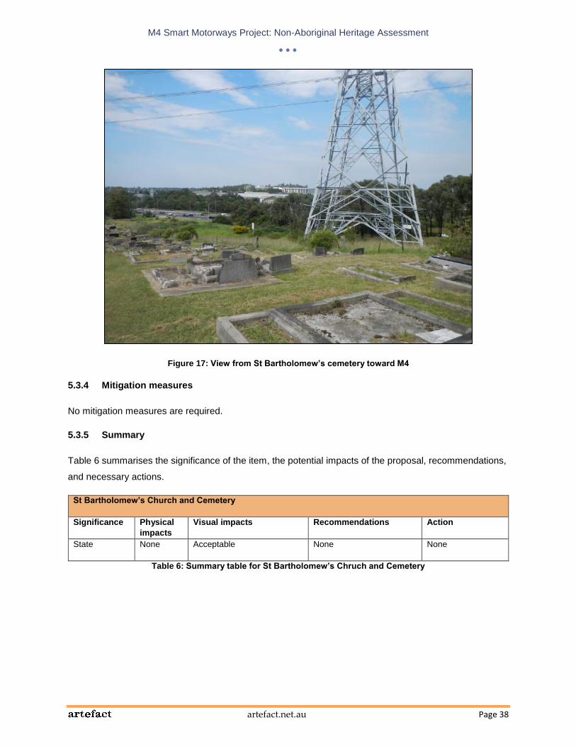
M4 Smart Motorways Project: Non-Aboriginal Heritage Assessment
artefact.net.au Page 38
Figure 17: View from St Bartholomew’s cemetery toward M4
5.3.4 Mitigation measures
No mitigation measures are required.
5.3.5 Summary
Table 6 summarises the significance of the item, the potential impacts of the proposal, recommendations,
and necessary actions.
St Bartholomew’s Church and Cemetery
Significance Physical
impacts
Visual impacts Recommendations Action
State None Acceptable None
None
Table 6: Summary table for St Bartholomew’s Chruch and Cemetery

M4 Smart Motorways Project: Non-Aboriginal Heritage Assessment
artefact.net.au Page 39
5.4 Former Prospect Post Office (Prospect Highway intersection)
5.4.1 History and description
The Prospect Post Office (Figure 18) is thought to have operated on the site from as early as 1871, in an
earlier timber building. The present building was constructed between 1880 and 1890 and includes two
sections – one that was the residence of the post office keepers, and one that was the post office and
general store,
The post office and general store were run by James Watts until his death in 1898, after which they were
operated by his wife, Mary Ann until her death in 1909. A local builder George Henry then took over the
business and lived in the residence with his wife and their four children. Henry also constructed a
butcher’s shop in a separate timber building to the south of the house and a number of other structures.
The post office formed the nucleus for the development of the small village of Prospect, which reached its
peak in around 1923.
The Prospect Post Office is believed to have operated from as early as 1871, in an earlier timber
structure on the site. The present building was constructed between 1880 and 1890 and was clearly a
more substantial structure with its separate shop and post office area, reflecting the growing prosperity of
the Watts family. Watts' store and post office became the focus of the small village of Prospect that slowly
developed with the gradual sub-division of Kennedy's 1799 grant. James Watt operated the general store
and post office until his death in 1898 and was succeeded by his wife, Mary Ann who continued operating
the business until her death in 1909 at which time a local builder, George Henry, took over the business
and occupied the house with his wife and their 4 children. Shortly after he assumed control of the
business, George added a butcher's shop housed in a separate timber structure to the south of the
house. A number of other associated structures were also constructed around this time. The village of
Prospect reached its peak of development around 1923.
The property was occupied by George Henry’s widow, Grace, from 1925 until her death in 1944. During
this time her daughters ran the post office and shop. Following Grace’s death, the building was sold to
Archibald White, who continued to run the store but did not keep up the operation of the post office.
In 1976, the property was purchased by the NSW Planning and Environment Commission as part of an
open space corridor provision (SHR entry for ‘Prospect Post Office (former)’).
The property is triangular and fronts Tarlington Place. It includes the former shop, residence and post
office as well as a garage and lean to, stables and foundations of various structures that have been
removed. The house is located around 46 metres north of the M4 road corridor.

M4 Smart Motorways Project: Non-Aboriginal Heritage Assessment
artefact.net.au Page 40
Figure 18: Former Prospect Post Office
5.4.2 Heritage significance
The statement of significance included in the SHR listing for the item is as follows:
“The former Prospect Post Office is of high local significance as the last surviving building of
the former Prospect Village and as the site of the Post Office for over 100 years. It has
social, historical, aesthetic and scientific value related to its function, its occupants and its
role in the development of the district. The building and site have State significance related
to the themes of early development of the Sydney region, commercial development and
service. It is a representative building typifying small village development from the last
century and retains elements of its setting and relationship to the former Western Road.”
5.4.3 Statement of heritage impact
Although the study area boundary runs along the southern side of the item’s curtilage (Figure 19), no
impacts are proposed within the curtilage of the item. A new pavement on ramp is proposed to the south
of the item, however, the item is elevated above the M4 and views toward the proposed changes would
be screened by the slope and by trees within the M4 corridor. The proposal would have no impact on the
Former Prospect Post Office.
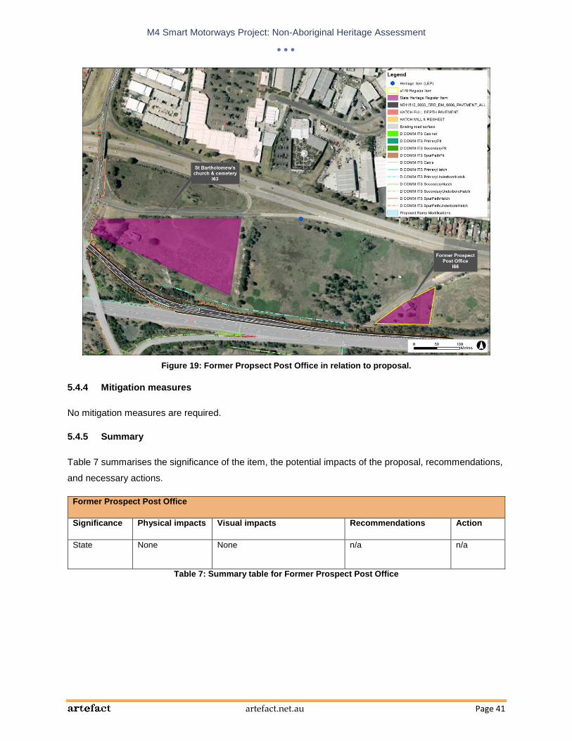
M4 Smart Motorways Project: Non-Aboriginal Heritage Assessment
artefact.net.au Page 41
Figure 19: Former Propsect Post Office in relation to proposal.
5.4.4 Mitigation measures
No mitigation measures are required.
5.4.5 Summary
Table 7 summarises the significance of the item, the potential impacts of the proposal, recommendations,
and necessary actions.
Former Prospect Post Office
Significance Physical impacts Visual impacts Recommendations Action
State None None n/a
n/a
Table 7: Summary table for Former Prospect Post Office

M4 Smart Motorways Project: Non-Aboriginal Heritage Assessment
artefact.net.au Page 42
5.5 ‘Bridestowe’ and Hicks’ Dairy (Prospect Highway and Reservoir Road intersection)
5.5.1 History and description
In 1884, William Edward Goodwin sold various parcels of land to the south of the Great Western Highway
to James Hicks, a farmer from Ryde. Hicks died in 1903 and left the property to his son, Joseph, who later
stated that the buildings on the land, which consisted of weatherboard buildings with iron roofs, had been
built about 1889 by his father. The property was known as ‘Bridestowe’ and was operated as a combined
dairy farm and orchard, while barley, oats and maize were also grown there.
When the Valuer-General valued this land in December 1922, there was a 6-roomed weatherboard
cottage with an iron roof named “Bridestowe” on the property, along with a dairy, hay shed, milking sheds
and a stable. An aerial photograph dating to 1930 shows Bridestowe at the front of the property with a
group of farm buildings to the rear. Some of these outbuildings were still visible in a 1943 aerial
photograph.
In 1942, the Hicks Brothers were still operating a dairy whilst living in the house at “Bridestowe”. The
brothers owned 188 acres and leased a further 170 acres of land owned by the Water Board and 99
acres from adjacent owners. They ran a total of 90 to 95 cows on the land (Draft Blacktown Heritage
Inventory 2009 entry for Hick’s Dairy).
The original house on the property is still standing and is known as ‘Bridestowe’. It is a single-storey late
Victorian weatherboard house fronting Reservoir Road, and is listed on the Blacktown LEP 1988 and
Draft LEP 2013. Some of the early dairy buildings still stand at the site, to the east of the house, and
these are listed as a heritage item named ‘Hicks’ Dairy’ on the Draft Blacktown LEP 2013.
5.5.2 Heritage significance
The statement of significance included in the State Heritage Inventory listing for ‘Bridestowe’ house is as
follows:
“An excellent example of residential development in the Victorian era in Prospect.”
The statement of significance included in the Draft Blacktown Heritage Inventory 2009 listing for ‘Hicks’
Dairy’ is as follows:
“A collection of farm buildings which is an excellent example of development of the Victorian
era in Prospect.”

M4 Smart Motorways Project: Non-Aboriginal Heritage Assessment
artefact.net.au Page 43
5.5.3 Statement of heritage impact
‘Bridestowe’ and Hicks’ Dairy are located over 70 metres from the study area and views between the
items and the study area are screened by vegetation (Figure 20). The proposal would have no impact on
the heritage significance of the items.
Figure 20: ‘Bridestowe’ (I 64) and Hicks’ Dairy (I 65) in relation to the proposal.
5.5.4 Mitigation measures
No mitigation measures are required.
5.1.5 Summary
Table 8 summarises the significance of the item, the potential impacts of the proposal, recommendations,
and necessary actions.
‘Bridestowe’ and Hicks’ Dairy
Significance Physical impacts Visual impacts Recommendations Action
Local None None n/a
n/a
Table 8: Summary table for ‘Bridestowe’ and Hicks’ Dairy

M4 Smart Motorways Project: Non-Aboriginal Heritage Assessment
artefact.net.au Page 44
5.6 Prospect Reservoir and surrounding area (Reservoir Road intersection)
5.6.1 History and description
Prospect Hill Reservoir was constructed as part of the original Upper Nepean Scheme, as proposed by
the 1867 Commission that recommended the scheme. This scheme was based on the provision of water
from the River Nepean and its tributaries Avon, Cataract and Cordeaux. The Upper Canal incorporated a
system of tunnels, canals and aqueducts that directed water towards Prospect Reservoir from where it
was taken via the Lower Canal to Pipehead Basin located near Guildford. The Upper Nepean Scheme
became partly effective in 1886 and was officially approved in 1888. Expansion resulted from the creation
of supplementary dams, including the Upper Nepean Dams between 1907 and 1935, Warragamba Dam
in 1960 and Tallowa Dam in 1977. Elements of the scheme, including Prospect Reservoir, major parts of
the Upper Canal and some of the mains laid in the 1880s are still in use today. The Lower Canal has
been decommissioned and is presently in use as a cycleway. Prospect Reservoir is used as a back-up
supply only (Sydney Water Corporation 2005:20-21).
The reservoir is a zoned earth embankment dam, 26 metres high and approximately 2.2 kilometres long.
The heritage listing encompasses the reservoir, landscape elements and all associated structures within
the property boundary, including examples of 1920s and 30s pumping stations, a residence, the
archaeological site of Veteran Hall and the 72 inch main, constructed between the Upper Canal and Pipe
Head in 1937. Later items associated with the Warragamba Supply Scheme and more modern
developments include several more recent pumping stations, screening and boosting plants on the
eastern and southern sides of the Reservoir, and the 84 inch water main from Prospect, to Pipe Head,
completed in 1958. The immediate catchment area of the reservoir is almost entirely vegetated. This
vegetation, cleared during settlement, has recovered to be one of the finest examples of the native
bushland left in the western suburbs of Sydney and is of natural heritage significance.
5.6.2 Heritage significance
The statement of significance included in the SHR listing for the item is as follows:
“Prospect Reservoir is historically significant at the state level as it is a central element of the
Sydney water supply system. As a part of the Upper Nepean Scheme, the Reservoir has
continued to supply water to Sydney for over 120 years, and generally still operates in the
same way as it was originally constructed. That it has continued to be used since its
construction reflects the inventive and progressive way in which the reservoir was designed
and built, and this contributes to its significance greatly. The Reservoir reflects three
significant changes in municipal life during the late 19th century; the development of water
and general public utility services; the importance of ensuring an adequate and dependable
centralised water supply; and the collective bureaucratic response to the delivery of capital

M4 Smart Motorways Project: Non-Aboriginal Heritage Assessment
artefact.net.au Page 45
works of this nature. Built between 1882 and 1888, it was an outstanding achievement in civil
engineering technology at the time, using innovative design and construction methods. It has
a high level of historical engineering significance. Prospect Reservoir is strongly associated
with the Harbours and Rivers Branch of the NSW Public Works Department, particularly
Edward Orpen Moriarty, Head of the branch at the time of the Reservoir's construction, and
later with the Board of Water Supply and Sewerage (later the Metropolitan Water and
Sewerage Board) and most recently, with the Sydney Catchment Authority. The Reservoir
area is aesthetically significant, as a picturesque site with a large expanse of water,
parklands, landscaping and bush. The place is valuable for its recreational amenity for
passive recreation, punctuating the monotony of the surrounding urban landscape. It has
been used for recreation by the community for generations. It continues to regulate the
release of water from Prospect Reservoir to the Lower Canal and the Sydney Distribution
system. The place also contains examples of functional colonial architecture. The listing
includes Prospect Reservoir, landscape elements and all associated structures, including
pumping stations, to the property boundary. The environs of the reservoir and hence this
listing also include a wide range of items, which relate to later amplification of water supply.
These include examples of 1920s and 30s pumping stations, a residence, and the 72" (1,800
mm) main, constructed between the Upper Canal and Pipe Head in 1937. Later items
associated with the Warragamba Supply Scheme and more modern developments include
several more recent pumping stations, screening and boosting plants on the eastern and
southern sides of the Reservoir, and the 84 inch (2,100 mm) water main from Prospect, to
Pipe Head, completed in 1958.”
5.6.3 Statement of heritage impact
The proposed changes in the vicinity of the Prospect Reservoir and surrounding area heritage item are
focused around Reservoir Road (Figure 21) and include:
Widening, lengthening and realigning the existing 1 lane entry ramps, including;
o Eastbound entry ramp to [provide 609 metres of storage, 3 lanes at the stop line an d
lengthening downstream of the stop line to provide safe merging onto the M4 Motorway.
o Westbound entry ramp to provide 728 metres of storage, 3 lanes at the stop line and
lengthening downstream of the stop line to provide safe merging onto the M4 Motorway.
Upgrading of the eastbound and westbound exit ramps through the installation of signalling, and any
civil works required.
Installation of traffic signals, VMS, VSLS, CCTV vehicle detection devices and fixed signage on the
proposed entry ramp.

M4 Smart Motorways Project: Non-Aboriginal Heritage Assessment
artefact.net.au Page 46
Installation of VMS, vehicle detection devices and fixed signage to the arterial road (Reservoir Road).
Cabling to provide power and communications.
The addition of a paved shoulder on the eastern side of Reservoir Road would not have a negative
impact on the setting of the remnant bushland preserved in the item. The proposed new VMS in the
western road reserve of the road would have a minor impact on views of the bushland along Reservoir
Road. However, the VMS would only be visible from a relatively small section of the road and would be
located beside a portion of the heritage item that is dominated by regrowth, rather than mature native
forest. The VMS would therefore have a minimal impact on the heritage significance of the item,
particularly as it is within the context of an existing road corridor, and this impact is considered to be
acceptable.
The proposed VSLS and ramp signalling on the on-ramp to the north of the item would not involve any
physical impacts to the item and would not affect its views and setting.
Potential compound sites may be located to the east and north of the heritage item. Any visual impacts
associated with the compound sites would be temporary, and would not impact on the views and setting
of the heritage item in the long term.
5.6.4 Mitigation measures
No mitigation measures are required.
5.6.5 Summary
Table 9 summarises the significance of the item, the potential impacts of the proposal, recommendations,
and necessary actions.
Prospect Reservoir and surrounding area
Significance Physical impacts Visual impacts Recommendations Action
State None Acceptable. n/a
n/a
Table 9: Summary table for Prospect Reservoir and surrounding area

M4 Smart Motorways Project: Non-Aboriginal Heritage Assessment
artefact.net.au Page 47
Figure 21: The Prospect Reservoir and surrounding area heritage item in relation to the proposal
5.7 ‘Essington’ (Burnett Street intersection)
5.7.1 History and description
Essington was built in the 1880s as the second residence of one of Holroyd’s prominent early settlers,
William Fullager. Fullagar was the son of convicts and was a butcher and public turned stock agent. In
1849, Fullagar purchased a 30 acre property to the south of Essington, where he built his first residence
‘The Wattles’ (still extant adjacent to Essington). From ‘The Wattles’ he continued to acquire land
throughout the area. It is believed that Essington was built as a gentleman’s villa in a prominent location
to reflect Fullagar’s wealth and importance.
Fullagar died in 1894 and the property subsequently passed through various hands. The Four Square
Gospel Church, Parramatta, purchased the property in 1980 and it is now used as a school.
Essington is a large two storey house (now run as a school), located on the north-western corner of
Bridge Road and the Great Western Highway. Its location on elevated land at the intersection of major
roads gives the building local prominence. The house is surrounded to the east and south by the school
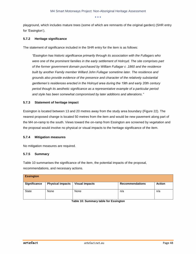
M4 Smart Motorways Project: Non-Aboriginal Heritage Assessment
artefact.net.au Page 48
playground, which includes mature trees (some of which are remnants of the original garden) (SHR entry
for ‘Essington’).
5.7.2 Heritage significance
The statement of significance included in the SHR entry for the item is as follows:
“Essington has historic significance primarily through its association with the Fullagars who
were one of the prominent families in the early settlement of Holroyd. The site comprises part
of the former government domain purchased by William Fullagar c .1860 and the residence
built by another Family member Willard John Fullagar sometime later. The residence and
grounds also provide evidence of the presence and character of the relatively substantial
gentlemen’s residences erected in the Holroyd area during the 19th and early 20th century
period though its aesthetic significance as a representative example of a particular period
and style has been somewhat compromised by later additions and alterations.”
5.7.3 Statement of heritage impact
Essington is located between 13 and 20 metres away from the study area boundary (Figure 22). The
nearest proposed change is located 50 metres from the item and would be new pavement along part of
the M4 on-ramp to the south. Views toward the on-ramp from Essington are screened by vegetation and
the proposal would involve no physical or visual impacts to the heritage significance of the item.
5.7.4 Mitigation measures
No mitigation measures are required.
5.7.5 Summary
Table 10 summarises the significance of the item, the potential impacts of the proposal,
recommendations, and necessary actions.
Essington
Significance Physical impacts Visual impacts Recommendations Action
State None None n/a
n/a
Table 10: Summary table for Essington

M4 Smart Motorways Project: Non-Aboriginal Heritage Assessment
artefact.net.au Page 49
Figure 22: Essington in relation to the study area
5.8 ‘The Wattles’ (Burnett Street intersection)
5.8.1 History and description
‘The Wattles’ was constructed c. 1851-1875 as the residence of William Fullagar, a prominent local
landholder who later had the adjacent building, Essington, built. ‘The Wattles’ was originally known as
Willow Cottage.
The house is a single-storey early Victorian residence in simple rectangular form with hipped-gable roof
containing attic rooms (Figure 23). The property is bounded by the Great Western Highway to the north,
the M4 corridor to the south, and the M4 ramp off the Great Western Highway to the east. This vegetation
screens views toward the house from the roads (Holroyd City Council Heritage Item Inventory Sheet for
‘The Wattles’).

M4 Smart Motorways Project: Non-Aboriginal Heritage Assessment
artefact.net.au Page 50
Figure 23: ‘The Wattles’ in 2002 (Holroyd City Council Heritage Item Inventory Sheet)
5.8.2 Heritage significance
The statement of significance included in the Holroyd City Council Heritage Item Inventory Sheet for ‘The
Wattles’ is as follows:
“Willow cottage [later The Wattles] has local historic significance primarily through its
associations with William Fullagar, one of Holroyd's prominent pioneer settlers and
developers. It is also possibly one of the oldest houses in Holroyd and a rare example in the
City of its particular (early Victorian) architectural style. The historic and aesthetic
significance of the residence has, however, been compromised to some degree by later
alterations and removal of original fabric.”
5.8.3 Statement of heritage impact
The addition of an eastbound entry ramp is proposed in the vicinity of ‘The Wattles.’ This work would
include the widening, lengthening and realignment of the eastbound entry ramp and arterial road
(Coleman Street) (Figure 24). Proposed works would also include the installation of traffic signal, VMS,
VSLS, CCTV, vehicle detection services and fixed signage on the entry ramp, and VMW, fixed signage
and vehicle detection devices on Coleman Street.

M4 Smart Motorways Project: Non-Aboriginal Heritage Assessment
artefact.net.au Page 51
The proposed section of new pavement would be located on the northern side of the ramp and would
begin adjacent to the north-eastern corner of ‘The Wattles’ curtilage. Views from ‘The Wattles’ toward the
on-ramp are screened by thick shrubbery (Figure 25) and the new pavement would have no impacts on
the views or setting of the item.
Views from the house toward the Great Western Highway are screened by vegetation around the house.
The setting of the property has already been severely impacted by upgrades to the Great Western
Highway and associate signage and traffic lights. The proposed addition of a new VMS on the far side of
the highway from the item would not have any further impact on the views or setting of the item.
Figure 24: ‘The Wattles’ in relation to the proposal.

M4 Smart Motorways Project: Non-Aboriginal Heritage Assessment
artefact.net.au Page 52
Figure 25: Thick shrubbery along eastern side of ‘The Wattles’ curtilage, between the house and the on-ramp.
5.8.4 Mitigation measures
No mitigation measures are required.
5.8.5 Summary
Table 11 summarises the significance of the item, the potential impacts of the proposal,
recommendations, and necessary actions.
‘The Wattles’
Significance Physical impacts Visual impacts Recommendations Action
Local None None n/a n/a
Table 11: Summary table for ‘The Wattles’

M4 Smart Motorways Project: Non-Aboriginal Heritage Assessment
artefact.net.au Page 53
5.9 Milestones between Parramatta and Greystanes (Cumberland Highway intersection and Burnett Street intersection)
5.9.1 History and description
Between 1810 and 1825, milestones were erected along the Great Western Highway under instruction
from Governor Macquarie. There are sixteen sandstone milestones located along the southern side of the
Great Western Highway from Parramatta to Penrith, and two of these are located in the vicinity of the
study area (Holroyd City Council Heritage Item Inventory Sheet for the ‘Parramatta to Greystanes
Milestones’).
One of the milestones is located within the study are on the south-west corner of the intersection of the
Great Western Highway and the M4 ramp, around 108 metres west of Bridge Road, Westmead. The
other is located outside the study area, around 60 metres west of the Cumberland Highway.
5.9.2 Heritage significance
The statement of significance included in the Holroyd City Council Heritage Item Inventory Sheet for the
‘Parramatta to Greystanes Milestones’ is as follows:
“One of five milestones recorded within the borders of Holroyd which line the road between
Parramatta and Penrith. This road was originally surveyed and constructed under Governor
Macquarie.”
5.9.3 Statement of heritage impact
The milestone within the study area to the west of Bridge Road would not be physically or visually
impacted by the proposed development (Figure 26). Although the milestone is located within the study
area, no modifications are proposed in the vicinity of the item.
The milestone to the west of the Cumberland Highway is located around 20 metres south of the study
area (Figure 27). A new VMS is proposed to be located about 35 metres north-east of the milestone,
within the island between the two sides of the Great Western Highway. The setting of the milestone has
already been significantly impacted by surrounding development and upgrades to the Great Western
Highway. Therefore the addition of the proposed VMS would not have a negative impact on the heritage
significance of the item.
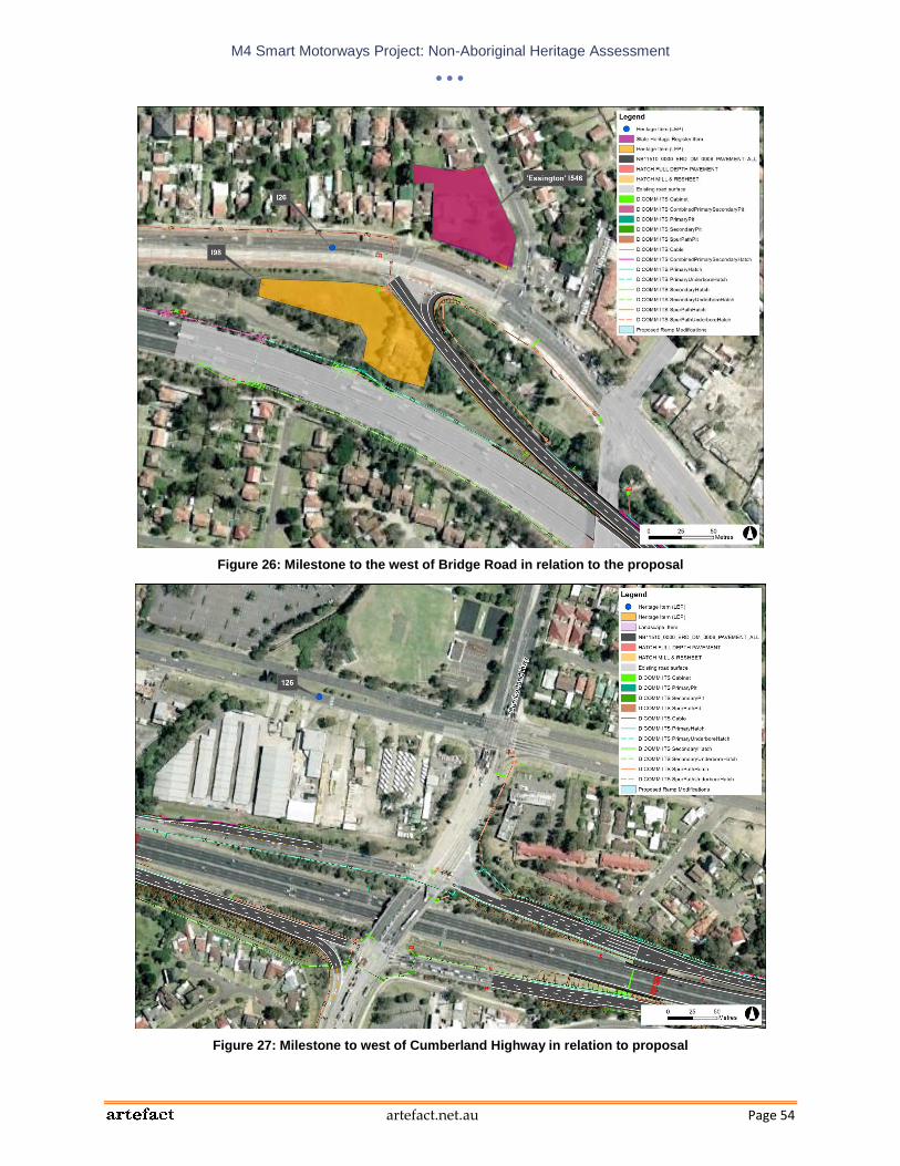
M4 Smart Motorways Project: Non-Aboriginal Heritage Assessment
artefact.net.au Page 54
Figure 26: Milestone to the west of Bridge Road in relation to the proposal
Figure 27: Milestone to west of Cumberland Highway in relation to proposal

M4 Smart Motorways Project: Non-Aboriginal Heritage Assessment
artefact.net.au Page 55
5.9.4 Mitigation measures
No mitigation measures are required.
5.9.5 Summary
Table 12 summarises the significance of the item, the potential impacts of the proposal,
recommendations, and necessary actions.
Milestones near the Cumberland Highway and Bridge Road, Westmead
Significance Physical impacts Visual impacts Recommendations Action
Local None None n/a
n/a
Table 12: Summary table for the milestones near the Cumberland Highway and Bridge Road, Westmead
5.10 Parramatta West Public School and Former Headmaster’s house (Burnett Street intersection)
5.10.1 History and description
Parramatta West Public School is located on former government land that was surveyed for subdivision in
1857, before being resumed for the creation of “Pitt Row” Public School, which opened in 1888. The
name of the school was changed to Parramatta West in 1937.
The school includes the original single-storeyed building which fronts Railway Street, as well as 20th
century additions along Railway Street and to the rear of the original building.
The former headmaster’s house is located at 59B Franklin Street and was constructed c. 1876-1900,
possibly as part of the early subdivision that preceded the construction of the school. The house is a
rectangular single-storey brick cottage with a hipped roof (Holroyd City Council Heritage Item Inventory
Sheets for Parramatta West Public School and Former Headmaster’s house).
5.10.2 Heritage significance
The statement of significance included in the Holroyd City Council Heritage Item Inventory Sheet for
Parramatta West Public School is as follows:
“Parramatta West Public School has local and regional historic and social significance
arising from its role as one of the early schools in the area. Having served the local
community as a public school since 1887 the school provides direct evidence of
contemporary population settlement patterns, demographic makeup and government

M4 Smart Motorways Project: Non-Aboriginal Heritage Assessment
artefact.net.au Page 56
education policies. It also serves as a reminder of the strong developmental relationship,
particularly in the 19th and early 20th centuries, between the north-eastern areas of Holroyd
and the adjacent early settlement of Parramatta. The largely intact original building, together
with its early additions, also has historic and aesthetic significance as a good, if modest,
representative example of a Late Victorian suburban school.”
The statement of significance included in the Holroyd City Council Heritage Item Inventory Sheet for the
Former Headmaster’s House of Parramatta West Public School is as follows:
“59b Franklin Street has local historic significance from being located on part of one of the
earliest subdivisions in Holroyd, the original government "Police Paddock" surveyed for
subdivision in 1857. Though of somewhat later date, the residence is important as a good
representative example of the more substantial houses erected in Holroyd in the late 19th
century period. This significance is enhanced by the degree to which the building has
retained much of its original fabric and detail. Both site and house also provide, through their
architectural character and location, evidence of the strong early links of this north-eastern
corner of Holroyd with the important settlement of Parramatta immediately adjacent.”
5.10.3 Statement of heritage impact
Parramatta West Public School and Former Headmaster’s House are located 20 metres to the north of
the study area (Figure 28). Views toward the M4 from Auburn Street to the rear of the school are blocked
by a strip of vegetation in the Auburn Street road reserve and a tall wall/noise barrier along the M4
corridor. The proposal would have no physical or visual impacts on the heritage items.
5.10.4 Mitigation measures
No mitigation measures are required.
5.10.5 Summary
Table 13 summarises the significance of the item, the potential impacts of the proposal,
recommendations, and necessary actions.
Parramatta West Public School and Former Headmaster’s House
Significance Physical impacts Visual impacts Recommendations Action
Local None None n/a
n/a
Table 13: Summary table for Parramatta West Public School and Former Headmaster’s House

M4 Smart Motorways Project: Non-Aboriginal Heritage Assessment
artefact.net.au Page 57
Figure 28: Parramatta West Public School (I 13) and Former Headmaster’ House (I 58) in relation to the proposal.
5.11 ‘Boori’ (Burnett Street intersection)
5.11.1 History and description
‘Boori’ is a Mid-Victorian Italianate house that was constructed in 1865 on land that was originally part of
‘Denham Farm’ and granted to Richard Atkins in 1793. The house was built by Alexander Campbell, a
prominent Sydney merchant, as a wedding gift for his daughter, Rachel (Holroyd City Council Heritage
Item Inventory Sheet for ‘Boori’).
The house is a single-storey building with a symmetrical front elevation and projecting wings at both ends.
The lot is surrounded by a modern brick wall.
5.11.2 Heritage significance
The statement of significance included in the Holroyd City Council Heritage Item Inventory Sheet for
‘Boori’ is as follows:

M4 Smart Motorways Project: Non-Aboriginal Heritage Assessment
artefact.net.au Page 58
“’Boori’ has both local and statewide historic and aesthetic significance as one of Holroyd's
small group of major early homesteads. Built by Alexander Campbell, a prominent early
merchant, on Richard Atkins' 1793 grant "Denham Farm", the site has been associated with
families of local and regional importance throughout its life. Though somewhat altered, the
building retains important original features and fabric - including a sizeable curtilage with
important early plantings - such that it remains an important representative example of a
"gentlemen's" residence as erected in Holroyd in the second half of the 19th century and one
of the earliest amongst this group.”
5.11.3 Statement of heritage impact
‘Boori’ is separated from the M4 corridor by a footpath and views toward the M4 are screened by a brick
wall and trees around the boundary of the property (Figure 29 and Figure 30). The property is also
elevated above the M4 and further screening is provided by vegetation in the M4 corridor. No
modifications are proposed in the vicinity of ‘Boori’ and the proposal would have no physical or visual
impacts on the item.
Figure 29: ‘Boori’ (I 65) in relation to the proposal.

M4 Smart Motorways Project: Non-Aboriginal Heritage Assessment
artefact.net.au Page 59
Figure 30: Footpath between ‘Boori’ and M4 corridor, with brick wall and trees along the northern boundary of the item.
5.11.4 Mitigation measures
No mitigation measures are required.
5.11.5 Summary
Table 14 summarises the significance of the item, the potential impacts of the proposal,
recommendations, and necessary actions.
‘Boori’
Significance Physical impacts Visual impacts Recommendations Action
Local None None n/a
n/a
Table 14: Summary table for ‘Boori’
5.12 ‘Carrington’ (Burnett Street intersection)
5.12.1 History and description
‘Carrington’ is a house built between 1876 and 1900 on land that was originally part of two grants made to
Richard Atkins in 1793 and 1798. The house was built for Robert H. Rickard, who was the brother of Sir
Arthur Rickard of Arthur Rickard and Co. Auctioneers and Realty Specialists. Arthur Rickard and Co.

M4 Smart Motorways Project: Non-Aboriginal Heritage Assessment
artefact.net.au Page 60
undertook subdivisions during the 1910s and 1920s that shaped much of the settlement pattern of
Western Sydney.
The property was inherited by Richard H. Rickard in 1914, at which time it was 12 acres in size. In 1923,
the property passed to Joseph Crawley and was leased back to Richard H. Rickard until 1926, at which
time it was further subdivided. The property subsequently passed through several hands and was further
subdivided in 1960 and 1980 to form the present boundaries.
The house is a single-storey brick structure with a U-shaped plan and a hipped roof. Plantings within the
property and along the road reserve partially obscure views to and from the house (Holroyd City Council
Heritage Item Inventory Sheet for ‘Carrington’).
5.12.2 Heritage significance
The statement of significance included in the Holroyd City Council Heritage Item Inventory Sheet for
‘Carrington’ is as follows:
“The building at 8 Ledger Road is a fine and largely intact example of an early residence in
the Holroyd district and is located on a prominent corner site. The building has historic,
aesthetic and social significance for its association with prominent residents of the district
and for the quality and intact nature of its style and detailing. The house has social
significance as an example of the social standing of its owner, Robert Heath Rickard.
It has aesthetic significance for the quality of the building and the remaining curtilage which
still retains important early mature trees and plantings. The visual quality of the property
maintains its earlier importance as a Gentleman's residence and as one of the small group of
major early homesteads in the district. The building holds scientific significance for both
archaeological and education potential.”
5.12.3 Statement of heritage impact
‘Carrington’ is location 10 metres to the south of the M4 corridor, on the southern side of Ledger Road
(Figure 31). The property is elevated above the M4, and views toward the M4 corridor are screened by
vegetation with the property, the road reserve of Ledger Road, and the M4 corridor. No modifications are
proposed in the vicinity of ‘Carrington’ and the proposal would have no physical or visual impacts on the
item.

M4 Smart Motorways Project: Non-Aboriginal Heritage Assessment
artefact.net.au Page 61
Figure 31: ‘Carrington’ (I 85) in relation to the proposal.
5.12.4 Mitigation measures
No mitigation measures are required.
5.12.5 Summary
Table 15 summarises the significance of the item, the potential impacts of the proposal,
recommendations, and necessary actions.
‘Carrington’
Significance Physical impacts Visual impacts Recommendations Action
Local None None n/a
n/a
Table 15: Summary table for ‘Carrington’
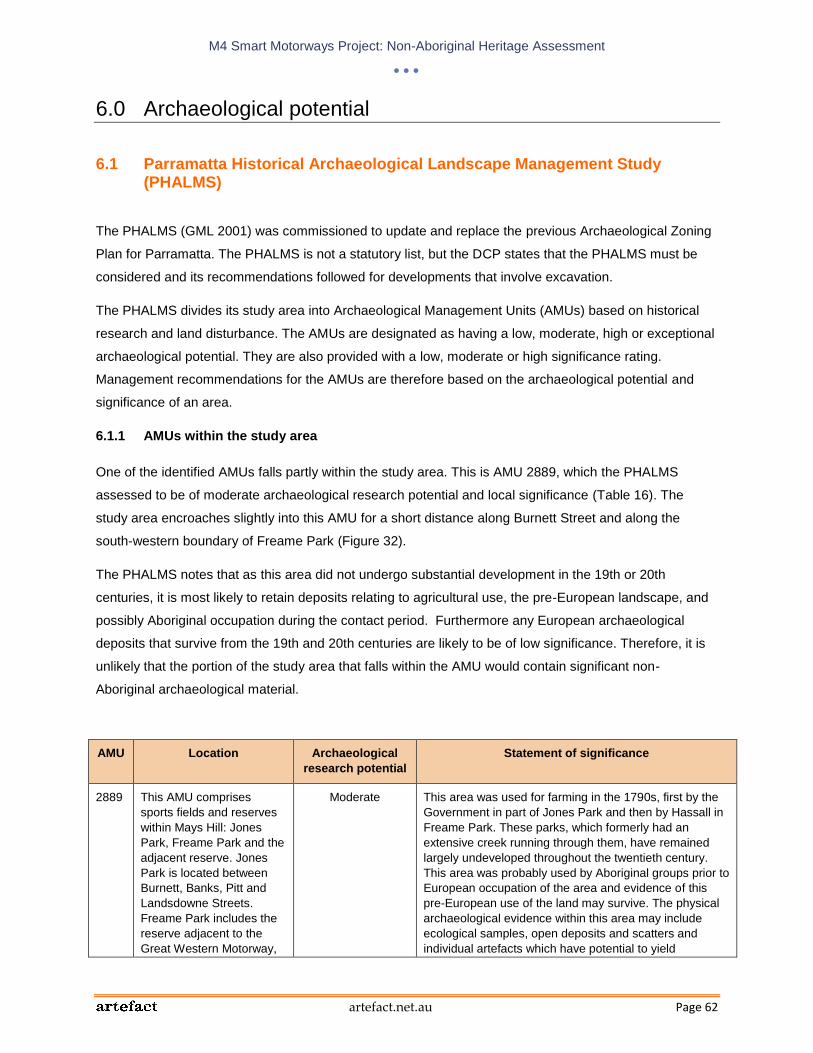
M4 Smart Motorways Project: Non-Aboriginal Heritage Assessment
artefact.net.au Page 62
6.0 Archaeological potential
6.1 Parramatta Historical Archaeological Landscape Management Study (PHALMS)
The PHALMS (GML 2001) was commissioned to update and replace the previous Archaeological Zoning
Plan for Parramatta. The PHALMS is not a statutory list, but the DCP states that the PHALMS must be
considered and its recommendations followed for developments that involve excavation.
The PHALMS divides its study area into Archaeological Management Units (AMUs) based on historical
research and land disturbance. The AMUs are designated as having a low, moderate, high or exceptional
archaeological potential. They are also provided with a low, moderate or high significance rating.
Management recommendations for the AMUs are therefore based on the archaeological potential and
significance of an area.
6.1.1 AMUs within the study area
One of the identified AMUs falls partly within the study area. This is AMU 2889, which the PHALMS
assessed to be of moderate archaeological research potential and local significance (Table 16). The
study area encroaches slightly into this AMU for a short distance along Burnett Street and along the
south-western boundary of Freame Park (Figure 32).
The PHALMS notes that as this area did not undergo substantial development in the 19th or 20th
centuries, it is most likely to retain deposits relating to agricultural use, the pre-European landscape, and
possibly Aboriginal occupation during the contact period. Furthermore any European archaeological
deposits that survive from the 19th and 20th centuries are likely to be of low significance. Therefore, it is
unlikely that the portion of the study area that falls within the AMU would contain significant non-
Aboriginal archaeological material.
AMU Location Archaeological
research potential
Statement of significance
2889 This AMU comprises
sports fields and reserves
within Mays Hill: Jones
Park, Freame Park and the
adjacent reserve. Jones
Park is located between
Burnett, Banks, Pitt and
Landsdowne Streets.
Freame Park includes the
reserve adjacent to the
Great Western Motorway,
Moderate This area was used for farming in the 1790s, first by the
Government in part of Jones Park and then by Hassall in
Freame Park. These parks, which formerly had an
extensive creek running through them, have remained
largely undeveloped throughout the twentieth century.
This area was probably used by Aboriginal groups prior to
European occupation of the area and evidence of this
pre-European use of the land may survive. The physical
archaeological evidence within this area may include
ecological samples, open deposits and scatters and
individual artefacts which have potential to yield

M4 Smart Motorways Project: Non-Aboriginal Heritage Assessment
artefact.net.au Page 63
AMU Location Archaeological
research potential
Statement of significance
and is bounded by Burnett,
Rees and Margaret Streets
and allotments along
Peggy Street and Belinda
Place.
information about the pre-European landscape relating to
major historic themes including Environment, Aboriginal
Pre-Contact, Pastoralism and Agriculture. Archaeological
evidence at this site is likely to be largely intact, but
subject to minor disturbance in some areas. This AMU
has Local archaeological significance.
Table 16: Details for AMU 2889 extracted from the State Heritage Inventory entry for the AMU
6.2 Potential archaeological resources outside the PHALMS study area
Generally, the proposed works are confined to the existing road corridors of the M4 and adjacent arterial
roads, with some additional ramp lanes, maintenance bays and utilities proposed to be located in narrow
areas immediately outside the existing road.
Where works are proposed outside the existing road corridors they are largely confined to areas that have
already been subject to significant disturbance through the construction of the motorway. For areas that
appear to have been subject to less disturbance, aerial photographs dating to 1943 and historical plans
were consulted in order to identify any former structures that were present prior to the construction of the
M4. No sites of archaeological potential that are likely to be impacted by the proposed works were
identified.

M4 Smart Motorways Project: Non-Aboriginal Heritage Assessment
artefact.net.au Page 64
Figure 32: PHALMS map showing AMU 2889 in relation to the study area boundary

M4 Smart Motorways Project: Non-Aboriginal Heritage Assessment
artefact.net.au Page 65
7.0 Overall Statement of Heritage Impact
The potential heritage impact of the proposal on the study area as a whole is assessed below using the
guidelines provided in the NSW Heritage Manual document Statements of Heritage Impact.
What aspects of the development proposal respect or enhance the heritage significance of the study area?
The proposed works would generally be confined to the existing M4 corridor and would therefore have no
physical impacts, and acceptable, temporary visual impacts, on the majority of the adjacent heritage
items.
Where works are proposed outside the existing road area they are largely limited to areas that have
already been subject to significant disturbance through the construction of the motorway. The proposal is
unlikely to have any impacts on intact archaeological material.
What aspects of the proposal could have a detrimental impact on the heritage significance of the study
area?
The proposed VMS on Reservoir Road would have a minor visual impact on the bushland within the
curtilage of Prospect Reservoir and surrounding area. However, this would have minimal impact on the
heritage significance of the item a, particularly within the wider context of a functioning road corridor, and
would be an acceptable impact.

M4 Smart Motorways Project: Non-Aboriginal Heritage Assessment
artefact.net.au Page 66
8.0 Recommendations
On the basis of background research and a site inspection and adhering to all statutory obligations, the
following recommendations have been made with regard to non-Aboriginal heritage.
No permits or approvals would be required for the proposed works.
If any unanticipated archaeological deposits are identified within the study area during construction
the Roads and Maritime Unexpected Archaeological Finds Procedure 2012 would be followed.

M4 Smart Motorways Project: Non-Aboriginal Heritage Assessment
artefact.net.au Page 67
9.0 References
Dictionary of Sydney (2008) entries for:
- ‘Granville’: http://dictionaryofsydney.org/entry/granville?zoom_highlight=granville. Accessed
10 April 2013.
- ‘Rosehill’: http://dictionaryofsydney.org/entry/rosehill?zoom_highlight=rosehill. Accessed 10
April 2013.
- ‘Harris Park’: http://dictionaryofsydney.org/entry/harris_park?zoom_highlight=harris+park.
Accessed 10 April 2013.
Draft Blacktown Heritage Inventory 2009 listing for ‘Hicks’ Dairy’
Fox & Associates (1987) Heritage Study of the City of Penrith. Report to Penrith City Council.
Godden Mackay Logan (2001) The Parramatta Historical Archaeological Landscape Management Study.
Report to Parramatta City Council.
Godden Mackay Logan (2011) Penrith Great River Walk: Interpretation Plan. Report to Penrith City
Council.
Holroyd Council website: Accessed on 5 April 2013 at http://www.holroyd.nsw.gov.au/your-
city/city/history/suburb/.
Holroyd City Council Heritage Item Inventory Sheets for:
- The Wattles
- Parramatta to Greystanes Milestones
- Parramatta West Public School
- Former Headmaster’s house, Parramatta West Public School
- Boori
- Carrington
Kass, T., C. Liston and John McClymont (1996) Parramatta: A Past Revealed. Parramatta City Council,
Parramatta.
Kass, T. (2005) Western Sydney Thematic History: State Heritage Register Project. NSW Heritage Office.

M4 Smart Motorways Project: Non-Aboriginal Heritage Assessment
artefact.net.au Page 68
NSW Heritage Office (2001) ‘Assessing Heritage Significance’ from the NSW Heritage Manual.
Paul Davies Pty Ltd (2007) Penrith Heritage Study: Locality Profiles. Report to Penrith City Council.
Roads and Maritime (2012) Unexpected Archaeological Finds Procedure.
(http://www.rta.nsw.gov.au/environment/downloads/unexpected_archaeological_finds_procedure.
pdf).
SHR entries for:
- Mamre. Accessed on 5 April 2013 at:
http://www.environment.nsw.gov.au/heritageapp/ViewHeritageItemDetails.aspx?ID=5045752
- St Bartholomew’s Anglican Church and Cemetery. Accessed on 5 April 2013 at:
http://www.environment.nsw.gov.au/heritageapp/ViewHeritageItemDetails.aspx?ID=5045521
- Prospect Post Office (former). Accessed on 5 April 2013 at:
http://www.environment.nsw.gov.au/heritageapp/ViewHeritageItemDetails.aspx?ID=5045747
- Prospect Reservoir and surrounding area. Accessed on 5 April 2013 at:
http://www.environment.nsw.gov.au/heritageapp/ViewHeritageItemDetails.aspx?ID=5045336
- Essington. Accessed on 5 April 2013 at:
http://www.environment.nsw.gov.au/heritageapp/ViewHeritageItemDetails.aspx?ID=5045170
State Heritage Inventory listings for:
- Bridestowe. Accessed on 5 April 2013 at:
http://www.environment.nsw.gov.au/heritageapp/ViewHeritageItemDetails.aspx?ID=1140066
Sydney Water Corporation (2005) Prospect Reservoir Site Conservation Management Plan. Sydney
Water.
Wotherspoon, G. (2010a) ‘The road west’, in the Dictionary of Sydney. Accessed on 5 April 2013 at:
http://dictionaryofsydney.org/entry/the_road_west.
Wotherspoon, G. (2010b) ‘Roads’, in the Dictionary of Sydney. Accessed on 5 April 2013 at:
http://dictionaryofsydney.org/entry/the_road_west.

Top Related