


Languages
Pages
Legal


Cours applications télédétection en météorologie agricole, Ouagadougou, Burkina Faso 5-9 Mai 2013
World Meteorological OrganizationWorld Meteorological OrganizationWorking together in weather, climate and waterWorking together in weather, climate and water
La pluie qui tombe Comment évaluer sa quantité parmi la télédétection
J. CamachoScientific Officer
Agricultural Meteorology Division. CLW/CLPA
WMO: Climate and Water www.wmo.int
WMO
Cours applications télédétection en météorologie agricole, Ouagadougou, Burkina Faso 5-9 Mai 2013
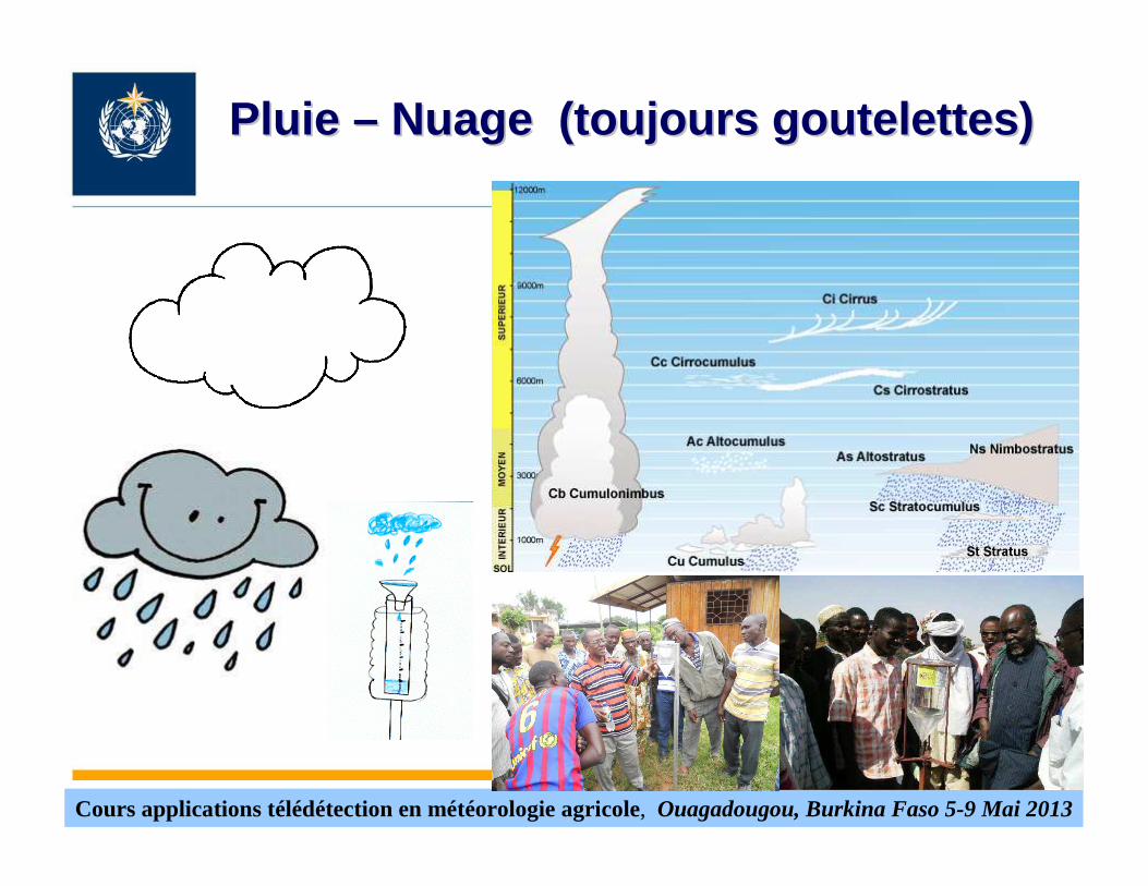
Pluie Pluie –– Nuage (toujours Nuage (toujours goutelettesgoutelettes ))

Cours applications télédétection en météorologie agricole, Ouagadougou, Burkina Faso 5-9 Mai 2013
Comme mesurer le total de precipitation Instruments
• Pluviometres, seaux
• Radar meteorologique
• Satellite (passive)
• Satellite (active)

Cours applications télédétection en météorologie agricole, Ouagadougou, Burkina Faso 5-9 Mai 2013
Pluviomètres

Cours applications télédétection en météorologie agricole, Ouagadougou, Burkina Faso 5-9 Mai 2013
Pluviomètres. Mesurent la pluie à un point. Qu’est-ce qu’ il passe a X kilometres?

Cours applications télédétection en météorologie agricole, Ouagadougou, Burkina Faso 5-9 Mai 2013
Réseau radar météorologiques (Qualité Suisse)
Cours applications télédétection en météorologie agricole, Ouagadougou, Burkina Faso 5-9 Mai 2013
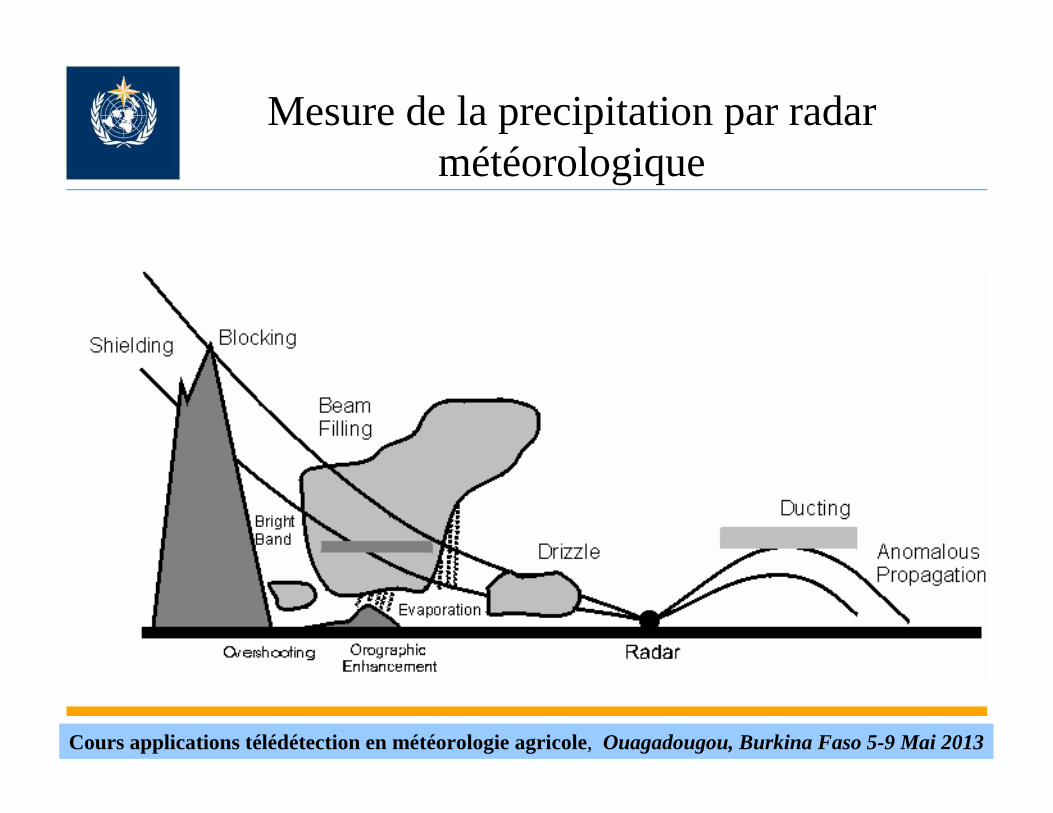
Mesure de la precipitation par radar météorologique

Cours applications télédétection en météorologie agricole, Ouagadougou, Burkina Faso 5-9 Mai 2013
Mesure de la precipitation par radar météorologique

Cours applications télédétection en météorologie agricole, Ouagadougou, Burkina Faso 5-9 Mai 2013
Mesure des cumuls de precipitationpar radar météorologique.
24 hours rain accumulation on the Val d'Irène radar in Eastern Canada. Notice the zones without data in the East and Southwest caused by radar beam blocking from mountains.
Radar-estimated precipitation ending Tuesday morning, January 10, 2012, shows a wide swath of 3 - 5 inches for much of Eastern Texas and Southern Louisiana.

Cours applications télédétection en météorologie agricole, Ouagadougou, Burkina Faso 5-9 Mai 2013
SEVIRI - MSG

Cours applications télédétection en météorologie agricole, Ouagadougou, Burkina Faso 5-9 Mai 2013
SEVIRI - MSG
Surface, cloudsBroadband (0.4 – 1.1 µm)HRV12
Cirrus cloud height, atmospheric instability14.4012.4013.40IR13.411
Surface, clouds, atmospheric instability13.0011.0012.00IR12.010
Surface, clouds, wind fields, atmospheric instability11.809.8010.80IR10.89
Ozone9.949.389.66IR9.78
Surface, clouds, atmospheric instability9.18.308.70IR8.77
Water vapor, atmospheric instability7.856.857.35WV7.36
Water vapor, high level clouds, atmospheric instability7.155.356.25WV6.25
Surface, clouds, wind fields4.363.483.90IR3.94
Surface, cloud phase1.781.501.64NIR1.63
Surface, clouds, wind fields0.880.740.81VIS0.82
Surface, clouds, wind fields 0.710.560.635VIS0.61
λmaxλminλcen
Main observational applicationCharacteristics of Spectral Band (µm)Spectral Band (µm)Channel

Cours applications télédétection en météorologie agricole, Ouagadougou, Burkina Faso 5-9 Mai 2013
SEVIRI - MSG

Cours applications télédétection en météorologie agricole, Ouagadougou, Burkina Faso 5-9 Mai 2013
SEVIRI - MSG
Weighting functions for the MSG SEVIRI thermal channels, i.e. channels 4 to 11, for a satellite nadir view. A mid-latitude summer standard atmosphere has been assumed for the simulation with a radiative transfer model.

Cours applications télédétection en météorologie agricole, Ouagadougou, Burkina Faso 5-9 Mai 2013
Instrumentation a bord des satellites
•Special Sensor Microwave/Imager (SSM/I) (passive) (Defence Meteorological Satellite-USA)
•Special Sensor Microwave Imager-Sounder (SSMIS) (passive) (DefenceMeteorological Satellite-USA)
•PMW Advanced Scanned Radiometer-Earth Observing System (EOS-AMSR-E) (AQUA satellite-NASA)
•MODIS (AQUA and TERRA satellites-NASA) (36 VIS/IR spectral bands
•Precipitation Radar and the TRMM Microwave Imager atthe Tropical RainfallMeasuring Mission (TRMM)
•MADRAS at the MEGHA-TROPICS mission
•Dual frequency precipitation radar on board at the GPM core observation satellite

Cours applications télédétection en météorologie agricole, Ouagadougou, Burkina Faso 5-9 Mai 2013
Télédetection active (radar embarqué au satellite)
Dual-frequency Precipitation Radar (DPR) instrument (JAXA) integrated onto the GPM Core Observatory satellite on flight from February 2014. New instrument designed to take 3-D measurements of raindrops and snowflakes. Is a spaceborne precipitation radar capable of making accurate rainfall measurements. The DPR is expected to be more sensitive than its TRMM predecessor especially in the measurement of light rainfall and snowfall in high latitude regions. Rain/snow determination is expected to be accomplished by using the differential attenuation between the Ku-band and the Ka-band frequencies. The variable pulse repetition frequency (VPRF) technique is also expected to increase the number of samples at each IFOV to realize a 0.2 mm/h sensitivity. The KuPR and KaPR, together with GMI, are the primary instruments on the GPM spacecraft. These Earth-pointing KuPR and KaPRinstruments will provide rain sensing over both land and ocean, both day and night.

Cours applications télédétection en météorologie agricole, Ouagadougou, Burkina Faso 5-9 Mai 2013
Pluviomètres simples

Cours applications télédétection en météorologie agricole, Ouagadougou, Burkina Faso 5-9 Mai 2013
Merci !Merci !Merci !
Top Related