


Languages
Pages
Legal


UC Davis Sacramento Campus
Hospital Seismic Demolitionand Office Replacement
DRAFT ENVIRONMENTAL IMPACT REPORT
August 2015
SCH #2015072012

UC Davis Sacramento Campus
Hospital Seismic Demolition and
Office Replacement
Draft Environmental Impact Report
SCH # 2015072012
August 2015
Prepared for:
University of California, Davis
Prepared by:
Impact Sciences, Inc.
University of California

Impact Sciences, Inc. i Hospital Seismic Demolition and Office Replacement Draft EIR
0992.012 August 2015
TABLE OF CONTENTS
Section Page
1.0 Introduction ............................................................................................................................................ 1.0‐1
2.0 Executive Summary ............................................................................................................................... 2.0‐1
3.0 Project Description ................................................................................................................................. 3.0‐1
4.0 Environmental Setting, Impacts, and Mitigation Measures ............................................................. 4.0‐1
4.1 Aesthetics .................................................................................................................................. 4.1‐1
4.2 Air Quality ................................................................................................................................ 4.2‐1
4.3 Greenhouse Gas Emissions ..................................................................................................... 4.3‐1
4.4 Hazards and Hazardous Materials ........................................................................................ 4.4‐1
4.5 Hydrology and Water Quality ............................................................................................... 4.5‐1
4.6 Noise .......................................................................................................................................... 4.6‐1
4.7 Transportation and Traffic ...................................................................................................... 4.7‐1
4.8 Utilities and Service Systems .................................................................................................. 4.8‐1
5.0 Alternatives ............................................................................................................................................. 5.0‐1
5.1 Introduction .............................................................................................................................. 5.0‐1
5.2 Project Objectives ..................................................................................................................... 5.0‐1
5.3 Range of Alternatives Considered ......................................................................................... 5.0‐2
5.4 Alternatives Evaluation ........................................................................................................... 5.0‐4
5.5 Environmentally Superior Alternative .................................................................................. 5.0‐9
6.0 Other CEQA Considerations ................................................................................................................ 6.0‐1
7.0 List of Preparers/Organizations Consulted ........................................................................................ 7.0‐1

Impact Sciences, Inc. ii Hospital Seismic Demolition and Office Replacement Draft EIR
0992.012 August 2015
Appendices (on CD)
1.0 Notice of Preparation (NOP), Initial Study, and Scoping Meeting Comments
Hospital Seismic Demolition and Office Replacement NOP
Hospital Seismic Demolition and Office Replacement Tiered Initial Study
Hospital Seismic Demolition and Office Replacement Scoping Meeting Comments
4.2 Air Quality an Greenhouse Gas Emissions Calculations
CalEEMod 2013.2.2
Impact Sciences, Inc. iii Hospital Seismic Demolition and Office Replacement Draft EIR
0992.012 August 2015
LIST OF FIGURES
Figure Page
3.0‐1 Sacramento Campus Regional Location Map .................................................................................... 3.0‐3
3.0‐2 Existing UC Davis Sacramento Campus ............................................................................................. 3.0‐4
3.0‐3 Project Site Locations ............................................................................................................................. 3.0‐5
3.0‐4 North Addition Office Building Project Site Detail ......................................................................... 3.0‐13
3.0‐5 Project Site Context .............................................................................................................................. 3.0‐14
3.0‐6 North Addition Office Building Conceptual Architectural Site Plan ............................................ 3.0‐15
3.0‐7 North Addition Office Building Conceptual Landscape Plan ....................................................... 3.0‐16
3.0‐8 North Addition Office Building Conceptual View of East Elevation ........................................... 3.0‐17
3.0‐9 North Addition Office Building Site Section .................................................................................... 3.0‐18
3.0‐10 North Addition Office Building Conceptual View of North Façade............................................. 3.0‐19
3.0‐11 North Addition Office Building Conceptual View of Northeast Corner ...................................... 3.0‐20
3.0‐12 North Addition Office Building Conceptual View of Northwest Corner .................................... 3.0‐21
3.0‐13 North Addition Office Building Conceptual View of West Elevation .......................................... 3.0‐22
3.0‐14 North/South Wing Demolition Sequences ........................................................................................ 3.0‐29
3.0‐15 North/South Wing Rendering – New West Façade ......................................................................... 3.0‐30
3.0‐16 Demolition Sites Fencing Plan ............................................................................................................ 3.0‐31
3.0‐17 Pedestrian and Vehicular Traffic Construction Wayfinding .......................................................... 3.0‐32
4.6‐1 Noise Monitoring Locations ................................................................................................................. 4.6‐9
Impact Sciences, Inc. iv Hospital Seismic Demolition and Office Replacement Draft EIR
0992.012 August 2015
LIST OF TABLES
Table Page
2.0‐1 Summary of Impacts and Mitigation Measures ................................................................................. 2.0‐7
2.0‐2 Summary Comparision of Project Alternatives ............................................................................... 2.0‐19
3.0‐1 Proposed Hospital Seismic Demolition and Office Replacement Project Space Plan ................... 3.0‐9
3.0‐2 Secondary Space Effects, Programs Relocating from the Housestaff Building ............................ 3.0‐10
3.0‐3 Proposed Hospital Seismic Demolition and Office Replacement Project Building Square
Footage ................................................................................................................................................... 3.0‐11
3.0‐4 Proposed Project Construction Sequencing and Traffic Estimates ................................................ 3.0‐28
4.1‐1 2010 LRDP EIR Mitigation Measures .................................................................................................. 4.1‐5
4.2‐1 Sacramento County Attainment Status ............................................................................................... 4.2‐4
4.2‐2 SMAQMD Air Quality Impact Significance Thresholds ................................................................. 4.2‐14
4.2‐3 2010 LRDP EIR Mitigation Measures ................................................................................................ 4.2‐16
4.2‐4 Comparison of Prior LRDP EIR Analysis to Proposed Project ...................................................... 4.2‐19
4.2‐5 Estimated Mitigated Construction Emissions from 2010 LRDP EIR ............................................. 4.2‐20
4.2‐6 2016 through 2021 Construction/Demolition Phase Details ........................................................... 4.2‐21
4.2‐7 Estimated Maximum Daily Construction Emissions‐Winter ......................................................... 4.2‐22
4.2‐8 Estimated Maximum Daily Construction Emissions‐Summer ...................................................... 4.2‐22
4.2‐9 Estimated Annual Mitigated Construction Emissions .................................................................... 4.2‐23
4.2‐10 Maximum Cancer Risk and Chronic Hazard for LRDP Operations ............................................. 4.2‐27
4.2‐11 Maximum Cancer Risk and Chronic Hazard for Mitigated LRDP Operations ........................... 4.2‐29
4.3‐1 Top Five GHG Producer Countries and the European Union (Annual) ........................................ 4.3‐5
4.3‐2 AB 32 Scoping Plan Measures (SPMs) ............................................................................................... 4.3‐13
4.3‐3 2010 LRDP EIR Mitigation Measures ................................................................................................ 4.3‐22
4.3‐4 Annual GHG Emissions for Demolition/Construction Activities ................................................. 4.3‐25
4.3‐5 Annual GHG Emissions for Operational Activities ......................................................................... 4.3‐26
4.6‐1 Definitions of Acoustical Terms ........................................................................................................... 4.6‐2
4.6‐2 Typical Noise Levels in the Environment ........................................................................................... 4.6‐3
4.6‐3 Typical Levels of Groundborne Vibration .......................................................................................... 4.6‐6
4.6‐4 Long‐Term‐Noise Measurement Data Summary ............................................................................... 4.6‐7
4.6‐5 Short‐Term Noise Measurement Data Summary ............................................................................... 4.6‐8
4.6‐6 General Plan Exterior Noise Compatibility Standards for Various Land Uses ........................... 4.6‐13
4.6‐7 General Plan Exterior Incremental Noise Impact Standards for Noise‐Sensitive Uses
(dB(A)) ................................................................................................................................................... 4.6‐14
4.6‐8 City of Sacramento Noise Ordinance Cumulative Intrusive Sound Limits ................................. 4.6‐15
4.6‐9 2010 LRDP EIR Mitigation Measures ................................................................................................ 4.6‐17
4.6‐10 Typical Construction Noise Levels .................................................................................................... 4.6‐20
4.6‐11 Vibration Source Levels for Construction Equipment .................................................................... 4.6‐25
4.6‐12 Noise Levels (measured in dB(A) Ldn) in Residential Areas Near Sacramento Campus in
dB(A) ...................................................................................................................................................... 4.6‐27
Impact Sciences, Inc. v Hospital Seismic Demolition and Office Replacement Draft EIR
0992.012 August 2015
4.7‐1 2010 LRDP EIR Mitigation Measures ................................................................................................ 4.7‐10
4.7‐2 Proposed Project Construction Sequencing and Traffic Estimates ................................................ 4.7‐12
5.0‐1 Summary Comparison of Alternatives .............................................................................................. 5.0‐13

Impact Sciences, Inc. 2.0‐1 Hospital Seismic Demolition and Office Replacement Draft EIR
0990.012 August 2015
2.0 EXECUTIVE SUMMARY
2.1 PURPOSE
This Draft Tiered Environmental Impact Report (EIR) evaluates the potentially significant environmental
effects of the proposed Hospital Seismic Demolition and Office Replacement project (project or proposed
project). This Executive Summary is intended to provide the decision makers, responsible agencies, and
the public with a clear, simple, and concise description of the proposed project and its potential
significant environmental impacts. The California Environmental Quality Act (CEQA) Guidelines (Section
15123) require that a summary be included in an EIR that identifies all major conclusions, identifies each
significant effect, recommended mitigation measure(s), and describes alternatives that would minimize
or avoid potential significant impacts of the proposed project. The summary is also required to identify
areas of controversy known to the lead agency, including issues raised by agencies and the public and
issues to be resolved.
2.2 PROJECT LOCATION
The approximately 142‐acre UC Davis Medical Center (Sacramento campus) is located in the City of
Sacramento, approximately 2.5 miles southeast of downtown Sacramento, 17 miles east of the UC Davis
main campus, and 90 miles northeast of San Francisco (see Figure 3.0‐1, Sacramento Campus Regional
Location Map). The Sacramento campus is bound by V Street on the north, Stockton Boulevard to the
west, Broadway to the south, and a residential neighborhood to the east.
The Main Hospital and clinical facilities located on the Sacramento campus provide acute care and
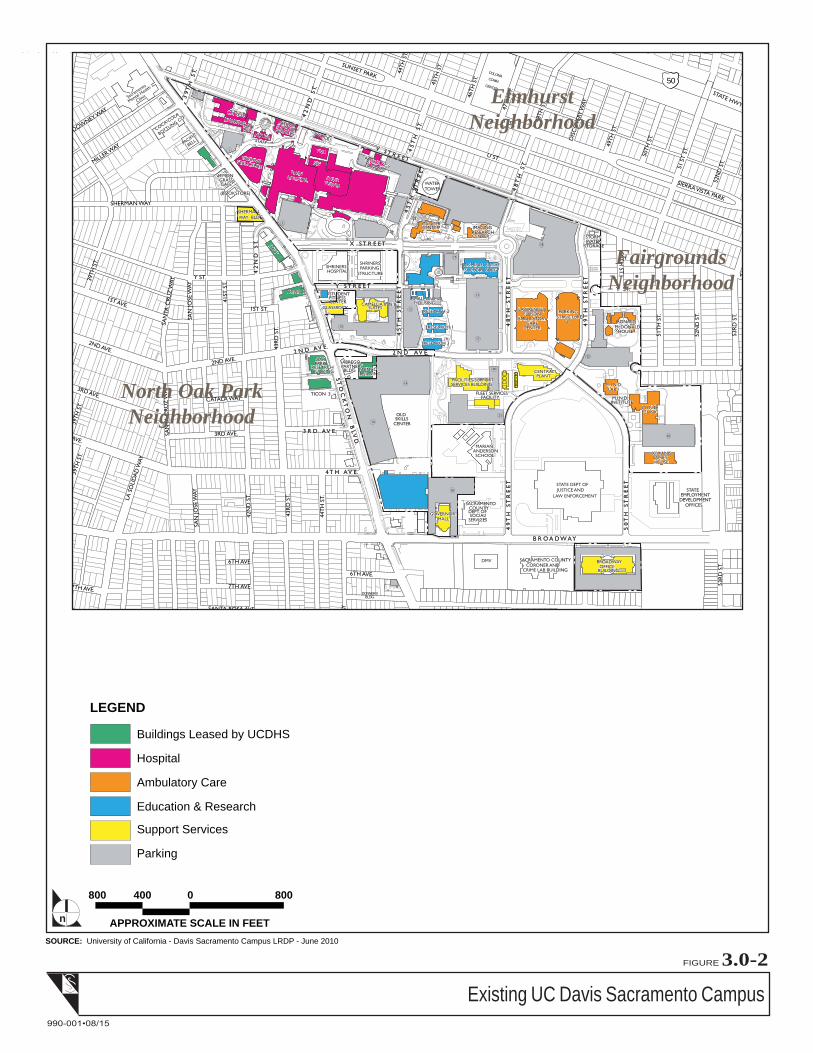
general care services to residents of the County of Sacramento. As depicted in Figure 3.0‐2, Existing UC
Davis Sacramento Campus, the existing campus is organized into four general land use zones or
functional areas, consisting of (1) Hospital, (2) Ambulatory Care, (3) Education and Research, and (4)
Support Services zones. The proposed project is located within the Hospital zone in the northwestern
portion of the campus.
2.3 PROJECT DESCRIPTION
The UC Davis Health System (UCDHS) proposes to implement the proposed project to improve seismic
safety and provide replacement office space at the Sacramento campus. The proposed project includes: (1)
the construction of the approximately 130,000 gross square foot (GSF)1 North Addition Office Building;
1 GSF = Gross Square Feet ‐ The sum of all areas on all floors of a building included within the outside faces of its exterior
walls, including all vertical penetration areas, for circulation and shaft areas that connect one floor to another.
2.0 Executive Summary
Impact Sciences, Inc. 2.0‐2 Hospital Seismic Demolition and Office Replacement Draft EIR
0992.012 August 2015
(2) demolition of the approximately 235,000 GSF North/South Main Hospital Wing, and the subsequent
‘re‐skinning’ of the remaining hospital structures; and (3) the demolition of the approximately 20,000 GSF
Housestaff Building. In total, the project would reduce building space on the Sacramento campus by
approximately 125,000 GSF.
The North Addition Office Building would provide replacement office space for staff currently working
in the North/South Wing of the Main Hospital, as well as staff currently located in the Cypress Building
and the off campus Sherman Building. The proposed building would be a six‐story building located in
the northern portion of the Sacramento campus between V Street and the Main Hospital Complex just
north of the East Wing and the Davis Tower. The building would have a footprint of approximately
21,000 square feet (SF), with the remaining site area redeveloped as an entry plaza and courtyard for the
south side of the building and enhanced pedestrian circulation around the perimeter of the building. The
North/South Wing would be demolished as part of the proposed project in order to remove seismically
deficient facilities. With removal of the North/South Wing of the Main Hospital, the remaining western
edge of the hospital would have no exterior wall. A new façade on the western face of the hospital would
be constructed to provide a finished exterior to the remaining building. Upon removal of the North/South
Wing, the site of the former structure would be redeveloped and landscaped to create a pedestrian plaza
area.
The Housestaff Building currently provides space for clinical pastoral services and transplant staff offices.
The two‐story building is seismically deficient and would be demolished as part of the project. The site of
the building would be developed into a pedestrian plaza area and landscaped.
Project construction and demolition are expected to take place from 2016 through 2022 with construction
access provided from Stockton Boulevard via Colonial Way; no construction site access or traffic would
be allowed on V Street.
2.4 PROJECT NEED AND OBJECTIVES
Need
The proposed project would provide modern replacement space for seismically deficient and outdated
facilities on the Sacramento campus.
ASF = Assignable Square Feet ‐ The sum of all areas on all floors of a building assigned to, or available for assignment to, an
occupant or specific use (classrooms, labs, offices, study facilities, special use, general use, support, health care, residential,
and unclassified – that are used to accomplish the institution’s mission).

2.0 Executive Summary
Impact Sciences, Inc. 2.0‐3 Hospital Seismic Demolition and Office Replacement Draft EIR
0992.012 August 2015
Following the deadly 1994 Northridge earthquake, hospital acute care facilities in California are subject to
seismic safety mandates outlined in the State of California Senate Bill (SB) 1953. Compliance with SB 1953
has been an integral component of UCDHS facility planning, and significant progress toward meeting
state seismic mandates has occurred in recent years. The construction of the Davis Tower (May 1999), and
the subsequent build‐out of its six floors of shelled space (1999‐2009) for inpatient beds, as well as the
completion of the Surgery and Emergency Services Pavilion (October 2010), has made way for virtually
all of UCDHS’s inpatient beds and critical systems to be located in facilities that are seismically
compliant. Over the past four years, patient care spaces have been relocated to the Surgery and
Emergency Services Pavilion Project, including the Operating Room Suite, Emergency Department,
Clinical Lab, Radiology, and Dietary Services.
The approximately 235,000 GSF North/South Wing of the Sacramento campus Main Hospital complex is a
“Structural Performance Category 1” structure per OSHPD standards. To comply with state seismic
mandates and maintain hospital licensure, the UCDHS intends to vacate and disconnect the North/South
Wing from the adjoining Main Hospital complex by the 2020 deadline.
At present, the North/South Wing is home to two acute care units (Apheresis and Dialysis unit, and
Children’s Surgery Center and Hospitalists), some support units (such as Environmental Services, Child
Life Program, and Gift Shop Storage), and several key administrative units which directly serve the Main
Hospital complex. The key administrative units located within the North/South Wing are:
Hospital Administration and Operations
Heart and Vascular Center
Patient Care Services
Pharmacy Operations
Physical Medicine & Rehabilitation Therapies
Performance Excellence
Neurology
Infection Prevention
Pastoral Services (limited to only a portion of this program, with most of the space located in the
Housestaff Building)
To house the displaced hospital administrative units listed above, UCDHS is proposing to construct the
North Addition Office Building. The remaining Apheresis and Dialysis units, and Children’s Surgery

2.0 Executive Summary
Impact Sciences, Inc. 2.0‐4 Hospital Seismic Demolition and Office Replacement Draft EIR
0992.012 August 2015
Center and Hospitalists have approved projects for relocation to other areas of the Main Hospital
complex (University Tower 1st Floor and Surgery and Emergency Services Pavilion, respectively). The
new building would also provide space for the relocation of programs currently located in the Cypress
Building and the off campus Sherman Building.
Another nearby building on the Sacramento campus, the Housestaff Building, which currently provides
space for clinical pastoral services and transplant staff offices, is also seismically deficient. The two‐story
building was constructed in 1916 and has a seismic safety rating of very poor. Programs located in that
building would be located to the Cypress and Sherman Buildings and the Housestaff Building would be
demolished as part of the project.
Project Objectives
The overall project objectives are to:
Provide replacement space for offices and support functions in the seismically deficient North/South
Wing.
Promote synergy and consolidate departments focused on enhancing quality and the patient
experience.
Respect the residential neighborhood to the north.
Foster highest and best use of space adjacent to the hospital.
Provide modest amount of growth space for academic offices.
Replace the hospital command center displaced by the Tower 1 renovation project.
Achieve UC sustainability goals for energy performance.
Create high quality office environment at reasonable cost.
Provide office space as non‐OSHPD space separate from hospital building.
Complement the aesthetic and operational aspects of the existing hospital buildings.
Create adjacent outdoor plaza/garden space
2.5 AREAS OF CONTROVERSY KNOWN TO THE UNIVERSITY
Although not necessarily areas of controversy, specific issues that were raised in written scoping
comments include potential impacts of the proposed project on nearby residences. In addition, several
2.0 Executive Summary
Impact Sciences, Inc. 2.0‐5 Hospital Seismic Demolition and Office Replacement Draft EIR
0992.012 August 2015
commenters expressed a desire for the Housestaff building to be recognized as having historical value
and saved if possible. All of the scoping comments are addressed in the impact analysis.
2.6 ALTERNATIVES
Consistent with CEQA requirements, a reasonable range of alternatives were evaluated and considered in
an effort to assist in the identification of an environmentally superior alternative. The alternatives
analyzed in detail in this Draft EIR are presented below.
2.6.1 Alternative 1: No Project
Under the No Project Alternative, a new office building to house programs being relocated out of the
Housestaff Building and the North/South Wing of the Main Hospital would not be constructed. However
due to seismic safety concerns and meet the OSHPD mandate, programs located in the two buildings
would need to be relocated into other existing building space. A single leased space that satisfies the
distance or square footage requirements for the programs being relocated out of the North/South Wing is
not available. Therefore, under the No Project Alternative, the various relocated programs would move
into existing on‐campus space and off‐campus leased space. The programs would therefore be dispersed
and would not have the benefit that would result from provision of the space necessary for consolidation
of the programs, as well as convenient access to the Main Hospital.
2.6.2 Alternative 2: Reduced Building Size Alternative
This alternative would reduce the size of the proposed North Addition Office Building by two floors
(approximately 43,500 GSF), in comparison with the proposed project’s approximately 130,000 GSF, six‐
story building. This reduction in building space in the new building would require that the UCDHS
either construct a smaller building in another location on the campus or relocate the unhoused programs
into existing on‐campus space (if available) and/or secure leased space in existing buildings near the
campus. No other changes to the proposed project are included in this alternative; the demolition of the
Housestaff Building and the North/South Wing, along with the construction of the new façade and the
two new pedestrian plaza areas would remain the same as under the proposed project. As such, access,
circulation, and landscape features (including the landscape buffer on the northern edge of the campus)
would be generally similar to those under the proposed project.
The intent of this alternative is to reduce the time needed to construct the building and thereby reduce
significant impacts of the proposed project related to noise associated with construction of the North
Addition Office Building.

2.0 Executive Summary
Impact Sciences, Inc. 2.0‐6 Hospital Seismic Demolition and Office Replacement Draft EIR
0992.012 August 2015
2.7 IMPACT SUMMARY
A detailed discussion regarding potential impacts of the proposed project is provided in Section 4.0,
Environmental Setting, Impacts, and Mitigation Measures. A summary of the impacts of the proposed
project is provided in Table 2.0‐1, Summary of Project Impacts and Mitigation Measures. Also provided
in Table 2.0‐1 are mitigation measures that are proposed to avoid or reduce significant and less than
significant project impacts. The table indicates whether implementation of the recommended mitigation
measures would reduce the impact to a less than significant level. Table 2.0‐2, Summary Comparison of
Project Alternatives, presents the environmental impacts of each alternative to allow the decision
makers, agencies and the public to compare and contrast these alternatives and weigh their relative
merits and demerits.
2.0 Executive Summary
Impact Sciences, Inc. 2.0‐7 Hospital Seismic Demolition and Office Replacement Draft EIR
0992.012 August 2015
Table 2.0‐1
Summary of Project Impacts and Mitigation Measures
Environmental Topic and Impact
Level of
Significance before
Mitigation Mitigation Measures
Level of Significance after
Mitigation
4.1 Aesthetics
Impact AES‐1
Implementation of the proposed
project would not substantially
degrade the existing visual character
or quality of the site and its
surroundings.
Less than Significant No project‐level mitigation measures are required. Less than Significant
Impact AES‐2
Implementation of the proposed
project would create new sources of
light and glare that could adversely
affect day or nighttime views in the
area.
Potentially Significant AES‐1: The use of security lighting during project
construction shall be limited to only those locations on
the construction site requiring illumination.
AES‐2: All security lights shall be properly shielded and
projected downwards during construction such that
light is directed onto the project site only.
Less than Significant
Cumulative Impact AES‐1
The proposed project, in conjunction
with other past, present and
reasonably foreseeable future
development, would not result in
significant cumulative impacts related
to aesthetics.
Less than Significant No project‐level mitigation measures are required. Less than Significant

2.0 Executive Summary
Impact Sciences, Inc. 2.0‐8 Hospital Seismic Demolition and Office Replacement Draft EIR
0992.012 August 2015
Environmental Topic and Impact
Level of
Significance before
Mitigation Mitigation Measures
Level of Significance after
Mitigation
4.2 Air Quality
Impact AIR‐1
Construction of the proposed project
would not result in construction
emissions that violate an air quality
standard or contribute substantially to
an existing or projected air quality
violation.
Less than Significant No project‐level mitigation measures are required. Less than Significant
Impact AIR‐2
The proposed project would not result
in operational emissions that would
violate an air quality standard or
contribute substantially to an existing
or projected air quality violation.
No Impact No project‐level mitigation measures are required. No Impact
Impact AIR‐3
Implementation of the proposed
project would not expose sensitive
receptors to substantial concentrations
of carbon monoxide.
Less than Significant No project‐level mitigation measures are required. Less than Significant
Impact AIR‐4
Implementation of the proposed
project would not expose sensitive
receptors to substantial concentrations
of toxic air contaminants.
Less than Significant No project‐level mitigation measures are required. Less than Significant
2.0 Executive Summary
Impact Sciences, Inc. 2.0‐9 Hospital Seismic Demolition and Office Replacement Draft EIR
0992.012 August 2015
Environmental Topic and Impact
Level of
Significance before
Mitigation Mitigation Measures
Level of Significance after
Mitigation
4.2 Air Quality (continued)
Impact AIR‐5
Implementation of the proposed
project would not conflict with or
obstruct implementation of the
applicable air quality plan.
Less than Significant No project‐level mitigation measures are required. Less than Significant
Cumulative Impact AIR‐1
Implementation of the proposed
project would not result in a
cumulatively considerable net
increase of a criteria pollutant for
which the project region is
nonattainment under an applicable
federal or state ambient air quality
standard.
Less than Significant No project‐level mitigation measures are required. Less than Significant
Cumulative Impact AIR‐2
Construction and operation of the
proposed project, in conjunction with
other nearby TAC sources, would not
expose sensitive receptors to
substantial concentrations of toxic air
contaminants.
Less than Significant No project‐level mitigation measures are required. Less than Significant
4.3 Greenhouse Gas Emissions
Impact GHG‐1
The proposed project would not
generate GHG emissions, either
directly or indirectly, that may have a
significant impact on the
environment.
Less than Significant No project‐level mitigation measures are required. Less than Significant
2.0 Executive Summary
Impact Sciences, Inc. 2.0‐10 Hospital Seismic Demolition and Office Replacement Draft EIR
0992.012 August 2015
Environmental Topic and Impact
Level of
Significance before
Mitigation Mitigation Measures
Level of Significance after
Mitigation
4.3 Greenhouse Gas Emissions (continued)
Impact GHG‐2
The proposed project would not
conflict with an applicable plan,
policy or regulation adopted for the
purpose of reducing the emissions of
greenhouse gases.
No Impact No project‐level mitigation measures are required. No Impact
4.4 Hazards and Hazardous Materials
Impact HAZ‐1
Implementation of the proposed
project would increase the routine
transport, use, storage, and disposal
of hazardous materials at the UC
Davis Sacramento campus but would
not create a significant hazard to the
public or the environment under the
routine or reasonably foreseeable
upset and accident conditions.
Less than Significant No project‐level mitigation measures are required. Less than Significant
Impact HAZ‐2
Demolition activities associated with
implementation of the proposed
project would not expose people to
contaminated building materials.
Less than Significant No project‐level mitigation measures are required. Less than Significant
Impact HAZ‐3
Implementation of the proposed
project would not result in handling
of hazardous materials within 0.25
mile of an existing school.
No Impact No project‐level mitigation measures are required. No Impact

2.0 Executive Summary
Impact Sciences, Inc. 2.0‐11 Hospital Seismic Demolition and Office Replacement Draft EIR
0992.012 August 2015
Environmental Topic and Impact
Level of
Significance before
Mitigation Mitigation Measures
Level of Significance after
Mitigation
4.4 Hazards and Hazardous Materials (continued)
Impact HAZ‐4
The proposed North Addition Office
Building would not be located on a
site that is included on a list of
hazardous materials sites compiled
pursuant to Government Code
Section 65962.5.
Less than Significant No project‐level mitigation measures are required. Less than Significant
Cumulative Impact HAZ‐1
The proposed project, in conjunction
with other past, present and
reasonably foreseeable future
development, would not result in
significant cumulative impacts related
to hazardous materials.
Less than Significant No project‐level mitigation measures are required. Less than Significant
4.5 Hydrology and Water Quality
Impact HYDRO‐1
Construction and operational
activities associated with
implementation of the proposed
project would not contribute
substantial loads of sediment or other
pollutants in storm water runoff that
could degrade receiving water
quality.
Less than Significant No project‐level mitigation measures are required. Less than Significant

2.0 Executive Summary
Impact Sciences, Inc. 2.0‐12 Hospital Seismic Demolition and Office Replacement Draft EIR
0992.012 August 2015
Environmental Topic and Impact
Level of
Significance before
Mitigation Mitigation Measures
Level of Significance after
Mitigation
4.5 Hydrology and Water Quality (continued)
Cumulative Impact HYDRO‐1
The proposed project, in conjunction
with other reasonably foreseeable
other future development in
Sacramento, could increase the
volume of urban runoff but would not
adversely affect receiving water
quality.
Less than Significant No project‐level mitigation measures are required. Less than Significant
4.6 Noise
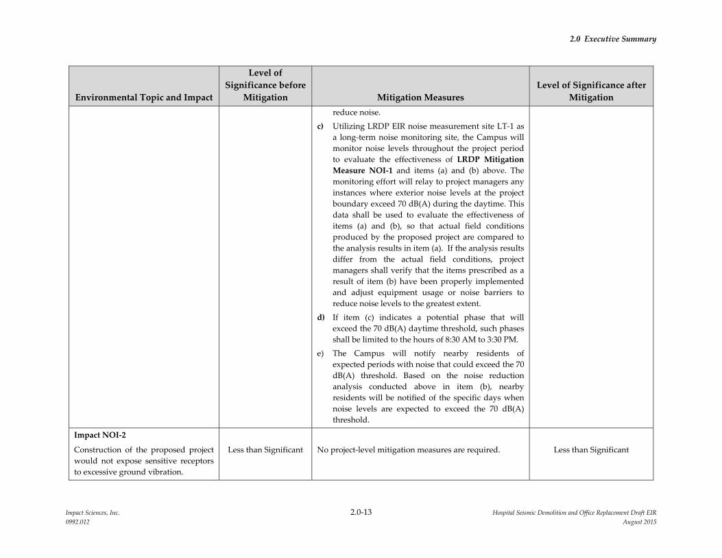
Impact NOI‐1
Construction of the proposed project
would expose existing off‐site and on‐
site receptors to elevated noise levels.
Potentially Significant NOI‐1: For each sequence of the North Addition Office
Building construction and the North/South Wing
Demolition, the following actions will be completed.
a) The Campus will conduct noise reduction analysis
for each sequence of the proposed project. Each
sequence will be evaluated once equipment details
and exact field conditions for that sequence are
known in order to forecast whether the expected
exterior noise levels will be below 70 dB(A) during
the daytime at the affected sensitive receptors.
b) In addition to LRDP Mitigation Measure NOI‐1, if
the noise reduction analysis completed per item (a)
above reveals impacts above the 70 dB(A) threshold,
the Campus will modify construction methods to
reduce noise impacts to the greatest extent feasible,
taking into account cost and sequencing constraints.
The Campus will utilize the results of the noise
reduction analysis to consider alternative
construction/demolition techniques, revised
equipment usage dates, specific placement of noise
reduction barriers, and alternative equipment to
Significant and Unavoidable
2.0 Executive Summary
Impact Sciences, Inc. 2.0‐13 Hospital Seismic Demolition and Office Replacement Draft EIR
0992.012 August 2015
Environmental Topic and Impact
Level of
Significance before
Mitigation Mitigation Measures
Level of Significance after
Mitigation
reduce noise.
c) Utilizing LRDP EIR noise measurement site LT‐1 as
a long‐term noise monitoring site, the Campus will
monitor noise levels throughout the project period
to evaluate the effectiveness of LRDP Mitigation
Measure NOI‐1 and items (a) and (b) above. The
monitoring effort will relay to project managers any
instances where exterior noise levels at the project
boundary exceed 70 dB(A) during the daytime. This
data shall be used to evaluate the effectiveness of
items (a) and (b), so that actual field conditions
produced by the proposed project are compared to
the analysis results in item (a). If the analysis results
differ from the actual field conditions, project
managers shall verify that the items prescribed as a
result of item (b) have been properly implemented
and adjust equipment usage or noise barriers to
reduce noise levels to the greatest extent.
d) If item (c) indicates a potential phase that will
exceed the 70 dB(A) daytime threshold, such phases
shall be limited to the hours of 8:30 AM to 3:30 PM.
e) The Campus will notify nearby residents of
expected periods with noise that could exceed the 70
dB(A) threshold. Based on the noise reduction
analysis conducted above in item (b), nearby
residents will be notified of the specific days when
noise levels are expected to exceed the 70 dB(A)
threshold.
Impact NOI‐2
Construction of the proposed project
would not expose sensitive receptors
to excessive ground vibration.
Less than Significant No project‐level mitigation measures are required. Less than Significant

2.0 Executive Summary
Impact Sciences, Inc. 2.0‐14 Hospital Seismic Demolition and Office Replacement Draft EIR
0992.012 August 2015
Environmental Topic and Impact
Level of
Significance before
Mitigation Mitigation Measures
Level of Significance after
Mitigation
4.6 Noise (continued)
Impact NOI‐3
Vehicular traffic associated with the
proposed project would result in an
incremental, but imperceptible, long‐
term increase in ambient noise levels.
Less than Significant No project‐level mitigation measures are required. Less than Significant
Impact NOI‐4
The operation of mechanical
equipment on the roof of the
proposed building would not result in
a substantial long‐term increase in
ambient noise levels.
Less than Significant No project‐level mitigation measures are required. Less than Significant
Impact NOI‐5
The proposed project would not
expose people to aircraft noise from
airports or airstrips.
No Impact No project‐level mitigation measures are required. No Impact
Cumulative Impact NOI‐1
The proposed project, in conjunction
with other past, present and
reasonably foreseeable future
development, would not result in
significant cumulative impacts related
to noise.
Less than Significant No project‐level mitigation measures are required. Less than Significant
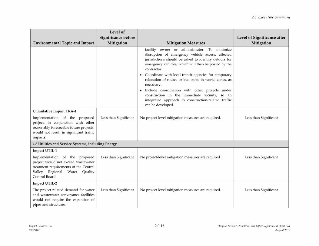
4.7 Transportation and Traffic
Impact TRA‐1
Implementation of the proposed
project could contribute to sub‐
standard intersection operations.
Potentially Significant TRA‐1: The University shall require the prime
contractor to prepare and implement a Construction
Traffic Management Plan that will include, but will not
necessarily be limited to, the following elements:
Identify proposed truck routes to be used; no
Less than Significant

2.0 Executive Summary
Impact Sciences, Inc. 2.0‐15 Hospital Seismic Demolition and Office Replacement Draft EIR
0992.012 August 2015
Environmental Topic and Impact
Level of
Significance before
Mitigation Mitigation Measures
Level of Significance after
Mitigation
construction traffic is to be permitted on V Street.
Specify construction hours, including limits on the
number of truck trips during the a.m. and p.m. peak
traffic periods (7:00 – 9:00 a.m. and 4:00 – 6:00 p.m.), if
conditions demonstrate the need.
Include a parking management plan for ensuring that
construction worker parking results in minimal
disruption to surrounding uses.
Include a public information and signage plan to
inform patients, visitors and staff of the planned
construction activities, roadway changes/closures,
and parking changes.
Store construction materials only in designated areas
that minimize impacts to nearby roadways.
Use of California Department of Transportation
(Caltrans) certified flag persons for any temporary
lane closures to minimize impacts to traffic flow, and
to ensure safe access into and out of the project site(s).
Develop circulation and detour plans to minimize
impacts to local street impacts from construction
activity on nearby major arterials. This may include
the use of signing and flagging to guide vehicles
through and/or around the construction zone.
Limit the number of lane closures during peak hours
to the extent possible.
Install traffic control devices as specified in the
California Department of Transportation Manual of
Traffic Controls for Construction and Maintenance
Work Zones.
Develop and implement access plans for potentially
impacted local services such as police and fire
stations, transit stations, hospitals, schools and parks.
The access plans should be developed with the
2.0 Executive Summary
Impact Sciences, Inc. 2.0‐16 Hospital Seismic Demolition and Office Replacement Draft EIR
0992.012 August 2015
Environmental Topic and Impact
Level of
Significance before
Mitigation Mitigation Measures
Level of Significance after
Mitigation
facility owner or administrator. To minimize
disruption of emergency vehicle access, affected
jurisdictions should be asked to identify detours for
emergency vehicles, which will then be posted by the
contractor.
Coordinate with local transit agencies for temporary
relocation of routes or bus stops in works zones, as
necessary.
Include coordination with other projects under
construction in the immediate vicinity, so an
integrated approach to construction‐related traffic
can be developed.
Cumulative Impact TRA‐1
Implementation of the proposed
project, in conjunction with other
reasonably foreseeable future projects,
would not result in significant traffic
impacts.
Less than Significant No project‐level mitigation measures are required. Less than Significant
4.8 Utilities and Service Systems, including Energy
Impact UTIL‐1
Implementation of the proposed
project would not exceed wastewater
treatment requirements of the Central
Valley Regional Water Quality
Control Board.
Less than Significant No project‐level mitigation measures are required. Less than Significant
Impact UTIL‐2
The project‐related demand for water
and wastewater conveyance facilities
would not require the expansion of
pipes and structures.
Less than Significant No project‐level mitigation measures are required. Less than Significant

2.0 Executive Summary
Impact Sciences, Inc. 2.0‐17 Hospital Seismic Demolition and Office Replacement Draft EIR
0992.012 August 2015
Environmental Topic and Impact
Level of
Significance before
Mitigation Mitigation Measures
Level of Significance after
Mitigation
4.14 Utilities and Service Systems, including Energy (continued)
Impact UTIL‐3
The proposed project would not
require expansion of campus storm
drainage conveyance and detention
facilities.
Less than Significant No project‐level mitigation measures are required. Less than Significant
Impact UTIL‐4
The proposed project would not
generate additional demand for water
and would be served from existing
entitlements and resources.
Less than Significant No project‐level mitigation measures are required. Less than Significant
Impact UTIL‐5
The proposed project would not
generate additional wastewater flows
and therefore would not exceed
available wastewater treatment
capacity.
Less than Significant No project‐level mitigation measures are required. Less than Significant
Impact UTIL‐6
The proposed project would not fail to
comply with regulations related to
solid waste and would not generate
solid waste that could not be
accommodated by the regional
landfill.
Less than Significant No project‐level mitigation measures are required. Less than Significant
Impact UTIL‐7
The proposed project would not
require on‐site expansion of electrical,
steam, and chilled water facilities.
Less than Significant No project‐level mitigation measures are required. Less than Significant

2.0 Executive Summary
Impact Sciences, Inc. 2.0‐18 Hospital Seismic Demolition and Office Replacement Draft EIR
0992.012 August 2015
Environmental Topic and Impact
Level of
Significance before
Mitigation Mitigation Measures
Level of Significance after
Mitigation
4.14 Utilities and Service Systems, including Energy (continued)
Impact UTIL‐8
The proposed project would not result
in wasteful, inefficient, and
unnecessary use of energy; place a
significant demand on regional
energy supply; or require provision of
substantial additional capacity.
Less than Significant No project‐level mitigation measures are required. Less than Significant
Cumulative Impact UTIL‐1
Implementation of the proposed
project in conjunction with other past,
present and reasonably foreseeable
development in Sacramento could
generate a cumulative demand for
new or expanded utilities in the
region, the construction of which
could result in significant
environmental impacts, but the
project’s contribution would not be
cumulatively considerable.
Less than Significant No project‐level mitigation measures are required. Less than Significant

2.0 Executive Summary
Impact Sciences, Inc. 2.0‐19 Hospital Seismic Demolition and Office Replacement Draft EIR
0992.012 August 2015
Table 2.0‐2
Summary Comparison of Project Alternatives
Resource Topic Proposed Project
Alternative 1
No Project
Alternative 2
Reduced Project
Aesthetics LTS No Impact Reduced
Air Quality – Construction LTS No Impact Reduced
Air Quality – Operational LTS No Impact Comparable
Biological Resources LTS No Impact Comparable
Cultural Resources LTS No Impact Comparable
Geology & Soils LTS No Impact Comparable
Greenhouse Gas Emissions LTS No Impact Comparable
Hazards and Hazardous Materials LTS No Impact Comparable
Hydrology & Water Quality LTS No Impact Comparable
Land Use NI No Impact Comparable
Noise – Construction SU No Impact Reduced,
but still SU
Noise – Operational LTS No Impact Comparable
Population and Housing NI No Impact No Impact
Public Services & Recreation LTS No Impact Comparable
Traffic – Construction LTS No Impact Reduced
Traffic Operational LTS No Impact Comparable
Utilities – Water LTS No Impact Comparable
Utilities – Wastewater LTS No Impact Comparable
Utilities – Solid Waste LTS No Impact Comparable
Utilities – Electricity LTS No Impact Comparable
Utilities – Natural Gas LTS No Impact Comparable
Utilities ‐ Telecommunications LTS No Impact Comparable
KEY
LTS Less than significant impact
NI No Impact
SU Significant and unavoidable
Impact Sciences, Inc. 3.0‐1 Hospital Seismic Demolition and Office Replacement Draft EIR
0992.012 August 2015
3.0 PROJECT DESCRIPTION
3.1 INTRODUCTION
The University of California system (UC system) consists of 10 campuses, five of which support health
sciences programs that include teaching hospital facilities affiliated with medical schools: San Francisco,
San Diego, Irvine, Los Angeles, and Davis. At the Davis Campus, the affiliation between the teaching
hospital and the medical school is a single organization called the UC Davis Health System (UCDHS).
The UCDHS includes UC Davis Medical Center, UC Davis School of Medicine, Betty Irene Moore School
of Nursing, and UC Davis Medical Group.
The University of California Board of Regents (The Regents) acquired the Sacramento County Hospital in
1973 to develop the UC Davis Medical Center Sacramento campus located approximately 17 miles east of
the UC Davis campus. In 1978, the facility was officially named by The Regents as the University of
California, Davis Medical Center (UCDMC). At that time, the existing hospital facility had several
seismically deficient buildings and did not have enough space to meet the medical center’s patient care,
educational, and research responsibilities. Since then, major construction and remodeling projects have
transformed the medical center to a state‐of‐the‐art 613‐licensed‐bed regional health care center that
serves as the principal clinical teaching and research site for the UC Davis School of Medicine. The
Medical Center is now known as the UC Davis Sacramento campus.
The proposed series of actions analyzed in this EIR as the Hospital Seismic Demolition and Office
Replacement project (project or proposed project) include the construction of a new office building on the
Sacramento campus to allow for the relocation of critical operational support programs from two
seismically deficient structures, the North/South Wing of the UCDHS Main Hospital (Main Hospital) and
the Housestaff Building, and the subsequent demolition of these structures. This project is part of a series
of actions that must be completed by 2020 to address seismic safety mandates required by the State of
California Office of Statewide Health Planning and Development (OSHPD).
3.2 PROJECT LOCATION AND SURROUNDING LAND USES
The approximately 142‐acre UC Davis Sacramento campus is located in the City of Sacramento,
approximately 2.5 miles southeast of downtown Sacramento, 17 miles east of the UC Davis main campus,
and 90 miles northeast of San Francisco (see Figure 3.0‐1, Sacramento Campus Regional Location Map).
The Sacramento campus is bound by V Street on the north, Stockton Boulevard to the west, Broadway to
the south, and a residential neighborhood to the east (see Figure 3.0‐2, Existing UC Davis Sacramento
Campus).

3.0 Project Description
Impact Sciences, Inc. 3.0‐2 Hospital Seismic Demolition and Office Replacement Draft EIR
0992.012 August 2015
The Main Hospital and clinical facilities located on the Sacramento campus provide acute care and
general care services to residents of the County of Sacramento. As depicted in Figure 3.0‐2, Existing UC
Davis Sacramento Campus, the existing campus is organized into four general land use zones or
functional areas, consisting of (1) Hospital, (2) Ambulatory Care, (3) Education and Research, and (4)
Support Services.
Hospital Zone – includes the Main Hospital, Cypress Building, Housestaff Building, Medical Records,
Patient Support Services, Pathology Support Building, and University Police Building.
Ambulatory Care Zone – includes the Lawrence J. Ellison Ambulatory Care Center, Cancer Center,
Medical Investigation of Neurodevelopmental Disorders (M.I.N.D.) Institute, M.I.N.D. Institute Wet Lab,
Imaging Research Center, Same Day Surgery Center, Ronald McDonald House, and Kiwanis House.
Education and Research Zone – includes the Education Building, and Research Buildings I, II, and III.
Administrative and Support Services Zone – includes the Central Plant, Facilities Support Services
Building, and Fleet Services Facility.
Land uses surrounding the campus site include local and regional commercial uses, a low‐density single‐
family residential neighborhood, and higher‐density mixed single‐ and multi‐family residential
neighborhoods. Stockton Boulevard, along the western boundary of the campus, is lined mostly with
one‐ to three‐story office buildings and a small amount of retail. A Shriners Hospital is located on
Stockton Boulevard just south of X Street across from the Main Hospital. The ABMCO building and
Abrego Partners building are located to west of the campus on Stockton Boulevard south of 2nd Avenue.
The Elmhurst neighborhood to the north and east of the campus is a residential neighborhood consisting
primarily of single‐family homes. To the west (west of commercial business buildings along Stockton
Boulevard) is the North Oak Park neighborhood, also residential, with a mix of single‐ and multi‐family
residences. These neighborhoods can be characterized as pre‐World War II traditional neighborhoods.
The Fairgrounds neighborhood to the south and southeast of the campus is also a residential area that
consists predominantly of multi‐family residential uses.
Several public institutions and offices are located between the southern edge of the campus and
Broadway. The Marian Anderson School, Sacramento County Department of Social Services, State
Department of Justice and Law Enforcement and State Employment Development Offices are located
along 49th and 50th Streets, and north of Broadway. The Department of Motor Vehicles and Sacramento
County Coroner and Crime Lab Building are located south of Broadway and west of the Broadway Office
Building. These public office uses continue south of Broadway as well.

Sacramento Campus Regional Location Map
FIGURE 3.0-1
990-001•08/15
SOURCE: University of California - Davis Sacramento Campus LRDP - June 2010
APPROXIMATE SCALE IN FEET
6400 3200 0 6400
n
LEGEND
UC Davis Sacramento Campus
City Boundary
Light Rail
Light Rail Stations
Light Rail Stations
Freeway
Arterial

52N
D S
T.
51 S
T ST
.
SIERRA VISTA PARK
STATE HWY 50
49TH
ST.
DIS
CO
VERY
WAY
T ST.
47TH
ST.
45TH
ST.
46TH
ST.
U ST.
48TH
ST.
44TH
ST.
SUNSET PARK
50TH
ST.
2ND AVE.
.TS D
R35
.TS D
R35
.TS D
N25
.TS H
T15
V ST.
.TS
HT0
5
Y ST.
1ST ST.
.TS D
R34
2ND AVE.
.TS TS14
CATALA WAY
6TH AVE.
.TS H
T44
3RD AVE.
6TH AVE.
7TH AVE.
.TS D
N24
. TS D
R34
YA
W O
SHERMAN WAY
DOWNEY WAY
MILLER W
AY
36TH
ST.
GER
BER
AVE.
Y ST.
SAN
TA C
RUZ
WAY
1ST AVE.
SAN
TA C
RUZ
WAY
YA
W ESOJ
NAS
39TH
ST.
39TH
ST. 38
TH S
T. 3RD AVE.
2ND AVE.
LA S
OLI
DA
D W
AY
SAN
JOSE
WAY
39TH
ST.
4TH AVE.
39TH
ST.
7TH AVE. .D
VLB G
NIK
R
SANTA ROSA AVE.
COMM.
COLOMA
CENTER
DONNER II BLDG.
50
(BOOKSTORE)
GOVERNOR’SHALL
INSTITUTE FORREGENERATIVECURES
BROADWAY
BUILDINGOFFICE
FAMILY KIWANIS
HOUSE
CENTRAL
ABREGOOAK
RESEARCHBUILDING
PARK ABMCO
BUILDING
PARTNERS BLDG
TICON 2
TICON 3
SHERMANWAY BLDG.
DAVIS 1
GLASSROCK
STUDENTFITNESSCENTER CAMELLIA INN &
SUITES
FACILITIES SUPPORT SERVICES BUILDING
RESEARCH 3
FACILITY FLEET SERVICES
PLANT
ADMINISTRATIVE SUPPORT BLDG
SMALL ANIMAL HOUSING
RESEARCH 2
RESEARCH 1
CANCER CENTER
CENTERCARE
ELLISONLAWRENCE J.
AMBULATORY
IMAGING
CENTERRESEARCH
MAIN HOSPITAL GRASSLEMON
CAFE
STRUCTURE 1
PARKING
HOUSESTAFF
BUILDINGMED. REC.
CYPRESS
PATIENT SUPPORT SERVICES
TOWER
DAVIS
TNU
SSSPATHOLOGY SUPPORT
POLICE
INSTITUTEM.I.N.D.
LAB I M.I.N.D.
M.I.N.D. CLINIC
PARKING STRUCTURE
2McDONALD
HOUSE
RONALD
Sacram
ento
Mental H
ealth
Clinic
COCA-COLA
BOTTLING CO.
PACIFIC
BELL
DMV SACRAMENTO COUNTY
CRIME LAB BUILDING CORONER AND
SOCIALSERVICES
SACRAMENTO COUNTYDEPT. OF
SCHOOL
STATE DEPT. OF
LAW ENFORCEMENT JUSTICE AND
EMPLOYMENT DEVELOPMENT
STATE
OFFICES
HOSPITAL SHRINERS
STRUCTURE PARKING SHRINERS
CENTERSKILLSOLD
ANDERSONMARIAN
TOWER WATER
STORAGE
STORM WATER
3 9
T H
S T
.
B R O A D W A Y
4 T H A V E.
4 9
T H
S
T R
E E
T
5 0
T H
S
T R
E E
T
4 5
T H
S T
R E
E T
X S T R E E T
S T O C
K T O
N B L V D
.
2 N D A V E.
3 R D A V E.
.T S D
N 2 4
Y S T R E E T
4 5
T H
S
T R
E E
T
2 N D A V E.
4 8
T H
S
T R
E E
T
V S T R E E T
4 2
N D
S T
.
4 5
T H
S T
.
4 8
T H
S T
.
4 9
T H
S
T R
E E
T
7
30
16
2
10
14
21
20
17
12
17
17
18
1
7
22
25
(BOOKSTORE)
BROADWAY
BUILDINGOFFICE
FAMILYKIWANIS
HOUSE
CENTRAL
ABREGOOAK
RESEARCHBUILDING
PARKABMCO
BUILDING
PARTNERSBLDG
TICON 2
TICON 3
SHERMANWAY BLDG.
DAVIS 1
GLASSROCK
STUDENTFITNESSCENTER CAMELLIA INN &
SUITES
FACILITIES SUPPORTSERVICES BUILDING
RESEARCH 3
FACILITYFLEET SERVICES
PLANT
ADMINISTRATIVESUPPORT BLDG
SMALL ANIMALHOUSING
RESEARCH 2
RESEARCH 1
CANCERCENTER
CENTERCARE
ELLISONLAWRENCE J.
AMBULATORY
IMAGING
CENTERRESEARCH
MAINHOSPITALGRASS
LEMON
CAFE
STRUCTURE 1
PARKING
HOUSESTAFF
BUILDINGMED.REC.
CYPRESS
PATIENTSUPPORTSERVICES
TOWER
DAVIS
TNU
SSSPATHOLOGYSUPPORT
POLICE
INSTITUTEM.I.N.D.
LAB IM.I.N.D.
M.I.N.D.CLINIC
PARKINGSTRUCTURE
2McDONALD
HOUSE
RONALD
Sacram
ento
Mental H
ealth
Clinic
COCA-COLA
BOTTLING CO.
PACIFIC
BELL
DMV SACRAMENTO COUNTY
CRIME LAB BUILDINGCORONER AND
SOCIALSERVICES
SACRAMENTOCOUNTYDEPT. OF
SCHOOL
STATE DEPT. OF
LAW ENFORCEMENTJUSTICE AND
EMPLOYMENTDEVELOPMENT
STATE
OFFICES
HOSPITALSHRINERS
STRUCTUREPARKINGSHRINERS
CENTERSKILLSOLD
ANDERSON
TOWERWATER
STORAGE
STORMWATER
3 9
T H
S T
.
B R O A D W A Y
4 T H A V E.
4 9
T H
S
T R
E E
T
5 0
T H
S
T R
E E
T
4 5
T H
S T
R E
E T
X S T R E E T
S T O C
K T O
N B L V D
.
2 N D A V E.
3 R D A V E.
.T S D
N 2 4
Y S T R E E T
4 5
T H
S
T R
E E
T
2 N D A V E.
4 8
T H
S
T R
E E
T
V S T R E E T
4 2
N D
S T
.
4 5
T H
S T
.
4 8
T H
S T
.
4 9
T H
S
T R
E E
T
7
30
16
2
10
14
21
20
17
12
17
17
18
1
7
22
25
GOVERNOR’SHALL
MARIAN
Existing UC Davis Sacramento Campus
FIGURE 3.0-2
990-001•08/15
SOURCE: University of California - Davis Sacramento Campus LRDP - June 2010
APPROXIMATE SCALE IN FEET
800 400 0 800
n
LEGEND
Buildings Leased by UCDHS
Hospital
Ambulatory Care
Education & Research
Support Services
Parking
ElmhurstNeighborhood
FairgroundsNeighborhood
North Oak ParkNeighborhood

DIS
CO
VERY
WAY
T ST.
47TH
ST.
45TH
ST.
46TH
ST.
U ST.
48TH
ST.
44TH
ST.
SUNSET PARK
SHERMAN WAY
DAVIS 1
COCA-COLA
BELL
TOWER WATER
3 9
T H
S T
.
4 5
T H
S T
R E
E T
X S T R E E T
V S T R E E T
4 2
N D
S T
.
4 5
T H
S T
.
4 8
T H
S T
.
7
2
17
18
1
7
3 9
T H
S T
.
4 5
T H
S T
R E
E T
X S T R E E T
.TS
DN 2
4
V S T R E E T
4 2
N D
S T
.
4 5
T H
S T
.
4 8
T H
S T
.
7
2
17
18
1
7
Pathology Support
Police
MainHospital
Structure 1Parking
HouseStaff
HouseStaff
BuildingMed.Rec.
CypressBuildingCypress
PatientSupportServices
TowerDavis
TNU
SSS
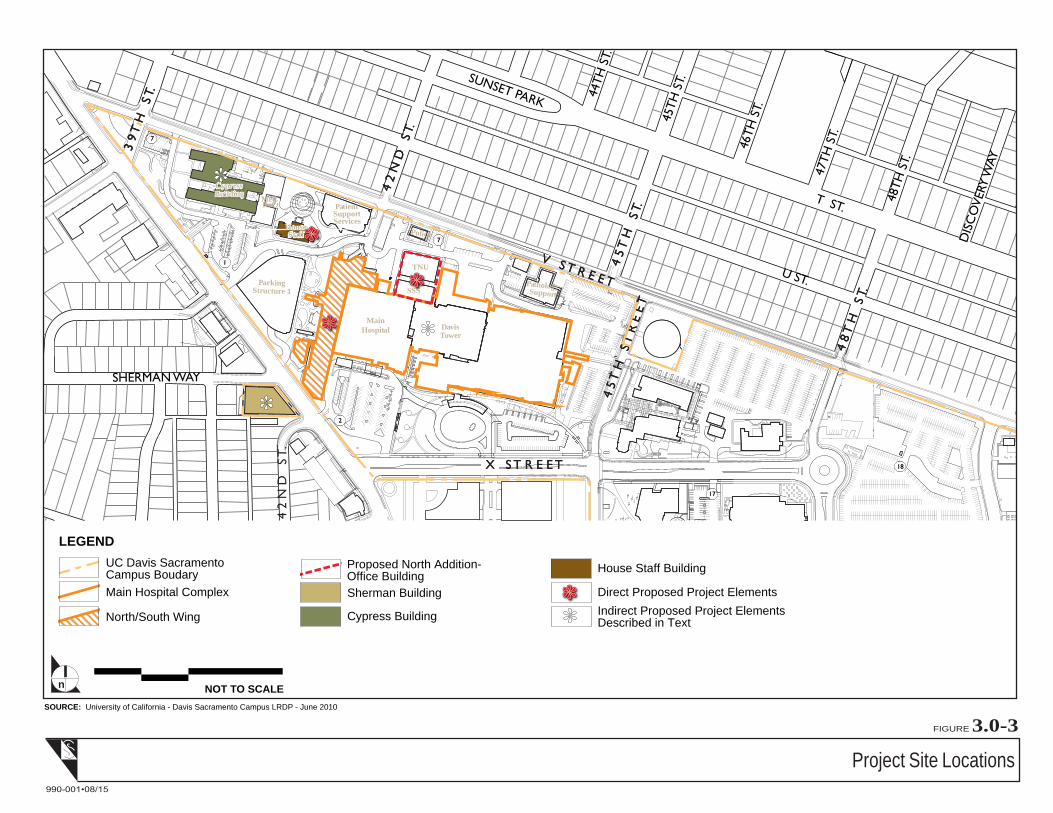
Project Site Locations
FIGURE 3.0-3
990-001•08/15
SOURCE: University of California - Davis Sacramento Campus LRDP - June 2010
NOT TO SCALEn
LEGENDUC Davis SacramentoCampus BoudaryMain Hospital Complex
North/South Wing
Proposed North Addition-Office BuildingSherman Building
Cypress Building
House Staff Building
Direct Proposed Project ElementsIndirect Proposed Project ElementsDescribed in Text


3.0 Project Description
Impact Sciences, Inc. 3.0‐6 Hospital Seismic Demolition and Office Replacement Draft EIR
0992.012 August 2015
3.3 PROJECT OVERVIEW
UCDHS proposes to implement the proposed project to improve seismic safety and provide replacement
office space at the Sacramento campus. The proposed project includes: (1) the construction of the
approximately 130,000 gross square foot (GSF)1 North Addition Office Building; (2) demolition of the
approximately 235,000 GSF North/South Wing of the Main Hospital, and the subsequent ‘re‐skinning’ of
the remaining hospital structures; and (3) the demolition of the approximately 20,000 GSF Housestaff
Building. In total, the project would reduce building area on the Sacramento campus by approximately
125,000 GSF.
The North Addition Office Building would provide replacement office space for staff currently working
in the North/South Wing of the Main Hospital, as well as the Cypress and Sherman buildings located on
Stockton Boulevard adjacent to the campus. The proposed building would be a six‐story building located
along the northern edge of the Sacramento campus between V Street and the Main Hospital Complex just
north of the East Wing and the Davis Tower. The project site and proposed building location for the
North Addition Office Building are shown on Figure 3.0‐3, Project Site Locations.
The North/South Wing would be demolished as part of the proposed project in order to remove
seismically deficient facilities. With removal of the North/South Wing of the Main Hospital, the
remaining western edge of the hospital would have no exterior wall. A new façade on the western face of
the hospital would be constructed to provide a finished exterior to the remaining building. Upon removal
of the North/South Wing, the site of the former structure would be redeveloped and landscaped to create
a pedestrian plaza area.
The Housestaff Building currently provides space for clinical pastoral services and transplant staff offices.
The two‐story building is seismically deficient and would be demolished as part of the project.
Project construction and demolition are expected to take place from 2016 through 2022 with construction
access provided from Stockton Boulevard via Colonial Way; no construction site access or traffic would
be allowed on V Street.
1 GSF = Gross Square Feet ‐ The sum of all areas on all floors of a building included within the outside faces of its exterior
walls, including all vertical penetration areas, for circulation and shaft areas that connect one floor to another.
ASF = Assignable Square Feet ‐ The sum of all areas on all floors of a building assigned to, or available for assignment to, an
occupant or specific use (classrooms, labs, offices, study facilities, special use, general use, support, health care, residential,
and unclassified – that are used to accomplish the institution’s mission).

3.0 Project Description
Impact Sciences, Inc. 3.0‐7 Hospital Seismic Demolition and Office Replacement Draft EIR
0992.012 August 2015
3.4 PROJECT NEED AND OBJECTIVES
Need
The proposed project would provide modern replacement space for seismically deficient and outdated
facilities on the Sacramento campus.
Following the deadly 1994 Northridge earthquake, hospital acute care facilities in California are subject to
seismic safety mandates outlined in the State of California Senate Bill (SB) 1953. Compliance with SB 1953
has been an integral component of UCDHS facility planning, and significant progress toward meeting
state seismic mandates has occurred in recent years. The construction of the Davis Tower (May 1999), and
the subsequent build‐out of its six floors of shelled space (1999‐2009) for inpatient beds, as well as the
completion of the Surgery and Emergency Services Pavilion (October 2010), has made way for virtually
all of UCDHS’s inpatient beds and critical systems to be located in facilities that are seismically
compliant. Over the past four years, patient care spaces have been relocated to the Surgery and
Emergency Services Pavilion Project, including the Operating Room Suite, Emergency Department,
Clinical Lab, Radiology, and Dietary Services.
The approximately 235,000 GSF North/South Wing of the Main Hospital complex is a “Structural
Performance Category 1” structure per OSHPD standards. To comply with state seismic mandates and
maintain hospital licensure, the UCDHS intends to vacate and disconnect the North/South Wing from the
adjoining Main Hospital complex by the 2020 deadline.
At present, the North/South Wing is home to two acute care units (Apheresis and Dialysis unit, and
Children’s Surgery Center and Hospitalists), some support units (such as Environmental Services, Child
Life Program, and Gift Shop Storage), and several key administrative units which directly serve the Main
Hospital complex. The key administrative units located within the North/South Wing are:
Hospital Administration and Operations
Heart and Vascular Center
Patient Care Services
Pharmacy Operations
Physical Medicine & Rehabilitation Therapies
Performance Excellence
Neurology
3.0 Project Description
Impact Sciences, Inc. 3.0‐8 Hospital Seismic Demolition and Office Replacement Draft EIR
0992.012 August 2015
Infection Prevention
Pastoral Services (limited to only a portion of this program, with most of the space located in the
Housestaff Building)
To house the displaced hospital administrative units listed above, UCDHS is proposing to construct the
North Addition Office Building. The remaining Apheresis and Dialysis units, and Children’s Surgery
Center and Hospitalists have approved projects for relocation to other areas of the Main Hospital
complex (University Tower 1st Floor and Surgery and Emergency Services Pavilion, respectively). The
new building would also provide space for the relocation of programs currently located in the Cypress
Building and the off campus Sherman Building.
Another nearby building on the Sacramento campus, the Housestaff Building, which currently provides
space for clinical pastoral services and transplant staff offices, is also seismically deficient. The two‐story
building was constructed in 1916 and has a seismic safety rating of very poor. Programs located in that
building would be located to the Cypress and Sherman Buildings and the Housestaff Building would be
demolished as part of the project.
Project Objectives
The overall project objectives are to:
Provide replacement space for offices and support functions in the seismically deficient North/South
Wing.
Promote synergy and consolidate departments focused on enhancing quality and the patient
experience.
Foster highest and best use of space adjacent to the hospital.
Provide modest amount of growth space for academic offices.
Replace the hospital command center displaced by the Tower 1 renovation project.
Achieve UC sustainability goals for energy performance.
Create high quality office environment at reasonable cost.
Provide office space as non‐OSHPD space separate from hospital building.
Complement the aesthetic and operational aspects of the existing hospital buildings.
Respect the residential neighborhood to the north.
Create adjacent outdoor plaza/garden space.

3.0 Project Description
Impact Sciences, Inc. 3.0‐9 Hospital Seismic Demolition and Office Replacement Draft EIR
0992.012 August 2015
3.5 PROJECT ELEMENTS
Project Building Space Plan and Population
As noted above, the project is composed of three components: construction and occupancy of the North
Addition Office Building, demolition of the North/South Wing, and the demolition of the Housestaff
Building. Table 3.0‐1, Proposed Hospital Seismic Demolition and Office Replacement Project Space
Plan and Table 3.0‐2, Secondary Space Effects, Programs Relocating from the Housestaff Building
provide a summary of the space to be vacated and the programs that would be relocated into the new
building. In total, as shown in Table 3.0‐3, Proposed Hospital Seismic Demolition and Office
Replacement Project Building Square Footage, the proposed project would reduce building space on the
Sacramento campus by approximately 125,000 GSF.
The proposed new office building would house approximately 571 existing staff currently located in the
North/South Wing, the Cypress Building, and the Sherman Building. Furthermore, the building includes
only a nominal amount of building space (4,000 ASF) to accommodate growth in the relocated programs.
As a result, the number of staff on the Sacramento campus is not anticipated to increase as a result of
project implementation.
Table 3.0‐1
Proposed Hospital Seismic Demolition and Office Replacement Project Space Plan
Program
(Current Staff Count) Current Location ASF
Reason For
Relocation
Future
Location
Estimated
New ASF
Auditorium Conference
Functions
(N/A)
North/South Wing 6,168 Seismic North Addition
Office Building
11,044
Hospital Admin and
Operations
(11)
North/South Wing 2,604 Seismic North Addition
Office Building
3,650
Heart and Vascular
(72)
North/South Wing 7,677 Seismic North Addition
Office Building
6,011
Performance Excellence
(12)
North/South Wing 651 Seismic North Addition
Office Building
1,006
Neurology
(25)
North/South Wing 1,663 Seismic North Addition
Office Building
2,196
Infection Prevention
(12)
North/South Wing 2,119 Seismic North Addition
Office Building
1,414
Patient Care Services
(56)
North/South Wing 6,979 Seismic North Addition
Office Building
7,165
Pharmacy Operations
(67)
North/South Wing 5,445 Seismic North Addition
Office Building
4,822
3.0 Project Description
Impact Sciences, Inc. 3.0‐10 Hospital Seismic Demolition and Office Replacement Draft EIR
0992.012 August 2015
PM&R Therapies
(85)
North/South Wing 3,005 Seismic North Addition
Office Building
4,104
Trauma
(44)
North/South Wing 6,456 Seismic North Addition
Office Building
6,587
Dieticians
(31)
North/South Wing 1,934 Seismic North Addition
Office Building
1,889
Surgery
(101)
Cypress 9,354 Program
adjacency which
frees up space to
solve Housestaff
Seismic Issue and
Transplant
adjacency issue
North Addition
Office Building
9,815
Clinical Affairs
(55)
Sherman 5,096 Program
adjacency which
frees up space to
solve Housestaff
Seismic Issue and
Pastoral Services
adjacency issue
North Addition
Office Building
4,853
Growth Factor
(N/A)
N/A N/A For possible
program growth
during
construction
North Addition
Office Building
4,000
Staff Total (571) Total Current ASF 59,151 Total New ASF 68,556
Source: UC Davis Environmental Stewardship and Sustainability Department, August 2015
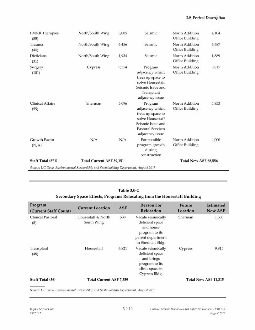
Table 3.0‐2
Secondary Space Effects, Programs Relocating from the Housestaff Building
Program
(Current Staff Count) Current Location ASF
Reason For
Relocation
Future
Location
Estimated
New ASF
Clinical Pastoral
(8)
Housestaff & North
South Wing
538 Vacate seismically
deficient space
and house
program to its
parent department
in Sherman Bldg.
Sherman 1,500
Transplant
(48)
Housestaff 6,821 Vacate seismically
deficient space
and brings
program to its
clinic space in
Cypress Bldg.
Cypress 9,815
Staff Total (56) Total Current ASF 7,359 Total New ASF 11,315
_________
Source: UC Davis Environmental Stewardship and Sustainability Department, August 2015
3.0 Project Description
Impact Sciences, Inc. 3.0‐11 Hospital Seismic Demolition and Office Replacement Draft EIR
0992.012 August 2015
Table 3.0‐3
Proposed Hospital Seismic Demolition and Office Replacement Project Building Square Footage
Building Existing (GSF) Proposed (GSF) Change
North/South Wing 235,000 0 (235,000)
Housestaff Building 20,000 0 (20,000)
North Addition Office Building 0 130,000 130,000
(125,000)
________
Source: UC Davis Environmental Stewardship and Sustainability Department, August 2015
North Addition Office Building Construction
The North Addition Office Building would be constructed north of the Main Hospital on the site
currently occupied by an approximately 30,000 square foot single‐story temporary building used as the
Children’s Surgery Center and the Trauma Nursing Unit that will be demolished under a separate project
in late 2015. The site is bounded on the south by the continuous north face of the Main Hospital, on the
east by loading docks and on the west by an asphalt service driveway for the hospital. The project site
and proposed location for the North Addition Office Building are shown on Figure 3.0‐3. The building
site consists entirely of impervious surfaces, including asphalt and concrete paving at the present time.
The new building would be a six‐story building that would provide 130,000 GSF of building space. The
building would have a footprint of approximately 21,000 square feet (SF), with the remaining site area
redeveloped as an entry plaza and courtyard for the south side of the building and enhanced pedestrian
circulation around the perimeter of the building. Refer to Figure 3.0‐4, North Addition Office Building
Project Site Detail, and Figure 3.0‐5, Project Site Context for further information regarding site
configuration. Following project construction, the site’s northern edge would be defined by the existing
University Police Building, a reconfigured service road, a small surface parking area with 12 spaces and
the related landscaped buffer that would be constructed as part of the proposed project.
The new building would be linked to the Main Hospital by a single‐story passage to an existing east/west
corridor located in the Davis Tower. The building would be connected to the existing utilities
infrastructure serving the overall Sacramento campus; no portions of the new construction would be
required to meet OSHPD regulations, other than the areas of construction directly connecting to the Main
Hospital building (Davis Tower). In addition, the proposed North Addition Office Building would be
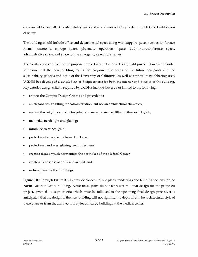
3.0 Project Description
Impact Sciences, Inc. 3.0‐12 Hospital Seismic Demolition and Office Replacement Draft EIR
0992.012 August 2015
constructed to meet all UC sustainability goals and would seek a UC equivalent LEED© Gold Certification
or better.
The building would include office and departmental space along with support spaces such as conference
rooms, restrooms, storage space, pharmacy operations space, auditorium/conference space,
administrative space, and space for the emergency operations center.
The construction contract for the proposed project would be for a design/build project. However, in order
to ensure that the new building meets the programmatic needs of the future occupants and the
sustainability policies and goals of the University of California, as well as respect its neighboring uses,
UCDHS has developed a detailed set of design criteria for both the interior and exterior of the building.
Key exterior design criteria required by UCDHS include, but are not limited to the following:
respect the Campus Design Criteria and precedents;
an elegant design fitting for Administration, but not an architectural showpiece;
respect the neighbor’s desire for privacy ‐ create a screen or filter on the north façade;
maximize north light and glazing;
minimize solar heat gain;
protect southern glazing from direct sun;
protect east and west glazing from direct sun;
create a façade which harmonizes the north face of the Medical Center;
create a clear sense of entry and arrival; and
reduce glare to other buildings.
Figure 3.0‐6 through Figure 3.0‐13 provide conceptual site plans, renderings and building sections for the
North Addition Office Building. While these plans do not represent the final design for the proposed
project, given the design criteria which must be followed in the upcoming final design process, it is
anticipated that the design of the new building will not significantly depart from the architectural style of
these plans or from the architectural styles of nearby buildings at the medical center.

North Addition Office Building Project Site Detail
FIGURE 3.0-4
990-001•08/15
SOURCE: University of California - Davis Sacramento Campus LRDP - June 2010
NOT TO SCALE
0
n
LEGEND
North Addition Footprint
North Addition Project Boundaries
North/South Wing Demolition (partially shown)


Project Site Context
FIGURE 3.0-5
990-001•08/15
SOURCE: University of California - Davis Sacramento Campus LRDP - June 2010


Respect the view from the community to the building
Emphasize entry, provide gathering space
Enhance staff entrance from parking structure. Emphasize entry. Provide gathering space.
Connect the entry and conferencing spaces with nature and courtyard.
1
2
3
4
Buildings to be removed / Future green space5
6Revise parking and landscape buffer for adjacent neighbors
Elevation Above Sea level
BASE-MENTG406
40’ LANDSCAPEBUFFER
(COMMUNITY VIEWS)
V STREET
POLICE1 STORY
COLONIAL WAY
V STREET
SERVICE AND LOADING DOCKS1 STORY
PSSB3 STORY
FUTURESUB-
STATION1 STORY
COLONIAL WAY
COURTYARD
ENTRYPLAZA
PREFUNCTION
CONFERENCE / PROGRAM
PARKING STRUCTURE 1
4 STORIES
EAST WING
8 STORIES
DAVIS TOWER14 STORIES
NORTH SOUTH WING7 STORIES
HOSPITAL CONNECTIONALIGN WITH EXISTING NORTH
SOUTH CORRIDOREXISTING EXITS
EXISTING EXIT
PROJECT SITE AREA
FF +30.35
+28.35
FF +28.35
+25.50
+25.76
+25.30
+24.96
+30.35
2
4
15
3
6
First Floor Diagram
The First Floor Diagram demonstrates program organization relative to adjacent existing conditions, notably: Existing Hospital Connection; Parking Structure 1 - and staff entrance to the North Addition; Loading/Service Dock
North Addition Office Building Conceptual Architectural Site Plan
NOT TO SCALEn
FIGURE 3.0-6
990-001•08/15
SOURCE: gkk works, 8/10/15.
+00.00

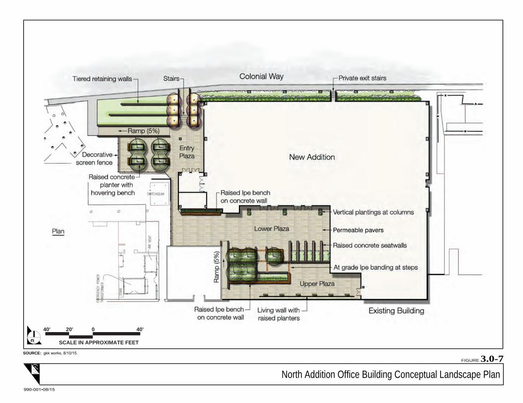
North Addition Office Building Conceptual Landscape Plan
SCALE IN APPROXIMATE FEET
40'020'40'
n
FIGURE 3.0-7
990-001•08/15
SOURCE: gkk works, 8/10/15.


North Addition Office Building Conceptual View of East Elevation
FIGURE 3.0-8
990-001•08/15
SOURCE: gkk works, 8/10/15.


North Addition Office Building Site Section Plan
NOT TO SCALEn
FIGURE 3.0-9
990-001•08/15
SOURCE: gkk works, 8/10/15.

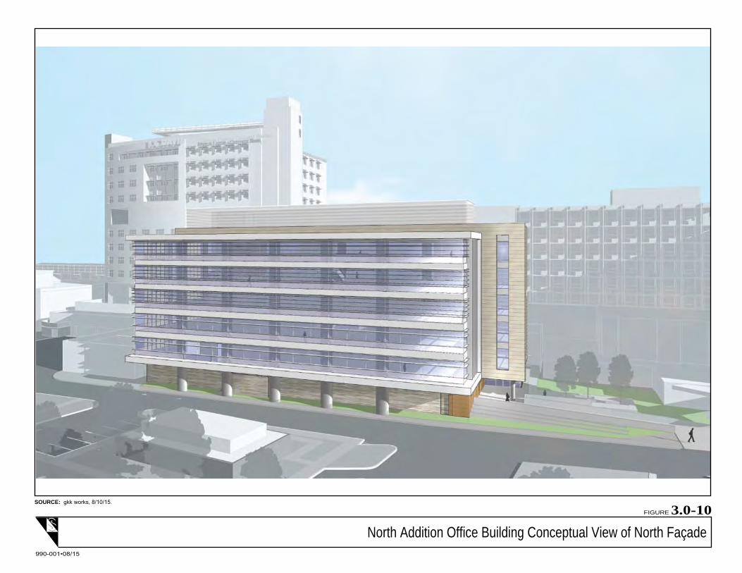
North Addition Office Building Conceptual View of North Façade
FIGURE 3.0-10
990-001•08/15
SOURCE: gkk works, 8/10/15.

North Addition Office Building Conceptual View of Northeast Corner
FIGURE 3.0-11
990-001•08/15
SOURCE: gkk works, 8/10/15.

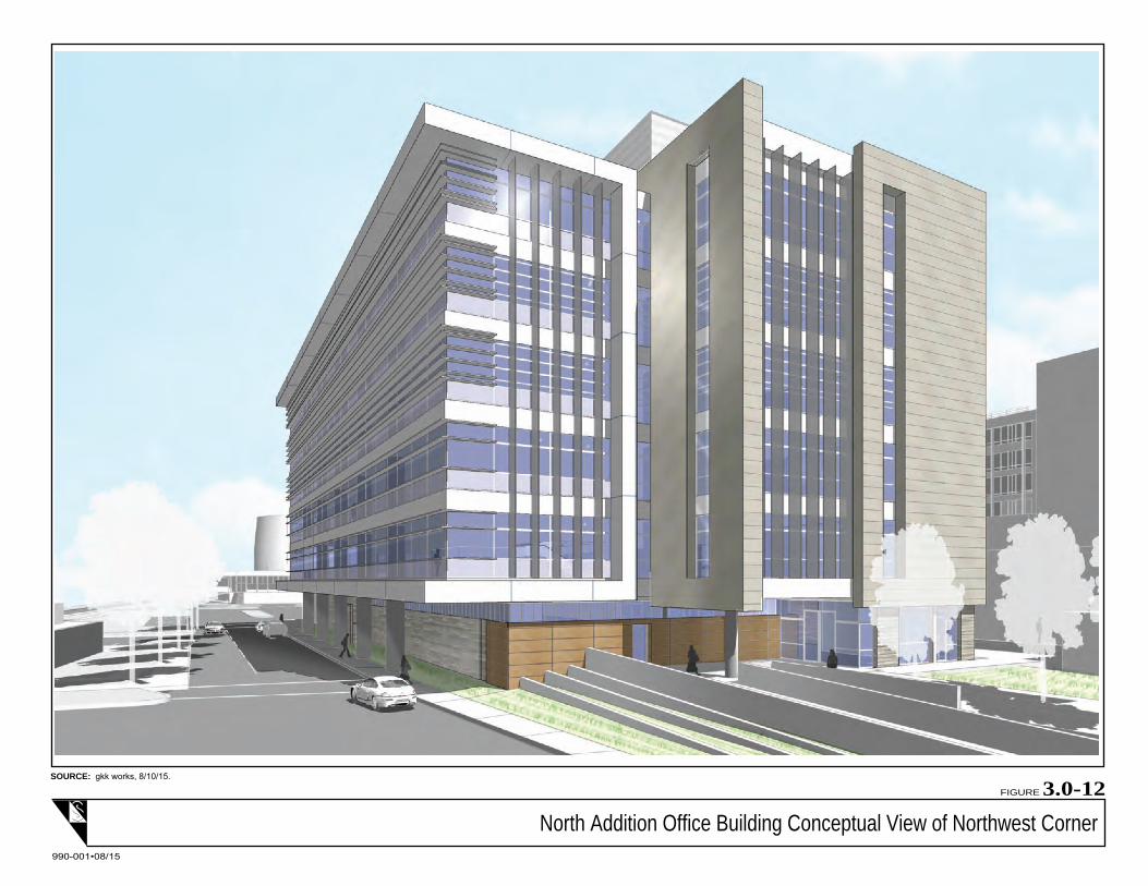
North Addition Office Building Conceptual View of Northwest Corner
FIGURE 3.0-12
990-001•08/15
SOURCE: gkk works, 8/10/15.


North Addition Office Building Conceptual View of West Elevation
FIGURE 3.0-13
990-001•08/15
SOURCE: gkk works, 8/10/15.


3.0 Project Description
Impact Sciences, Inc. 3.0‐23 Hospital Seismic Demolition and Office Replacement Draft EIR
0992.012 August 2015
Housestaff Building Demolition
The Housestaff Building (approximately 20,000 GSF) is located adjacent to Colonial Way, on an
approximately 10,000 sf site. To the east and west of the site are two‐story existing administrative support
buildings (the Patient Support Services and Cypress Buildings, respectively), Parking Structure 1
(Cypress Building parking) is located across Colonial Way, south of the site, with a landscaped courtyard
area located to the north. The location of the Housestaff Building is shown on Figure 3.0‐3.
As noted above, programs located in Housestaff Building would be located to the Cypress and Sherman
Buildings and the building would be demolished as part of the project. Once the building is demolished,
the site would be graded and landscaped to provide a pedestrian walkway and shade trees and it would
essentially expand and complement the existing plaza north of the project site. However, the Housestaff
Building site may be used for construction staging for both the construction of the North Addition Office
Building and the North/South Wing demolition and façade reconstruction phases of the project. If this
becomes the chosen option, the clinical pastoral services and transplant staff currently occupying the
Housestaff Building would be temporarily accommodated in a portion of the Main Hospital or the
Sherman Building, pending completion of the North Addition Office Building.
Demolition of the Housestaff Building would include an abatement phase to meet asbestos and lead
removal requirements and a demolition phase consisting of building deconstruction and removal by
trucks. The site would be fenced and a double‐wide gate would be installed at the eastern corner of the
property on Colonial Way which would ensure separation from the Parking Garage 1 ingress and egress
location. Once fencing and gates were in place, the building and improvements would be demolished.
The contractor would bring in a portable motorized crusher and crush all of the concrete on‐site;
effectively creating an aggregate base type material which would then be used to create a crushed‐
aggregate base parking lot. Construction trailers, materials staging and contractor parking would all be
accommodated on this parking lot for the duration of both the construction of the North Addition Office
Building and the North/South Wing demolition and façade reconstruction phase. Following the
completion of these phases, the (former Housestaff Building) site would be landscaped to create a
pedestrian plaza area.
North/South Wing Demolition
The North/South Wing of the Main Hospital is a six‐story building (approximately 235,000 GSF) that is
located immediately adjacent to the Parking Structure 1 entrance/exit at Stockton Boulevard to the south,
and Colonial Way to the north and is approximately 200 feet from the northern edge of the Sacramento
campus, on an approximately 50,000 sf site. The east side of the building is attached to the Main Hospital.

3.0 Project Description
Impact Sciences, Inc. 3.0‐24 Hospital Seismic Demolition and Office Replacement Draft EIR
0992.012 August 2015
An approximately 75‐foot wide landscaped area separates the North/South Wing from Parking Structure
1 to the west. The location of the North/South Wing is shown on Figure 3.0‐3.
Demolition of the North/South Wing of the Main Hospital would include the following central activities:
Utility disconnection
Building decommission and hazardous materials abatement
Building demolition
Main Hospital façade reconstruction
Site restoration and landscaping to create a pedestrian plaza area
Building demolition would take place in seven sequences, the first being “soft demolition,” followed by
six sequences of the “hard demolition.” Soft demolition is the internal ʺfinishʺ stripping of the building
carried out by demolition laborers and lightweight motorized equipment. The focus of soft demolition is
to remove as much of the waste materials from the building ahead of the structural or hard demolition,
which is the systematic deconstruction of a structure by means of heavy equipment. The prime objective
of the soft demolition sequence is to segregate and recycle as much material from inside the building as
possible, leaving just the structure intact. All waste materials from this sequence would be removed from
the site to licensed recycling and landfill centers. The soft demolition sequence is expected to take
approximately 30 weeks to complete.
Following the completion of all the soft demolition work, the contractor will install a separation curtain at
all floor levels through the existing expansion joints that exist between the North/South Wing and the
East Wing of the Main Hospital. This separation curtain can best be described as a chain link fence screen
that is installed vertically through the building’s expansion joints. This curtain assures that during the
hard demolition phase, no debris would be permitted to reach the East Tower.
The hard demolition of the North/South Wing would be accomplished over approximately 12 weeks in
six separate sequences mainly working across the site from south to north. The Ramp Tower and the one‐
story Surgical Center would be demolished first, followed by the southern end of the Wing. The next
sequence would demolish the East Tower connector as well as the 1928 South Annex, followed by
demolition of the central portion of the Wing. The final sequences would demolish the northern portion
of the Wing and lastly the 1928 North Annex. Refer to Figure 3.0‐14, North/South Wing Demolition
Sequence for an illustration of the sequences.

3.0 Project Description
Impact Sciences, Inc. 3.0‐25 Hospital Seismic Demolition and Office Replacement Draft EIR
0992.012 August 2015
As the structure is demolished all of the concrete would be separated from the steel and other assorted
debris. The recovered steel will be taken to a licensed recycling center, while the other debris will be
taken to a licensed landfill center if it cannot be recycled. Load out will be continuous to maximize on‐site
space and assure the cleanliness of the site. The contractor would bring in a portable motorized crusher
and crush all of the concrete on‐site; effectively creating an aggregate base type material which will then
be used to fill in the hole left by the demolished North/South Wing basement. Overall the proposed
project is anticipated to achieve a 75 percent recycle rate to meet the UC equivalent LEED Material and
Resources Credit 2.2©.
With removal of the North/South Wing of the Main Hospital, the remaining western edge of the hospital
would have no exterior wall. A new façade on the western face of the hospital would be constructed to
provide a finished exterior to the remaining building. In addition, the site of the former structure would
be redeveloped and landscaped to create a pedestrian plaza area. Construction of the new façade and the
pedestrian plaza is expected to take approximately seven months. Figure 3.0‐15, North/South Wing
Rendering ‐ New West Façade provides a conceptual rendering of the remaining Main Hospital building
following the proposed façade reconstruction. As with the renderings provided for the North Addition
Office Building, these plans do not represent the final design for the North/South Wing façade
reconstruction. However, given the design criteria which must be followed in the upcoming final design
process, it is anticipated that the design of the new façade will not significantly depart from the
architectural style of these plans or from the architectural styles of nearby buildings at the medical center.
Construction and Demolition Logistics
Staging
Construction staging would take place on site and surface parking lot areas proximate to the North
Addition Office Building construction site, on the Housestaff Building site, and/or around the
North/South Wing in areas between the existing building and the nearby Parking Structure 1.
Construction Fencing
An additional concern during demolition/construction activities is construction security and safety. As is
customary for all construction, temporary construction fencing would be used to not only secure the sites;
but also to assure public safety. All fencing would be eight feet tall and have a wind screening covering
the entire fence, including all gates and the entire face of Parking Structure 1. The exception to this would
be the fencing along the northern edge of the North Addition Office Building site, which would be of
plywood, or other solid material, in order to provide a barrier for construction noise attenuation. The
fence shown around the demolition sites (refer to Figure 3.0‐16, Demolition Sites Fencing Plan) would
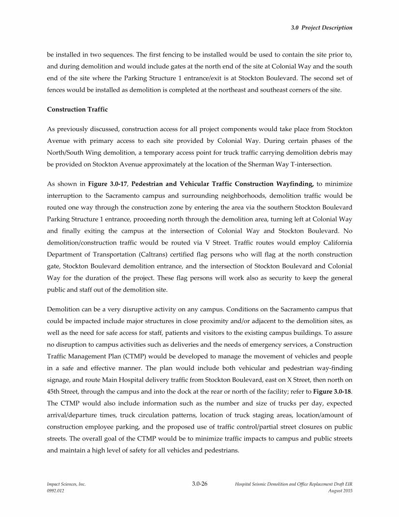
3.0 Project Description
Impact Sciences, Inc. 3.0‐26 Hospital Seismic Demolition and Office Replacement Draft EIR
0992.012 August 2015
be installed in two sequences. The first fencing to be installed would be used to contain the site prior to,
and during demolition and would include gates at the north end of the site at Colonial Way and the south
end of the site where the Parking Structure 1 entrance/exit is at Stockton Boulevard. The second set of
fences would be installed as demolition is completed at the northeast and southeast corners of the site.
Construction Traffic
As previously discussed, construction access for all project components would take place from Stockton
Avenue with primary access to each site provided by Colonial Way. During certain phases of the
North/South Wing demolition, a temporary access point for truck traffic carrying demolition debris may
be provided on Stockton Avenue approximately at the location of the Sherman Way T‐intersection.
As shown in Figure 3.0‐17, Pedestrian and Vehicular Traffic Construction Wayfinding, to minimize
interruption to the Sacramento campus and surrounding neighborhoods, demolition traffic would be
routed one way through the construction zone by entering the area via the southern Stockton Boulevard
Parking Structure 1 entrance, proceeding north through the demolition area, turning left at Colonial Way
and finally exiting the campus at the intersection of Colonial Way and Stockton Boulevard. No
demolition/construction traffic would be routed via V Street. Traffic routes would employ California
Department of Transportation (Caltrans) certified flag persons who will flag at the north construction
gate, Stockton Boulevard demolition entrance, and the intersection of Stockton Boulevard and Colonial
Way for the duration of the project. These flag persons will work also as security to keep the general
public and staff out of the demolition site.
Demolition can be a very disruptive activity on any campus. Conditions on the Sacramento campus that
could be impacted include major structures in close proximity and/or adjacent to the demolition sites, as
well as the need for safe access for staff, patients and visitors to the existing campus buildings. To assure
no disruption to campus activities such as deliveries and the needs of emergency services, a Construction
Traffic Management Plan (CTMP) would be developed to manage the movement of vehicles and people
in a safe and effective manner. The plan would include both vehicular and pedestrian way‐finding
signage, and route Main Hospital delivery traffic from Stockton Boulevard, east on X Street, then north on
45th Street, through the campus and into the dock at the rear or north of the facility; refer to Figure 3.0‐18.
The CTMP would also include information such as the number and size of trucks per day, expected
arrival/departure times, truck circulation patterns, location of truck staging areas, location/amount of
construction employee parking, and the proposed use of traffic control/partial street closures on public
streets. The overall goal of the CTMP would be to minimize traffic impacts to campus and public streets
and maintain a high level of safety for all vehicles and pedestrians.

3.0 Project Description
Impact Sciences, Inc. 3.0‐27 Hospital Seismic Demolition and Office Replacement Draft EIR
0992.012 August 2015
During the demolition phase, the majority of pedestrians and vehicular traffic would be sent to the south
side of Parking Structure 1, once the 1‐story surgical center structure on the southern edge of the
North/South Wing is demolished, which will create a large safety buffer for the pedestrians. Way‐finding
signage would also be installed inside Parking Structure 1 directing pedestrian traffic to the north or
south sidewalks which would remain intact and outside the demolition site fence. The project would also
provide signage along the north and south walks directing pedestrians and vehicles to the main entrance
of the Main Hospital.
In order to ensure the safety of the staff, patients and visitors it has been recommended that the eastern
third of the roof level of Parking Structure 1 be completely closed to the UCDMC staff and the public
until the demolition of the fire exit ramp tower on the western edge of the North/South Wing, proximate
to Parking Structure 1 is completed. To further safeguard pedestrian safety, a lighted pedestrian
walkway, constructed of tube and clamp scaffolding, fully planked and sealed on top and sides with
roofing and plywood would be provided along the east side of the site near the Main Hospital entrance.
Following project construction, all campus roadways, pedestrian walkways, and parking lots/structures
would be restored to their pre‐construction uses and configurations.
Construction Timeline
Demolition of the Housestaff Building and construction of the North Addition Office Building could
occur beginning as early as 2016 and continue through 2018. Upon occupancy of the North Addition
Office Building, the North/South Wing of the Main Hospital would begin the staged process of
decommissioning, demolition, façade replacement, and site redevelopment as a plaza area with an
expected timeline of 2018 through 2022 for project completion. Table 3.0‐4, Proposed Project
Construction Sequencing and Traffic Estimates, provides estimated durations of key activities and
estimated daily truck trips.

3.0 Project Description
Impact Sciences, Inc. 3.0‐28 Hospital Seismic Demolition and Office Replacement Draft EIR
0992.012 August 2015
Table 3.0‐4
Proposed Project Construction Sequencing and Traffic Estimates
Building Sequence Description
Estimated
Number of
Weeks
Approximate Daily
Truck Trips
(entering and leaving)
North Addition Office Building
Site Prep and Utilities Site clearing and utility prep. 20 4
Excavation and Foundation Foundation excavation, steel
placement, concrete pouring
12 4
Vertical Construction Steel and floor construction,
building skin, finishing
64 6
Housestaff Building
Abatement and Utility
Disconnect
Equipment/furnishing removal.
Abatement with utility
disconnection.
8 4
Demolition Building demolition and
hauling
2 12
Site Stabilization Provide gravel for contractor
staging
1 6
Plaza Reconstruction1 Landscape and concrete work 8 3
North/South Wing
Sequence 1 Interior Demolition and
Abatement (Soft Demolition)
30 2
Sequence 2 Structural Demo of Ramp
Tower and Surgical Center
2 40
Sequence 3 Structural Demo of Southern
end of the Wing
2 38
Sequence 4 Structural Demo of East Tower
connector and 1928 South
Annex
2 38
Sequence 5 Structural Demo of Central
portion of the Wing
2 38
Sequence 6 Structural Demo of Northern
portion of the Wing
2 38
Sequence 7 Structural Demo of 1928 North
Annex
2 28
Façade Construction Construction work 26 15
Plaza Reconstruction Landscape and concrete work 8 3
________
1 – It is anticipated that plaza reconstruction at the Housestaff Building and the North/South Wing demolition sites would take place
concurrently.
Note: Truck trips per day represent the total entering and leaving trips for each distinct phase. For example, the Sequence 2 demolition
would occur over a two week period (10 working days) and is expected to include a total of 200 truck loads. This would average 20
loads departing on an average day and a total of 40 truck trips (20 arrivals of an empty truck and 20 departures with a full truck)
for a total of 40 loads in Sequence 2.
Source: UC Davis Environmental Stewardship and Sustainability Department, August 2015.
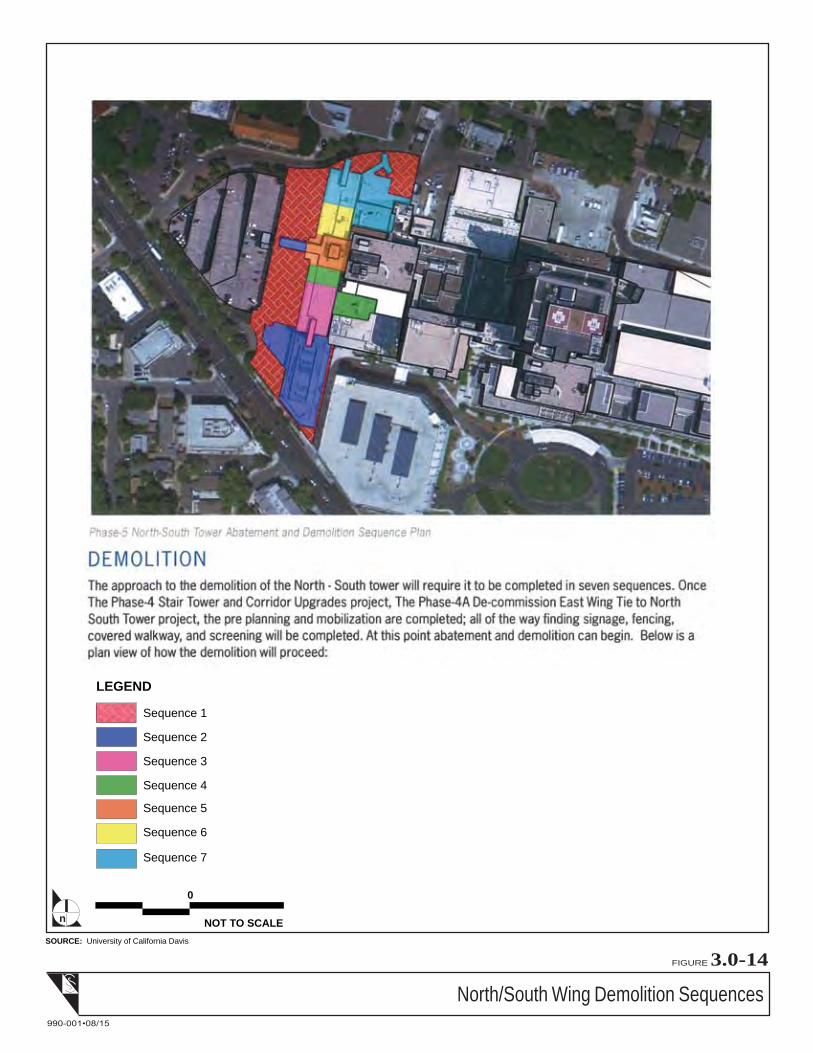
North/South Wing Demolition Sequences
FIGURE 3.0-14
990-001•08/15
SOURCE: University of California Davis
NOT TO SCALE
0
n
LEGEND
Sequence 1
Sequence 2
Sequence 3
Sequence 4
Sequence 5
Sequence 6
Sequence 7


North/South Wing Rendering – New West Façade
FIGURE 3.0-15
990-001•08/15
SOURCE: gkk works, 8/10/15.


Demolition Sites Fencing Plan
NOT TO SCALEn
FIGURE 3.0-16
990-001•08/15
SOURCE: McCarthy

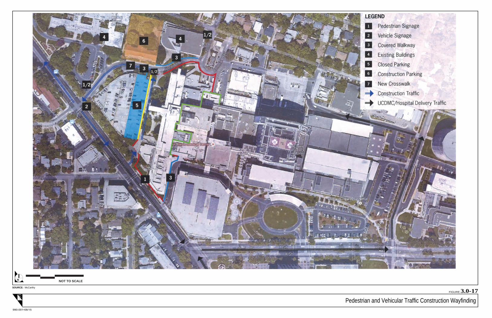
Pedestrian and Vehicular Traffic Construction Wayfinding
NOT TO SCALEn
FIGURE 3.0-17
990-001•08/15
SOURCE: McCarthy


3.0 Project Description
Impact Sciences, Inc. 3.0‐33 Hospital Seismic Demolition and Office Replacement Draft EIR
0992.012 August 2015
Utilities and Infrastructure
As described in Section 3.12, Volume 1 of the 2010 LRDP EIR from which this EIR is tiered, the campus is
currently serviced by the full range of utilities and a well‐developed utility infrastructure, augmented by
water, wastewater, natural gas, electricity, and some telecommunications services from outside
providers.
Potable and Irrigation Water
The City of Sacramento provides potable water to the campus. This water is used for domestic, fire
protection, central plant, and irrigation uses, though some of the irrigation demand is met by well water
on the campus. Under future 2010 LRDP conditions in the anticipated horizon year of 2025, the annual
water demand at the campus was estimated be about 164.4 million gallons and the maximum flow rate
would be 3,967 gallons per minute.
The water service provider, the City of Sacramento, confirmed there is adequate capacity in their large
diameter transmission main system surrounding the campus to accommodate the potable water demands
associated with campus development under the 2010 LRDP full build‐out scenario (Jacobs 2009).
Although general system upgrades are not anticipated, depending on the specific requirements of the
proposed project, distribution pipes on‐ and off‐campus may require modification or replacement. The
Campus will upgrade the on‐campus systems as needed to provide adequate flow and pressure to the
proposed project.
Regarding consumptive use of water, the new building would be designed and constructed using UC
sustainability goals which include water efficiency. Furthermore, as noted above, the new building
includes a nominal amount of building space for growth of programs and therefore, the staffing levels on
the campus are not expected to increase due to the project. As a result, overall water use on the campus is
not expected to increase as a result of the proposed project and could potentially decrease with project
implementation.
Sanitary Sewer
Wastewater from the campus is conveyed to the City of Sacramento combined sewer and storm water
facilities. It is treated at the Sacramento Regional Wastewater Treatment Plant (SRWTP), which is owned
and operated by the Sacramento Regional County Sanitation District (SRCSD). The Central Valley
Regional Water Quality Control Board (CVRWQCB) regulates the quality and quantity of effluent
discharged from the SRWTP. According to the SRWTP 2020 Master Plan, the treatment plant would be
expanded to have a design capacity of 218 mgd ADWF by 2020. The 2010 LRDP EIR estimated that about

3.0 Project Description
Impact Sciences, Inc. 3.0‐34 Hospital Seismic Demolition and Office Replacement Draft EIR
0992.012 August 2015
0.24 million gallons per day/87.5 million gallons per year of sanitary sewer flows each year would
discharged into the City’s combined sewer system at full build‐out.
Regarding discharge of wastewater, the new building would be designed and constructed using UC
sustainability goals which include water efficiency and therefore the building would result in lower than
normal wastewater flows. Furthermore, as noted above, the staffing levels on the campus are not
expected to increase due to the project. As a result, overall wastewater discharge from the campus is not
expected to increase as a result of the proposed project and could potentially decrease with project
implementation.
Storm Water
As stated in the 2010 LRDP EIR, the existing campus land area consists of approximately 75 percent
impervious and 25 percent pervious surfaces. Half of the campus area discharges storm water into the
City’s combined sewer system, which serves both storm water runoff and domestic sewer discharge.
Stormwater from the other half of the campus flows via the City storm drains to the American River. A
City‐owned storm water detention basin designed for 10‐year flows is located on the campus.
With the implementation of the Hospital Seismic Demolition and Office Replacement it is anticipated that
the total area of impervious surfaces would actually decrease slightly with the demolition of two
buildings and the subsequent addition of open space and landscape areas. As a result of the decrease in
impervious surfaces, the site storm water runoff volumes are also expected to decrease.
Solid Waste
As stated in the 2010 LRDP EIR, solid waste is separated into appropriate waste streams. Medical waste
and hazardous chemical and radioactive waste are packaged and labeled, and categorized for transport to
appropriate off‐campus licensed disposal sites. Wastes generated on the project site would be disposed in
a similar manner.
Electrical Power, Chilled and Hot Water for Heating and Cooling
The Central Cogeneration Plant (Central Plant) provides normal and emergency electrical power, chilled
and hot water for heating and cooling, and process steam to most campus buildings. The Central Plant
uses natural gas provided by Pacific Gas & Electric Company. The Central Plant is designed to
accommodate some growth in utility demand. The proposed North Addition Office Building would be
served by the existing Central Plant. Refer to Figure 3.0‐2 for the location of the Central Plant.
3.0 Project Description
Impact Sciences, Inc. 3.0‐35 Hospital Seismic Demolition and Office Replacement Draft EIR
0992.012 August 2015
As previously discussed, the proposed North Addition Office Building would be constructed to meet all
UC sustainability goals and would seek a UC equivalent LEED© Gold Certification or better. As a result,
because of the efficiencies in the new building and the decrease in total building space on the campus, it
is anticipated that overall energy use on the Sacramento campus would decrease with project
implementation.
Natural Gas
Pacific Gas & Electric Company (PG&E) provides natural gas to the campus by 28 gas services from gas
distribution piping mains on V Street, Stockton Boulevard, Broadway, 45th Street, 48th Street, Y Street, and
2nd Avenue. The proposed new building would be served by existing gas mains located near the project
site.
As previously discussed, the proposed North Addition Office Building would be constructed to meet all
UC sustainability goals and would seek a UC equivalent LEED© Gold Certification or better. As a result,
because of the efficiencies in the new building and the decrease in total building space on the campus,
overall use of natural gas on the Sacramento campus would decrease with project implementation.
Telecommunications
The Campus owns and operates its own telecommunications infrastructure. Only modest changes to this
infrastructure are anticipated as a result of the proposed project.
3.6 UC SUSTAINABLE PRACTICES POLICY
The University of California has an established a sustainability policy and has most recently update the
policy in May 2015. The Sustainable Practices Policy establishes goals in nine areas of sustainable
practices: green building, clean energy, transportation, climate protection, sustainable operations, waste
reduction and recycling, environmentally preferable purchasing, sustainable foodservice and sustainable
water systems. The proposed project will contain certain activities that are related to the UC
Sustainability Practices Policy and the on‐going implementation of the policy helps to reduce
environmental impacts. The proposed project would target energy efficiency in the proposed North
Addition Office Building and LEED Gold Certification of the North Addition Office Building.
3.7 PROJECT APPROVALS
As a public agency principally responsible for approving or carrying out the proposed project, The
Regents is the Lead Agency under CEQA and is responsible for reviewing and certifying the adequacy of
the environmental document and approving the proposed project. It is anticipated that The Regents will

3.0 Project Description
Impact Sciences, Inc. 3.0‐36 Hospital Seismic Demolition and Office Replacement Draft EIR
0992.012 August 2015
consider approval of the North Addition Office Building project component in November 2015 and that
subsequent approvals for the demolition of the Housestaff Building and the North/South Wing
demolition and façade reconstruction portions of the proposed project would be considered in 2016 or
2017.
Impact Sciences, Inc. 4.0‐1 Hospital Seismic Demolition and Office Replacement Draft EIR
0992.012 August 2015
4.0 ENVIRONMENTAL SETTING, IMPACTS,
AND MITIGATION MEASURES
4.1 INTRODUCTION
This section of the Focused Tiered Draft Environmental Impact Report (EIR) presents potential
environmental impacts of the proposed Hospital Seismic Demolition and Office Replacement project
(proposed project). The scope of the analysis and key attributes of the analytical approach are presented
below to assist readers in understanding the manner in which the impact analysis has been conducted in
this Draft EIR.
4.2 LEVELS OF SIGNIFICANCE
The Focused Tiered Draft EIR uses a variety of terms to describe the levels of significance of adverse
impacts identified during the course of the environmental analysis. The following are definitions of terms
used in this Draft EIR:
Significant and Unavoidable Impact. Impacts that exceed the defined standards of significance and
cannot be avoided or reduced to a less than significant level through the implementation of feasible
mitigation measures.
Significant Impact. Impacts that exceed the defined standards of significance and that can be
eliminated or reduced to a less than significant level through the implementation of feasible
mitigation measures.
Potentially Significant Impact. Significant impacts that may ultimately be determined to be less than
significant; the level of significance may be reduced in the future through implementation of policies
or guidelines (that are not required by statute or ordinance), or through further definition of the
project detail in the future. Potentially Significant Impacts may also be impacts about which there is
not enough information to draw a firm conclusion; however, for the purpose of this Draft EIR, they
are considered significant. Such impacts are equivalent to Significant Impacts and require the
identification of feasible mitigation measures.
Less Than Significant Impact. Impacts that are adverse but that do not exceed the specified
standards of significance.
No Impact. The project would not create an impact.

4.0 Environmental Setting, Impacts, and Mitigation Measures
Impact Sciences, Inc. 4.0‐2 Hospital Seismic Demolition and Office Replacement Draft EIR
0992.012 August 2015
4.3 APPROACH TO IMPACT ANALYSIS
The preparation of this Focused Tiered Draft EIR was preceded by an Tiered Initial Study (included in
Appendix 1.0, Notice of Preparation, Initial Study, and Scoping Comments), which determined that the
proposed project would not result in significant or potentially significant impacts on certain resource
areas. Therefore, this Draft EIR evaluates project impacts in eight of the 17 resource areas on the
Appendix G California Environmental Quality Act (CEQA) checklist.
For each of the eight resource areas evaluated in the sections that follow, the Draft EIR describes the
existing environmental setting, the potential for the proposed project to significantly affect the existing
resources, and recommended mitigation measures that could reduce or avoid potentially significant
impacts. Each of the resource sections also clearly identifies those impacts that were determined in the
Initial Study to be less than significant, and thus, do not require detailed evaluation in this Draft EIR.
For purposes of the analyses in this Draft EIR, the year 2015 is used to establish the baseline or existing
conditions. Impacts are evaluated in terms of environmental changes as a result of implementation of the
proposed project as compared to existing conditions in 2015.
4.4 APPROACH TO CUMULATIVE IMPACT ANALYSIS
CEQA requires that an EIR discuss cumulative impacts, in addition to project‐specific impacts. In
accordance with CEQA, the discussion of cumulative impacts must reflect the severity of the impacts and
the likelihood of their occurrence; however, the discussion need not be as detailed as the discussion of
environmental impacts attributable to the project alone. According to Section 15355 of the 2015 State
CEQA Guidelines:
“Cumulative impacts” refer to two or more individual effects which, when considered together, are
considerable or which compound or increase other environmental impacts.
(a) The individual effects may be changes resulting from a single project or a number of separate
projects.
(b) The cumulative impact from several projects is the change in the environment which results
from the incremental impact of the project when added to other closely related past, present,
and reasonably foreseeable probable future projects. Cumulative impacts can result from
individually minor but collectively significant projects taking place over a period of time.
4.0 Environmental Setting, Impacts, and Mitigation Measures
Impact Sciences, Inc. 4.0‐3 Hospital Seismic Demolition and Office Replacement Draft EIR
0992.012 August 2015
Section 15130(a)(l) of the State CEQA Guidelines further states that “a cumulative impact consists of an
impact which is created as a result of the combination of the project evaluated in the EIR together with
other projects causing related impacts.”
Section 15130(a) of the State CEQA Guidelines also requires that EIRs discuss the cumulative impacts of a
project when the projectʹs incremental effect is “cumulatively considerable.”1 Where a Lead Agency is
examining a project with an incremental effect that is not cumulatively considerable, it need not consider
the effect significant but must briefly describe the basis for its conclusion. If the combined cumulative
impact associated with the projectʹs incremental effect and the effects of other projects is not significant,
Section 15130(a)(2) of the State CEQA Guidelines requires a brief discussion in the EIR of why the
cumulative impact is not significant and why it is not discussed in further detail. Section 15130(a)(3) of
the State CEQA Guidelines requires supporting analysis in the EIR if a determination is made that a
projectʹs contribution to a significant cumulative impact is rendered less than cumulatively considerable
and, therefore, is not significant. CEQA recognizes that the analysis of cumulative impacts need not be as
detailed as the analysis of project‐related impacts, but instead should “be guided by the standards of
practicality and reasonableness” (State CEQA Guidelines Section 15130(b)). The discussion of cumulative
impacts in this Draft EIR focuses on whether the impacts of the proposed project are cumulatively
considerable.
The fact that a cumulative impact is significant does not necessarily mean that the project’s contribution
to the cumulative impact is significant as well. Instead, under CEQA, a project‐related contribution to a
significant cumulative impact is only significant if the contribution is “cumulatively considerable.”
To support each significance conclusion, the Draft EIR provides a cumulative impact analysis; and where
project‐specific impacts have been identified that, together with the effects of other related projects, could
result in cumulatively significant impacts, these potential impacts are documented.
Section 15130(b) of the State CEQA Guidelines defines consideration of the following two elements as
necessary to provide an adequate discussion of cumulative impacts:
(A) a list of past, present, and reasonably anticipated future projects producing related or
cumulative impacts, including those projects outside the control of the agency, or
(B) a summary of projections contained in an adopted local, regional or statewide plan, or related
planning document, that describes or evaluates conditions contributing to the cumulative
1 Under Section 15065(a)(3) of the State CEQA Guidelines, “cumulatively considerable” means that “the incremental
effects of an individual project are significant when viewed in connection with the effects of past projects, the
effects of other current projects, and the effects of probable future projects.”

4.0 Environmental Setting, Impacts, and Mitigation Measures
Impact Sciences, Inc. 4.0‐4 Hospital Seismic Demolition and Office Replacement Draft EIR
0992.012 August 2015
effect. Such plans may include: a general plan, regional transportation plan, or plans for the
reduction of greenhouse gas emissions.
Because this Draft EIR is tiered from the 2010 LRDP EIR, for all operational impacts of the proposed
project, this EIR relies on the cumulative impact analysis in the 2010 LRDP EIR. However, to evaluate
temporary construction and demolition impacts, the City of Sacramento was contacted to obtain a list of
approved and pending projects that potentially could be under construction at the same time as the
proposed project and in its vicinity such that potential short‐term cumulative impacts could occur. The
City informed the Campus that there is one approved residential mixed use project at the intersection of
Stockton Boulevard and T Street.
The Stockton and T Street Mixed‐Use project would remove the existing 120,000 sf vacant office building
(formerly AT&T) and associated parking lot and subdivide the property for construction of a mixed‐use
residential and commercial development. The proposed project includes a 214‐unit, five‐story, multi‐
family housing complex with ground floor commercial and parking garage on the corner of Stockton
Boulevard and T Street. In addition, the proposed project includes construction of approximately 24
single‐family homes between S Street and US 50. While the construction timeline for the Stockton and T
Street Mixed‐Use project is not known, the project has been approved by the City, and thus it could
commence construction anytime. In order to present a conservative analysis, the Campus has assumed
that the construction of the Stockton and T Street Mixed‐Use project would overlap with the proposed
Hospital Seismic Demolition and Office Replacement project and have evaluated the cumulative
construction impacts of both projects.
Impact Sciences, Inc. 4.1‐1 Hospital Seismic Demolition and Office Replacement Draft EIR
0992.012 August 2015
4.1 AESTHETICS
4.1.1 INTRODUCTION
This section presents existing visual resources at the project site and analyzes the potential for
implementation of the proposed Hospital Seismic Demolition and Office Replacement project (proposed
project) to affect those resources. Information and analysis presented in this section is based on
preliminary project design studies, and review of the 2010 LRDP Environmental Impact Report (EIR) for
the University of California, Davis Sacramento Campus (Sacramento campus).
The overall visual character of a given area results from the unique combination of natural landscape
features such as landform, water, and vegetation patterns as well as built features such as buildings,
roads, and other structures. For purposes of this analysis, visual or aesthetic resources are generally
defined as aesthetically pleasing natural and built landscape features that are visible to humans from
public vantage points.
Public comments related to aesthetics received in response to the Notice of Preparation (NOP) issued for
this Draft EIR included a request to consider privacy issues from the new building and planting of tall
trees for privacy between the proposed building and nearby residential areas north of V Street. All
comment letters received in response to the NOP are provided in Appendix 1.0 of this Draft EIR.
4.1.2 ENVIRONMENTAL SETTING
4.1.2.1 Project Site
As previously discussed in Section 3.0, Project Description, the proposed project includes work on three
sites (North Addition Office Building, Housestaff Building, and North/South Wing) located within the
northwestern portion of the Sacramento campus. The three project sites are shown on Figure 3.0‐3,
Project Site Locations and Figure 3.0‐4, North Addition Office Building Project Site Detail.
The campus appears as an urbanized, highly developed area and is currently developed with medical
facilities and support buildings, roadways, parking lots, and landscaping. The proposed project would be
located in an area identified as the Hospital Zone in the 2010 LRDP. Buildings in the Hospital Zone
include the UC Davis Health System Main Hospital (Main Hospital), Cypress Building, Housestaff
Building, and buildings that house Medical Records, Patient Support Services, Pathology Support, and
University Police Department. Buildings in the Hospital Zone range in height from one story to 14 stories.
In addition to surface parking lots, there are two aboveground parking structures in the zone. Open space
areas are vegetated with non‐native grasses, mature trees, and shrubs.

4.1 Aesthetics
Impact Sciences, Inc. 4.1‐2 Hospital Seismic Demolition and Office Replacement Draft EIR
0992.012 August 2015
The existing visual character of the Sacramento campus’s built environment is typical of a hospital and
medical center campus. Established in the 1850s as the Sacramento County Hospital, the existing campus
buildings date to as far back as 1916 and include buildings of various ages and architectural styles. The
most visually prominent building is the 14‐story Davis Tower, which is part of the Main Hospital. Many
of the buildings are painted with off‐white and muted brown tones and have grey or red‐tiled roofs.
Some buildings display an industrial look and utilitarian quality.
The 2010 LRDP provides that within the Hospital Zone, building heights will be limited to three stories
between 40 and 100 feet of the northern property line, with six story buildings permitted between 100 and
180 feet, and up to 14 stories (230 feet) south of that. In addition, no new above grade building
construction is to take place within 40 feet of the property line. This buffer zone would provide a setback
between the new buildings built on the campus and adjoining residential neighborhoods to the north and
east. The buffer is intended to be a minimum of 40 feet wide (where feasible) and attractively landscaped.
For purposes of this study, the project viewshed is defined as the general area from which the project
sites would be visible to the public. The project sites cannot be viewed from a single off‐site vantage point
due to the flat topography and the presence of off‐campus buildings and street trees. However, portions
of the project sites are visible from nearby residential neighborhoods, public roadways, and commercial
buildings. Views of portions of the project sites are available from single‐family homes along V Street and
throughout the Elmhurst Neighborhood, and from commercial buildings along Stockton Boulevard.
4.1.2.2 Surrounding Land Uses
The Sacramento campus is surrounded by a mix of urban uses, including regional commercial, low‐
density single‐family residential neighborhoods, and a higher‐density mixed single‐ multi‐family
residential neighborhood. Stockton Boulevard, along the western boundary of the campus, is lined with
one‐ to three‐story office buildings and a small amount of retail. A Shriners Hospital is located on
Stockton Boulevard just south of X Street across from the Main Hospital.
The Elmhurst neighborhood to the north and east of the campus is a residential neighborhood consisting
primarily of single‐family homes. To the west (west of commercial business buildings along Stockton
Boulevard) is the North Oak Park neighborhood, also residential, with a mix of single‐family and multi‐
family residences. These neighborhoods can be characterized as pre‐World War II traditional
neighborhoods. Multi‐family residential uses predominate in the Fairgrounds neighborhood to the
southeast of the campus.
Between the southern edge of the campus and Broadway are located several public institutions and
offices, including Marian Anderson Elementary School (now closed), and County and state office

4.1 Aesthetics
Impact Sciences, Inc. 4.1‐3 Hospital Seismic Demolition and Office Replacement Draft EIR
0992.012 August 2015
buildings. These public office uses continue south of Broadway as well. The Broadway Office Building
owned by the Sacramento campus houses the campus’s administrative offices.
4.1.3 REGULATORY FRAMEWORK
4.1.3.1 Local Plans and Policies
The Sacramento campus is a University of California (University) campus that conducts work within the
University’s mission on land that is owned or controlled by The Board of Regents of the University of
California (The Regents). As a state entity, the University is exempt under the state constitution from
compliance with local land use regulations, including general plans and zoning. The only local land use
plans applicable to the campus is the 2010 LRDP. The following subsection summarizes the planning
principles in the 2010 LRDP related to aesthetics.
UC Davis Sacramento Campus 2010 LRDP Planning Principles
The 2010 LRDP proposes six fundamental planning principles that form the basis for implementing the
LRDP. Principle 2, Improve Campus Open Space and Landscape Character, and Principle 5, Provide
Attractive Campus Entries and Edges, are most applicable to aesthetic aspects of new development. The
2010 LRDP, set forth to assist the UC Davis Health System in creating a built environment to achieve the
goals, programmatic needs, and campus objectives identified in its Strategic Plan, includes the following
principles related to aesthetics that are pertinent to the proposed project:
• Continue strong landscape treatment of major roads to provide shaded sidewalks for pedestrians and
an image similar to the greater Sacramento downtown streets.
• Create a network of secondary, building‐related courtyards with amenities such as benches and
shade, to provide an outdoor destination for patients, visitors, faculty, and staff.
• Establish a landscape edge around the campus that will buffer neighbors from campus facilities and
operations and provide a green campus image appropriate to a campus of the University of
California.
4.1.4 IMPACTS AND MITIGATION MEASURES
4.1.4.1 Significance Criteria
The impacts on aesthetics from the implementation of the proposed project would be considered
significant if they would exceed the following significance criteria, in accordance with Appendix G of the
State CEQA Guidelines and the UC CEQA Handbook:
Have a substantial adverse effect on a scenic vista;

4.1 Aesthetics
Impact Sciences, Inc. 4.1‐4 Hospital Seismic Demolition and Office Replacement Draft EIR
0992.012 August 2015
Substantially damage scenic resources, including, but not limited to, trees, rock outcroppings, and
historic buildings within a state scenic highway;
Substantially degrade the existing visual character or quality of the site and its surroundings; or
Create a new source of substantial light or glare which would adversely affect day or nighttime views
in the area.
4.1.4.2 CEQA Checklist Items Adequately Analyzed at the 2010 LRDP Level or Not
Applicable to the Project
Have a substantial adverse effect on a scenic vista
Substantially damage scenic resources, including, but not limited to, trees, rock outcroppings, and
historic buildings within a State scenic highway
As discussed in Section 4.1, Aesthetics of the 2010 LRDP EIR, a scenic vista is generally defined as an
expansive view of highly valued landscape as observable from a publicly accessible vantage point. The
Sacramento campus, including the project sites, is not part of a scenic vista as designated by any local
plans or policies. Furthermore, the project sites are flat and located in an urban area surrounded by urban
and suburban uses. The intervening buildings and mature trees limit short‐range and long‐range views to
and from the Sacramento campus. Therefore, as noted in the 2010 LRDP EIR, implementation of the 2010
LRDP would not adversely affect any scenic vistas. No further analysis of impacts on scenic vistas is
required for the Hospital Seismic Demolition and Office Replacement Project.
Views of the campus site are available from US Highway 99 (US 99), US 50, and Interstate 80 (I‐80), in
addition to local routes. These roadways are not designated as state scenic highways. Therefore, as noted
in the 2010 LRDP EIR, implementation of the 2010 LRDP would not adversely affect any scenic resources.
No further analysis of impacts on scenic resources is required for the Hospital Seismic Demolition and
Office Replacement Project.
4.1.4.2 Methodology
Information and analysis presented in this section is based on preliminary project design studies, and
review of the 2010 LRDP, and the 2010 LRDP EIR for the Sacramento campus.
4.1.4.3 2010 LRDP EIR Mitigation Measures Included in the Proposed Project
Table 4.1‐1, 2010 LRDP EIR Mitigation Measures, presents the mitigation measures in the 2010 LRDP
EIR that are applicable to the proposed project. Since these previously adopted mitigation measures are
already being carried out as part of implementation of the 2010 LRDP, they are included in and are a part

4.1 Aesthetics
Impact Sciences, Inc. 4.1‐5 Hospital Seismic Demolition and Office Replacement Draft EIR
0992.012 August 2015
of the proposed project and will not be readopted. Implementation of these mitigation measures is
assumed as part of the project impact analysis.
Table 4.1‐1
2010 LRDP EIR Mitigation Measures
Mitigation
Measure Description
LRDP MM AES‐1 The University will install landscaping within the 40‐foot landscape buffer adjacent to new specific projects that are approved. Installation would occur within one year of the development of the new projects.
LRDP MM AES‐2a Design for specific projects shall provide for the use of textured non‐reflective exterior surfaces and non‐reflective glass.
LRDP MM AES‐2b Except as provided in LRDP Mitigation Measure AES‐2c, all new outdoor lighting shall utilize directional lighting methods with shielded and cutoff type light fixtures to minimize glare and upward directed lighting.
LRDP MM AES‐2c Non‐cutoff, non‐shielded lighting fixtures used to enhance nighttime views of walking paths, specific landscape features, or specific architectural features shall be reviewed by the Campus Facilities Planning, Design and Construction staff prior to installation to ensure that: (1) the minimum amount of required lighting is proposed to achieve the desired nighttime emphasis, and (2) the proposed illumination creates no adverse effect on nighttime views.
LRDP MM AES‐2d The University will implement the use of the specific lighting design and equipment when older lighting fixtures and designs are replaced over time.
Source: UC Davis Sacramento Campus, 2010 LRDP EIR, Section 4.1, Aesthetics.
4.1.4.4 Project Impacts and Mitigation Measures
Impact AES‐1: Implementation of the proposed project would not substantially degrade the
existing visual character or quality of the site and its surroundings. (Less than
Significant)
Demolition of the North/South Wing and the Housestaff Building, and construction of the proposed
North Addition Office Building would result in a visual change to the project sites and their
surroundings. The visual character and quality of the project sites would be altered during construction
and upon completion of the three project components. The changes are described below by phase and
evaluated for their potential to significantly affect the visual character and quality of the project sites.
Impact during Construction
The existing single‐story buildings on the North Addition Office Building site would be demolished
under a separate project in late 2015. At commencement of the construction North Addition Office
Building, the site would be excavated and recompacted for the foundation work, and additional
infrastructure would be installed to support the new building. The appearance of the construction site

4.1 Aesthetics
Impact Sciences, Inc. 4.1‐6 Hospital Seismic Demolition and Office Replacement Draft EIR
0992.012 August 2015
would vary depending on the work and equipment being used at the site. As is customary for all
construction, the site would be fully enclosed with temporary construction fencing; all fencing would be
eight feet tall and have a wind screening covering the entire fence, with the exception of the fencing along
the northern edge, which would be of plywood, or other solid material in order to provide a barrier for
construction noise attenuation. As such, most of the construction operations would not be visible to local
residents or motorists using nearby streets. However, when in use on the site, large construction
equipment would be visible above the perimeter fence and the building under construction would also be
visible. The visual effects of construction activities would be temporary (i.e., for the duration of the
construction activities) and the project site would appear similar to other construction sites, which is not
unusual in urban areas. Furthermore, the project vicinity is not a scenic area where views of construction
activities could adversely affect the scenic quality. Therefore, project construction activities would not
result in a significant visual impact.
The demolition components of the proposed project would take place in multiple phases, potentially
beginning with the demolition of the Housestaff Building to provide an area for construction staging. If
this becomes the chosen option, the site would be fenced and gated. Once fencing and gates were in
place, the building and improvements would be demolished and a crushed‐aggregate base parking lot
would be built. Construction trailers, materials staging and contractor parking would all be
accommodated on this parking lot. Due to the location of the Housestaff Building site, views of this
staging area would not be available from most off‐site locations.
As described in Section 3.0, Project Description, the hard demolition of the North/South Wing would be
accomplished in six separate sequences mainly working across the site from south to north. The Ramp
Tower and the one‐story Surgical Center would be demolished first, followed by the southern end of the
Wing. The next sequence would demolish the East Tower connector as well as the 1928 South Annex,
followed by demolition of the central portion of the Wing. The final sequences would demolish the
northern portion of the Wing and lastly the 1928 North Annex. Although due to building height,
demolition work would be visible to viewers in the area, especially on Stockton Boulevard, the visual
effects of demolition activities would be temporary (i.e., for the duration of the demolition activities) and
the project site would appear similar to other construction sites, which is not unusual in urban areas.
In summary, due to project location and screening provided by construction fencing and intervening
buildings, and because of the temporary nature of the construction and demolition activities, the impact
of project demolition and construction on visual character and quality would be less than significant.
4.1 Aesthetics
Impact Sciences, Inc. 4.1‐7 Hospital Seismic Demolition and Office Replacement Draft EIR
0992.012 August 2015
Impact upon Completion of Construction
Upon project completion, the visual character of the three project sites would change. North Addition
Office Building would place a six‐story office building on a site that currently is occupied by single‐story
temporary buildings. The Housestaff Building would be replaced with a pedestrian plaza and
landscaping, and the North/South Wing would also be replaced with a landscaped area and a Main
Hospital would be fitted with a new façade on the west side facing Stockton Boulevard. Although the
change in the area of the North Addition Office Building would be the greatest, the new building would
not adversely affect the visual character of the area. The building would be located approximately 120
feet from the campus property line and would be limited to six‐stories in height, which meets the design
feature constraint in the 2010 LRDP. Its height and mass would be harmonious with that of existing
adjacent buildings and would be appropriate for its setting (See Figure 3.0‐5, Project Site Context). The
proposed project would also include the provision of a 40‐foot landscaped buffer with plantings that
would include trees that will grow to provide partial screening of the new building along the edge of the
campus to be located between the existing facilities equipment yard and the University Police building
along V Street as required under LRDP Mitigation Measure AES‐1.
Therefore, upon project completion, the proposed project would not result in a substantial, demonstrable
negative effect on the visual character and quality of the area. Further, as described above, the flat
topography and mixed land‐use setting alleviates the potential of the proposed project to block, degrade,
or obstruct any scenic view or vista now observed from a public area. The impact would be less than
significant.
Mitigation Measures: No project‐level mitigation measures are required.
Impact AES‐2: Implementation of the proposed project would create new sources of light and
glare that could adversely affect day or nighttime views in the area.
(Potentially Significant; Less than Significant with Mitigation)
Impact during Construction
Existing light sources on and adjacent to, the proposed North Addition Office Building and Housestaff
Building sites are primarily associated with the existing buildings and uses in the area which include
Patient Support Services Building, University Police and the Main Hospital. During construction,
nighttime lighting would be maintained on the (former) Housestaff Building and North Addition Office
Building project sites for security purposes. Since construction activity would be limited to daytime
hours, no lighting associated with the operation of construction equipment would be utilized during the
nighttime. The use of security lighting during construction would be temporary. However, the potential
4.1 Aesthetics
Impact Sciences, Inc. 4.1‐8 Hospital Seismic Demolition and Office Replacement Draft EIR
0992.012 August 2015
increase in ambient illumination levels could be significant if not properly controlled. Mitigation
Measures AES‐1 and AES‐2 are proposed to address this impact. Mitigation Measure AES‐1 would limit
the use of security lights to only those locations on the construction sites requiring illumination.
Mitigation Measure AES‐2 would require that all security lights are properly shielded and projected
downwards such that light is directed onto the project site only. With implementation of these mitigation
measures and temporary usage of nighttime security lighting during construction, the impact to existing
ambient illumination levels in the project area during construction would be less than significant.
Impact during Operations
Construction of the proposed North Addition Office Building would add new sources of light and glare
within an already developed area. Sources of new light and glare could include expansive windows and
exterior nighttime lighting fixtures. During the day, sunlight could reflect off the windows of the building
and could thereby create additional glare. During the nighttime, the building and its surrounding area
would be lit for nighttime operations and for security reasons.
As discussed in section 3.0, Project Description, UCDHS has developed a detailed set of design criteria
for both the interior and exterior of the North Addition Office Building. To provide the nearby single‐
family residential neighborhood to the north with a sense of privacy, exterior design criteria related to
light and glare include the following: (1) respect the neighbor’s desire for privacy ‐ create a screen or filter
on the north façade; and (2) reduce glare to other buildings. These design criteria would serve to
minimize the project’s light and glare impacts to adjacent residential land uses, as well as campus
buildings and open space areas.
In addition, LRDP Mitigation Measures AES‐2a through 2d have been incorporated into the proposed
project. These require that the project design include textured non‐reflective exterior surfaces and non‐
reflective glass, directional lighting methods with shielded and cutoff type light fixtures to minimize
glare and upward directed lighting, and that to the extent the project includes non‐cutoff, non‐shielded
lighting fixtures, those fixtures shall be reviewed by the Campus Facilities Planning, Design and
Construction staff. In addition to the above, the building’s 120‐foot setback from the northern property
line would also help minimize any light and glare impacts on areas to the north of the campus, and light
and glare to nearby off‐site areas would also be minimized by the intervening Patient Support Services
and University Police buildings along V Street and the provision of the proposed landscape buffer.
Therefore, the additional light and glare introduced to the area by the proposed building would not
adversely affect adjacent land uses and the impact would be less than significant.
4.1 Aesthetics
Impact Sciences, Inc. 4.1‐9 Hospital Seismic Demolition and Office Replacement Draft EIR
0992.012 August 2015
Given the eventual demolition of the North/South Wing of the Main Hospital, there is also the potential
that ambient light and glare would be reduced in the general project vicinity. However, as views of the
project site from V Street and Stockton Boulevard are largely blocked by intervening buildings, including
Parking Structure 1, and landscaping, this reduction would be minimal.
Mitigation Measures:
AES‐1 The use of security lighting during project construction shall be limited to only those
locations on the construction site requiring illumination.
AES‐2 All security lights shall be properly shielded and projected downwards during
construction such that light is directed onto the project site only.
4.1.4.5 Cumulative Project Impacts and Mitigation Measures
Cumulative Impact AES‐1: The proposed project, in conjunction with other past, present and
reasonably foreseeable future development, would not result in
significant cumulative impacts related to aesthetics (Less than
Significant)
As previously discussed, upon project completion, the long‐term visual character of the project sites,
including the proposed North Addition Office Building, the new Main Hospital building façade and the
two new pedestrian plazas, would not result in a negative aesthetic effect as they would be built in an
area that contains a variety of building types and heights. The cumulative visual change in the immediate
vicinity of the project site would be minimal. The nearest reasonably foreseeable project is located at the
northwest corner of Stockton Boulevard and T Street, at a location that has no visual connection with the
proposed project. Therefore, the cumulative impacts to visual character would be less than significant.
Existing development within the city of Sacramento and the remainder of Sacramento County outside of
the city limits has resulted in a cumulative increase in nighttime lighting. The cumulative effect of this
past development has resulted in a cumulative loss of available nighttime views. The proposed project
would be implemented in an area with existing urban uses, in an area already exposed to lighting from
existing development. With implementation of LRDP Mitigation Measures AES‐2b through AES‐2d, the
proposed project’s contribution to cumulative increases in nighttime lighting would be minimized and
the project’s contribution would not be cumulatively considerable. Therefore, the cumulative light
impacts would be less than significant.
4.1 Aesthetics
Impact Sciences, Inc. 4.1‐10 Hospital Seismic Demolition and Office Replacement Draft EIR
0992.012 August 2015
One of the main sources of existing glare is multi‐story buildings with glass‐dominated façades located in
the downtown area of Sacramento or along major roadways. However, with implementation of the
Campus’s design review process, including the implementation of strict design criteria, and LRDP
Mitigation Measure AES‐2a, the proposed project would not result in a cumulatively considerable
contribution to the potentially significant daytime glare impacts in the Sacramento area and impacts
would be less than significant.
Mitigation Measures: No project‐level mitigation measures are required.
4.1.5 REFERENCES
University of California, Davis Sacramento Campus. 2009. 2010 Long Range Development Plan. November.
University of California, Davis Sacramento Campus. 2010. 2010 Long Range Development Plan
Environmental Impact Report. July.
Impact Sciences, Inc. 4.2‐1 Hospital Seismic Demolition and Office Replacement Draft EIR
0992.012 August 2015
4.2 AIR QUALITY
4.2.1 INTRODUCTION
This section discusses the existing regional air quality conditions in Sacramento County and evaluates the
potential air quality impacts associated with implementation of the proposed Hospital Seismic
Demolition and Office Replacement project (proposed project). The impacts associated with the proposed
project are evaluated based on the thresholds of significance and significance criteria recommended by
the Sacramento Metropolitan Air Quality Management District (SMAQMD). A discussion of the
applicable federal, state, regional, and local agencies that regulate, monitor, and control air emissions, as
well as the applicable SMAQMD rules and regulations that pertain to the proposed project is also
provided. This analysis has been prepared in accordance with the SMAQMD 2009 Guide to Air Quality
Assessment in Sacramento County as updated through June 2015. Copies of the modeling runs and
supporting technical data are provided in Appendix 4.2 of this EIR.
Public and agency comments related to air quality received in response to the Notice of Preparation
(NOP) circulated for the Draft EIR requested that UC Davis control dust during the demolition efforts.
All comment letters received in response to the NOP are provided in Appendix 1.0 of this Draft EIR.
4.2.2 ENVIRONMENTAL SETTING
4.2.2.1 Regional Setting
The California Air Resources Board (CARB) has divided California into regional air basins according to
topographic features. The proposed project is located within the City of Sacramento, which is located in
the Sacramento County portion of the Sacramento Valley Air Basin (SVAB). The SVAB is under the
jurisdiction of the SMAQMD for issues related to air quality planning. The primary factors that determine
air quality are the locations of air pollutant sources, the amount of pollutants emitted, and meteorological
and topographical conditions affecting their dispersion. Atmospheric conditions, including wind speed,
wind direction, and air temperature gradients, interact with the physical features of the landscape to
determine the movement and dispersal of air pollutants.
The SVAB includes Butte, Colusa, Glenn, Sacramento, Shasta, Sutter, Tehama, Yolo, and Yuba counties,
the western urbanized portion of Placer County, and the eastern portion of Solano County. The SVAB
occupies 15,040 square miles and has a population of more than 2 million people. The SVAB is bounded
by the North Coast Ranges on the west and Northern Sierra Nevada Mountains on the east. The
intervening terrain is flat and is often described as a bowl shaped valley.

4.2 Air Quality
Impact Sciences, Inc. 4.2‐2 Hospital Seismic Demolition and Office Replacement Draft EIR
0992.012 August 2015
Because of its inland location, the climate of the SVAB is more extreme than the climate in the San
Francisco Bay Area Air Basin or South Coast Air Basin. The SVAB has a Mediterranean climate,
characterized by hot dry summers and mild rainy winters. During the year the temperature may range
from 20 to 115 degrees Fahrenheit with summer highs usually in the 90s and winter lows occasionally
below freezing. Average annual rainfall is about 20 inches with snowfall being very rare. The prevailing
winds are moderate in strength and vary from moist breezes from the south to dry land flows from the
north.
The mountains surrounding the SVAB create a barrier to airflow, which can trap air pollutants in the
valley when meteorological conditions are right and a temperature inversion exists. The highest
frequency of air stagnation occurs in the autumn and early winter when large high‐pressure cells lie over
the valley. The lack of surface wind during these periods and the reduced vertical flow caused by less
surface heating reduces the influx of outside air and allows air pollutants to become concentrated in the
air. The surface concentrations of pollutants are highest when these conditions are combined with smoke
from agricultural burning or when temperature inversions trap cool air, fog, and pollutants near the
ground.
The ozone season (May through October) in the SVAB is characterized by stagnant morning air or light
winds with the Delta sea breeze arriving in the afternoon out of the southwest. Usually the evening
breeze transports the airborne pollutants to the north out of the SVAB. During about half of the days from
July to September, however, a phenomenon called the “Schultz Eddy” prevents this from occurring.
Instead of allowing for the prevailing wind patterns to move north carrying the pollutants out of the
valley, the Schultz Eddy causes the wind pattern and pollutants to circle back southward. This
phenomenon’s effect exacerbates the pollution levels in the area and increases the likelihood of violating
the federal and state air quality standards.1
4.2.2.2 Ambient Air Quality Standards
Both the federal government and the State of California have established ambient air quality standards
for several different pollutants. The United States Environmental Protection Agency (U.S. EPA) sets
National Ambient Air Quality Standards (NAAQS) for the following seven “criteria” pollutants: carbon
monoxide (CO), nitrogen dioxide (NO2), ozone (O3), sulfur dioxide (SO2), respirable particulate matter
(PM10), fine particulate matter (PM2.5), and lead. California Ambient Air Quality Standards (CAAQS) have
been adopted for these pollutants, as well as for sulfates, visibility‐reducing particles, hydrogen sulfide,
and vinyl chloride. California standards are generally stricter than national standards. Each of the criteria
1 Sacramento Metropolitan Air Quality Management District, Guide to Air Quality Assessment in Sacramento County,
(2009) 1‐7 – 1‐8.

4.2 Air Quality
Impact Sciences, Inc. 4.2‐3 Hospital Seismic Demolition and Office Replacement Draft EIR
0992.012 August 2015
pollutants that are relevant to this project and that are of concern in the Sacramento County portion of the
SVAB is briefly described below. While reactive organic gases (ROGs) are not considered to be criteria air
pollutants, they are widely emitted by sources associated with land development projects and undergo
photochemical reactions in the atmosphere to form O3; therefore, ROGs are relevant to this project and
are of concern in the area.2
Ozone (O3). O3 is a gas that is formed when ROGs and NOX, both byproducts of internal combustion
engine exhaust and other sources undergo slow photochemical reactions in the presence of sunlight.
Ozone concentrations are generally highest during the summer months when direct sunlight, light
wind, and warm temperature conditions are favorable to the formation of this pollutant.
Reactive Organic Gases (ROGs). ROGs are compounds comprised primarily of atoms of hydrogen
and carbon. Internal combustion associated with motor vehicle usage is the major source of
hydrocarbons. Adverse effects on human health are not caused directly by ROGs, but rather by
reactions of ROGs to form secondary air pollutants, including ozone. ROGs are also referred to as
reactive organic compounds (ROCs) or volatile organic compounds (VOCs). ROGs themselves are
not “criteria” pollutants; however, they contribute to formation of O3.
Nitrogen Dioxide (NO2). NO2 is a reddish‐brown, highly reactive gas that is formed in the ambient
air through the oxidation of nitric oxide (NO). NO2 is also a byproduct of fuel combustion. The
principal form of NOX produced by combustion is NO, but NO reacts quickly to form NO2, creating
the mixture of NO and NO2 referred to as NOX. NO2 acts as an acute irritant and, in equal
concentrations, is more injurious than NO. At atmospheric concentrations, however, NOX is only
potentially irritating. NO2 absorbs blue light, the result of which is a brownish‐red cast to the
atmosphere and reduced visibility.
Carbon Monoxide (CO). CO is a colorless, odorless gas produced by the incomplete combustion of
fuels. CO concentrations tend to be the highest during winter mornings, with little to no wind, when
surface‐based inversions trap the pollutant at ground levels. Because CO is emitted directly from
internal combustion engines, unlike ozone, and motor vehicles operating at slow speeds are the
primary source of CO in the basin, the highest ambient CO concentrations are generally found near
congested transportation corridors and intersections.
Sulfur Dioxide (SO2). SO2 is a colorless, extremely irritating gas or liquid. It enters the atmosphere as
a pollutant mainly as a result of burning high‐sulfur‐content fuel oils and coal and from chemical
processes occurring at chemical plants and refineries. When SO2 oxidizes in the atmosphere, it forms
sulfates (SO4).
Respirable Particulate Matter (PM10). PM10 consists of extremely small, suspended particles or
droplets 10 microns or smaller in diameter. Some sources of PM10, like pollen and windstorms, are
naturally occurring. However, in populated areas, most PM10 is caused by road dust, diesel soot,
combustion products, abrasion of tires and brakes, and construction activities.
Fine Particulate Matter (PM2.5). PM2.5 is particulate matter that is 2.5 micrometers or smaller in
diameter. The sources of PM2.5 include fuel combustion from automobiles, power plants, wood
2 U.S. Environmental Protection Agency, “Ground‐level Ozone,” http://www.epa.gov/air/ozonepollution/.
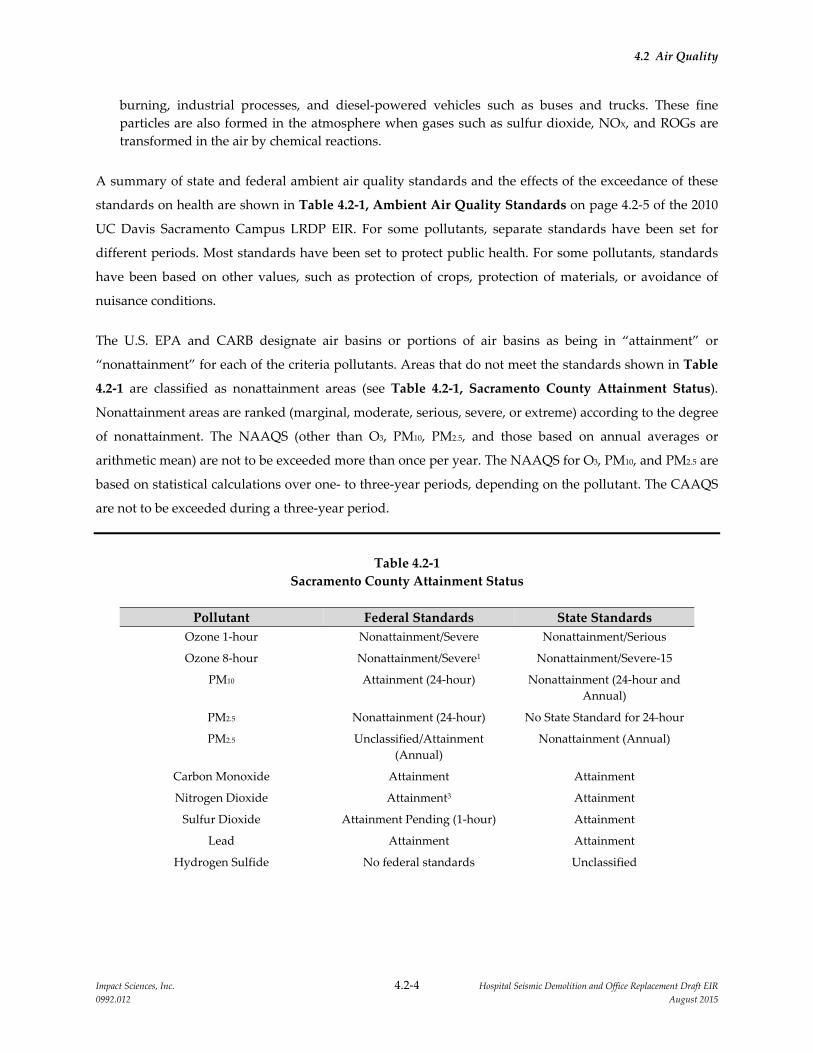
4.2 Air Quality
Impact Sciences, Inc. 4.2‐4 Hospital Seismic Demolition and Office Replacement Draft EIR
0992.012 August 2015
burning, industrial processes, and diesel‐powered vehicles such as buses and trucks. These fine
particles are also formed in the atmosphere when gases such as sulfur dioxide, NOX, and ROGs are
transformed in the air by chemical reactions.
A summary of state and federal ambient air quality standards and the effects of the exceedance of these
standards on health are shown in Table 4.2‐1, Ambient Air Quality Standards on page 4.2‐5 of the 2010
UC Davis Sacramento Campus LRDP EIR. For some pollutants, separate standards have been set for
different periods. Most standards have been set to protect public health. For some pollutants, standards
have been based on other values, such as protection of crops, protection of materials, or avoidance of
nuisance conditions.
The U.S. EPA and CARB designate air basins or portions of air basins as being in “attainment” or
“nonattainment” for each of the criteria pollutants. Areas that do not meet the standards shown in Table
4.2‐1 are classified as nonattainment areas (see Table 4.2‐1, Sacramento County Attainment Status).
Nonattainment areas are ranked (marginal, moderate, serious, severe, or extreme) according to the degree
of nonattainment. The NAAQS (other than O3, PM10, PM2.5, and those based on annual averages or
arithmetic mean) are not to be exceeded more than once per year. The NAAQS for O3, PM10, and PM2.5 are
based on statistical calculations over one‐ to three‐year periods, depending on the pollutant. The CAAQS
are not to be exceeded during a three‐year period.
Table 4.2‐1
Sacramento County Attainment Status
Pollutant Federal Standards State Standards
Ozone 1‐hour Nonattainment/Severe Nonattainment/Serious
Ozone 8‐hour Nonattainment/Severe1 Nonattainment/Severe‐15
PM10 Attainment (24‐hour) Nonattainment (24‐hour and
Annual)
PM2.5 Nonattainment (24‐hour) No State Standard for 24‐hour
PM2.5 Unclassified/Attainment
(Annual)
Nonattainment (Annual)
Carbon Monoxide Attainment Attainment
Nitrogen Dioxide Attainment3 Attainment
Sulfur Dioxide Attainment Pending (1‐hour) Attainment
Lead Attainment Attainment
Hydrogen Sulfide No federal standards Unclassified

4.2 Air Quality
Impact Sciences, Inc. 4.2‐5 Hospital Seismic Demolition and Office Replacement Draft EIR
0992.012 August 2015
Pollutant Federal Standards State Standards
Sulfates No federal standards Attainment
Vinyl Chloride No federal standards Unclassified
Visibility‐Reducing Particulates No federal standards Unclassified
Source: Sacramento Metropolitan Air Quality Management District, “Air Quality Standards Attainment Status,”
http://www.airquality.org/aqdata/attainmentstat.shtml. August 2015.
1 A formal request for voluntary reclassification from “serious” to “severe” for the 8‐hour ozone nonattainment area with an
associated attainment deadline of June 15, 2019, was submitted by CARB to the U.S. EPA on February 14, 2008. The U.S. EPA
approved the reclassification request on April 15, 2010.
The determination of whether an area is meeting the state and/or federal standards is based on air quality
monitoring data. Some areas are unclassified, which means there is insufficient monitoring data for
determining attainment or nonattainment. Unclassified areas are typically treated as being in attainment.
Because the attainment/nonattainment designation is pollutant specific, an area may be classified as
nonattainment for one pollutant and attainment for another. Similarly, because the state and federal
standards differ, an area could be classified as attainment for the federal standards of a pollutant and as
nonattainment for the state standards of the same pollutant.
4.2.2.3 Toxic Air Contaminants
In addition to criteria pollutants, CARB periodically assesses the health impacts and ambient levels of
toxic air contaminants in California. The U.S. EPA assesses health impacts for hazardous air pollutants. A
toxic air contaminant is defined by California Health and Safety Code:3
“Toxic air contaminant” means an air pollutant which may cause or contribute to an increase in
mortality or in serious illness, or which may pose a present or potential hazard to human health. A
substance that is listed as a hazardous air pollutant pursuant to subsection (b) of Section 112 of
the federal act (42 U.S.C. Sec. 7412(b)) is a toxic air contaminant.
As noted in the definition above, all U.S. EPA hazardous air pollutants are considered to be toxic air
contaminants. CARB has assessed inhalation cancer risk for the state and has provided risk maps based
on the Assessment System for Population Exposure Nationwide (ASPEN)4 dispersion model. The ASPEN
model is used in the U.S. EPA’s National Air Toxics Assessment5 study. The risk maps depict inhalation
cancer risk due to modeled outdoor toxic pollutant levels, and do not account for cancer risk due to other
types of exposure (i.e., direct or ingestion). Based on CARB’s assessment, the largest contributor to
3 California Air Resources Board, “California Air Pollution Control Laws: Health and Safety Code ‐ Section
39655,” http://www.arb.ca.gov/bluebook/bb00/toc00.htm.
4 US Environmental Protection Agency, “The ASPEN Model,” http://www.epa.gov/ttn/atw/nata /aspen.html. n.d.
5 US Environmental Protection Agency, “National Air Toxics Assessments,” http://www.epa.gov/ttn
/atw/natamain/. n.d.

4.2 Air Quality
Impact Sciences, Inc. 4.2‐6 Hospital Seismic Demolition and Office Replacement Draft EIR
0992.012 August 2015
inhalation cancer risk is diesel emissions, which is consistent with the result of other studies, such as the
South Coast Air Quality Management District’s Multiple Air Toxics Exposure Study III (MATES III).6
In 2004, CARB conducted a health risk assessment of airborne particulate matter emissions from
diesel‐fueled locomotives at the Union Pacific J.R. Davis Yard located in Roseville, California. The study
found that the background cancer risk for the broader Sacramento region was 360 in a million for diesel
particulate matter and 520 in a million for all toxic air contaminants.7
4.2.2.4 Sensitive Receptors
Sensitive populations (sensitive receptors) are more susceptible to the effects of air pollution than is the
population at large. The SMAQMD defines sensitive receptors as “facilities that house or attract children,
the elderly, people with illnesses, or others who are especially sensitive to the effects of air pollutants.”
Hospitals, schools, convalescent facilities, and residential areas are examples of sensitive receptors.8
Sensitive receptors that are near localized sources of criteria pollutants, toxic air contaminants, and CO
are of particular concern. For the purposes of impact assessment, the definition of sensitive receptors is
typically expanded to include residences, playgrounds, rehabilitation centers, and athletic facilities.
The 142‐acre UC Davis Sacramento Campus (Sacramento campus) contains 1,887,850 square feet of
hospital facilities, 621,250 square feet of ambulatory care facilities, 525,575 square feet of education and
research facilities, 407,867 square feet of administration and support facilities, and associated parking
structures. The campus is bound by V Street on the north, Stockton Boulevard to the West, Broadway
Street to the south, and a residential neighborhood to the east. Beyond Stockton Boulevard, V Street, and
Broadway Street, residential land uses are located to the north, south, and west, and commercial land
uses located to the south of the campus. The proposed project includes the construction and operation of
a new office building in the northern portion of the campus adjacent to the Main Hospital, and the
demolition of two existing buildings in the same general area. The nearest sensitive receptors would be
the patients in the Main Hospital and other facilities on the campus and residents of homes located to the
north of V Street.
4.2.3 REGULATORY CONSIDERATION
Air quality within Sacramento County is addressed through the efforts of various federal, state, regional,
and local government agencies. These agencies work individually, as well as jointly, to improve air
6 South Coast Air Quality Management District, “MATES III: Multiple Air Toxics Exposure Study,”
http://www.aqmd.gov/prdas/matesIII/matesIII.html. 2008.
7 California Air Resources Board, Roseville Rail Yard Study, (2004) 5.
8 Sacramento Municipal Air Quality Management District, CEQA Guide, (2009) 2–4.

4.2 Air Quality
Impact Sciences, Inc. 4.2‐7 Hospital Seismic Demolition and Office Replacement Draft EIR
0992.012 August 2015
quality through legislation, regulations, planning, policy making, education, and a variety of other
programs. The agencies primarily responsible for improving the air quality within the county include the
U.S. EPA, CARB, SMAQMD, and the Sacramento Area Council of Governments (SACOG). The City of
Sacramento includes policies in its 2030 General Plan that are designed to improve air quality. The UC
Davis Sacramento Campus 2010 LRDP, which was adopted for the Sacramento campus by the University
in 2009, also includes policies that govern development on the campus and pertain to air quality. These
agencies, their laws, regulations, rules, plans, and policies as they pertain to air quality and the proposed
project are discussed below.
4.2.3.1 Federal
The U.S. EPA is responsible for enforcing the Clean Air Act (CAA) and the NAAQS that the act
establishes. This agency also has regulatory and enforcement jurisdiction over emission sources beyond
state waters (outer continental shelf), and those that are under the exclusive authority of the federal
government, such as aircraft, locomotives, and interstate trucking.
The CAA was originally adopted in 1970, but was amended most recently in 1990 with regulations that
better protect the public’s health and create more efficient methods of lowering pollutant emissions. The
major areas of improvement resulting from the amendments include air basin designations (previously
discussed), automobile/heavy‐duty engine emissions, and toxic air pollutants. The amendments
established more stringent standards for hydrocarbons, NOX, and CO emissions in order to reduce O3 and
CO levels in heavily populated areas. Fuels became more strictly regulated, requiring new fuels to be less
volatile, contain less sulfur (regarding diesel fuels), and have higher levels of oxygenates
(oxygen‐containing substances to improve fuel combustion).
The 1990 Clean Air Act Amendments (CAAA) lists 189 hazardous air pollutants (HAPs), which are
carcinogenic, mutagenic, and/or reproductive toxicants, to be reduced. The air toxics program under the
CAA involves locating all major (greater than 10 tons per year [tpy]) stationary and area emission sources
in order to implement Maximum Achievable Control Technology (MACT) to reduce HAP emissions and
their associated health impacts.
States with basins that are not in attainment with the NAAQS are required to submit a State
Implementation Plan (SIP) that describes how the air basin will achieve the federal standards by specified
dates. The SIP includes strategies and control measures to attain the NAAQS by deadlines established by
the CAA. The CAA amendments dictate that states containing areas violating the NAAQS revise their SIP
to include extra control measures to reduce air pollution. SIPs are not single documents, but are a
4.2 Air Quality
Impact Sciences, Inc. 4.2‐8 Hospital Seismic Demolition and Office Replacement Draft EIR
0992.012 August 2015
compilation of state regulations, air quality management/attainment plans, programs, and air district
rules that are continuously revised to meet CAA amendment requirements.
Local air districts, such as the SMAQMD, and other agencies prepare air quality management/attainment
plans and submit them to CARB for review and approval. Once a plan is approved, CARB forwards the
plan to the U.S. EPA as a SIP revision. The U.S. EPA reviews the plan to determine if it conforms to the
1990 amendments and would achieve that air basin’s air quality goals. Upon a satisfactory review,
approval of the plan is published in the Federal Register.
In general, air quality management/attainment plans contain a discussion of ambient air data and trends;
a baseline emissions inventory; future‐year projections of emissions, which account for growth and
already adopted control measures; a comprehensive control strategy of additional measures needed to
reach attainment; attainment demonstration, which generally involves complex modeling; and
contingency measures. Plans may also include interim milestones for progress toward attainment. The
status of the Sacramento County portion of the SVAB with respect to attainment with the NAAQS is
summarized above in Table 4.2‐1.
4.2.3.2 State
The California Clean Air Act (CCAA) established a legal mandate for air basins to achieve the CAAQS by
the earliest practical date. The CAAQS, established by CARB, apply to the same seven pollutants as the
NAAQS, as well as to sulfates, visibility‐reducing particles, hydrogen sulfide, and vinyl chloride. The
CAAQS are more stringent than the NAAQS, and in the case of PM10 and SO2, far more stringent.
As a branch of the California Environmental Protection Agency (CalEPA), CARB oversees air quality
monitoring, planning, and control throughout California. It is primarily responsible for implementing the
CCAA, ensuring conformance with CAA requirements, and for regulating emissions from motor vehicles
and consumer products within the state. In addition, CARB sets the CAAQS and control measures for
toxic air contaminants (TACs). CARB approves the regional air quality management/attainment plans for
incorporation into the SIP and is responsible for preparing those portions of the SIP that are related to
mobile source emissions. CARB establishes new standards for vehicles sold in California and for various
types of commercially available equipment. It also sets fuel specifications to further reduce vehicular
emissions.
CARB also makes area designations for O3, CO, NO2, SO2, PM10, PM2.5, sulfates, lead, hydrogen sulfide,
and visibility‐reducing particles. Health and Safety Code Section 39607(e) requires CARB to establish and
periodically review area designation criteria. These designation criteria provide the basis for CARB to
designate areas of the state as “attainment,” “nonattainment,” or “unclassified” according to state
4.2 Air Quality
Impact Sciences, Inc. 4.2‐9 Hospital Seismic Demolition and Office Replacement Draft EIR
0992.012 August 2015
standards. In addition, Health and Safety Code Section 39608 requires CARB to use the designation
criteria to classify areas of the state and to annually review those area designations.
4.2.3.3 Regional
Sacramento Area Council of Governments
The SACOG is an association of local governments in the Sacramento County region that provides
transportation planning and funding for the region. Although SACOG is not an air quality management
agency, it is responsible for several air quality planning issues. Specifically, as the designated
Metropolitan Planning Organization for the Sacramento region, it is responsible, pursuant to Section
176(c) of the 1990 amendments to the federal CAA, for providing current population, employment, travel,
and congestion projections for regional air quality planning efforts.
Sacramento Metropolitan Air Quality Management District
The SMAQMD has jurisdiction over most air quality matters within the Sacramento County portion of
the SVAB. The SMAQMD regulates most stationary sources of air pollutant in Sacramento County,
maintains ambient air quality monitoring stations at numerous locations, and prepares the air quality
management/attainment plans for the area that are required under the CAA and CCAA. Additional
details regarding SMAQMD planning efforts for regional air quality attainment are summarized in the
UC Davis Sacramento Campus 2010 LRDP EIR beginning on page 4.2‐14.
SMAQMD Rules and Regulations
The SMAQMD’s primary means of implementing its attainment plans is through its adopted rules and
regulations. The proposed project would be subject to the following rules adopted by the SMAQMD that
are designed to reduce and control pollutant emissions throughout the Sacramento County portion of the
air basin.
Rule 201 (Permit Required): This rule requires that any project constructing, altering, replacing, or
operating any stationary source operation, the use of which emits, may emit, or may reduce
emissions, to obtain an Authority to Construct (ATC) and a Permit to Operate (PTO). This rule
applies to the construction and operation of new or modified processes and equipment, except those
specifically exempted from permitting requirements.
Rule 202 (New Source Review): This rule applies to all new and modified stationary sources that
would emit, after construction, a criteria pollutant for which there is an established NAAQS or
CAAQS. The rule provides mechanisms by which an ATC can be granted without interfering with
the basin’s attainment with ambient air quality standards. These mechanisms offer methods to

4.2 Air Quality
Impact Sciences, Inc. 4.2‐10 Hospital Seismic Demolition and Office Replacement Draft EIR
0992.012 August 2015
generate no net increases in emissions of nonattainment pollutants over specific thresholds as
detailed in the rule.
Rule 207 (Title V Federal Operating Permit Program): The purpose of this rule is to establish an
operating permitting system consistent with the requirements of 42 U.S.C. Section 7661 et seq. (Title
V) and pursuant to 40 CFR Part 70. Stationary sources subject to the requirements of this rule are also
required to comply with any other applicable federal, state, or District orders, rules and regulations,
including requirements pertaining to prevention of significant deterioration pursuant to Rule 203,
Prevention of Significant Deterioration, requirements to obtain an authority to construct pursuant to
Rule 201, General Permit Requirements, or applicable requirements under Rule 202, New Source
Review.
Rule 401 (Ringelmann Chart/Opacity): This rule limits the discharge of air contaminants
(i.e., fugitive dust, diesel exhaust) into the atmosphere through visible emissions and opacity.
Rule 402 (Nuisance): This rule applied to any source operation that emits air contaminants or other
materials which cause injury, detriment, nuisance or annoyance to any considerable number of
persons or the public, or which endanger the comfort, repose, health or safety of any such persons or
the public, or which cause or have natural tendency to cause injury or damage to business or
property. In the event that the project or construction of the project creates a public nuisance, it could
be in violation and subject to district enforcement action.
Rule 403 (Fugitive Dust): The purpose of this rule is to reasonably regulate operations that
periodically may cause fugitive dust emissions into the atmosphere.
Rule 404 (Particulate Matter): The purpose of this rule is to limit the quantity of particulate matter in
the atmosphere through establishment of an emission concentration limit.
Rule 405 (Dust and Condensed Fumes): The purpose of this rule is to limit the discharge of dust and
condensed fumes into the atmosphere by establishing emission rates based on process weight.
Rule 406 (Specific Contaminants): The purpose of this rule is to limit the emission of sulfur
compounds and combustion contaminants through establishment of emission concentrations.
Rule 412 (Stationary Internal Combustion Engines Located at Major Stationary Sources of NOX):
The purpose of this rule is to limit emissions of NOX, CO, and non‐methane hydrocarbons from the
operation of stationary internal combustion engines, rated at more than 50 brake horsepower, located
at a major stationary source of NOX.
Rule 413 (Stationary Gas Turbines): The purpose of this rule is to limit emissions of nitrogen oxides
to the atmosphere from the operation of stationary gas turbines.
Rule 414 (Natural Gas‐Fired Water Heaters): The purpose of this rule is to limit emissions of
nitrogen oxides from natural gas‐fired water heaters.
Rule 420 (Sulfur Content of Fuels): The purpose of this rule is to limit the emission of compounds of
sulfur from combustion of fuels.

4.2 Air Quality
Impact Sciences, Inc. 4.2‐11 Hospital Seismic Demolition and Office Replacement Draft EIR
0992.012 August 2015
Rule 442 (Architectural Coatings): The purpose of this rule is to limit the quantity of volatile organic
compounds in architectural coatings supplied, sold, offered for sale, applied, solicited for application,
or manufactured for use within the District.
Rule 902 (Asbestos): The purpose of this rule is to implement U.S. EPA’s National Emission Standard
for Hazardous Air Pollutants (NESHAP) for Asbestos (40 C.F.R. Section 61.140 et. seq.) and to limit
the emission of asbestos to the atmosphere. The NESHAP requires that all buildings be properly
inspected for the presence of asbestos prior to demolition and renovation and that the SMAQMD be
notified before any demolition or renovation activity occurs.
4.2.3.4 Local Plans and Policies
The Sacramento campus is a University of California campus that conducts work within the University’s
mission on land that is owned or controlled by The Regents of the University of California. As an entity of
the State Constitution, the University is exempted from compliance with local land use regulations,
including general plans and zoning. However, the University seeks to develop its property in a manner
that minimizes potential land use conflicts with local jurisdictions to the extent feasible. The UC Davis
Sacramento Campus 2010 LRDP is the land use plan that is applicable to all development on the
Sacramento campus. The following subsection summarizes elements from that plan that relate to air
quality.
UC Davis Sacramento Campus 2010 Long Range Development Plan
The 2010 LRDP does not contain policies that specifically address air quality. However, the LRDP does
contain elements with respect to energy‐efficiency and encouraging alternative transportation which
would reduce air pollutant emissions and emissions of ozone‐depleting substances. These elements
would encourage walking and bicycling on the campus and in surrounding neighborhoods. The
following principles would reduce the project’s air quality impacts.
Principle #1 Ensure Appropriate Facilities Adjacencies. Facility adjacencies help create
efficiencies in operations and in the movement of patients, visitors, students,
faculty, and staff. Recognizing existing major building investments, new facilities
will be located in reasonable proximity to the current primary UCDHS
mission‐related uses.
Principle #2 Improve Campus Open Space and Landscape Character. While the Sacramento
campus has a number of attractive open spaces and landscaped areas, the
campus falls short of being the welcoming environment that it might be. For
instance, the campus lacks a large green quad or other major open space
typically associated with an academic institution. Also, the site does not yet

4.2 Air Quality
Impact Sciences, Inc. 4.2‐12 Hospital Seismic Demolition and Office Replacement Draft EIR
0992.012 August 2015
capture the special nature of “the City of Trees” that characterizes the City of
Sacramento, especially the downtown, State Capitol area, and downtown
neighborhoods. The planned program growth at the campus would improve the
open space character of the campus.
Principle #3 Provide Convenient Access to and within the Campus. Providing convenient
access to and connections within the campus is crucially important to the
successful operations of UCDHS. Within the areas of education and research,
parking will move to the periphery in order to support a more
pedestrian‐friendly, auto‐free environment similar to a traditional higher
education campus. The Campus will continue to incorporate alternate means of
transportation to and from the campus with a particular focus on the commute
habits of faculty, staff, and students. The Campus will support improved
transportation options such as working with RT to improve bus and light rail
service to and near the campus, and identify potential improvements to
Campus‐operated shuttle systems The Campus will implement appropriate
alternate mode use incentives such as discounted transit passes; carpool
matching services; preferential parking for carpools, vanpools and low emissions
vehicles; and flexible car share programs for the campus. The Campus will also
implement parking management policies, such as pricing, to encourage use of
alternate modes. Finally the campus will encourage students in particular to live
in close proximity of the campus to facilitate daily commuting.
Principle #4 Improve Pedestrian Connections throughout the Campus. All areas of the
campus will be improved for better pedestrian access. The open space system of
the connecting malls will provide the backbone of the connection system.
Pedestrian walkways and tree‐lined sidewalks will provide additional
connections and will ensure easy and efficient ways to move throughout the
campus without needing to drive.
Principle #5 Provide Attractive Campus Entries and Edges. Patient access will be focused at
two street entry points: Stockton Boulevard and X Street, and Broadway and 50th
Street. These entries will provide access to the Patient Care Boulevard, and will
simplify access for patients all clinical destinations. In order to minimize impacts
on surrounding neighborhoods, access to the campus for general traffic from V
Street will be limited to only one location at 49th Street. Other existing entry
4.2 Air Quality
Impact Sciences, Inc. 4.2‐13 Hospital Seismic Demolition and Office Replacement Draft EIR
0992.012 August 2015
points at 45th and 48th Streets will be closed to general traffic with only service or
emergency vehicles allowed.
Principle #6 Continue to Plan and Operate a Sustainable Campus. The University of
California has been a leader in its sustainability practices. The Board of Regents
directed the UC President to create a Policy on Sustainable Practices in 2003
which set ambitious goals to advance environmental practices. This policy
continues to be updated. Recent reporting indicates that UC has achieved great
advances in important areas of energy and waste. In addition UC has received
recognition as a national leader in the full spectrum of sustainability areas and is
considered among the top tier of “green universities.” The University is
committed to developing a long term strategy for meeting the State’s goal of a
reduction of greenhouse gas (GHG) emissions to 2000 levels by 2014, is further
pursuing the goal of reducing GHG emissions to 1990 levels by 2020, and is
developing an action plan for becoming carbon neutral.
4.2.4 IMPACTS AND MITIGATION MEASURES
4.2.4.1 Significance Criteria
The impacts from the implementation of the proposed project on air quality would be considered
significant if they would exceed the following significance criteria, in accordance with Appendix G of the
State CEQA Guidelines and the UC CEQA Handbook:
Conflict with or obstruct implementation of the applicable air quality plan;
Violate any air quality standard or contribute substantially to an existing or projected air quality
violation;
Result in a cumulatively considerable net increase of any criteria pollutant for which the project
region is nonattainment under an applicable federal or state ambient air quality standard (including
releasing emissions which exceed quantitative thresholds for ozone precursors;
Expose sensitive receptors to substantial pollutant concentrations; or
Create objectionable odors affecting a substantial number of people.
The State CEQA Guidelines further state that the significance thresholds recommended by the applicable
air quality management or air pollution control district may be relied on to make the determinations
above. Therefore, to assess the project’s impact relative to the significance criteria listed above, air quality
impact significance thresholds put forth by the SMAQMD have been used in this EIR. These thresholds

4.2 Air Quality
Impact Sciences, Inc. 4.2‐14 Hospital Seismic Demolition and Office Replacement Draft EIR
0992.012 August 2015
are contained in the SMAQMD’s CEQA Guide. The SMAQMD’s thresholds of significance for
construction‐ and operational‐related emissions are presented in Table 4.2‐2, SMAQMD Air Quality
Impact Significance Thresholds. If the proposed project’s emissions would exceed any of the emission
thresholds listed in Table 4.2‐2, the impact from the emissions of the specific pollutant will be considered
a significant impact.
Table 4.2‐2
SMAQMD Air Quality Impact Significance Thresholds
Phase SMAQMD Thresholds
Construction Phase Operational Phase
Mass Emission Thresholds
NOx (ozone precursor) 85 pounds per day 65 pounds per day
ROG (VOC) (ozone precursor) None 65 pounds per day
PM10 Zero (0). If all feasible
BACT/BMP’s are applied; then 80
pounds per day and 14.6 tons per
year
Zero (0). If all feasible
BACT/BMP’s are applied; then 80
pounds per day and 14.6 tons per
year
PM2.5 Zero (0). If all feasible
BACT/BMP’s are applied; then 82
pounds per day and 15 tons per
year
Zero (0). If all feasible
BACT/BMP’s are applied; then 82
pounds per day and 15 tons per
year
Concentration Thresholds (based on the California Ambient Air Quality Standards, identical to both phases of development)
CO 20 ppm 1‐hour standard (23 mg/m3 ); 9 ppm 8‐hour standard (10 mg/m3 )
NO2 0.18 ppm 1‐hour standard (339 μg/m3 ); 0.03 ppm Annual Arithmetic
Mean (57 μg/m3 )
SO2 0.25 ppm 1‐hour standard (665 μg/m3 ); 0.04 ppm 24‐hour standard (105
μg/m3 )
Lead 1.5 μg/m3 30‐day average
Visibility reducing particles Extinction coefficient of 0.23 per kilometer ‐ visibility of ten miles or more
due to particles when relative humidity is less than 70 percent
Sulfates 25 μg/m3 24‐hour standard
H2S 0.03 ppm (42 μg/m3 ) 1‐hour standard
Vinyl Chloride 0.01 ppm (26 μg/m3 ) 24‐hour standard
Source: Sacramento Metropolitan Air Quality Management District, CEQA Guide. June 2015.
Mass emissions thresholds shown in Table 4.2‐2 are addressed through modeling using the most recent
version of the California Emissions Estimator Model (CalEEMod). Concentration thresholds, reported in
Table 4.2‐2, are based on ambient air quality standards. These thresholds are applied if there is a

4.2 Air Quality
Impact Sciences, Inc. 4.2‐15 Hospital Seismic Demolition and Office Replacement Draft EIR
0992.012 August 2015
potential for the project to cause or contribute to violations of ambient air quality standards. NOx
emissions thresholds address a project’s contribution to ground level ozone and nitrogen dioxide (NO2)
standards. Projects with mass emissions of NOx below the mass emissions thresholds would not be
considered to cause or contribute to violations of the NOx concentration threshold. Other concentration
thresholds in Table 4.2‐2 for carbon monoxide, sulfur dioxide, and lead are of less concern for the
proposed project because construction activities are not likely to generate substantial quantities of these
pollutants. As far as project operations are concerned, traffic is the primary source of emissions, which
could affect ambient carbon monoxide concentrations, and the CO impacts are evaluated in this EIR
relative to the concentration threshold for CO.
The SMAQMD’s CEQA Guide also states that a project’s impact would be considered significant if it
results in:
An incremental cancer risk greater than 10 in 1 million at any off‐site receptor; or
Ground‐level concentration of project‐generated TACs that would result in a Hazard Index greater
than 1 at any off‐site receptor.
4.2.4.2 CEQA Checklist Items Adequately Addressed in the Initial Study
The analysis in the Initial Study prepared for the project and circulated with the NOP concluded that
further analysis of the following issues was not required in the EIR.
Create objectionable odors affecting a substantial number of people.
The proposed project would not produce unusual odors because the proposed redevelopment would not
result in industrial processing, large‐scale manufacturing operations such as food processing, agricultural
waste processing, or storage of products with unusual odors. No impact would occur and no further
analysis if required.
4.2.4.3 Methodology
The methodology used to evaluate the air quality impacts associated with construction and operation of
the proposed project is based on the SMAQMD’s CEQA Guide,9 the California Emissions Estimator
Model (CalEEMod, version 2013.2.2), and the CalEEMod user guide. The construction emissions
estimates are based on expected construction and demolition phasing schedules and equipment activity
9 Sacramento Metropolitan Air Quality Management District, “CEQA Guide to Air Quality Assessment,”
http://www.airquality.org/ceqa/ceqaguideupdate.shtml . June 2015.
4.2 Air Quality
Impact Sciences, Inc. 4.2‐16 Hospital Seismic Demolition and Office Replacement Draft EIR
0992.012 August 2015
levels. Emission calculations and air quality modeling conducted for the project are provided in
Appendix 4.2.
While not a requirement of CEQA, the analysis of potential adverse air quality impacts in this EIR
incorporates a conservative approach. This approach entails the premise that whenever the analysis
requires that assumptions be made or default values be used, the assumptions and default values that
result in the greatest reasonable adverse impacts are typically chosen. This method ensures that no
potential effects of the proposed project are understated.
Construction‐related emissions can be distinguished as either on site or off site. On‐site emissions
generated during construction principally consist of exhaust emissions (ROG, NOX, CO, SOX, PM10, and
PM2.5) from the operation of heavy‐duty construction equipment, fugitive dust (PM10 and PM2.5) from
disturbed soil and building demolition, and ROG emissions from asphalt paving and architectural
coating. Off‐site emissions during the construction phase normally consist of exhaust emissions and
entrained paved road dust (PM10 and PM2.5) from construction worker commute trips, material delivery
trips, and haul truck material removal trips to and from the construction site.
4.2.4.4 LRDP EIR Mitigation Measures Included in the Proposed Project
Table 4.2‐3, 2010 LRDP EIR Mitigation Measures, presents the mitigation measures in the 2010 LRDP
EIR that are applicable to the proposed project. Since these previously adopted mitigation measures are
already being carried out as part of implementation of the 2010 LRDP, they are included in and are a part
of the proposed project and will not be readopted. Implementation of these mitigation measures is
assumed as part of the project impact analysis.
Table 4.2‐3
2010 LRDP EIR Mitigation Measures
Mitigation
Measure Description
LRDP Mitigation
Measure AIR‐1b
For each construction project on the campus, the project contractor will
implement the following PM10 and PM2.5 control measures, as
appropriate:
Water exposed soil with adequate frequency to minimize fugitive
dust. However, the contractor shall not overwater to the extent
that sediment flows off the site.
Suspend excavation, grading, and/or demolition activity when
wind speeds exceed 20 mph.
Install wind breaks (e.g., solid fencing) on windward side(s) of
construction areas.
4.2 Air Quality
Impact Sciences, Inc. 4.2‐17 Hospital Seismic Demolition and Office Replacement Draft EIR
0992.012 August 2015
Mitigation
Measure Description
Plant vegetative ground cover in disturbed areas as soon as
possible. Water appropriately until vegetation is established.
Prevent soil from leaving the construction site (e.g., install wheel
washers for all exiting trucks, or wash off all trucks as equipment
leaving the site; Treat site accesses to a distance of 100 feet from
the paved road with a 6‐ to 12‐inch layer of wood chips, mulch, or
gravel to reduce generation of road dust carryout onto public
roads).
Post a publicly visible sign with the telephone number and
person to contact at the lead agency regarding dust complaints.
This person shall respond and take corrective action within 48
hours. The phone number of the District shall also be visible to
ensure compliance.
LRDP Mitigation
Measure AIR‐1b
For each construction project on the campus, the University shall
require that the project include a construction emissions control plan
that includes a comprehensive inventory of all off‐road construction
equipment, equal to or greater than 50 horsepower, that will be used
for an aggregate of 40 or more hours during any portion of the
construction project. The inventory shall include the horsepower
rating, engine production year, and projected hours of use for each
piece of equipment. The inventory shall be updated monthly
throughout the duration of the project as needed, except that an
inventory shall not be required for any 30‐day period in which no
construction activity occurs. The plan will also include the anticipated
construction timeline including start date, and name and phone
number of the project manager and on‐site foreman. The plan will also
demonstrate that the heavy‐duty (> 50 horsepower) self‐propelled
off‐road equipment to be used in the construction project, including
owned, leased and subcontractor vehicles, will achieve a project‐wide
fleet‐average 20 percent NOX reduction or greater and 45 percent
particulate reduction or greater compared to the most recent CARB
fleet average at the time of project construction. The University shall
retain a copy of the construction emissions control plan on the campus,
which will be made available to the agencies and the public upon
request.
LRDP Mitigation
Measure AIR‐4
Because the bulk of the TAC emissions resulting in the significant
human health risk operational impacts would be emitted by the
existing and future stationary sources on the campus such as the
Central Energy Plant boilers, and emergency generator testing, a
number of potential mitigation measures were identified that focused
on these stationary sources. These mitigation measures include the
following:
Limit fuel oil usage to 40 hrs/yr for the Building 34 emergency
generator
4.2 Air Quality
Impact Sciences, Inc. 4.2‐18 Hospital Seismic Demolition and Office Replacement Draft EIR
0992.012 August 2015
Mitigation
Measure Description
Limit natural gas usage to 500,000 Therms per year (each) for
existing Central Energy Plant boilers 1, 2, 3, and 4
Limit natural gas usage to 500,000 Therms per year (each) for
future Central Energy Plant boilers 1, 2, and 3
Remove rain caps from the existing Central Plant boilers and
replace with rain sleeves, while increasing overall stack height by
10 feet
LRDP Mitigation
Measure AIR‐6
The University will implement LRDP Mitigation Measure AIR‐1,
which is designed to reduce construction emissions. It will also
implement LRDP Mitigation Measure TRA‐1 which will reduce
traffic‐related air pollutant emissions resulting from campus
operations. For new and expanded stationary sources on the campus,
the University will comply with BACT and offset requirements.
LRDP
Cumulative
Mitigation
Measure AIR‐1
The University will work with SACOG to ensure that campus growth
is accounted for in the regional population and employment
projections so that the emissions associated with campus growth can
be accounted for in the regional air quality plans.
Source: UC Davis Sacramento Campus, 2010 LRDP EIR, Section 4.2, Air Quality.
4.2.4.5 Project Impacts and Mitigation Measures
Impact AIR‐1: Construction of the proposed project would not result in construction
emissions that violate an air quality standard or contribute substantially to an
existing or projected air quality violation. (Less than Significant)
The proposed project would include demolition and construction activities from 2016 through 2021.
While the intensity of the demolition and construction activities would vary depending on the details of
each particular sequence, the activities are planned to sequentially follow one another with little overlap
between the demolition and construction efforts. In total, through the six‐year construction and
demolition period, the proposed project would demolish 245,000 square feet of space (equivalent to
539,000 cubic feet of demolition materials), construct 130,000 square feet of new building space, develop
two small pedestrian plaza areas, and reconstruct the west façade of the remaining hospital building.
These activities are part of the demolition and construction efforts that were anticipated as part of the
long‐term development plan adopted in the 2010 LRDP for the UC Davis Sacramento Campus. To date,
the development anticipated to occur under the 2010 LRDP has been less intense than planned in terms of
new facilities and population growth.

4.2 Air Quality
Impact Sciences, Inc. 4.2‐19 Hospital Seismic Demolition and Office Replacement Draft EIR
0992.012 August 2015
The 2010 LRDP growth projections through the year 2025 were evaluated for potential air quality impacts
in Section 4.2 of the 2010 LRDP EIR. Beginning on page 4.2‐24, the 2010 LRDP EIR included analysis of
anticipated demolition and construction air quality impacts. At the time of the 2010 LRDP, the project
details for the Hospital Seismic Demolition and Office Replacement project were not known and the
details (location, timing, and sizes) of other potential projects were not known. The 2010 LRDP EIR air
quality analysis conducted demolition and construction air quality analysis based on the assumption that
every three years of LRDP implementation would result in 1.33 million cubic feet of demolition effort,
approximately 790,000 square feet of new building space, and additional construction for new parking
facilities.
To develop an estimate of the maximum possible construction emissions that could result from the
projected new development under the 2010 LRDP, it was assumed that there would be ongoing
construction on the campus between 2011 and 2025, and that all the new building space proposed under
the 2010 LRDP would be completely constructed by 2025. During this period, construction emissions of
criteria pollutants and diesel particulate matter (DPM) would be generated by heavy‐duty construction
equipment, on‐road trucks for material deliveries, and construction worker vehicles. ROG emissions
would occur as a result of asphalt paving and architectural coatings. In addition, fugitive dust would be
generated by grading and related activities. Based on this assumed rate of growth, the 2010 LRDP EIR
then calculated (using the URBEMIS2007 modeling tool) potential demolition and construction emissions
as described below. The amount of growth analyzed in the 2010 LRDP EIR emission projection in
comparison to the currently proposed project are shown in Table 4.2‐4, Comparison of Prior LRDP EIR
Analysis to Proposed Project.
Table 4.2‐4
Comparison of Prior LRDP EIR Analysis to Proposed Project
Activity Type Six‐Year Quantity in 2010 LRDP
EIR Analysis
Quantity in Proposed Project and
Currently Anticipated Projects
Demolition 2.66 million cubic feet 0.539 million cubic feet
Building Construction 1,580,000 square feet 130,000 square feet
Parking Construction Approximately 500 Up to 12
Grading and Excavation 16 acres Approximately 3 acres
Paving Two acres One acre
Source: 2010 LRDP EIR; Section 4.2. 1 The 2010 LRDP EIR analysis included 1.33 million cubic feet and 790,000 square feet of building construction for every three‐
year period of LRDP implementation. The proposed project would take place over a six‐year period and the quantity comparison
expressed above provides LRDP EIR quantities for two, three‐year periods. 2 Air quality analysis included architectural coatings as an overlapping phase of Building Construction using URBEMIS2007
default assumptions. Asphalt paving for each phase was assumed to occur over four months overlapping with the last four
months of the building construction.

4.2 Air Quality
Impact Sciences, Inc. 4.2‐20 Hospital Seismic Demolition and Office Replacement Draft EIR
0992.012 August 2015
Based on assumptions described above and URBEMIS2007 default assumptions, the URBEMIS2007model
was used in the 2010 LRDP EIR air quality analysis to estimate annual unmitigated and mitigated
construction emissions of criteria pollutants from 2011 to 2025. The 2010 LRDP EIR projections identified
that PM10 and PM2.5 emissions would be of a sufficient level to likely result in ambient concentrations in
the project area that would potentially exceed 5 percent of the CAAQS. Therefore, conservatively it was
concluded in the 2010 LRDP EIR that construction emissions would result in a significant impact on air
quality. With adoption of the 2010 LRDP EIR, the University committed to implementation of LRDP
Mitigation Measures AIR‐1a and AIR‐1b detailed in Table 4.2‐3, above. LRDP Mitigation Measures AIR‐
1a and AIR‐1b require the University to reduce emissions (through items such as dust control and a
construction equipment inventory process) during implementation of the LRDP and are currently
required for all University projects (including the proposed project) at the Sacramento campus. The 2010
LRDP EIR projections of mitigated emissions over the six‐year period corresponding to the duration of
the proposed project are shown in Table 4.2‐5, Estimated Mitigated Construction Emissions from the
2010 LRDP EIR.
Table 4.2‐5
Estimated Mitigated Construction Emissions from 2010 LRDP EIR
Construction Year
Emissions in Pounds per Day
ROG NOX CO SOX PM10 PM2.5
2016 99.23 34.41 87.94 0.15 2.36 1.78
2017 7.46 40.96 88.90 0.15 48.36 10.87
2018 6.84 37.35 83.74 0.15 42.09 9.98
2019 97.77 26.42 73.14 0.15 1.94 1.39
2020 5.87 31.26 74.85 0.15 41.81 9.73
2021 5.26 27.57 60.73 0.15 41.69 9.62
Maximum Daily Emissions 101.16 71.21 133.70 0.15 49.26 11.70
SMAQMD Prior Threshold: — 85 — — — —
Exceeds Threshold? — NO — — YES1 YES1
SMAQMD Current Threshold — 85 — — 80 82
Exceeds Current Threshold NO NO NO
Source: 2010 LRDP EIR, Section 4.2.
Totals in the table may not appear to add exactly due to rounding in the computer model calculations. 1 Shown as an exceedance of the prior SMAQMD prior threshold because although modeling of PM10 and PM2.5 emissions was not conducted
to estimate the concentrations of these pollutants, but based on the estimated mass emissions, conservatively the analysis concluded that the
project generated PM10 and PM2.5 emissions will likely exceed CAAQS for these pollutants by 5 percent at nearby sensitive receptors
located in close proximity to construction activity. The 2010 LRDP EIR model results would not have exceeded the currently adopted
SMAQMD threshold.

4.2 Air Quality
Impact Sciences, Inc. 4.2‐21 Hospital Seismic Demolition and Office Replacement Draft EIR
0992.012 August 2015
As shown in Table 4.2‐5, while PM10 and PM2.5 emissions would be reduced by the implementation of the
mitigation measures noted above, emissions were projected to be a sufficient level to likely result in
ambient concentrations in the project area that would still have exceeded the CAAQS for these pollutants
at nearby receptors. Based on this analysis, the 2010 LRDP EIR identified the impact from construction
and demolition emissions as significant. If the 2010 LRDP EIR model results of 49.26 pounds per day of
PM10 and 11.70 pounds per day of PM2.5 are compared to the current SMAQMD significance thresholds
for particulate matter of 80 pounds per day of PM10 and 82 pounds per day of PM2.5, the impact from
construction and demolition emissions would be less than significant.
To update the prior analysis conducted for the 2010 LRDP EIR using the now available, project‐specific
details, the California Emissions Estimator Model (CalEEMod), which is recommended by the SMAQMD,
and the revised SMAQMD significance thresholds, a new analysis of construction emissions was
completed. The project dates for each phase are shown in Table 4.2‐6. The estimated daily and annual
demolition and construction emissions for 2016 through 2021 are shown below in Tables 4.2‐7, 4.2‐8, and
4.2‐9.
Table 4.2‐6
2016 through 2021 Construction/Demolition Phase Details
Phase
Phase Details
Facility Modeled Start
Date
Modeled End
Date
Demolition 1 Housestaff
Demolition 2/1/2016 2/19/2016
Site Preparation North Addition 3/1/2016 3/14/2016
Grading and Excavation North Addition 3/15/2016 3/28/2016
Construction North Addition 6/1/2016 6/1/2018
Paving North Addition 6/1/2018 6/4/2018
Architectural Coatings North Addition 3/15/2018 4/15/2018
Demolition 2.1 North/South Wing
Abatement and
Demolition
Preparation
12/1/2019 4/29/2020
Demolition 2.2 North/South Wing
Demolition 5/1/2020 7/20/2020
Note: During each period, model projections included 5 working days per week.
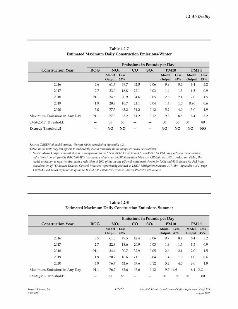
4.2 Air Quality
Impact Sciences, Inc. 4.2‐22 Hospital Seismic Demolition and Office Replacement Draft EIR
0992.012 August 2015
Table 4.2‐7
Estimated Maximum Daily Construction Emissions‐Winter
Construction Year
Emissions in Pounds per Day
ROG NOX CO SOX PM10 PM2.5
Model
Output
Less
20% Model
Output
Less
45%
Model
Output
Less
45%
2016 5.6 61.7 49.7 42.8 0.06 9.8 8.5 6.4 5.2
2017 2.7 23.0 18.8 22.1 0.03 1.9 1.3 1.5 0.9
2018 91.1 34.6 30.9 34.6 0.05 2.6 2.1 2.0 1.5
2019 1.9 20.8 16.7 21.1 0.04 1.4 1.0 0.96 0.6
2020 7.0 77.3 63.2 51.2 0.12 5.2 4.0 3.0 1.9
Maximum Emissions in Any Day 91.1 77.3 63.2 51.2 0.12 9.8 8.5 6.4 5.2
SMAQMD Threshold: — 85 85 — — 80 80 80 80
Exceeds Threshold? — NO NO — — NO NO NO NO
Source: CalEEMod model output. Output tables provided in Appendix 4.2..
Totals in the table may not appear to add exactly due to rounding in the computer model calculations. 1 Notes: Model Output amount shown in comparison to the “Less 20%” for NOx and “Less 45%” for PM. Respectively, these include
reductions from all feasible BACT/BMP’s (previously adopted as LRDP Mitigation Measure AIR‐1a). For NOx, PM10, and PM2.5, the
model projection is reported first with a reduction of 20% of the on‐site off‐road equipment shown for NOx and 45% shown for PM from
consideration of “Enhanced Exhaust Control Practices” (previously adopted as LRDP Mitigation Measure AIR‐1b). Appendix 4.2‐1, page
1 includes a detailed explanation of the NOx and PM Enhanced Exhaust Control Practices deductions.
Table 4.2‐8
Estimated Maximum Daily Construction Emissions‐Summer
Construction Year
Emissions in Pounds per Day
ROG NOX CO SOX PM10 PM2.5
Model
Output
Less
20% Model
Output
Less
45%
Model
Output
Less
45%
2016 5.5 61.5 49.5 42.4 0.06 9.7 8.4 6.4 5.2
2017 2.7 22.8 18.6 20.9 0.03 1.9 1.3 1.5 0.9
2018 91.1 34.4 30.7 32.9 0.05 2.6 2.1 2.0 1.5
2019 1.9 20.7 16.6 21.1 0.04 1.4 1.0 1.0 0.6
2020 6.9 76.7 62.6 47.6 0.12 5.2 4.0 3.0 1.9
Maximum Emissions in Any Day 91.1 76.7 62.6 47.6 0.12 9.7 8.4 6.4 5.2
SMAQMD Threshold: — 85 85 — — 80 80 80 80

4.2 Air Quality
Impact Sciences, Inc. 4.2‐23 Hospital Seismic Demolition and Office Replacement Draft EIR
0992.012 August 2015
Construction Year
Emissions in Pounds per Day
ROG NOX CO SOX PM10 PM2.5
Model
Output
Less
20% Model
Output
Less
45%
Model
Output
Less
45%
Exceeds Threshold? — NO NO — — NO NO NO NO
Source: CalEEMod model output. Output tables provided in Appendix 4.2..
Totals in the table may not appear to add exactly due to rounding in the computer model calculations. 1 Notes: Reported amounts include reductions from all feasible BACT/BMP’s (previously adopted as LRDP Mitigation Measure AIR‐1a).
For NOx, PM10, and PM2.5, the model projection is reported first with a reduction of 20% of the on‐site off‐road equipment shown for
NOx and 45% shown for PM from consideration of “Enhanced Exhaust Control Practices” (previously adopted as LRDP Mitigation
Measure AIR‐1b). Appendix 4.2, page 1 includes a detailed explanation of the NOx and PM Enhanced Exhaust Control Practices
deductions.
Table 4.2‐9
Estimated Annual Mitigated Construction Emissions
Construction Year
Emissions in Tons per Year
ROG NOX CO SOX PM10 PM2.5
2016 0.2895 2.5915 2.1513 ‐‐ 0.2118 0.1632
2017 0.3490 2.9817 2.7511 ‐‐ 0.2452 0.1889
2018 1.1045 1.1437 1.1486 ‐‐ 0.0936 0.0700
2019 0.0204 0.2281 0.2306 ‐‐ 0.0153 0.0105
2020 0.2721 3.0152 2.2762 ‐‐ 0.2004 0.1224
Maximum Annual Emissions 1.1045 3.01 2.7511 negligible 0.2452 0.1889
SMAQMD Threshold: — — — — 14.6 15
Exceeds Threshold? — — — — NO NO
Source: CalEEMod model output. Output tables provided in Appendix 4.2.
Totals in the table may not appear to add exactly due to rounding in the computer model calculations.
The CalEEMod results indicate that the NOx and particulate matter emissions from demolition and
construction activities of the proposed project would not exceed the SMAQMD daily or annual
thresholds for these pollutants during any of the implementation years. With anticipated emissions
projected to remain below the significance thresholds, the expected impact of demolition and
construction emissions would be less than significant.
Mitigation Measures: No project‐level mitigation measures are required.
4.2 Air Quality
Impact Sciences, Inc. 4.2‐24 Hospital Seismic Demolition and Office Replacement Draft EIR
0992.012 August 2015
Impact AIR‐2: The proposed project would not result in operational emissions that would
violate an air quality standard or contribute substantially to an existing or
projected air quality violation. (No Impact)
The proposed project would result in decreased operational emissions with the anticipated net decrease
of 130,000 square feet of building space at the Sacramento campus. The proposed project includes the
closure and demolition of 245,000 square feet of building space in the North/South Wing and the
Housestaff Building. These buildings were built prior to the adoption of energy code requirements and
are considered to not provide a high level of energy efficiency on a per square foot basis. The proposed
North Addition Office Building, which would provide replacement space for the programs located in the
buildings to be demolished, would be constructed to meet the UC equivalent LEED© Gold certification or
better standard. It would thereby achieve higher energy efficiency on a per square foot basis than the
existing space proposed for closure. A rough calculation comparing the electricity and natural gas
demand for the proposed building in comparison to the existing buildings indicates an electricity
demand decrease of approximately 78% (a demand reduction of approximately 3,379,000 kw/year) and a
natural gas demand decrease of approximately 82% (a demand reduction of approximately 155,900
therms per year). The proposed project would include no increase to the campus population and the
North Addition Office Building would include no laboratory space or other energy intensive uses. With
completion of the proposed project, the operational emissions would not increase compared to existing
conditions. No impact would occur.
Mitigation Measures: No project‐level mitigation measures are required.
Impact AIR‐3: Implementation of the proposed project would not expose sensitive receptors
to substantial concentrations of carbon monoxide. (Less than Significant)
The proposed project would result in an increase in trips generated in and around the project site. The
SMAQMD’s CEQA Guide provides lead agencies with a conservative indication of whether
project‐generated vehicle trips would result in the generation of CO emissions that would contribute to
an exceedance of the CAAQS. Two tiers have been created by SMAQMD as screening criteria for lead
agencies to analyze potential CO impacts and identify when site‐specific CO dispersion modeling is
necessary. If the first tier of screening criteria is not met then the second tier of screening criteria is
examined. The first and second tier screening criteria are as follows:
First Tier: The proposed project would result in a less than significant impact related to localized
emissions of CO if:
Traffic generated by the proposed project would not result in deterioration of intersection level of
service (LOS) to LOS E or F; or

4.2 Air Quality
Impact Sciences, Inc. 4.2‐25 Hospital Seismic Demolition and Office Replacement Draft EIR
0992.012 August 2015
The project would not contribute additional traffic to an intersection that already operates at LOS of E
or F.
Second Tier: If all of the following criteria are met, the proposed project would result in a less than
significant impact related to localize emissions of CO if:
The project would not result in an affected intersection experiencing more than 31,600 vehicles per
hour;
The project would not contribute traffic to a tunnel, parking garage, bridge underpass, urban street
canyon, or below‐grade roadway; or other locations where horizontal or vertical mixing of air would
be substantially limited; and
The mix of vehicle types at the intersection is not anticipated to be substantially different from the
county average (as identified by the EMFAC or URBEMIS models).
The proposed project would not increase the traffic on the nearby road network in the long run because
the campus population and associated vehicle trips would not increase with the proposed project. The
proposed project would however add varying amounts of construction vehicle traffic to the road network
for the duration of demolition and construction (a period of about 6 years). This traffic would be added to
intersections already operating at LOS F without the project. Therefore, the project would not meet the
first tier of the screening criteria presented above. When the first tier is not met, the SMAQMD requires
an examination of the second tier. During peak activities, such as the demolition of the North/South
Wing, the proposed project’s construction traffic would not exceed 100 vehicles a day. Therefore, the
project would add vehicles to the affected intersections at a rate much less than the significance threshold
of 31,600 vehicles per hour. In addition, the area near the project site does not include tunnels, bridge
underpasses, urban street canyons, or below‐grade roadways that would substantially hamper horizontal
or vertical mixing of air. Therefore, the project would not contribute traffic to a tunnel, parking garage,
bridge underpass, urban street canyon, or below‐grade roadway where horizontal or vertical mixing of
air would be substantially limited and the increase that would result would be much less than the 31,600
vehicles per hour indicator. Therefore, the project meets the second tier screening criteria and CO
concentrations would not be expected to exceed the SMAQMD significance threshold for CO and would
not result in the formation of CO hotspots. Implementation of the proposed project would have a less
than significant impact on air quality with respect to this criterion.
Mitigation Measures: No project‐level mitigation measures are required.

4.2 Air Quality
Impact Sciences, Inc. 4.2‐26 Hospital Seismic Demolition and Office Replacement Draft EIR
0992.012 August 2015
Impact AIR‐4: Implementation of the proposed project would not expose sensitive receptors
to substantial concentrations of toxic air contaminants. (Less than Significant)
Toxic air contaminants (TACs) consist primarily of reactive organic gases, such as benzene and
formaldehyde, polycyclic aromatic hydrocarbons, such as benzo(a)pyrene‐10 and
dibenz(a,h)anthracene‐10, and metals, such as arsenic and lead. Diesel particulate matter (DPM) from
diesel‐fueled engines has also been identified by CARB as a TAC defined under Section 39655 of the
Health and Safety Code.
The potential for project‐related TACs to affect human health is typically assessed in terms of an increase
in cancer risk and non‐cancer health effects. The SMAQMD has established a threshold for evaluating
human health risk impacts from TACs, which is based on an incremental increase in cancer risk. A project
is considered to have a less than significant impact in terms of lifetime cancer risk, if the project would
result in a maximum increase of no more than 10 in 1 million in the risk of contracting cancer during a
lifetime of exposure to a project’s TAC emissions at any one receptor.
Potential non‐cancer health effects are assessed by use of a “Hazard Index,” which is the sum of the ratios
of each chemical’s hazard quotient (the hazard quotient is determined for each chemical by comparing
the modeled exposure level at a particular receptor location to the acceptable exposure level for that
chemical; in other words, a hazard quotient is the fraction of a non‐cancer health effects threshold, for a
particular contaminant, experienced by a person at a particular location). Hazard indices are calculated
for both long‐term (chronic) and short‐term (acute) health effects, and a separate hazard index is
calculated for each target organ group affected by the TACs being assessed. According to SMAQMD, a
hazard index (HI) of 1.0 or less indicates that no adverse non‐cancer health effects would be anticipated.
The Sacramento Campus conducted a comprehensive human health risk assessment (HHRA) to assess
health risks (cancer risks and non‐cancer health hazards) associated with full development of the campus
under the 2010 LRDP by estimating both the lifetime cancer risk and hazard indices (Golder 2010). The
HHRA evaluated emission impacts of TACs from ongoing health care, education, research, and
associated operations activities. To evaluate the campus’s operational impacts, the HHRA included all
existing and future TAC emissions associated with hospital and clinical uses, educational/research
laboratories, the Central Energy Plant, natural gas and diesel fired stationary combustion sources
(including routine firing of back‐up emergency generators for testing and maintenance), and other
sources (e.g., painting operations, solvent cleaning operations, facility‐owned mobile sources, delivery
vehicles, waste solvent handling, etc.). In addition, the HHRA included emissions from
demolition/construction equipment as contributors to TAC emissions during LRDP implementation. The
HHRA components and methodology and results are described in the Section 4.2 of the 2010 LRDP EIR

4.2 Air Quality
Impact Sciences, Inc. 4.2‐27 Hospital Seismic Demolition and Office Replacement Draft EIR
0992.012 August 2015
beginning on page 4.2‐36 with additional methodology and assumptions presented in the Human Health
Risk Assessment for the University of California Davis Sacramento Campus 2010 Long Range
Development Plan (Golder 2010). The proposed project is a component of the overall implementation of
the 2010 LRDP and the on‐going operations of the Sacramento campus which collectively contribute to
TAC emissions. Table 4.2‐10 summarizes the human health effects on worker and resident MEI locations
from campus operations (including on‐going construction) at full development under the 2010 LRDP.
Table 4.2‐10
Maximum Cancer Risk and Chronic Hazard for LRDP Operations
Receptor Type Lifetime Excess Cancer Risk
Chronic
Hazard Index
Acute
Hazard Index
Worker MEI 12 in a million 1.8 2.4
Resident MEI 12 in a million 0.3 1.2
SMAQMD Project Level
Threshold 10 in a million 1.0 1.0
Bold font indicates a significant impact.
Impacts on Residential Receptors
The maximum LECR from total operations (current operations plus additional development on the
campus under the 2010 LRDP) at residential receptor locations (all of which are off of the campus site)
was calculated to be 12 in 1 million at the northern campus boundary along V Street. This value exceeds
the significance threshold of 10 in 1 million and represents a significant impact. Most of the estimated risk
at this location is due to DPM emissions from the five existing generators at the Central Energy Plant and
the new generator at Building 34. Campus non‐laboratory stationary source emissions comprise 93
percent of the risk at the MEI, and all other campus sources combined contribute 7 percent.
The maximum chronic HI from total operations at residential receptor locations was calculated to be 0.3.
This value is below the significance threshold of an HI of 1 or less and represents a less than significant
impact.
The maximum acute HI from total operations at residential receptor locations was calculated to be 1.2,
just off‐campus and east of the Central Energy Plant. This value exceeds the significance threshold of an
HI of 1 or less and represents a significant impact. Most of the acute hazard was estimated to be due to
arsenic and mercury emissions from the four existing boilers (from trace amounts of arsenic and mercury
in the natural gas and diesel fuels used), as well as formaldehyde emissions from these boilers.
4.2 Air Quality
Impact Sciences, Inc. 4.2‐28 Hospital Seismic Demolition and Office Replacement Draft EIR
0992.012 August 2015
Impacts on Non‐Residential Receptors
The human health effects from total campus operations (current operations plus additional development
on the campus under the 2010 LRDP and ongoing construction activities) were also calculated at all on‐
campus locations and some off‐campus locations with occupational worker exposure parameters (this
includes locations where the exposed population is present during the course of the day but is not
present at night and does not permanently reside at that location). The maximum lifetime cancer risk for
the non‐residential MEI was calculated to be 12 in 1 million at just north of the existing Central Energy
Plant. This value exceeds the significance threshold of 10 in 1 million and represents a significant impact.
Most of the estimated risk at this location is due to DPM emissions from the five existing generators at the
Central Energy Plant and arsenic and other toxic metals emissions from the four existing boilers at the
Central Energy Plant (from trace amounts of arsenic and other metals in the natural gas and diesel fuels
used). Campus non‐laboratory stationary source emissions comprise 95 percent of the risk at the MEI,
and all other campus sources combined contribute 5 percent.
The maximum chronic HI from total operations at locations with occupational worker exposure
parameters was calculated to be 1.8 near the existing Central Energy Plant on campus. This value exceeds
the significance threshold of an HI of 1 or less and represents a significant impact. Most of the chronic
hazard was estimated to be due to arsenic emissions from the four existing boilers (from trace amounts of
arsenic in the natural gas and diesel fuels used).
The maximum acute HI from total operations at locations with the most occupational worker exposure
parameters was calculated to be 2.4 near the existing Central Energy Plant on campus. This value exceeds
the significance threshold of an HI of 1 or less and represents a significant impact. Most of the acute
hazard was estimated to be due to arsenic and mercury emissions from the four existing boilers (from
trace amounts of arsenic and mercury in the natural gas and diesel fuels used), as well as formaldehyde
emissions from these boilers.
Given the proximity of the campus to Marian Anderson School (now closed), the human health risk
impacts were specifically calculated for this non‐residential receptor. Although the Marian Anderson
School is now closed, the maximum lifetime cancer risk was calculated to be 2.7 in a million, the chronic
HI was estimated to be 0.5, and the acute HI was estimated to be 1.2. The first two values are below the
significance thresholds. However, the estimated acute HI for the school exceeds the significance threshold
of an HI of 1 or less and represents a significant impact.
In summary, the total estimated cancer risk and non‐cancer human health risk from the operation phase
of the 2010 LRDP were predicted to exceed the significance thresholds, and the impact from campus
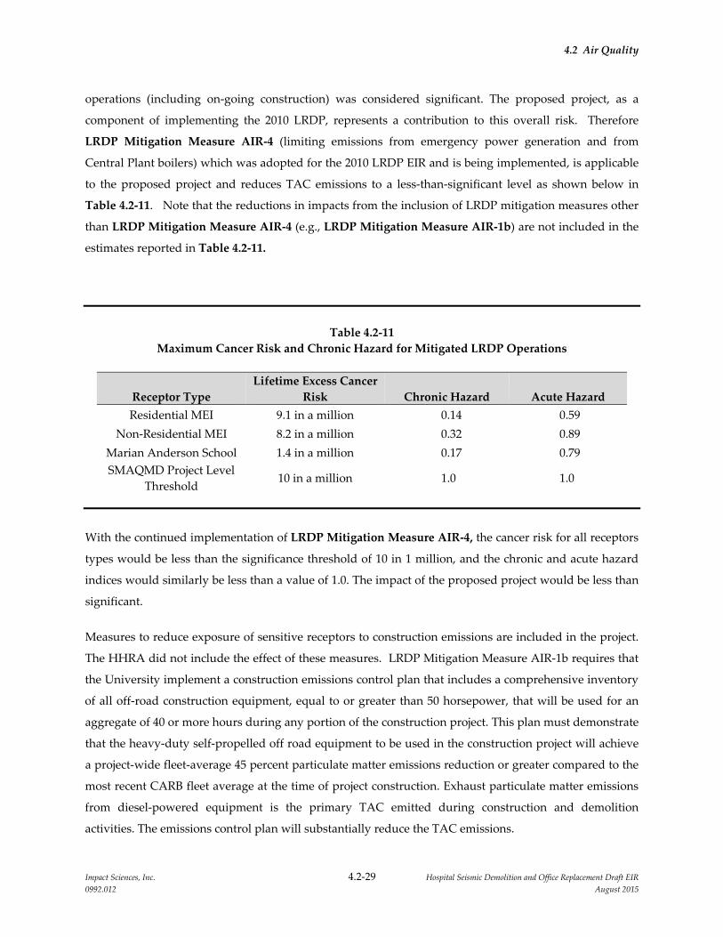
4.2 Air Quality
Impact Sciences, Inc. 4.2‐29 Hospital Seismic Demolition and Office Replacement Draft EIR
0992.012 August 2015
operations (including on‐going construction) was considered significant. The proposed project, as a
component of implementing the 2010 LRDP, represents a contribution to this overall risk. Therefore
LRDP Mitigation Measure AIR‐4 (limiting emissions from emergency power generation and from
Central Plant boilers) which was adopted for the 2010 LRDP EIR and is being implemented, is applicable
to the proposed project and reduces TAC emissions to a less‐than‐significant level as shown below in
Table 4.2‐11. Note that the reductions in impacts from the inclusion of LRDP mitigation measures other
than LRDP Mitigation Measure AIR‐4 (e.g., LRDP Mitigation Measure AIR‐1b) are not included in the
estimates reported in Table 4.2‐11.
Table 4.2‐11
Maximum Cancer Risk and Chronic Hazard for Mitigated LRDP Operations
Receptor Type
Lifetime Excess Cancer
Risk Chronic Hazard Acute Hazard
Residential MEI 9.1 in a million 0.14 0.59
Non‐Residential MEI 8.2 in a million 0.32 0.89
Marian Anderson School 1.4 in a million 0.17 0.79
SMAQMD Project Level
Threshold 10 in a million 1.0 1.0
With the continued implementation of LRDP Mitigation Measure AIR‐4, the cancer risk for all receptors
types would be less than the significance threshold of 10 in 1 million, and the chronic and acute hazard
indices would similarly be less than a value of 1.0. The impact of the proposed project would be less than
significant.
Measures to reduce exposure of sensitive receptors to construction emissions are included in the project.
The HHRA did not include the effect of these measures. LRDP Mitigation Measure AIR‐1b requires that
the University implement a construction emissions control plan that includes a comprehensive inventory
of all off‐road construction equipment, equal to or greater than 50 horsepower, that will be used for an
aggregate of 40 or more hours during any portion of the construction project. This plan must demonstrate
that the heavy‐duty self‐propelled off road equipment to be used in the construction project will achieve
a project‐wide fleet‐average 45 percent particulate matter emissions reduction or greater compared to the
most recent CARB fleet average at the time of project construction. Exhaust particulate matter emissions
from diesel‐powered equipment is the primary TAC emitted during construction and demolition
activities. The emissions control plan will substantially reduce the TAC emissions.

4.2 Air Quality
Impact Sciences, Inc. 4.2‐30 Hospital Seismic Demolition and Office Replacement Draft EIR
0992.012 August 2015
Mitigation Measures: No project‐level mitigation measures are required.
Impact AIR‐5: Implementation of the proposed project would not conflict with or obstruct
implementation of the applicable air quality plan. (Less than Significant)
In compliance with the State CEQA Guidelines, this EIR evaluates whether the proposed project would
conflict with or otherwise obstruct implementation of regional air quality plans. For air quality planning
purposes, the SMAQMD creates emissions inventories based on existing and foreseeable future land uses
within its jurisdiction. If a new project is consistent with the planned land use designation that was
considered in the development of an air quality management plan, the proposed project would not
conflict and would not obstruct implementation of the applicable air quality management plan.
Generally, a project’s conformance with a local general plan that was taken into account in the
preparation of an air quality management plan would demonstrate that the project would not conflict
with or obstruct implementation of the air quality management plan. Although the City’s General Plan
identifies the campus site for its current and proposed uses, the campus growth under the 2010 LRDP
was not accounted for in the City’s General Plan projections for employment and population growth or in
the SACOG growth projections for the region. As described in Impact AIR‐2 above, the campus
population and building space is not projected to grow under the proposed project and operational
emissions would not increase as a result of the project. Therefore, the operation of the proposed project
would not conflict with the region’s air quality plan.
As described in Impact AIR‐1 above, the demolition and construction activities associated with the
proposed project are forecast to remain below the SMAQMD thresholds for each phase of the project
occurring during the years 2016 through 2021. Therefore, the demolition/construction activities are also
not expected to interfere with the regional air quality plan. The potential impact would be less than
significant.
Mitigation Measures: No project‐level mitigation measures are required.
4.2.4.6 Cumulative Impacts and Mitigation Measures
Cumulative Impact AIR‐1: Implementation of the proposed project would not result in a
cumulatively considerable net increase of a criteria pollutant
for which the project region is nonattainment under an
applicable federal or state ambient air quality standard. (Less
than Significant)
4.2 Air Quality
Impact Sciences, Inc. 4.2‐31 Hospital Seismic Demolition and Office Replacement Draft EIR
0992.012 August 2015
The SMAQMD’s CEQA Guide considers a project’s impact on air quality to be a largely cumulative
impact. According to the SMAQMD, given past, current, and future development projects within the
SMAQMD’s jurisdiction, and given the current nonattainment status of the Sacramento County portion
of the SVAB for ozone, PM10, and PM2.5, a significant air quality impact already exists.10
In general, the SMAQMD states that if a project’s individual emissions are less than the project‐level
thresholds of significance, the project would not result in a cumulatively considerable adverse
contribution to the region’s existing air quality conditions. In addition, an exceedance of the project‐level
thresholds does not necessarily constitute a significant cumulative impact. Emissions from a project that
is consistent with the regional air quality management plans and clean air plans would not be considered
cumulatively considerable even though the emissions exceed the project‐level thresholds. This is because
the emissions would be accounted for in the region’s growth projections and emissions budget contained
in the SIP.
The emissions budget in the SIP includes a provision for on‐going construction emissions. Projects that
result in construction emissions below project‐level thresholds are considered to be accounted for in the
regional plan because their emissions are small enough to be captured in the construction emissions
budget included in the plan. As demonstrated in Impact AIR‐1 above, the project’s individual emissions
during construction are less than the project‐level thresholds of significance set forth by the SMAQMD.
Therefore, the project’s construction emissions are accounted for in the emissions budget and the project
would not conflict with the regional air quality plan nor result in a cumulatively considerable net increase
of a criteria pollutant for which the project region is nonattainment under an applicable federal or state
ambient air quality standard. The impact from project construction would be less than significant.
With respect to operational emissions, LRDP Impact AIR‐6 in the 2010 LRDP EIR analyzed the potential
for all of campus growth under the 2010 LRDP to result in a net increase of criteria pollutants for which
the air basin was in nonattainment and concluded that the campus’ growth is not accounted for in the
regional population and employment projections, and therefore the air emissions associated with that
growth are also not accounted for in the regional air quality planning efforts. Consequently, the
operational emissions associated with campus growth under the 2010 LRDP had the potential to set back
regional air quality planning efforts and result in a cumulatively considerable net increase of a criteria
pollutant for which the project region is nonattainment. To address this, the University adopted LRDP
Cumulative MM AIR‐1 (for the University work with SACOG to ensure that campus growth is
accounted for in the regional population and employment projections) to improve regional air quality
10 Sacramento Metropolitan Air Quality Management District, Guide to Air Quality Assessment in Sacramento County
(2009) 8‐1.
4.2 Air Quality
Impact Sciences, Inc. 4.2‐32 Hospital Seismic Demolition and Office Replacement Draft EIR
0992.012 August 2015
attainment planning. However, because the campus’s future emissions are not as yet accounted for in the
regional air quality plans, the impact would still be significant until campus growth is added to the plans.
The proposed project would, however, not contribute to this significant cumulative impact identified in
the 2010 LRDP EIR. This is because, as noted in Impact AIR‐2 above, the campus population and
building space is not projected to grow under the proposed project and operational emissions would not
increase as a result of the project. The impact would be less than significant.
Mitigation Measures: No project‐level mitigation measures are required.
Cumulative Impact AIR‐2: Construction and operation of the proposed project, in
conjunction with other nearby TAC sources, would not expose
sensitive receptors to substantial concentrations of toxic air
contaminants. (Less than Significant)
In addition to evaluating the direct impact of TACs from campus operations at full campus development
under the 2010 LRDP (LRDP Impact AIR‐4 described above), an additional cumulative analysis was
conducted in the 2010 LRDP EIR that included TAC emissions emitted not only from the campus’
existing and future operational and construction TAC sources, but also emissions from other off‐campus
sources near the campus. At the time that the 2010 LRDP EIR was prepared, the SMAQMD did not have
specific guidance as to how the cumulative impacts of a project may be evaluated or what thresholds may
be used to evaluate the cumulative impacts. Therefore, the approach to the cumulative impact analysis
and the significance threshold for evaluating the cumulative impact was obtained from the guidance
adopted by the Bay Area Air Quality Management District (BAAQMD) in June 2010 to determine that
that cumulative impact of campus emissions through full implementation of the 2010 LRDP would be
less than significant.
The SMAQMD now provides guidance for evaluating the cumulative impact from TAC emissions and
states that because the District’s threshold of significance for health risk exposure from TACs is based on
the incremental increase in health risk from a project’s TAC emissions, the District considers
implementation of the project‐level mitigation requirements to be sufficient for a finding of a less than
cumulatively considerable contribution to the cumulative impacts of TACs. Therefore, the cumulative
impact would be less than significant.
Mitigation Measures: No project‐level mitigation measures are required.
4.2.5 REFERENCES
Danby, John. 2015. Email from John Danby to Matt Dulcich, May 7, 2015; Subject: North Addition, NS
Wing Demolition Energy.
4.2 Air Quality
Impact Sciences, Inc. 4.2‐33 Hospital Seismic Demolition and Office Replacement Draft EIR
0992.012 August 2015
Golder Associates. 2010. Human Health Risk Assessment in Support of the 2010 LRDP Environmental Impact
Report. July.
Sacramento Metropolitan Air Quality Management District (SMAQMD). 2009. Guide to Air Quality
Assessment in Sacramento County. Updated through June 2015.
University of California, Davis Sacramento Campus. 2009. 2010 Long Range Development Plan. November.
University of California, Davis Sacramento Campus. 2010. 2010 Long Range Development Plan
Environmental Impact Report. July.
Impact Sciences, Inc. 4.3‐1 Hospital Seismic Demolition and Office Replacement Draft EIR
0992.012 August 2015
4.3 GREENHOUSE GAS EMISSIONS
4.3.1 INTRODUCTION
This section discusses the existing global, national, and statewide conditions related to greenhouse gases
(GHG) and global climate change and evaluates the potential impacts on global climate from the
implementation of the proposed Hospital Seismic Demolition and Office Replacement project (proposed
project). The section also provides discussion of the applicable federal, state, regional, and local agencies
that regulate, monitor, and control GHG emissions. The impacts associated with the proposed project are
compared with the thresholds of significance and significance criteria established by the Sacramento
Metropolitan Air Quality Management District (SMAQMD). Copies of the modeling runs to estimate
GHG emissions associated with the proposed project and supporting technical data are found in
Appendix 4.2 of this EIR.
No comments related to GHG emissions were received in response to the Notice of Preparation (NOP)
issued for this EIR. All comment letters received in response to the NOP are provided in Appendix 1.0 of
this Draft EIR.
4.3.2 EXISTING CONDITIONS
4.3.2.1 Site Setting
The proposed project consists of the three sites at the UC Davis Sacramento campus described in Section
3.0. These sites are developed portions of the medical center campus and currently include 255,000 square
feet of building space. Potential GHG emissions associated with the current site include the emissions
associated with the ventilation, heating, cooling, and lighting of the building interiors. In addition,
existing emissions include the emissions associated with the operations and maintenance of these
facilities, including direct and indirect emissions resulting from water, wastewater, solid waste from
existing operations, exterior landscaping emissions, and mobile emissions associated with existing
employees at the medical center. The proposed project includes the replacement of the existing building
square footage with new facilities that would provide 130,000 square feet of space rather than the existing
255,000 square feet of space. With the relocation of the existing activities from the space proposed for
demolition into the new space, the project includes no changes to expected employment or visitor trips to
the Sacramento campus.
4.3 Greenhouse Gas Emissions
Impact Sciences, Inc. 4.3‐2 Hospital Seismic Demolition and Office Replacement Draft EIR
0992.012 August 2015
4.3.2.2 Background
Global climate change refers to any significant change in climate measurements, such as temperature,
precipitation, or wind, lasting for an extended period (i.e., decades or longer) (US EPA 2008a). Climate
change may result from:
natural factors, such as changes in the sun’s intensity or slow changes in the Earth’s orbit around the
sun;
natural processes within the climate system (e.g., changes in ocean circulation, reduction in sunlight
from the addition of GHG and other gases to the atmosphere from volcanic eruptions); and
human activities that change the atmosphere’s composition (e.g., through burning fossil fuels) and
the land surface (e.g., deforestation, reforestation, urbanization, desertification).
The primary effect of global climate change has been a rise in the average global tropospheric
temperature of 0.2 degree Celsius per decade, determined from meteorological measurements worldwide
between 1990 and 2005. Climate change modeling using 2000 emission rates shows that further warming
is likely to occur, which would induce further changes in the global climate system during the current
century (IPCC 2007). Changes to the global climate system and ecosystems, and to California, could
include:
declining sea ice and mountain snowpack levels, thereby increasing sea levels and sea surface
evaporation rates with a corresponding increase in tropospheric water vapor due to the atmosphere’s
ability to hold more water vapor at higher temperatures (IPCC 2007);
rising average global sea levels primarily due to thermal expansion and the melting of glaciers, ice
caps, and the Greenland and Antarctic ice sheets (model‐based projections of global average sea level
rise at the end of the 21st century (2090–2099) range from 0.18 meter to 0.59 meter or 0.59 foot to 1.94
feet) (IPCC 2007);
changing weather patterns, including changes to precipitation, ocean salinity, and wind patterns, and
more energetic aspects of extreme weather including droughts, heavy precipitation, heat waves,
extreme cold, and the intensity of tropical cyclones (IPCC 2007);
declining Sierra snowpack levels, which account for approximately half of the surface water storage
in California, by 70 percent to as much as 90 percent over the next 100 years (Cal EPA 2006);
increasing the number of days conducive to ozone formation by 25 to 85 percent (depending on the
future temperature scenario) in high ozone areas located in the Southern California area and the San
Joaquin Valley by the end of the 21st century (Cal EPA 2006);
increasing the potential for erosion of California’s coastlines and sea water intrusion into the
Sacramento and San Joaquin Delta and associated levee systems due to the rise in sea level
(California EPA 2006);
4.3 Greenhouse Gas Emissions
Impact Sciences, Inc. 4.3‐3 Hospital Seismic Demolition and Office Replacement Draft EIR
0992.012 August 2015
increasing pest infestation, making California more susceptible to forest fires (Cal EPA 2006);
increasing the demand for electricity by 1 to 3 percent by 2020 due to rising temperatures resulting in
hundreds of millions of dollars in extra expenditures (Cal EPA 2006); and
summer warming projections in the first 30 years of the 21st century ranging from about 0.5 to
2 degrees Celsius (°C) (0.9 to 3.6 °F) and by the last 30 years of the 21st century, from about 1.5 to 5.8
°C (2.7 to 10.5 °F) (Cal EPA 2006).
The natural process through which heat is retained in the troposphere1 is called the “greenhouse effect.”
The greenhouse effect traps heat in the troposphere through a threefold process as follows: (1) short‐wave
radiation in the form of visible light emitted by the Sun is absorbed by the Earth as heat; (2) long‐wave
radiation re‐emitted by the Earth; and (3) GHGs in the upper atmosphere absorbing or trapping the
long‐wave radiation and re‐emitting it back towards the Earth and into space. This third process is the
focus of current climate change actions.
While water vapor and carbon dioxide (CO2) are the most abundant GHGs, other trace GHGs have a
greater ability to absorb and re‐radiate long‐wave radiation. To gauge the potency of GHGs, scientists
have established a Global Warming Potential (GWP) for each GHG based on its ability to absorb and
re‐emit long‐wave radiation over a specific time period. The GWP of a gas is determined using CO2 as the
reference gas, which has a GWP of 1 over 100 years (IPCC 1996).2 For example, a gas with a GWP of 10 is
10 times more potent than CO2 over 100 years. The use of GWP allows GHG emissions to be reported
using CO2 as a baseline. The sum of each GHG multiplied by its associated GWP is referred to as “carbon
dioxide equivalents” (CO2e). This essentially means that 1 metric ton of a GHG with a GWP of 10 has the
same climate change impacts as 10 metric tons of CO2.
4.3.2.3 Greenhouse Gases
State law defines GHGs to include the following compounds:
Carbon Dioxide (CO2). Carbon dioxide primarily is generated by fossil fuel combustion from
stationary and mobile sources. Due to the emergence of industrial facilities and mobile sources over
the past 250 years, the concentration of carbon dioxide in the atmosphere has increased 35 percent
(US EPA 2008b). Carbon dioxide is the most widely emitted GHG and is the reference gas (GWP of 1)
for determining the GWP of other GHGs. In 2004, 82.8 percent of California’s GHG emissions were
carbon dioxide (California Energy Commission 2007).
Methane (CH4). Methane is emitted from biogenic sources (i.e., resulting from the activity of living
organisms), incomplete combustion in forest fires, landfills, manure management, and leaks in
1 The troposphere is the bottom layer of the atmosphere, which varies in height from the Earth’s surface to 10 to
12 kilometers).
2 All Global Warming Potentials are given as 100‐year values.

4.3 Greenhouse Gas Emissions
Impact Sciences, Inc. 4.3‐4 Hospital Seismic Demolition and Office Replacement Draft EIR
0992.012 August 2015
natural gas pipelines. In the United States, the top three sources of methane are landfills, natural gas
systems, and enteric fermentation (US EPA n.d.[a). Methane is the primary component of natural gas,
which is used for space and water heating, steam production, and power generation. The GWP of
methane is 21.
Nitrous Oxide (N2O). Nitrous oxide is produced by natural and human‐related sources. Primary
human‐related sources include agricultural soil management, animal manure management, sewage
treatment, mobile and stationary combustion of fossil fuel, adipic acid production, and nitric acid
production. The GWP of nitrous oxide is 310.
Hydrofluorocarbons (HFCs). HFCs typically are used as refrigerants in both stationary refrigeration
and mobile air conditioning. The use of HFCs for cooling and foam‐blowing is growing particularly
as the continued phase‐out of chlorofluorocarbons (CFCs) and hydrochlorofluorocarbons (HCFCs)
gains momentum. The GWP of HFCs ranges from 140 for HFC‐152a to 6,300 for HFC‐236fa.
Perfluorocarbons (PFCs). Perfluorocarbons are compounds consisting of carbon and fluorine. They
are primarily created as a byproduct of aluminum production and semiconductor manufacturing.
Perfluorocarbons are potent GHGs with a GWP several thousand times that of carbon dioxide,
depending on the specific PFC. Another area of concern regarding PFCs is their long atmospheric
lifetime (up to 50,000 years) (Energy Information Administration 2007). The GWPs of PFCs range
from 5,700 to 11,900.
Sulfur Hexafluoride (SF6). Sulfur hexafluoride is a colorless, odorless, nontoxic, nonflammable gas. It
is most commonly used as an electrical insulator in high voltage equipment that transmits and
distributes electricity. Sulfur hexafluoride is the most potent GHG that has been evaluated by the
Intergovernmental Panel on Climate Change with a GWP of 23,900. However, its global warming
contribution is not as high as the GWP would indicate due to its low mixing ratio, as compared to
carbon dioxide (4 parts per trillion [ppt] in 1990 versus 365 parts per million [ppm] of CO2) (US EPA
n.d.[b]).
4.3.2.4 Contributions to Greenhouse Gas Emissions
Global
Worldwide anthropogenic (man‐made) GHG emissions are tracked for industrialized nations (referred to
as Annex I) and developing nations (referred to as Non‐Annex I). Man‐made GHG emissions for Annex I
nations are available through 2007. Man‐made GHG emissions for Non‐Annex I nations are available
through 2005. The sum of these emissions totaled approximately 42,133 million metric tons of CO2
equivalents (MMTCO2E).3 It should be noted that global emissions inventory data are not all from the
3 The CO2 equivalent emissions commonly are expressed as “million metric tons of carbon dioxide equivalent
(MMTCO2E).” The carbon dioxide equivalent for a gas is derived by multiplying the tons of the gas by the
associated GWP, such that MMTCO2E = (million metric tons of a GHG) x (GWP of the GHG). For example, the
GWP for methane is 21. This means that the emission of one million metric tons of methane is equivalent to the
emission of 21 million metric tons of CO2.

4.3 Greenhouse Gas Emissions
Impact Sciences, Inc. 4.3‐5 Hospital Seismic Demolition and Office Replacement Draft EIR
0992.012 August 2015
same year and may vary depending on the source of the emissions inventory data.4 The top five countries
and the European Union accounted for approximately 55 percent of the total global GHG emissions
according to the most recently available data (See Table 4.3‐1, Top Five GHG Producer Countries and
the European Union [Annual]). The GHG emissions in more recent years may differ from the inventories
presented in Table 4.3‐1; however, the data is representative of currently available global inventory data.
Table 4.3‐1
Top Five GHG Producer Countries and the European Union (Annual)
Emitting Countries
GHG Emissions
(MMTCO2e)
China 7,250
United States 7,217
European Union (EU), 27 Member States 5,402
Russian Federation 2,202
India 1,863
Japan 1,412
Total 25,346
Source: World Resources Institute, “Climate Analysis Indicators Tool (CAIT),” http://cait.wri.org/. 2010.
Excludes emissions and removals from land use, land‐use change and forestry (LULUCF).
Note: Emissions for Annex I nations are based on 2007 data. Emissions for Non‐Annex I nations (e.g., China,
India) are based on 2005 data).
United States
As noted in Table 4.3‐1, the United States was the number two producer of global GHG emissions as of
2005. The primary GHG emitted by human activities in the United States was CO2, representing
approximately 84 percent of total GHG emissions (US EPA 2008a). Carbon dioxide from fossil fuel
combustion, the largest source of GHG emissions, accounted for approximately 80 percent of U.S. GHG
emissions.5
4 The global emissions are the sum of Annex I and non‐Annex I countries, without counting Land‐Use, Land‐Use
Change and Forestry (LULUCF). For countries without 2005 data, the UNFCCC data for the most recent year
were used. United Nations Framework Convention on Climate Change, “Annex I Parties – GHG total without
LULUCF,” http://unfccc.int/ghg_emissions_data/ghg_data_from_unfccc/time_series_annex_i/ items/3841.php
and “Flexible GHG Data Queries” with selections for total GHG emissions excluding LULUCF/LUCF, all years,
and non‐Annex I countries, http://unfccc.int/di/FlexibleQueries/Event.do?event= showProjection. n.d.
5 Supra no. 4.
4.3 Greenhouse Gas Emissions
Impact Sciences, Inc. 4.3‐6 Hospital Seismic Demolition and Office Replacement Draft EIR
0992.012 August 2015
State of California
The California Air Resources Board compiles GHG inventories for the State of California. Based upon the
2006 GHG inventory data (i.e., the latest year for which data are available) for the 2000–2006 GHG
emissions inventory, California emitted 484 MMTCO2e including emissions resulting from imported
electrical power in 2006 (CARB 2009). Based on the CARB inventory data and GHG inventories compiled
by the World Resources Institute, California’s total statewide GHG emissions rank second in the United
States (Texas is number one) with emissions of 434 MMTCO2e excluding emissions related to imported
power (CARB 2009).
A California Energy Commission (CEC) emissions inventory report placed CO2 produced by fossil fuel
combustion in California as the largest source of California’s GHG emissions in 2004, accounting for 80
percent of the total GHG emissions (California Energy Commission 2006a). Emissions of CO2 from other
sources contributed 3.1 percent of the total GHG emissions; methane emissions 6.4 percent; nitrous oxide
emissions 7.6 percent; and the remaining 3.2 percent was composed of emissions of high‐GWP gases
(California Energy Commission 2006a). These high GWP gases are largely composed of refrigerants, with
small contributions of SF6 used in connection with insulating materials for electricity transmission and
distribution.
4.3.3 REGULATORY FRAMEWORK
4.3.3.1 Intergovernmental Panel on Climate Change
The World Meteorological Organization (WMO) and United Nations Environmental Program (UNEP)
established the IPCC in 1988. The goal of the IPCC is to evaluate the risk of climate change caused by
human activities. Rather than performing research or monitoring climate, the IPCC relies on peer‐
reviewed and published scientific literature to make its assessment. While not a regulatory body, the
IPCC assesses information (i.e., scientific literature) regarding human‐induced climate change and the
impacts of human‐induced climate change, and recommends options to policy makers for the adaptation
and mitigation of climate change. The IPCC reports its evaluations in special reports called “assessment
reports.” The Fifth Assessment Report was published in 2014. The Fifth Assessment Report upgrades the
likelihood of climate change being attributable to human activities to “extremely likely.”
4.3.3.2 Federal Laws and Regulations
In Massachusetts vs. EPA, the Supreme Court held that United States Environmental Protection Agency
(US EPA) has the statutory authority under Section 202 of the Clean Air Act (CAA) to regulate GHGs
from new motor vehicles. The court did not hold that the US EPA was required to regulate GHG

4.3 Greenhouse Gas Emissions
Impact Sciences, Inc. 4.3‐7 Hospital Seismic Demolition and Office Replacement Draft EIR
0992.012 August 2015
emissions; however, it indicated that the agency must decide whether GHGs from motor vehicles cause
or contribute to air pollution that is reasonably anticipated to endanger public health or welfare. Upon
the final decision, the President signed Executive Order 13432 on May 14, 2007, directing the US EPA,
along with the Departments of Transportation, Energy, and Agriculture, to initiate a regulatory process
that responds to the Supreme Court’s decision.
In December 2007, the President signed the Energy Independence and Security Act of 2007, which sets a
mandatory Renewable Fuel Standard (RFS) requiring fuel producers to use at least 36 billion gallons of
biofuel in 2022 and sets a national fuel economy standard of 35 miles per gallon by 2020. The act also
contains provisions for energy efficiency in lighting and appliances and for the implementation of green
building technologies in federal buildings. On July 11, 2008, the US EPA issued an Advanced Notice of
Proposed Rulemaking (ANPRM) on regulating GHGs under the CAA. The ANPRM reviews the various
CAA provisions that may be applicable to the regulation of GHGs and presents potential regulatory
approaches and technologies for reducing GHG emissions. On April 10, 2009, the US EPA published the
Proposed Mandatory Greenhouse Gas Reporting Rule in the Federal Register (US EPA 2009). The rule was
adopted on September 22, 2009 and covers approximately 10,000 facilities nationwide, accounting for
85 percent of US GHG emissions.
On September 15, 2009, the US EPA and the Department of Transportation’s (DOT) National Highway
Traffic Safety Administration (NHTSA) issued a joint proposal to establish a national program consisting
of new standards for model year 2012 through 2016 light‐duty vehicles that will reduce GHG emissions
and improve fuel economy. The proposed standards would be phased in and would require passenger
cars and light‐duty trucks to comply with a declining emissions standard. In 2012, passenger cars and
light‐duty trucks would have to meet an average standard of 295 grams of CO2 per mile and 30.1 miles
per gallon. By 2016, the vehicles would have to meet an average standard of 250 grams of CO2 per
mile and 35.5 miles per gallon.6 These standards were formally adopted by the US EPA and DOT on
April 1, 2010.
On December 7, 2009, the US EPA Administrator signed two distinct findings regarding GHGs under
section 202(a) of the CAA:
Endangerment Finding: The Administrator finds that the current and projected concentrations of the
six key well‐mixed GHGs (carbon dioxide, methane, nitrous oxide, hydrofluorocarbons,
perfluorocarbons, and sulfur hexafluoride) in the atmosphere threaten the public health and welfare
of current and future generations.
6 The CO2 emission standards and fuel economy standards stated are based on US EPA formulas.
4.3 Greenhouse Gas Emissions
Impact Sciences, Inc. 4.3‐8 Hospital Seismic Demolition and Office Replacement Draft EIR
0992.012 August 2015
Cause or Contribute Finding: The Administrator finds that the combined emissions of these well‐
mixed greenhouse gases from new motor vehicles and new motor vehicle engines contribute to the
greenhouse gas pollution which threatens public health and welfare.
While these findings do not impose additional requirements on industry or other entities, this action was
a prerequisite to finalizing the US EPA’s proposed GHG emissions standards for light‐duty vehicles,
which were jointly proposed by the US EPA and DOT. On April 1, 2010, the US EPA and NHTSA issued
final rules requiring that by the 2016 model‐year, manufacturers must achieve a combined average
vehicle emission level of 250 grams of CO2 per mile, which is equivalent to 35.5 miles per gallon as
measured by US EPA standards. These agencies are currently in the process of developing similar
regulations for the 2017 through 2025 model years.
4.3.3.3 State Laws and Regulations
Title 24 Building Standards Code
The California Energy Commission first adopted Energy Efficiency Standards for Residential and
Nonresidential Buildings (California Code of Regulations, Title 24, Part 6) in 1978 in response to a
legislative mandate to reduce energy consumption in the state. Although not originally intended to
reduce GHG emissions, increased energy efficiency, and reduced consumption of electricity, natural gas,
and other fuels would result in fewer GHG emissions from residential and nonresidential buildings
subject to the standard. The standards are updated periodically to allow for the consideration and
inclusion of new energy efficiency technologies and methods. The latest revisions were adopted in 2013
and became effective on July 1, 2014.
Part 11 of the Title 24 Building Standards Code is referred to as the California Green Building Standards
Code (CALGreen Code). The purpose of the CALGreen Code is to “improve public health, safety and
general welfare by enhancing the design and construction of buildings through the use of building
concepts having a positive environmental impact and encouraging sustainable construction practices in
the following categories: (1) Planning and design; (2) Energy efficiency; (3) Water efficiency and
conservation; (4) Material conservation and resource efficiency; and (5) Environmental air quality
(California Building Standards Commission 2009). The CALGreen Code is not intended to substitute or
be identified as meeting the certification requirements of any green building program that is not
established and adopted by the California Building Standards Commission (CBSC). The CBSC has
released a 2013 California Green Building Standards Code on its website (California Building Standards
Commission 2013). The update to Part 11 of the Title 24 Building Standards Code became effective on
January 1, 2014. Unless otherwise noted in the regulation, all newly constructed buildings in California
are subject of the requirements of the CALGreen Code.

4.3 Greenhouse Gas Emissions
Impact Sciences, Inc. 4.3‐9 Hospital Seismic Demolition and Office Replacement Draft EIR
0992.012 August 2015
Assembly Bill 1493
In response to the transportation sector’s contribution of more than half of California’s CO2 emissions,
Assembly Bill 1493 (AB 1493, Pavley) was enacted on July 22, 2002. AB 1493 requires CARB to set GHG
emission standards for passenger vehicles, light‐duty trucks, and other vehicles whose primary use is
noncommercial personal transportation. CARB adopted the standards in September 2004. The new
standards will be phased in during the 2009 through 2016 model years. When fully phased in, the near
term (2009–2012) standards will result in a reduction of about 22 percent in GHG emissions compared to
the emissions from the 2002 fleet, while the midterm (2013–2016) standards will result in a reduction of
about 30 percent.
Before these regulations may go into effect, the US EPA must grant California a waiver under the federal
CAA, which ordinarily preempts state regulation of motor vehicle emission standards. On June 30, 2009,
the US EPA formally approved California’s waiver request. However, in light of the September 15, 2009,
announcement by the US EPA and NHTSA regarding the national program to reduce vehicle GHG
emissions, California—and states adopting California emissions standards—have agreed to defer to the
proposed national standard through model year 2016 if granted a waiver by the US EPA. The 2016
endpoint of the two standards is similar, although the national standard ramps up slightly more slowly
than required under the California standard. The Pavley standards require additional reductions in
CO2 emissions beyond 2016 (referred to as Phase II standards). While the Phase II standards have yet to
be fully developed, CARB has made it clear that the state intends to pursue additional reductions from
motor vehicles in the 2017 through 2020 timeframe under the California Global Warming Solutions Act
of 2006.
Executive Order S‐3‐05 and the Climate Action Team
In June 2005, Governor Schwarzenegger established California’s GHG emissions reduction targets in
Executive Order S‐3‐05. The Executive Order established the following goals: GHG emissions should be
reduced to 2000 levels by 2010, 1990 levels by 2020, and 80 percent below 1990 levels by 2050.
The Secretary of Cal EPA is required to coordinate efforts of various agencies in order to collectively and
efficiently reduce GHGs. Some of the agency representatives involved in the GHG reduction plan include
the Secretary of the Business, Transportation and Housing Agency, the Secretary of the Department of
Food and Agriculture, the Secretary of the Resources Agency, the Chairperson of CARB, the Chairperson
of the CEC, and the President of the Public Utilities Commission.
Representatives from each of the aforementioned agencies comprise the Climate Action Team. The Cal
EPA secretary is required to submit a biannual progress report from the Climate Action Team to the

4.3 Greenhouse Gas Emissions
Impact Sciences, Inc. 4.3‐10 Hospital Seismic Demolition and Office Replacement Draft EIR
0992.012 August 2015
governor and state legislature disclosing the progress made toward GHG emission reduction targets. In
addition, another biannual report must be submitted illustrating the impacts of global warming on
California’s water supply, public health, agriculture, coastline, and forests, and reporting possible
mitigation and adaptation plans to combat these impacts. Some strategies currently being implemented
by state agencies include CARB introducing vehicle climate change standards and diesel anti‐idling
measures, the Energy Commission implementing building and appliance efficiency standards, and the
Cal EPA implementing their green building initiative. The Climate Action Team also recommends future
emission reduction strategies, such as using only low‐GWP refrigerants in new vehicles, developing
ethanol as an alternative fuel, reforestation, solar power initiatives for homes and businesses, and
investor‐owned utility energy efficiency programs. According to the report, implementation of current
and future emission reduction strategies have the potential to achieve the goals set forth in Executive
Order S‐3‐05.
Assembly Bill 32
In furtherance of the goals established in Executive Order S‐3‐05, the legislature enacted Assembly Bill 32
(AB 32, Nuñez and Pavley), the California Global Warming Solutions Act of 2006, which Governor
Schwarzenegger signed on September 27, 2006. AB 32 represents the first enforceable statewide program
to limit GHG emissions from all major industries with penalties for noncompliance. AB 32 requires the
state to undertake several actions. The major requirements are discussed below.
CARB Early Action Measures
CARB is responsible for carrying out and developing the programs and requirements necessary to
achieve the goal of AB 32—the reduction of Californiaʹs GHG emissions to 1990 levels by 2020. The first
action under AB 32 resulted in CARB’s adoption of a report listing three specific early‐action greenhouse
gas emission reduction measures on June 21, 2007. On October 25, 2007, CARB approved six additional
early‐action GHG reduction measures under AB 32. CARB has adopted regulations for all early action
measures. The early‐action measures are divided into three categories:
Group 1 – GHG rules for immediate adoption and implementation
Group 2 – Several additional GHG measures under development
Group 3 – Air pollution controls with potential climate co‐benefits
The original three adopted early‐action regulations meeting the narrow legal definition of “discrete early‐
action GHG reduction measures” include:
a low‐carbon fuel standard to reduce the “carbon intensity” of California fuels;

4.3 Greenhouse Gas Emissions
Impact Sciences, Inc. 4.3‐11 Hospital Seismic Demolition and Office Replacement Draft EIR
0992.012 August 2015
reduction of refrigerant losses from motor vehicle air conditioning system maintenance to restrict the
sale of ”do‐it‐yourself” automotive refrigerants; and
increased methane capture from landfills to require broader use of state‐of‐the‐art methane capture
technologies.
The six additional early‐action regulations adopted on October 25, 2007, also meeting the narrow legal
definition of “discrete early‐action GHG reduction measures,” include:
reduction of aerodynamic drag, and thereby fuel consumption, from existing trucks and trailers
through retrofit technology;
reduction of auxiliary engine emissions of docked ships by requiring port electrification;
reduction of perfluorocarbons from the semiconductor industry;
reduction of propellants in consumer products (e.g., aerosols, tire inflators, and dust removal
products);
the requirement that all tune‐up, smog check and oil change mechanics ensure proper tire inflation as
part of overall service in order to maintain fuel efficiency; and
restriction on the use of sulfur hexafluoride (SF6) from non‐electricity sectors if viable alternatives are
available.
State of California Greenhouse Gas Inventory and 2020 Limit
As required under AB 32, on December 6, 2007, CARB approved the 1990 GHG inventory, thereby
establishing the emissions limit for 2020. The 2020 emissions limit was set at 427 MMTCO2e. CARB also
projected the state’s 2020 GHG emissions under “business as usual” (BAU) conditions—that is, emissions
that would occur without any plans, policies, or regulations to reduce GHG emissions. CARB used an
average of the state’s GHG emissions from 2002 through 2004 and projected the 2020 levels based on
population and economic forecasts. The projected net emissions totaled approximately 596 MMTCO2e,
though this was updated in 2010 to 507 MMTCO2e. Therefore, the state must reduce its 2020 BAU
emissions by approximately 16 percent in order to meet the 1990 target.
The inventory revealed that in 1990, transportation, with 35 percent of the stateʹs total emissions, was the
largest single sector, followed by industrial emissions, 24 percent; imported electricity, 14 percent; in‐state
electricity generation, 11 percent; residential use, 7 percent; agriculture, 5 percent; and commercial uses,
3 percent. AB 32 does not require individual sectors to meet their individual 1990 GHG emissions
inventory; the total statewide emissions are required to meet the 1990 threshold by 2020.
4.3 Greenhouse Gas Emissions
Impact Sciences, Inc. 4.3‐12 Hospital Seismic Demolition and Office Replacement Draft EIR
0992.012 August 2015
CARB Mandatory Reporting Requirements
In addition to the 1990 emissions inventory, CARB also adopted regulations requiring the mandatory
reporting of GHG emissions for large facilities on December 6, 2007. The mandatory reporting regulations
require annual reporting from the largest facilities in the state, which account for approximately
94 percent of point source greenhouse gas emissions from industrial and commercial stationary sources
in California. About 800 separate sources fall under the new reporting rules and include electricity‐
generating facilities, electricity retail providers and power marketers, oil refineries, hydrogen plants,
cement plants, cogeneration facilities, and industrial sources that emit over 25,000 tons of carbon dioxide
each year from on‐site stationary combustion sources. Transportation sources, which account for
38 percent of California’s total GHG emissions, are not covered by these regulations but will continue to
be tracked through existing means.
AB 32 Climate Change Scoping Plan
As indicated above, AB 32 requires CARB to adopt a scoping plan indicating how reductions in
significant GHG sources will be achieved through regulations, market mechanisms, and other actions.
After receiving public input on their discussion draft of the scoping plan, the CARB Governing Board
approved the Climate Change Scoping Plan on December 11, 2008. Key elements of the Scoping Plan
include the following recommendations:
Expanding and strengthening existing energy efficiency programs as well as building and appliance
standards;
Achieving a statewide renewable energy mix of 33 percent;
Developing a California cap‐and‐trade program that links with other Western Climate Initiative
partner programs to create a regional market system;
Establishing targets for transportation‐related greenhouse gas emissions for regions throughout
California and pursuing policies and incentives to achieve those targets;
Adopting and implementing measures pursuant to existing state laws and policies, including
California’s clean car standards, goods movement measures, and the Low Carbon Fuel Standard; and
Creating targeted fees, including a public goods charge on water use, fees on high global warming
potential gases, and a fee to fund the administrative costs of the state’s long‐term commitment to
AB 32 implementation.
Under the Scoping Plan, approximately 85 percent of the state’s emissions are subject to a cap‐and‐trade
program where covered sectors are placed under a declining emissions cap. The emissions cap
incorporates a margin of safety whereas the 2020 emissions limit will still be achieved even in the event

4.3 Greenhouse Gas Emissions
Impact Sciences, Inc. 4.3‐13 Hospital Seismic Demolition and Office Replacement Draft EIR
0992.012 August 2015
that uncapped sectors do not fully meet their anticipated emission reductions. Emissions reductions will
be achieved through regulatory requirements and the option to reduce emissions further or purchase
allowances to cover compliance obligations. It is expected that emission reduction from this
cap‐and‐trade program will account for a large portion of the reductions required by AB 32.
Table 4.3‐2, AB 32 Scoping Plan Measures (SPMs), lists CARB’s preliminary recommendations for
achieving GHG emissions reductions under AB 32 along with a brief description of the requirements and
applicability.
Table 4.3‐2
AB 32 Scoping Plan Measures (SPMs)
Scoping Plan Measure Description
SPM‐1: California Cap‐and‐Trade Program linked to Western Climate Initiative
Implement a broad‐based cap‐and‐trade program that links with other Western Climate Initiative Partner programs to create a regional market system. Ensure California’s program meets all applicable AB 32 requirements for market‐based mechanisms. Capped sectors include transportation, electricity, natural gas, and industry. Projected 2020 business‐as‐usual emissions are estimated at 512 metric tons of CO2 equivalents (MTCO2e); preliminary 2020 emissions limit under cap‐and‐trade program are estimated at 365 MTCO2e (29 percent reduction).
SPM‐2: California Light‐Duty Vehicle GHG Standards
Implement adopted Pavley standards and planned second phase of the program. AB 32 states that if the Pavley standards (AB 1493) do not remain in effect, CARB shall implement equivalent or greater alternative regulations to control mobile sources.
SPM‐3: Energy Efficiency Maximize energy efficiency building and appliance standards, and pursue additional efficiency efforts. The Scoping Plan considers green building standards as a framework to achieve reductions in other sectors, such as electricity.
SPM‐4: Renewables Portfolio Standard Achieve 33 percent Renewables Portfolio Standard by both investor‐owned and publicly owned utilities.
SPM‐5: Low Carbon Fuel Standard CARB identified the Low Carbon Fuel Standard as a Discrete Early Action item and the final regulation was adopted on April 23, 2009. In January 2007, Governor Schwarzenegger issued Executive Order S‐1‐07, which called for the reduction of the carbon intensity of Californiaʹs transportation fuels by at least 10 percent by 2020.
SPM‐6: Regional Transportation‐Related Greenhouse Gas Targets
Develop regional greenhouse gas emissions reduction targets for passenger vehicles. SB 375 requires CARB to develop, in consultation with metropolitan planning organizations (MPOs), passenger vehicle greenhouse gas emissions reduction targets for 2020 and 2035 by September 30, 2010. SB 375 requires MPOs to prepare a sustainable communities strategy to reach the regional target provided by CARB.
SPM‐7: Vehicle Efficiency Measures Implement light‐duty vehicle efficiency measures. CARB is pursuing fuel‐efficient tire standards and measures to ensure properly inflated tires during vehicle servicing.
SPM‐8: Goods Movement Implement adopted regulations for port drayage trucks and the use of shore power for ships at berth. Improve efficiency in goods movement operations.
SPM‐9: Million Solar Roofs Program Install 3,000 MW of solar‐electric capacity under California’s existing solar programs.
SPM‐10: Heavy/Medium‐Duty Vehicles Adopt heavy‐ and medium‐duty vehicle and engine measures targeting aerodynamic efficiency, vehicle hybridization, and engine efficiency.
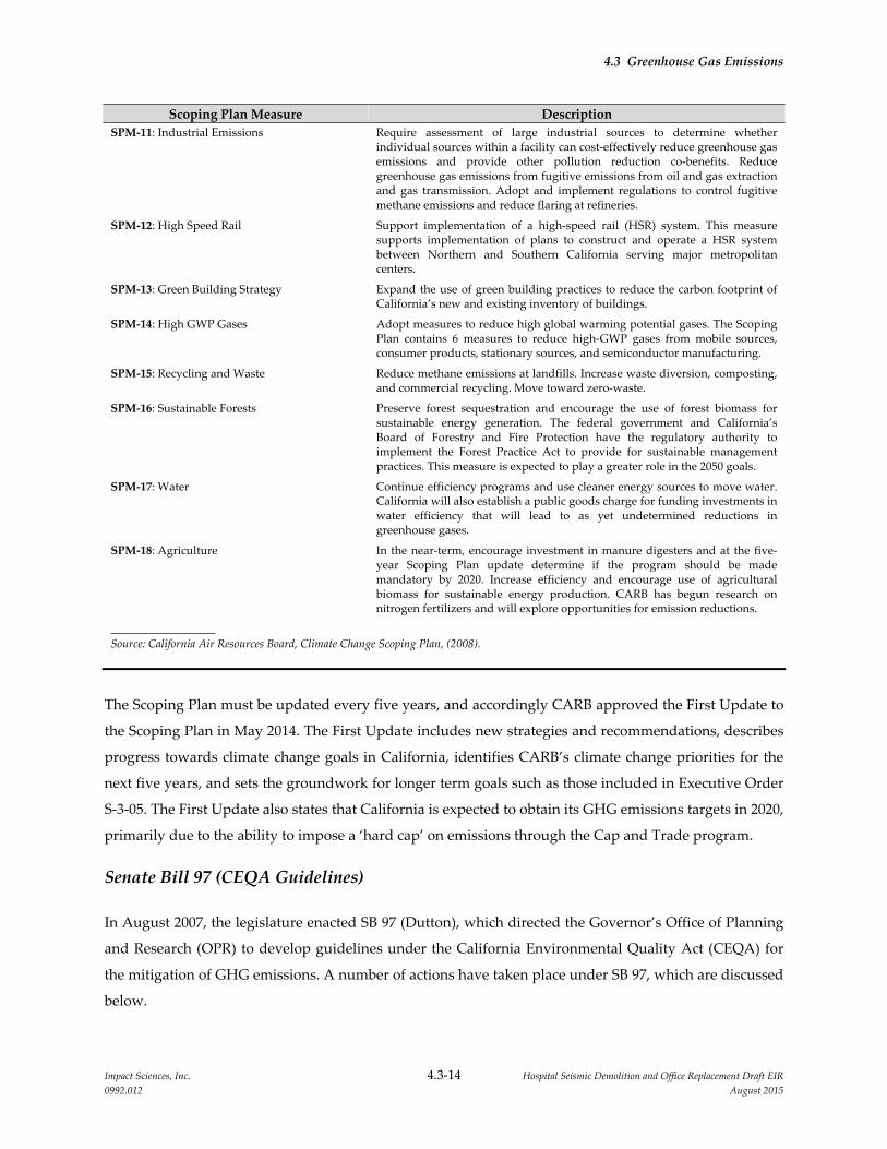
4.3 Greenhouse Gas Emissions
Impact Sciences, Inc. 4.3‐14 Hospital Seismic Demolition and Office Replacement Draft EIR
0992.012 August 2015
Scoping Plan Measure Description
SPM‐11: Industrial Emissions Require assessment of large industrial sources to determine whether individual sources within a facility can cost‐effectively reduce greenhouse gas emissions and provide other pollution reduction co‐benefits. Reduce greenhouse gas emissions from fugitive emissions from oil and gas extraction and gas transmission. Adopt and implement regulations to control fugitive methane emissions and reduce flaring at refineries.
SPM‐12: High Speed Rail Support implementation of a high‐speed rail (HSR) system. This measure supports implementation of plans to construct and operate a HSR system between Northern and Southern California serving major metropolitan centers.
SPM‐13: Green Building Strategy Expand the use of green building practices to reduce the carbon footprint of California’s new and existing inventory of buildings.
SPM‐14: High GWP Gases Adopt measures to reduce high global warming potential gases. The Scoping Plan contains 6 measures to reduce high‐GWP gases from mobile sources, consumer products, stationary sources, and semiconductor manufacturing.
SPM‐15: Recycling and Waste Reduce methane emissions at landfills. Increase waste diversion, composting, and commercial recycling. Move toward zero‐waste.
SPM‐16: Sustainable Forests Preserve forest sequestration and encourage the use of forest biomass for sustainable energy generation. The federal government and California’s Board of Forestry and Fire Protection have the regulatory authority to implement the Forest Practice Act to provide for sustainable management practices. This measure is expected to play a greater role in the 2050 goals.
SPM‐17: Water Continue efficiency programs and use cleaner energy sources to move water. California will also establish a public goods charge for funding investments in water efficiency that will lead to as yet undetermined reductions in greenhouse gases.
SPM‐18: Agriculture In the near‐term, encourage investment in manure digesters and at the five‐year Scoping Plan update determine if the program should be made mandatory by 2020. Increase efficiency and encourage use of agricultural biomass for sustainable energy production. CARB has begun research on nitrogen fertilizers and will explore opportunities for emission reductions.
Source: California Air Resources Board, Climate Change Scoping Plan, (2008).
The Scoping Plan must be updated every five years, and accordingly CARB approved the First Update to
the Scoping Plan in May 2014. The First Update includes new strategies and recommendations, describes
progress towards climate change goals in California, identifies CARB’s climate change priorities for the
next five years, and sets the groundwork for longer term goals such as those included in Executive Order
S‐3‐05. The First Update also states that California is expected to obtain its GHG emissions targets in 2020,
primarily due to the ability to impose a ‘hard cap’ on emissions through the Cap and Trade program.
Senate Bill 97 (CEQA Guidelines)
In August 2007, the legislature enacted SB 97 (Dutton), which directed the Governor’s Office of Planning
and Research (OPR) to develop guidelines under the California Environmental Quality Act (CEQA) for
the mitigation of GHG emissions. A number of actions have taken place under SB 97, which are discussed
below.

4.3 Greenhouse Gas Emissions
Impact Sciences, Inc. 4.3‐15 Hospital Seismic Demolition and Office Replacement Draft EIR
0992.012 August 2015
OPR Climate Change Technical Advisory
On June 19, 2008, OPR issued a technical advisory as interim guidance regarding the analysis of GHG
emissions in CEQA documents (OPR 2008). The advisory indicated that a project’s GHG emissions,
including those associated with vehicular traffic and construction activities should be identified and
estimated. The advisory further recommended that the lead agency determine significance of the impacts
and impose all mitigation measures that are necessary to reduce GHG emissions to a less than significant
level. The advisory did not recommend a specific threshold of significance. Instead, OPR requested that
CARB recommend a method for setting thresholds that lead agencies may adopt (OPR 2009).
CEQA Guideline Amendments
In its work to formulate CEQA Guideline Amendments for GHG emissions, OPR submitted the Proposed
Draft CEQA Guideline Amendments for Greenhouse Gas Emissions to the Secretary for Natural Resources on
April 13, 2009. The Natural Resources Agency conducted formal rulemaking procedures in 2009 and
adopted the CEQA Guideline Amendments on December 30, 2009. They became effective in March 2010.
Senate Bill 375
The California legislature passed SB 375 (Steinberg) on September 1, 2008. SB 375 requires CARB to set
regional GHG reduction targets after consultation with local governments. The target must then be
incorporated within that region’s regional transportation plan (RTP), which is used for long‐term
transportation planning, in a Sustainable Communities Strategy. SB 375 also requires each region’s
regional housing needs assessment (RHNA) to be adjusted based on the Sustainable Communities
Strategy in its RTP. Additionally, SB 375 reforms the environmental review process to create incentives to
implement the strategy, especially transit priority projects. The governor signed SB 375 into law on
September 30, 2008.
On January 23, 2009, CARB appointed a Regional Targets Advisory Committee (RTAC) to provide
recommendations and methodologies to be used in the target setting process. The RTAC provided its
recommendations in a report to CARB on September 29, 2009. On August 9, 2010, CARB staff issued the
Proposed Regional Greenhouse Gas Emission Reduction Targets for Automobiles and Light Trucks Pursuant to
Senate Bill 375. CARB staff proposed draft reduction targets for the four largest MPOs (Bay Area,
Sacramento, Southern California, and San Diego) of 7 to 8 percent for 2020 and reduction targets between
13 to 16 percent for 2035. For the Bay Area, CARB established a draft target of 7 percent for 2020 and
15 percent for 2035. These targets were recommended to CARB by the Metropolitan Transportation
Commission, which adopted the thresholds for its planning purposes on July 28, 2010. Of note, the
4.3 Greenhouse Gas Emissions
Impact Sciences, Inc. 4.3‐16 Hospital Seismic Demolition and Office Replacement Draft EIR
0992.012 August 2015
proposed reduction targets explicitly exclude emission reductions expected from the AB 1493 and low
carbon fuel standard regulations. CARB adopted the final targets on September 23, 2010.
4.3.3.3 Regional Programs
In December 2009, the Sacramento Metropolitan Air Quality Management District (SMAQMD) adopted
the Guide to Air Quality Assessment in Sacramento County (CEQA Guide) and has continued to update the
guide with the latest update occurring in June 2015. The CEQA Guide contains recommendations for
assessing and reducing the impacts of project‐specific GHG emissions on global climate change.
According to the CEQA Guide, projects should describe the existing environment and regulatory setting,
identify the significance thresholds, quantify the project’s GHG emissions from both construction and
operational activities, determine the significance of the emissions, and consider feasible mitigation
measures to reduce significant impacts. The CEQA Guide identifies the SMAQMD significance threshold
for lead agencies to use. The SMAQMD’s CEQA Guide also provides recommended measures for
reducing GHG emissions from land use development projects and stationary sources.
4.3.3.4 Applicable Local Plans and Policies
University of California Sustainable Practices Policy
The University of California Sustainable Practices Policy was adopted by The Regents in 2006 and revised
periodically through June 2015. The policy was developed to standardize campus practices and is a
system‐wide commitment to minimize the University of California’s impact on the environment and
reduce the University’s dependence on non‐renewable energy sources. The University of California
Sustainable Practices Policy promotes the principles of energy efficiency and sustainability in the
following areas:
Green Building Design
Clean Energy Standard
Climate Protection Practices
Sustainable Transportation Practices
Sustainable Operations
Recycling and Waste Management
Environmentally Preferable Purchasing Practices
Food

4.3 Greenhouse Gas Emissions
Impact Sciences, Inc. 4.3‐17 Hospital Seismic Demolition and Office Replacement Draft EIR
0992.012 August 2015
The policy guidelines that address these topics recommend that University operations:
Incorporate the principles of energy efficiency and sustainability in all capital projects, operations and
maintenance within budgetary constraints and programmatic requirements.
Minimize the use of non‐renewable energy sources on behalf of UC’s built environment by creating a
portfolio approach to energy use, including use of local renewable energy and purchase of green
power from the grid as well as conservation measures that reduce energy consumption.
Incorporate alternative means of transportation to/from and within the campus to improve the
quality of life on campus and in the surrounding community. The campuses will continue their
strong commitment to provide affordable on‐campus housing, in order to reduce the volume of
commutes to and from campus. These housing goals are detailed in the campuses’ LRDPs.
Track, report and minimize GHG emissions on behalf of UC operations.
Minimize the amount of University‐generated waste sent to landfill.
Utilize the University’s purchasing power to meet its sustainability objectives.
The University of California has signed the American College and University Presidents Climate
Commitment. Each signatory commits to completing an inventory of GHG emissions within one year,
and to developing, within two years, an institutional plan to achieve climate neutrality as soon as
possible. The commitment also includes specific interim actions, including requiring that new campus
construction will be built to at least the US Green Building Council’s LEED Silver standard or equivalent;
purchasing Energy Star appliances; offsetting greenhouse gas emissions generated by institutional air
travel; encouraging and providing access to public transportation; purchasing or producing at least 15
percent of the institution’s electricity consumption from renewable sources; supporting climate and
sustainability shareholder proposals at companies where the institution’s endowment is invested; and
adopting measures to reduce waste.
UC Davis Sacramento Campus 2010 Long Range Development Plan
The 2010 LRDP is the plan for the development of the campus. Although the 2010 LRDP does not contain
policies that specifically address GHG emissions, it does contain a number of elements with respect to
fuel‐ and energy‐efficiency provisions and elements that would encourage walking and bicycling on
campus and in surrounding neighborhoods, all of which would reduce GHG emissions. The 2010 LRDP
incorporates the University of California Policy on Sustainable Practices by establishing principles of
energy efficiency, sustainability, and alternative modes of transportation. The following principles are
contained in the 2010 LRDP.

4.3 Greenhouse Gas Emissions
Impact Sciences, Inc. 4.3‐18 Hospital Seismic Demolition and Office Replacement Draft EIR
0992.012 August 2015
Principle #1 Ensure Appropriate Facilities Adjacencies. Facility adjacencies help create
efficiencies in operations and in the movement of patients, visitors, students,
faculty, and staff. Recognizing existing major building investments, new facilities
will be located in proximity to the current primary UCDHS mission‐related uses.
Principle #2 Improve Campus Open Space and Landscape Character. While the Sacramento
campus has a number of attractive open spaces and landscaped areas, the
campus falls short of being the welcoming environment that it might be. For
instance, the campus lacks a large green quad or other major open space
typically associated with an academic institution. Also, the site does not yet
capture the special nature of “the City of Trees” that characterizes the City of
Sacramento, especially the downtown, State Capitol area, and downtown
neighborhoods. The planned program growth at the campus provides an
excellent opportunity to improve the open space character of the campus.
Components will include:
Improve the open space environment to create a comfortable, more campus‐
like character in the Education and Research District.
Create a large, multi‐purpose open space in the Education and Research
District, suitable for a variety of uses such as graduation ceremonies and
informal recreation.
Create two new pedestrian malls connecting primary destinations of
students, faculty and staff: the hospital, the education and research area, and
the ambulatory care facilities.
Continue strong landscape treatment of major roads to provide shaded
sidewalks for pedestrians and an image similar to the great Sacramento
downtown streets.
Create a network of secondary, building‐related courtyards with amenities
such as benches and shade, to provide an outdoor destination for patients,
visitors, faculty and staff.
Principle #3 Provide Convenient Access to and within the Campus. Providing convenient
access to and connections within the campus is crucially important to the
successful operations of UCDHS. Within the areas of education and research,
parking will move to the periphery in order to support a more pedestrian‐
friendly, auto‐free environment similar to a traditional higher education campus.
The campus will continue to incorporate alternate means of transportation to and
4.3 Greenhouse Gas Emissions
Impact Sciences, Inc. 4.3‐19 Hospital Seismic Demolition and Office Replacement Draft EIR
0992.012 August 2015
from the campus with a particular focus on the commute habits of faculty, staff
and students. The campus will support improved transportation options such as
working with RT to improve bus and light rail service to and near the campus,
and identify potential improvements to campus‐operated shuttle systems The
campus will implement appropriate alternate mode use incentives such as
discounted transit passes; carpool matching services; preferential parking for
carpools, vanpools and low emissions vehicles; and flexible car share programs
for the campus. The campus will also implement parking management policies,
such as pricing, to encourage use of alternate modes. Finally the campus will
encourage students in particular to live in close proximity of the campus to
facilitate daily commuting
Principle #4 Improve Pedestrian Connections throughout the Campus. All areas of the
campus will be improved for better pedestrian access. The open space system of
the connecting malls will provide the backbone of the connection system.
Pedestrian walkways and tree‐lined sidewalks will provide additional
connections and will ensure easy and efficient ways to move throughout the
campus without needing to drive.
Principle #5 Provide Attractive Campus Entries and Edges. Patient access will be focused at
two street entry points: Stockton Boulevard and X Street, and Broadway and
50th Street. These entries will provide access to the Patient Care Boulevard, and
will simplify access for patients all clinical destinations. In order to minimize
impacts on surrounding neighborhoods, access to the campus for general traffic
from V Street will be limited to only one location at 49th Street. Other existing
entry points at 45th and 48th Streets will be closed to general traffic with only
service or emergency vehicles allowed.
Principle #6 Continue to Plan and Operate a Sustainable Campus. The University of
California has been a leader in its sustainability practices. The Board of Regents
directed the UC President to create a Policy on Sustainable Practices in 2003
which set ambitious goals to advance environmental practices. This policy
continues to be updated. Recent reporting indicates that UC has achieved great
advances in important areas of energy and waste. In addition UC has received
recognition as a national leader in the full spectrum of sustainability areas and is
considered among the top tier of “green universities.” The University is
committed to developing a long term strategy for meeting the State’s goal of a
4.3 Greenhouse Gas Emissions
Impact Sciences, Inc. 4.3‐20 Hospital Seismic Demolition and Office Replacement Draft EIR
0992.012 August 2015
reduction of greenhouse gas (GHG) emissions to 2000 levels by 2014, is further
pursuing the goal of reducing GHG emissions to 1990 levels by 2020, and is
developing an action plan for becoming carbon neutral.
UC Davis Climate Action Plan
As discussed earlier in this section, the UC Policy on Sustainable Practices – Climate Protection section
targets three goals: reduction of GHG emissions back to 2000 levels by 2014, to 1990 levels by 2020, and
ultimately climate neutrality. Climate neutrality is defined in the UC Policy as the University having a net
zero impact on the Earth’s climate, which is to be achieved by minimizing GHG emissions as much as
possible and using carbon offsets or other measures to mitigate the remaining GHG emissions.
UC Davis has prepared the 2009‐2010 Climate Action Plan (CAP), which includes both the Davis and
Sacramento campuses, as well as outlying facilities. The CAP describes and addresses policy and
regulatory requirements of (1) the UC Sustainable Practices Policy , (2) AB 32, (3) the American College
and University Presidents Climate Commitment, (4) CEQA, and (4) US EPA reporting requirements. The
CAP provides documentation of how campus GHG emissions are calculated, a report of 2008 emissions,
estimates of past (to 1990) and future emissions (to 2020), a statement of GHG emission reduction goals, a
characterization of options and methods to reduce emissions, and a blueprint for future action.
The CAP focuses on the 2014 and 2020 targets, with the understanding that climate neutrality will require
fundamental shifts in global and national energy policy, energy production, and technologies currently
using fossil fuels. Further, the CAP focuses on emissions related to campus operations, instead of
commuting and air travel, because emissions related to commuting and air travel are less than one‐
quarter those of campus operations. The CAP does provide analysis of commuting and air travel
reduction options, but does not quantify emissions reductions for those options.
In the CAP, GHG emissions were calculated back to 1990, using hard data whenever possible (and
projected data when not), and including nearly every source of emissions. Calculated emissions for all of
UC Davis, excluding commuting and air travel, for 2000 are 246,000 MTCO2e and for 1990 are 142,000
MTCO2e. In 2008, inventoried emissions (in CCAR), excluding commuting and air travel, totaled 238,000,
indicating that UC Davis had already met the 2014 target. Thus, the CAP defined a new emissions target
of 210,000 MTCO2e, almost 15 percent below the 2000 emissions, as the new 2014 target. The 2020 target,
to reach 1990 emissions, is about 40 percent below the 1990 emissions.
Four years of verified inventories of emissions have shown consistently that the Davis campus
contributes about 70 percent of the emissions total, the Sacramento campus contributes about 29 percent
of the total, and the outlying facilities contribute about 1 percent of the total.

4.3 Greenhouse Gas Emissions
Impact Sciences, Inc. 4.3‐21 Hospital Seismic Demolition and Office Replacement Draft EIR
0992.012 August 2015
4.3.4 IMPACTS AND MITIGATION MEASURES
4.3.4.1 Significance Criteria
The impacts related to GHG emissions resulting from the implementation of the proposed project would
be considered significant if they would exceed either of the following significance criteria, in accordance
with Appendix G of the State CEQA Guidelines:
Generate greenhouse gas emissions, either directly or indirectly, that may have a significant impact
on the environment;
In compliance with the SMAQMD CEQA Guide, the quantitative thresholds for direct or indirect
GHG emissions are the following:
Construction: On an annualized basis, the project would have a significant impact if the
construction GHG emissions equaled or exceeded 1,100 metric tons/year (expressed as CO2e).
Operation: On an annualized basis, the project would have a significant impact if the operational
phase GHG emissions equaled or exceeded 1,100 metric tons/year (expressed as CO2e).
Conflict with an applicable plan, policy, or regulation adopted for the purpose of reducing the
emissions of greenhouse gases.
4.3.4.2 Methodology
This section was prepared in conformance with the SMAQMD CEQA guide using the CalEEMod
emissions estimating model to estimate project‐related GHG emissions. Site‐specific or project‐specific
data were used in the CalEEMod model where available. Where information was not available for the
proposed project, model default values were used. Emission calculations conducted for the proposed
project are contained in Appendix 4.2.
4.3.4.3 2010 LRDP EIR Mitigation Measures Included in the Proposed Project
With adoption of the 2010 UC Davis Sacramento Campus LRDP, UC Davis began implementing a series
of mitigation measures to reduce GHG emissions. The adopted LRDP mitigation measures are listed
below in Table 4.3‐3, LRDP EIR Mitigation Measures. These measures continue to be implemented as
part of on‐going operations and planning for new facilities, and relevant measures have been
incorporated into and made part of the proposed project.

4.3 Greenhouse Gas Emissions
Impact Sciences, Inc. 4.3‐22 Hospital Seismic Demolition and Office Replacement Draft EIR
0992.012 August 2015
Table 4.3‐3
2010 LRDP EIR Mitigation Measures
Mitigation
Measure Description
LRDP MM GHG‐1a UC Davis shall implement green building design standards for all new construction developed under the 2010 LRDP in accordance with the UC Policy on Sustainable Practices.
New building projects, other than acute‐care facilities, shall outperform the required provisions of the California Energy Code (Title 24) energy‐efficiency standards by at least 20 percent.
New building projects, other than acute‐care facilities, shall outperform the required provisions of the California Energy Code (Title 24) energy‐efficiency standards by 30 percent or more, whenever possible within the constraints of program needs and standard budget parameters.
UC Davis shall develop and implement, in consultation with other campuses and medical centers, standards for energy efficiency for new acute‐care facilities.
New building projects, except laboratory and acute care facilities, shall be certified to a minimum standard equivalent to a LEED™‐NC “Silver” rating according to the version of LEED™‐NC that is current at the time of design approval.
New building projects, except laboratory and acute care facilities, shall be certified to a minimum standard equivalent to a Leadership in Energy and Environmental Design (LEED™) “Gold” rating for new construction (NC), whenever possible within the constraints of program needs and standard budget parameters, according to the version of LEED™‐NC that is current at the time of design approval.
New laboratory building projects shall be certified to a minimum standard equivalent to a LEED™‐NC “Silver” rating and the Laboratories for the 21st Century (Labs21) Environmental Performance Criteria (EPC), as appropriate. The design process will include attention to energy efficiency for systems not addressed by the California Energy Code (Title 24).
New building projects shall achieve at least two of the available credits in the LEED™‐NC Water Efficiency category and shall cooperate with local water district in efforts to conserve water and to meet reduced water use goals of the local district.
New privatized development projects on The Regents’ land where the project is to be used for a programmatic or auxiliary purpose (i.e., a University‐related purpose) shall comply with the provisions of UC Policy on Sustainable Practices listed herein.
New building projects built on The Regents’ land pursuant to a ground lease by a private, institutional or government entity (“Lessee”) for the Lessee’s own use (whether in support the University’s mission or to generate income for the University) shall abide by the UC Policy provisions listed herein.
LRDP MM GHG‐1b The University of California is developing and UC Davis shall participate in a system‐wide portfolio approach to reduce consumption of nonrenewable energy. The portfolio will include a combination of energy efficiency projects, the incorporation of local renewable power measures for existing and new facilities, green power purchases from the electrical grid, and other energy measures with equivalent demonstrable effect on the environment and reduction in fossil fuel usage. UC Davis shall achieve a level of grid‐provided electricity from renewable sources that is similar to or greater than the State’s Renewable Portfolio Standard (RPS).

4.3 Greenhouse Gas Emissions
Impact Sciences, Inc. 4.3‐23 Hospital Seismic Demolition and Office Replacement Draft EIR
0992.012 August 2015
Mitigation
Measure Description
LRDP MM GHG‐1c UC Davis shall implement environmentally preferable purchasing practices for all new construction developed under the 2010 LRDP in accordance with the UC Policy on Sustainable Practices and the UC Davis CAP.
New building projects shall procure only products with an ENERGY STAR® rating for product categories that have ENERGY STAR® rated products available, consistent with the needs of UC Davis researchers.
New building projects shall require that suppliers ensure that all electronic equipment and items delivered to the project site enable all energy efficiency and conservation features, if the option exists and is consistent with the needs of the project.
New building projects shall give preference to technologies that ensure the efficient use of water resources for all products and services that require the use of water (e.g., low‐flow water fixtures, water efficient irrigation, etc.).
LRDP MM GHG‐1d UC Davis shall implement transportation reduction measures in accordance with the UC Policy on Sustainable Practices and the UC Davis CAP.
For all campus‐owned fleet vehicles, old equipment scheduled for retirement shall be preferentially replaced with fuel efficient, low emission vehicles (LEV), zero‐emission vehicles (ZEV), and/or alternative‐fueled vehicles consistent with the needs of the campus.
UC Davis shall investigate ways to expand or further improve upon the Green Light Commuter Club by providing additional alternative transportation options and incentives, and shall educate students, staff, faculty, and visitors about the program.
UC Davis shall implement campus‐wide policies and programs for reducing vehicle and flight miles traveled through teleconferencing, telecommuting, and telemedicine and shall educate students, staff, faculty, and visitors about these policies and programs.
UC Davis shall pursue the expansion of Transportation Demand Management (TDM) programs and projects to reduce the environmental impacts from commuting. TDM programs may include: carshare, carpools (rideshare), vanpools, buspools, campus shuttles, transit, bicycle circulation system, pedestrian circulation system, emergency rides home, telecommuting, flexible schedules, parking management (amount, access, fees), etc. In conjunction with this effort, campuses will engage in advocacy efforts with local transit districts to improve routes in order to better serve student and staff ridership. UC Davis shall educate students, staff, faculty, and visitors about TDM programs.
LRDP MM GHG‐1e UC Davis shall implement further waste reduction and recycling actions to reduce overall contributions to the campus landfill. Waste reduction and recycling actions shall include new purchasing requirements to increase recycled content in consumable materials and improved requirements for purchasing recyclable materials where possible.
LRDP MM GHG‐1f UC Davis shall monitor and report the total annual GHG emissions on a biannual basis. If the total annual increase in emissions from the project exceeds 25,000 MTCO2e in 2014 and/or 2020, UC Davis shall buy renewable energy credits, offsets, and/or allowances in accordance with the UC Policy on Sustainable Practices and/or a future cap‐and‐trade program to reduce the new emissions to below 25,000 MTCO2e.
Source: UC Davis Sacramento Campus, 2010 LRDP EIR, Section 4.6, Greenhouse Gas Emissions.
4.3 Greenhouse Gas Emissions
Impact Sciences, Inc. 4.3‐24 Hospital Seismic Demolition and Office Replacement Draft EIR
0992.012 August 2015
4.3.4.4 Project Impacts and Mitigation Measures
Impact GHG‐1: The proposed project would not generate greenhouse gas emissions, either
directly or indirectly, that may have a significant impact on the environment.
(Less than significant)
The project GHG emissions were calculated using the CalEEMod emissions model. CalEEMod provides
output for construction related emissions and for operational emissions. The following impact analysis
first addresses construction GHG emissions and then operational GHG emissions.
Construction Emissions
For construction emissions, project‐specific data regarding construction and demolition timing, expected
construction and demolition equipment, and detailed demolition debris hauling information were used
as inputs for the CalEEMod modelling. Where project‐specific information was not available, the
CalEEMod default values were utilized.
The proposed project consists of three main construction/demolition elements: Housestaff Building
demolition, North Addition Office Building construction, and North/South Wing demolition. In addition,
a final element of providing a new façade to the west face of the hospital and completing the landscape
plazas were considered part of the North/South Wing demolition for purposes of the CalEEMod
modeling.
The model outputs for construction/demolition activities are shown below in Table 4.3‐4 Annual GHG
Emissions from Demolition/Construction Activities. The Housestaff Building demolition and the North
Addition Office Building construction would overlap in year 2016, with North Addition construction
continuing into 2018. The total emissions from all of the Housestaff Building demolition and the North
Addition construction activities were estimated to be 902 MTCO2e and during the three‐year period of
2016, 2017, and 2018, these emissions are estimated to be approximately 301 MTCO2e per year. The
North/South Wing demolition would take place mostly in 2020 with some activities concluding in 2021.
The North/South Wing demolition was estimated to result in total emissions of 494 MTCO2e. In
combination, all of the construction demolition activities would result in 1,396 MTCO2e and when
averaged over the construction years of 2016, 2017, 2018, and 2020, the resulting annual average
emissions would 349 MTCO2e. GHG emissions during none of the construction years would exceed the
threshold of 1,100 MTCO2e per year. The potential GHG emission impact from construction activities
would be less than significant.

4.3 Greenhouse Gas Emissions
Impact Sciences, Inc. 4.3‐25 Hospital Seismic Demolition and Office Replacement Draft EIR
0992.012 August 2015
Table 4.3‐4
Annual GHG Emissions for Demolition/Construction Activities
Scope Source
GHG Emissions
Metric Tons CO2e/year*
Overlapping Phases:
Housestaff Demolition 2016
and
North Addition
Construction 2016‐19
North/South
Wing
Demolition
2020 ‐ 21
Total Annual GHG
Emissions
Demolition/
Construction
Demolition/
Construction
Annual
Total for years 2016‐2018 = 902
Annual average =301 494
Total for years 2016 ‐
2018, 2020 = 1,396
Annual average
(4‐year period) = 349
SMAQMD Threshold (per year) 1,100
Exceeds SMAQMD Threshold NO
Source: CalEEMod Model Results. Emission details are provided in Appendix 4.2.
Note: Totals in table may not appear to add exactly due to rounding. Estimated emissions account for construction and demolition trips.
Operational Emissions
To evaluate the proposed project’s operational impacts, GHG emissions associated with the existing
buildings under the present conditions were compared to the GHG emissions that would result in the
future upon completion of the proposed project. These emissions were estimated using basic CalEEMod
default inputs for the three buildings that are part of the proposed project, Housestaff Building (proposed
for demolition), the North Addition Office Building (proposed for construction), and the North/South
Wing (proposed for demolition). The Housestaff Building and the North/South Wing were modeled with
no “mitigation factors” such as energy efficiency items included in the CalEEMod model. For the North
Addition Office Building project, improved energy efficiency items were selected within the CalEEMod
mitigation factors to account for the energy efficiency measures that will be required under the UC Policy
and the UC‐equivalent LEED Gold certification or better that the project will seek. The operational
emissions for the Housestaff Building and the North/South Wing are presented below as reduced
emissions reflecting that the proposed project would result in these buildings ceasing operations and thus
eliminating GHG emissions associated with each building.
Table 4.3‐5, Annual GHG Emissions for Operational Activities, summarizes the output of operational
GHG emissions that would result from the proposed project. With the large GHG emission reductions
that would occur from closure of Housestaff Building and the North/South Wing, the overall operational

4.3 Greenhouse Gas Emissions
Impact Sciences, Inc. 4.3‐26 Hospital Seismic Demolition and Office Replacement Draft EIR
0992.012 August 2015
effect of the proposed project on GHG emissions would be a net decrease. The Housestaff Building and
the North/South Wing are projected to result in a decrease of 284 and 3,361 MTCO2e per year
respectively. The North Addition Office Building is projected to result in new operational GHG emissions
of 790 MTCO2e per year. The net change in operational GHG emissions is projected to be a decrease of
2,855 MTCO2e per year.
Table 4.3‐5
Annual GHG Emissions for Operational Activities
Scope Source
GHG Emissions (Reductions)
Metric Tons CO2e/year*
Housestaff
Building Ceasing
Operations ‐ 2016
North
Addition
Operations ‐
2019
North/South
Wing
Ceasing
Operations ‐
2019
Total Annual
GHG
Emissions
Energy
Electricity
and Gas
Operational
Estimates
‐188 759 ‐2,219 ‐1,653
Other Waste ‐90 59 ‐1,072 ‐1,103
Other Water ‐6 67 ‐70 ‐9
Total
Annual
GHG
Emissions
(Reductions)
‐284 885 ‐3,361 ‐2,765
SMAQMD Threshold (per year) 1,100
Exceeds SMAQMD Threshold NO
Source: CalEEMod Model Results. Emission details are provided in Appendix 4.2
Note: Totals in table may not appear to add exactly due to rounding. No mobile emissions were estimated because there would be no
increase in campus population as a result of the proposed project and therefore no increase in daily vehicle trips to the campus.
It is noteworthy that not only would the annual construction emissions associated with the proposed
project be well below the threshold recommended by the Air District, the total demolition and
construction GHG emissions (1,396 MTCO2e) would be more than completely offset by the decrease in
the operational emissions (2,885 MTCO2e per year) Based on this comparison, the project is considered to
result in no net increase in GHG emissions. No impact would occur.
Mitigation Measures: No project‐level mitigation measures are required.
4.3 Greenhouse Gas Emissions
Impact Sciences, Inc. 4.3‐27 Hospital Seismic Demolition and Office Replacement Draft EIR
0992.012 August 2015
Impact GHG‐2: The proposed project would not conflict with an applicable plan, policy, or
regulation adopted for the purpose of reducing GHG emissions. (No Impact)
As described in Impact GHG‐1 above, the proposed project would reduce the GHG emissions associated
with the Sacramento campus by about 2,885 MTCO2e per year. Furthermore, the proposed project
contains no elements that would conflict with UC Davis’s GHG reduction efforts, including the Campus’s
Climate Action Plan. There would be no impact.
Mitigation Measures: No project‐level mitigation measures are required.
4.3.4.5 Cumulative Impacts and Mitigation Measures
As the impact from a project’s GHG emissions is essentially a cumulative impact, the analysis presented
in the section provides an adequate analysis of the proposed project’s cumulative impact related to GHG
emissions. No further analysis is required.
4.3.5 REFERENCES
California Air Pollution Control Officers Association (CAPCOA). 2008. CEQA & Climate Change:
Evaluating and Addressing Greenhouse Gas Emissions from Projects Subject to the California
Environmental Quality Act.
California Air Resources Board (CARB). 2009. California Greenhouse Gas 2000‐2006 Inventory by Scoping
Plan Category – Summary. http://www.arb.ca.gov/cc/inventory/data/data.htm.
California Building Standards Commission. 2009. 2008 California Green Building Standards Code.
California Building Standards Commission. 2010. “CALGreen,” http://www.bsc.ca.gov/CALGreen
/default.htm.
California Climate Action Registry. 2009. General Reporting Protocol: Reporting Entity‐Wide Greenhouse as
Emissions Version 3.1.
California Department of Finance. 2008. “E‐5 City/County Population and Housing Estimates, 2008,
Revised 2001‐2007, with 2000 Benchmark,” http://www.dof.ca.gov/research/demographic/reports
/estimates/e‐5_2001‐06/.
California Department of Finance. 2009. Financial & Economic Data: Gross Domestic Product, California.
http://www.dof.ca.gov/HTML/FS_DATA/LatestEconData/FS_Misc.htm. June 2.
California Energy Commission. 2002. Diesel Use in California, Remarks by Commissioner James D. Boyd.
California Energy Commission. 2006a. Inventory of California Greenhouse Gas Emissions and Sinks 1990 to
2004.
4.3 Greenhouse Gas Emissions
Impact Sciences, Inc. 4.3‐28 Hospital Seismic Demolition and Office Replacement Draft EIR
0992.012 August 2015
California Energy Commission. 2006b. Refining Estimates of Water‐Related Energy Use in California, PIER
Final Project Report (CEC‐500‐2006‐118). Prepared by Navigant Consulting, Inc.
California Energy Commission. 2007. Revisions to the 1990–2004 Greenhouse Gas Emissions Inventory Report,
Published in December 2006. http://www.energy.ca.gov/2006publications/CEC‐600‐2006‐013/2007‐
01‐23_GHG_INVENTORY_REVISIONS.PDF.
California Environmental Protection Agency (Cal EPA), Climate Action Team. 2006. Climate Action Team
Report to Governor Schwarzenegger and the Legislature.
California Natural Resources Agency. 2009. Final Statement of Reasons for Regulatory Action: Amendments to
the State CEQA Guidelines Addressing Analysis and Mitigation of Greenhouse Gas Emissions Pursuant
to SB97.
The Climate Registry. 2010. Local Government Operations Protocol: For the quantification and reporting of
greenhouse gas emission inventories, Version 1.1.
Energy Information Administration. 2007. “Other Gases: Hydrofluorocarbons, Perfluorocarbons, and
Sulfur Hexafluoride,” http://www.eia.doe.gov/oiaf/1605/ggrpt/summary/other_gases.html.
Intergovernmental Panel on Climate Change (IPCC). 1996. Climate Change 1995: The Science of Climate
Change – Contribution of Working Group I to the Second Assessment Report of the Intergovernmental
Panel on Climate Change.
Intergovernmental Panel on Climate Change (IPCC). 2007. Climate Change 2007: The Physical Science Basis,
Summary for Policymakers. http://ipcc‐wg1.ucar.edu/wg1/docs/WG1AR4_SPM
_PlenaryApproved.pdf.
Sacramento Metropolitan Air Quality Management District (SMAQMD). 2009. Guide to Air Quality
Assessment in Sacramento County. Updated through June 2015.
State of California, Governor’s Office of Planning and Research (OPR). 2008. CEQA and Climate Change:
Addressing Climate Change Through California Environmental Quality Act (CEQA) Review.
State of California, Governor’s Office of Planning and Research (OPR). 2009. Draft CEQA Guideline
Amendments for Greenhouse Gas Emissions.
US Census Bureau. 2009. “Data Finders.” http://www.census.gov/.
US Environmental Protection Agency (US EPA). 1996. AP‐42 Compilation of Air Pollutant Emission
Factors, Fifth Edition, Volume I, Chapter 3.4. October.
US Environmental Protection Agency (US EPA). 1998. AP‐42 Compilation of Air Pollutant Emission
Factors, Fifth Edition, Volume I, Chapter 1.4. July.
US Environmental Protection Agency (US EPA). 2000. AP‐42 Compilation of Air Pollutant Emission
Factors, Fifth Edition, Volume I, Chapter 3.1. April.

4.3 Greenhouse Gas Emissions
Impact Sciences, Inc. 4.3‐29 Hospital Seismic Demolition and Office Replacement Draft EIR
0992.012 August 2015
US Environmental Protection Agency (US EPA). 2005. Greenhouse Gas Emissions from a Typical Passenger
Vehicle (EPA420‐F‐05‐004).
US Environmental Protection Agency (US EPA). 2008a. Glossary of Climate Change Terms.
http://www.epa.gov/climatechange/glossary.html.
US Environmental Protection Agency (US EPA). 2008b. Inventory of US Greenhouse Gas Emissions and Sinks
1990–2006. http://www.epa.gov/climatechange/emissions/usinventoryreport.html.
US Environmental Protection Agency (US EPA). 2009. “Climate Change.” http://www.epa.gov
/climatechange.
US Environmental Protection Agency (US EPA). n.d.(a) “High GWP Gases and Climate Change,”
http://www.epa.gov/highgwp/scientific.html#sf6.
US Environmental Protection Agency (US EPA). n.d.(b) “Methane: Sources and Emissions,”
http://www.epa.gov/methane/sources.html.
Impact Sciences, Inc. 4.4‐1 Hospital Seismic Demolition and Office Replacement Draft EIR
0992.012 August 2015
4.4 HAZARDS AND HAZARDOUS MATERIALS
4.4.1 INTRODUCTION
This section describes the existing conditions with respect to hazards and hazardous materials on the
project site and its vicinity, and potential impacts related to hazards and hazardous materials that may
occur as a result of the implementation of the proposed Hospital Seismic Demolition and Office
Replacement project (proposed project). Regulations and policies affecting hazardous conditions and
materials are also described in this section. Information presented in this section was obtained from the
Hazardous Materials Survey completed for the North/South Tower (Matec 2014).
Section 4.7 of the 2010 LRDP EIR contains an analysis of hazards and hazardous materials issues for the
UC Davis Sacramento campus and anticipated growth of the campus through the year 2025. The
following analysis focuses on the potential impacts of the proposed project Hospital Seismic Demolition
and Office Replacement project (proposed project) consisting of the three components: North Addition
Office Building construction and operation, North/South Wing Demolition, and Housestaff Building
Demolition.
No public or agency comments related to hazards and hazardous materials were received in response to
the Notice of Preparation (NOP) issued for this EIR. All comment letters received in response to the NOP
are provided in Appendix 1.0 of this Draft EIR.
4.4.2 ENVIRONMENTAL SETTING
4.4.2.1 Hazardous Materials
The term “hazardous material” is defined in Section 25501 of the California Health and Safety Code as
any material that, because of quantity, concentration, or physical or chemical characteristics poses a
significant present or potential hazard to human health and safety or to the environment. Hazardous
materials are grouped into the following four categories, based on their properties: toxic (causes human
health effects), ignitable (has the ability to burn), corrosive (causes severe burns or damage to materials),
and reactive (causes explosions or generates toxic gases).
Numerous hazardous materials, including non‐radioactive hazardous chemicals (organic compounds,
reagents) and radioactive materials, are used in patient care and clinical operations and research activities
at the Sacramento campus. Hazardous materials are also used in facility operations and building,
grounds and vehicle maintenance. Hazardous material use in turn generates hazardous wastes. Ongoing
renovation projects also generate asbestos waste, and used batteries from throughout the campus also

4.4 Hazards and Hazardous Materials
Impact Sciences, Inc. 4.4‐2 Hospital Seismic Demolition and Office Replacement EIR
0992.012 August 2015
require recycling or disposal. In addition to the above, several sources of non‐ionizing radiation (e.g.,
lasers, magnets, and microwave generators) are used to conduct research on university campuses and in
research facilities. Lasers and magnets (e.g., MRI) are also used in patient care. Certain scientific
materials, including laboratory animals, that are not hazardous materials by definition, are also used in
research. University campuses, especially medical schools, perform a wide range of biological and related
research involving recombinant technology, recombinant genomic materials, and genetically modified
organisms (GMOs). Recombinant research is commonly performed using microbiological agents (e.g.,
bacteria and viruses), human and animal cells, and other organisms, such as mice.
The Campus has numerous policies and procedures in place that govern how chemicals,
pharmaceuticals, biohazardous, and radioactive materials are used, stored, and disposed. This ensures
compliance with applicable federal, state, and local laws and regulations pertaining to hazardous
materials.
Hazardous Chemical Materials
A variety of chemicals are used in laboratories on the campus, along with many products that contain
hazardous chemicals. With few exceptions, specifically the Pathology laboratories, most of the hazardous
materials are stored and used in small quantities, generally a few gallons or less. The UC Davis Office of
Environmental Health and Safety (UC Davis EH&S) maintains a computerized inventory of hazardous
chemical materials stored in School of Medicine buildings on the Sacramento campus and the UC Davis
Health System Office of Environmental Health and Safety (Sacramento Campus EH&S) maintains a
manual inventory for all other locations. Sacramento Campus EH&S submits applicable portions of this
inventory to the County of Sacramento Department of Environmental Management as part of its
Hazardous Materials Business Plans (HMBPs). There are four HMBPs for the Sacramento campus—for
the Central Plant, Fleet Services, School of Medicine facilities, and the remainder of the campus. The
HMBPs, which may be reviewed at the Sacramento Campus EH&S office, list the names and quantities of
all hazardous chemical materials stored on the campus in quantities per building greater than 55 gallons
(for liquids), 500 pounds (for solids), or 200 cubic feet (for gases).1
In addition to the chemicals stored in buildings, the Sacramento campus has six underground storage
tanks ranging in capacity from 10,000 gallons to 15,000 gallons, and other smaller aboveground storage
tanks with capacities ranging from 165 gallons to 1,000 gallons, used to store fuel, waste oil, and aqueous
ammonia. All of the tanks meet federal, state, and local regulatory standards.2
1 Personal communication with John Danby and Impact Sciences, February 1, 2010.
2 Personal communication with John Danby and Impact Sciences, February 1, 2010.

4.4 Hazards and Hazardous Materials
Impact Sciences, Inc. 4.4‐3 Hospital Seismic Demolition and Office Replacement EIR
0992.012 August 2015
Radioactive and Biohazardous Materials
Radioactive and biohazardous materials are used on the Sacramento campus in research or diagnostic
applications, as well as patient treatment (radiopharmaceuticals). The proposed project would involve no
use of radioactive or biohazardous materials and no detailed background on the use or regulations of
these are provided in this analysis. Additional analysis of radioactive and biohazardous materials on the
Sacramento campus are available beginning on page 4.7‐3 of the 2010 LRDP EIR.
4.4.2.2 Soil and Groundwater Contamination
A government records report was reviewed for the 2010 LRDP EIR for the Sacramento campus and the
area within 0.5 mile of the campus (EDR 2009). This report searches federal and state databases, including
the California Government Code 65962.5 (Cortese) list, for potential sources of hazardous substances or
petroleum that might affect soil and/or groundwater quality at the project site and its vicinity. The report
also lists potential sources of hazardous airborne substances that might affect air quality, the impacts of
which are evaluated in Section 4.2, Air Quality.
There is one site on the campus that is currently listed on the Cortese list. Review of listings for the
campus indicate that, historically, there were 10 underground storage tanks (USTs) on the campus
ranging in capacity from 500 gallons to 26,000 gallons (EDR 2009) that were associated with the former
Fleet Services facility on V Street or the old boiler plant.3 The USTs contained diesel, unleaded gasoline,
and waste oil (EDR 2009). The former Fleet Services facility was demolished in the early 1990s prior to
construction of the Davis Tower. The tanks, including one leaking tank, were removed and the site was
remediated. The old Boiler Plant and Camellia Cottage were demolished in 2003 and replaced with the
new Surgery and Emergency Services Pavilion. The boiler plant USTs were removed and no
contamination was found. However, an old redwood tank used for bunker fuel was discovered beneath
the site of Camellia Cottage, which had previously been the site of an original hospital building used for
cleaning laundry. The tank contained petroleum hydrocarbons which appeared to have been heating oil
for the laundry building boiler. The contaminated soil was excavated and disposed of in 2003 (RGA
2005). Closure of the site and further compliance needs took place after completion of final site
documentation in April 2011. There is no other known soil or groundwater contamination on the
Sacramento campus at this time.
Five properties within a 0.5‐mile radius of the project site, though outside of the campus boundaries, are
listed on the regulatory agency databases. The database listings show that no leaks were detected for
3 Personal communication with John Danby and Impact Sciences, May 18, 2010.
4.4 Hazards and Hazardous Materials
Impact Sciences, Inc. 4.4‐4 Hospital Seismic Demolition and Office Replacement EIR
0992.012 August 2015
USTs. No known RCRA violations occurred at the sites and the cleanup of the LUST sites has been
completed (EDR 2009).
4.4.3 REGULATORY SETTING
Sacramento campus facilities are subject to environmental, health, and safety regulations applicable to the
transportation, use, management, and disposal of hazardous materials and wastes. This section provides
an overview of the regulatory setting and describes current health and safety policies and procedures.
The primary federal agencies with responsibility for hazardous materials management include the United
States Environmental Protection Agency (US EPA), and the US Department of Transportation (DOT). The
applicable federal laws, regulations, and responsible agencies are discussed in detail in this section. In
many cases, California state law mirrors or is more restrictive than federal law, and enforcement of these
laws has been delegated to the state or a local agency. In January 1996, the California Environmental
Protection Agency (CalEPA) adopted regulations implementing a Unified Hazardous Waste and
Hazardous Materials Management Regulatory Program (Unified Program). The program has six
elements: (1) hazardous waste generators and hazardous waste on‐site treatment, (2) underground
storage tanks, (3) aboveground storage tanks, (4) hazardous materials release response plans and
inventories, (5) risk management and prevention programs, and (6) Unified Fire Code hazardous
materials management plans and inventories. The local agency responsible for implementation of the
Unified Program is called the Certified Unified Program Agency (CUPA). As the Sacramento campus is
located within Sacramento County, the Environmental Compliance Division of the County’s
Environmental Management Department (EMD) is the designated CUPA for the campus. Similarly,
CDPH has designated EMD as the Local Enforcement Agency (LEA) for the administration of many
components, including generator compliance, of the California Medical Waste Management Act,
although CDPH has retained authority over permitted medical waste treatment facilities such as the one
at the Sacramento campus.
4.4.3.1 Hazardous Materials Management
Federal and state laws require detailed planning to ensure that hazardous materials are properly
handled, used, stored, and disposed of, and in the event that such materials are accidentally released, to
prevent or to mitigate injury to health or the environment. These laws require hazardous materials users
to prepare written plans, such as Hazardous Materials Business Plans. Sacramento County, through its
CUPA program, requires any business that handles hazardous materials above certain thresholds to
prepare a Hazardous Materials Business Plan, which must include the following:
Details of the facility and business conducted at the site

4.4 Hazards and Hazardous Materials
Impact Sciences, Inc. 4.4‐5 Hospital Seismic Demolition and Office Replacement EIR
0992.012 August 2015
An inventory of hazardous materials that are handled or stored on site
An emergency response plan and contact information
A site map
The Sacramento campus complies with these state requirements as enforced by the CUPA.
4.4.3.2 Hazardous Waste Handling
The federal Resource Conservation and Recovery Act of 1976 (RCRA) created a federal hazardous waste
“cradle‐to‐grave” regulatory program administered by US EPA. Under RCRA, US EPA regulates the
management, treatment, and disposal of hazardous waste, and the investigation and remediation of
hazardous waste sites. Individual states may apply to US EPA to authorize them to implement their own
hazardous waste programs in lieu of RCRA, as long as the state program is at least as stringent as federal
RCRA requirements. California has been authorized by US EPA to implement its own hazardous waste
program, with certain exceptions. In California, the Department of Toxic Substances Control (DTSC)
regulates the generation, transportation, treatment, storage, and disposal of hazardous waste, and the
investigation and remediation of hazardous waste sites. The California DTSC program incorporates
provisions of both federal and state hazardous waste laws. As noted above, DTSC has delegated several
components of the hazardous waste program to the local CUPA.
4.4.3.3 Hazardous Materials Transportation
The DOT regulates the transportation of hazardous materials between states and foreign countries. DOT
regulations govern all means of transportation, except for packages sent by mail, which are governed by
US Postal Service regulations. The State of California has adopted DOT regulations for the intrastate
movement of hazardous materials. In addition, the State of California regulates the transportation of
hazardous waste originating in the state and passing out of the state.
The two state agencies that have primary responsibility for enforcing federal and state regulations and
responding to hazardous materials transportation emergencies are the California Highway Patrol (CHP)
and the California Department of Transportation (Caltrans). The CHP enforces hazardous material and
hazardous waste labeling and packing regulations to prevent leakage and spills of material in transit and
to provide detailed information to cleanup crews in the event of an accident. The CHP conducts regular
inspections of licensed transporters to assure regulatory compliance.
Every hazardous materials package type used by a hazardous materials shipper must undergo tests that
imitate some of the possible rigors of travel. While not every package must be put through every test,
4.4 Hazards and Hazardous Materials
Impact Sciences, Inc. 4.4‐6 Hospital Seismic Demolition and Office Replacement EIR
0992.012 August 2015
representative packages for any package design must be able to be dropped, fully loaded, onto a concrete
floor with no significant leakage; survive a compression test in a stacked configuration with no significant
damage or distortion; demonstrate that they are leak proof when subjected to internal air and/or liquid
pressure; and not have package closure mechanisms adversely affected by vibration.
4.4.3.4 Occupational Safety
Occupational safety standards exist in federal and state laws to minimize worker safety risks from both
physical and chemical hazards in the workplace. The State of California Division of Occupational Safety
and Health Administration (Cal/OSHA) is responsible for developing and enforcing worker safety in the
workplace in California.
Cal/OSHA regulations contain requirements concerning the use of hazardous materials in the workplace
and during construction that mandate employee safety training, safety equipment, accident and illness
prevention programs, hazardous substance exposure warnings, emergency action and fire prevention
plan preparation, and a hazard communication program. The hazard communication program
regulations contain training and information requirements, including procedures for identifying and
labeling hazardous substances, and communicating hazard information relating to hazardous substances
and their handling. The hazard communication program also requires that Material Safety Data Sheets or
equivalent safety information be available to employees, and that employee information and training
programs be documented. These regulations require preparation of emergency action plans (escape and
evacuation procedures, rescue and medical duties, alarm systems, and training in emergency evacuation).
Cal/OSHA regulations include special provisions for hazard communication to employees in research
laboratories, including training in chemical work practices. Specific, more detailed training and
monitoring is required for the use of carcinogens, ethylene oxide, lead, asbestos, and certain other
chemicals. Emergency equipment and supplies, such as fire extinguishers, safety showers, and eye
washes, must also be provided and maintained in accessible places as the need dictates. Cal/OSHA
regulations include extensive, detailed requirements for worker protection applicable to any activity that
could disturb asbestos‐containing materials, including maintenance, renovation, and demolition. These
regulations are also designed to ensure that people working near the maintenance, renovation, or
demolition activity are not exposed to asbestos.
The Sacramento campus complies with these state requirements related to occupational safety.
4.4 Hazards and Hazardous Materials
Impact Sciences, Inc. 4.4‐7 Hospital Seismic Demolition and Office Replacement EIR
0992.012 August 2015
4.4.3.5 Local Plans and Policies
The following subsections summarize existing plans related to hazards and hazardous materials that are
implemented at the Sacramento campus.
California Accidental Release Prevention Risk Management Plan
In accordance with the provisions of the California Accidental Release Prevention (CalARP) program, the
Sacramento campus is required to prepare a Risk Management Plan (RMP) for the use of aqueous
ammonia above the California threshold quantity of 500 pounds at the Sacramento Campus Central
Energy Plant. The County of Sacramento Environmental Management Department, Hazardous Materials
Division, is the Administering Agency for the CalARP program in the county.
The Sacramento campus submitted a five‐year update of the RMP for the Central Energy Plant in April
2008. The RMP provides an evaluation of the potential for and impacts of accidental releases from the
aqueous ammonia utilized at the Central Energy Plant. The Campus also maintains a Hazardous
Materials Business Plan for the Central Energy Plant with annual submittals to the County of Sacramento
Environmental Management Department.
Spill Prevention, Control, and Countermeasures Plan
The Sacramento campus has prepared a Spill Prevention, Control, and Countermeasures (SPCC) Plan
pursuant to the Code of Federal Regulations, Title 40, Part 112 – Oil Pollution Prevention. The objective of
the SPCC Plan is to prevent the discharge of oil from non‐transportation related onshore and offshore
facilities into or upon the navigable waters of the United States or adjoining shorelines. The areas of the
campus subject to the SPCC regulation threshold include the Central Plant, Parking Structure 1
(emergency diesel fire pump), Fleet Services, Lot 7 (emergency diesel generator), the Hazardous Waste
Consolidation Facility, and the Portable Diesel Generators. There are various transformers and elevator
hydraulic systems located throughout the campus that are also subject to the SPCC regulation.
4.4.4 IMPACTS AND MITIGATION MEASURES
4.4.4.1 Significance Criteria
The impacts related to hazards and hazardous materials from the implementation of the 2010 LRDP
would be considered significant if they would exceed the following significance criteria, in accordance
with Appendix G of the State CEQA Guidelines and the UC CEQA Handbook:

4.4 Hazards and Hazardous Materials
Impact Sciences, Inc. 4.4‐8 Hospital Seismic Demolition and Office Replacement EIR
0992.012 August 2015
create a significant hazard to the public or the environment through the routine transport, use, or
disposal of hazardous materials;
create a significant hazard to the public or the environment through reasonably foreseeable upset and
accident conditions involving the release of hazardous materials into the environment;
emit hazardous emissions or handle hazardous or acutely hazardous materials, substances, or waste
within 0.25 mile of an existing or proposed school;
be located on a site that is included on a list of hazardous materials sites compiled pursuant to
government code section 65962.5 and, as a result, create a significant hazard to the public or the
environment;
for a project located within an airport land use plan or, where such a plan has not been adopted,
within 2 miles of a public airport or public use airport, would the project result in a safety hazard for
people residing or working in the project area;
for a project within the vicinity of a private airstrip, would the project result in a safety hazard for
people residing or working in the project area;
impair implementation of or physically interfere with an adopted emergency response plan or
emergency evacuation plan; or
expose people or structures to a significant risk of loss, injury, or death involving wildland fires,
including where wildlands are adjacent to urbanized areas or where residences are intermixed with
wildlands.
4.4.4.2 CEQA Checklist Items Adequately Addressed in the Initial Study
The analysis in the Initial Study prepared for the project and circulated with the NOP concluded that
further analysis of the following issues was not required in the EIR.
for a project located within an airport land use plan or, where such a plan has not been adopted,
within 2 miles of a public airport or public use airport, would the project result in a safety hazard for
people residing or working in the project area;
for a project within the vicinity of a private airstrip, would the project result in a safety hazard for
people residing or working in the project area;
impair implementation of or physically interfere with an adopted emergency response plan or
emergency evacuation plan; or
expose people or structures to a significant risk of loss, injury, or death involving wildland fires,
including where wildlands are adjacent to urbanized areas or where residences are intermixed with
wildlands.
4.4 Hazards and Hazardous Materials
Impact Sciences, Inc. 4.4‐9 Hospital Seismic Demolition and Office Replacement EIR
0992.012 August 2015
4.4.4.3 Methodology
Analysis in the section was conducted through a site visit and tour of areas surrounding the project sites,
review of project construction and demolition plans, review of the Hazardous Materials Survey
Completed for the North/South Wing of the UC Davis Sacramento Campus Hospital (Matec 2014), and
review of Section 4.7 Hazards and Hazardous Materials in the 2010 UC Davis Sacramento Campus LRDP
EIR.
4.4.4.4 LRDP EIR Mitigation Measures Included in the Proposed Project
The 2010 LRDP EIR included no mitigation measures for Hazards and Hazardous Materials. Accordingly,
no mitigation measures have been incorporated into this analysis.
4.4.4.5 Project Impacts and Mitigation Measures
Impact HAZ‐1: Implementation of the proposed project would increase the routine transport,
use, storage, and disposal of hazardous materials at the UC Davis Sacramento
Campus but would not create a significant hazard to the public or the
environment under the routine or reasonably foreseeable upset and accident
conditions. (Less than Significant)
Implementation of the proposed project involves the construction and operations of new facilities which
would replace existing facilities with a net reduction of approximately 125,000 square feet of space. The
expected net effect is that while the construction period would result in increased hazardous materials
use, storage, and disposal, the long‐term operational effect would be a reduction in hazardous materials
use, storage, and disposal. The proposed North Addition Office Building would replace the space
proposed for demolition in the North/South Wing of the Main Hospital. The North Addition Office
Building would consist of new construction free from lead, asbestos, or other known contaminants. With
the decreased square footage there would be a commensurate decrease in maintenance of the new
facilities as compared to the on‐going maintenance in the existing North/South Wing of the Main
Hospital. With the operational decrease in the transport, use, storage, and disposal of hazardous
materials and wastes, the project would result in no impact involving long‐term operational aspects of
hazards and hazardous materials. The following discussion evaluates the demolition and construction
aspects of transport, use, storage, and disposal of hazardous materials and wastes.
Use of products containing hazardous materials during demolition and construction would be limited to
such items as solvents, paints, cleaning agents, and petroleum‐based fuels used in vehicles and
equipment. Products containing hazardous materials used during these activities would be transported

4.4 Hazards and Hazardous Materials
Impact Sciences, Inc. 4.4‐10 Hospital Seismic Demolition and Office Replacement EIR
0992.012 August 2015
to, used, and stored at work sites in accordance with applicable hazardous materials management laws
and regulations. As discussed in Section 4.8, Hydrology and Water Quality, as required by federal and
state law, Best Management Practices (BMPs) included in construction storm water pollution prevention
plans will be implemented to ensure that runoff from work sites does not contain hazardous materials
that could affect receiving water quality. The use and storage of such materials represents a short‐term
increase, limited only to the duration of work at the demolition or construction site. Therefore, hazardous
materials impacts during demolition and construction would be less than significant.
Mitigation Measures: No project‐level mitigation measures are required.
Impact HAZ‐2: Demolition activities associated with implementation of the proposed project
would not expose people to contaminated building materials. (Less than
Significant)
Demolition of the Housestaff Building and North/South Wing could expose construction personnel, staff,
patients, students, and visitors to asbestos‐containing building materials, lead‐based paint, and other
hazardous building materials containing polychlorinated biphenyls (PCBs). These buildings to be
demolished were constructed prior to the 1970s, when asbestos‐containing building materials were being
manufactured and used. Therefore, there is a potential for encountering asbestos‐containing building
materials in the roof/ceiling and floor tiles, building insulation, concrete, and other materials throughout
the buildings. The University requirements for building management include removal of asbestos in
compliance with strict abatement procedures and in compliance with applicable regulations. The
SMAQMD has adopted Rule 902 regarding asbestos and the project would comply with all applicable
requirements of Rule 902.
The SMAQMD has identified that demolition of existing buildings and structures would be subject to
District Rule 902. SMAQMD Rule 902 is intended to limit asbestos emissions from demolition or
renovation of structures and the associated disturbance of asbestos containing waste material generated
or handled during these activities. The rule addresses the national emissions standards for asbestos along
with some additional requirements. The rule requires lead agencies and their contractors to notify the
District of any regulated renovation or demolition activity. This notification includes a description of
structures and methods utilized to determine whether asbestos‐containing materials are potentially
present. All asbestos‐containing material found on the site must be removed prior to demolition or
renovation activity in accordance with District Rule 902, including specific requirements for surveying,
notification, removal, and disposal of material containing asbestos. Therefore, projects that comply with
Rule 902 would ensure that asbestos containing materials would be disposed of appropriately and safely.
By complying with District Rule 902, thereby minimizing the release of airborne asbestos emissions,
4.4 Hazards and Hazardous Materials
Impact Sciences, Inc. 4.4‐11 Hospital Seismic Demolition and Office Replacement EIR
0992.012 August 2015
demolition activity would not result in a significant impact to air quality. Because District Rule 902 is in
place, no further analysis about the demolition of asbestos‐containing materials is needed in a CEQA
document. However, the District does recommend that CEQA documents acknowledge and discuss
District Rule 902 to support the public’s understanding of this issue. Rule 902 specifies that concrete
containing asbestos can be demolished prior to abatement provided that adequate wetting of the concrete
is completed prior to disturbing the material. UC Davis does not expect that the concrete in the
Housestaff Building or the North/South Wing contains asbestos and will test the concrete prior to
initiating the SMAQMD Rule 902 permitting requirements. If asbestos is contained in the concrete
proposed for demolition, the Rule 902 procedures requiring wetting of the concrete whenever exposed
during demolition will be followed to avoid releasing airborne asbestos..
Prior to beginning work, the pre‐abatement assessment reports will detail potential abatement needed in
each building. The proposed project includes substantial time in the project schedule and specific
contracting steps to provide an extended abatement period and post‐abatement testing period for each
building proposed for demolition. State law requires that contractors and workers be notified of the
presence of asbestos in buildings constructed before 1979. The CDPH requires the certification of
employees and supervisors performing lead‐related construction activities in residential and public
buildings. Standard specifications included in all campus construction contracts specify that contractors
who disturb or potentially disturb asbestos or lead must comply with all federal, state, and local rules
and regulations regarding these materials. Contractors are also required to stop work and inform the
Sacramento campus if they encounter material believed to be asbestos, PCBs, lead, or other hazardous
materials. Compliance with federal, state, and local regulations, as well as existing campus policies and
procedures, including enclosures and dust control measures, would minimize possible exposure to
hospital staff and patients.
Prior to any demolition in a laboratory, all hazardous materials must be removed and the laboratory must
be surveyed for contamination. Sacramento Campus EH&S then performs a confirmation survey for
contamination resulting from the use of radioactive or biohazardous materials, chemical carcinogens,
fume hoods or biosafety cabinets, and hazardous chemicals. Sacramento Campus EH&S uses a survey
meter and collects wipe samples to test for radioactivity before removing a room from a Radiation Use
Authorization. If the Sacramento Campus EH&S auditor finds reasons to suspect a major chemical spill
or if there are concerns about waste disposal, sampling for chemical constituents may be performed.
Compliance with federal and state regulations, campus policies, and current UC Davis Sacramento
Campus EH&S procedures minimizes the potential for exposure of people to contaminated building
materials. These standards have been developed to protect the general population and construction
workers from hazards associated with exposure to these materials. Young children, the elderly, and
4.4 Hazards and Hazardous Materials
Impact Sciences, Inc. 4.4‐12 Hospital Seismic Demolition and Office Replacement EIR
0992.012 August 2015
people in poor health (i.e., patients at the Sacramento campus) may be more susceptible to adverse health
effects from exposure to asbestos and lead released to the environment.
The Sacramento campus would continue to comply with federal and state regulations for the proposed
project. Abatement would be conducted early in the demolition of Housestaff Building and the
North/South Wing, with little potential for exposure in adjacent areas. Prior to demolition, asbestos‐ and
lead‐containing materials, and other hazardous materials requiring special handling would be managed
and/or removed and disposed of by qualified contractors in accordance with applicable regulations.
Therefore, because the campus would continue to comply with applicable procedures and regulations,
the removal and disposal of these materials is not considered a significant health hazard, and the impact
would be less than significant.
Mitigation Measures: No project‐level mitigation measures are required.
Impact HAZ‐3: Implementation of the proposed project would not result in handling of
hazardous materials within 0.25 mile of an existing school. (No impact)
The Sacramento High Charter School and the Kit Carson Middle School are located approximately 0.5
miles and 0.75 miles from the project site. Therefore, the project would not involve handling of hazardous
materials within 0.25 miles of a school. No impact would occur.
Mitigation Measures: No project‐level mitigation measures are required.
Impact HAZ‐4: The proposed North Addition Office Building would not be located on a site
that is included on a list of hazardous materials sites compiled pursuant to
Government Code Section 65962.5. (Less than Significant)
There is one hazardous materials site on the Sacramento campus that is currently listed on the Cortese
List compiled pursuant to Government Code Section 65962.5. This is the leaking UST site that, as
discussed above, that was remediated in 2003. Regulatory action for the site was completed upon
completion of final documentation in April 2011. Furthermore, the proposed building would not be
located on the former UST site.
Although the Sacramento campus is not aware of any unremediated contamination, there is a potential
for past uses at the campus site to have resulted in spills or leaks of fuels or other hazardous substances
that have not been identified. There also may be buried items (e.g., underground tanks installed prior to
permitting requirements) or debris, which could have resulted in soil contamination. Construction of
projects on the campus could expose construction and demolition workers to contamination.

4.4 Hazards and Hazardous Materials
Impact Sciences, Inc. 4.4‐13 Hospital Seismic Demolition and Office Replacement EIR
0992.012 August 2015
To minimize the risk associated with construction taking place on a site with unknown contamination,
the Campus has contract language that requires work stoppage if any hazardous materials are
encountered. Construction workers are trained to identify contaminants based on discoloration of soil or
sheen in groundwater. If contaminants are found, the Campus evaluates the nature and extent of
contamination, reports the findings to the appropriate regulatory agency, remediates, and then resumes
construction. Sacramento Campus EH&S retains qualified contractors to prepare health and safety plans
and report compliance for work performed on contaminated sites, and to review site remediation plans
prior to construction. Implementation of health and safety plans by campus contractors is a condition of
campus and contractor management. Therefore, impacts associated with contaminated soil and
groundwater would be less than significant.
Mitigation Measures: No project‐level mitigation measures are required.
4.4.4.6 Cumulative Impacts and Mitigation Measures
Cumulative Impact HAZ‐1: The proposed project, in conjunction with other past, present and
reasonably foreseeable future development, would not result in
significant cumulative impacts related to hazardous materials. (Less
than Significant)
As described in the 2010 LRDP EIR Section 4.7, Cumulative Impact HAZ‐1, the study area for potential
cumulative impacts related to hazardous materials is limited to the project sites and their immediate
vicinity as this would be the area that could be affected in the event of simultaneous accidental releases of
hazardous materials and the area that could be affected by air emissions stemming from the routine use
of hazardous materials.
As discussed above, the use of hazardous materials and the generation of hazardous wastes in the
proposed office building are not expected to result in significant impacts. Varying amounts and types of
hazardous materials would be handled in daily activities and operations. Proper management and
treatment/disposal of hazardous wastes would be based on regulations established by the US EPA and
the DTSC. Compliance with appropriate federal, state, and local laws and regulations would minimize
potential impacts of the project. Most of the area surrounding the project site is built out and according to
the land uses designated under the City’s General Plan, the Stockton Boulevard corridor was designated
as an area of opportunity for redevelopment. The remaining surrounding area is mostly designated for
residential uses, and is not identified as an area for new or redevelopment. Although redevelopment of
some parcels, especially along Stockton Boulevard, could result in the establishment of land uses that
involve the use of hazardous materials, because each project would be subject to laws and regulations

4.4 Hazards and Hazardous Materials
Impact Sciences, Inc. 4.4‐14 Hospital Seismic Demolition and Office Replacement EIR
0992.012 August 2015
related to the use, storage, transport, and disposal of hazardous materials and wastes, the cumulative
risks associated with hazardous materials would be less than significant.
Mitigation Measures: No project‐level mitigation measures are required.
4.4.5 REFERENCES
Environmental Data Resources, Inc. (EDR). 2009. Preliminary Map Report. April 22.
Matec 2014. Hazardous Materials Survey Completed for the North/South Wing of the UC Davis Sacramento
Campus Hospital.
RGA Environmental Inc. 2005. Soil Management Report, University of California Davis Medical Center.
August 29.
State Water Resource Control Board (SWRCB). 2009. UCD Medical Center SESP Site Demolition (T06067
16568), Closure Review. August 18.
Impact Sciences, Inc. 4.5‐1 Hospital Seismic Demolition and Office Replacement Draft EIR
0992.012 August 2015
4.5 HYDROLOGY AND WATER QUALITY
4.5.1 INTRODUCTION
This section describes the existing environmental conditions pertaining to the hydrology and water
quality on the project site and its vicinity. The description of the existing conditions is followed by a
discussion of the regulatory setting. The section evaluates and discusses the consequences associated with
implementation of the proposed Hospital Seismic Demolition and Office Replacement project (proposed
project). Section 4.14, Volume 1 of the 2010 Long Range Development Plan (LDRP) Environmental Impact
Report (EIR) from which this EIR is tiered and the City of Sacramento 2035 General Plan EIR were used in
the preparation of this section.
The Central Valley Regional Water Quality Control Board provided a comment letter in response to the
Notice of Preparation (NOP) issued for this EIR indicating that certain regulations, permits and design
standards may be applicable to the proposed project. All comment letters received in response to the
NOP are provided in Appendix 1.0 of this Draft EIR.
4.5.2 ENVIRONMENTAL SETTING
4.5.2.1 Surface Water Resources
The Sacramento campus is located approximately 1.5 miles south of the American River, and three miles
east of the Sacramento River, and is within the 27,000‐square‐mile Sacramento River Basin. This basin is
bounded by the Sierra Nevada to the east, the Coast Ranges to the west, the Cascade Range and Trinity
Mountains to the north, and the Sacramento–San Joaquin Rivers Delta to the southeast. The Sacramento
River Basin is the largest river basin in California and captures on average approximately 22 million acre‐
feet of annual precipitation. The Sacramento Valley portion of the basin contains the largest population,
concentrated in the cities of Sacramento, West Sacramento, Chico, Red Bluff, and Redding. The river is
regulated by dams for power generation, flood control, water supply, recreation, fisheries, and wildlife
management (City of Sacramento 2014).
The American River watershed encompasses approximately 1,900 square miles and is a tributary to the
Sacramento River. The American River watershed is situated on the western slope of the Sierra Nevada
mountain range, extending from the spine of the Sierra Nevada westward to the City of Sacramento. The
river is regulated by dams, canals, and pipelines for power generation, flood control, water supply,
recreation, fisheries, and wildlife management. Folsom Dam, located on the American River, is owned
and operated by the US Bureau of Reclamation. Folsom Lake and its afterbay, Lake Natoma, release
4.5 Hydrology and Water Quality
Impact Sciences, Inc. 4.5‐2 Hospital Seismic Demolition and Office Replacement Draft EIR
0992.012 August 2015
water to the lower American River and to the Folsom South Canal at Nimbus Dam. The operation of
Folsom Dam and Nimbus Dam directly affects most of the water utilities on the American River system
(City of Sacramento 2014).
The City, including the Sacramento campus, uses surface water from the Sacramento and American
Rivers, and groundwater pumped from the North American and South American subbasins to meet its
water demands. The City has surface water entitlements, consisting of five appropriative water right
permits issued by the State Water Resources Control Board (SWRCB), pre‐1914 rights, and a water rights
settlement contract with the US Bureau of Reclamation (City of Sacramento 2011).
4.5.2.2 Storm Water Drainage
The existing 142‐acre Sacramento campus land area consists of approximately 75 percent impervious and
25 percent pervious surfaces. Under existing conditions, the peak flow rate for a 10‐year storm is 178
cubic feet per second (cfs), while the 100‐year peak flow is 301 cfs (UC Davis 2010).
Storm water flows from the Sacramento campus are collected in the drain inlets, catch basins, and gutters,
before being discharged into the City of Sacramento’s storm drain system. Storm water from the western
half of the Sacramento campus site is held in an underground storm water detention facility that was
constructed on the Sacramento campus by the City of Sacramento, before it is discharged into the City’s
combined sewer system. The combined sewer system accommodates both domestic sewer discharge and
storm water runoff and combined flows are treated at the Sacramento Regional Wastewater Treatment
Plant (SRWTP). The storm water detention facility is designed to accommodate runoff from 10‐year storm
events generated by impervious surfaces on the Sacramento campus. The City designed and constructed
the detention system to handle flows from the development of more than 6 million gross square feet of
building space on the Sacramento campus. Storm water from the eastern half of the Sacramento campus
is collected in a separate storm drain system that discharges into the American River. During large storm
events which produce runoff that cannot be handled by the separate storm drain system, to avoid
localized flooding, excess storm water from the eastern half of the Sacramento campus is held in separate
chambers in the storm water detention facility to then be discharged into the storm drain system at a rate
that the system can handle. If flows are very high, the excess storm water is pumped from the separate
storm water chambers to the City’s combined sewer system, and treated at the SRWTP (UC Davis 2010).
4.5.2.3 Surface Water Quality
The Sacramento campus and the land surrounding it generally consists of flatlands intensely developed
with urban uses. Runoff from urban areas is characterized by constituents such as fertilizers, herbicides,
and pesticides, and often contains bacteria, high nutrient content, and dissolved solids. “First flush”
4.5 Hydrology and Water Quality
Impact Sciences, Inc. 4.5‐3 Hospital Seismic Demolition and Office Replacement Draft EIR
0992.012 August 2015
storm events, during which pollutants that have accumulated throughout the dry season are concentrated
with little dilution by the initial storm event of the season, are thought to have the largest impact on
receiving waters.
As stated above, storm water flows from the western half of the Sacramento campus and excess flows
from the eastern half are detained on site before they are discharged into the City’s combined sewer
system or to the American River. The combined sewer system is considered at or near capacity and the
City requires all additional inflow into the system to be offset. During smaller storms, the City sends up
to 60 million gallons per day (mgd) of wastewater to the SRWTP, which treats storm water and sanitary
sewage prior to discharge into the Sacramento River. When the flows in the City’s combined sewer
system exceed 60 mgd, flows are routed to Pioneer Reservoir, a 22‐million‐gallon storage and primary
treatment facility adjacent to the Sacramento River just north of the Pioneer Bridge (US Highway 50).
Once the capacity of Pioneer Reservoir is reached, flows are routed to the City’s Combined Wastewater
Treatment Plant (CWTP) to maximize available storage, before flows are sent to the Pioneer Reservoir
treatment facility for treatment and discharge to the Sacramento River. The CWTP provides primary
treatment with disinfection of up to 130 mgd of combined wastewater. The system may also store water
in the CWTP basins, such that up to 250 mgd of combined wastewater can receive primary treatment
with disinfection before it is discharged to the Sacramento River. Under extreme high flow conditions,
discharge of untreated combined wastewater from the combined sewer system may occur (City of
Sacramento 2009). Please see Section 4.8, Utilities and Service Systems, for more information on the
combined sewer and storm drainage facilities that serve the Sacramento campus.
4.5.3 REGULATORY CONSIDERATIONS
4.5.3.1 Federal and State Laws
The California SWRCB is the state agency with the primary responsibility for implementation of both
state and federally established regulations relating to water resource issues. Typically, all regulatory
requirements are implemented by the SWRCB through regional boards established throughout the state.
Clean Water Act
In 1972, the Federal Water Pollution Control Act—also known as and hereafter referred to as the Clean
Water Act (CWA)—was amended to require NPDES permits for discharge of pollutants into the “waters
of the United States” that include oceans, bays, rivers, streams, lakes, ponds, and wetlands from any
point source. In 1987, the CWA was amended to require that the US Environmental Protection Agency
(US EPA) establish regulations for permitting under the NPDES permit program of municipal and
industrial storm water discharges. The US EPA published final regulations regarding storm water
4.5 Hydrology and Water Quality
Impact Sciences, Inc. 4.5‐4 Hospital Seismic Demolition and Office Replacement Draft EIR
0992.012 August 2015
discharges on November 16, 1990. The regulations require that municipal separate storm sewer system
(MS4) discharges to surface waters be regulated by an NPDES permit.
In addition, the CWA requires the states to adopt water quality standards for water bodies and have
those standards approved by the US EPA. Water quality standards consist of designated beneficial uses—
e.g., wildlife habitat, agricultural supply, fishing, etc.—for a particular water body, along with water
quality criteria necessary to support those uses. Water quality criteria are prescribed concentrations or
levels of constituents—such as lead, suspended sediment, and fecal coliform bacteria—or narrative
statements that represent the quality of water that supports a particular use. Because California has not
established a complete list of acceptable water quality criteria, the US EPA established numeric water
quality criteria for certain toxic constituents in the form of the California Toxics Rule (40 CFR 131.38).
Water bodies not meeting water quality standards are deemed “impaired” and, under CWA Section
303(d), are placed on a list of impaired waters for which a Total Maximum Daily Load (TMDL) must be
developed for the impairing pollutant(s). A TMDL is an estimate of the total load of pollutants from
point, nonpoint, and natural sources that a water body may receive without exceeding applicable water
quality standards (with a “factor of safety” included). Once established, the TMDL is allocated among
current and future pollutant sources discharging to the water body.
Both the Lower American River and the Sacramento River (from Knights Landing to the Delta) are listed
on the 303(d) list as being impaired for mercury and unknown toxicities (SWRCB 2011).
Porter‐Cologne Water Quality Control Act
The Porter‐Cologne Water Quality Control Act (Porter‐Cologne Act), which is the state’s clean water act,
provides the statutory authority for SWRCB and the RWQCBs to regulate water quality and was
amended in 1972 to extend the federal CWA authority to these agencies (see Clean Water Act, above).
The Porter‐Cologne Act established the SWRCB and divided the state into nine regions, each overseen by
a RWQCB. The SWRCB is the primary state agency responsible for protecting the quality of the state’s
surface and groundwater supplies, but much of the daily implementation of water quality regulations is
carried out by the nine RWQCBs. The Sacramento campus is within the Central Valley RWQCB
(CVRWQCB).
The Porter‐Cologne Act provides for the development and periodic review of water quality control plans
(also known as basin plans). The basin plan for the Sacramento River Basin designates beneficial uses and
water quality objectives for surface water bodies and groundwater in the region.
4.5 Hydrology and Water Quality
Impact Sciences, Inc. 4.5‐5 Hospital Seismic Demolition and Office Replacement Draft EIR
0992.012 August 2015
4.5.3.2 Programs and Permits
CWA Permits for Discharge to Surface Waters
CWA Sections 401 and 402 contain requirements for discharges to surface waters through the NPDES
program, administered by the US EPA. In California, SWRCB is authorized by the US EPA to oversee the
NPDES program through the RWQCBs (see related discussion under Porter‐Cologne Water Quality
Control Act, below). The NPDES program provides for both general permits (those that cover a number
of similar or related activities) and individual permits.
General Construction Permit
According to NPDES regulations, discharges of storm water from construction sites in California with a
disturbed area of 1‐acre or more, are required either to obtain individual NPDES permits for storm water
discharges or to be covered by the statewide Construction General Permit. Coverage under the
Construction General Permit is accomplished by completing and filing a Notice of Intent with the
SWRCB. Each applicant under the Construction General Permit must ensure that a Storm Water Pollution
Prevention Plan (SWPPP) is prepared prior to grading and is implemented during construction.
Effective July 1, 2010, all dischargers are required to obtain coverage under the Construction General
Permit Order 2009‐0009‐DWQ adopted on September 2, 2009, and as amended by Order 2010‐0014‐DWQ
and Order 2012‐006‐DWQ, adopted February 2011 and July 2012, respectively. Section A of the
Construction General Permit describes the elements that must be contained in a SWPPP. The SWPPP
should contain a site map(s) which shows the construction site perimeter, existing and proposed
buildings, lots, roadways, storm water collection, and discharge points, general topography both before
and after construction, and drainage patterns across the project. The SWPPP must list the BMPs the
discharger will use to protect storm water runoff and the placement of those BMPs. Additionally, the
SWPPP must contain a visual monitoring program, a chemical monitoring program for “non‐visible”
pollutants to be implemented if there is a failure of BMPs, and a sediment monitoring plan if the site
discharges directly to a water body listed on the 303(d) list for sediment.
All new projects which are over one acre in size and which are not already covered by the current
stormwater permit are required to calculate the proper classification of the project as either a Risk Level 1,
2 or 3 project. Risk Level 1 has the least stringent requirements and is not subject to either the Numeric
Action Limits (NALs) or Numeric Effluent Limits (NELs) which have been established for pH and
turbidity. In contrast, a NAL of 250 NTU, and a pH of 6.5‐8.5 has been established for Risk Levels 2 and 3,
while NELs of 500 NTU and a pH of 6.0‐9.0 have been established for Risk Level 3 projects. In addition,
Risk Level 1 projects do not have to prepare a Rain Event Action Plan (REAP) while both Risk Level 2 and

4.5 Hydrology and Water Quality
Impact Sciences, Inc. 4.5‐6 Hospital Seismic Demolition and Office Replacement Draft EIR
0992.012 August 2015
3 projects are required to prepare a REAP which is applicable to every event where there is a forecast of
50 percent or greater probability of measurable precipitation (0.01 inch or more). The permit also requires
the SWPPP to include a description of all post‐construction BMPs on a site and a maintenance schedule.
Municipal Separate Storm Sewer System Permit
Municipal Separate Storm Water Systems (MS4s) are any conveyance or system of conveyances that are
owned or operated by a state or local government entity and are designed for collecting and conveying
storm water that is not part of a Publicly Owned Treatment Works (i.e., not a combined sewer). The 1987
amendments to the CWA directed the US EPA to implement storm water programs into two phases.
Phase I addresses large‐ and medium‐sized MS4 communities with populations of 250,000 or more, and
100,000–250,000, respectively. Phase II regulates storm water discharges associated with small
construction activities (activities disturbing between 1‐ and 5‐acres), and small municipal storm water
systems (serving populations less than 100,000). The RWQCBs issue MS4 permits that regulate storm
water discharges. The permits require the permittees to establish controls to the maximum extent
practicable and effectively prohibit non‐storm water discharges to the MS4. The MS4 permits detail
requirements for new development and significant redevelopment projects, and includes specific sizing
criteria for treatment BMPs. The Sacramento campus is subject to the Phase II requirements.
4.5.3.3 Local Programs
City of Sacramento Stormwater Quality Improvement Program
The City of Sacramento’s municipal storm water NPDES permit regulates the discharge of all wet and
dry weather urban runoff within the City of Sacramento and requires the City to implement a storm
water management program to reduce pollutants in storm water to the maximum extent practicable. The
City of Sacramento established the Stormwater Quality Improvement Program (SQIP) in 1990 to reduce
the pollution carried by storm water into local creeks and rivers in compliance with the municipal storm
water NPDES permit. The comprehensive plan includes pollution control measures for construction sites,
industrial sites, illegal discharges and illicit connections, new development, and municipal operations.
The program also includes an extensive public education effort, target pollutant reduction strategy, and
monitoring program.
Stormwater Quality Design Manual for Sacramento and South Placer Regions
In addition, the County of Sacramento and the cities of Sacramento, Folsom, Citrus Heights, Elk Grove,
Rancho Cordova, Galt, and Roseville collaborated and published the Stormwater Quality Design Manual
for Sacramento and South Placer Regions (May 2007) to meet the regulatory requirements of their

4.5 Hydrology and Water Quality
Impact Sciences, Inc. 4.5‐7 Hospital Seismic Demolition and Office Replacement Draft EIR
0992.012 August 2015
respective municipal storm water NPDES permits. The manual provides locally adapted information for
design and selection of three categories of storm water quality control measures: source control, runoff
reduction, and treatment control.
4.5.4 IMPACTS AND MITIGATION MEASURES
4.5.4.1 Significance Criteria
The impact of the proposed project on hydrology and water quality would be considered significant if it
would exceed the following significance criteria, in accordance with Appendix G of the State CEQA
Guidelines and the UC CEQA Handbook:
Violate any water quality standards or waste discharge requirements;
Substantially deplete groundwater supplies or interfere substantially with groundwater recharge
such that there would be a net deficit in aquifer volume or a lowering of the local groundwater table
level (e.g., the production rate of the pre‐existing nearby wells would drop to a level which would
not support existing land uses or planned uses for which permits have been granted;
Substantially alter the existing drainage pattern of the site or area, including through the alteration of
the course of a stream or river, in a manner which would result in substantial erosion or siltation on
or off site;
Substantially alter the existing drainage pattern of the site or area, including through the alteration of
the course of a stream or river, or substantially increase the rate or amount of surface runoff in a
manner which would result in flooding on or off site;
Create or contribute runoff water that would exceed the capacity of existing or planned storm water
drainage systems, or provide substantial additional sources of polluted runoff;
Otherwise substantially degrade water quality;
Place housing within a 100‐year flood hazard area as mapped on a federal Flood Hazard Boundary or
Flood Insurance Rate Map or other flood hazard delineation;
Place within a 100‐year flood hazard area structures that would impede or redirect flood flows;
Expose people or structures to a significant risk of loss, injury or death involving flooding, including
flooding as a result of the failure of a levee or dam; or
Inundation by seiche, tsunami, or mudflow.
4.5.4.2 CEQA Checklist Items Adequately Addressed in the Initial Study
The analysis in the Initial Study prepared for the project and circulated with the NOP concluded that no
further analysis of the following issues was required in the EIR.
4.5 Hydrology and Water Quality
Impact Sciences, Inc. 4.5‐8 Hospital Seismic Demolition and Office Replacement Draft EIR
0992.012 August 2015
Substantially deplete groundwater supplies or interfere substantially with groundwater recharge
such that there would be a net deficit in aquifer volume or a lowering of the local groundwater table
level (e.g., the production rate of the pre‐existing nearby wells would drop to a level which would
not support existing land uses or planned uses for which permits have been granted;
Substantially alter the existing drainage pattern of the site or area, including through the alteration of
the course of a stream or river, or substantially increase the rate or amount of surface runoff in a
manner which would result in flooding on or off site;
Substantially alter the existing drainage pattern of the site or area, including through the alteration of
the course of a stream or river, in a manner which would result in substantial erosion or siltation on
or off site;
Create or contribute runoff water that would exceed the capacity of existing or planned storm water
drainage systems, or provide substantial additional sources of polluted runoff;
Place housing within a 100‐year flood hazard area as mapped on a federal Flood Hazard Boundary or
Flood Insurance Rate Map or other flood hazard delineation;
Place within a 100‐year flood hazard area structures that would impede or redirect flood flows;
Expose people or structures to a significant risk of loss, injury or death involving flooding, including
flooding as a result of the failure of a levee or dam; or
Inundation by seiche, tsunami, or mudflow.
As discussed in the Initial Study, the proposed project would not interfere with groundwater recharge
and would not exceed capacity of stormwater runoff systems. The proposed project would increase the
area of permeable ground coverage on sites that currently have no permeable coverage so that more
stormwater could infiltrate through the surface to assist with aquifer recharge and reduce flows into
stormwater conveyance facilities. The project is expected to result in an increase of approximately 30,000
GSF in permeable ground coverage. The project would have no impact on groundwater recharge and no
impact to the capacity of stormwater runoff systems.
The project sites are fully developed areas of the hospital complex. The project includes removal of two
existing buildings with one project site left redeveloped as a landscaped area and one project site
redeveloped as a plaza and landscaped area. The proposed project is expected to result in no change to
drainage patterns or the quality of stormwater runoff. The project would have no effect on a stream or
river and would have no effect on the existing drainage pattern of the site or an area around the site. The
redevelopment of the project sites would include detailed drainage designs to route stormwater from the
sites into the same pipes that currently serve the sites with the proposed new landscape areas reducing
the amount of expected runoff. No impact would occur.

4.5 Hydrology and Water Quality
Impact Sciences, Inc. 4.5‐9 Hospital Seismic Demolition and Office Replacement Draft EIR
0992.012 August 2015
The proposed does not include residential uses that could be affected by flooding and the site is not
located in a 100‐year floodplain, as defined by the Federal Emergency Management Agency (FEMA Flood
Map 6067C0195H, effective August 2012) and would not place residences or any other type of structure in
a 100‐year floodplain. The project site is not located near a levee or dam and would not be subject to risk
of flooding due to failure of one of these structures. No impact would occur.
The campus is generally flat and is not located in close proximity to any large water bodies, therefore,
campus is not subject to inundation by seiche, tsunami, or mudflow. Therefore, no impact would occur.
4.5.4.3 2010 LRDP EIR Mitigation Measures Included in the Proposed Project
Analysis in the 2010 LRDP EIR concluded that all potential impacts to hydrology and water quality as a
result of implementation of the 2010 LRDP would be less than significant and no mitigation measures
were necessary.
4.5.4.4 Project Impacts and Mitigation Measures
Impact HYDRO‐1: Construction and operational activities associated with the proposed
project would not contribute substantial loads of sediment or other
pollutants in storm water runoff that could degrade receiving water
quality. (Less than Significant)
Construction
The proposed project would disturb three sites on the campus which together would involve more than 1
acre of disturbance. Proposed construction and grading activities would include demolition of existing
structures, removal of asphalt, site grading, and the operation of heavy equipment. Although the project
site is essentially flat and the potential for soil erosion is considered to be low, peak storm water runoff
could result in short‐term sheet erosion within areas of exposed or stockpiled soils. Furthermore, the
compaction of soils by heavy equipment may reduce the infiltration capacity of soils and increase runoff
and erosion potential. Given the above, pollutants such as soil, sediments, and other substances
associated with construction activities (e.g., oil, gasoline, grease, and surface litter) could enter the local
storm drain system.
As discussed above, projects that would disturb areas of 1 acre or more during construction are required
to comply with the state’s NPDES General Permit for Discharges of Storm Water Associated with
Construction Activity (Construction General Permit). The project construction contractor would be
required to file a notice of intent to obtain coverage under the Construction General Permit. This permit

4.5 Hydrology and Water Quality
Impact Sciences, Inc. 4.5‐10 Hospital Seismic Demolition and Office Replacement Draft EIR
0992.012 August 2015
requires that a SWPPP be prepared that would include appropriate erosion control measures. In addition,
the SWPPP would require that if any spills of materials known to be water pollutants or hazardous
materials do occur, the proper agencies would be contacted immediately (if necessary) and appropriate
cleanup of the spill would take place as soon as possible. Erosion control measures that would be
implemented during site grading and construction would include the use of straw hay bales, straw bale
inlet filters, filter barriers, and silt fences. Adherence to the NPDES requirements would ensure that the
construction of the proposed project would not substantially degrade surface water quality. Given the
above, the implementation of the proposed project would have a less than significant short‐term impact
on water quality during construction.
Operation
Upon completion of construction, as under existing conditions, stormwater runoff from the three project
sites would continue to drain into the City’s combined sewer system, as well the City storm drains and
eventually to the American River. Once the proposed project is constructed, the project sites would be
under impervious surfaces (buildings, pavement, etc.) and landscaped. This would minimize the
potential for erosion and sedimentation in the long term. In addition, post‐development peak storm
water flows would not exceed pre‐development peak storm water flows because there would not be a
substantial increase in impervious surfaces on the project sites. In fact the impervious surfaces on the
project sites are expected to decrease by about 30,000 square feet. As a result, the amount of runoff
entering the City’s storm drain system would not increase relative to existing conditions and would not
result in discharge of sediments, or otherwise affect water quality. In addition, in compliance with
NPDES Phase II regulations, the Sacramento campus has developed and is implementing a campus‐wide
Storm Water Management Plan (SWMP). That plan encompasses the entire campus, including the project
sites, and includes structural and non‐structural BMPs to control the discharge of pollutants into storm
water from campus operations. Therefore, the impact from project operations is considered less than
significant.
Mitigation Measures: No project‐level mitigation measures are required.
4.5.4.5 Cumulative Impacts and Mitigation Measures
The cumulative context for evaluation of hydrology and water quality impacts includes campus
development under the 2010 LRDP (including the proposed project) in combination with anticipated
development in the City of Sacramento that has the potential to impact the same receiving waters.
Cumulative Impact HYDRO‐1: The proposed project, in conjunction with other reasonably
foreseeable future development in Sacramento, could increase

4.5 Hydrology and Water Quality
Impact Sciences, Inc. 4.5‐11 Hospital Seismic Demolition and Office Replacement Draft EIR
0992.012 August 2015
the volume of urban runoff, but would not adversely affect
receiving water quality. (Less than Significant)
Future development in the Sacramento region could affect existing absorption rates, drainage patterns, or
the rate of surface runoff. If the development in an area is intensified, natural vegetated pervious
groundcover could be converted to impervious surfaces such as paved streets, rooftops, and parking lots
that increase runoff rates. Increased development and human activity could cause degradation of surface
and groundwater quality in the region. However, for future construction projects in the watershed in the
City’s jurisdiction, the City would require public or private contractors to comply with the requirements
of the City’s SQIP. In addition, before the onset of any construction activities, where the disturbed area is
one acre or more in size, the City would require any public or private contractors to obtain coverage
under the NPDES General Construction Permit and include erosion and sediment control plans. In
addition, the City’s SQIP would require implementation of post‐construction measures to reduce or
eliminate water quality problems, including source controls such as reduced surface disturbance, and
treatment of polluted runoff such as detention or retention basins (City of Sacramento 2009). The
Sacramento campus would also comply with state and federal water quality regulations. As described
above in Impact HYDRO‐1, construction and operational activities associated with implementation of the
proposed project would not contribute substantial loads of sediment or other pollutants in storm water
runoff that could degrade receiving water quality because the campus would comply with applicable
regulatory standards. Therefore, the proposed project’s contribution to any cumulative effect on surface
and groundwater quality will not be cumulatively considerable.
Mitigation Measures: No project‐level mitigation measures are required.
4.5.5 REFERENCES
California Department of Water Resources. 2003. Californiaʹs Groundwater ‐ Bulletin 118, Update 2003.
California Department of Water Resources. 2011. 2010 Integrated Report (Clean Water Act Section 303(d) List
/ 305(b) Report). October.
Central Valley Regional Water Quality Control Board. 2011. Future Actions List and Workplan for the
Groundwater Quality Protection Strategy, a “Roadmap” for the Central Valley Region. June.
City of Sacramento. 2014. Background Report for the 2035 General Plan Environmental Impact Report. August.
City of Sacramento. 2014. 2035 General Plan Environmental Impact Report. August.
City of Sacramento. 2011. 2010 Urban Water Management Plan. October.
4.5 Hydrology and Water Quality
Impact Sciences, Inc. 4.5‐12 Hospital Seismic Demolition and Office Replacement Draft EIR
0992.012 August 2015
Sacramento Stormwater Quality Partnership. 2009. 2009 Approved Stormwater Quality Improvement Plan
(SQIP). November.
University of California, Davis Sacramento Campus. 2010. 2010 Long Range Development Plan
Environmental Impact Report. July.

Impact Sciences, Inc. 4.6‐1 Hospital Seismic Demolition and Office Replacement Draft EIR
0992.012 August 2015
4.6 NOISE
4.6.1 INTRODUCTION
This section describes the existing ambient noise environment of the UC Davis Sacramento campus,
including the sources of existing noise in the project area and the locations of noise‐sensitive land uses
that potentially could be affected by development of the proposed Hospital Seismic Demolition and
Office Replacement project (proposed project). The relevant noise standards and guidelines are also
described in this section. The changes in estimated noise levels due to the proposed project are compared
to thresholds of significance to determine the significance of the changes in the ambient noise
environment that are anticipated to result from implementation of the proposed project.
Comments received regarding noise in response to the Notice of Preparation (NOP) circulated for this
EIR requested that the University consider the noise impacts to adjacent properties as part of the noise
evaluation for the project. All comment letters received in response to the NOP are provided in Appendix
1.0 of this Draft EIR.
4.6.2 ENVIRONMENTAL SETTING
4.6.2.1 Background Information on Noise
Noise may be defined as unwanted sound. Noise is usually objectionable because it is disturbing or
annoying. The objectionable nature of sound could be caused by its pitch or its loudness. Pitch is the
height or depth of a tone or sound, depending on the relative rapidity (frequency) of the vibrations by
which it is produced. Higher‐pitched signals sound louder to humans than sounds with a lower pitch.
Loudness is the amplitude of sound waves combined with the reception characteristics of the ear.
Amplitude may be compared with the height of an ocean wave.
In addition to the concepts of pitch and loudness, there are several noise measurement scales which are
used to describe noise in a particular location. A decibel (dB) is a unit of measurement which indicates the
relative amplitude of a sound. The zero on the dB scale is based on the lowest sound level that the
healthy, unimpaired human ear can detect. Sound levels in dB are calculated on a logarithmic basis. An
increase of 10 dB represents a 10‐fold increase in acoustic energy, while 20 dB is 100 times more intense,
30 dB is 1,000 times more intense, etc. There is a relationship between the subjective noisiness or loudness
of a sound and its level. Each 10 dB increase in sound level is perceived as approximately a doubling of
loudness over a fairly wide range of intensities. Technical terms are defined in Table 4.6‐1, Definitions of
Acoustical Terms.

4.6 Noise
Impact Sciences, Inc. 4.6‐2 Hospital Seismic Demolition and Office Replacement Draft EIR
0992.012 August 2015
Table 4.6‐1
Definitions of Acoustical Terms
Term Definitions
Decibel, dB A unit describing the amplitude of sound, equal to 20 times the
logarithm to the base 10 of the ratio of the pressure of the sound
measures to the reference pressure. The reference pressure for air is
20 μPa.
Sound Pressure Level Sound pressure is the sound force per unit area, usually expressed in
micro Pascals (micro Newtons per square meter), where 1 Pascal is the
pressure resulting from a force of 1 Newton exerted over an area of
1 square meter. The sound pressure level is expressed in dB as 20 times
the logarithm to the base 10 of the ratio between the pressures exerted
by the sound to a reference sound pressure (e.g., 20 micro Pascals).
Sound pressure level is the quantity that is directly measured by a
sound level meter
Frequency, Hz The number of complete pressure fluctuations per second above and
below atmospheric pressure. Normal human hearing is between 20 Hz
and 20,000 Hz. Infrasonic sound are below 20 Hz and Ultrasonic sounds
are above 20,000 Hz.
A‐Weighted Sound Level, dB(A) The sound pressure level in dB as measured on a sound level meter using
the A‐weighting filter network. The A‐weighting filter de‐emphasizes the
very low and very high frequency components of the sound in a manner
similar to the frequency response of the human ear and correlates well
with subjective reactions to noise.
Equivalent Noise Level, Leq The average A‐weighted noise level during the measurement period. The
hourly Leq used for this report is denoted as dB(A) Leq(h).
Community Noise Equivalent Level, CNEL The average A‐weighted noise level during a 24‐hour day, obtained after
addition of 5 dB in the evening from 7:00 PM to 10:00 PM and after
addition of 10 dB to sound levels in the night between 10:00 PM and
7:00 AM.
Day/Night Noise Level, Ldn The average A‐weighted noise level during a 24‐hour day, obtained after
addition of 10 dB to levels measured in the night between 10:00 PM and
7:00 AM.
L01, L10, L50, L90 The A‐weighted noise levels that are exceeded 1%, 10%, 50%, and 90% of
the time during the measurement period.
Ambient Noise Level The composite of noise from all sources near and far. The normal or
existing level of environmental noise at a given location.
Intrusive That noise which intrudes over and above the existing ambient noise at a
given location. The relative intrusiveness of a sound depends upon its
amplitude, duration, frequency, and time of occurrence and tonal or
informational content as well as the prevailing ambient noise level.
Source: Illingworth & Rodkin, Inc., 2010.
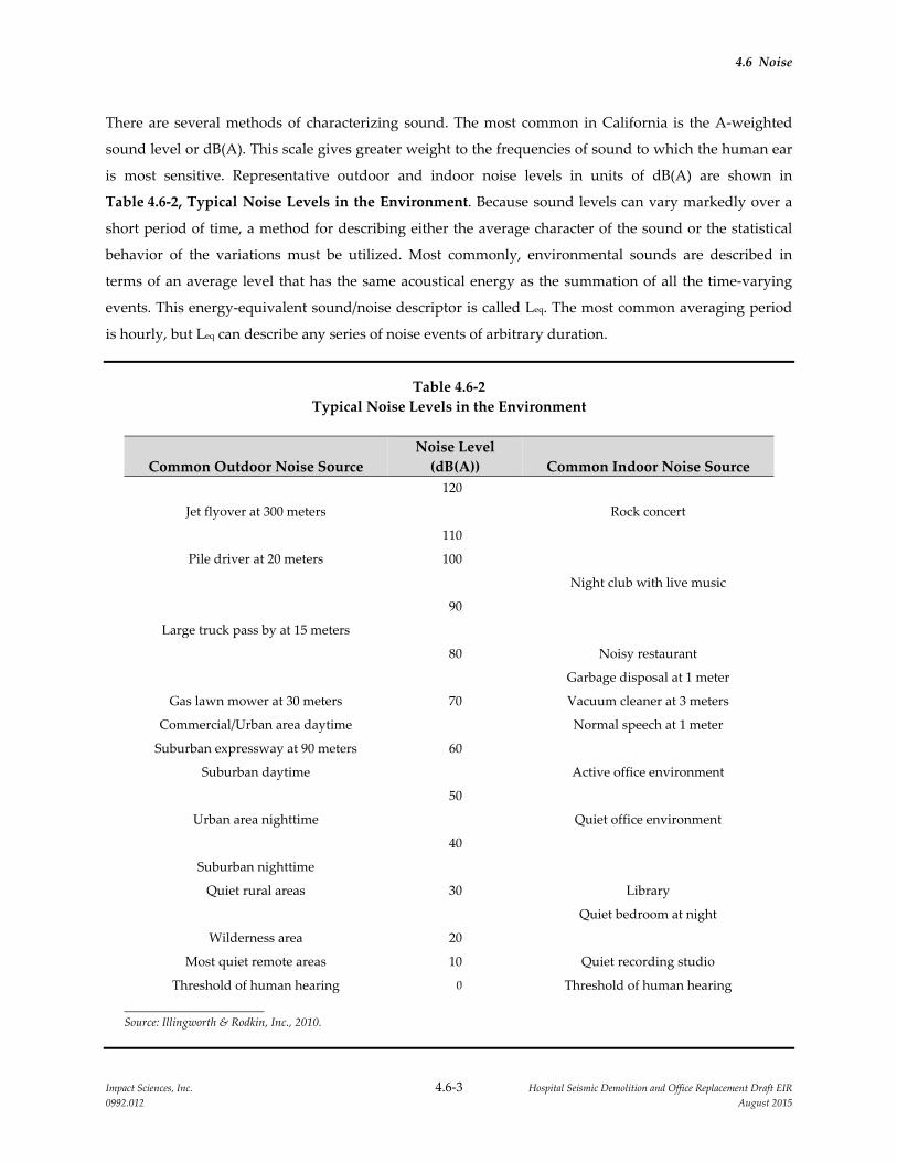
4.6 Noise
Impact Sciences, Inc. 4.6‐3 Hospital Seismic Demolition and Office Replacement Draft EIR
0992.012 August 2015
There are several methods of characterizing sound. The most common in California is the A‐weighted
sound level or dB(A). This scale gives greater weight to the frequencies of sound to which the human ear
is most sensitive. Representative outdoor and indoor noise levels in units of dB(A) are shown in
Table 4.6‐2, Typical Noise Levels in the Environment. Because sound levels can vary markedly over a
short period of time, a method for describing either the average character of the sound or the statistical
behavior of the variations must be utilized. Most commonly, environmental sounds are described in
terms of an average level that has the same acoustical energy as the summation of all the time‐varying
events. This energy‐equivalent sound/noise descriptor is called Leq. The most common averaging period
is hourly, but Leq can describe any series of noise events of arbitrary duration.
Table 4.6‐2
Typical Noise Levels in the Environment
Common Outdoor Noise Source
Noise Level
(dB(A)) Common Indoor Noise Source
120
Jet flyover at 300 meters Rock concert
110
Pile driver at 20 meters 100
Night club with live music
90
Large truck pass by at 15 meters
80 Noisy restaurant
Garbage disposal at 1 meter
Gas lawn mower at 30 meters 70 Vacuum cleaner at 3 meters
Commercial/Urban area daytime Normal speech at 1 meter
Suburban expressway at 90 meters 60
Suburban daytime Active office environment
50
Urban area nighttime Quiet office environment
40
Suburban nighttime
Quiet rural areas 30 Library
Quiet bedroom at night
Wilderness area 20
Most quiet remote areas 10 Quiet recording studio
Threshold of human hearing 0 Threshold of human hearing
Source: Illingworth & Rodkin, Inc., 2010.
4.6 Noise
Impact Sciences, Inc. 4.6‐4 Hospital Seismic Demolition and Office Replacement Draft EIR
0992.012 August 2015
The scientific instrument used to measure noise is the sound level meter. Sound level meters can
accurately measure environmental noise levels to within about plus or minus 1 dB(A). Various computer
models are used to predict environmental noise levels from sources, such as roadways and airports. The
accuracy of the predicted models depends upon the distance the receptor is from the noise source. Close
to the noise source, the models are accurate to within about plus or minus 1 to 2 dB(A).
Since the sensitivity to noise increases during the evening and at night (because excessive noise interferes
with the ability to sleep), 24‐hour descriptors have been developed that incorporate artificial noise
penalties added to quiet‐time noise events. The Community Noise Equivalent Level, (CNEL), is a
measure of the cumulative noise exposure in a community, with a 5 dB penalty added to evening
(7:00 PM to 10:00 PM) and a 10 dB addition to nocturnal (10:00 PM to 7:00 AM) noise levels. The
Day/Night Average Sound Level (Ldn) is essentially the same as CNEL, with the exception that the
evening period is dropped and all occurrences during this 3‐hour period are grouped into the daytime
period.
4.6.2.2 Effects of Noise on Sleep and Speech
The thresholds for speech interference indoors are about 45 dB(A) if the noise is steady and above
55 dB(A) if the noise is fluctuating. Outdoors the thresholds are about 15 dB(A) higher. Steady noise of
sufficient intensity, above 35 dB(A), and fluctuating noise levels above about 45 dB(A) have been shown
to affect sleep. Interior residential standards for multi‐family dwellings are set by the State of California
at 45 dB(A) Ldn. Typically, the highest steady traffic noise level during the daytime is about equal to the
Ldn and nighttime levels are 10 dB(A) lower. The standard is designed for sleep and speech protection and
most jurisdictions apply the same criterion for all residential uses. Typical structural attenuation is
12‐17 dB(A) with open windows. With closed windows in good condition, the noise attenuation factor is
around 20 dB(A) for an older structure and 25 dB(A) for a newer construction. Sleep and speech
interference is therefore possible when exterior noise levels are about 57–62 dB(A) Ldn with open
windows and 65–70 dB(A) Ldn if the windows are closed. Levels of 55–60 dB(A) are common along
collector streets and secondary arterials, while 65–70 dB(A) is a typical value for a primary/major arterial.
Levels of 75–80 dB(A) are normal noise levels at the first row of development outside a freeway
right‐of‐way. In order to achieve an acceptable interior noise environment, bedrooms facing secondary
roadways need to be able to have their windows closed; those facing major roadways and freeways
typically need sound‐rated glass windows.
4.6 Noise
Impact Sciences, Inc. 4.6‐5 Hospital Seismic Demolition and Office Replacement Draft EIR
0992.012 August 2015
4.6.2.3 Background Information on Vibration
Vibration is a unique form of noise. It is unique because its energy is carried through structures and the
earth, whereas noise is simply carried through the air. Thus, vibration is generally felt rather than heard.
Some vibration effects can be caused by noise, for example, the rattling of windows from truck pass‐bys.
This phenomenon is related to the coupling of the acoustic energy at frequencies that are close to the
resonant frequency of the material being vibrated. Typically, groundborne vibration generated by
manmade activities attenuates rapidly as distance from the source of the vibration increases. Vibration,
which spreads through the ground rapidly, diminishes in amplitude with distance from the source. The
ground motion caused by vibration is measured as particle velocity in inches per second and in the
United States is referenced as vibration decibels (VdB).
The vibration velocity level threshold of perception for humans is approximately 65 VdB. A vibration
velocity of 75 VdB is the approximate dividing line between barely perceptible and distinctly perceptible
levels for many people. Most perceptible indoor vibration is caused by sources within buildings such as
operation of mechanical equipment, movement of people, or the slamming of doors. Typical outdoor
sources of perceptible groundborne vibration are construction equipment, steel‐wheeled trains, and
traffic on rough roads. If a roadway is smooth, the groundborne vibration from traffic is barely
perceptible. Table 4.6‐3, Typical Levels of Groundborne Vibration, identifies typical groundborne
vibration levels in VdB and human response to different levels of vibration.
In addition to human annoyance and interference with human activities such as sleep, groundborne
vibrations can also affect buildings. A vibration level of 100 VdB is the general threshold where minor
damage can occur in fragile buildings.
4.6.2.4 Project Sites and Surrounding Land Uses
The three project sites together make up approximately three acres within the 142 acre UC Davis
Sacramento campus (Sacramento campus). The project sites are surrounded by hospital and residential
uses and are approximately 0.25 mile to the south of US 50. Regional commercial uses, low‐density and
high‐density residential neighborhoods, various state and local government buildings, and a public
school are located in the immediate vicinity of the Sacramento campus. Sensitive noise uses include the
adjacent hospital building with patient rooms approximately 10 feet from the project site and nearby
residential uses approximately 40 feet from the proposed landscape buffer construction; 160 feet from the
Housestaff Building demolition; 150 feet from the North Addition Office Building construction; and 190
feet from the North/South Wing demolition.

4.6 Noise
Impact Sciences, Inc. 4.6‐6 Hospital Seismic Demolition and Office Replacement Draft EIR
0992.012 August 2015
Roadways and Freeways
The campus is in an area with heavy roadway and freeway traffic, outside of residential neighborhoods
including traffic along Stockton Boulevard and Broadway that are adjacent to the campus. The major
roadways affect noise levels in the project area.
Table 4.6‐3
Typical Levels of Groundborne Vibration
Human/Structural Response
Velocity Level in
VdB (dB(A))
Typical Sources 50 feet from
Source
Threshold, Minor Cosmetic Damage to
Fragile Buildings 100 Blasting from Construction Projects
Bulldozer and Other
Difficulty with Tasks such as Reading a
VDT Screen 90
Heavy‐Tracked Construction
Equipment
Commuter Rail, Upper Range
Residential Annoyance, Infrequent Events
(E.G., Commuter Rail) 80 Rapid Transit, Upper Range
Commuter Rail, Typical
Residential Annoyance, Frequent Events
(E.G., Rapid Transit) Bus or Truck Over Bump
70 Rapid Transit, Typical
Bus or Truck, Typical
Limit for Vibration Sensitive Equipment
Approximate Threshold for Human
Perception of Vibration
60
Average Residence without Stereo Playing Typical Ground Vibration
Average Whisper 50
Source: Federal Transit Administration, 1998.

4.6 Noise
Impact Sciences, Inc. 4.6‐7 Hospital Seismic Demolition and Office Replacement Draft EIR
0992.012 August 2015
Stationary Sources
Stationary noise sources associated with the project include common building mechanical equipment
such as air conditioners and ventilation systems. These noise sources become a concern when they are in
close proximity of land uses where people would be sensitive to elevated noise levels.
Ambient Noise Levels
An environmental noise impact assessment was conducted for the 2010 LRDP EIR. The study involved
the monitoring of ambient noise levels at various locations on and near the Sacramento campus and
modeling of future noise levels based on projections of future traffic volumes through the year 2025
prepared by Fehr & Peers Associates for the LRDP EIR. Ambient noise levels were monitored by
Illingworth & Rodkin, Inc., on January 27 and 28, 2010. Short‐term measurements (15 minutes in
duration) were taken at 10 locations and unattended long‐term (24 hours in duration) measurements
were taken at three locations. The measurement locations are shown in Figure 4.6‐1, Noise Measurement
Locations. The off‐campus long term noise measurement locations were selected to be representative of
noise‐sensitive residential receptors at the campus periphery that are most likely to be affected by the
additional noise that would be generated by 2010 LRDP‐related noise sources. On‐campus long term
noise measurements were conducted near the Campus Central Plant to document noise emissions from
this facility. Except near the Central Plant or other discrete noise sources, on‐campus noise levels are
judged to be at or below the levels documented at the project periphery therefore additional on‐campus
long term measurement locations were considered not necessary. Measured data reported in the
environmental noise assessment are shown in Table 4.6‐4, Long‐Term Noise Measurement Data
Summary, and Table 4.6‐5, Short‐Term Noise Measurement Data Summary. As shown in Table 4.6‐4,
below, the measured ambient noise levels vary from 59 to 66 dB(A) Leq in the Sacramento campus
vicinity.
Table 4.6‐4
Long‐Term‐Noise Measurement Data Summary
Site ID Measurement Location
Measurement
Date
24‐hr Leq
(dB(A))
24‐hr Ldn
(dB(A))
LT‐1
Utility pole at the edge of the
single‐family residential area
north of V Street opposite the
hospital emergency/loading
entrance
1/27/10–1/28/10 66 67
LT‐2
Utility pole at residential
property line at end of Y Street
(eastern edge of the campus)
1/27/10–1/28/10 59 61
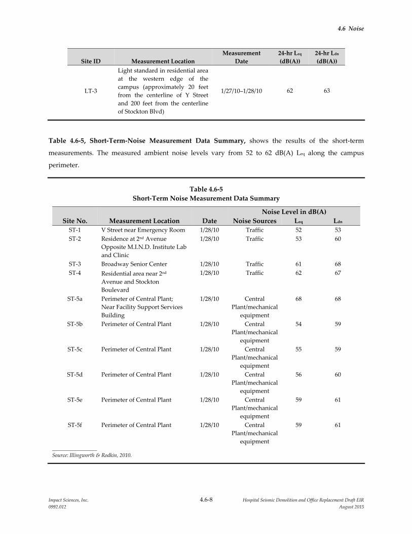
4.6 Noise
Impact Sciences, Inc. 4.6‐8 Hospital Seismic Demolition and Office Replacement Draft EIR
0992.012 August 2015
Site ID Measurement Location
Measurement
Date
24‐hr Leq
(dB(A))
24‐hr Ldn
(dB(A))
LT‐3
Light standard in residential area
at the western edge of the
campus (approximately 20 feet
from the centerline of Y Street
and 200 feet from the centerline
of Stockton Blvd)
1/27/10–1/28/10 62 63
Table 4.6‐5, Short‐Term‐Noise Measurement Data Summary, shows the results of the short‐term
measurements. The measured ambient noise levels vary from 52 to 62 dB(A) Leq along the campus
perimeter.
Table 4.6‐5
Short‐Term Noise Measurement Data Summary
Noise Level in dB(A)
Site No. Measurement Location Date Noise Sources Leq Ldn
ST‐1 V Street near Emergency Room 1/28/10 Traffic 52 53
ST‐2 Residence at 2nd Avenue
Opposite M.I.N.D. Institute Lab
and Clinic
1/28/10 Traffic 53 60
ST‐3 Broadway Senior Center 1/28/10 Traffic 61 68
ST‐4 Residential area near 2nd
Avenue and Stockton
Boulevard
1/28/10 Traffic 62 67
ST‐5a Perimeter of Central Plant;
Near Facility Support Services
Building
1/28/10 Central
Plant/mechanical
equipment
68 68
ST‐5b Perimeter of Central Plant 1/28/10 Central
Plant/mechanical
equipment
54 59
ST‐5c Perimeter of Central Plant 1/28/10 Central
Plant/mechanical
equipment
55 59
ST‐5d Perimeter of Central Plant 1/28/10 Central
Plant/mechanical
equipment
56 60
ST‐5e Perimeter of Central Plant 1/28/10 Central
Plant/mechanical
equipment
59 61
ST‐5f Perimeter of Central Plant 1/28/10 Central
Plant/mechanical
equipment
59 61
Source: Illingworth & Rodkin, 2010.
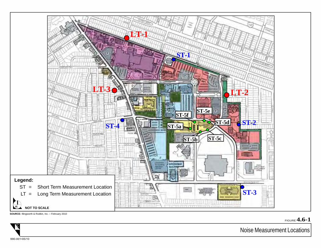
LT-1
LT-2LT-3
ST-2
ST-1
ST-4
ST-3
ST-5a
ST-5b ST-5c
ST-5d
ST-5eST-5f
Noise Measurement Locations
FIGURE 4.6-1
990-001•05/10
SOURCE: Illingworth & Rodkin, Inc. – February 2010
NOT TO SCALEn
Legend: ST = Short Term Measurement Location
LT = Long Term Measurement Location

4.6 Noise
Impact Sciences, Inc. 4.6‐10 Hospital Seismic Demolition and Office Replacement Draft EIR
0992.012 August 2015
Aircraft Overflights
The closest airport is Executive Airport, located approximately three miles southwest of the project sites.
While noise from aircraft overflights is occasionally perceptible within the project area, it does not
substantially affect the noise environment.
Emergency Helicopter Operations
The project sites are currently exposed to noise from helicopter take‐off and landing operations associated
with the transport of patients requiring urgent care.
4.6.3 REGULATORY CONSIDERATIONS
State Building Code
The interior noise environment inside hospital and clinic patient rooms is subject to the environmental
noise standards set forth in Appendix Chapter 35 sec. 3501 of the California State Building Code (Part 2,
Title 24, CCR). The purpose of the regulations as stated therein is to establish uniform minimum noise
insulation performance standards to protect persons within new hotels, motels, dormitories, long‐term
care facilities, apartment houses, and dwellings, other than detached single‐family dwellings from the
effects of excessive noise, including but not limited to, hearing loss or impairment and interference with
speech and sleep.
4.6.3.1 Local Plans and Policies
The Sacramento campus is a University of California campus that conducts work within the University’s
mission on land that is owned or controlled by The Board of Regents of the University of California. As a
state entity, the University is exempt under the state constitution from compliance with local land use
regulations, including general plans, zoning, and ordinances. However, the University seeks to develop
its property in a manner that minimizes potential conflicts with the land use policies and plans of local
jurisdictions to the extent feasible. The Sacramento campus is located in the City of Sacramento. The
following subsection summarizes policies contained in the City of Sacramento General Plan regarding
noise, as well as the City of Sacramento Noise Ordinance and provides context for the impact analysis.
City of Sacramento General Plan
The City of Sacramento’s General Plan Noise Element contains the City’s goals and policies for
controlling and reducing environmental noise in the City of Sacramento. Generally, the compatible noise
level for most residential uses and hotel/motel uses is 65 dB(A) Ldn or less, while conditionally acceptable
4.6 Noise
Impact Sciences, Inc. 4.6‐11 Hospital Seismic Demolition and Office Replacement Draft EIR
0992.012 August 2015
noise levels range from over 60 dB(A) Ldn to 70 dB(A) Ldn (may require insulation, etc.). Noise levels over
70 dB(A) Ldn are, in general, incompatible with residential uses.
The City of Sacramento General Plan policies pertaining to noise include the following:
Goal EC 3.1 Noise Reduction: Minimize noise impacts on human activity to ensure the health and
safety of the community.
Policy EC 3.1.1: Exterior Noise Standards: The City shall require noise mitigation for all
development where the projected exterior noise levels exceed those shown in
Table EC 1 [Table 4.6‐6, General Plan Exterior Noise Compatibility Standards
for Various Land Uses, below], to the extent feasible.
Policy EC 3.1.2: Exterior Incremental Noise Standards: The City shall require noise mitigation for
all development that increases existing noise levels by more than the allowable
increment shown in Table EC 2 [Table 4.6‐7, General Plan Exterior Incremental
Noise Impact Standards for Noise‐Sensitive Uses (dB(A)), below], to the extent
feasible.
Policy EC 3.1.3: Interior Noise Standards: The City shall require new development to include
noise mitigation to assure acceptable interior noise levels appropriate to the land
use type: 45 dB(A) Ldn for residential, transient lodgings, hospitals, nursing
homes and other uses where people normally sleep; and 45 db(A) Ldn (peak
hour) for office buildings and similar uses.
Policy EC 3.1.4: Interior Noise Review for Multiple, Loud Short‐Term Events: In cases where new
development is proposed in areas subject to frequent, high‐noise events (such as
aircraft over‐flights, or train and truck pass‐bys), the City shall evaluate noise
impacts on any sensitive receptors from such events when considering whether
to approve the development proposal, taking into account potential for sleep
disturbance, undue annoyance, and interruption in conversation, to ensure that
the proposed development is compatible within the context of its surroundings.
Policy EC 3.1.5: Interior Vibration Standards: The City shall require construction projects
anticipated to generate significant amount of vibration to ensure acceptable
interior vibration levels at nearby residential and commercial uses based on the
current City or Federal Transit Administration (FTA).
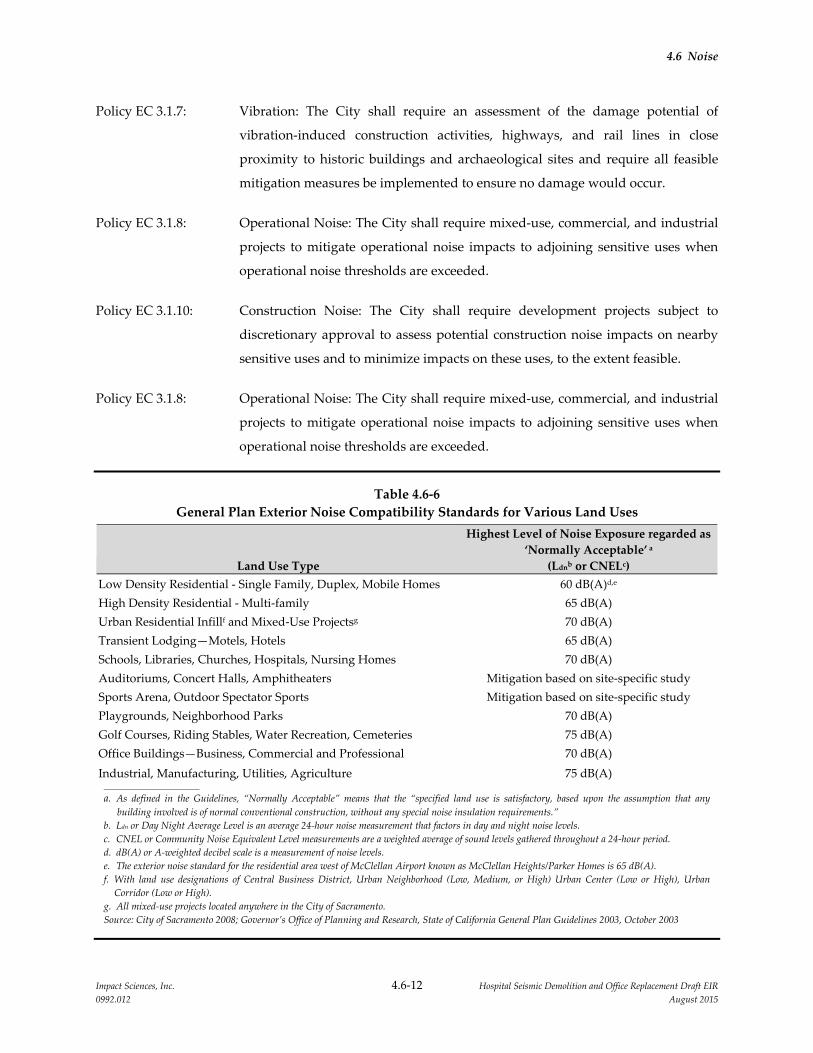
4.6 Noise
Impact Sciences, Inc. 4.6‐12 Hospital Seismic Demolition and Office Replacement Draft EIR
0992.012 August 2015
Policy EC 3.1.7: Vibration: The City shall require an assessment of the damage potential of
vibration‐induced construction activities, highways, and rail lines in close
proximity to historic buildings and archaeological sites and require all feasible
mitigation measures be implemented to ensure no damage would occur.
Policy EC 3.1.8: Operational Noise: The City shall require mixed‐use, commercial, and industrial
projects to mitigate operational noise impacts to adjoining sensitive uses when
operational noise thresholds are exceeded.
Policy EC 3.1.10: Construction Noise: The City shall require development projects subject to
discretionary approval to assess potential construction noise impacts on nearby
sensitive uses and to minimize impacts on these uses, to the extent feasible.
Policy EC 3.1.8: Operational Noise: The City shall require mixed‐use, commercial, and industrial
projects to mitigate operational noise impacts to adjoining sensitive uses when
operational noise thresholds are exceeded.
Table 4.6‐6
General Plan Exterior Noise Compatibility Standards for Various Land Uses
Land Use Type
Highest Level of Noise Exposure regarded as
‘Normally Acceptable’ a
(Ldnb or CNELc)
Low Density Residential ‐ Single Family, Duplex, Mobile Homes 60 dB(A)d,e
High Density Residential ‐ Multi‐family 65 dB(A)
Urban Residential Infillf and Mixed‐Use Projectsg 70 dB(A)
Transient Lodging—Motels, Hotels 65 dB(A)
Schools, Libraries, Churches, Hospitals, Nursing Homes 70 dB(A)
Auditoriums, Concert Halls, Amphitheaters Mitigation based on site‐specific study
Sports Arena, Outdoor Spectator Sports Mitigation based on site‐specific study
Playgrounds, Neighborhood Parks 70 dB(A)
Golf Courses, Riding Stables, Water Recreation, Cemeteries 75 dB(A)
Office Buildings—Business, Commercial and Professional 70 dB(A)
Industrial, Manufacturing, Utilities, Agriculture 75 dB(A)
a. As defined in the Guidelines, “Normally Acceptable” means that the “specified land use is satisfactory, based upon the assumption that any
building involved is of normal conventional construction, without any special noise insulation requirements.”
b. Ldn or Day Night Average Level is an average 24‐hour noise measurement that factors in day and night noise levels.
c. CNEL or Community Noise Equivalent Level measurements are a weighted average of sound levels gathered throughout a 24‐hour period.
d. dB(A) or A‐weighted decibel scale is a measurement of noise levels.
e. The exterior noise standard for the residential area west of McClellan Airport known as McClellan Heights/Parker Homes is 65 dB(A).
f. With land use designations of Central Business District, Urban Neighborhood (Low, Medium, or High) Urban Center (Low or High), Urban
Corridor (Low or High).
g. All mixed‐use projects located anywhere in the City of Sacramento.
Source: City of Sacramento 2008; Governor’s Office of Planning and Research, State of California General Plan Guidelines 2003, October 2003

4.6 Noise
Impact Sciences, Inc. 4.6‐13 Hospital Seismic Demolition and Office Replacement Draft EIR
0992.012 August 2015
Table 4.6‐7
General Plan Exterior Incremental Noise Impact Standards for Noise‐Sensitive Uses (dB(A))
Residences and buildings where people
normally sleepa
Institutional land uses with primarily daytime
and evening usesb
Existing Ldn
Allowable Noise
Increment
Existing Peak Hour
Leq
Allowable Noise
Increment
45 8 45 12
50 5 50 9
55 3 55 6
60 2 60 5
65 1 65 3
70 1 70 3
75 0 75 1
80 0 80 0
a. This category includes homes, hospitals, and hotels where a nighttime sensitivity to noise is assumed to be of utmost importance.
b. This category includes schools, libraries, theaters, and churches where it is important to avoid interference with such activities as
speech, meditation, and concentration on reading material.
Source: City of Sacramento 2008; Federal Transit Administration, Transit Noise Impact and Vibration Assessment, May 2006
Sacramento City Code Noise Ordinance
Chapter 8.68 of the Sacramento City Code governs noise and vibration within the City. Section 8.68.100
sets the limits for permissible stationary source noise levels during the day and night for all agricultural
and residential properties.
8.68.060 Exterior Noise Standards
A. The following noise standards unless otherwise specifically indicated in this article shall apply
to all agricultural and residential properties.
1. From 7 AM to 10 PM the exterior noise standard shall be 55 dB(A).
2. From 10 PM to 7 AM the exterior noise standard shall be 50 dB(A).
B. It is unlawful for any person at any location to create any noise which causes the noise levels
when measured on agricultural or residential property to exceed for the duration of time set
forth following [shown in Table 4.6‐8, City of Sacramento Noise Ordinance
Cumulative Intrusive Sound Limits], the specified exterior noise standards in any 1
hour by:

4.6 Noise
Impact Sciences, Inc. 4.6‐14 Hospital Seismic Demolition and Office Replacement Draft EIR
0992.012 August 2015
Table 4.6‐8
City of Sacramento Noise Ordinance Cumulative Intrusive Sound Limits
Cumulative Duration of the Intrusive Sound Allowable Decibels
Cumulative period of 30 minutes per hour 0
Cumulative period of 15 minutes per hour +5
Cumulative period of 5 minutes per hour +10
Cumulative period of 1 minute per hour +15
Level not to be exceeded for any time per hour +20
Source: Sacramento City Code, Chapter 8.68, Section 8.68.060, 2009
]
8.68.070 Interior Noise Standards
A. In any apartment, condominium, townhouse, duplex or multiple dwelling unit it is unlawful
for any person to create any noise from inside his or her unit that causes the noise level when
measured in a neighboring unit during the periods 10 PM to 7 AM to exceed:
1. 45 dB(A) for a cumulative period of more than 5 minutes in any hour;
2. 50 dB(A) for a cumulative period of more than 1 minute in any hour;
3. 55 dB(A) for any period of time.
B. If the ambient noise level exceeds that permitted by any of the noise level categories specified
in subsection A of this section, the allowable noise limit shall be increased in 5 dB(A)
increments in each category to encompass the ambient noise level.
8.68.080 Exemptions
The following applicable activities shall be exempted from the provisions of this chapter:
A. School bands, school athletic and school entertainment events. School entertainment events
shall not include events sponsored by student organizations.
B. Outdoor gatherings, public dances, shows and sporting and entertainment events provided
said events are conducted pursuant to a discretionary license or permit by the city or county.
C. Activities conducted on parks and public playgrounds, provided such parks and public
playgrounds are owned and operated by a public entity.
D. Any mechanical device, apparatus or equipment related to or connected with emergency
activities or emergency work.
E. Noise sources due to the erection (including excavation), demolition, alteration or repair of
any building or structure between the hours of 7 AM and 6 PM, on Monday, Tuesday,

4.6 Noise
Impact Sciences, Inc. 4.6‐15 Hospital Seismic Demolition and Office Replacement Draft EIR
0992.012 August 2015
Wednesday, Thursday, Friday and Saturday, and between 9 AM and 6 PM on Sunday;
provided, however, that the operation of an internal combustion engine shall not be exempt
pursuant to this subsection if such engine is not equipped with suitable exhaust and intake
silencers which are in good working order. The director of building inspections may permit
work to be done during the hours not exempt by this subsection in the case of urgent necessity
and in the interest of public health and welfare for a period not to exceed three days.
Application for this exemption may be made in conjunction with the application for the work
permit or during progress of the work.
H. Noise sources associated with maintenance of street trees and residential area property
provided said activities take place between the hours of 7 AM and 6 PM.
8.68.100 Schools, Hospitals and Churches
It is unlawful for any person to create any noise which causes the noise level at any school,
hospital or church while the same is in use to exceed the noise standards specified in Section
8.68.060 of this chapter or to create any noise which unreasonably interferes with the use of such
institution or unreasonably disturbs or annoys patients in the hospital. In any disputed case,
interfering noise which is 10 dB(A) or more, greater than the ambient noise level at the building,
shall be deemed excessive and unlawful.
4.6.4 IMPACTS AND MITIGATION MEASURES
4.6.4.1 Significance Criteria
The impact of the proposed project related to noise would be considered significant if it would exceed the
following standards of significance, in accordance with Appendix G of the State CEQA Guidelines and the
UC CEQA Handbook.
Expose people to or generate noise levels in excess of standards established in any applicable plan or
noise ordinance, or applicable standards of other agencies;
Expose people to or generate excessive ground‐borne vibration or ground‐borne noise levels;
Result in a substantial permanent increase in ambient noise levels in the project vicinity above levels
existing without the project;
Result in a substantial temporary or periodic increase in ambient noise levels in the project vicinity
above levels existing without the project;
Result in exposure of people residing or working in the project area to excessive noise levels if the
project is located within an area covered by an airport land use plan, or where such a plan has not
been adopted, within 2 miles of a public airport or public use airport; or
Result in exposure of people residing or working in the project area to excessive noise levels if the
project is located in the vicinity of a private airstrip.
4.6 Noise
Impact Sciences, Inc. 4.6‐16 Hospital Seismic Demolition and Office Replacement Draft EIR
0992.012 August 2015
To assess whether the proposed project would expose persons to or generate noise levels that are
excessively high, the EIR evaluates the absolute change in noise levels due to the project and the
relationship between the resultant noise level and the City of Sacramento’s established guidelines for
satisfactory noise and land use compatibility.
Traffic Noise
According to the City of Sacramento General Plan, a significant noise impact would result if exterior
noise levels increase substantially at noise‐sensitive land uses (e.g., residences). For the purposes of this
EIR, noise impacts would be considered significant if the project‐related noise exceeded the allowable
noise increment at locations that affect human receptors, as specified on Table 4.6‐7.
Stationary Source Noise
A significant impact due to stationary mechanical equipment noise at adjacent noise‐sensitive land uses
would be identified if noise levels produced by this equipment exceed 55 dB(A) during the daytime and
50 dB(A) at night as modified by the cumulative hourly duration factors shown in Table 4.6‐8.
Construction and Demolition Noise
Construction and demolition‐related noise activities between the hours of 7:00 AM and 6:00 PM, on
Monday, Tuesday, Wednesday, Thursday, Friday, and Saturday, and between 9:00 AM and 6:00 PM on
Sunday are exempt from noise standards of the City of Sacramento Noise ordinance. However, the City
of Sacramento 2030 General Plan requires an assessment of potential construction noise impacts on
nearby sensitive uses to minimize impacts on these uses. While the University is not subject to the local
land use plans, policies or regulations, construction and demolition‐noise associated with the 2010 LRDP
was analyzed using the City’s standards to assess whether the projects implemented as part of campus
development under the 2010 LRDP would result in a substantial temporary or periodic increase in
ambient noise levels in the project vicinity above levels existing without project. Noise impacts would be
considered significant if construction activities produce noise levels above 70 dB(A) during the daytime
and/or 55 dB(A) at night at the nearest sensitive receptor and which effect the same noise sensitive
receptors on a continuous basis for a period of 90 days or more (LRDP EIR 2010.

4.6 Noise
Impact Sciences, Inc. 4.6‐17 Hospital Seismic Demolition and Office Replacement Draft EIR
0992.012 August 2015
Vibration
The City’s General Plan noise element provides requirements for interior vibration standards and
damage to historic or archaeological structures, but does not provide specific vibration thresholds. In the
absence of significance thresholds for vibration from construction, the Federal Railroad Administration
was utilized (FRA) which identifies a maximum acceptable level threshold of 65 VdB for buildings where
low ambient vibration is essential for interior operations (such as hospitals and recording studios), 72
VdB for residences and buildings where people normally sleep, and 75 VdB for institutional land uses
with primary daytime use (such as churches and schools).
4.6.4.2 Methodology
Information presented in the discussion and analysis was obtained from site visits, project sequencing
details shown in Section 3.0, and the environmental noise assessment prepared for the 2010 LRDP EIR
noise section.
4.6.4.3 2010 LRDP EIR Mitigation Measures Included in the Proposed Project
Table 4.6‐9, 2010 LRDP EIR Mitigation Measures, presents the mitigation measures in the 2010 LRDP
EIR that are applicable to the proposed project. Since these previously adopted mitigation measures are
already being carried out as part of implementation of the 2010 LRDP, they are included in and are a part
of the proposed project and will not be readopted. Implementation of these mitigation measures is
assumed as part of the project impact analysis.
Table 4.6‐9
2010 LRDP EIR Mitigation Measures
Mitigation
Measure Description
LRDP Mitigation
Measure NOI‐1
The following mitigation measures are proposed to reduce noise generated
by demolition and construction activities:
Erect temporary noise control blanket barriers in a manner to shield
adjacent off‐campus residences and on‐campus occupied facilities at the
perimeter of construction staging areas, at the perimeter of ground clearing,
excavation, or demolition sites, and at elevated construction sites (i.e.,
multistory buildings). When feasible, barriers will be erected at or near the
work site itself to provide the most noise attenuation.
Where construction is adjacent to on‐site or off‐site sensitive receptors,
construct a noise barrier 8 to 10 feet in height at the project site perimeter that
will break the line‐of‐sight between construction equipment and noise
receptors, where feasible.
4.6 Noise
Impact Sciences, Inc. 4.6‐18 Hospital Seismic Demolition and Office Replacement Draft EIR
0992.012 August 2015
Mitigation
Measure Description
Limit significant noise‐generating construction activities, including
truck traffic coming to and from the site for any purpose, to the hours of 7:00
AM to 6:00 PM Monday through Saturday, and 9:00 AM to 6:00 PM on
Sundays and Holidays.
Properly muffle and maintain all construction equipment powered by
internal combustion engines.
Prohibit unnecessary idling of internal combustion engines.
Locate all stationary noise‐generating construction equipment, such as
air compressors and cranes, as far as practical from existing nearby
residences and other noise‐sensitive land uses. Acoustically shield such
equipment.
Select quiet construction equipment, particularly air compressors,
whenever possible. (Fit motorized equipment with proper mufflers in good
working order).
Minimize construction traffic along V Street.
The Government and Community Relations office will be responsible for
responding to any local complaints about construction noise. The office
would determine the cause of the noise complaint (e.g., starting too early,
bad muffler, etc.) and would require that reasonable measures warranted to
correct the problem be implemented. Conspicuously post a telephone
number for the office at the construction site and include it in the notice sent
to neighbors regarding the construction schedule.
LRDP Mitigation
Measure NOI‐2
For construction adjacent to off‐site residential uses, advance notice will be
given to occupants of these uses to ensure that precautions are taken to protect
ongoing activities from vibration effects.
LRDP Mitigation
Measure NOI‐4
Mechanical equipment and building design shall be selected so that noise
levels from future building and other facility operations would not exceed the
Noise Ordinance limits of the City of Sacramento for commercial areas or
residential zones as measured on any noise‐sensitive receptor in the area
surrounding the Sacramento campus. Controls that would typically be
incorporated to attain adequate noise reduction would include selection of
quiet equipment, sound attenuators on fans, sound attenuator packages for
cooling towers and emergency generators, acoustical screen walls, and
equipment enclosures.
Source: UC Davis Sacramento Campus, 2010 LRDP EIR, Section 4.10, Noise.
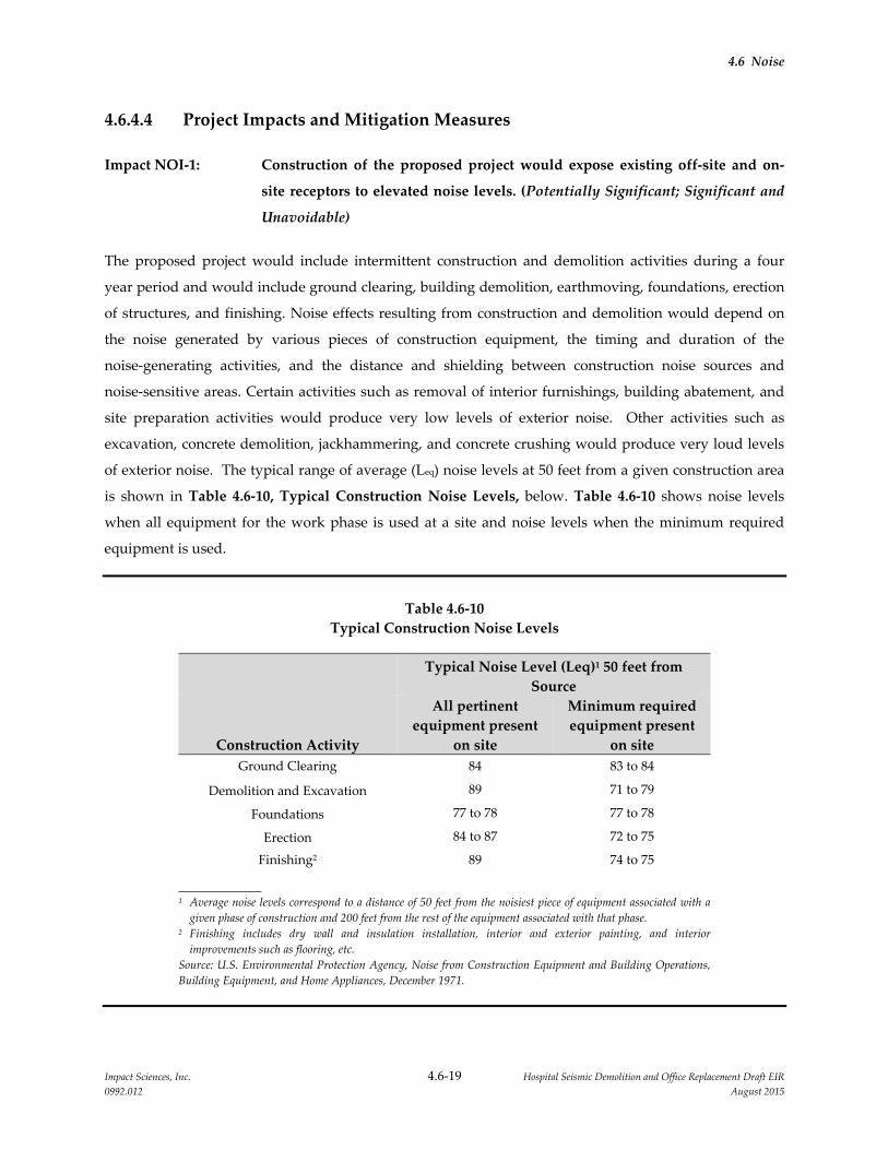
4.6 Noise
Impact Sciences, Inc. 4.6‐19 Hospital Seismic Demolition and Office Replacement Draft EIR
0992.012 August 2015
4.6.4.4 Project Impacts and Mitigation Measures
Impact NOI‐1: Construction of the proposed project would expose existing off‐site and on‐
site receptors to elevated noise levels. (Potentially Significant; Significant and
Unavoidable)
The proposed project would include intermittent construction and demolition activities during a four
year period and would include ground clearing, building demolition, earthmoving, foundations, erection
of structures, and finishing. Noise effects resulting from construction and demolition would depend on
the noise generated by various pieces of construction equipment, the timing and duration of the
noise‐generating activities, and the distance and shielding between construction noise sources and
noise‐sensitive areas. Certain activities such as removal of interior furnishings, building abatement, and
site preparation activities would produce very low levels of exterior noise. Other activities such as
excavation, concrete demolition, jackhammering, and concrete crushing would produce very loud levels
of exterior noise. The typical range of average (Leq) noise levels at 50 feet from a given construction area
is shown in Table 4.6‐10, Typical Construction Noise Levels, below. Table 4.6‐10 shows noise levels
when all equipment for the work phase is used at a site and noise levels when the minimum required
equipment is used.
Table 4.6‐10
Typical Construction Noise Levels
Typical Noise Level (Leq)1 50 feet from
Source
Construction Activity
All pertinent
equipment present
on site
Minimum required
equipment present
on site
Ground Clearing 84 83 to 84
Demolition and Excavation 89 71 to 79
Foundations 77 to 78 77 to 78
Erection 84 to 87 72 to 75
Finishing2 89 74 to 75
1 Average noise levels correspond to a distance of 50 feet from the noisiest piece of equipment associated with a
given phase of construction and 200 feet from the rest of the equipment associated with that phase. 2 Finishing includes dry wall and insulation installation, interior and exterior painting, and interior
improvements such as flooring, etc.
Source: U.S. Environmental Protection Agency, Noise from Construction Equipment and Building Operations,
Building Equipment, and Home Appliances, December 1971.
4.6 Noise
Impact Sciences, Inc. 4.6‐20 Hospital Seismic Demolition and Office Replacement Draft EIR
0992.012 August 2015
As shown in Table 4.10‐9, the highest exterior noise level from construction and demolition activities
would be 89 dB(A) Leq. This noise level could be reached during the demolition, excavation and finishing
phases. Noise levels from these activities would drop at a rate of about 6 dB(A) per doubling of distance
between the source and receptor, and the maximum exterior noise levels would be about 83 dB(A) Leq at
100 feet. In addition, shielding by buildings or terrain could result in lower noise levels at distant
receptors. The proposed sequencing for the demolition of the North/South Wing of the Main Hospital
would result in demolition proceeding from the south to the north. This effort would leave the north
portion of the building in place as a noise barrier between the residences north of V Street during most of
the building demolition. Lastly, indoor noise levels would be approximately 12 dB lower for rooms with
open windows and 20 to 25 dB lower for rooms with closed windows. Therefore, construction related
activities could result in interior noise levels of up to 64 to 69 dB(A) if windows are closed.
Demolition and construction activities would occur while the Sacramento campus facilities, including the
hospital, are operational. Activities occurring directly adjacent to the occupied buildings would generate
significant noise levels. Though the actual exterior to interior attenuation provided by the hospital
buildings is not known, patient rooms typically have fixed glazing and are built with greater exterior to
interior attenuation than typical residential uses, thus patient rooms at the hospital would be expected to
achieve a minimum exterior to interior noise reduction of 25 dB(A). The construction could be closer than
50 feet away from off‐site receptors and within 10 feet of on‐site receptors, which would increase interior
noise levels above 64 dB(A) with windows closed.
The Campus has procedures in place that lessen the impact of construction noise to on‐site sensitive
receptors, such as patients, surgical units and research units. It is standard practice for the Campus to
identify noise‐producing activities on the construction schedule, and then coordinate the timing of the
activities with hospital or research units that would likely be affected and, if necessary close particular
rooms in order to not place patients or employees in close proximity to noisy areas. Further, construction
managers can be contacted by hospital or research units in the event that noise becomes too disruptive,
and the activities are adjusted or rescheduled at a less sensitive time. With these procedures in place, the
impact to on‐site sensitive receptors would be less than significant.
In addition to on‐campus patient rooms and other receptors, noise‐sensitive residential uses are located
adjacent to the Sacramento campus. As described above, the majority of the activity would generate noise
levels below 89 dB(A) at a distance of 50 feet from the noise source but some activities, especially
demolition, would generate up to 89 dB(A) Leq. The nearest off‐site residential receptors would be 40 feet
from construction of the proposed landscape buffer on the south side of V Street, 150 feet from the North
Addition Office Building construction, 190 feet from the Sequence 7 of the North/South Wing demolition,
and 160 feet from the Housestaff Building demolition. Based on these distances, unshielded maximum
4.6 Noise
Impact Sciences, Inc. 4.6‐21 Hospital Seismic Demolition and Office Replacement Draft EIR
0992.012 August 2015
average noise levels during the loudest demolition and construction activities in these areas could reach a
Leq of 81 to 89 dB(A), which would exceed the daytime standard of 70 dB(A) for noise‐sensitive residential
uses by 11 to 19 dB(A). Therefore, demolition and construction activities associated with the proposed
project would result in temporarily increased noise levels at noise‐sensitive residential uses off site that
would exceed applicable thresholds.
The 2010 LRDP EIR identified LRDP Mitigation Measure NOI‐1 to reduce noise generated by demolition
and construction activities. This mitigation measure was adopted as part of the 2010 LRDP and is
considered part of the proposed project. The mitigation measure includes the following noise control
measures.
Erect temporary noise control blanket barriers in a manner to shield adjacent
off‐campus residences and on‐campus occupied facilities at the perimeter of
construction staging areas, at the perimeter of ground clearing, excavation,
or demolition sites, and at elevated construction sites (i.e., multistory
buildings). When feasible, barriers will be erected at or near the work site
itself to provide the most noise attenuation.
Where construction is adjacent to on‐site or off‐site sensitive receptors,
construct a noise barrier 8 to 10 feet in height at the project site perimeter that
will break the line‐of‐sight between construction equipment and noise
receptors, where feasible.
Limit significant noise‐generating construction activities, including truck
traffic coming to and from the site for any purpose, to the hours of 7:00 AM
to 6:00 PM Monday through Saturday, and 9:00 AM to 6:00 PM on Sundays
and Holidays.
Properly muffle and maintain all construction equipment powered by
internal combustion engines.
Prohibit unnecessary idling of internal combustion engines.
Locate all stationary noise‐generating construction equipment, such as air
compressors and cranes, as far as practical from existing nearby residences
and other noise‐sensitive land uses. Acoustically shield such equipment.
Select quiet construction equipment, particularly air compressors, whenever
possible. (Fit motorized equipment with proper mufflers in good working
order).
Minimize construction traffic along V Street.
The Government and Community Relations office will be responsible for
responding to any local complaints about construction noise. The office
would determine the cause of the noise complaint (e.g., starting too early,
4.6 Noise
Impact Sciences, Inc. 4.6‐22 Hospital Seismic Demolition and Office Replacement Draft EIR
0992.012 August 2015
bad muffler, etc.) and would require that reasonable measures warranted to
correct the problem be implemented. Conspicuously post a telephone
number for the office at the construction site and include it in the notice sent
to neighbors regarding the construction schedule.
With implementation of LRDP Mitigation Measure NOI‐1, construction noise impacts on both off‐site
and on‐site sensitive receptors would be reduced for most construction and demolition efforts of the
proposed project. However, it is possible that construction noise from specific sequences of the proposed
Hospital Seismic Demolition and Office Replacement project would not be controlled adequately by these
mitigation measures and that the resulting exterior noise levels received at the nearby off‐site receptors
could exceed 70 dB(A) during the daytime. This impact was identified in the 2010 LRDP EIR as
significant and unavoidable. Based on the project‐specific analysis, this impact is also determined to be a
significant impact of the Hospital Seismic Demolition and Office Replacement project.
In compliance with CEQA that requires a project to examine additional ways to reduce a significant
impact that cannot be fully mitigated using the program EIR mitigation measures (in this case the LRDP
EIR mitigation measure noted above), a project‐specific Mitigation Measure NOI‐1 is proposed. This
measure includes the following items to assist with reducing noise levels and the impact of
demolition/construction noise on nearby receptors.
Mitigation Measures:
NOI‐1: For each sequence of the North Addition Office Building construction and the
North/South Wing demolition, the following actions will be completed.
a) The Campus will conduct noise reduction analysis for each sequence of the
proposed project. Each sequence will be evaluated once equipment details
and exact field conditions for that sequence are known in order to forecast
whether the expected exterior noise levels will be below 70 dB(A) during the
daytime at the affected sensitive receptors.
b) In addition to LRDP Mitigation Measure NOI‐1, if the noise reduction
analysis completed per item (a) above reveals impacts above the 70 dB(A)
threshold, the Campus will modify construction methods to reduce noise
impacts to the greatest extent feasible, taking into account cost and
sequencing constraints. The Campus will utilize the results of the noise
reduction analysis to consider alternative construction/demolition
techniques, revised equipment usage dates, specific placement of noise
reduction barriers, and alternative equipment to reduce noise.

4.6 Noise
Impact Sciences, Inc. 4.6‐23 Hospital Seismic Demolition and Office Replacement Draft EIR
0992.012 August 2015
c) Utilizing LRDP EIR noise measurement site LT‐1 as a long‐term noise
monitoring site, the Campus will monitor noise levels throughout the project
period to evaluate the effectiveness of LRDP Mitigation Measure NOI‐1 and
items (a) and (b) above. The monitoring effort will relay to project managers
any instances where exterior noise levels at the project boundary exceed 70
dB(A) during the daytime. This data shall be used to evaluate the
effectiveness of items (a) and (b), so that actual field conditions produced by
the proposed project are compared to the analysis results in item (a). If the
analysis results differ from the actual field conditions, project managers shall
verify that the items prescribed as a result of item (b) have been properly
implemented and adjust equipment usage or noise barriers to reduce noise
levels to the greatest extent.
d) If item (c) indicates a potential phase that will exceed the 70 dB(A) daytime
threshold, such phases shall be limited to the hours of 8:30 AM to 3:30 PM.
e) The Campus will notify nearby residents of expected periods with noise that
could exceed the 70 dB(A) threshold. Based on the noise reduction analysis
conducted above in item (b), nearby residents will be notified of the specific
days when noise levels are expected to exceed the 70 dB(A) threshold.
Significance after Mitigation: With the implementation of the proposed mitigation measure, the impact
related to construction and demolition noise would be reduced but is still considered Significant and
Unavoidable because the effectiveness of these combined items cannot be quantified and it cannot be
established with certainty that construction noise levels will never exceed the construction noise
threshold.
Impact NOI‐2: Construction of the proposed project would not expose sensitive receptors to
excessive ground vibration. (Less than Significant)
Sensitive receptors on campus, such as patients, surgical units and research units could be exposed to
excessive groundborne vibration or groundborne noise levels from construction and demolition activities
of the proposed project. In addition, it is possible that residential uses located adjacent to the Sacramento
campus could be exposed to excessive groundborne vibration or groundborne noise levels from
construction activities, but to a lesser degree given the distance of these uses from construction activities
that would occur on campus. Ground vibrations from construction activities very rarely reach the levels
that can damage structures, but they can achieve the audible range and be felt in buildings very close to
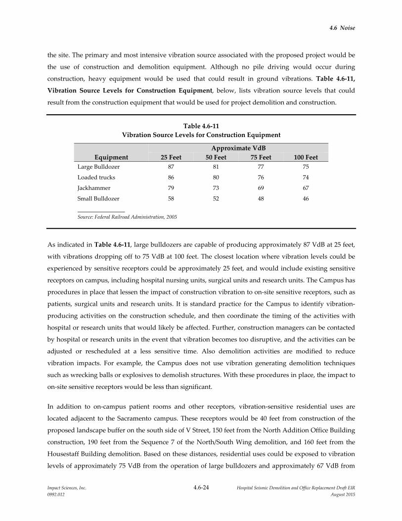
4.6 Noise
Impact Sciences, Inc. 4.6‐24 Hospital Seismic Demolition and Office Replacement Draft EIR
0992.012 August 2015
the site. The primary and most intensive vibration source associated with the proposed project would be
the use of construction and demolition equipment. Although no pile driving would occur during
construction, heavy equipment would be used that could result in ground vibrations. Table 4.6‐11,
Vibration Source Levels for Construction Equipment, below, lists vibration source levels that could
result from the construction equipment that would be used for project demolition and construction.
Table 4.6‐11
Vibration Source Levels for Construction Equipment
Equipment
Approximate VdB
25 Feet 50 Feet 75 Feet 100 Feet
Large Bulldozer 87 81 77 75
Loaded trucks 86 80 76 74
Jackhammer 79 73 69 67
Small Bulldozer 58 52 48 46
Source: Federal Railroad Administration, 2005
As indicated in Table 4.6‐11, large bulldozers are capable of producing approximately 87 VdB at 25 feet,
with vibrations dropping off to 75 VdB at 100 feet. The closest location where vibration levels could be
experienced by sensitive receptors could be approximately 25 feet, and would include existing sensitive
receptors on campus, including hospital nursing units, surgical units and research units. The Campus has
procedures in place that lessen the impact of construction vibration to on‐site sensitive receptors, such as
patients, surgical units and research units. It is standard practice for the Campus to identify vibration‐
producing activities on the construction schedule, and then coordinate the timing of the activities with
hospital or research units that would likely be affected. Further, construction managers can be contacted
by hospital or research units in the event that vibration becomes too disruptive, and the activities can be
adjusted or rescheduled at a less sensitive time. Also demolition activities are modified to reduce
vibration impacts. For example, the Campus does not use vibration generating demolition techniques
such as wrecking balls or explosives to demolish structures. With these procedures in place, the impact to
on‐site sensitive receptors would be less than significant.
In addition to on‐campus patient rooms and other receptors, vibration‐sensitive residential uses are
located adjacent to the Sacramento campus. These receptors would be 40 feet from construction of the
proposed landscape buffer on the south side of V Street, 150 feet from the North Addition Office Building
construction, 190 feet from the Sequence 7 of the North/South Wing demolition, and 160 feet from the
Housestaff Building demolition. Based on these distances, residential uses could be exposed to vibration
levels of approximately 75 VdB from the operation of large bulldozers and approximately 67 VdB from
4.6 Noise
Impact Sciences, Inc. 4.6‐25 Hospital Seismic Demolition and Office Replacement Draft EIR
0992.012 August 2015
the use of jackhammers. As noted above, a vibration level of 72 VdB is used as threshold for residences
and buildings where people normally sleep. Therefore, at certain times, especially when large bulldozers
are in use, the proposed project could result in temporarily elevated vibration levels at vibration‐sensitive
residential uses that exceed the vibration threshold for this land use and LRDP Mitigation Measure
NOI‐2 (requiring notification of nearby people) would be applicable to the project. While LRDP
Mitigation Measure NOI‐2 could reduce the potential impact to a less than significant level, an
additional mitigation measure (Mitigation Measure NOI‐2 is proposed) Furthermore, all construction
and demolition activities will be conducted during daytime hours, consistent with the City’s Noise
Ordinance. Therefore, the impact related to construction‐phase vibrations would be less than significant.
Mitigation Measures:
NOI‐2: For each sequence of work near Colonial Way and within 100 feet of nearby
residences, the University shall select smaller bulldozers, rubber‐tire equipment
if possible, and avoid heavy‐duty tracked equipment whenever feasible.
Significance after Mitigation: With the implementation of the proposed mitigation measure, the impact
related to construction and demolition noise and vibration would be further reduced. The potential
impact would be less than significant.
Impact NOI‐3: Vehicular traffic associated with the proposed project would result in an
incremental, but imperceptible, long‐term increase in ambient noise levels.
(Less than Significant)
The project will not result in a permanent increase in noise from traffic because the employee population
at the UC Davis Sacramento campus would not increase as a result of the project.
The proposed project would, however, result in a temporary increase in construction related traffic noise
for the duration of the construction and demolition activities. All construction traffic will be prohibited
from utilizing V Street and accordingly, the following discussion focuses on increased traffic along
Stockton Boulevard. For the proposed construction and demolition activities of the proposed project,
traffic would result from construction workers arriving at the project site, delivery of construction
materials to the project site, and hauling of demolition debris from the project site. The estimated
construction employee population will vary during each phase of the construction effort with a
maximum of 50 employees expected during any particular day. The estimated truck traffic is expected to
range from a low of two per day to a maximum of seven per hour (approximately 40 trucks per day)
during demolition hauling operations. Based on the approximate rate that trucks can be loaded, the
demolition hauling trucks are expected to depart the site at a rate of approximately one truck every 10

4.6 Noise
Impact Sciences, Inc. 4.6‐26 Hospital Seismic Demolition and Office Replacement Draft EIR
0992.012 August 2015
minutes. All construction truck traffic and most of the construction worker vehicles are expected to use
Stockton Boulevard, X Street, and Colonial Way to travel to and from the project sites, with the remainder
of travel occurring on the freeway.
Traffic data was developed for the 2010 LRDP EIR for study intersections in the campus vicinity. Four
different scenarios were analyzed: existing no project peak hour traffic, existing with project peak hour
traffic, cumulative no project traffic, and cumulative with project peak hour traffic. These traffic data
were used in the 2010 LRDP EIR to determine whether there would be a substantial increase in traffic
noise on streets serving the project site as a result of new traffic generated by the anticipated traffic levels
caused by the entire amount of growth predicted for the Sacramento campus through the year 2025.
Traffic‐related noise was modeled for street segments in the vicinity of noise‐sensitive receptors. The
environmental noise assessment evaluated traffic data for roadways near the northern, western, and
southern perimeter of the campus where sensitive residential receptors were present. As shown in Table
4.6‐12, Noise Levels at Residences Near Sacramento Campus in dB(A), project‐generated traffic would
result in an increase of 3 dB(A) Ldn or less at all study segments near the campus perimeter. This result is
also valid for on‐campus roadways, such that project‐generated traffic would result in an increase of 3
dB(A) Ldn or less adjacent to on‐campus roadways. The study concluded that project‐generated traffic for
all of the growth expected through the year 2025 would cause an imperceptible change to the noise
environment. This impact was considered in the 2010 LRDP EIR to be less than significant.
Table 4.6‐12
Noise Levels (measured in dB(A) Ldn) in Residential Areas Near Sacramento Campus in dB(A)
Existing Conditions 2025 Conditions
Location
Without
Project
With
Project Increase
Without
Project
With
Project Increase
V Street near Emergency Room
(LT‐1) 66 67 1 67 67 0
V Street, east of Emergency Room
(ST‐1) 53 56 3 54 dB(A) 57 dB(A) 3
Broadway Street (ST‐3) 68 69 dB(A) 1 70 dB(A) 70 dB(A) 0
Stockton Blvd. (LT‐3 & ST‐4) 63 dB(A) 64 dB(A) 1 64 dB(A) 65 dB(A) 1
Source: Illingworth &Rodkin 2010
The amount of traffic for the construction and demolition of the proposed project would be less than the
traffic evaluated in the 2010 LRDP EIR traffic noise assessment and the amount of traffic noise is expected
4.6 Noise
Impact Sciences, Inc. 4.6‐27 Hospital Seismic Demolition and Office Replacement Draft EIR
0992.012 August 2015
to be less than the traffic noise projection contained in the 2010 LRDP EIR. The expected impact from the
project’s construction traffic would be less than significant.
Mitigation Measures: No project‐level mitigation measures are required.
Impact NOI‐4: The operation of mechanical equipment on the roof of the proposed building
would not result in a substantial long‐term increase in ambient noise levels.
(Less than Significant)
Although the proposed project would result in the removal of some exterior equipment that is currently
on the rooftop of the North/South Wing of the Main Hospital, it would also add new operational sources
of noise at the Sacramento campus in the form of mechanical and ventilation equipment on the proposed
rooftop of the North Addition Office Building. Noise levels generated by this equipment would be
attenuated by the distance between the equipment and the receptors on the north side of V Street.
Furthermore, in accordance with LRDP Mitigation Measure NOI‐4 which has been incorporated and
made part of the proposed project, the project would select mechanical equipment, screening, and noise
attenuation features such as sound attenuators on fans, sound attenuator packages emergency generators,
acoustical screen walls, and equipment enclosures to ensure that noise levels do not exceed the Noise
Ordinance Standard limits (55 dB(A) daytime or 50 dB(A) nighttime) at noise‐sensitive residences
surrounding the campus. The potential impact related to stationary source noise would be less than
significant.
Mitigation Measures: No project‐level mitigation measures are required.
Impact NOI‐5: The proposed project would not expose people to aircraft noise from airports
or airstrips. (No Impact)
The proposed project is within the vicinity of the emergency helicopter operations at the Main Hospital.
Noise impacts from helicopter operations at the campus were evaluated in the UC Davis Sacramento 2010
LRDP EIR with specific background information beginning on page 4.10‐10 of the LRDP EIR and specific
noise impact analysis beginning on page 4.10‐31 of the LRDP EIR. The proposed project would result in
no changes to helicopter operations. No impact would occur.
Mitigation Measures: No project‐level mitigation measures are required.

4.6 Noise
Impact Sciences, Inc. 4.6‐28 Hospital Seismic Demolition and Office Replacement Draft EIR
0992.012 August 2015
4.6.4.5 Cumulative Impacts and Mitigation Measures
Cumulative Impact NOI‐1: The proposed project, in conjunction with other past, present and
reasonably foreseeable future development, would not result in
significant cumulative impacts related to noise. (Less than Significant)
Potential noise impacts from the development of the entire amount of growth on the Sacramento campus
anticipated under the 2010 LRDP were evaluated in terms of (1) temporary increases in noise and
vibration from construction activities, (2) permanent increases in noise that would stem from the
increased traffic along roadways used by the Sacramento campus‐related population, and (3) permanent
increases in noise levels from daily activities including stationary equipment. That analysis represents the
cumulative impact analysis for all potential projects at the Sacramento campus. Therefore, LRDP Impact
NOI‐3 evaluates the cumulative increase in traffic noise that would result from growth in traffic due to
the 2010 LRDP implementation combined with regional traffic through 2025. The analysis concluded that
the impact would be less than significant.
With respect to cumulative construction noise and vibration impacts, those would occur only if projects
proposed by others were to be under construction the same time as the projects within the Sacramento
campus and if these concurrent projects would be in close proximity of the same sensitive receptor. The
nearby residential mixed use development at the northwest corner of T Street on Stockton Boulevard
could result in increased construction traffic during the construction and demolition effort of the
proposed project. The Stockton and T Street Mixed‐Use project would include traffic from construction
workers and delivery of materials. The Stockton and T Street Mixed‐Use project is expected to be phased
over a two year or longer time frame and is not expected to significantly increase traffic related noise on
the same group of sensitive receptors as the proposed project due to the distance between the project sites
(approximately 0.36 mile, or 1,925 feet). It should also be noted that due to the Stockton and T Street
Mixed‐Use project’s immediate proximity to US 50, construction traffic from the project would most
likely be routed to the north, further decreasing the potential for cumulative traffic noise impacts in
conjunction with the proposed project. The cumulative impact would be less than significant.
Mitigation Measures: No project‐level mitigation measures are required.
4.6.5 REFERENCES
City of Sacramento. Code Sec. 8.68.050.
Federal Railroad Administration. 1998. High‐Speed Transportation Noise and Vibration Impact Assessment.
Governor’s Office of Planning and Research. 1998. General Plan Guidelines, Appendix A: Guidelines for the
Preparation and Content of the Noise Element of the General Plan.
4.6 Noise
Impact Sciences, Inc. 4.6‐29 Hospital Seismic Demolition and Office Replacement Draft EIR
0992.012 August 2015
U.S. Environmental Protection Agency. 1971. Noise from Construction Equipment and Building Operations,
Building Equipment, and Home Appliances. December.
UC Davis. 2010. UC Davis Sacramento Campus Long Range Development Environmental Impact Report.
November.
Impact Sciences, Inc. 4.7‐1 Hospital Seismic Demolition and Office Replacement Draft EIR
0992.012 August 2015
4.7 TRANSPORTATION AND TRAFFIC
4.7.1 INTRODUCTION
This section discusses the existing transportation system in the vicinity of the project site and analyzes the
potential for implementation of the proposed Hospital Seismic Demolition and Office Replacement
project (proposed project) to affect that system. Information and analysis presented in this section is
based on preliminary project design studies, and review of the 2010 LRDP Environmental Impact Report
(EIR) for the University of California, Davis Medical Center (Sacramento campus).
Caltrans submitted a comment related to impacts on state highways in response to the Notice of
Preparation (NOP) issued for this EIR. All comment letters received in response to the NOP are provided
in Appendix 1.0 of this Draft EIR.
4.7.2 ENVIRONMENTAL SETTING
4.7.2.1 Study Area
The study area for this transportation and traffic section consists of the regional and local roadway
network in the vicinity of the proposed project. Vehicular access to the proposed project sites, both
during and after project demolition and construction activities would be from Stockton Boulevard and
Colonial Way; no construction access or new operational access to the project sites would be provided via
V Street. The existing streets and sidewalks would be also be used by pedestrians and bicyclists to access
the sites.
4.7.2.2 Roadway System
The project sites, shown in Figure 3.0‐3, Project Site Locations, are located in the Hospital Zone of the
Sacramento campus. As described in Section 4.13, Volume 1 of the 2010 LRDP EIR from which this EIR
is tiered, the campus is currently served by a fully developed roadway network which provides regional
and local access. The roadways within the project vicinity are described below.
US 50 is a cross‐country east‐west highway that connects the Sacramento area to the Reno/Tahoe area. In
the vicinity of the project, the highway is a limited‐access freeway. An interchange at Stockton Boulevard
provides regional access to the project site.

4.7 Transportation and Traffic
Impact Sciences, Inc. 4.7‐2 Hospital Seismic Demolition and Office Replacement Draft EIR
0992.012 August 2015
Stockton Boulevard is a north‐south roadway that runs from Alhambra Boulevard to Power Inn Road and
provides access to US 50. It is a four‐lane divided road adjacent to the Sacramento campus. It contains a
striped median serving as a two‐way left turn lane along the campus.
T Street is an east‐west roadway that extends from Alhambra Boulevard to Kroy Way, east of 65th Street.
In the project vicinity, T Street provides one travel lane in each direction with a landscaped median
between 40th Street and 44th Street (Sunset Park).
V Street is an east‐west roadway that extends from Stockton Boulevard to 57th Street. In the project
vicinity, V Street provides one travel lane in each direction and serves residences to the north and the
campus to the south.
Colonial Way is an east‐west roadway that extends from Stockton Boulevard to 42nd Street. In the project
vicinity, Colonial Way provides one travel lane in each direction and provides internal vehicular
circulation for the campus.
42nd Street is a north‐south roadway that extends from S Street to Colonial Way. In the project vicinity,
42nd Street provides one travel lane in each direction.
4.7.2.3 Transit Facilities
Sacramento Regional Transit
The Sacramento Regional Transit District (RT) provides public transit service within the project area. RT’s
light rail Gold Line operates north of US 50 between downtown Sacramento and the City of Folsom. The
closest stations to the Sacramento campus are located at 48th Street and 39th Street. These stations are
within a half‐mile walk to the project sites.
UC Davis Health System
The UC Davis Health System operates the Med‐Transit shuttle service on the Sacramento campus as well
as an intercampus shuttle system to UC Davis Main Campus for persons affiliated with the UC system.
This includes faculty, staff, students, interns, volunteers, patients, and visitors. Two routes – internal and
perimeter – provide service to and from buildings, parking lots, and the 39th Street light rail station.
Generally, the system operates with headways between 5 to 7 minutes. On‐demand service is also
available at secondary shuttle stops. Morning express routes run between the Ambulatory Care Center,
Main Hospital, and remote parking lots. The intercampus shuttle operates hourly departing from the east
side of Lot 2.

4.7 Transportation and Traffic
Impact Sciences, Inc. 4.7‐3 Hospital Seismic Demolition and Office Replacement Draft EIR
0992.012 August 2015
4.7.2.4 Bicycle Facilities
The Sacramento City/County Bikeway Master Plan (Bikeway Plan) was originally adopted by the City of
Sacramento in 1995, with the most recent update in March 2015. The Bikeway Plan identifies existing and
planned bikeway facilities in the study area. The facilities are defined as follows:
Class I Bikeway – bicycle paths in a completely separated right‐of‐way for the exclusive use of
bicyclists and pedestrians
Class II Bikeway – bicycle lanes striped on a street or highway
Class III Bikeway – bicycle routes are on‐street shared facilities
There are no Class I facilities in the project vicinity. Class II bicycle lanes exist on X Street, 48th Street
south of X Street, 49th Street, 50th Street, and T Street. Class III bicycle routes are indicated on 48th Street
north of V Street, 51st Street north of V Street, V Street between 48th Street and 51st Street, and 2nd Avenue
west of 2nd Avenue.
4.7.2.5 Pedestrian Facilities
In general, sidewalks measuring 4 to 5 feet in width are present along most of the roadways in the project
vicinity. About half the sidewalks on the Sacramento campus are separated from vehicle traffic by a
landscape strip. These detached sidewalks are also present along Stockton Boulevard, V Street, and
throughout the Elmhurst neighborhood to the north of the project sites. Most of these locations have trees
along the sidewalks, which are commonly considered attributes of a pedestrian‐friendly environment.
4.7.2.6 Sacramento Campus TDM Program
The Sacramento campus has a robust TDM program that comprises the use of carpool, vanpool, transit,
Amtrak, bicycling and walking to and from the campus. The program is offered to all employees,
including faculty and staff. As of 2008–09, approximately 12 percent of the Sacramento campus’s daytime
staff used alternative transportation to travel to and from the campus, with 4 percent arriving in van‐ and
carpools, 4 percent by transit, 3 percent on bicycle, and 1 percent on foot. Students are also eligible for the
TDM program. Population estimates indicate that 12 percent of the students travel to the campus using
alternative transportation. Less than 1 percent of the patients and visitors arrive at the campus using
alternative modes.
4.7 Transportation and Traffic
Impact Sciences, Inc. 4.7‐4 Hospital Seismic Demolition and Office Replacement Draft EIR
0992.012 August 2015
4.7.3 REGULATORY CONSIDERATIONS
4.7.3.1 California Department of Transportation
The California Department of Transportation (Caltrans) provides for the mobility of people, goods,
services, and information. Its mission is to work in partnership with others to provide the people of
California with a safe, efficient, and effective intermodal transportation system by planning, developing,
maintaining, and managing the interregional transportation system and assisting and guiding delivery of
local and regional transportation services. Caltrans provides administrative support for transportation
programming decisions made by the California Transportation Commission and Caltrans for state
funding programs. The State Transportation Improvement Program (STIP) is a multi‐year capital
improvement program that sets priorities and funds transportation projects envisioned in long‐range
transportation plans.
US 50 Corridor System Management Plan
The US 50 Corridor System Management Plan (May 2009) identifies “Concept LOS” and “Concept
Facility” to reflect the minimum level or quality of operations acceptable for each route segment within
the 20‐year planning period and the highway facility needed in the next 20 years to maintain the Concept
LOS. Caltrans’ Concept LOS for the freeway segment in the project vicinity is LOS F.
4.7.3.2 Sacramento Area Council of Governments
The Sacramento Area Council of Governments (SACOG) is an association of local governments in the
six‐county Sacramento Region. Its members include the counties of Sacramento, El Dorado, Placer, Sutter,
Yolo, and Yuba as well as 22 cities. SACOG provides transportation planning and funding for the region,
and serves as a forum for the study and resolution of regional issues. In addition to preparing the region’s
long‐range transportation plan, SACOG assists in planning for transit, bicycle networks, clean air, and
airport land uses. SACOG also maintains a regional model that is used for developing long‐range travel
forecasts (City of Sacramento 2009).
2035 Metropolitan Transportation Plan/Sustainable Communities Strategy
The Metropolitan Transportation Plan/Sustainable Communities Strategy (MTP/SCS) for 2035 (SACOG
2012) is a federally mandated long‐range fiscally constrained transportation plan for the six‐county area.
Most of this area is designated a federal non‐attainment area for ozone, indicating that the transportation
system is required to meet stringent air quality emissions budgets to reduce pollutant levels that
contribute to ozone formation. To receive federal funding, transportation projects nominated by cities,

4.7 Transportation and Traffic
Impact Sciences, Inc. 4.7‐5 Hospital Seismic Demolition and Office Replacement Draft EIR
0992.012 August 2015
counties, and agencies must be consistent with the MTP/SCS. Consistency is measured based on whether
the project was contained in the plan and its associated computer modeling of transportation and air
quality impacts. In addition, any regionally significant transportation project planned for a city or county
must be included in the MTP because of its potential effect on travel demand and air pollution.
4.7.3.3 Sacramento Regional Transit
The Sacramento Regional Transit District (RT) provides public transit service within the project area. RT
operates approximately 100 bus routes and 40 miles of light rail covering a 418‐square‐mile service area.
TransitAction Plan
Sacramento Regional Transit District’s “TransitAction Plan” (August 2009) is the revised long‐term plan
for transit service over the next 25 years, with a horizon year of 2035. The TransitAction Plan places
significant emphasis on improved transit service throughout the region through a combination of
infrastructure investments and service modifications. The Plan defines three planning scenarios and
presents a preferred scenario for future implementation.
4.7.3.4 City of Sacramento
The City of Sacramento provides for the mobility of people and goods within the City of Sacramento.
Nearly all the study intersections are within the City of Sacramento jurisdiction.
City of Sacramento 2035 General Plan
The City of Sacramento 2035 General Plan, adopted in August 2014, was shaped over a four‐year period
by an extensive public outreach process. The guiding vision of the General Plan is that “Sacramento will
be the most livable City in America.” The General Plan contains goals and policies that determine
acceptable operations for intersections in the city.
Sacramento City/County Bikeway Master Plan
The Sacramento City/County Bikeway Master Plan adopted by the City of Sacramento in 1995 identifies
existing and planned bikeway facilities in the study area. The plan provides recommendations for
implementing a comprehensive and coordinated bikeway network for making travel by bicycle a viable
transportation option in the City and County of Sacramento. The major goal of the plan is to “develop
and maintain a coordinated approach by City/County and other agencies to implement the plan as
funding becomes available or as development occurs.”

4.7 Transportation and Traffic
Impact Sciences, Inc. 4.7‐6 Hospital Seismic Demolition and Office Replacement Draft EIR
0992.012 August 2015
City of Sacramento Pedestrian Master Plan (2006)
The City of Sacramento Pedestrian Master Plan (2006) provides a comprehensive vision for improving
pedestrian conditions. The purpose is to make Sacramento a model pedestrian‐friendly city – the
“Walking Capital.” The goals of the plan fall into the following three categories.
Create a walkable pedestrian environment throughout the city.
Improve awareness of the pedestrian mode through education.
Increase pedestrian safety (City of Sacramento 2009).
4.7.3.5 UC Davis Sacramento Campus 2010 Long Range Development Plan
The 2010 LRDP is intended to provide a general land use plan that will allow the UC Davis Health
System to achieve its educational, clinical, research, and engagement goals. The plan provides for the
following:
Hospital renovation and growth (additional 1,172,000 square feet)
Expansion of ambulatory care services (additional 780,000 square feet)
Growth in education and research facilities (additional 1,140,000 square feet)
Increase in support facilities (additional 87,000 square feet)
The Campus is expected to grow to approximately 12,760 faculty, students, daytime staff, interns,
residents, and fellows by 2025. Patient and visitor population is projected to grow to 6,956 persons by
2025.
The 2010 LRDP identifies the following transportation and circulation changes:
Consolidation and removal of some existing surface lot parking facilities
Construction of five additional parking structures on Campus to provide approximately 3,500
additional parking spaces
Closure of 45th Street south of V Street to general vehicle traffic
Closure of 48th Street south of V Street to general vehicle traffic

4.7 Transportation and Traffic
Impact Sciences, Inc. 4.7‐7 Hospital Seismic Demolition and Office Replacement Draft EIR
0992.012 August 2015
4.7.4 ENVIRONMENTAL IMPACTS
4.7.4.1 Significance Criteria
The impacts from the implementation of the proposed project related to transportation and traffic would
be considered significant if they would exceed the following significance criteria, in accordance with
Appendix G of the State CEQA Guidelines and the UC CEQA Handbook:
Exceed the capacity of the existing circulation system, based on an applicable measure of
effectiveness (as designated in a general plan policy, ordinance, etc.), taking into account all relevant
components of the circulation system, including but not limited to intersections, streets, highways
and freeways, pedestrian and bicycle paths, and mass transit;
Conflict with an applicable congestion management program, including, but not limited to level of
service standards and travel demand measures, or other standards established by the county
congestion management agency for designated roads or highways;
Result in a change in air traffic patterns, including either an increase in traffic levels or a change in
location that results in substantial safety risks;
Substantially increase hazards due to a design feature (e.g., sharp curves or dangerous intersections)
or incompatible uses (e.g., farm equipment);
Result in inadequate emergency access; or
Conflict with adopted policies, plans, or programs supporting alternative transportation (e.g., bus
turnouts, bicycle racks).
Although the LRDP EIR evaluated the impacts of campus growth and development under the 2010 LRDP
on parking capacity, since then Appendix G has been revised and inadequate parking capacity is no
longer considered an environmental impact. Therefore, the issue is not evaluated in the impact analysis
below.
4.7.4.2 CEQA Checklist Items Adequately Analyzed at the 2010 LRDP Level or Not
Applicable to the Project
Substantially increase hazards due to a design feature (e.g., sharp curves or dangerous intersections)
or incompatible uses (e.g., farm equipment)
Conflict with adopted policies, plans, or programs supporting alternative transportation (e.g., bus
turnouts, bicycle racks)
The analysis in Section 4.13 of the 2010 LRDP EIR found that the campus development under the 2010
LRDP would not involve construction of new or changed roadways that would contain design features

4.7 Transportation and Traffic
Impact Sciences, Inc. 4.7‐8 Hospital Seismic Demolition and Office Replacement Draft EIR
0992.012 August 2015
that could be hazardous. Under the proposed project, the closure of the southern entrance to Parking
Structure 1 during demolition of the Ramp Tower and the Surgical Center of the North/South Wing
would be temporary (lasting approximately two to three weeks) and would not result in any permanent
changes to the area roadways. In addition, to minimize interruption to the Sacramento campus and
surrounding neighborhoods, demolition traffic would be routed one way through the construction zone,
with the traffic entering the area via the southern Stockton Boulevard Parking Structure 1 entrance,
proceeding north through the demolition area, turning left at Colonial Way and finally exiting the
campus at the intersection of Colonial Way and Stockton Boulevard. No demolition/construction traffic
would be routed via V Street. California Department of Transportation (Caltrans) certified flag persons
would be deployed along all traffic routes near the project sites who would direct traffic at the north
construction gate, Stockton Boulevard demolition entrance, and the intersection of Stockton Boulevard
and Colonial Way for the duration of the project. These flag persons will work also as security to keep the
general public and staff out of the demolition sites. Thus, impacts related to roadway design hazards
and/or incompatible uses would be less than significant. No further analysis is required.
The analysis in Section 4.13 of the 2010 LRDP EIR found that implementation of the 2010 LRDP would
not substantially increase demand for transit service nor result in conflicts with any existing plans for
transit. The proposed project is not expected to disrupt or discourage transit use. The proposed project
does not include any improvements that could interfere with transit plans for the area. Therefore, the
proposed project would result in a less than significant impact to the area transit system. No further
analysis is required.
As discussed in Section 4.13, implementation of the 2010 LRDP would increase the volume of pedestrians
and bicyclists in the surrounding area but would not adversely affect existing or planned bicycle and
pedestrian facilities, result in reduced pedestrian or bicyclist safety, or conflict with existing plans for
bicycle and pedestrian facilities. The proposed project does not involve improvements that would
adversely affect any bicycle facilities on or off the campus site. Further, implementation of the proposed
project would not interfere with the implementation of the Sacramento City/County Bikeway Master
Plan. Under the proposed project, in order to ensure safety, certain pedestrian and bikeways may be
subject to temporary closure (refer to Section 3.5, Project Description, Project Elements, Construction
and Demolition Logistics), but the proposed project would not result in any permanent changes to the
pedestrian and bikeway circulation system in the area. The proposed project does not include any plans
for improvements that would obstruct pedestrian facilities or interfere with implementation of the City of
Sacramento Pedestrian Master Plan. Therefore, the proposed project would result in a less than
significant impact to the bicycle and pedestrian systems. No further analysis is required.

4.7 Transportation and Traffic
Impact Sciences, Inc. 4.7‐9 Hospital Seismic Demolition and Office Replacement Draft EIR
0992.012 August 2015
4.7.4.3 CEQA Checklist Items Adequately Addressed in the Initial Study
The analysis in the Initial Study prepared for the project and circulated with the NOP concluded that
further analysis of the following issue was not required in the EIR.
Result in a change in air traffic patterns, including either an increase in traffic levels or a change in
location that results in substantial safety risks
Result in inadequate emergency access
The proposed project would result in no change to air traffic patterns and no increase in air traffic levels.
Accordingly, the project would result in no change to safety risks related to air traffic. No impact would
occur. No further analysis is needed.
During project construction and demolition, temporary construction fencing would be installed such that
emergency access to all hospital facilities is maintained (refer to Section 3.5, Project Description, Project
Elements, Construction and Demolition Logistics). One of the primary objectives of the Main Hospital is
to provide emergency services and the routing needs for emergency access will undergo extensive
scrutiny during the project design process to ensure that each phase of the project maintains adequate
access. No impact would occur. No further analysis is needed.
4.7.4.4 2010 LRDP EIR Mitigation Measures Included in the Proposed Project
Table 4.7‐1, 2010 LRDP EIR Mitigation Measures, presents the mitigation measures in the 2010 LRDP
EIR that are applicable to the proposed project. Since these previously adopted mitigation measures are
already being carried out as part of implementation of the 2010 LRDP, they are included in and are a part
of the proposed project and will not be readopted. Implementation of these mitigation measures is
assumed as part of the project impact analysis.
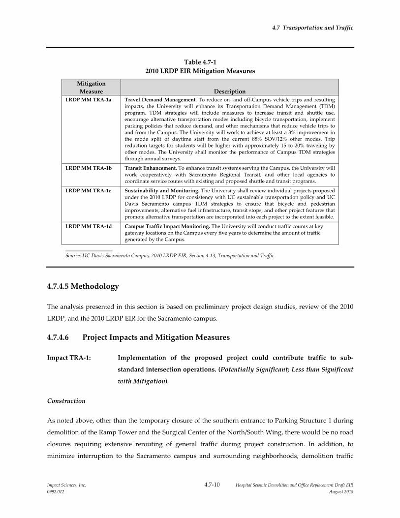
4.7 Transportation and Traffic
Impact Sciences, Inc. 4.7‐10 Hospital Seismic Demolition and Office Replacement Draft EIR
0992.012 August 2015
Table 4.7‐1
2010 LRDP EIR Mitigation Measures
Mitigation
Measure Description
LRDP MM TRA‐1a Travel Demand Management. To reduce on‐ and off‐Campus vehicle trips and resulting impacts, the University will enhance its Transportation Demand Management (TDM) program. TDM strategies will include measures to increase transit and shuttle use, encourage alternative transportation modes including bicycle transportation, implement parking policies that reduce demand, and other mechanisms that reduce vehicle trips to and from the Campus. The University will work to achieve at least a 3% improvement in the mode split of daytime staff from the current 88% SOV/12% other modes. Trip reduction targets for students will be higher with approximately 15 to 20% traveling by other modes. The University shall monitor the performance of Campus TDM strategies through annual surveys.
LRDP MM TRA‐1b Transit Enhancement. To enhance transit systems serving the Campus, the University will work cooperatively with Sacramento Regional Transit, and other local agencies to coordinate service routes with existing and proposed shuttle and transit programs.
LRDP MM TRA‐1c Sustainability and Monitoring. The University shall review individual projects proposed under the 2010 LRDP for consistency with UC sustainable transportation policy and UC Davis Sacramento campus TDM strategies to ensure that bicycle and pedestrian improvements, alternative fuel infrastructure, transit stops, and other project features that promote alternative transportation are incorporated into each project to the extent feasible.
LRDP MM TRA‐1d Campus Traffic Impact Monitoring. The University will conduct traffic counts at key gateway locations on the Campus every five years to determine the amount of traffic generated by the Campus.
Source: UC Davis Sacramento Campus, 2010 LRDP EIR, Section 4.13, Transportation and Traffic.
4.7.4.5 Methodology
The analysis presented in this section is based on preliminary project design studies, review of the 2010
LRDP, and the 2010 LRDP EIR for the Sacramento campus.
4.7.4.6 Project Impacts and Mitigation Measures
Impact TRA‐1: Implementation of the proposed project could contribute traffic to sub‐
standard intersection operations. (Potentially Significant; Less than Significant
with Mitigation)
Construction
As noted above, other than the temporary closure of the southern entrance to Parking Structure 1 during
demolition of the Ramp Tower and the Surgical Center of the North/South Wing, there would be no road
closures requiring extensive rerouting of general traffic during project construction. In addition, to
minimize interruption to the Sacramento campus and surrounding neighborhoods, demolition traffic
4.7 Transportation and Traffic
Impact Sciences, Inc. 4.7‐11 Hospital Seismic Demolition and Office Replacement Draft EIR
0992.012 August 2015
would be routed one way through the construction zone, with the traffic by entering the area via the
southern Stockton Boulevard Parking Structure 1 entrance, proceeding north through the demolition
area, turning left at Colonial Way and finally exiting the campus at the intersection of Colonial Way and
Stockton Boulevard. No demolition/construction traffic would be routed via V Street. Flag persons would
be deployed along all traffic routes near the project sites who direct traffic at key locations for the
duration of the project. Therefore, disruption of general traffic on adjacent city streets would be
minimized. The proposed project would, however, add a substantial amount of truck traffic to the city
streets, especially during the demolition of the North/South Wing. As shown in Table 4.7‐2, Proposed
Project Construction Sequencing and Traffic Estimates, depending on the activities that are underway,
the proposed project would generate varying numbers of daily truck trips during construction of the
North Addition Office Building, demolition of the Housestaff Building and the North/South Wing,
construction of the replacement façade on the Main Hospital, and site redevelopment for the two new
plaza areas, with the highest number of daily truck trips associated with the demolition of the
North/South Wing. The highest number of truck trips would occur over a period of 10 to 12 weeks. In
addition, daily vehicle trips would be added to the city streets by construction workers traveling to and
from the project sites. In summary, construction traffic associated with the proposed project could result
in congestion and reduced street capacity in the project vicinity.
To address this potentially significant impact, a project specific mitigation measure (Mitigation Measure
TRA‐1) is proposed that requires the Campus to develop and implement a Construction Traffic
Management Plan (CTMP) to manage the movement of construction vehicles in a safe and effective
manner. The CTMP would include information such as the number and size of trucks per day, times of
the day when truck movement is allowed, truck circulation patterns, location of staging areas,
location/amount of construction employee parking, and the proposed use of traffic control/partial street
closures on public streets. The CTMP would also include both vehicular and pedestrian way‐finding
signage, and route Main Hospital delivery traffic from Stockton Boulevard, east on X Street, then north on
45th Street, through the Campus and into the dock at the rear or north of the facility (refer to Figure 3.0‐
18). The overall goal of the CTMP would be to minimize traffic impacts to Campus and public streets and
maintain a high level of safety for all vehicles and pedestrians.
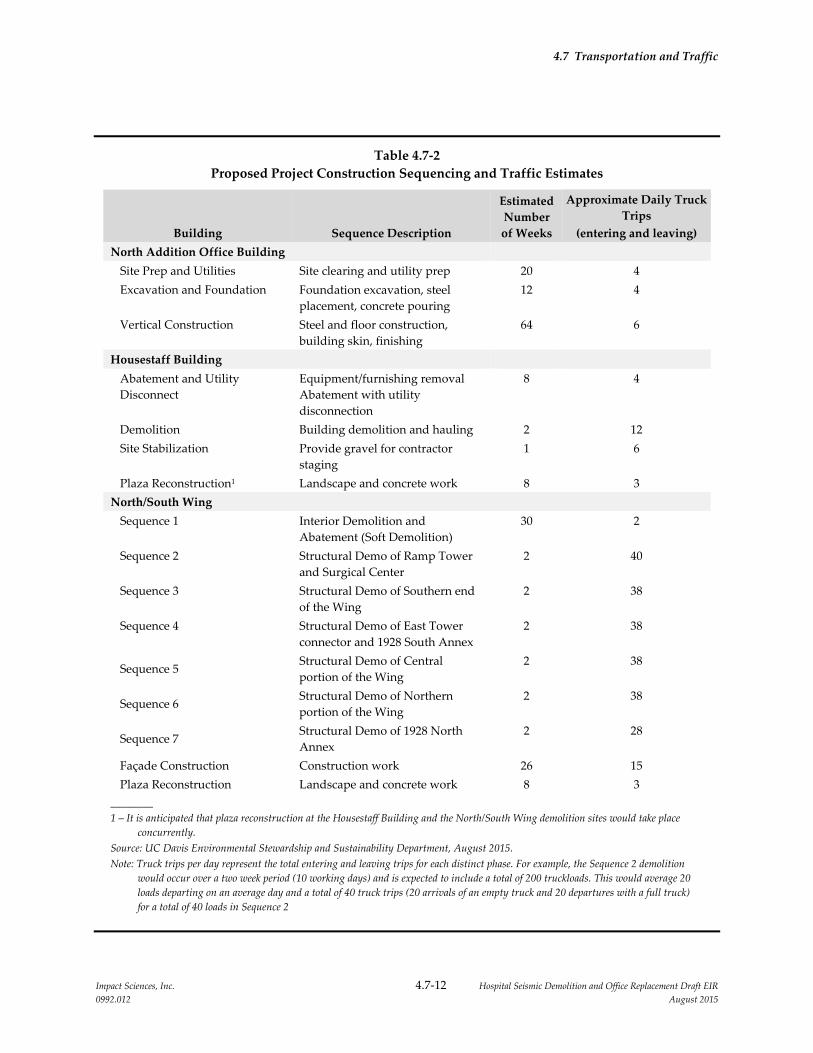
4.7 Transportation and Traffic
Impact Sciences, Inc. 4.7‐12 Hospital Seismic Demolition and Office Replacement Draft EIR
0992.012 August 2015
Table 4.7‐2
Proposed Project Construction Sequencing and Traffic Estimates
Building Sequence Description
Estimated
Number
of Weeks
Approximate Daily Truck
Trips
(entering and leaving)
North Addition Office Building
Site Prep and Utilities Site clearing and utility prep 20 4
Excavation and Foundation Foundation excavation, steel
placement, concrete pouring
12 4
Vertical Construction Steel and floor construction,
building skin, finishing
64 6
Housestaff Building
Abatement and Utility
Disconnect
Equipment/furnishing removal
Abatement with utility
disconnection
8 4
Demolition Building demolition and hauling 2 12
Site Stabilization Provide gravel for contractor
staging
1 6
Plaza Reconstruction1 Landscape and concrete work 8 3
North/South Wing
Sequence 1 Interior Demolition and
Abatement (Soft Demolition)
30 2
Sequence 2 Structural Demo of Ramp Tower
and Surgical Center
2 40
Sequence 3 Structural Demo of Southern end
of the Wing
2 38
Sequence 4 Structural Demo of East Tower
connector and 1928 South Annex
2 38
Sequence 5 Structural Demo of Central
portion of the Wing
2 38
Sequence 6 Structural Demo of Northern
portion of the Wing
2 38
Sequence 7 Structural Demo of 1928 North
Annex
2 28
Façade Construction Construction work 26 15
Plaza Reconstruction Landscape and concrete work 8 3
________
1 – It is anticipated that plaza reconstruction at the Housestaff Building and the North/South Wing demolition sites would take place
concurrently.
Source: UC Davis Environmental Stewardship and Sustainability Department, August 2015.
Note: Truck trips per day represent the total entering and leaving trips for each distinct phase. For example, the Sequence 2 demolition
would occur over a two week period (10 working days) and is expected to include a total of 200 truckloads. This would average 20
loads departing on an average day and a total of 40 truck trips (20 arrivals of an empty truck and 20 departures with a full truck)
for a total of 40 loads in Sequence 2

4.7 Transportation and Traffic
Impact Sciences, Inc. 4.7‐13 Hospital Seismic Demolition and Office Replacement Draft EIR
0992.012 August 2015
Operations
The transportation and traffic impacts of all campus development under the 2010 LRDP, including the
proposed project, are adequately addressed in Section 4.13 of the 2010 LRDP EIR. As noted in Section 3.0,
Project Description, the proposed project involves the relocation of existing programs and the North
Addition Office Building provides only a small amount of building space for growth of the relocated
programs. As a result, the population of the campus is not expected to increase substantially as a result of
project implementation. Consequently, the number of daily vehicle trips to the campus is not expected to
increase substantially as a result of the proposed project. Furthermore, the Campus will continue to
implement LRDP Mitigation Measure TRA‐1 which is included in and a part of the proposed project.
LRDP Mitigation Measure TRA‐1 is a multi‐component program to monitor trip generation, reduce
peak‐hour trips to the extent feasible, and/or participate in roadway improvements to mitigate off‐site
impacts at the intersections affected by the proposed project. The operation of the North Addition Office
Building would result in a less than significant impact on traffic conditions.
Mitigation Measures:
TRA‐1: The University shall require the prime contractor to prepare and implement a
Construction Traffic Management Plan that will include, but will not necessarily
be limited to, the following elements:
Identify proposed truck routes to be used; no construction traffic is to be
permitted on V Street.
Specify construction hours, including limits on the number of truck trips
during the a.m. and p.m. peak traffic periods (7:00 – 9:00 AM and 4:00 – 6:00
PM), if conditions demonstrate the need.
Include a parking management plan for ensuring that construction worker
parking results in minimal disruption to surrounding uses.
Include a public information and signage plan to inform patients, visitors
and staff of the planned construction activities, roadway changes/closures,
and parking changes.
Store construction materials only in designated areas that minimize impacts
to nearby roadways.

4.7 Transportation and Traffic
Impact Sciences, Inc. 4.7‐14 Hospital Seismic Demolition and Office Replacement Draft EIR
0992.012 August 2015
Use of California Department of Transportation (Caltrans) certified flag
persons for any temporary lane closures to minimize impacts to traffic flow,
and to ensure safe access into and out of the project site(s).
Develop circulation and detour plans to minimize impacts to local street
impacts from construction activity on nearby major arterials. This may
include the use of signing and flagging to guide vehicles through and/or
around the construction zone.
Limit the number of lane closures during peak hours to the extent possible.
Install traffic control devices as specified in the California Department of
Transportation Manual of Traffic Controls for Construction and Maintenance
Work Zones.
Develop and implement access plans for potentially impacted local services
such as police and fire stations, transit stations, hospitals, schools and parks.
The access plans should be developed with the facility owner or
administrator. To minimize disruption of emergency vehicle access, affected
jurisdictions should be asked to identify detours for emergency vehicles,
which will then be posted by the contractor.
Coordinate with local transit agencies for temporary relocation of routes or
bus stops in works zones, as necessary.
Include coordination with other projects under construction in the
immediate vicinity, so an integrated approach to construction‐related traffic
can be developed.
Significance after Mitigation: Implementation of this mitigation measure would reduce the project’s
construction traffic impact to a less than significant level.
4.7 Transportation and Traffic
Impact Sciences, Inc. 4.7‐15 Hospital Seismic Demolition and Office Replacement Draft EIR
0992.012 August 2015
4.7.4.7 Cumulative Impacts and Mitigation Measures
Cumulative Impact TRA‐1: Implementation of the proposed project, in conjunction with other
reasonably foreseeable future projects, would not result in significant
traffic impacts. (Less than Significant)
Construction
To evaluate the potential for cumulative temporary construction and demolition impacts, the City of
Sacramento was contacted to obtain a list of approved and pending projects that potentially could be
under construction at the same time as the proposed project and in its vicinity such that potential short‐
term cumulative impacts could occur. The City informed the Campus that there is one approved
residential mixed‐use project at the intersection of Stockton Boulevard and T Street, about three city
blocks to the north of the Sacramento campus. The Stockton and T Street Mixed‐Use project would
remove the existing 120,000 sf vacant office building (formerly AT&T) and associated parking lot and
subdivide the property for construction of a mixed‐use residential and commercial development. The
mixed‐use project includes a 214‐unit, five‐story, multi‐family housing complex with ground floor
commercial and parking garage on the corner of Stockton Boulevard and T Street. In addition, the project
includes construction of approximately 24 single‐family homes between S Street and US 50. Although the
construction timeline of that project is not known at this time, however, because the project has been
approved, its construction could commence anytime and overlap with the construction and demolition
activities of the proposed project on the Sacramento campus. Construction traffic associated with both
projects would add traffic to Stockton Boulevard up to the two east‐and westbound ramps of US 50.
There is existing congestion at the westbound on‐ramp in the PM peak hour, and both projects could
potentially contribute traffic at this location. However, as stated in the Initial Study/Mitigated Negative
Declaration prepared for the mixed‐use project by the City of Sacramento, the proposed project would
implement MTP/SCS EIR Mitigation Measure TRN‐3, and SCEA IS Mitigation Measure XI‐2 which would
reduce the impact of the project’s construction traffic to a less than significant level (City of Sacramento
2015). Similarly, the proposed project would implement Mitigation Measure TRA‐1 to minimize any
construction‐phase impacts. This measure also includes coordination between the two projects to
minimize traffic congestion. Therefore the cumulative construction traffic impact would be less than
significant.

4.7 Transportation and Traffic
Impact Sciences, Inc. 4.7‐16 Hospital Seismic Demolition and Office Replacement Draft EIR
0992.012 August 2015
Operations
The cumulative transportation and traffic impacts of all growth under the 2010 LRDP, including the
proposed project, are adequately addressed in Section 4.13 of the 2010 LRDP EIR. No further evaluation
of cumulative traffic impacts is required.
Mitigation Measure: No project level mitigation measures are required.
4.7.5 REFERENCES
City of Sacramento. 2015. Draft SCEA Initial Study, Stockton and T Street (P14‐042). March
University of California, Davis Sacramento Campus. 2009. 2010 Long Range Development Plan. November.
University of California, Davis Sacramento Campus. 2010. 2010 Long Range Development Plan
Environmental Impact Report. July.

Impact Sciences, Inc. 4.8‐1 Hospital Seismic Demolition and Office Replacement Draft EIR
0992.012 August 2015
4.8 UTILITIES AND SERVICE SYSTEMS, INCLUDING ENERGY
4.8.1 INTRODUCTION
This section describes the existing utilities and service systems that serve the project site. It determines
whether the implementation of the Hospital Seismic Demolition and Office Replacement project (project
or proposed project) would result in the need for new or improved utilities, the construction of which
could produce potential environmental impacts. It also evaluates the potential for the proposed project to
result in significant energy impacts. As described in Section 4.14, Volume 1 of the 2010 Long Range
Development Plan (LDRP) EIR from which this EIR is tiered, the University of California Davis Medical
Center (Sacramento campus) is currently served by the full range of utilities and a well‐developed utility
infrastructure, augmented by water, wastewater, natural gas, electricity, and some telecommunications
services from outside providers.
No public or agency comments related to utilities, service systems, and energy were received in response
to the Notice of Preparation (NOP) issued for this EIR. All comment letters received in response to the
NOP are provided in Appendix 1.0 of this Draft EIR.
4.8.2 ENVIRONMENTAL SETTING
4.8.2.1 Project Location
The Sacramento campus is located in the City of Sacramento, approximately 2.5 miles southeast of
downtown Sacramento, and 17 miles east of the UC Davis main campus. The Sacramento campus is
bound by V Street on the north, Stockton Boulevard to the west, Broadway to the south, and a residential
neighborhood to the east. The campus is organized into four general land use zones or functional areas,
consisting of (1) Hospital, (2) Ambulatory Care, (3) Education and Research, and (4) Support Services
zones (see Figure 3.0‐2, Existing UC Davis Sacramento Campus).
The proposed project is located within the Hospital Zone and is composed of three components:
construction and occupancy of the North Addition Office Building, demolition of the North/South Wing,
and the demolition of the Housestaff Building. The North Addition Office Building would be constructed
north of the Main Hospital on the site currently occupied by an approximately 30,000 square foot single‐
story temporary building used as the Children’s Surgery Center and the Trauma Nursing Unit that will
be demolished under a separate project in late 2015. The Housestaff Building is a 20,000 gross‐square foot

4.8 Utilities and Service Systems
Impact Sciences, Inc. 4.8‐2 Hospital Seismic Demolition and Office Replacement Draft EIR
0992.012 August 2015
(GSF)1 building, located adjacent to Colonial Way, on an approximately 10,000 sf site. The North/South
Wing of the Main Hospital is a six‐story building that is located immediately adjacent to Stockton
Boulevard to the south, and Colonial Way to the north and is approximately 200 feet from the northern
edge of the campus, on an approximately 50,000 sf site (see Figure 3.0‐3, Project Site Locations).
4.8.2.2 Utilities and Service Systems
Water Supply
Potable water is supplied to the Sacramento campus by connection to the City of Sacramento domestic
water system. This water is used for domestic, fire protection, Central Energy Plant (Central Plant), and
partially for irrigation uses.2 A City of Sacramento aboveground water tank is present on the campus on
the south side of V Street. The Campus owns and operates two wells that supply irrigation water to all
campus grounds (UC Davis 2010).
Wastewater
Wastewater from the campus is conveyed to the City of Sacramento combined sewer and storm water
facilities. It is treated at the Sacramento Regional Wastewater Treatment Plant (SRWTP), which is owned
and operated by the Sacramento Regional County Sanitation District (SRCSD). The Central Valley
Regional Water Quality Control Board (CVRWQCB) regulates the quality and quantity of effluent
discharged from the SRWTP (UC Davis 2010).
Storm water
Storm water from half of the campus area discharges into the City’s combined sewer system, which
handles both storm water runoff and domestic sewer discharge. Storm water from the other half of the
campus flows via the city storm drains to the American River. A City‐owned storm water detention basin
designed for 10‐year flows is located in the northeastern portion of the campus (UC Davis 2010).
Municipal Solid Waste
The UC Davis Department of Facilities Operations and Maintenance is responsible for the collection and
disposal of solid waste on the campus. Solid waste collected on campus is disposed of in a regional
landfill with adequate permitted capacity to serve anticipated regional needs.
1 GSF = Gross Square Feet ‐ The sum of all areas on all floors of a building included within the outside faces of its
exterior walls, including all vertical penetration areas, for circulation and shaft areas that connect one floor to
another.
2 To comply with State Executive Order B‐29‐15 outdoor irrigation of ornamental landscapes or turf with potable
water from the campus domestic water system is limited to two days per week. `

4.8 Utilities and Service Systems
Impact Sciences, Inc. 4.8‐3 Hospital Seismic Demolition and Office Replacement Draft EIR
0992.012 August 2015
The campus is considered a Large Quantity Generator (LQG) of hazardous waste and is subject to state
and federal regulations affecting these facilities. The campus generates and disposes of corrosive,
reactive, ignitable, metallic (chromium, lead, mercury, and silver) and other wastes on the Resource
Conservation and Recovery Act (RCRA) list (UC Davis 2010).
Electricity and Natural Gas
Pacific Gas & Electric Company (PG&E) provides natural gas to the campus from gas distribution mains
on V Street, Stockton Boulevard, Broadway, 45th Street, 48th Street, Y Street, and 2nd Avenue. A 6‐inch
transmission main extension was built in 1997 from an existing transmission main located in 24th and T
Street to 49th and 2nd Avenue to provide transmission level service to the campus. This system serves the
(Central Plant. The Central Plant on the campus provides normal and emergency electrical power, and is
designed to accommodate growth in utility demand on the campus (UC Davis 2010).
Campus Chilled Water and Steam Systems
The Central Plant provides chilled and hot water for cooling and heating, and process steam to most
campus buildings. The Central Plant includes a chilled water system composed of multiple absorption
and centrifugal chillers, with an operating capacity of 10,500 tons of water. The Central Plant total steam
production capability from the combined cycle turbine power plant and installed boiler capacity is
160,800 pounds per hour (lbs/hr). Due to existing air permit requirements, only two of the four boilers are
allowed to operate when the gas turbine is operating at full load. This reduces the allowable steam
production capacity to 122,400 lbs/hr (UC Davis 2010).
Telecommunications
The Campus owns and operates its own telecommunications infrastructure.
4.8.3 REGULATORY SETTING
4.8.3.1 State Regulations
SB 610 and SB 221 – Water Supply Assessments
In 2001, the California Legislature passed Senate Bill 610 (Water Code Section 10910 et seq.) and Senate
Bill 221 (Water Code Section 66473.7) to improve the link between information on water supply
availability and certain land use decisions made by cities and counties. SB 610 and SB 221 were
companion measures, which sought to promote more collaborative planning between local water

4.8 Utilities and Service Systems
Impact Sciences, Inc. 4.8‐4 Hospital Seismic Demolition and Office Replacement Draft EIR
0992.012 August 2015
suppliers and cities and counties. SB 610 and SB 221 are not applicable to University of California
projects.
Assembly Bill 939
In 1989, Assembly Bill (AB 939) established the current organization, structure and mission of the
California Integrated Waste Management Board. The purpose was to direct attention to the increasing
waste stream and decreasing landfill capacity, and to mandate a reduction of waste being disposed.
Jurisdictions were required by AB 939 to meet diversion goals of 25 percent by 1995 and 50 percent by the
year 2000. Each City and County was required to submit a plan (Source Reduction and Recycling
Element) which described how they would meet the waste reduction mandates. The University of
California is not subject to this Act. However, sustainability is a central element of the 2010 LRDP and the
UC Sustainable Practices Policy sets waste diversion goals of 75 percent by June 2012 and zero waste by
2020.
California Universal Waste Law
This legislation went into effect in February 2006. Universal wastes are a wide variety of hazardous
wastes such as batteries, fluorescent tubes, and some electronic devices, that contain mercury, lead,
cadmium, copper or other substances hazardous to human and environmental health. Universal waste
may not be discarded in solid waste landfills, but instead are recyclable and (to encourage recycling and
recovery of valuable metals) can be managed under less stringent requirements than those that apply to
other hazardous wastes.
Government Code 54999
Government Code 54999 provides for the payment of fees in certain specific enumerated situations for
capital improvements to utilities actually serving the University. A capital facilities fee that is imposed
must be nondiscriminatory and the amount must not exceed the amount actually necessary to provide
capital facilities to the University.
Executive Order B‐29‐15
The Campus must comply with State Executive Order B‐29‐15 which requires potable water demand to
be reduced by 25 percent. To ensure strict compliance with the regulations, the outdoor irrigation of
ornamental landscapes or turf with potable water is limited to two days per week. Additionally, these
systems must be operated to prevent runoff and halt irrigating for 48 hours following measurable
rainfall.3
3 UC Davis Utilities Department, Water Consumption Memorandum, May 31, 2015.

4.8 Utilities and Service Systems
Impact Sciences, Inc. 4.8‐5 Hospital Seismic Demolition and Office Replacement Draft EIR
0992.012 August 2015
University of California Sustainable Practices Policy
The University of California Sustainable Practices Policy was adopted by The Regents in 2006 and most
recently revised and issued in June 2015. The policy was developed to standardize campus practices and
is a system‐wide commitment to minimize the University of California’s impact on the environment and
reduce the University’s dependence on non‐renewable energy sources. The University of California
Policy on Sustainable Practices establishes goals in nine areas of sustainable practices:
Green Building,
Clean Energy,
Climate Change and Protection,
Sustainable Transportation,
Sustainable Operations,
Waste Reduction and Recycling,
Sustainable Purchasing,
Sustainable Foodservice, and
Sustainable Water Systems.
The policy guidelines that address these topics recommend that University operations:
Incorporate the principles of energy efficiency and sustainability in all capital projects, operations and
maintenance within budgetary constraints and programmatic requirements.
Minimize the use of non‐renewable energy sources on behalf of UC’s built environment by creating a
portfolio approach to energy use, including use of local renewable energy and purchase of green
power from the grid as well as conservation measures that reduce energy consumption.
Incorporate alternative means of transportation to/from and within the campus to improve the
quality of life on campus and in the surrounding community. The campuses will continue their
strong commitment to provide affordable on‐campus housing, in order to reduce the volume of
commutes to and from campus. These housing goals are detailed in the campuses’ LRDPs.
Track, report and minimize GHG emissions on behalf of UC operations.
Minimize the amount of University‐generated waste sent to landfill.
Utilize the University’s purchasing power to meet its sustainability objectives.
4.8 Utilities and Service Systems
Impact Sciences, Inc. 4.8‐6 Hospital Seismic Demolition and Office Replacement Draft EIR
0992.012 August 2015
The University of California has signed the American College and University Presidents Climate
Commitment. Each signatory commits to completing an inventory of GHG emissions within one year,
and to developing, within two years, an institutional plan to achieve climate neutrality as soon as
possible. The commitment also includes specific interim actions, including requiring that new campus
construction be built to at least the US Green Building Council’s LEED Silver standard or equivalent;
purchasing Energy Star appliances; offsetting greenhouse gas emissions generated by institutional air
travel; encouraging and providing access to public transportation; purchasing or producing at least 15
percent of the institution’s electricity consumption from renewable sources; supporting climate and
sustainability shareholder proposals at companies where the institution’s endowment is invested; and
adopting measures to reduce waste.
4.8.4 IMPACTS AND MITIGATION MEASURES
4.8.4.1 Significance Criteria
The significance criteria listed below are derived from Appendix G and Appendix F of the State CEQA
Guidelines and the UC CEQA Handbook. For the purpose of this EIR, utilities, service systems, and
energy impacts would be significant if implementation of the proposed project would:
exceed the Regional Water Quality Control Board’s wastewater treatment requirements;
require or result in the construction or expansion of water or wastewater treatment facilities, which
would cause significant environmental effects;
require or result in the construction or expansion of storm water drainage facilities, which could
cause significant environmental effects;
result in the need for new or expanded water supply entitlements due to insufficient water supplies
available to serve the project from existing entitlements and resources;
exceed available wastewater treatment capacity;
be served by a landfill with insufficient permitted capacity to accommodate the project’s solid waste
disposal needs;
fail to comply with applicable federal, state, and local statutes and regulations related to solid waste.
require or result in the construction or expansion of electrical or natural gas facilities which would
cause significant environmental impacts;
result in wasteful, inefficient, and unnecessary use of energy; or
place a significant demand on regional energy supply or require provision of substantial additional
capacity.

4.8 Utilities and Service Systems
Impact Sciences, Inc. 4.8‐7 Hospital Seismic Demolition and Office Replacement Draft EIR
0992.012 August 2015
4.8.4.2 Methodology
Project impacts to utilities, service systems and energy are based on a qualitative comparison of the
existing and projected demand for utilities and the resulting need, if any, for new, expanded, or modified
facilities to meet the increased demand. As determined in Section 4.14, Utilities and Service Systems of
the 2010 LDRP EIR, from which this EIR is tiered, impacts to the existing utilities and service systems that
serve the campus would be less than significant upon buildout of the LDRP. Further, the staffing levels
on the campus are not expected to increase due to the proposed project. As the proposed project would
be constructed to meet all UC sustainability goals and would seek a UC equivalent LEED© Gold
Certification or better, these project features were taken into consideration when determining the
proposed project’s demand for utilities and energy.
4.8.4.3 2010 LRDP EIR Mitigation Measures Included in the Proposed Project
Analysis in the 2010 LRDP EIR concluded that all potential impacts to Utilities and Service Systems as a
result of implementation of the 2010 LRDP would be less than significant and no mitigation measures
were necessary.
4.8.4.4 Project Impacts and Mitigation Measures
Impact UTIL‐1: Implementation of the proposed project would not exceed wastewater
treatment requirements of the Central Valley Regional Water Quality Control
Board. (Less than Significant)
Development of the proposed project would not result in an increase in staffing levels and would reduce
building space on the campus by approximately 125,000 GSF. In addition, the proposed project would be
constructed to meet all UC sustainability goals, applicable goals included in the Campus CAP,4 and
would seek a UC equivalent LEED© Gold Certification or better. Projects that qualify for LEED© Gold
certification are required to reduce indoor aggregate water consumption by 20 percent from the
calculated baseline water consumption conditions.56 To meet the 20 percent reduction, the proposed
4 The Climate Action Plan lists strategies to minimize campus water consumption, including water‐efficient
landscaping, fixture retrofits, efficient fixtures in new buildings, education, and energy conservation initiatives
that would minimize water use
5 The US Green Building Council (USGBC) has established baseline conditions (based on volumes and flow rates)
for commercial fittings, fixtures and appliances. USGBC website Indoor Water Use Reduction, Table 1,
http://www.usgbc.org/node/1734960?return=/credits/new‐construction/v4/water‐efficiency, accessed August 10,
2015
6 USGBC LEED BD+C New Construction, Indoor Water Use Required Reduction,
http://www.usgbc.org/node/1734960?return=/credits/new‐construction/v4/water‐efficiency, accessed August 10,
2015

4.8 Utilities and Service Systems
Impact Sciences, Inc. 4.8‐8 Hospital Seismic Demolition and Office Replacement Draft EIR
0992.012 August 2015
project would be required to install low‐flush toilets and water efficient faucets and showerheads. The
proposed project’s reduction in indoor water consumption would also result in a reduction in the
project’s wastewater generation. Therefore, operation of the proposed project would not increase the
volume of wastewater conveyed to the City of Sacramento combined sewer and storm water facilities, but
instead would reduce the volume of wastewater, compared to existing conditions. Wastewater generated
during operation of the proposed project would be treated at the SRWTP. The CVRWQCB would
regulate the quality and quantity of effluent discharged from the SRWTP. The proposed project would
comply with discharge requirements of the SRWTP. Further, operational activities associated with the
proposed project would not contribute pollutants in wastewater that is discharged into the sanitary sewer
system that could cause a violation of waste discharge requirements of the SRWTP. The impact would be
less than significant.
Mitigation Measures: No project‐level mitigation measures are required.
Impact UTIL‐2: The project‐related demand for water and wastewater conveyance facilities
would not require the expansion of pipes and structures. (Less than
Significant)
Development of the proposed project would not result in an increase in staffing levels and would reduce
building space on the campus by approximately 125,000 GSF. As discussed above, the proposed project
includes the construction of the approximately 130,000 GSF North Addition Office Building. The new
building would be constructed on the site currently occupied by an approximately 30,000 square foot
single‐story temporary building used as the Children’s Surgery Center and the Trauma Nursing Unit.
The new building would connect to the existing water and wastewater distribution piping which
currently serves the temporary building located on the project site.
To qualify for the LEED© Gold certification, the new building would be required to reduce indoor water
consumption by 20 percent (based on the calculated baseline water consumption conditions) which
would reduce the project’s wastewater demand. To meet the LEED© outdoor water consumption
requirement, the proposed project would be required to reduce its landscape water requirement by at
least 30 percent, compared to the project site’s peak water calculated baseline, or include landscaping
which would not require an irrigation system beyond a maximum two‐year establishment period.7
Further, the new building would be designed and constructed using UC sustainability goals and
applicable goals included in the CAP, both of which would improve the new building’s water and
7 USGBC LEED BD+C New Construction, Outdoor Water Use Required Reduction
http://www.usgbc.org/node/2611372?return=/credits/new‐construction/v4/water‐efficiency, accessed August 11,
2015
4.8 Utilities and Service Systems
Impact Sciences, Inc. 4.8‐9 Hospital Seismic Demolition and Office Replacement Draft EIR
0992.012 August 2015
wastewater efficiency. These actions would result in a reduction in water consumption and wastewater
generation over baseline conditions.
Because there would be a reduction in water consumption and wastewater generation compared to
existing conditions, the existing water and wastewater distribution piping on the campus as well as the
City’s water and sewer lines could accommodate the new building’s water demand and wastewater
generation, and no new pipelines would be required. The impact would be less than significant.
Mitigation Measures: No project‐level mitigation measures are required.
Impact UTIL‐3: The proposed project would not require expansion of campus storm drainage
conveyance and detention facilities. (Less than Significant)
Approximately 75 percent of the campus land area is comprised of impervious surfaces. Half of the
campus area discharges storm water into the City’s combined sewer system, which serves both storm
water runoff and domestic sewer discharge. Storm water from the other half of the campus flows via the
City storm drains to the American River. A City‐owned storm water detention basin designed for 10‐year
flows is located on the campus.
With the implementation of the proposed project it is anticipated that that the total area of impervious
surfaces would decrease and pervious surfaces would increase slightly (approximately 30,000 GSF) with
the demolition of two buildings and the subsequent addition of open space and landscape areas. As a
result of the decrease in impervious surfaces, the site storm water runoff volumes would be expected to
decrease or stay comparable to existing conditions. Therefore, construction of the proposed project would
not require expansion of the campus storm drainage system and/or detention facilities. The impact would
be less than significant.
Mitigation Measures: No project‐level mitigation measures are required.
Impact UTIL‐4: The proposed project would not generate additional demand for water and
would be served from existing entitlements and resources. (Less than
Significant)
The water service provider, the City of Sacramento, confirmed there is adequate capacity in their large
diameter transmission main system surrounding the campus to accommodate the potable water demands
associated with campus development under the 2010 LRDP full build‐out scenario.8 The proposed project
would reduce the total amount of building space on the campus. Furthermore, staffing levels are not
8 UC Davis Sacramento Campus 2010 LRDP Draft EIR, Section 4.14 Utilities and Service Systems

4.8 Utilities and Service Systems
Impact Sciences, Inc. 4.8‐10 Hospital Seismic Demolition and Office Replacement Draft EIR
0992.012 August 2015
expected to increase due to the project. In addition, the new building would be designed and constructed
using UC sustainability goals and applicable goals included in the Campus CAP, both of which would
improve the new building’s water efficiency. Further, as discussed above, the proposed project would
apply for LEED© Gold certification, which would require the proposed project to reduce indoor water
consumption by 20 percent from the calculated baseline water consumption conditions. Therefore the
proposed project would not increase the demand for water on the Sacramento campus relative to existing
conditions, and the water demand associated with the North Addition Office Building would be served
by the existing supplies that are provided to the campus by the City of Sacramento. The impact related to
water supply would be less than significant.
Mitigation Measures: No project‐level mitigation measures are required.
Impact UTIL‐5: The proposed project would not generate additional wastewater flows and
therefore would not exceed available wastewater treatment capacity. (Less than
Significant)
Wastewater from the campus is conveyed to the City of Sacramento combined sewer and storm water
facilities. It is treated at the SRWTP, which is owned and operated by the SRCSD. According to the
SRWTP 2020 Master Plan, the treatment plant would be expanded to have a design capacity of 218 mgd
average dry weather flows by 2020 (SRCSD 2008). The 2010 LRDP EIR estimated that about 0.24 million
gallons per day/87.5 million gallons per year of sanitary sewer flows each year would be discharged into
the City’s combined sewer system at full build‐out. Regarding discharge of wastewater, the new building
would be designed and constructed using UC sustainability goals and applicable goals included in the
Campus CAP. In addition, the proposed project would apply for LEED© Gold certification, which would
require the proposed project to reduce indoor water consumption through the installation of water
efficient fixtures, including low‐flush toilets. As clarified above, these measures would result in the
building discharging lower than baseline condition wastewater flows. Furthermore, staffing levels on the
campus are not expected to increase due to the project. As a result, overall wastewater discharge from the
campus is not expected to increase as a result of the proposed project and could potentially decrease with
project implementation. The impact on wastewater treatment capacity would be less than significant.
Mitigation Measures: No project‐level mitigation measures are required.

4.8 Utilities and Service Systems
Impact Sciences, Inc. 4.8‐11 Hospital Seismic Demolition and Office Replacement Draft EIR
0992.012 August 2015
Impact UTIL‐6: The proposed project would not fail to comply with regulations related to
solid waste and would not generate solid waste that could not be
accommodated by the regional landfill. (Less than Significant)
As noted above, the proposed project is composed of three components: construction and occupancy of
the North Addition Office Building, demolition of the North/South Wing, and the demolition of the
Housestaff Building. In total, the project would reduce building space on the Sacramento campus by
approximately 125,000 GSF.
Construction
Demolition of the North/South Wing and the Housestaff Building would result in construction waste.
Construction waste materials are expected to be typical construction debris, including concrete, wood,
metal, glass, and green wastes. Overall the proposed project is anticipated to achieve a 75 percent recycle
construction waste rate to meet the UC equivalent LEED© Material and Resources Credit 2.2©.9
Concrete waste from demolition of the Housestaff Building would be crushed on‐site; effectively creating
an aggregate base type material which will then be used to create a crushed‐aggregate base parking lot on
the former Housestaff Building site. Concrete from demolition of the North/South Wing would be
separated from the steel and other assorted debris. The recovered steel would be taken to a licensed
recycling center, while the other debris would be taken to a licensed landfill center if it cannot be
recycled. Similar to the Housestaff Building site, concrete from the demolition of the North/South Wing
would be crushed on the project site, creating an aggregate base type material which would then be used
to backfill the hole left by the demolished North/South Wing basement. The remainder of construction
waste would be disposed of in a Class III landfill or a mixed debris recycling facility which recycles 50
percent of all waste received. The impact from solid waste generated during demolition and construction
would be less than significant.
Operation
The new building includes a nominal amount of building space for growth of programs and therefore,
the staffing levels on the campus are not expected to increase due to the proposed project. As a result
overall solid waste generation on the campus is not expected to increase due to operation of the new
building and could potentially decrease with implementation of the proposed project. To comply with
the UC Sustainable Practices Policy , approximately 75 percent of solid waste generated during operation
9 USGBC LEED BD+C New Construction, Construction and Demolition Waste Management,
http://www.usgbc.org/node/2601031?return=/credits/new‐construction/v4/material‐%26‐resources, accessed
August 11, 2015
4.8 Utilities and Service Systems
Impact Sciences, Inc. 4.8‐12 Hospital Seismic Demolition and Office Replacement Draft EIR
0992.012 August 2015
of the proposed project would be diverted from landfills. In addition, to meet the LEED© Storage and
Collection of Recyclables requirement, dedicated marked bins for recyclable materials would be placed
throughout the project site.10 Non‐recyclable solid waste generated during operation of the new building
would be separated into the appropriate waste streams and disposed. Because the volume of waste
generated is not expected to increase, the proposed project would not generate solid waste that could not
be accommodated by the regional landfill. The impact related to solid waste generated during project
operation would be less than significant.
Mitigation Measures: No project‐level mitigation measures are required.
Impact UTIL‐7: The proposed project would not require the expansion of electrical, steam, and
chilled water facilities. (Less than Significant)
The campus demand for electricity, chilled and hot water for heating and cooling and process steam is
served by the Central Plant. As previously discussed the new building would be constructed to meet all
UC sustainability goals, all applicable goals included in the Campus CAP, and would seek a UC
equivalent LEED© Gold Certification or better. To qualify for the LEED© Gold Certification the new
building would be required to meet the LEED© minimum energy performance requirement and
incorporate project design features, including, but no limited to, compliance with the 2013 Title 24 Part 6
California Energy Code11, all of which would reduce the new building’s electricity and cooling and
heating demands.12 Furthermore, with the demolition of the North/South Wing and Housestaff Building,
the proposed project would reduce the total building space on the campus by approximately 125,000 GSF.
Staffing levels would not change with the construction of the new building, which would include an
energy efficient HVAC system. As a result, because of the electricity related efficiencies in the new
building, the staffing levels remaining the same, and the decrease in building space, overall energy use on
the campus would decrease with project implementation, and no expansion of any of the heating and
cooling systems or the electrical facilities on the campus would be required. The impact would be less
than significant.
Mitigation Measures: No project‐level mitigation measures are required.
10 USGBC LEED BD+C New Construction, Storage and Collection of Recyclables,
http://www.usgbc.org/node/2614336?return=/credits/new‐construction/v4/material‐%26‐resources, accessed
August 11, 2015
11 California Energy Commission, 2013 Building Energy Efficiency Standards,
http://www.energy.ca.gov/2012publications/CEC‐400‐2012‐004/CEC‐400‐2012‐004‐CMF‐REV2.pdf, accessed
August 12, 2015.
12 USGBC LEED BD+C New Construction, Minimum Energy Performance,
http://www.usgbc.org/node/2613358?return=/credits/new‐construction/v4/energy‐%26‐atmosphere, accessed
August 11, 2015

4.8 Utilities and Service Systems
Impact Sciences, Inc. 4.8‐13 Hospital Seismic Demolition and Office Replacement Draft EIR
0992.012 August 2015
Impact UTIL‐8: The proposed project would not result in wasteful, inefficient, and
unnecessary use of energy; place a significant demand on regional energy
supply; or require provision of substantial additional capacity. (Less than
Significant)
Staffing levels are not expected to increase due to the proposed project. The new building would be
designed and constructed using UC sustainability goals and applicable goals included in the Campus
CAP, both of which would minimize the new building’s electrical and natural gas consumption. Further,
as discussed above, the proposed project would apply for LEED© Gold certification, which would require
the new building to achieve a minimum level of energy efficiency to reduce the environmental and
economic harms of excessive energy use. Demolition of the North/South Wing and Housestaff Building
would reduce building space on the campus by approximately 125,000 GSF, further decreasing the
campus’ energy consumption. PG&E would continue to provide natural gas to the campus, including the
Central Plant, which provide electrical power to the new building. Because energy use would not
increase with the project, the project would not place a significant demand on regional energy supply nor
require the provision of additional capacity. The impact related to energy use would be less than
significant.
Mitigation Measures: No project‐level mitigation measures are required.
4.8.4.5 Cumulative Impacts and Mitigation Measures
Cumulative Impact UTIL‐1: Implementation of the proposed project, in conjunction with
other past, present and reasonably foreseeable development in
Sacramento, could generate a cumulative demand for new or
expanded utilities in the region, the construction of which
could result in significant environmental impacts, but the
project’s contribution would not be cumulatively considerable.
(Less than Significant)
The cumulative impacts of campus development under the 2010 LRDP on utilities and service systems
were evaluated in the 2010 LRDP EIR under LRDP Cumulative Impact UTIL‐1. That analysis concluded
that full development of the campus under the 2010 LRDP, in conjunction with buildout of the City of
Sacramento pursuant to its adopted General Plan, would result in the demand for additional water
supply and wastewater treatment capacity. However, the 2010 LRDP development would not require
substantial modifications to utility systems, especially off‐site utilities. Furthermore, the 2010 LRDP
includes sustainability goals to substantially reduce the Campus’s water use and wastewater generation.

4.8 Utilities and Service Systems
Impact Sciences, Inc. 4.8‐14 Hospital Seismic Demolition and Office Replacement Draft EIR
0992.012 August 2015
The extensive programs focused on demand reduction would minimize the project’s contribution to
cumulative impacts. The University noted that as a result of cumulative growth, including the growth of
the campus, some improvements to the utility systems, especially wastewater treatment capacity, could
be required. But when such improvements are proposed, they would be evaluated by the City or other
regional providers for their environmental impacts and mitigation measures would be incorporated for
any impacts that are found to be significant. To the extent that the Sacramento campus contributes to
these impacts, as noted in LRDP Mitigation Measure UTIL‐5, the Campus will contribute its
proportional share of the cost of environmental mitigation. Therefore, the contribution of the campus
development under the 2010 LRDP to the cumulative impact on utilities would not be cumulatively
considerable. Furthermore, for reasons presented above under Impacts UTIL‐1 through ‐8, the proposed
project is not expected to place an additional demand on water, wastewater, solid waste, and energy
facilities. Therefore, the proposed project’s contribution to cumulative impacts on water, wastewater,
solid waste, and energy facilities would not be cumulatively considerable.
Mitigation Measures: No project‐level mitigation measures are required.
4.8.5 REFERENCES
California Integrated Waste Management Board (CalRecycle). http://www.calrecycle.ca.gov/
City of Sacramento. 2011. 2010 Urban Water Management Plan. October.
Sacramento Regional County Sanitation District. 2008. Regional Wastewater Treatment Plant 2020 Master
Plan. May.
UC Davis. 2010. UC Davis Sacramento Campus Long Range Development Plan Draft EIR. July.
UC Davis Utilities Department. 2015. Water Consumption Memorandum. May.
US Green Building Council. http://www.usgbc.org/home
Impact Sciences, Inc. 5.0‐1 Hospital Seismic Demolition and Office Replacement Draft EIR
0992.012 August 2015
5.0 ALTERNATIVES
5.1 INTRODUCTION
The California Environmental Quality Act (CEQA) requires that an EIR describe a range of reasonable
alternatives to the project, or to the location of the project that could feasibly avoid or lessen any
significant environmental impacts while substantially attaining the basic objectives of the project. An EIR
should also evaluate the comparative merits of the alternatives. This section sets forth potential
alternatives to the proposed project, and for those alternatives that would achieve most of the basic
objectives of the proposed project, evaluates the alternatives for their ability to avoid or reduce the
proposed project’s significant impacts.
5.2 PROJECT OBJECTIVES
Alternatives considered in the EIR should be feasible and should attain most of the basic project
objectives. The University of California Davis Health Systems (UCDHS) objectives of the Hospital Seismic
Demolition and Office Replacement project are to:
Provide replacement space for offices and support functions in the seismically deficient North/South
Wing.
Promote synergy and consolidate departments focused on enhancing quality and the patient
experience.
Foster highest and best use of space adjacent to the hospital.
Provide modest amount of growth space for academic offices.
Replace the hospital command center displaced by the Tower 1 renovation project.
Achieve UC sustainability goals for energy performance.
Create high quality office environment at reasonable cost.
Provide office space as non‐OSHPD space separate from hospital building.
Complement the aesthetic and operational aspects of the existing hospital buildings.
Respect the residential neighborhood to the north.
Create adjacent outdoor plaza/garden space.
5.0 Alternatives
Impact Sciences, Inc. 5.0‐2 Hospital Seismic Demolition and Office Replacement Draft EIR
0992.012 August 2015
5.3 RANGE OF ALTERNATIVES CONSIDERED
5.3.1 ALTERNATIVES CONSIDERED IN DETAIL
An EIR must briefly describe the rationale for selection of alternatives. The lead agency may make an
initial determination as to which alternatives are feasible, and therefore merit in‐depth consideration, and
which are infeasible. Alternatives that do not meet most of the project objectives need not be considered
in detail. Alternatives that are remote or speculative, or have effects that cannot be reasonably predicted,
also need not be considered.1 Based on their ability to meet project objectives and in order to comply with
CEQA requirements, the following alternatives are considered in detail in this EIR:
No Project
Reduced Size Alternative
5.3.2 ALTERNATIVES ELIMINATED FROM FUTURE CONSIDERATION
The following alternatives were considered by the UCDHS but rejected as infeasible. A brief explanation
of the reasons for their exclusion is presented below.
5.3.2.1 Reinforce and Renovate Existing Housestaff Building and Existing
Hospital Space
This alternative would seek to seismically reinforce and renovate the Housestaff Building and the
North/South Wing of the Main Hospital on the University of California, Davis Medical Center
(Sacramento campus). Under this alternative, the proposed North Office Addition Building would not be
constructed. Instead, the following would need to occur to implement this alternative:
An alternative space near the Main Hospital complex would need to be identified and/or developed
to allow for the temporary relocation and housing of programs.
Once programs are temporarily relocated, renovations to the North/South Wing would commence.
Programs would then be relocated back into the structure.
While this alternative would meet space program goals, this strategy would not be able to meet the
schedule mandated by the State of California Office of Statewide Health Planning and Development
(OSHPD) that requires that the retrofit be completed by 2020 to address seismic safety. Second, a
1 California Public Resources Code, Title 14, Division 6, Chapter 3, California Environmental Quality Act Guidelines,
Section 15126.6(f)(3).
5.0 Alternatives
Impact Sciences, Inc. 5.0‐3 Hospital Seismic Demolition and Office Replacement Draft EIR
0992.012 August 2015
renovation project would add significant financial costs because of the phasing and coordination required
to relocate the programs two times.
Third, this alternative would cost more than the total cost to construct equivalent new space. The
North/South Wing was expanded in the 1950’s and the original seismically deficient, three‐story,
unreinforced‐masonry 1928 structure serves as the core of the building. Retrofitting the 1928 part of the
North/South Wing structure to meet seismic requirements would be extremely time consuming and is not
cost effective. Excluding the logistics and phasing required to facilitate seismic renovations, the cost of the
renovation itself is estimated at $221.94 million, far greater than the estimated cost of $76.09 million to
construct a new building. Reasons for such a costly renovation include both the age of the building and
the specifics of construction. The renovation of the Housestaff Building would also not be cost effective.
For all of the above reasons, this alternative was not carried forth for detailed evaluation.
5.3.2.2 Alternate Off‐Campus Location
This alternative would involve identifying and securing long‐term lease space near the Main Hospital to
house programs currently within the seismically deficient North/South Wing and the Housestaff
Building. The Main Hospital complex is bordered primarily by residential homes and small commercial
structures currently occupied by UCDHS and non‐UCDHS tenants; these structures generally do not
have enough contiguous space to satisfy all of the project’s program requirements. Moreover, one of the
programs being relocated from the North/South Wing is the Main Hospital’s primary administration in
charge of operations. Managing the Main Hospital from a location off‐campus would add significant
operational costs from a travel and logistics standpoint, and would also lower the standard of patient
care. For example, some programs (especially Trauma) need to be within a fifteen‐minute walking
distance of the surgery rooms within the Main Hospital complex. There is no vacant leasable space that is
large enough to satisfy program requirements within a reasonable radius of the Main Hospital.
In order to provide a comprehensive analysis, one lease was analyzed for cost per square foot metrics.
However, it is important to note that this lease cannot satisfy the distance or square footage requirements
for the programs being relocated out of the North/South Wing, but is used for illustrative purposes. For a
ten‐year lease that would be built‐to‐suit by a developer, the total cost (turn‐key) is currently estimated at
$87.5 million. While this would be similar to the estimated total cost of $76.09 million for new University
construction, the issue of long‐term lease costs would still remain, as many programs being relocated out
of the North/South Wing are key hospital administrative departments that require permanent space. This
operational reality deems this alternative to be physically impossible in the short term and financially
disadvantageous in the long term. For all of the above reasons, this alternative was not carried forth for
detailed evaluation.

5.0 Alternatives
Impact Sciences, Inc. 5.0‐4 Hospital Seismic Demolition and Office Replacement Draft EIR
0992.012 August 2015
5.3.2.2 Alternate Location on Campus
This alternative would involve constructing the proposed North Addition Office Building at another
location on the campus, while still demolishing the North/South Wing and the Housestaff Building.
UCDHS evaluated other potential locations on the campus but concluded that many of the key objectives
of the proposed project would not be attained if the proposed office building was not placed immediately
adjacent to the Main Hospital. As noted above, some of the key project objectives are to:
Promote synergy and consolidate departments focused on enhancing quality and the patient
experience.
Foster highest and best use of space adjacent to the hospital.
Replace the hospital command center displaced by the Tower 1 renovation project.
Provide office space as non‐OSHPD space separate from hospital building.
Complement the aesthetic and operational aspects of the existing hospital buildings.
Create high quality office environment at reasonable cost.
For these reasons, this alternative was not carried forth for detailed evaluation.
5.4 ALTERNATIVES EVALUATION
5.4.1 Alternative 1: No Project
Description and Analysis
Under the No Project Alternative, a new office building to house programs being relocated out of the
North/South Wing would not be constructed and the two buildings (North/South Wing and Housestaff
Building) would not be demolished. However due to seismic safety concerns and meet the OSHPD
mandate, programs located in the two buildings would need to be relocated into other existing building
space. As noted above in Section 5.2.3.3, Alternate Off‐site Location, a single leased space that satisfies
the distance or square footage requirements for the programs being relocated out of the North/South
Wing is not available. Therefore under the No Project Alternative, the various relocated programs would
move into existing on‐campus space and/or off‐campus leased space. The programs would therefore be
dispersed and would not have the benefit that would result from consolidation of the programs in one
building, as well as easy access to the Main Hospital.

5.0 Alternatives
Impact Sciences, Inc. 5.0‐5 Hospital Seismic Demolition and Office Replacement Draft EIR
0992.012 August 2015
Aesthetics
Under the No Project Alternative, no construction would occur. Therefore, the proposed project’s less
than significant impacts related to light and glare and visual character and quality would be avoided.
Air Quality
Under the No Project Alternative, no development would occur. Therefore, the proposed project’s less
than significant air quality impacts would be avoided.
Biological Resources
Given that no new development would take place under this alternative, the proposed project’s less than
significant biological resources impacts would be avoided.
Cultural Resources
Given that no new development would take place under this alternative, the proposed project’s
potentially significant impacts to archaeological resources and human remains would be avoided.
Geology and Soils
Given that no new development would take place under this alternative, the proposed project’s less than
significant impacts related to geology and soils would be avoided.
Greenhouse Gas Emissions
Given that no new development would take place under this alternative, the proposed project’s less than
significant impacts related to greenhouse gas emissions would be avoided.
Hazards and Hazardous Materials
Given that no new development would take place under this alternative, the proposed project’s less than
significant impacts related to hazards and hazardous materials would be avoided.
Hydrology and Water Quality
Given that no new development would take place under this alternative, the proposed project’s less than
significant impacts related to hydrology and water quality would be avoided.

5.0 Alternatives
Impact Sciences, Inc. 5.0‐6 Hospital Seismic Demolition and Office Replacement Draft EIR
0992.012 August 2015
Land Use and Planning
Given that no new development would take place under this alternative, the proposed project’s less than
significant impacts related to land use and planning would be avoided.
Noise
Given that no new development would take place under this alternative, the proposed project’s
significant and unavoidable impact related to construction noise and the less than significant operational
noise and construction vibration impacts would be avoided.
Public Services and Recreation
Given that no new development would take place under this alternative, the proposed project’s less than
significant impacts related to public services and recreation would be avoided.
Population and Housing
Given that no new development would take place under this alternative, similar to the proposed project,
there would be no impacts related to population and housing.
Transportation and Traffic
Given that no new development would take place under this alternative, the proposed project’s less than
significant impacts related to both construction and operational traffic would be avoided.
Utilities, Service Systems, and Energy
Given that no new development would take place under this alternative, the proposed project’s less than
significant impacts to utilities and energy would be avoided.
Conclusion and Relationship to Project Objectives
The No Project Alternative would not allow for the consolidation of important administrative and patient
serving departments to take place at the Sacramento campus. In addition, the hospital command center
displaced by the Tower 1 renovation project would not be replaced.
The proposed project is part of a series of actions, some of which must be completed by 2020 in order to
address seismic safety mandates, maintain hospital licensure, and avoid possible fees for non‐compliance
as required by OSHPD. The No Project Alternative would not allow the UCDHS to vacate and disconnect

5.0 Alternatives
Impact Sciences, Inc. 5.0‐7 Hospital Seismic Demolition and Office Replacement Draft EIR
0992.012 August 2015
the North/South Wing from the adjoining Main Hospital complex by the 2020 deadline, putting Main
Hospital operations at risk functionally, legally and financially.
Further, the No Project alternative would not meet any of the UCDHS project objectives.
5.4.2 Alternative 2: Reduced Building Size Alternative
Description and Analysis
This alternative would reduce the size of the proposed North Addition Office Building by two floors
(approximately 43,500 GSF) making it a four‐story, approximately 86,500 GSF building, in comparison
with the proposed project’s approximately 130,000 GSF, six‐story building; a reduction of approximately
33 percent. This reduction in building space in the new building would require that the UCDHS either
construct a smaller building in another location on the campus or relocate the unhoused programs into
existing on‐campus space (if available) and/or secure leased space in existing buildings near the campus.
There would be no other changes to the proposed project under this alternative; the demolition of the
Housestaff Building and the North/South Wing, along with the construction of the new Main Hospital
Façade and the two new pedestrian plaza areas would still occur as under the proposed project. As such,
access, parking, circulation, and landscape features (including the landscape buffer on the northern edge
of the campus) would be the same as under the proposed project.
The intent of this alternative is to reduce the time needed to construct the building and thereby reduce the
duration of the significant construction noise impacts associated with construction of the North Addition
Office Building.
Aesthetics
The Reduced Building Size alternative would alter the visual character of the Hospital Seismic
Demolition and Office Replacement project site to a similar degree as the proposed project. The
alternative would be located in an already urban setting, and would replace an existing one‐story
temporary building. Similar to the proposed project, the alternative would result in less than significant
impacts related to scenic vistas and scenic resources. The less than significant impacts related to visual
character would be slightly reduced because the building would be smaller in size and therefore less
visually prominent. The less than significant impacts related to new sources of light and glare associated
with the alternative would be similar to the proposed project because the same exterior design criteria
regarding building materials and lighting would be imposed and the same 2010 LRDP mitigation
measures would be implemented. Therefore, implementation of this alternative would slightly reduce the
project’s less than significant impacts related to visual character and light and glare. In the event that a
5.0 Alternatives
Impact Sciences, Inc. 5.0‐8 Hospital Seismic Demolition and Office Replacement Draft EIR
0992.012 August 2015
smaller building is constructed elsewhere on the campus to accommodate the unhoused programs,
additional but less than significant visual impacts could occur.
Air Quality
Under the Reduced Building Size Alternative, there would be less building space constructed on the
project site. Therefore, the less than significant air quality impacts related to the construction of the North
Addition Office Building would be incrementally reduced under the alternative. However, in the event
that the remaining space needs are addressed by constructing a small building in another portion of the
campus, additional construction phase emissions would occur and the construction‐phase impact would
be comparable to that of the proposed project. Although the building would be smaller by approximately
33 percent and there would be fewer occupants, the remainder of the population would be
accommodated in a new on‐campus building and/or in existing on‐campus and off‐campus building
space. Therefore, the vehicle trips to the campus vicinity would still occur, and the overall operational
impacts would be similar to that of the proposed project.
Biological Resources
Under the Reduced Building Size Alternative, the North Addition Office Building would be constructed
on the same site as under the proposed project and a second building would potentially be constructed
on another location on the campus. The North/South Wing and the Housestaff Building would also be
demolished under this alternative. The alternative’s impacts to biological resources would be the same as
those of the proposed project.
Cultural Resources
Similar to the proposed project, construction and demolition activities under this alternative could result
in the disturbance of previously undiscovered historic or prehistoric cultural resources, artifacts, or
human remains. However, LRDP mitigation measures have been incorporated and made a part of the
proposed project, and therefore the project’s impact on cultural resources would be less than significant.
This alternative would construct the North Addition Office Building on the same site as the proposed
project and potentially a second building on another location on the campus. The North/South Wing and
the Housestaff Building would also be demolished under this alternative. Therefore, impacts on cultural
resources would be comparable and less than significant.
5.0 Alternatives
Impact Sciences, Inc. 5.0‐9 Hospital Seismic Demolition and Office Replacement Draft EIR
0992.012 August 2015
Geology and Soils
The construction sites under this alternative are the same as that of the proposed project, with the
possible addition of one building site elsewhere on the campus. The same geologic conditions would
apply to the Reduced Building Size alternative. Therefore, impacts related to geology and soils would be
comparable and less than significant.
Greenhouse Gas Emissions
The Reduced Building Size Alternative would reduce the amount of building square footage in
comparison to the proposed project by approximately 33 percent. Therefore, greenhouse gas emissions
during construction would be incrementally less or comparable in the event that a second smaller
building is also constructed on the campus. Similar to the proposed project, impacts related to
greenhouse gas emissions would be less than significant.
Hazards and Hazardous Materials
The project components for this alternative are the same as that of the proposed project. Therefore,
similar to the proposed project, the alternative would require decommissioning and demolition of the
existing Housestaff Building and the North/South Wing, and the alternative would result in the potential
exposure of construction workers, the public, and the environment to asbestos‐containing building
materials, lead‐based paint, and other hazardous building materials. As with the proposed project,
compliance with federal, state, and local regulations, as well as existing campus policies and procedures,
including enclosures and dust control measures, would minimize possible exposure to construction
workers, the public, and the environment, and the impacts would be less than significant. Therefore,
impacts under this alternative would be comparable to the impacts of the proposed project.
Hydrology and Water Quality
The construction sites under this alternative are the same as that of the proposed project, with a possible
addition of one more, smaller site for a second office building elsewhere on the campus. The same local,
state and federal regulations regarding hydrology and water quality would apply to the Reduced
Building Size alternative. Therefore, impacts related to hydrology and water quality would be
comparable and less than significant.
Land Use and Planning
Since the Reduced Building Size Alternative would develop largely the same construction sites, as with
the proposed project it would not result in any land use and planning impacts.
5.0 Alternatives
Impact Sciences, Inc. 5.0‐10 Hospital Seismic Demolition and Office Replacement Draft EIR
0992.012 August 2015
Noise
The proposed Hospital Seismic Demolition and Office Replacement project would result in significant
noise impacts during construction of the North Addition Office Building and the demolition of the
North/South Wing and Housestaff Building. Under the Reduced Building Size Alternative, there would
be less building space constructed, which would reduce the duration over which nearby residents would
be exposed to construction noise associated with the new building. However, as the location of the
construction project would be the same and the two buildings would also be demolished under this
alternative, despite the implementation of LRDP mitigation measures and project‐specific mitigation
measures, noise impacts would remain significant and unavoidable. Therefore, the alternative would
marginally reduce but not avoid the proposed project’s significant and unavoidable impact. All other
noise impacts would be comparable to the proposed project and less than significant.
Population and Housing
The proposed project would construct a new office building, allowing for the relocation of Campus
programs and the subsequent demolition of seismically deficient space. There would be no change to
staffing levels under the proposed project and thus no impact to population and housing. The Reduced
Building Size Alternative would reduce the size of the office building in comparison to the project, with
the unhoused programs relocated to another smaller new building or into existing space on or off
campus. Similar to the proposed project, there would be no impact associated with population and
housing.
Public Services and Recreation
The Reduced Building Size Alternative would reduce the amount of building space at the project site in
comparison to the proposed project but would require the addition of new building space or leased space
at other locations. Therefore, demands for public services and recreational facilities would be comparable.
Similar to the proposed project, impacts related to public services and recreation would be less than
significant.
Transportation and Traffic
As a result of a somewhat reduced construction period, the Reduced Building Size Alternative would
result in a reduced construction traffic impact in the first phase of the proposed project, and similar to the
proposed project the impact would be less than significant. Traffic associated with the subsequent phases
involving the demolition of the two buildings would be the same as evaluated for the proposed project.
As with the proposed project, all traffic impacts under the alternative would be less than significant.
5.0 Alternatives
Impact Sciences, Inc. 5.0‐11 Hospital Seismic Demolition and Office Replacement Draft EIR
0992.012 August 2015
Utilities, Service Systems, and Energy
The Reduced Building Size Alternative would reduce the amount of building space on the project site in
comparison to the proposed project by approximately 33 percent but would require additional new
building space or leased space at other locations. Therefore, demand for utilities and energy would be
comparable or somewhat greater due to inefficiencies associated with dispersed locations. Similar to the
proposed project, impacts related to utilities and energy would be less than significant.
Conclusion and Relationship to Project Objectives
This alternative would partially achieve the basic objectives of the proposed project which are to provide
replacement space for offices and support functions in the seismically deficient North/South Wing, at a
location proximate to the Main Hospital. However, the 33 percent reduction in the building space under
this alternative would reduce the ability of this alternative to provide all the necessary space. The
remaining needed space would need to be provided either in a smaller new building elsewhere on the
campus or in existing on‐ or off‐campus space. As a result, this alternative would not meet several key
objectives of the proposed project which are to promote synergy and consolidate departments focused on
enhancing quality and the patient experience; foster highest and best use of space adjacent to the Main
Hospital; provide modest amount of growth space for academic offices; replace the hospital command
center displaced by the Tower 1 renovation project; and create high quality office environment at
reasonable cost.
5.5 ENVIRONMENTALLY SUPERIOR ALTERNATIVE
The State CEQA Guidelines require that an environmentally superior alternative be identified among the
alternatives evaluated in detail.
The No Project Alternative is considered the Environmentally Superior Alternative because it would
avoid all of environmental impacts of the proposed project. However, it would not meet the objectives of
the proposed project. Further, as the No Project Alternative would not allow the UCDHS to vacate and
disconnect the North/South Wing from the adjoining Main Hospital complex by the 2020 deadline.
If the environmentally superior alternative is the No Project Alternative, State CEQA Guidelines Section
15126(d)(2) requires that the EIR shall identify another alternative as environmentally superior.
Therefore, the remaining alternative, the Reduced Building Size Alternative, is considered the
environmentally superior alternative because this alternative would result in similar or slightly lower
impacts than the proposed project with respect to all resource areas, including significant impacts during
construction related to noise. However, this alternative would not fully realize the project objective to

5.0 Alternatives
Impact Sciences, Inc. 5.0‐12 Hospital Seismic Demolition and Office Replacement Draft EIR
0992.012 August 2015
accommodate the space needs of programs, and other support spaced needed for the Sacramento campus
to promote synergy and consolidate departments focused on enhancing quality and the patient
experience. By decreasing the amount of space, the Reduced Building Size Alternative would not allow
the campus to foster highest and best use of space adjacent to the Main Hospital, provide modest amount
of growth space for academic offices, replace the hospital command center displaced by the Tower 1
renovation project, and create high quality office environment at reasonable cost.
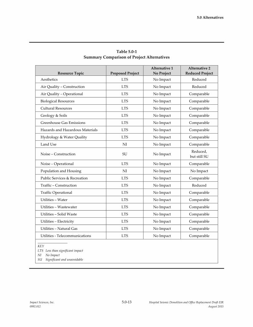
5.0 Alternatives
Impact Sciences, Inc. 5.0‐13 Hospital Seismic Demolition and Office Replacement Draft EIR
0992.012 August 2015
Table 5.0‐1
Summary Comparison of Project Alternatives
Resource Topic Proposed Project
Alternative 1
No Project
Alternative 2
Reduced Project
Aesthetics LTS No Impact Reduced
Air Quality – Construction LTS No Impact Reduced
Air Quality – Operational LTS No Impact Comparable
Biological Resources LTS No Impact Comparable
Cultural Resources LTS No Impact Comparable
Geology & Soils LTS No Impact Comparable
Greenhouse Gas Emissions LTS No Impact Comparable
Hazards and Hazardous Materials LTS No Impact Comparable
Hydrology & Water Quality LTS No Impact Comparable
Land Use NI No Impact Comparable
Noise – Construction SU No Impact Reduced,
but still SU
Noise – Operational LTS No Impact Comparable
Population and Housing NI No Impact No Impact
Public Services & Recreation LTS No Impact Comparable
Traffic – Construction LTS No Impact Reduced
Traffic Operational LTS No Impact Comparable
Utilities – Water LTS No Impact Comparable
Utilities – Wastewater LTS No Impact Comparable
Utilities – Solid Waste LTS No Impact Comparable
Utilities – Electricity LTS No Impact Comparable
Utilities – Natural Gas LTS No Impact Comparable
Utilities ‐ Telecommunications LTS No Impact Comparable
KEY
LTS Less than significant impact
NI No Impact
SU Significant and unavoidable
Impact Sciences, Inc. 6.0‐1 Hospital Seismic Demolition and Office Replacement Draft EIR
0992.012 August 2015
6.0 OTHER CEQA CONSIDERATIONS
6.1 INTRODUCTION
Section 15126 of the California Environmental Quality Act (CEQA) Guidelines states that an Environmental
Impact Report (EIR) must include a discussion of the following three topics:
Significant environmental effects which cannot be avoided if the proposed project is implemented;
Significant irreversible environmental changes which would be involved in the proposed project
should it be implemented; and
Growth inducing effects of the proposed project.
In addition, Section 15128 of the State CEQA Guidelines requires a brief statement of the reasons that
various possible effects of a project have been determined not to be significant and, therefore, are not
evaluated in the EIR. The following sections address each of these types of impacts.
6.2 SIGNIFICANT AND UNAVOIDABLE EFFECTS
An EIR must identify significant impacts associated with implementation of the proposed project that
could not be mitigated to a less than significant level. As part of the certification process, The Board of
Regents of the University of California (The Regents) will make a final decision as to the significance of
impacts and the feasibility of mitigation measures in this EIR. As detailed in Section 4.0, implementation
of the proposed project would result in the following significant impacts that would not be mitigated to a
less than significant level:
6.2.1 Noise
Impact NOI‐1: Construction of the proposed project would expose existing off‐site and on‐
site receptors to elevated noise levels. (Potentially Significant; Significant and
Unavoidable)
6.3 SIGNIFICANT IRREVERSIBLE ENVIRONMENTAL CHANGES
Section 15126.2(c) of the State CEQA Guidelines states that an EIR must include a discussion of any
significant irreversible environmental changes that would be caused by a proposed project. Generally, a
project would result in significant irreversible environmental changes if:
the primary and secondary impacts would generally commit future generations to similar uses;

6.0 Other CEQA Considerations
Impact Sciences, Inc. 6.0‐2 Hospital Seismic Demolition and Office Replacement Draft EIR
0992.012 August 2015
the proposed consumption of resources is not justified (e.g., the project involves the wasteful use of
energy);
the project would involve a large commitment of nonrenewable resources; or
the project involves uses in which irreversible damage could result from any potential environmental
accidents associated with the project.
Implementation of the proposed project would continue to commit the campus to institutional uses,
thereby ruling out other land uses during operation of the campus. The University’s ownership of the
campus represents a long‐term commitment of the Sacramento campus lands to an institutional use.
Restoration of the campus to pre‐developed conditions is not feasible given the levels of disturbance and
capital investment.
Resources that would be permanently and continually consumed by project implementation include
water, electricity, natural gas, and fossil fuels. In addition, construction activities related to the proposed
project would result in the irretrievable commitment of nonrenewable energy resources, primarily in the
form of fossil fuels (including fuel oil, natural gas, and gasoline) for automobiles and construction
equipment.
As discussed in Section 3.0, the North Addition Office Building would be constructed to meet all UC
sustainability goals, all applicable goals included in the Campus Climate Action Plan (CAP) and would
seek a UC equivalent LEED© Gold Certification or better. In addition, a detailed set of design criteria (e.g.,
maximize north light and glazing, minimize solar heat gain) for both the interior and exterior of the new
building would ensure that the proposed project would not result in an exorbitant amount of resources
being consumed. Therefore, the consumption of these resources during construction and operation of
campus facilities would not represent unnecessary, inefficient, or wasteful use of resources.
As the new building would be constructed to meet LEED© Gold Certification, construction and operation
of the proposed project would include strategies to minimize water consumption and solid waste
generation. Energy efficient appliances as well as a building‐cooling efficiency system would be installed
prior to operation of the new building. In addition, operation of the new building would be in accordance
with specifications contained in Title 24 of the California Code of Regulations (CCR) and State Executive‐
Order B‐29‐15.1
Construction and operation of the proposed project would comply with all applicable building codes,
campus conservation features, and would ensure that all natural resources, including water, are
1 Executive Order B‐29‐15 requires consumption of potable water to be reduced by 25 percent statewide. This
includes limiting outdoor watering with potable water to two days per week.
6.0 Other CEQA Considerations
Impact Sciences, Inc. 6.0‐3 Hospital Seismic Demolition and Office Replacement Draft EIR
0992.012 August 2015
conserved to the maximum extent feasible. Overall, the variety of energy and water conservation
measures that would be implemented with the proposed project would not involve a large commitment
of nonrenewable resources.
The State CEQA Guidelines also require a discussion of the potential for irreversible environmental
damage caused by an accident associated with the project. While the campus uses, transports, stores, and
disposes of hazardous wastes, as described in Section 4.4, Hazards and Hazardous Materials, the
campus complies with all applicable state and federal laws and existing campus programs, practices, and
procedures related to hazardous materials, which reduces the likelihood and severity of accidents that
could result in irreversible environmental damage. In the history of UC ownership of the campus, there
have been no accidents resulting in irreversible environmental damage, indicating that current practices
with respect to hazardous materials handling are adequate, and thus the potential for the proposed
project to cause irreversible environmental damage from an accident or upset of hazardous materials, is
considered low.
6.4 GROWTH‐INDUCING IMPACTS
This section evaluates the potential for the proposed project to induce growth in the Sacramento area.
Section 15126.2(d) of the State CEQA Guidelines requires that an EIR include a discussion of the potential
for a proposed project to foster economic or population growth, or the construction of additional housing,
either directly or indirectly, in the surrounding environment.
The State CEQA Guidelines do not provide specific criteria for evaluating growth inducement and state
that it must not be assumed that growth in an area is necessarily beneficial, detrimental, or of little
significance to the environment. Growth inducement is generally not quantified, but is instead evaluated
as either occurring or not occurring with implementation of a project. The identification of
growth‐inducing impacts is generally informational, and mitigation of growth inducement is not
required under CEQA. It must be emphasized that the State CEQA Guidelines require an EIR to “discuss
the ways” that a project could be growth inducing and to, “discuss the characteristics of some projects
that may encourage … activities that could significantly affect the environment.” However, the State
CEQA Guidelines do not require an EIR to predict or speculate specifically where such growth would
occur, in what form it would occur, or when it would occur.
For the purposes of this analysis, the proposed project would be considered growth‐inducing if it meets
either of the following criteria:
Implementation of the proposed project causes economic expansion and population growth through
employment expansion and/or the construction of new housing, or

6.0 Other CEQA Considerations
Impact Sciences, Inc. 6.0‐4 Hospital Seismic Demolition and Office Replacement Draft EIR
0992.012 August 2015
Implementation of the propose project removes an obstacle to population growth (for example,
through the expansion of public services or utilities into an area that does not presently receive these
services), or through the provision of new access to an area, or a change in a restrictive zoning or
General Plan land use designation.
An evaluation of the proposed project against these criteria is provided below.
6.4.1 Direct Employment and Population Growth
Potential growth inducing impacts of the proposed project are evaluated with respect to a study area that
includes the City of Sacramento and Sacramento County. This area is within a reasonable commuting
distance of the campus. The project site does not have any existing housing uses, nor do people live on
the project site. The staffing levels on the campus would not increase due to the proposed project and no
new housing is proposed. Thus, implementation of the proposed project would not directly increase the
study area population by providing employment expansion and or new housing opportunities. The
proposed project would not be considered growth‐inducing with respect to direct employment and
population growth.
6.4.2 Indirect Employment Growth
Indirect jobs are those that are created or supported when the campus purchases goods and services from
businesses in the region, and induced jobs are created or supported when wage incomes of those
employed in direct and indirect jobs or students are spent on the purchase of goods and services in the
region. The operation of the new building would not result in the creation of new indirect growth and/or
induced jobs, as staffing levels on the campus would not change. Further, as operation of the new
building would not result in employment growth there would be no increased demand for goods and
services.
6.4.3 Indirect Population Growth
As discussed above, implementation of the proposed project would not result in indirect and/or induced
employment and would not include any new housing opportunities. Thus, implementation of the
proposed project would not result in additional population growth.
6.4.4 Removal of an Impediment to Growth
Growth in an area may result from the removal of physical impediments or restrictions to growth, as well
as the removal of planning impediments resulting from land use plans and policies. In this context,
physical growth impediments may include non‐existent or inadequate access to an area or the lack of
6.0 Other CEQA Considerations
Impact Sciences, Inc. 6.0‐5 Hospital Seismic Demolition and Office Replacement Draft EIR
0992.012 August 2015
essential public services (e.g., water services), and planning impediments may include restrictive zoning
and/or general plan designations.
The campus is presently developed and is supplied by a full contingent of public services and utilities.
The new building would be served by existing water, wastewater, gas, communications, and electrical
lines that run through the project site or along the site boundary. Any infrastructure improvements
upgrades would serve only the campus. Therefore, the proposed utilities would enable growth
envisioned for the proposed project, but would not induce growth beyond that planned for the project
site. Therefore, implementation of the proposed project would not directly remove an obstacle to
population growth. Furthermore, implementation of the proposed project does not include the
establishment of a new public service or increase in staffing levels. The existing public services would
accommodate the new building. Therefore, the proposed project would not be considered growth‐
inducing with respect to service/utility infrastructure.
The new building’s staff members would continue to utilize the existing circulation system surrounding
the project site and no modifications would be made to surrounding roadways. It would, therefore, not
be considered growth‐inducing with respect to access.
As noted above, growth can also be induced if restrictions to growth and other planning impediments
resulting from land use plans and policies, including restrictive zoning and/or general plan designations
are removed. The proposed project would have no effect on land use designations for adjoining lands.
The proposed project would not facilitate additional population growth on the campus or in the
surrounding communities. Therefore, implementation of the proposed project would not be considered
growth‐inducing with respect to land use plans and policies.
6.4.5 Conclusion
As discussed above, the proposed project would not remove impediments to growth and/or result in
indirect/direct population and/or employment growth. As the staffing levels would remain the same,
implementation of the proposed project would not create economic growth in the area by increasing the
demand for local goods and services. Therefore, implementing the project would not be considered
growth inducing.
6.5 EFFECTS FOUND NOT TO BE SIGNIFICANT
Section 15128 of the State CEQA Guidelines requires an EIR to briefly describe any potential environmental
effects that were determined not to be significant during the Initial Study and EIR scoping process and
were, therefore, not discussed in detail in the EIR. A discussion of the effects of the proposed project on

6.0 Other CEQA Considerations
Impact Sciences, Inc. 6.0‐6 Hospital Seismic Demolition and Office Replacement Draft EIR
0992.012 August 2015
agricultural and forest resources, air quality, biological resources, cultural resources, geology and soils,
hazards and hazardous materials, hydrology and water quality, land use and planning, mineral
resources, population and housing, public services, recreation, and transportation and circulation that
were found not to be significant is presented below. Other impacts found to be less than significant in the
EIR are discussed in detail in Section 4.0, Environmental Setting, Impacts, and Mitigation Measures,
and summarized in Section 2.0, Executive Summary.
6.5.1 Agricultural and Forestry Resources
Would the project:
convert Prime Farmland, Unique Farmland, or Farmland of Statewide Importance (Farmland), as
shown on the maps prepared pursuant to the Farmland Mapping and Monitoring Program of the
California Resources Agency, to non‐agricultural use?
conflict with existing zoning for agricultural use, or a Williamson Act contract?
conflict with existing zoning for, or cause rezoning of, forest land (as defined in Public Resources
Code section 12220(g)), timberland (as defined by Public Resources Code section 4526), or timberland
zoned Timberland Production (as defined by Government Code section 51104(g))?
result in the loss of forest land or conversion of forest land to non‐forest use?
involve other changes in the existing environment, which, due to their location or nature, could result
in conversion of Farmland, to non‐agricultural use or conversion of forest land to non‐forest use?
The project site is developed and is located near commercial and residential land uses. The Farmland
Mapping and Monitoring Program has designated the project site as Urban and Built‐Up Land.2 There
are no Williamson Act contracts within its boundaries or in areas in the vicinity. No agricultural land,
forest land, or related uses are found in the area or on the campus. The proposed project would not result
in the conversion of farmland to a non‐agricultural use or forest land to a nonforest use. Therefore,
implementation of the proposed project would not impact agricultural or forest resources.
6.5.2 Air Quality
Would the project:
create objectionable odors affecting a substantial number of people?
2 California Department of Conservation, Farmland Mapping and Monitoring Program,
http://www.conservation.ca.gov/dlrp/fmmp/Pages/Index.aspx, accessed August 13, 2015
6.0 Other CEQA Considerations
Impact Sciences, Inc. 6.0‐7 Hospital Seismic Demolition and Office Replacement Draft EIR
0992.012 August 2015
The proposed project includes the demolition of the North/South Wing in the Main Hospital and
Housestaff Building and construction of the North Addition Office Building. Uses associated with the
new building would not include industrial and/or manufacturing operations, food processing, and/or
agricultural waste processing. Therefore, construction and operation of the proposed project would not
result in the production of objectionable odors. No significant impacts are identified for this threshold.
6.5.3 Biological Resources
Would the project:
Have a substantial adverse effect, either directly or through habitat modifications, on any species
identified as a candidate, sensitive, or special status species in local or regional plans, policies, or
regulations, or by the California Department of Fish and Game or U.S. Fish and Wildlife Service?
Have a substantial adverse effect on any riparian habitat or other sensitive natural community
identified in local or regional plans, policies, regulations or by the California Department of Fish and
Game or US Fish and Wildlife Service?
Have a substantial adverse effect on federally protected wetlands as defined by Section 404 of the
Clean Water Act (including, but not limited to, marsh, vernal pool, coastal, etc.) through direct
removal, filling, hydrological interruption, or other means?
Interfere substantially with the movement of any native resident or migratory fish or wildlife species
or with established native resident or migratory wildlife corridors, or impede the use of native
wildlife nursery sites?
Conflict with any local policies or ordinances protecting biological resources, such as a tree
preservation policy or ordinance?
Conflict with the provisions of an adopted Habitat Conservation Plan, Natural Community
Conservation Plan, or other approved local, regional, or state habitat conservation plan?
The project site is fully developed. No sensitive plant species are located on the project site. As discussed
in the LRDP EIR, Cooper’s hawk and Purple martin nests’ have been identified on the campus.
Mitigation Measure BIO‐2, included in the LRDP EIR, would be implemented to ensure potential
impacts to nesting birds from construction of the proposed project would remain less than significant.
Under LRDP Mitigation Measure BIO‐2 a pre‐construction nesting bird survey of the project vicinity
would be required if construction of the proposed project occurs during the nesting/breeding season of
any native bird species (typically February through August in the project region). With implementation
of the LRDP EIR Mitigation Measure BIO‐2 construction impacts to nesting birds would be less than
significant.

6.0 Other CEQA Considerations
Impact Sciences, Inc. 6.0‐8 Hospital Seismic Demolition and Office Replacement Draft EIR
0992.012 August 2015
The project site is located in an urban area and is developed with structures and infrastructure. No
riparian, native, or sensitive habitats, as defined by the US Fish and Wildlife Service and/or the California
Department of Fish and Wildlife encompass the project site. Further, no jurisdictional wetlands and/or
water courses are located on the campus. Development of the proposed project would not interfere with
the migration of any wildlife species (including migratory fish) or impede the use of native wildlife
nursery sites. No significant impacts are identified for these thresholds.
The project site is not located within a Habitat Conservation and/or Natural Community Conservation
Plan. Although construction of the proposed project would require the removal of ornamental
landscaping trees, the existing heritage trees located on the project site would not be removed. Thus,
implementation of the proposed project would not result in significant impacts to the existing biological
resources located within the vicinity of the project site.
6.5.4 Cultural Resources
Would the project:
Cause a substantial adverse change in the significance of a historical resource defined in Section
15064.5?
Cause a substantial adverse change in the significance of an archaeological resource pursuant to
Section 15064.5?
Directly or indirectly destroy a unique paleontological resource or site or unique geological feature?
Disturb any human remains, including those interred outside of formal cemeteries?
Would the project cause a substantial adverse change in the significance of a tribal cultural resource
as defined in public Resources Code 21074?
The proposed project would include the demolition of the North/South Wing of the Main Hospital,
constructed in 1929 and 1951 and the demolition of the Housestaff Building, constructed in 1916. In
accordance with the LRDP EIR Mitigation Measure CUL‐1a a historical evaluation of both structures
was completed in 2015 as documented in the Initial Study for the proposed project. In response to the
Notice of Preparation, several members of the public expressed a desire for the Housestaff Building to not
be demolished. The expressed interest for retaining the Housestaff building focused on the old style of
architecture and a desire for the building to be recognized as a historic structure. As described above, a
historic building evaluation was completed for the Housestaff Building and for the North/South Wing of
the Main Hospital. The evaluation determined that neither structure qualifies for listing on the National

6.0 Other CEQA Considerations
Impact Sciences, Inc. 6.0‐9 Hospital Seismic Demolition and Office Replacement Draft EIR
0992.012 August 2015
Register of Historic Places and/or the state Office of Historic Preservation. Thus, no significant impacts
were identified for this threshold.
The campus has been subject to extensive ground disturbance in conjunction with the construction of
existing and former buildings, roadways, and landscape areas. An archival search completed for the
LRDP EIR revealed that no archaeological resources have been recovered on the campus. The probability
of uncovering archaeological and/or paleontological resources on the project site is considered low. In the
unlikely event cultural resources are uncovered during construction of the proposed project,
implementation of LRDP Mitigation Measures CUL‐2a through CUL‐2c, included in the LRDP EIR
would reduce potential impacts to a less than significant level.
A burial ground exists on the northern portion of campus adjacent to the area originally occupied by the
Sacramento County Hospital building. The proposed project would be required to implement LRDP
Mitigation Measures CUL‐3a through CUL‐3d, included in the LRDP EIR. In the unlikely event that
human remains are accidently uncovered during construction of the proposed project, LRDP Mitigation
Measures CUL‐3a through CUL‐3d would reduce impacts to the uncovered human remains to a less
than significant level. As no tribal cultural resources have been identified on the campus and the new
building would be located on a previously disturbed and developed site, no impacts to tribal cultural
resources have been identified. Thus, implementation of the proposed project would not impact cultural
resources.
6.5.5 Geology, Soils, and Seismicity
Would the project:
Expose people or structures to potential substantial adverse effects, including the risk of loss, injury,
or death involving:
o Rupture of a known earthquake fault, as delineated on the most recent Alquist‐Priolo Earthquake
Fault Zoning Map issued by the State Geologize for the area or based on other substantial
evidence of a known fault? Refer to Division of Mines and Geology Special Publication 42.
o Strong seismic ground shaking?
o Seismic‐related ground failure, including liquefaction?
o Landslides?
Result in substantial soil erosion or the loss of topsoil?
6.0 Other CEQA Considerations
Impact Sciences, Inc. 6.0‐10 Hospital Seismic Demolition and Office Replacement Draft EIR
0992.012 August 2015
Be located on a geologic unit or soil that is unstable, or the loss of topsoil, or that would become
unstable as a result of the project, and potentially result in on‐ or off‐site, landslide, lateral spreading,
subsidence, liquefaction or collapse?
Be located on expansive soil, as defined in Table 18‐1‐B of the Uniform Building Code (1994), creating
substantial risks to life or property?
Have soils incapable of adequately support the use of septic tanks or alternative wastewater disposal
systems where sewers are not available for the disposal of wastewater?
The proposed project includes the construction of a new office building on the campus to allow for the
relocation of critical operational support programs from two seismically deficient structures, the
North/South Wing of the Main Hospital and the Housestaff Building, and the subsequent demolition of
these structures. This project is part of a series of actions that must be completed by 2020 to address
seismic safety mandates required by the State of California Office of Statewide Health Planning and
Development (OSHPD).
The campus and surrounding area are not located within an Alquist‐Priolo Earthquake Fault Zone. The
project site is located in Northern California, an area which is prone to earthquakes and strong seismic
shaking. Fault rupture on the project site is unlikely to occur as the Dunnigan Hills Fault, the nearest
active fault, is more than 40 miles north of the project site. Further, the project site and surrounding area’s
topography is characterized by flat plains and would not be susceptible to landslides.
The project site is developed with limited areas of exposed soil. Construction and operation of the
proposed project would not result in soil erosion or loss of topsoil. Groundwater was determined to be
approximately 18 to 32 feet below the project site. Implementation of LRDP Mitigation Measure GEO‐1
would reduce impacts associated with liquefaction and expansive soils. This includes building structural
damage which could cause human injuries. The project applicant would be required to conduct a site‐
specific design‐level geotechnical investigation, which would include a seismic evaluation of ground
acceleration as well as existing soil conditions on the project site. In addition, the proposed project would
be design to meet the California Building Code (CBC) structural requirements for buildings located on
expansive soils. Therefore, impacts related to liquefaction and expansive soils would be reduced to a less
than significant level.
The proposed project would not include alternative wastewater disposal systems and/or the use of septic
tanks. Based on the analysis above, implementation of the proposed project would not result in a
significant impact to geology and soils.

6.0 Other CEQA Considerations
Impact Sciences, Inc. 6.0‐11 Hospital Seismic Demolition and Office Replacement Draft EIR
0992.012 August 2015
6.5.6 Hazards and Hazardous Materials
Would the project:
For a project located within an airport land use plan, or where such a plan has not been adopted,
within two miles of a public airport, or public use airport, would the project result in a safety hazard
for people residing or working in the project area?
For a project within the vicinity of a private airstrip, would the project result in a safety hazard for
people residing or working in the project area?
Impair implementation of or physically interfere with an adopted emergency response plan or
emergency evacuation plan?
Expose people or structures to a significant risk of loss, injury or death involving wildland fires,
including where wildlands are adjacent to urbanized areas or where residences are intermixed with
wildlands?
The proposed project is not located within an airport land use plan, within two miles of a public airport,
or within the vicinity of a private airstrip. The public airport closest to the project site, the Sacramento
International Airport, is located approximately 20 miles northeast of the campus. The proposed project
includes the demolition of the North/South Wing of the Main Hospital and Housestaff Building, as well
as the construction of the North Addition Office Building. No changes would be made to the campus
circulation system and the proposed project would not physically interfere with any adopted emergency
response and/or evacuation plans. Construction vehicles and equipment would be stationed on the
project site to allow for continued operation of the UC Davis Hospital. The project site is located in a
developed area surrounded by commercial and residential uses and is not located in an area susceptible
to wildland fires. Therefore, impacts related to the hazard thresholds above would be less than
significant.
6.5.7 Hydrology and Water Quality
Would the project:
Substantially deplete groundwater supplies or interfere substantially with groundwater recharge
such that there would be a net deficit in aquifer volume or a lowering of the local groundwater table
level (e.g., the production rate of pre‐existing nearby wells would drop to a level which would not
support existing land uses or planned uses for which permits have been granted)?

6.0 Other CEQA Considerations
Impact Sciences, Inc. 6.0‐12 Hospital Seismic Demolition and Office Replacement Draft EIR
0992.012 August 2015
Substantially alter the existing drainage pattern of the site or area, including through the alteration of
the course of a stream or river, in a manner which would result in substantial erosion or siltation on‐
or off‐site?
Substantially alter the existing drainage patter of the site or area, including through the alternation of
the course of a stream or river, or substantially increase the rate or amount of surface runoff in a
manner which would result in flooding on‐ or off‐site?
Create or contribute runoff water which would exceed the capacity of existing or planned storm
water drainage systems or provide substantial additional sources of polluted runoff?
Place housing within a 100‐year flood hazard area as mapped on a federal Flood Hazard Boundary or
Flood Insurance Rate Map or other flood hazard delineation map?
Place within a 100‐year flood hazard area structures which would impede or redirect flood flows?
Expose people or structures to a significant risk of loss, injury or death involving flooding, including
flooding as a result of the failure of a levee or dam?
Inundation by seiche, tsunami or mudflow?
The proposed project includes the demolition of the Housestaff Building and North/South Wing and
construction of the North Addition Office Building. Buildout of the proposed project would not alter the
campus’ existing drainage pattern but would reduce the total area of impervious surfaces which would
decrease the volume of stormwater runoff. Stormwater runoff would continue to drain into the City’s
combined sewer system, as well the City storm drains and eventually to the American River.
Development of the proposed project would not interfere with groundwater recharge. Further, as the
existing campus land area consists of approximately 75 percent impervious and 25 percent pervious
surfaces, it is anticipated that the total area of impervious surfaces would actually decrease slightly with
the demolition of two buildings and the subsequent addition of open space and landscape areas.
A City‐owned storm water detention basin designed for 10‐year flows is located on the campus. The
proposed project does not include any residential uses. Further, the new building would not be
constructed in a designated 100‐year floodplain. The campus is not located within the vicinity of a levee
or dam, is generally flat and is not located in close proximity to any large bodies of water. Thus the

6.0 Other CEQA Considerations
Impact Sciences, Inc. 6.0‐13 Hospital Seismic Demolition and Office Replacement Draft EIR
0992.012 August 2015
proposed project would not be subject to inundation by seiche, tsunami, or mudflow. Therefore, impacts
would be less than significant.
6.5.8 Land Use and Planning
Would the project:
Physically divide an established community?
Conflict with any applicable land use plan, policy, or regulation of an agency with jurisdiction over
the project (including, but not limited to the general plan, specific plan, local coastal program, or
zoning ordinance) adopted for the purpose of avoiding or mitigation an environmental effect?
Conflict with any applicable habitat conservation plan or natural community conservation plan?
Result in development of land uses that are substantially incompatible with existing adjacent land
uses or with planned uses?
The proposed project would be located on the campus and would not divide an established community
or conflict with any applicable land use plan or habitat conservation plan. The proposed project would be
consistent with the land uses designation included in the LRDP and develop the project site for hospital
related uses. The height and mass of the North Addition Office Building would be harmonious with that
of existing adjacent buildings and would be appropriate for its setting. A 40‐foot landscaped buffer
would be incorporated along the edge of the campus to be located between the existing facilities
equipment yard and the University Police building along V Street as required under LRDP Mitigation
Measure AES‐1. Upon completion of the proposed project the former Housestaff Building site and
North/South Wing site would be landscaped and repurposed as open space. The North Addition Office
Building would be constructed north of the Main Hospital on the site currently occupied by an
approximately 30,000 square foot single‐story temporary building used as the Children’s Surgery Center
and the Trauma Nursing Unit that will be demolished under a separate project in late 2015. Therefore,
impacts related to the land use thresholds above would be less than significant.
6.5.9 Mineral Resources
Would the project:
result in the loss of availability of a known mineral resource that would be of future value to the
region and the residents of the state?
result in the loss of availability of a locally important mineral resource recovery site delineated on a
local general plan, specific plan, or other land use plan?

6.0 Other CEQA Considerations
Impact Sciences, Inc. 6.0‐14 Hospital Seismic Demolition and Office Replacement Draft EIR
0992.012 August 2015
According to the State of California Department of Mines and Geology, Mineral Resource Zones and
Resource Sectors map, the project site is located in an area designated as MRZ‐3. This designation refers
to an area that contains mineral deposits, the significance of which cannot be evaluated from available
data. Development under the proposed project would not involve extraction of mineral resources, so
would not result in the loss of availability of a known mineral resource. Therefore, implementation of the
project would not impact mineral resources.
6.5.10 Population and Housing
Would the project:
Induce substantial population growth in an area, either directly (for example, by proposing new
homes and businesses) or indirectly (for example, through extension of roads or other
infrastructure)?
Displace substantial numbers of existing housing, necessitating the construction of replacement
housing elsewhere?
Displace substantial numbers of people, necessitating the construction of replacement housing
elsewhere?
As discussed above, the proposed project does not include a residential component. Implementation of
the proposed project would not result in indirect/direct population and/or employment growth. As the
staffing levels would remain the same, implementation of the proposed project would not be growth
inducing. Therefore, implementation of the proposed project would not impact the campus and/or
surrounding area population.
6.5.11 Public Services
Would the project:
Result in substantial adverse physical impacts associated with the provision of new or physically
altered governmental facilities, need for new or physically altered governmental facilities, the
construction of which could cause significant environmental impacts, in order to maintain acceptable
service ratios, response times or other performance objectives for any of the public services:
o Fire protection
o Police protection
o Schools
o Parks
o Other public facilities
6.0 Other CEQA Considerations
Impact Sciences, Inc. 6.0‐15 Hospital Seismic Demolition and Office Replacement Draft EIR
0992.012 August 2015
The proposed project includes the demolition of the North/South Wing of the Main Hospital, the
demolition of the Housestaff Building, and the construction of the North Addition Office Building. In
total, the proposed project would reduce building area on the campus by approximately 125,000 gross
square feet (GSF). Campus staffing levels would not increase due to the proposed project. Further, the
proposed project would not directly or indirectly induce population growth on campus or in the
surrounding area. Thus, the proposed project would not result in an increase in the number of police and
fire protection calls and would not significantly impact the surrounding libraries, parks, or schools.
Therefore, implementation of the project would not impact public services.
6.5.12 Transportation, Circulation and Parking
Would the project:
Result in a change in air traffic patterns, including either an increase in traffic levels or a change in
location that results in substantial safety risks?
Result in inadequate emergency access?
The new building would be a six‐story building and would not result in a change to air traffic patterns as
the Sacramento International Airport is approximately 20 miles northeast of the campus. No changes
would be made to the campus circulation system and the proposed project would not physically interfere
with emergency access to the Main Hospital or any other buildings on the campus. During the demolition
and construction phases, construction vehicles and equipment would be stationed on the project site to
ensure access to the Main Hospital and surrounding buildings. No significant impacts are identified for
these two transportation thresholds.

Impact Sciences, Inc. 7.0‐1 Hospital Seismic Demolition and Office Replacement Draft EIR
0992.012 August 2015
7.0 LIST OF PREPARERS/ORGANIZATIONS CONSULTED
7.1 REPORT PREPARERS
University of California Davis Sacramento Campus
Facilities Design and Construction
Facilities Support Services Building
4800 2nd Avenue, Suite 3010
Sacramento, California 95817
Joel Swift, Interim Director, Facilities Planning & Development Division, UC Davis Health System
University of California Davis
Sid England, Assistant Vice Chancellor, Office of Environmental Stewardship and Sustainability
Matt Dulcich, Assistant Director for Environmental Planning, Office of Environmental Stewardship and
Sustainability
7.2 EIR CONSULTANTS
Impact Sciences, Inc.
505 14th Street, Suite 1230
Oakland, California 94612
Shabnam Barati, Ph.D., Managing Principal/Project Manager
Lynn Kaufman, Senior Project Manager
Paul Stephenson, Senior Project Manager
Kathleen King, Project Planner
Graphics
Carl Workman, Lunalicht Design
7.3 PERSONS AND ORGANIZATIONS CONSULTED
Austin, Doug, Senior Project Manager, Facilities Design and Construction, UC Davis Sacramento Campus
Danby, John, Environmental Programs Specialist, Environmental Health and Safety, UC Davis
Sacramento Campus
Reyff, James, Illingworth & Rodkin, Inc.
Yee, Richard, Senior Architect/Senior Project Manager, Facilities Design and Construction, UC Davis
Sacramento Campus
Top Related