


Languages
Pages
Legal


HISTORYTHEORIESPRINCIPLES
the
of urban and regional planning
RAGENE ANDREA L. PALMA, [email protected]
and

HOW TO REMEMBER CONCEPTS
JOT DOODLE CONNECT

TELL ME IF YOU NEED ME TO
STOP REPEAT ELABORATE

I will discuss everything I can The more you draw, the betterI arranged the lecture so that concepts are clustered I pulled together the highlightsBut out of my 200 slides about 5-10 topics will just pop out in the exam

WHAT WE’LL LEARN ABOUT
1 The history and foundation of urban and regional planning
2 Theories3 Evolution of urban forms4 Types of planning5 The role of a planner

?Urban and regional planningTown and country planning
Environmental planningHuman settlements planning
City planningMaster planning

“urban”
“regional”

https://upload.wikimedia.org/wikipedia/commons/thumb/d/dc/Skyscrapers_of_Shinjuku_2009_January_(revised).jpg/900px-Skyscrapers_of_Shinjuku_2009_January_(revised).jpg
https://upload.wikimedia.org/wikipedia/commons/thumb/9/95/Regional_Internet_Registries_world_map.svg/2000px-Regional_Internet_Registries_world_map.svg.png

“urban”of, relating to, characteristic of, or constituting a city (Merriam Webster)
LARGE CITY
LARGE AMOUNT
SIGNIFICANTLY-DEVELOPED AREA
http://www.investorwords.com/5192/urban.html
DISTANCE BETWEEN BUILDINGS IS VERY SMALL

“regional”
of or relating to a particular region, district, area, or part, as of a country; sectional; local
LOCALIZED
A PART OF
TERRITORIAL
PROVINCE
DISTRICTDIVISION
SECTION
QUARTER
ZONE
BELT
PART

“rural”
“environmental”

“rural”
“environmental”https://upload.wikimedia.org/wikipedia/commons/f/f5/Barossa_Valley_South_Australia.jpg
http://www.breakingnewstime.com/wp-content/uploads/2016/03/in.jpg

“rural”
LOW POPULATION
OFTEN AGRICULTURALLY-BASED
of or relating to the country and the people who live there instead of the city
COUNTRYSIDE
SPARSELY POPULATED
AREA

“environmental”relating to the natural world and the impact of human activity on its condition
PERSON’S SURROUNDINGS
LIVING ORGANISM
SOIL
CLIMATE CHANGE
PLANTS AND ANIMALS
NATURAL FORCES

http://www.nscb.gov.ph/activestats/psgc/articles/con_urbanrural.asp

http://thumbs.dreamstime.com/z/group-business-people-meeting-planning-41699625.jpg

What is planning?
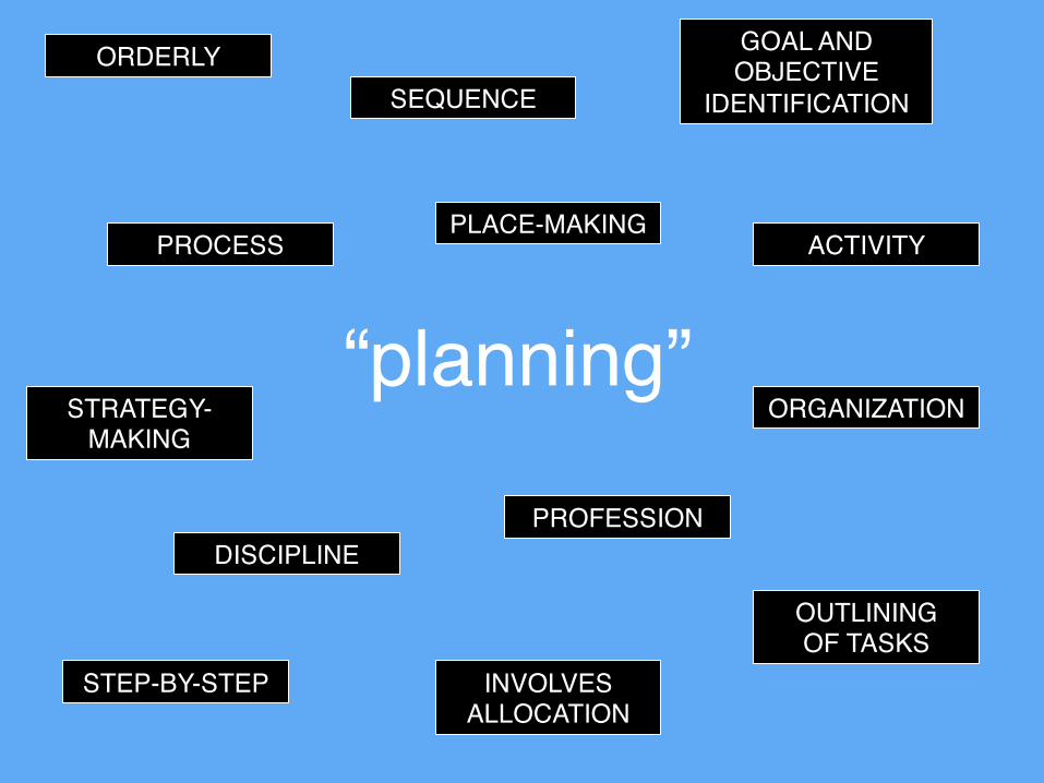
“planning”PROCESS
SEQUENCE
ACTIVITY
ORGANIZATION
PROFESSIONDISCIPLINE
INVOLVES ALLOCATION
STRATEGY-MAKING
GOAL AND OBJECTIVE
IDENTIFICATION
OUTLINING OF TASKS
ORDERLY
STEP-BY-STEP
PLACE-MAKING

Environmental planning, also known as urban and regional planning, city planning, town and country planning, and/or human settlements planning, refers to the multi-disciplinary art and science of analyzing, specifying, clarifying, harmonizing, managing and regulating the use and development of land and water resources, in relation to their environs, for the development of sustainable communities and ecosystems. (RA 10587)


I’M A
PLANNER.
In the Philippines, an environmental planner refers to a person who is registered and licensed to practice environmental planning and who holds a valid Certificate of Registration and a valid Professional Identification Card from the Board of Environmental Planning and the Professional Regulation Commission.(RA10587)
http://img.freeflagicons.com/thumb/waving_flag/philippines/philippines_640.png

what is
my role? o One who creates and
recommends plans on land use and other planning fields
o An advisor and regulator to the government, private sector, and the communities
o An urban designero Someone who looks far into
the future for the welfare of a place
o A capacity builder, facilitator, and educator
o An advocate of causes

Let’s start history with the Ancients.

http://media.web.britannica.com/eb-media/64/89964-050-7C939C5B.gif

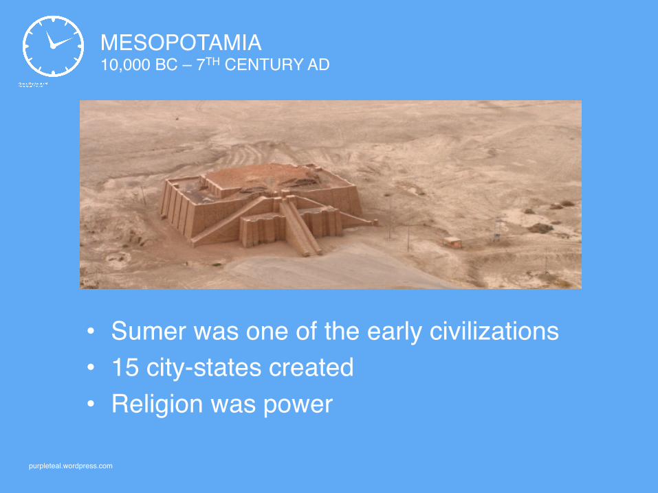
MESOPOTAMIA10,000 BC – 7TH CENTURY AD
• “Fertile crescent” means land between rivers• Scope of the Tigris and Euphrates river systems• Water as a basis of urban development

MESOPOTAMIA
http://lhmrramsey.com/Mesopotamia.jpg

Sketch what you just saw.They say planners see things that
other’s don’t. What can you derive from
Mesopotamia?

http://lhmrramsey.com/Mesopotamia.jpg
ZIGGURAT
MOAT
HIGHER BUILDINGS
SMALLER HOUSES
AGRICULTURAL LANDS
MESOPOTAMIA10,000 BC – 7TH CENTURY AD
• Sumer was one of the early civilizations• 15 city-states created• Religion was power
purpleteal.wordpress.com

ANCIENT EGYPThttp://newlinetravel.net/wp-content/uploads/2014/03/Ancient-Egypt-Pyramids-4.jpg

ANCIENT EGYPT3,000 – 300 BC
• Religion still powerful: Ancient Egyptians worshipped kings as gods
• Once buried, lives forever• Pyramids constructed in capital cities• Cities of dead people (necropolis)

http://newlinetravel.net/wp-content/uploads/2014/03/Ancient-Egypt-Pyramids-4.jpg
PYRAMID IS A TOMB
PHAROAH HEAD ONMORTUARY TEMPLE
TEMPLES

ANCIENT GREECE
http://cdn.history.com/sites/2/2013/12/acropolis-athens-H.jpeg
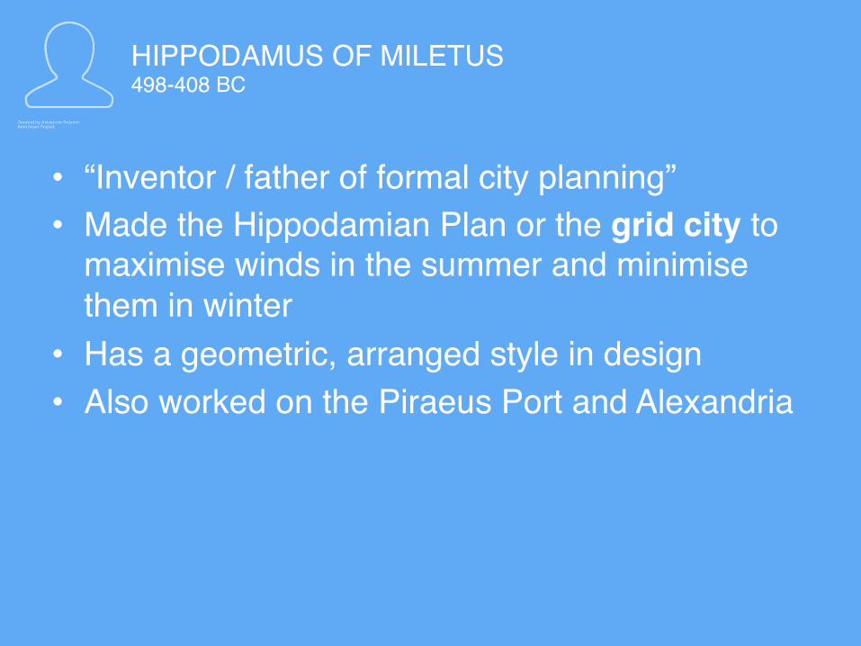
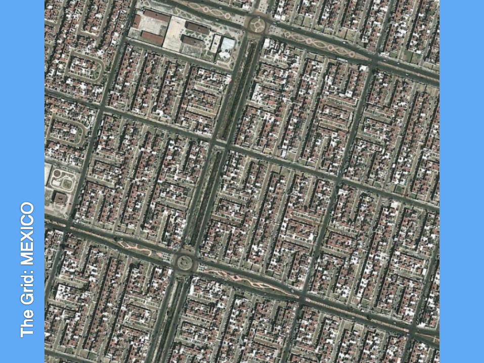
HIPPODAMUS OF MILETUS498-408 BC
• “Inventor / father of formal city planning”• Made the Hippodamian Plan or the grid city to
maximise winds in the summer and minimise them in winter
• Has a geometric, arranged style in design• Also worked on the Piraeus Port and Alexandria

PIRAEUS GRID
museumofthecity.org

PIRAEUS
museumofthecity.org

CHICAGO

BUENOS AIRES

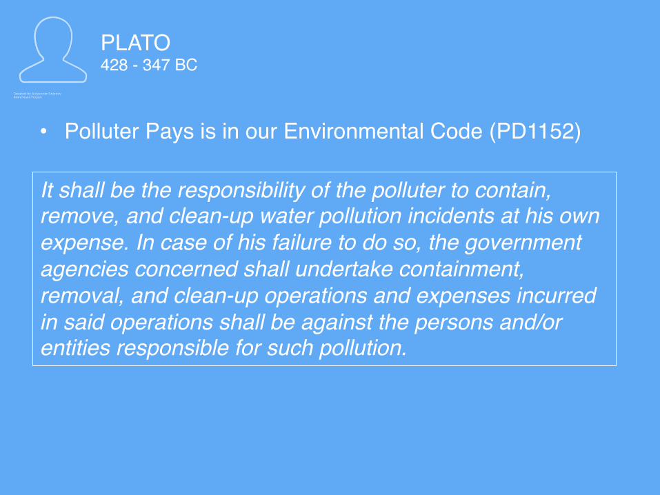
PLATO428 - 347 BC
• Established the Polluter Pays Principle
“If any one internationally pollutes the water of another, whether the water of a spring, or collected in reservoirs, either by poisonous substances, or by digging, or by theft, let the injured party bring the cause before the wardens of the city, and claim in writing the value of the loss; if the accused be found guilty of injuring the water by deleterious substances, let him not only pay damages, but purify the stream or the cistern which contains the water, in such manner as the laws… order the purification to be made by the offender in each case.”
PLATO428 - 347 BC
• Polluter Pays is in our Environmental Code (PD1152)
It shall be the responsibility of the polluter to contain, remove, and clean-up water pollution incidents at his own expense. In case of his failure to do so, the government agencies concerned shall undertake containment, removal, and clean-up operations and expenses incurred in said operations shall be against the persons and/or entities responsible for such pollution.

ARISTOTLE384 - 322 BC
• Provided the foundation for the concept of intergenerational equity
• For our children’s children
Human well-being is realised only partly by satisfying whatever people’s preferences happen to be at a particular time; it is also necessary for successive generations to leave behind sufficient resources so that future generations are not constrained in their preferences.”

ARISTOTLE384 - 322 BC
INTERGENERATIONAL EQUITY
http://www.unis.unvienna.org/images/2015/Infographic_5_elem_related_l.jpg

THE ROMAN EMPIRE
http://cdn.history.com/sites/2/2014/01/roman-forum.jpg

THE ROMAN EMPIRE29 BC – 393 AD
• Excelled in military science and engineering• Designs and inventions looked at improving
transport and military strategies

ROME, THE IMPERIAL CITY
http://cdn.history.com/sites/2/2014/01/roman-forum.jpg
WALLED FOR PROTECTION
“CASTRA” OR CAMP
GRID STREETS

VIA APPIA
http://cdn.history.com/sites/2/2014/01/roman-forum.jpg

THE ROMAN FORUMhttp://cdn.history.com/sites/2/2014/01/roman-forum.jpg

COLOSSEUM
http://cdn.history.com/sites/2/2014/01/roman-forum.jpg

THE ROMAN EMPIRE29 BC – 393 AD
• Heavily dependent on water• Engineered sewerage, canals, hydraulics
roman aqueducts.info
ROMAN AQUEDUCT
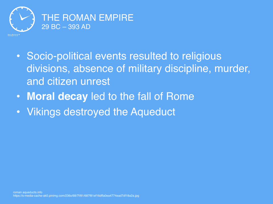
THE ROMAN EMPIRE29 BC – 393 AD
• Socio-political events resulted to religious divisions, absence of military discipline, murder, and citizen unrest
• Moral decay led to the fall of Rome• Vikings destroyed the Aqueduct
roman aqueducts.infohttps://s-media-cache-ak0.pinimg.com/236x/68/7f/81/687f81ef16dffa0ea4774ead7df18a2a.jpg

THE MEDIEVAL PERIOD
https://upload.wikimedia.org/wikipedia/commons/d/d9/Lorenzetti_amb.effect2.jpg

THE MEDIEVAL PERIOD 5TH – 15TH CENTURY AD
• The church and monasticism• Rise of Islam• Byzantine empire• State power• The Crusades• Carolingian dynasty
roman aqueducts.infohttps://s-media-cache-ak0.pinimg.com/236x/68/7f/81/687f81ef16dffa0ea4774ead7df18a2a.jpg

https://upload.wikimedia.org/wikipedia/commons/d/d9/Lorenzetti_amb.effect2.jpg
HIGH WALLS
CENTER OF ACTIVITIES

MUNICH, GERMANYmaps.google.com
CATHEDRAL IN CENTER
WITH DEFINED
BOUNDARY
RADIAL GROWTH

CATHEDRAL CITIES
• Cathedral or monument as a focal point of the city
• Radial growth• Retained the walled city from Roman practice• Enclosure caused problems such as epidemics
and limited resources
roman aqueducts.infohttps://s-media-cache-ak0.pinimg.com/236x/68/7f/81/687f81ef16dffa0ea4774ead7df18a2a.jpg

RENAISSANCE
https://daliennation.files.wordpress.com/2013/05/renaissance.jpg

RENAISSANCE14TH TO 17TH CENTURY AD
• Commerce as a driving factor• Called for accessibility and mobility• Like the Medieval Period, had a radial growth
pattern• Plans began to follow the topography of an
area
roman aqueducts.infohttps://s-media-cache-ak0.pinimg.com/236x/68/7f/81/687f81ef16dffa0ea4774ead7df18a2a.jpg

RENAISSANCE
maps.google.com
VENICE, ITALY
FINGERS

LEON BATTISTA ALBERTI1404-1472
• Wrote the De Re Aedificatoria: Ten books of planning and design principles
Growth is characterized by a star-shaped
form


GEORGES-EUGENE HAUSSMANN 1809-1891
PLAN AND RENOVATION OF PARIS

GEORGES-EUGENE HAUSSMANN 1809-1891
travellingandfood.com
ARC DE TRIOMPHE AS CENTER
RADIATING OUTWARD AVENUES
LINED WITH TREES AND
POCKET PARKS
Paris, the best planned city

CITY BEAUTIFUL MOVEMENT
https://nextdaybetter.com/wp-content/uploads/2015/04/DC.jpg
CITY BEAUTIFUL MOVEMENT1800s – 1900s
• Emphasized beauty and aesthetics• Think monuments, grand buildings, parks,
perfect landscapes, lakes, and circular road systems
roman aqueducts.infohttps://s-media-cache-ak0.pinimg.com/236x/68/7f/81/687f81ef16dffa0ea4774ead7df18a2a.jpg

DANIEL HUDSON BURNHAM1846-1912
• Father of American City Planning
• Together with Frederick Law Olmstead and John Wellborn Root, designed the World’s Columbian Exposition, the first comprehensive planning document in the US

DANIEL HUDSON BURNHAM1846-1912
“Make no little plans; they have no magic to stir men’s blood and probably themselves will not be realized. Make big plans; aim high in hope and work, remembering that a noble, logical diagram
once recorded will never die, but long after we are gone will be a living thing, asserting itself with ever- growing insistency. Remember that our sons and
grandsons are going to do things that would stagger us. Let your watchword be order and your
beacon beauty.”

CHICAGO MANILA BAGUIO
burnhampi.files.wordpress.com
• Greatest feat was the Plan of Chicago (called Paris on a Prairie); other plans include Manila, Baguio, Cleveland, and San Francisco
DANIEL HUDSON BURNHAM1846-1912

CANBERRA
http://www.capitalmetro.act.gov.au/__data/assets/image/0020/802730/Canberra-Carosel.jpg

MELBOURNEhttp://accorhotels.com.au/files/MelbourneBridge_2400x1350_0.jpg

SIR EBENEZER HOWARD 1850 - 1928
• Wrote the book Garden Cities of Tomorrow• Addressed population and pollution that came about by
the industrial revolution by creating garden cities

https://upload.wikimedia.org/wikipedia/commons/3/3d/Garden_City_Concept_by_Howard.jpg

https://upload.wikimedia.org/wikipedia/commons/3/3d/Garden_City_Concept_by_Howard.jpg
5,000-acre CENTRAL CITY 58,000 PEOPLE
1,000-acre GARDEN CITIES 30,000 PEOPLE
CONNECTED BY ROADS AND RAILWAYSGREEN SPACES

http://33.media.tumblr.com/tumblr_mb1k1lYqWy1rsuub0o1_500.jpg

https://upload.wikimedia.org/wikipedia/commons/5/55/Howard-three-magnets.png

SIR RAYMOND UNWIN Architect – city planner for LetchworthWrote Nothing Gained by Overcrowding
SIR FREDERIC JAMES OSBORN Championed garden cities
LOUIS DE SOISSONSArchitect of Welwyn

http://www.letchworth.com/sites/default/files/images/letchworth_aerial_photos_142.jpg

http://www.shropshirestar.com/wpmvc/wp/wp-content/uploads/2014/09/6114828.jpg

https://upload.wikimedia.org/wikipedia/commons/thumb/2/20/The_Metropolitan_Green_Belt_among_the_green_belts_of_England.svg/2000px-The_Metropolitan_Green_Belt_among_the_green_belts_of_England.svg.png
https://www.researchgate.net/profile/Vanessa_Carlow/publication/279057647/figure/fig1/AS:294368092147716@1447194230827/Figure-1-London-Green-Belt-official-map-Graphics-by-VM-Carlow-Data-source-London.png

questionWhat do you call the area
between a city and the outskirts?

say itURBAN FRINGE

LE CORBUSIER (CHARLES EDOUARD JEANNERET)1887-1965
• Created the Radiant City• Modernist, futuristic, and orderly• But socially disadvantageous and unrealistic for
settlements• Criticized because he tried to solve congestion with
more congestion• Wrote the books Urbanisme and The City of Tomorrow
and Its Planning

http://alanamuir.wikispaces.com/file/view/Corbusier_cartesian_skyscrapers.jpg/333908066/Corbusier_cartesian_skyscrapers.jpg
LE VILLE RADIEUSE(THE RADIANT CITY)

http://alanamuir.wikispaces.com/file/view/Corbusier_cartesian_skyscrapers.jpg/333908066/Corbusier_cartesian_skyscrapers.jpg
LE VILLE RADIEUSE(THE RADIANT CITY)
GRIDS
CUBIST AESTHETICS
ORDERLY, RATIONAL CITY BLOCKS
BOX-TYPE HOUSES
60-STOREY BUILDINGS

?
GARDEN CITY RADIANT CITY

GARDEN CITY RADIANT CITY

FRANK LLOYD WRIGHT1867-1959
• Champion and proponent of urban decentralisation• Involved communities• Designed the 1,000-hectare Broadacre City• included social services in the forms of schools, trains,
and museums, as well as employment in the forms of markets, offices, nearby farms, and industrial areas
• Plan included a helicopter, which was criticized

http://metropolismag.com/images/cache/cache_a/cache_6/cache_b/broadacre1-9c603b6a.jpeg?ver=1415421530&aspectratio=1.7808219178082

http://mediaarchitecture.at/architekturtheorie/broadacre_city/content/quadruple_block_plan_jss_022802_wright_008.jpg
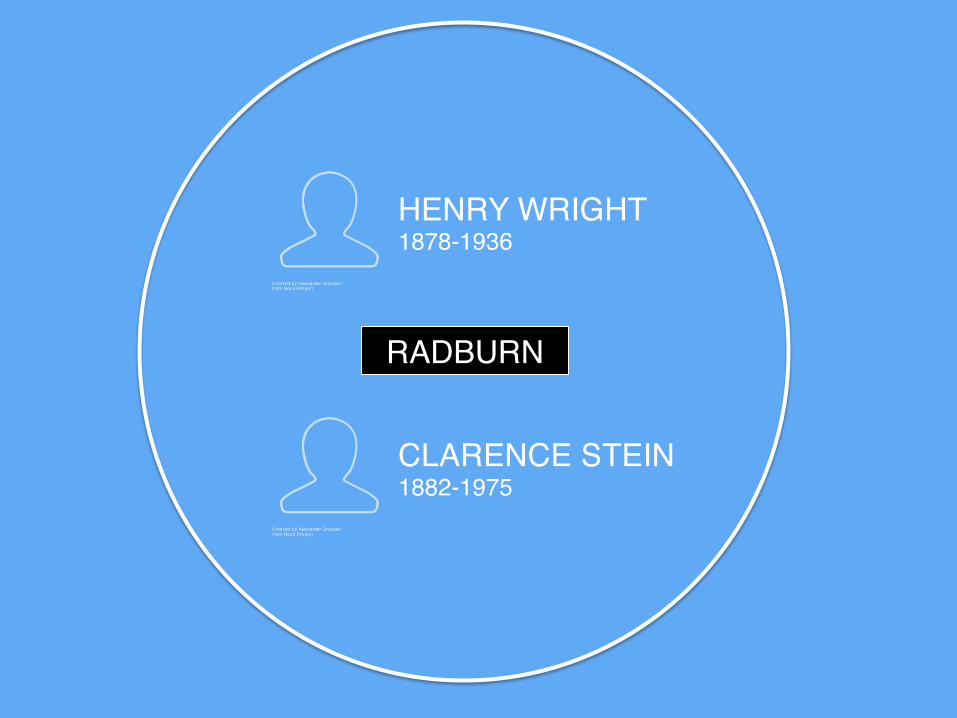
HENRY WRIGHT1878-1936
CLARENCE STEIN 1882-1975
RADBURN

http://www.fradkinmcalpin.com/wp-content/uploads/2014/08/1130x640-fradkin-mcalpin-nyc-architects-projects-3-radburn-nj-1130x640.jpg
GARDEN CITY
SEPARATES VEHICLES FROM PEDESTRIANS
CUL-DE-SACS
SUPERBLOCK
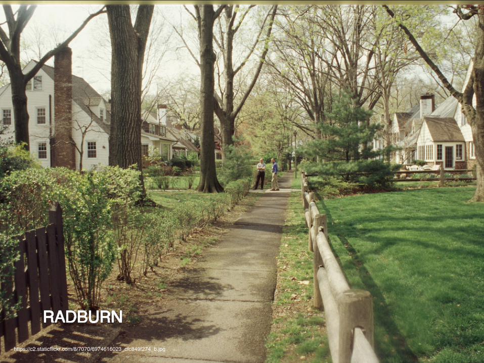
https://c2.staticflickr.com/8/7070/6974616023_cfc849f274_b.jpg

CLARENCE STEIN 1882-1975
• Initiated plans to produce greenbelt resettlements all over the US
• Wrote the book Toward New Towns for America
HENRY WRIGHT1878-1936
• Created the superblock

https://s-media-cache-ak0.pinimg.com/564x/60/57/b8/6057b80059133de5d5d850cbe9f8e621.jpg
GARDEN ISLAND
CUL-DE-SACS
THOROUGHFARES
HOMES
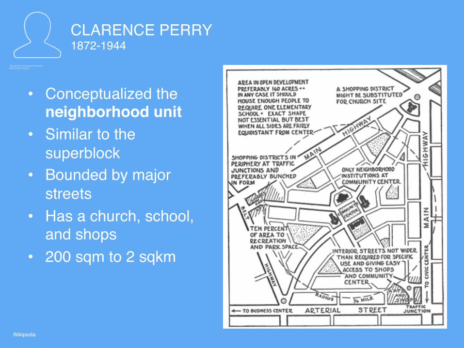
CLARENCE PERRY1872-1944
• Conceptualized the neighborhood unit
• Similar to the superblock
• Bounded by major streets
• Has a church, school, and shops
• 200 sqm to 2 sqkm
Wikipedia

https://www.bartlett.ucl.ac.uk/planning/research/urban-regional-development-governance/images/from-the-sky

SIR PATRICK GEDDES1954-1932
• Introduced the notion of a region• Became the Father of Regional Planning• Biologist, sociologist, and geographer• Dissected the planning environment by analysing
occupational activities• Used observation and rational methods• Instead of gridiron planning, used conservative surgery
Wikipedia
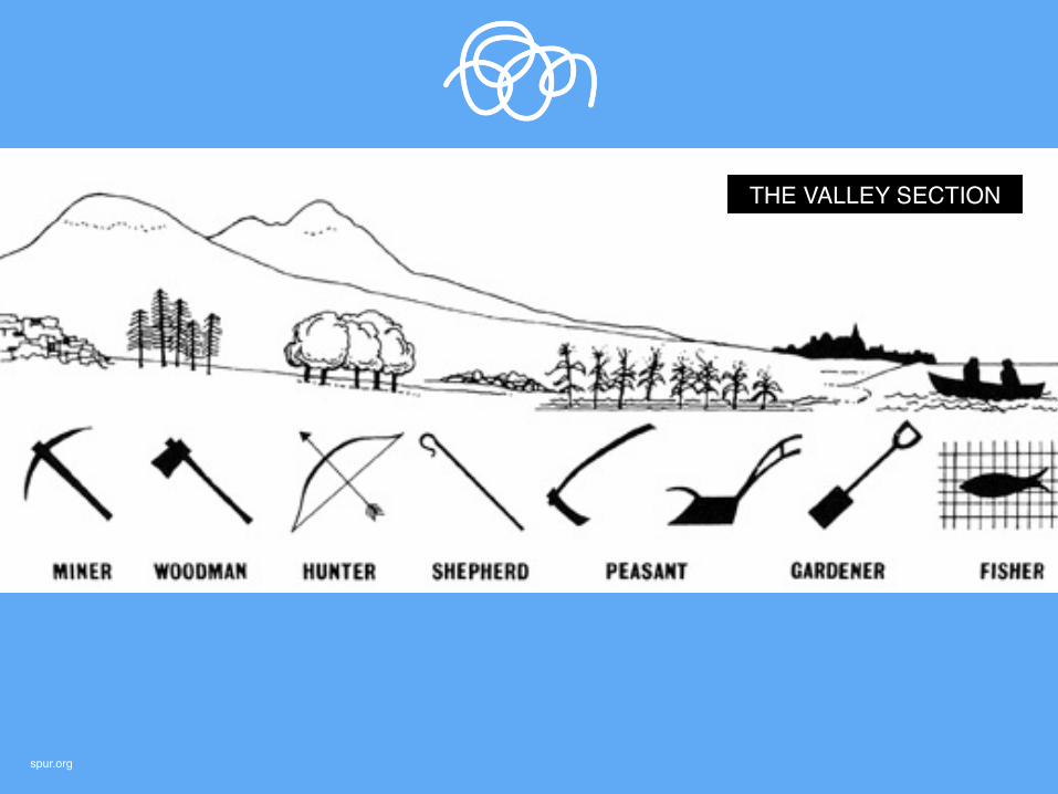
spur.org
THE VALLEY SECTION

spur.org
THE VALLEY SECTION
RIDGE-TO-REEF

SIR PATRICK GEDDES1954-1932
• Introduced the term conurbation, which means “an aggregation of continuous network of urban communities.”
• Emphasized the relationships of people and cities, thus the city-region term.
• Used the rational planning method of Survey Analysis
• Wrote the book Cities in Evolution
Israel.travel

SIR LESLIE PATRICK ABERCROMBIE1954-1932
• Created the post-war plans for London, and combatted sprawling by resettlement
• Made the London Country Plan (1944) and the Greater London Plan (1943)

thesemaphoreline.wordpress.com
SOCIAL AND FUNCTIONAL ANALYSIS
CENTRAL COMMUNITIES
SUBURBAN COMMUNITIES
OPEN SPACES
SHOPPING CENTERS

LEWIS MUMFORD 1895-1990
• A historian-sociologist who studied cities and architecture
• From his 23 books, the most prominent in city planning is The City in History, which pointed out how technology and nature could be harmonious
• Gave the concept of an organic city • Rationalised how planning has various disciplines
Wikipedia

Mumford was friends with City Beautiful advocates Frank Lloyd Wright, Clarence Stein, and Frederic Osborn. Mumford and Wright exchanged transatlantic letters on professional and personal matters.
news.rracution.com

BENTON MCKAYE1879-1975
• Originator of the 3,500 km Appalachian Trail in the eastern United States (Georgia to Maine)
• Was a forester and conservationist, and co-founded the Wilderness Society
• Championed regional conservationism

atc.civicore.com and daveallenphotography.com

personal.umich.edu, Wikipedia, ak-cahce.legacy.net, boiseplanning.wordpress.com
THE FOUNDERS: Clarence Stein, Benton McKaye, Lewis Mumford, Alexander Bing (a real estate developer), and Henry Wright

https://www.vectoropenstock.com/media/users/2049/76727/raw/83c2a55cb583cdb1c73f9313b3f719c0-industrial-cityscape-silhouettes.jpg

EDWARD BASSETT1863-1948
• Urban planner and lawyer who was the Father of American Zoning. He was the first to use zoning as a means of implementing land use in New York. He wrote books about zoning.
• Also coined the term freeway and parkway

DON ARTURO SORIA Y MATA1844-1920
• Made the concept Linear City, which has many parallel and specialized functions
Wikipedia

DON ARTURO SORIA Y MATA1844-1920
The linear city gears away from the usual centric urban forms. The lines help control the expansion of a city.
prezi.com

TONY GARNIER 1869-1948
• Made the concept Linear Industrial City, which has many parallel and specialized functions
• Used the concept of zoning and labeled space into leisure, industry, work, and transport
Wikipedia

aria.archi.fr and s-media-cache-ak0.pinimg.com
• Plan caters to 35,000 residents• Follows the principles of funciton, greeneries, open
space, and exposure to the sunlight• City is linked by circular patterns
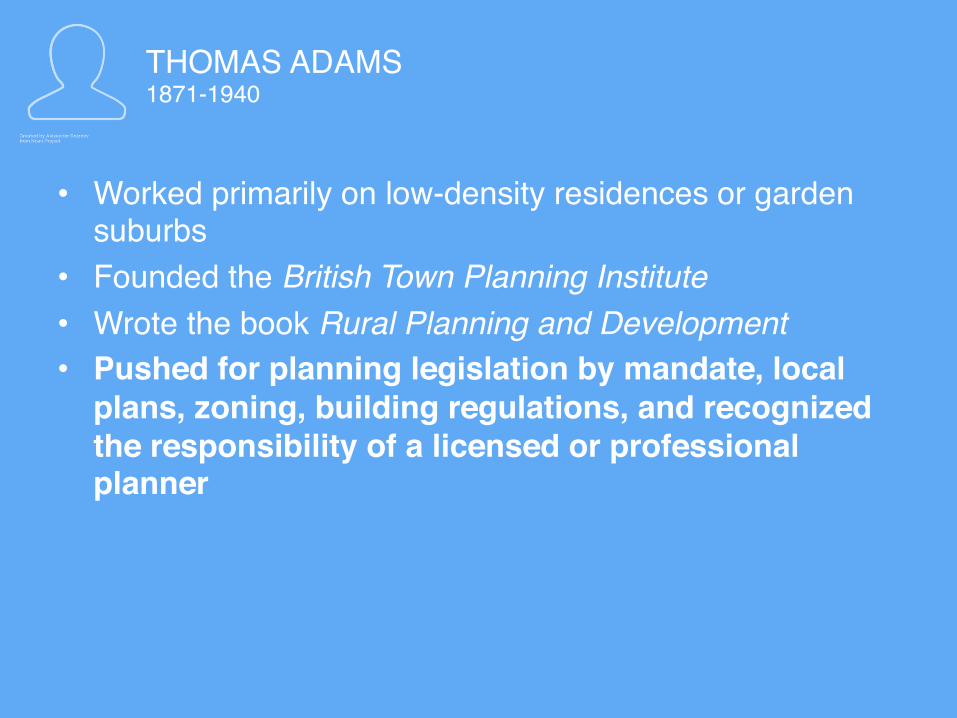
THOMAS ADAMS1871-1940
• Worked primarily on low-density residences or garden suburbs
• Founded the British Town Planning Institute• Wrote the book Rural Planning and Development• Pushed for planning legislation by mandate, local
plans, zoning, building regulations, and recognized the responsibility of a licensed or professional planner

http://ekistics.com/wordpress/wp-content/uploads/2011/05/first_forest_img_02.jpg

CONSTANTINOS APOSTOLOS DOXIADIS1914-1975
• Studied the science of human settlements, called ekistics
• Looks into the culture, economics, and society in varying scales
http://photos1.blogger.com/blogger2/7109/397093975058892/320/eki_circles.1.png


skyscrapercity.com
GRID
PRINCIPLES OF EKISTICS
ISLAMABAD

FRANCIS STUART CHAPIN 1888-1974
• As a sociologist and educator, he stressed the importance of quantifying social activities in an evolving city through statistics.
• He was the first to write the textbooks on urban and regional planning
Amazon

http://financialtribune.com/sites/default/files/field/image/07_AH_Transportation%20439-ab-ED.jpg

IRA LOWRY
• Published A Model of Metropolis, a computer model for spatial organization of anthropogenic activities in a metropolitan area
• This generates an assessment that can be the basis for urban policy decisions
• Worked with Robert Garin on a model that looks at the relationship and logic to the spatial arrangement of human activities
• Expands to gravity modeling, or trip distribution in transport planning, or distance decay in physics
Amazon
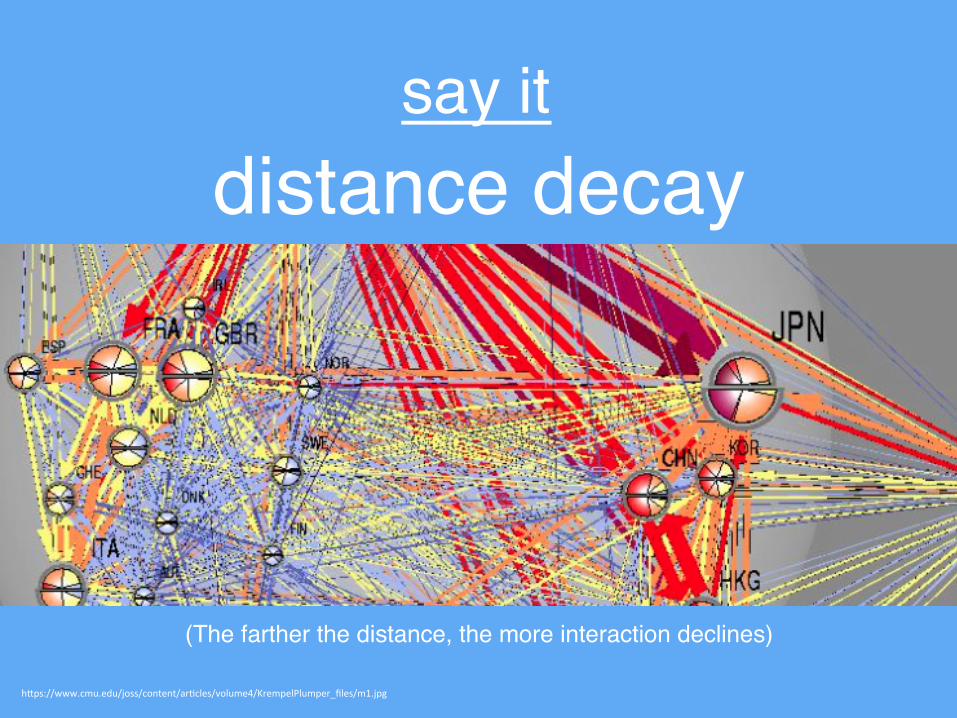
say itdistance decay
h"ps://www.cmu.edu/joss/content/ar4cles/volume4/KrempelPlumper_files/m1.jpg
(The farther the distance, the more interaction declines)

Wikipedia

WILLIAM LEVITT1907-1994
• Father of American Suburbia / The King of Suburbia / The Inventor of the Suburb
• Mass produced houses that were affordable


http://www.dailytexanonline.com/sites/default/files/styles/large/public/images/2013/10/2013-10-18_Traffic_I-35_Joe.Capraro21231.jpg?itok=rbss2CM4
CARS WERE PUT ON A PEDESTAL

https://upload.wikimedia.org/wikipedia/commons/0/0e/Saskatoon_gated_community.JPG
SO COMMUNITIES BECAME GATED
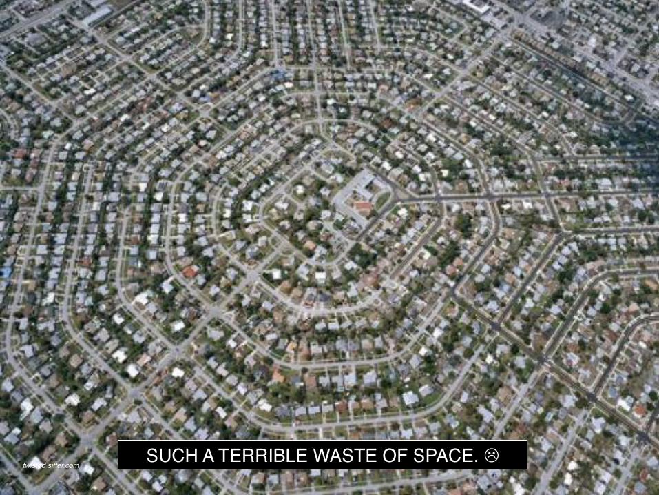
twisted sifter.comSUCH A TERRIBLE WASTE OF SPACE. L

http://thewestendmuseum.org/wordpress/wp-content/gallery/urban-renewal/urban_web.jpg

CATHERINE BAUER WURSTER 1905-1964
• An advocate of social and public housing. She authored the American Housing Act of 1937 and was an adviser to five presidents.
• Wrote the book Modern Housing• She also worked with Lewis Mumford

ROBERT MOSES1888-1981
• The Master Builder of New York• His plans had parkways, expressways, and housing
development • One of the most controversial figures in the history of
urban planning
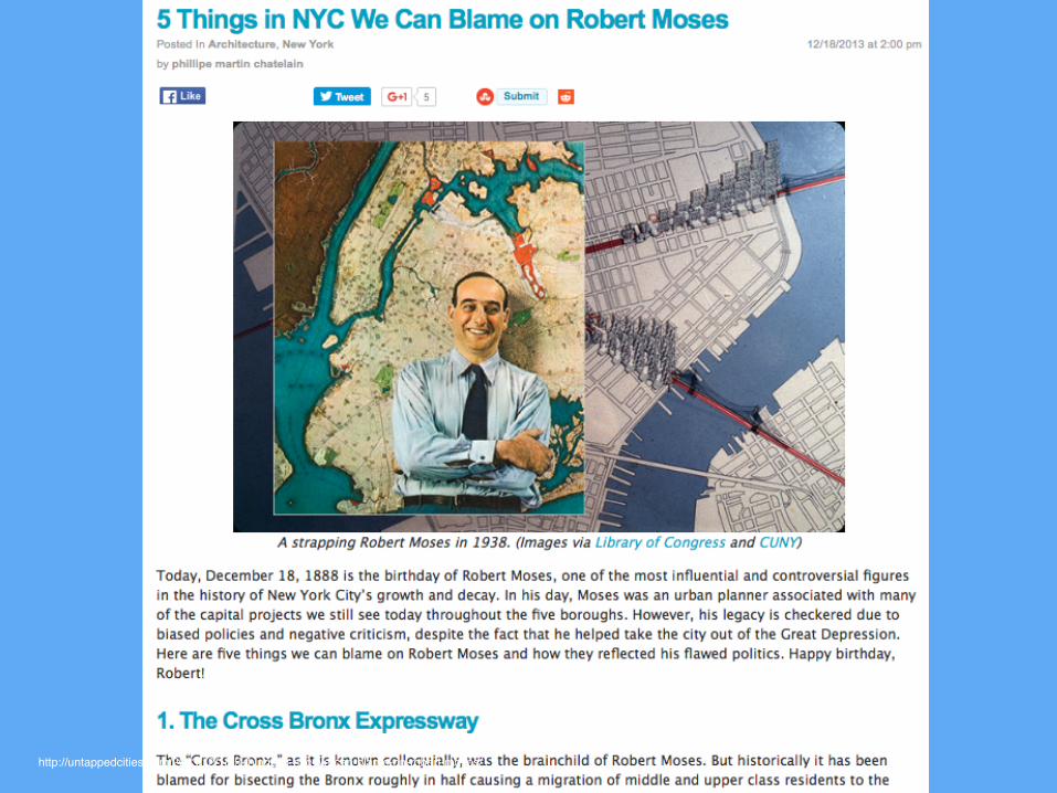
http://untappedcities.com/2013/12/18/5-things-in-nyc-we-can-blame-on-robert-moses/


http://www.shropshirepcas.co.uk/wp-content/uploads/2013/11/Pcas-support-250x300.jpg

SAUL DAVID ALINSKY1909-1972
• Founder of modern community organizing• Wrote the book Rules for Radicals • Worked with the poorer communities, and influenced
neighbourhood organisations

SHERRY ARNSTEIN 1909-1972
• Social and health worker• Published an article on the ladder of citizen
participation, which gave not only a voice but power to the citizens. This addressed how citizens were being victimised, and led the way to participatory planning.

lithgow-schmidt.dk 8 RUNGS OF CITIZEN PARTICIPATION

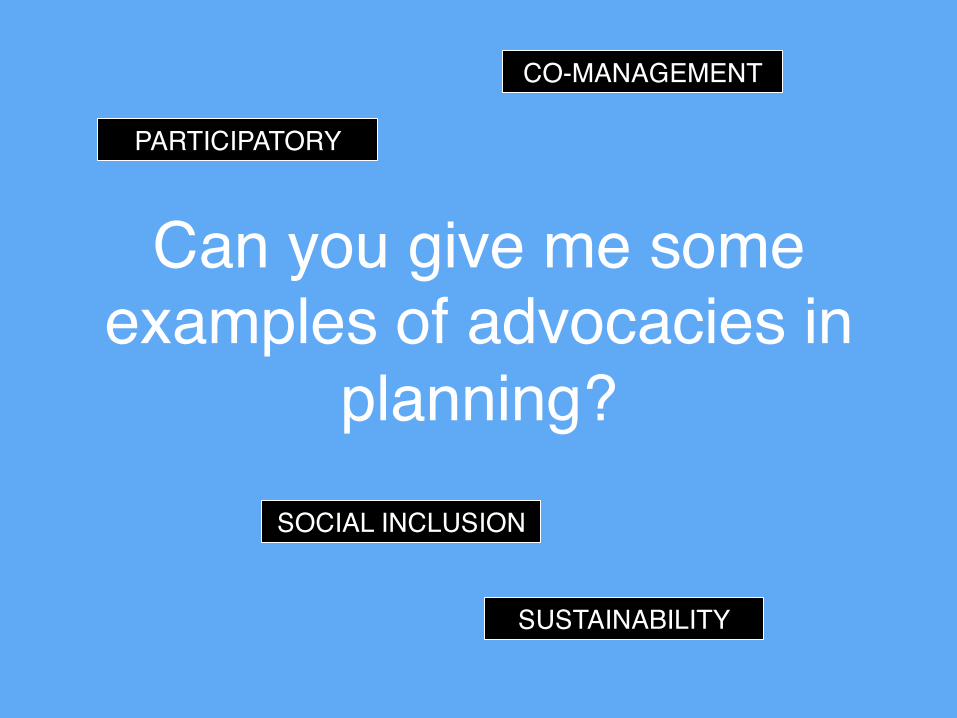
Can you give me some examples of advocacies in
planning?
Can you give me some examples of advocacies in
planning?
PARTICIPATORY
CO-MANAGEMENT
SOCIAL INCLUSION
SUSTAINABILITY

https://www.cnu.org/sites/default/files/styles/homepage_slider/public/UptownNormal_hero_0.jpg?itok=XEvcy15V
NEW URBANISM

What do you notice about the picture?

https://www.cnu.org/sites/default/files/styles/homepage_slider/public/UptownNormal_hero_0.jpg?itok=XEvcy15V
PUBLIC SPACE
PEOPLE
THRIVING ECONOMIC ACTIVITIES
GREENS

http://osmosnetwork.com/wp-content/uploads/2016/03/jane_jacobs.jpg

JANE JACOBS1916-2006
• An urban activist who was strong and vocal against urban renewal; she fought for new urbanism
• Wrote the powerful book The Death and Life of American Cities Her book and activism led to the eventual fall of urban renewal towards city diversity, mixed-use, dense neighborhoods, and vibrant communities.
• Also wrote the book The Economy of Cities

planetizen.com
MOSES VS JACOBS

archdaily.com

http://www.palauconservation.org/cms/images/stories/programImages/watershedLandUses.png
ENVIRONMENTAL PLANNING
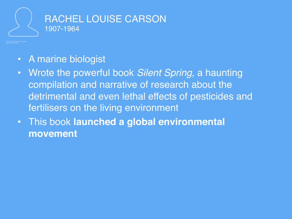
RACHEL LOUISE CARSON 1907-1964
• A marine biologist• Wrote the powerful book Silent Spring, a haunting
compilation and narrative of research about the detrimental and even lethal effects of pesticides and fertilisers on the living environment
• This book launched a global environmental movement

IAN MCHARG1920-2001
• Was called an “architect who valued a site’s natural features”
• Transformed efforts of traditional planning into environmental planning by using the technique of sieve mapping or overlay, which took into account the varied features of the environment.

IAN MCHARG1920-2001
• Wrote the book Design with Nature, which triggered responsible planning of landscapes, respecting natural features
• Laid the foundation for Geographic Information Systems
http://www.kln.ac.lk/socialsciences/depts/geography/images/stories/gis/gis.png


EXPLORATORY
PREDICTIVE
NORMATIVE

https://heimatkunde.boell.de/sites/default/files/uploads/2008/12/push-pull.jpg

http://www.emigration.link/images/push-pull-04.png
http://image.slidesharecdn.com/migration-1-1204994446996443-4-140108145312-phpapp02/95/migration-ruralurban-5-638.jpg?cb=1389192907

https://thegreenhorns.files.wordpress.com/2014/08/berglee-fig04_008.jpg

Theory Rural areas organize agricultural production in support of an urban center. Distance from the center determines the use of land.
Findings Longer distance from marketLess profitabilityEasier to transport
Applicability or Planning Implication
Showed the early analysis of human behavior and its spatial consequences

https://www.google.com/url?sa=i&rct=j&q=&esrc=s&source=images&cd=&ved=0ahUKEwjpseKz8c7MAhXElJQKHYXRB9oQjBwIBA&url=http%3A%2F%2Fmedia.credoreference.com%2Fsagegeography2010%2F381-2.jpg&bvm=bv.121421273,d.dGo&psig=AFQjCNH4YivoLHw4r9CyDbHEaSR0l9j8Qw&ust=1462948323798278&cad=rjt

Theory The range of good and threshold population of retail shops and service establishments are the major influences in explaining the number, size and distribution patterns of settlements.
Findings Consumers avoid higher transport costs by going to the nearest service location. The larger the settlements in size, the fewer in number they will be. The more number of settlements, the higher order of services, and the higher the degree of specialization that occurs.
Applicability or Planning Implication
Provides an economic and spatial development of regions through provision of appropriate goods and services, with establishments according to scale.

http://www.mygeo.info/skripte/skript_bevoelkerung_siedlung/images/lanu26.gif

how to draw it

how to draw it

how to draw it

how to draw it

Central Place Theory in the Philippines: Malls
http://outoftownblog.com/wp-content/uploads/2014/07/Inside-SM-Mall-of-Asia-.jpg

https://apmodels.wikispaces.com/file/view/weber_7.gif/133610959/403x280/weber_7.gif

Theory A factory or plant locates where transport and labor costs are at a minimum, determined by cost of distance vs. weight of raw materials, cost of labor, agglomeration and deglomeration.
Findings The point of least transport costs is that at which the combined weight movements involved in assembly (from sources and in distribution is at a minimum). If savings in labor cost is labor cost per unit output exceeds the extra transport costs, labor will attract the industry to the location.
Applicability or Planning Implication
Brings economics into the spatial domain. Provides rationality in determining the location of a firm

https://upload.wikimedia.org/wikipedia/commons/thumb/6/62/Bid_rent1.svg/2000px-Bid_rent1.svg.png

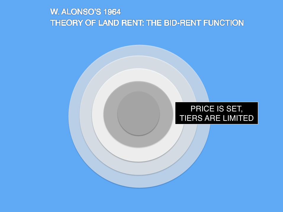
PRICE IS SET, TIERS ARE LIMITED

BID RENT PUSHES AWAY THOSE WHO CANNOT MATCH THE PRICES
CREATES CONCENTRIC
PATTERNS
THIS IS WHY SLUMS SURROUND A BETTER
OFF CITY CENTER

Theory The price of and demand for land changes according to the distance from the center (CBD). The center commands the highest value of land because of its proximity to business establishments and supports services as well as the market.
Applicability or Planning Implication
Provided an explanation on why slums and squatter settlements proliferate in areas close to the CBD or commercial centers

https://0901.static.prezi.com/preview/iuat5aejdzhenvd4ynqqvsekyt6jc3sachvcdoaizecfr3dnitcq_0_0.png
https://www.asu.edu/courses/gcu600/gcu673a/6/Readings/Ravenstein_files/image001.gif

LEAPFROG!

Theory Birth, mortality rates, and population movement are major determinants of settlement patterns.
Findings Migration is caused by economic reasons. Migrants tend not to go straight to their ultimate destinations. They leapfrog.
Applicability or Planning Implication
Gives basis for migration and urban growth studies: distance decay, push-pull studies on migration, and gravity modeling

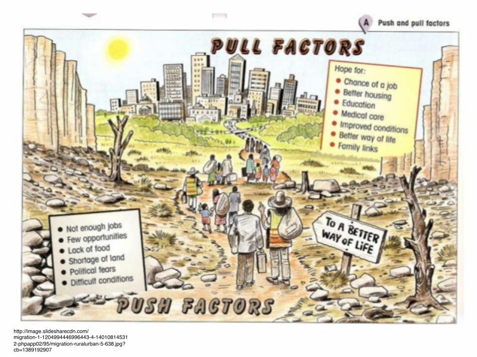
http://www.geographylwc.org.uk/A/AS/ASpopulation/images/push%20pulled.jpg MIGRATION IN DEVELOPING COUNTRIES

Theory Migration is an economic dimension of rural dwellers where individual and household members believe that there is a higher expected income in urban areas.
Findings PakikipagsapalaranApplicability or Planning Implication
This influenced national policy on on-site and services approach to low cost housing, resettlement, relocation and minimization of rural-urban disparities.
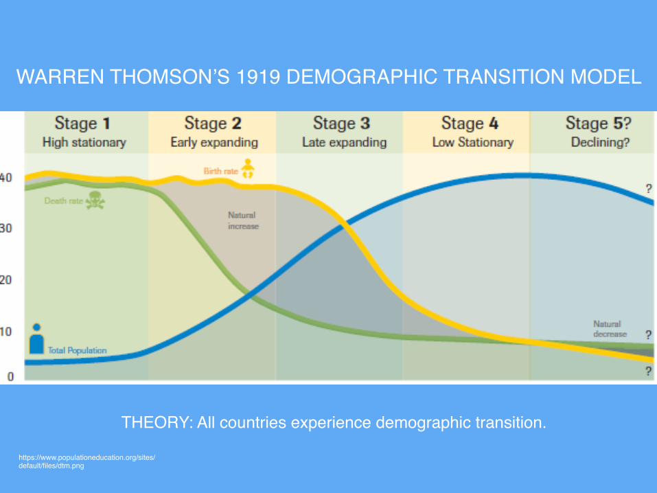
https://www.populationeducation.org/sites/default/files/dtm.png
WARREN THOMSON’S 1919 DEMOGRAPHIC TRANSITION MODEL
THEORY: All countries experience demographic transition.

http://static.trunity.net/images/181082/450x399/scale/Ecosystems_and_Human_Well-Being_Volume_1_Current_State_and_Trends_Urban_Systems10.JPG
MCGRANAHAN’S 2009 URBAN ENVIRONMENTAL TRANSITION THEORY

http://static.trunity.net/images/181082/450x399/scale/Ecosystems_and_Human_Well-Being_Volume_1_Current_State_and_Trends_Urban_Systems10.JPG
MCGRANAHAN’S 2009 URBAN ENVIRONMENTAL TRANSITION THEORY

MCGRANAHAN’S 2009 URBAN ENVIRONMENTAL TRANSITION THEORY
THE ENVIRONMENTAL KUZNET’S CURVE
Development Environment

https://upload.wikimedia.org/wikipedia/en/4/4e/Environmental_Kuznets_Curve.png

http://static.trunity.net/images/181082/450x399/scale/Ecosystems_and_Human_Well-Being_Volume_1_Current_State_and_Trends_Urban_Systems10.JPG
MCGRANAHAN’S 2009 URBAN ENVIRONMENTAL TRANSITION THEORY
HOUSEHOLD CITY OR COUNTRY GLOBAL

http://static.trunity.net/images/181082/450x399/scale/Ecosystems_and_Human_Well-Being_Volume_1_Current_State_and_Trends_Urban_Systems10.JPG
MCGRANAHAN’S 2009 URBAN ENVIRONMENTAL TRANSITION THEORY
HOUSEHOLD CITY OR COUNTRY GLOBAL
WASTE MANAGEMENT
RIVER POLLUTION GREENHOUSE GASES

http://www.assignmentpoint.com/wp-content/uploads/2013/02/Five-Stages-of-Development.jpg
ROSTOW’S 1960 STAGES OF GROWTH DEVELOPMENT
MODERNIZATION IS LINEAR.

http://www.assignmentpoint.com/wp-content/uploads/2013/02/Five-Stages-of-Development.jpg
ROSTOW’S 1960 STAGES OF GROWTH DEVELOPMENT
AGRICULTURE
INDUSTRIALIZATION
SELF-SUSTAINING ECONOMY
TECHNOLOGIES AND NEW INDUSTRIES

http://media.tumblr.com/tumblr_lmklviriHi1qil6h5.gif
WALLERSTEIN’S WORLD ECONOMIC SYSTEM THEORY

http://media.tumblr.com/tumblr_lmklviriHi1qil6h5.gif
WALLERSTEIN’S WORLD ECONOMIC SYSTEM THEORY
STRONG CENTRAL
GOVERNMENT AND
BUREAUCRACY
LACKS STRONG GOVERNMENT
TRANSIT POINT

https://figures.boundless-cdn.com/5979/large/harper-midway-chicago.jpeg
SO MANY THINKERS!

http://cdn.yourarticlelibrary.com/wp-content/uploads/2014/05/clip_image008_thumb8.jpg

http://2.bp.blogspot.com/-yg3tTntN3uc/T-ythq70YfI/AAAAAAAAAGA/TzjSWwGWTkM/s1600/Chicago+School.png

http://egg-humangeography.weebly.com/uploads/2/0/5/0/20502018/801740_orig.gif
BURGESS ET AL’S CONCENTRIC MODEL (1923)

https://egyptgeo.files.wordpress.com/2015/05/screen-shot-2015-04-28-at-9-08-47-am-e1430441496362.png
INCOME, PROFIT POTENTIAL AND RENT DRIVE THE DIRECTION
CHICAGO’S INTERNAL URBAN STRUCTURE IS COMPOSED OF RINGS

http://cdn.yourarticlelibrary.com/wp-content/uploads/2014/05/clip_image0102.jpg
PETER MANN’S CONCENTRIC ZONE MODEL (1965)

http://cdn.yourarticlelibrary.com/wp-content/uploads/2014/05/clip_image0102.jpg
PETER MANN’S CONCENTRIC ZONE MODEL (1965)
FROM CHICAGO TO BRITAIN
COMMUTER VILLAGE
SEPARATED FROM BUILT-UP AREAS

https://aphug.wikispaces.com/file/view/hoyt.png/72462597/hoyt.png
HOMER HOYT’S SECTOR MODEL (1939)

https://aphug.wikispaces.com/file/view/hoyt.png/72462597/hoyt.png
HOMER HOYT’S SECTOR MODEL (1939)
WEDGE-SHAPED
UPPER CLASS TENDS TO LOCATE NEAR THE CBD FOR BEAUTY AND
ACCESSIBILITY

https://upload.wikimedia.org/wikipedia/commons/thumb/8/8f/Multiple_nuclei_model.svg/450px-Multiple_nuclei_model.svg.png
HOMER HOYT’S SECTOR MODEL (1939)

https://upload.wikimedia.org/wikipedia/commons/thumb/8/8f/Multiple_nuclei_model.svg/450px-Multiple_nuclei_model.svg.png
HOMER HOYT’S SECTOR MODEL (1939)
NEW NUCLEI EMERGED
LAND USES REPEL OR ATTRACT
LAND USE CHANGE EMERGES FROM
NEW DEVELOPMENTS

https://taylorgeoitalyisawesome.files.wordpress.com/2015/05/multiple-nuclei-model1.png

https://taylorgeoitalyisawesome.files.wordpress.com/2015/05/multiple-nuclei-model-sketch-up1.png

http://geographylaunchpad.weebly.com/uploads/2/5/4/1/25412597/8251168.jpg?581

http://lewishistoricalsociety.com/wiki2011/article_image.php?image_type=article&id=92

http://s2.thingpic.com/images/Ux/58gecjuCZvntnJhQK6xQ32AA.png

http://ihouse.hkedcity.net/~hm1203/settlement/models-new-color.gif


Where are the paths?


littlemissurbanite.wordpress.com+ prelims+ exam overview+ filing + expectations+ planning bibles+ TIPS J
Top Related