


Languages
Pages
Legal


Staff report for action – Church and Gloucester Properties – Intention to Designate 20
ATTACHMENT NO.3A
HERITAGE PROPERTY RESEARCH AND EVALUATION REPORT
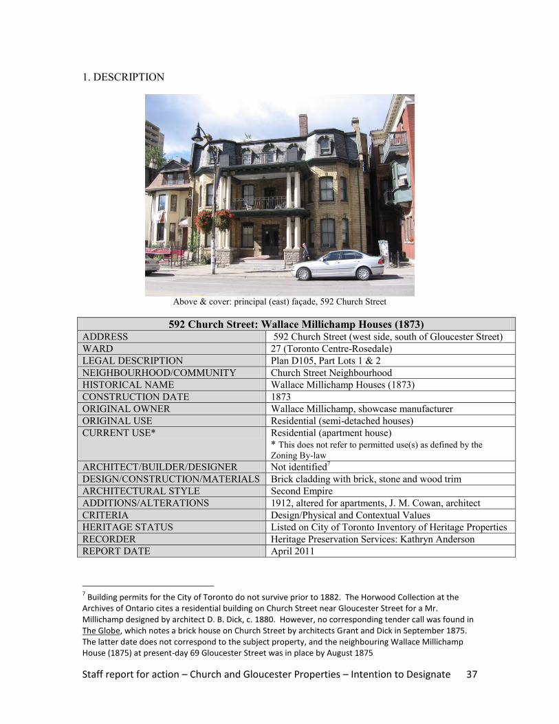
WILLIAM ST. CROIX HOUSES
580-582 CHURCH STREET, TORONTO
Prepared by:
Heritage Preservation Services
City Planning Division
City of Toronto
April 2011

Staff report for action – Church and Gloucester Properties – Intention to Designate 21
1. DESCRIPTION
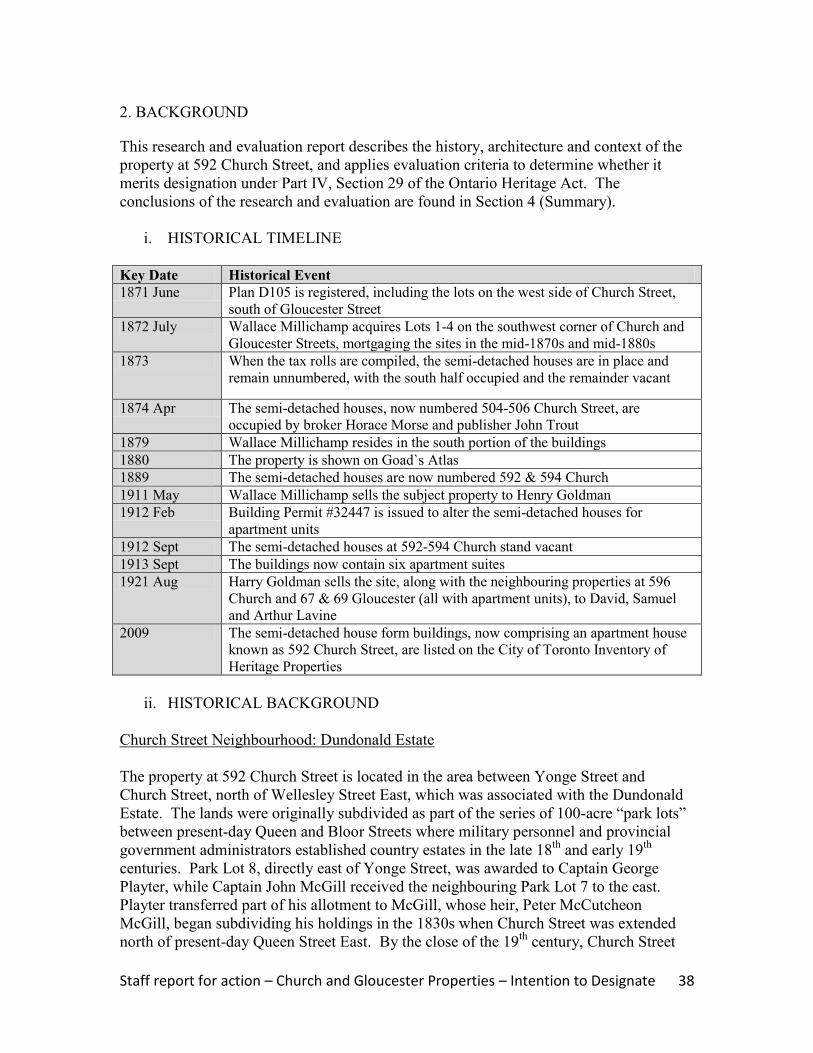
Above: principal (east) façades (right) and south elevation (left) of the William St. Croix Houses
Cover: east façade (left) and north wall (right)
580-582 Church Street: William St. Croix Houses ADDRESS 580-582 Church Street (northwest corner of Dundonald
Street)
WARD 27 (Toronto Centre-Rosedale)
LEGAL DESCRIPTION Plan E250, Part Block C
NEIGHBOURHOOD/COMMUNITY Church Street Neighbourhood (Dundonald Estate)
HISTORICAL NAME William St. Croix Houses
CONSTRUCTION DATE 1877
ORIGINAL OWNER William St. Croix, builder
ORIGINAL USE Residential (semi-detached houses)
CURRENT USE* Commercial
* This does not refer to permitted use(s) as defined by the
Zoning By-law
ARCHITECT/BUILDER/DESIGNER William St. Croix, builder (attribution)1
DESIGN/CONSTRUCTION/MATERIALS Brick cladding with brick, stone & wood detailing
ARCHITECTURAL STYLE Second Empire
ADDITIONS/ALTERATIONS 1904, relocated one building north
CRITERIA Design/Physical, Historical/Associative & Contextual
HERITAGE STATUS Listed on City of Toronto Inventory of Heritage
Properties
RECORDER Heritage Preservation Services: Kathryn Anderson
REPORT DATE April 2011
1 Building permits for the City of Toronto do not survive prior to 1882; no tender call was found in The
Globe

Staff report for action – Church and Gloucester Properties – Intention to Designate 22
2. BACKGROUND
This research and evaluation report describes the history, architecture and context of the
properties at 580-582 Church Street, and applies evaluation criteria to determine whether
designation is merited under Part IV, Section 29 of the Ontario Heritage Act. The
conclusions of the research and evaluation are found in Section 4 (Summary).
i. HISTORICAL TIMELINE
Key Date Historical Event
1877 May William St. Croix, a builder, purchases part of the Dundonald Estate from
Donald Mackay
1877 Sept Two “unfinished houses” owned by William St. Croix & located on the west
side of Church Street, north of Wellesley Street East, are identified on the tax
assessment rolls
1878 May William St. Croix registers Plan D275 on the west side of Church Street, north
of Wellesley Street East and south of the subject properties; the plan shows
two pairs of semi-detached houses on the north part of St. Croix‟s tract
1878 Sept The semi-detached houses at the north end of St. Croix‟s property are occupied
by storekeeper Robert Simpson (south) and builder Joseph Phillips (north),
with another pair standing vacant and a third pair under construction
1880 Goad‟s Atlas shows St. Croix‟s three pairs of semi-detached houses on Church
Street, with the northernmost pair (the subject buildings) placed on the future
alignment of Dundonald Street; the subject properties contain single detached
wood houses
1893 Oct St. Croix mortgages the properties for $33,000
1904 May Frank McMahon acquires the properties developed by St. Croix under Power
of Sale
1904 June McMahon registers Plan E250, which lays out Dundonald Street
1904 Aug McMahon is granted Building Permit #1098 for “alterations to dwellings brick,
Nos. 580 & 582 on Church Street”
1905 July 580-582 Church Street are recorded on the tax assessment rolls as “vacant
houses” owned by Frank McMahon and located north of Dundonald Street
1907 June Frank McMahon and his wife, Jennie, sell the properties to Mary Dancy, who
retains them until her death in the early 1920s; subsequent sales occur in 1949,
1959, 1963 and 1975
1912 Goad‟s Atlas for 1910 updated to 1912 shows the semi-detached houses at
“580” Church Street on the northwest corner of Dundonald Street; the other
semi-detached houses developed by St. Croix are found south of the
intersection
1961 A demolition permit is issued & revoked for the properties, which stand vacant
three years later (Building Records)
1976 The properties at 580-582 Church Street are listed on the City of Toronto
Inventory of Heritage Properties
1980s-2010 According to Building Records, the properties contains a series of restaurants

Staff report for action – Church and Gloucester Properties – Intention to Designate 23
ii. HISTORICAL BACKGROUND
Church Street Neighbourhood: Dundonald Estate
The properties at 580-582 Church Street are located in the area between Yonge Street and
Church Street, north of Wellesley Street, which was associated with the Dundonald
Estate. The lands were originally subdivided as part of the series of 100-acre “park lots”
between present-day Queen and Bloor Streets where military personnel and provincial
government administrators established country estates in the late 18th
and early 19th
centuries. Park Lot 8, directly east of Yonge Street, was awarded to Captain George
Playter, while Captain John McGill was granted the neighbouring Park Lot 7 to the east.
Playter transferred part of his allotment to McGill, whose heir, Peter McCutcheon
McGill, began selling parts of his holdings in the 1830s when Church Street was
extended north of present-day Queen Street East. By the close of the 19th
century,
housing subdivisions adjoined Church Street, the main thoroughfare in the residential
neighbourhood east of Yonge Street. Along with Jarvis Street and Sherbourne Street to
the east, “each of these corridors evolved its own ambience,” ranging from working class
housing at the south end, to the substantial mansions of Toronto‟s business and political
leaders near Bloor Street, while the “growing middle class of clerks, accountants, and
„travellers‟ settled into more commodious single, double and triple houses in the centre of
the tracts.”2 Goad‟s Atlases for the late 1800s trace the development of the subdivisions,
including the parcelling of the lands abutting Church and Gloucester Streets (Images 4-
5).
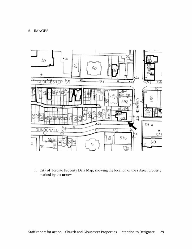
In the mid 1840s, Bank of Upper Canada president William Proudfoot acquired acreage
in the area between Yonge and Church Streets, north of Wellesley Street East, where his
country residence named “Kearsney House” was completed. The estate is shown on the
Boulton Atlas of 1858 (Image 2) and illustrated in Image 3. Donald Mackay (sic)
purchased the tract in 1867, renaming the property “Dundonald”. Between 1880 and
1903, the house is depicted on successive versions of Goad‟s Atlases (Images 4-6), which
also records the subdivision of the adjoining lands during that period. Dundonald was
razed in 1904 when developer Frank McMahon registered a residential subdivision
bounded by Yonge, Wellesley, Church and Gloucester Streets under Plan E250, and laid
out Dundonald Street as an east-west street transecting the tract.
580-582 Church Street
The properties at 580-582 Church Street contain a pair of semi-detached house form
buildings that were constructed in 1877 and relocated to their current site in 1904.
Toronto builder William St. Croix acquired part of the Dundonald Estate on the west side
of Church Street, north of Wellesley Street, in May1877.3 Three months later, the houses
were described as “unfinished” in the tax assessment rolls. In May 1878, when St. Croix
2 McHugh 151
3 In 1877, St. Croix is recorded in land records as a builder; prior to that, the city directories associate him
with plaster mills on Buchanan Street

Staff report for action – Church and Gloucester Properties – Intention to Designate 24
legally registered Plan D275 on the lands, the plan showed two sets of semi-detached
houses on the north end of the tract. The northernmost pair was occupied by Robert
Simpson and Joseph Phillips when the next assessment was undertaken in September
1878, with the adjoining semi-detached houses standing vacant and a third set under
construction to the south. The trio of buildings is shown on Goad‟s Atlas for 1880
(Image 4). St. Croix heavily mortgaged his properties in the 1890s, and lost them by
default.
In May 1904, developer Frank McMahon acquired St. Croix‟s tract through a Power of
Sale and, the following month, registered Plan E250. This residential subdivision
included a new street, Dundonald, which extended on an east-west axis from Yonge to
Church Streets, parallel to and north of Wellesley Street East. Where Dundonald Street
curved to meet Church Street, the alignment extended through St. Croix‟s northernmost
pair of semi-detached houses. In August 1904, McMahon received a building permit to
“alter” the “dwellings brick” at 580 and 582 Church Street (Image 9). Since the permit
authorized alterations rather than demolition, it appears that the existing semi-detached
houses were relocated slightly north to stand on the northwest corner of Church and
Dundonald Streets.4 The updates to Goad‟s Atlas in 1912 and 1923 (Images 7-8) show
the placement of the semi-detached buildings at 580-582 Church, as well as the
introduction of a new detached brick house directly north of the William St. Croix
Houses ,which is now identified as 584 Church Street.5
The original occupant in the south half of the William St. Croix Houses was department
store founder, Robert Simpson. A Scottish immigrant, Simpson opened a dry goods
business on Yonge Street in 1872, which formed the basis of his future department store
complex. Simpson resided at 580 Church Street until 1884, when he moved into
“Haddon Hall,” the mansion he commissioned on Bloor Street East, near Sherbourne
Street (later demolished).
iii. ARCHITECTURAL DESCRIPTION
The William St. Croix Houses at 580-582 Church Street display characteristics of the late
19th
century Second Empire style, which is identified by the distinctive mansard (double-
gable) roof. Named for the reign of Napoleon III, the style appeared in France in the mid
1800s with the unveiling of the New Louvre in a design that combined features from
classical French prototypes and Italian Renaissance architecture. When the style was
transported to North America, it was initially favoured for institutional buildings. In
Toronto, it was introduced for residential use with the completion in 1870 of Government
House, the Lieutenant-Governor of Ontario‟s official residence at King Street West and
4 The other two sets of semi-detached houses remained in their original locations, south of Dundonald
Street, where they were depicted on revisions to Goad’s Atlases; the latter buildings have been demolished 5 Constructed in 1909 on the site of one of the wood buildings associated with the Dundonald Estate, the
property was originally occupied by Catherine Collard and first numbered on Goad’s Atlases as “582” Church (leaving the subject properties as “580”). The properties at 580-582 and 584 Church previously contained modest wood buildings associated with the Dundonald Estate

Staff report for action – Church and Gloucester Properties – Intention to Designate 25
Simcoe Street (now the location of Roy Thomson Hall), with the design reproduced on a
reduced scale in fashionable neighbourhoods throughout the city. The popularity of the
Second Empire style was illusive as, “during the 1870s, these ornate buildings took
Canada by storm, but by the mid-1880s, after a rapid fall from fashion, they were no
longer being erected.”6
As shown in the photographs on the cover and in Section 6 of this report (Images 10-11),
the William St. Croix Houses feature 2½-storey rectangular plans above raised bases.
The mansard roof covering the structures has slate shingles, flared eaves with paired
brackets, ornate segmental-arched dormers, pairs of brick chimneys on the north and
south ends and, on the east slope, a tower with the same detailing as the main roofline.
The red brick cladding features contrasting buff brick for the string course beneath the
eaves and the quoins. The principal (east) façade is organized into three bays with the
entrances located in the centre. The pair of entries has round-arched surrounds, and both
are protected by an open porch with decorative wood posts. Above the entrances, the
second-storey displays an enclosed sun porch with round-arched openings and wood
cladding and detailing. In the outer bays, single-storey bay windows in the lower floor
have round-arched openings with stone hood moulds, key stones and corbelled sills. The
paired window openings in the second storey have similar detailing. Round-arched
openings are repeated on the side elevations (north and south) and on the rear (west)
wings that are visible from Church and Dundonald Streets. The open verandah on the
south elevation overlooks Dundonald Street.
iv. CONTEXT
The properties at 580-582 Church Street are located on the northwest corner of Church
and Dundonald Streets, as shown on the property data map below (Image 1) and the
context photographs (Images 12-13). On the lands comprising the former Dundonald
Estate, the Paul Kane House (1854) at 56 Wellesley Street East is designated under Part
IV, Section 29 of the Ontario Heritage Act. Three detached house form buildings on the
south side of Gloucester Street that date to the late 19th
century are recognized on the City
of Toronto Inventory of Heritage Properties. On Church Street, the William St. Croix
Houses face a trio of row houses at #551-555 that are included on the City‟s heritage
inventory, as well as a collection of row houses on the northeast corner of Gloucester
Street (#561-555 and #569-573). South of Dundonald Street, on the east side of Church
Street, the former Granite Curling Club (1906), which is more recently known as the 519
Church Community Centre, is a designated heritage property and a neighbourhood
landmark.
The William St. Croix Houses anchor the south end of the block on Church Street that
extends north from Dundonald Street to Gloucester Street. North of the William St.
Croix Houses, the semi-detached house form buildings (now apartments) at 592 Church
Street date to the same era. The latter properties, along with the surviving portion and
wing of a former residential building at 69 Gloucester Street and the low-rise apartment
6 Cameron, 8
Staff report for action – Church and Gloucester Properties – Intention to Designate 26
houses at 596 Church Street and 67 Gloucester Street, are also recognized on the City of
Toronto Inventory of Heritage Properties.
3. EVALUATION CHECKLIST
The following evaluation applies Ontario Regulation 9/06 made under the Ontario
Heritage Act: Criteria for Determining Cultural Heritage Value or Interest. While the
criteria are prescribed for municipal designation under Part IV, Section 29 of the Ontario
Heritage Act, the City of Toronto uses it when assessing properties for inclusion on the
City of Toronto Inventory of Heritage Properties. The evaluation table is marked “N/A”
if the criterion is “not applicable” to the property or X if it is applicable, with explanatory
text below.
Design or Physical Value i. rare, unique, representative or early example of a style, type, expression,
material or construction method X
ii. displays high degree of craftsmanship or artistic merit X iii. demonstrates high degree of scientific or technical achievement N/A
Representative Examples of a Style – The William St. Croix Houses are late 19th
century residential buildings with well-crafted Second Empire styling that contributes to
their architectural significance. The semi-detached houses are distinguished by the
pattern brickwork, the detailing of the distinctive mansard roof, and the fenestration.
With the changes to the Church Street neighbourhood and the loss of many of the
residential buildings that typified its development, the William St. Croix Houses are
important surviving examples of Second Empire styling. They are complemented by the
neighbouring Wallace Millichamp Houses (1873) at 592 Church Street in the same block,
which share the characteristic mansard roof but display buff brick cladding and different
detailing, as well as the surviving portions of the detached Wallace Millichamp House
(1875) at 69 Gloucester Street.
Historical or Associative Value i. direct associations with a theme, event, belief, person, activity, organization or
institution that is significant to a community X
ii. yields, or has the potential to yield, information that contributes to an
understanding of a community or culture N/A
iii. demonstrates or reflects the work or ideas of an architect, artist, builder,
designer or theorist who is significant to a community N/A
Person – The properties at 580-582 Church Street are associated with entrepreneur
Robert Simpson, founder of one of Toronto‟s iconic department stores. Simpson (1834-
97) was the first occupant in the south portion of the William St. Croix Houses where he
lived between 1878 and 1884. During his residency on Church Street, Simpson
developed his Yonge Street company, which grew during the late 19th
century from a

Staff report for action – Church and Gloucester Properties – Intention to Designate 27
modest dry goods business to a 35-department store with 500 employees headquartered in
a landmark building at Yonge and Queen Streets.
Contextual Value i. important in defining, maintaining or supporting the character of an area N/A ii. physically, functionally, visually or historically linked to its surroundings X iii. landmark N/A
Surroundings – The William St. Croix Houses are historically linked to their
surroundings as part of the residential subdivision developed on the former Dundonald
Estate adjoining Church Street. The house form buildings anchor the south end of a
block of low-rise detached, semi-detached and multi-unit residential edifices that
represent the evolution of the Church Street, north of Wellesley Street East, in the late
19th
and early 20th
centuries.
4. SUMMARY
Following research and evaluation according to Regulation 9/06, it has been determined
that the properties at 580-582 Church Street have design, associative and contextual
values. The William St. Croix Houses retain their integrity as late 19th
century residential
buildings distinguished by their Second Empire styling, and the south unit is associated
with Toronto entrepreneur Robert Simpson. Contextually, the semi-detached houses are
historically linked to their surroundings on Church Street where they anchor the south
end of the block between Dundonald Street (south) and Gloucester Street (north) with its
collection of domestic buildings that represent the development of the area as a sought-
after residential neighbourhood in the late 1800s and early 1900s.
5. SOURCES
Archival Sources
Abstract Index of Deeds, Plan D275, Lots 1-5
Abstract Index of Deeds, Plan E250, Block C
Assessment Rolls, City of Toronto, St. James Ward, 1872-91, and Ward 3, Division 3,
1892 ff.
Boulton Atlas, 1858
Building Permit #1098 (August 23, 1904), City of Toronto Archives
Building Records, Toronto and East York, 1961-2001
City of Toronto Directories, 1871 ff.
Goad‟s Atlases, 1880, 1894, 1903, and 1910 revised to 1912 and 1923
Books
Arthur, Eric, Toronto: no mean city, 3rd
ed., revised by Stephen A. Otto, 1986
Blumenson, John, Ontario Architecture, 1990
Cameron, Christina, and Janet Wright, Second Empire Style in Canada, 1980
Kalman, Harold, An Encyclopedia of Canadian Architecture, Vol. 2, 1994
Lundell, Liz, The Estates of Old Toronto, 1997
Maitland, Leslie, Jacqueline Hucker and Shannon Ricketts, A Guide to Canadian

Staff report for action – Church and Gloucester Properties – Intention to Designate 28
Architectural Styles, 1992
McHugh, Patricia, Toronto Architecture: a city guide, 2nd
ed., 1989
“Robert Simpson,” entry in The Canadian Encyclopedia, 1999
Staff report for action – Church and Gloucester Properties – Intention to Designate 29
6. IMAGES
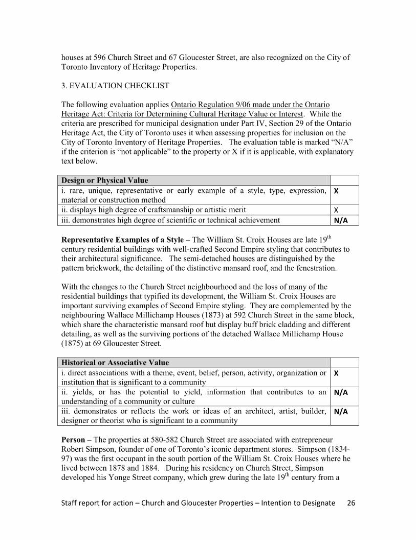
1. City of Toronto Property Data Map, showing the location of the subject property
marked by the arrow
Staff report for action – Church and Gloucester Properties – Intention to Designate 30
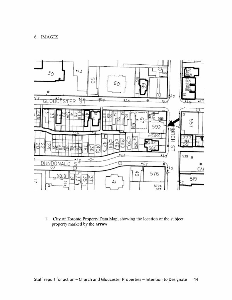
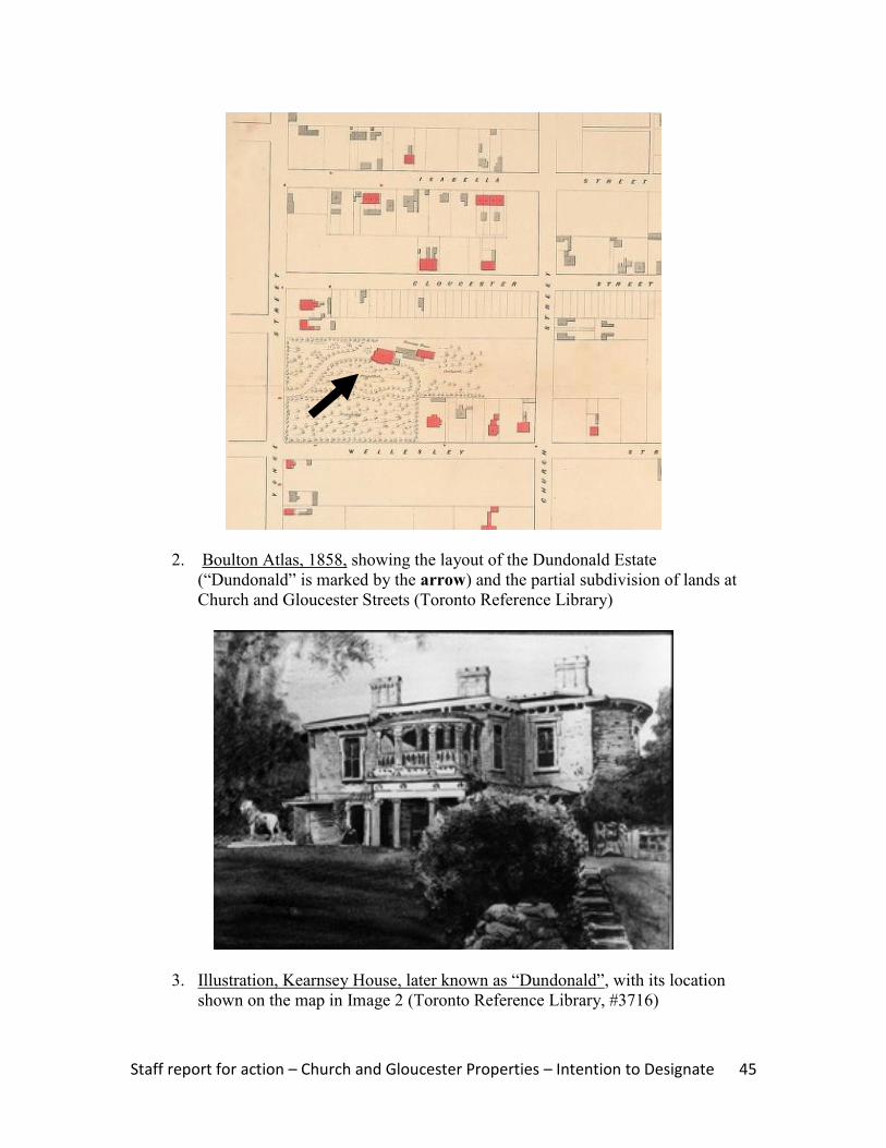
2. Boulton Atlas, 1858, showing the layout of the Dundonald Estate (“Dundonald” is
marked by the arrow) and the partial subdivision of the lands along Gloucester Street
(Toronto Reference Library)
3. Illustration, Kearnsey House, later known as “Dundonald”, with its location
shown on the map in Image 2 (Toronto Reference Library, #3716)
Staff report for action – Church and Gloucester Properties – Intention to Designate 31
4. Goad‟s Atlas, 1880, showing the subject property (marked by an arrow) when a
single detached wood building occupied the site. Directly south, the William St.
Croix Houses stand in their original locations, before the northernmost pair was
relocated to the subject site
5. Goad‟s Atlas, 1894, showing the status of the site (marked by the arrow), where
there have been no changes since the 1880 map (Image 4)

Staff report for action – Church and Gloucester Properties – Intention to Designate 32
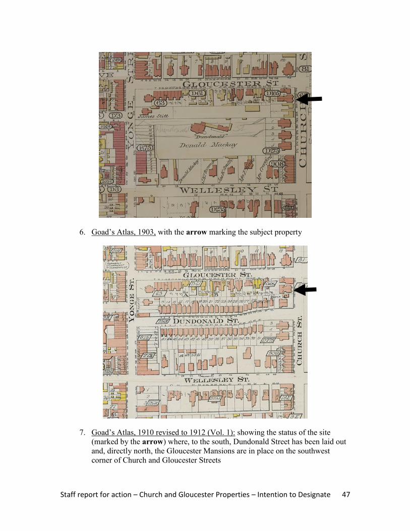
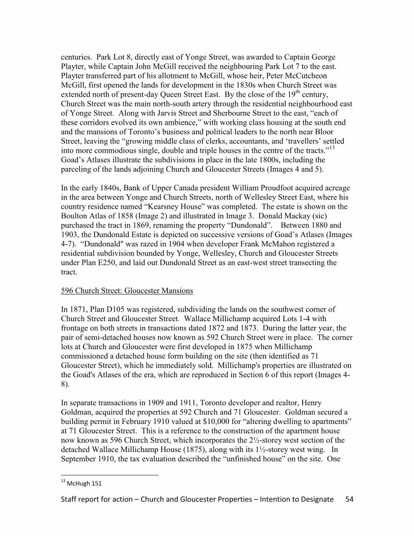
6. Goad‟s Atlas, 1903, showing the status of the subject site (marked by the arrow),
which remains the same as in 1894 (Image 5)
7. Goad‟s Atlas, 1910 revised to 1912 (Vol. 1): showing the updates to the map,
where Dundonald Street has been laid out and the semi-detached houses placed
on the northwest corner of Church Street and Dundonald Street (as marked by the
arrow) beside a new detached brick house form building now known as #584
Church

Staff report for action – Church and Gloucester Properties – Intention to Designate 33
8. Goad‟s Atlas, 1910 revised to 1923 (Vol. 1): showing the subject properties
(marked by the arrow)
9. Building Permit #1098 (August 23, 1904), for the relocation of the semi-detached
house form buildings at 580-582 Church Street (City of Toronto Archives)

Staff report for action – Church and Gloucester Properties – Intention to Designate 34
10 & 11: Photographs of the principal (east) façade (above) and the south elevation
(below) of the semi-detached house form buildings at 580-582 Church Street
Staff report for action – Church and Gloucester Properties – Intention to Designate 35
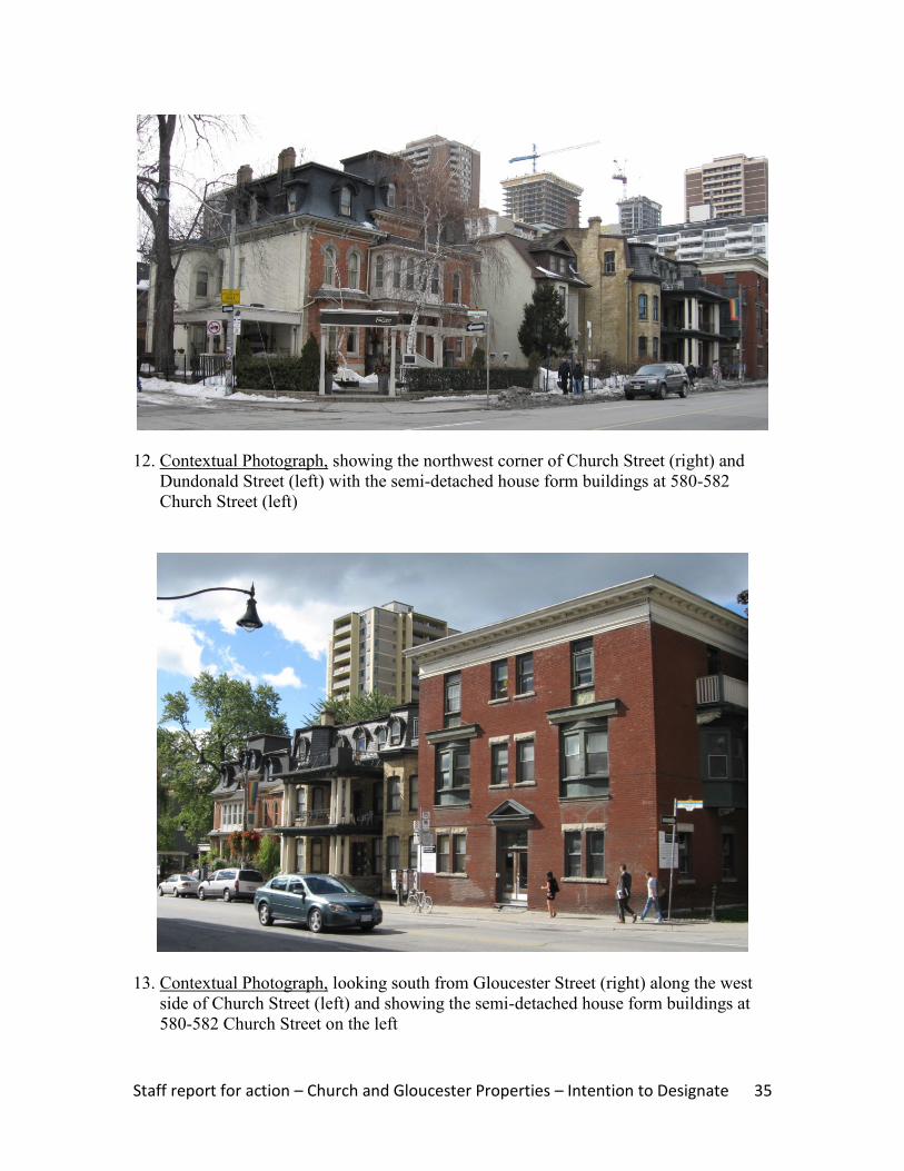
12. Contextual Photograph, showing the northwest corner of Church Street (right) and
Dundonald Street (left) with the semi-detached house form buildings at 580-582
Church Street (left)
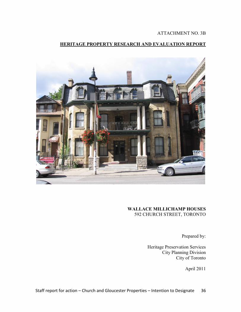
13. Contextual Photograph, looking south from Gloucester Street (right) along the west
side of Church Street (left) and showing the semi-detached house form buildings at
580-582 Church Street on the left
Staff report for action – Church and Gloucester Properties – Intention to Designate 36
ATTACHMENT NO. 3B
HERITAGE PROPERTY RESEARCH AND EVALUATION REPORT
WALLACE MILLICHAMP HOUSES
592 CHURCH STREET, TORONTO
Prepared by:
Heritage Preservation Services
City Planning Division
City of Toronto
April 2011
Staff report for action – Church and Gloucester Properties – Intention to Designate 37
1. DESCRIPTION
Above & cover: principal (east) façade, 592 Church Street
592 Church Street: Wallace Millichamp Houses (1873) ADDRESS 592 Church Street (west side, south of Gloucester Street)
WARD 27 (Toronto Centre-Rosedale)
LEGAL DESCRIPTION Plan D105, Part Lots 1 & 2
NEIGHBOURHOOD/COMMUNITY Church Street Neighbourhood
HISTORICAL NAME Wallace Millichamp Houses (1873)
CONSTRUCTION DATE 1873
ORIGINAL OWNER Wallace Millichamp, showcase manufacturer
ORIGINAL USE Residential (semi-detached houses)
CURRENT USE* Residential (apartment house)
* This does not refer to permitted use(s) as defined by the
Zoning By-law
ARCHITECT/BUILDER/DESIGNER Not identified7
DESIGN/CONSTRUCTION/MATERIALS Brick cladding with brick, stone and wood trim
ARCHITECTURAL STYLE Second Empire
ADDITIONS/ALTERATIONS 1912, altered for apartments, J. M. Cowan, architect
CRITERIA Design/Physical and Contextual Values
HERITAGE STATUS Listed on City of Toronto Inventory of Heritage Properties
RECORDER Heritage Preservation Services: Kathryn Anderson
REPORT DATE April 2011
7 Building permits for the City of Toronto do not survive prior to 1882. The Horwood Collection at the
Archives of Ontario cites a residential building on Church Street near Gloucester Street for a Mr. Millichamp designed by architect D. B. Dick, c. 1880. However, no corresponding tender call was found in The Globe, which notes a brick house on Church Street by architects Grant and Dick in September 1875. The latter date does not correspond to the subject property, and the neighbouring Wallace Millichamp House (1875) at present-day 69 Gloucester Street was in place by August 1875
Staff report for action – Church and Gloucester Properties – Intention to Designate 38
2. BACKGROUND
This research and evaluation report describes the history, architecture and context of the
property at 592 Church Street, and applies evaluation criteria to determine whether it
merits designation under Part IV, Section 29 of the Ontario Heritage Act. The
conclusions of the research and evaluation are found in Section 4 (Summary).
i. HISTORICAL TIMELINE
Key Date Historical Event
1871 June Plan D105 is registered, including the lots on the west side of Church Street,
south of Gloucester Street
1872 July Wallace Millichamp acquires Lots 1-4 on the southwest corner of Church and
Gloucester Streets, mortgaging the sites in the mid-1870s and mid-1880s
1873 When the tax rolls are compiled, the semi-detached houses are in place and
remain unnumbered, with the south half occupied and the remainder vacant
1874 Apr The semi-detached houses, now numbered 504-506 Church Street, are
occupied by broker Horace Morse and publisher John Trout
1879 Wallace Millichamp resides in the south portion of the buildings
1880 The property is shown on Goad`s Atlas
1889 The semi-detached houses are now numbered 592 & 594 Church
1911 May Wallace Millichamp sells the subject property to Henry Goldman
1912 Feb Building Permit #32447 is issued to alter the semi-detached houses for
apartment units
1912 Sept The semi-detached houses at 592-594 Church stand vacant
1913 Sept The buildings now contain six apartment suites
1921 Aug Harry Goldman sells the site, along with the neighbouring properties at 596
Church and 67 & 69 Gloucester (all with apartment units), to David, Samuel
and Arthur Lavine
2009 The semi-detached house form buildings, now comprising an apartment house
known as 592 Church Street, are listed on the City of Toronto Inventory of
Heritage Properties
ii. HISTORICAL BACKGROUND
Church Street Neighbourhood: Dundonald Estate
The property at 592 Church Street is located in the area between Yonge Street and
Church Street, north of Wellesley Street East, which was associated with the Dundonald
Estate. The lands were originally subdivided as part of the series of 100-acre “park lots”
between present-day Queen and Bloor Streets where military personnel and provincial
government administrators established country estates in the late 18th
and early 19th
centuries. Park Lot 8, directly east of Yonge Street, was awarded to Captain George
Playter, while Captain John McGill received the neighbouring Park Lot 7 to the east.
Playter transferred part of his allotment to McGill, whose heir, Peter McCutcheon
McGill, began subdividing his holdings in the 1830s when Church Street was extended
north of present-day Queen Street East. By the close of the 19th
century, Church Street

Staff report for action – Church and Gloucester Properties – Intention to Designate 39
was the main north-south thoroughfare through an established residential neighbourhood.
Along with Jarvis Street and Sherbourne Street to the east, “each of these corridors
evolved its own ambience,” ranging from working class housing at the south end to the
opulent mansions of Toronto's political and business leaders to the north near Bloor
Street, while “the growing middle class of clerks, accountants, and „travellers‟ settled into
more commodious single, double and triple houses in the centre of the tracts.”8 The latter
section is illustrated in the extracts from Goad‟s Atlases that are attached (Images 4-6),
specifically the layout of the subdivisions along Church and Gloucester Streets.
In the early 1840s, Bank of Upper Canada president William Proudfoot acquired a
substantial parcel between Yonge and Church Streets, north of Wellesley Street East,
where his country residence named “Kearsney House” was completed. The estate is
shown on the Boulton Atlas of 1858 (Image 2) and illustrated in Image 3. Donald
Mackay (sic) purchased the site in 1869, renaming the property “Dundonald”. Between
1880 and 1903, the Dundonald Estate is depicted on successive versions of Goad‟s
Atlases (Images 4-6). “Dundonald” was razed in 1904 when developer Frank McMahon
registered a residential subdivision bounded by Yonge, Wellesley, Church and Gloucester
Streets under Plan E250, and laid out Dundonald Street as an east-west street transecting
the tract.
592 Church Street: Wallace Millichamp Houses (1873)
The lands on the southwest corner of Church Street and Gloucester Street were
subdivided in 1871 by Plan D105. In transactions dated 1872 and 1873, Wallace
Millichamp acquired Lots 1-4, giving him frontage on both streets. The pair of semi-
detached houses originally numbered 504-506 Church Street were in place by the time
the tax assessment rolls were compiled in 1873, with Horace Morse, a broker, residing in
the south unit and the remaining half standing vacant. Both portions were occupied the
next year, with publisher John Trout the tenant in the north section. By 1879, Millichamp
moved into the south unit (renumbered as 592 Church by 1889) and lived there for over
20 years. During his occupancy of the site, Millichamp served as a two-term City
alderman. In 1901, his daughter Ethel‟s wedding was “celebrated this afternoon at 592
Church Street” and “the guests, who numbered one hundred, offered their congratulations
to the newly-married couple when refreshments were served in the dining room.”9 The
next year, Millichamp moved out, but continued to rent both units of the semi-detached
houses to a series of tenants. The Wallace Millichamp Houses (1875) were illustrated on
Goad‟s Atlases beginning in 1880, with extracts from some of the maps reproduced in
Section 6 of this report (Images 4-8).
In a transaction dated 1911, Millichamp sold the property at 592 Church Street to Henry
Goldman, a local realtor and developer. In February 1912, J. M. Cowan, a Toronto
architect and Goldman‟s representative, received a building permit for "altering a
8 McHugh 151
9 Toronto Daily Star, November 20, 1901

Staff report for action – Church and Gloucester Properties – Intention to Designate 40
dwelling to apartments near Gloucester Street on Church Street"10
(Image 9). The
conversion of the semi-detached houses into an apartment complex was part of a larger
project initiated by Goldman, who had previously taken a detached house form building
on the southwest corner of Church and Gloucester (commissioned but never occupied by
Millichamp), retained the rear section and wing of the structure for apartment suites, and
replaced the main body of the residence with a low-rise apartment building named the
“Gloucester Mansions.” Goldman also commissioned Cowan to design the adjoining
apartment house at 67 Gloucester Street, also known as the “Gloucester Mansions,” in
1912.
With the completion of the new apartment buildings, the semi-detached houses at 592
Church were identified as “Building C” of the complex.11
Goldman retained the group of
buildings, including 592 Church Street, until 1921 when he transferred them to David,
Samuel and Arthur Lavine, who specialized in the development and management of
apartment buildings in Toronto during the World War I era.
iii. ARCHITECTURAL DESCRIPTION
The pair of semi-detached houses known historically as the Wallace Millichamp Houses
(1873) are designed with Second Empire styling, which is identified by its characteristic
mansard (double-gable) roof. The style originated in mid 19th-
century France with the
appearance of the New Louvre. The Second Empire style was named in recognition of
the reign of Napoleon III and blended architectural elements from Italian Renaissance
architecture and classical French prototypes. Introduced to North America, the style was
initially favoured for institutional buildings. In Toronto, the first residential application
of the Second Empire style was the 1870 Government House, the Lieutenant-Governor of
Ontario‟s official residence at King Street West and Simcoe Street (now the site of Roy
Thomson Hall). The initial popularity of Second Empire designs “typifies the
increasingly elaborate and monumental appearance of architecture towards the end of the
19th
century”12
when the style was welcomed in the fashionable neighbourhoods of the
city, including the Church Street residential corridor.
As shown in the photographs on the cover and in Section 6 of this report (Images 10-12),
the Wallace Millichamp Houses (1873) extend 2½ stories above raised bases with
window openings and feature rectangular plans. The structures are clad with buff brick
and trimmed with brick and stone. The distinctive mansard roofs covering the structures
feature flared eaves with brackets, segmental-arched dormers, brick end chimneys, and
slate. The firebreak end walls (north and south) with brick corbelling are bowed. The
principal (east) façade is divided into five bays. In the outer bays, bay windows rise two
stories beneath the projecting mansard roof. The segmental-arched window openings
with brick hood moulds and stone keystones that are placed in both stories of the bay
windows are repeated on either side of the entrances. The main entrance in the first
10
Building permit #32447 (February 7, 1912) 11
City of Toronto Directories 12
Maitland, 64

Staff report for action – Church and Gloucester Properties – Intention to Designate 41
storey and the smaller door opening in the second floor have classical detailing with
multiple keystones. The treatment of the entries, along with the classically-detailed two-
storey verandah with columns, reflects the alterations made when the houses were
converted to multiple units and represent the stylistic evolution of the buildings. The
sections of the side elevations (north and south) with the angled walls and the window
openings that are visible from Church Street are important features that convey the three-
dimensional quality of the structures.
iv. CONTEXT
The Wallace Millichamp Houses (1873) are located on the west side of Church Street,
between Gloucester Street (north) and Dundonald Street (south), on the former
Dundonald Estate. Their location is shown on the property data map below (Image 1)
and the context photographs (Images 12-13). On the former estate lands, the Paul Kane
House (1854) at 56 Wellesley Street East is designated under Part IV, Section 29 of the
Ontario Heritage Act. Three detached house form buildings on the south side of
Gloucester Street that date to the late 19th
century are recognized on the City of Toronto
Inventory of Heritage Properties. On Church Street, the Wallace Millichamp Houses
(1873) overlook the trio of row houses at #551-555 that are included on the City‟s
heritage inventory, as well as a collection of row houses on the northeast corner of
Gloucester Street (#561-555 and #569-573). South of Dundonald Street, on the east side
of Church Street, the former Granite Curling Club (1906), which is more recently known
as the 519 Church Community Centre, is a designated heritage property and a
neighbourhood landmark.
South of the Wallace Millichamp Houses (1873), the semi-detached house form buildings
known as the William St. Croix Houses at 580-582 Church Street anchor the south end of
the block at Dundonald Street. To the north, the property at 592 Church Street is
adjoined by the Gloucester Mansions at 596 Church, with the remnants of the former
Wallace Millichamp House (1875) to the rear at 69 Gloucester Street. The detached
apartment building known as the Gloucester Mansions at 67 Gloucester completes the
enclave of residential buildings, which are identified on the City‟s heritage inventory and
represent the evolution of Church Street where late 19th
century detached and semi-
detached residences were joined by apartment complexes in the pre-World War I era.
3. EVALUATION CHECKLIST
The following evaluation applies Ontario Regulation 9/06 made under the Ontario
Heritage Act: Criteria for Determining Cultural Heritage Value or Interest. While the
criteria are prescribed for municipal designation under Part IV, Section 29 of the Ontario
Heritage Act, the City of Toronto uses it when assessing properties for inclusion on the
City of Toronto Inventory of Heritage Properties. The evaluation table is marked “N/A”
if the criterion is “not applicable” to the property or X if it is applicable, with explanatory
text below.

Staff report for action – Church and Gloucester Properties – Intention to Designate 42
Design or Physical Value i. rare, unique, representative or early example of a style, type, expression,
material or construction method X
ii. displays high degree of craftsmanship or artistic merit N/A iii. demonstrates high degree of scientific or technical achievement N/A
Representative and Early Example – The Wallace Millichamp Houses are
representative examples of late 19th
century house form buildings with features of the
Second Empire style that are distinguished by their grand designs, mansard roofs and
decorative detailing. With the changes to the Church Street neighbourhood and the loss of
many of the residential buildings that characterized its development, the Wallace
Millichamp Houses (1873) are important surviving examples and early applications of
the Second Empire style in Toronto. The semi-detached house form buildings are
complemented by the remaining sections of the Wallace Millichamp House (1875) at 69
Gloucester and, in the same block on Church Street, the William St. Croix Houses at 580-
582 Church that share the characteristic mansard roofs but display red brickwork.
Historical or Associative Value i. direct associations with a theme, event, belief, person, activity, organization or
institution that is significant to a community N/A
ii. yields, or has the potential to yield, information that contributes to an
understanding of a community or culture N/A
iii. demonstrates or reflects the work or ideas of an architect, artist, builder,
designer or theorist who is significant to a community N/A
There are no historical or associative values identified for the property at 592 Church
Street. Wallace Millichamp, who developed the semi-detached houses and occupied one
portion for more than 20 years, was a Toronto showcase manufacturer and two-term city
alderman. However, it has been determined that his connection to the site is not
compelling enough to be identified as a cultural heritage value.
Contextual Value i. important in defining, maintaining or supporting the character of an area N/A ii. physically, functionally, visually or historically linked to its surroundings X iii. landmark N/A
Surroundings – The Wallace Millichamp Houses (1873) are historically linked to their
surroundings on Church Street, south of Gloucester Street. They form part of a collection
of low-rise detached, semi-detached and multi-unit residential buildings dating from the
late 1800s to the World War I era on Church and Gloucester Streets on the former
Dundonald Estate, most of which are recognized on the City of Toronto Inventory of
Heritage Properties.
Staff report for action – Church and Gloucester Properties – Intention to Designate 43
4. SUMMARY
Following research and evaluation according to Regulation 9/06, it has been determined
that the property at 592 Church Street has design and contextual values. The Wallace
Millichamp Houses (1873) retain their integrity as early and representative examples of
semi-detached houses designed in the Second Empire style that contribute to the
collection of late 19th-
and early 20th-
century residential buildings adjoining the southwest
corner of Church and Gloucester Streets to which they are historically related.
5. SOURCES
Archival Sources
Abstract Index of Deeds, Plan D105, Lots 1-4
Assessment Rolls, City of Toronto, St. James Ward, 1872-91, and Ward 3, Division 3,
1892 ff.
Boulton Atlas, 1858
Building Permit #32447 (February 7, 1912), City of Toronto Archives
Building Records, Toronto and East York, 1914-1982
City of Toronto Directories, 1871 ff.
Goad‟s Atlases, 1880, 1894, 1903, and 1910 revised to 1912 and 1923
Books and Newspapers
Arthur, Eric, Toronto: no mean city, 3rd
ed., revised by Stephen A. Otto, 1986
Blumenson, John, Ontario Architecture, 1990
“City news” (Wallace Millichamp‟s candidacy for alderman), The Evening Star
(September 18, 1896)
“Goldman sells two apartments and buys one,” Toronto Daily Star (March 14, 1927)
Lundell, Liz, The Estates of Old Toronto, 1997
Maitland, Leslie, Jacqueline Hucker and Shannon Ricketts, A Guide to Canadian
Architectural Styles, 1992
McHugh, Patricia, Toronto Architecture: a city guide, 2nd
ed., 1989
Cameron, Christina, and Janet Wright, Second Empire Style in Canada, 1980
“Wallace Millichamp‟s estate worth $141, 885,” Toronto Daily Star (September 12,
1917)
“Williams–Millichamp” (marriage announcement), Toronto Daily Star (November 20,
1901)
Staff report for action – Church and Gloucester Properties – Intention to Designate 44
6. IMAGES
1. City of Toronto Property Data Map, showing the location of the subject
property marked by the arrow
Staff report for action – Church and Gloucester Properties – Intention to Designate 45
2. Boulton Atlas, 1858, showing the layout of the Dundonald Estate
(“Dundonald” is marked by the arrow) and the partial subdivision of lands at
Church and Gloucester Streets (Toronto Reference Library)
3. Illustration, Kearnsey House, later known as “Dundonald”, with its location
shown on the map in Image 2 (Toronto Reference Library, #3716)
Staff report for action – Church and Gloucester Properties – Intention to Designate 46
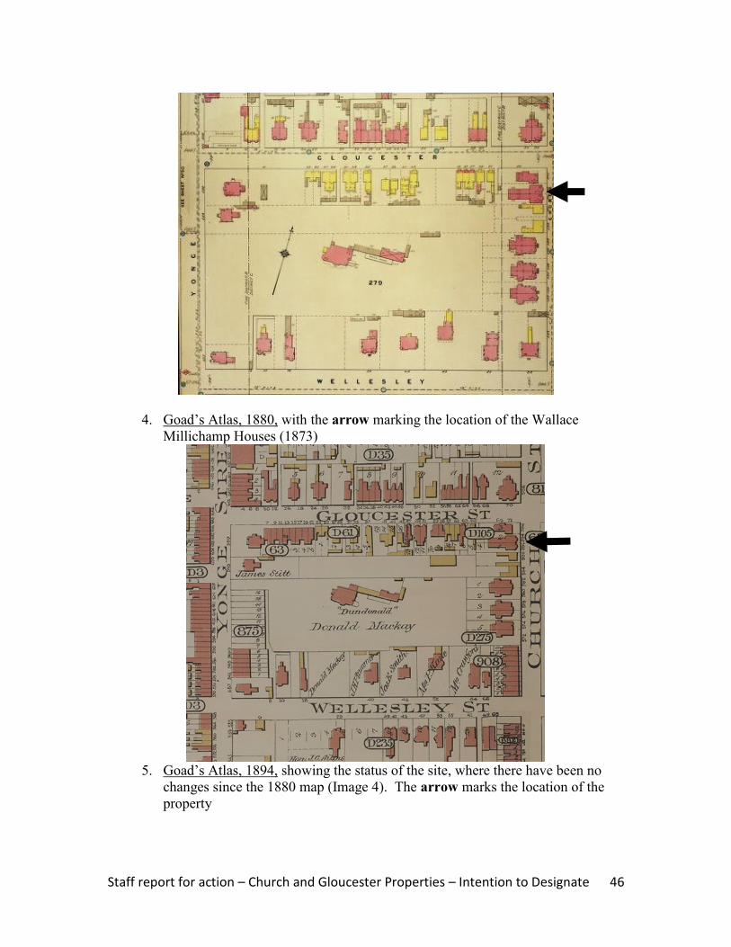
4. Goad‟s Atlas, 1880, with the arrow marking the location of the Wallace
Millichamp Houses (1873)
5. Goad‟s Atlas, 1894, showing the status of the site, where there have been no
changes since the 1880 map (Image 4). The arrow marks the location of the
property
Staff report for action – Church and Gloucester Properties – Intention to Designate 47
6. Goad‟s Atlas, 1903, with the arrow marking the subject property
7. Goad‟s Atlas, 1910 revised to 1912 (Vol. 1): showing the status of the site
(marked by the arrow) where, to the south, Dundonald Street has been laid out
and, directly north, the Gloucester Mansions are in place on the southwest
corner of Church and Gloucester Streets

Staff report for action – Church and Gloucester Properties – Intention to Designate 48
8. Goad‟s Atlas, 1910 revised to 1923 (Vol. 1): showing the status of the subject
site (marked by the arrow), with the adjoining apartment houses in place at 596
Church Street and 67 Gloucester Street
9. Building Permit #32447 (February 7, 1912), authorizing the conversion of the
semi-detached houses at present-day 592 Church Street to apartment units
Staff report for action – Church and Gloucester Properties – Intention to Designate 49
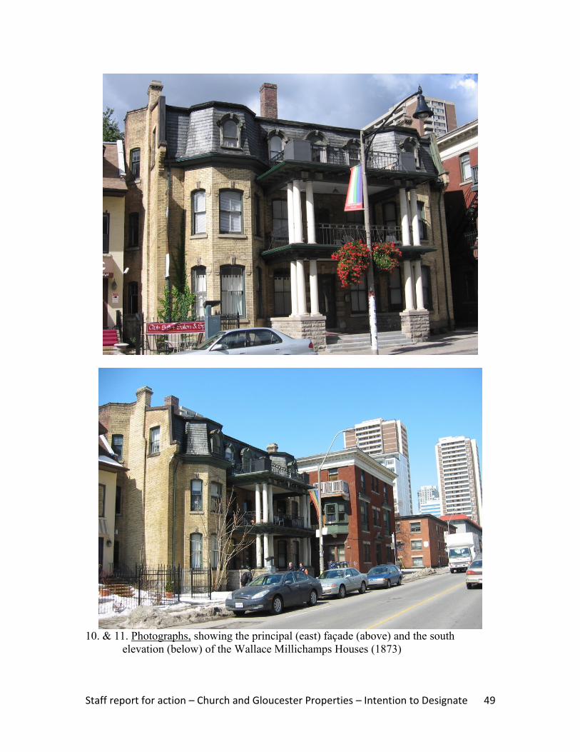
10. & 11. Photographs, showing the principal (east) façade (above) and the south
elevation (below) of the Wallace Millichamps Houses (1873)

Staff report for action – Church and Gloucester Properties – Intention to Designate 50
12. Contextual photograph, showing the west side of Church Street and looking north
toward Gloucester Street where the Wallace Millichamp Houses (1873) stand mid-
block
13. Contextual photograph, showing the west side of Church Street and looking south
toward Dundonald Street from Gloucester Street where the Wallace Millichamp
Houses (1873) stand mid-block
Staff report for action – Church and Gloucester Properties – Intention to Designate 51
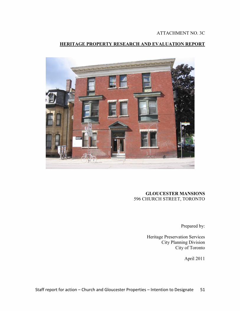
ATTACHMENT NO. 3C
HERITAGE PROPERTY RESEARCH AND EVALUATION REPORT
GLOUCESTER MANSIONS
596 CHURCH STREET, TORONTO
Prepared by:
Heritage Preservation Services
City Planning Division
City of Toronto
April 2011

Staff report for action – Church and Gloucester Properties – Intention to Designate 52
1. DESCRIPTION
Above: east façade on Church Street (left) and north elevation on Gloucester Street (right)
Cover: principal (east) facade
596 Church Street: Gloucester Mansions ADDRESS 596 Church Street (southwest corner of Gloucester Street)
WARD 27 (Toronto Centre-Rosedale)
LEGAL DESCRIPTION Plan D105, Part Lots 2 & 3
NEIGHBOURHOOD/COMMUNITY Church Street Neighbourhood
HISTORICAL NAME Gloucester Mansions
CONSTRUCTION DATE 1910
ORIGINAL OWNER Harry Goldman, developer & realtor
ORIGINAL USE Residential (apartment building)
CURRENT USE* Residential (apartment building)
* This does not refer to permitted use(s) as defined by the
Zoning By-law
ARCHITECT/BUILDER/DESIGNER Stanley A. Waggett, architect
DESIGN/CONSTRUCTION/MATERIALS Brick cladding with brick, stone and wood trim
ARCHITECTURAL STYLE Edwardian Classicism
ADDITIONS/ALTERATIONS No significant alterations identified in Building Records
CRITERIA Design/Physical and Contextual Values
HERITAGE STATUS Listed on City of Toronto Inventory of Heritage Properties
RECORDER Heritage Preservation Services: Kathryn Anderson
REPORT DATE April 2011
Staff report for action – Church and Gloucester Properties – Intention to Designate 53
2. BACKGROUND
This research and evaluation report describes the history, architecture and context of the
property at 596 Church Street, and applies evaluation criteria to determine whether it
merits designation under Part IV, Section 29 of the Ontario Heritage Act. The
conclusions of the research and evaluation are found in Section 4 (Summary).
i. HISTORICAL TIMELINE
Key Date Historical Event
1871 June Plan D105 is registered, including the lots adjoining Church & Gloucester
Streets
1872 July Wallace Millichamp acquires Lots 1-4 on the west side of Church Street,
where he commissions semi-detached houses at present-day 592 Church Street
in 1873
1875 A detached house for Wallace Millichamp is under construction on the
southwest corner of Church & Gloucester Streets; he immediately sells the site,
which is identified as “71 Gloucester Street”
1880 The subject property is shown on Goad`s Atlas with a detached house
1909 Sept Henry Goldman purchases the property at the southwest corner of Church &
Gloucester Streets with the detached house identified as “71 Gloucester”
1910 Feb Goldman receives a building permit valued at $10,000 for “altering building
into apartments” at 71 Gloucester Street, a reference to the construction of the
apartment building at 596 Church Street, which incorporates parts of the
Wallace Millichamp House (1875)
1910 Sept The tax rolls record Goldman as the assessed owner of an "unfinished house"
at 71 Gloucester
1911 Sept Goldman is the assessed owner of the vacant apartment house at 596 Church
Street, and he occupies “71 Gloucester,” which is the rear section of the former
Wallace Millichamp House (1875); “69 Gloucester” contains “vacant suites”
(reference is to the west wing of the 1875 house form building)
1912 Goad's Atlas, updated to 1912, shows the apartment house at 596 Church
Street, which is built to the west limit of Church Street
1912 Sept The apartment building at 596 Church Street is occupied with 6 rental suites
1921 Aug Harry Goldman sells his Church & Gloucester properties, including 596
Church Street, to David, Samuel and Arthur Lavine
2009 The Gloucester Mansions at 596 Church Street are listed on the City of
Toronto Inventory of Heritage Properties
ii. HISTORICAL BACKGROUND
Church Street Neighbourhood: Dundonald Estate
The property at 596 Church Street is located in the area between Yonge Street and
Church Street, north of Wellesley Street, which was associated with the Dundonald
Estate. The lands were originally subdivided as part of the series of 100-acre “park lots”
between present-day Queen and Bloor Streets where military personnel and provincial
government administrators established country estates in the late 18th
and early 19th
Staff report for action – Church and Gloucester Properties – Intention to Designate 54
centuries. Park Lot 8, directly east of Yonge Street, was awarded to Captain George
Playter, while Captain John McGill received the neighbouring Park Lot 7 to the east.
Playter transferred part of his allotment to McGill, whose heir, Peter McCutcheon
McGill, first opened the lands for development in the 1830s when Church Street was
extended north of present-day Queen Street East. By the close of the 19th
century,
Church Street was the main north-south artery through the residential neighbourhood east
of Yonge Street. Along with Jarvis Street and Sherbourne Street to the east, “each of
these corridors evolved its own ambience,” with working class housing at the south end
and the mansions of Toronto‟s business and political leaders to the north near Bloor
Street, leaving the “growing middle class of clerks, accountants, and „travellers‟ settled
into more commodious single, double and triple houses in the centre of the tracts.”13
Goad‟s Atlases illustrate the subdivisions in place in the late 1800s, including the
parceling of the lands adjoining Church and Gloucester Streets (Images 4 and 5).
In the early 1840s, Bank of Upper Canada president William Proudfoot acquired acreage
in the area between Yonge and Church Streets, north of Wellesley Street East, where his
country residence named “Kearsney House” was completed. The estate is shown on the
Boulton Atlas of 1858 (Image 2) and illustrated in Image 3. Donald Mackay (sic)
purchased the tract in 1869, renaming the property “Dundonald”. Between 1880 and
1903, the Dundonald Estate is depicted on successive versions of Goad‟s Atlases (Images
4-7). “Dundonald" was razed in 1904 when developer Frank McMahon registered a
residential subdivision bounded by Yonge, Wellesley, Church and Gloucester Streets
under Plan E250, and laid out Dundonald Street as an east-west street transecting the
tract.
596 Church Street: Gloucester Mansions
In 1871, Plan D105 was registered, subdividing the lands on the southwest corner of
Church Street and Gloucester Street. Wallace Millichamp acquired Lots 1-4 with
frontage on both streets in transactions dated 1872 and 1873. During the latter year, the
pair of semi-detached houses now known as 592 Church Street were in place. The corner
lots at Church and Gloucester were first developed in 1875 when Millichamp
commissioned a detached house form building on the site (then identified as 71
Gloucester Street), which he immediately sold. Millichamp's properties are illustrated on
the Goad's Atlases of the era, which are reproduced in Section 6 of this report (Images 4-
8).
In separate transactions in 1909 and 1911, Toronto developer and realtor, Henry
Goldman, acquired the properties at 592 Church and 71 Gloucester. Goldman secured a
building permit in February 1910 valued at $10,000 for “altering dwelling to apartments”
at 71 Gloucester Street. This is a reference to the construction of the apartment house
now known as 596 Church Street, which incorporates the 2½-storey west section of the
detached Wallace Millichamp House (1875), along with its 1½-storey west wing. In
September 1910, the tax evaluation described the “unfinished house” on the site. One
13
McHugh 151

Staff report for action – Church and Gloucester Properties – Intention to Designate 55
year later, the “Gloucester Mansions” were in place, while the preserved portions of the
Wallace Millichamp House (1875) contained apartment suites known as 69 and 71
Gloucester where Goldman and his family resided in the latter building. With the
conversion of the semi-detached houses at 592 Church into apartment units, and the
completion of the second “Gloucester Mansions” (1912) at 67 Gloucester Street, the
apartment house at 596 Church anchored an apartment complex that combined existing
residential buildings with purpose-built apartments. Goldman retained the group of
buildings, including 596 Church Street, until 1921 when he transferred them to David,
Samuel and Arthur Lavine, who specialized in the development and management of
apartment buildings in Toronto during the World War I era.
The design for the Gloucester Mansions is attributed to Toronto architect Stanley A.
Waggett, whose name is listed on the building permit. Waggett is described as "an
obscure figure who practised in Toronto" and "can be credited with the design of some of
that city's first apartment houses."14
His projects included the Parkdale Mansions (1912),
the apartment complex at 194 Dowling and 1501 Queen Street West, which was
commissioned by David Lavine, a co-owner of the Gloucester Mansions in the early
1920s.15
iii. ARCHITECTURAL DESCRIPTION
The Gloucester Mansions at 596 Church Street are designed with features of Edwardian
Classicism, the most popular architectural style in the opening decades of the 20th
century. Identified by its characteristic somber brickwork, symmetrical placement of
door and window openings, and "the free and selective use of classical forms," the style
was applied to both grand institutional buildings and more modest commercial and
residential edifices.16
As shown in the photographs on the cover and in Section 6 of this report, the Gloucester
Mansions feature a three-storey L-shaped plan. Clad with red brick and trimmed with
brick, stone and wood, the structure is covered by a flat roof where a cornice has
extended eaves, brackets, dentils and a moulded frieze. The principal (east) façade on
Church Street is divided into three bays. The central entrance, which is placed in a flat-
headed surround with a stone label and a triangular pediment, contains double wood and
glazed doors under a glazed transom labeled "Gloucester Mansions". The fenestration
consists of flat-headed openings arranged in singles and pairs, with two-sided oriel
windows inset in the outer bays of the second storey. The shape and detailing of the
fenestration, with stone labels and sills, continues on the north elevation facing
Gloucester Street. Special features on the latter wall are the oriel window with brackets
in the second floor. Balconies are placed on the north and south elevations, where the
flat-headed openings in the first (east) bay of the latter wall are visible from Church
Street. The portion of the rear (west) wall viewed from Gloucester Street displays a
14
Biographical Dictionary of Architects in Canada, unpaged 15
The Dowling and Queen Street West properties with the Parkdale Mansions are designated under Part IV, Section 29 of the Ontario Heritage Act by By-law No. 996-2008 16
Maitland, 119

Staff report for action – Church and Gloucester Properties – Intention to Designate 56
three-storey verandah with classical detailing that protects the entries. The west wall is
attached to the two separate structures comprised of the 2½-storey rear (west) section and
1½-storey wing of the former Wallace Millichamp House (1875), which are listed on the
City of Toronto Inventory of Heritage Properties as 69 Gloucester Street.
iv. CONTEXT
The Gloucester Mansions at 596 Church Street are located on the southwest corner of
Church Street and Gloucester Street on the former Dundonald Estate. Their location is
shown on the property data map below (Image 1) and in the context photographs (Images
10-11). On the former estate lands, the Paul Kane House (1854) at 56 Wellesley Street
East is designated under Part IV, Section 29 of the Ontario Heritage Act. Three detached
house form buildings on the south side of Gloucester Street that date to the late 19th
century are recognized on the City of Toronto Inventory of Heritage Properties. On
Church Street, the Gloucester Mansions overlook the trio of row houses at #551-555, and
stand kitty corner to a collection of row houses on the northeast corner of Gloucester
Street (#561-555 and #569-573), all of which are included on the City‟s heritage
inventory. Further south, on the east side of Church Street, the former Granite Curling
Club (1906), which is more recently known as the 519 Church Community Centre, is a
designated heritage property and a neighbourhood landmark.
The Gloucester Mansions anchor the north end of the block on Church Street that extends
south to Dundonald Street where the semi-detached house form buildings known as the
William St. Croix Houses stand at 580-582 Church Street. The apartment building is
adjoined to the south by the semi-detached house form buildings (1873) at 592 Church
Street that contain apartment units while, on the west, the rear sections of the former
Wallace Millichamp House (1875) separate it from the free-standing apartment house at
67 Gloucester. Together, the detached, semi-detached and multi-unit buildings form a
residential enclave at the corner of Church and Gloucester.
3. EVALUATION CHECKLIST
The following evaluation applies Ontario Regulation 9/06 made under the Ontario
Heritage Act: Criteria for Determining Cultural Heritage Value or Interest. While the
criteria are prescribed for municipal designation under Part IV, Section 29 of the Ontario
Heritage Act, the City of Toronto uses it when assessing properties for inclusion on the
City of Toronto Inventory of Heritage Properties. The evaluation table is marked “N/A”
if the criterion is “not applicable” to the property or X if it is applicable, with explanatory
text below.
Design or Physical Value i. rare, unique, representative or early example of a style, type, expression,
material or construction method X
ii. displays high degree of craftsmanship or artistic merit N/A iii. demonstrates high degree of scientific or technical achievement N/A
Staff report for action – Church and Gloucester Properties – Intention to Designate 57
Representative Example – The Gloucester Mansions are a representative example of an
early 20h century low-rise apartment building designed with features of Edwardian
Classicism, the most popular style for residential architecture in the World War I era.
The complex is distinguished by its inset oriel windows and Classical detailing,
particularly the cornice that is visible from many vantage points on Church and
Gloucester Streets.
Historical or Associative Value i. direct associations with a theme, event, belief, person, activity, organization or
institution that is significant to a community N/A
ii. yields, or has the potential to yield, information that contributes to an
understanding of a community or culture N/A
iii. demonstrates or reflects the work or ideas of an architect, artist, builder,
designer or theorist who is significant to a community N/A
No historical or associative values have been identified for the property at 596 Gloucester
Street.
Contextual Value i. important in defining, maintaining or supporting the character of an area N/A ii. physically, functionally, visually or historically linked to its surroundings X iii. landmark N/A
Surroundings – The Gloucester Mansions at 596 Church Street are historically linked to
their surroundings adjoining Church and Gloucester Streets, where they contribute to the
group of low-rise buildings from the late 1800s to the pre-World War I era that line the
west side of the block on Church Street that extends south to Dundonald Street.
4. SUMMARY
Following research and evaluation according to Regulation 9/06, it has been determined
that the property at 596 Church Street has design and contextual values. The Gloucester
Mansions retain their integrity as a representative example of an apartment house
designed with Edwardian Classical styling that contributes to the collection of late 19th-
and early 20th-
century residential buildings on Church Street between Gloucester Street
and Dundonald Street to which they are historically related.
5. SOURCES
Archival Sources
Abstract Index of Deeds, Plan D105, Lots 1-4
Assessment Rolls, City of Toronto, St. James Ward, 1872-91, and Ward 3, Division 3,
1892 ff.
Boulton Atlas, 1858
Staff report for action – Church and Gloucester Properties – Intention to Designate 58
Building Permit #18971 (February 10, 1910), City of Toronto Archives
Building Records, Toronto and East York, 1914-1982
City of Toronto Directories, 1871 ff.
Goad‟s Atlases, 1880, 1894, 1903, and 1910 revised to 1912 and 1923
Books and Newspapers
Arthur, Eric, Toronto: no mean city, 3rd
ed., revised by Stephen A. Otto, 1986
Blumenson, John, Ontario Architecture, 1990
“Goldman sells two apartments and buys one,” Toronto Daily Star (March 14, 1927)
Lundell, Liz, The Estates of Old Toronto, 1997
Maitland, Leslie, Jacqueline Hucker and Shannon Ricketts, A Guide to Canadian
Architectural Styles, 1992
McHugh, Patricia, Toronto Architecture: a city guide, 2nd
ed., 1989
Cameron, Christina, and Janet Wright, Second Empire Style in Canada, 1980
Other
"Samuel A. Waggett," entry in The Biographical Dictionary of Architects in Canada,
1800-1950, www.dictionaryofarchitectsincanada.org

Staff report for action – Church and Gloucester Properties – Intention to Designate 59
IMAGES
1. City of Toronto Property Data Map, showing the location of the subject property
marked by the arrow

Staff report for action – Church and Gloucester Properties – Intention to Designate 60
2. Boulton Atlas, 1858, showing the layout of the Dundonald Estate (“Dundonald”
is marked by the arrow) and the partial subdivision of the lands at Church and
Gloucester Streets (Toronto Reference Library)
3. Illustration, Kearnsey House, later known as “Dundonald”, with its location
shown on the map in Image 2 (Toronto Reference Library, #3716)

Staff report for action – Church and Gloucester Properties – Intention to Designate 61
4. Goad‟s Atlas, 1880, with the arrow marking the location of the Wallace
Millichamp House (1875) at the southwest corner of Church and Gloucester
Streets
5. Goad‟s Atlas, 1894, showing the status of the site, where there have been no
changes since the 1880 map (Image 4). The arrow marks the location of the
property
Staff report for action – Church and Gloucester Properties – Intention to Designate 62
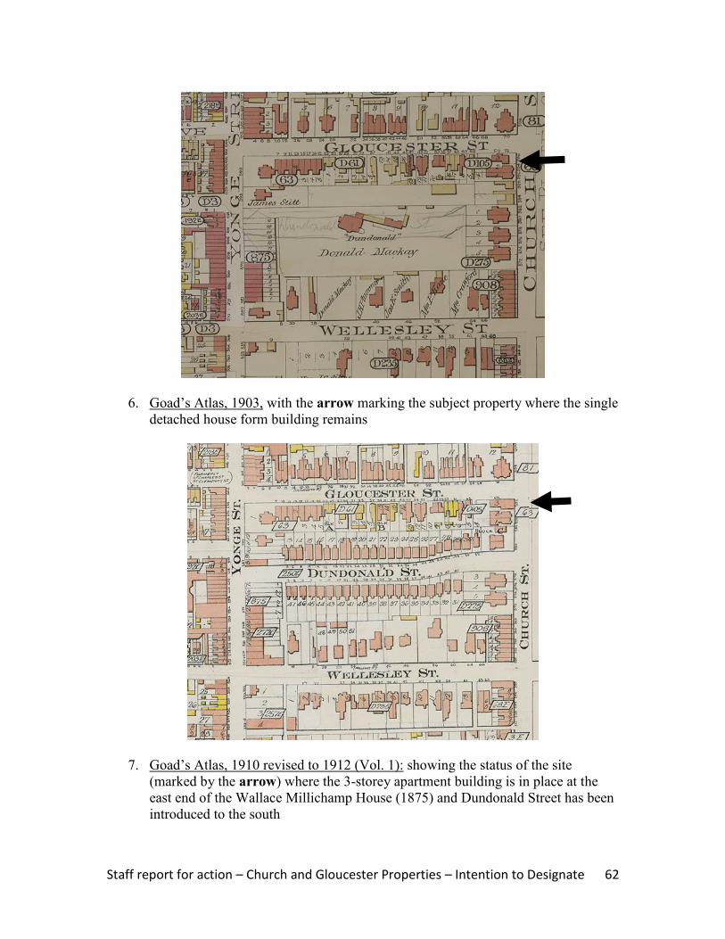
6. Goad‟s Atlas, 1903, with the arrow marking the subject property where the single
detached house form building remains
7. Goad‟s Atlas, 1910 revised to 1912 (Vol. 1): showing the status of the site
(marked by the arrow) where the 3-storey apartment building is in place at the
east end of the Wallace Millichamp House (1875) and Dundonald Street has been
introduced to the south
Staff report for action – Church and Gloucester Properties – Intention to Designate 63
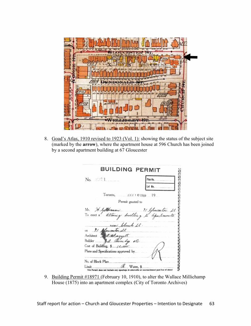
8. Goad‟s Atlas, 1910 revised to 1923 (Vol. 1): showing the status of the subject site
(marked by the arrow), where the apartment house at 596 Church has been joined
by a second apartment building at 67 Gloucester
9. Building Permit #18971 (February 10, 1910), to alter the Wallace Millichamp
House (1875) into an apartment complex (City of Toronto Archives)

Staff report for action – Church and Gloucester Properties – Intention to Designate 64
10. Contextual photograph, showing the west side of Church Street and looking south
toward Dundonald Street from Gloucester Street where the Gloucester Mansions
(right) anchor the north end of the block
11. Contextual photograph, looking north along the west side of Church Street to
Gloucester Street and showing the south elevation (left) and principal (east)
façade (right) of the Gloucester Mansions at 596 Church Street
Staff report for action – Church and Gloucester Properties – Intention to Designate 65
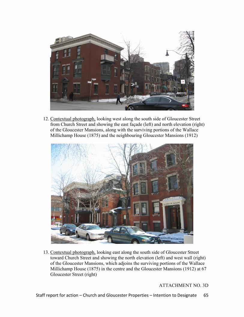
12. Contextual photograph, looking west along the south side of Gloucester Street
from Church Street and showing the east façade (left) and north elevation (right)
of the Gloucester Mansions, along with the surviving portions of the Wallace
Millichamp House (1875) and the neighbouring Gloucester Mansions (1912)
13. Contextual photograph, looking east along the south side of Gloucester Street
toward Church Street and showing the north elevation (left) and west wall (right)
of the Gloucester Mansions, which adjoins the surviving portions of the Wallace
Millichamp House (1875) in the centre and the Gloucester Mansions (1912) at 67
Gloucester Street (right)
ATTACHMENT NO. 3D

Staff report for action – Church and Gloucester Properties – Intention to Designate 66
HERITAGE PROPERTY RESEARCH AND EVALUATION REPORT
GLOUCESTER MANSIONS
67 GLOUCESTER STREET, TORONTO
Prepared by:
Heritage Preservation Services
City Planning Division
City of Toronto
April 2011
Staff report for action – Church and Gloucester Properties – Intention to Designate 67
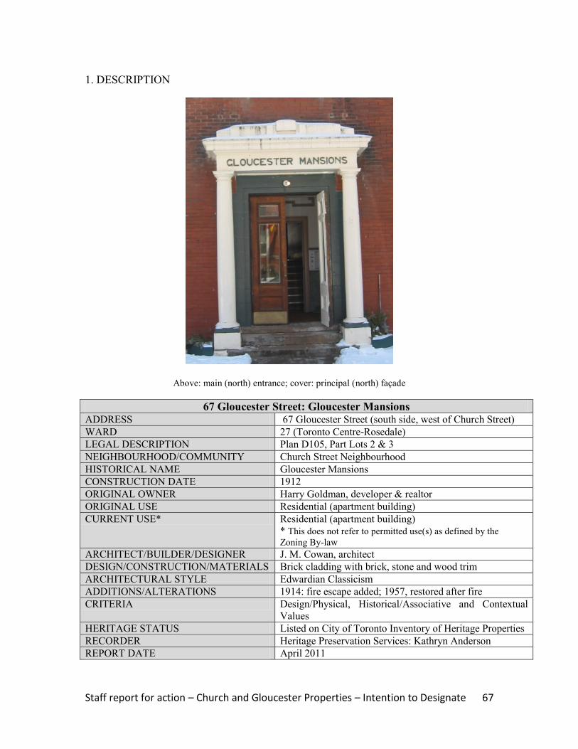
1. DESCRIPTION
Above: main (north) entrance; cover: principal (north) façade
67 Gloucester Street: Gloucester Mansions ADDRESS 67 Gloucester Street (south side, west of Church Street)
WARD 27 (Toronto Centre-Rosedale)
LEGAL DESCRIPTION Plan D105, Part Lots 2 & 3
NEIGHBOURHOOD/COMMUNITY Church Street Neighbourhood
HISTORICAL NAME Gloucester Mansions
CONSTRUCTION DATE 1912
ORIGINAL OWNER Harry Goldman, developer & realtor
ORIGINAL USE Residential (apartment building)
CURRENT USE* Residential (apartment building)
* This does not refer to permitted use(s) as defined by the
Zoning By-law
ARCHITECT/BUILDER/DESIGNER J. M. Cowan, architect
DESIGN/CONSTRUCTION/MATERIALS Brick cladding with brick, stone and wood trim
ARCHITECTURAL STYLE Edwardian Classicism
ADDITIONS/ALTERATIONS 1914: fire escape added; 1957, restored after fire
CRITERIA Design/Physical, Historical/Associative and Contextual
Values
HERITAGE STATUS Listed on City of Toronto Inventory of Heritage Properties
RECORDER Heritage Preservation Services: Kathryn Anderson
REPORT DATE April 2011

Staff report for action – Church and Gloucester Properties – Intention to Designate 68
2. BACKGROUND
This research and evaluation report describes the history, architecture and context of the
property at 67 Gloucester Street, and applies evaluation criteria to determine whether it
merits designation under Part IV, Section 29 of the Ontario Heritage Act. The
conclusions of the research and evaluation are found in Section 4 (Summary).
i. HISTORICAL TIMELINE
Key Date Historical Event
1871 June Plan D105 is registered, including the lots on the southwest corner of Church
& Gloucester Streets
1872 July Wallace Millichamp acquires Lots 1-4 on the southwest corner of Church and
Gloucester Streets, and builds semi-detached houses at present-day 592 Church
Street in 1873
1875 A detached house for Wallace Millichamp is under construction on the
southwest corner of Church & Gloucester Streets; he sells the site immediately
1880 Millichamp's semi-detached and detached houses are shown on Goad`s Atlas
1909 & 1911 In separate transactions, Henry Goldman buys Lots 1-4 with the existing
buildings
1910 Feb Goldman finances the "Gloucester Mansions" at 596 Church Street,
incorporating a portion of the Wallace Millichamp House (1875) at the rear of
the building
1912 Goad's Atlas, updated to 1912, shows the apartment house at 596 Church
Street, while the subject site remains vacant
1912 Apr A building permit is issued for the apartment house at present-day 67
Gloucester
1921 Aug Harry Goldman sells his properties, including 67 Gloucester Street, to David,
Samuel and Arthur Lavine
1923 The update to Goad's Atlas shows the Gloucester Mansions at 67 Gloucester
2009 The Gloucester Mansions at 67 Gloucester Street are listed on the City of
Toronto Inventory of Heritage Properties
ii. HISTORICAL BACKGROUND
Church Street Neighbourhood: Dundonald Estate
The property at 67 Gloucester Street is located in the area between Yonge Street and
Church Street, north of Wellesley Street, which was associated with the Dundonald
Estate. The lands were originally subdivided as part of the series of 100-acre “park lots”
between present-day Queen and Bloor Streets where military personnel and provincial
government administrators established country estates in the late 18th
and early 19th
centuries. Park Lot 8, directly east of Yonge Street, was awarded to Captain George
Playter, while Captain John McGill received the neighbouring Park Lot 7 to the east.
Playter transferred part of his allotment to McGill, whose heir, Peter McCutcheon
McGill, began subdividing the tract in the 1830s when Church Street was extended north
of present-day Queen Street East. By the close of the 19th
century, much of the land was
opened up to residential development, with Church Street as an important central
Staff report for action – Church and Gloucester Properties – Intention to Designate 69
thoroughfare in the neighbourhood. Along with Jarvis Street and Sherbourne Street to
the east, “each of these corridors evolved its own ambience,” ranging from the working
class housing at the south end, to the substantial mansions for Toronto‟s political and
business leaders near Bloor Street to the north, with the “growing middle class of clerks,
accountants, and „travellers‟ settled into more commodious single, double and triple
houses in the centre of the tracts.”17
Goad‟s Atlases for the later 19th
century trace the
development of residential subdivisions in the area adjoining Church Street (Images 4
and 5).
In the early 1840s, Bank of Upper Canada president William Proudfoot acquired acreage
in the area northeast of Yonge Street and Wellesley Street East where his country
residence named “Kearsney House” was completed. The estate is shown on the Boulton
Atlas of 1858 (Image 2) and illustrated in Image 3. Donald Mackay (sic) purchased the
tract in 1869, renaming the property “Dundonald”. Between 1880 and 1903, the
Dundonald Estate is depicted on successive versions of Goad‟s Atlases (Images 4-7).
“Dundonald” was razed in 1904 when developer Frank McMahon registered a residential
subdivision bounded by Yonge, Wellesley, Church and Gloucester Streets under Plan
E250, and laid out Dundonald Street as an east-west street transecting the tract.
67 Gloucester Street: Gloucester Mansions
Plan D105 was registered on the lands adjoining the southwest corner of Church and
Gloucester Streets in 1871 and, within two years, Lots 1 through 4 were acquired by
Wallace Millichamp. A showcase manufacturer and two-term City alderman,
Millichamp directed the construction of semi-detached houses (now known as 592
Church) on his Church Street frontage in 1873, followed two years later by a detached
house form building on the southwest corner of Church and Gloucester. Millichamp's
properties are illustrated on the Goad's Atlases of the era, which are reproduced in
Section 6 of this report (Images 4-8).
In transactions dated 1909 and 1911, Toronto developer and realtor Henry Goldman
acquired Lots 1-4, including the previously undeveloped site on the south side of
Gloucester Street, west of the Wallace Millichamp House (1875). In 1910, Goldman
demolished part of the latter structure, retaining the rear sections as apartment units, and
authorized the construction of an apartment building named “Gloucester Mansions” at
596 Church Street. Two years later, Goldman‟s representative received building permits
to convert the semi-detached houses at 592 Church into apartment suites and to erect a
second apartment house, also known as “Gloucester Mansions” on Gloucester Street.
With the completion of the latter building, an enclave of apartment buildings, consisting
of single, double and multiple residential buildings, was in place on the southwest corner
of Church and Gloucester Streets. Goldman retained the group of properties, including
67 Gloucester Street, until 1921 when he transferred them to David, Samuel and Arthur
Lavine, who specialized in the development and management of apartment buildings in
Toronto during the World War I era.
17
McHugh 151

Staff report for action – Church and Gloucester Properties – Intention to Designate 70
The Gloucester Mansions were designed by Toronto architect J. M. Cowan. After
receiving training with the local architectural firms of Beaumont Jarvis and Ellis and
Connery, James Michael Cowan (1880-1941) opened a solo practice in 1907. "Much of
his career was devoted to ecclesiastical works for the Roman Catholic Diocese of
Toronto, where he held the post of Architect to the Separate School Board…."18
St.
Vincent de Paul Roman Catholic Church (completed in 1923) at 263 Roncesvalles
Avenue is among Cowan's best-known projects in Toronto, which is also recognized on
the City's heritage inventory.
iii. ARCHITECTURAL DESCRIPTION
The Gloucester Mansions at 67 Gloucester Street display features associated with
Edwardian Classicism, the most popular architectural style in the early 20th
century.
With compositions typically blending symmetry, subdued brickwork and classical
embellishments, the style "restored simplicity and order to domestic architecture".19
As illustrated by the photographs on the cover and in Section 6 of this report, the
Gloucester Mansions rise three stories above a raised base and feature an "I"-shaped plan.
Clad with red brick and trimmed with artificial stone and wood, the structure has a flat
roofline with stone coping. The principal (north) façade on Gloucester Street is
organized into five bays with a central entrance. The north entry has paired wood doors
with glazing that are set in a flat-headed surround and protected by an open porch with
classical detailing and a name band reading "Gloucester Mansions." Above the entrance,
the upper floors contain flat-headed window openings with stone surrounds with quoins
and corbelled sills. The bays flanking the entry display single flat-headed window
openings with labels and corbelled sills, while the outer bays have bay windows with
stone surrounds. Many of the openings contain multi-paned six-over-one sash windows.
The symmetrical placement of the fenestration continues on the side elevations (east and
west) that are visible from Gloucester Street.
iv. CONTEXT
Placed on the south side of Gloucester Street, west of Church Street, the location of the
Gloucester Mansions is shown on the property data map below (Image 1) and in the
context photographs (Images 11-13). The site occupies a small portion of the former
Dundonald Estate where the Paul Kane House (1854) at 56 Wellesley Street East is
designated under Part IV, Section 29 of the Ontario Heritage Act. Three detached house
form buildings on the south side of Gloucester Street that date to the late 19th
century are
also recognized on the City of Toronto Inventory of Heritage Properties. In the
immediate Church Street neighbourhood, north and south of the intersection of Church
and Gloucester Streets, the row houses at #551-555, #561-566 and #569-573 Church are
included on the City‟s heritage inventory. The former Granite Curling Club (1906) at
18
Biographical Dictionary of Architects in Canada, unpaged 19
Blumenson, 166
Staff report for action – Church and Gloucester Properties – Intention to Designate 71
519 Church, where it is more recently known as the 519 Church Community Centre, is a
designated heritage property and a neighbourhood landmark.
The Gloucester Mansions at 67 Gloucester Street form part of an extended block at
Church and Gloucester Streets that contains a group of single, double and multiple
residential buildings, most of which are identified on the City of Toronto Inventory of
Heritage Properties. On the west side of Church, between Gloucester Street (north) and
Dundonald Street (south), the William St. Croix Houses at 580-582 Church anchor the
south end of the block and, further north, the Wallace Millichamp Houses (1873) stand at
592 Church with the Gloucester Mansions at 596 Church. At the west end of the latter
building, portions of the Wallace Millichamp House (1875) remain at 69 Gloucester.
Apart from the properties at 580-582 Church, the enclave of buildings described above
has served as apartment suites since the early 20th
century, with 67 Gloucester as the final
piece of the complex.
3. EVALUATION CHECKLIST
The following evaluation applies Ontario Regulation 9/06 made under the Ontario
Heritage Act: Criteria for Determining Cultural Heritage Value or Interest. While the
criteria are prescribed for municipal designation under Part IV, Section 29 of the Ontario
Heritage Act, the City of Toronto uses it when assessing properties for inclusion on the
City of Toronto Inventory of Heritage Properties. The evaluation table is marked “N/A”
if the criterion is “not applicable” to the property or X if it is applicable, with explanatory
text below.
Design or Physical Value i. rare, unique, representative or early example of a style, type, expression,
material or construction method X
ii. displays high degree of craftsmanship or artistic merit N/A iii. demonstrates high degree of scientific or technical achievement N/A
Representative and Early Example – The Gloucester Mansions are a representative
example of an early 20th
century low-rise apartment building designed with features of
Edwardian Classicism, the most popular style for residential architecture in the World
War I era. The complex is distinguished by its articulated façade on Gloucester Street,
which displays full-height bay windows and fenestration that is highlighted by stone
detailing.
Historical or Associative Value i. direct associations with a theme, event, belief, person, activity, organization or
institution that is significant to a community N/A
ii. yields, or has the potential to yield, information that contributes to an
understanding of a community or culture N/A
iii. demonstrates or reflects the work or ideas of an architect, artist, builder,
designer or theorist who is significant to a community X

Staff report for action – Church and Gloucester Properties – Intention to Designate 72
The property at 67 Gloucester Street is associated with Toronto architect J. M. Cowan.
While his well-documented career focused on churches, schools and related buildings for
the Roman Catholic Archdiocese of Toronto, the Gloucester Mansions are a rare example
of an apartment building designed by the architect.20
Contextual Value i. important in defining, maintaining or supporting the character of an area N/A ii. physically, functionally, visually or historically linked to its surroundings X iii. landmark N/A
Surroundings – The Gloucester Mansions at 67 Gloucester Street are historically linked
to their surroundings adjoining Church and Gloucester Streets where they contribute to
the group of detached and semi-detached house form buildings and low-rise apartment
houses from the late 1800s and the pre-World War I era that represent the evolution and
residential development of the former Dundonald Estate.
4. SUMMARY
Following research and evaluation according to Regulation 9/06, it has been determined
that the property at 67 Gloucester Street has design, associative and contextual values.
The Gloucester Mansions retain their integrity as a representative example of an
apartment house designed with Edwardian Classical styling by Toronto architect J. M.
Cowan that contributes to the collection of late 19th-
and early 20th-
century residential
buildings along Church and Gloucester Streets on the former Dundonald Estate to which
they are historically related.
5. SOURCES
Archival Sources
Abstract Index of Deeds, Plan D105, Lots 1-4
Assessment Rolls, City of Toronto, St. James Ward, 1872-91, and Ward 3, Division 3,
1892 ff.
Boulton Atlas, 1858
Building Permits #33282 (April 13, 1912) and 39732 (March 21, 1914), City of Toronto
Archives
Building Records, Toronto and East York, 1914-1982
City of Toronto Directories, 1871 ff.
Goad‟s Atlases, 1880, 1894, 1903, and 1910 revised to 1912 and 1923
Books and Newspapers
Arthur, Eric, Toronto: no mean city, 3rd
ed., revised by Stephen A. Otto, 1986
20
Biographical Dictionary of Architects in Canada, unpaged
Staff report for action – Church and Gloucester Properties – Intention to Designate 73
Blumenson, John, Ontario Architecture, 1990
“Goldman sells two apartments and buys one,” Toronto Daily Star (March 14, 1927)
Lundell, Liz, The Estates of Old Toronto, 1997
Maitland, Leslie, Jacqueline Hucker and Shannon Ricketts, A Guide to Canadian
Architectural Styles, 1992
McHugh, Patricia, Toronto Architecture: a city guide, 2nd
ed., 1989
Cameron, Christina, and Janet Wright, Second Empire Style in Canada, 1980
Other
"James Michael Cowan," entry in The Biographical Dictionary of Architects in Canada,
1800-1950, www.dictionaryofarchitectsincanada.org
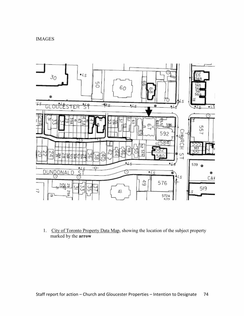
Staff report for action – Church and Gloucester Properties – Intention to Designate 74
IMAGES
1. City of Toronto Property Data Map, showing the location of the subject property
marked by the arrow

Staff report for action – Church and Gloucester Properties – Intention to Designate 75
2. Boulton Atlas, 1858, showing the layout of the Dundonald Estate (“Dundonald” is
marked by the arrow) and the partial subdivision of lands at Church and Gloucester
Streets (Toronto Reference Library)
3. Illustration, Kearnsey House, later known as “Dundonald”, with its location shown on
the map in Image 2 (Toronto Reference Library, #3716)

Staff report for action – Church and Gloucester Properties – Intention to Designate 76
4. Goad‟s Atlas, 1880, with the arrow marking the future location of the Gloucester
Mansions at 67 Gloucester Street
5. Goad‟s Atlas, 1894, showing the status of the site, where there have been no changes
since the 1880 map (Image 4). The arrow marks the future location of the apartment
house
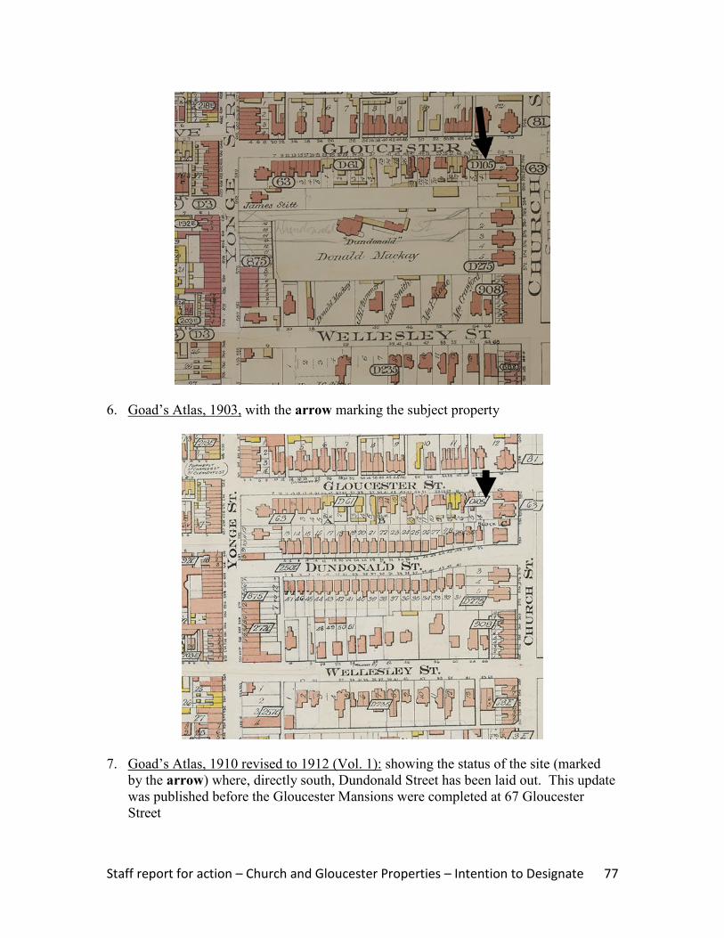
Staff report for action – Church and Gloucester Properties – Intention to Designate 77
6. Goad‟s Atlas, 1903, with the arrow marking the subject property
7. Goad‟s Atlas, 1910 revised to 1912 (Vol. 1): showing the status of the site (marked
by the arrow) where, directly south, Dundonald Street has been laid out. This update
was published before the Gloucester Mansions were completed at 67 Gloucester
Street
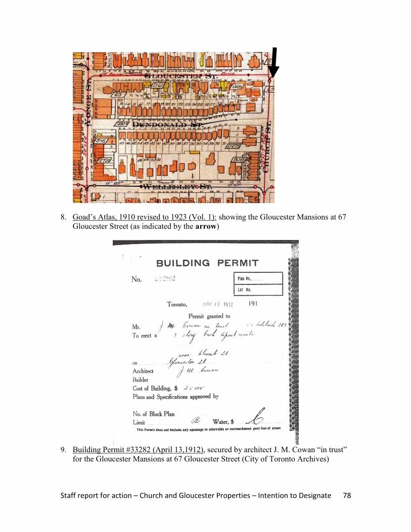
Staff report for action – Church and Gloucester Properties – Intention to Designate 78
8. Goad‟s Atlas, 1910 revised to 1923 (Vol. 1): showing the Gloucester Mansions at 67
Gloucester Street (as indicated by the arrow)
9. Building Permit #33282 (April 13,1912), secured by architect J. M. Cowan “in trust”
for the Gloucester Mansions at 67 Gloucester Street (City of Toronto Archives)
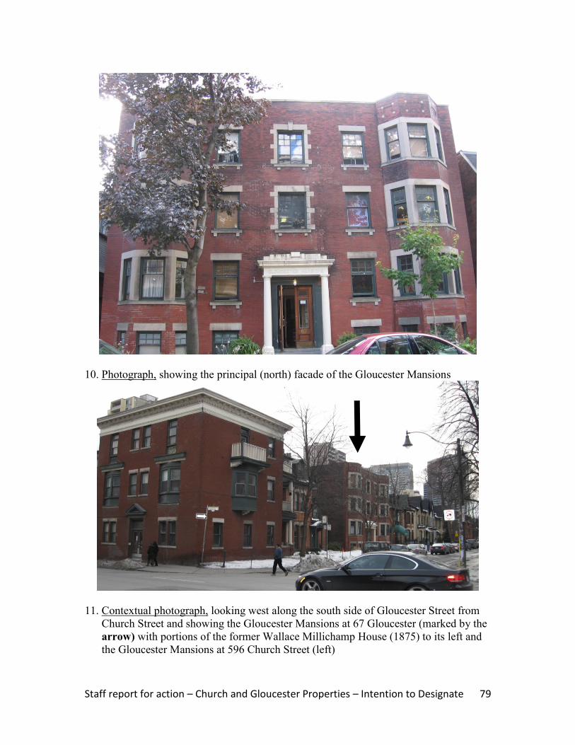
Staff report for action – Church and Gloucester Properties – Intention to Designate 79
10. Photograph, showing the principal (north) facade of the Gloucester Mansions
11. Contextual photograph, looking west along the south side of Gloucester Street from
Church Street and showing the Gloucester Mansions at 67 Gloucester (marked by the
arrow) with portions of the former Wallace Millichamp House (1875) to its left and
the Gloucester Mansions at 596 Church Street (left)

Staff report for action – Church and Gloucester Properties – Intention to Designate 80
12. Contextual photograph, looking east along the south side of Gloucester Street toward
Church Street and showing the Gloucester Mansions at 67 Gloucester on the right
13. Contextual Photograph, showing the west side of Church Street and looking south
toward Dundonald Street from Gloucester Street. The Gloucester Mansions at 596
Church (right) anchor the north end of the block, with the Wallace Millichamp
Houses (1873) in the centre and the William St. Croix Houses (580-582 Church
Street, left) at the corner of Dundonald Street

Staff report for action – Church and Gloucester Properties – Intention to Designate 81
ATTACHMENT NO. 3E
HERITAGE PROPERTY RESEARCH AND EVALUATION REPORT
WALLACE MILLICHAMP HOUSE (1875)
69 GLOUCESTER STREET, TORONTO
Prepared by:
Heritage Preservation Services
City Planning Division
City of Toronto
April 2011
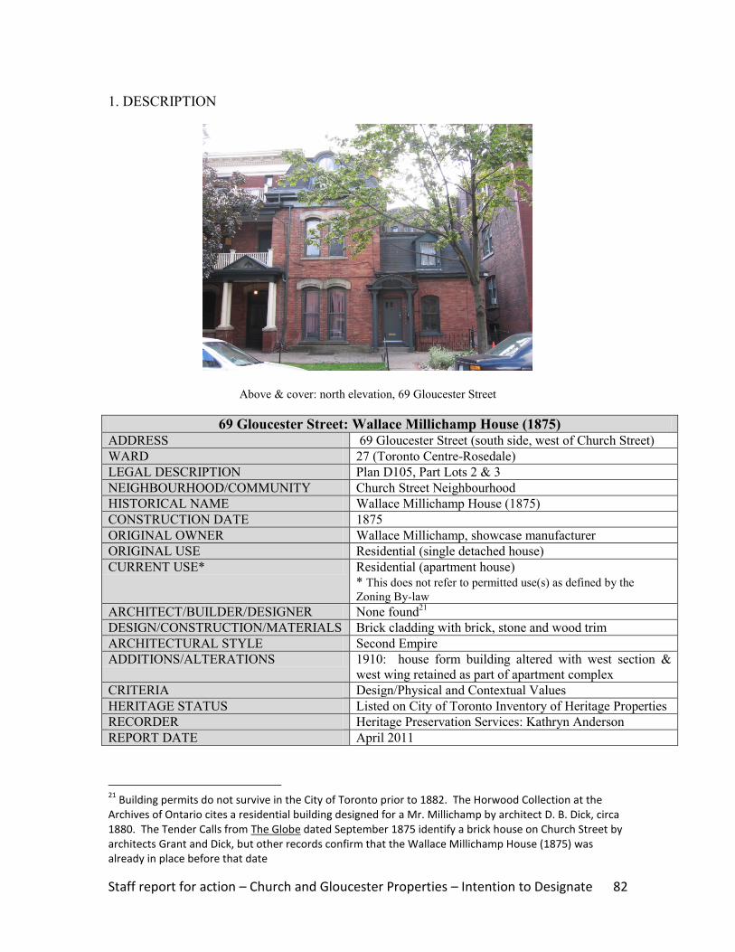
Staff report for action – Church and Gloucester Properties – Intention to Designate 82
1. DESCRIPTION
Above & cover: north elevation, 69 Gloucester Street
69 Gloucester Street: Wallace Millichamp House (1875) ADDRESS 69 Gloucester Street (south side, west of Church Street)
WARD 27 (Toronto Centre-Rosedale)
LEGAL DESCRIPTION Plan D105, Part Lots 2 & 3
NEIGHBOURHOOD/COMMUNITY Church Street Neighbourhood
HISTORICAL NAME Wallace Millichamp House (1875)
CONSTRUCTION DATE 1875
ORIGINAL OWNER Wallace Millichamp, showcase manufacturer
ORIGINAL USE Residential (single detached house)
CURRENT USE* Residential (apartment house)
* This does not refer to permitted use(s) as defined by the
Zoning By-law
ARCHITECT/BUILDER/DESIGNER None found21
DESIGN/CONSTRUCTION/MATERIALS Brick cladding with brick, stone and wood trim
ARCHITECTURAL STYLE Second Empire
ADDITIONS/ALTERATIONS 1910: house form building altered with west section &
west wing retained as part of apartment complex
CRITERIA Design/Physical and Contextual Values
HERITAGE STATUS Listed on City of Toronto Inventory of Heritage Properties
RECORDER Heritage Preservation Services: Kathryn Anderson
REPORT DATE April 2011
21
Building permits do not survive in the City of Toronto prior to 1882. The Horwood Collection at the Archives of Ontario cites a residential building designed for a Mr. Millichamp by architect D. B. Dick, circa 1880. The Tender Calls from The Globe dated September 1875 identify a brick house on Church Street by architects Grant and Dick, but other records confirm that the Wallace Millichamp House (1875) was already in place before that date

Staff report for action – Church and Gloucester Properties – Intention to Designate 83
2. BACKGROUND
This research and evaluation report describes the history, architecture and context of the
property at 69 Gloucester Street, and applies evaluation criteria to determine whether it
merits designation under Part IV, Section 29 of the Ontario Heritage Act. The
conclusions of the research and evaluation are found in Section 4 (Summary).
i. HISTORICAL TIMELINE
Key Date Historical Event
1871 June Plan D105 is registered, subdividing the lots along Church & Gloucester
Streets
1872 July Wallace Millichamp acquires Lots 1-4 on the southwest corner of Church and
Gloucester Streets
1873 Millichamp commissions a pair of semi-detached house form buildings on
Church Street, south of Gloucester, which are now known as 592 Church
1874 Apr The property on the southwest corner of Church and Gloucester Street remains
vacant
187522
A 2½-storey brick house with extensions is recorded as "unfinished" on the
subject property and valued at $3000
1875 Aug Millichamp sells the subject site to Sallie A. Priestman for $7000
1876 Apr The detached house form building identified as "71 Gloucester" is occupied by
Joseph Priestman and valued at $3200
1880 The detached house form building is illustrated on Goad‟s Atlas
1886 Priestman sells the property to Minerva Bate; the site is sold again in 1894 and
twice in 1906, with the house rented to a series of occupants (when it is known
as "69 & 71 Gloucester")
1909 & 1911 In separate transactions, Henry Goldman purchases Lots 1-4, including the
Wallace Millichamp House (1875)
1910 Feb Goldman receives a building permit for “altering building into apartments” at
71 Gloucester Street, whereby the west portions of the detached house are
attached to the "Gloucester Mansions," a new apartment building at 596
Church Street
1912 The surviving portions of the Wallace Millichamp House (1875) at the rear of
the Gloucester Mansions are illustrated on the update to Goad's Atlas
1921 Aug Harry Goldman sells his properties at Church & Gloucester to David, Samuel
and Arthur Lavine, including the surviving portions of the Wallace Millichamp
House (1875)
2009 The property at 69 Gloucester Street, comprised of the rear (west) portion &
wing of the Wallace Millichamp House (1875), is listed on the City of Toronto
Inventory of Heritage Properties
22
The Assessment Roll does not indicate the month, but it is likely to have been "April" given the consistency of the other volumes during the 1870s; the small increase in value from 1875 to 1876 suggests that the building was near completion when the tax roll was compiled
Staff report for action – Church and Gloucester Properties – Intention to Designate 84
ii. HISTORICAL BACKGROUND
Church Street Neighbourhood: Dundonald Estate
The property at 69 Gloucester Street is located in the area between Yonge Street and
Church Street, north of Wellesley Street, which was associated with the Dundonald
Estate. The lands were originally subdivided as part of the series of 100-acre “park lots”
between present-day Queen and Bloor Streets where military personnel and provincial
government administrators established country estates in the late 18th
and early 19th
centuries. Captain George Playter received Park Lot 8, directly east of Yonge Street,
while the neighbouring Park Lot 7 to the east was granted to Captain John McGill.
Playter transferred part of his allotment to McGill, whose heir, Peter McCutcheon
McGill, began subdividing the lands in the1830s when Church Street was extended north
of present-day Queen Street East. By the close of the 19th
century, Church Street was the
main thoroughfare through the residential neighbourhood. Along with Jarvis Street and
Sherbourne Street to the east, “each of these corridors evolved its own ambience,”
ranging from the working class areas at the south end, to the substantial mansions of
prominent Toronto businessmen and politicians near Bloor Street to the north, with “the
growing middle class of clerks, accountants, and „travellers‟ settled into more
commodious single, double and triple houses in the centre of the tracts.”23
Goad‟s
Atlases for the later 19th
century trace the subdivisions, including the partitioning of the
lands along the edges of Church and Gloucester Streets (Image 4 and 5).
In the early 1840s, Bank of Upper Canada president William Proudfoot acquired acreage
in the area northeast of Yonge Street & Wellesley Street where his country residence
named “Kearsney House” was completed. The estate is shown on the Boulton Atlas of
1858 (Image 2) and illustrated in Image 3. Donald Mackay (sic) purchased the tract in
1869, renaming the property “Dundonald”. Between 1880 and 1903, the Dundonald
Estate is depicted on successive versions of Goad‟s Atlases (Images 4-6), which also
trace the development of the estate lands. “Dundonald” was razed in 1904 when
developer Frank McMahon registered a residential subdivision under Plan E250, and laid
out Dundonald Street as an east-west street transecting the tract.
69 Gloucester Street: Wallace Millichamp House (1875)
Following the registration of Plan D105 in 1871, Wallace Millichamp acquired four lots
on the southwest corner of Church and Gloucester Streets. A showcase manufacturer and
two-term City alderman, Millichamp commissioned a pair of semi-detached house form
buildings (now known as 592 Church) on his Church Street frontage, south of Gloucester
Street, in 1873. He initially rented both residences, but moved into and occupied the
south unit for a 20-year period at the close of the 1800s. In 1875, Millichamp authorized
the construction of a detached house form building on the southwest corner of Church
23
McHugh 151
Staff report for action – Church and Gloucester Properties – Intention to Designate 85
and Gloucester, which was originally known as “71Gloucester Street.” There is no
evidence that Millichamp resided on-site, as he immediately sold the property to Sallie A.
Priestman. Sallie and her husband, Joseph Priestman lived in the house for a decade,
after which the property changed hands and was rented to a series of tenants. The site is
illustrated on Goad‟s Atlases beginning in 1880, some of which are reproduced in Section
6 of this report (Images 4-8).
In September 1909, developer and realtor Henry Goldman acquired the property at the
southwest corner of Church and Gloucester Streets, including the Wallace Millichamp
House (1875). A building permit valued at $10,000 was issued to Goldman in February
1910, authorizing the “altering dwelling to apartments.” The construction of a three-
storey apartment building close to Church Street resulted in the demolition of the east
section of the house form building, but retained the 2½-storey rear portion with the 1½-
storey wing (Image 9). By September, the tax evaluation for the site described 71
Gloucester as an “unfinished house”. When the properties were assessed the following
year, Goldman and his family resided at 71 Gloucester (the west part of the house), while
the wing contained apartment suites. With the “Gloucester Mansions” at 596 Church
tenanted, by the end of 1912 Goldman had converted the former Wallace Millichamp
Houses (1873) at 592 Church Street into apartment units and completed a detached
apartment house, also known as the “Gloucester Mansions”, at 67 Gloucester Street.
Goldman retained the group of buildings, including present-day 69 Gloucester, until 1921
when he transferred them to David, Samuel and Arthur Lavine, who specialized in the
development and management of apartment buildings in Toronto during the World War I
era.
iii. ARCHITECTURAL DESCRIPTION
The surviving portions of the Wallace Millichamp House (1875) consist of the 2½ storey
west part of the main house and, to its west, the 1½-storey wing. With their distinctive
mansard (double-gable) roofs, the structures reflect the Second Empire style that was
popular during the period of construction and also employed on the Wallace Millichamp
Houses (1873), the neighbouring semi-detached house form buildings now known as 592
Church Street. Second Empire styling originated in mid 19th
century France when the
New Louvre was unveiled. Blending elements from classical French design and Italian
Renaissance prototypes, the style was named for the reign of Napoleon III. Introduced to
North America where it was initially favoured for intuitional buildings, in Toronto the
first residential application of the style was Government House (1870), the Lieutenant-
Governor of Ontario‟s residence at King Street West and Simcoe Street (now the location
of Roy Thomson Hall). The Second Empire style appeared on house form buildings in
the city‟s fashionable neighbourhoods, including Church Street.
The Wallace Millichamp House (1875) features red brick cladding with brick and stone
trim. The mansard roofs covering the 2½-storey rear section of the dwelling and the 1½-
storey west wing feature segmental-arched and gabled dormers, with extended eaves with
brackets and a brick chimney (west) on the house. With the alterations that converted the
structures into apartment suites, the main entrance is placed on the north wall of the wing,
Staff report for action – Church and Gloucester Properties – Intention to Designate 86
where a flat-headed opening is protected by a segmental-arched pediment on piers. The
tall segmental-arched window openings feature stone hood moulds on the house, brick
voussoirs on the wing, and stone sills. The surviving portion of the house is attached to
the rear (west) end of the Gloucester Mansions at 596 Church Street.
iv. CONTEXT
The Wallace Millichamp House (1875) is located on the south side of Gloucester Street,
west of Church Street, where its location is shown on the property data map below
(Image 1) and in the contextual photographs (Images 11-13). The site occupies a small
portion of the former Dundonald Estate where the Paul Kane House (1854) at 56
Wellesley Street East is designated under Part IV, Section 29 of the Ontario Heritage Act.
West of the Wallace Millichamp House (1875), three detached house form buildings on
the south side of Gloucester Street that date to the late 19th
century are also recognized on
the City of Toronto Inventory of Heritage Properties. In the immediate Church Street
neighbourhood, north and south of the intersection of Church and Gloucester Streets, the
row houses at #551-555, #561-566 and #569-573 Church are included on the City‟s
heritage inventory. The former Granite Curling Club (1906) at 519 Church, where it is
more recently known as the 519 Church Community Centre, is a designated heritage
property and a neighbourhood landmark.
The Wallace Millichamp House (1873), now identified as 69 Gloucester Street, forms
part of an extended block at Church and Gloucester Streets that contains a group of
single, double and multiple residential buildings, most of which are identified on the City
of Toronto Inventory of Heritage Properties. On the west side of Church, between
Gloucester Street (north) and Dundonald Street (south), the William St. Croix Houses at
580-582 Church anchor the south end of the block, where they are joined by the Wallace
Millichamp Houses (1873) at 592 Church and the Gloucester Mansions at 596 Church.
The latter two properties adjoin the surviving portions of the Wallace Millichamp House
(1875) at 69 Gloucester, as well as the Gloucester Mansions at 67 Gloucester, to form an
enclave of buildings that have served as apartment houses since the early 20th
century.
3. EVALUATION CHECKLIST
The following evaluation applies Ontario Regulation 9/06 made under the Ontario
Heritage Act: Criteria for Determining Cultural Heritage Value or Interest. While the
criteria are prescribed for municipal designation under Part IV, Section 29 of the Ontario
Heritage Act, the City of Toronto uses it when assessing properties for inclusion on the
City of Toronto Inventory of Heritage Properties. The evaluation table is marked “N/A”
if the criterion is “not applicable” to the property or X if it is applicable, with explanatory
text below.

Staff report for action – Church and Gloucester Properties – Intention to Designate 87
Design or Physical Value i. rare, unique, representative or early example of a style, type, expression,
material or construction method X
ii. displays high degree of craftsmanship or artistic merit N/A iii. demonstrates high degree of scientific or technical achievement N/A
Representative and Early Example – The surviving portions of the Wallace
Millichamp House (1875) are representative examples of late 19th
century house form
buildings designed in the Second Empire style that are distinguished by their design,
mansard roofs and decorative detailing.
With the changes to the Church Street neighbourhood and the loss of many of the
residential buildings that characterized its development, the William Millichamp House
(1875) is an important surviving example of Second Empire styling that is complemented
by the neighbouring Wallace Millichamp Houses (1875) at 592 Church Street and the
William St. Croix Houses at 580-582 Church that share its scale and distinctive mansard
roofs.
Historical or Associative Value i. direct associations with a theme, event, belief, person, activity, organization or
institution that is significant to a community N/A
ii. yields, or has the potential to yield, information that contributes to an
understanding of a community or culture N/A
iii. demonstrates or reflects the work or ideas of an architect, artist, builder,
designer or theorist who is significant to a community N/A
No historical or associative values have been identified for the property at 69 Gloucester
Street. A further examination of architect D. B. Dick's possible connection to the site
may result in the addition of an associative value.
Contextual Value i. important in defining, maintaining or supporting the character of an area N/A ii. physically, functionally, visually or historically linked to its surroundings X iii. landmark N/A
Surroundings – The Wallace Millichamp House (1875) is historically linked to its
surroundings on Gloucester Street, west of Church Street, where it contributes to the
group of low-rise buildings from the late 1800s to the pre-World War I era that represent
the development and evolution of the neighbourhood adjoining Church and Gloucester
Street on the former Dundonald Estate.

Staff report for action – Church and Gloucester Properties – Intention to Designate 88
4. SUMMARY
Following research and evaluation according to Regulation 9/06, it has been determined
that the property at 67 Gloucester Street has design and contextual values. The Wallace
Millichamp House (1875) retains its integrity as a surviving example of residential design
with Second Empire styling that complements the adjoining buildings at 580-582 and 592
Church Street, and also contributes to the collection of late 19th-
and early 20th-
century
residential buildings that adjoin the corner of Church and Gloucester Street on the former
Dundonald Estate and to which it is historically related.
5. SOURCES
Archival Sources
Abstract Index of Deeds, Plan D105, Lots 1-4
Assessment Rolls, City of Toronto, St. James Ward, 1872-91, and Ward 3, Division 3,
1892 ff.
Boulton Atlas, 1858
Building Permit #18971 (February 10, 1910), City of Toronto Archives
Building Records, Toronto and East York, 1914-1982
City of Toronto Directories, 1871 ff.
Goad‟s Atlases, 1880, 1884, 1894, 1903, and 1910 revised to 1912 and 1923
Books and Newspapers
Arthur, Eric, Toronto: no mean city, 3rd
ed., revised by Stephen A. Otto, 1986
Blumenson, John, Ontario Architecture, 1990
“City news” (Wallace Millichamp‟s candidacy for alderman), The Evening Star
(September 18, 1896)
“Goldman sells two apartments and buys one,” Toronto Daily Star (March 14, 1927)
Lundell, Liz, The Estates of Old Toronto, 1997
Maitland, Leslie, Jacqueline Hucker and Shannon Ricketts, A Guide to Canadian
Architectural Styles, 1992
McHugh, Patricia, Toronto Architecture: a city guide, 2nd
ed., 1989
Cameron, Christina, and Janet Wright, Second Empire Style in Canada, 1980
“Tender Calls,” The Globe (September 29, 1875)
“Wallace Millichamp‟s estate worth $141, 885,” Toronto Daily Star (September 12,
1917)
Other
“David Brash Dick” and "Samuel A. Waggett," entries in The Biographical Dictionary of
Architects in Canada, 1800-1950, www.dictionaryofarchitectsincanada.org
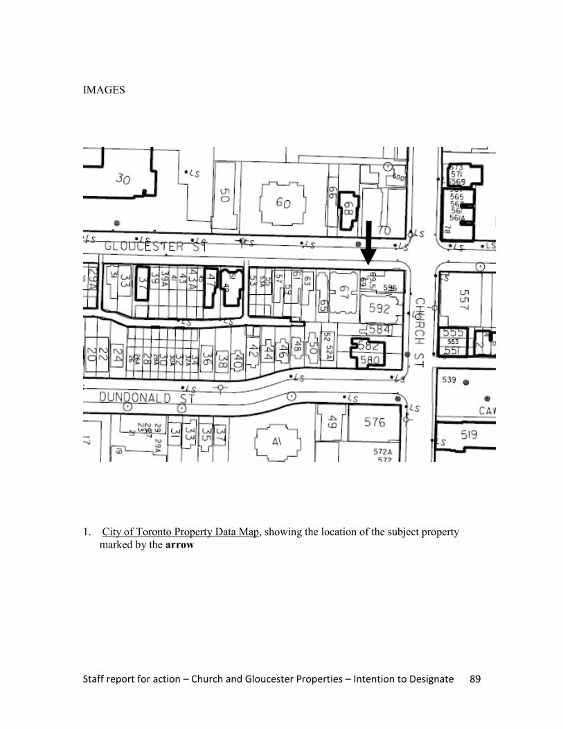
Staff report for action – Church and Gloucester Properties – Intention to Designate 89
IMAGES
1. City of Toronto Property Data Map, showing the location of the subject property
marked by the arrow

Staff report for action – Church and Gloucester Properties – Intention to Designate 90
2. Boulton Atlas, 1858, showing the layout of the Dundonald Estate ("Dundonald" is
marked by the arrow) and the partial subdivision of lands at Church Street and
Gloucester Street (Toronto Reference Library)
3. Illustration, Kearnsey House, later known as “Dundonald”, with its location shown on
the map in Image 2 (Toronto Reference Library, #3716)

Staff report for action – Church and Gloucester Properties – Intention to Designate 91
4. Goad‟s Atlas, 1880, with the arrow marking the location of the Wallace Millichamp
House (1875)
5. Goad‟s Atlas, 1894, showing the status of the site, identified as 69 & 71 Gloucester
Street (the building then contained tenants). The arrow marks the location of the
property

Staff report for action – Church and Gloucester Properties – Intention to Designate 92
6. Goad‟s Atlas, 1903, with the arrow marking the subject property
7. Goad‟s Atlas, 1910 revised to 1912 (Vol. 1): showing the status of the site (marked
by the arrow) where part of the Wallace Millichamp House (1875) has been replaced
by the Gloucester Mansions (showing the east wall built out to Church Street). To the
south, Dundonald Street has been laid out
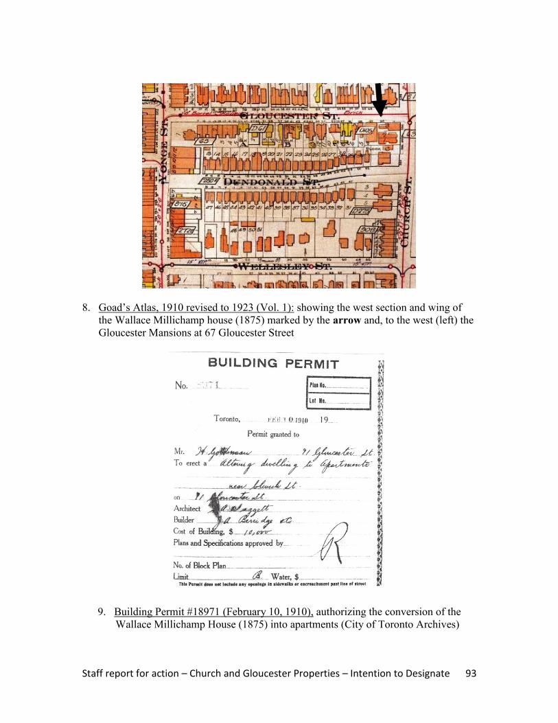
Staff report for action – Church and Gloucester Properties – Intention to Designate 93
8. Goad‟s Atlas, 1910 revised to 1923 (Vol. 1): showing the west section and wing of
the Wallace Millichamp house (1875) marked by the arrow and, to the west (left) the
Gloucester Mansions at 67 Gloucester Street
9. Building Permit #18971 (February 10, 1910), authorizing the conversion of the
Wallace Millichamp House (1875) into apartments (City of Toronto Archives)

Staff report for action – Church and Gloucester Properties – Intention to Designate 94
10. Photograph, showing the north elevation of the west section and wing of the Wallace
Millichamp House (1875) on the right where it adjoins the rear (west) wall of the
Gloucester Mansions at 596 Church Street (left)
11. Contextual photograph, looking west along the south side of Gloucester Street from
Church Street and showing the north elevations of the surviving portions of the
Wallace Millichamp House (1875) (centre), with the apartment buildings at 596
Church Street (left) and 67 Gloucester Street (right)
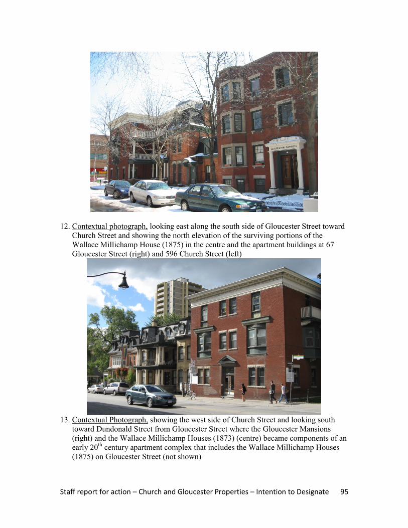
Staff report for action – Church and Gloucester Properties – Intention to Designate 95
12. Contextual photograph, looking east along the south side of Gloucester Street toward
Church Street and showing the north elevation of the surviving portions of the
Wallace Millichamp House (1875) in the centre and the apartment buildings at 67
Gloucester Street (right) and 596 Church Street (left)
13. Contextual Photograph, showing the west side of Church Street and looking south
toward Dundonald Street from Gloucester Street where the Gloucester Mansions
(right) and the Wallace Millichamp Houses (1873) (centre) became components of an
early 20th
century apartment complex that includes the Wallace Millichamp Houses
(1875) on Gloucester Street (not shown)
Top Related