


Languages
Pages
Legal


237
237
82
237
203
203
203
86
30
30
30
84
84
!
!
!
Bus with bike carrier service available between Baker, La Grande, Haines, and North Powder. www.neotransit.org
CatherineCreekState Park
HilgardJunctionState Park
Eagle Hot Lake RV Park
Smooth unpavedroad section(1.5 mi)
Heavytraffic
Continue straight on Pocahontas Rd./Anthony Lakes Hwy
Powder
River
Grande
River
Ronde
EL
KH
OR
N
MO
UN
TA
I NS
E A G L E C A PM O U N T A I N Ssummit
Lower Cove Rd
Hw
y
La G
rand
e-Ba
ker H
wy
An
tho
ny Lakes
Medical Springs
Market Ln
Co
ve Hw
y
Pocah
on
tas Rd
Pocahantas Rd
Booth Ln
Lower Cove Rd
Rd
Hw
y
Hw
y
La G
rand
e-Ba
ker H
wy
An
tho
ny Lakes
Atw
oo
d/L
ind
ley65
55 60
50
45
40
35
30
Start/End
25
20
70
75
80
85
90
95
100
105
110
115
120125
130
5
10
15
LaGrande
Union
CoveIslandCity
North Powder
Pondosa
Baker City
Haines
X
X
X
X
X
X
X
X
X
X
X
X
X X
X
X
X
X
X
X
X
X
X
X
X
X
X
X
Grande TourScenic Bikeway
State Parks and Rec. Info (800) 551-6949
www.RideOregonRide.com/GrandeTour
State Park Reservations(800) 452-5687 N
Mileage fromstart of route
Inset mapson next page
Food Restrooms
Drinking water
Day useparking
25
Lodging Campground
Fullservices
Conveniencestore
! Caution
Transitstation
Bikeway X
0 10 miles5
5 10 15 km
Elev
atio
n (f
eet)
CoveUnion
Union Baker
La Grande/Island City
summit
NorthPowder
Pondosa
La Grande/Island City
Elevation (meters)
2,500
3,500
3,000
4,500
4,000
0
0
10 20 30 40 50 60 70 80 90 100 110 120 130 mi.
Elevation Profile
20 40 60 80 200 km100 140 160 180120
800
1,200
1,400
1,000
RiversidePark
October, 2015
WALLOWA-
WHITMAN
NATIONAL
FOREST
WALLOWA-
WHITMAN
NATIONAL
FOREST

X
X
X
X
X
X
X
X
X
X
XXX
X
X
X X
X X
X
X
X
X
X
X
X
X
XXX
X
X
X X X
X
X
X
X
X
X
X
X
X
XXX
X
X
X X
X X
X
X
X
X X
X
X
X
X
X
X
X
X
18
17
105
104
237
203
203 237
Co
ve Hw
y
N M
ain St
S Main
St
E Beakman
La Grande - Baker Hwy
W Bryan Ave
W Delta Ave
W Grande St
W Arch St
S 10th St
N 10th
St
E Bryan Ave
Medical Springs Hwy
Union
UnionCity Park
0
0.5 km.
0.5 mi.
Creek
Catherine
X
X
X
X
X
X
X
X
X
X
XXX
X
X
X X
X X
X
X
X
X
X
X
X
X
XXX
X
X
X X X
X
X
X
X
X
X
X
X
X
XXX
X
X
X X
X X
X
X
X
X X
X X
X
X
X
X
X
XX
X
113112
115
114
111
110
X116
237
237
Cove Hwy
Union-Cove Hwy Haefer Ln
Lantz Ln
Jasper St
Low
er Co
ve Rd
Main St
CoveCove
0 1 mi.
1 km.
X
X
X
X
X
X
X
X
XXX
X
X
X X
X X
X
X
X
X
X
X
X
X
XXX
X
X
X X X
X
X
X
X
X
X
X
X
X
XXX
X
X
X X
X X
X
X
X
6
4
Start/End
128
130
132
126
2
8
134
LaGrande
30
30
82
237
203
84
84
84
82
N Sp
ruce St
(3501 N Spruce.Overnightparking available)
RiversidePark
Start/End
Fruitdale Ln
0.25 mi.0
X
Monroe
Ave
LaGrande
Transitstation
UNION COUNTY CHAMBER OF COMMERCE
30
McA
lister Rd
Gekeler Ln
Pierce Rd
Fruitdale Ln
La Grande
Buchanan
Market Ln
Booth Ln
Hu
nter R
d
Wal
low
a La
ke H
wy
IslandCity
Mount G
len Rd
RiversidePark
RiversidePark
0 2 mi.
2.5 km
Grande
River
Ronde
Full servicesavailable
X
X
X
X
X
X
X
X
X
X
XXX
X
X
X X
X X
X
X
X
X
X
X
X
X
XXX
X
X
X X X
X
X
X X
X X
X
X
61
62
63
59
60
5857
30
86
7
84
84
Lind
ley Rd
Atw
oo
d R
d
Campbell St
Pocahontas Rd
La Grande-Baker H
wy
BakerCity
Hughes Ln
10th St
GeiserPollmanPark 0 1 mi.
1 km.
Powd
er R
iver
Transitstation
Full servicesavailable
Grande TourScenic Bikeway
Inset Maps
Mileage fromstart of route
Food
Bikeway
Restrooms
Drinkingwater
Day useparking
25
Lodging
TransitstationCampground
Full services
Conveniencestore
XMay, 2018
N
TM
Bus with bike carrier service available between Baker, La Grande, Haines, and North Powder. www.neotransit.or
Grande Tour Scenic Bikeway, counter-clockwise November 6, 2017
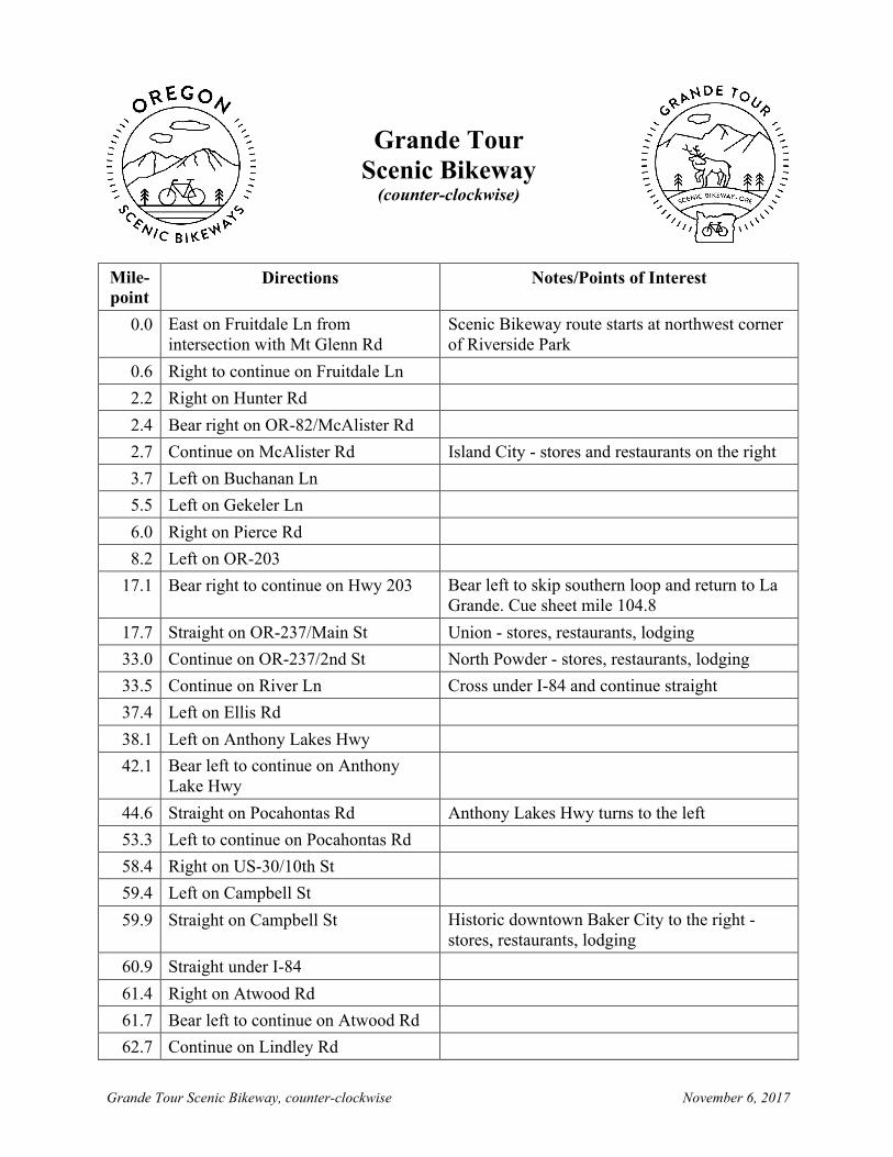
Grande Tour Scenic Bikeway (counter-clockwise)
Mile- point
Directions Notes/Points of Interest
0.0 East on Fruitdale Ln from intersection with Mt Glenn Rd
Scenic Bikeway route starts at northwest corner of Riverside Park
0.6 Right to continue on Fruitdale Ln 2.2 Right on Hunter Rd 2.4 Bear right on OR-82/McAlister Rd 2.7 Continue on McAlister Rd Island City - stores and restaurants on the right 3.7 Left on Buchanan Ln 5.5 Left on Gekeler Ln 6.0 Right on Pierce Rd 8.2 Left on OR-203
17.1 Bear right to continue on Hwy 203 Bear left to skip southern loop and return to La Grande. Cue sheet mile 104.8
17.7 Straight on OR-237/Main St Union - stores, restaurants, lodging 33.0 Continue on OR-237/2nd St North Powder - stores, restaurants, lodging 33.5 Continue on River Ln Cross under I-84 and continue straight 37.4 Left on Ellis Rd 38.1 Left on Anthony Lakes Hwy 42.1 Bear left to continue on Anthony
Lake Hwy
44.6 Straight on Pocahontas Rd Anthony Lakes Hwy turns to the left 53.3 Left to continue on Pocahontas Rd 58.4 Right on US-30/10th St 59.4 Left on Campbell St 59.9 Straight on Campbell St Historic downtown Baker City to the right -
stores, restaurants, lodging 60.9 Straight under I-84 61.4 Right on Atwood Rd 61.7 Bear left to continue on Atwood Rd 62.7 Continue on Lindley Rd

Grande Tour Scenic Bikeway, counter-clockwise November 6, 2017
Mile- point
Directions Notes/Points of Interest
64.7 Continue on Lindley Rd Begin 2 miles hard packed dirt surface 66.9 Right on OR-203 84.0 Continue on OR-203 Medical Springs - small store 90.1 Continue on OR-203 Catherine Summit- 4,178 feet 95.6 Continue on OR-203 Catherine Creek State Park - camping,
picnicking, water 103.8 Bear left onto E Beakman St 104.2 Right on OR-217/Main St Union - stores, restaurants, lodging 104.8 Right on OR-237/Bryan St 105.0 Left to continue on OR-237 113.4 Left to continue on OR-237 N/Jasper
St Cove - stores, restaurants
114.5 Bear right onto Lower Cove Rd 122.2 Bear left onto Market Ln 128.0 Left on OR-82/Wallowa Lake Hwy 129.7 Right on Booth Ln 132.8 Continue onto Mt Glen Rd 134.5 Route ends at intersection with
Fruitdale Rd Riverside Park at southeast corner of intersection

Grande Tour Scenic Bikeway, clockwise November 6, 2017
Grande Tour Scenic Bikeway
(clockwise)
Mile- point
Directions Notes/Points of Interest
0.0 North on Mt Glenn Rd from intersection with Fruitdale Ln
Scenic Bikeway route starts at northwest corner of Riverside Park
1.6 Continue straight on Booth Ln 4.8 Left on OR-82 E 6.5 Right on Market Ln
12.3 Right on Lower Cove Rd 20.0 Straight on OR-237 21.1 Right on OR-237/Main St Cove - stores, restaurants 29.5 Right on OR-237/Bryan St 29.7 Left on OR-237/Main St Bear right on OR-203 to skip southern loop and
return to La Grande - cue sheet milepoint 117.4 30.3 Left on OR-203/Beakman St Union - stores, restaurants, lodging 38.4 Continue on OR-203 Catherine Creek State Park - camping, picnicking,
water 44.4 Continue on OR-203 Catherine Summit - 4,178 feet 50.5 Continue on OR-203 Medical Springs - small store 67.6 Left on Lindley Rd Begin 2 miles hard packed dirt surface 68.6 Continue on Lindley Rd 72.8 Bear right onto Atwood Rd 73.0 Left on Campbell St 73.6 Straight under I-84 74.5 Straight on Campbell St Historic downtown Baker City to the left - stores,
restaurants, lodging 75.1 Right on US-30/10th St 76.1 Left on Pocahontas Rd 81.1 Right to continue on Pocahontas
Rd
89.9 Straight on Anthony Lakes Hwy 91.8 Bear left to continue on Anthony
Lakes Hwy

Grande Tour Scenic Bikeway, clockwise November 6, 2017
Mile- point
Directions Notes/Points of Interest
92.2 Bear right to continue on Anthony Lakes Hwy
96.4 Right on Ellis Rd 97.1 Right on River Ln
101.0 Continue onto OR-237 N/2nd St 101.1 Continue on OR-237/2nd St Cross under I-84 and continue straight 101.6 Continue on OR-237/2nd St North Powder - stores, restaurants, lodging 115.8 Continue on OR-237/Main St Union - stores, restaurants, lodging 117.4 Bear left on OR-203 126.3 Right on Pierce Rd 128.5 Left on Gekeler Ln 129.0 Right on Buchanan Ln 130.8 Right on McAlister Rd 131.8 Straight on OR-82/McAlister Rd Island City - stores, restaurants, lodging to the left 132.1 Left on McAlister Rd/Hunter Rd 132.3 Left on Fruitdale Ln 133.9 Left to continue on Fruitland Ln 134.5 Route ends at intersection with Mt
Glenn Rd Riverside Park at southeast corner of intersection
Top Related