


Languages
Pages
Legal

360320
280
240
200
160
12080
40
200
160
120
80
80
120
160200
120
160
200
240
280
80
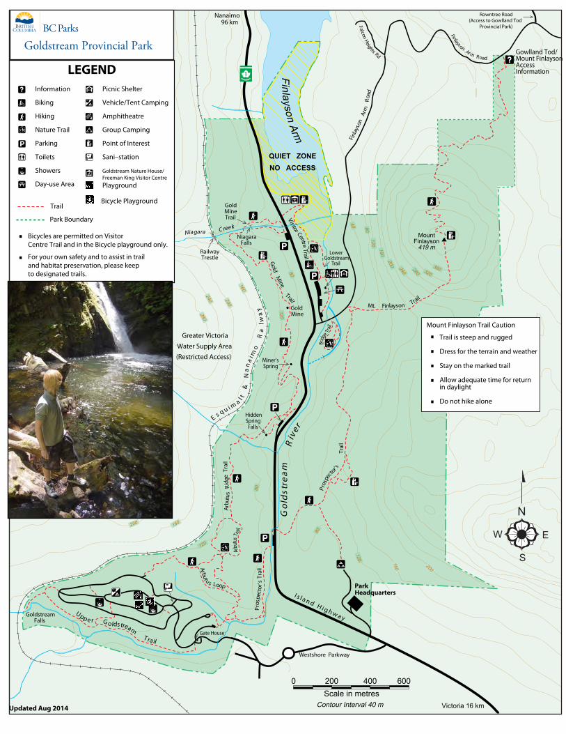
Contour Interval 40 m
LEGENDInformation
Biking
Hiking
Nature Trail
Parking
Toilets
Showers
Day-use Area
Picnic Shelter
Vehicle/Tent Camping
Amphitheatre
Group Camping
Point of Interest
Sani–station
Goldstream Nature House/Freeman King Visitor Centre
Trail
Park Boundary
Bicycles are permitted on Visitor Centre Trail and in the Bicycle playground only.
For your own safety and to assist in trail and habitat preservation, please keep to designated trails.
GoldMine
GoldM
ine
Trail
Miner’sSpring
HiddenSpringFalls
Arbu
tus
Ridg
eT r
ail
Go
l ds t
ream
Riv
e r
Niagara C reek
E s q u i m a l t&
Na
na
i mo
Ra
lwa
y
Upp e r G oldstreamT rail
GoldstreamFalls
Pros
pect
or’s
Trai
l
Pros
pecto
r’sTr
ail
B ridg
e Trai
l
Scale in metres0 200 400 600
Arbutu s Loop
Arbu
tusTra
il
ParkHeadquartersI s l a n d H i g h w a y
FinlaysonArm
NiagaraFalls
MountFinlayson
419 m
S
R T U BA
RailwayTrestle
GoldMineTrail
Mt. Finlayson Trail
Visitor CentreTrail
FinlaysonArm Road
Rowntree Road(Access to Gowlland Tod
Provincial Park)FalconHeights Rd
Finla
yson
Arm
Road
Victoria 16 km
Nanaimo96 km
QUIET ZONENO ACCESS
Gowlland Tod/Mount FinlaysonAccessInformation
Mount Finlayson Trail Caution
Trail is steep and rugged
Dress for the terrain and weather
Stay on the marked trail
Allow adequate time for returnin daylight
Do not hike alone
Greater VictoriaWater Supply Area(Restricted Access)
Gate House
LowerGoldstream
Trail
N
E
S
W
Westshore Parkway
Playground
Goldstream Provincial Park
Updated Aug 2014
Bicycle Playground
Top Related