


Languages
Pages
Legal

NTS Map Sheets Southeast Alberta Area: 72L
Red Deer Area: 82P; 83A; 83B and 83H Fox Creek: 83K
South Peace River Arch Area: 83M, 83N, 83O, 84D and 83B
TECHNICAL REPORT
GEOLOGICAL INTRODUCTION TO MGX MINERALS INC.’S LITHIUM OILFIELD BRINE PROJECT IN ALBERTA, CANADA
Prepared For:
MGX Minerals Inc. Suite 303, 1080 Howe St. Vancouver, BC V6C 2T1
Prepared by:
APEX Geoscience Ltd. Suite 110, 8429 – 24th Street
Edmonton, AB Canada, T6P 1L3
D. Roy Eccles, M.Sc., P. Geol.
Effective Date: 15 June 2016 Edmonton, Alberta, Canada
Geological Introduction to MGX Minerals Inc.’s Lithium Oilfield Brine Project in Alberta
15 June 2016 ii
Contents
1 Summary ................................................................................................................... 1 2 Introduction ................................................................................................................ 6 3 Reliance of Other Experts ........................................................................................ 10 4 Property Description and Location ........................................................................... 11
4.1 Property Description ......................................................................................... 11 4.1.1 Red Deer Group of Permits .................................................................... 11 4.1.2 South Peace River Arch Group of Permits ............................................. 14 4.1.3 Fox Creek Group of Permits ................................................................... 14 4.1.4 Southeast Alberta Group of Permits ....................................................... 14
4.2 Permits Applications (Subject to Approval by Alberta Energy) ......................... 18 4.3 Property Rights and Maintenance .................................................................... 18
4.4 Coexisting Oil, Gas and Oil Sands Rights ........................................................ 20
5 Accessibility, Climate, Local Resources, Infrastructure and Physiography .............. 20 5.1 Red Deer Group of Permits .............................................................................. 20 5.2 South Peace River Arch Group of Permits ....................................................... 21
5.3 Fox Creek Group of Permits ............................................................................. 22 5.4 Southeast Alberta Group of Permits ................................................................. 23
6 History ...................................................................................................................... 24
6.1 Summary of Selected Alberta Devonian Hydrocarbon-Bearing Formations ..... 24 6.1.1 Elk Point Group (Winnipegosis Formation) ............................................. 27
6.1.2 Beaverhill Lake Group (Swan Hills Formation) ....................................... 27 6.1.3 Woodbend Group (Leduc Formation) ..................................................... 28 6.1.4 Winterburn Group (Nisku Formation) ...................................................... 28
6.1.5 Summary of Alberta’s Devonian Petroleum System ............................... 29
6.1.6 ‘Remaining Established Reserves’ in Fields/Pools Associated with MGX’s Properties. .............................................................................................. 31
6.2 Discovery of Lithium-Enriched Formation Water/Brine in Alberta ..................... 32
6.3 Mineral Potential of Devonian Formation Water in Saskatchewan ................... 33 6.4 Alberta Lithium-Brine Resource Estimations (not related to MGX’s Properties) 35
6.5 Historical Summary of Lithium Oilfield Brine Chemistries Specific to MGX’s Properties ......................................................................................................... 35 6.5.1 Red Deer Group of Permits .................................................................... 36 6.5.2 South Peace River Arch Group of Permits ............................................. 39 6.5.3 Fox Creek Group of Permits ................................................................... 41
6.5.4 Southeast Alberta Group of Permits ....................................................... 41 6.5.5 Historical Fluid Geochemistry Summary ................................................. 41
7 Geological Setting and Mineralization ...................................................................... 44 7.1 Early to Middle Devonian Elk Point Group (Prairie Evaporite Formation) ......... 46 7.2 Middle to Late Devonian Beaverhill Lake Group (Swan Hills Formation) ......... 46 7.3 Late Devonian Woodbend- Winterburn Groups (Leduc and Duvernay
Formations; Nisku Formation) .......................................................................... 47
7.4 Late Devonian Wabamun Group ...................................................................... 48
Geological Introduction to MGX Minerals Inc.’s Lithium Oilfield Brine Project in Alberta
15 June 2016 iii
7.5 ‘Peace River Arch’ Structural Anomaly ............................................................. 48 7.6 Mineralization ................................................................................................... 50
8 Deposit Types .......................................................................................................... 52
9 Exploration ............................................................................................................... 53 10 Drilling ...................................................................................................................... 53 11 Sample Preparation, Analyses and Security ............................................................ 53 12 Data Verification....................................................................................................... 54 13 Mineral Processing and Metallurgical Testing .......................................................... 54
14 Mineral Resource Estimates .................................................................................... 54 23 Adjacent Properties .................................................................................................. 55 24 Other Relevant Data and Information ...................................................................... 56 25 Interpretation and Conclusions ................................................................................ 56 26 Recommendations ................................................................................................... 60
26.1 Phase One Exploration Work ........................................................................... 60 26.2 Phase Two Exploration Work ........................................................................... 61
27 References .............................................................................................................. 63
28 Certificate of Author ................................................................................................. 69
Tables
Table 1. Summary of Phase One and Phase Two recommendations to advance MGX’s lithium-enriched oilfield brine project. ............................................................... 5
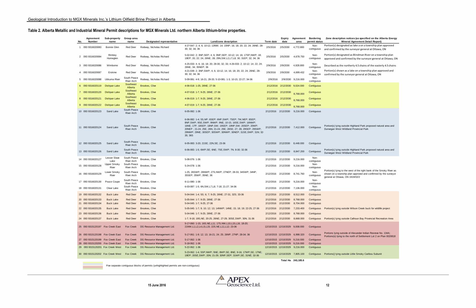
Table 2. Alberta Metallic and Industrial Mineral Permit descriptions for MGX Minerals Ltd. northern Alberta lithium-brine properties. ................................................ 12
Table 3. Simplified Devonian stratigraphy of Alberta. .................................................... 25 Table 4. Maximum lithium values for Cambrian- to Triassic-aged formation waters
(Hitchon et al., 1995).. .................................................................................... 33 Table 5. Selected historical fluid geochemical data from oil and gas wells that were
spudded within the MGX sub-properties.. ...................................................... 37 Table 6. Summary and current status of oil, gas and water wells that were drilled on the
MGX sub-Properties. The Devonian well data does not include commingled pools. .............................................................................................................. 51
Table 7. Summary of Phase One and Phase Two recommendations to advance MGX’s lithium-enriched oilfield brine project. ............................................................. 62
Figures
Figure 1. General location of MGX Minerals Ltd.’s northern Alberta lithium-brine properties.. ....................................................................................................... 7
Figure 2. Location of Alberta Metallic and Industrial Mineral Permit descriptions at MGX Minerals Ltd.’s northern Alberta lithium-brine properties (Red Deer group of permits). ......................................................................................................... 13
Geological Introduction to MGX Minerals Inc.’s Lithium Oilfield Brine Project in Alberta
15 June 2016 iv
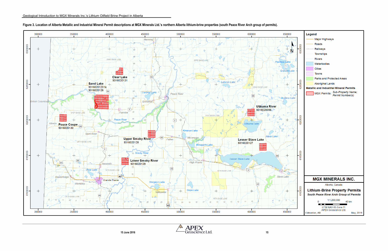
Figure 3. Location of Alberta Metallic and Industrial Mineral Permit descriptions at MGX Minerals Ltd.’s northern Alberta lithium-brine properties (south Peace River Arch group of permits). ................................................................................... 15
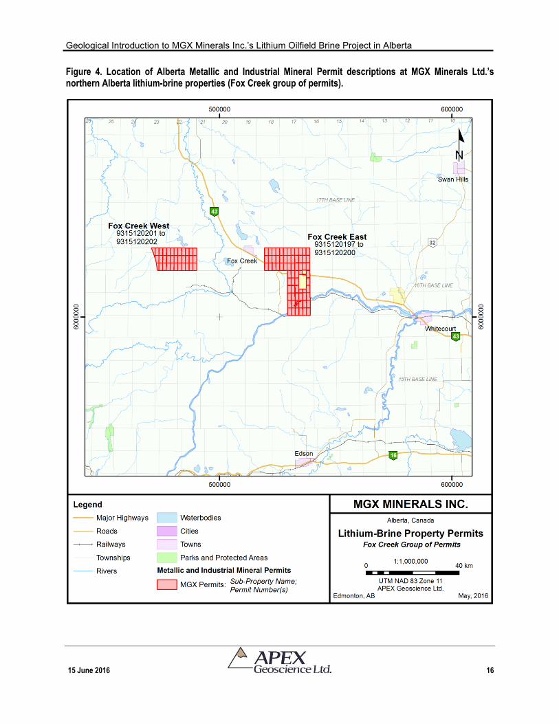
Figure 4. Location of Alberta Metallic and Industrial Mineral Permit descriptions at MGX Minerals Ltd.’s northern Alberta lithium-brine properties (Fox Creek group of permits). ......................................................................................................... 16
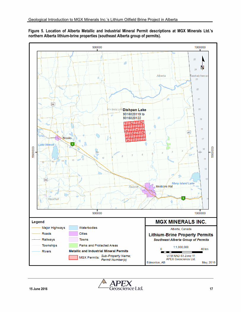
Figure 5. Location of Alberta Metallic and Industrial Mineral Permit descriptions at MGX Minerals Ltd.’s northern Alberta lithium-brine properties (southeast Alberta group of permits). ........................................................................................... 17
Figure 6. Overview of major Devonian oil and gas fields/pools underlain with the outline of the Devonian reef complexes. .................................................................... 26
Figure 7. Distribution of crude oil and conventional marketable gas reserves in Alberta (Source: Alberta Energy Regulator, 2015). .................................................... 30
Figure 8. Shaded contour map of lithium-bearing formation waters in west-central Alberta.. .......................................................................................................... 34
Figure 9. Devonian lithium-brine occurrences in the Red Deer group of permits. The data are from analytical work conducted as part of historical oil and gas well exploration. ..................................................................................................... 38
Figure 10. Devonian lithium-brine occurrences in the Peace River Arch group of permits. The data are from analytical work conducted as part of historical oil and gas well exploration. ................................................................................ 40
Figure 11. Devonian lithium-brine occurrences in the Fox Creek group of permits. The data are from analytical work conducted as part of historical oil and gas well exploration. ..................................................................................................... 42
Figure 12. Devonian lithium-brine occurrences in the southern Alberta group of permits. The data are from analytical work conducted as part of historical oil and gas well exploration. ............................................................................................. 43
Figure 13. Bedrock Geology of Alberta (from Hamilton et al., 2013) with the outline of the Peace River Arch (from O'Connell et al., 1994). ....................................... 45
Geological Introduction to MGX Minerals Inc.’s Lithium Oilfield Brine Project in Alberta
15 June 2016 1
1 Summary
MGX Minerals Inc. (“MGX”) has commissioned APEX Geoscience Ltd. (“APEX”) to prepare a National Instrument 43-101 Technical Report to introduce their lithium oilfield brine project in Alberta, Canada. MGX’s Alberta lithium-brine Properties, which are the subject of this Technical Report, consist of 30 Metallic and Industrial Mineral permits for a total land package of 243,185.6 hectares (600,924.7 acres). The 30 contiguous and non-contiguous Permits can be divided into 15 sub-Properties that are located in four general areas of Alberta:
1. The Red Deer group of permits are situated in the Red Deer, AB area of south-
central Alberta and comprise 10 permits, including a contiguous cluster of six permits (Buck Lake sub-Property) and four non-contiguous permits (Bonnie Glen, Rimbey Homeglen, Erskine and Wimborne sub-Properties);
2. The South Peace River Arch group of permits is situated near the communities
of Hines Creek, AB and Fairview, AB and south of the Peace River Arch in northwestern Alberta, and comprises 10 permits, including a contiguous cluster of four permits (Sand Lake sub-Property) and six non-contiguous permits (Clear Lake; Utikuma River; Lesser Slave Lake; Upper and Lower Smoky River; and Pouce Coupe sub-Properties);
3. The Fox Creek group of permits is located near the Town of Fox Creek, AB and includes two separate groups of contiguous permits: Fox Creek East sub-Property (4 permits) and Fox Creek West sub-Property (2 permits); and
4. The Southeast group of permits is located north of the city of Medicine Hat, AB
and east of the city of Brooks, AB in southeastern Alberta and comprises four contiguous permits (Dishpan Lake sub-Property).
The Properties were acquired through three separate transactions. MGX holds
100% rights on the Permits, which gives MGX the exclusive right to explore for and develop potentially economic deposits of metallic and industrial minerals within the boundaries of the Permits subject to meeting bi-annual expenditure requirements. In addition to these Permits, MGX has recently applied for additional Alberta Metallic and Industrial Mineral Permits; these permit applications have yet to be formally granted by the Government of Alberta.
In general, the Permits are situated in areas where the energy sector is active year
round providing excellent transportation roots, supplies services, equipment and personnel that is associated with Alberta’s vast oil and gas sector; consequently there is an unlimited availability of resources including: workers and resource field personnel; power; equipment; engineering expertise; etc.
MGX has yet to conduct any exploration, but proposes to assess saline formation
water, or brine, for dissolved lithium, potassium, bromine and boron that is hosted in
Geological Introduction to MGX Minerals Inc.’s Lithium Oilfield Brine Project in Alberta
15 June 2016 2
aquifers within Devonian reef complexes of the Beaverhill Lake Group (Swan Hills Formation), Woodbend Group (Leduc Formation) and Elk Point Group (Winnipegosis Formation). The brine is currently being pumped to the surface from depths of between 1,660 m and 3,300 m below surface as a waste product of hydrocarbon production.
Currently, the extracted brine is separated from the petroleum products and then re-
injected back into the subsurface. Hence, the brine represents the largest-volume waste stream associated with oil and gas production. It is conceivable that existing water processing procedures could be modified to extract lithium and other elements from the brine; however at this stage of exploration there is no current production and no guarantee that lithium and associated elements can be economically extracted from the brine with current technology.
The Properties represent an early-stage exploration project, and at present, MGX is
relying on historical brine geochemical fluid data. That is, MGX has yet to conduct any: brine sampling; analytical work; drilling; recovery test work; or mineral resource estimate work. Accordingly, the intent and purpose of this Technical Report is to provide a geological introduction to MGX’s Properties in accordance with the Canadian Securities Administration’s National Instrument 43-101.
As no exploration work has been conducted by MGX on the Properties, the History
Section delivers a significant component of this Technical Report and provides an historical overview of:
1. The scale of the Devonian petroleum system in Alberta as any future lithium-brine operation is dependent on oil and gas industry activity (i.e., access to Devonian formation waters as they are pumped to the surface as a waste product of oil and gas production); and
2. The geochemical fluid results from historical oil and gas formation water
sampling and analyses.
The first major oil discovery in Western Canada was made in the Late Devonian (Frasnian) Leduc Formation of the Woodbend Group near the city of Devon, AB in 1947 (Leduc #1 well). Oil has been produced from the Devonian petroleum system in the Alberta portion of the Western Canada Sedimentary Basin ever since. The remaining established reserves of conventional crude oil in Alberta is about 288.2 x 10⁶m3 – more than one third of Canada’s remaining conventional reserves – and the Cretaceous and Devonian reservoirs are the major sources for all remaining conventional oil. The vast Devonian hydrocarbon reserves can largely be attributed to the abundance of mature, excellent to good quality carbonate source rocks. These same porous Devonian rock units host significant volumes of formation water, which can possibly and are currently being assessed for their lithium-enriched brine potential.
Geological Introduction to MGX Minerals Inc.’s Lithium Oilfield Brine Project in Alberta
15 June 2016 3
Oil and gas well fluid and stratigraphic data presented in this Technical Report were acquired by searching the Alberta Energy Regulator database, who acts as the custodian for oil and gas data in the Province. The data are made available via numerous standard oil and gas industry software programs such as GeoSCOUTTM. Good judgment is required to assess the quality and validity of data and information obtained from the database. In the case of oil and gas well fluid geochemical data, the author of this Technical Report has reviewed the data and found no significant issues or inconsistencies that would cause one to question the validity of the data.
An historical account of fluid geochemistry of Devonian formations waters from wells that were spudded on the MGX sub-Properties shows that:
Mineralization on MGX’s Properties consists of Li-enriched Na-Ca brine hosted in aquifers within Devonian carbonate reef complexes predominantly of the Woodbend-Winterburn groups (MGX’s Red Deer, South Peace River Arch and Fox Creek groups of permits) and Elk Point Group (MGX’s Southeast group of permits).
The Devonian formation/aquifer brine samples on the MGX Properties were collected from depths of between 1,665 m and 3,666 m below the surface.
Devonian formation waters from selected wells on the MGX Properties reportedly contain up to 140 mg/L Li (21 separate well analyses average 100 mg/L Li). All 15 sub-Properties have at least one well with a recorded lithium content of >75 mg/L Li.
In general, and given the small selected sample set (n=21 analyses), the Leduc Formation with an average lithium content of 112 mg/L Li has higher values of lithium in comparison to the average contents of the Winterburn Group (91 mg/L Li), Wabamun Group (86 mg/L Li) and Elk Point Group (76 mg/L Li).
Potassium was recorded in four separate Devonian wells yielding between 4,570 and 7,270 mg/L all of which were recorded in the area of the Red Deer group of permits.
Formation water from a single well, 00/15-22-033-26W4-0, was analyzed for bromide (956 mg/L Br) and iodide (18 mg/L I).
One Triassic sample contained significantly less lithium (26 mg/L Li) and potassium (430 mg/L K) showing that the Devonian brines contain higher concentrations of the elements of interest.
As the Devonian petroleum system has generally been subject to hydrocarbon production for decades, many of the fields/pools are classified as mature or have extinguished their hydrocarbon resources. Consequently, an important consideration for
Geological Introduction to MGX Minerals Inc.’s Lithium Oilfield Brine Project in Alberta
15 June 2016 4
Li-brine companies is to investigate Devonian fields/pools with viable petroleum reserves and active hydrocarbon production (i.e., operational lifespan) to ascertain/estimate the Li-brine potential of the associated aquifer going forward. With respect to MGX’s Properties, the Bonnie Glen, Erskine and Wimborne sub-Properties are all reported to have significant remaining established commingled natural gas reserves (15 x 106m3; 24 x 106m3; and 629 x 106m3, respectively; Alberta Energy Regulator, 2015). In addition, the Fox Creek area is undergoing hydrocarbon resurgence in that hydraulic fracturing technology has made tight oil and gas associated with the Woodbend Group (Duvernay Formation shale) accessible to current and future development.
A total of 4,969 oil, gas and water wells – regardless of stratigraphic target age – have been spudded on MGX’s Properties. Of the 4,969 wells, 228 wells penetrate the Devonian within the MGX Permits; the current well status of these wells includes: 41 active wells; 32 suspended wells; 148 abandoned wells; and seven wells of unknown status, which are typically related to shallow water wells. The majority of the Devonian wells, regardless of well status, occur in MGX’s Bonnie Glen; Rimbey Homeglen, Wimborne and Erskine sub-Properties (Red Deer group of permits in central Alberta) and Fox Creek group of permits in west-central Alberta. Importantly, production records show that these wells are capable of producing substantial volumes of formation water. For example, well 11/08-14-033-26W4, on the Wimborne sub-Property, produces about 900 bbls of formation water per day.
This Technical Report has shown that historical formation water geochemical
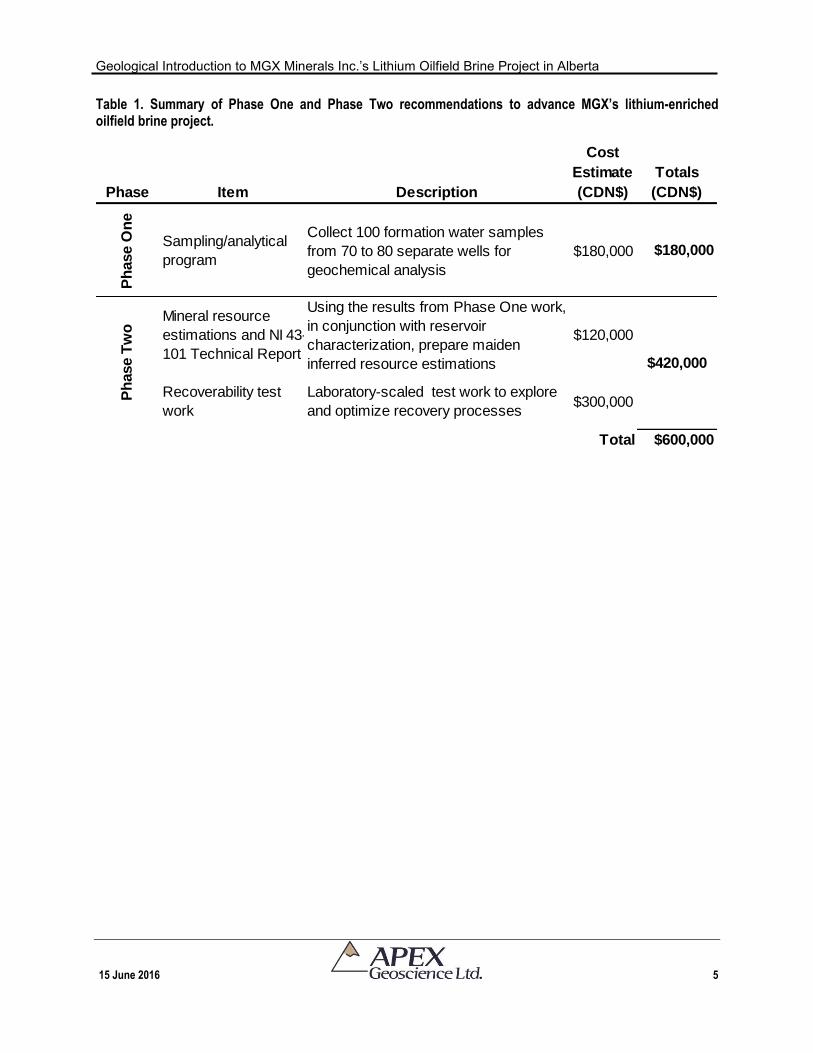
analyses within MGX’s Properties contain up to 140 mg/L Li, which is equivalent to the highest lithium-enriched brine samples documented to date in Devonian aquifers of the Western Canada Sedimentary Basin. It is recommended, therefore, that MGX conduct a two-phased program to verify and assess Li-brine at its properties. The total estimated cost of both phases is CDN$600,000 (Table 1). Recommended Phase One work, which is estimated at CDN$180,000, involves a formation water geochemical sampling program with the objectives of verifying the historical brine chemistry that is presented in this Technical Report. Pending the results of the Phase One exploration work, the purpose and objective of the Phase Two exploration work is to: 1) prepare inferred mineral resource estimations at selected MGX sub-Properties; and 2) conduct laboratory-scaled test work to explore and optimize the elemental recovery process. The total cost of the Phase Two exploration work is estimated at CDN$420,000.
Geological Introduction to MGX Minerals Inc.’s Lithium Oilfield Brine Project in Alberta
15 June 2016 5
Table 1. Summary of Phase One and Phase Two recommendations to advance MGX’s lithium-enriched oilfield brine project.
Phase Item Description
Cost
Estimate
(CDN$)
Totals
(CDN$)
Ph
ase O
ne
Sampling/analytical
program
Collect 100 formation water samples
from 70 to 80 separate wells for
geochemical analysis
$180,000 $180,000
Mineral resource
estimations and NI 43-
101 Technical Report
Using the results from Phase One work,
in conjunction with reservoir
characterization, prepare maiden
inferred resource estimations
$120,000
Recoverability test
work
Laboratory-scaled test work to explore
and optimize recovery processes$300,000
Total $600,000
$420,000
Ph
ase T
wo
Geological Introduction to MGX Minerals Inc.’s Lithium Oilfield Brine Project in Alberta
15 June 2016 6
2 Introduction
This Technical Report was prepared by APEX Geoscience Ltd. (“APEX”) for MGX Minerals Inc. (“MGX”, or the “Company”), a diversified Canadian mining company headquartered in Vancouver, British Columbia, Canada. MGX is engaged in the acquisition and development of industrial mineral deposits that offer near-term production potential, minimal barriers to entry and low initial capital expenditures. The Company's flagship property is the Driftwood Creek magnesium deposit in southeast British Columbia and the Company now controls the majority of the known magnesite occurrences in British Columbia. MGX is also exploring for ferro silica at its Koot Property in southeast British Columbia and silica (frac) sand at its Longworth Property in east-central British Columbia.
During 2016, MGX expanded its commodity portfolio to include lithium-brine (“Li-
brine”) by acquiring 30 Metallic and Industrial Mineral permits (the “Properties” or the “Permits”) in Alberta for a total land package of 243,185.6 hectares (600,924.7 acres). The Permits are contiguous and non-contiguous, but can be divided into 15 sub-Properties that are located in four general areas of Alberta (Figure 1). The Properties, which are the subject of this Technical Report, were staked for their Li-brine potential and other elements of interest. More specifically, MGX proposes to assess saline formation water, or brine, for dissolved lithium (“Li”), potassium (“K”), bromine (“Br”) and boron (“B”). Formation water is defined as formation water with a salinity of greater than 100,000 mg/L. The brine is hosted in aquifers within Devonian reef complexes of the Beaverhill Lake Group (Swan Hills Formation), Woodbend Group (Leduc Formation) and Elk Point Group (Winnipegosis Formation).
The brine is currently being pumped to the surface from depths of between
approximately 1,600 m and 3,700 m below surface as a waste product of hydrocarbon production (e.g., oil, gas and condensate). Currently, the extracted brine is treated by the oil and gas companies to separate and remove petroleum products and then re-inject the brine back into the subsurface. It is conceivable that existing water processing procedures could be modified to extract lithium and other elements from the brine; however at this stage of exploration there is no current production and no guarantee that lithium and associated elements can be economically extracted from the brine with current technology.
MGX holds 100% rights on the Permits, which gives them exclusive right to explore
for and develop economic deposits of metallic and industrial minerals within the boundaries of the Permits subject to meeting bi-annual expenditure requirements. The Properties represent an early-stage exploration project, and at present, MGX is relying on historical brine geochemical fluid data (MGX has not conducted any new brine sampling). No mineral resource work has been conducted or is contemplated in this Technical Report. Accordingly, the intent and purpose of this Technical Report is to provide a geological introduction to MGX’s Properties in accordance with the Canadian Securities Administration’s (“CSA’s”) National Instrument 43-101 (“NI 43-101”).
Geological Introduction to MGX Minerals Inc.’s Lithium Oilfield Brine Project in Alberta
15 June 2016 7
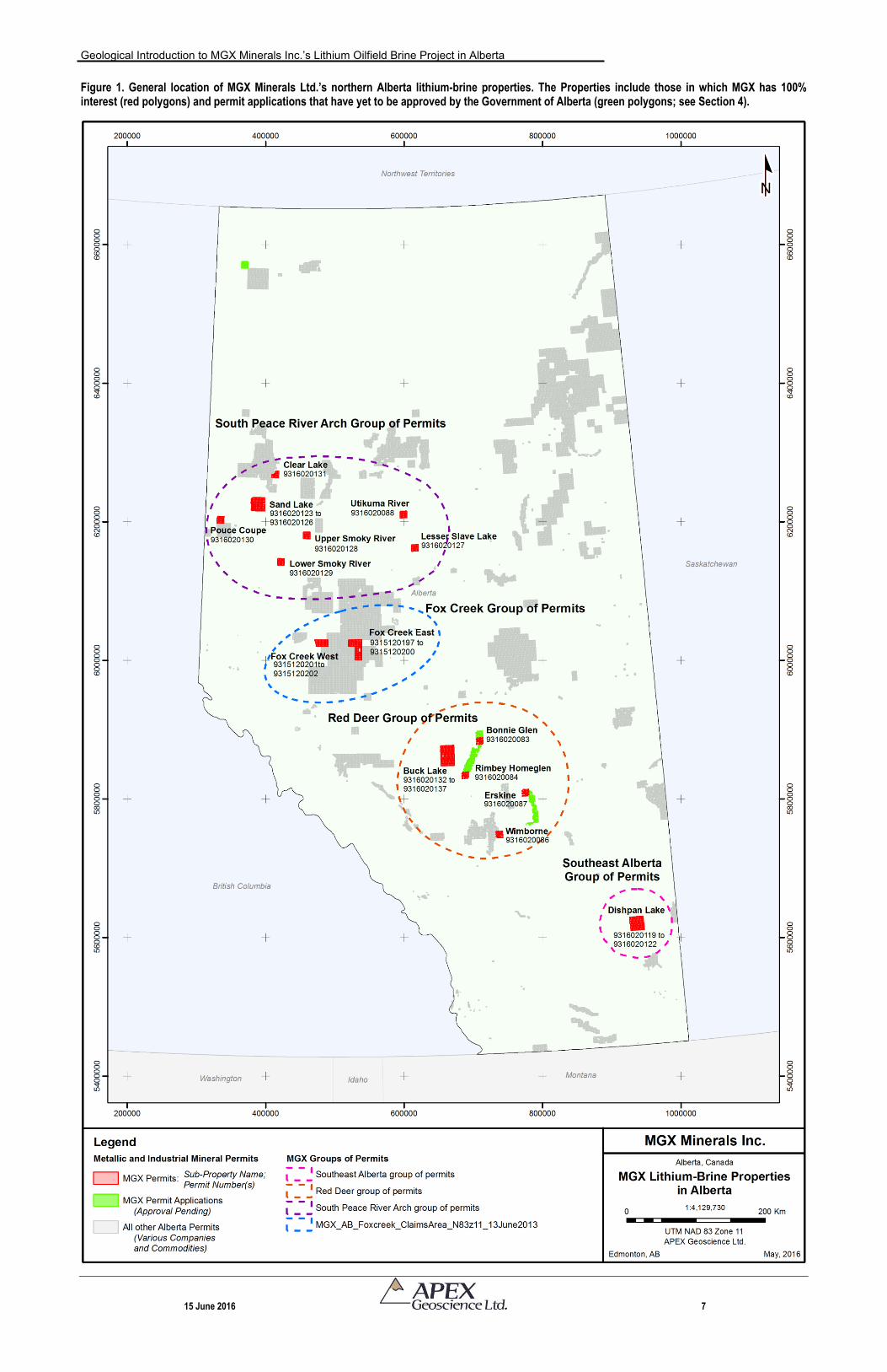
Figure 1. General location of MGX Minerals Ltd.’s northern Alberta lithium-brine properties. The Properties include those in which MGX has 100% interest (red polygons) and permit applications that have yet to be approved by the Government of Alberta (green polygons; see Section 4).
Geological Introduction to MGX Minerals Inc.’s Lithium Oilfield Brine Project in Alberta
15 June 2016 8
Mr. Eccles, M.Sc. P. Geol., of APEX (the “author”) supervised the preparation of, and is responsible for the ultimate publication of this Technical Report. The author is a Qualified Person as defined by the CSA’s NI 43-101. The Canadian Institute of Mining, Metallurgy and Petroleum (“CIM”) defines a Qualified Person as “an individual who is a geoscientist with at least five years of experience in mineral exploration, mine development or operation or mineral project assessment, or any combination of these; has experience relevant to the subject matter of the mineral project and the technical report; and is a member or licensee in good standing of a professional association.”
Mr. Eccles is a Professional Geologist with the Association of Professional
Engineers and Geoscientists of Alberta (APEGA), and has worked as a geologist for more than 25 years since his graduation from University. Mr. Eccles has been involved in all aspects of mineral exploration and mineral resource estimations for metallic and industrial mineral projects and deposits in North America.
The author has worked in the vicinity of the Properties during his 21-year career
with the Alberta Geological Survey (“AGS”), but any specific studies would not have been associated with Li-brine. The author did not visit the MGX Properties as part of this Technical Report, but is knowledgeable and technically competent to contribute and/or be responsible for introductory through to advanced technical reporting as they pertain to lithium-brine deposits and resources. The author’s technical experience with respect to Li-brine includes:
Government of Alberta AGS geological studies documenting the spatial location of lithium-enriched brine in Alberta (e.g., Eccles and Jean, 2010);
Government of Alberta AGS studies and national presentations that propose hypotheses on the source origins of the lithium (e.g., Eccles and Berhane, 2011; Eccles, 2012); and
Lithium-brine resource estimations that were prepared in accordance with CIM best practice guideline for brine resources (1 November 2012) and NI 43-101 (e.g., Eccles et al., 2012a,b; Eccles et al., 2016). During the preparation of these reports, the author supervised a variety of Qualified Persons with relevant experience in brine geology such as geologists, hydrogeologists and geochemists.
The source of information and data used in this Technical Report are based on the
compilation of publicly available geological and geochemical data as they pertain to MGX’s Properties and the surrounding area. The data compilation includes original, historical oil field formation water data. These data were validated and interpreted by APEX staff working under the direct supervision of the author.
Geological Introduction to MGX Minerals Inc.’s Lithium Oilfield Brine Project in Alberta
15 June 2016 9
Government reports include those that depict the Devonian bedrock stratigraphy of northwestern Alberta and the formation water geochemistry of Alberta (e.g., Green and Mellon, 1970; Hitchon, 1984; Cant, 1988; Bloy and Hadley, 1989; Connolly et al., 1990a,b; O’Connell et al., 1990; Hitchon et al., 1993, 1995; Meijer Drees, 1994; Mossop et al., 1994; Switzer et al., 1994; Oldale and Munday, 1994; Underschultz et al., 1994; Bachu et al., 1995; Pana, 2003; Garrett, 2004; Pawlowicz and Fenton, 1995a,b; Eccles and Jean, 2010; Eccles and Berhane, 2011; Huff et al., 2011, 2012; Rokosh et al., 2012).
Miscellaneous Journal articles, company news releases and NI 43-101 Technical
Reports – the latter of which were prepared by APEX and pertain to Li-brine – were used to corroborate the stratigraphy and formation water potential of Alberta (e.g., Billings et al., 1969; Kunasz, 1980, 1994, 2006; Ross et al., 1991; Leckie et al., 1992; Bloch et al., 1993; Eccles et al., 2012a,b; Eccles et al., 2016; MGX Minerals Inc., 2016a,b,c,d,e).
With respect to energy reserves, the nomenclature used to quantify crude bitumen,
crude oil, natural gas, natural gas liquids, sulphur, and coal should not be confused with NI-43-101 or CIM guidelines. Through 2014, the Alberta Energy Regulator (“AER”) used a reserves reporting system called IPACE (Inter-Provincial Advisory Committee on Energy) for uniform terminology and definitions in estimating and publishing hydrocarbon reserves information in Canada. In 2015, the AER created a differentiated resource classification system to be used in the future to capture the increased production from the low permeability and shale resources. The resource classification system accounts for both conventional and unconventional resources and gives the AER the flexibility to tailor its reserves evaluation, classification, and reporting procedures according to the unique properties of individual resource types.
The author of this Technical Report, Mr. Eccles, has reviewed all government and
miscellaneous reports, including the hydrocarbon reserves information. Government reports and Journal papers were prepared by a person, or persons, holding post-secondary geology or related degrees. Based on review of these documents and/or information, the senior author has deemed that these reports and information, to the best of his knowledge, are valid contributions to this Technical Report, and therefore takes ownership of the ideas and values as they pertain to the current Technical Report.
Oil and gas well fluid and stratigraphic data presented in this Technical Report were acquired by searching the AER database, who acts as the custodian for oil and gas data in the Province. The data are made available via numerous standard oil and gas industry software programs such as GeoSCOUTTM. Good judgment is required to assess the quality and validity of data and information obtained from the GeoSCOUT database. In the case of oil and gas well fluid geochemical data, the senior author has reviewed the data and found no significant issues or inconsistencies that would cause one to question the validity of the data.
Geological Introduction to MGX Minerals Inc.’s Lithium Oilfield Brine Project in Alberta
15 June 2016 10
With respect to units of measure, unless otherwise stated, this Technical Report uses:
Abbreviated shorthand consistent with the International System of Units (International Bureau of Weights and Measures, 2006);
Distance and ‘small’ weights are presented in both imperial (and metric) units;
‘Bulk’ weight in both United States short tons (2,000 lbs or 907.2 kg) and metric tonnes (1,000 kg or 2,204.6 lbs);
Oil and gas industry standard abbreviations:
o API - American Petroleum Institute gravity, or API gravity, is a measure of how heavy or light a petroleum liquid is compared to water
o MMBbls - million barrels
o BCF - billion cubic feet equivalent
o TCF - trillion cubic feet equivalent
Geographic coordinates that are projected in the Universal Transverse Mercator (“UTM”) system relative to Zones 11 and 12 of the North American Datum (“NAD”) 1983; and
Currency in Canadian dollars (“CDN$”).
This Technical Report was completed pursuant to the NI 43-101 regulations and guidelines, and in compliance to Form 43-101F1 for the CSA. The estimated Mineral Resources are considered compliant with the CIM, with CIM Standards on Mineral Resources and Reserves, and with Definitions and Guidelines prepared by the CIM Standing Committee on Reserve Definitions.
The effective date of this Technical Report is 15 June, 2016.
3 Reliance of Other Experts MGX’s Alberta Properties consist of 30 contiguous and non-contiguous Metallic and
Industrial Mineral Permits that encompass an amalgamated land package of 243,185.6 hectares (600,924.7 acres). MGX has either acquired the Properties directly through permit application to the Coal and Mineral Development Unit of the Alberta Ministry of Energy, or through Purchase Agreements with various companies for which the Company has acquired 100% undivided interests.
Geological Introduction to MGX Minerals Inc.’s Lithium Oilfield Brine Project in Alberta
15 June 2016 11
Alberta Metallic and Industrial Mineral Permits can be held by an individual person, or by any organized or corporate entity, which is duly registered to do business in the province of Alberta. The authors of this Technical Report are not qualified to provide an opinion or comment on issues related to legal agreements, royalties, permitting and environmental matters, and therefore, disclaim certain portions associated with Section 4, Property Description and Location.
The authors have not attempted to verify the legal status of the Property; however,
at the time of report preparation, the authors reviewed the Alberta Energy metallic and industrial mineral disposition of mineral rights management system, which shows that the MGX claims are active and in good standing as of 15 June 2016. The Government of Alberta mineral rights management system can be accessed at: http://www.energy.gov.ab.ca/OurBusiness/1071.asp.
4 Property Description and Location
4.1 Property Description The Properties are comprised of 30 Alberta Metallic and Industrial Mineral Permits
that collectively form 15 sub-Properties in total. The Properties include both contiguous and non-contiguous permit land packages that total 243,185.6 hectares (600,924.7 acres). The MGX Properties have not been legally surveyed. The Government of Alberta mineral rights management system can be accessed at: http://www.energy.gov.ab.ca/OurBusiness/1071.asp.
The MGX Properties are scattered throughout Alberta, but generally cluster in four
general regions: Red Deer in south-central Alberta; South Peace River Arch in northwestern Alberta; Fox Creek in west-central Alberta; and in Southeast Alberta. The permit locations and descriptions are provided in the text that follows and in the accompanying Table 2 and Figures 2 to 5.
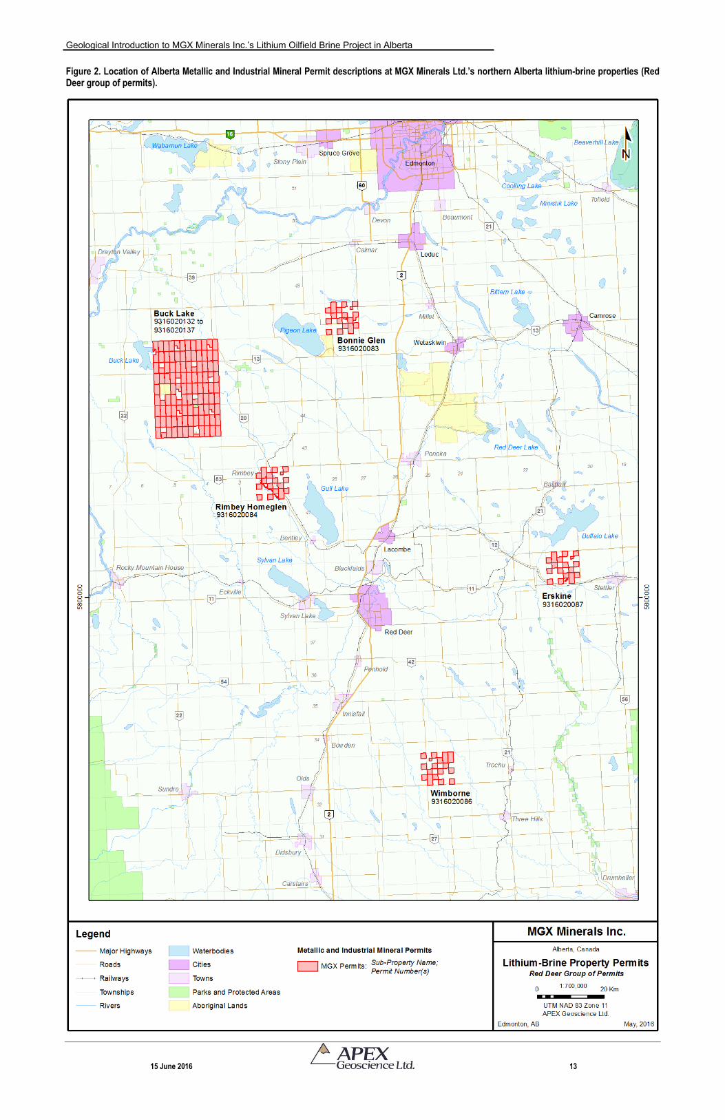
4.1.1 Red Deer Group of Permits
Comprises 10 permits, including a contiguous cluster of six permits (Buck Lake sub-Property) and four non-contiguous permits (Bonnie Glen, Rimbey Homeglen, Erskine and Wimborne sub-Properties) in the Red Deer, AB area of south-central Alberta (Figure 2).
The permits are located in the following 1:250 000 National Topographic System map sheets: 82P; 83A; 83B and 83H.
The center of the contiguous six permit cluster (Buck Lake sub-Property) is located at Latitude 52.8918 and Longitude -114.5812 (decimal degrees), or Universal Transverse Mercator (UTM) 662718 m Easting (“E”) and 5862974 m Northing (“N”), Zone 11, North American Data 83 (NAD83).
Geological Introduction to MGX Minerals Inc.’s Lithium Oilfield Brine Project in Alberta
15 June 2016 12
Table 2. Alberta Metallic and Industrial Mineral Permit descriptions for MGX Minerals Ltd. northern Alberta lithium-brine properties.
No.
Agreement
Number
Sub-property
name
Group area
name Designated representative Land/zone description Term date
Expiry
date
Agreement
area
Bordering
permit status
Zone description notices (as specified on the Alberta Energy
Mineral Agreement Detail Report)
1 093 9316020083 Bonnie Glen Red Deer Rodway, Nicholas Richard4-27-047: 2; 4; 6; 10-12; 13NW; 14; 15NP; 16; 18; 20; 22; 24; 26NE; 28-
30; 32; 34; 36 2/5/2016 2/5/2030 4,772.800
Non-
contiguous
Portion(s) designated as lake a on a township plan approved
and confirmed by the surveyor general at Ottawa, ON
2 093 9316020084Rimbey
HomeglenRed Deer Rodway, Nicholas Richard
5-02-042: 2; 3NP,SEP; 4; 6; 9NP,SEP; 10-12; 14; 16; 17SP,NWP; 18;
19EP; 20; 22; 24; 26NE; 28; 29N,SW,L2,L7,L8; 30; 31EP; 32; 34; 362/5/2016 2/5/2030 4,678.750
Non-
contiguous
Portion(s) designated as Blindman River on a township plan
approved and confirmed by the surveyor general at Ottawa, ON
3 093 9316020086 Wimborne Red Deer Rodway, Nicholas Richard4-25-033: 4; 6; 16; 18; 20; 28-30; 32; 33; 4-26-033: 2; 10-12; 14; 22; 24;
26NE; 34; 35NEP; 362/9/2016 2/9/2030 4,928.800
Non-
contiguousDescribed as the northerly 4.5 chains of the easterly 4.5 chains
4 093 9316020087 Erskine Red Deer Rodway, Nicholas Richard4-21-039: 2; 3NP,SWP; 4; 6; 10-12; 14; 16; 18; 20; 22; 24; 26NE; 28-
30; 32; 34; 362/9/2016 2/9/2030 4,699.432
Non-
contiguous
Portion(s) shown as a lake on a township plan approved and
confirmed by the surveyor general at Ottawa, ON
5 093 9316020088 Utikuma RiverSouth Peace
River ArchRodway, Nicholas Richard 5-09-081: 4-9; 16-21; 28-33; 5-10-081: 1-3; 10-15; 22-27; 34-36 2/9/2016 2/9/2030 9,216.000
Non-
contiguous
6 093 9316020119 Dishpan LakeSoutheast
AlbertaBrookes, Clive 4-06-018: 1-25; 26NE; 27-36 2/12/2016 2/12/2030 9,024.000 Contiguous
7 093 9316020120 Dishpan LakeSoutheast
AlbertaBrookes, Clive 4-07-018: 1-7; 9-25; 26NE; 27-36 2/12/2016 2/12/2030
8,768.000Contiguous
8 093 9316020121 Dishpan LakeSoutheast
AlbertaBrookes, Clive 4-06-019: 1-7; 9-25; 26NE; 27-36 2/12/2016 2/12/2030
8,768.000Contiguous
9 093 9316020122 Dishpan LakeSoutheast
AlbertaBrookes, Clive 4-07-019: 1-7; 9-25; 26NE; 27-36 2/12/2016 2/12/2030
8,768.000Contiguous
10 093 9316020123 Sand LakeSouth Peace
River ArchBrookes, Clive 6-05-082: 1-36 2/12/2016 2/12/2030 9,216.000 Contiguous
11 093 9316020124 Sand LakeSouth Peace
River ArchBrookes, Clive
6-06-082: 1-4; 5S,NP; 6SEP; 6NP,SWP; 7SEP; 7W,NEP; 8SEP;
8NP,SWP; 9SE,SWP; 9NWP; 9NE; 10-15; 16SE,SWP; 16NWP;
16NE; 17P; 18SEP; 18NP,SW; 19SEP; 19NP,SW; 20SEP; 20WP;
20NEP ; 21-24; 25E; 26N; 21-24; 25E; 26SE; 27; 28; 29SEP; 29SWP;
29NWP; 29NE; 30SEP; 30SWP; 30NWP; 30NEP; 31SE,SWP; 31N; 32-
35; 36S
2/12/2016 2/12/2030 7,412.000 ContiguousPortion(s) lying outside Highland Park proposed natural area and
Dunvegan West Wildland Provincial Park
12 093 9316020125 Sand LakeSouth Peace
River ArchBrookes, Clive 6-05-083: 3-20; 21SE; 22N,SE; 23-36 2/12/2016 2/12/2030 8,448.000 Contiguous
13 093 9316020126 Sand LakeSouth Peace
River ArchBrookes, Clive
6-06-083: 1-5; 6WP,SE; 6NE; 7SE,SWP; 7N; 8-30; 32-36 2/12/2016 2/12/2030 8,847.200 Contiguous
Portion(s) lying outside Highland Park proposed natural area and
Dunvegan West Wildland Provincial Park
14 093 9316020127Lesser Slave
Lake
South Peace
River ArchBrookes, Clive 5-08-076: 1-36 2/12/2016 2/12/2030 9,216.000
Non-
contiguous
15 093 9316020128Upper Smoky
River
South Peace
River ArchBrookes, Clive 5-24-078: 1-36 2/12/2016 2/12/2030 9,216.000
Non-
contiguous
16 093 9316020129Lower Smoky
River
South Peace
River ArchBrookes, Clive
1-25; 26SWP; 26NWP; 27S,NWP; 27NEP; 28-33; 34SWP; 34NP;
35SEP; 35WP; 35NE; 362/12/2016 2/12/2030 8,741.760
Non-
contiguous
Portion(s) lying to the west of the right bank of the Smoky River as
shown on a township plan approved and confirmed by the surveyor
general at Ottawa, ON 1919/02/2
17 093 9316020130 Pouce CoupeSouth Peace
River ArchBrookes, Clive 6-11-080: 1-36 2/12/2016 2/12/2030 9,216.000
Non-
contiguous
18 093 9316020131 Clear LakeSouth Peace
River ArchBrookes, Clive
6-03-087: 1-5; 6N,SW,L7,L8; 7-18; 21-27; 34-36 2/12/2016 2/12/2030 7,136.000
Non-
contiguous
19 093 9316020132 Buck Lake Red Deer Brookes, Clive 5-04-044: 1-4; 5S; 6; 7; 9-25; 26NE; 27-31; 32S; 33-36 2/12/2016 2/12/2030 8,512.000 Contiguous
20 093 9316020133 Buck Lake Red Deer Brookes, Clive 5-05-044: 1-7; 9-25; 26NE; 27-36 2/12/2016 2/12/2030 8,768.000 Contiguous
21 093 9316020134 Buck Lake Red Deer Brookes, Clive 5-04-045: 1-7; 9-25; 27-36 2/12/2016 2/12/2030 8,704.000 Contiguous
22 093 9316020135 Buck Lake Red Deer Brookes, Clive 5-05-045: 1-7; 9; 10; 12; 13; 14NWP; 14NE; 15; 18; 19; 22-25; 27-36 2/12/2016 2/12/2030 7,233.400 Contiguous Portion(s) lying outside Wilson Creek buck for wildlife project
23 093 9316020136 Buck Lake Red Deer Brookes, Clive 5-04-046: 1-7; 9-25; 26NE; 27-36 2/12/2016 2/12/2030 8,768.000 Contiguous
24 093 9316020137 Buck Lake Red Deer Brookes, Clive 1-7; 9-18; 19S,NE; 20-25; 26NE; 27-29; 30SE,SWP; 30N; 31-36 2/12/2016 2/12/2030 8,668.000 Contiguous Portion(s) lying outside Calhoun Bay Provincial Recreation Area
25 093 9315120197 Fox Creek East Fox Creek DG Resource Management Ltd.
5-17-060: 1-15; 16S,NE,L11; 17S,NW,L10,L15,L16; 18-20;
21NW,L1,L2,L4,L5,L15; 22S,NE,L11,L12; 23-36 12/10/2015 12/10/2029 9,008.000 Contiguous
26 093 9315120198 Fox Creek East Fox Creek DG Resource Management Ltd. 5-17-061: 1-9; 12; 13; 16-21; 24; 25; 26NP; 27NP; 28-34; 36 12/10/2015 12/10/2029 6,998.320 ContiguousPortions lying outside of Alexander Indian Resreve No. 134A;
Portions(s) lying to the north of Settlement Lot 2 on Plan 0020818
27 093 9315120199 Fox Creek East Fox Creek DG Resource Management Ltd. 5-17-062: 1-36 12/10/2015 12/10/2029 9,216.000 Contiguous
28 093 9315120200 Fox Creek East Fox Creek DG Resource Management Ltd. 5-18-062: 1-36 12/10/2015 12/10/2029 9,216.000 Contiguous
29 093 9315120201 Fox Creek West Fox Creek DG Resource Management Ltd. 5-22-062: 1-36 12/10/2015 12/10/2029 9,216.000 Contiguous
30 093 9315120202 Fox Creek West Fox Creek DG Resource Management Ltd.5-23-062: 1-4; 5SP,NWP; 5NE; 8WP,SE; 8NE; 9-16; 17WP,SE; 17NE;
19EP; 20SE,SWP; 20N; 21-29; 30NP,SEP; 31WP,SE; 31NE; 32-3612/10/2015 12/10/2029 7,805.100 Contiguous Portions() lying outside Little Smoky Caribou Subunit
Total Ha 243,185.6
Five separate contiguous blocks of permits (unhighlighted permits are non-contiguous)
Geological Introduction to MGX Minerals Inc.’s Lithium Oilfield Brine Project in Alberta
15 June 2016 13
Figure 2. Location of Alberta Metallic and Industrial Mineral Permit descriptions at MGX Minerals Ltd.’s northern Alberta lithium-brine properties (Red Deer group of permits).
Geological Introduction to MGX Minerals Inc.’s Lithium Oilfield Brine Project in Alberta
15 June 2016 14
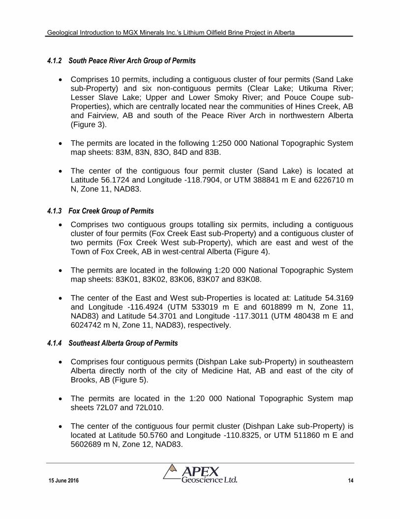
4.1.2 South Peace River Arch Group of Permits
Comprises 10 permits, including a contiguous cluster of four permits (Sand Lake sub-Property) and six non-contiguous permits (Clear Lake; Utikuma River; Lesser Slave Lake; Upper and Lower Smoky River; and Pouce Coupe sub-Properties), which are centrally located near the communities of Hines Creek, AB and Fairview, AB and south of the Peace River Arch in northwestern Alberta (Figure 3).
The permits are located in the following 1:250 000 National Topographic System map sheets: 83M, 83N, 83O, 84D and 83B.
The center of the contiguous four permit cluster (Sand Lake) is located at Latitude 56.1724 and Longitude -118.7904, or UTM 388841 m E and 6226710 m N, Zone 11, NAD83.
4.1.3 Fox Creek Group of Permits
Comprises two contiguous groups totalling six permits, including a contiguous cluster of four permits (Fox Creek East sub-Property) and a contiguous cluster of two permits (Fox Creek West sub-Property), which are east and west of the Town of Fox Creek, AB in west-central Alberta (Figure 4).
The permits are located in the following 1:20 000 National Topographic System map sheets: 83K01, 83K02, 83K06, 83K07 and 83K08.
The center of the East and West sub-Properties is located at: Latitude 54.3169 and Longitude -116.4924 (UTM 533019 m E and 6018899 m N, Zone 11, NAD83) and Latitude 54.3701 and Longitude -117.3011 (UTM 480438 m E and 6024742 m N, Zone 11, NAD83), respectively.
4.1.4 Southeast Alberta Group of Permits
Comprises four contiguous permits (Dishpan Lake sub-Property) in southeastern Alberta directly north of the city of Medicine Hat, AB and east of the city of Brooks, AB (Figure 5).
The permits are located in the 1:20 000 National Topographic System map sheets 72L07 and 72L010.
The center of the contiguous four permit cluster (Dishpan Lake sub-Property) is located at Latitude 50.5760 and Longitude -110.8325, or UTM 511860 m E and 5602689 m N, Zone 12, NAD83.
Geological Introduction to MGX Minerals Inc.’s Lithium Oilfield Brine Project in Alberta
15 June 2016 15
Figure 3. Location of Alberta Metallic and Industrial Mineral Permit descriptions at MGX Minerals Ltd.’s northern Alberta lithium-brine properties (south Peace River Arch group of permits).
Geological Introduction to MGX Minerals Inc.’s Lithium Oilfield Brine Project in Alberta
15 June 2016 16
Figure 4. Location of Alberta Metallic and Industrial Mineral Permit descriptions at MGX Minerals Ltd.’s northern Alberta lithium-brine properties (Fox Creek group of permits).
Geological Introduction to MGX Minerals Inc.’s Lithium Oilfield Brine Project in Alberta
15 June 2016 17
Figure 5. Location of Alberta Metallic and Industrial Mineral Permit descriptions at MGX Minerals Ltd.’s northern Alberta lithium-brine properties (southeast Alberta group of permits).
Geological Introduction to MGX Minerals Inc.’s Lithium Oilfield Brine Project in Alberta
15 June 2016 18
4.2 Permits Applications (Subject to Approval by Alberta Energy)
During the preparation of this Technical Report, MGX applied for additional Alberta Metallic and Industrial Mineral Permits. These permit applications have yet to be formally granted by the Government of Alberta. The location of the permit applications is shown on Figure 1. With the exception of a single permit application in the uppermost northwestern corner of the province, the permit requests tie into currently approved MGX permits that:
Tie together the Rimbey Homeglen – Bonnie Glen sub-Properties; and
Expand the Erskine sub-Property.
Because the permits have yet to be approved, they are referenced only in this subsection and are not discussed in the remainder of this Technical Report. 4.3 Property Rights and Maintenance
MGX has 100% undivided interest in the land package. The Properties were
acquired through three separate transactions, which are described in the following text.
1 February 2016: MGX entered into a Purchase Agreement with Zimtu Capital Corp., DG Resource Management Ltd. and Ridge Resources Ltd. to acquire a 100% undivided interest in 12 Metallic and Industrial Mineral Permits and Permit Applications encompassing 96,000 hectares. In connection with the Agreement, MGX will issue 1,500,000 common shares of the Company over a period of 24 months and make payments to the vendors totalling CDN$20,000 (MGX Minerals, 2016a).
14 March 2016: MGX applied for five Metallic and Industrial Minerals Permits to the Coal and Mineral Development Unit of the Alberta Ministry of Energy covering 45,000 hectares (MGX Minerals, 2016b).
14 April 2016: MGX entered into an Agreement with the Brookes Heyman Lithium Syndicate to acquire a 100% undivided interest in 160,000 hectares of exploration permits. MGX has agreed to issue one million common shares of the Company, with 333,000 shares due at closing and an additional 333,000 shares due on the first and second anniversaries. MGX will also issue cash payments totalling CDN$60,000, with CA$20,000 due at closing and an additional CDN$20,000 due on the first and second anniversaries. MGX has also granted a 2% Net Smelter Royalty to the Syndicate, of which 1% may be repurchased by the Company for a one-time cash payment of CDN$1 million (MGX Minerals, 2016c).
Geological Introduction to MGX Minerals Inc.’s Lithium Oilfield Brine Project in Alberta
15 June 2016 19
The Permits grant MGX the exclusive right to explore for metallic and industrial minerals for seven consecutive two-year terms (total of fourteen years), subject to traditional biannual assessment work. Work requirements for maintenance of permits in good standing are $5.00/ha for the first term, $10.00/ha for each of the second and third terms, and $15.00/ha for each the fourth, fifth, sixth and seventh terms.
The statutes also provide for conversion of Permits to Metallic Minerals Leases once
a mineral deposit has been identified. Leases are granted for a renewable term of 15 years, and require annual payments of $3.50/ha for rent to maintain them in good standing. There are no work requirements for the maintenance of leases and they confer rights to minerals.
Complete terms and conditions for mineral exploration permitting and work can be
found in the Alberta Mines and Minerals Act and Regulations (Metallic and Industrial Minerals Tenure Regulation 145/2005, Metallic and Industrial Minerals Exploration Regulation 213/98). These and other acts and regulations, with respect to mineral exploration and mining, can be found in the Laws Online section of the Government of Alberta Queen’s Printer website (www.qp.alberta.ca/Laws_Online.cfm).
Based upon legal descriptions for the Properties as provided by the Coal and Mineral Development Unit of the Alberta Ministry of Energy, the Properties lie adjacent to several proposed wildlife areas including:
Proposed Highland Park natural area and Dunvegan West Wildland Provincial Park (permits 9316020124 and 9316020126 in the Sand Lake sub-Property);
Wilson Creek buck for wildlife project (permit 9316020135 in the Buck Lake sub-Property) and the Little Smoky Caribou Subunit (permit 9315120202 in Fox Creek West); and
Calhoun Bay Provincial Recreation area (permit 9316020137 in the Buck Lake sub-Property).
Portions of the Permits lie outside of, or directly adjacent to, a variety of protected
areas such as the Duvegan West Wildland Provincial Park; Calhoun Bay Provincial Recreation Area; Highland Park proposed natural area; Wilson Creek buck for wildlife project; and miscellaneous lakes and rivers (Table 2). These areas do not pose any risk to exploration. Rather, Alberta Energy has limited exploration permitting to only those areas outside of the proposed or existing wildlife areas and/or Provincial Parks.
The Dishpan Lake sub-Property is located within the Canadian Forces Base Suffield
(“CFB Suffield”). CFB Suffield falls under the Canadian Army command of the 3rd Canadian Division. CFB Suffield is located approximately 50 km west of Medicine Hat and has been the site of military training in the region since 1972. CFB Suffield is host to the largest military training area in Canada, conducting the largest live-fire training
Geological Introduction to MGX Minerals Inc.’s Lithium Oilfield Brine Project in Alberta
15 June 2016 20
exercises in the country. The Maneuver Training Area covers 1,588 square kilometres of the 2,700 square kilometre base. CFB Suffield has had extensive oil and gas development and exploration activities occurring in the area since the mid-1970s. Two Natural Wildlife Areas along the South Saskatchewan River are associated with CFB Suffield; both of which occur outside of, and to the east of, the Dishpan Lake sub-Property. It is recommended that any access to the area (e.g., for brine sampling) include approval by the Base Commander in conjunction with the Government of Canada Department of National Defense.
4.4 Coexisting Oil, Gas and Oil Sands Rights
Rights to metallic and industrial minerals, to bitumen (oil sands), to coal and to
oil/gas within the region are regulated under separate statutes, which collectively make it possible for several different ‘rights’ to coexist and be held by different grantees over the same geographic location. Oil/gas leases, coal leases, oil sands leases and permits coexist throughout Alberta.
5 Accessibility, Climate, Local Resources, Infrastructure and Physiography 5.1 Red Deer Group of Permits
The Red Deer group of permits is located in the Red Deer area of south-central
Alberta. Sub-Properties include: Buck Lake; Bonnie Glen, Rimbey Homeglen, Erskine and Wimborne (Figure 2; Table 2). The City of Red Deer is Alberta's third most-populous city (slightly over 100,000 people), and is located near the midpoint of the two larger, major Alberta cities of Calgary and Edmonton. The area is situated in aspen parkland, a region of rolling hills that is home to oil, grain and cattle production. The area represents a central hub for oil and agriculture distribution, and the surrounding region is a major center for petrochemical production.
Access to the permit areas is excellent as the permits are situated in an industrious
portion of the Province that include numerous oil and gas producing wells that are typically easy to access via all-purpose roads. The Queen Elizabeth II (QE2) Highway (formerly Highway 2), is the busiest stretch of highway in Alberta and defines the Calgary–Edmonton Corridor. The QE2 runs through the middle of the permit area. Secondary highways and all-season paved and gravel roads connect the QE2 to the various oil wells situated on the permits. A Canadian Pacific rail line runs generally parallel to the QE2 Highway, or its Highway 2A feeder system. The Calgary–Edmonton Corridor has two major international airports – the Calgary International and Edmonton International – and is one of Canada's busiest commuter flight sectors.
The major waterway is the Red Deer River; other drainage and wetland areas
include, but are not limited to: Waskasoo Creek; Piper Creek; Gaetz Lakes; and Slack Slough. The elevation of the area is generally flat ranchland with an approximate elevation of 855 m above sea level. Red Deer has a humid continental climate, with a
Geological Introduction to MGX Minerals Inc.’s Lithium Oilfield Brine Project in Alberta
15 June 2016 21
semi-arid influence. Average yearly highs and lows are 9.8°C and -2.3°C, respectively. The hottest recorded temperature was 36°C on August 24, 1992. The coldest recorded temperature was −43.3 °C (−45.9 °F) on December 9, 1977 (Environment Canada, 2014). The average yearly precipitation is 486 mm, which includes 380 mm of rainfall and 106 mm of snowfall.
The energy sector in the area works year round. Because the area is located in
central Alberta and has excellent transportation roots, the area supplies services, equipment and personnel to Alberta’s vast oil and gas sector; consequently there is an unlimited availability of resources including: workers and resource field personnel; power; equipment; engineering expertise; etc in the Red Deer area. 5.2 South Peace River Arch Group of Permits
The South Peace River Arch group of permits, including: Sand Lake; Clear Lake;
Utikuma River; Lesser Slave Lake; Upper and Lower Smoky River; and Pouce Coupe, is situated in the foothills region of west-central Alberta (Figure 3; Table 2). The area is characterized by hilly topography with elevations varying from approximately 600 m to 1,380 m above sea level. The area is generally referred to as “Peace Country”. Major communities in the Alberta portion of the Peace Country include Grande Prairie, Peace River, High Level and Fairview, AB. Peace Country has no fixed boundaries but covers an area of approximately 260,000 km² to 390,000 km².
Peace Country contains Canada's northernmost lands that are suitable for
agriculture, which are more-or-less situated in the paleo-valley and floodplains associated with the Peace River. Crops raised include canola, oats, peas and barley. Some cattle ranching and beekeeping is also done in the area. Other industries include oil and gas extraction and forestry. Regional air transport hubs are the Grande Prairie Airport and the Peace River Airport.
The only contiguous cluster of permits (four) is located near the Village of Hines Creek and the Town of Fairview. Fairview is the larger of the two communities, and is located 82 km southwest of the Town of Peace River and 115 km north of Grande Prairie at the intersection of Highway 2 and Highway 64A.
The predominant landform is the Peace River Lowland, which was incised by the Peace River and its tributaries down through glacial lake sediments and into the uppermost Cretaceous bedrock. The Peace River is the largest river in Alberta and yet has the least water allocation licenses. Only 0.2% of provincial water allocations and only 0.3% or 9.1 million cubic metres of all estimated water use in the province are in the Lower Peace Region, implying that less than 1% of the average annual flow is allocated or used. Consequently, the Peace River is often considered for large energy projects.
Geological Introduction to MGX Minerals Inc.’s Lithium Oilfield Brine Project in Alberta
15 June 2016 22
The general area is categorized ecologically as aspen parkland with mixed wood stands. Forested regions are dominated by aspen, balsam poplar, lodgepole pine and white spruce. Vegetation in the wetland areas is characterized by black spruce, tamarack and mosses. There is a variety of wetland habitats in the area with several being quite marshy with shallow water, soft bottoms and abundant aquatic vegetation. Some of the lakes and sloughs are used by various waterfowls, both migrating and resident, for nesting. Peace Country also comprises a host of terrestrial animals (e.g., deer, elk, and Black and Grizzly bears).
The Town of Fairview experiences a humid continental climate. Average yearly highs and lows are 7.0°C and -2.8°C, respectively. The hottest recorded temperature was 36°C on and the coldest recorded temperature was −45 °C (Environment Canada, 2014). The average yearly precipitation is 472 mm.
5.3 Fox Creek Group of Permits
The Fox Creek group of permits, including Fox Creek East (four contiguous permits) and Fox Creek West (two contiguous permits) are located directly adjacent to, or just west of the Town of Fox Creek, AB (Figure 4, Table 2). It is located on Highway 43, approximately 259 km (161 mi) northwest of the City of Edmonton and 199 km southeast of the City of Grande Prairie. Fox Creek Airport, (Transport Canada Location Identifier: CED4), is located 3.7 km southeast of Fox Creek.
Fox Creek has a population of about 2,000 people. Residents began settling in Fox
Creek shortly after Highway 43 officially opened in the fall of 1955, attracted by opportunities in the forestry and oil and gas exploration industries.
A total of 12 oil and gas fields were discovered over a six-year span between 1957
and 1962, of which included the discovery of a significant gas field to the south of Fox Creek in 1961 known as the Kaybob South Field. Today, Fox Creek's economy continues to be driven by the oil and gas resource industry. The major oil and gas employer in the area is SemCAMS, which is part of the SemGroup Corporation. SemCAMS owns and operates two sour gas processing plants (Kaybob South No. 3 and Kaybob Amalgamated), a sweet gas processing plant (West Fox Creek), and numerous pipelines in the area.
Fox Creek's secondary resource-based industry is forestry. A fire destroyed the
area’s Millar Western Forest Products Ltd. sawmill on August 29, 2008. In 2010, Millar Western announced that it would rebuild the Fox Creek sawmill.
The town is within 12 km of three lakes: Smoke Lake to the southwest; Iosegun Lake
to the north; and Raspberry Lake to the northeast. The Fox Creek flows through the community draining into Iosegun Lake. Fox Creek has an elevation of 808 m. Weather data for the Town of Whitecourt, which is located 84 km southeast of Fox Creek on Highway 43, has recorded average yearly highs and lows are 18.5°C and -2.7°C, respectively. The highest temperature recorded was 44.2 °C; the coldest temperature
Geological Introduction to MGX Minerals Inc.’s Lithium Oilfield Brine Project in Alberta
15 June 2016 23
recorded was −41.5 °C (Environment Canada, 2014). The average yearly precipitation is 545 mm, which includes approximately 410 mm of rainfall and 151 mm of snowfall.
5.4 Southeast Alberta Group of Permits
The Southeast Alberta group of permits (Dishpan Lake sub-Property) is located in
NTS 1:20 000 map sheets: 72L10 and 72L07. The four contiguous permits are located approximately 65 km due east of the City of Brooks, AB and 45 km due north of the City of Medicine Hat, AB. Brooks is located on Highway 1 (Trans-Canada Highway) and the Canadian Pacific Railway, approximately 186 km southeast of Calgary, and 110 km northwest of Medicine Hat (Figure 5; Table 2). The city has an elevation of 760 m above sea level. Medicine Hat is situated on the Trans-Canada Highway (Highway 1), the eastern terminus of the Crowsnest Highway, and the South Saskatchewan River, and sits at an elevation of 690 m above sea level. Secondary paved highways 884 and 555 pass directly west and north of the permits, and direct access is via all-weather gravel roads servicing farm areas and specific oil and gas well sites.
The area is rich in natural resources including natural gas, coal, clay, and farmland;
Medicine Hat was once known as "the Pittsburgh of the West". A number of large industries located here, under the inducement of cheap and plentiful energy resources: chemical plants, a Goodyear tire and rubber plant, greenhouses, numerous oil and gas related companies, a foundry, I-XL Industries brick works, coal mines, glass bottle manufacturing plants, flour mills, etc. Medicine Hat prides itself as one of the most economical places to live in Canada, with its unique city-owned gas utility and power generation plant being predominant factors. The agricultural potential of the surrounding area, both in crop and livestock, also made the town a viable service center.
The region is dominated by a shortgrass prairie ecosystem. The land is flat to slightly rolling. The region features mixed grasslands, wetlands and montane habitats.
Major hydrological features include the South Saskatchewan Rivers. Extensive coulee systems have formed adjacent to major rivers resulting in badlands terrain. Medicine Hat occurs in the steppe region known as Palliser's Triangle; a largely semi-arid region in the Prairie Provinces of Western Canada that was determined to be unsuitable for agriculture because of its unfavourable climate. Although Palliser's Triangle designated land that was lacking of resources for settlement, John Palliser also discovered a ‘fertile belt’ that was rich with agriculture soil that would allow for settlement to flourish. The area is also known for its ranching.
The semi-arid, continental climate is consistent with cold, dry winters and warm to
hot summers. Medicine Hat receives less precipitation annually than most other cities on the Canadian Prairies and plentiful sunshine (it is sometimes referred to as "The sunniest city in Canada"). Average yearly highs and lows are 10.9°C and -2.4°C, respectively. The highest temperature recorded in Medicine Hat was 42.2 °C (108 °F) on 12 July 1886; the coldest temperature recorded was −46.1 °C (−51 °F) on 4
Geological Introduction to MGX Minerals Inc.’s Lithium Oilfield Brine Project in Alberta
15 June 2016 24
February 1887 (Environment Canada, 2014). The average yearly precipitation is 384 mm, which includes 260 mm of rainfall and 95 mm of snowfall.
The energy sector in the area works year round. Because the area and City act as a central hub to oil and gas services and supplies, there is an unlimited availability of resources including: workers and resource field personnel; power; equipment; engineering expertise; etc.
6 History
MGX’s Alberta Properties were acquired for their Li-brine potential and other elements of interest (e.g., K, Br and B). The brine occurs in Devonian oil and gas reservoirs, or aquifers, and its chemical composition is known only because the formation water has been pumped to the surface as waste material that is associated with oil and gas production. MGX and other companies interested in testing Alberta Li-brine are therefore reliant on being able to access waste Devonian formation waters that are produced by the energy companies (unless of course the future economics are such that a mineral exploration company can fund energy-type drilling that is capable of penetrating to depths of 3,000 m or greater).
One objective of the History Section is to provide the reader with an indication of the
scale of the energy industry in Alberta; particularly because any Li-brine operation is dependent on oil and gas industry activity (i.e., access to Devonian aquifers and there formation water/brine). Accordingly, a general summary of the oil and gas production within Alberta’s major Devonian reef-bearing units is presented, which include the: Elk Point Group (Winnipegosis Formation); Beaverhill Lake Group (Swan Hills Formation); Woodbend Group (Leduc Formation); and Winterburn Group (Nisku Formation; Table 3). In addition to oil and gas, this section includes references to other potential deep basin Devonian commodities such as halite and potash.
A second objective of this section is to provide an historical overview of:
1. The discovery of Li-brine in Alberta formation water; and
2. The geochemical results of historical oil and gas formation water sampling including the Li, K, Br and B content of those brines that were sampled from oil and gas wells spudded from within MGX’s sub-Property boundaries.
6.1 Summary of Selected Alberta Devonian Hydrocarbon-Bearing Formations
The first major oil discovery in Western Canada was made in the Late Devonian (Frasnian) Leduc Formation of the Woodbend Group near the city of Devon, AB in 1947 (Leduc #1 well). Oil has been produced from the Devonian petroleum system of the WCSB ever since. The vast hydrocarbon reserves can largely be attributed to the abundance of mature, excellent to good quality Devonian source rocks.
Geological Introduction to MGX Minerals Inc.’s Lithium Oilfield Brine Project in Alberta
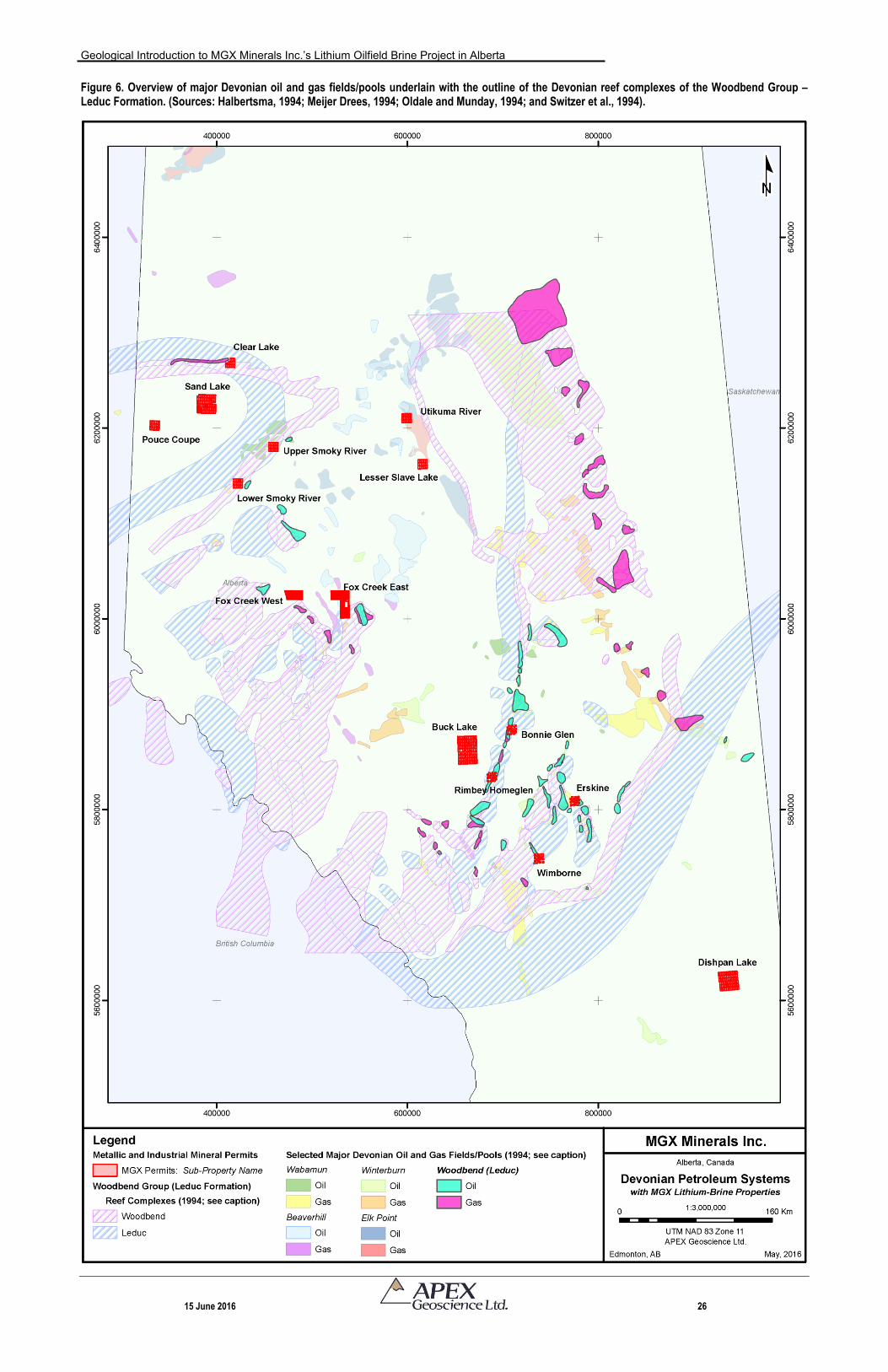
15 June 2016 25
With respect to NI 43-101 reporting, it is important to note that the Devonian petroleum system underlies much of Alberta, and consequently, this portion of the historical summary encompasses an area that is significantly more extensive that the MGX Properties. For example, Figure 6 shows Alberta’s Devonian oilfields and pools as they correlate to the reef complexes of the Woodbend Group (Leduc Formation). It is easy to envisage that the Devonian petroleum system underlies vast areas of Alberta, and therefore, this discussion does not relate specifically to MGX’ Properties. Accordingly, any discussion on Li-brine mineralization in Devonian aquifers outside of MGX’s Properties might not be indicative of mineralization on the MGX Properties that are the subject of this Technical Report.
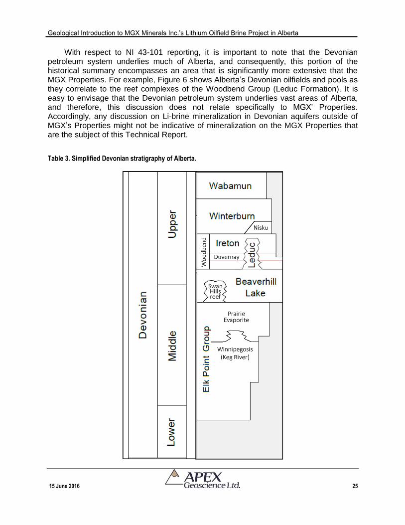
Table 3. Simplified Devonian stratigraphy of Alberta.
Geological Introduction to MGX Minerals Inc.’s Lithium Oilfield Brine Project in Alberta
15 June 2016 26
Figure 6. Overview of major Devonian oil and gas fields/pools underlain with the outline of the Devonian reef complexes of the Woodbend Group – Leduc Formation. (Sources: Halbertsma, 1994; Meijer Drees, 1994; Oldale and Munday, 1994; and Switzer et al., 1994).
Geological Introduction to MGX Minerals Inc.’s Lithium Oilfield Brine Project in Alberta
15 June 2016 27
The main purpose of this section is to provide the reader with a bigger picture perspective of hydrocarbon production within selected Devonian strata of Alberta. 6.1.1 Elk Point Group (Winnipegosis Formation)
In southeast Alberta, oil is being produced from dolomitic reservoirs of the
Winnipegosis Formation immediately to the south of the Big Valley Stettler Leduc platform. In this area, the Elk Point Group (Winnipegosis Formation) depositional environment occurs in the evaporitic interior of a carbonate platform. The Winnipegosis dolomite is overlain by thick units of salt associated with the Prairie Evaporite Formation (Table 3). The subsequent oil trap (or cap rock) has been reported as a local structural closure, perhaps over a Cambrian high. The oil in the reservoir is slightly heavy at 25 API. 6.1.2 Beaverhill Lake Group (Swan Hills Formation)
The Swan Hills Formation reef complex within the Beaverhill Lake Group is located in west-central Alberta, approximately 200 km northwest of Edmonton. Oil was initially produced from the reef complex in 1957 and production continues today. The complex is over 80 km long and covers over 24 Townships of land (2,238 km2). It is estimated that fields/pools within the Beaverhill Lake Group contain over seven billion barrels of light, sweet oil, and is therefore recognized as one of Canada’s giant oilfields.
There are fifteen Beaverhill Lake oilfields with Initial Established Recoverable Oil
Reserves of over 1 x 10⁶m3 (6 MMBbls; Oldale and Munday, 1994). Nine of the largest Beaverhill Lake oilfields occur in the Swan Hills reef complex of west-central Alberta (Table 3). Total recoverable oil reserves in the Beaverhill Lake are estimated at 409 x 106m3 of which 322 x 106m3 have already been produced (Oldale and Munday, 1994). Initial Established In-Place Volume of Beaverhill Lake oil reserves totals 1,052 x 106m3. There are 165 Beaverhill Lake oil pools, with average recoverable oil reserves of 2,479 x 103m3/pool (Oldale and Munday, 1994).
Gas production from the Beaverhill Lake Group is primarily derived from three reef
sources located in: northeastern British Columbia and west-central Alberta; the foothills area of south-central Alberta; and as solution gas in the Swan Hills oilfields of central Alberta. There are 30 Beaverhill Lake gas fields with Initial Established Marketable Gas Reserves of over 1000 x 106m3 (35 BCF). Total recoverable gas reserves in the Beaverhill Lake are estimated at 262.4 x 10⁶m3, of which 111.2 x 10⁶m3 has already been produced. Initial Established In-Place Volume of Beaverhill Lake gas reserves totals 564.2 x 10⁶m3 (Oldale and Munday, 1994). Remaining established reserves of Beaverhill Lake commingled natural gas reserves of multi-field pools is 401 x 106m3 (Alberta Energy Regulator, 2015).
The Devonian in southern Alberta has many porous and permeable reservoirs but there are few major hydrocarbon traps and limited exploration drilling. There is no oil
Geological Introduction to MGX Minerals Inc.’s Lithium Oilfield Brine Project in Alberta
15 June 2016 28
production from the Beaverhill Lake unit in southern Alberta at present (Mort et al., 2015). 6.1.3 Woodbend Group (Leduc Formation)
Woodbend oil production is generally concentrated: along the Rimbey-Meadowbrook Reef Trend; along the Clive-Bashaw D-3 Reef Complex; and in west-central Alberta in the Sturgeon Lake-Simonette-Windfall areas. There are 26 Woodbend oilfields with initial established recoverable oil reserves of over 1 x 10⁶m3 (6 MMBbls; Switzer et al., 1994). Initial established in-place volume of Woodbend oil reserves totals 818 x 106m3. There are 161 Woodbend oil pools, with average recoverable oil reserves of 3,054 x 103m3/pool (Switzer et al., 1994). All oilfields of Woodbend age contain light to medium gravity oil.
Gas production from the Woodbend Group is primarily derived from the D-3 reefs in
south-central Alberta and occurs predominantly as solution gas. There are 35 Woodbend gas fields with initial established marketable gas reserves of over 1,000 x 106m3 (35 BCF; Switzer et al., 1994). Current initial established reserves for the Woodbend-Leduc are 15,148 x 103m3 (Alberta Energy Regulator, 2015). Remaining reserves of marketable gas for the Woodbend-Leduc is 2,659 x 106m3 (Alberta Energy Regulator, 2015).
Tight-shale gas and liquids are also extracted from the Woodbend Group’s Duvernay Formation shale, which is stratigraphically equivalent to the Leduc Formation (Table 3). The hydrocarbons are extracted from the shale using horizontal drilling and multi-stage hydraulic fracturing. Initially-in-place Duvernay shale-hosted:
natural gas ranges from a low estimate of 353 Tcf to a high estimate of 540 Tcf, with a medium estimate of 443 Tcf;
natural-gas liquids range from a low estimate of 7.492 billion barrels to a high estimate of 16.304 billion barrels; and
oil ranges from a low estimate of 44.077 billion barrels to a high estimate of 82.889 billion barrels (Rokosh et al., 2012).
6.1.4 Winterburn Group (Nisku Formation)
Oil production from the Winterburn Group occurs primarily in south-central Alberta
from Nisku Formation shelf carbonates (Table 3). Twenty Winterburn oil fields have Initial Established Recoverable Oil Reserves of over 1 x 10⁶m3 (6 MMBbls; Switzer et al., 1994). Total recoverable oil reserves in the Winterburn Group is relatively small, compared to the other Devonian horizons, and is estimated at 177 x 106m3, of which 148 x 106m3 (83%) have already been produced. The initial established in-place volume
Geological Introduction to MGX Minerals Inc.’s Lithium Oilfield Brine Project in Alberta
15 June 2016 29
of Winterburn oil reserves totals 379.0 x 10⁶m3. There are 229 Winterburn oil pools, with average recoverable oil reserves of 774 x 10 m3/pool (Switzer et al., 1994).
Gas production from the Winterburn Group occurs primarily in west-central Alberta
and in northeastern British Columbia. There are 30 Winterburn gas fields with initial established marketable gas reserves of over 1000 x 106m3 (35 BCF; Switzer et al., 1994).
6.1.5 Summary of Alberta’s Devonian Petroleum System
The Devonian petroleum system comprises carbonate reservoirs with estimated 1.4 x 10⁹m3 (8.9 x 10⁹ bbl) of conventional initial oil in place (IOIP), which is about 30% of the total IOIP and about 51% of all extractable conventional crude oil in the WCSB (Creaney et al., 1994; Hay, 1994). The Devonian petroleum system also contains about 840 x 109m3 (30 x 1012 cubic feet) of natural gas, which is about 23% of all marketable gas in the WCSB (Hay, 1994).
The AER provides yearly updates of Alberta hydrocarbon reserves and estimates
that the remaining established reserves of conventional crude oil is about 288.2 106m3 – more than one third of Canada’s remaining conventional reserves. The Cretaceous and Upper Devonian ages are the major sources for remaining conventional oil (Figure 7). Most of the initial and remaining reserves are in the central and foothills regions of the province. On average, 23% of the total oil in place in these pools is expected to be recovered with today’s technology and there is potential for increased recovery through enhanced oil recovery or new drilling and completion techniques, such as high-density drilling and multistage fracturing technology. In addition, shale- and siltstone-hosted hydrocarbon resources identified 67,320 106m3 of unconventional in-place shale oil resources in six key shale formations in Alberta.
With respect to gas, approximately 4,367 109m3 of natural gas remains unproduced
in Alberta. With current technologies, 1,009 109m3 is still expected to be produced (Alberta Energy Regulator, 2015). The Upper and Lower Cretaceous periods account for about 72% of the province’s remaining established reserves of marketable gas and are important as a future source of natural gas (Figure 7).
The Devonian petroleum system continues to produce oil, heavy oil, gas and
unconventional oil and gas. Figure 7 shows that crude oil and conventional marketable gas reserves of the Devonian petroleum system is dwindling, but it is still a viable producer of oil and gas in Alberta. It is recognized that the Devonian systems, some of which have been in operation since the late-1940s, are presently mature fields/pools or have extinguished their hydrocarbon resources. Consequently, an important consideration for Li-brine companies is to investigate the remaining reserves of Devonian petroleum products within their respective target fields/pools to ascertain/estimate the operational lifespan of the hydrocarbon producing wells (i.e., assurance to access Li-brine).
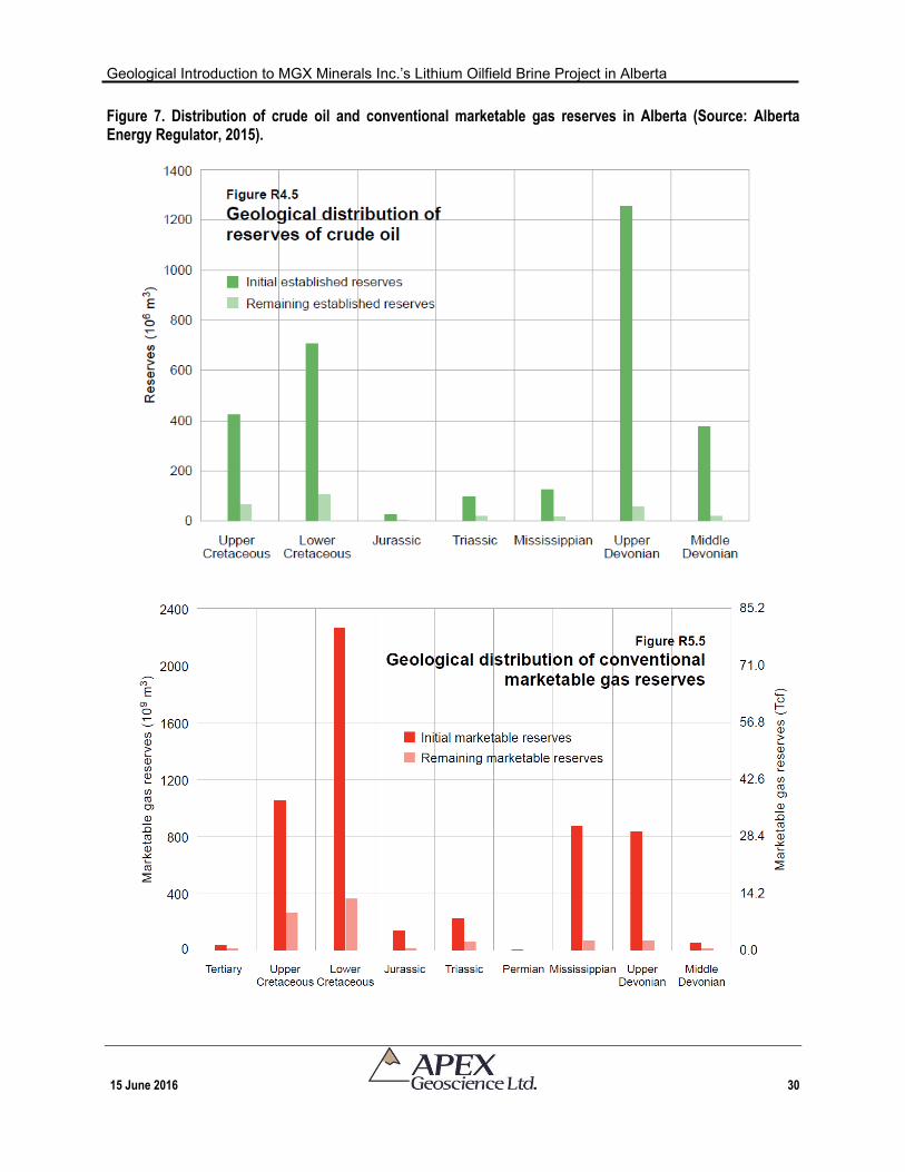
Geological Introduction to MGX Minerals Inc.’s Lithium Oilfield Brine Project in Alberta
15 June 2016 30
Figure 7. Distribution of crude oil and conventional marketable gas reserves in Alberta (Source: Alberta Energy Regulator, 2015).
Geological Introduction to MGX Minerals Inc.’s Lithium Oilfield Brine Project in Alberta
15 June 2016 31
6.1.6 ‘Remaining Established Reserves’ in Fields/Pools Associated with MGX’s Properties. The following reserve data are taken from AER’s Alberta Energy Reserves 2014 and
Supply/Demand Outlook – Appendix B. The author has not ascertained the exact outlines of the following pools/fields, and therefore, the reader should assume that boundaries of the oil/gas fields/pools do not correlate at a one-to-one relationship with MGX’s sub-Properties and they likely extend outside the sub-Property boundaries. The author is presenting only those reserve data for the MGX sub-Properties whose Property name correlates directly with a field/pool name (e.g., the Bonnie Glen sub-Property corresponds to the Bonnie Glen pool). Consequently, it is possible that there is oil/gas field/pool reserve data for those sub-Properties that are not included in this section (e.g., Sand Lake, Utikuma River, etc.). The main intent of presenting these data is to show that some of MGX’s sub-Properties have active pumping, and continuing oil and gas production.
Buck Lake: The Minnehik-Buck Lake Commingled natural gas multi-field pool has remaining established reserves of 140 x 106m3; the reservoir is a Cretaceous in age and there is no Devonian production (Alberta Energy Regulator, 2015).
Bonnie Glen: The Bonnie Glen Commingled natural gas multi-field pool (Leduc Formation) has remaining established reserves of 15 x 106m3 (Alberta Energy Regulator, 2015).
Erskine: The Erskine Commingled natural gas multi-field pool (e.g., Leduc, Nisku and Belly River formations) has remaining established reserves of 24 x 106m3
(Alberta Energy Regulator, 2015).
Wimborne: The Wimborne Commingled natural gas multi-field pool (e.g., Leduc and Nisku formations) has remaining established reserves of 629 x 106m3
(Alberta Energy Regulator, 2015).
Pouce Coupe: The Pouce Coupe South Commingled Pool has initial established oil reserves of 1,230 x 103m3, and remaining reserves of marketable gas (raw ethane) of 13,979 106m3 (Wabumun and Montney formations; Alberta Energy Regulator, 2015).
Fox Creek: The Fox Creek Commingled and Kaybob South Commingled pools have natural gas reserves of 730 x 106m3 and 6,341 x 106m3. Kaybob and Kaybob South have remaining reserves of marketable gas (natural gas liquids) of 3,743 x 106m3 and 12,672 x 106m3. Kaybob. The the Leduc-equivalent Duvernay has an estimated: 12,479 x 109m3 natural gas; 1,798 x 106m3 natural gas liquids; and 9,803 x 106m3 crude oil (Alberta Energy Regulator, 2015).
Geological Introduction to MGX Minerals Inc.’s Lithium Oilfield Brine Project in Alberta
15 June 2016 32
6.2 Discovery of Lithium-Enriched Formation Water/Brine in Alberta
The first comprehensive overview of the mineral potential of formation waters from across Alberta was compiled by the Government of Alberta (Hitchon et al., 1995). ‘Formation water’ is used as a generic term to describe all water that naturally occurs in pores of a rock and if the rock is permeable could represent an aquifer. Hitchon et al. (1995) compiled nearly 130,000 analyses of formation water across Alberta from numerous sources including: the AER submissions for drilling as reported by the petroleum industry; and from various Government of Alberta reports and unpublished detailed analyses provided to the Government of Alberta. The compilation encompassed Cambrian through to Triassic formation waters. Hitchon (1984) and Hitchon et al. (1995) defined arbitrary ‘detailed’ and ‘regional’ threshold values to define elements of possible economic interest as follows:
A ‘detailed exploration threshold value’ was determined by studying the concentrations in economically producing fields as defined in Hitchon (1984) and Hitchon et al. (1995).
A lower regional exploration threshold value was defined to allow for contouring and extrapolation of data to undrilled areas.
The threshold values were defined for each element. For example, the regional
exploration threshold value for Li was considered to be 50 ppm and the detailed exploration threshold value was defined as 75 ppm (Hitchon et al., 1995).
At the provincial scale, the Hitchon et al. (1995) reported disclosed that lithium was analyzed and reported in 708 formation water analyses (out of the 130,000 total analyses examined). Of the 708 analyses:
96 analyses/wells contained Li above the ‘regional threshold value’ (greater than 50 ppm); and
47 analyses/wells yielded Li concentrations above the ‘detailed threshold value’ of 75 ppm.
The Hitchon et al. (1995) compilations showed that the highest concentrations of
lithium in formation water occurred within the Beaverhill Lake (Swan Hills) and/or Woodbend (Leduc) aquifers: 130 mg/L and 140 mg/L, respectively (Table 4).
More recently, Eccles and Jean (2010) modelled 1,511 lithium-bearing formation
water analyses from throughout Alberta (more than double the lithium values reported by Hitchon et al., 1995). This compilation supported the previous author’s conclusion that there are several pockets of concentrated lithium in west-central Alberta (Figure 8). Of the 1,511 analyses, 19 analyses/wells contained >100 mg/L Li (up to 140 mg/L), all of which were sampled from within the Middle to Late Devonian carbonate complexes.
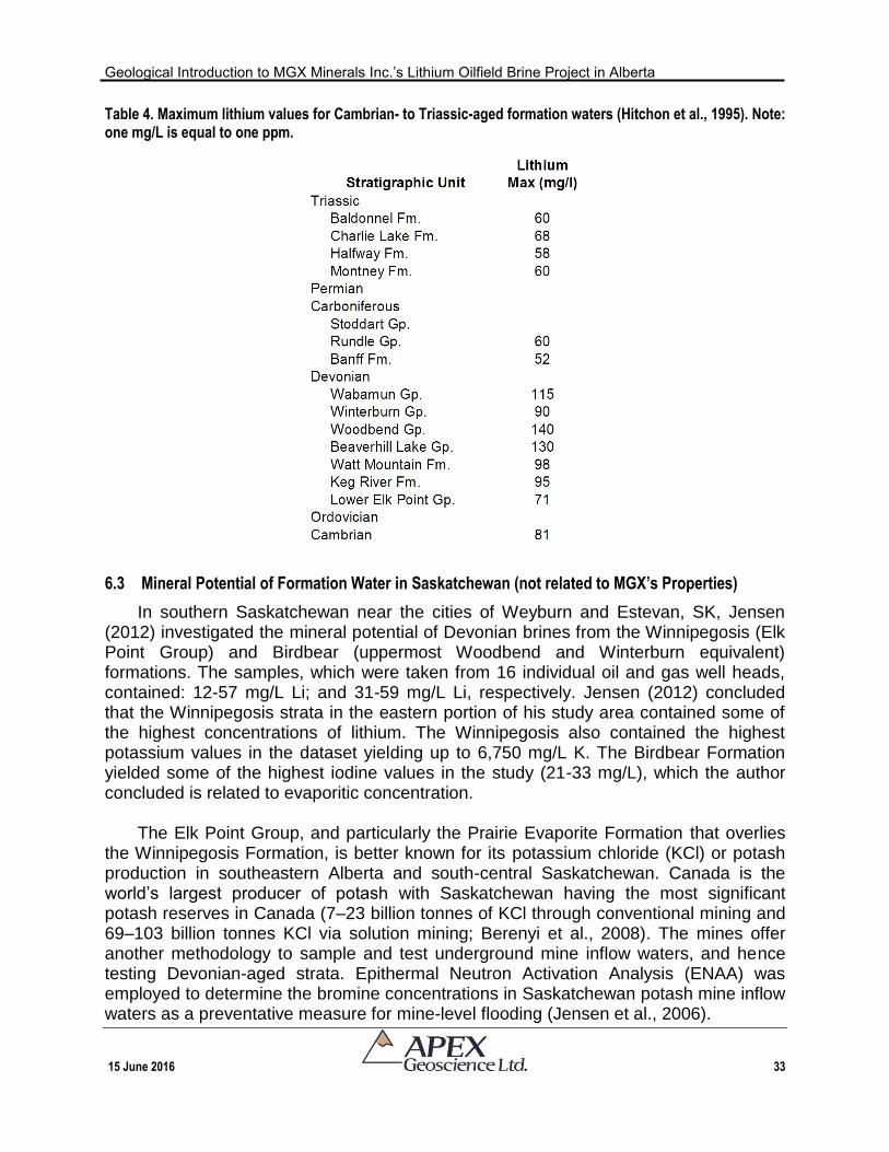
Geological Introduction to MGX Minerals Inc.’s Lithium Oilfield Brine Project in Alberta
15 June 2016 33
Table 4. Maximum lithium values for Cambrian- to Triassic-aged formation waters (Hitchon et al., 1995). Note: one mg/L is equal to one ppm.
6.3 Mineral Potential of Formation Water in Saskatchewan (not related to MGX’s Properties)
In southern Saskatchewan near the cities of Weyburn and Estevan, SK, Jensen (2012) investigated the mineral potential of Devonian brines from the Winnipegosis (Elk Point Group) and Birdbear (uppermost Woodbend and Winterburn equivalent) formations. The samples, which were taken from 16 individual oil and gas well heads, contained: 12-57 mg/L Li; and 31-59 mg/L Li, respectively. Jensen (2012) concluded that the Winnipegosis strata in the eastern portion of his study area contained some of the highest concentrations of lithium. The Winnipegosis also contained the highest potassium values in the dataset yielding up to 6,750 mg/L K. The Birdbear Formation yielded some of the highest iodine values in the study (21-33 mg/L), which the author concluded is related to evaporitic concentration.
The Elk Point Group, and particularly the Prairie Evaporite Formation that overlies
the Winnipegosis Formation, is better known for its potassium chloride (KCl) or potash production in southeastern Alberta and south-central Saskatchewan. Canada is the world’s largest producer of potash with Saskatchewan having the most significant potash reserves in Canada (7–23 billion tonnes of KCl through conventional mining and 69–103 billion tonnes KCl via solution mining; Berenyi et al., 2008). The mines offer another methodology to sample and test underground mine inflow waters, and hence testing Devonian-aged strata. Epithermal Neutron Activation Analysis (ENAA) was employed to determine the bromine concentrations in Saskatchewan potash mine inflow waters as a preventative measure for mine-level flooding (Jensen et al., 2006).
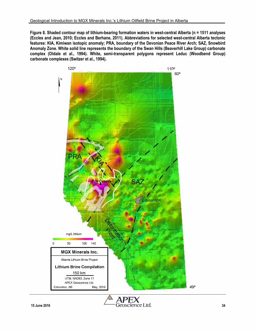
Geological Introduction to MGX Minerals Inc.’s Lithium Oilfield Brine Project in Alberta
15 June 2016 34
Figure 8. Shaded contour map of lithium-bearing formation waters in west-central Alberta (n = 1511 analyses (Eccles and Jean, 2010; Eccles and Berhane, 2011). Abbreviations for selected west-central Alberta tectonic features: KIA, Kimiwan isotopic anomaly; PRA, boundary of the Devonian Peace River Arch; SAZ, Snowbird Anomaly Zone. White solid line represents the boundary of the Swan Hills (Beaverhill Lake Group) carbonate complex (Oldale et al., 1994). White, semi-transparent polygons represent Leduc (Woodbend Group) carbonate complexes (Switzer et al., 1994).
Geological Introduction to MGX Minerals Inc.’s Lithium Oilfield Brine Project in Alberta
15 June 2016 35
Sixty-three inflow samples were collected from various depths in the Saskatchewan (PCS) Rocanville, Cory, and Allan potash mines. The authors discovered that the bromine increases with depth at all three mines ranging from 2 mg/l Br in near-surface aquifers (58 m depth), to approximately 5500 mg/l Br in Devonian carbonate aquifers (1025 m depth). The wide spacing of elevated bromine samples (e.g., 55 km between the Cory and Allan mines) implies that they are more than just an isolated occurrence at each mine (Jensen et al., 2006).
At present there is no potash production in Alberta mainly because the Alberta portion of the Western Canada Sedimentary Basin contains an enormous volume of pure or nearly pure halite in the Lower to Middle Devonian Elk Point Group. Accordingly, salt production in Alberta is mainly by extraction from salt brine from the extensive, pure Upper Lotsberg salts. The salt is used in the manufacture of sodium chlorate and chlor-alkali products. Mid-1990s government studies of Alberta formation waters reported that waters of the Beaverhill Lake Group, which overlies the Prairie Evaporite Formation, had potassium concentrations of up to 19,000 mg/L (Eccles et al., 2009). This study led these authors to suggest that K-rich formation waters should be further evaluated by hydrodynamic modelling to explain the origin of the potassium, and as an economic prospect for potassium extraction. 6.4 Alberta Lithium-Brine Resource Estimations (not related to MGX’s Properties)
To date, there is no current production and/or guarantee that lithium and associated elements can be economically extracted from Alberta brine.
Alberta is currently experiencing its second staking rush/exploration period this
decade for its Li-brine potential. The first round of industry exploration (circa 2009-2012) showed that the Li-brine is sourced in substantial quantities; however, these companies did little in the way of showing that the metal was recoverable from the brine. Nevertheless, Li-brine resource estimates were published for two spatially separate Devonian reservoirs, both of which occur in west-central Alberta, but are in no way connected or related (Eccles et al., 2012a,b; Eccles et al., 2016). The mineral resource estimates were prepared in accordance with NI 43-101. The estimation areas do not encompass or overlap with any of MGX’s Properties. Accordingly, the resource estimate reports are not discussed in this History Section or this Technical Report, but the author would like to make the reader aware that the reports can be accessed at www.sedar.com. Any discussion on Li-brine mineralization in Devonian aquifers outside of MGX’s Properties might not be indicative of mineralization on the MGX Properties that are the subject of this Technical Report.
6.5 Historical Summary of Lithium Oilfield Brine Chemistries (Specific to MGX’s Properties)
The fluid geochemical data presented in this section are from publicly available well
data were submitted to, and is managed by, the AER and has been compiled and reported in various government reports (e.g., Hitchon et al., 1995; Eccles and Jean,
Geological Introduction to MGX Minerals Inc.’s Lithium Oilfield Brine Project in Alberta
15 June 2016 36
2010; Eccles and Berhane, 2011). In addition, the data includes some new formation water geochemical analyses that were conducted in central Alberta by the AGS (Huff et al., 2011, 2012).
The author of this Technical Report has been unable to personally verify the water
sampling protocol and analytical methods that were used to collect and analyze these historical samples/data. However, the author has reviewed the geochemical data and found no significant issues or inconsistencies that would cause one to question the validity of the data and is satisfied to include these publicly available data to introduce the Li-brine potential of the MGX Properties.
Lithium (Li) values from wells located within the boundaries of MGX’s sub-Properties
are presented in Table 5 and described in the text that follows. Potassium (K), bromide (Br) and Iodide (I) values are also included, where available. Most of the wells were drilled in the mid-1970s and the formation water samples were collected and tested at this time. 6.5.1 Red Deer Group of Permits
Historical oil and gas geochemical data for the Red Deer group of permits are
presented in Table 5, Figure 9 and are summarized – by sub-Property – in the text that follows.
Buck Lake: Petroleum production on this sub-Property is from Cretaceous Cardium, Viking and Belly River formations (there is no Devonian production). In 1975, well 10-36-045-05W5-0 drilled to a depth of 2,475 m intersected the Devonian Winterburn Group Nisku Formation; a drill stem test (DST) from the Nisku yielded 90 mg/L Li. Cretaceous fluid data from well 100/06-10-045-04W5 did not record lithium, bromide, boron or iodide, and the potassium results were relatively low (3,050 mg/L K) in comparison to some of MGX’s other Properties.
Bonnie Glen: Is part of a long chain of Devonian Leduc and Nisku pools culminating to the north at the famous Leduc pool and the Leduc #1 well. Woodbend Group formation water yielded lithium values of up to 140 mg/L Li from well 00/05-21-047-27W4-0. Well 100/09-09-047-27W4/00 did not record lithium, but did measure 5,110 mg/L K from the Wabamun.
Erskine: This Leduc pool has a long history of production and consequently only a few Devonian wells are still producing. Well 00/02-22-039-21W4-0 and well 102/04-30-039-21W4/00 yielded Woodbend Group formation waters with 130 mg/L Li and 7,270 mg/L K, respectively. Well 102/08-26-039-21W4 was sampled by Huff et al. (2011) and yielded 74.7 mg/L Li, 5,870 mg/L K and 870 mg/L Br from the Leduc Formation at a depth of 1,664 m.
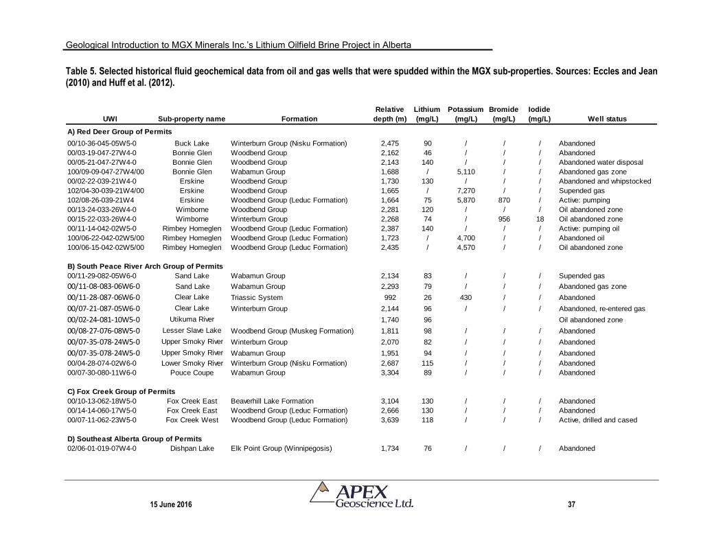
Geological Introduction to MGX Minerals Inc.’s Lithium Oilfield Brine Project in Alberta
15 June 2016 37
Table 5. Selected historical fluid geochemical data from oil and gas wells that were spudded within the MGX sub-properties. Sources: Eccles and Jean (2010) and Huff et al. (2012).
UWI Sub-property name Formation
Relative
depth (m)
Lithium
(mg/L)
Potassium
(mg/L)
Bromide
(mg/L)
Iodide
(mg/L) Well status
A) Red Deer Group of Permits
00/10-36-045-05W5-0 Buck Lake Winterburn Group (Nisku Formation) 2,475 90 / / / Abandoned
00/03-19-047-27W4-0 Bonnie Glen Woodbend Group 2,162 46 / / / Abandoned
00/05-21-047-27W4-0 Bonnie Glen Woodbend Group 2,143 140 / / / Abandoned water disposal
100/09-09-047-27W4/00 Bonnie Glen Wabamun Group 1,688 / 5,110 / / Abandoned gas zone
00/02-22-039-21W4-0 Erskine Woodbend Group 1,730 130 / / / Abandoned and whipstocked
102/04-30-039-21W4/00 Erskine Woodbend Group 1,665 / 7,270 / / Supended gas
102/08-26-039-21W4 Erskine Woodbend Group (Leduc Formation) 1,664 75 5,870 870 / Active: pumping
00/13-24-033-26W4-0 Wimborne Woodbend Group 2,281 120 / / / Oil abandoned zone
00/15-22-033-26W4-0 Wimborne Winterburn Group 2,268 74 / 956 18 Oil abandoned zone
00/11-14-042-02W5-0 Rimbey Homeglen Woodbend Group (Leduc Formation) 2,387 140 / / / Active: pumping oil
100/06-22-042-02W5/00 Rimbey Homeglen Woodbend Group (Leduc Formation) 1,723 / 4,700 / / Abandoned oil
100/06-15-042-02W5/00 Rimbey Homeglen Woodbend Group (Leduc Formation) 2,435 / 4,570 / / Oil abandoned zone
B) South Peace River Arch Group of Permits
00/11-29-082-05W6-0 Sand Lake Wabamun Group 2,134 83 / / / Supended gas
00/11-08-083-06W6-0 Sand Lake Wabamun Group 2,293 79 / / / Abandoned gas zone
00/11-28-087-06W6-0 Clear Lake Triassic System 992 26 430 / / Abandoned
00/07-21-087-05W6-0 Clear Lake Winterburn Group 2,144 96 / / / Abandoned, re-entered gas
00/02-24-081-10W5-0 Utikuma River 1,740 96 Oil abandoned zone
00/08-27-076-08W5-0 Lesser Slave Lake Woodbend Group (Muskeg Formation) 1,811 98 / / / Abandoned
00/07-35-078-24W5-0 Upper Smoky River Winterburn Group 2,070 82 / / / Abandoned
00/07-35-078-24W5-0 Upper Smoky River Wabamun Group 1,951 94 / / / Abandoned
00/04-28-074-02W6-0 Lower Smoky River Winterburn Group (Nisku Formation) 2,687 115 / / / Abandoned
00/07-30-080-11W6-0 Pouce Coupe Wabamun Group 3,304 89 / / / Abandoned
C) Fox Creek Group of Permits
00/10-13-062-18W5-0 Fox Creek East Beaverhill Lake Formation 3,104 130 / / / Abandoned
00/14-14-060-17W5-0 Fox Creek East Woodbend Group (Leduc Formation) 2,666 130 / / / Abandoned
00/07-11-062-23W5-0 Fox Creek West Woodbend Group (Leduc Formation) 3,639 118 / / / Active, drilled and cased
D) Southeast Alberta Group of Permits
02/06-01-019-07W4-0 Dishpan Lake Elk Point Group (Winnipegosis) 1,734 76 / / / Abandoned
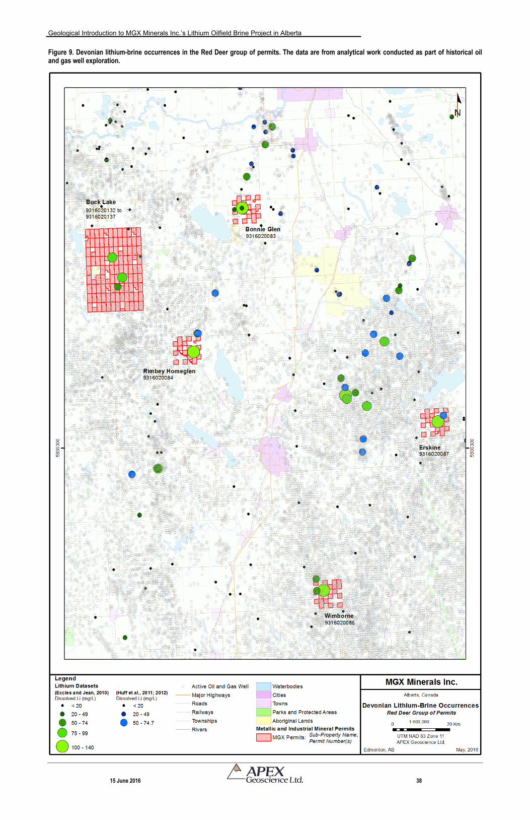
Geological Introduction to MGX Minerals Inc.’s Lithium Oilfield Brine Project in Alberta
15 June 2016 38
Figure 9. Devonian lithium-brine occurrences in the Red Deer group of permits. The data are from analytical work conducted as part of historical oil and gas well exploration.
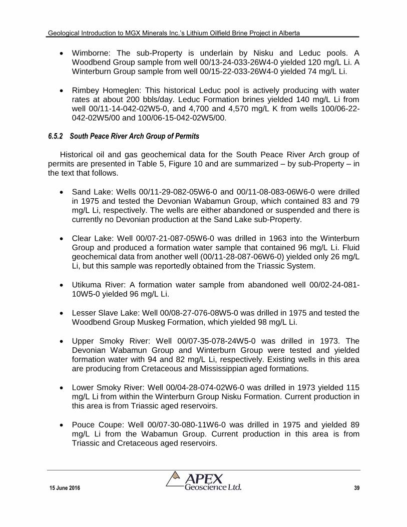
Geological Introduction to MGX Minerals Inc.’s Lithium Oilfield Brine Project in Alberta
15 June 2016 39
Wimborne: The sub-Property is underlain by Nisku and Leduc pools. A Woodbend Group sample from well 00/13-24-033-26W4-0 yielded 120 mg/L Li. A Winterburn Group sample from well 00/15-22-033-26W4-0 yielded 74 mg/L Li.
Rimbey Homeglen: This historical Leduc pool is actively producing with water rates at about 200 bbls/day. Leduc Formation brines yielded 140 mg/L Li from well 00/11-14-042-02W5-0, and 4,700 and 4,570 mg/L K from wells 100/06-22-042-02W5/00 and 100/06-15-042-02W5/00.
6.5.2 South Peace River Arch Group of Permits
Historical oil and gas geochemical data for the South Peace River Arch group of
permits are presented in Table 5, Figure 10 and are summarized – by sub-Property – in the text that follows.
Sand Lake: Wells 00/11-29-082-05W6-0 and 00/11-08-083-06W6-0 were drilled in 1975 and tested the Devonian Wabamun Group, which contained 83 and 79 mg/L Li, respectively. The wells are either abandoned or suspended and there is currently no Devonian production at the Sand Lake sub-Property.
Clear Lake: Well 00/07-21-087-05W6-0 was drilled in 1963 into the Winterburn Group and produced a formation water sample that contained 96 mg/L Li. Fluid geochemical data from another well (00/11-28-087-06W6-0) yielded only 26 mg/L Li, but this sample was reportedly obtained from the Triassic System.
Utikuma River: A formation water sample from abandoned well 00/02-24-081-10W5-0 yielded 96 mg/L Li.
Lesser Slave Lake: Well 00/08-27-076-08W5-0 was drilled in 1975 and tested the Woodbend Group Muskeg Formation, which yielded 98 mg/L Li.
Upper Smoky River: Well 00/07-35-078-24W5-0 was drilled in 1973. The Devonian Wabamun Group and Winterburn Group were tested and yielded formation water with 94 and 82 mg/L Li, respectively. Existing wells in this area are producing from Cretaceous and Mississippian aged formations.
Lower Smoky River: Well 00/04-28-074-02W6-0 was drilled in 1973 yielded 115 mg/L Li from within the Winterburn Group Nisku Formation. Current production in this area is from Triassic aged reservoirs.
Pouce Coupe: Well 00/07-30-080-11W6-0 was drilled in 1975 and yielded 89 mg/L Li from the Wabamun Group. Current production in this area is from Triassic and Cretaceous aged reservoirs.
Geological Introduction to MGX Minerals Inc.’s Lithium Oilfield Brine Project in Alberta
15 June 2016 40
Figure 10. Devonian lithium-brine occurrences in the Peace River Arch group of permits. The data are from analytical work conducted as part of historical oil and gas well exploration.
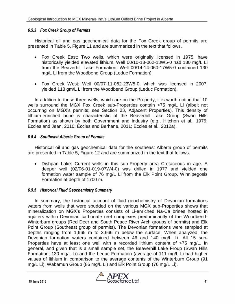
Geological Introduction to MGX Minerals Inc.’s Lithium Oilfield Brine Project in Alberta
15 June 2016 41
6.5.3 Fox Creek Group of Permits
Historical oil and gas geochemical data for the Fox Creek group of permits are presented in Table 5, Figure 11 and are summarized in the text that follows.
Fox Creek East: Two wells, which were originally licensed in 1975, have historically yielded elevated lithium. Well 00/10-13-062-18W5-0 had 130 mg/L Li from the Beaverhill Lake Formation. Well 00/14-14-060-17W5-0 contained 130 mg/L Li from the Woodbend Group (Leduc Formation).
Fox Creek West: Well 00/07-11-062-23W5-0, which was licensed in 2007, yielded 118 gm/L Li from the Woodbend Group (Leduc Formation).
In addition to these three wells, which are on the Property, it is worth noting that 10
wells surround the MGX Fox Creek sub-Properties contain >75 mg/L Li (albeit not occurring on MGX’s permits; see Section 23, Adjacent Properties). This density of lithium-enriched brine is characteristic of the Beaverhill Lake Group (Swan Hills Formation) as shown by both Government and industry (e.g., Hitchon et al., 1975; Eccles and Jean, 2010; Eccles and Berhane, 2011; Eccles et al., 2012a). 6.5.4 Southeast Alberta Group of Permits
Historical oil and gas geochemical data for the southeast Alberta group of permits
are presented in Table 5, Figure 12 and are summarized in the text that follows.
Dishpan Lake: Current wells in this sub-Property area Cretaceous in age. A deeper well (02/06-01-019-07W4-0) was drilled in 1977 and yielded one formation water sample of 76 mg/L Li from the Elk Point Group, Winnipegosis Formation at depth of 1700 m.
6.5.5 Historical Fluid Geochemistry Summary
In summary, the historical account of fluid geochemistry of Devonian formations
waters from wells that were spudded on the various MGX sub-Properties shows that mineralization on MGX’s Properties consists of Li-enriched Na-Ca brines hosted in aquifers within Devonian carbonate reef complexes predominantly of the Woodbend-Winterburn groups (Red Deer and South Peace River Arch groups of permits) and Elk Point Group (Southeast group of permits). The Devonian formations were sampled at depths ranging from 1,665 m to 3,666 m below the surface. When analyzed, the Devonian formation waters contained between 46 and 140 mg/L Li. All 15 sub-Properties have at least one well with a recorded lithium content of >75 mg/L. In general, and given that is a small sample set, the Beaverhill Lake Froup (Swan Hills Formation; 130 mg/L Li) and the Leduc Formation (average of 111 mg/L Li had higher values of lithium in comparison to the average contents of the Winterburn Group (91 mg/L Li), Wabamun Group (86 mg/L Li) and Elk Point Group (76 mg/L Li).
Geological Introduction to MGX Minerals Inc.’s Lithium Oilfield Brine Project in Alberta
15 June 2016 42
Figure 11. Devonian lithium-brine occurrences in the Fox Creek group of permits. The data are from analytical work conducted as part of historical oil and gas well exploration.
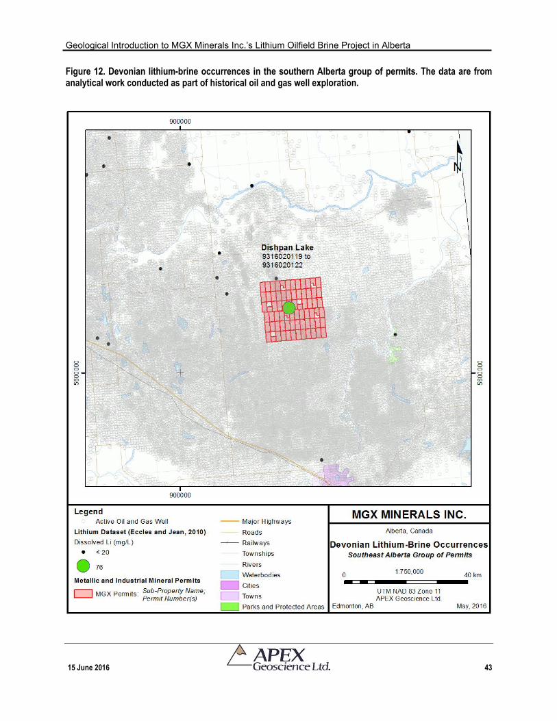
Geological Introduction to MGX Minerals Inc.’s Lithium Oilfield Brine Project in Alberta
15 June 2016 43
Figure 12. Devonian lithium-brine occurrences in the southern Alberta group of permits. The data are from analytical work conducted as part of historical oil and gas well exploration.
Geological Introduction to MGX Minerals Inc.’s Lithium Oilfield Brine Project in Alberta
15 June 2016 44
7 Geological Setting and Mineralization Geological units of Alberta range in age from Archean to Recent and are exposed as
broad northwesterly trending belts, which decrease in age towards the southwest (Figure 13; Hamilton et al., 1999). Precambrian rocks are exposed in the northeast and form the basement for a thickening wedge of Phanerozoic strata of the Western Canada Sedimentary Basin (WCSB) that reaches a maximum thickness of about 6,000 m in front of the Cordilleran fold-and-thrust belt to the southwest.
The crystalline basement rocks of northern Alberta represent the westernmost part
of the Canadian Shield and have been assigned to more or less distinct continental slivers accreted to the composite Churchill province during the assembly of western Laurentia (~2.0 to 1.8 Ga; e.g., Hoffman, 1988; Ross et al., 1994); or to a more uniform continental fragment that was separated from and welded back to the Churchill province (Burwash et al., 1994, 2000).
The WCSB is a vast wedge of sedimentary rock that extends from the Rocky
Mountains in the west to the Canadian Shield in the east. At its thickest, this wedge is about 6 km thick under the Rocky Mountains and thins to its zero extent at the eastern margins of the basin. Phanerozoic strata have been deposited in the WCSB in two fundamentally different tectonosedimentary environments: 1) Late Proterozoic to Middle Jurassic passive continental margin; and 2) Middle Jurassic to Oligocene foreland basin. The WCSB contains one of the world’s largest reserves of petroleum and natural gas, bitumen (oil sands) and coal.
The Paleozoic to Jurassic platformal succession, which is dominated by carbonate
rocks, can be summarized as two periods of continental margin sedimentation separated by cratonic inundations from the west, southeast and northwest (Kent, 1994). During this period, marine inundation, sedimentation and erosion were strongly influenced by epeirogenic movements on intracratonic arches (e.g., Peace River Arch in northwestern Alberta) that episodically differentiated the region into a complex array of sub-basins and uplifts (Mossop and Shetsen, 1994). As a result, much of the Paleozoic succession consists of unconformity-bounded, thin to thick sequences of carbonate rocks interlayered with predominantly fine- to medium-grained clastic marine sedimentary rocks.
As presented in the History section of this Technical Report, formation waters within
the Devonian tend to be enriched in lithium. In addition, these formation waters are pumped to the surface in large volumes as waste products associated with oil and gas production. The Devonian Winterburn-Woodbend, and Elk Point groups (Table 3) contain over 50% and 23% of Western Canada's initial established recoverable oil and gas reserves, and accounts for 54% and 34% of Western Canada's cumulative production oil and gas to date (Hay, 1994). Accordingly, the geology section in this Technical Report focuses on these Devonian groups and their specific oil-bearing rock units and associated aquifers.
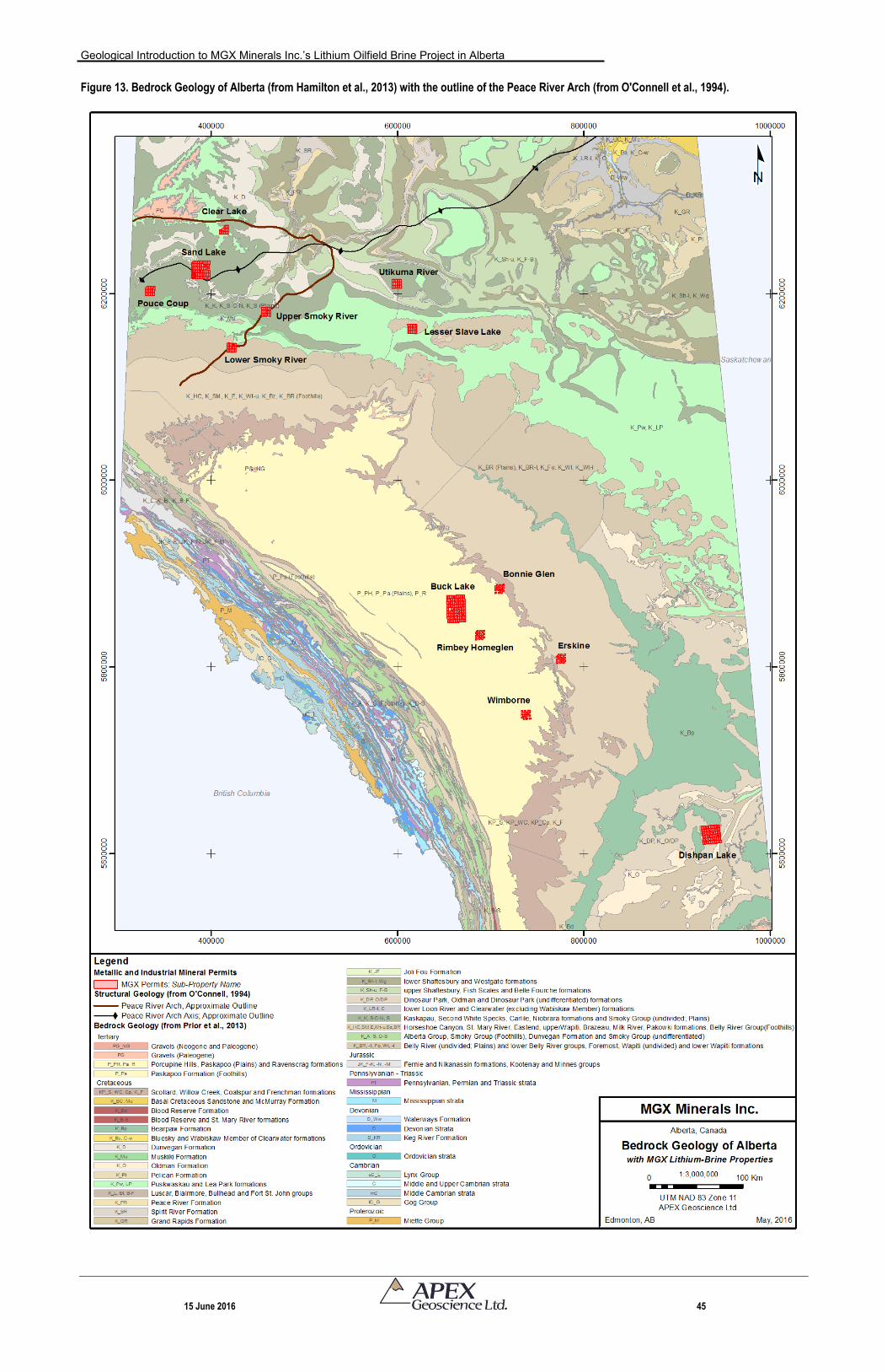
Geological Introduction to MGX Minerals Inc.’s Lithium Oilfield Brine Project in Alberta
15 June 2016 45
Figure 13. Bedrock Geology of Alberta (from Hamilton et al., 2013) with the outline of the Peace River Arch (from O'Connell et al., 1994).
Geological Introduction to MGX Minerals Inc.’s Lithium Oilfield Brine Project in Alberta
15 June 2016 46
7.1 Early to Middle Devonian Elk Point Group (Prairie Evaporite Formation) The Elk Point Group was deposited in a restricted-marine environment on top of the
pre-Devonian erosional unconformity (Meijer-Drees, 1994). The Elk Point Group consists of carbonates and evaporates and is capped the Watt Mountain Formation shale (Meijer Drees, 1994). The upper units of the Elk Point group, including the Ft. Vermillion, Muskeg and Watt Mountain Formations, comprise an aquitard (Hitchon et al., 1990).
The Elk Point aquifer is defined as those aquifers lying between: 1) the Prairie
Evaporite aquiclude and the Lotsberg and Cold Lake aquicludes; 2) the Contact Rapids and Keg River aquifers; and 3) the Granite Wash aquifer, which overlies the Precambrian basement (Hitchon et al., 1995). Elements exceeding these authors’ threshold values are limited to calcium (Ca) and magnesium (Mg).
7.2 Middle to Late Devonian Beaverhill Lake Group (Swan Hills Formation)
Overlying the Elk Point Group, the Beaverhill Lake Group consists of reefal
carbonates that deposited on an open marine platform. The Beaverhill Lake Group consists of anhydrite and carbonate rocks at the base, and is overlain by interbedded sequences of calcareous shale, argillaceous micritic limestone, limestone and dolostone. The Beaverhill Lake Group becomes thicker and shaly to the west. It reaches a maximum thickness of about 240 m in central Alberta (Oldale and Munday, 1994). Six paleogeographic areas are recognized for the Beaverhill Lake Group: Horn River Basin; Hay River Basin; Peace River Arch Fringing Reef Complex; Swan Hills Complex; Waterways Basin; and Souris River Shelf.
The Beaverhill Lake group in Southeastern Alberta was deposited as a series of
northwestern prograding carbonate ramps (i.e., the Souris River Shelf). The ramp complex is time equivalent to the aggrading and backstopping Swan Hills platform which developed to the north and west. At the base of the system, a salt basin was deposited and is surrounded by evaporitic platform interior sediments.
The Middle to Late Devonian Swan Hills Complex was deposited on the flank of the
West Alberta Ridge and consists of dolomitic shallowing-upward reef cycles (Oldale and Munday, 1994). The Swan Hill Complex is characterized by a stromatoporoid reef composed of micritic and pelletoidal limestone facies or coarse, porous, bioclastic limestone facies that reaches a maximum thickness of 152 m. Porosity development in the Swan Hills area is associated with the high-energy reef margin facies (Wendte and Stoakes, 1982).
The Beaverhill Lake aquifer occurs throughout much of the province, but in southern
Alberta, the aquifer has high contents of Ca, Mg and K (and possibly Br; Hitchon et al., 1995).

Geological Introduction to MGX Minerals Inc.’s Lithium Oilfield Brine Project in Alberta
15 June 2016 47
7.3 Late Devonian Woodbend- Winterburn Groups (Leduc and Duvernay Formations; Nisku Formation)
A number of notable changes occurred during deposition of the Woodbend-
Winterburn strata, which as summarized by Switzer et al. (1994) include: 1) an apparent increase in the rate of accumulation and preservation of sediment; 2) a dramatic increase in the occurrence of basin-filling shale; 3) the development of thick and extensive reef complexes; 4) the deposition of widespread and prolific hydrocarbon source rocks; and 5) the significant accumulation of economic reserves of hydrocarbons hosted largely by numerous reefal carbonate reservoirs.
The Woodbend Group is conformably overlain by the Winterburn Group, which
conformably overlays the Beaverhill Lake Group. The Woodbend Group reaches a maximum thickness of 700 m in northern Alberta (owing to significant reef development), with a typical thickness of 300 m in southern and central Alberta. The two most distinctive features in the Woodbend include the stacked reef complexes of the Leduc Formation, which exceed 275 m in thickness, and the highly bituminous source rocks (Duvernay and Muskwa formations; Switzer et al., 1994).
The Leduc Formation sub-unit is comprised of shallow water reef deposits that
include mostly dolomitized: stromatoporoid limestone, skeletal mudstone, boundstone, floatstone, packstone and wackestone. The basal Leduc Formation is characterized by dolomitic carbonate from multiple cycles of reef growth, including back-stepping reef rimmed complexes and isolated reefs (Switzer et al. 1994). The Leduc Formation is well known as a host to prolific reserves of oil and gas within Alberta.
The Majeau Lake and Duvernay Formations surround the Leduc reefs. The Majeau
Lake Formation consists of isolated reefs and deep water deposits (shale and limestone). The Duvernay interval is a unique depositional unit within the Woodbend Group. The conditions resulting in its deposition signalled a profound change in the basin. Deposition of the Duvernay is characterized by extensive basinal deposits, synchronous with a significant stage of Leduc reef growth. The Duvernay Formation consists of dark brown bituminous shale and limestone and represents a period of great accumulation and preservation of organic carbon. Consequently, Allan and Creaney (1991) suggested that the Duvernay generated the majority of hydrocarbons found within the Upper Devonian reservoirs of the Alberta Basin.
By the end of Woodbend deposition the WCSB was almost filled by mudstone and
carbonate, and the Winterburn interval began with an apparent relative rise in sea level. This marine transgression resulted in deposition of a widespread carbonate ramp. The Winterburn succession thickens from less than 20 m in Saskatchewan to more than 380 m in northeastern British Columbia. The Winterburn sequence is subdivided stratigraphically into the Nisku, Blue Ridge and Upper Graminia intervals.
Geological Introduction to MGX Minerals Inc.’s Lithium Oilfield Brine Project in Alberta
15 June 2016 48
The Late Devonian (Frasnian) Nisku Formation reef complexes occur in west-central Alberta where the Nisku has been subdivided into four off-reef members (Lobstick, Bigoray, Cynthia and Wolf Lake members) and one reefal member (the Zeta Lake Member). The Zeta Lake "pinnacle" reefs are approximately 180 km long by 65 km wide. Porosity and permeability of the Nisku Formation is controlled by a complex sequence of diagenetic processes. The occurrence or absence of intermediate burial dolomitization is the most important factor governing porosity and permeability of the Zeta Lake Member (Watts, 1987; Machel, 1983, 1985; Anderson, 1985).
Significant aquifers of note within the Woodbend-Winterburn include aquifers
associated with the Leduc Formation and the Swan Hills Formation, both of which contain formation waters with lithium contents of >100 mg/L Li (Hitchon et al., 1995; Eccles and Jean, 2010; Eccles and Berhane, 2011).
7.4 Late Devonian Wabamun Group
The Late Devonian (Famennian) Wabamun Group lies conformably on the Graminia
Formation siltstone of the Winterburn Group. The Wabamun consists of a series of stacked cyclical ramp and shelf carbonates and associated evaporates. It has a stratigraphic thickness of about 50 m in Saskatchewan, thickening to over 200 m in large parts of Alberta (Halbertsma, 1994). Lithofacies intervals reflect the following generalized trends: shale and argillaceous carbonate in the northwest; limestone in north and west-central Alberta; dolomite and evaporite in southern Alberta; and red bed shale and dolomitic siltstone in southern Saskatchewan and Manitoba (Halbertsma, 1994). Sedimentation represents an overall regressive sequence punctuated by several important transgressive pulses. In the Peace River Arch area of northwestern Alberta, Wabamun Group oil and gas fields occur in and/or are associated with faulted horst structures.
The Wabamun Group is characterized as a regional aquifer, but is confined at its
base by siliciclastics and carbonates of the underlying Calmar and Graminia formations of the Winterburn Group (Bachu et al., 2008). Locally, the Graminia Formation may act as an aquifer and provide hydraulic communication with the Nisku Formation (Winterburn Group). Mississipian shale units (Exshaw and Lower Banff formation) form an aquitard at the top of the Wabamun Group.
7.5 ‘Peace River Arch’ Structural Anomaly
A roughly east-northeast-striking zone of long-lasting structural disturbance, which is
known as the Peace River Arch (PRA), cuts across northern Alberta (Figure 13). At present, it is an entirely sub-surface structure, characterized by many sedimentological, structural and diagenetic aberrations (e.g., Sikabonyi and Rogers, 1959; Stott, 1982; Cant, 1988; O’Connell, 1994). The PRA recorded the longest history of tectonic activity within the WCSB and consists of three distinct phases of Phanerozoic evolution (e.g., Cant, 1988; O'Connell et al., 1990; O'Connell, 1994):
Geological Introduction to MGX Minerals Inc.’s Lithium Oilfield Brine Project in Alberta
15 June 2016 49
1) Pre-Late Devonian development (or preservation) of the topographically high
PRA on the WCSB passive margin of proto–North America. The PRA was an asymmetrical structure that reached a maximum width of 140 km at the sixth meridian (longitude 118ºW) and a maximum elevation of about 1,000 m above the surrounding WCSB.
2) Early Carboniferous collapse and reversal of its topographic expression from a highland arch to an embayment (Peace River Embayment [PRE]), with enhanced subsidence relative to the WCSB as a whole persisting through the Triassic (e.g., Beaumont et al., 1993).
3) Enhanced Mesozoic subsidence within the PRE and was coeval with the initiation and evolution of thrust loading (Columbian and Laramide orogenies) in the Cordilleran orogen (O’Connell et al., 1990).
In terms of present-day structural features, adjustment along pre-existing fault
planes is undoubtedly occurring. A strong earthquake occurred in northern Alberta just 50 km northeast of the town of Dawson Creek, in April 2001. The focal mechanism for the magnitude 5.4 earthquake indicates thrust faulting occurred along an approximately east-west striking fault (J. Cassidy, personal communication, 2001). Several other earthquakes of smaller magnitude and with intracrustal hypocenters have been recorded in the PRA area suggesting continuous tectonic readjustments of the basement in a region of long-lasting tectonic instability.
The underlying tectonic causes for the Peace River Arch-Embayment have remained an enigma for over half a century. Various mechanisms have been proposed for the origin and development of the PRA, interpreting it either as a passive or an active structure (for a review see Pana et al., 2001). The most recent hypothesis, a variation on the oceanic transform model, attempts to integrate the initially passive arch structure into a more regional picture, and points to a combination of factors that may have favoured the localization and complex evolution of the PRA. It is therefore emphasized that the PRA is located just inboard (toward the craton) from a transfer zone where the geometry of the miogeocline changes from upper plate in the south to lower plate in the north (Cecile et al., 1997). The approximate northern limit of this transfer zone is located where the Hay River Fault intersects the Cordillera. Transfer zones that accommodate a change in passive-margin polarity and salient re-entrant geometries represent probable areas of locally anomalous intraplate stresses. The early evolution of the PRA may reflect stress buildups and elastic deflections generated due to both the presence of the Winagami Reflection Sequence (WRS), and the break-up and formation of the paleo-Pacific margin in the Canadian Cordillera (Ross and Eaton, 1997; Eaton et al., 1999).
Geological Introduction to MGX Minerals Inc.’s Lithium Oilfield Brine Project in Alberta
15 June 2016 50
7.6 Mineralization Mineralization on MGX’s Properties consists of Li-enriched Na-Ca brines hosted in
aquifers within Devonian carbonate reef complexes predominantly of the Woodbend-Winterburn groups (Red Deer; South Peace River Arch; and Fox Creek groups of permits) and Elk Point Group (Southeast group of permits). Lithium values of up to 140 mg/L Li are reported, historically, from the AER oil and gas well database and Government studies (see Section 6 History; Table 5; Hitchon et al., 1995; Eccles and Jean, 2010; Huff et al., 2011, 2012).
A total of 4,969 oil, gas and water wells – regardless of stratigraphic target age –
have been spudded on MGX’s Properties, which are located throughout Alberta (Table 6; Alberta Energy Regulator, 2016). By far, the majority of these wells (n=2,082) are situated within the Dishpan Lake sub-Property in southeast Alberta; however, all of the Dishpan Lake wells focus on the Late Cretaceous Mannville Group Glauconitic/Ostracod Zone oil and shallow gas. In fact, of the 4,969 wells, 228 wells penetrate Devonian fields/pools within the MGX Permits (not including commingled pools); the current well status of these wells includes: 41 active wells; 32 suspended wells; 148 abandoned wells; and seven wells of unknown status, which are typically related to shallow water wells (Table 6). All active wells in the Fox Creek East and West sub-Properties are focused on hydraulic fracturing of tight oil and gas in the Duvernay shale (Leduc Formation equivalent strata; n=29 wells). Of these wells, 21 are active, five are abandoned and three are suspended. While the Fox Creeks wells are focused on tight shale oil/gas, there is potential to access the Leduc aquifer via these wells.
The majority of the Devonian wells, regardless of well status, occur in MGX’s
Bonnie Glen; Rimbey Homeglen, Wimborne and Erskine sub-Properties, all of which are situated within the Red Deer group of permits area of central Alberta. Hydrocarbon production associated with these largely mature Devonian fields/pools produce excessive amounts of formation water. For example, the production of formation water from selected wells within MGX’s sub-Properties includes, but is not limited to:
Rimbey Homeglen sub-Property (Red Deer group of permits), which produces 200 bbls/day of formation water;
Wimborne sub-Property (Red Deer group of permits) well 11/08-14-033-26W4, which produces about 900 bbls/day; and
Clear Lake sub-Property (South Peace River Arch groups of permits), well 7-21-87-5W6 (abandoned) was producing over 1,000 bbls/day of lithium-enriched brine.
The active Devonian wells represent target opportunities to sample oilfield brine
from producing wells that will help to verify and advance the lithium mineralization at MGX’s Properties.
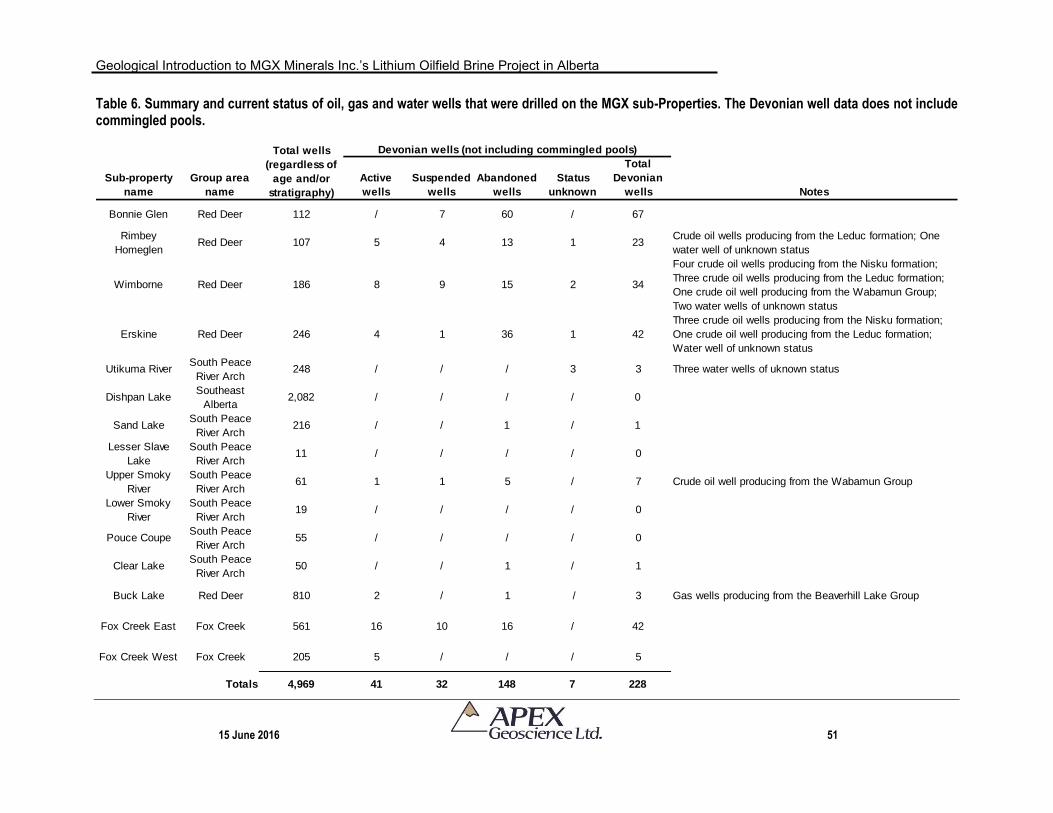
Geological Introduction to MGX Minerals Inc.’s Lithium Oilfield Brine Project in Alberta
15 June 2016 51
Table 6. Summary and current status of oil, gas and water wells that were drilled on the MGX sub-Properties. The Devonian well data does not include commingled pools.
Sub-property
name
Group area
name
Active
wells
Suspended
wells
Abandoned
wells
Status
unknown
Total
Devonian
wells Notes
Bonnie Glen Red Deer 112 / 7 60 / 67
Rimbey
HomeglenRed Deer 107 5 4 13 1 23
Crude oil wells producing from the Leduc formation; One
water well of unknown status
Wimborne Red Deer 186 8 9 15 2 34
Four crude oil wells producing from the Nisku formation;
Three crude oil wells producing from the Leduc formation;
One crude oil well producing from the Wabamun Group;
Two water wells of unknown status
Erskine Red Deer 246 4 1 36 1 42
Three crude oil wells producing from the Nisku formation;
One crude oil well producing from the Leduc formation;
Water well of unknown status
Utikuma RiverSouth Peace
River Arch248 / / / 3 3 Three water wells of uknown status
Dishpan LakeSoutheast
Alberta2,082 / / / / 0
Sand LakeSouth Peace
River Arch216 / / 1 / 1
Lesser Slave
Lake
South Peace
River Arch11 / / / / 0
Upper Smoky
River
South Peace
River Arch61 1 1 5 / 7 Crude oil well producing from the Wabamun Group
Lower Smoky
River
South Peace
River Arch19 / / / / 0
Pouce CoupeSouth Peace
River Arch55 / / / / 0
Clear LakeSouth Peace
River Arch50 / / 1 / 1
Buck Lake Red Deer 810 2 / 1 / 3 Gas wells producing from the Beaverhill Lake Group
Fox Creek East Fox Creek 561 16 10 16 / 42
Fox Creek West Fox Creek 205 5 / / / 5
Totals 4,969 41 32 148 7 228
Total wells
(regardless of
age and/or
stratigraphy)
Devonian wells (not including commingled pools)
Geological Introduction to MGX Minerals Inc.’s Lithium Oilfield Brine Project in Alberta
15 June 2016 52
8 Deposit Types The traditional definition of lithium brine deposits applies to Quaternary-aged,
closed-basin deposits comprised of saline groundwater that is enriched in dissolved lithium. All producing brine deposits have the following characteristics: 1) arid climate; 2) closed basin; 3) tectonically driven subsidence; 4) associated igneous or geothermal activity; 5) suitable lithium source-rocks; 6) one or more adequate aquifers; and 7) sufficient time to concentrate a brine (Bradley et al., 2013). In essence, the lithium is liberated to a closed basin environment by: weathering of adjacent, exposed basin strata or exhumation of older lithium-bearing rock units (and/or paleo lake beds); or it is derived from a variety of hydrothermal fluid sources.
In contrast, lithium oilfield brine occurs when saline formation water associated with
some of the world’s oilfields is known to contain medium to highly anomalous concentrations of lithium. Because the brine is associated with an oilfield reservoir, the brine could occur at various ages (e.g., Jurassic Smackover brine, Arkansas and Texas; Cretaceous reservoirs, Texas; Permian Altmark gasfield, Germany; Cretaceous Heletz-Kokhav, Israel; and Devonian North Dakota formations. In addition, the shape and dimensions of the brine is more or less dependent on the distribution and trapping mechanisms of the oil-bearing source rocks, which can vary significantly – even between pools associated with a single oilfield.
The Smackover brines in the southern United States (Arkansas and Texas) have
been documented by numerous authors as high NaCl and CaCl2 brines with lithium ranging from 50 to 572 ppm Li (Garrett, 2004; Tahil, 2007). The Smackover brines are found at depths ranging from 1,800 to 4,800 m and are hosted in an oolitic limestone with an average porosity of about 5% (Garrett, 2004). The high Ca and Br content of these brines suggest they are concentrated seawater dolomitization brines with the high concentrations of Li (along with B and other trace ions) that was supplied by geothermal sources. Currently only Br is recovered from the Arkansas brines however studies have been conducted on the potential recovery of lithium (Garrett, 2004; Tahil, 2007).
In Alberta, lithium-enriched (up to 140 mg/L Li) brines are present within the Devonian Elk Point (Winnipegosis), Beaverhill Lake (Swan Hills), Winterburn (Nisku) and Woodbend (Leduc) groups (formations) of the WCSB. Early studies proposed that the source of the mineralization was related to connate water (original sea water) that was altered by diagenesis with selective membrane-filtration of lithium (Billings et al., 1969).
More recently, geochemical and strontium-lead-lithium isotopic data were used by
Eccles and Berhane (2011) to suggest that any viable lithium-source model for the Swan Hills area of west-central Alberta should invoke the direct mobilization of silicate-bearing fluids from either the crystalline basement or the immature siliciclastics that were deposited or altered at the basement (basal Cambrian sandstone, Granite Wash or the Gilwood Member), and transported upwards to the Devonian aquifers. Based on
Geological Introduction to MGX Minerals Inc.’s Lithium Oilfield Brine Project in Alberta
15 June 2016 53
major ion and strontium, lead and lithium isotopic geochemistry, Eccles and Berhane (2011) concluded that the source of the lithium is ultimately unknown, but it precludes halite precipitation, lacks a meteoric water source, and involves alteration of silicate (particularly Li- and K-bearing minerals).
Additional brine analysis, which included oxygen isotope work, was conducted by Huff (in press). These results show that at least two Li-enriched brines have distinctly different geochemical characteristics, and thus distinct evolutionary histories, exist within the Late Devonian carbonates of the Alberta Basin. The Li-enriched brine of the Nisku and Leduc Formations were formed by preferential dissolution of Li-enriched late-stage evaporate minerals, likely from the Middle Devonian Prairie Evaporite, into evapoconcentrated Late Devonian seawater. Dense Li-enriched brines formed through evaporite dissolution migrated downward into the Middle Devonian Winnipegosis Formation and then westward by gravity-driven flow in response to westward tilting of the Winnipegosis Formation beginning in Jurassic time. Laramide tectonics and modern-day upward movement of water through Devonian carbonates has emplaced the diluted Li-enriched brines into the Late Devonian carbonate reef complexes or the Nisku and Leduc Formations (Huff, in press).
Alternatively, brines of the Swan Hills Formation were formed through halite
dissolution and mixing with Li-enriched fluids possibly expelled from Precambrian crystalline basement rocks (Huff, in press), which supports the hypothesis of Eccles and Berhane (2011).
9 Exploration MGX has yet to conduct any exploration work at their Alberta Properties for the
intent to explore for Li-brine.
10 Drilling MGX has yet to conduct any drilling at their Alberta Properties for the intent to
explore for Li-brine. It is doubtful that drilling conducted by MGX will take place in the future. That is, all drill-related brine samples will come from active oil and gas production wells that are producing formation water as a waste product of the hydrocarbon production process.
11 Sample Preparation, Analyses and Security MGX has yet to conduct any sampling or analytical work at their Alberta Properties
for the intent to explore for Li-brine.
Geological Introduction to MGX Minerals Inc.’s Lithium Oilfield Brine Project in Alberta
15 June 2016 54
12 Data Verification The fluid geochemical data presented in the History Section are from publicly
available well fluid data that was analyzed by the original oil and gas companies; the data were submitted to, and is managed by, the AER. These data have been compiled and reported in various government reports (e.g., Hitchon et al., 1995; Eccles and Jean, 2010; Eccles and Berhane, 2011).
In addition, the data includes some recent formation water geochemical analyses
that were conducted in central Alberta by the AGS (Huff et al., 2011, 2012). In this instance, the author of this Technical Report has discussed the sampling and analytical protocol with the main Government author. The fact that Huff et al. (2012) reported Li-enriched brine, including one sample that was taken from a well on MGX’s Erskine sub-Property and contained 75 mg/L Li lends credibility to the lithium data that forms the larger AER fluid geochemical dataset.
The author of this Technical Report has been unable to personally verify the water
sampling protocol and analytical methods that were used to collect and analyze these historical samples/data. However, the author has reviewed the geochemical data and found no significant issues or inconsistencies that would cause one to question the validity of the data and is satisfied to include these publicly available data to introduce the Li-brine potential of the MGX Properties.
13 Mineral Processing and Metallurgical Testing MGX has not yet conduct Li-brine mineral processing or metallurgical testing at their
Alberta Properties. To the best of the author’s knowledge, no company or process has successfully extracted lithium and/or other elements of interest (e.g., K, Br, B, I) from Alberta Devonian formation water/brine.
In June 2016, MGX announced that the company had acquired intellectual property
and design rights to a proprietary processing design that proposes to reduce lithium brine evaporation times by >99% over standard solar evaporation pond processes (MGX Minerals Inc., 2016f). The extraction technology has yet to be tested at MGX’s Properties in Alberta.
14 Mineral Resource Estimates The intent of this Technical Report is to provide a geological introduction to MGX’s
Properties in accordance with the Canadian Securities Administration’s (“CSA’s”) National Instrument 43-101 (“NI 43-101”). Because exploration work, including Li-brine sampling and analysis and reservoir characterization work, has yet to commence at the Properties, it is not at this time possible to conduct mineral resource estimation work associated with this early stage exploration project.
Geological Introduction to MGX Minerals Inc.’s Lithium Oilfield Brine Project in Alberta
15 June 2016 55
23 Adjacent Properties The MGX Properties are comprised of 30 Alberta Metallic and Industrial Mineral
Permits that collectively form both contiguous and non-contiguous permit land packages that total 243,185.6 hectares (600,924.7 acres). For the purpose of introducing the MGX Properties, the permits have been grouped into four general areas: Red Deer; South Peace River Arch; Fox Creek; and southeast Alberta. Despite the collective coverage of MGX’s land package, with the exception of the Fox Creek area, there are few adjacent claims. This is because of the nature of the staking for Li-brine, in which the permits are typically isolated on a specific oil and gas field/pool. If an exploration companies permits cover the pool, then adjacent claim staking doesn’t make much sense as there would be no producing wells outside of the field/pool area that could pump the brine to surface.
With respect to Li-brine staking in Alberta, the two most advanced land positions
from the Li-brine perspective are situated in the Swan Hills area of west-central Alberta and include the general areas of Fox Creek, AB and Valleyview, AB, the latter of which is located approximately 55 km north-northwest of Fox Creek. These two areas are currently the subject of a second round of minerals staking for lithium-enriched oilfield brine. Previous lithium exploration was carried out in the Swan Hills area by Lithium Exploration Group Inc. and Channel Resources Ltd. between 2009 and 2012. These companies conducted database compilations, formation water sampling programs and resource estimations for their respective properties (Eccles et al., 2012a,b).
The Fox Creek area recently been staked by numerous competitors, including but
not limited to: Canadian International Minerals Inc.; Dominica Energy Minerals Inc. (“Dominica”); Empire Rock Minerals Inc. (“Empire Rock”; Dahrouge Geological Consulting Ltd.; and Ryan Berthold Kalt. To date, none of these companies has publicly disclosed the commencement of Li-brine field program or active brine-processing recovery test work. A block of permits situated directly east and south of MGX’s Fox Creek West sub-Property is listed at Alberta Energy as belonging to Dominica Energy Minerals Inc.
MGX’s Fox Creek East sub-Property is completely surrounded by permits belonging
to other companies. To the north, a large block of permits belongs to Headwater Mineral Exploration and Development Ltd. (“Headwater”); this company has been active in the Swan Hills region for decades and has disclosed exploration expenditures and interest on various commodities, including, but not limited to: bentonite, gold, diamonds and aggregate. To date, Headwater has not publicly disclosed interest in Li-brine. To the east, west and south, MGX’s Fox Creek East sub-Property is directly adjacent to Dominica’s Fox Creek Property. In April 2016, the Dominica Fox Creek Li-brine Property, which includes a 362,000 hectare contiguous land package, was acquired by Empire Rock (Empire Rock Minerals Inc., 2016). Empire Rock is focused on the Li-brine and has yet to disclose any Li-brine sampling results or resource estimation work.
Geological Introduction to MGX Minerals Inc.’s Lithium Oilfield Brine Project in Alberta
15 June 2016 56
Other MGX sub-Properties that have adjacent Alberta Metallic and Industrial Mineral Permits include:
Clear Lake sub-Property is situated on the southeast corner of a large land package held by Ironstone Resources Ltd. This company is not focused on Li-brine; rather they are advancing the development of their Clear Hills iron and vanadium project that is hosted in ooidal ironstone of the Cretaceous Bad Heart Formation. The ironstone occurs at surface and Ironstone Resources Ltd. has conducted exploration with shallow diamond drilling and trenching.
Pouce Coupe sub-Property occurs adjacent to a block of permits (approximately four townships) held by Alan Brent Hemingway. At this time, it is not known if there has been any exploration at the permits or what the commodity focus of the exploration permits relates to.
Wimborne sub-Property is located to the east of a large block of scattered permits. On 31 May 2016, the Alberta Energy interactive permit map does not disclose who owns the adjacent permits, but permits within the same block (further to the west) are owned by Holocene Exploration Consulting Inc. At this time, it is not known if there has been any exploration at the permits or what the commodity focus of the exploration permits relates to. Given the nature of the staking, it is possible that Holocene Exploration Consulting Inc. staked the permits for Li-brine.
24 Other Relevant Data and Information None to report.
25 Interpretation and Conclusions APEX has prepared a NI 43-101 Technical Report for MGX at their Li-brine
Properties in Alberta. During 2016, MGX expanded its industrial mineral deposit and commodity portfolio to include lithium-brine by acquiring 100% interest in 30 Alberta Metallic and Industrial Mineral permits for a total land package of 243,185.6 hectares (600,924.7 acres). The Properties, which include both contiguous and non-contiguous permits, are located throughout Alberta. MGX acquired the permits to assess saline formation water, or brine, within Devonian reef complexes of the Beaverhill Lake Group (Swan Hills Formation), Woodbend Group (Leduc Formation) and Elk Point Group (Winnipegosis Formation) for dissolved Li, K, Br and B.
The MGX Properties are scattered throughout Alberta, but generally cluster in four
general regions:
Geological Introduction to MGX Minerals Inc.’s Lithium Oilfield Brine Project in Alberta
15 June 2016 57
The Red Deer group of permits is located in the Red Deer area of south-central Alberta and includes the sub-Properties: Buck Lake; Bonnie Glen, Rimbey Homeglen, Erskine and Wimborne.
The South Peace River Arch group of permits, which include: Sand Lake; Clear Lake; Utikuma River; Lesser Slave Lake; Upper and Lower Smoky River; and Pouce Coupe, are situated in the foothills region of west-central Alberta.
The Fox Creek group of permits, which includes two groups of contiguous permits: Fox Creek East sub-Property (4 permits) and Fox Creek West sub-Property (2 permits), that are located near the Town of Fox Creek, AB; and
The Southeast Alberta group consists of four contiguous permits called the Dishpan Lake sub-Property; the permits are located approximately 65 km east of the City of Brooks, AB and 45 km north of the City of Medicine Hat, AB.
The Permits grant MGX the exclusive right to explore for metallic and industrial
minerals for seven consecutive two-year terms (total of fourteen years), subject to traditional biannual assessment work. MGX has applied for additional Alberta Metallic and Industrial Mineral Permits; these permit applications have yet to be formally granted by the Government of Alberta.
To date no brine sampling work or resource estimation work has been completed,
and MGX relied on historical brine geochemical fluid data to stake the permits. Consequently, the intent and purpose of this NI 43-101 Technical Report is to provide a geological introduction to MGX’s Properties. The effective date of this report is 15 June, 2016.
As no exploration work has been conducted by MGX on the Properties, the History
Section provides a significant component of this Technical Report and provides an historical overview of:
1. The scale of the Devonian petroleum system in Alberta as any future Li-brine
operation will be dependent on oil and gas industry activity (i.e., access to formation waters from Devonian aquifers as they are pumped to the surface as a waste product of oil and gas production);
2. The discovery of Li-brine in Alberta formation water and the geochemical results of historical oil and gas formation water sampling including the Li, K, Br and B content of those brines that were sampled from oil and gas wells spudded from within MGX’s sub-Property boundaries.
The Devonian petroleum system continues to produce oil, heavy oil, gas and
unconventional oil and gas. While crude oil and conventional marketable gas reserves of the Devonian petroleum system is dwindling, the Devonian carbonate rocks are still a
Geological Introduction to MGX Minerals Inc.’s Lithium Oilfield Brine Project in Alberta
15 June 2016 58
viable producer of oil and gas in Alberta. For example, remaining established reserves of conventional crude oil in Alberta is about 288.2 106m3 – more than one third of Canada’s remaining conventional reserves – and the Cretaceous and Upper Devonian reservoirs are the major sources for remaining conventional oil. It is recognized that the Devonian systems, some of which have been in operation since the late-1940s, are presently mature fields/pools or have extinguished their hydrocarbon resources.
Consequently, an important consideration for Li-brine companies is to investigate
Devonian fields/pools with viable petroleum reserves and active hydrocarbon production (i.e., operational lifespan) to ascertain/estimate the Li-brine potential of the associated aquifer going forward. With respect to MGX’s Properties, the Bonnie Glen, Erskine and Wimborne sub-Properties are all reported to have significant remaining established commingled natural gas reserves (15 x 106m3; 24 x 106m3; and 629 x 106m3, respectively; Alberta Energy Regulator, 2015). In addition, the Fox Creek area is undergoing hydrocarbon resurgence in that hydraulic fracturing technology has made tight oil and gas associated with the Woodbend Group (Duvernay Formation shale) accessible to current and future development.
The historical fluid geochemical is from publicly available well data that has been
compiled and reported in various government reports (e.g., Hitchon et al., 1995; Eccles and Jean, 2010; Eccles and Berhane, 2011). In addition, the data includes some new formation water geochemical analyses that were conducted in central Alberta by the AGS (Huff et al., 2011, 2012). MGX has reviewed these data and staked permits over areas in which elevated Li-brine results occur. For example,
Buck Lake: A Devonian Winterburn Group Nisku Formation yielded 90 mg/L Li;
Bonnie Glen: Woodbend Group formation waters yielded up to 140 mg/L Li’
Erskine: Samples from several wells yielded Woodbend Group (Leduc Formation) brine that contained up to 130 mg/L Li, 7,270 mg/L K and 870 mg/L Br;
Wimborne: A Woodbend Group sample yielded 120 mg/L Li;
Rimby Homeglen: Woodbend Group (Leduc Formation) brines from several wells yielded up to 140 mg/L Li and 4,700 mg/L K;
Sand Lake: Devonian Wabamun Group contained up to 83 mg/L Li;
Clear Lake: Winterburn Group formation water sample contained 96 mg/L Li;
Utikuma River: A formation water of an unknown Devonian-aged rock formation yielded 96 mg/L Li;
Geological Introduction to MGX Minerals Inc.’s Lithium Oilfield Brine Project in Alberta
15 June 2016 59
Lesser Slave Lake: Woodbend Group Muskeg Formation brine sample yielded 98 mg/L Li;
Upper Smoky River: Devonian Wabamun and Winterburn groups yielded formation water with 94 and 82 mg/L Li, respectively;
Lower Smoky River: Winterburn Group Nisku Formation brine yielded 115 mg/L Li;
Pouce Coupe: Wabamun Group brine yielded 89 mg/L Li;
Fox Creek East: Beaverhill Lake and Leduc formations both yielded 130 mg/L Li;
Fox Creek West: Leduc Formation yielded 118 mg.L Li; and
Dishpan Lake: Elk Point Group, Winnipegosis Formation brine sample contained 76 mg/L Li.
In summary, the historical account of fluid geochemistry of Devonian formations
waters from wells that were spudded on the various MGX sub-Properties shows that:
Mineralization on MGX’s Properties consists of Li-enriched Na-Ca brines hosted in aquifers within Devonian carbonate reef complexes predominantly of the Woodbend-Winterburn groups (Red Deer and South Peace River Arch groups of permits) and Elk Point Group (Southeast group of permits).
The Devonian formation/aquifer brine samples were collected from depths of between 1,665 m and 3,666 m below the surface.
Devonian formation waters from selected wells on the MGX Properties reportedly contain up to 140 mg/L Li (21 separate well analyses average 100 mg/L Li). All 15 sub-Properties have at least one well with a recorded lithium content of >75 mg/L Li.
In general, and given the small selected sample set (n=21 analyses), the Leduc Formation with an average lithium content of 112 mg/L Li had higher values of lithium in comparison to the average contents of the Winterburn Group (91 mg/L Li), Wabamun Group (86 mg/L Li) and Elk Point Group (76 mg/L Li).
Potassium was recorded in four separate Devonian wells yielding between 4,570 and 7,270 mg/L.
Formation water from a single well, 00/15-22-033-26W4-0, was analyzed for bromide (956 mg/L Br) and iodide (18 mg/L I).
Geological Introduction to MGX Minerals Inc.’s Lithium Oilfield Brine Project in Alberta
15 June 2016 60
One Triassic sample contained significantly less lithium (26 mg/L Li) and potassium (430 mg/L K) showing that the Devonian brines contain higher concentrations of the elements of interest.
A total of 4,969 oil, gas and water wells – regardless of stratigraphic target age –
have been spudded on MGX’s Properties. Of the 4,969 wells, 228 wells penetrate the Devonian within the MGX Permits; the current well status of these wells includes: 41 active wells; 32 suspended wells; 148 abandoned wells; and seven wells of unknown status, which are typically related to shallow water wells. The majority of the Devonian wells, regardless of well status, occur in MGX’s Bonnie Glen; Rimbey Homeglen, Wimborne and Erskine sub-Properties (Red Deer group of permits in central Alberta) and Fox Creek group of permits in west-central Alberta. Importantly, production records show that these wells are capable of producing substantial volumes of formation water. For example, well 11/08-14-033-26W4, on the Wimborne sub-Property, produces about 900 bbls of formation water per day.
To date, MGX has not conducted any exploration, drilling, sampling, mineral
processing or mineral resource estimations. In June 2016, MGX announced that the company had acquired intellectual property and design rights to a proprietary processing design that proposes to reduce lithium brine evaporation times by >99% over standard solar evaporation pond processes (MGX Minerals Inc., 2016f).
26 Recommendations MGX has acquired 30 Metallic and Industrial Mineral permits (243,185.6 hectares or
600,924.7 acres) that can be divided into 15 separate sub-Properties composed of contiguous and non-contiguous permits. All 15 sub-Properties contain historically documented lithium-enriched brine.
This Technical Report has shown that historical formation water geochemical
analyses within MGX’s Properties contain up to 140 mg/L Li, which is equivalent to the highest lithium-enriched brine samples documented to date in Devonian aquifers of the Western Canada Sedimentary Basin. It is recommended, therefore, that MGX conduct a two-phased program to verify and assess Li-brine at its properties. The total estimated cost of both phases is CDN$600,000 (Table 1). These costs are outlined in Table 7 and summarized in the text that follows. 26.1 Phase One Exploration Work
The total of the Phase One exploration work is estimated at CDN$180,000.
Recommended Phase One work involves a formation water geochemical sampling program with the objectives of verifying the historical chemistries that are presented in this Technical Report. It is recommended that the sampling program attempt to collect formation water samples that are:
Geological Introduction to MGX Minerals Inc.’s Lithium Oilfield Brine Project in Alberta
15 June 2016 61
Associated with all 15 sub-Properties in order to determine which permit areas have the highest Li-brine content;
Concentrated, in particular, in the Red Deer area group of permits where there is known Leduc Formation hydrocarbon production with high volumes of waste formation water; and
Collected in sufficient quantities such that both geochemical analytical work and mineral recovery test work can be completed as part of a Phase Two program.
The sampling program should involve a third party agency/laboratory with
experience in oilfield well sampling protocol and safety (e.g., knowledge with high H2S wells), and in conjunction with a Qualified Professional to ensure and document sampling procedure, maintain chain of custody and conduct Quality Assurance – Quality Control (QAQC). It is recommend that MGX collect approximately 100 formation water samples from 70 to 80 separate wells. The sampling program should include duplicate samples to confirm the mineralization and laboratory process. In consideration of a robust QAQC program, samples should also be collected from the entire production and brine treatment stream, including the well head, brine pipelines, brine treatment plant (if one is required at any specific operation) and injection well. The sample density should be increased, if possible, in those sub-Properties that encompass the entire, or a large portion, of any specific oil gas pool for future resource estimation work in Phase Two.
Critical to the Phase One work, the sampling program should include optimally sized
samples to initiate element extraction/recovery test work as part of Phase Two work; that is conduct recoverability testing if the samples collected by MGX contain lithium values that are comparable to historical results. 26.2 Phase Two Exploration Work
The total cost of the Phase Two exploration work is estimated at CDN$420,000. Pending the results of the Phase One exploration work, the purpose and objective of the Phase Two exploration work is to prepare an inferred mineral resource estimate. As per CIM Best Practice Guideline for Brine Resources (1 Nov 2012), preparation of a resource estimate and ensuing Technical Report requires: Participation of a variety of Qualified Persons with relevant experience in brine geology such as geologists, hydrogeologists and geochemists; and disclosure of results must reflect the input of the entire team.
Accordingly, mineral resource estimation can be calculated by multiplying the total
in-place formation water by the average mineral grade (from the brine sampling and analyses). The total in-place formation water should consider the net volume of rock, regional porosity value and net brine. It is also necessary to include discussion on what influence the hydraulic parameters will have on resource extraction and overall brine recoverability as fluid withdrawal from any aquifer will form a drawdown effect that
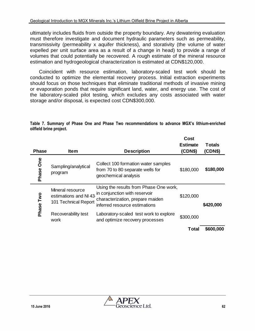
Geological Introduction to MGX Minerals Inc.’s Lithium Oilfield Brine Project in Alberta
15 June 2016 62
ultimately includes fluids from outside the property boundary. Any dewatering evaluation must therefore investigate and document hydraulic parameters such as permeability, transmissivity (permeability x aquifer thickness), and storativity (the volume of water expelled per unit surface area as a result of a change in head) to provide a range of volumes that could potentially be recovered. A rough estimate of the mineral resource estimation and hydrogeological characterization is estimated at CDN$120,000.
Coincident with resource estimation, laboratory-scaled test work should be conducted to optimize the elemental recovery process. Initial extraction experiments should focus on those techniques that eliminate traditional methods of invasive mining or evaporation ponds that require significant land, water, and energy use. The cost of the laboratory-scaled pilot testing, which excludes any costs associated with water storage and/or disposal, is expected cost CDN$300,000.
Table 7. Summary of Phase One and Phase Two recommendations to advance MGX’s lithium-enriched oilfield brine project.
Phase Item Description
Cost
Estimate
(CDN$)
Totals
(CDN$)
Ph
ase O
ne
Sampling/analytical
program
Collect 100 formation water samples
from 70 to 80 separate wells for
geochemical analysis
$180,000 $180,000
Mineral resource
estimations and NI 43-
101 Technical Report
Using the results from Phase One work,
in conjunction with reservoir
characterization, prepare maiden
inferred resource estimations
$120,000
Recoverability test
work
Laboratory-scaled test work to explore
and optimize recovery processes$300,000
Total $600,000
$420,000
Ph
ase T
wo
Geological Introduction to MGX Minerals Inc.’s Lithium Oilfield Brine Project in Alberta
15 June 2016 63
27 References
Alberta Energy Regulator (2015): Alberta’s energy reserves 2014 and supply/demand outlook 2015-2024; Report ST98-2015, 299 p.
Alberta Energy Regulator (2016): List of wells in Alberta: Monthly updates; Report ST37, data files.
Allan, J. and Creaney, S. (1991): Oil families of the Western Canada Basin. Bulletin of Canadian Petroleum Geology, v. 39, p. 107-122.
Anderson, J.H. (1985): Depositional facies and carbonate diagenesis of the downslope reefs in the Nisku Formation (Upper Devonian), Central Alberta, Canada; Unpublished Ph. D. Thesis, University of Texas, Austin, Texas, 393 p.
Bachu, S., Yuan, L.P. and Brulotte, M. (1995): Resource estimates of industrial minerals in Alberta formation waters; Alberta Research Council, Alberta Geological Survey, Open File Report 1995-01, 59 p.
Bachu, S., Buschkuehle, M., Haug, K. and Michael, K. (2008): Subsurface characterization of the Pembina-Wabamun acid-gas injection area; Energy Resources Conservation Board, ERCB/AGS Special Report 93, 60 p.
Beaumont, C., Quinlan, G. and Stockmal, G.S. (1993): The evolution of the western interior basin: causes, consequences and unsolved problems. In: Geodynamic Evolution of the Western Interior Basin, W.G.E. Caldwell and E.G. Kauffman, (editors), Geological Association of Canada, Special Paper 39, p. 97-117.
Berenyi, J., Yang, C. and Jensen, G. (2008): Potash in Saskatchewan: an overview of exploration and developments; Saskatchewan Energy and Resources, Saskatchewan Geological Survey, Open House 2008 Abstract Volume, p. 30.
Billings, G.K., Hitchon, B., Shaw, D.R. (1969): Geochemistry and origin of formation waters in the Western Canada Sedimentary Basin; Chemical Geology, v. 4, p. 211-223.
Bloch, J., Schroder-Adams, C., Leckie, D.A., McIntyre, D.J., Craig, J. and Staniland, M. (1993): Revised stratigraphy of the Lower Colorado Group (Albian to Turonian), Western Canada; Bulletin of Canadian Petroleum Geology, vol. 41, no. 3, p. 325-348.
Bloy, G.R. and Hadley, M.G. (1989): The development of porosity in carbonate reservoirs; Canadian Society of Petroleum Geologists, Continuing education Short Course.
Bradley, W., Munk, L., Jochens, H., Hynek, S. and Labay, K. (2013): A preliminary deposit model for lithium brines; U.S. Department of the Interior, U.S. Geological Survey, Open File Report 2013-1006, 6 p.
Burwash, R.A., McGregor, C.R. and Wilson, J.A. (1994): Precambrian basement beneath the Western Canada Sedimentary Basin. In G.D. Mossop and I. Shetsen, editors, Geological Atlas of the Western Canada Sedimentary Basin, Published Jointly by the Canadain Society Of Petroleum Geologists and the Alberta Research Council, p. 49-56.
Burwash, R.A., Kupricka, J. and Wijbrans, J.R. (2000): Metamorphic evolution of the Precambrian basement of Alberta. Canadian Mineralogoist, v 38, p. 423-434.
Cant, D.J. (1988): Regional structure and development of the Peace River Arch, Alberta: A Paleozoic failed-rift system?; Bulletin of Canadian Petroleum Geology, v. 36, p. 284-295.
Geological Introduction to MGX Minerals Inc.’s Lithium Oilfield Brine Project in Alberta
15 June 2016 64
Cecile, M.P., Morrow, D.W. and Williams, G.K. (1997): Early Paleozoic (Cambrian to Early Devonian) tectonic framework, Canadian Cordillera; Bulletin of Canadian Petroleum Geology, v. 45, p. 54-74.
Connolly, C.A., Walter, L.M., Baadsgaard, H., Longstaff, F.J. (1990a): Origin and evolution of formation waters, Alberta Basin, Western Canada Sedimentary basin; Applied Geochemistry, v.5, n.4, p. 375-395.
Connolly, C.A., Walter, L.M., Baadsgaard, H., Longstaff, F.J. (1990a): Origin and evolution of formation waters, Alberta Basin, Western Canada Sedimentary Basin; Applied Geochemistry, v.5, n.4, p.397-413.
Creaney, S., Allen, J. and (1994): Petroleum generation and migration in the Western Canada Sedimentary Basin; In: Mossop, G.D. and Shetsen, I. (compilers), Geological Atlas of the Western Canada Sedimentary Basin, Canadian Society of Petroleum Geologists and Alberta Research Council, Calgary, p. 455-468.
Eaton, D.W., Ross, G.M. and Hope, J. (1999): Rise and fall of a cratonic arch: A regional seismic perspective on the Peace River Arch, Alberta. Bulletin of Canadian Petroleum Geology, v. 47, p. 346-361.
Eccles, D.R., Al-Souqi, M., Grattan, K. and Dufresne, M.B. (2009): Preliminary investigation of potash potential in Alberta; Energy Resources Conservation Board, ERCB/AGS Open File Report 2009-20, 29 p.
Eccles, D.R. and Jean, G.M. (2010): Lithium Groundwater and Formation Water Geochemical Data; Alberta Geological Survey, Digital Data DIG 2010-0001.
Eccles, D.R. and Berhane, H. (2011): Geological introduction to lithium-rich formation water with emphasis on the Fox Creek area of west-central Alberta (NTS 83F and 83K); Energy Resources Conservation Board, AER/AGS Open File Report 2011-10, 22 p.
Eccles, D.R. (2012): Turning Water into Wine: Lithium-enriched formation water in northwestern Alberta. Paper presented at the Geological Association of Canada-Mineralogical Association of Canada, St. Johns, 26 May 2012.
Eccles, D.R., Dufresne, M.B., McMillan, K., Touw, J. and Clissold, R.J. (2012a): Maiden Li-K-B-Br-Ca-Mg-Na resource estimate report on lithium-enriched formation water, Fox Creek Property, Swan Hills area, west-central Alberta; NI 43-101 Technical Report completed on behalf of Channel Resources Ltd. Listed on Sedar, March 2012, 62 p.
Eccles, D.R., Dufresne, M.B., McMillan, K., Touw, J. and Clissold, R.J. (2012b): Inferred Li-K-B-Br-Ca-Mg-Na resource report on lithium-enriched formation water, Valleyview Property, west-central Alberta; NI 43-101 Technical Report completed on behalf of Lithium Exploration Group Inc., March 2012, 64 p.
Eccles, D.R. and Dufresne, M.B. (2016): Sturgeon Lake Li-K-B-Br-Ca-Mg-Na Oilfield Brine Inferred Mineral Resource estimate; NI 43-101 Technical Report completed on behalf of Canadian International Minerals Inc., January 2016, 74 p.
Empire Rock Minerals Inc. (2016): Empire to acquire Fox Creek lithium project in Alberta; News Release, 12 April, 2016.
Environment Canada (2014): Red Deer. Canadian Climate Normals 1981–2010; Environment Canada, May 14, 2014.
Geological Introduction to MGX Minerals Inc.’s Lithium Oilfield Brine Project in Alberta
15 June 2016 65
Garrett, D.E., (2004) Handbook of Lithium and Natural Calcium Chloride: Their Deposits, Processing Uses and Properties. Elsevier Academic Press. 488p. Glass, D.J. (1990): Lexicon of Canadian Stratigraphy, v. 4, Western Canada, including Eastern British Columbia, Alberta, Saskatchewan and Southern Manitoba; Canadian Society of Petroleum Geologists.
Green, R., Mellon, G.B. and Carrigy, M.A. (1970): Bedrock Geology of Northern Alberta; Alberta Research Council, Unnumbered Map (scale 1:500,000):
Halbertsma, H.L. (1994): Devonian Wabamun Group of the Western Canada Sedimentary Basin; in Geological Atlas of the Sedimentary Basin, Canadian Society of Petroleum Geologists and Alberta Research Council, p. 165–202.
Hamilton, W.N., Langenberg, W.C., Price, M.C. and Chao, D.K. (1999): Geological map of Alberta; Alberta Geological Survey, Map 236, scale 1: 1 000 000.
Hay, P.W. (1994): Oil and gas resources of the Western Canada Sedimentary Basin; in Geological Atlas of the Sedimentary Basin, Canadian Society of Petroleum Geologists and Alberta Research Council, p. 469-470.
Hitchon, B., Billings, G.K., Klovan, J.E. (1971) Geochemistry and origin of formation waters in the Western Canadian sedimentary basin – III Factors controlling chemical composition; Geochemica et Cosmochimica Acta, v. 35, p. 567-598.
Hitchon, B., (1984) Formation Waters as a Source of Industrial Minerals Alberta. In: G.R. Guillet and W. Martin (eds.), The Geology of Industrial Minerals in Canada; Canadian Institute of Mining and Metallurgy, Special Volume 29, p. 247-249.
Hitchon, B., Sauveplane, C.M., Bachu, S. (1989): Hydrogeology of the Valleyview Area, Alberta: Evaluation for deep waste injection; Bulletin 58, Edmonton, Alberta Research Council.
Hitchon, B. (1990) Hydrochemistry of the Peace River Arch area, Alberta and British Columbia; Alberta Research Council Open File report 1990-18.
Hitchon, B., Underschultz, J.R. and Bachu, S. (1993): Industrial mineral potential of Alberta formation waters; Alberta Research Council, Alberta Geological Survey, Open File Report 1993-15, 85 p.
Hitchon, B., Bachu, S., Underschultz, J.R., Yuan, L.P. (1995) Industrial Mineral Potential of Alberta Formation Waters; Bulletin 62, Alberta Geological Survey, 64 p.
Hoffman, P.F. (1988): United Plates of America: the birth of a craton. Annual Review of Earth and Planetary Sciences, v 16, p. 543-604.
Huff, G.F.; Stewart, S.A.; Riddell, J.T.F.; Chisholm, S. (2011): Water Geochemical Data, Saline Aquifer Project (tabular data, tab delimited format); Alberta Geological Survey, DIG 2011-0007, digital data.
Huff, G.F.; Bechtel, D.J.; Stewart, S.A.; Brock, E.; Heikkinen, C. (2012): Water Geochemical Data, Saline Aquifer Project (tabular data, tab delimited format); Alberta Geological Survey, DIG 2012-0001, digital data.
Jensen, G.K.S., Rostron, B.J., Duke, M.J.M., and Holmden, C. (2006): Chemical profiles of formation waters from potash mine shafts, Saskatchewan; in Summary of Investigations 2006, Volume 1, Saskatchewan Geological Survey, Sask. Industry Resources, Misc. Rep. 2006-4.1, CD-ROM, Paper A-7, 8p.
Geological Introduction to MGX Minerals Inc.’s Lithium Oilfield Brine Project in Alberta
15 June 2016 66
Jensen, G.K.S. (2012): Initial results of a brine sampling project: investigating the mineral potential of brines in southeastern Saskatchewan; In: Summary of Investigations 2012, Saskatchewan Geological Survey, Saskatchewan Ministry of the Economy, Miscellaneous Report 2012-4.1, Paper A-8, 8 p.
Kunasz, I.A., (1980): Lithium in Brines. Fifth International Symposium on Salt. Northern Ohio; Geological Society, No.5, Vol. 1, p.115-117.
Kunasz, I.A., (1994): Lithium Resources. In: D.D. Carr (Ed.) Industrial Minerals and Rocks. Society for Mining, Metallurgy and Exploration Inc., Littleton, USA, 1214p.
Kunasz, I.A., (2006): Lithium Resources. In: J.E. Kogel, N.C. Trivedi, J.M. Barker, S.T.
Leckie, D.A., Singh, C., Bloch, J., Wilson, M. and Wall, J. (1992): An Anoxic event at the Albian-Cenomanian Boundary: the Fish Scale Marker Bed, Northern Alberta, Canada; Palaeogeography, Palaeoclimatology, Palaeoecology, vol. 92, p. 139-166.
Machel, H.G. (1983): Facies and diagenesis of some Nisku buildups and associated strata, Upper Devonian, Alberta, Canada; In: Harris, P. M., (ed.), Carbonate Buildups - A Core Workshop, Society of Economic Paleontologists and Mineralogists, Core Workshop No.4, p. 114 - 181.
Machel, H.G. (1985): Facies and diagenesis of the Upper Devonian Nisku Formation in the subsurface of central Alberta. Unpublished Ph. D. Thesis, McGill University, Montreal, 392 p.
Meijer Drees, N.C. (1994): Devonian Elk Point Group of the Western Canada Sedimentary Basin; in Geological Atlas of the Sedimentary Basin, Canadian Society of Petroleum Geologists and Alberta Research Council, p. 129–147.
MGX Minerals Inc. (2016a): MGX Minerals Acquires Lithium Properties Covering 370 Sq. Miles (96,000 Hectares) in Alberta; MGX Minerals Inc. News Release, 1 February 2016.
MGX Minerals Inc. (2016b): MGX Minerals Increases Lithium Land Position to 540 Sq. Miles (141,000 Hectares) in Alberta; MGX Minerals Inc. News Release, 14 March 2016.
MGX Minerals Inc. (2016c): MGX Minerals Further Expands Lithium Land Position to 300,000 Hectares in Alberta; MGX Minerals Inc. News Release, 14 April 2016.
MGX Minerals Inc. (2016d): MGX Minerals Receives Initial Process Design and Scoping Study for Production of Lithium Carbonate; MGX Minerals Inc. News Release, 14 April 2016.
MGX Minerals Inc. (2016e): MGX Minerals Receives Initial CAPEX Report for Lithium Carbonate Plant; MGX Minerals Inc. News Release, 9 May 2016.
MGX Minerals Inc. (2016f): MGX Minerals Acquires Rights to Rapid Lithium Brine Production Prcess; MGX Minerals Inc. News Release, 6 June 2016.
Mort, A., Stevens, L. and Wierzbicki, R. (2015): Devonian petroleum systems and exploration potential, southern Alberta, a review in three parts. Part 3: Core presentation; abstracts, Geoconvention 2015; Calgary; CA; May 4-8, 2015.
Mossop, G. and Shetsen, I. (eds.) (1994): Geological Atlas of the Western Canada Sedimentary Basin. Calgary, Canadian Society of Petroleum Geologists and Alberta Research Council, 510 p.
O’Connell, S.C. (1994): Geological History of the Peace River Arch. In: Geological Atlas of the Western Canadian Sedimentary Basin, G.D. Mossop and I. Shetson (comps). Canadian
Geological Introduction to MGX Minerals Inc.’s Lithium Oilfield Brine Project in Alberta
15 June 2016 67
Society of Petroleum Geologists and Alberta Research Council, Calgary, Alberta, p. 431-438.
O’Connell, S.C., Dix, G.R. and Barclay, J.E. (1990): The origin, history and regional structural development of the Peace River Arch, Western Canada; Bulletin of Canadian Petroleum Geology, 38A:4-24.
Oldale, H.S. and Munday, R.J. (1994): Devonian Beaverhill Lake Group of the Western Canada Sedimentary Basin; in Geological Atlas of the Sedimentary Basin, Canadian Society of Petroleum Geologists and Alberta Research Council, p. 149–163.
Pana, D., Waters, J. and Grobe, M. (2001): GIS Compilation of Structural Elements in Northern Alberta, Release 1.0. Alberta Energy and Utilities Board, Alberta Geological Survey, Earth Science Report 2001-01, 53 p.
Panǎ, D.I. (2003): Precambrian Basement of the Western Canada Sedimentary Basin in Northern Alberta; EUB/AGS Earth Sciences Report 2002-02. February 2003. 39 p.
Pawlowicz, J.J. and Fenton, M.M. (1995a): Bedrock topography of Alberta; Alberta Geological Survey, Energy and Utilities Board, Map 226, scale 1:2,000,000.
Pawlowicz, J.J. and Fenton, M.M. (1995b): Drift thickness of Alberta; Alberta Geological Survey, Energy and Utilities Board, Map 227, scale 1:2,000,000.
Rokosh, C.D., Lyster, S., Anderson, S.D.A., Beaton, A.P., Berhane, H., Brazzoni, T., Chen, D., Cheng, Y., Mack, T., Pana, C. and Pawlowicz, J.G. (2012): Summary of Alberta's shale- and siltstone-hosted hydrocarbon resource potential; Energy Resources Conservation Board, ERCB/AGS Open File Report 2012-06, 327 p.
Ross, G.M., Parrish, R.R., Villeneuve, M.E. and Bowring, S.A. (1991): Geophysics and geochronology of the crystalline basement of the Alberta Basin, western Canada; Canadian Journal of Earth Sciences, vol. 28, p. 512-522.
Ross, G.M. and Eaton, D.W. (1997): Winagami reflection sequence: Seismic evidence for post-collisional magmatism iin the Proterozoic of western Canada. Geology, v. 25, p. 199-202.
Sikabonyi, L.A. and Rodgers, W.J. 1959. Paleozoic tectonics and sedimentation in the northern half of the west Canadian Basin. Journal of the Alberta Society of Petroleum Geologists, v. 7. p. 193-216.
Stott, D.F. (1982): Lower Cretaceous Fort St. John Group and Upper Cretaceous Dunvegan Formation of the Foothills and Plains of Alberta, British Columbia and Yukon Territory; Geological Survey of Canada, Bulletin 328, 124 p.
Switzer, S.B., Holland, W.G., Graf, G.C., Hedinger, A.S., McAuley, R.J., Wierzbicki, R.A. and Packard, J.J. (1994): Devonian Woodbend-Winterburn strata of the Western Canada Sedimentary Basin; in Geological Atlas of the Sedimentary Basin, Canadian Society of Petroleum Geologists and Alberta Research Council, p. 165–202.
Underschultz, J.R., Yuan, L.P., Bachu, S., Cotterill, D.K. and Hitchon, B. (1994): Industrial mineral resources in Alberta formation waters; Alberta Research Council, Alberta Geological Survey, Open File Report 1994-13, 71 p.
Watts, N.R. (1987): The role of carbonate diagenesis in exploration and production from Devonian Nisku reefs, Alberta, Canada. In: Bloy, G.R. and Hopkins, J.e. (eds.), Principles and Concepts for Exploration and Exploitation of Reefs in the Western Canada Basin, A
Geological Introduction to MGX Minerals Inc.’s Lithium Oilfield Brine Project in Alberta
15 June 2016 68
Short Course: Canadian Reef Inventory Project, Calgary, Alberta, Canadian Society of Petroleum Geologists, 31 p.
Wendte, J.C. and Stoakes, F.A. (1982): Evolution and corresponding porosity distribution of the Judy Creek reef complex, Upper Devonian, central Alberta; In: Canada’s giant hydrocarbon reservoirs. W.G. Cutler (ed.), Canadian Society of Petroleum Geologists Core Conference Manual, p. 63-81.
Geological Introduction to MGX Minerals Inc.’s Lithium Oilfield Brine Project in Alberta
15 June 2016 69
28 Certificate of Author
I, D. Roy Eccles, P.Geol., do here by certify that: 1. I am a Senior Consulting Geologist and Operations Manager of APEX Geoscience Ltd.,
Suite 110, 8429-24 Street, Edmonton, Alberta T6P 1L3. 2. I graduated with a B.Sc. in Geology from the University of Manitoba in Winnipeg, Manitoba
in 1986 and with a M.Sc. in Geology from the University of Alberta in Edmonton, Alberta in 2004.
3. I am and have been registered as a Professional Geologist with the Association of Professional Engineers, Geologists and Geophysicists of Alberta since 2003.
4. I have worked as a geologist for more than 25 years since my graduation from University and have been involved in all aspects of mineral exploration, mineral research and mineral resource estimations for metallic, industrial, specialty and rare-earth element mineral projects and deposits in Canada.
5. I have read the definition of “Qualified Person” set out in National Instrument 43‐101 (“NI 43‐101”) and certify that by reason of my education, affiliation with a professional association (as defined in NI 43‐101) and past relevant work experience, I fulfill the requirements to be a
“Qualified Person” for the purposes of NI 43‐101. 6. I am responsible for and have supervised the “Geological Introduction to MGX Minerals
Inc.’s Lithium Oilfield Brine Project in Alberta, Canada” (the “Technical Report”) with an effective date of 15 June 2016. I published two Alberta government reports documenting Li-enriched Alberta formation water, presented the Li-brine potential at national and international conferences and have conducted Li-brine resource estimations in other parts of Alberta for various companies. I have historically visited the Property area, but have not done so as part of this Technical Report. Rather, I reviewed oil and gas well information at MGX’s Properties to confirm historical fluid geochemical values and the status of the wells.
7. I am not aware of any scientific or technical information with respect to the subject matter of the Technical Report that is not reflected in the Technical Report, the omission to disclose which makes the Technical Report misleading.
8. I have read National Instrument 43‐101 and Form 43‐101F1, and the Technical Report has been prepared in compliance with that instrument and form.
9. I am independent of the issuer, the vendor and the Property applying all of the tests in section 1.5 of both NI 43-101 and 43-101CP.
10. I have not had any prior involvement with the Property that is the subject of the Technical Report.
11. I consent to the filing of the Technical Report with any stock exchange and other regulatory authority and any publication by them for regulatory purposes, including electronic publication in the public company files or their websites.
Dated this 15 June 2016 Edmonton, Alberta, Canada
D. Roy Eccles, M.Sc., P.Geol.
Top Related