


Languages
Pages
Legal


San Diego, California Tule Wind ProjectGeological Hazards Report
January 2010
PAGE 2 OF 16
Executive Summary
A wind-to-energy project is proposed in southeastern San Diego County, California,
comprising 66 wind turbine tower locations and attendant facilities. This report presents the
results of a geologic hazards assessment, including a review of fault rupture hazards, ground
shaking hazards, and hazards posed by liquefaction, landsliding, unstable geologic units and
soils, and expansive soils.
This assessment is based on published and other publically available information. The site is
underlain by crystalline igneous and metamorphic bedrock with generally thin granular soils
present. There are no known active faults present in the project area. There are two
potentially active faults that are in the immediate vicinity of the project area. Project area
seismicity is moderate to high. Local saturated granular soils potentially susceptible to
liquefaction may be present, adjacent to several springs within the project area. No unstable
geologic units, except on steeper slopes exposing foliated metamorphic rocks such as schists,
are present within the project area. No quick clays, peats, or collapsible soils are likely to be
present in the project area. No highly plastic clays subject to expansion are known to be
present in the project area.
1.0 Description of Proposed Development
The proposed Tule Wind Project is located north of the town of Live Oak Springs in San
Diego County, California, approximately 50 miles east of the City of San Diego (Figure 1).
The wind project is planned to consist of 66 wind turbines. Figure 2 is a map of the proposed
project area and preliminary turbine sites. The proposed wind turbine is a Gamesa model
G87 2.0 megawatt (MW) unit. The Gamesa model G87 has turbine blade assemblies that are
87 meters (285 feet) in diameter. The development also includes ancillary facilities such as
two meteorological station (Met) towers, an operations and maintenance building, a
substation, attendant roads, fencing and other appurtenant improvements.

San Diego, California Tule Wind ProjectGeological Hazards Report
January 2010
PAGE 3 OF 16
2.0 Scope of Work
This report constitutes an initial assessment of geologic hazards associated with the proposed
development of a 66-tower wind-to-energy production facility. The study has been limited to
review and assessment of readily available published and unpublished geological and
seismological information. The County of San Diego provides Guidelines for Determining
Significance of various issues (http://www.sdcounty.ca.gov/dplu/procguid.html#guide).
The county guidelines include recommendations to address the following geologic hazards:
Fault rupture
Ground shaking
Liquefaction
Landslides
Unstable Geologic Unit or Soil
Expansive soils
The county guidelines also include the following hydrology hazards:
Flash floods and debris flows
Alluvial fan floods
Urbanization
Landform modification
Dam failure
Faulty drainage facilities
The County guidelines also list tsunamis and seiches as possible issues in both the
geologic and hydrologic hazards, but as the site is far inland and not adjacent to any
large water bodies these are not considered risks for this project.

San Diego, California Tule Wind ProjectGeological Hazards Report
January 2010
PAGE 4 OF 16
The tasks completed include:
Compile and review readily available geological and seismological information,
including geologic maps and reports, geophysical reports, topographic maps,
wetlands maps, flood maps, proposed development maps/turbine layouts, and aerial
photographs.
Summarize geological/geotechnical conditions.
Estimate preliminary site seismic parameters per International Building Code
procedures.
Identify and qualify geologic risks.

San Diego, California Tule Wind ProjectGeological Hazards Report
January 2010
PAGE 5 OF 16
3.0 Site Geology
The primary reference resource for the geology of the project area is the Preliminary
Geologic Map of the El Cajon 30’ x 60’ Quadrangle, Southern California, Version 1.0,
compiled by V.R. Todd (Todd, 2004) issued by the United States Geological Survey
(USGS). A fault activity map of California and adjacent areas prepared by the California
Geological Survey (formerly the California Division of Mines and Geology) was also
consulted, along with various geologic publications pertaining to the site and vicinity (see
References).
The project site is in the eastern portion of the Peninsular Ranges physiographic province. In
the area surrounding and including the project area, volcanic and marine sedimentary rocks
of Triassic and Jurassic age were intruded by dioritic rocks, chiefly tonalite, in Cretaceous
time.
3.1 Bedrock Geology
Approximately ninety per cent of the project area is underlain by the La Posta Tonalite unit
of early and late Cretaceous age (see geologic map, Figure 3). These crystalline plutonic
rocks include primarily hornblende-biotite trondhjemite which is locally foliated near its
western edge. This rock body is largely undeformed and inclusion-free.
In the westernmost 10 per cent of the project area a body of metamorphic rocks of Triassic
and Jurassic ages is exposed, which include semi-pelitic, pelitic, and quartzitic schists, calc-
silicate bearing feldspathic metaquartzite, and minor small pebble metaconglomerate. These
rocks also contain layers of sandstone, quartz pebble conglomerate, mudstone, and
amphibolite, and are thought to represent metamorphosed submarine fan deposits
interlayered with volcanic rocks. These rocks are locally intruded by leucocratic dikes
comprising leucogranite, granophyre, alaskite, pegmatite, and aplite, which range in age from
late Jurassic to early Cretaceous. A small body of middle to late Jurassic age Harper Creek
gneiss is present at the westernmost edge of the project area.

San Diego, California Tule Wind ProjectGeological Hazards Report
January 2010
PAGE 6 OF 16
3.2 Surficial Units
Local areas of younger alluvium are present in the project area. These materials are
generally composed of sand, silt, and gravel, and occur along modern intermittent drainage
courses. Colluvium occurs on east-facing slopes in the western portion of the project area.
Colluvium includes sand and gravel as slopewash deposits and debris flows. Some talus
(broken rock piles) is also present at the base of local steeper slopes in the western portion of
the project area.
Figure 4 shows the mapped soil types as taken in November, 2009 from the United States
Department of Agriculture, Natural Resource Conservation Service Soil Survey Geographic
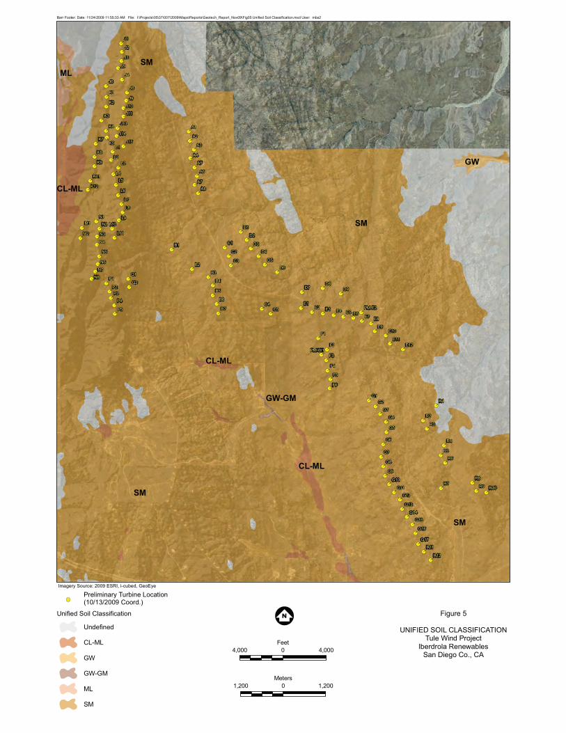
(SSURGO) database. Figure 5 shows the Unified Soil Classification System (USCS) soil
classifications for the project area and vicinity, taken from the same SSURGO data base.
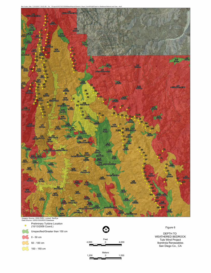
The majority of the area is shown to be underlain by silty sand (SM). Figure 6 shows the
approximate thickness of the site soils, also taken from the SSURGO data base. Soils across
much of the project area are thin, less than 1 meter, indicating that excavation for foundations
and collection systems and roads may require heavy ripping. Based on regional mapping by
others, areas of soil in excess of five feet deep are generally restricted to drainage bottoms.
3.3 Faulting
Several unnamed northwest-trending faults, having lengths from a few hundred feet up to
4,000 feet, are mapped in and adjacent to the project area. These faults are generally
identified as being of pre-Quaternary age (see Figure 3; see also CDMG, 1994). There are
many similar faults in the areas surrounding the proposed development (Todd, 2004) only a
few of which are shown on the CDMG 1994 fault activity map. Those shown on the CDMG
map are said to be of pre-Quaternary age, except for two of the northwest-trending faults
mentioned above, which are said to be of undivided Quaternary age (i.e. between 1.6 million
and 200 years old), and which thus must be considered potentially active. Two faults
trending nearly east-west are present transecting the northern portion of the project area.
These faults have lengths of 2,000 and 1,500 feet, respectively. No age attribution has been
published for these small faults.

San Diego, California Tule Wind ProjectGeological Hazards Report
January 2010
PAGE 7 OF 16
3.4 Hydrogeologic Conditions
In the crystalline bedrock ground water will only be present in open joints, fractures and local
shear zones, there being no primary porosity in the rocks present. Concentrations of ground
water may be present adjacent to mapped faults where more fracturing is present and where
fault gouge along fault planes and shear zones may cause retardation of lateral and vertical
flow of descending meteoric water and ground water. Several mapped springs in the project
area probably reflect water being conducted along joint and fracture systems where they
intersect the ground surface, and may also include areas where faults cause local retention of
ground water (See Figure 3 and U.S.G.S. Sombrero Peak 7.5-minute topographic
quadrangle). It is not known whether the mapped springs are perennial or intermittent.
Recharge of these systems comes through rainfall and snow melt. Small local bodies of silt,
sand, and gravel in intermittent stream drainages may also be seasonally saturated through
rainfall and snow melt.

San Diego, California Tule Wind ProjectGeological Hazards Report
January 2010
PAGE 8 OF 16
4.0 Geologic Hazards Evaluation
4.1 General Summary of Geologic Risks
Table 1 is a summary of geologic and geotechnical hazards for the site.
Table 1. Summary of Geologic Hazards
HazardPresentat Site?
Comments
Flooding/High groundwater Possibly
The proposed turbine sites are situated ongenerally high ground between drainages, notnear springs, and soils present are generallywell drained. Flash flooding may be possiblein drainages during intense storm events,which may affect access roads and otherproject constructed features.
Landslides Possibly
The site has moderate to high relief andgenerally thin and granular soils. Somebedrock units in the westernmost portion ofthe project area contain internal foliations andmay have planes of weakness. These willneed to be investigated and considered whendesigning cut slopes.
Subsidence – Pumping No
Project site is underlain by crystalline bedrockcapable of resisting subsidence due to withdrawalof ground water. There are no known oil orgas fields in the area.
Subsidence – Mining Yes
Three mine tunnels, one mine shaft, one quarry,and one prospect have been identified adjacent tothe locations of towers N7, N8, P4 and P5, alongthe southwest boundary of the project area.These may impact foundation elements such asrock anchors and should be investigated.
Subsidence – Caves/Karst NoThere are no rock types present in the projectarea that are susceptible to dissolution.
Earthquake/Seismicity Yes
The site is located 7.1 miles southwesterly of theElsinore Fault Zone, and may experiencemoderate to high levels of ground shaking duringa maximum credible earthquake event on it.Shallow bedrock persists throughout the sitewhich mitigates the more destructive lowerfrequency ground shaking associated with suchevents.

San Diego, California Tule Wind ProjectGeological Hazards Report
January 2010
PAGE 9 OF 16
Table 1. Summary of Geologic Hazards
HazardPresentat Site?
Comments
Earthquake/ground rupture No
There are no known active faults in the projectarea. One potentially active fault transects aportion of the project area near tower locationsB1 through B7. In the absence of aninvestigation of this fault, tower sites should beno closer than 50 feet from any mapped faulttrace.
Liquefaction Unlikely
Seismicity is moderate to high and soils aregenerally sandy but probably well graded. Localliquefaction may occur in sandy soils nearsprings during large earthquake events. Notower sites are proposed for any such areas.
Swelling/shrinking soil NoHigh shrink/swell soils have not been identifiedby others in the project area.
Corrosive soil PossiblyThe soil survey reports generally moderateconcrete corrosion and moderate steelcorrosion.
Made ground Unlikely
There are only a few local areas of filledground within the project boundaries.These can be avoided, removed, ormitigated by removal and recompaction.
Collapsible soil NoCollapsible deposits have not been identified byothers in the project area.
Volcanic activity No No current volcanic activity exists in the region.
Extrasensitive (quick) clays NoQuick clay conditions are not known or likelyto be present.
4.2 Soil Conditions
The project site has surficial soils of detrital, colluvial and alluvial origin, consisting
primarily of sand, silty sand, and gravel. The generally well-drained soil conditions
should provide for a favorable construction condition. However, low areas, areas of
springs, and drainage swales should be avoided or mitigated when laying out proposed
access roads and turbine locations. In addition, shallow bedrock is present at the project
site, which may present rippability issues in excavations for foundations, collection
system cables, and roads.

San Diego, California Tule Wind ProjectGeological Hazards Report
January 2010
PAGE 10 OF 16
4.3 Fault Rupture
The information on mapped faults presented by San Diego County, the United States
Geologic Survey (USGS), and the California Geological Survey (CGS) on-line databases
indicates that there are no mapped active faults within the proposed development area.
Not all of the mapped faults presented on the geologic map of the El Cajon quadrangle
(excerpted in Figure 3; see also Todd, 2004) are shown on the CDMG Fault Activity Map
(CDMG, 1994). Those faults presented on the CDMG 1994 map in the area of the
project site are shown to be of pre-Quaternary age (CDMG, 1994), with the exception of
two northwest-trending faults, one outside the project area to the northeast, and one
that transects the project area in the vicinity of tower locations B1 through B7 (see
Figure 3). These two faults are listed as “undivided Quaternary” on the CDMG map
(from 1.6 million to 200 years in age) and thus must be considered potentially active.
In the absence of information regarding the activity status of these faults (such as
might be obtained by fault trenching), focused geologic mapping at a scale appropriate
to determine whether tower foundations or foundation elements (i.e. rock anchors) are
to be constructed astride the latest (onsite) fault should be performed prior to
construction, in order to provide for proper risk management.
The nearest active fault is the Elsinore Fault zone, which is located approximately 7.1
miles to the northeast at its nearest point.
Most of the proposed project structures (turbine towers, substation, met towers) are not
designed for human occupancy. Only the operations and maintenance building is
designed for human occupancy. None of the proposed turbine locations are within 50
ft of the trace of a known active fault or a County-level fault special studies zone. Fault
rupture does not appear to be a significant risk to the project.
4.3.1 Ground Shaking
All of San Diego County is located within Seismic Zone 4, which indicates that the site is
subject to moderate to severe ground shaking. For the project area, this is attributable to the
presence of the Elsinore Fault Zone, approximately 7.1 miles east-northeast of the project
site at its nearest point. The Maximum Credible Earthquake for the Temecula segment of

San Diego, California Tule Wind ProjectGeological Hazards Report
January 2010
PAGE 11 OF 16
the Elsinore Fault Zone is a moment magnitude 6.8 event (Cao et al, 2003). Table 2
contains seismic design parameters derived from the USGS earthquake hazards program
(accessed November 11, 2009). Full details of the input parameters used to generate
these values are presented in Appendix A. Site class B (rock) was selected for this
assessment, which is the appropriate site class for the proposed ridgeline tower locations in
the project area.
Table 2. Site Seismic Acceleration Values
Location Ss/S11 SMs/SM12 SDs/SD13
Northern End of Project Area 1.429/0.519 1.429/0.519 0.953/0.346
Southern End of Project Area 1.283/0.450 1.283/0.450 0.855/0.300
Notes:1. Ss/S1 are the spectral acceleration response parameters in multiples of the acceleration of gravity (g) for the mapped maximumcredible earthquake (MCE) for seismic wave periods of 0.2 seconds (Ss) and 1.0 seconds (S1).
2. SMs/SM1 are the spectral acceleration response parameters in multiples of the acceleration of gravity (g) for the mappedmaximum credible earthquake (MCE) adjusted for site conditions, for seismic wave periods of 0.2 seconds (SMs) and 1.0 seconds(SM1).
3. SDs/SD1 are the spectral acceleration response parameters in multiples of the acceleration of gravity (g) used to determine thesite seismic design category, calculated as 2/3 of the SMs/SM1 values for periods of 0.2 seconds (SDs) and 1.0 seconds (SD1).
4.3.2 Liquefaction
Liquefaction is a potential risk where loose, saturated sandy soils may be subjected to
seismic energy. The County has identified specific soil units that are susceptible to
liquefaction risk, including the Mottsville loamy coarse sand (MxA) 0-2 percent
slopes. The site contains a Mottsville soil unit (MvC) that is a loamy coarse sand
supporting 2 to 9 percent slopes, with a depth to the water table of more than 80
inches (http://websoilsurvey.nrcs.usda.gov/app/WebSoilSurvey.aspx). This is a well-
drained soil. It does not appear that any of the currently proposed turbine locations are on
the Mottsville soil, but proposed site C4 is close to an area of Mottsville soil. It should be
noted that this general description – loamy coarse sand, applies to virtually all of the site
soil types. Most of the soil types shown in the project area are described as less than
80 inches thick over rock and weathered rock.

San Diego, California Tule Wind ProjectGeological Hazards Report
January 2010
PAGE 12 OF 16
There are seven springs located within one mile of a proposed tower site (see Figure 3,
and references, U.S.G.S. Sombrero Peak 7.5-minute topographic quadrangle). The
closest that any tower location comes to a spring location is approximately 1,000 feet
from proposed tower C3. While it is possible that saturated soils exist immediately
adjacent to these spring locations, the tower sites are all sufficiently distant from the
springs that the risk of liquefaction appears to be low. Still, this should be further
evaluated as the project moves forward and site-specific information is generated,
including the locations of other project structures like met towers, the operations and
maintenance building, substation, and collection system.
4.3.3 Landslides
The project site has areas of steep slopes, greater than 25%. Some bedrock units such
as schists have foliations and other planes of weakness that could contribute to
instability of constructed cut slopes. There may be local talus deposits which could
also impact planned grading. The potential for the presence of existing landslides
exists primarily in the westernmost portion of the site, where schists are present.
Areas underlain by tonalite (approximately 90 percent of the project area) are
considered to be generally free of the potential for landslides.
4.3.4 Expansive Soils
Certain types of clayey soils have a tendency to adsorb water and swell and then
shrink as they dry. This can exert considerable pressure on structures, leading to
cosmetic and structural damage. The County has identified specific soil units that are
susceptible to expansion (shrink-swell) risks (see Figure 6 and references, San Diego
County, 2007. None of these specifically-named soils are present at the site. In
general, the project area soils are silty sands (Unified Soil Classification System
designation SM), not highly plastic clays (designations CH or MH, see Figure 5).
Therefore the risk of expansive soils is not considered significant.

San Diego, California Tule Wind ProjectGeological Hazards Report
January 2010
PAGE 13 OF 16
4.3.5 Flash Floods and Debris Flows
Debris flows are shallow water-saturated landslides that travel rapidly down slopes
carrying rocks, brush, and other debris. Debris flow deposits are present in the project
area as described by Todd (2004). The path of a debris flow is determined by local
topography, and will typically follow existing drainage patterns. Project facilities will
generally be constructed on ridgelines and are not expected to be susceptible to debris
flows or flash floods. Although access roads layouts have not been prepared at this
stage of conceptual design, any access road alignment crossing these types of drainages
must consider the potential for this type of event.
4.3.6 Alluvial Fan Floods
Alluvial fans are generally a desert phenomenon where streams emerge from canyons
and deposit sand and rock in a cone-shaped formation fanning out from the canyon
mouth. Alluvial fans form in arid and semi-arid environments where steep mountain
fronts meet flatter valley floors. The infrequent but intense storms in these environments
produce flash floods that can carry heavy debris and sediment loads. No alluvial fans
have been identified on the project site.
4.3.7 Urbanization
The conversion of undeveloped, natural areas to urbanized uses throughout San
Diego’s watersheds can contribute to increased potential for flooding, by increasing the
rate and amount of runoff in a watershed and altering drainage patterns. The proposed
wind farm will result in a negligible change to the impervious area.
4.3.8 Landform Modification
Any alteration to natural drainage patterns by modifying landforms that control the
conveyance of surface water can increase the potential for flooding. The proposed
project improvements will not significantly alter the drainage patterns.

San Diego, California Tule Wind ProjectGeological Hazards Report
January 2010
PAGE 14 OF 16
4.3.9 Dam Failure
Dam failure inundation is flooding caused by the release of impounded water from
failure or overtopping of a dam. The failure of a dam occurs most commonly as a
result of inadequate design, neglect, or structural damage caused by earthquakes.
There are no dams identified in the project area.
4.3.10 Faulty Drainage Facilities
Drainage facilities including storm drains, culverts, inlets, channels or other of these
types of structures are designed to prevent flooding by collecting storm water runoff and
directing flows to either the natural drainage course and/or away from urban
development. The capacity of a drainage structure can typically be adequately
determined by a hydrology and drainage study; however if drainage facilities are not
adequately designed or built, or properly maintained, the facilities can overflow or
fail, resulting in flooding. The drainage facilities in the project site are limited to small
culverts on intermittent streams. Overflow or failure of drainage facilities is not
considered a significant risk in the project area.

San Diego, California Tule Wind ProjectGeological Hazards Report
January 2010
PAGE 15 OF 16
5.0 Conclusions
As presented by Todd (2004) the project area is almost wholly underlain by crystalline
igneous and metamorphic bedrock. Soils within the project area are reported to be generally
thin and granular in nature, comprising primarily silty sand. As shown on the State of
California fault activity map (CDMG, 1994) there are no known active faults present in the
project area. There are two potentially active faults that are in the immediate vicinity of the
project area (see Figure 3). As indicated from calculations generated by the California
Geological Survey Probabilistic Seismic Hazards Ground Motions web page (see Appendix
A) project area seismicity is moderate to high. Local saturated granular soils potentially
susceptible to liquefaction may be present adjacent to several springs within the project area.
On steeper slopes exposing foliated metamorphic rocks such as schists, slope stability issues
may be present within the project area. These rock types will require assessment in the
design of cut slopes and other excavations. Based on soil descriptions provided by the
USDA (SSURGO data base, see references), no extra-sensitive (“quick”) clays, no peats, and
no collapsible soils are likely to be present in the project area. Also per information provided
by the USDA, no highly plastic clays subject to expansion are known to be present in the
project area.

San Diego, California Tule Wind ProjectGeological Hazards Report
January 2010
PAGE 16 OF 16
6.0 References
California Geological Survey, Department of Conservation; California Probabilistic SeismicHazard Maps, (http://www.consrv.ca.gov/CGS/rghm/psha).
Cao, T., W.A. Bryant, B. Rowshandel, D. Branum, and C.J. Wills, 2003, The Revised 2002.
International Code Council Inc., International Building Code, 2006.
Mooney, Harold M. 1980. Handbook of Engineering Geophysics Volume 2: ElectricalResistivity. Bison Instruments, Inc., Minneapolis, pp. 1-5.
Natural Resources Conservation Survey (NRCS). Web Soil Survey, accessed athttp://websoilsurvey.nrcs.usda.gov/app/WebSoilSurvey.aspx
Rowshandel, B., Reichle, M., Wills, C., Cao, T., Petersen, M., Branum, D., and Davis, J.,200X, Estimation of Future Earthquake Losses in California; California GeologicalSurvey, Department of Conservation.
San Diego County, 2007, County of San Diego Guidelines for Determining Significance,Geologic Hazards; Land Use and Environment Group, Department of Planning andLand Use, Department of Public Works, July 30, 2007.
Telford, W. M., L.P. Geldart, R.E. Sheriff, and D.A. Keys, 1976, Applied Geophysics:Cambridge University Press, New York, pp. 454-455, 860.
Todd, Victoria L., 2004. Preliminary Geologic Map of the El Cajon 30’ x 60’ Quadrangle,Southern California, Version 1.0; USGS Open-File Report 2004-1361.
USDA NRCS Web soil survey, http://websoilsurvey.nrcs.usda.gov/app/WebSoilSurvey.aspxaccessed 23 October 2009.
USGS, 1959 (photorevised 1975); Sombrero Peak 7.5-minute topographic quadrangle;1:24,000-scale.

FIGURES
FIGURES
Figure 1 – Site LocationFigure 2 – Site TopographyFigure 3 – Geologic MapFigure 4 – Soil MapFigure 5 – Unified Soil ClassificationFigure 6 – Depth to Weathered Bedrock

MEXICO
8
8
86
2
80
22
78
76
3
7
188
2
79
22
78
78
94
98
79
79
22
78
279
2
94
79
S a n D i e g oS a n D i e g o
C o u n t yC o u n t y
I m p e r i a lI m p e r i a l
C o u n t yC o u n t y
San Diego
RamonaRamona Anza-Borrego Desert State ParkAnza-Borrego Desert State Park
Cuyamaca Rancho State ParkCuyamaca Rancho State Park
Lake Morena Co ParkLake Morena Co Park
Salton Sea
Lake Henshaw
Clark Lake
El Capitan Reservoir
Barrett Lake
Morena Reservoir
Cuyamaca Reservoir
Sutherland Lake
Loveland Reservoir
6 0 6
Miles
Figure 1
SITE LOCATIONTule Wind Project
Iberdrola RenewablesSan Diego Co., CA
10 0 10
Kilometers
Barr Footer: Date: 11/24/2009 11:40:03 AM File: I:\Projects\05\37\007\2009\Maps\Reports\Geotech_Report_Nov09\Fig01 Site Location.mxd User: mbs2
Preliminary Turbine Location(10/13/2009 Coord.)
California
Nevada
Utah
Oregon Idaho
Arizona

Mc C
ain
Valle
y Rd
Old
Min
e R
d
Bia
12
Cre
stw
ood
Rd
Lost Valley Rd
Thin
g V
alle
y R
dCanebrake Rd
Manzanita
Rd
Ribbo
nwood R
d
Willia
m R
d
Cross Rd
Black Wood Rd
William
s Rd
McC
ain
Rd
BIA Route 12
Manzanita
Rd
R9
R8
R7
R6
R5
R4
R3
R2
R1
Q2
Q1
P5
P4
P3
P2
P1N8
N7
N6
N5
N4
N3
N2
N1
M2
M1
L9
L8
L7
L6
L5
L4
L3
L2
L1
K9
K8
K7K5
K4
K3
K2
K1
J9
J8
J6
J5
J4
J3
J2
J1
G9
G8
G7
G6
G5
G4
G3
G2
G1
F6
F5
F4
F3
F2
F1
E9
E8E7
E6E5E4E3E2E1
D9
D8D7
D6
D5
D4
D3
D2
D1
C5
C4
C3
C2
C1
B7
B6
B5
B4
B3
B2
B1
A8
A7
A6
A5
A4
A3
A2
A1
R12
R11
R10
L11
L10
K12
K11
J15
J14
J13
J11
J10
G17
G16
G15
G14
G13
G12
G11
G10
E12
E11
E10
PM-W1
PM-E2
4,000 0 4,000
Feet
Figure 2
SITE LAYOUTTule Wind Project
Iberdrola RenewablesSan Diego Co., CA
1,200 0 1,200
Meters
Barr Footer: Date: 11/24/2009 11:38:13 AM File: I:\Projects\05\37\007\2009\Maps\Reports\Geotech_Report_Nov09\Fig02 Site Layout.mxd User: mbs2
Preliminary Turbine Location(10/13/2009 Coord.)
Imagery Source: 2009 ESRI, i-cubed, GeoEye

KJld Leucocratic dikes (Late Cretaceous and Late Jurassic)—Leucogranite, granophyre, alaskite, pegmatite, and aplite; found cutting plutonic units in quadrangle. Includes dikes of at least three ages
JT m Metasedimentary and metavolcanic rocks (Jurassic and Triassic)—Interlayered semi-pelitic, pelitic, and quartzitic schists; calcsilicate-bearing feldspathic metaquartzite; and minor small-pebble metaconglomerate. Includes layers of sandstone, quartz-pebble conglomerate, mudstone, and amphibolite. Interpreted to be metamorphosed submarine fan deposits and intercalated volcanic rocks; equivalent to the Julian Schist of Hudson (1922)
Jcr Granodiorite of Cuyamaca Reservoir (Late and Middle Jurassic)—Biotite and hypersthene-biotite granodiorite and tonalite; also contains actinolitic amphibole. Fine to medium grained, strongly foliated, locally mylonite gneiss. Average color index is 25
Klp Tonalite of La Posta (Early and Late Cretaceous)—Hornblende-biotite trondhjemite in western part, and biotite trondhjemite and granodiorite in eastern part. Unit is leucocratic, homogeneous, largely undeformed, and inclusion-free, but locally, pluton margins are moderately to strongly foliated. Color index from 6 to 15
Qoa Older alluvium (Holocene and Pleistocene)—Sand, silt, and gravel; moderately dissected terraces in stream valleys. Well to poorly bedded, unconsolidated. In places, modern streams incise older alluvium to as much as 15 m. In some areas, older alluvium grades into younger alluvium
Qc Colluvium (Holocene and Pleistocene)—Sand and gravel of slopewash, debris-flow, and talus deposits. Grades locally into younger alluvium (Qya) and older alluvium (Qoa)
Young alluvium (Holocene)—Sand, silt, and gravel in modern streambeds and washes. Includes recent material accumulated on active alluvial fans
Qya
Contact — Solid where accuracy of location ranges from well located to approximately located; dashed where very poorly located or inferred. Color change without a contact shown is a scratch boundary
Fault — Solid where accurately located, dashed where approximately located, dotted where concealed. Arrow and number indicate direction and amount of dip.
Strike and dip of bedding
Horizontal
Inclined
Strike and dip of foliation, primary igneous
Inclined
Vertical
Strike and dip of foliation, metamorphic
Inclined
Vertical
70
50
50
20
R
EXPLANATION
Jhc Gneiss of Harper Creek (Late and Middle Jurassic)—Gneissic to mylonitic biotite granodiorite and tonalite, and lesser monzogranite. Fine- to medium-grained; strongly foliated. Average color index is 22. Contains muscovite, cordierite, sillimanite, and garnet, and abundant, inclusions. Isoclinal folded in places
Jhc
Quaternary fault - age undi�erentiated (CDMG - Fault Activity Map of California and Adjacent Areas (1994)
Spring (Approximate)
Geology from Todd, V.R., 2004, GeologicMap of El Cajon 30’x 60’ Quadrangle,Southern California
Figure 3

ToE2Tollhouse
LcE2La Posta
LaE2La Posta
LaE2La Posta
SpG2Sheephead
AcGAcid igneous rock land
LaE2La Posta
LdGLa Posta
LcE2La Posta
KcD2Kitchen Creek
LcE2La Posta
CaC2Calpine
ToGTollhouse
ToGTollhouse
ToGTollhouse
LcE2La Posta
BbG2Bancas
HnEHolland
ToE2Tollhouse
ToE2Tollhouse
AcGAcid igneous rock land
LcE2La Posta
LcE2La Posta
MvCMottsville
AcGAcid igneous rock land
LcF2La Posta
LcE2La Posta
LdELa Posta
ToGTollhouse
CeCCarrizo
SpE2Sheephead
KcCKitchen Creek
MvCMottsville
MvCMottsville
MvCMottsville
MvCMottsville
KcD2Kitchen Creek
MvCMottsville
MvCMottsville
LdGLa Posta
CaC2Calpine
AcGAcid igneous rock land
LcE2La Posta
CaC2Calpine
BbGBancas
SvEStony land
LdELa Posta
MvCMottsville
LuLoamy alluvial land
SpE2Sheephead
LcE2La Posta
KcCKitchen Creek
MvDMottsville
MvCMottsville
MvCMottsville
MvDMottsville
MvDMottsville
LcE2La Posta
LdELa Posta
KcCKitchen Creek
CaC2Calpine
HnGHolland
MvDMottsville
MvAMottsville
ToE2Tollhouse
MvCMottsville
LaE3La Posta
MvDMottsville
MvDMottsville
CaCCalpine
LcE2La Posta
RsARositas
MvCMottsville
LcE2La Posta
MvCMottsville
MvCMottsville
LcE2La Posta
LaE3La Posta
CaCCalpine
HmDHolland
AcGAcid igneous rock land
KcD2Kitchen Creek
MvCMottsville
KcCKitchen Creek
MvCMottsville
MvCMottsville
MvCMottsville
LcE2La Posta
MvCMottsville
KcCKitchen Creek
MvCMottsville
MvCMottsville
LcE2La Posta
MvCMottsville
MvCMottsville
MvCMottsville
AcGAcid igneous rock land
RmRiverwash
MvCMottsville Lu
Loamy alluvial land
BbEBancas
CaBCalpine
RsCRositas
ToE2Tollhouse
HnGHolland
ToE2Tollhouse
MvDMottsville
SpE2Sheephead
ToE2Tollhouse
LuLoamy alluvial land
MvDMottsville
ToE2Tollhouse
MvDMottsville
MvDMottsville
MvDMottsville
MvDMottsville
MvCMottsville
MvCMottsville
MvCMottsville
HmDHolland
MvCMottsville
ToE2Tollhouse
LuLoamy alluvial land
HmDHolland
MvCMottsville
LuLoamy alluvial land
LcE2La Posta
AcGAcid igneous rock land
LcE2La Posta
LcE2La Posta
BbEBancas
LuLoamy alluvial land
ToE2
BbEBancas
MvCMottsville
LuLoamy alluvial land
R9
R8
R7
R6
R5
R4
R3
R2
R1
Q2
Q1
P5
P4
P3
P2
P1N8
N7
N6
N5
N4
N3
N2
N1
M2
M1
L9
L8
L7
L6
L5
L4
L3
L2L1
K9
K8
K7
K5
K4
K3
K2
K1
J9
J8
J6
J5
J4
J3
J2
J1
G9
G8
G7
G6
G5
G4
G3
G2
G1F6
F5
F4
F3
F2
F1
E9
E8E7
E6E5E4E3E2E1
D9
D8D7
D6
D5
D4
D3
D2
D1
C5
C4
C3
C2
C1
B7
B6
B5
B4
B3
B2
B1
A8
A7
A6
A5
A4
A3
A2
A1
R12R11
R10
L11
L10
K12
K11
J15
J14
J11
J10
G17
G16
G15
G14
G13
G12
G11
G10
E12
E11
E10
PM-W1
PM-E2
4,000 0 4,000
Feet
Figure 4
SOIL MAPTule Wind Project
Iberdrola RenewablesSan Diego Co., CA
1,200 0 1,200
Meters
Barr Footer: Date: 11/24/2009 11:43:37 AM File: I:\Projects\05\37\007\2009\Maps\Reports\Geotech_Report_Nov09\Fig04 Soils Map.mxd User: mbs2
Preliminary Turbine Location(10/13/2009 Coord.)
Soil Map Unit
Imagery Source: 2009 ESRI, i-cubed, GeoEyeData Source: USDA NRCS SSURGO Database
SM
GW
CL-ML
ML
GW-GM
SM
SM
SM
CL-ML
CL-ML
R9
R8
R7
R6
R5
R4
R3
R2
R1
Q2
Q1
P5
P4
P3
P2
P1N8
N7
N6
N5
N4
N3
N2
N1
M2
M1
L9
L8
L7
L6
L5
L4
L3
L2
L1
K9
K8
K7K5
K4
K3
K2
K1
J9
J8
J6
J5
J4
J3
J2
J1
G9
G8
G7
G6
G5
G4
G3
G2
G1
F6
F5
F4
F3
F2
F1
E9
E8E7
E6E5E4E3E2E1
D9
D8D7
D6
D5
D4
D3
D2
D1
C5
C4
C3
C2
C1
B7
B6
B5
B4
B3
B2
B1
A8
A7
A6
A5
A4
A3
A2
A1
R12
R11
R10
L11
L10
K12
K11
J15
J14
J13
J11
J10
G17
G16
G15
G14
G13
G12
G11
G10
E12
E11
E10
PM-W1
PM-E2
4,000 0 4,000
Feet
Figure 5
UNIFIED SOIL CLASSIFICATIONTule Wind Project
Iberdrola RenewablesSan Diego Co., CA
1,200 0 1,200
Meters
Barr Footer: Date: 11/24/2009 11:55:33 AM File: I:\Projects\05\37\007\2009\Maps\Reports\Geotech_Report_Nov09\Fig05 Unified Soil Classification.mxd User: mbs2
Preliminary Turbine Location(10/13/2009 Coord.)
Unified Soil Classification
Undefined
CL-ML
GW
GW-GM
ML
SM
Imagery Source: 2009 ESRI, i-cubed, GeoEye
ToE2Tollhouse
LcE2La Posta
LaE2La Posta
LaE2La Posta
SpG2Sheephead
AcGAcid igneous rock land
LaE2La Posta
LdGLa Posta
LcE2La Posta
KcD2Kitchen Creek
LcE2La Posta
CaC2Calpine
ToGTollhouse
ToGTollhouse
ToGTollhouse
LcE2La Posta
BbG2Bancas
HnEHolland
ToE2Tollhouse
ToE2Tollhouse
AcGAcid igneous rock land
LcE2La Posta
LcE2La Posta
MvCMottsville
AcGAcid igneous rock land
LcF2La Posta
LcE2La Posta
LdELa Posta
ToGTollhouse
CeCCarrizo
SpE2Sheephead
KcCKitchen Creek
MvCMottsville
MvCMottsville
MvCMottsville
MvCMottsville
KcD2Kitchen Creek
MvCMottsville
MvCMottsville
LdGLa Posta
CaC2Calpine
AcGAcid igneous rock land
LcE2La Posta
CaC2Calpine
BbGBancas
SvEStony land
LdELa Posta
MvCMottsville
LuLoamy alluvial land
SpE2Sheephead
LcE2La Posta
KcCKitchen Creek
MvDMottsville
MvCMottsville
MvCMottsville
MvDMottsville
MvDMottsville
LcE2La Posta
LdELa Posta
KcCKitchen Creek
CaC2Calpine
HnGHolland
MvDMottsville
MvAMottsville
ToE2Tollhouse
MvCMottsville
LaE3La Posta
MvDMottsville
MvDMottsville
CaCCalpine
LcE2La Posta
RsARositas
MvCMottsville
LcE2La Posta
MvCMottsville
MvCMottsville
LcE2La Posta
LaE3La Posta
CaCCalpine
HmDHolland
AcGAcid igneous rock land
KcD2Kitchen Creek
MvCMottsville
KcCKitchen Creek
MvCMottsville
MvCMottsville
MvCMottsville
LcE2La Posta
MvCMottsville
KcCKitchen Creek
MvCMottsville
MvCMottsville
LcE2La Posta
MvCMottsville
MvCMottsville
MvCMottsville
AcGAcid igneous rock land
RmRiverwash
MvCMottsville Lu
Loamy alluvial land
BbEBancas
CaBCalpine
RsCRositas
ToE2Tollhouse
HnGHolland
ToE2Tollhouse
MvDMottsville
SpE2Sheephead
ToE2Tollhouse
LuLoamy alluvial land
MvDMottsville
ToE2Tollhouse
MvDMottsville
MvDMottsville
MvDMottsville
MvDMottsville
MvCMottsville
MvCMottsville
MvCMottsville
HmDHolland
MvCMottsville
ToE2Tollhouse
LuLoamy alluvial land
HmDHolland
MvCMottsville
LuLoamy alluvial land
LcE2La Posta
AcGAcid igneous rock land
LcE2La Posta
LcE2La Posta
BbEBancas
LuLoamy alluvial land
ToE2
BbEBancas
MvCMottsville
LuLoamy alluvial land
R9
R8
R7
R6
R5
R4
R3
R2
R1
Q2
Q1
P5
P4
P3
P2
P1N8
N7
N6
N5
N4
N3
N2
N1
M2
M1
L9
L8
L7
L6
L5
L4
L3
L2L1
K9
K8
K7
K5
K4
K3
K2
K1
J9
J8
J6
J5
J4
J3
J2
J1
G9
G8
G7
G6
G5
G4
G3
G2
G1F6
F5
F4
F3
F2
F1
E9
E8E7
E6E5E4E3E2E1
D9
D8D7
D6
D5
D4
D3
D2
D1
C5
C4
C3
C2
C1
B7
B6
B5
B4
B3
B2
B1
A8
A7
A6
A5
A4
A3
A2
A1
R12R11
R10
L11
L10
K12
K11
J15
J14
J11
J10
G17
G16
G15
G14
G13
G12
G11
G10
E12
E11
E10
PM-W1
PM-E2
4,000 0 4,000
Feet
Figure 6
DEPTH TO WEATHERED BEDROCK
Tule Wind ProjectIberdrola Renewables
San Diego Co., CA
1,200 0 1,200
Meters
Barr Footer: Date: 11/24/2009 11:59:25 AM File: I:\Projects\05\37\007\2009\Maps\Reports\Geotech_Report_Nov09\Fig06 Depth to Weathered Bedrock.mxd User: mbs2
Preliminary Turbine Location(10/13/2009 Coord.)
Unspecified/Greater than 150 cm
0 - 50 cm
50 - 100 cm
100 - 150 cm
Imagery Source: 2009 ESRI, i-cubed, GeoEyeData Source: USGS SSURGO Database
APPENDIX A
APPENDIX A
Site Seismic Information

Conterminous 48 States2006 International Building CodeLatitude = 32.83Longitude = -116.37Spectral Response Accelerations Ss and S1Ss and S1 = Mapped Spectral Acceleration ValuesSite Class B - Fa = 1.0 ,Fv = 1.0Data are based on a 0.009999999776482582 deg grid spacing Period Sa (sec) (g) 0.2 1.429 (Ss, Site Class B) 1.0 0.519 (S1, Site Class B)
Conterminous 48 States2006 International Building CodeLatitude = 32.83Longitude = -116.37Spectral Response Accelerations SMs and SM1SMs = Fa x Ss and SM1 = Fv x S1Site Class B - Fa = 1.0 ,Fv = 1.0
Period Sa (sec) (g) 0.2 1.429 (SMs, Site Class B) 1.0 0.519 (SM1, Site Class B)
Conterminous 48 States2006 International Building CodeLatitude = 32.83Longitude = -116.37Design Spectral Response Accelerations SDs and SD1SDs = 2/3 x SMs and SD1 = 2/3 x SM1Site Class B - Fa = 1.0 ,Fv = 1.0
Period Sa (sec) (g) 0.2 0.953 (SDs, Site Class B) 1.0 0.346 (SD1, Site Class B)

Conterminous 48 States2006 International Building CodeLatitude = 32.76Longitude = -116.28Spectral Response Accelerations Ss and S1Ss and S1 = Mapped Spectral Acceleration ValuesSite Class B - Fa = 1.0 ,Fv = 1.0Data are based on a 0.009999999776482582 deg grid spacing Period Sa (sec) (g) 0.2 1.283 (Ss, Site Class B) 1.0 0.450 (S1, Site Class B)
Conterminous 48 States2006 International Building CodeLatitude = 32.76Longitude = -116.28Spectral Response Accelerations SMs and SM1SMs = Fa x Ss and SM1 = Fv x S1Site Class B - Fa = 1.0 ,Fv = 1.0
Period Sa (sec) (g) 0.2 1.283 (SMs, Site Class B) 1.0 0.450 (SM1, Site Class B)
Conterminous 48 States2006 International Building CodeLatitude = 32.76Longitude = -116.28Design Spectral Response Accelerations SDs and SD1SDs = 2/3 x SMs and SD1 = 2/3 x SM1Site Class B - Fa = 1.0 ,Fv = 1.0
Period Sa (sec) (g) 0.2 0.855 (SDs, Site Class B) 1.0 0.300 (SD1, Site Class B)

California Home Wednesday, November 11, 2009
Department of Conservation
California Geological Survey
Probablistic Seismic Hazards Assessment Page
Earthquakes (Recent & Historic)
California Fault Database
Loss Estimation
Aquist-Priolo Earthquake Fault Zoning Act
Seismic Shaking Hazard Maps of California
CGS Links
About Us
Contact Us
Jobs
Site Map
Help/FAQ
submit
Search This Site
Probabilistic Seismic Hazards Mapping Ground Motion Page
User Selected Site
Ground Motions for User Selected Site
Ground motions (10% probability of being exceeded in 50 years) are expressed as a fraction of the acceleration due to gravity (g). Three values of ground motion are shown, peak ground acceleration (Pga), spectral acceleration(Sa) at short (0.2 second) and moderately long (1.0 second) periods. Ground motion values are also modified by the local site soil conditions. Each ground motion value is shown for 3 different site conditions: firm rock (conditions on the boundary between site categories B and C as defined by the building code), soft rock (site category C) and alluvium (site category D).
NEHRP Soil Corrections were used to calculate Soft Rock and Alluvium. Ground Motion values were interpolated from a grid (0.05 degree spacing) of calculated values. Interpolated ground motion may not equal values calculated for a specific site, therefore these values are not intended for design or analysis.
Longitude -116.32 Latitude 32.8
Ground Motion Firm Rock Soft Rock AlluviumPga 0.327 0.342 0.374 Sa 0.2 sec 0.784 0.826 0.901 Sa 1.0 sec 0.282 0.353 0.437
Page 1 of 2California Geological Survey - Probablistic Seismic Hazards Assessment
11/11/2009http://redirect.conservation.ca.gov/cgs/rghm/pshamap/pshamap.asp

Back to Top of Page
Last edited on June 12, 2008
Click here to return to the statewide PSHA map or enter new coordinates below:
Longitude: Latitude:
Please enter coordinates as Decimal Degrees Example: Longitude -122.0017 Latitude 36.9894
Submit
Contact: [email protected] | Copyright © California Department of Conservation, 2007. All rights reserved. The Department of Conservation makes no warranties as to the suitability of this product for any purpose.
© 2007 State of California. Arnold Schwarzenegger, Governor. Conditions of Use Privacy Policy
Page 2 of 2California Geological Survey - Probablistic Seismic Hazards Assessment
11/11/2009http://redirect.conservation.ca.gov/cgs/rghm/pshamap/pshamap.asp
Top Related