


Languages
Pages
Legal

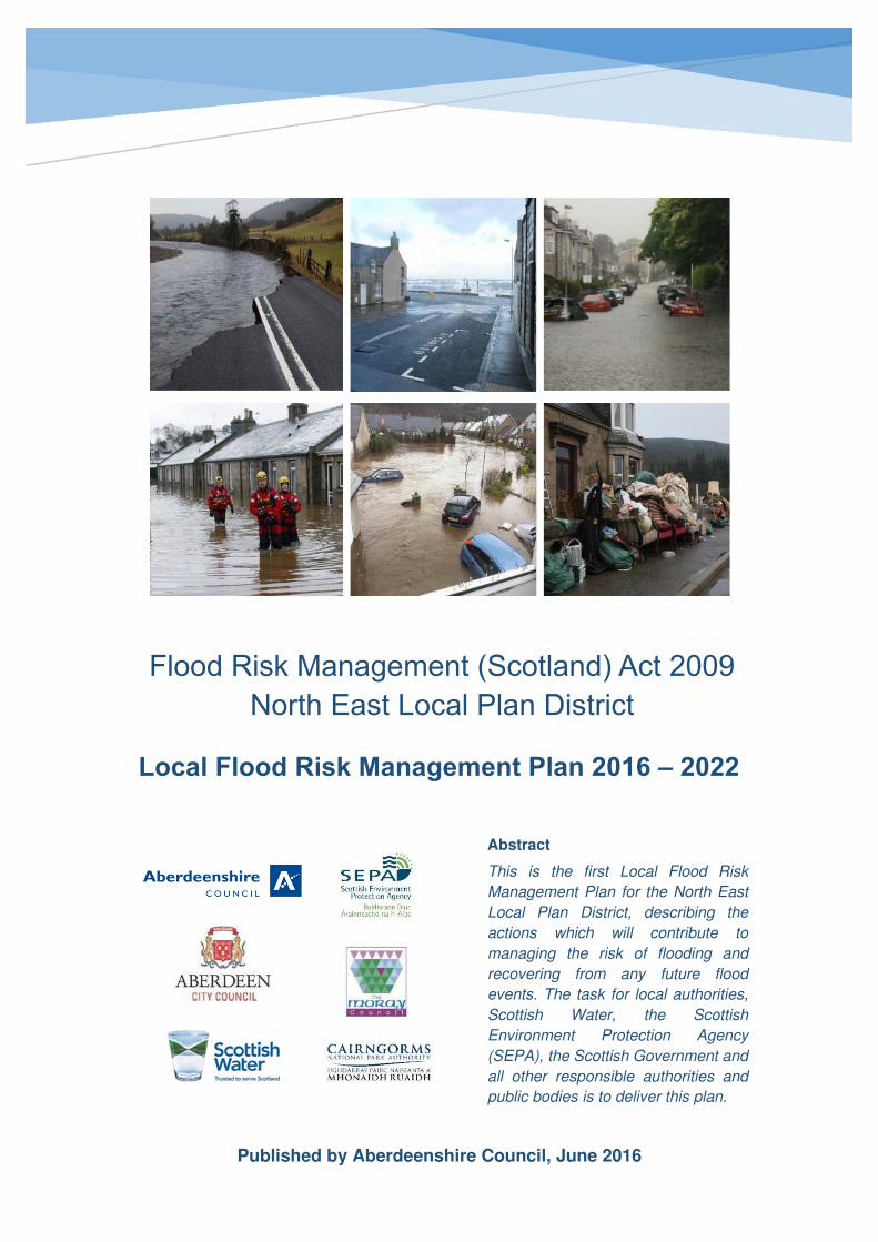
Flood Risk Management (Scotland) Act 2009
North East Local Plan District
Abstract
This is the first Local Flood Risk
Management Plan for the North East
Local Plan District, describing the
actions which will contribute to
managing the risk of flooding and
recovering from any future flood
events. The task for local authorities,
Scottish Water, the Scottish
Environment Protection Agency
(SEPA), the Scottish Government and
all other responsible authorities and
public bodies is to deliver this plan.
Published by Aberdeenshire Council, June 2016
Local Flood Risk Management Plan 2016 – 2022

North East Local Plan District – Local Flood Risk Management Plan
Foreword
The impacts of flooding experienced by individuals, communities and businesses can be
devastating and long lasting. It is vital that we continue to reduce the risk of any such
future events and improve the area’s ability to manage and recover from any events which
do occur.
The publication of this Plan is an important milestone in implementing the Flood Risk
Management (Scotland) Act 2009 and improving how we cope with and manage floods in
the North East Local Plan District. The Plan translates this legislation into actions over the
first planning cycle from 2016 to 2022 to reduce the risk of damage and distress caused
by flooding.
The North East Local Plan District is led and is published by Aberdeenshire Council on
behalf of a partnership comprising three local authorities: Aberdeenshire Council,
Aberdeen City Council and The Moray Council together with SEPA and the following
Responsible Authorities: Scottish Water; SEPA; Forestry Commission Scotland; and
Cairngorms National Park Authority.
In summary, there are 23 areas that have been identified as being potentially vulnerable
to flood risk across the North East Local Plan District and these have been designated as
Potentially Vulnerable Areas (PVAs). The North East Local Plan District contains
approximately 13,000 residential and 3,600 non-residential properties at risk with an
estimated Annual Average Damages of £29 million.
This Plan presents actions to avoid and reduce the risk of flooding and prepare and
protect ourselves and our communities within these PVAs and across the Local Plan
District (LPD). These actions include three local authority-led flood protection schemes or
works; 9 local authority-led flood protection studies; as well as flood warning schemes, 13
Surface Water Management Plans, and a natural flood management study. The delivery
of many of these actions may be dependent on the availability of funding. However, we
can all play our part in managing flood risk.
Individuals are the first line of defence against flooding and have responsibilities to protect
themselves from flooding. The publication of this Plan shows that the coordinated and
collaborative efforts of public bodies can be brought together to deliver sustainable
outcomes. However, the actions in this Plan can only be delivered with the support of all
the public bodies, The Scottish Government, and most importantly you and your
community.
This Plan, therefore, provides the blueprint upon which SEPA, local authorities and
Scottish Water and any other responsible authorities will deliver their flood risk
management duties under the Flood Risk Management (Scotland) Act 2009.

North East Local Plan District – Local Flood Risk Management Plan
Acknowledgements
With thanks to the following who contributed to the development of this Plan which will
help shape the way in which floods and their impacts are managed across the North East
Local Plan District:
Jonathan Duncan Aberdeenshire Council (LFRMP Project Manager)
Gavin Penman Aberdeenshire Council
William Murdoch Aberdeenshire Council (Retired)
Joanna Cubbage Aberdeenshire Council (Former)
Lee Watson Aberdeenshire Council
David Gowans The Moray Council
Deborah Halliday The Moray Council
Alan Robertson Aberdeen City Council
Will Burnish Aberdeen City Council
Steve McFarland SEPA
Iris Krammer SEPA
Ben Bickle Scottish Water
David Berry, Gavin Miles Cairngorms National Park Authority
North East Local Flood Risk Management Plan Steering Group elected members
Councillor Bryan Stuart
North East LPD Steering Group Chair
(Aberdeenshire Council)
Councillor Andrew Finlayson
LPD Elected Member Representative
(Aberdeen City Council)
Councillor Stewart Cree
LPD Elected Member Representative
(The Moray Council)
North East Local Plan District – Local Flood Risk Management Plan
List of Acronyms and Abbreviations
CoSLA Convention of Scottish Local Authorities
FRM Flood Risk Management
ICS Integrated Catchment Study
LA Local Authority
LFRMP Local Flood Risk Management Plan
LLA Lead Local Authority
LPD Local Plan District
NFRA National Flood Risk Assessment
NFM Natural Flood Management
PVA Potentially Vulnerable Area
RBMP River Basin Management Plan
SAC Special Area of Conservation
SSSI Site of Special Scientific Interest
SEPA Scottish Environmental Protection Agency
SEA Strategic Environmental Assessment
SFRA Strategic Flood Risk Assessment
SPA Special Protection Area
SuDS Sustainable Drainage Systems
SWMP Surface Water Management Plan
North East Local Plan District – Local Flood Risk Management Plan
Table of Contents

North East Local Plan District – Local Flood Risk Management Plan
North East Local Plan District – Local Flood Risk Management Plan
7
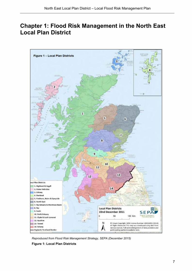
Chapter 1: Flood Risk Management in the North East Local Plan District
Reproduced from Flood Risk Management Strategy, SEPA (December 2015)
Figure 1: Local Plan Districts

North East Local Plan District – Local Flood Risk Management Plan
8
1.0 What is a Local Flood Risk Management Plan?
This Local Flood Risk Management Plan (the ‘Plan’) has been developed to detail the
actions adopted to reduce the devastating and costly impact of flooding in the North East
Local Plan District. The Plan supplements the North East Flood Risk Management
Strategy (the ‘Strategy’), which coordinates the efforts of all organisations that tackle
flooding, be it in urban or rural areas and be it from rivers, the sea or from surface water.
The Strategy identifies where the risk of flooding and benefits of investment are greatest.
The Plan details the prioritised actions that will be delivered with this investment. There
are 13 other Strategies and Plans for the other Local Plan Districts in Scotland.
Individuals and communities have the information to manage their own responsibilities
within the published Plan. Everyone can take action with the confidence of what others
are doing and with the clear knowledge when they are doing it.
In compliance with the Flood Risk Management (Scotland) Act 2009, these descriptions
include:
1. A detailed timetable for the completion of the action currently being implemented,
and the implementation of measures yet to be commenced;
2. Who is, or is to be, responsible for implementing the action and the arrangements
for funding the action; and
3. A description of the coordination arrangement to implement the actions.
It is through this risk-based and plan-led approach that flood management will improve for
the individuals, communities and businesses at risk in the North East Local Plan District.
The contents of the Plan have been agreed with the lead authority and every other
Responsible Authority which has flood risk related functions exercisable in or in relation to
the Local Plan District and SEPA.
The Plan is published by Aberdeenshire Council, Lead Local Authority for the North East
Local Plan District. The Plan has been prepared in collaboration with Aberdeen City
Council, The Moray Council, Scottish Water and other organisations with a responsibility
or interest in managing flooding. The Plan is a requirement under the Flood Risk
Management (Scotland) Act 2009 and fulfils requirements within the European
Commission Floods Directive.

North East Local Plan District – Local Flood Risk Management Plan
9
1.1 How to read this Plan
The Local Flood Risk Management Plan has three sections:
Chapter 1 contains background information on the approach taken in Scotland to manage
flooding. It explains the duties and aims of relevant organisations, including how they work
together and how flood risk management planning is linked to other government policies
and initiatives; and, most importantly, how flood risk management planning is delivered
locally to each Local Plan District through a Local Flood Risk Management Plan.
Chapter 2 is the most important section for those individuals and communities seeking to
understand their flood risk and its management. For areas identified as being at risk of
flooding and where the impact of flooding is sufficient to justify further assessment and
appraisal (Potentially Vulnerable Areas there is a short description of the causes and
consequences of flooding and the agreed objectives for flood risk management are clearly
set out. And, most importantly, the actions that will deliver progress against these
objectives over the first six-year planning cycle from 2016 and 2022 are described,
including when they will be implemented, which organisation is responsible, and how they
are to be funded.
Chapter 3 contains Annexes to the Plan, providing supporting documents and references
and presents more detailed information in various formats. A glossary of terms is included.
The Plan should be read alongside the Strategy for the North East Local Plan District
which has been developed in parallel and provides additional background information and
national context. SEPA published the Strategy in December 2015. Both the Plan and the
Strategy will be updated every six years. SEPA’s Flood Risk Management Strategy can
be found at: http://apps.sepa.org.uk/FRMStrategies/

North East Local Plan District – Local Flood Risk Management Plan
10
1.2 How we have developed the Plan?
Coordination, collaboration and partnership working
Many organisations and individuals are involved in helping to improve flood management
in Scotland. It is recognised that a piecemeal approach to management of flooding does
not work. Flooding can be a complex mechanism, and the causes and impacts are too
complicated for any single organisation to address alone. Flooding disregards local
authority boundaries and similarly cuts across the responsibilities of organisations such as
SEPA, Scottish Water and emergency responders. Successful and sustainable flood
management requires the coordination set out in this Plan (and parallel Strategy) to be
successful. A willingness to collaborate by those responsible for flood management is
essential for its success and this collaborative approach has been instrumental in
delivering the Plan.
The Plan has been developed in partnership. These partner organisations are working
more closely together than ever before. In local partnerships, here and throughout
Scotland, SEPA has provided the technical analysis and ensured a consistent national
approach is taken. It has provided the evidence upon which to make sensible, informed
decisions. Local authorities and Scottish Water have made sure that local knowledge and
expertise has informed the decision-making process and where appropriate, they have
also contributed. The Plan has been developed by:
Aberdeenshire Council (Lead Local Authority); Aberdeen City Council; The Moray Council,
Scottish Water, SEPA, Forestry Commission Scotland and the Cairngorms National Park
Authority.
Roles and responsibilities for flood risk management
Local authorities have no statutory duty to prevent properties from flooding, but will help
residents and communities as much as we can. The responsibility for protecting individual
properties lies with the property owner. However, public bodies have responsibilities too
and are working together to reduce the impacts of flooding in Scotland. Responsibility for
flood risk management planning falls mainly to SEPA, local authorities and Scottish
Water. However, individuals have a personal responsibility to protect themselves and their
property.
Some of the key roles are outlined below and more information is available from the SEPA
website. http://www.sepa.org.uk/environment/water/flooding/responsibilities-for-flooding
North East Local Plan District – Local Flood Risk Management Plan
11
Your responsibilities
The local authorities have no statutory duty to prevent properties from flooding, but will
help residents and communities as much as they can. The responsibility for protecting
individual properties lies with the property owner.
Being prepared by knowing what to do and who to contact if flooding happens can help
you reduce the damage and disruption flooding can have on your life.
The first step to being prepared is signing up to Floodline so you can receive messages to
let you know where and when flooding is likely to happen. Other useful tools and advice
on how to be prepared are available on the Floodline website including a quick guide to
who to contact in the event of a flood. You can also check how your area could be
affected by flooding by looking at SEPA’s flood maps
SEPA
SEPA is Scotland’s national flood forecasting, flood warning and strategic flood risk
management authority. SEPA has a statutory duty to produce Scotland's Flood Risk
Management Strategies. As described above, SEPA works closely with other
organisations responsible for managing flood risk through a network of partnerships and
stakeholder groups to ensure that a nationally consistent approach to flood risk
management is adopted.
SEPA also has a responsibility to identify where in Scotland there is the potential for
natural flood management techniques to be introduced. Natural flood management is the
use of the natural features of the land to store and slow down the flow of water.
In running Floodline, SEPA provides live flooding information and advice on how to
prepare for or cope with the impacts of flooding 24 hours a day, seven days a week.
SEPA works closely with the Met Office to help forecast flooding.
To raise awareness of flooding at a national level SEPA runs education initiatives,
community engagement programmes and an annual campaign to promote the useful
advice and information available through Floodline. This work is done in partnership with
local authorities, Neighbourhood Watch Scotland, Ready Scotland and others to share
resources and help to promote preparedness and understanding of how flood risk is
managed.
Local authorities
In terms of the Flood Risk Management (Scotland) Act 2009, the local authorities must
exercise their general functions with a view to reducing its overall flood risk. More specific
detail of each relevant section of the Act is outlined below:
North East Local Plan District – Local Flood Risk Management Plan
12
Section 1: General Duties
This requires all responsible authorities (including local authorities) when exercising their
flood risk related functions to manage flood risk in a sustainable way and to cooperate
with all responsible authorities.
Sections 34-39: Local Flood Risk Management Plans
Local authorities must assist SEPA in preparing the national flood risk assessment, flood
hazard and risk maps and Flood Risk Management Strategies. Lead Local Authorities
must also prepare Local Flood Risk Management Plans for relevant Local Plan Districts
by June 2016. Lead Local Authorities are required to publish an interim report within 2-3
years of the publication of the local flood risk management plan and a final report 5-6
years after publication.
Section 56: General power to manage flood risk
This section gives local authorities general powers to manage flood risk (from all sources
including surface water flooding) in their area, including implementation of measures
described in the Local Flood Risk Management Plans, carry out flood protection schemes
and any other flood protection work.
These powers are permissive; local authorities do not have a duty to use these powers.
This enables a local authority to do anything which it considers will contribute in a positive
way to the implementation of current measures described in the LFRMP. This could
include supporting or contributing to activities carried out by others, including other
responsible authorities. This may include for example: preventative actions, emergency
repairs or other flood avoidance activities.
In addition to emergency measures and those in a Plan, local authorities may carry out
other flood protection work to manage flood risk, so long as it does not affect the
implementation of measures in the Plan. This could include works identified as beneficial
since the Plan was published, or circumstances where funding has become available for
flood protection work.
Section 56 enables local authorities to enter into agreements with other people or
organisations such as land managers, other responsible authorities including Scottish
Water and other local authorities, community groups, charitable organisations and private
businesses to carry out works or to manage the flow of water.
Local authorities can contribute towards the cost of the other body or receive contributions
from any other body towards costs incurred. For example, a local authority could
contribute towards the development of a flood warning scheme by SEPA or to Scottish
Water for a joint project to improve surface water management. A local authority could
also receive contributions towards works, for example, from a developer wishing to
increase flood protection to support a development proposal.

North East Local Plan District – Local Flood Risk Management Plan
13
Section 56 also enables local authorities to enter into agreements relating to the
management of land in a way which can assist with slowing the flow or retaining flood
water. These activities are generally known as natural flood management (NFM). The
local authority can compensate the land manager for income lost as a result of entering
into such arrangements.
Section 57: Limits of general power
Local authorities are prevented from doing anything under section 56 which it would be
otherwise unable to do as a result of other Acts or forms of legislation e.g. the Water
Environment and Water Services (Scotland) Act 2003. In considering actions under
Section 56, local authorities should determine what they are unable to do as a result of
other legislative restrictions and satisfy themselves that these restrictions have been
adhered to.
Section 17 & 18: Local authorities to prepare maps and assess of bodies of water
Section 17 and 18 require local authorities to map bodies of water and SUDS, assess
bodies of water and prepare a schedule of clearance and repair works. Where bodies of
water are assessed as giving rise to a risk of flooding to land and the authority considers
works of clearance and repair would substantially reduce that risk, a schedule of
clearance and repair works must be prepared.
Clearance and repair works are works that consist of any or all of the following:
(a) removing obstructions from a body of water,
(b) removing things that are at significant risk of becoming such obstructions,
(c) repairing artificial structures which form part of the bed or banks of a body of water.
This schedule must be made available for public inspection and should indicate when the
local authority next intends to carry out an assessment of this body of water.
Section 59: Duty to carry out clearance and repair works
Local authorities are required to carry out the clearance and repair works described in the
schedule prepared under Section 18 if the Act, as long as the works contribute to the
implementation of measures described in the relevant Plan or do not affect the
implementation of those measures.
Many clearance and repair works will not require an authorisation under The Water
Environment (Controlled Activities) (Scotland) Regulations 2011 (CAR) and can be
completed under a General Binding Rule. However, the level of authorisation required
under CAR depends not only on the extent of the planned works but also on the sensitivity
of the water body to ecological status deterioration.

North East Local Plan District – Local Flood Risk Management Plan
14
Roads (Scotland) Act 1984
Local authorities have a duty in terms of the Roads (Scotland) Act 1984 to provide
drainage of public roads (for normal circumstances) and for road safety which may only
involve signing and diversion of traffic in the event of flooding. In particular, Section 31
provides powers to the roads authority to drain a public road or proposed public road or
otherwise prevent surface water from flowing onto it. Section 99 allows roads authorities
to carry out works to prevent flows of water onto roads, where the owner or occupier of
any land has failed to prevent the flow or percolation of water, from the land onto the road.
Importantly, in terms of the prevention of flow of water onto roads, under the Roads
(Scotland) Act 1984 there is no requirement for this to have been as a result of an ‘action’.
For example, if through a lack of maintenance water is flowing onto a road, then a notice
can be served on the owner or occupier to prevent this. It should be noted that a proper
assessment of what can be done to prevent the flow should have been undertaken by the
roads authority – it is not merely the case of the owner or occupier preventing the flow of
water onto a road if this is not possible or practical.
Water Environment and Water Services (Scotland) Act 2003
According to the Act, local authorities should exercise their flood related functions with
view to reducing overall flood risk. They should act in the best way calculated to promote
and manage flood risk in a sustainable way, with a view to raising public awareness of this
risk. Local authorities should be seeking to contribute to the achievement of sustainable
development and look to adopt an integrated approach by cooperating with SEPA and
other Responsible Authorities.
Scottish Water
Scottish Water is a responsible authority for flood risk management and is working closely
with SEPA, local authorities and others to coordinate plans to manage flood risk.
Scottish Water has the public drainage duty and is responsible for foul drainage and the
drainage of rainwater run-off from roofs and any paved ground surface from the boundary
of properties. Additionally, Scottish Water helps to protect homes from flooding caused by
sewers either overflowing or becoming blocked. Scottish Water is not responsible for
private pipework or guttering within the property boundary.
National Parks
The two National Park Authorities, Loch Lomond and Trossachs National Park and
Cairngorms National Park, were designated as responsible authorities for flood risk
management purposes in 2012. Both have worked with SEPA, local authorities and
Scottish Water to help develop Flood Risk Management Strategies and Plans.

North East Local Plan District – Local Flood Risk Management Plan
15
They also fulfil an important role in land use planning, carrying out or granting permission
for activities that can play a key role in managing and reducing flood risk.
The Cairngorms National Park Authority is a Responsible Authority for the North East
Local Plan District.
Other organisations
The Scottish Government oversees the implementation of the Flood Risk Management
(Scotland) Act 2009 which requires the production of Flood Risk Management Strategies
and Local Flood Risk Management Plans. Scottish Ministers are responsible for setting
the policy framework for how organisations collectively manage flooding in Scotland and
approving Strategies.
Scottish Natural Heritage has provided general and local advice in the development of
Flood Risk Management Strategies. Flooding is seen as a natural process that can
maintain the features of interest at many designated sites, so Scottish Natural Heritage
helps to ensure that any changes to patterns of flooding do not adversely affect the
environment. Scottish Natural Heritage also provides advice on the impact of Flood
Protection Schemes and other land use development on designated sites and species.
Forestry Commission Scotland was designated in 2012 as a Responsible Authority for
flood risk management planning purposes and has engaged in the development of the
Flood Risk Management Strategies through national and local advisory groups. This
reflects the widely held view that forestry can play a significant role in managing flooding.
During the preparation of the first flood risk management plans Network Rail and
Transport Scotland have undertaken works to address flooding at a number of frequently
flooded sites. Further engagement is planned with SEPA and local authorities to identify
areas of future work. There is the opportunity for further works to be undertaken during the
first flood risk management planning cycle although locations for these works are yet to be
confirmed.
Utility companies have undertaken site specific flood risk studies for their primary assets
and have management plans in place to mitigate the effects of flooding to their assets and
also minimise the impacts on customers.
The Met Office provides a wide range of forecasts and weather warnings. SEPA and the
Met Office work together through the Scottish Flood Forecasting Service.
The emergency services provide emergency relief when flooding occurs and can
coordinate evacuations. You should call the emergency services on 999 if you are
concerned about your safety or the safety of others and act immediately on any advice
provided.

North East Local Plan District – Local Flood Risk Management Plan
16
Historic Environment Scotland considers flooding as part of their regular site
assessments. As such, flooding is considered as one of the many factors which inform the
development and delivery of its management and maintenance programmes.
Consultation, engagement and advice
Local authorities and SEPA have been keen to hear from people and communities that
live under the threat of flooding, to ensure that our technical analysis of the risks is
accurate and that efforts to manage flooding are targeted to where most can be achieved.
Two statutory public consultations were held during the development of the Strategies and
Plans. The first, by SEPA, was on the general approach to flood risk management
planning and the identification of priority areas (2011); the second, held jointly with SEPA
and local authorities, was on the understanding of flooding in these priority areas and on
the objectives and actions to manage flooding (2015). The views and representations of
the respondents to the second consultation were taken account of in developing and
finalising the Plan.
Further advice has been sought from relevant organisations at key stages. The Strategies
(and Plans) have benefitted from input from Local Advisory Groups, providing important
area-based knowledge on both the causes and consequences of flooding and on the
appropriate actions for future management. Advice was also taken from a National Flood
Management Advisory Group consisting of over 50 member organisations, reflecting the
national importance and impact of flooding on our communities, economy, environment
and cultural heritage.
Some of the work carried out has been complex and technical in nature for which
professional advice was sought from across Scotland and beyond. Working together,
SEPA, Scottish Government, local authorities, Scottish Water, Forestry Commission
Scotland, the National Park Authorities and other key interested organisations have
assisted each other and developed industry best practice guidance for flood risk
management planning.
Identification of objectives, appraisal and prioritisation of actions
The identification of objectives and appraisal of actions to reduce flood risk has been led
by SEPA with significant local input from local authorities and Scottish Water. The setting
of objectives and selecting the most sustainable actions to reduce flood risk in each Local
Plan District will provide the long-term vision for Flood Risk Management in Scotland.
Objectives set focus on the main sources and impacts of flooding identified for each
Potentially Vulnerable Area in every Local Plan District. A wide range of actions were
appraised, including flood protection works and schemes, flood protection studies, flood
warning schemes, Surface Water Management Plans, and natural flood management
studies and works.
To prioritise future actions across Scotland as required in flood risk management
planning, SEPA separated the technical, risk-based assessment of priorities from aspects
North East Local Plan District – Local Flood Risk Management Plan
17
of local, practical deliverability. In this way the data on the costs and impacts of actions is
used alongside information from delivery and funding bodies to jointly agree priorities and
identify indicative delivery dates for actions. A National Prioritisation Advisory Group was
established to provide guidance to SEPA on the priority of flood risk management actions,
having considered both the technical ranking prepared by SEPA and issues of local
priority. This group was made up of representatives from SEPA, local authorities, Scottish
Water and CoSLA.
The Strategy provides the list of prioritised actions for the first six-year flood risk
management planning cycle, 2016 to 2022. The Plan identifies who will be responsible for
the action, a timetable of when it will be undertaken and the funding arrangements – see
Chapter 2.
The lists of prioritised actions to meet agreed goals and objectives in the first six-year
cycle considered what would be achievable assuming a similar level of funding for flood
risk management activities from The Scottish Government. However, given the timing of
spending reviews and annualised financial settlements for local government, the actual
ability to deliver all the actions set in the Strategies in December 2015 and detailed in this
Plan will be dependent on the availability of the necessary funding in each year of the six-
year Plan.

North East Local Plan District – Local Flood Risk Management Plan
18
1.3 Links with other plans, policies, strategies and legislative
requirements
The Plan does not stand in isolation. As far as is practicable, an integrated approach to
land and water management has been pursued. When developing the Strategy and Plan,
early links were made with other relevant aspects of water and land management
including local development plans, river basin management plans and emergency plans.
In turn, the responsible authorities will work proactively to ensure the findings from these
flood risk management plans and strategies will influence other planning initiatives in an
interactive and iterative cycle. Making these links has helped identify opportunities to
deliver multiple benefits from flood risk management goals, objectives and actions.
River basin management planning
River basin management aims to protect and improve the condition of our rivers, lochs,
estuaries and coastal waters. Taking action to reduce flood risk in Scotland provides an
opportunity to connect with plans to improve the quality of Scotland’s water environment
at the same time. For example, coordination between river basin management and flood
risk management can reduce flood risk, whilst improving water quality and biodiversity.
SEPA is leading the delivery of River Basin Management Plans and Flood Risk
Management Strategies and has worked to ensure that there is integration and
coordination between them. This coordination, particularly in regard to consultation and
engagement, will be important for stakeholders many of whom have an interest in the
objectives of both plans.
Land use and spatial planning
Land use planning decisions are one of the most powerful tools available to manage flood
risk. The alignment of flood risk management and land use planning policy is pivotal to
achieving sustainable flood risk management. Decisions relating to flood risk management
can have significant implications for the location of development and, likewise, decisions
relating to the location of development can impact on flood risk. Land use planning has
the potential to contribute to sustainable flood risk management through the location, use
and design of new development and the redevelopment of existing areas. Actions that
deliver national level land use planning policies are summarised in Annex 5.
SEPA is a statutory consultee providing advice on planning applications with regards to
flood risk. Guidance aims to minimise flood risk to development and ensure no adverse
effects occur elsewhere.
Land use planning objectives and actions have been agreed with responsible authorities,
which will ensure that flood risk is adequately taken into account throughout the planning
process.
North East Local Plan District – Local Flood Risk Management Plan
19
Emergency planning and response
Emergency plans are prepared under the Civil Contingencies Act 2004. They are in place
across Scotland and are prepared by Category 1 and 2 Responders, such as Police
Scotland and the Scottish Ambulance Service. Emergency plans ensure the effective
management of response to emergencies. Emergency plans can either be generic and
deal with all emergencies OR specific to deal with, for example, flooding. The information
contained in the Flood Risk Management Strategies can be used to inform wider
emergency response plans for flooding.
Many organisations have specific roles and responsibilities during an emergency
response to a flood for example, local authorities, the Scottish Fire and Rescue Services,
Police Scotland and SEPA. In many cases, this response is augmented by the work of
voluntary organisations, communities and individuals. During an emergency, the response
by these agencies will be coordinated through regional and local resilience partnerships.
Strategic Environmental Assessment and Habitats Regulation Appraisal (SEA)
Aberdeenshire Council submitted a screening report to the strategic environmental
assessment Gateway to assess the significant environmental effects of the Plan.
As there were no additional actions within the Local Flood Risk Management Plan that
have not been identified within the previously assessed Flood Risk Management Strategy
undertaken by SEPA it was accepted that no further SEA work was required.
SEPA’s assessment from the SEA of the Flood Risk Management Strategy was published
in an environmental report, and SEPA consulted the public on the findings. SEPA also
published a post-adoption statement, which describes how it has taken account of the
environmental assessment and the consultation responses, and how it will monitor any
significant environmental effects of the Flood Risk Management Strategies.
Aberdeenshire Council also undertook a Habitats Regulations Appraisal to ensure that the
Plan will not adversely affect the integrity of Special Areas of Conservation and Special
Protection Areas. The Council consulted Scottish Natural Heritage and Natural England
on the appraisal method and took their views into account. The Council has applied
mitigation measures where required.
S18 Schedule of Clearance and Repair
Local authorities have a duty under Section 18 of the Flood Risk Management Scotland
Act to assess bodies of water and carry out clearance and repair works where such works
would substantially reduce flood risk. They produce schedules of clearance and repair
works and make these available for public inspection.
Asset owners and riparian landowners are responsible for the maintenance and
management of their own assets including those which help to reduce flood risk.
North East Local Plan District – Local Flood Risk Management Plan
20
Scottish Water Business Plan 2015-2021
Scottish Water’s investment programme is set out in their business plan 2015-2021, which
can be found in their website: https://www.scottishwater.co.uk/about-
us/publications/strategic-projections
Scottish Water's customers have told them that reducing internal property flooding from
sewers is a high priority and this is reflected in Scottish Water's Business Plan
commitments for the period 2015-21. Addressing sewer flooding is of the highest
importance to Scottish Water, as highlighted by our customers who have helped shape
the investment plans for 2015-21.
In recognition of this high priority, within the period 2015-2021, Scottish Water will invest
c£115m to improve the hydraulic capability of the sewer network so that they can remove
all customers from the high risk internal sewer flooding register (greater than 10% chance
per annum) as quickly as possible, typically within four years of their problem being
confirmed. However Scottish Water has made a commitment to those customers on the
register on 31 March 2015 that they will no longer be on the register by 31 March 2021.
Scottish Water's Customers have also highlighted external flooding is an important issue.
As a result, within the period 2015-2021, they are investing c£40m to develop and to
begin to implement solutions to reduce the flood risk for 400 high priority external sewer
flooding areas suffering from frequent repeat flooding events.
As a responsible authority under the Flood Risk Management (Scotland) Act 2009,
Scottish Water is also working collaboratively with third parties such as SEPA and Local
Authorities through the Flood Risk Management Planning process which will assess the
risk of flooding into the future.
As part of that work, Scottish Water has allocated investment to undertake further
modelling and assessment in sewer catchments within PVA’s to improve knowledge and
understanding of flood risk from the sewers in these areas, as required under Section 16
of the Flood Risk Management (Scotland) Act 2009. Scottish Water is also working in
partnership with SEPA and Local Authorities, to lead on the production of Integrated
Catchment Studies across key catchments. Work carried out under these Flood Risk
Management (Scotland) Act 2009 duties will continue to inform future investment
requirements for Scottish Water.

North East Local Plan District – Local Flood Risk Management Plan
21
Surface Water Management Planning
Surface water flooding is experienced in all Plan areas and therefore there is a need for
surface water management planning. Surface water flooding is a key component of the
flood risk assessment that has led to the development of this Plan. However, not all
surface water management planning will require a surface water management plan or
specific study or other action which are described in Chapter 2 of this Plan. Responsible
authorities in each LPD may therefore undertake broader surface water management
planning over the period of the first Flood Risk Management (FRM) cycle. Such additional
surface water management planning is described in Chapter 2.4 of the Plan ‘Other flood
risk activities by local authorities in the North East Local Plan District’.
Integrated Catchment Studies
Integrated Catchment Studies (ICS) are led by Scottish Water in partnership with local
authorities and SEPA. These studies will improve knowledge and understanding of the
interactions between the above ground and below ground drainage network e.g. with the
sewer network, watercourses and (where appropriate) the sea. This will improve the
understanding of contributions these drainage networks play in local surface water flood
risk.
Five ICS’s were undertaken in Scotland during SR10 (2010-2015), to Modelling and Flood
Risk assessment stage, which have provided a fuller understanding of the sources and
mechanisms of flooding across these catchments. These studies are expected to
undertake an Optioneering phase between 2015-2021. This will identify the actions to
reduce flood risk across the catchments, with the outputs feeding into the Local Authority
lead surface water management planning process.
Fifteen ICS’s will begin in Scotland during SR15 (2015-2021). These studies will go
through the Scoping and Modelling phases, which culminates in defining the sources and
mechanisms of flooding in the catchment, and an understanding of the impacts of that
flooding. It is expected that the ICS partnerships will remain and it is anticipated that the
Optioneering phase for these studies will be initiated directly after the preceding phases.
Within this Local Plan District, an ICS is being carried out in the Aberdeen catchment
which covers Aberdeen City, parts of Westhill and Portlethen and Stonehaven to the
south.
North East Local Plan District – Local Flood Risk Management Plan
22
1.4 Next steps and monitoring progress
The Plan runs for six years from June 2016. Over this period the North East LPD
partnership will continue to meet periodically to monitor progress towards implementing
the actions detailed in Chapter 2.
Between years 2 and 3 of the FRM cycle (i.e. before June 2019), Aberdeenshire Council,
as Lead Local Authority will publish a report on the conclusions of a review of the Plan,
including information on the progress that has been made towards implementing the
measures identified in the implementation part of the Plan.
Between years 5 and 6 of the FRM cycle (i.e. before June 2022), Aberdeenshire Council,
as Lead Local Authority will publish a report on the Plan containing an assessment of the
progress made towards implementing the current measures, a summary of the current
measures which were not implemented, with reasons for their non-implementation, and a
description of any other measures implemented since the Plan was finalised which the
Lead Local Authority considers have contributed to the achievement of the objectives
summarised in the Plan.
The Lead Local Authority will make these reports available for public inspection.
North East Local Plan District – Local Flood Risk Management Plan
23
Chapter 2: Managing Flood Risk in the North East Local Plan District
This chapter presents the summaries of flooding for the North East Local Plan District and
for the 23 Potentially Vulnerable Areas (PVAs). Planned actions to manage flooding that
have been prioritised for delivery between 2016 and 2022 across the whole of the LPD
area and in each PVA are detailed. It identifies who will be responsible for the delivery and
implementation of the actions, along with a timetable of when the actions will be
undertaken and the funding arrangements.
Annexes 1, 2 & 3 summarise the characteristics and impacts of flooding from river, coastal
and surface water sources on the North East Local Plan District and how flooding from
these mechanisms is to be managed.
Section 2.1 presents a summary for the Local Plan District
Section 2.2 presents a Local Plan District overview.
Sections 2.3.1 – 2.3.23 presents actions by PVA.
Section 2.4 describes other flood risk activities undertaken by local authorities in the North
East Local Plan District so as to provide as full a picture as possible of how flood risk is
managed.
North East Local Plan District – Local Flood Risk Management Plan
24
2.1 Local Plan District summary
There are 23 PVAs across the North East Local Plan District
The Moray Council
06/01 Portgordon
06/06 Newmill
Aberdeenshire Council
06/02 Portsoy
06/03 Banff
06/04 Macduff
06/05 Fraserburgh and Rosehearty
06/07 Turriff
06/08 Peterhead
06/09 Methlick
06/10 Huntly
06/11 Insch
06/12 Ellon
06/13 Inverurie and Kintore
06/21 Banchory and Torphins
06/23 Stonehaven
Aberdeen City Council / Aberdeenshire Council
06/15 Aberdeen City - Bridge of Don
06/17 Westhill
06/19 Peterculter
Aberdeen City Council
06/16 Aberdeen City - Denmore
06/18 Aberdeen City - Deeside
Cairngorms National Park / Aberdeenshire Council
06/14 Heugh-head
06/20 Aboyne
06/22 Ballater
The PVAs represent 87% of the 13,000 residential and 3,600 non-residential properties at
flood risk in the North East Local Plan District. The PVAs cover just over £20 million
Annual Average Damages across the North East Local Plan District, which represents
69% of the Annual Average Damages for the whole LPD.
Figure 2 below illustrates the locations of PVAs in the North East Local Plan District.

Figure 2: The North East Local Plan District with Potentially Vulnerable Areas identified (Reproduced from North East Flood Risk Management Strategy, SEPA (December 2015))

North East Local Plan District – Local Flood Risk Management Plan
26
Table 1 summarises the headline actions to manage flood risk over the six-year plan
period.
A full list of actions to manage flood risk over the six-year plan period including details of
the standard of protection, costs and benefits, and coordination and funding arrangements
are provided for the LPD and each PVA in sections 2.2 and 2.3.1 to 2.3.23 respectively.
Figures 7, 19 and 25 present the Annual Average Damages from river flooding, coastal
flooding and surface water flooding across the North East Local Plan District.
PVA Flo
od
pro
tecti
on
sch
em
e/
wo
rks
Natu
ral
flo
od
man
ag
em
en
t w
ork
s
New
flo
od
warn
ing
Flo
od
pro
tecti
on
stu
dy
Natu
ral
flo
od
man
ag
em
en
t stu
dy
Su
rface w
ate
r p
lan
/stu
dy
Str
ate
gic
map
pin
g a
nd
m
od
ellin
g
Ma
inta
in f
loo
d p
rote
cti
on
sch
em
e*
Ma
inta
in f
loo
d w
arn
ing
*
Flo
od
fo
recasti
ng
Pro
pe
rty level p
rote
cti
on
sch
em
e
Co
mm
un
ity f
loo
d a
cti
on
g
rou
ps
Self
help
Aw
are
ne
ss r
ais
ing
Ma
inte
na
nce
Sit
e p
rote
cti
on
pla
ns
Em
erg
en
cy p
lan
s/ re
sp
on
se
Pla
nn
ing
po
licie
s
06/01
06/02 N/A
06/03
06/04
06/05
06/06
06/07
06/08
06/09
06/10
06/11
06/12
06/13
06/14
06/15
06/16
06/17
06/18
06/19
06/20
06/21
06/22
06/23
*Note: N/A is used where there is no formal Flood Protection Scheme or flood warning scheme present.
Table 1: Summary of actions by LPD

North East Local Plan District – Local Flood Risk Management Plan
27
Responsible Authorities have several obligations that will be provided regardless of
whether the area in question is located within a PVA. These are as follows:
Responsible Authorities have an obligation under Section 1 of the Act to raise awareness
regarding flood risk. Activities are to be pursued both nationally and locally over the first
cycle to fulfil this obligation.
Providing an emergency response to flooding is the responsibility of many organisations,
including local authorities, the emergency services and SEPA.
Effective management of an emergency response relies on emergency plans that are
prepared under the Civil Contingencies Act 2004 by Category 1 and 2 Responders.
The emergency response by these organisations is coordinated through regional and local
resilience partnerships. This response may be supported by the work of voluntary
organisations.
The Scottish Flood Forecasting Service is a joint initiative between SEPA and the Met
Office that produces daily, national flood guidance statements which are issued to
Category 1 and 2 Responders. The service also provides information which allows SEPA
to issue flood warnings, giving people a better chance of reducing the impact of flooding
on their home or business. For more information, please visit SEPA’s website.
National planning policies set out Scottish Ministers’ priorities for the operation of the
planning system and for the development and use of land. In terms of flood risk
management, the policy supports a catchment-scale approach to sustainable flood risk
management and aims to build the resilience of our cities and towns, encourage
sustainable land management in our rural areas, and to address the long-term
vulnerability of parts of our coasts and islands. Under this approach, development in areas
with medium to high likelihood of flooding should be avoided.
In the following section the proposed actions for the first cycle are outlined with the two
main actions being flood protection schemes and flood protection studies.
Schemes are physical works to prevent an area flooding, these can take the form of walls
and embankments, upstream storage, bypass channels or other engineered options to
reduce flood risk. The types of proposals proposed for each area are outlined under the
specific actions.
Flood protection studies are intended to develop our understanding of flood risk in a
specific area and develop options for reducing the risk. A flood protection study takes a
catchment-based multi discipline approach to developing our understanding of flood risk.
It is intended that the studies will examine all options including the use of natural flood
management, development of Surface Water Management Plans, construction of direct
defences or utilising community based approaches such as developing flood groups,
emergency action plans or using property level protection.
North East Local Plan District – Local Flood Risk Management Plan
28
2.2 Local Plan District Overview
The following section takes the information detailed in the Strategy and summarises the
flood risk, objectives, actions and prioritisation for the whole of the North East Local Plan
District. In addition, it identifies who will be responsible for the delivery and implementation
of the actions, along with a timetable of when the actions will be undertaken and the
funding arrangements.
The North East Local Plan District extends from the Outer Moray Firth in the north to the
central and eastern Grampians in the south. It has an area of approximately 6,500km2 and
a coastline with a length of approximately 220km. There are 23 Potentially Vulnerable
Areas in the North East Local Plan District.
Flood Risk in the North East
There are approximately 13,000 residential properties and 3,600 non-residential
properties at risk of flooding within the Local Plan District. This is approximately 5% of all
residential properties and 10% of all non-residential properties. It is estimated that 87% of
these properties at risk of flooding are located within Potentially Vulnerable Areas.
The Annual Average Damages from flooding are approximately £29 million with an
estimated 69% of the total damages for the entire Local Plan District accounted for in the
Potentially Vulnerable Areas.
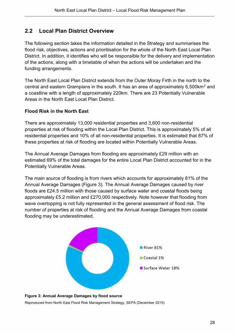
The main source of flooding is from rivers which accounts for approximately 81% of the
Annual Average Damages (Figure 3). The Annual Average Damages caused by river
floods are £24.5 million with those caused by surface water and coastal floods being
approximately £5.2 million and £270,000 respectively. Note however that flooding from
wave overtopping is not fully represented in the general assessment of flood risk. The
number of properties at risk of flooding and the Annual Average Damages from coastal
flooding may be underestimated.
Figure 3: Annual Average Damages by flood source
Reproduced from North East Flood Risk Management Strategy, SEPA (December 2015)
North East Local Plan District – Local Flood Risk Management Plan
29
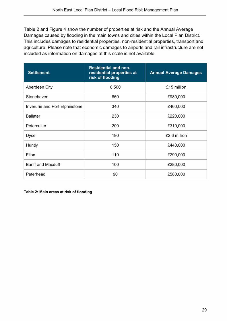
Table 2 and Figure 4 show the number of properties at risk and the Annual Average
Damages caused by flooding in the main towns and cities within the Local Plan District.
This includes damages to residential properties, non-residential properties, transport and
agriculture. Please note that economic damages to airports and rail infrastructure are not
included as information on damages at this scale is not available.
Settlement Residential and non-residential properties at risk of flooding
Annual Average Damages
Aberdeen City 8,500 £15 million
Stonehaven 860 £980,000
Inverurie and Port Elphinstone 340 £460,000
Ballater 230 £220,000
Peterculter 200 £310,000
Dyce 190 £2.6 million
Huntly 150 £440,000
Ellon 110 £290,000
Banff and Macduff 100 £280,000
Peterhead 90 £580,000
Table 2: Main areas at risk of flooding

North East Local Plan District – Local Flood Risk Management Plan
30
Reproduced from North East Flood Risk Management Strategy, SEPA (December 2015)
Figure 4: The North East Local Plan District areas with most properties at risk of flooding and associated damages
North East Local Plan District – Local Flood Risk Management Plan
31
Background Information on the North East Local Plan District
The extent of the North East Local Plan District and the location of the Potentially
Vulnerable Areas are shown previously in Figure 2.
The population of the Local Plan District is approximately 500,000. The largest urban area
is Aberdeen with a population of approximately 220,000 people. The Local Plan District
contains three local authorities (Aberdeen City Council, Aberdeenshire Council and The
Moray Council) and parts of the Cairngorms National Park.
Approximately 3% of the area of the North East Local Plan District is classified as urban.
The two main types of land cover are arable and horticulture, and improved grassland.
Each covers approximately 23% of the area. Coniferous woodland, heather and montane
habitats are also present, each covering between 9% and 12% of the area.
Objectives and actions in the North East Local Plan District
The objectives are the shared aims for managing flooding. Actions describe where and
how flood risk will be managed. Objectives and actions have been set by SEPA and
agreed by flood risk management responsible authorities following consultation.
These objectives and actions apply to all areas of the Local Plan District, including the
Potentially Vulnerable Areas. There are more specific actions that apply within Potentially
Vulnerable Areas, in addition to those listed below. Further detail can be found in the
relevant Potentially Vulnerable Area chapter.
Reproduced from North East Flood Risk Management Strategy, SEPA (December 2015)
Target area Objective(s) ID Indicators
Applies across
the North East
Local Plan
District
Avoid an overall increase in
flood risk 600001
• 13,000 residential
properties
• 3,600 non-residential
properties
• 28,000 people
Applies across
the North East
Local Plan
District
Reduce overall flood risk 600002
• 13,000 residential
properties
• 3,600 non-residential
properties
• 28,000 people

North East Local Plan District – Local Flood Risk Management Plan
32
Action (ID): FLOOD FORECASTING (6000020009)
Objective (ID): Reduce overall flood risk. (600002)
Delivery lead: SEPA
Status: Existing Indicative delivery: Ongoing
Description:
The Scottish Flood Forecasting Service is a joint initiative between SEPA and the Met Office that
produces daily, national flood guidance statements which are issued to Category 1 and 2
Responders.
The flood guidance statements provide an assessment of the risk of flooding for a five-day period
allowing responders time to put preparations in place to reduce the impact of flooding. The
service also provides information which allows SEPA to issue flood warnings, giving people a
better chance of reducing the impact of flooding on their home or business.
Hydrological information is provided by SEPA and meteorological information is provided by the
Met Office. SEPA uses the information to predict the likelihood and timing of river, coastal and
surface water flooding.
For more information, please visit SEPA’s website.
SEPA’s flood forecasting service is funded through Scottish Government’s grant in aid allocation.
The Met Office receives funding from the UK Government.

North East Local Plan District – Local Flood Risk Management Plan
33
Action (ID): SELF HELP (6000020011)
Objective (ID): Reduce overall flood risk. (600002)
Delivery lead: -
Status: Existing Indicative delivery: Ongoing
Description:
Everyone is responsible for protecting themselves and their property from flooding. Property and
business owners can take simple steps to reduce damage and disruption to their homes and
businesses should flooding happen. This includes preparing a flood plan and flood kit, installing
property level protection, signing up to Floodline and Resilient Communities initiatives, and
ensuring that properties and businesses are insured against flood damage.
The Moray Council provides advice to members of the public regarding flood risk and resilience.
The Council also holds information events from time to time in collaboration with Scottish Water,
SEPA and the Scottish Flood Forum which are funded from the FRM Revenue budget.
Aberdeenshire Council currently provide a small range of flood protection products for individual
property protection, which are available for all types of flooding, at cost price with free delivery
across Aberdeenshire.
Aberdeen City Council will be promoting self-help through work with the community which will
include the creation of a Flood Guard Grant Scheme to assist people with putting in Property
Level Protection. This will be coordinated through its Flood Team and seek advice from
appropriate bodies such as the Scottish Flood Forum when setting up the Grant scheme. The
scheme will be funded via the ACC Capital works Programme.

North East Local Plan District – Local Flood Risk Management Plan
34
Action (ID): AWARENESS RAISING (6000020013)
Objective (ID): Reduce overall flood risk. (600002)
Delivery lead: Responsible Authorities
Status: Existing Indicative delivery: Ongoing
Description:
Aberdeenshire Council
Aberdeenshire Council have a duty to raise public awareness of flood risk under the Flood Risk
Management (Scotland) Act 2009 and to plan and inform of risks to communities under the Civil
Contingencies Act 2004.
Over the six years of the Plan, 2016-2022, Aberdeenshire Council will seek opportunities to raise
awareness of both flood risk and actions that enable individuals, homes and businesses to
reduce the overall impact of flooding. More general information and flooding guidance will be
available on the website at: https://www.aberdeenshire.gov.uk/environment/flooding/
In partnership with Education Scotland Aberdeenshire Council will look to engage schools in
activities relating to flooding, extreme weather, climate change and other community resilience
issues.
Aberdeenshire Council will also develop emergency response plans and work with community
flood action groups where these exist.
Awareness raising will be funded from existing local authority flood revenue budgets.
The Moray Council
The Moray Council will seek opportunities to raise awareness of flood risk and actions that
prepare individuals, homes and businesses as described in the Act. They will support community
resilience groups working with SEPA, responsible authorities, Crown Estates and the Scottish
Flood Forum. During the development of the flood protection study The Moray Council will hold
at least one event in Portgordon to consult residents on the proposed flood protection measures
identified and advise them on how the study is progressing.
Awareness raising will be funded from existing local authority flood revenue budgets.
Aberdeen City Council
Aberdeen City Council will be undertaking a number of community events to promote awareness
to the risk of flooding and what can be done to reduce the impact of flooding. As part of this we
will be looking to create flood action groups and community resilience groups with regards to
flooding. These groups will help promote the risk that flooding presents as well as provide
practical advice to the community they serve.
(continued)
North East Local Plan District – Local Flood Risk Management Plan
35
Aberdeen City Council will be working with the flooding groups as a minimum to promote
awareness to flood risk:-
• Community Councils
• Local residents
• Education Scotland
• Aberdeen Education Department
• SEPA
Activities undertaken by Aberdeen City Council will be funded by existing revenue budgets.
SEPA
From 2016 SEPA will engage with the community through local participation in national
initiatives, including partnership working with Neighbourhood Watch Scotland. In addition, SEPA
will engage with local authorities and community resilience groups where possible.
Across Scotland, SEPA will create and share communication and education resources with other
responsible authorities. These resources will include awareness campaigns, media and
marketing activity and promotion of SEPA's flood forecasting and warning services (Floodline).
Where they exist, SEPA will engage with community resilience groups and community safety
partnerships.
SEPA's awareness raising activities are funded by Scottish Government through SEPA’s grant in
aid settlement and will be coordinated with the activities of other responsible authorities as
required.
Scottish Water
Scottish Water will support SEPA and responsible authorities with their awareness raising
activities as required and provide targeted flooding communications for Scottish Water specific
activities. Scottish Water will raise awareness by producing and supplying targeted information to
the public on large capital projects and detailed local studies.
More general information and flooding guidance will be available on the website at:
https://www.scottishwater.co.uk/you-and-your-home/your-home/flooding-information
Scottish Water will keep responsible authorities informed of its awareness raising activities
through the Local Plan District partnerships.

North East Local Plan District – Local Flood Risk Management Plan
36
Action (ID): MAINTENANCE (6000020007)
Objective (ID): Reduce overall flood risk. (600002)
Delivery lead: local authority, asset / land managers
Status: Existing Indicative delivery: Ongoing
Description:
Local authorities have a duty to assess watercourses and carry out clearance and repair works
where such works would substantially reduce flood risk. They produce schedules of clearance
and repair works and make these available for public inspection.
The Moray Council
The Moray Council has a schedule of clearance and repair, which identifies routine maintenance
and repairs to address areas known to be at risk. It may include small improvement works. This
schedule is reviewed and updated regularly. This review is based on inspections and information
provided by the public and other organisations. Works identified in the Council's clearance and
repair schedule are funded from the FRM Revenue budget.
Aberdeenshire Council
Aberdeenshire Council will produce schedules of clearance and repair works and make these
available for public inspection. Maintenance will be funded from existing Flood revenue budgets,
for works which are defined to pose a significant flood risk.
Aberdeen City Council
Aberdeen City Council will produce schedules of clearance and repair works and make these
available for public inspection. Delivery of the clearance and repair Schedule will be undertaken
working with the following partners as a minimum: -
• ACC Community, Housing and Infrastructure Directorate who are responsible for Roads and
Planning within ACC
• SEPA
• Scottish water
• Land Owners
• Aberdeenshire Council
Funding to come from existing ACC Flood revenue budget, for works which are defined to be
ACC responsibility or pose a significant flood risk.
Scottish Water
Scottish Water undertake risk based inspection, maintenance and repair on the public sewer
network together with keeping responsible authorities informed of large scale capital
maintenance work to identify opportunities for co-ordination.
Asset owners and riparian landowners are responsible for the maintenance and
management of their own assets including those which help to reduce flooding.
North East Local Plan District – Local Flood Risk Management Plan
37
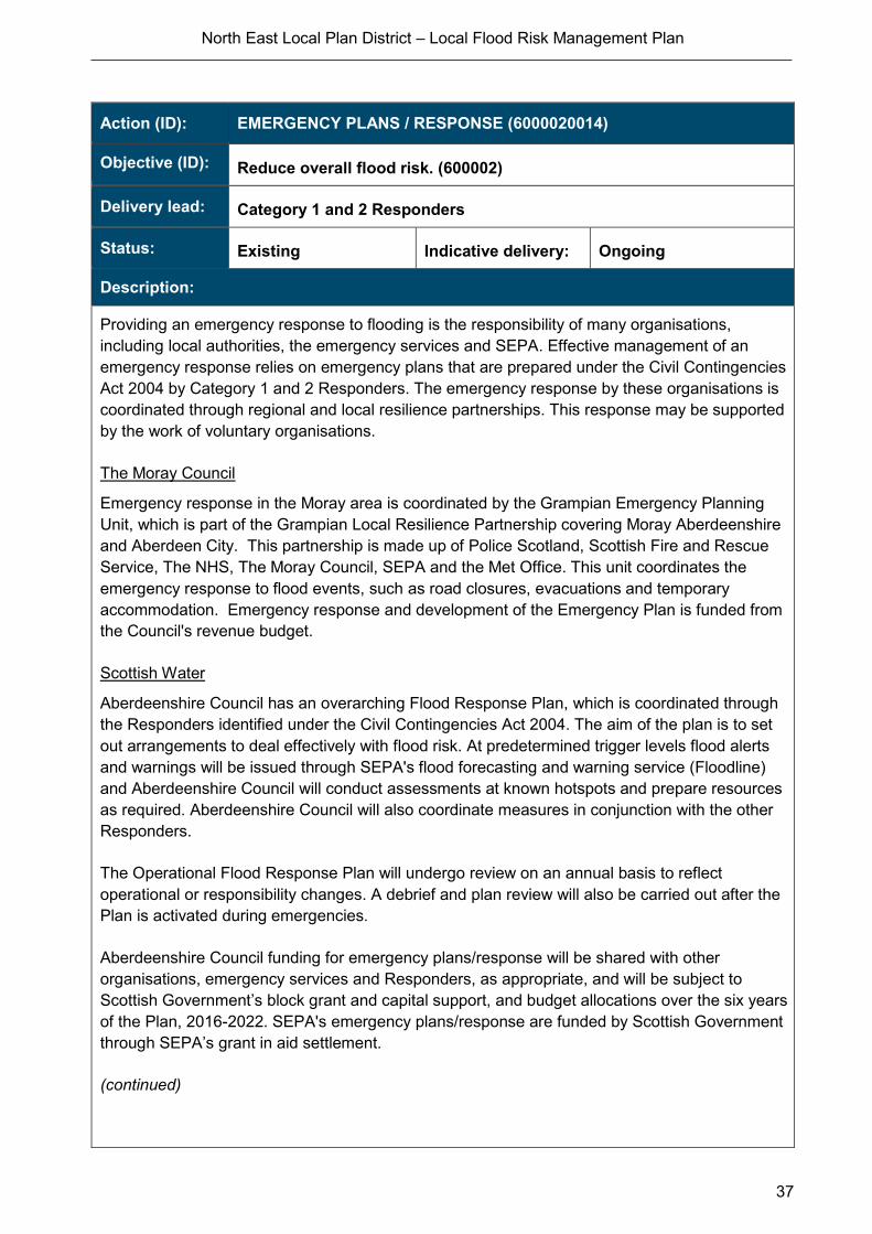
Action (ID): EMERGENCY PLANS / RESPONSE (6000020014)
Objective (ID): Reduce overall flood risk. (600002)
Delivery lead: Category 1 and 2 Responders
Status: Existing Indicative delivery: Ongoing
Description:
Providing an emergency response to flooding is the responsibility of many organisations,
including local authorities, the emergency services and SEPA. Effective management of an
emergency response relies on emergency plans that are prepared under the Civil Contingencies
Act 2004 by Category 1 and 2 Responders. The emergency response by these organisations is
coordinated through regional and local resilience partnerships. This response may be supported
by the work of voluntary organisations.
The Moray Council
Emergency response in the Moray area is coordinated by the Grampian Emergency Planning
Unit, which is part of the Grampian Local Resilience Partnership covering Moray Aberdeenshire
and Aberdeen City. This partnership is made up of Police Scotland, Scottish Fire and Rescue
Service, The NHS, The Moray Council, SEPA and the Met Office. This unit coordinates the
emergency response to flood events, such as road closures, evacuations and temporary
accommodation. Emergency response and development of the Emergency Plan is funded from
the Council's revenue budget.
Scottish Water
Aberdeenshire Council has an overarching Flood Response Plan, which is coordinated through
the Responders identified under the Civil Contingencies Act 2004. The aim of the plan is to set
out arrangements to deal effectively with flood risk. At predetermined trigger levels flood alerts
and warnings will be issued through SEPA's flood forecasting and warning service (Floodline)
and Aberdeenshire Council will conduct assessments at known hotspots and prepare resources
as required. Aberdeenshire Council will also coordinate measures in conjunction with the other
Responders.
The Operational Flood Response Plan will undergo review on an annual basis to reflect
operational or responsibility changes. A debrief and plan review will also be carried out after the
Plan is activated during emergencies.
Aberdeenshire Council funding for emergency plans/response will be shared with other
organisations, emergency services and Responders, as appropriate, and will be subject to
Scottish Government’s block grant and capital support, and budget allocations over the six years
of the Plan, 2016-2022. SEPA's emergency plans/response are funded by Scottish Government
through SEPA’s grant in aid settlement.
(continued)

North East Local Plan District – Local Flood Risk Management Plan
38
Aberdeen City Council
Aberdeen City Council will work with all CAT 1 and CAT 2 responders to deliver the emergency
response plan for Aberdeen City. All Cat 1 and Cat 2 responders are to work together for
decision making and to identify solutions at the time of emergency response and for emergency
planning.
Funding will be sourced through existing emergency response Budgets for the ACC elements of
this objective.
Action (ID): PLANNING POLICIES (6000010001)
Objective (ID): Avoid an overall increase in flood risk. (600001)
Delivery lead: Planning authority
Status: Existing Indicative delivery: Ongoing
Description:
Scottish Planning Policy and accompanying Planning Advice Notes set out Scottish Ministers’
priorities for the operation of the planning system and for the development and use of land. In
terms of flood risk management, the policy supports a catchment-scale approach to sustainable
flood risk management and aims to build the resilience of our cities and towns, encourage
sustainable land management in our rural areas, and to address the long-term vulnerability of
parts of our coasts and islands. Under this approach, new development in areas with medium to
high likelihood of flooding should be avoided.
For further information on the application of national planning policies see Annex 5.
The Moray Council
The Moray Council develops and adopts a revised Local Plan every five years. This plan sets
out the strategy for delivering appropriate development throughout Moray and takes into
consideration a number of potential constraints including flood risk. The Council’s Flood Risk
Management team provides advice regarding flood risk that informs this plan. The current plan
was adopted in 2015 and consultation on the new plan started in 2016.
Aberdeenshire Council
Aberdeenshire Council is a local planning authority and will work with the regional planning
authority, the Aberdeen City and Shire Strategic Development Planning Authority.
As a consultee on planning applications, Aberdeenshire Council’s Flood & Coast Protection team
will work directly with colleagues in the Planning Service to ensure that appropriate policies and
measures are put in place to reduce flood risk. Planning applications are assessed against the
flooding standards set out in the current Aberdeenshire Local Development Plan, and in future
those in the proposed Aberdeenshire Local Development Plan 2016.

North East Local Plan District – Local Flood Risk Management Plan
39
Aberdeen City Council
Aberdeen City Council (ACC) will be applying a catchment-scale approach to sustainable flood
risk management and aims to build the resilience of the city.
They will be working with all relevant bodies to coordinate the activities that are highlighted within
Planning Policy.
SEPA
SEPA has a statutory role in relation to the provision of flood risk advice to planning authorities.
This role is expressed in Section 72 of the FRM Act, 2009. SEPA also has a duty to cooperate
with planning authorities in the preparation of development plans. When consulted in relation to
planning applications for development or site allocations in development plans, and where the
planning authority considers there may be a risk of flooding, SEPA will provide advice. The
advice provided by SEPA will be with respect to the risk of flooding and on the basis of the
relevant information it holds which is suitable for planning purposes. It will also be in line with the
principles and duties set out in the FRM Act. Further information about how SEPA engages in
the planning system, including guidance on flood risk and planning is available on SEPA’s
website http://www.sepa.org.uk/environment/land/planning/
SEPA's land use planning activities will be coordinated with the activities of other responsible
authorities as required and are funded by Scottish Government through SEPA’s grant in aid
settlement.
Scottish Water
Scottish Water is a statutory consultee within the planning legislation and is required to comment
on all outline or full planning applications which are referred by a local authority.
Other areas
There will be other flood risk management actions being undertaken in the Local Plan
District outside of Potentially Vulnerable Areas.

North East Local Plan District – Local Flood Risk Management Plan
40
2.3 Flood risk, objectives & actions for the North East Potentially
Vulnerable Areas
The following section sets out the background, flooding impacts, history of flooding,
the objectives to manage flooding and the actions and planned delivery of these
actions to reduce flood risk in the North East PVAs

North East Local Plan District – Local Flood Risk Management Plan
Portgordon (Potentially Vulnerable Area 06/01)
41
2.3.1 Portgordon (Potentially Vulnerable Area 06/01)
Local Plan District local authority Main catchment
North East The Moray Council Banff coastal
Background
This Potentially Vulnerable Area is located on
the Moray Firth, covering approximately
13km2.
The area covers the coastline from Seatown,
Buckie to the outfall of the Burn of Tynet in
the west, together with the mainly rural areas
to the south.
The A98 and A990 pass through this
Potentially Vulnerable Area.
There are fewer than 10 residential and non-
residential properties at risk of flooding.
The Annual Average Damages are
approximately £8,500. The majority of these
are attributed to surface water flooding,
however it is recognised that wave
overtopping causes flooding to a number of
properties in Portgordon and Buckie.
Annual Average Damages by flood source
Reproduced from North East Flood Risk Management Strategy, SEPA (December 2015)
River 16%
Coastal <1%
Surfacewater 84%
North East Local Plan District – Local Flood Risk Management Plan
Portgordon (Potentially Vulnerable Area 06/01)
42
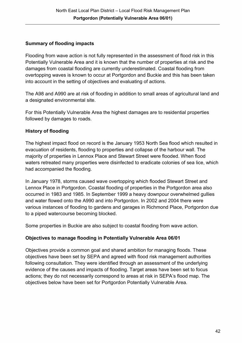
Summary of flooding impacts
Flooding from wave action is not fully represented in the assessment of flood risk in this
Potentially Vulnerable Area and it is known that the number of properties at risk and the
damages from coastal flooding are currently underestimated. Coastal flooding from
overtopping waves is known to occur at Portgordon and Buckie and this has been taken
into account in the setting of objectives and evaluating of actions.
The A98 and A990 are at risk of flooding in addition to small areas of agricultural land and
a designated environmental site.
For this Potentially Vulnerable Area the highest damages are to residential properties
followed by damages to roads.
History of flooding
The highest impact flood on record is the January 1953 North Sea flood which resulted in
evacuation of residents, flooding to properties and collapse of the harbour wall. The
majority of properties in Lennox Place and Stewart Street were flooded. When flood
waters retreated many properties were disinfected to eradicate colonies of sea lice, which
had accompanied the flooding.
In January 1978, storms caused wave overtopping which flooded Stewart Street and
Lennox Place in Portgordon. Coastal flooding of properties in the Portgordon area also
occurred in 1983 and 1985. In September 1999 a heavy downpour overwhelmed gullies
and water flowed onto the A990 and into Portgordon. In 2002 and 2004 there were
various instances of flooding to gardens and garages in Richmond Place, Portgordon due
to a piped watercourse becoming blocked.
Some properties in Buckie are also subject to coastal flooding from wave action.
Objectives to manage flooding in Potentially Vulnerable Area 06/01
Objectives provide a common goal and shared ambition for managing floods. These
objectives have been set by SEPA and agreed with flood risk management authorities
following consultation. They were identified through an assessment of the underlying
evidence of the causes and impacts of flooding. Target areas have been set to focus
actions; they do not necessarily correspond to areas at risk in SEPA’s flood map. The
objectives below have been set for Portgordon Potentially Vulnerable Area.

North East Local Plan District – Local Flood Risk Management Plan
Portgordon (Potentially Vulnerable Area 06/01)
43
Reduce risk in Portgordon from Coastal Flooding
Indicators: Target area:
80 People
£25,000 Annual Average
Damages from residential
properties
Objective ID: 600101
© Crown Copyright. All rights reserved. SEPA lic.no. 100016991 (2015)
Reproduced from North East Flood Risk Management Strategy, SEPA (December 2015)
Target area Objective ID Indicators within
PVA
Portgordon Reduce risk from surface water flooding in Portgordon and Buckie
600102 * See note below
Applies across North East Local Plan District
Avoid an overall increase in flood risk 600001 <10 residential properties
£8,500 Annual Average Damages
Applies across North East Local Plan District
Reduce overall flood risk 600002 <10 residential properties
£8,500 Annual Average Damages
Applies across North East Local Plan District
Organisations such as utility companies and Historic Environment Scotland actively maintain and manage their own assets, including the risk of flooding. These actions are not detailed further in the Flood Risk Management Strategies.
* This objective will be monitored using surface water flood risk across the Potentially Vulnerable Area. For 06/01 there are <10 residential properties at risk and Annual Average Damages of £8,500.
Reproduced from North East Flood Risk Management Strategy, SEPA (December 2015)
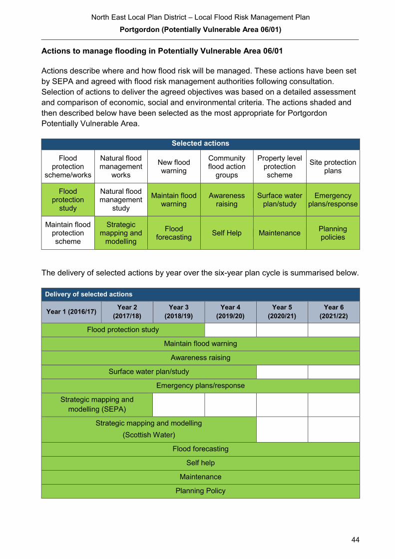
North East Local Plan District – Local Flood Risk Management Plan
Portgordon (Potentially Vulnerable Area 06/01)
44
Actions to manage flooding in Potentially Vulnerable Area 06/01
Actions describe where and how flood risk will be managed. These actions have been set
by SEPA and agreed with flood risk management authorities following consultation.
Selection of actions to deliver the agreed objectives was based on a detailed assessment
and comparison of economic, social and environmental criteria. The actions shaded and
then described below have been selected as the most appropriate for Portgordon
Potentially Vulnerable Area.
Selected actions
Flood protection
scheme/works
Natural flood management
works
New flood warning
Community flood action
groups
Property level protection scheme
Site protection plans
Flood protection
study
Natural flood management
study
Maintain flood warning
Awareness raising
Surface water plan/study
Emergency plans/response
Maintain flood protection scheme
Strategic mapping and
modelling
Flood forecasting
Self Help Maintenance Planning policies
The delivery of selected actions by year over the six-year plan cycle is summarised below.
Delivery of selected actions
Year 1 (2016/17) Year 2
(2017/18)
Year 3
(2018/19)
Year 4
(2019/20)
Year 5
(2020/21)
Year 6
(2021/22)
Flood protection study
Maintain flood warning
Awareness raising
Surface water plan/study
Emergency plans/response
Strategic mapping and
modelling (SEPA)
Strategic mapping and modelling
(Scottish Water)
Flood forecasting
Self help
Maintenance
Planning Policy
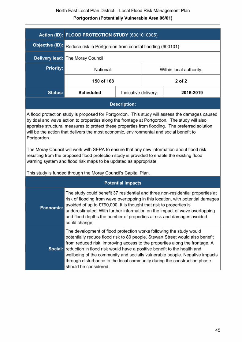
North East Local Plan District – Local Flood Risk Management Plan
Portgordon (Potentially Vulnerable Area 06/01)
45
Action (ID): FLOOD PROTECTION STUDY (6001010005)
Objective (ID): Reduce risk in Portgordon from coastal flooding (600101)
Delivery lead: The Moray Council
Priority: National: Within local authority:
150 of 168 2 of 2
Status: Scheduled Indicative delivery: 2016-2019
Description:
A flood protection study is proposed for Portgordon. This study will assess the damages caused
by tidal and wave action to properties along the frontage at Portgordon. The study will also
appraise structural measures to protect these properties from flooding. The preferred solution
will be the action that delivers the most economic, environmental and social benefit to
Portgordon.
The Moray Council will work with SEPA to ensure that any new information about flood risk
resulting from the proposed flood protection study is provided to enable the existing flood
warning system and flood risk maps to be updated as appropriate.
This study is funded through the Moray Council's Capital Plan.
Potential impacts
Economic:
The study could benefit 37 residential and three non-residential properties at
risk of flooding from wave overtopping in this location, with potential damages
avoided of up to £790,000. It is thought that risk to properties is
underestimated. With further information on the impact of wave overtopping
and flood depths the number of properties at risk and damages avoided
could change.
Social:
The development of flood protection works following the study would
potentially reduce flood risk to 80 people. Stewart Street would also benefit
from reduced risk, improving access to the properties along the frontage. A
reduction in flood risk would have a positive benefit to the health and
wellbeing of the community and socially vulnerable people. Negative impacts
through disturbance to the local community during the construction phase
should be considered.
North East Local Plan District – Local Flood Risk Management Plan
Portgordon (Potentially Vulnerable Area 06/01)
46
Environmental: Flood protection studies should consider the positive and negative impacts of
proposed actions on the ecological quality of the environment. Opportunities
to mitigate any environmental impacts may include design and timing of
works. The flood protection study should ensure the actions avoid or
minimise the potential loss of natural habitat, do not interfere with coastal
processes and ensure no negative effects to the Spey Bay Site of Special
Scientific Interest. To be in accord with the FRM Strategy, the responsible
authority should seek to ensure as part of the study that the action will not
have an adverse effect on the integrity of the Spey Bay Special Area of
Conservation.
Action (ID): MAINTAIN FLOOD WARNING (6000020030)
Objective (ID): Reduce overall flood risk (600002)
Delivery lead: SEPA
Status: Existing Indicative delivery: Ongoing
Description:
Continue to maintain the 'Portgordon to Cullen' flood warning area which is part of the Moray
Firth coastal flood warning scheme.
A flood protection study is proposed for Portgordon. SEPA will work with the local authority to
ensure that any new information about flood risk resulting from the proposed flood protection
study is considered in the existing flood warning system.
When flood events occur in an area with an existing flood warning service, SEPA will seek to
verify the flood forecasts and warnings. SEPA will use feedback and post-event data to ensure
that our flood warning service is timely and accurate.
The maintenance of SEPA’s flood warning service is funded by Scottish Government through
SEPA’s grant in aid settlement.

North East Local Plan District – Local Flood Risk Management Plan
Portgordon (Potentially Vulnerable Area 06/01)
47
Action (ID): AWARENESS RAISING (6000020013)
Objective (ID): Reduce overall flood risk (600002)
Delivery lead: Responsible authorities
Status: Existing Indicative delivery: Ongoing
Description:
The Moray Council will seek opportunities to raise awareness of flood risk and actions that
prepare individuals, homes and businesses as described in the Act. They will support community
resilience groups working with SEPA, responsible authorities, Crown Estates and the Scottish
Flood Forum. During the development of the flood protection study The Moray Council will hold
at least one event in Portgordon to consult residents on the proposed flood protection measures
identified and advise them on how the study is progressing.
Awareness raising will be funded from existing local authority flood revenue budgets.
From 2016 SEPA will engage with the community through local participation in national
initiatives, including partnership working with Neighbourhood Watch Scotland. In addition, SEPA
will engage with local authorities and community resilience groups where possible.
Across Scotland, SEPA will create and share communication and education resources with other
responsible authorities. These resources will include awareness campaigns, media and
marketing activity and promotion of SEPA's flood forecasting and warning services (Floodline).
Where they exist, SEPA will engage with community resilience groups and community safety
partnerships.
SEPA's awareness raising activities are funded by Scottish Government through SEPA’s grant in
aid settlement and will be coordinated with the activities of other responsible authorities as
required.
Scottish Water will support SEPA and responsible authorities with their awareness raising
activities as required and provide targeted flooding communications for Scottish Water specific
activities. Scottish Water will raise awareness by producing and supplying targeted information to
the public on large capital projects and detailed local studies.
More general information and flooding guidance will be available on the website at:
https://www.scottishwater.co.uk/you-and-your-home/your-home/flooding-information
Scottish Water will keep responsible authorities informed of its awareness raising activities
through the Local Plan District partnerships.
North East Local Plan District – Local Flood Risk Management Plan
Portgordon (Potentially Vulnerable Area 06/01)
48
Action (ID): SURFACE WATER PLAN/STUDY (6001020018)
Objective (ID): Reduce risk from surface water flooding in Portgordon and Buckie (600102)
Delivery lead: The Moray Council
Status: Scheduled Indicative delivery: 2016-2019
Description:
A Surface Water Management Plan for the Portgordon/Buckie area will be developed by the
Moray Council in partnership with Scottish Water and other responsible authorities as required
The development of this plan will be funded from the Council's FRM Revenue budget.
Scottish Water will work with The Moray Council and support surface water management
planning through ensuring that best available knowledge and data is used to input into the
Surface Water Management Plans
Action (ID): EMERGENCY PLANS/RESPONSE (6000020014)
Objective (ID): Reduce overall flood risk (600002)
Delivery lead: Category 1 and 2 Responders
Status: Existing Indicative delivery: Ongoing
Description:
Providing an emergency response to flooding is the responsibility of many organisations,
including local authorities, the emergency services and SEPA. Effective management of an
emergency response relies on emergency plans that are prepared under the Civil Contingencies
Act 2004 by Category 1 and 2 Responders. The emergency response by these organisations is
coordinated through regional and local resilience partnerships. This response may be supported
by the work of voluntary organisations.
Emergency response in the Moray area is coordinated by the Grampian Emergency Planning
Unit, which is part of the Grampian Local Resilience Partnership covering Moray Aberdeenshire
and Aberdeen City. This partnership is made up of Police Scotland, Scottish Fire and Rescue
Service, The NHS, The Moray Council, SEPA and the Met Office. This unit coordinates the
emergency response to flood events, such as road closures, evacuations and temporary
accommodation.
Emergency response and development of the Emergency Plan is funded from the Council's
revenue budget.
North East Local Plan District – Local Flood Risk Management Plan
Portgordon (Potentially Vulnerable Area 06/01)
49
Action (ID): STRATEGIC MAPPING AND MODELLING (6001010016)
Objective (ID): Reduce risk in Portgordon from coastal flooding (600101)
Delivery lead: SEPA
Status: Scheduled Indicative delivery: 2017-2018
Description:
SEPA will be seeking to develop the flood hazard mapping in the Banff to Lossiemouth area to
improve understanding of the coastal flood risk. The extent and timing of the completed
improvements will be dependent on detailed scoping and data availability. A flood protection
study is proposed for Portgordon. SEPA will work with The Moray Council to ensure that new
information about flood risk resulting from the proposed flood protection study is considered in
SEPA's strategic mapping and modelling developments where appropriate and relevant.
SEPA's strategic mapping and modelling activities are funded by Scottish Government through
SEPA’s grant in aid settlement.
Action (ID): STRATEGIC MAPPING AND MODELLING (6000020019)
Objective (ID): Reduce overall flood risk (600002)
Delivery lead: Scottish Water
Status: Scheduled Indicative delivery: 2016-2019
Description:
Scottish Water will undertake further investigation and modelling in the Buckie sewer catchment
to improve knowledge and understanding of flood risk in this area as required under Section 16
of the Flood Risk Management (Scotland) Act 2009.
Scottish Water will work with responsible authorities to incorporate relevant information into these
studies by regularly keeping the responsible authorities informed of their progress. Scottish
Water will provide responsible authorities with the outputs of the Section 16 assessment which,
where relevant, may be used to inform Surface Water Management Plans and SEPA flood
hazard and risk maps.
Scottish Water funding is committed in its capital programme through Q&S 4a (2015-2021) which
is approved by its regulators and customers.

North East Local Plan District – Local Flood Risk Management Plan
Portgordon (Potentially Vulnerable Area 06/01)
50
Action (ID): FLOOD FORECASTING (6000020009)
Objective (ID): Reduce overall flood risk (600002)
Delivery lead: SEPA
Status: Existing Indicative delivery: Ongoing
Description:
The Scottish Flood Forecasting Service is a joint initiative between SEPA and the Met Office that
produces daily, national flood guidance statements which are issued to Category 1 and 2
Responders. The flood guidance statements provide an assessment of the risk of flooding for a
five-day period allowing responders time to put preparations in place to reduce the impact of
flooding. The service also provides information which allows SEPA to issue flood warnings,
giving people a better chance of reducing the impact of flooding on their home or business. For
more information, please visit SEPA’s website. The Potentially Vulnerable Area is within the
'Aberdeenshire and Aberdeen City' flood alert area.
Hydrological information is provided by SEPA and meteorological information is provided by the
Met Office. SEPA uses the information to predict the likelihood and timing of river, coastal and
surface water flooding.
SEPA’s flood forecasting service is funded through Scottish Government’s grant in aid allocation.
The Met Office receives funding from the UK Government.
Action (ID): SELF HELP (6000020011)
Objective (ID): Reduce overall flood risk (600002)
Delivery lead: —
Status: Existing Indicative delivery: Ongoing
Description:
Everyone is responsible for protecting themselves and their property from flooding. Property and
business owners can take simple steps to reduce damage and disruption to their homes and
businesses should flooding happen. This includes preparing a flood plan and flood kit, installing
property level protection, signing up to Floodline and Resilient Communities initiatives, and
ensuring that properties and businesses are insured against flood damage.
The Moray Council provides advice to members of the public regarding flood risk and resilience.
The Council also holds information events from time to time in collaboration with Scottish Water,
SEPA and the Scottish Flood Forum.
Events hosted by the Council are funded from the FRM Revenue budget.
North East Local Plan District – Local Flood Risk Management Plan
Portgordon (Potentially Vulnerable Area 06/01)
51
Action (ID): MAINTENANCE (6000020007)
Objective (ID): Reduce overall flood risk (600002)
Delivery lead: The Moray Council, asset / land managers
Status: Existing Indicative delivery: Ongoing
Description:
Local authorities have a duty to assess watercourses and carry out clearance and repair works
where such works would substantially reduce flood risk. They produce schedules of clearance
and repair works and make these available for public inspection.
The Moray Council has a schedule of clearance and repair, which identifies routine maintenance
and repairs to address areas known to be at risk. It may include small improvement works. This
schedule is reviewed and updated regularly. This review is based on inspections and information
provided by the public and other organisations.
Works identified in the Council's clearance and repair schedule are funded from the FRM
Revenue budget.
Scottish Water undertake risk based inspection, maintenance and repair on the public sewer
network together with keeping responsible authorities informed of large scale capital
maintenance work to identify opportunities for coordination.
Asset owners and riparian landowners are responsible for the maintenance and management of
their own assets including those which help to reduce flood risk.
North East Local Plan District – Local Flood Risk Management Plan
Portgordon (Potentially Vulnerable Area 06/01)
52
Action (ID): PLANNING POLICIES (6000010001)
Objective (ID): Avoid an overall increase in flood risk (600001)
Reduce overall flood risk (600002)
Delivery lead: Planning authority
Status: Existing Indicative delivery: Ongoing
Description:
Scottish Planning Policy and accompanying Planning Advice Notes set out Scottish Ministers’
priorities for the operation of the planning system and for the development and use of land. In
terms of flood risk management, the policy supports a catchment-scale approach to sustainable
flood risk management and aims to build the resilience of our cities and towns, encourage
sustainable land management in our rural areas, and to address the long-term vulnerability of
parts of our coasts and islands. Under this approach, new development in areas with medium to
high likelihood of flooding should be avoided.
For further information on the application of national planning policies see Annex 5.
The Moray Council develops and adopts a revised Local Plan every five years. This plan sets
out the strategy for delivering appropriate development throughout Moray and takes into
consideration a number of potential constraints including flood risk. The Council’s Flood Risk
Management team provides advice regarding flood risk that informs this plan. The current plan
was adopted in 2015 and consultation on the new plan started in 2016.
SEPA has a statutory role in relation to the provision of flood risk advice to planning authorities.
This role is expressed in Section 72 of the FRM Act, 2009. SEPA also has a duty to cooperate
with planning authorities in the preparation of development plans. When consulted in relation to
planning applications for development or site allocations in development plans, and where the
planning authority considers there may be a risk of flooding, SEPA will provide advice. The
advice provided by SEPA will be with respect to the risk of flooding and on the basis of the
relevant information it holds which is suitable for planning purposes. It will also be in line with the
principles and duties set out in the FRM Act. Further information about how SEPA engages in
the planning system, including guidance on flood risk and planning is available on SEPA’s
website http://www.sepa.org.uk/environment/land/planning/
SEPA's land use planning activities will be coordinated with the activities of other responsible
authorities as required and are funded by Scottish Government through SEPA’s grant in aid
settlement.
Scottish Water is a statutory consultee within the planning legislation and is required to comment
on all outline or full planning applications which are referred by a local authority.
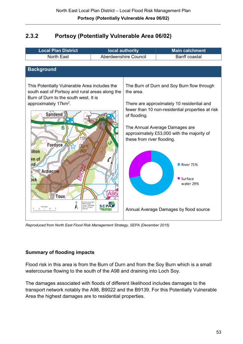
North East Local Plan District – Local Flood Risk Management Plan
Portsoy (Potentially Vulnerable Area 06/02)
53
2.3.2 Portsoy (Potentially Vulnerable Area 06/02)
Local Plan District local authority Main catchment
North East Aberdeenshire Council Banff coastal
Background
This Potentially Vulnerable Area includes the
south east of Portsoy and rural areas along the
Burn of Durn to the south west. It is
approximately 17km2.
The Burn of Durn and Soy Burn flow through
the area.
There are approximately 10 residential and
fewer than 10 non-residential properties at risk
of flooding.
The Annual Average Damages are
approximately £53,000 with the majority of
these from river flooding.
Annual Average Damages by flood source
Reproduced from North East Flood Risk Management Strategy, SEPA (December 2015)
Summary of flooding impacts
Flood risk in this area is from the Burn of Durn and from the Soy Burn which is a small
watercourse flowing to the south of the A98 and draining into Loch Soy.
The damages associated with floods of different likelihood includes damages to the
transport network notably the A98, B9022 and the B9139. For this Potentially Vulnerable
Area the highest damages are to residential properties.
River 71%
Surfacewater 29%

North East Local Plan District – Local Flood Risk Management Plan
Portsoy (Potentially Vulnerable Area 06/02)
54
History of flooding
The Soy Burn and Loch Soy are known sources of flood risk with a number of properties
having been repeatedly flooded. For example, the Soy Burn caused flooding of properties
in Soy Avenue, Portsoy in 2001, 2008, and 2009.
Just outside of this Potentially Vulnerable Area, there are issues with coastal erosion and
flooding around the mouth of the Burn of Durn. A graveyard is affected by erosion and in
the past, a landslip near the mouth of the Burn of Durn caused a blockage in the burn,
resulting in the flooding of a listed building.
Objectives to manage flooding in Potentially Vulnerable Area 06/02
Objectives provide a common goal and shared ambition for managing floods. These
objectives have been set by SEPA and agreed with flood risk management authorities
following consultation. They were identified through an assessment of the underlying
evidence of the causes and impacts of flooding. Target areas have been set to focus
actions; they do not necessarily correspond to areas at risk in SEPA’s flood map. The
objectives below have been set for Portsoy Potentially Vulnerable Area.
Reduce flood risk in the vicinity of Loch Soy and Soy Avenue from the Soy Burn
Indicators: Target area:
20 people
£4,700 Annual Average
Damages from residential
properties
Objective ID: 600201
© Crown Copyright. All rights reserved. SEPA lic.no. 100016991 (2015)
Reproduced from North East Flood Risk Management Strategy, SEPA (December 2015)
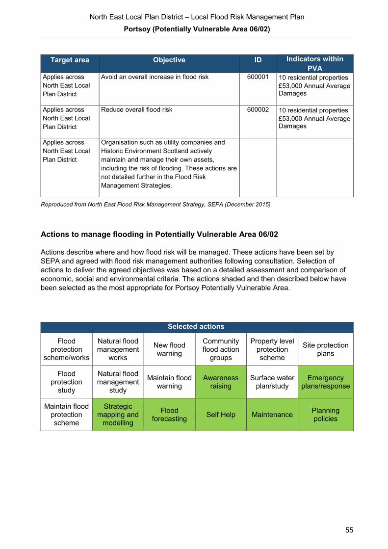
North East Local Plan District – Local Flood Risk Management Plan
Portsoy (Potentially Vulnerable Area 06/02)
55
Target area Objective ID Indicators within
PVA Applies across
North East Local
Plan District
Avoid an overall increase in flood risk 600001 10 residential properties
£53,000 Annual Average Damages
Applies across
North East Local
Plan District
Reduce overall flood risk 600002 10 residential properties
£53,000 Annual Average Damages
Applies across
North East Local
Plan District
Organisation such as utility companies and
Historic Environment Scotland actively
maintain and manage their own assets,
including the risk of flooding. These actions are
not detailed further in the Flood Risk
Management Strategies.
Reproduced from North East Flood Risk Management Strategy, SEPA (December 2015)
Actions to manage flooding in Potentially Vulnerable Area 06/02
Actions describe where and how flood risk will be managed. These actions have been set by
SEPA and agreed with flood risk management authorities following consultation. Selection of
actions to deliver the agreed objectives was based on a detailed assessment and comparison of
economic, social and environmental criteria. The actions shaded and then described below have
been selected as the most appropriate for Portsoy Potentially Vulnerable Area.
Selected actions
Flood protection
scheme/works
Natural flood management
works
New flood warning
Community flood action
groups
Property level protection scheme
Site protection plans
Flood protection
study
Natural flood management
study
Maintain flood warning
Awareness raising
Surface water plan/study
Emergency plans/response
Maintain flood protection scheme
Strategic mapping and
modelling
Flood forecasting
Self Help Maintenance Planning policies
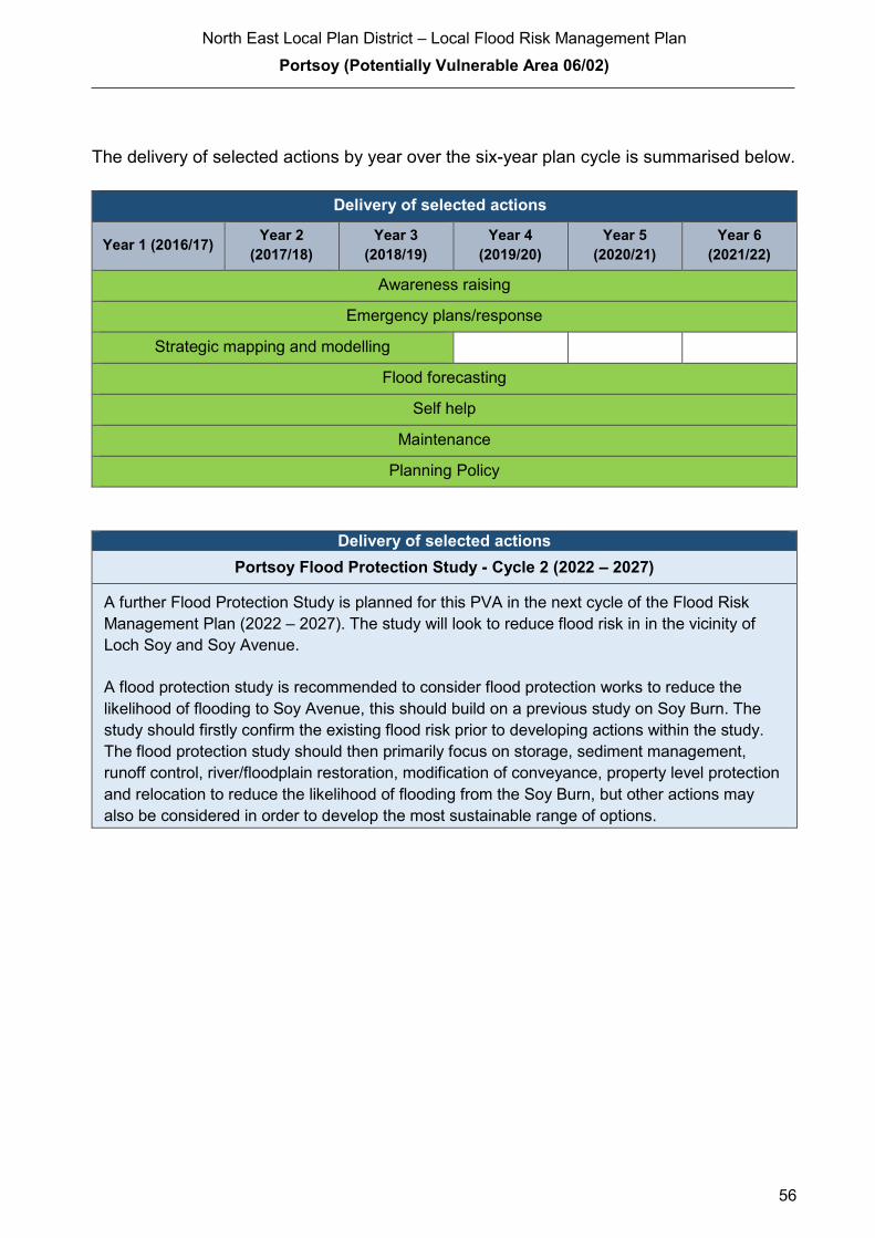
North East Local Plan District – Local Flood Risk Management Plan
Portsoy (Potentially Vulnerable Area 06/02)
56
The delivery of selected actions by year over the six-year plan cycle is summarised below.
Delivery of selected actions
Year 1 (2016/17) Year 2
(2017/18)
Year 3
(2018/19)
Year 4
(2019/20)
Year 5
(2020/21)
Year 6
(2021/22)
Awareness raising
Emergency plans/response
Strategic mapping and modelling
Flood forecasting
Self help
Maintenance
Planning Policy
Delivery of selected actions
Portsoy Flood Protection Study - Cycle 2 (2022 – 2027)
A further Flood Protection Study is planned for this PVA in the next cycle of the Flood Risk
Management Plan (2022 – 2027). The study will look to reduce flood risk in in the vicinity of
Loch Soy and Soy Avenue.
A flood protection study is recommended to consider flood protection works to reduce the
likelihood of flooding to Soy Avenue, this should build on a previous study on Soy Burn. The
study should firstly confirm the existing flood risk prior to developing actions within the study.
The flood protection study should then primarily focus on storage, sediment management,
runoff control, river/floodplain restoration, modification of conveyance, property level protection
and relocation to reduce the likelihood of flooding from the Soy Burn, but other actions may
also be considered in order to develop the most sustainable range of options.

North East Local Plan District – Local Flood Risk Management Plan
Portsoy (Potentially Vulnerable Area 06/02)
57
Action (ID): AWARENESS RAISING (6000020013)
Objective (ID): Reduce overall flood risk (600002)
Delivery lead: Responsible authorities
Status: Existing Indicative delivery: Ongoing
Description:
Aberdeenshire Council have a duty to raise public awareness of flood risk under the Flood Risk
Management (Scotland) Act 2009 and to plan and inform of risks to communities under the Civil
Contingencies Act 2004.
Over the six years of the Plan, 2016-2022, Aberdeenshire Council will seek opportunities to raise
awareness of both flood risk and actions that enable individuals, homes and businesses to
reduce the overall impact of flooding.
In partnership with Education Scotland Aberdeenshire Council will look to engage schools in
activities relating to flooding, extreme weather, climate change and other community resilience
issues. Aberdeenshire Council will also develop emergency response plans and work with
community flood action groups where these exist.
Awareness raising will be funded from existing local authority flood revenue budgets.
From 2016 SEPA will engage with the community through local participation in national
initiatives, including partnership working with Neighbourhood Watch Scotland. In addition, SEPA
will engage with local authorities and community resilience groups where possible.
Across Scotland, SEPA will create and share communication and education resources with other
responsible authorities. These resources will include awareness campaigns, media and
marketing activities and promotion of SEPA's flood forecasting and warning service (Floodline).
Where they exist, SEPA will engage with community resilience groups and community safety
partnerships. Additionally, SEPA's awareness raising activities will be coordinated with the
activities of other responsible authorities as required.
SEPA's awareness raising activities are funded by Scottish Government through their grant in aid
settlement and will be coordinated with the activities of other responsible authorities as required.
Scottish Water will support SEPA and responsible authorities with their awareness raising
activities as required and provide targeted flooding communications for Scottish Water specific
activities. Scottish Water will raise awareness by producing and supplying targeted information to
the public on large capital projects and detailed local studies.
(continued)
North East Local Plan District – Local Flood Risk Management Plan
Portsoy (Potentially Vulnerable Area 06/02)
58
Action (ID): EMERGENCY PLANS/RESPONSE (6000020014)
Objective (ID): Reduce overall flood risk (600002)
Delivery lead: Category 1 and 2 Responders
Status: Existing Indicative delivery: Ongoing
Description:
Providing an emergency response to flooding is the responsibility of many organisations,
including local authorities, the emergency services and SEPA. Effective management of an
emergency response relies on emergency plans that are prepared under the Civil Contingencies
Act 2004 by Category 1 and 2 Responders.
There is a level gauge and camera at the upstream end of Soy Burn culvert to provide an early
warning of high water levels for properties on Soy Avenue.
Aberdeenshire Council has an overarching Flood Response Plan, which is coordinated through
the Responders identified under the Civil Contingencies Act 2004. The aim of the plan is to set
out arrangements to deal effectively with flood risk. At predetermined trigger levels flood alerts
and warnings will be issued through SEPA's flood forecasting and warning service (Floodline)
and Aberdeenshire Council will conduct assessments at known hotspots and prepare resources
as required. Aberdeenshire Council will also coordinate measures in conjunction with the other
Responders. The emergency response process is coordinated through regional and local
resilience partnerships. This response may be supported by the work of voluntary organisations.
The Operational Flood Response Plan will undergo review on an annual basis to reflect
operational or responsibility changes. A debrief and plan review will also be carried out after the
Plan is activated during emergencies.
Aberdeenshire Council funding for emergency plans/response will be shared with other
organisations, emergency services and Responders, as appropriate, and will be subject to
Scottish Government’s block grant and capital support, and budget allocations over the six years
of the Plan, 2016-2022. SEPA's emergency plans/response are funded by Scottish Government
through SEPA’s grant in aid settlement.
More general information and flooding guidance will be available on the website at:
https://www.scottishwater.co.uk/you-and-your-home/your-home/flooding-information
Scottish Water will keep responsible authorities informed of its awareness raising activities
through the Local Plan District partnerships.
North East Local Plan District – Local Flood Risk Management Plan
Portsoy (Potentially Vulnerable Area 06/02)
59
Action (ID): STRATEGIC MAPPING AND MODELLING (6000020019)
Objective (ID): Reduce overall flood risk (600002)
Delivery lead: Scottish Water
Status: Scheduled Indicative delivery: 2016-2019
Description:
Scottish Water will undertake further investigation and modelling in the Portsoy sewer catchment
to improve knowledge and understanding of flood risk in this area as required under Section 16
of the Flood Risk Management (Scotland) Act 2009.
Scottish Water will work with responsible authorities to incorporate relevant information into these
studies by regularly keeping the responsible authorities informed of their progress. Scottish
Water will provide responsible authorities with the outputs of the Section 16 assessment which,
where relevant, may be used to inform Surface Water Management Plans and SEPA flood
hazard and risk maps.
Scottish Water funding is committed in its capital programme through Q&S 4a (2015-2021) which
is approved by its regulators and customers.
North East Local Plan District – Local Flood Risk Management Plan
Portsoy (Potentially Vulnerable Area 06/02)
60
Action (ID): FLOOD FORECASTING (6000020009)
Objective (ID): Reduce overall flood risk (600002)
Delivery lead: SEPA
Status: Existing Indicative delivery: Ongoing
Description:
The Scottish Flood Forecasting Service is a joint initiative between SEPA and the Met Office that
produces daily, national flood guidance statements which are issued to Category 1 and 2
Responders. The flood guidance statements provide an assessment of the risk of flooding for a
five-day period allowing responders time to put preparations in place to reduce the impact of
flooding. The service also provides information which allows SEPA to issue flood warnings,
giving people a better chance of reducing the impact of flooding on their home or business. For
more information, please visit SEPA’s website. The Potentially Vulnerable Area is within the
'Aberdeenshire and Aberdeen City' flood alert area.
Hydrological information is provided by SEPA and meteorological information is provided by the
Met Office. SEPA uses the information to predict the likelihood and timing of river, coastal and
surface water flooding.
SEPA’s flood forecasting service is funded through Scottish Government’s grant in aid allocation.
The Met Office receives funding from the UK Government.
Action (ID): SELF HELP (6000020011)
Objective (ID): Reduce overall flood risk (600002)
Delivery lead: —
Status: Existing Indicative delivery: Ongoing
Description:
Everyone is responsible for protecting themselves and their property flooding. Property and
business owners can take simple steps to reduce damage and disruption to their homes and
businesses should flooding happen. This includes preparing a flood plan and flood kit, installing
property level protection, signing up to Floodline and Resilient Communities initiatives, and
ensuring that properties and businesses are insured against flood damage.
Aberdeenshire Council currently provide a small range of flood protection products for individual
property protection, which are available for all types of flooding, at cost price with free delivery
across Aberdeenshire.

North East Local Plan District – Local Flood Risk Management Plan
Portsoy (Potentially Vulnerable Area 06/02)
61
Action (ID): MAINTENANCE (6000020007)
Objective (ID): Reduce overall flood risk (600002)
Delivery lead: Aberdeenshire Council
Status: Existing Indicative delivery: Ongoing
Description:
Local authorities have a duty to assess watercourses and carry out clearance and repair works
where such works would substantially reduce flood risk. Aberdeenshire Council will produce
schedules of clearance and repair works and make these available for public inspection.
Maintenance will be funded from existing Flood revenue budgets, for works which are defined to
pose a significant flood risk.
Scottish Water undertake risk based inspection, maintenance and repair on the public sewer
network together with keeping responsible authorities informed of large scale capital
maintenance work to identify opportunities for co-ordination.

North East Local Plan District – Local Flood Risk Management Plan
Portsoy (Potentially Vulnerable Area 06/02)
62
Action (ID): PLANNING POLICIES (6000010001)
Objective (ID): Avoid an overall increase in flood risk (600001)
Delivery lead: Planning authority
Status: Existing Indicative delivery: Ongoing
Description:
Scottish Planning Policy and accompanying Planning Advice Notes set out Scottish Ministers’
priorities for the operation of the planning system and for the development and use of land. In
terms of flood risk management, the policy supports a catchment-scale approach to sustainable
flood risk management and aims to build the resilience of our cities and towns, encourage
sustainable land management in our rural areas, and to address the long-term vulnerability of
parts of our coasts and islands. Under this approach, new development in areas with medium to
high likelihood of flooding should be avoided.
For further information on the application of national planning policies see Annex 5.
Aberdeenshire Council is a local planning authority and will work with the regional planning
authority, the Aberdeen City and Shire Strategic Development Planning Authority.
As a consultee on planning applications, Aberdeenshire Council’s Flood & Coast Protection team
will work directly with colleagues in the Planning Service to ensure that appropriate policies and
measures are put in place to reduce flood risk. Planning applications are assessed against the
flooding standards set out in the current Aberdeenshire Local Development Plan, and in future
those in the proposed Aberdeenshire Local Development Plan 2016.
SEPA has a statutory role in relation to the provision of flood risk advice to planning authorities.
This role is expressed in Section 72 of the FRM Act, 2009. SEPA also has a duty to cooperate
with planning authorities in the preparation of development plans. When consulted in relation to
planning applications for development or site allocations in development plans, and where the
planning authority considers there may be a risk of flooding, SEPA will provide advice. The
advice provided by SEPA will be with respect to the risk of flooding and on the basis of the
relevant information it holds which is suitable for planning purposes. It will also be in line with the
principles and duties set out in the FRM Act. Further information about how SEPA engages in
the planning system, including guidance on flood risk and planning is available on SEPA’s
website http://www.sepa.org.uk/environment/land/planning/
SEPA's land use planning activities will be coordinated with the activities of other responsible
authorities as required and are funded by Scottish Government through SEPA’s grant in aid
settlement.
Scottish Water is a statutory consultee within the planning legislation and is required to comment
on all outline or full planning applications which are referred by a local authority.
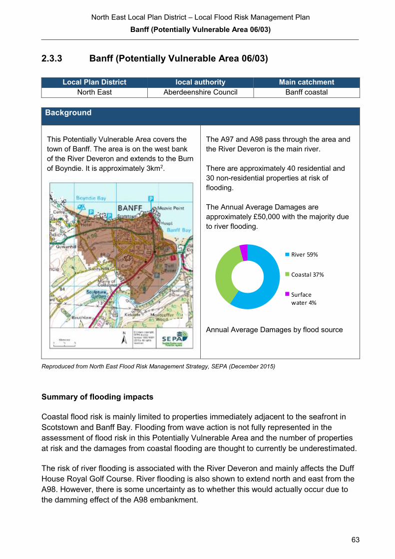
North East Local Plan District – Local Flood Risk Management Plan
Banff (Potentially Vulnerable Area 06/03)
63
2.3.3 Banff (Potentially Vulnerable Area 06/03)
Local Plan District local authority Main catchment
North East Aberdeenshire Council Banff coastal
Background
This Potentially Vulnerable Area covers the
town of Banff. The area is on the west bank
of the River Deveron and extends to the Burn
of Boyndie. It is approximately 3km2.
The A97 and A98 pass through the area and
the River Deveron is the main river.
There are approximately 40 residential and
30 non-residential properties at risk of
flooding.
The Annual Average Damages are
approximately £50,000 with the majority due
to river flooding.
Annual Average Damages by flood source
Reproduced from North East Flood Risk Management Strategy, SEPA (December 2015)
Summary of flooding impacts
Coastal flood risk is mainly limited to properties immediately adjacent to the seafront in
Scotstown and Banff Bay. Flooding from wave action is not fully represented in the
assessment of flood risk in this Potentially Vulnerable Area and the number of properties
at risk and the damages from coastal flooding are thought to currently be underestimated.
The risk of river flooding is associated with the River Deveron and mainly affects the Duff
House Royal Golf Course. River flooding is also shown to extend north and east from the
A98. However, there is some uncertainty as to whether this would actually occur due to
the damming effect of the A98 embankment.
River 59%
Coastal 37%
Surfacewater 4%

North East Local Plan District – Local Flood Risk Management Plan
Banff (Potentially Vulnerable Area 06/03)
64
Five designated cultural heritage sites and a small area of designated environmental sites
are at risk of flooding within this area. This includes the Whitehills to Melrose Coast Site of
Special Scientific Interest.
For this Potentially Vulnerable Area the highest damages are to residential properties
followed by damages to non-residential properties.
History of flooding
There is a long history of flooding in Banff from the River Deveron. The earliest recorded
flood was in 1768 when the Deveron flooded and destroyed an important bridge. The
Deveron has also flooded at Banff in 1835, 1855, 1859, 1873, 1875 and 1882 affecting
property, farmland and the railway line. The golf course was badly flooded in 2009
however the flooding did not extend to Duff House or the town.
The most damaging flood on record is the 1953 North Sea flood. A gasworks was washed
into the sea, buildings and their protective wall were destroyed and many properties
inundated with floodwater. In December 2013 there was localised coastal flooding of five
properties and significant wave damage in the inner part of Banff Bay. Coastal flooding
from overtopping waves is also known to impact on some local access roads including the
road to the community centre.
Surface water flooding affected Low Street, Banff in August 2006.
Objectives to manage flooding in Potentially Vulnerable Area 06/03
Objectives provide a common goal and shared ambition for managing floods. These
objectives have been set by SEPA and agreed with flood risk management authorities
following consultation. They were identified through an assessment of the underlying
evidence of the causes and impacts of flooding. Target areas have been set to focus
actions; they do not necessarily correspond to areas at risk in SEPA’s flood map. The
objectives below have been set for Banff Potentially Vulnerable Area.
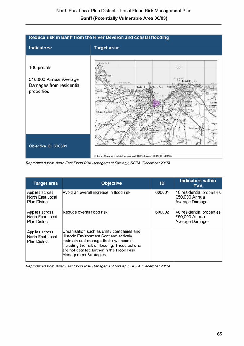
North East Local Plan District – Local Flood Risk Management Plan
Banff (Potentially Vulnerable Area 06/03)
65
Reduce risk in Banff from the River Deveron and coastal flooding
Indicators: Target area:
100 people
£18,000 Annual Average
Damages from residential
properties
Objective ID: 600301
© Crown Copyright. All rights reserved. SEPA lic.no. 100016991 (2015)
Reproduced from North East Flood Risk Management Strategy, SEPA (December 2015)
Target area Objective ID Indicators within
PVA
Applies across North East Local Plan District
Avoid an overall increase in flood risk 600001 40 residential properties £50,000 Annual
Average Damages
Applies across North East Local Plan District
Reduce overall flood risk 600002 40 residential properties £50,000 Annual
Average Damages
Applies across North East Local Plan District
Organisation such as utility companies and Historic Environment Scotland actively maintain and manage their own assets, including the risk of flooding. These actions are not detailed further in the Flood Risk Management Strategies.
Reproduced from North East Flood Risk Management Strategy, SEPA (December 2015)

North East Local Plan District – Local Flood Risk Management Plan
Banff (Potentially Vulnerable Area 06/03)
66
Actions to manage flooding in Potentially Vulnerable Area 06/03
Actions describe where and how flood risk will be managed. These actions have been set
by SEPA and agreed with flood risk management authorities following consultation.
Selection of actions to deliver the agreed objectives was based on a detailed assessment
and comparison of economic, social and environmental criteria. The actions shaded and
then described below have been selected as the most appropriate for Banff Potentially
Vulnerable Area.
Selected actions
Flood protection
scheme/works
Natural flood management
works
New flood warning
Community flood action
groups
Property level protection scheme
Site protection plans
Flood protection
study
Natural flood management
study
Maintain flood warning
Awareness raising
Surface water plan/study
Emergency plans/response
Maintain flood protection scheme
Strategic mapping and
modelling
Flood forecasting
Self Help Maintenance Planning policies
The delivery of selected actions by year over the six-year plan cycle is summarised below.
Delivery of selected actions
Year 1
(2016/17)
Year 2
(2017/18)
Year 3
(2018/19)
Year 4
(2019/20)
Year 5
(2020/21)
Year 6
(2021/22)
Maintain flood warning
Awareness raising
Emergency plans/response
Strategic mapping and modelling (SEPA)
Strategic mapping and modelling
(Scottish Water)
Flood forecasting
Self help
Maintenance
Planning Policy

North East Local Plan District – Local Flood Risk Management Plan
Banff (Potentially Vulnerable Area 06/03)
67
Delivery of selected actions
Banff Flood Protection Study - Cycle 2 (2022 – 2027)
A further Flood Protection Study is planned for this PVA in the next cycle of the Flood Risk
Management Plan (2022 – 2027). The study will look to reduce flood risk in Banff from the
River Deveron and coastal flooding.
A flood protection study is recommended to consider flood protection works to reduce the
likelihood of flooding to Banff from coastal flooding. The flood protection study should primarily
focus on coastal management actions, direct defences, relocation and property level
protection, but other actions may also be considered in order to develop the most sustainable
range of options. The study should assess the impact from wave overtopping to confirm the
existing risk and define the height and extent of flood protection works required
North East Local Plan District – Local Flood Risk Management Plan
Banff (Potentially Vulnerable Area 06/03)
68
Action (ID): MAINTAIN FLOOD WARNING (6000020030)
Objective (ID): Reduce overall flood risk (600002)
Delivery lead: SEPA
Status: Existing Indicative delivery: Ongoing
Description:
SEPA will continue to maintain both the 'Banff' flood warning area which is part of the Deveron
river flood warning scheme and the Portsoy to Macduff' flood warning area which is part of the
Moray Firth coastal flood warning scheme. When flood events occur in an area with an existing
flood warning service, SEPA will seek to verify the flood forecasts and warnings. SEPA will use
feedback and post-event data to ensure that our flood warning service is timely and accurate.
The maintenance of SEPA’s flood warning service is funded by Scottish Government through
SEPA’s grant in aid settlement.
Action (ID): AWARENESS RAISING (6000020013)
Objective (ID): Reduce overall flood risk (600002)
Delivery lead: Responsible authorities
Status: Existing Indicative delivery: Ongoing
Description:
Aberdeenshire Council have a duty to raise public awareness of flood risk under the Flood Risk
Management (Scotland) Act 2009 and to plan and inform of risks to communities under the Civil
Contingencies Act 2004.
Over the six years of the Plan, 2016-2022, Aberdeenshire Council will seek opportunities to raise
awareness of both flood risk and actions that enable individuals, homes and businesses to
reduce the overall impact of flooding.
In partnership with Education Scotland Aberdeenshire Council will look to engage schools in
activities relating to flooding, extreme weather, climate change and other community resilience
issues.
Aberdeenshire Council will also develop emergency response plans and work with community
flood action groups where these exist.
(continued)
North East Local Plan District – Local Flood Risk Management Plan
Banff (Potentially Vulnerable Area 06/03)
69
Awareness raising will be funded from existing local authority flood revenue budgets.
From 2016 SEPA will engage with the community through local participation in national
initiatives, including partnership working with Neighbourhood Watch Scotland. In addition, SEPA
will engage with local authorities and community resilience groups where possible.
Across Scotland, SEPA will create and share communication and education resources with other
responsible authorities. These resources will include awareness campaigns, media and
marketing activities and promotion of SEPA's flood forecasting and warning service (Floodline).
Where they exist, SEPA will engage with community resilience groups and community safety
partnerships. Additionally, SEPA's awareness raising activities will be coordinated with the
activities of other responsible authorities as required.
SEPA's awareness raising activities are funded by Scottish Government through their grant in aid
settlement and will be coordinated with the activities of other responsible authorities as required.
Scottish Water will support SEPA and responsible authorities with their awareness raising
activities as required and provide targeted flooding communications for Scottish Water specific
activities. Scottish Water will raise awareness by producing and supplying targeted information to
the public on large capital projects and detailed local studies.
More general information and flooding guidance will be available on the website at:
https://www.scottishwater.co.uk/you-and-your-home/your-home/flooding-information
Scottish Water will keep responsible authorities informed of its awareness raising activities
through the Local Plan District partnerships.

North East Local Plan District – Local Flood Risk Management Plan
Banff (Potentially Vulnerable Area 06/03)
70
Action (ID): EMERGENCY PLANS/RESPONSE (6000020014)
Objective (ID): Reduce overall flood risk (600002)
Delivery lead: Category 1 and 2 Responders
Status: Existing Indicative delivery: Ongoing
Description:
Providing an emergency response to flooding is the responsibility of many organisations,
including local authorities, the emergency services and SEPA. Effective management of an
emergency response relies on emergency plans that are prepared under the Civil Contingencies
Act 2004 by Category 1 and 2 Responders.
Aberdeenshire Council has an overarching Flood Response Plan, which is coordinated through
the Responders identified under the Civil Contingencies Act 2004. The aim of the plan is to set
out arrangements to deal effectively with flood risk. At predetermined trigger levels flood alerts
and warnings will be issued through SEPA's flood forecasting and warning service (Floodline)
and Aberdeenshire Council will conduct assessments at known hotspots and prepare resources
as required. Aberdeenshire Council will also coordinate measures in conjunction with the other
Responders. The emergency response process is coordinated through regional and local
resilience partnerships. This response may be supported by the work of voluntary organisations.
The Operational Flood Response Plan will undergo review on an annual basis to reflect
operational or responsibility changes. A debrief and plan review will also be carried out after the
Plan is activated during emergencies.
Aberdeenshire Council funding for emergency plans/response will be shared with other
organisations, emergency services and Responders, as appropriate, and will be subject to
Scottish Government’s block grant and capital support, and budget allocations over the six years
of the Plan, 2016-2022. SEPA's emergency plans/response are funded by Scottish Government
through SEPA’s grant in aid settlement.

North East Local Plan District – Local Flood Risk Management Plan
Banff (Potentially Vulnerable Area 06/03)
71
Action (ID): STRATEGIC MAPPING AND MODELLING (6003010016)
Objective (ID): Reduce risk in Banff from the River Deveron and coastal flooding (600301)
Reduce overall flood risk (600002)
Delivery lead: SEPA
Status: Scheduled Indicative delivery: 2016-2018
Description:
600301 - SEPA will be seeking to develop the flood hazard mapping in the Banff area to improve
understanding of the coastal flood risk. The extent and timing of the completed improvements will
be dependent on detailed scoping and data availability.
Indicative delivery 2017 – 2018
600002 – The road embankment potentially provides some protection to the properties at risk,
however this needs to be investigated to confirm the standard of protection provided by the
embankment and any residual risk. SEPA will review existing modelling for this area in
partnership with Aberdeenshire Council to determine if any improvements can be made to the
flood maps. SEPA will support the local authority if further work beyond a strategic scale is
required.
Indicative delivery 2016 – 2017
SEPA's strategic mapping activities will be coordinated with the activities of other responsible
authorities as required and will be funded by Scottish Government through SEPA’s grant in aid
settlement.

North East Local Plan District – Local Flood Risk Management Plan
Banff (Potentially Vulnerable Area 06/03)
72
Action (ID): STRATEGIC MAPPING AND MODELLING (6000020019)
Objective (ID): Reduce overall flood risk (600002)
Delivery lead: Scottish Water
Status: Scheduled Indicative delivery: 2016-2018
Description:
Scottish Water will undertake further investigation and modelling in the Macduff sewer catchment
to improve knowledge and understanding of flood risk in this area as required under Section 16
of the Flood Risk Management (Scotland) Act 2009.
Scottish Water will work with responsible authorities to incorporate relevant information into these
studies by regularly keeping the responsible authorities informed of their progress. Scottish
Water will provide responsible authorities with the outputs of the Section 16 assessment which,
where relevant, may be used to inform Surface Water Management Plans and SEPA flood
hazard and risk maps.
Scottish Water funding is committed in its capital programme through Q&S 4a (2015-2021) which
is approved by its regulators and customers.

North East Local Plan District – Local Flood Risk Management Plan
Banff (Potentially Vulnerable Area 06/03)
73
Action (ID): FLOOD FORECASTING (6000020009)
Objective (ID): Reduce overall flood risk (600002)
Delivery lead: SEPA
Status: Existing Indicative delivery: Ongoing
Description:
The Scottish Flood Forecasting Service is a joint initiative between SEPA and the Met Office that
produces daily, national flood guidance statements which are issued to Category 1 and 2
Responders. The flood guidance statements provide an assessment of the risk of flooding for a
five-day period allowing responders time to put preparations in place to reduce the impact of
flooding. The service also provides information which allows SEPA to issue flood warnings,
giving people a better chance of reducing the impact of flooding on their home or business. For
more information, please visit SEPA’s website. The Potentially Vulnerable Area is within the
'Aberdeenshire and Aberdeen City' flood alert area.
SEPA / Met Office joint initiative. Hydrological information is provided by SEPA and
meteorological information is provided by the Met Office. SEPA uses the information to predict
the likelihood and timing of river, coastal and surface water flooding.
SEPA’s flood forecasting service is funded through Scottish Government’s grant in aid allocation.
The Met Office receives funding from the UK Government.

North East Local Plan District – Local Flood Risk Management Plan
Banff (Potentially Vulnerable Area 06/03)
74
Action (ID): SELF HELP (6000020011)
Objective (ID): Reduce overall flood risk (600002)
Delivery lead: —
Status: Existing Indicative delivery: Ongoing
Description:
Everyone is responsible for protecting themselves and their property flooding. Property and
business owners can take simple steps to reduce damage and disruption to their homes and
businesses should flooding happen. This includes preparing a flood plan and flood kit, installing
property level protection, signing up to Floodline and Resilient Communities initiatives, and
ensuring that properties and businesses are insured against flood damage.
Aberdeenshire Council currently provide a small range of flood protection products for individual
property protection, which are available for all types of flooding, at cost price with free delivery
across Aberdeenshire.
Action (ID): MAINTENANCE (6000020007)
Objective (ID): Reduce overall flood risk (600002)
Delivery lead: Aberdeenshire Council, asset / land managers
Status: Existing Indicative delivery: Ongoing
Description:
Local authorities have a duty to assess watercourses and carry out clearance and repair works
where such works would substantially reduce flood risk. Aberdeenshire Council will produce
schedules of clearance and repair works and make these available for public inspection.
Maintenance will be funded from existing Flood revenue budgets, for works which are defined to
pose a significant flood risk.
Scottish Water undertake risk based inspection, maintenance and repair on the public sewer
network together with keeping responsible authorities informed of large scale capital
maintenance work to identify opportunities for co-ordination.
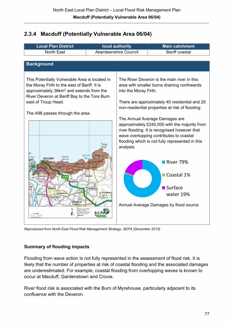
North East Local Plan District – Local Flood Risk Management Plan
Macduff (Potentially Vulnerable Area 06/04)
77
2.3.4 Macduff (Potentially Vulnerable Area 06/04)
Local Plan District local authority Main catchment North East Aberdeenshire Council Banff coastal
Background
This Potentially Vulnerable Area is located in
the Moray Firth to the east of Banff. It is
approximately 36km2 and extends from the
River Deveron at Banff Bay to the Tore Burn
east of Troup Head.
The A98 passes through the area.
The River Deveron is the main river in this
area with smaller burns draining northwards
into the Moray Firth.
There are approximately 40 residential and 20
non-residential properties at risk of flooding.
The Annual Average Damages are
approximately £240,000 with the majority from
river flooding. It is recognised however that
wave overtopping contributes to coastal
flooding which is not fully represented in this
analysis.
Annual Average Damages by flood source
Reproduced from North East Flood Risk Management Strategy, SEPA (December 2015)
Summary of flooding impacts
Flooding from wave action is not fully represented in the assessment of flood risk. It is
likely that the number of properties at risk of coastal flooding and the associated damages
are underestimated. For example, coastal flooding from overtopping waves is known to
occur at Macduff, Gardenstown and Crovie.
River flood risk is associated with the Burn of Myrehouse, particularly adjacent to its
confluence with the Deveron.
River 79%
Coastal 1%
Surfacewater 19%

North East Local Plan District – Local Flood Risk Management Plan
Banff (Potentially Vulnerable Area 06/03)
75
Action (ID): PLANNING POLICIES (6000010001)
Objective (ID): Avoid an overall increase in flood risk (600001)
Reduce overall flood risk (600002)
Delivery lead: Planning authority
Status: Existing Indicative delivery: Ongoing
Description:
Scottish Planning Policy and accompanying Planning Advice Notes set out Scottish Ministers’
priorities for the operation of the planning system and for the development and use of land. In
terms of flood risk management, the policy supports a catchment-scale approach to sustainable
flood risk management and aims to build the resilience of our cities and towns, encourage
sustainable land management in our rural areas, and to address the long-term vulnerability of
parts of our coasts and islands. Under this approach, new development in areas with medium to
high likelihood of flooding should be avoided.
For further information on the application of national planning policies see Annex 5.
Aberdeenshire Council is a local planning authority and will work with the regional planning
authority, the Aberdeen City and Shire Strategic Development Planning Authority.
As a consultee on planning applications, Aberdeenshire Council’s Flood & Coast Protection team
will work directly with colleagues in the Planning Service to ensure that appropriate policies and
measures are put in place to reduce flood risk. Planning applications are assessed against the
flooding standards set out in the current Aberdeenshire Local Development Plan, and in future
those in the proposed Aberdeenshire Local Development Plan 2016.
SEPA has a statutory role in relation to the provision of flood risk advice to planning authorities.
This role is expressed in Section 72 of the FRM Act, 2009. SEPA also has a duty to cooperate
with planning authorities in the preparation of development plans. When consulted in relation to
planning applications for development or site allocations in development plans, and where the
planning authority considers there may be a risk of flooding, SEPA will provide advice. The
advice provided by SEPA will be with respect to the risk of flooding and on the basis of the
relevant information it holds which is suitable for planning purposes. It will also be in line with the
principles and duties set out in the FRM Act.
Further information about how SEPA engages in the planning system, including guidance on
flood risk and planning is available on SEPA’s website
http://www.sepa.org.uk/environment/land/planning/
(continued)
North East Local Plan District – Local Flood Risk Management Plan
Banff (Potentially Vulnerable Area 06/03)
76
SEPA's land use planning activities will be coordinated with the activities of other responsible
authorities as required and are funded by Scottish Government through SEPA’s grant in aid
settlement.
Scottish Water is a statutory consultee within the planning legislation and is required to comment
on all outline or full planning applications which are referred by a local authority.

North East Local Plan District – Local Flood Risk Management Plan
Macduff (Potentially Vulnerable Area 06/04)
78
Several road locations are at risk of flooding including sections of the A947, B9026 and
B9031. There are ten designated cultural heritage sites and a small area of designated
environmental sites at risk.
Non-residential properties experience the greatest economic impact. Note that there is
some uncertainty around the high level of damages estimated for river flooding, which is
mostly attributed to a single site and which will require further investigation.
History of flooding
The earliest recorded flood was in 1880, when waves overtopped the sea wall in Macduff
causing damage to the harbour and boats. The 1953 North Sea flood undermined and
washed away sections of seawall and damaged the slipway and boat launching beach. In
addition, wave overtopping caused flooding to properties in Macduff and Gardenstown. In
Crovie the flooding was so severe the village was abandoned after the 1953 storm event.
In 1957 coastal flooding affected properties on the sea front, washed away the cliff road,
and required the evacuation of families. In August 2008 surface water flooding in Macduff
affected properties in Duff Street, Commercial Street, and George Street. Old Gamrie
Road in Macduff flooded in 2009 following a heavy rainstorm.
Objectives to manage flooding in Potentially Vulnerable Area 06/04
Objectives provide a common goal and shared ambition for managing floods. These
objectives have been set by SEPA and agreed with flood risk management authorities
following consultation. They were identified through an assessment of the underlying
evidence of the causes and impacts of flooding. Target areas have been set to focus
actions; they do not necessarily correspond to areas at risk in SEPA’s flood map. The
objectives below have been set for Macduff Potentially Vulnerable Area.
Target area Objective ID Indicators within
PVA Applies across
North East Local
Plan District
Avoid an overall increase in flood risk 600001 40 residential properties
£240,000 Annual Average Damages
Applies across
North East Local
Plan District
Reduce overall flood risk 600002 40 residential properties
£240,000 Annual Average Damages
Applies across
North East Local
Plan District
Organisation such as utility companies and
Historic Environment Scotland actively
maintain and manage their own assets,
including the risk of flooding. These actions are
not detailed further in the Flood Risk
Management Strategies.

North East Local Plan District – Local Flood Risk Management Plan
Macduff (Potentially Vulnerable Area 06/04)
79
Actions to manage flooding in Potentially Vulnerable Area 06/04
Actions describe where and how flood risk will be managed. These actions have been set
by SEPA and agreed with flood risk management authorities following consultation.
Selection of actions to deliver the agreed objectives was based on a detailed assessment
and comparison of economic, social and environmental criteria. The actions shaded and
then described below have been selected as the most appropriate for Macduff Potentially
Vulnerable Area.
Selected actions
Flood protection
scheme/works
Natural flood management
works
New flood warning
Community flood action
groups
Property level protection scheme
Site protection plans
Flood protection
study
Natural flood management
study
Maintain flood warning
Awareness raising
Surface water plan/study
Emergency plans/response
Maintain flood protection scheme
Strategic mapping and
modelling
Flood forecasting
Self Help Maintenance Planning policies
The delivery of selected actions by year over the six-year plan cycle is summarised below.
Delivery of selected actions
Year 1 (2016/17) Year 2
(2017/18)
Year 3
(2018/19)
Year 4
(2019/20)
Year 5
(2020/21)
Year 6
(2021/22)
Maintain flood warning
Awareness raising
Emergency plans/response
Strategic mapping and modelling
(SEPA)
Strategic mapping and modelling
(Scottish Water)
Flood forecasting
Self help
Maintenance
Planning Policy
North East Local Plan District – Local Flood Risk Management Plan
Macduff (Potentially Vulnerable Area 06/04)
80
Action (ID): MAINTAIN FLOOD WARNING (6000020030)
Objective (ID): Reduce overall flood risk (600002)
Delivery lead: SEPA
Status: Existing Indicative delivery: Ongoing
Description:
SEPA will continue to maintain the 'Banff' flood warning area which is part of the Deveron river
flood warning scheme.
They will also continue to maintain the 'Gardenstown to Pennan' and 'Portsoy to Macduff' flood
warning areas which are part of the Moray Firth coastal flood warning scheme.
When flood events occur in an area with an existing flood warning service, SEPA will seek to
verify the flood forecasts and warnings. SEPA will use feedback and post-event data to ensure
that our flood warning service is timely and accurate.
The maintenance of SEPA’s flood warning service is funded by Scottish Government through
SEPA’s grant in aid settlement.
Action (ID): AWARENESS RAISING (6000020013)
Objective (ID): Reduce overall flood risk (600002)
Delivery lead: Responsible authorities
Status: Existing Indicative delivery: Ongoing
Description:
Aberdeenshire Council have a duty to raise public awareness of flood risk under the Flood Risk
Management (Scotland) Act 2009 and to plan and inform of risks to communities under the Civil
Contingencies Act 2004.
Over the six years of the Plan, 2016-2022, Aberdeenshire Council will seek opportunities to raise
awareness of both flood risk and actions that enable individuals, homes and businesses to
reduce the overall impact of flooding.
In partnership with Education Scotland Aberdeenshire Council will look to engage schools in
activities relating to flooding, extreme weather, climate change and other community resilience
issues.
(continued)
North East Local Plan District – Local Flood Risk Management Plan
Macduff (Potentially Vulnerable Area 06/04)
81
Aberdeenshire Council will also develop emergency response plans and work with community
flood action groups where these exist.
Awareness raising will be funded from existing local authority flood revenue budgets.
From 2016 SEPA will engage with the community through local participation in national
initiatives, including partnership working with Neighbourhood Watch Scotland. In addition, SEPA
will engage with local authorities and community resilience groups where possible.
Across Scotland, SEPA will create and share communication and education resources with other
responsible authorities. These resources will include awareness campaigns, media and
marketing activities and promotion of SEPA's flood forecasting and warning service (Floodline).
Where they exist, SEPA will engage with community resilience groups and community safety
partnerships. Additionally, SEPA's awareness raising activities will be coordinated with the
activities of other responsible authorities as required.
SEPA's awareness raising activities are funded by Scottish Government through their grant in aid
settlement and will be coordinated with the activities of other responsible authorities as required.
Scottish Water will support SEPA and responsible authorities with their awareness raising
activities as required and provide targeted flooding communications for Scottish Water specific
activities. Scottish Water will raise awareness by producing and supplying targeted information to
the public on large capital projects and detailed local studies.
More general information and flooding guidance will be available on the website at:
https://www.scottishwater.co.uk/you-and-your-home/your-home/flooding-information
Scottish Water will keep responsible authorities informed of its awareness raising activities
through the Local Plan District partnerships.

North East Local Plan District – Local Flood Risk Management Plan
Macduff (Potentially Vulnerable Area 06/04)
82
Action (ID): EMERGENCY PLANS/RESPONSE (6000020014)
Objective (ID): Reduce overall flood risk (600002)
Delivery lead: Category 1 and 2 Responders
Status: Existing Indicative delivery: Ongoing
Description:
Providing an emergency response to flooding is the responsibility of many organisations,
including local authorities, the emergency services and SEPA. Effective management of an
emergency response relies on emergency plans that are prepared under the Civil Contingencies
Act 2004 by Category 1 and 2 Responders.
Aberdeenshire Council has an overarching Flood Response Plan, which is coordinated through
the Responders identified under the Civil Contingencies Act 2004. The aim of the plan is to set
out arrangements to deal effectively with flood risk. At predetermined trigger levels flood alerts
and warnings will be issued through SEPA's flood forecasting and warning service (Floodline)
and Aberdeenshire Council will conduct assessments at known hotspots and prepare resources
as required. Aberdeenshire Council will also coordinate measures in conjunction with the other
Responders. The emergency response process is coordinated through regional and local
resilience partnerships. This response may be supported by the work of voluntary organisations.
The Operational Flood Response Plan will undergo review on an annual basis to reflect
operational or responsibility changes. A debrief and plan review will also be carried out after the
Plan is activated during emergencies.
Aberdeenshire Council funding for emergency plans/response will be shared with other
organisations, emergency services and Responders, as appropriate, and will be subject to
Scottish Government’s block grant and capital support, and budget allocations over the six years
of the Plan, 2016-2022. SEPA's emergency plans/response are funded by Scottish Government
through SEPA’s grant in aid settlement.

North East Local Plan District – Local Flood Risk Management Plan
Macduff (Potentially Vulnerable Area 06/04)
83
Action (ID): STRATEGIC MAPPING AND MODELLING (6000020016)
Objective (ID): Reduce overall flood risk (600002)
Delivery lead: SEPA
Status: Scheduled Indicative delivery: 2017-2018
Description:
SEPA will be seeking to develop the flood hazard mapping in the Banff area to improve
understanding of the coastal flood risk. The extent and timing of the completed improvements will
be dependent on detailed scoping and data availability.
SEPA's strategic mapping activities will be coordinated with the activities of other responsible
authorities as required and are funded by Scottish Government through SEPA’s grant in aid
settlement
Action (ID): STRATEGIC MAPPING AND MODELLING (6000020019)
Objective (ID): Reduce overall flood risk (600002)
Delivery lead: Scottish Water
Status: Scheduled Indicative delivery: 2016-2018
Description:
Scottish Water will undertake further investigation and modelling in the Macduff sewer catchment
to improve knowledge and understanding of flood risk in this area as required under Section 16
of the Flood Risk Management (Scotland) Act 2009.
Scottish Water will work with responsible authorities to incorporate relevant information into these
studies by regularly keeping the responsible authorities informed of their progress. Scottish
Water will provide responsible authorities with the outputs of the Section 16 assessment which,
where relevant, may be used to inform Surface Water Management Plans and SEPA flood
hazard and risk maps.
Scottish Water funding is committed in its capital programme through Q&S 4a (2015-2021) which
is approved by its regulators and customers.

North East Local Plan District – Local Flood Risk Management Plan
Macduff (Potentially Vulnerable Area 06/04)
84
Action (ID): FLOOD FORECASTING (6000020009)
Objective (ID): Reduce overall flood risk (600002)
Delivery lead: SEPA
Status: Existing Indicative delivery: Ongoing
Description:
The Scottish Flood Forecasting Service is a joint initiative between SEPA and the Met Office that
produces daily, national flood guidance statements which are issued to Category 1 and 2
Responders. The flood guidance statements provide an assessment of the risk of flooding for a
five-day period allowing responders time to put preparations in place to reduce the impact of
flooding. The service also provides information which allows SEPA to issue flood warnings,
giving people a better chance of reducing the impact of flooding on their home or business. For
more information, please visit SEPA’s website. The Potentially Vulnerable Area is within the
'Aberdeenshire and Aberdeen City' flood alert area.
SEPA / Met Office joint initiative. Hydrological information is provided by SEPA and
meteorological information is provided by the Met Office. SEPA uses the information to predict
the likelihood and timing of river, coastal and surface water flooding.
SEPA’s flood forecasting service is funded through Scottish Government’s grant in aid allocation.
The Met Office receives funding from the UK Government.
Action (ID): SELF HELP (6000020011)
Objective (ID): Reduce overall flood risk (600002)
Delivery lead: —
Status: Existing Indicative delivery: Ongoing
Description:
Everyone is responsible for protecting themselves and their property flooding. Property and
business owners can take simple steps to reduce damage and disruption to their homes and
businesses should flooding happen. This includes preparing a flood plan and flood kit, installing
property level protection, signing up to Floodline and Resilient Communities initiatives, and
ensuring that properties and businesses are insured against flood damage.
Aberdeenshire Council currently provide a small range of flood protection products for individual
property protection, which are available for all types of flooding, at cost price with free delivery
across Aberdeenshire.
North East Local Plan District – Local Flood Risk Management Plan
Macduff (Potentially Vulnerable Area 06/04)
85
Action (ID): MAINTENANCE (6000020007)
Objective (ID): Reduce overall flood risk (600002)
Delivery lead: Aberdeenshire Council, asset / land managers
Status: Existing Indicative delivery: Ongoing
Description:
Local authorities have a duty to assess watercourses and carry out clearance and repair works
where such works would substantially reduce flood risk. Aberdeenshire Council will produce
schedules of clearance and repair works and make these available for public inspection.
Maintenance will be funded from existing Flood revenue budgets, for works which are defined to
pose a significant flood risk.
Scottish Water undertake risk based inspection, maintenance and repair on the public sewer
network together with keeping responsible authorities informed of large scale capital
maintenance work to identify opportunities for co-ordination.
Action (ID): PLANNING POLICIES (6000010001)
Objective (ID): Avoid an overall increase in flood risk (600001)
Reduce overall flood risk (600002)
Delivery lead: Planning authority
Status: Existing Indicative delivery: Ongoing
Description:
Scottish Planning Policy and accompanying Planning Advice Notes set out Scottish Ministers’
priorities for the operation of the planning system and for the development and use of land. In
terms of flood risk management, the policy supports a catchment-scale approach to sustainable
flood risk management and aims to build the resilience of our cities and towns, encourage
sustainable land management in our rural areas, and to address the long-term vulnerability of
parts of our coasts and islands. Under this approach, new development in areas with medium to
high likelihood of flooding should be avoided.
For further information on the application of national planning policies see Annex 5.
Aberdeenshire Council is a local planning authority and will work with the regional planning
authority, the Aberdeen City and Shire Strategic Development Planning Authority.
(continued)
North East Local Plan District – Local Flood Risk Management Plan
Macduff (Potentially Vulnerable Area 06/04)
86
As a consultee on planning applications, Aberdeenshire Council’s Flood & Coast Protection team
will work directly with colleagues in the Planning Service to ensure that appropriate policies and
measures are put in place to reduce flood risk. Planning applications are assessed against the
flooding standards set out in the current Aberdeenshire Local Development Plan, and in future
those in the proposed Aberdeenshire Local Development Plan 2016.
SEPA has a statutory role in relation to the provision of flood risk advice to planning authorities.
This role is expressed in Section 72 of the FRM Act, 2009. SEPA also has a duty to cooperate
with planning authorities in the preparation of development plans. When consulted in relation to
planning applications for development or site allocations in development plans, and where the
planning authority considers there may be a risk of flooding, SEPA will provide advice. The
advice provided by SEPA will be with respect to the risk of flooding and on the basis of the
relevant information it holds which is suitable for planning purposes. It will also be in line with the
principles and duties set out in the FRM Act. Further information about how SEPA engages in
the planning system, including guidance on flood risk and planning is available on SEPA’s
website http://www.sepa.org.uk/environment/land/planning/
SEPA's land use planning activities will be coordinated with the activities of other responsible
authorities as required and are funded by Scottish Government through SEPA’s grant in aid
settlement.
Scottish Water is a statutory consultee within the planning legislation and is required to comment
on all outline or full planning applications which are referred by a local authority.
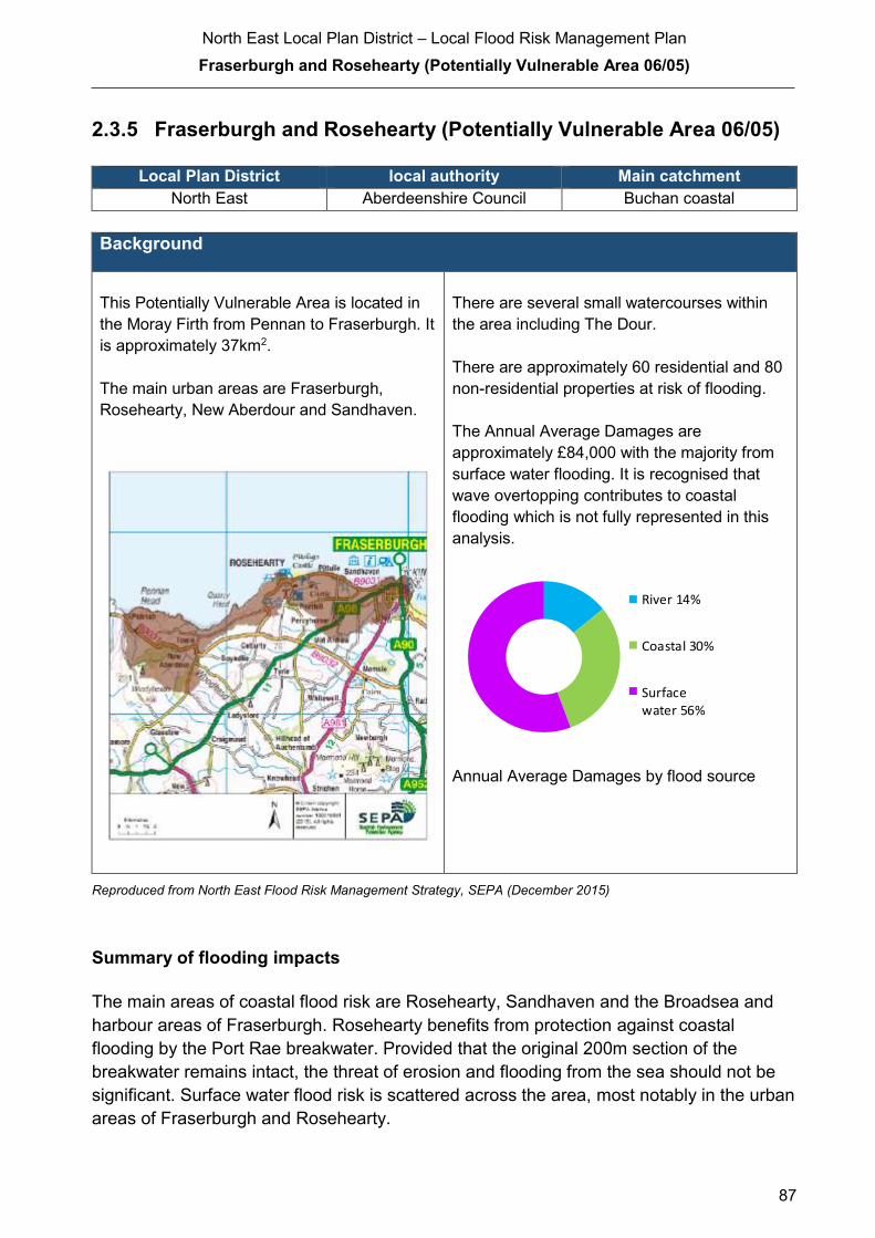
North East Local Plan District – Local Flood Risk Management Plan
Fraserburgh and Rosehearty (Potentially Vulnerable Area 06/05)
87
2.3.5 Fraserburgh and Rosehearty (Potentially Vulnerable Area 06/05)
Local Plan District local authority Main catchment North East Aberdeenshire Council Buchan coastal
Background
This Potentially Vulnerable Area is located in
the Moray Firth from Pennan to Fraserburgh. It
is approximately 37km2.
The main urban areas are Fraserburgh,
Rosehearty, New Aberdour and Sandhaven.
There are several small watercourses within
the area including The Dour.
There are approximately 60 residential and 80
non-residential properties at risk of flooding.
The Annual Average Damages are
approximately £84,000 with the majority from
surface water flooding. It is recognised that
wave overtopping contributes to coastal
flooding which is not fully represented in this
analysis.
Annual Average Damages by flood source
Reproduced from North East Flood Risk Management Strategy, SEPA (December 2015)
Summary of flooding impacts
The main areas of coastal flood risk are Rosehearty, Sandhaven and the Broadsea and
harbour areas of Fraserburgh. Rosehearty benefits from protection against coastal
flooding by the Port Rae breakwater. Provided that the original 200m section of the
breakwater remains intact, the threat of erosion and flooding from the sea should not be
significant. Surface water flood risk is scattered across the area, most notably in the urban
areas of Fraserburgh and Rosehearty.
River 14%
Coastal 30%
Surfacewater 56%
North East Local Plan District – Local Flood Risk Management Plan
Fraserburgh and Rosehearty (Potentially Vulnerable Area 06/05)
88
A nursing home, Westfield School in Fraserburgh and sections of the A98 are at risk of
flooding. Five designated cultural heritage and small areas of designated environmental
sites are also at risk.
For this Potentially Vulnerable Area the highest damages are to non-residential properties
followed by damages to residential properties.
History of flooding
Fraserburgh suffered from flooding in 1863 and 1895. Between 2002 and 2012 there were
seven floods caused by various small burns including the Kessock Burn, and surface
water runoff. These floods were generally due to heavy rainfall overwhelming road
drainage and the small burns. In August 2006, the road and public park flooded due to
water backing up behind a trash screen on the Kessock Burn and overtopping the culvert
entrance.
Properties at Murison Drive in Rosehearty have also flooded several times in the last few
years including in 2002 and 2009 due to excess surface water runoff and overflow from a
small watercourse.
During the 1953 North Sea flood properties were destroyed by coastal flooding in
Rosehearty and flooding occurred in various locations across the area, including
Sandhaven and Pennan. Rosehearty and Sandhaven harbours both suffered damage
from the coastal storms in December 2012 and 2013. Coastal storms also caused erosion
at Kinnaird Head in Fraserburgh affecting a public footpath.
Five properties were damaged as a result of flooding events in December 2015
Objectives to manage flooding in Potentially Vulnerable Area 06/05
Objectives provide a common goal and shared ambition for managing floods. These
objectives have been set by SEPA and agreed with flood risk management authorities
following consultation. They were identified through an assessment of the underlying
evidence of the causes and impacts of flooding. Target areas have been set to focus
actions; they do not necessarily correspond to areas at risk in SEPA’s flood map. The
objectives below have been set for Fraserburgh and Rosehearty Potentially Vulnerable
Area.

North East Local Plan District – Local Flood Risk Management Plan
Fraserburgh and Rosehearty (Potentially Vulnerable Area 06/05)
89
Target area Objective ID Indicators within
PVA
Fraserburgh Reduce risk from surface water flooding in
Fraserburgh
600501 * See note below
Applies across
North East Local
Plan District
Avoid an overall increase in flood risk 600001 60 residential properties
£84,000 Annual Average Damages
Applies across
North East Local
Plan District
Reduce overall flood risk 600002 60 residential properties
£84,000 Annual Average Damages
Applies across
North East Local
Plan District
Organisation such as utility companies and
Historic Environment Scotland actively
maintain and manage their own assets,
including the risk of flooding. These actions are
not detailed further in the Flood Risk
Management Strategies.
* This objective will be monitored using surface water flood risk across the Potentially Vulnerable Area. For
06/05 there are 60 residential properties at risk and Annual Average Damages of £47,000.
Reproduced from North East Flood Risk Management Strategy, SEPA (December 2015)
Actions to manage flooding in Potentially Vulnerable Area 06/05
Actions describe where and how flood risk will be managed. These actions have been set
by SEPA and agreed with flood risk management authorities following consultation.
Selection of actions to deliver the agreed objectives was based on a detailed assessment
and comparison of economic, social and environmental criteria. The actions shaded and
then described below have been selected as the most appropriate for Fraserburgh and
Rosehearty Potentially Vulnerable Area.
Selected actions
Flood protection
scheme/works
Natural flood management
works
New flood warning
Community flood action
groups
Property level protection scheme
Site protection plans
Flood protection
study
Natural flood management
study
Maintain flood warning
Awareness raising
Surface water plan/study
Emergency plans/response
Maintain flood protection scheme
Strategic mapping and
modelling
Flood forecasting
Self Help Maintenance Planning policies
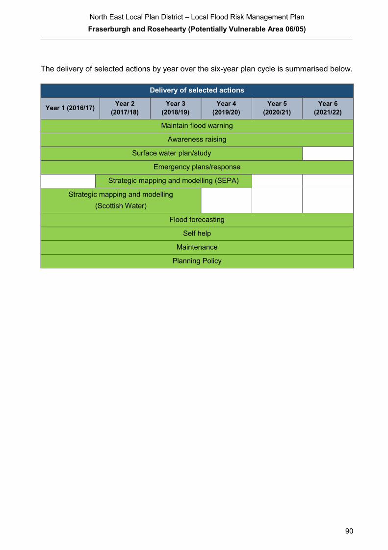
North East Local Plan District – Local Flood Risk Management Plan
Fraserburgh and Rosehearty (Potentially Vulnerable Area 06/05)
90
The delivery of selected actions by year over the six-year plan cycle is summarised below.
Delivery of selected actions
Year 1 (2016/17) Year 2
(2017/18)
Year 3
(2018/19)
Year 4
(2019/20)
Year 5
(2020/21)
Year 6
(2021/22)
Maintain flood warning
Awareness raising
Surface water plan/study
Emergency plans/response
Strategic mapping and modelling (SEPA)
Strategic mapping and modelling
(Scottish Water)
Flood forecasting
Self help
Maintenance
Planning Policy

North East Local Plan District – Local Flood Risk Management Plan
Fraserburgh and Rosehearty (Potentially Vulnerable Area 06/05)
91
Action (ID): MAINTAIN FLOOD WARNING (6000020030)
Objective (ID): Reduce overall flood risk (600002)
Delivery lead: SEPA
Status: Existing Indicative delivery: Ongoing
Description:
SEPA will continue to maintain both the 'Gardenstown to Pennan' and 'Rosehearty to
Fraserburgh' flood warning areas which are part of the Moray Firth coastal flood warning
scheme.
When flood events occur in an area with an existing flood warning service, SEPA will seek to
verify the flood forecasts and warnings. SEPA will use feedback and post-event data to ensure
that our flood warning service is timely and accurate."
The maintenance of SEPA’s flood warning service is funded by Scottish Government through
SEPA’s grant in aid settlement.

North East Local Plan District – Local Flood Risk Management Plan
Fraserburgh and Rosehearty (Potentially Vulnerable Area 06/05)
92
Action (ID): AWARENESS RAISING (6000020013)
Objective (ID): Reduce overall flood risk (600002)
Delivery lead: Responsible authorities
Status: Existing Indicative delivery: Ongoing
Description:
Aberdeenshire Council have a duty to raise public awareness of flood risk under the Flood Risk
Management (Scotland) Act 2009 and to plan and inform of risks to communities under the Civil
Contingencies Act 2004.
Over the six years of the Plan, 2016-2022, Aberdeenshire Council will seek opportunities to raise
awareness of both flood risk and actions that enable individuals, homes and businesses to
reduce the overall impact of flooding.
In partnership with Education Scotland Aberdeenshire Council will look to engage schools in
activities relating to flooding, extreme weather, climate change and other community resilience
issues.
Aberdeenshire Council will also develop emergency response plans and work with community
flood action groups where these exist.
Awareness raising will be funded from existing local authority flood revenue budgets.
From 2016 SEPA will engage with the community through local participation in national
initiatives, including partnership working with Neighbourhood Watch Scotland. In addition, SEPA
will engage with local authorities and community resilience groups where possible.
Across Scotland, SEPA will create and share communication and education resources with other
responsible authorities. These resources will include awareness campaigns, media and
marketing activities and promotion of SEPA's flood forecasting and warning service (Floodline).
Where they exist, SEPA will engage with community resilience groups and community safety
partnerships. Additionally, SEPA's awareness raising activities will be coordinated with the
activities of other responsible authorities as required.
SEPA's awareness raising activities are funded by Scottish Government through their grant in aid
settlement and will be coordinated with the activities of other responsible authorities as required.
Scottish Water will support SEPA and responsible authorities with their awareness raising
activities as required and provide targeted flooding communications for Scottish Water specific
activities. Scottish Water will raise awareness by producing and supplying targeted information to
the public on large capital projects and detailed local studies.
(continued)

North East Local Plan District – Local Flood Risk Management Plan
Fraserburgh and Rosehearty (Potentially Vulnerable Area 06/05)
93
More general information and flooding guidance will be available on the website at:
https://www.scottishwater.co.uk/you-and-your-home/your-home/flooding-information
Scottish Water will keep responsible authorities informed of its awareness raising activities
through the Local Plan District partnerships.
Action (ID): SURFACE WATER PLAN/STUDY (6005010018)
Objective (ID): Reduce risk from surface water flooding in Fraserburgh (600501)
Delivery lead: Aberdeenshire Council
Status: Ongoing Indicative delivery: 2016-2021
Description:
Aberdeenshire Council will undertake a study to prepare Surface Water Management Plan
(SWMP) to generate increased understanding of the causes, probability and consequences of
surface water flooding and to evaluate options for surface water flood management in
Fraserburgh and Rosehearty. The study will help in preparing a coordinated action plan,
supported by an understanding of the costs and benefits, to identify measures to mitigate surface
water flooding, identifying opportunities where SuDS and similar sustainable measures can play
a more significant role in managing surface water flood risk and generate improved public
engagement and understanding of surface water flooding as well as inform future developments.
The study has the potential to benefit 33 residential properties, 45 non-residential properties and
sections of road network at risk of flooding in this location, with potential average annual
damages avoided of up to £47,000. A reduction in flood risk would have a positive benefit to the
health and wellbeing of the community and socially vulnerable people located within the study
area and may also contribute to enhanced biodiversity and economic activity.
The study will consider interactions with drainage system, water bodies and the sea. Additional
data and information will be procured or surveys commissioned to generate data to inform the
study. The study will take a sustainable and integrated approach by coordinating with the river
basin management plan. It will explore opportunities for enhancing biodiversity and for
promoting economic activity and social wellbeing.
Aberdeenshire Council will coordinate with Scottish Water, SEPA and community groups as well
as other relevant agencies and organisations. Aberdeenshire Council will undertake the study
through the Local Planning District (LPD) partnership and / or through separate agreements.
Funding for the study will be subject to Scottish Government’s block grant and capital support,
and budget allocations over the six years of the Plan, 2016-2022.

North East Local Plan District – Local Flood Risk Management Plan
Fraserburgh and Rosehearty (Potentially Vulnerable Area 06/05)
94
Action (ID): EMERGENCY PLANS/RESPONSE (6000020014)
Objective (ID): Reduce overall flood risk (600002)
Delivery lead: Category 1 and 2 Responders
Status: Existing Indicative delivery: Ongoing
Description:
Providing an emergency response to flooding is the responsibility of many organisations,
including local authorities, the emergency services and SEPA. Effective management of an
emergency response relies on emergency plans that are prepared under the Civil Contingencies
Act 2004 by Category 1 and 2 Responders.
Aberdeenshire Council has an overarching Flood Response Plan, which is coordinated through
the Responders identified under the Civil Contingencies Act 2004. The aim of the plan is to set
out arrangements to deal effectively with flood risk. At predetermined trigger levels flood alerts
and warnings will be issued through SEPA's flood forecasting and warning service (Floodline)
and Aberdeenshire Council will conduct assessments at known hotspots and prepare resources
as required. Aberdeenshire Council will also coordinate measures in conjunction with the other
Responders. The emergency response process is coordinated through regional and local
resilience partnerships. This response may be supported by the work of voluntary organisations.
The Operational Flood Response Plan will undergo review on an annual basis to reflect
operational or responsibility changes. A debrief and plan review will also be carried out after the
Plan is activated during emergencies.
Aberdeenshire Council funding for emergency plans/response will be shared with other
organisations, emergency services and Responders, as appropriate, and will be subject to
Scottish Government’s block grant and capital support, and budget allocations over the six years
of the Plan, 2016-2022. SEPA's emergency plans/response are funded by Scottish Government
through SEPA’s grant in aid settlement.
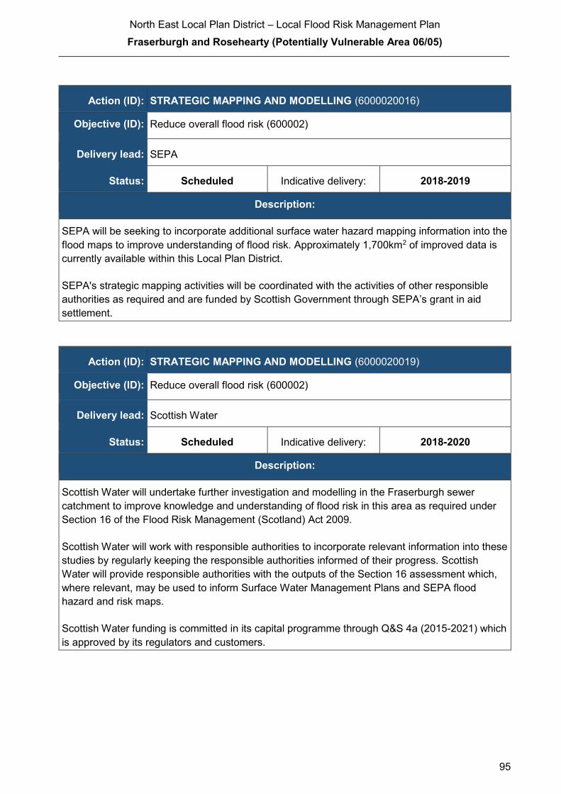
North East Local Plan District – Local Flood Risk Management Plan
Fraserburgh and Rosehearty (Potentially Vulnerable Area 06/05)
95
Action (ID): STRATEGIC MAPPING AND MODELLING (6000020016)
Objective (ID): Reduce overall flood risk (600002)
Delivery lead: SEPA
Status: Scheduled Indicative delivery: 2018-2019
Description:
SEPA will be seeking to incorporate additional surface water hazard mapping information into the
flood maps to improve understanding of flood risk. Approximately 1,700km2 of improved data is
currently available within this Local Plan District.
SEPA's strategic mapping activities will be coordinated with the activities of other responsible
authorities as required and are funded by Scottish Government through SEPA’s grant in aid
settlement.
Action (ID): STRATEGIC MAPPING AND MODELLING (6000020019)
Objective (ID): Reduce overall flood risk (600002)
Delivery lead: Scottish Water
Status: Scheduled Indicative delivery: 2018-2020
Description:
Scottish Water will undertake further investigation and modelling in the Fraserburgh sewer
catchment to improve knowledge and understanding of flood risk in this area as required under
Section 16 of the Flood Risk Management (Scotland) Act 2009.
Scottish Water will work with responsible authorities to incorporate relevant information into these
studies by regularly keeping the responsible authorities informed of their progress. Scottish
Water will provide responsible authorities with the outputs of the Section 16 assessment which,
where relevant, may be used to inform Surface Water Management Plans and SEPA flood
hazard and risk maps.
Scottish Water funding is committed in its capital programme through Q&S 4a (2015-2021) which
is approved by its regulators and customers.

North East Local Plan District – Local Flood Risk Management Plan
Fraserburgh and Rosehearty (Potentially Vulnerable Area 06/05)
96
Action (ID): FLOOD FORECASTING (6000020009)
Objective (ID): Reduce overall flood risk (600002)
Delivery lead: SEPA
Status: Existing Indicative delivery: Ongoing
Description:
The Scottish Flood Forecasting Service is a joint initiative between SEPA and the Met Office that
produces daily, national flood guidance statements which are issued to Category 1 and 2
Responders. The flood guidance statements provide an assessment of the risk of flooding for a
five-day period allowing responders time to put preparations in place to reduce the impact of
flooding. The service also provides information which allows SEPA to issue flood warnings,
giving people a better chance of reducing the impact of flooding on their home or business. For
more information, please visit SEPA’s website. The Potentially Vulnerable Area is within the
'Aberdeenshire and Aberdeen City' flood alert area.
SEPA / Met Office joint initiative. Hydrological information is provided by SEPA and
meteorological information is provided by the Met Office. SEPA uses the information to predict
the likelihood and timing of river, coastal and surface water flooding.
SEPA’s flood forecasting service is funded through Scottish Government’s grant in aid allocation.
The Met Office receives funding from the UK Government.
Action (ID): SELF HELP (6000020011)
Objective (ID): Reduce overall flood risk (600002)
Delivery lead: —
Status: Existing Indicative delivery: Ongoing
Description:
Everyone is responsible for protecting themselves and their property flooding. Property and
business owners can take simple steps to reduce damage and disruption to their homes and
businesses should flooding happen. This includes preparing a flood plan and flood kit, installing
property level protection, signing up to Floodline and Resilient Communities initiatives, and
ensuring that properties and businesses are insured against flood damage.
Aberdeenshire Council currently provide a small range of flood protection products for individual
property protection, which are available for all types of flooding, at cost price with free delivery
across Aberdeenshire.

North East Local Plan District – Local Flood Risk Management Plan
Fraserburgh and Rosehearty (Potentially Vulnerable Area 06/05)
97
Action (ID): MAINTENANCE (6000020007)
Objective (ID): Reduce overall flood risk (600002)
Delivery lead: Aberdeenshire Council, asset / land managers
Status: Existing Indicative delivery: Ongoing
Description:
Local authorities have a duty to assess watercourses and carry out clearance and repair works
where such works would substantially reduce flood risk. Aberdeenshire Council will produce
schedules of clearance and repair works and make these available for public inspection.
Maintenance will be funded from existing Flood revenue budgets, for works which are defined to
pose a significant flood risk.
Scottish Water undertake risk based inspection, maintenance and repair on the public sewer
network together with keeping responsible authorities informed of large scale capital
maintenance work to identify opportunities for co-ordination.
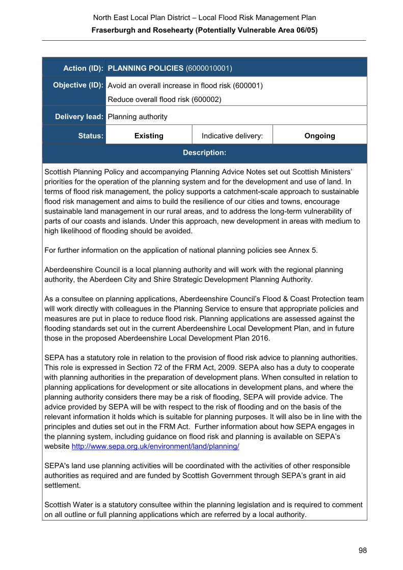
North East Local Plan District – Local Flood Risk Management Plan
Fraserburgh and Rosehearty (Potentially Vulnerable Area 06/05)
98
Action (ID): PLANNING POLICIES (6000010001)
Objective (ID): Avoid an overall increase in flood risk (600001)
Reduce overall flood risk (600002)
Delivery lead: Planning authority
Status: Existing Indicative delivery: Ongoing
Description:
Scottish Planning Policy and accompanying Planning Advice Notes set out Scottish Ministers’
priorities for the operation of the planning system and for the development and use of land. In
terms of flood risk management, the policy supports a catchment-scale approach to sustainable
flood risk management and aims to build the resilience of our cities and towns, encourage
sustainable land management in our rural areas, and to address the long-term vulnerability of
parts of our coasts and islands. Under this approach, new development in areas with medium to
high likelihood of flooding should be avoided.
For further information on the application of national planning policies see Annex 5.
Aberdeenshire Council is a local planning authority and will work with the regional planning
authority, the Aberdeen City and Shire Strategic Development Planning Authority.
As a consultee on planning applications, Aberdeenshire Council’s Flood & Coast Protection team
will work directly with colleagues in the Planning Service to ensure that appropriate policies and
measures are put in place to reduce flood risk. Planning applications are assessed against the
flooding standards set out in the current Aberdeenshire Local Development Plan, and in future
those in the proposed Aberdeenshire Local Development Plan 2016.
SEPA has a statutory role in relation to the provision of flood risk advice to planning authorities.
This role is expressed in Section 72 of the FRM Act, 2009. SEPA also has a duty to cooperate
with planning authorities in the preparation of development plans. When consulted in relation to
planning applications for development or site allocations in development plans, and where the
planning authority considers there may be a risk of flooding, SEPA will provide advice. The
advice provided by SEPA will be with respect to the risk of flooding and on the basis of the
relevant information it holds which is suitable for planning purposes. It will also be in line with the
principles and duties set out in the FRM Act. Further information about how SEPA engages in
the planning system, including guidance on flood risk and planning is available on SEPA’s
website http://www.sepa.org.uk/environment/land/planning/
SEPA's land use planning activities will be coordinated with the activities of other responsible
authorities as required and are funded by Scottish Government through SEPA’s grant in aid
settlement.
Scottish Water is a statutory consultee within the planning legislation and is required to comment
on all outline or full planning applications which are referred by a local authority.

North East Local Plan District – Local Flood Risk Management Plan
Newmill (Potentially Vulnerable Area 06/06)
99
2.3.6 Newmill (Potentially Vulnerable Area 06/06)
Local Planning District local authority Main catchment
North East The Moray Council River Deveron
Background
This Potentially Vulnerable Area is located to
the north of Keith. It is approximately 13km2
and includes the Newmill and Glen of Newmill
areas. The A95, B9017 and B911 roads, a
railway line and railway station are all within
the area.
The largest river in the area is the River Isla.
There are approximately 13 residential and
fewer than 10 non-residential properties at risk
of flooding.
The Annual Average Damages are
approximately £24,000. These are evenly
distributed between surface water and river
flooding.
Annual Average Damages by flood source
Reproduced from North East Flood Risk Management Strategy, SEPA (December 2015)
Summary of flooding impacts
River flood risk is associated with the River Isla as it flows to the north of Keith notably in
the vicinity of the railway line and A95 at Montgrew. There are areas of surface water
flood risk in Newmill and within Keith itself, although most of the areas at risk in Keith are
outside the southern boundary of this Potentially Vulnerable Area.
Roads potentially affected by flooding include the A95, B9017 and B911. Sections of the
Aberdeen to Inverness railway are also at risk of flooding.
For this Potentially Vulnerable Area the highest damages are to residential properties.
River 51%
Surfacewater 49%
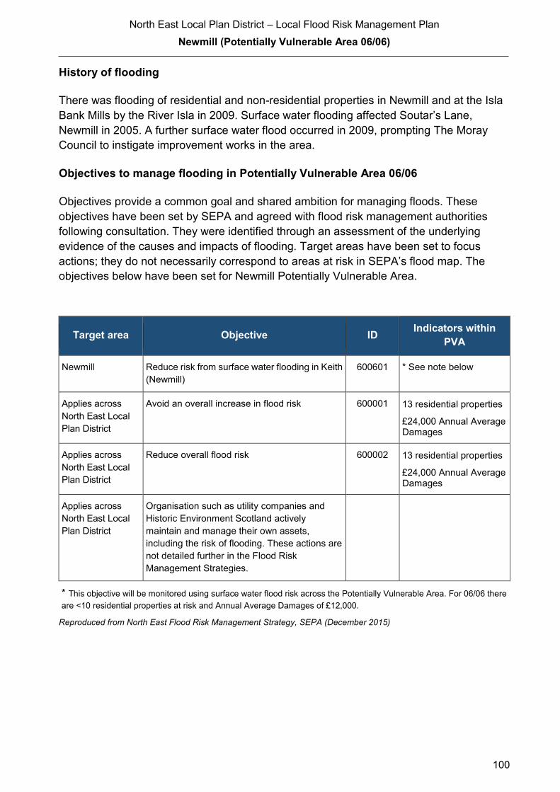
North East Local Plan District – Local Flood Risk Management Plan
Newmill (Potentially Vulnerable Area 06/06)
100
History of flooding
There was flooding of residential and non-residential properties in Newmill and at the Isla
Bank Mills by the River Isla in 2009. Surface water flooding affected Soutar’s Lane,
Newmill in 2005. A further surface water flood occurred in 2009, prompting The Moray
Council to instigate improvement works in the area.
Objectives to manage flooding in Potentially Vulnerable Area 06/06
Objectives provide a common goal and shared ambition for managing floods. These
objectives have been set by SEPA and agreed with flood risk management authorities
following consultation. They were identified through an assessment of the underlying
evidence of the causes and impacts of flooding. Target areas have been set to focus
actions; they do not necessarily correspond to areas at risk in SEPA’s flood map. The
objectives below have been set for Newmill Potentially Vulnerable Area.
Target area Objective ID Indicators within
PVA
Newmill Reduce risk from surface water flooding in Keith
(Newmill)
600601 * See note below
Applies across
North East Local
Plan District
Avoid an overall increase in flood risk 600001 13 residential properties
£24,000 Annual Average Damages
Applies across
North East Local
Plan District
Reduce overall flood risk 600002 13 residential properties
£24,000 Annual Average Damages
Applies across
North East Local
Plan District
Organisation such as utility companies and
Historic Environment Scotland actively
maintain and manage their own assets,
including the risk of flooding. These actions are
not detailed further in the Flood Risk
Management Strategies.
* This objective will be monitored using surface water flood risk across the Potentially Vulnerable Area. For 06/06 there
are <10 residential properties at risk and Annual Average Damages of £12,000.
Reproduced from North East Flood Risk Management Strategy, SEPA (December 2015)
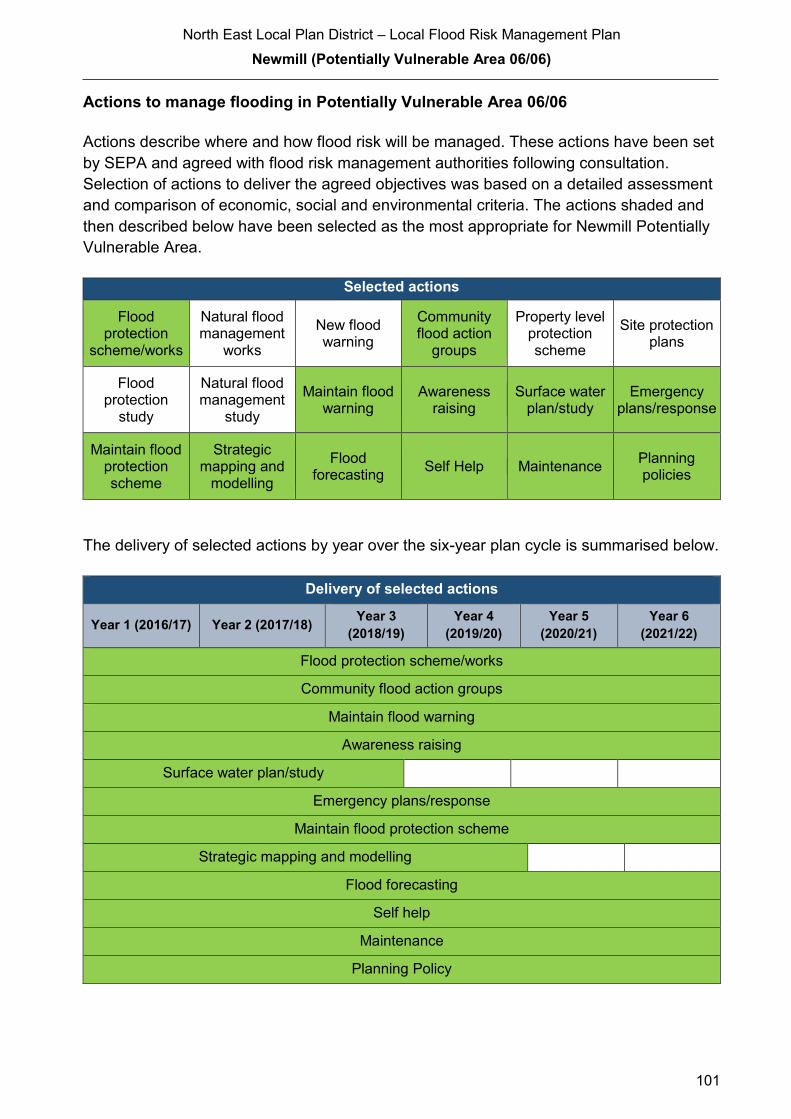
North East Local Plan District – Local Flood Risk Management Plan
Newmill (Potentially Vulnerable Area 06/06)
101
Actions to manage flooding in Potentially Vulnerable Area 06/06
Actions describe where and how flood risk will be managed. These actions have been set
by SEPA and agreed with flood risk management authorities following consultation.
Selection of actions to deliver the agreed objectives was based on a detailed assessment
and comparison of economic, social and environmental criteria. The actions shaded and
then described below have been selected as the most appropriate for Newmill Potentially
Vulnerable Area.
Selected actions
Flood protection
scheme/works
Natural flood management
works
New flood warning
Community flood action
groups
Property level protection scheme
Site protection plans
Flood protection
study
Natural flood management
study
Maintain flood warning
Awareness raising
Surface water plan/study
Emergency plans/response
Maintain flood protection scheme
Strategic mapping and
modelling
Flood forecasting
Self Help Maintenance Planning policies
The delivery of selected actions by year over the six-year plan cycle is summarised below.
Delivery of selected actions
Year 1 (2016/17) Year 2 (2017/18) Year 3
(2018/19)
Year 4
(2019/20)
Year 5
(2020/21)
Year 6
(2021/22)
Flood protection scheme/works
Community flood action groups
Maintain flood warning
Awareness raising
Surface water plan/study
Emergency plans/response
Maintain flood protection scheme
Strategic mapping and modelling
Flood forecasting
Self help
Maintenance
Planning Policy
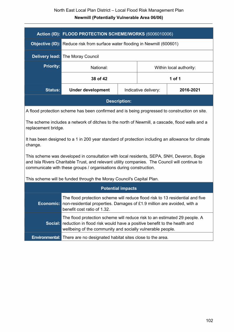
North East Local Plan District – Local Flood Risk Management Plan
Newmill (Potentially Vulnerable Area 06/06)
102
Action (ID): FLOOD PROTECTION SCHEME/WORKS (6006010006)
Objective (ID): Reduce risk from surface water flooding in Newmill (600601)
Delivery lead: The Moray Council
Priority: National: Within local authority:
38 of 42 1 of 1
Status: Under development Indicative delivery: 2016-2021
Description:
A flood protection scheme has been confirmed and is being progressed to construction on site.
The scheme includes a network of ditches to the north of Newmill, a cascade, flood walls and a
replacement bridge.
It has been designed to a 1 in 200 year standard of protection including an allowance for climate
change.
This scheme was developed in consultation with local residents, SEPA, SNH, Deveron, Bogie
and Isla Rivers Charitable Trust, and relevant utility companies. The Council will continue to
communicate with these groups / organisations during construction.
This scheme will be funded through the Moray Council's Capital Plan.
Potential impacts
Economic:
The flood protection scheme will reduce flood risk to 13 residential and five
non-residential properties. Damages of £1.9 million are avoided, with a
benefit cost ratio of 1.32.
Social:
The flood protection scheme will reduce risk to an estimated 29 people. A
reduction in flood risk would have a positive benefit to the health and
wellbeing of the community and socially vulnerable people.
Environmental: There are no designated habitat sites close to the area.
North East Local Plan District – Local Flood Risk Management Plan
Newmill (Potentially Vulnerable Area 06/06)
103
Action (ID): COMMUNITY FLOOD ACTION GROUPS (6000020012)
Objective (ID): Reduce overall flood risk (600002)
Delivery lead: Community
Status: Existing Indicative delivery: Ongoing
Description:
Newmill Community Association has worked with The Moray Council, and tenants to reduce the
impact of surface water flooding. This relationship will be maintained throughout the construction
of the scheme.
Action (ID): MAINTAIN FLOOD WARNING (6000020030)
Objective (ID): Reduce overall flood risk (600002)
Delivery lead: SEPA
Status: Existing Indicative delivery: Ongoing
Description:
SEPA will continue to maintain the 'Keith' flood warning area which is on the River Isla and forms
part of the Deveron river flood warning scheme.
A flood protection scheme is proposed for Newmill. SEPA will work with The Moray Council to
ensure that changes to hydrology and flood risk as a result of the proposed flood protection
scheme are fully considered in the existing flood warning system.
The maintenance of SEPA’s flood warning service is funded by Scottish Government through
SEPA’s grant in aid settlement.

North East Local Plan District – Local Flood Risk Management Plan
Newmill (Potentially Vulnerable Area 06/06)
104
Action (ID): AWARENESS RAISING (6000020013)
Objective (ID): Reduce overall flood risk (600002)
Delivery lead: Responsible authorities
Status: Existing Indicative delivery: Ongoing
Description:
The Moray Council will seek opportunities to raise awareness of flood risk and actions that
prepare individuals, homes and businesses as described in the Act. They will support community
resilience groups working with SEPA, responsible authorities and the Scottish Flood Forum. Most
recently The Moray Council held an event in Keith to inform residents of the objectives ad actions
included in this plan and how the plan may affect them in the future.
Awareness raising will be funded from existing local authority flood revenue budgets.
SEPA and the responsible authorities have a duty to raise public awareness of flood risk.
Improved awareness of flood risk and actions that prepare individuals, homes and businesses for
flooding can reduce the overall impact. SEPA will engage with the community through local
participation in national initiatives, including partnership working with Neighbourhood Watch
Scotland. In addition, SEPA will engage with local authorities and community resilience groups
where possible. Local authorities will be undertaking additional awareness raising activities.
Further details will be set out in the Plan.
From 2016 SEPA will engage with the community through local participation in national
initiatives, including partnership working with Neighbourhood Watch Scotland. In addition, SEPA
will engage with local authorities and community resilience groups where possible.
Across Scotland, SEPA will create and share communication and education resources with other
responsible authorities. These resources will include awareness campaigns, media and
marketing activity and promotion of SEPA's flood forecasting and warning services (Floodline).
Where they exist, SEPA will engage with community resilience groups and community safety
partnerships.
For the new flood protection scheme at Newmill, SEPA will support the local authority’s
communications and engagement activities with media activity, local public awareness events
and education engagement with the schools. SEPA will also deliver joint communications with
local authorities for Floodline customers in any newly protected flood warning area.
SEPA's awareness raising activities are funded through Scottish Government’s grant in aid
allocation.
(continued)

North East Local Plan District – Local Flood Risk Management Plan
Newmill (Potentially Vulnerable Area 06/06)
105
Action (ID): SURFACE WATER PLAN/STUDY (6006010018)
Objective (ID): Reduce risk from surface water flooding in Keith (Newmill) (600601)
Delivery lead: The Moray Council
Status: Ongoing Indicative delivery: 2016-2021
Description:
A Surface Water Management Plan for the Keith/Newmill area will be developed by The Moray
Council in collaboration with Scottish Water which will set objectives for the management of
surface water flood risk and identify the most sustainable actions to achieve the objectives.
The development of this plan will be funded from the Council's FRM Revenue budget.
Scottish Water will work with The Moray Council and support surface water management
planning through ensuring that best available knowledge and data is used to input into the
Surface Water Management Plans.
Scottish Water will support SEPA and responsible authorities with their awareness raising
activities as required and provide targeted flooding communications for Scottish Water specific
activities. Scottish Water will raise awareness by producing and supplying targeted information to
the public on large capital projects and detailed local studies.
More general information and flooding guidance will be available on the website at:
https://www.scottishwater.co.uk/you-and-your-home/your-home/flooding-information
Scottish Water will keep responsible authorities informed of its awareness raising activities
through the Local Plan District partnerships.
North East Local Plan District – Local Flood Risk Management Plan
Newmill (Potentially Vulnerable Area 06/06)
106
Action (ID): EMERGENCY PLANS/RESPONSE (6000020014)
Objective (ID): Reduce overall flood risk (600002)
Delivery lead: Category 1 and 2 Responders
Status: Existing Indicative delivery: Ongoing
Description:
Providing an emergency response to flooding is the responsibility of organisations, including local
authorities, the emergency services and SEPA. Emergency response in the Moray area is co-
ordinated by the Grampian Emergency Planning Unit, which is part of the Grampian Local
Resilience Partnership covering Moray Aberdeenshire and Aberdeen City. This partnership is
made up of Police Scotland, Scottish Fire and Rescue Service, The NHS, The Moray Council,
SEPA and the Met Office. This unit coordinates the emergency response to flood events, such as
road closures, evacuations and temporary accommodation.
Emergency response and development of the Emergency Plan is funded from the Council's
revenue budget.
Effective management of an emergency response relies on emergency plans that are prepared
under the Civil Contingencies Act 2004 by Category 1 and 2 Responders. The emergency
response by these organisations is coordinated through regional and local resilience
partnerships. This response may be supported by the work of voluntary organisations.
Action (ID): MAINTAIN FLOOD PROTECTION SCHEME (6000020017)
Objective (ID): Reduce overall flood risk (600002)
Delivery lead: The Moray Council
Status: Existing Indicative delivery: Ongoing
Description:
The Moray Council will continue to maintain the Newmill Flood Protection Scheme, including
phase 2, once completed.
Maintenance of this scheme is included in the Council's schedule of clearance and repair
Works identified in the Council's clearance and repair schedule are funded from the FRM
Revenue budget.
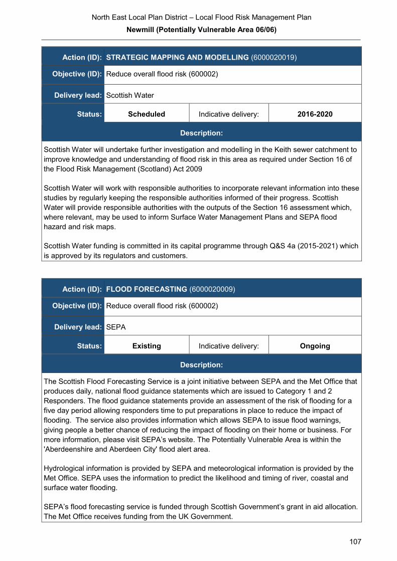
North East Local Plan District – Local Flood Risk Management Plan
Newmill (Potentially Vulnerable Area 06/06)
107
Action (ID): STRATEGIC MAPPING AND MODELLING (6000020019)
Objective (ID): Reduce overall flood risk (600002)
Delivery lead: Scottish Water
Status: Scheduled Indicative delivery: 2016-2020
Description:
Scottish Water will undertake further investigation and modelling in the Keith sewer catchment to
improve knowledge and understanding of flood risk in this area as required under Section 16 of
the Flood Risk Management (Scotland) Act 2009
Scottish Water will work with responsible authorities to incorporate relevant information into these
studies by regularly keeping the responsible authorities informed of their progress. Scottish
Water will provide responsible authorities with the outputs of the Section 16 assessment which,
where relevant, may be used to inform Surface Water Management Plans and SEPA flood
hazard and risk maps.
Scottish Water funding is committed in its capital programme through Q&S 4a (2015-2021) which
is approved by its regulators and customers.
Action (ID): FLOOD FORECASTING (6000020009)
Objective (ID): Reduce overall flood risk (600002)
Delivery lead: SEPA
Status: Existing Indicative delivery: Ongoing
Description:
The Scottish Flood Forecasting Service is a joint initiative between SEPA and the Met Office that
produces daily, national flood guidance statements which are issued to Category 1 and 2
Responders. The flood guidance statements provide an assessment of the risk of flooding for a
five day period allowing responders time to put preparations in place to reduce the impact of
flooding. The service also provides information which allows SEPA to issue flood warnings,
giving people a better chance of reducing the impact of flooding on their home or business. For
more information, please visit SEPA’s website. The Potentially Vulnerable Area is within the
'Aberdeenshire and Aberdeen City' flood alert area.
Hydrological information is provided by SEPA and meteorological information is provided by the
Met Office. SEPA uses the information to predict the likelihood and timing of river, coastal and
surface water flooding.
SEPA’s flood forecasting service is funded through Scottish Government’s grant in aid allocation.
The Met Office receives funding from the UK Government.

North East Local Plan District – Local Flood Risk Management Plan
Newmill (Potentially Vulnerable Area 06/06)
108
Action (ID): SELF HELP (6000020011)
Objective (ID): Reduce overall flood risk (600002)
Delivery lead: —
Status: Existing Indicative delivery: Ongoing
Description:
Everyone is responsible for protecting themselves and their property from flooding. Property and
business owners can take simple steps to reduce damage and disruption to their homes and
businesses should flooding happen. This includes preparing a flood plan and flood kit, installing
property level protection, signing up to Floodline and Resilient Communities initiatives, and
ensuring that properties and businesses are insured against flood damage.
The Moray Council provides advice to members of the public regarding flood risk and resilience.
The Council also holds information events from time to time in collaboration with Scottish Water,
SEPA and the Scottish Flood Forum.
Events hosted by the Council are funded from the FRM Revenue budget.
Action (ID): MAINTENANCE (6000020007)
Objective (ID): Reduce overall flood risk (600002)
Delivery lead: The Moray Council, asset / land managers
Status: Existing Indicative delivery: Ongoing
Description:
Local authorities have a duty to assess watercourses and carry out clearance and repair works
where such works would substantially reduce flood risk. They produce schedules of clearance
and repair works and make these available for public inspection.
Asset owners and riparian landowners are responsible for the maintenance and management of
their own assets including those which help to reduce flood risk.
The Moray Council has a schedule of clearance and repair, which identifies routine maintenance
and repairs to address areas known to be at risk. It may include small improvement works. This
schedule is reviewed and updated. This review is based on inspections and information provided
by the public and other organisations.
(continued)
North East Local Plan District – Local Flood Risk Management Plan
Newmill (Potentially Vulnerable Area 06/06)
109
Works identified in the Council's clearance and repair schedule are funded from the FRM
Revenue budget.
Scottish Water undertake risk based inspection, maintenance and repair on the public sewer
network together with keeping responsible authorities informed of large scale capital
maintenance work to identify opportunities for co-ordination.
Action (ID): PLANNING POLICIES (6000010001)
Objective (ID): Avoid an overall increase in flood risk (600001)
Reduce overall flood risk (600002)
Delivery lead: Planning authority
Status: Existing Indicative delivery: Ongoing
Description:
Scottish Planning Policy and accompanying Planning Advice Notes set out Scottish Ministers’
priorities for the operation of the planning system and for the development and use of land. In
terms of flood risk management, the policy supports a catchment-scale approach to sustainable
flood risk management and aims to build the resilience of our cities and towns, encourage
sustainable land management in our rural areas, and to address the long-term vulnerability of
parts of our coasts and islands. Under this approach, new development in areas with medium to
high likelihood of flooding should be avoided.
For further information on the application of national planning policies see Annex 5.
The Moray Council develops and adopts a revised Local Plan every five years. This plan sets
out the strategy for delivering appropriate development throughout Moray and takes into
consideration a number of potential constraints including flood risk. The Council’s Flood Risk
Management team provides advice regarding flood risk that informs this plan. The current plan
was adopted in 2015 and consultation on the new plan started in 2016.
SEPA has a statutory role in relation to the provision of flood risk advice to planning authorities.
This role is expressed in Section 72 of the FRM Act, 2009. SEPA also has a duty to cooperate
with planning authorities in the preparation of development plans. When consulted in relation to
planning applications for development or site allocations in development plans, and where the
planning authority considers there may be a risk of flooding, SEPA will provide advice. The
advice provided by SEPA will be with respect to the risk of flooding and on the basis of the
relevant information it holds which is suitable for planning purposes. It will also be in line with the
principles and duties set out in the FRM Act. Further information about how SEPA engages in
the planning system, including guidance on flood risk and planning is available on SEPA’s
website http://www.sepa.org.uk/environment/land/planning/
(continued)

North East Local Plan District – Local Flood Risk Management Plan
Newmill (Potentially Vulnerable Area 06/06)
110
SEPA's land use planning activities will be coordinated with the activities of other responsible
authorities as required and are funded by Scottish Government through SEPA’s grant in aid
settlement.
Scottish Water is a statutory consultee within the planning legislation and is required to comment
on all outline or full planning applications which are referred by a local authority.
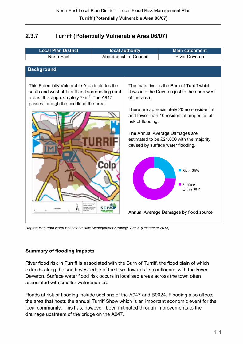
North East Local Plan District – Local Flood Risk Management Plan
Turriff (Potentially Vulnerable Area 06/07)
111
2.3.7 Turriff (Potentially Vulnerable Area 06/07)
Local Plan District local authority Main catchment
North East Aberdeenshire Council River Deveron
Background
This Potentially Vulnerable Area includes the
south and west of Turriff and surrounding rural
areas. It is approximately 7km2. The A947
passes through the middle of the area.
The main river is the Burn of Turriff which
flows into the Deveron just to the north west
of the area.
There are approximately 20 non-residential
and fewer than 10 residential properties at
risk of flooding.
The Annual Average Damages are
estimated to be £24,000 with the majority
caused by surface water flooding.
Annual Average Damages by flood source
Reproduced from North East Flood Risk Management Strategy, SEPA (December 2015)
Summary of flooding impacts
River flood risk in Turriff is associated with the Burn of Turriff, the flood plain of which
extends along the south west edge of the town towards its confluence with the River
Deveron. Surface water flood risk occurs in localised areas across the town often
associated with smaller watercourses.
Roads at risk of flooding include sections of the A947 and B9024. Flooding also affects
the area that hosts the annual Turriff Show which is an important economic event for the
local community. This has, however, been mitigated through improvements to the
drainage upstream of the bridge on the A947.
River 25%
Surfacewater 75%

North East Local Plan District – Local Flood Risk Management Plan
Turriff (Potentially Vulnerable Area 06/07)
112
For this Potentially Vulnerable Area the highest damages are to non-residential properties
followed by damages to residential properties.
History of flooding
The Burn of Turriff flooded in 1829 and 1859; the latter destroying several bridges
including a railway bridge. In 1999, heavy rainfall overwhelmed the sewer causing flooding
in Crooked Lane, Turriff.
10 properties were damaged as a result of flooding events in December 2015
Turriff United football ground has flooded on a number of occasions from the Burn of
Turriff and Gassie Burn including in 2000 and 2002. Surface water flooding also occurred
in Turriff in 2004, 2005, and 2008 due to the drainage infrastructure being unable to cope
with runoff from heavy rainfall. This resulted in the flooding of properties and roads.
Objectives to manage flooding in Potentially Vulnerable Area 06/07
Objectives provide a common goal and shared ambition for managing floods. These
objectives have been set by SEPA and agreed with flood risk management authorities
following consultation. They were identified through an assessment of the underlying
evidence of the causes and impacts of flooding. Target areas have been set to focus
actions; they do not necessarily correspond to areas at risk in SEPA’s flood map. The
objectives below have been set for Turriff Potentially Vulnerable Area.
Target area Objective ID Indicators within
PVA
Applies across
North East Local
Plan District
Avoid an overall increase in flood risk 600001 <10 residential
properties
£24,000 Annual
Average Damages
Applies across
North East Local
Plan District
Reduce overall flood risk 600002 <10 residential
properties
£24,000 Annual
Average Damages
Applies across
North East Local
Plan District
Organisation such as utility companies
and Historic Environment Scotland actively
maintain and manage their own assets,
including the risk of flooding. These
actions are not detailed further in the
Flood Risk Management Strategies.
Reproduced from North East Flood Risk Management Strategy, SEPA (December 2015)

North East Local Plan District – Local Flood Risk Management Plan
Turriff (Potentially Vulnerable Area 06/07)
113
Actions to manage flooding in Potentially Vulnerable Area 06/07
Actions describe where and how flood risk will be managed. These actions have been set
by SEPA and agreed with flood risk management authorities following consultation.
Selection of actions to deliver the agreed objectives was based on a detailed assessment
and comparison of economic, social and environmental criteria. The actions shaded and
then described below have been selected as the most appropriate for Turriff Potentially
Vulnerable Area.
Selected actions
Flood protection
scheme/works
Natural flood management
works
New flood warning
Community flood action
groups
Property level protection scheme
Site protection plans
Flood protection
study
Natural flood management
study
Maintain flood warning
Awareness raising
Surface water plan/study
Emergency plans/response
Maintain flood protection scheme
Strategic mapping and
modelling
Flood forecasting
Self Help Maintenance Planning policies
The delivery of selected actions by year over the six-year plan cycle is summarised below.
Delivery of selected actions
Year 1 (2016/17) Year 2
(2017/18)
Year 3
(2018/19)
Year 4
(2019/20)
Year 5
(2020/21)
Year 6
(2021/22)
Maintain flood warning
Awareness raising
Emergency plans/response
Strategic mapping and modelling
(Scottish Water)
Flood forecasting
Self help
Maintenance
Planning Policy
North East Local Plan District – Local Flood Risk Management Plan
Turriff (Potentially Vulnerable Area 06/07)
114
Action (ID): MAINTAIN FLOOD WARNING (6000020030)
Objective (ID): Reduce overall flood risk (600002)
Delivery lead: SEPA
Status: Existing Indicative delivery: Ongoing
Description:
SEPA will continue to maintain the 'Turriff' flood warning area which is part of the Deveron river
flood warning scheme.
When flood events occur in an area with an existing flood warning service, SEPA will seek to
verify the flood forecasts and warnings. SEPA will use feedback and post-event data to ensure
that our flood warning service is timely and accurate."
The maintenance of SEPA’s flood warning service is funded by Scottish Government through
SEPA’s grant in aid settlement.

North East Local Plan District – Local Flood Risk Management Plan
Turriff (Potentially Vulnerable Area 06/07)
115
Action (ID): AWARENESS RAISING (6000020013)
Objective (ID): Reduce overall flood risk (600002)
Delivery lead: Responsible authorities
Status: Existing Indicative delivery: Ongoing
Description:
Aberdeenshire Council have a duty to raise public awareness of flood risk under the Flood Risk
Management (Scotland) Act 2009 and to plan and inform of risks to communities under the Civil
Contingencies Act 2004.
Over the six years of the Plan, 2016-2022, Aberdeenshire Council will seek opportunities to raise
awareness of both flood risk and actions that enable individuals, homes and businesses to
reduce the overall impact of flooding.
In partnership with Education Scotland Aberdeenshire Council will look to engage schools in
activities relating to flooding, extreme weather, climate change and other community resilience
issues.
Aberdeenshire Council will also develop emergency response plans and work with community
flood action groups where these exist.
Awareness raising will be funded from existing local authority flood revenue budgets.
From 2016 SEPA will engage with the community through local participation in national
initiatives, including partnership working with Neighbourhood Watch Scotland. In addition, SEPA
will engage with local authorities and community resilience groups where possible.
Across Scotland, SEPA will create and share communication and education resources with other
responsible authorities. These resources will include awareness campaigns, media and
marketing activities and promotion of SEPA's flood forecasting and warning service (Floodline).
Where they exist, SEPA will engage with community resilience groups and community safety
partnerships. Additionally, SEPA's awareness raising activities will be coordinated with the
activities of other responsible authorities as required.
SEPA's awareness raising activities are funded by Scottish Government through their grant in aid
settlement and will be coordinated with the activities of other responsible authorities as required.
Scottish Water will support SEPA and responsible authorities with their awareness raising
activities as required and provide targeted flooding communications for Scottish Water specific
activities. Scottish Water will raise awareness by producing and supplying targeted information to
the public on large capital projects and detailed local studies.
(continued)

North East Local Plan District – Local Flood Risk Management Plan
Turriff (Potentially Vulnerable Area 06/07)
116
More general information and flooding guidance will be available on the website at:
https://www.scottishwater.co.uk/you-and-your-home/your-home/flooding-information
Scottish Water will keep responsible authorities informed of its awareness raising activities
through the Local Plan District partnerships.
Action (ID): EMERGENCY PLANS/RESPONSE (6000020014)
Objective (ID): Reduce overall flood risk (600002)
Delivery lead: Category 1 and 2 Responders
Status: Existing Indicative delivery: Ongoing
Description:
Providing an emergency response to flooding is the responsibility of many organisations,
including local authorities, the emergency services and SEPA. Effective management of an
emergency response relies on emergency plans that are prepared under the Civil Contingencies
Act 2004 by Category 1 and 2 Responders.
Aberdeenshire Council has an overarching Flood Response Plan, which is coordinated through
the Responders identified under the Civil Contingencies Act 2004. The aim of the plan is to set
out arrangements to deal effectively with flood risk. At predetermined trigger levels flood alerts
and warnings will be issued through SEPA's flood forecasting and warning service (Floodline)
and Aberdeenshire Council will conduct assessments at known hotspots and prepare resources
as required. Aberdeenshire Council will also coordinate measures in conjunction with the other
Responders. The emergency response process is coordinated through regional and local
resilience partnerships. This response may be supported by the work of voluntary organisations.
The Operational Flood Response Plan will undergo review on an annual basis to reflect
operational or responsibility changes. A debrief and plan review will also be carried out after the
Plan is activated during emergencies.
Aberdeenshire Council funding for emergency plans/response will be shared with other
organisations, emergency services and Responders, as appropriate, and will be subject to
Scottish Government’s block grant and capital support, and budget allocations over the six years
of the Plan, 2016-2022. SEPA's emergency plans/response are funded by Scottish Government
through SEPA’s grant in aid settlement.
North East Local Plan District – Local Flood Risk Management Plan
Turriff (Potentially Vulnerable Area 06/07)
117
Action (ID): STRATEGIC MAPPING AND MODELLING (6000020019)
Objective (ID): Reduce overall flood risk (600002)
Delivery lead: Scottish Water
Status: Scheduled Indicative delivery: 2016-2018
Description:
Scottish Water will undertake further investigation and modelling in the Turriff sewer catchment to
improve knowledge and understanding of flood risk in this area as required under Section 16 of
the Flood Risk Management (Scotland) Act 2009.
Scottish Water will work with responsible authorities to incorporate relevant information into these
studies by regularly keeping the responsible authorities informed of their progress. Scottish
Water will provide responsible authorities with the outputs of the Section 16 assessment which,
where relevant, may be used to inform Surface Water Management Plans and SEPA flood
hazard and risk maps.
Scottish Water funding is committed in its capital programme through Q&S 4a (2015-2021) which
is approved by its regulators and customers.
Action (ID): FLOOD FORECASTING (6000020009)
Objective (ID): Reduce overall flood risk (600002)
Delivery lead: SEPA
Status: Existing Indicative delivery: Ongoing
Description:
The Scottish Flood Forecasting Service is a joint initiative between SEPA and the Met Office that
produces daily, national flood guidance statements which are issued to Category 1 and 2
Responders. The flood guidance statements provide an assessment of the risk of flooding for a
five day period allowing responders time to put preparations in place to reduce the impact of
flooding. The service also provides information which allows SEPA to issue flood warnings,
giving people a better chance of reducing the impact of flooding on their home or business. For
more information, please visit SEPA’s website. The Potentially Vulnerable Area is within the
'Aberdeenshire and Aberdeen City' flood alert area.
SEPA / Met Office joint initiative. Hydrological information is provided by SEPA and
meteorological information is provided by the Met Office. SEPA uses the information to predict
the likelihood and timing of river, coastal and surface water flooding.
SEPA’s flood forecasting service is funded through Scottish Government’s grant in aid allocation.
The Met Office receives funding from the UK Government.

North East Local Plan District – Local Flood Risk Management Plan
Turriff (Potentially Vulnerable Area 06/07)
118
Action (ID): SELF HELP (6000020011)
Objective (ID): Reduce overall flood risk (600002)
Delivery lead: —
Status: Existing Indicative delivery: Ongoing
Description:
Everyone is responsible for protecting themselves and their property flooding. Property and
business owners can take simple steps to reduce damage and disruption to their homes and
businesses should flooding happen. This includes preparing a flood plan and flood kit, installing
property level protection, signing up to Floodline and Resilient Communities initiatives, and
ensuring that properties and businesses are insured against flood damage.
Aberdeenshire Council currently provide a small range of flood protection products for individual
property protection, which are available for all types of flooding, at cost price with free delivery
across Aberdeenshire.
Action (ID): MAINTENANCE (6000020007)
Objective (ID): Reduce overall flood risk (600002)
Delivery lead: Aberdeenshire Council, asset / land managers
Status: Existing Indicative delivery: Ongoing
Description:
Local authorities have a duty to assess watercourses and carry out clearance and repair works
where such works would substantially reduce flood risk. Aberdeenshire Council will produce
schedules of clearance and repair works and make these available for public inspection.
Maintenance will be funded from existing Flood revenue budgets, for works which are defined to
pose a significant flood risk.
Scottish Water undertake risk based inspection, maintenance and repair on the public sewer
network together with keeping responsible authorities informed of large scale capital
maintenance work to identify opportunities for co-ordination.

North East Local Plan District – Local Flood Risk Management Plan
Turriff (Potentially Vulnerable Area 06/07)
119
Action (ID): PLANNING POLICIES (6000010001)
Objective (ID): Avoid an overall increase in flood risk (600001)
Reduce overall flood risk (600002)
Delivery lead: Planning authority
Status: Existing Indicative delivery: Ongoing
Description:
Scottish Planning Policy and accompanying Planning Advice Notes set out Scottish Ministers’
priorities for the operation of the planning system and for the development and use of land. In
terms of flood risk management, the policy supports a catchment-scale approach to sustainable
flood risk management and aims to build the resilience of our cities and towns, encourage
sustainable land management in our rural areas, and to address the long-term vulnerability of
parts of our coasts and islands. Under this approach, new development in areas with medium to
high likelihood of flooding should be avoided.
For further information on the application of national planning policies see Annex 5.
Aberdeenshire Council is a local planning authority and will work with the regional planning
authority, the Aberdeen City and Shire Strategic Development Planning Authority.
As a consultee on planning applications, Aberdeenshire Council’s Flood & Coast Protection team
will work directly with colleagues in the Planning Service to ensure that appropriate policies and
measures are put in place to reduce flood risk. Planning applications are assessed against the
flooding standards set out in the current Aberdeenshire Local Development Plan, and in future
those in the proposed Aberdeenshire Local Development Plan 2016.
SEPA has a statutory role in relation to the provision of flood risk advice to planning authorities.
This role is expressed in Section 72 of the FRM Act, 2009. SEPA also has a duty to cooperate
with planning authorities in the preparation of development plans. When consulted in relation to
planning applications for development or site allocations in development plans, and where the
planning authority considers there may be a risk of flooding, SEPA will provide advice. The
advice provided by SEPA will be with respect to the risk of flooding and on the basis of the
relevant information it holds which is suitable for planning purposes. It will also be in line with the
principles and duties set out in the FRM Act. Further information about how SEPA engages in
the planning system, including guidance on flood risk and planning is available on SEPA’s
website http://www.sepa.org.uk/environment/land/planning/
SEPA's land use planning activities will be coordinated with the activities of other responsible
authorities as required and are funded by Scottish Government through SEPA’s grant in aid
settlement.
Scottish Water is a statutory consultee within the planning legislation and is required to comment
on all outline or full planning applications which are referred by a local authority.
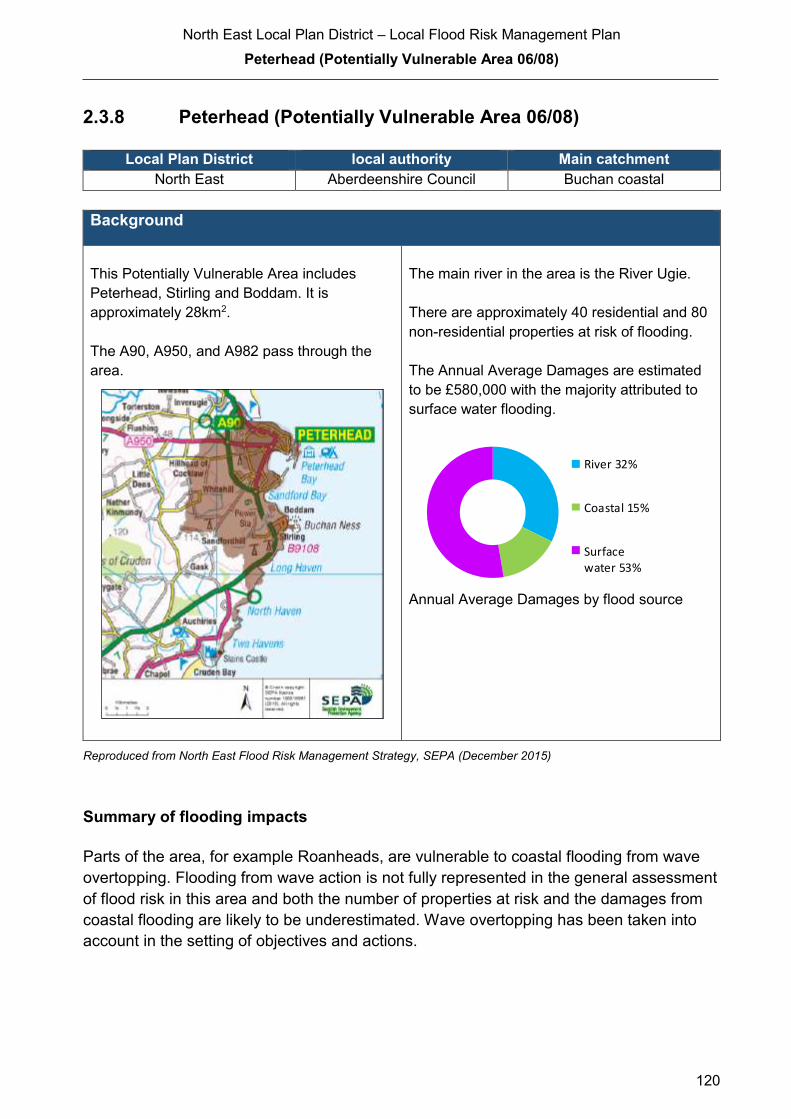
North East Local Plan District – Local Flood Risk Management Plan
Peterhead (Potentially Vulnerable Area 06/08)
120
2.3.8 Peterhead (Potentially Vulnerable Area 06/08)
Local Plan District local authority Main catchment North East Aberdeenshire Council Buchan coastal
Background
This Potentially Vulnerable Area includes
Peterhead, Stirling and Boddam. It is
approximately 28km2.
The A90, A950, and A982 pass through the
area.
The main river in the area is the River Ugie.
There are approximately 40 residential and 80
non-residential properties at risk of flooding.
The Annual Average Damages are estimated
to be £580,000 with the majority attributed to
surface water flooding.
Annual Average Damages by flood source
Reproduced from North East Flood Risk Management Strategy, SEPA (December 2015)
Summary of flooding impacts
Parts of the area, for example Roanheads, are vulnerable to coastal flooding from wave
overtopping. Flooding from wave action is not fully represented in the general assessment
of flood risk in this area and both the number of properties at risk and the damages from
coastal flooding are likely to be underestimated. Wave overtopping has been taken into
account in the setting of objectives and actions.
River 32%
Coastal 15%
Surfacewater 53%
North East Local Plan District – Local Flood Risk Management Plan
Peterhead (Potentially Vulnerable Area 06/08)
121
River flooding is associated with the Ugie and its tributary, the Collie Burn, as well as from
the Millbank Burn. There are widespread areas of surface water flood risk notably
affecting the A90 at Stirling village and Boddam.
Transport links at risk of flooding include significant lengths of the A90, the A980 and
A950. One designated cultural heritage site and small areas of designated environmental
sites are also at risk.
For this Potentially Vulnerable Area the highest damages are to non-residential properties.
History of flooding
Peterhead was flooded in 1881 and 1882 by the River Ugie. There have been 15 floods
since 2002, with the majority being related to surface water. The areas affected include
Wood End House, Upperton Industrial Estate, Howe of Buchan, Lendrum Terrace, Station
Road/A90 junction, Queen Street, Mallard Drive, central Peterhead, Braehead Crescent,
Balmoor Terrace, Springbank, River View, A90 bypass, A950, Forman Drive, Schivas
Road, Petergrange Road, Hawthorn Road, Geary Place and Crossfolds Crescent.
4 properties were affected as a result of flooding events in December 2015
Properties on Catto Drive, Collieburn Crescent, Golf Road, Riverside Drive and York
Street experienced surface water flooding in August 2012; several properties were
evacuated during this event.
In the 1953 North Sea flood, Peterhead was badly affected with many cottages being
washed away. More recently, in December 2012, around 30 people were evacuated from
the Roanheads area of the town due to coastal flooding, which was exacerbated by wave
overtopping.
Objectives to manage flooding in Potentially Vulnerable Area 06/08
Objectives provide a common goal and shared ambition for managing floods. These
objectives have been set by SEPA and agreed with flood risk management authorities
following consultation. They were identified through an assessment of the underlying
evidence of the causes and impacts of flooding. Target areas have been set to focus
actions; they do not necessarily correspond to areas at risk in SEPA’s flood map. The
objectives below have been set for Peterhead Potentially Vulnerable Area.
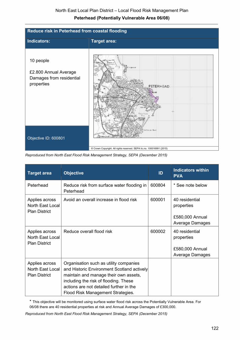
North East Local Plan District – Local Flood Risk Management Plan
Peterhead (Potentially Vulnerable Area 06/08)
122
Reduce risk in Peterhead from coastal flooding
Indicators: Target area:
10 people
£2.800 Annual Average
Damages from residential
properties
Objective ID: 600801
© Crown Copyright. All rights reserved. SEPA lic.no. 100016991 (2015)
Reproduced from North East Flood Risk Management Strategy, SEPA (December 2015)
Target area Objective ID Indicators within
PVA
Peterhead Reduce risk from surface water flooding in
Peterhead
600804 * See note below
Applies across
North East Local
Plan District
Avoid an overall increase in flood risk 600001 40 residential
properties
£580,000 Annual
Average Damages
Applies across
North East Local
Plan District
Reduce overall flood risk 600002 40 residential
properties
£580,000 Annual
Average Damages
Applies across
North East Local
Plan District
Organisation such as utility companies
and Historic Environment Scotland actively
maintain and manage their own assets,
including the risk of flooding. These
actions are not detailed further in the
Flood Risk Management Strategies.
* This objective will be monitored using surface water flood risk across the Potentially Vulnerable Area. For
06/08 there are 40 residential properties at risk and Annual Average Damages of £300,000.
Reproduced from North East Flood Risk Management Strategy, SEPA (December 2015)

North East Local Plan District – Local Flood Risk Management Plan
Peterhead (Potentially Vulnerable Area 06/08)
123
Actions to manage flooding in Potentially Vulnerable Area 06/08
Actions describe where and how flood risk will be managed. These actions have been set
by SEPA and agreed with flood risk management authorities following consultation.
Selection of actions to deliver the agreed objectives was based on a detailed assessment
and comparison of economic, social and environmental criteria. The actions shaded and
then described below have been selected as the most appropriate for Peterhead
Potentially Vulnerable Area.
Selected actions
Flood protection
scheme/works
Natural flood management
works
New flood warning
Community flood action
groups
Property level protection scheme
Site protection plans
Flood protection
study
Natural flood management
study
Maintain flood warning
Awareness raising
Surface water plan/study
Emergency plans/response
Maintain flood protection scheme
Strategic mapping and
modelling
Flood forecasting
Self Help Maintenance Planning policies
The delivery of selected actions by year over the six-year plan cycle is summarised below.
Delivery of selected actions
Year 1 (2016/17) Year 2
(2017/18)
Year 3
(2018/19)
Year 4
(2019/20)
Year 5
(2020/21)
Year 6
(2021/22)
New flood warning
Awareness raising
Surface water plan/study
Emergency plans/response
Strategic mapping and modelling
(Scottish Water)
Flood forecasting
Self help
Maintenance
Planning Policy
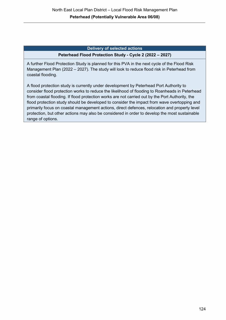
North East Local Plan District – Local Flood Risk Management Plan
Peterhead (Potentially Vulnerable Area 06/08)
124
Delivery of selected actions
Peterhead Flood Protection Study - Cycle 2 (2022 – 2027)
A further Flood Protection Study is planned for this PVA in the next cycle of the Flood Risk
Management Plan (2022 – 2027). The study will look to reduce flood risk in Peterhead from
coastal flooding.
A flood protection study is currently under development by Peterhead Port Authority to
consider flood protection works to reduce the likelihood of flooding to Roanheads in Peterhead
from coastal flooding. If flood protection works are not carried out by the Port Authority, the
flood protection study should be developed to consider the impact from wave overtopping and
primarily focus on coastal management actions, direct defences, relocation and property level
protection, but other actions may also be considered in order to develop the most sustainable
range of options.

North East Local Plan District – Local Flood Risk Management Plan
Peterhead (Potentially Vulnerable Area 06/08)
125
Action (ID): NEW FLOOD WARNING (6000020010)
Objective (ID): Reduce overall flood risk (600002)
Delivery lead: SEPA
Status: Scheduled Indicative delivery: 2017 - 2018
Description:
Flood warning is required for communities at risk of coastal flooding along the Aberdeenshire
coast from Peterhead to Montrose. A flood warning system will be developed and implemented.
The geographical extent of specific flood warning areas will be developed as part of this process.
The maintenance of SEPA’s flood warning service is funded by Scottish Government through
SEPA’s grant in aid settlement. In addition, Scottish Government provides grant funding to
enable SEPA to implement new flood warning schemes.

North East Local Plan District – Local Flood Risk Management Plan
Peterhead (Potentially Vulnerable Area 06/08)
126
Action (ID): AWARENESS RAISING (6000020013)
Objective (ID): Reduce overall flood risk (600002)
Delivery lead: Responsible authorities
Status: Existing Indicative delivery: Ongoing
Description:
Aberdeenshire Council have a duty to raise public awareness of flood risk under the Flood Risk
Management (Scotland) Act 2009 and to plan and inform of risks to communities under the Civil
Contingencies Act 2004.
Over the six years of the Plan, 2016-2022, Aberdeenshire Council will seek opportunities to raise
awareness of both flood risk and actions that enable individuals, homes and businesses to
reduce the overall impact of flooding.
In partnership with Education Scotland Aberdeenshire Council will look to engage schools in
activities relating to flooding, extreme weather, climate change and other community resilience
issues.
Aberdeenshire Council will also develop emergency response plans and work with community
flood action groups where these exist.
Awareness raising will be funded from existing local authority flood revenue budgets.
From 2016 SEPA will engage with the community through local participation in national
initiatives, including partnership working with Neighbourhood Watch Scotland. In addition, SEPA
will engage with local authorities and community resilience groups where possible.
Across Scotland, SEPA will create and share communication and education resources with other
responsible authorities. These resources will include awareness campaigns, media and
marketing activities and promotion of SEPA's flood forecasting and warning service (Floodline).
Where they exist, SEPA will engage with community resilience groups and community safety
partnerships. Additionally, SEPA's awareness raising activities will be coordinated with the
activities of other responsible authorities as required.
SEPA's awareness raising activities are funded by Scottish Government through their grant in aid
settlement and will be coordinated with the activities of other responsible authorities as required.
Scottish Water will support SEPA and responsible authorities with their awareness raising
activities as required and provide targeted flooding communications for Scottish Water specific
activities. Scottish Water will raise awareness by producing and supplying targeted information to
the public on large capital projects and detailed local studies.
(continued)
North East Local Plan District – Local Flood Risk Management Plan
Peterhead (Potentially Vulnerable Area 06/08)
127
More general information and flooding guidance will be available on the website at:
https://www.scottishwater.co.uk/you-and-your-home/your-home/flooding-information
Scottish Water will keep responsible authorities informed of its awareness raising activities
through the Local Plan District partnerships.
Action (ID): SURFACE WATER PLAN/STUDY (6008040018)
Objective (ID): Reduce risk from surface water flooding in Peterhead (600804)
Delivery lead: Aberdeenshire Council
Status: Ongoing Indicative delivery: 2016-2021
Description:
Aberdeenshire Council will undertake a study to prepare Surface Water Management Plan
(SWMP) to generate increased understanding of the causes, probability and consequences of
surface water flooding and to evaluate options for surface water flood management in Peterhead.
The study will help in preparing a coordinated action plan, supported by an understanding of the
costs and benefits, to identify measures to mitigate surface water flooding, identifying
opportunities where SuDS and similar sustainable measures can play a more significant role in
managing surface water flood risk and generate improved public engagement and understanding
of surface water flooding as well as inform future developments.
The study has the potential to benefit 40 residential properties and sections of road network at
risk of flooding in this location, with potential average annual damages avoided of up to
£300,000. A reduction in flood risk would have a positive benefit to the health and wellbeing of
the community and socially vulnerable people located within the study area and may also
contribute to enhanced biodiversity and economic activity.
The study will consider interactions with drainage system, water bodies and the sea. Additional
data and information will be procured or surveys commissioned to generate data to inform the
study. The study will take a sustainable and integrated approach by coordinating with the river
basin management plan. It will explore opportunities for enhancing biodiversity and for
promoting economic activity and social wellbeing.
Aberdeenshire Council will coordinate with Scottish Water, SEPA and community groups as well
as other relevant agencies and organisations. Aberdeenshire Council will undertake the study
through the Local Planning District (LPD) partnership and / or through separate agreements.
Funding for the study will be subject to Scottish Government’s block grant and capital support,
and budget allocations over the six years of the Plan, 2016-2022.
North East Local Plan District – Local Flood Risk Management Plan
Peterhead (Potentially Vulnerable Area 06/08)
128
Action (ID): EMERGENCY PLANS/RESPONSE (6000020014)
Objective (ID): Reduce overall flood risk (600002)
Delivery lead: Category 1 and 2 Responders
Status: Existing Indicative delivery: Ongoing
Description:
Providing an emergency response to flooding is the responsibility of many organisations,
including local authorities, the emergency services and SEPA. Effective management of an
emergency response relies on emergency plans that are prepared under the Civil Contingencies
Act 2004 by Category 1 and 2 Responders.
Aberdeenshire Council has an overarching Flood Response Plan, which is coordinated through
the Responders identified under the Civil Contingencies Act 2004. The aim of the plan is to set
out arrangements to deal effectively with flood risk. At predetermined trigger levels flood alerts
and warnings will be issued through SEPA's flood forecasting and warning service (Floodline)
and Aberdeenshire Council will conduct assessments at known hotspots and prepare resources
as required. Aberdeenshire Council will also coordinate measures in conjunction with the other
Responders. The emergency response process is coordinated through regional and local
resilience partnerships. This response may be supported by the work of voluntary organisations.
The Operational Flood Response Plan will undergo review on an annual basis to reflect
operational or responsibility changes. A debrief and plan review will also be carried out after the
Plan is activated during emergencies.
Aberdeenshire Council funding for emergency plans/response will be shared with other
organisations, emergency services and Responders, as appropriate, and will be subject to
Scottish Government’s block grant and capital support, and budget allocations over the six years
of the Plan, 2016-2022. SEPA's emergency plans/response are funded by Scottish Government
through SEPA’s grant in aid settlement.

North East Local Plan District – Local Flood Risk Management Plan
Peterhead (Potentially Vulnerable Area 06/08)
129
Action (ID): STRATEGIC MAPPING AND MODELLING (6000020019)
Objective (ID): Reduce overall flood risk (600002)
Delivery lead: Scottish Water
Status: Scheduled Indicative delivery: 2016-2019
Description:
Scottish Water will undertake further investigation and modelling in the Peterhead sewer
catchment to improve knowledge and understanding of flood risk in this area as required under
Section 16 of the Flood Risk Management (Scotland) Act 2009.
Scottish Water will work with responsible authorities to incorporate relevant information into these
studies by regularly keeping the responsible authorities informed of their progress. Scottish
Water will provide responsible authorities with the outputs of the Section 16 assessment which,
where relevant, may be used to inform Surface Water Management Plans and SEPA flood
hazard and risk maps.
Scottish Water funding is committed in its capital programme through Q&S 4a (2015-2021) which
is approved by its regulators and customers.

North East Local Plan District – Local Flood Risk Management Plan
Peterhead (Potentially Vulnerable Area 06/08)
130
Action (ID): FLOOD FORECASTING (6000020009)
Objective (ID): Reduce overall flood risk (600002)
Delivery lead: SEPA
Status: Existing Indicative delivery: Ongoing
Description:
The Scottish Flood Forecasting Service is a joint initiative between SEPA and the Met Office that
produces daily, national flood guidance statements which are issued to Category 1 and 2
Responders.
The flood guidance statements provide an assessment of the risk of flooding for a five day period
allowing responders time to put preparations in place to reduce the impact of flooding. The
service also provides information which allows SEPA to issue flood warnings, giving people a
better chance of reducing the impact of flooding on their home or business.
For more information, please visit SEPA’s website. The Potentially Vulnerable Area is within the
'Aberdeenshire and Aberdeen City' flood alert area.
Hydrological information is provided by SEPA and meteorological information is provided by the
Met Office. SEPA uses the information to predict the likelihood and timing of river, coastal and
surface water flooding.
SEPA’s flood forecasting service is funded through Scottish Government’s grant in aid allocation.
The Met Office receives funding from the UK Government.
North East Local Plan District – Local Flood Risk Management Plan
Peterhead (Potentially Vulnerable Area 06/08)
131
Action (ID): SELF HELP (6000020011)
Objective (ID): Reduce overall flood risk (600002)
Delivery lead: —
Status: Existing Indicative delivery: Ongoing
Description:
Everyone is responsible for protecting themselves and their property flooding. Property and
business owners can take simple steps to reduce damage and disruption to their homes and
businesses should flooding happen. This includes preparing a flood plan and flood kit, installing
property level protection, signing up to Floodline and Resilient Communities initiatives, and
ensuring that properties and businesses are insured against flood damage.
Aberdeenshire Council currently provide a small range of flood protection products for individual
property protection, which are available for all types of flooding, at cost price with free delivery
across Aberdeenshire.
Action (ID): MAINTENANCE (6000020007)
Objective (ID): Reduce overall flood risk (600002)
Delivery lead: Aberdeenshire Council, asset / land managers
Status: Existing Indicative delivery: Ongoing
Description:
Local authorities have a duty to assess watercourses and carry out clearance and repair works
where such works would substantially reduce flood risk. Aberdeenshire Council will produce
schedules of clearance and repair works and make these available for public inspection.
Maintenance will be funded from existing Flood revenue budgets, for works which are defined to
pose a significant flood risk.
Scottish Water undertake risk based inspection, maintenance and repair on the public sewer
network.
Asset owners and riparian landowners are responsible for the maintenance and management of
their own assets including those which help to reduce flood risk.

North East Local Plan District – Local Flood Risk Management Plan
Peterhead (Potentially Vulnerable Area 06/08)
132
Action (ID): PLANNING POLICIES (6000010001)
Objective (ID): Avoid an overall increase in flood risk (600001)
Reduce overall flood risk (600002)
Delivery lead: Planning authority
Status: Existing Indicative delivery: Ongoing
Description:
Scottish Planning Policy and accompanying Planning Advice Notes set out Scottish Ministers’
priorities for the operation of the planning system and for the development and use of land. In
terms of flood risk management, the policy supports a catchment-scale approach to sustainable
flood risk management and aims to build the resilience of our cities and towns, encourage
sustainable land management in our rural areas, and to address the long-term vulnerability of
parts of our coasts and islands. Under this approach, new development in areas with medium to
high likelihood of flooding should be avoided.
For further information on the application of national planning policies see Annex 5.
Aberdeenshire Council is a local planning authority and will work with the regional planning
authority, the Aberdeen City and Shire Strategic Development Planning Authority.
As a consultee on planning applications, Aberdeenshire Council’s Flood & Coast Protection team
will work directly with colleagues in the Planning Service to ensure that appropriate policies and
measures are put in place to reduce flood risk. Planning applications are assessed against the
flooding standards set out in the current Aberdeenshire Local Development Plan, and in future
those in the proposed Aberdeenshire Local Development Plan 2016.
SEPA has a statutory role in relation to the provision of flood risk advice to planning authorities.
This role is expressed in Section 72 of the FRM Act, 2009. SEPA also has a duty to cooperate
with planning authorities in the preparation of development plans. When consulted in relation to
planning applications for development or site allocations in development plans, and where the
planning authority considers there may be a risk of flooding, SEPA will provide advice. The
advice provided by SEPA will be with respect to the risk of flooding and on the basis of the
relevant information it holds which is suitable for planning purposes. It will also be in line with the
principles and duties set out in the FRM Act.
Further information about how SEPA engages in the planning system, including guidance on
flood risk and planning is available on SEPA’s website
http://www.sepa.org.uk/environment/land/planning/
SEPA's land use planning activities will be coordinated with the activities of other responsible
authorities as required and are funded by Scottish Government through SEPA’s grant in aid
settlement.
Scottish Water is a statutory consultee within the planning legislation and is required to comment
on all outline or full planning applications which are referred by a local authority.
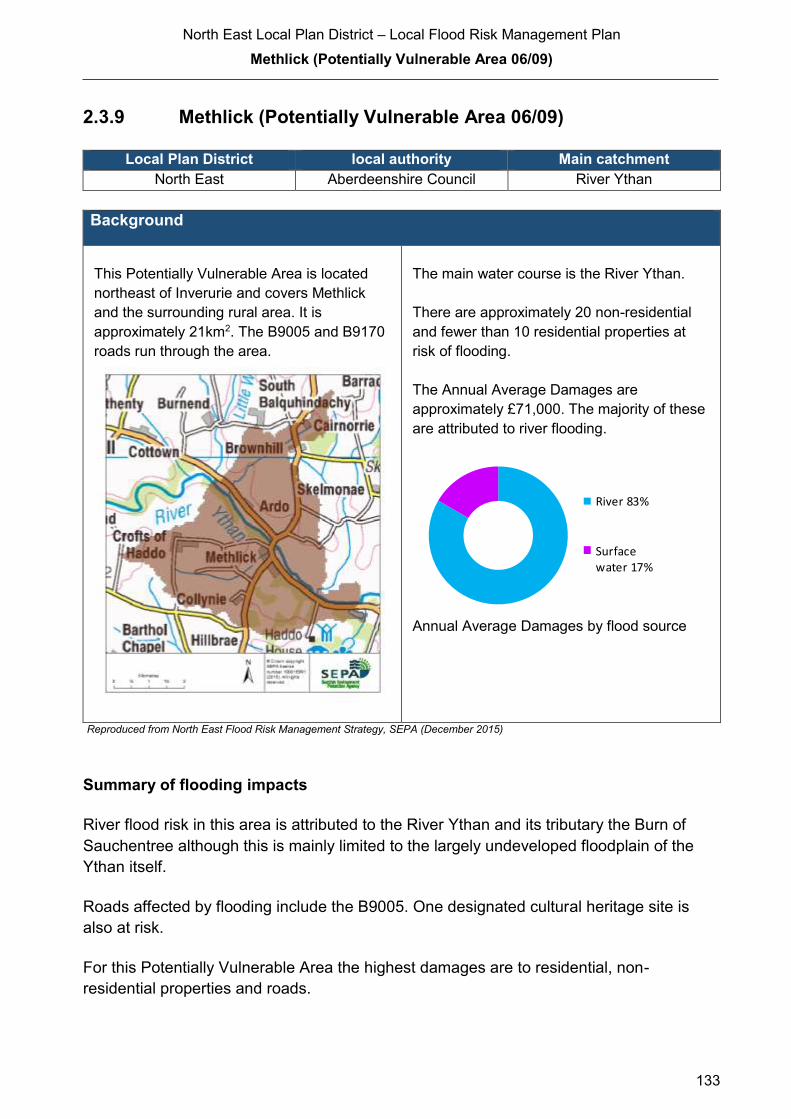
North East Local Plan District – Local Flood Risk Management Plan
Methlick (Potentially Vulnerable Area 06/09)
133
2.3.9 Methlick (Potentially Vulnerable Area 06/09)
Local Plan District local authority Main catchment North East Aberdeenshire Council River Ythan
Background
This Potentially Vulnerable Area is located
northeast of Inverurie and covers Methlick
and the surrounding rural area. It is
approximately 21km2. The B9005 and B9170
roads run through the area.
The main water course is the River Ythan.
There are approximately 20 non-residential
and fewer than 10 residential properties at
risk of flooding.
The Annual Average Damages are
approximately £71,000. The majority of these
are attributed to river flooding.
Annual Average Damages by flood source
Reproduced from North East Flood Risk Management Strategy, SEPA (December 2015)
Summary of flooding impacts
River flood risk in this area is attributed to the River Ythan and its tributary the Burn of
Sauchentree although this is mainly limited to the largely undeveloped floodplain of the
Ythan itself.
Roads affected by flooding include the B9005. One designated cultural heritage site is
also at risk.
For this Potentially Vulnerable Area the highest damages are to residential, non-
residential properties and roads.
River 83%
Surfacewater 17%
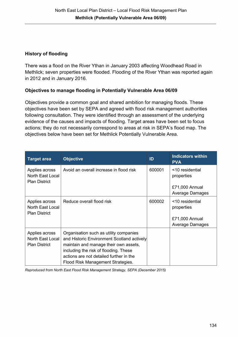
North East Local Plan District – Local Flood Risk Management Plan
Methlick (Potentially Vulnerable Area 06/09)
134
History of flooding
There was a flood on the River Ythan in January 2003 affecting Woodhead Road in
Methlick; seven properties were flooded. Flooding of the River Ythan was reported again
in 2012 and in January 2016.
Objectives to manage flooding in Potentially Vulnerable Area 06/09
Objectives provide a common goal and shared ambition for managing floods. These
objectives have been set by SEPA and agreed with flood risk management authorities
following consultation. They were identified through an assessment of the underlying
evidence of the causes and impacts of flooding. Target areas have been set to focus
actions; they do not necessarily correspond to areas at risk in SEPA’s flood map. The
objectives below have been set for Methlick Potentially Vulnerable Area.
Target area Objective ID Indicators within
PVA
Applies across
North East Local
Plan District
Avoid an overall increase in flood risk 600001 <10 residential
properties
£71,000 Annual
Average Damages
Applies across
North East Local
Plan District
Reduce overall flood risk 600002 <10 residential
properties
£71,000 Annual
Average Damages
Applies across
North East Local
Plan District
Organisation such as utility companies
and Historic Environment Scotland actively
maintain and manage their own assets,
including the risk of flooding. These
actions are not detailed further in the
Flood Risk Management Strategies.
Reproduced from North East Flood Risk Management Strategy, SEPA (December 2015)
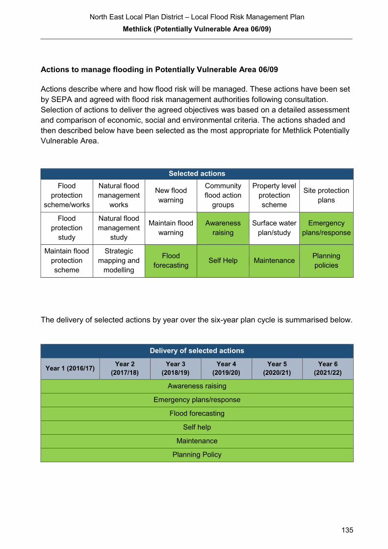
North East Local Plan District – Local Flood Risk Management Plan
Methlick (Potentially Vulnerable Area 06/09)
135
Actions to manage flooding in Potentially Vulnerable Area 06/09
Actions describe where and how flood risk will be managed. These actions have been set
by SEPA and agreed with flood risk management authorities following consultation.
Selection of actions to deliver the agreed objectives was based on a detailed assessment
and comparison of economic, social and environmental criteria. The actions shaded and
then described below have been selected as the most appropriate for Methlick Potentially
Vulnerable Area.
Selected actions
Flood
protection
scheme/works
Natural flood
management
works
New flood
warning
Community
flood action
groups
Property level
protection
scheme
Site protection
plans
Flood
protection
study
Natural flood
management
study
Maintain flood
warning
Awareness
raising
Surface water
plan/study
Emergency
plans/response
Maintain flood
protection
scheme
Strategic
mapping and
modelling
Flood
forecasting Self Help Maintenance
Planning
policies
The delivery of selected actions by year over the six-year plan cycle is summarised below.
Delivery of selected actions
Year 1 (2016/17) Year 2
(2017/18)
Year 3
(2018/19)
Year 4
(2019/20)
Year 5
(2020/21)
Year 6
(2021/22)
Awareness raising
Emergency plans/response
Flood forecasting
Self help
Maintenance
Planning Policy

North East Local Plan District – Local Flood Risk Management Plan
Methlick (Potentially Vulnerable Area 06/09)
136
Action (ID): AWARENESS RAISING (6000020013)
Objective (ID): Reduce overall flood risk (600002)
Delivery lead: Responsible authorities
Status: Existing Indicative delivery: Ongoing
Description:
Aberdeenshire Council have a duty to raise public awareness of flood risk under the Flood Risk
Management (Scotland) Act 2009 and to plan and inform of risks to communities under the Civil
Contingencies Act 2004.
Over the six years of the Plan, 2016-2022, Aberdeenshire Council will seek opportunities to raise
awareness of both flood risk and actions that enable individuals, homes and businesses to
reduce the overall impact of flooding.
In partnership with Education Scotland Aberdeenshire Council will look to engage schools in
activities relating to flooding, extreme weather, climate change and other community resilience
issues.
Aberdeenshire Council will also develop emergency response plans and work with community
flood action groups where these exist.
Awareness raising will be funded from existing local authority flood revenue budgets.
From 2016 SEPA will engage with the community through local participation in national
initiatives, including partnership working with Neighbourhood Watch Scotland. In addition, SEPA
will engage with local authorities and community resilience groups where possible.
Across Scotland, SEPA will create and share communication and education resources with other
responsible authorities. These resources will include awareness campaigns, media and
marketing activities and promotion of SEPA's flood forecasting and warning service (Floodline).
Where they exist, SEPA will engage with community resilience groups and community safety
partnerships. Additionally, SEPA's awareness raising activities will be coordinated with the
activities of other responsible authorities as required.
SEPA's awareness raising activities are funded by Scottish Government through their grant in aid
settlement and will be coordinated with the activities of other responsible authorities as required.
Scottish Water will support SEPA and responsible authorities with their awareness raising
activities as required and provide targeted flooding communications for Scottish Water specific
activities. Scottish Water will raise awareness by producing and supplying targeted information to
the public on large capital projects and detailed local studies.
(continued)

North East Local Plan District – Local Flood Risk Management Plan
Methlick (Potentially Vulnerable Area 06/09)
137
Action (ID): EMERGENCY PLANS/RESPONSE (6000020014)
Objective (ID): Reduce overall flood risk (600002)
Delivery lead: Category 1 and 2 Responders
Status: Existing Indicative delivery: Ongoing
Description:
Providing an emergency response to flooding is the responsibility of many organisations,
including local authorities, the emergency services and SEPA. Effective management of an
emergency response relies on emergency plans that are prepared under the Civil Contingencies
Act 2004 by Category 1 and 2 Responders.
Aberdeenshire Council has an overarching Flood Response Plan, which is coordinated through
the Responders identified under the Civil Contingencies Act 2004. The aim of the plan is to set
out arrangements to deal effectively with flood risk. At predetermined trigger levels flood alerts
and warnings will be issued through SEPA's flood forecasting and warning service (Floodline)
and Aberdeenshire Council will conduct assessments at known hotspots and prepare resources
as required. Aberdeenshire Council will also coordinate measures in conjunction with the other
Responders. The emergency response process is coordinated through regional and local
resilience partnerships. This response may be supported by the work of voluntary organisations.
The Operational Flood Response Plan will undergo review on an annual basis to reflect
operational or responsibility changes. A debrief and plan review will also be carried out after the
Plan is activated during emergencies.
Aberdeenshire Council funding for emergency plans/response will be shared with other
organisations, emergency services and Responders, as appropriate, and will be subject to
Scottish Government’s block grant and capital support, and budget allocations over the six years
of the Plan, 2016-2022. SEPA's emergency plans/response are funded by Scottish Government
through SEPA’s grant in aid settlement.
More general information and flooding guidance will be available on the website at:
https://www.scottishwater.co.uk/you-and-your-home/your-home/flooding-information
Scottish Water will keep responsible authorities informed of its awareness raising activities
through the Local Plan District partnerships.
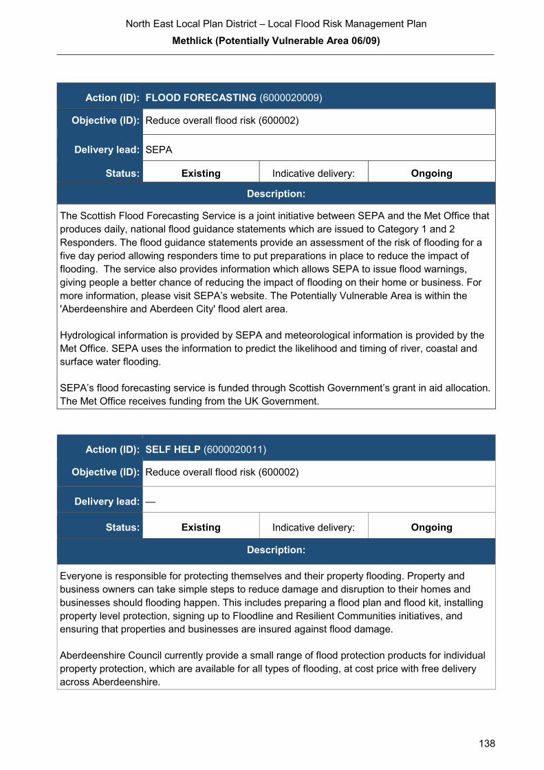
North East Local Plan District – Local Flood Risk Management Plan
Methlick (Potentially Vulnerable Area 06/09)
138
The Scottish Flood Forecasting Service is a joint initiative between SEPA and the Met Office that
produces daily, national flood guidance statements which are issued to Category 1 and 2
Responders. The flood guidance statements provide an assessment of the risk of flooding for a
five day period allowing responders time to put preparations in place to reduce the impact of
flooding. The service also provides information which allows SEPA to issue flood warnings,
giving people a better chance of reducing the impact of flooding on their home or business. For
more information, please visit SEPA’s website. The Potentially Vulnerable Area is within the
'Aberdeenshire and Aberdeen City' flood alert area.
Hydrological information is provided by SEPA and meteorological information is provided by the
Met Office. SEPA uses the information to predict the likelihood and timing of river, coastal and
surface water flooding.
SEPA’s flood forecasting service is funded through Scottish Government’s grant in aid allocation.
The Met Office receives funding from the UK Government.
Action (ID): SELF HELP (6000020011)
Objective (ID): Reduce overall flood risk (600002)
Delivery lead: —
Status: Existing Indicative delivery: Ongoing
Description:
Everyone is responsible for protecting themselves and their property flooding. Property and
business owners can take simple steps to reduce damage and disruption to their homes and
businesses should flooding happen. This includes preparing a flood plan and flood kit, installing
property level protection, signing up to Floodline and Resilient Communities initiatives, and
ensuring that properties and businesses are insured against flood damage.
Aberdeenshire Council currently provide a small range of flood protection products for individual
property protection, which are available for all types of flooding, at cost price with free delivery
across Aberdeenshire.
Action (ID): FLOOD FORECASTING (6000020009)
Objective (ID): Reduce overall flood risk (600002)
Delivery lead: SEPA
Status: Existing Indicative delivery: Ongoing
Description:

North East Local Plan District – Local Flood Risk Management Plan
Methlick (Potentially Vulnerable Area 06/09)
139
Action (ID): MAINTENANCE (6000020007)
Objective (ID): Reduce overall flood risk (600002)
Delivery lead: Aberdeenshire Council, asset / land managers
Status: Existing Indicative delivery: Ongoing
Description:
Local authorities have a duty to assess watercourses and carry out clearance and repair works
where such works would substantially reduce flood risk. Aberdeenshire Council will produce
schedules of clearance and repair works and make these available for public inspection.
Maintenance will be funded from existing Flood revenue budgets, for works which are defined to
pose a significant flood risk.
Scottish Water undertake risk based inspection, maintenance and repair on the public sewer
network together with keeping responsible authorities informed of large scale capital
maintenance work to identify opportunities for co-ordination.
Action (ID): PLANNING POLICIES (6000010001)
Objective (ID): Avoid an overall increase in flood risk (600001)
Reduce overall flood risk (600002)
Delivery lead: Planning authority
Status: Existing Indicative delivery: Ongoing
Description:
Scottish Planning Policy and accompanying Planning Advice Notes set out Scottish Ministers’
priorities for the operation of the planning system and for the development and use of land. In
terms of flood risk management, the policy supports a catchment-scale approach to sustainable
flood risk management and aims to build the resilience of our cities and towns, encourage
sustainable land management in our rural areas, and to address the long-term vulnerability of
parts of our coasts and islands. Under this approach, new development in areas with medium to
high likelihood of flooding should be avoided.
For further information on the application of national planning policies see Annex 5.
Aberdeenshire Council is a local planning authority and will work with the regional planning
authority, the Aberdeen City and Shire Strategic Development Planning Authority.
(continued)

North East Local Plan District – Local Flood Risk Management Plan
Methlick (Potentially Vulnerable Area 06/09)
140
As a consultee on planning applications, Aberdeenshire Council’s Flood & Coast Protection team
will work directly with colleagues in the Planning Service to ensure that appropriate policies and
measures are put in place to reduce flood risk. Planning applications are assessed against the
flooding standards set out in the current Aberdeenshire Local Development Plan, and in future
those in the proposed Aberdeenshire Local Development Plan 2016.
SEPA has a statutory role in relation to the provision of flood risk advice to planning authorities.
This role is expressed in Section 72 of the FRM Act, 2009. SEPA also has a duty to cooperate
with planning authorities in the preparation of development plans. When consulted in relation to
planning applications for development or site allocations in development plans, and where the
planning authority considers there may be a risk of flooding, SEPA will provide advice. The
advice provided by SEPA will be with respect to the risk of flooding and on the basis of the
relevant information it holds which is suitable for planning purposes. It will also be in line with the
principles and duties set out in the FRM Act. Further information about how SEPA engages in
the planning system, including guidance on flood risk and planning is available on SEPA’s
website http://www.sepa.org.uk/environment/land/planning/
SEPA's land use planning activities will be coordinated with the activities of other responsible
authorities as required and are funded by Scottish Government through SEPA’s grant in aid
settlement.
Scottish Water is a statutory consultee within the planning legislation and is required to comment
on all outline or full planning applications which are referred by a local authority.

North East Local Plan District – Local Flood Risk Management Plan Huntly (Potentially Vulnerable Area 06/10)
141
2.3.10 Huntly (Potentially Vulnerable Area 06/10)
Local Plan District local authority Main catchment North East Aberdeenshire Council River Deveron
Background
This Potentially Vulnerable Area includes
Huntly and the rural area to the south. It is
approximately 20km².
The A96, A97 and A920 pass through the
area.
The River Deveron and the River Bogie are
the main rivers in this area.
There are approximately 110 residential and
50 non-residential properties at risk of flooding.
The Annual Average Damages are
approximately £450,000 with the majority due
to river flooding.
Annual Average Damages by flood source
Reproduced from North East Flood Risk Management Strategy, SEPA (December 2015)
Summary of flooding impacts
River flood risk is primarily focused on the Meadows area in the north of Huntly. This
coincides with the floodplain of the Deveron and the Meadow Burn. There are localised
areas of surface water flood risk throughout Huntly.
A nursing home, roads including the A96 A97 and A920, and the Aberdeen to Inverness
railway line are at risk of flooding. Four designated cultural heritage sites are also at risk
within this area.
For this Potentially Vulnerable Area the highest damages are to residential properties
followed by damages to non-residential properties.
River 84%
Surfacewater 16%

North East Local Plan District – Local Flood Risk Management Plan Huntly (Potentially Vulnerable Area 06/10)
142
History of flooding
Huntly has flooded from the River Deveron, River Bogie and Meadow Burn. Residents in
the Meadows area have been evacuated on several occasions in recent years.
The earliest recorded flood was in 1829 when the town was surrounded by water and
bridges destroyed by the Bogie and Deveron. There are also floods recorded from the
Bogie in 1865, 1872, 1878 and 1881. The Deveron caused flooding in 1839, 1865, 1869,
1874 and 1881.
More recently, there was flooding of the Meadows area in 1995 and a further 12 floods
have been recorded since 1997 from various sources including the Ittingstone Burn,
Meadows Burn (2009), the Bogie (2002, 2003, 2005, and 2006) and the Deveron (2009).
The highest impact flood on record occurred in November 2009 when over 100 people
had to be evacuated from the Meadows area, including from a nursing home, due to
flooding from the Meadows Burn.
Flooding from surface water runoff has also been recorded at various locations in Huntly.
These floods have affected properties, roads, caravan parks, car parks and a care home.
The areas of Huntly which have been affected include central, south east, and east
Huntly, including Bleachfield Street, Burnside Road, Green Road and Glamourhaugh,
George Street, and the Meadows area.
Objectives to manage flooding in Potentially Vulnerable Area 06/10
Objectives provide a common goal and shared ambition for managing floods. These
objectives have been set by SEPA and agreed with flood risk management authorities
following consultation. They were identified through an assessment of the underlying
evidence of the causes and impacts of flooding. Target areas have been set to focus
actions; they do not necessarily correspond to areas at risk in SEPA’s flood map. The
objectives below have been set for Huntly Potentially Vulnerable Area
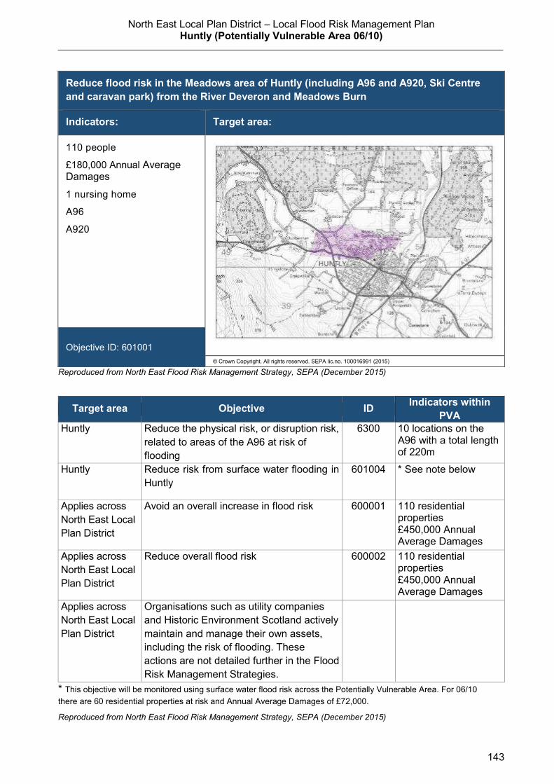
North East Local Plan District – Local Flood Risk Management Plan Huntly (Potentially Vulnerable Area 06/10)
143
Reproduced from North East Flood Risk Management Strategy, SEPA (December 2015)
Target area Objective ID Indicators within
PVA
Huntly Reduce the physical risk, or disruption risk,
related to areas of the A96 at risk of
flooding
6300 10 locations on the A96 with a total length of 220m
Huntly Reduce risk from surface water flooding in
Huntly
601004 * See note below
Applies across
North East Local
Plan District
Avoid an overall increase in flood risk 600001 110 residential properties
£450,000 Annual Average Damages
Applies across
North East Local
Plan District
Reduce overall flood risk 600002 110 residential properties
£450,000 Annual Average Damages
Applies across
North East Local
Plan District
Organisations such as utility companies
and Historic Environment Scotland actively
maintain and manage their own assets,
including the risk of flooding. These
actions are not detailed further in the Flood
Risk Management Strategies.
* This objective will be monitored using surface water flood risk across the Potentially Vulnerable Area. For 06/10
there are 60 residential properties at risk and Annual Average Damages of £72,000.
Reproduced from North East Flood Risk Management Strategy, SEPA (December 2015)
Reduce flood risk in the Meadows area of Huntly (including A96 and A920, Ski Centre
and caravan park) from the River Deveron and Meadows Burn
Indicators: Target area:
110 people
£180,000 Annual Average Damages
1 nursing home
A96
A920
Objective ID: 601001
© Crown Copyright. All rights reserved. SEPA lic.no. 100016991 (2015)
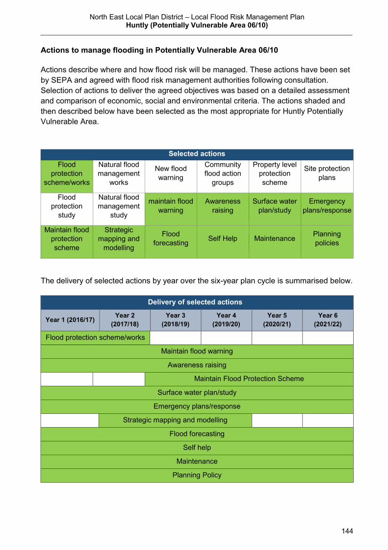
North East Local Plan District – Local Flood Risk Management Plan Huntly (Potentially Vulnerable Area 06/10)
144
Actions to manage flooding in Potentially Vulnerable Area 06/10
Actions describe where and how flood risk will be managed. These actions have been set
by SEPA and agreed with flood risk management authorities following consultation.
Selection of actions to deliver the agreed objectives was based on a detailed assessment
and comparison of economic, social and environmental criteria. The actions shaded and
then described below have been selected as the most appropriate for Huntly Potentially
Vulnerable Area.
Selected actions
Flood
protection
scheme/works
Natural flood
management
works
New flood
warning
Community
flood action
groups
Property level
protection
scheme
Site protection
plans
Flood
protection
study
Natural flood
management
study
maintain flood
warning
Awareness
raising
Surface water
plan/study
Emergency
plans/response
Maintain flood
protection
scheme
Strategic
mapping and
modelling
Flood
forecasting Self Help Maintenance
Planning
policies
The delivery of selected actions by year over the six-year plan cycle is summarised below.
Delivery of selected actions
Year 1 (2016/17) Year 2
(2017/18)
Year 3
(2018/19)
Year 4
(2019/20)
Year 5
(2020/21)
Year 6
(2021/22)
Flood protection scheme/works
Maintain flood warning
Awareness raising
Maintain Flood Protection Scheme
Surface water plan/study
Emergency plans/response
Strategic mapping and modelling
Flood forecasting
Self help
Maintenance
Planning Policy

North East Local Plan District – Local Flood Risk Management Plan Huntly (Potentially Vulnerable Area 06/10)
145
Action (ID): FLOOD PROTECTION SCHEME/WORKS (6010010006)
Objective (ID): Reduce flood risk in the Meadows area of Huntly (including A96 and A920,
Ski Centre and caravan park) from the River Deveron and Meadows Burn
(601001)
Delivery lead: Aberdeenshire Council
Priority: National: Within local authority:
33 of 42 2 of 2
Status: Under development Indicative delivery: 2016-2017
Description:
The detailed modelling has shown that a combination of raised defences on the River Deveron,
increasing the conveyance on selected culverts on the Ittingstone and Meadow Burns and the
provision of storage on the Meadow Burn are the most effective methods of providing flood risk
mitigation for the community of Huntly. The scheme will provide a defence standard of 1 in 200
years, which will reduce the flood risk to 0.5% chance of flooding in any given year. The works
broadly comprise of the following elements:
Raised defences on the right bank of the River Deveron from Arnhall Cottages to Milton Farm
(either next to the river or set back against the A920)
Increasing the size of the culvert on the Ittingstone Burn below the A920 and constructing raised
defences adjacent to the road and on the right bank of the burn
Raising and strengthening the existing defences on the river Deveron between the Bridge
of Gibston and the Hill of Haugh
Constructing raised defences to the east and south of the caravan park
Replacing one undersize culvert on the Meadow Burn with a timber footbridge
Creating local storage to the west of the Meadows estate by constricting the flow in the
Meadow Burn to a figure that can be accommodated by the downstream channel and
culvert systems
Various headwalls, culverts and drainage improvements
Construction will commence in Summer 2016 for a duration of around 9 months.
It is anticipated that the Huntly Flood Protection Scheme will be eligible for 80% funding from the
Scottish Government’s Flooding Component of the General Capital Grant. The remaining funding
will be met from the Harbours, Coast & Flooding line from Aberdeenshire Council’s Capital Plan
2015-2031
(continued)

North East Local Plan District – Local Flood Risk Management Plan Huntly (Potentially Vulnerable Area 06/10)
146
Action (ID): MAINTAIN FLOOD WARNING (6000020030)
Objective (ID): Reduce overall flood risk (600002)
Delivery lead: SEPA
Status: Existing Indicative delivery: Ongoing
Description:
SEPA will continue to maintain the 'Huntly (Bogie)' flood warning area which is on the River
Bogie and the 'Milton and The Meadows' flood warning area. Both form part of the Deveron river
flood warning scheme. When flood events occur in an area with an existing flood warning
service, SEPA will seek to verify the flood forecasts and warnings. SEPA will use feedback and
post-event data to ensure that our flood warning service is timely and accurate.
A flood protection scheme is proposed for Huntly. SEPA will work with the local authority to
ensure that changes to hydrology and flood risk as a result of the proposed flood protection
scheme are fully considered in the existing flood warning system.
The maintenance of SEPA’s flood warning service is funded by Scottish Government through
SEPA’s grant in aid settlement.
Potential impacts
Economic:
The flood protection scheme will reduce flood risk to 50 residential
properties and 13 non-residential properties, with estimated damages
avoided of £3.4 million. The benefit cost ratio of the proposed works is 1.1.
Social:
The flood protection scheme will reduce risk to an estimated 110 people. A
reduction in flood risk would have a positive benefit to the health and
wellbeing of the community and socially vulnerable people. There are a
higher than average number of vulnerable people in the area who will
benefit from the works. The nursing home, A96 and A920, ski centre and
caravan park would also benefit from reduced flood risk.
Environmental: Flood protection works can have both positive and negative impacts on the
ecological quality of the environment depending on how they are designed.
In Huntly, the embankments are set back from the river and are likely to
improve the ecological quality. One scheduled monument would benefit from
reduced risk of flooding. Actions taken to minimise the impacts to the
environment include use of shallow sloping defences to reduce the visual
impacts. There are no designated habitat sites close to the area.

North East Local Plan District – Local Flood Risk Management Plan Huntly (Potentially Vulnerable Area 06/10)
147
Action (ID): AWARENESS RAISING (6000020013)
Objective (ID): Reduce overall flood risk (600002)
Delivery lead: Responsible authorities
Status: Existing Indicative delivery: Ongoing
Description:
Aberdeenshire Council have a duty to raise public awareness of flood risk under the Flood Risk
Management (Scotland) Act 2009 and to plan and inform of risks to communities under the Civil
Contingencies Act 2004.
Over the six years of the Plan, 2016-2022, Aberdeenshire Council will seek opportunities to raise
awareness of both flood risk and actions that enable individuals, homes and businesses to
reduce the overall impact of flooding.
In partnership with Education Scotland Aberdeenshire Council will look to engage schools in
activities relating to flooding, extreme weather, climate change and other community resilience
issues.
Aberdeenshire Council will also develop emergency response plans and work with community
flood action groups where these exist.
Awareness raising will be funded from existing local authority flood revenue budgets.
A flood protection scheme is proposed for Huntly. For the new flood protection scheme, SEPA
will support the local authority’s communications and engagement activities with media activity,
local public awareness events and education engagement with schools. SEPA will also deliver
joint communications with local authorities for Floodline customers in any newly protected flood
warning area.
From 2016 SEPA will engage with the community through local participation in national
initiatives, including partnership working with Neighbourhood Watch Scotland. In addition, SEPA
will engage with local authorities and community resilience groups where possible.
Across Scotland, SEPA will create and share communication and education resources with other
responsible authorities. These resources will include awareness campaigns, media and
marketing activities and promotion of SEPA's flood forecasting and warning service (Floodline).
Where they exist, SEPA will engage with community resilience groups and community safety
partnerships. Additionally, SEPA's awareness raising activities will be coordinated with the
activities of other responsible authorities as required.
(continued)
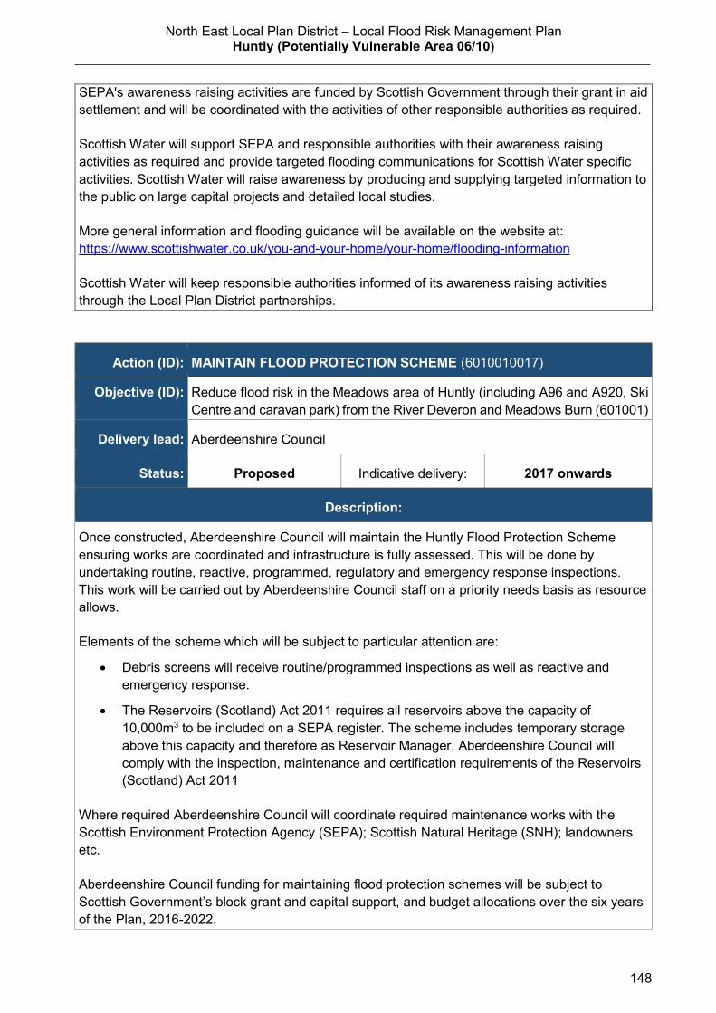
North East Local Plan District – Local Flood Risk Management Plan Huntly (Potentially Vulnerable Area 06/10)
148
SEPA's awareness raising activities are funded by Scottish Government through their grant in aid
settlement and will be coordinated with the activities of other responsible authorities as required.
Scottish Water will support SEPA and responsible authorities with their awareness raising
activities as required and provide targeted flooding communications for Scottish Water specific
activities. Scottish Water will raise awareness by producing and supplying targeted information to
the public on large capital projects and detailed local studies.
More general information and flooding guidance will be available on the website at:
https://www.scottishwater.co.uk/you-and-your-home/your-home/flooding-information
Scottish Water will keep responsible authorities informed of its awareness raising activities
through the Local Plan District partnerships.
Action (ID): MAINTAIN FLOOD PROTECTION SCHEME (6010010017)
Objective (ID): Reduce flood risk in the Meadows area of Huntly (including A96 and A920, Ski
Centre and caravan park) from the River Deveron and Meadows Burn (601001)
Delivery lead: Aberdeenshire Council
Status: Proposed Indicative delivery: 2017 onwards
Description:
Once constructed, Aberdeenshire Council will maintain the Huntly Flood Protection Scheme
ensuring works are coordinated and infrastructure is fully assessed. This will be done by
undertaking routine, reactive, programmed, regulatory and emergency response inspections.
This work will be carried out by Aberdeenshire Council staff on a priority needs basis as resource
allows.
Elements of the scheme which will be subject to particular attention are:
Debris screens will receive routine/programmed inspections as well as reactive and
emergency response.
The Reservoirs (Scotland) Act 2011 requires all reservoirs above the capacity of
10,000m3 to be included on a SEPA register. The scheme includes temporary storage
above this capacity and therefore as Reservoir Manager, Aberdeenshire Council will
comply with the inspection, maintenance and certification requirements of the Reservoirs
(Scotland) Act 2011
Where required Aberdeenshire Council will coordinate required maintenance works with the
Scottish Environment Protection Agency (SEPA); Scottish Natural Heritage (SNH); landowners
etc.
Aberdeenshire Council funding for maintaining flood protection schemes will be subject to
Scottish Government’s block grant and capital support, and budget allocations over the six years
of the Plan, 2016-2022.
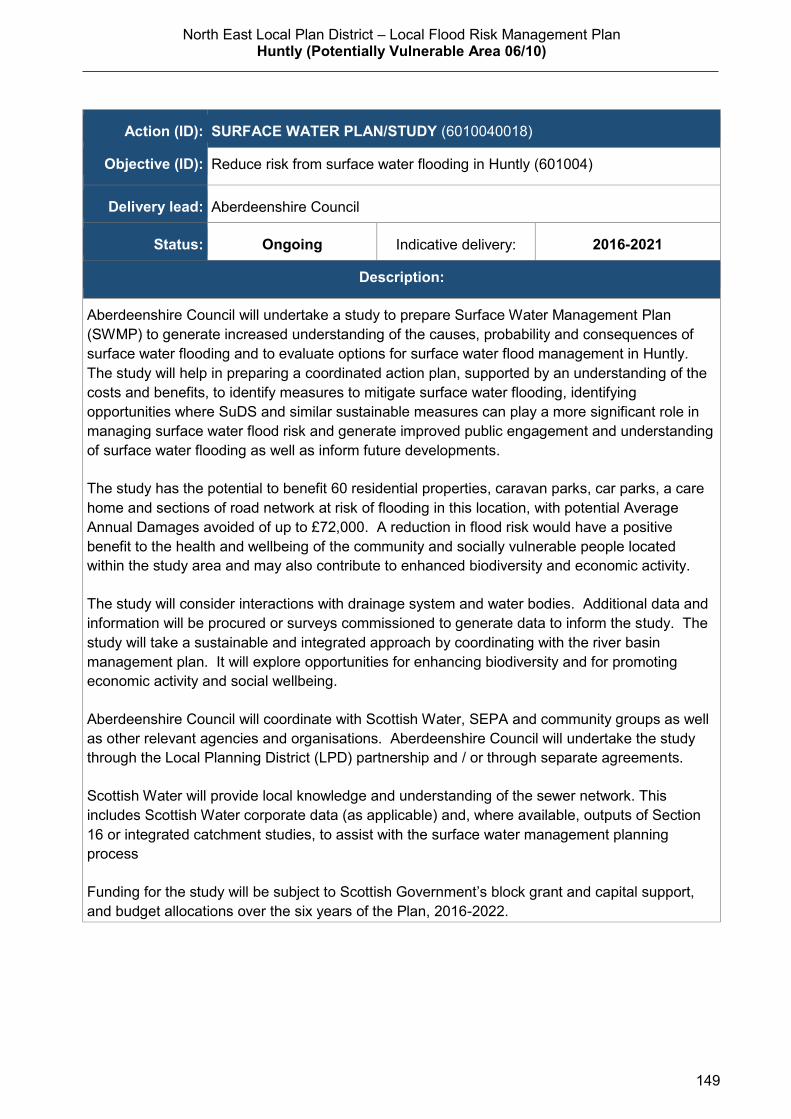
North East Local Plan District – Local Flood Risk Management Plan Huntly (Potentially Vulnerable Area 06/10)
149
Action (ID): SURFACE WATER PLAN/STUDY (6010040018)
Objective (ID): Reduce risk from surface water flooding in Huntly (601004)
Delivery lead: Aberdeenshire Council
Status: Ongoing Indicative delivery: 2016-2021
Description:
Aberdeenshire Council will undertake a study to prepare Surface Water Management Plan
(SWMP) to generate increased understanding of the causes, probability and consequences of
surface water flooding and to evaluate options for surface water flood management in Huntly.
The study will help in preparing a coordinated action plan, supported by an understanding of the
costs and benefits, to identify measures to mitigate surface water flooding, identifying
opportunities where SuDS and similar sustainable measures can play a more significant role in
managing surface water flood risk and generate improved public engagement and understanding
of surface water flooding as well as inform future developments.
The study has the potential to benefit 60 residential properties, caravan parks, car parks, a care
home and sections of road network at risk of flooding in this location, with potential Average
Annual Damages avoided of up to £72,000. A reduction in flood risk would have a positive
benefit to the health and wellbeing of the community and socially vulnerable people located
within the study area and may also contribute to enhanced biodiversity and economic activity.
The study will consider interactions with drainage system and water bodies. Additional data and
information will be procured or surveys commissioned to generate data to inform the study. The
study will take a sustainable and integrated approach by coordinating with the river basin
management plan. It will explore opportunities for enhancing biodiversity and for promoting
economic activity and social wellbeing.
Aberdeenshire Council will coordinate with Scottish Water, SEPA and community groups as well
as other relevant agencies and organisations. Aberdeenshire Council will undertake the study
through the Local Planning District (LPD) partnership and / or through separate agreements.
Scottish Water will provide local knowledge and understanding of the sewer network. This
includes Scottish Water corporate data (as applicable) and, where available, outputs of Section
16 or integrated catchment studies, to assist with the surface water management planning
process
Funding for the study will be subject to Scottish Government’s block grant and capital support,
and budget allocations over the six years of the Plan, 2016-2022.

North East Local Plan District – Local Flood Risk Management Plan Huntly (Potentially Vulnerable Area 06/10)
150
Action (ID): EMERGENCY PLANS/RESPONSE (6000020014)
Objective (ID): Reduce overall flood risk (600002)
Delivery lead: Category 1 and 2 Responders
Status: Existing Indicative delivery: Ongoing
Description:
Providing an emergency response to flooding is the responsibility of many organisations,
including local authorities, the emergency services and SEPA. Effective management of an
emergency response relies on emergency plans that are prepared under the Civil Contingencies
Act 2004 by Category 1 and 2 Responders.
There are two containers of sand bags, which can be accessed by members of the community
for deployment in the event of a flood warning, within the Meadows area in Huntly.
Aberdeenshire Council also operates a flood monitor on the Meadows Burn to provide early
warning of potential flooding.
Aberdeenshire Council has an overarching Flood Response Plan, which is coordinated through
the Responders identified under the Civil Contingencies Act 2004. The aim of the plan is to set
out arrangements to deal effectively with flood risk. At predetermined trigger levels flood alerts
and warnings will be issued through SEPA's flood forecasting and warning service (Floodline)
and Aberdeenshire Council will conduct assessments at known hotspots and prepare resources
as required. Aberdeenshire Council will also coordinate measures in conjunction with the other
Responders. The emergency response process is coordinated through regional and local
resilience partnerships. This response may be supported by the work of voluntary organisations.
The Operational Flood Response Plan will undergo review on an annual basis to reflect
operational or responsibility changes. A debrief and plan review will also be carried out after the
Plan is activated during emergencies.
Scottish will support regional and local resilience partnerships as required. Aberdeenshire
Council funding for emergency plans/response will be shared with other organisations,
emergency services and Responders, as appropriate, and will be subject to Scottish
Government’s block grant and capital support, and budget allocations over the six years of the
Plan, 2016-2022. SEPA's emergency plans/response are funded by Scottish Government
through SEPA’s grant in aid settlement.
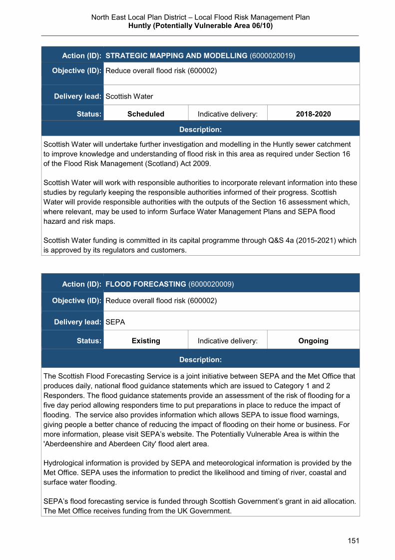
North East Local Plan District – Local Flood Risk Management Plan Huntly (Potentially Vulnerable Area 06/10)
151
Action (ID): STRATEGIC MAPPING AND MODELLING (6000020019)
Objective (ID): Reduce overall flood risk (600002)
Delivery lead: Scottish Water
Status: Scheduled Indicative delivery: 2018-2020
Description:
Scottish Water will undertake further investigation and modelling in the Huntly sewer catchment
to improve knowledge and understanding of flood risk in this area as required under Section 16
of the Flood Risk Management (Scotland) Act 2009.
Scottish Water will work with responsible authorities to incorporate relevant information into these
studies by regularly keeping the responsible authorities informed of their progress. Scottish
Water will provide responsible authorities with the outputs of the Section 16 assessment which,
where relevant, may be used to inform Surface Water Management Plans and SEPA flood
hazard and risk maps.
Scottish Water funding is committed in its capital programme through Q&S 4a (2015-2021) which
is approved by its regulators and customers.
Action (ID): FLOOD FORECASTING (6000020009)
Objective (ID): Reduce overall flood risk (600002)
Delivery lead: SEPA
Status: Existing Indicative delivery: Ongoing
Description:
The Scottish Flood Forecasting Service is a joint initiative between SEPA and the Met Office that
produces daily, national flood guidance statements which are issued to Category 1 and 2
Responders. The flood guidance statements provide an assessment of the risk of flooding for a
five day period allowing responders time to put preparations in place to reduce the impact of
flooding. The service also provides information which allows SEPA to issue flood warnings,
giving people a better chance of reducing the impact of flooding on their home or business. For
more information, please visit SEPA’s website. The Potentially Vulnerable Area is within the
'Aberdeenshire and Aberdeen City' flood alert area.
Hydrological information is provided by SEPA and meteorological information is provided by the
Met Office. SEPA uses the information to predict the likelihood and timing of river, coastal and
surface water flooding.
SEPA’s flood forecasting service is funded through Scottish Government’s grant in aid allocation.
The Met Office receives funding from the UK Government.

North East Local Plan District – Local Flood Risk Management Plan Huntly (Potentially Vulnerable Area 06/10)
152
Action (ID): SELF HELP (6000020011)
Objective (ID): Reduce overall flood risk (600002)
Delivery lead: —
Status: Existing Indicative delivery: Ongoing
Description:
Everyone is responsible for protecting themselves and their property from flooding.
Property and business owners can take simple steps to reduce damage and disruption to their
homes and businesses should flooding happen. This includes preparing a flood plan and flood
kit, installing property level protection, signing up to Floodline and Resilient Communities
initiatives, and ensuring that properties and businesses are insured against flood damage.
Aberdeenshire Council currently provide a small range of flood protection products for individual
property protection, which are available for all types of flooding, at cost price with free delivery
across Aberdeenshire.
Action (ID): MAINTENANCE (6000020007)
Objective (ID): Reduce overall flood risk (600002)
Delivery lead: Aberdeenshire Council, asset / land managers
Status: Existing Indicative delivery: Ongoing
Description:
Local authorities have a duty to assess watercourses and carry out clearance and repair works
where such works would substantially reduce flood risk. Aberdeenshire Council will produce
schedules of clearance and repair works and make these available for public inspection.
Maintenance will be funded from existing Flood revenue budgets, for works which are defined to
pose a significant flood risk.
Scottish Water undertake risk based inspection, maintenance and repair on the public sewer
network together with keeping responsible authorities informed of large scale capital
maintenance work to identify opportunities for co-ordination.
North East Local Plan District – Local Flood Risk Management Plan Huntly (Potentially Vulnerable Area 06/10)
153
Action (ID): PLANNING POLICIES (6000010001)
Objective (ID): Avoid an overall increase in flood risk (600001) Reduce overall flood risk (600002)
Delivery lead: Planning authority
Status: Existing Indicative delivery: Ongoing
Description:
Scottish Planning Policy and accompanying Planning Advice Notes set out Scottish Ministers’
priorities for the operation of the planning system and for the development and use of land. In
terms of flood risk management, the policy supports a catchment-scale approach to sustainable
flood risk management and aims to build the resilience of our cities and towns, encourage
sustainable land management in our rural areas, and to address the long-term vulnerability of
parts of our coasts and islands. Under this approach, new development in areas with medium to
high likelihood of flooding should be avoided.
For further information on the application of national planning policies see Annex 5.
Aberdeenshire Council is a local planning authority and will work with the regional planning
authority, the Aberdeen City and Shire Strategic Development Planning Authority.
As a consultee on planning applications, Aberdeenshire Council’s Flood & Coast Protection team
will work directly with colleagues in the Planning Service to ensure that appropriate policies and
measures are put in place to reduce flood risk. Planning applications are assessed against the
flooding standards set out in the current Aberdeenshire Local Development Plan, and in future
those in the proposed Aberdeenshire Local Development Plan 2016.
SEPA has a statutory role in relation to the provision of flood risk advice to planning authorities.
This role is expressed in Section 72 of the FRM Act, 2009. SEPA also has a duty to cooperate
with planning authorities in the preparation of development plans. When consulted in relation to
planning applications for development or site allocations in development plans, and where the
planning authority considers there may be a risk of flooding, SEPA will provide advice. The
advice provided by SEPA will be with respect to the risk of flooding and on the basis of the
relevant information it holds which is suitable for planning purposes. It will also be in line with the
principles and duties set out in the FRM Act. Further information about how SEPA engages in
the planning system, including guidance on flood risk and planning is available on SEPA’s
website http://www.sepa.org.uk/environment/land/planning/
SEPA's land use planning activities will be coordinated with the activities of other responsible
authorities as required and are funded by Scottish Government through SEPA’s grant in aid
settlement.
Scottish Water is a statutory consultee within the planning legislation and is required to comment
on all outline or full planning applications which are referred by a local authority.

North East Local Plan District – Local Flood Risk Management Plan
Insch (Potentially Vulnerable Area 06/11)
154
2.3.11 Insch (Potentially Vulnerable Area 06/11)
Local Plan District local authority Main catchment North East Aberdeenshire Council River Don
Background
This Potentially Vulnerable Area is based
around Insch and Oldtown. It is approximately
40km2. The B9002 and B992 and the
Aberdeen to Inverness railway line pass
through the area.
The main watercourse is The Shevock which
is a tributary of the River Urie.
There are approximately 80 residential and 30
non-residential properties at risk of flooding.
The Annual Average Damages are estimated
to be £250,000 with the majority caused by
river flooding.
Annual Average Damages by flood source
Reproduced from North East Flood Risk Management Strategy, SEPA (December 2015)
Summary of flooding impacts
River flood risk in this area is mainly associated with the Shevock Burn where it flows
through the southern part of town of Insch.
A hospital, one nursing home, sections of road and railway are all identified as being at
risk of flooding.
For this Potentially Vulnerable Area the highest damages are to residential properties
followed by damages to non-residential properties.
River 89%
Surfacewater 11%

North East Local Plan District – Local Flood Risk Management Plan
Insch (Potentially Vulnerable Area 06/11)
155
History of flooding
The earliest recorded floods occurred in 1864 from The Shevock and in 1879, when the
railway flooded from a burn in Insch. There were floods in 1903 and 1930 from The
Shevock, resulting in minor damage.
The highest impact flood on record within this Potentially Vulnerable Area occurred in
November 2002, when a nursing home had to be evacuated due to flooding by The
Shevock; residential properties were also affected. Local knowledge also refers to the
nursing home being affected by flooding in 1995, however SEPA have no records to
confirm this event or its impacts.
There have been seven floods since 2002 coming variously from the Valentine Burn, The
Shevock and surface water runoff. There were two floods in 2004; one in June from The
Shevock, which affected properties in southwest Insch, and the other from the Valentine
Burn in August which affected property in North West Insch. Both floods were
exacerbated by drainage systems being unable to cope with the heavy rainfall. Roads are
often affected by surface water flooding, for example in 2008 the B9002 was flooded.
26 properties were damaged as a result of flooding events in December 2015
Objectives to manage flooding in Potentially Vulnerable Area 06/11
Objectives provide a common goal and shared ambition for managing floods. These
objectives have been set by SEPA and agreed with flood risk management authorities
following consultation. They were identified through an assessment of the underlying
evidence of the causes and impacts of flooding. Target areas have been set to focus
actions; they do not necessarily correspond to areas at risk in SEPA’s flood map. The
objectives below have been set for Insch Potentially Vulnerable Area.
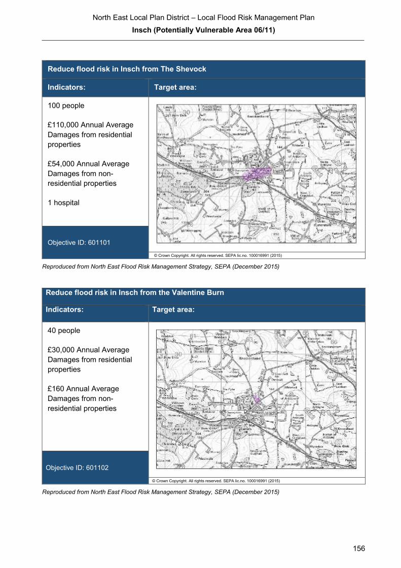
North East Local Plan District – Local Flood Risk Management Plan
Insch (Potentially Vulnerable Area 06/11)
156
Reduce flood risk in Insch from The Shevock
Indicators: Target area:
100 people
£110,000 Annual Average
Damages from residential
properties
£54,000 Annual Average
Damages from non-
residential properties
1 hospital
Objective ID: 601101
© Crown Copyright. All rights reserved. SEPA lic.no. 100016991 (2015)
Reproduced from North East Flood Risk Management Strategy, SEPA (December 2015)
Reduce flood risk in Insch from the Valentine Burn
Indicators: Target area:
40 people
£30,000 Annual Average
Damages from residential
properties
£160 Annual Average
Damages from non-
residential properties
Objective ID: 601102
© Crown Copyright. All rights reserved. SEPA lic.no. 100016991 (2015)
Reproduced from North East Flood Risk Management Strategy, SEPA (December 2015)

North East Local Plan District – Local Flood Risk Management Plan
Insch (Potentially Vulnerable Area 06/11)
157
Target area Objective ID Indicators within
PVA
Applies across
North East Local
Plan District
Avoid an overall increase in flood risk 600001 80 residential properties
£250,000 Annual Average Damages
Applies across
North East Local
Plan District
Reduce overall flood risk 600002 80 residential properties
£250,000 Annual Average Damages
Applies across
North East Local
Plan District
Organisation such as utility companies and
Historic Environment Scotland actively
maintain and manage their own assets,
including the risk of flooding. These
actions are not detailed further in the Flood
Risk Management Strategies.
Reproduced from North East Flood Risk Management Strategy, SEPA (December 2015)
Actions to manage flooding in Potentially Vulnerable Area 06/11
Actions describe where and how flood risk will be managed. These actions have been set
by SEPA and agreed with flood risk management authorities following consultation.
Selection of actions to deliver the agreed objectives was based on a detailed assessment
and comparison of economic, social and environmental criteria. The actions shaded and
then described below have been selected as the most appropriate for Insch Potentially
Vulnerable Area.
Selected actions
Flood
protection
scheme/works
Natural flood
management
works
New flood
warning
Community
flood action
groups
Property level
protection
scheme
Site protection
plans
Flood
protection
study
Natural flood
management
study
Maintain flood
warning
Awareness
raising
Surface water
plan/study
Emergency
plans/response
Maintain flood
protection
scheme
Strategic
mapping and
modelling
Flood
forecasting Self Help Maintenance
Planning
policies
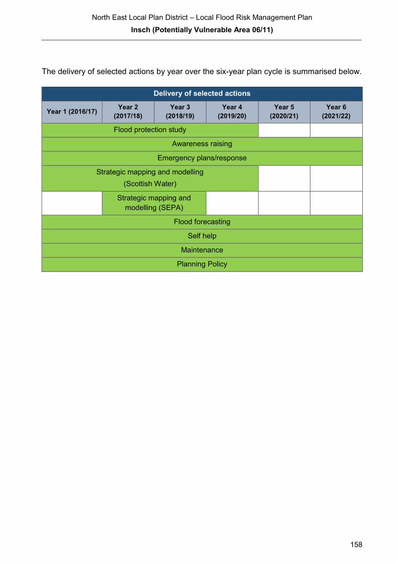
North East Local Plan District – Local Flood Risk Management Plan
Insch (Potentially Vulnerable Area 06/11)
158
The delivery of selected actions by year over the six-year plan cycle is summarised below.
Delivery of selected actions
Year 1 (2016/17) Year 2
(2017/18)
Year 3
(2018/19)
Year 4
(2019/20)
Year 5
(2020/21)
Year 6
(2021/22)
Flood protection study
Awareness raising
Emergency plans/response
Strategic mapping and modelling
(Scottish Water)
Strategic mapping and
modelling (SEPA)
Flood forecasting
Self help
Maintenance
Planning Policy
North East Local Plan District – Local Flood Risk Management Plan
Insch (Potentially Vulnerable Area 06/11)
159
Action (ID): FLOOD PROTECTION STUDY (6011010005)
Objective (ID): Reduce flood risk in Insch from the Valentine Burn (601102) Reduce flood risk in Insch from The Shevock (601101)
Delivery lead: Aberdeenshire Council
Priority:
National: Within local authority:
61 of 168 3 of 12
Status: Scheduled Indicative delivery: 2016-2021
Description:
Aberdeenshire Council will undertake a flood protection study to evaluate options for flood
management to reduce the risk of flooding in Insch from the Shevock and Valentine Burn. It is
currently estimated that the study will be completed by Summer 2019.
The study has the potential to benefit 52 residential properties, 20 non-residential properties,
sections of road network and a healthcare facility at risk of flooding in this location, with potential
damages avoided of up to £6.3 million. A reduction in flood risk would have a positive benefit to
the health and wellbeing of the community and socially vulnerable people located within the
study area and may also contribute to enhanced biodiversity and economic activity.
The study will take a sustainable and integrated approach by coordinating with the river basin
management plan. It will be undertaken with due consideration to internationally, nationally and
locally designated sites including listed buildings. It will also explore opportunities for enhancing
biodiversity and for promoting economic activity and social wellbeing.
The study will consider natural flood management measures along with traditional flood defences
by exploring opportunities for online and offline flood storage, flow control structures, modification
to conveyance capacity of watercourses by sediment and channel management, modifications to
the bridges to improve conveyance, the construction of direct defences, river / floodplain
restoration, runoff control through catchment and riparian tree planting, land-use and land-
management changes, etc. Additionally, the study will also consider property level protection and
property relocation. It is expected that the recommended flood protection scheme will comprise a
combination of such measures to ensure a sustainable and integrated approach to flood risk
management by due consideration of impacts on economy, society, environment and cultural
heritage.
Aberdeenshire Council will coordinate with SEPA, Scottish Water, SNH, The Crown Estate,
landowners and community groups as well as other relevant agencies and organisations.
Aberdeenshire Council will undertake the study through the Local Planning District (LPD)
partnership and / or through separate agreements.
Funding for the study will be subject to Scottish Government’s block grant and capital support,
and budget allocations over the six years of the Plan, 2016-2022.

North East Local Plan District – Local Flood Risk Management Plan
Insch (Potentially Vulnerable Area 06/11)
160
Potential impacts
Economic: The study could benefit 52 residential and 20 non-residential properties at risk
of flooding in this location, with potential damages avoided of up to £6.3
million.
Social:
The development of flood protection works following the study would
potentially reduce risk to 141 people. A reduction in flood risk would have a
positive benefit to the health and wellbeing of the community and socially
vulnerable people. One healthcare facility would benefit from reduced
likelihood of flooding if flood protection works provided protection to risk
floods. Natural flood management actions can restore and enhance natural
environments and create opportunities for recreation and tourism. Negative
impacts through disturbance to the local community during the construction
phase should be considered.
Environmental: Flood protection studies should consider the positive and negative impacts of
proposed actions on the ecological quality of the environment. Natural flood
management actions can have a positive impact by restoring and enhancing
natural habitats. Opportunities to mitigate any environmental impacts may
include design and timing of works. The flood protection study should
consider how to avoid or minimise potential negative effects such as loss or
disturbance of sediment.

North East Local Plan District – Local Flood Risk Management Plan
Insch (Potentially Vulnerable Area 06/11)
161
Action (ID): AWARENESS RAISING (6000020013)
Objective (ID): Reduce overall flood risk (600002)
Delivery lead: Responsible authorities
Status: Existing Indicative delivery: Ongoing
Description:
Aberdeenshire Council have a duty to raise public awareness of flood risk under the Flood Risk
Management (Scotland) Act 2009 and to plan and inform of risks to communities under the Civil
Contingencies Act 2004.
Over the six years of the Plan, 2016-2022, Aberdeenshire Council will seek opportunities to raise
awareness of both flood risk and actions that enable individuals, homes and businesses to
reduce the overall impact of flooding.
In partnership with Education Scotland Aberdeenshire Council will look to engage schools in
activities relating to flooding, extreme weather, climate change and other community resilience
issues.
Aberdeenshire Council will also develop emergency response plans and work with community
flood action groups where these exist.
Awareness raising will be funded from existing local authority flood revenue budgets.
From 2016 SEPA will engage with the community through local participation in national
initiatives, including partnership working with Neighbourhood Watch Scotland. In addition, SEPA
will engage with local authorities and community resilience groups where possible.
Across Scotland, SEPA will create and share communication and education resources with other
responsible authorities. These resources will include awareness campaigns, media and
marketing activities and promotion of SEPA's flood forecasting and warning service (Floodline).
Where they exist, SEPA will engage with community resilience groups and community safety
partnerships. Additionally, SEPA's awareness raising activities will be coordinated with the
activities of other responsible authorities as required.
SEPA's awareness raising activities are funded by Scottish Government through their grant in aid
settlement and will be coordinated with the activities of other responsible authorities as required.
Scottish Water will support SEPA and responsible authorities with their awareness raising
activities as required and provide targeted flooding communications for Scottish Water specific
activities. Scottish Water will raise awareness by producing and supplying targeted information to
the public on large capital projects and detailed local studies.
(continued)

North East Local Plan District – Local Flood Risk Management Plan
Insch (Potentially Vulnerable Area 06/11)
162
Action (ID): EMERGENCY PLANS/RESPONSE (6000020014)
Objective (ID): Reduce overall flood risk (600002)
Delivery lead: Category 1 and 2 Responders
Status: Existing Indicative delivery: Ongoing
Description:
Providing an emergency response to flooding is the responsibility of many organisations,
including local authorities, the emergency services and SEPA. Effective management of an
emergency response relies on emergency plans that are prepared under the Civil Contingencies
Act 2004 by Category 1 and 2 Responders.
Aberdeenshire Council has an overarching Flood Response Plan, which is coordinated through
the Responders identified under the Civil Contingencies Act 2004. The aim of the plan is to set
out arrangements to deal effectively with flood risk. At predetermined trigger levels flood alerts
and warnings will be issued through SEPA's flood forecasting and warning service (Floodline)
and Aberdeenshire Council will conduct assessments at known hotspots and prepare resources
as required. Aberdeenshire Council will also coordinate measures in conjunction with the other
Responders. The emergency response process is coordinated through regional and local
resilience partnerships. This response may be supported by the work of voluntary organisations.
The Operational Flood Response Plan will undergo review on an annual basis to reflect
operational or responsibility changes. A debrief and plan review will also be carried out after the
Plan is activated during emergencies.
Aberdeenshire Council funding for emergency plans/response will be shared with other
organisations, emergency services and Responders, as appropriate, and will be subject to
Scottish Government’s block grant and capital support, and budget allocations over the six years
of the Plan, 2016-2022. SEPA's emergency plans/response are funded by Scottish Government
through SEPA’s grant in aid settlement.
More general information and flooding guidance will be available on the website at:
https://www.scottishwater.co.uk/you-and-your-home/your-home/flooding-information
Scottish Water will keep responsible authorities informed of its awareness raising activities
through the Local Plan District partnerships.
North East Local Plan District – Local Flood Risk Management Plan
Insch (Potentially Vulnerable Area 06/11)
163
Action (ID): STRATEGIC MAPPING AND MODELLING (6000020019)
Objective (ID): Reduce overall flood risk (600002)
Delivery lead: Scottish Water
Status: Scheduled Indicative delivery: 2017-2020
Description:
Scottish Water will undertake further investigation and modelling in the Insch sewer catchment to
improve knowledge and understanding of flood risk in this area as required under Section 16 of
the Flood Risk Management (Scotland) Act 2009.
Scottish Water will work with responsible authorities to incorporate relevant information into these
studies by regularly keeping the responsible authorities informed of their progress.
Scottish Water will provide responsible authorities with the outputs of the Section 16 assessment
which, where relevant, may be used to inform Surface Water Management Plans and SEPA
flood hazard and risk maps.
Scottish Water funding is committed in its capital programme through Q&S 4a (2015-2021) which
is approved by its regulators and customers.
Action (ID): STRATEGIC MAPPING AND MODELLING (6000020016)
Objective (ID): Reduce overall flood risk (600002)
Delivery lead: SEPA
Status: Scheduled Indicative delivery: 2018-2019
Description:
SEPA will be seeking to incorporate additional surface water hazard mapping information into the
flood maps to improve understanding of flood risk. Approximately 1,700km² of improved data is
currently available within this Local Plan District.
SEPA's strategic mapping activities will be coordinated with the activities of other responsible
authorities as required.
SEPA's strategic mapping and modelling activities are funded by Scottish Government through
SEPA’s grant in aid settlement

North East Local Plan District – Local Flood Risk Management Plan
Insch (Potentially Vulnerable Area 06/11)
164
Action (ID): FLOOD FORECASTING (6000020009)
Objective (ID): Reduce overall flood risk (600002)
Delivery lead: SEPA
Status: Existing Indicative delivery: Ongoing
Description:
The Scottish Flood Forecasting Service is a joint initiative between SEPA and the Met Office that
produces daily, national flood guidance statements which are issued to Category 1 and 2
Responders. The flood guidance statements provide an assessment of the risk of flooding for a
five day period allowing responders time to put preparations in place to reduce the impact of
flooding. The service also provides information which allows SEPA to issue flood warnings,
giving people a better chance of reducing the impact of flooding on their home or business. For
more information, please visit SEPA’s website. The Potentially Vulnerable Area is within the
'Aberdeenshire and Aberdeen City' flood alert area.
Hydrological information is provided by SEPA and meteorological information is provided by the
Met Office. SEPA uses the information to predict the likelihood and timing of river, coastal and
surface water flooding.
SEPA’s flood forecasting service is funded through Scottish Government’s grant in aid allocation.
The Met Office receives funding from the UK Government.
Action (ID): SELF HELP (6000020011)
Objective (ID): Reduce overall flood risk (600002)
Delivery lead: —
Status: Existing Indicative delivery: Ongoing
Description:
Everyone is responsible for protecting themselves and their property flooding. Property and
business owners can take simple steps to reduce damage and disruption to their homes and
businesses should flooding happen. This includes preparing a flood plan and flood kit, installing
property level protection, signing up to Floodline and Resilient Communities initiatives, and
ensuring that properties and businesses are insured against flood damage.
Aberdeenshire Council currently provide a small range of flood protection products for individual
property protection, which are available for all types of flooding, at cost price with free delivery
across Aberdeenshire.

North East Local Plan District – Local Flood Risk Management Plan
Insch (Potentially Vulnerable Area 06/11)
165
Action (ID): MAINTENANCE (6000020007)
Objective (ID): Reduce overall flood risk (600002)
Delivery lead: Aberdeenshire Council, asset / land managers
Status: Existing Indicative delivery: Ongoing
Description:
Local authorities have a duty to assess watercourses and carry out clearance and repair works
where such works would substantially reduce flood risk. Aberdeenshire Council will produce
schedules of clearance and repair works and make these available for public inspection.
Maintenance will be funded from existing Flood revenue budgets, for works which are defined to
pose a significant flood risk.
Scottish Water undertake risk based inspection, maintenance and repair on the public sewer
network together with keeping responsible authorities informed of large scale capital
maintenance work to identify opportunities for co-ordination.

North East Local Plan District – Local Flood Risk Management Plan
Insch (Potentially Vulnerable Area 06/11)
166
Action (ID): PLANNING POLICIES (6000010001)
Objective (ID): Avoid an overall increase in flood risk (600001)
Reduce overall flood risk (600002)
Delivery lead: Planning authority
Status: Existing Indicative delivery: Ongoing
Description:
Scottish Planning Policy and accompanying Planning Advice Notes set out Scottish Ministers’
priorities for the operation of the planning system and for the development and use of land. In
terms of flood risk management, the policy supports a catchment-scale approach to sustainable
flood risk management and aims to build the resilience of our cities and towns, encourage
sustainable land management in our rural areas, and to address the long-term vulnerability of
parts of our coasts and islands. Under this approach, new development in areas with medium to
high likelihood of flooding should be avoided.
For further information on the application of national planning policies see Annex 5.
Aberdeenshire Council is a local planning authority and will work with the regional planning
authority, the Aberdeen City and Shire Strategic Development Planning Authority.
As a consultee on planning applications, Aberdeenshire Council’s Flood & Coast Protection team
will work directly with colleagues in the Planning Service to ensure that appropriate policies and
measures are put in place to reduce flood risk. Planning applications are assessed against the
flooding standards set out in the current Aberdeenshire Local Development Plan, and in future
those in the proposed Aberdeenshire Local Development Plan 2016.
SEPA has a statutory role in relation to the provision of flood risk advice to planning authorities.
This role is expressed in Section 72 of the FRM Act, 2009. SEPA also has a duty to cooperate
with planning authorities in the preparation of development plans. When consulted in relation to
planning applications for development or site allocations in development plans, and where the
planning authority considers there may be a risk of flooding, SEPA will provide advice. The
advice provided by SEPA will be with respect to the risk of flooding and on the basis of the
relevant information it holds which is suitable for planning purposes. It will also be in line with the
principles and duties set out in the FRM Act.
Further information about how SEPA engages in the planning system, including guidance on
flood risk and planning is available on SEPA’s website
http://www.sepa.org.uk/environment/land/planning/
(continued)

North East Local Plan District – Local Flood Risk Management Plan
Insch (Potentially Vulnerable Area 06/11)
167
SEPA's land use planning activities will be coordinated with the activities of other responsible
authorities as required and are funded by Scottish Government through SEPA’s grant in aid
settlement.
Scottish Water is a statutory consultee within the planning legislation and is required to comment
on all outline or full planning applications which are referred by a local authority.

North East Local Plan District – Local Flood Risk Management Plan
Ellon (Potentially Vulnerable Area 06/12)
168
2.3.12 Ellon (Potentially Vulnerable Area 06/12)
Local Plan District local authority Main catchments
North East Aberdeenshire Council River Ythan
Buchan coastal
Background
This Potentially Vulnerable Area is centred on
Ellon. It is approximately 19km2.
The A920, A948, B9005 and a short section
of the A90 pass through the area.
The main river in the area is the Ythan, which
is tidally influenced downstream of Ellon.
There are approximately 110 residential and
40 non-residential properties at risk of
flooding.
The Annual Average Damages are
approximately £300,000 with the majority due
to river flooding.
Annual Average Damages by flood source
Reproduced from North East Flood Risk Management Strategy, SEPA (December 2015)
Summary of flooding impacts
The river flood risk comes from the River Ythan and its smaller tributaries, including
Modley Burn and Broomies Burn.
Roads at risk of flooding include the A920, A948 and A90. One school is at risk of
flooding. Three designated cultural heritage sites and small areas of designated
environmental sites are shown to be at risk.
For this Potentially Vulnerable Area the highest damages are to residential properties
followed by damages to non-residential properties.
River 75%
Coastal <1%
Surfacewater 25%

North East Local Plan District – Local Flood Risk Management Plan
Ellon (Potentially Vulnerable Area 06/12)
169
History of flooding
There are two recorded floods from the Modley Burn in Ellon. In 2000 a wall collapsed,
causing flooding. In 2002 the basements of property located on the culverted section of
the burn flooded due to water backing up.
In 2004, two properties in Findhorn Gardens flooded due to runoff from the adjacent
housing development.
In 2009 there was a flood from Broomies Burn, which affected Castle Way Industrial
Estate, Ellon and damaged two bridges. Two industrial units and a school were affected.
Flooding in December 2015 resulted in damage to over 80 Properties within Ellon. 18
homes evacuated in the Meadows area and an electricity substation flooded causing
power cuts to 150 homes. 37 people attended rest centre in Ellon. The road between
Ythanbank and Methlick was closed.
Objectives to manage flooding in Potentially Vulnerable Area 06/12
Objectives provide a common goal and shared ambition for managing floods. These
objectives have been set by SEPA and agreed with flood risk management authorities
following consultation. They were identified through an assessment of the underlying
evidence of the causes and impacts of flooding. Target areas have been set to focus
actions; they do not necessarily correspond to areas at risk in SEPA’s flood map. The
objectives below have been set for Ellon Potentially Vulnerable Area.
Reduce flood risk in Ellon from the River Ythan
Indicators: Target area:
80 people
£58,000 Annual Average
Damages from residential
properties
£6,200 Annual Average
Damages from non-
residential properties
Objective ID: 601201
© Crown Copyright. All rights reserved. SEPA lic.no. 100016991 (2015)
Reproduced from North East Flood Risk Management Strategy, SEPA (December 2015)
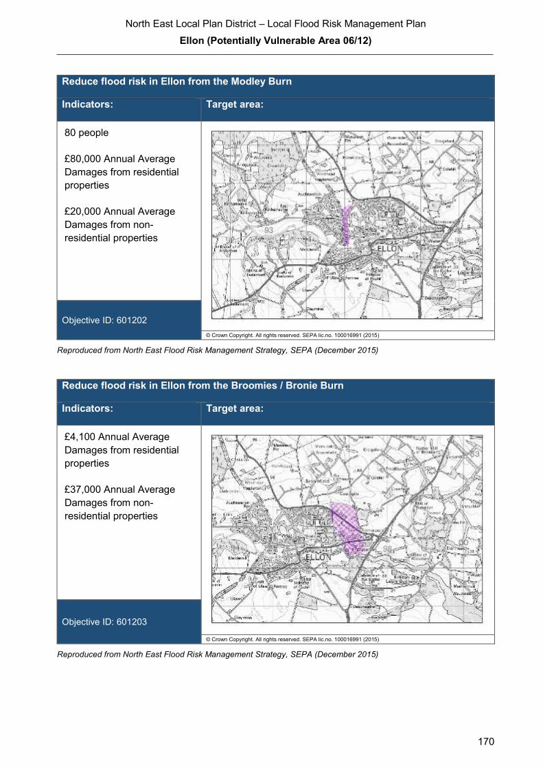
North East Local Plan District – Local Flood Risk Management Plan
Ellon (Potentially Vulnerable Area 06/12)
170
Reduce flood risk in Ellon from the Modley Burn
Indicators: Target area:
80 people
£80,000 Annual Average
Damages from residential
properties
£20,000 Annual Average
Damages from non-
residential properties
Objective ID: 601202
© Crown Copyright. All rights reserved. SEPA lic.no. 100016991 (2015)
Reproduced from North East Flood Risk Management Strategy, SEPA (December 2015)
Reduce flood risk in Ellon from the Broomies / Bronie Burn
Indicators: Target area:
£4,100 Annual Average
Damages from residential
properties
£37,000 Annual Average
Damages from non-
residential properties
Objective ID: 601203
© Crown Copyright. All rights reserved. SEPA lic.no. 100016991 (2015)
Reproduced from North East Flood Risk Management Strategy, SEPA (December 2015)
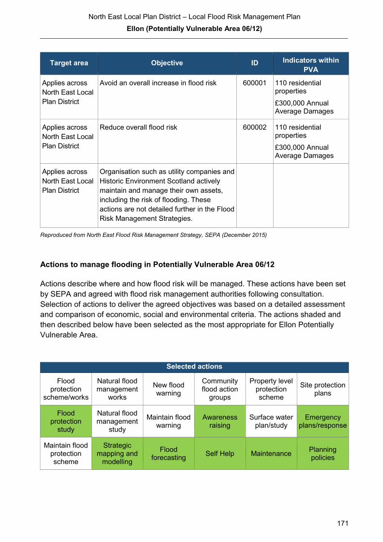
North East Local Plan District – Local Flood Risk Management Plan
Ellon (Potentially Vulnerable Area 06/12)
171
Target area Objective ID Indicators within
PVA
Applies across
North East Local
Plan District
Avoid an overall increase in flood risk 600001 110 residential properties
£300,000 Annual Average Damages
Applies across
North East Local
Plan District
Reduce overall flood risk 600002 110 residential properties
£300,000 Annual Average Damages
Applies across
North East Local
Plan District
Organisation such as utility companies and
Historic Environment Scotland actively
maintain and manage their own assets,
including the risk of flooding. These
actions are not detailed further in the Flood
Risk Management Strategies.
Reproduced from North East Flood Risk Management Strategy, SEPA (December 2015)
Actions to manage flooding in Potentially Vulnerable Area 06/12
Actions describe where and how flood risk will be managed. These actions have been set
by SEPA and agreed with flood risk management authorities following consultation.
Selection of actions to deliver the agreed objectives was based on a detailed assessment
and comparison of economic, social and environmental criteria. The actions shaded and
then described below have been selected as the most appropriate for Ellon Potentially
Vulnerable Area.
Selected actions
Flood protection
scheme/works
Natural flood management
works
New flood warning
Community flood action
groups
Property level protection scheme
Site protection plans
Flood protection
study
Natural flood management
study
Maintain flood warning
Awareness raising
Surface water plan/study
Emergency plans/response
Maintain flood protection scheme
Strategic mapping and
modelling
Flood forecasting
Self Help Maintenance Planning policies
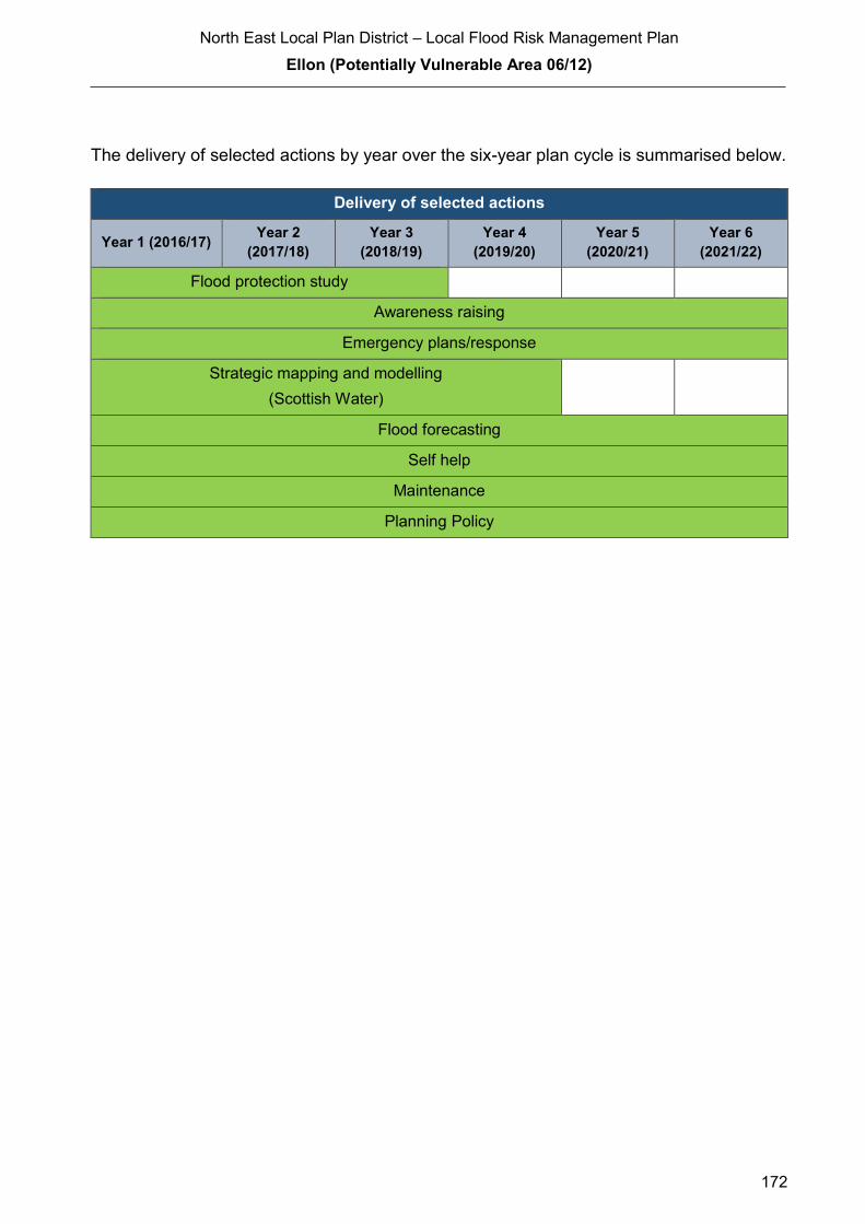
North East Local Plan District – Local Flood Risk Management Plan
Ellon (Potentially Vulnerable Area 06/12)
172
The delivery of selected actions by year over the six-year plan cycle is summarised below.
Delivery of selected actions
Year 1 (2016/17) Year 2
(2017/18)
Year 3
(2018/19)
Year 4
(2019/20)
Year 5
(2020/21)
Year 6
(2021/22)
Flood protection study
Awareness raising
Emergency plans/response
Strategic mapping and modelling
(Scottish Water)
Flood forecasting
Self help
Maintenance
Planning Policy
North East Local Plan District – Local Flood Risk Management Plan
Ellon (Potentially Vulnerable Area 06/12)
173
Action (ID): FLOOD PROTECTION STUDY (6012010005)
Objective (ID): Reduce flood risk in Ellon from the Broomies / Bronie Burn (601203)
Reduce flood risk in Ellon from the Modley Burn (601202)
Reduce flood risk in Ellon from the River Ythan (601201)
Delivery lead: Aberdeenshire Council
Priority: National: Within local authority:
55 of 168 1 of 12
Status: Scheduled Indicative delivery: 2016-2019
Description:
Aberdeenshire Council will undertake a flood protection study to evaluate options for flood
management to reduce the risk of flooding in Ellon from the River Ythan, Modley Burn and
Broomies / Bronie Burn. The study will be completed by the Summer 2019
The study has the potential to benefit 77 residential properties, 18 non-residential properties,
sections of road network and a school at risk of flooding in this location, with potential damages
avoided of up to £6.1 million. A reduction in flood risk would have a positive benefit to the health
and wellbeing of the community and socially vulnerable people located within the study area and
may also contribute to enhanced biodiversity and economic activity.
The study will take a sustainable and integrated approach by coordinating with the river basin
management plan. It will be undertaken with due consideration to internationally, nationally and
locally designated sites including listed buildings. It will also explore opportunities for enhancing
biodiversity and for promoting economic activity and social wellbeing.
The study will consider natural flood management measures along with traditional flood defences
by exploring opportunities for online and offline flood storage, flow control structures, modification
to conveyance capacity of watercourses by sediment and channel management, modifications to
the bridges to improve conveyance, the construction of direct defences, river / floodplain
restoration, runoff control through catchment and riparian tree planting, land-use and land-
management changes, etc. Additionally, the study will also consider property level protection and
property relocation. It is expected that the recommended flood protection scheme will comprise a
combination of such measures to ensure a sustainable and integrated approach to flood risk
management by due consideration of impacts on economy, society, environment and cultural
heritage.
(continued)
North East Local Plan District – Local Flood Risk Management Plan
Ellon (Potentially Vulnerable Area 06/12)
174
Aberdeenshire Council will coordinate with SEPA, Scottish Water, SNH, The Crown Estate,
landowners and community groups as well as other relevant agencies and organisations.
Aberdeenshire Council will undertake the study through the Local Planning District (LPD)
partnership and / or through separate agreements.
Funding for the study will be subject to Scottish Government’s block grant and capital support,
and budget allocations over the six years of the Plan, 2016-2022.
Potential impacts
Economic: The study could benefit 77 residential and 18 non-residential properties at risk
of flooding in this location, with potential damages avoided of up to £6.1
million.
Social: The development of flood protection works following the study would
potentially reduce risk to 169 people. A reduction in flood risk would have a
positive benefit to the health and wellbeing of the community and socially
vulnerable people. One school may benefit from any works. Three utility sites
(energy/electricity) could also benefit from the flood protection works identified
in the study depending on the location and extent of works. Natural flood
management actions can restore and enhance natural environments and
create opportunities for recreation and tourism. Negative impacts through
disturbance to the local community during the construction phase should be
considered.
Environmental: Flood protection studies should consider the positive and negative impacts of
proposed actions on the ecological quality of the environment. Natural flood
management actions can have a positive impact by restoring and enhancing
natural habitats. Opportunities to mitigate any environmental impacts may
include design and timing of works. The flood protection study should
consider how to avoid or minimise potential negative effects such as loss or
disturbance of sediment, disruption to natural processes and loss of habitat.
To be in accord with the FRM Strategy, the Responsible Authority should
seek to ensure as part of the study that the action will not have an adverse
effect on the integrity of the Ythan Estuary, Sands of Forvie and Meikle Loch
Special Protection Area. The study should ensure the actions do not impact
the downstream Sands of Forvie and Ythan Estuary Site of Special Scientific
Interest.
North East Local Plan District – Local Flood Risk Management Plan
Ellon (Potentially Vulnerable Area 06/12)
175
Action (ID): AWARENESS RAISING (6000020013)
Objective (ID): Reduce overall flood risk (600002)
Delivery lead: Responsible authorities
Status: Existing Indicative delivery: Ongoing
Description:
Aberdeenshire Council have a duty to raise public awareness of flood risk under the Flood Risk
Management (Scotland) Act 2009 and to plan and inform of risks to communities under the Civil
Contingencies Act 2004.
Over the six years of the Plan, 2016-2022, Aberdeenshire Council will seek opportunities to raise
awareness of both flood risk and actions that enable individuals, homes and businesses to
reduce the overall impact of flooding.
In partnership with Education Scotland Aberdeenshire Council will look to engage schools in
activities relating to flooding, extreme weather, climate change and other community resilience
issues.
Aberdeenshire Council will also develop emergency response plans and work with community
flood action groups where these exist.
Awareness raising will be funded from existing local authority flood revenue budgets.
From 2016 SEPA will engage with the community through local participation in national
initiatives, including partnership working with Neighbourhood Watch Scotland. In addition, SEPA
will engage with local authorities and community resilience groups where possible.
Across Scotland, SEPA will create and share communication and education resources with other
responsible authorities. These resources will include awareness campaigns, media and
marketing activities and promotion of SEPA's flood forecasting and warning service (Floodline).
Where they exist, SEPA will engage with community resilience groups and community safety
partnerships. Additionally, SEPA's awareness raising activities will be coordinated with the
activities of other responsible authorities as required.
SEPA's awareness raising activities are funded by Scottish Government through their grant in aid
settlement and will be coordinated with the activities of other responsible authorities as required.
Scottish Water will support SEPA and responsible authorities with their awareness raising
activities as required and provide targeted flooding communications for Scottish Water specific
activities. Scottish Water will raise awareness by producing and supplying targeted information to
the public on large capital projects and detailed local studies.
(continued)

North East Local Plan District – Local Flood Risk Management Plan
Ellon (Potentially Vulnerable Area 06/12)
176
Action (ID): EMERGENCY PLANS/RESPONSE (6000020014)
Objective (ID): Reduce overall flood risk (600002)
Delivery lead: Category 1 and 2 Responders
Status: Existing Indicative delivery: Ongoing
Description:
Providing an emergency response to flooding is the responsibility of many organisations,
including local authorities, the emergency services and SEPA. Effective management of an
emergency response relies on emergency plans that are prepared under the Civil Contingencies
Act 2004 by Category 1 and 2 Responders.
Aberdeenshire Council has an overarching Flood Response Plan, which is coordinated through
the Responders identified under the Civil Contingencies Act 2004. The aim of the plan is to set
out arrangements to deal effectively with flood risk. At predetermined trigger levels flood alerts
and warnings will be issued through SEPA's flood forecasting and warning service (Floodline)
and Aberdeenshire Council will conduct assessments at known hotspots and prepare resources
as required. Aberdeenshire Council will also coordinate measures in conjunction with the other
Responders. The emergency response process is coordinated through regional and local
resilience partnerships. This response may be supported by the work of voluntary organisations.
The Operational Flood Response Plan will undergo review on an annual basis to reflect
operational or responsibility changes. A debrief and plan review will also be carried out after the
Plan is activated during emergencies.
Aberdeenshire Council funding for emergency plans/response will be shared with other
organisations, emergency services and Responders, as appropriate, and will be subject to
Scottish Government’s block grant and capital support, and budget allocations over the six years
of the Plan, 2016-2022. SEPA's emergency plans/response are funded by Scottish Government
through SEPA’s grant in aid settlement.
More general information and flooding guidance will be available on the website at:
https://www.scottishwater.co.uk/you-and-your-home/your-home/flooding-information
Scottish Water will keep responsible authorities informed of its awareness raising activities
through the Local Plan District partnerships.

North East Local Plan District – Local Flood Risk Management Plan
Ellon (Potentially Vulnerable Area 06/12)
177
Action (ID): STRATEGIC MAPPING AND MODELLING (6000020019)
Objective (ID): Reduce overall flood risk (600002)
Delivery lead: Scottish Water
Status: Scheduled Indicative delivery: 2016-2020
Description:
Scottish Water will undertake further investigation and modelling in the Ellon sewer catchment to
improve knowledge and understanding of flood risk in this area as required under Section 16 of
the Flood Risk Management (Scotland) Act 2009.
Scottish Water will work with responsible authorities to incorporate relevant information into these
studies by regularly keeping the responsible authorities informed of their progress. Scottish
Water will provide responsible authorities with the outputs of the Section 16 assessment which,
where relevant, may be used to inform Surface Water Management Plans and SEPA flood
hazard and risk maps.
Scottish Water funding is committed in its capital programme through Q&S 4a (2015-2021) which
is approved by its regulators and customers.
Action (ID): FLOOD FORECASTING (6000020009)
Objective (ID): Reduce overall flood risk (600002)
Delivery lead: SEPA
Status: Existing Indicative delivery: Ongoing
Description:
The Scottish Flood Forecasting Service is a joint initiative between SEPA and the Met Office that
produces daily, national flood guidance statements which are issued to Category 1 and 2
Responders. The flood guidance statements provide an assessment of the risk of flooding for a
five day period allowing responders time to put preparations in place to reduce the impact of
flooding. The service also provides information which allows SEPA to issue flood warnings,
giving people a better chance of reducing the impact of flooding on their home or business. For
more information, please visit SEPA’s website. The Potentially Vulnerable Area is within the
'Aberdeenshire and Aberdeen City' flood alert area.
SEPA / Met Office joint initiative. Hydrological information is provided by SEPA and
meteorological information is provided by the Met Office. SEPA uses the information to predict
the likelihood and timing of river, coastal and surface water flooding.
SEPA’s flood forecasting service is funded through Scottish Government’s grant in aid allocation.
The Met Office receives funding from the UK Government.
North East Local Plan District – Local Flood Risk Management Plan
Ellon (Potentially Vulnerable Area 06/12)
178
Action (ID): MAINTENANCE (6000020007)
Objective (ID): Reduce overall flood risk (600002)
Delivery lead: Aberdeenshire Council, asset / land managers
Status: Existing Indicative delivery: Ongoing
Description:
Local authorities have a duty to assess watercourses and carry out clearance and repair works
where such works would substantially reduce flood risk. Aberdeenshire Council will produce
schedules of clearance and repair works and make these available for public inspection.
Maintenance will be funded from existing Flood revenue budgets, for works which are defined to
pose a significant flood risk.
Scottish Water undertake risk based inspection, maintenance and repair on the public sewer
network together with keeping responsible authorities informed of large scale capital
maintenance work to identify opportunities for co-ordination.
Action (ID): SELF HELP (6000020011)
Objective (ID): Reduce overall flood risk (600002)
Delivery lead: —
Status: Existing Indicative delivery: Ongoing
Description:
Everyone is responsible for protecting themselves and their property flooding. Property and
business owners can take simple steps to reduce damage and disruption to their homes and
businesses should flooding happen. This includes preparing a flood plan and flood kit, installing
property level protection, signing up to Floodline and Resilient Communities initiatives, and
ensuring that properties and businesses are insured against flood damage.
Aberdeenshire Council currently provide a small range of flood protection products for individual
property protection, which are available for all types of flooding, at cost price with free delivery
across Aberdeenshire.

North East Local Plan District – Local Flood Risk Management Plan
Ellon (Potentially Vulnerable Area 06/12)
179
Action (ID): PLANNING POLICIES (6000010001)
Objective (ID): Avoid an overall increase in flood risk (600001)
Reduce overall flood risk (600002)
Delivery lead: Planning authority
Status: Existing Indicative delivery: Ongoing
Description:
Scottish Planning Policy and accompanying Planning Advice Notes set out Scottish Ministers’
priorities for the operation of the planning system and for the development and use of land. In
terms of flood risk management, the policy supports a catchment-scale approach to sustainable
flood risk management and aims to build the resilience of our cities and towns, encourage
sustainable land management in our rural areas, and to address the long-term vulnerability of
parts of our coasts and islands. Under this approach, new development in areas with medium to
high likelihood of flooding should be avoided.
For further information on the application of national planning policies see Annex 5.
Aberdeenshire Council is a local planning authority and will work with the regional planning
authority, the Aberdeen City and Shire Strategic Development Planning Authority.
As a consultee on planning applications, Aberdeenshire Council’s Flood & Coast Protection team
will work directly with colleagues in the Planning Service to ensure that appropriate policies and
measures are put in place to reduce flood risk. Planning applications are assessed against the
flooding standards set out in the current Aberdeenshire Local Development Plan, and in future
those in the proposed Aberdeenshire Local Development Plan 2016.
SEPA has a statutory role in relation to the provision of flood risk advice to planning authorities.
This role is expressed in Section 72 of the FRM Act, 2009. SEPA also has a duty to cooperate
with planning authorities in the preparation of development plans. When consulted in relation to
planning applications for development or site allocations in development plans, and where the
planning authority considers there may be a risk of flooding, SEPA will provide advice. The
advice provided by SEPA will be with respect to the risk of flooding and on the basis of the
relevant information it holds which is suitable for planning purposes. It will also be in line with the
principles and duties set out in the FRM Act. Further information about how SEPA engages in
the planning system, including guidance on flood risk and planning is available on SEPA’s
website http://www.sepa.org.uk/environment/land/planning/
SEPA's land use planning activities will be coordinated with the activities of other responsible
authorities as required and are funded by Scottish Government through SEPA’s grant in aid
settlement.
Scottish Water is a statutory consultee within the planning legislation and is required to comment
on all outline or full planning applications which are referred by a local authority.
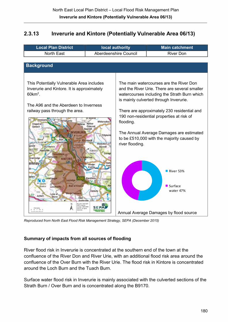
North East Local Plan District – Local Flood Risk Management Plan
Inverurie and Kintore (Potentially Vulnerable Area 06/13)
180
2.3.13 Inverurie and Kintore (Potentially Vulnerable Area 06/13)
Local Plan District local authority Main catchment North East Aberdeenshire Council River Don
Background
This Potentially Vulnerable Area includes
Inverurie and Kintore. It is approximately
60km2.
The A96 and the Aberdeen to Inverness
railway pass through the area.
The main watercourses are the River Don
and the River Urie. There are several smaller
watercourses including the Strath Burn which
is mainly culverted through Inverurie.
There are approximately 230 residential and
190 non-residential properties at risk of
flooding.
The Annual Average Damages are estimated
to be £510,000 with the majority caused by
river flooding.
Annual Average Damages by flood source
Reproduced from North East Flood Risk Management Strategy, SEPA (December 2015)
Summary of impacts from all sources of flooding
River flood risk in Inverurie is concentrated at the southern end of the town at the
confluence of the River Don and River Urie, with an additional flood risk area around the
confluence of the Over Burn with the River Urie. The flood risk in Kintore is concentrated
around the Loch Burn and the Tuach Burn.
Surface water flood risk in Inverurie is mainly associated with the culverted sections of the
Strath Burn / Over Burn and is concentrated along the B9170.
River 53%
Surfacewater 47%

North East Local Plan District – Local Flood Risk Management Plan
Inverurie and Kintore (Potentially Vulnerable Area 06/13)
181
Several road locations, including the A96 and parts of the Aberdeen to Inverness railway
line are at risk of flooding. Thirteen designated cultural heritage sites and an extensive
area of agricultural land are also at risk of flooding.
For this Potentially Vulnerable Area the highest damages are to residential properties
followed by damages to non-residential properties and roads.
History of flooding
The earliest recorded flood was in 1768 when flooding on the Don destroyed most of the
agricultural crops in affected areas. Similar floods were recorded on the Don in 1828,
1838, 1872, 1903, 1905, 1928, 1948, and 1951. The River Don also caused flooding in
1995, 2002, 2003, 2004, and 2009.
The 2002 flood had the highest water level recorded at the Bridge of Don and flooding
from the canal affected Canal Road. In 2003, the flood barrier at Keithhall Road, Inverurie
was breached and residential properties were flooded.
The Gas Burn flooded Blackall Road in Inverurie in 1924. The Strath Burn caused flooding
to properties in central Inverurie in 2002, 2005, 2006, 2008, 2009, and 2010 due to the
culvert backing up and blockage of the trash screen.
In 2009 Oldmeldrum Road and Souterford Road flooded due to overtopping of the River
Urie. Other floods in this location were recorded in 1995 and 2002.
There was flooding in Kintore from the Tuach Burn in 2002, 2003, 2006, and 2009, when
water backed up the burn from the River Don. Properties in south east Kintore, including
Kingsfield Road, were flooded. Water levels backing up from the River Don caused
flooding on the Loch Burn in the eastern areas of Kintore in 2002, 2005, and 2009
affecting commercial property in the area between the two railway culverts and properties
on Northern Road.
Over 2 events in January 2016 there were reports of 56 properties damaged by flooding in
Kintore and over 80 properties in Inverurie.
The fire brigade and the coast guard conducted rescue efforts to evacuate residents from
Canal Road, Canal Crescent, Riverside Park where houses were inundated by several
feet of water. Inverurie Academy was opened as temporary accommodation and the Port
Elphinstone Bridge on Elphinstone Road was closed.

North East Local Plan District – Local Flood Risk Management Plan
Inverurie and Kintore (Potentially Vulnerable Area 06/13)
182
Objectives to manage flooding in Potentially Vulnerable Area 06/13
Objectives provide a common goal and shared ambition for managing floods. These
objectives have been set by SEPA and agreed with flood risk management authorities
following consultation. They were identified through an assessment of the underlying
evidence of the causes and impacts of flooding. Target areas have been set to focus
actions; they do not necessarily correspond to areas at risk in SEPA’s flood map. The
objectives below have been set for Inverurie and Kintore Potentially Vulnerable Area.
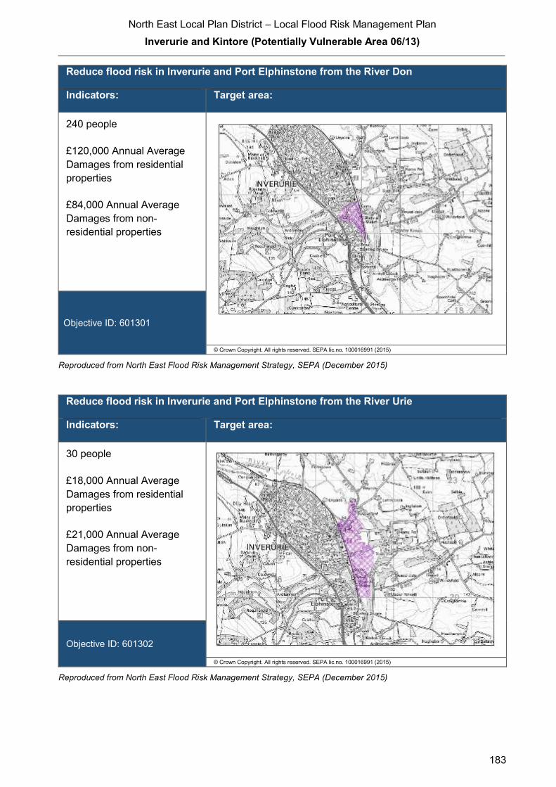
North East Local Plan District – Local Flood Risk Management Plan
Inverurie and Kintore (Potentially Vulnerable Area 06/13)
183
Reduce flood risk in Inverurie and Port Elphinstone from the River Don
Indicators: Target area:
240 people
£120,000 Annual Average
Damages from residential
properties
£84,000 Annual Average
Damages from non-
residential properties
Objective ID: 601301
© Crown Copyright. All rights reserved. SEPA lic.no. 100016991 (2015)
Reproduced from North East Flood Risk Management Strategy, SEPA (December 2015)
Reduce flood risk in Inverurie and Port Elphinstone from the River Urie
Indicators: Target area:
30 people
£18,000 Annual Average
Damages from residential
properties
£21,000 Annual Average
Damages from non-
residential properties
Objective ID: 601302
© Crown Copyright. All rights reserved. SEPA lic.no. 100016991 (2015)
Reproduced from North East Flood Risk Management Strategy, SEPA (December 2015)
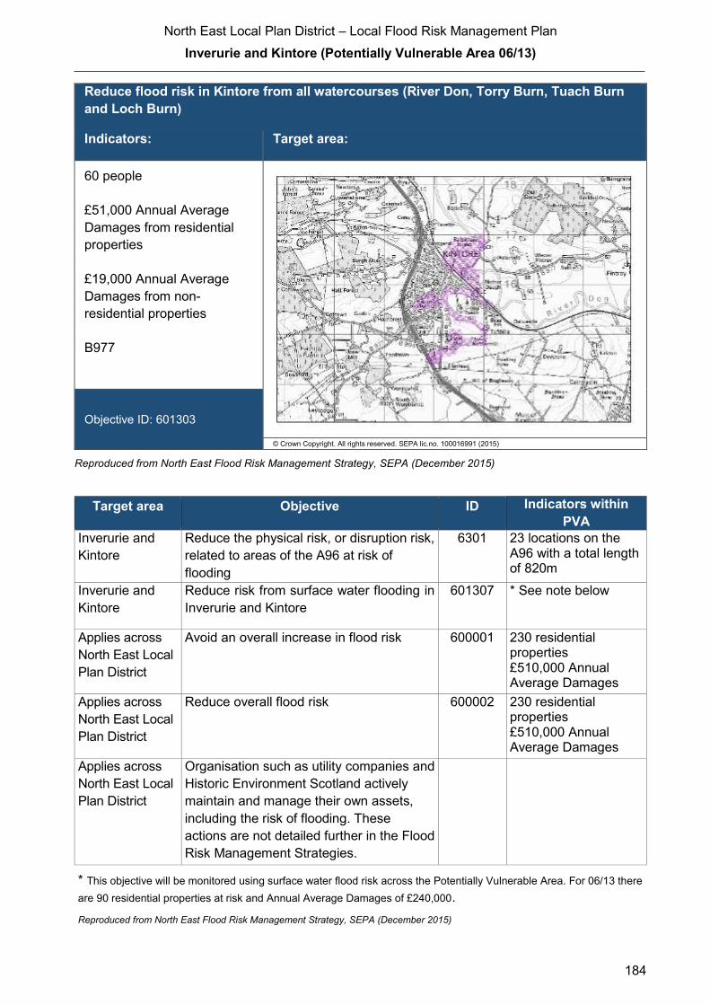
North East Local Plan District – Local Flood Risk Management Plan
Inverurie and Kintore (Potentially Vulnerable Area 06/13)
184
Reduce flood risk in Kintore from all watercourses (River Don, Torry Burn, Tuach Burn
and Loch Burn)
Indicators: Target area:
60 people
£51,000 Annual Average
Damages from residential
properties
£19,000 Annual Average
Damages from non-
residential properties
B977
Objective ID: 601303
© Crown Copyright. All rights reserved. SEPA lic.no. 100016991 (2015)
Reproduced from North East Flood Risk Management Strategy, SEPA (December 2015)
Target area Objective ID Indicators within
PVA
Inverurie and
Kintore
Reduce the physical risk, or disruption risk,
related to areas of the A96 at risk of
flooding
6301 23 locations on the A96 with a total length of 820m
Inverurie and
Kintore
Reduce risk from surface water flooding in
Inverurie and Kintore
601307 * See note below
Applies across
North East Local
Plan District
Avoid an overall increase in flood risk 600001 230 residential properties
£510,000 Annual Average Damages
Applies across
North East Local
Plan District
Reduce overall flood risk 600002 230 residential properties
£510,000 Annual Average Damages
Applies across
North East Local
Plan District
Organisation such as utility companies and
Historic Environment Scotland actively
maintain and manage their own assets,
including the risk of flooding. These
actions are not detailed further in the Flood
Risk Management Strategies.
* This objective will be monitored using surface water flood risk across the Potentially Vulnerable Area. For 06/13 there
are 90 residential properties at risk and Annual Average Damages of £240,000.
Reproduced from North East Flood Risk Management Strategy, SEPA (December 2015)

North East Local Plan District – Local Flood Risk Management Plan
Inverurie and Kintore (Potentially Vulnerable Area 06/13)
185
Actions to manage flooding in Potentially Vulnerable Area 06/13
Actions describe where and how flood risk will be managed. These actions have been set
by SEPA and agreed with flood risk management authorities following consultation.
Selection of actions to deliver the agreed objectives was based on a detailed assessment
and comparison of economic, social and environmental criteria. The actions shaded and
then described below have been selected as the most appropriate for Inverurie and
Kintore Potentially Vulnerable Area.
Selected actions
Flood protection
scheme/works
Natural flood management
works
New flood warning
Community flood action
groups
Property level protection scheme
Site protection plans
Flood protection
study
Natural flood management
study
Maintain flood warning
Awareness raising
Surface water
plan/study
Emergency plans/response
Maintain flood protection scheme
Strategic mapping and
modelling
Flood forecasting
Self Help Maintenance Planning policies
The delivery of selected actions by year over the six-year plan cycle is summarised below.
Delivery of selected actions
Year 1 (2016/17) Year 2
(2017/18)
Year 3
(2018/19)
Year 4
(2019/20)
Year 5
(2020/21)
Year 6
(2021/22)
Flood protection study
Maintain flood warning
Awareness raising
Surface water plan/study
Emergency plans/response
Strategic mapping and
modelling (SEPA)
Strategic mapping and modelling
(Scottish Water)
Flood forecasting
Self help
Maintenance
Planning Policy
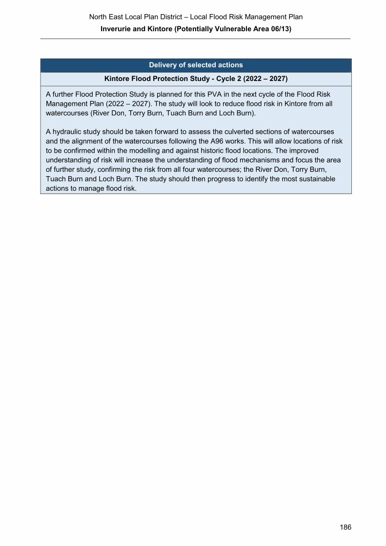
North East Local Plan District – Local Flood Risk Management Plan
Inverurie and Kintore (Potentially Vulnerable Area 06/13)
186
Delivery of selected actions
Kintore Flood Protection Study - Cycle 2 (2022 – 2027)
A further Flood Protection Study is planned for this PVA in the next cycle of the Flood Risk
Management Plan (2022 – 2027). The study will look to reduce flood risk in Kintore from all
watercourses (River Don, Torry Burn, Tuach Burn and Loch Burn).
A hydraulic study should be taken forward to assess the culverted sections of watercourses
and the alignment of the watercourses following the A96 works. This will allow locations of risk
to be confirmed within the modelling and against historic flood locations. The improved
understanding of risk will increase the understanding of flood mechanisms and focus the area
of further study, confirming the risk from all four watercourses; the River Don, Torry Burn,
Tuach Burn and Loch Burn. The study should then progress to identify the most sustainable
actions to manage flood risk.

North East Local Plan District – Local Flood Risk Management Plan
Inverurie and Kintore (Potentially Vulnerable Area 06/13)
187
Action (ID): FLOOD PROTECTION STUDY (6013010005)
Objective (ID):
Reduce flood risk in Inverurie and Port Elphinstone from the River Urie
(601302)
Reduce flood risk in Inverurie and Port Elphinstone from the River Don
(601301)
Delivery lead: Aberdeenshire Council
Priority: National: Within local authority:
57 of 168 2 of 12
Status: Scheduled Indicative delivery: 2019
Description:
Aberdeenshire Council will undertake a flood protection study to evaluate options for flood
management to reduce the risk of flooding in Inverurie and Port Elphinstone from the River Don
and River Urie. The study will build upon previous studies and it is currently estimated that the
study will be completed by Summer 2019.
The study has the potential to benefit 120 residential properties and 35 non-residential properties
and sections of road network at risk of flooding in this location, with potential damages avoided of
up to £6.8 million. Additionally, three utility sites (energy/electricity sites) could benefit from the
study. A reduction in flood risk would have a positive benefit to the health and wellbeing of the
community and socially vulnerable people located within the study area and may also contribute
to enhanced biodiversity and economic activity.
The study will take a sustainable and integrated approach by coordinating with the river basin
management plan. It will be undertaken with due consideration to internationally, nationally and
locally designated sites including listed buildings. It will also explore opportunities for enhancing
biodiversity and for promoting economic activity and social wellbeing.
The study will consider natural flood management measures along with traditional flood defences
by exploring opportunities for online and offline flood storage, flow control structures, modification
to conveyance capacity of watercourses by sediment and channel management, modifications to
the bridges to improve conveyance, the construction of direct defences, river / floodplain
restoration, runoff control through catchment and riparian tree planting, land-use and land-
management changes, etc. Additionally, the study will also consider property level protection and
property relocation. It is expected that the recommended flood protection scheme will comprise a
combination of such measures to ensure a sustainable and integrated approach to flood risk
management by due consideration of impacts on economy, society, environment and cultural
heritage.
(continued)
North East Local Plan District – Local Flood Risk Management Plan
Inverurie and Kintore (Potentially Vulnerable Area 06/13)
188
Aberdeenshire Council will coordinate with SEPA, Scottish Water, SNH, The Crown Estate,
landowners and community groups as well as other relevant agencies and organisations.
Aberdeenshire Council will undertake the study through the Local Planning District (LPD)
partnership and / or through separate agreements.
Funding for the study will be subject to Scottish Government’s block grant and capital support,
and budget allocations over the six years of the Plan, 2016-2022.
Potential impacts
Economic: The study could benefit 120 residential and 35 non-residential properties at
risk of flooding in this location, with potential damages avoided of up to £6.8
million.
Social: The development of flood protection works following the study would
potentially reduce risk to 264 people. A reduction in flood risk would have a
positive benefit to the health and wellbeing of the community and socially
vulnerable people. Three utility sites (energy/electricity sites), roads (including
the B9170) and the railway line could benefit from flood protection works.
Negative impacts through disturbance to the local community during the
construction phase should be considered.
Environmental: Flood protection studies should consider the positive and negative impacts of
proposed actions on the ecological quality of the environment. Opportunities to
mitigate any environmental impacts may include design and timing of works.
The flood protection study should consider how to avoid or minimise potential
negative effects such as loss or disturbance of sediment, disruption to natural
processes and loss of habitat. Six cultural heritage sites could benefit from the
flood protection works identified in the study, however this will depend on the
final location and extent of the works.

North East Local Plan District – Local Flood Risk Management Plan
Inverurie and Kintore (Potentially Vulnerable Area 06/13)
189
Action (ID): MAINTAIN FLOOD WARNING (6000020030)
Objective (ID): Reduce overall flood risk (600002)
Delivery lead: SEPA
Status: Existing Indicative delivery: Ongoing
Description:
Continue to maintain the 'Inverurie' and 'Kintore' flood warning areas which are part of the Don
river flood warning scheme. When flood events occur in an area with an existing flood warning
service, SEPA will seek to verify the flood forecasts and warnings. SEPA will use feedback and
post-event data to ensure that our flood warning service is timely and accurate.
A flood protection study is proposed for Inverurie and Port Elphinstone. SEPA will work with the
local authority to ensure that any new information about flood risk resulting from the proposed
flood protection study is considered in the existing flood warning system.
The maintenance of SEPA’s flood warning service is funded by Scottish Government through
SEPA’s grant in aid settlement.

North East Local Plan District – Local Flood Risk Management Plan
Inverurie and Kintore (Potentially Vulnerable Area 06/13)
190
Action (ID): AWARENESS RAISING (6000020013)
Objective (ID): Reduce overall flood risk (600002)
Delivery lead: Responsible authorities
Status: Existing Indicative delivery: Ongoing
Description:
Aberdeenshire Council have a duty to raise public awareness of flood risk under the Flood Risk
Management (Scotland) Act 2009 and to plan and inform of risks to communities under the Civil
Contingencies Act 2004.
Over the six years of the Plan, 2016-2022, Aberdeenshire Council will seek opportunities to raise
awareness of both flood risk and actions that enable individuals, homes and businesses to
reduce the overall impact of flooding.
In partnership with Education Scotland Aberdeenshire Council will look to engage schools in
activities relating to flooding, extreme weather, climate change and other community resilience
issues.
Aberdeenshire Council will also develop emergency response plans and work with community
flood action groups where these exist.
Awareness raising will be funded from existing local authority flood revenue budgets.
From 2016 SEPA will engage with the community through local participation in national
initiatives, including partnership working with Neighbourhood Watch Scotland. In addition, SEPA
will engage with local authorities and community resilience groups where possible.
Across Scotland, SEPA will create and share communication and education resources with other
responsible authorities. These resources will include awareness campaigns, media and
marketing activities and promotion of SEPA's flood forecasting and warning service (Floodline).
Where they exist, SEPA will engage with community resilience groups and community safety
partnerships. Additionally, SEPA's awareness raising activities will be coordinated with the
activities of other responsible authorities as required.
SEPA's awareness raising activities are funded by Scottish Government through their grant in aid
settlement and will be coordinated with the activities of other responsible authorities as required.
Scottish Water will support SEPA and responsible authorities with their awareness raising
activities as required and provide targeted flooding communications for Scottish Water specific
activities. Scottish Water will raise awareness by producing and supplying targeted information to
the public on large capital projects and detailed local studies.
(continued)

North East Local Plan District – Local Flood Risk Management Plan
Inverurie and Kintore (Potentially Vulnerable Area 06/13)
191
More general information and flooding guidance will be available on the website at:
https://www.scottishwater.co.uk/you-and-your-home/your-home/flooding-information
Scottish Water will keep responsible authorities informed of its awareness raising activities
through the Local Plan District partnerships.
Action (ID): SURFACE WATER PLAN/STUDY (6013070018)
Objective (ID): Reduce risk from surface water flooding in Inverurie and Kintore (601307)
Delivery lead: Aberdeenshire Council
Status: Ongoing Indicative delivery: 2016-2021
Description:
Aberdeenshire Council will undertake a study to prepare Surface Water Management Plan
(SWMP) to generate increased understanding of the causes, probability and consequences of
surface water flooding and to evaluate options for surface water flood management in Inverurie
and Kintore. The study will help in preparing a coordinated action plan, supported by an
understanding of the costs and benefits, to identify measures to mitigate surface water flooding,
identifying opportunities where SuDS and similar sustainable measures can play a more
significant role in managing surface water flood risk and generate improved public engagement
and understanding of surface water flooding as well as inform future developments.
The study has the potential to benefit 90 residential properties and sections of road network at
risk of flooding in this location, with potential average annual damages avoided of up to
£240,000. A reduction in flood risk would have a positive benefit to the health and wellbeing of
the community and socially vulnerable people located within the study area and may also
contribute to enhanced biodiversity and economic activity.
The study will consider interactions with drainage system and water bodies. Additional data and
information will be procured or surveys commissioned to generate data to inform the study. The
study will take a sustainable and integrated approach by coordinating with the river basin
management plan. It will explore opportunities for enhancing biodiversity and for promoting
economic activity and social wellbeing.
Aberdeenshire Council will coordinate with Scottish Water, SEPA and community groups as well
as other relevant agencies and organisations. Aberdeenshire Council will undertake the study
through the Local Planning District (LPD) partnership and / or through separate agreements.
Scottish Water will provide local knowledge and understanding of the sewer network. This
includes Scottish Water corporate data (as applicable) and, where available, outputs of Section
16 or integrated catchment studies, to assist with the surface water management planning
process.
(continued)

North East Local Plan District – Local Flood Risk Management Plan
Inverurie and Kintore (Potentially Vulnerable Area 06/13)
192
Scottish Water will work with Aberdeenshire Council and support surface water management
planning through ensuring that best available knowledge and data is used to input into the
Surface Water Management Plans.
Funding for the study will be subject to Scottish Government’s block grant and capital support,
and budget allocations over the six years of the Plan, 2016-2022.
Action (ID): EMERGENCY PLANS/RESPONSE (6000020014)
Objective (ID): Reduce overall flood risk (600002)
Delivery lead: Category 1 and 2 Responders
Status: Existing Indicative delivery: Ongoing
Description:
Providing an emergency response to flooding is the responsibility of many organisations,
including local authorities, the emergency services and SEPA. Effective management of an
emergency response relies on emergency plans that are prepared under the Civil Contingencies
Act 2004 by Category 1 and 2 Responders.
Aberdeenshire Council has an overarching Flood Response Plan, which is coordinated through
the Responders identified under the Civil Contingencies Act 2004. The aim of the plan is to set
out arrangements to deal effectively with flood risk. At predetermined trigger levels flood alerts
and warnings will be issued through SEPA's flood forecasting and warning service (Floodline)
and Aberdeenshire Council will conduct assessments at known hotspots and prepare resources
as required. Aberdeenshire Council will also coordinate measures in conjunction with the other
Responders. The emergency response process is coordinated through regional and local
resilience partnerships. This response may be supported by the work of voluntary organisations.
The Operational Flood Response Plan will undergo review on an annual basis to reflect
operational or responsibility changes. A debrief and plan review will also be carried out after the
Plan is activated during emergencies.
Aberdeenshire Council operates a water level sensor on the Strath Burn to provide early warning
of potential flooding. Additional debris clearance on the trash screen is undertaken when water
levels are high or weather forecasts suggest heightened risk of flooding.
Aberdeenshire Council funding for emergency plans/response will be shared with other
organisations, emergency services and Responders, as appropriate, and will be subject to
Scottish Government’s block grant and capital support, and budget allocations over the six years
of the Plan, 2016-2022. SEPA's emergency plans/response are funded by Scottish Government
through SEPA’s grant in aid settlement.

North East Local Plan District – Local Flood Risk Management Plan
Inverurie and Kintore (Potentially Vulnerable Area 06/13)
193
Action (ID): STRATEGIC MAPPING AND MODELLING (6000020016)
Objective (ID): Reduce overall flood risk (600002)
Delivery lead: SEPA
Status: Scheduled Indicative delivery: 2017 - 2018
Description:
SEPA will be seeking to develop the flood hazard mapping in the Upper Don area (from Pitcaple
to Kintore) to improve understanding of the flood risk.
The extent and timing of the completed improvements will be dependent on detailed scoping and
data availability.
SEPA's strategic mapping activities will be coordinated with the activities of other responsible
authorities as required.
SEPA's strategic mapping and modelling activities are funded by Scottish Government through
SEPA’s grant in aid settlement.
Action (ID): STRATEGIC MAPPING AND MODELLING (6000020019)
Objective (ID): Reduce overall flood risk (600002)
Delivery lead: Scottish Water
Status: Scheduled Indicative delivery: 2017-2020
Description:
Scottish Water will undertake further investigation and modelling in the Inverurie sewer
catchment to improve knowledge and understanding of flood risk in this area as required under
Section 16 of the Flood Risk Management (Scotland) Act 2009.
Scottish Water will work with responsible authorities to incorporate relevant information into these
studies by regularly keeping the responsible authorities informed of their progress. Scottish
Water will provide responsible authorities with the outputs of the Section 16 assessment which,
where relevant, may be used to inform Surface Water Management Plans and SEPA flood
hazard and risk maps.
Scottish Water funding is committed in its capital programme through Q&S 4a (2015-2021) which
is approved by its regulators and customers.

North East Local Plan District – Local Flood Risk Management Plan
Inverurie and Kintore (Potentially Vulnerable Area 06/13)
194
Action (ID): FLOOD FORECASTING (6000020009)
Objective (ID): Reduce overall flood risk (600002)
Delivery lead: SEPA
Status: Existing Indicative delivery: Ongoing
Description:
The Scottish Flood Forecasting Service is a joint initiative between SEPA and the Met Office that
produces daily, national flood guidance statements which are issued to Category 1 and 2
Responders. The flood guidance statements provide an assessment of the risk of flooding for a
five day period allowing responders time to put preparations in place to reduce the impact of
flooding. The service also provides information which allows SEPA to issue flood warnings,
giving people a better chance of reducing the impact of flooding on their home or business. For
more information, please visit SEPA’s website. The Potentially Vulnerable Area is within the
'Aberdeenshire and Aberdeen City' flood alert area.
SEPA / Met Office joint initiative. Hydrological information is provided by SEPA and
meteorological information is provided by the Met Office. SEPA uses the information to predict
the likelihood and timing of river, coastal and surface water flooding.
SEPA’s flood forecasting service is funded through Scottish Government’s grant in aid allocation.
The Met Office receives funding from the UK Government.
Action (ID): SELF HELP (6000020011)
Objective (ID): Reduce overall flood risk (600002)
Delivery lead: —
Status: Existing Indicative delivery: Ongoing
Description:
Everyone is responsible for protecting themselves and their property flooding. Property and
business owners can take simple steps to reduce damage and disruption to their homes and
businesses should flooding happen. This includes preparing a flood plan and flood kit, installing
property level protection, signing up to Floodline and Resilient Communities initiatives, and
ensuring that properties and businesses are insured against flood damage.
Aberdeenshire Council currently provide a small range of flood protection products for individual
property protection, which are available for all types of flooding, at cost price with free delivery
across Aberdeenshire.

North East Local Plan District – Local Flood Risk Management Plan
Inverurie and Kintore (Potentially Vulnerable Area 06/13)
195
Action (ID): MAINTENANCE (6000020007)
Objective (ID): Reduce overall flood risk (600002)
Delivery lead: Aberdeenshire Council, asset / land managers
Status: Existing Indicative delivery: Ongoing
Description:
Local authorities have a duty to assess watercourses and carry out clearance and repair works
where such works would substantially reduce flood risk. Aberdeenshire Council will produce
schedules of clearance and repair works and make these available for public inspection.
Maintenance will be funded from existing Flood revenue budgets, for works which are defined to
pose a significant flood risk.
Scottish Water undertake risk based inspection, maintenance and repair on the public sewer
network together with keeping responsible authorities informed of large scale capital
maintenance work to identify opportunities for co-ordination.

North East Local Plan District – Local Flood Risk Management Plan
Inverurie and Kintore (Potentially Vulnerable Area 06/13)
196
Action (ID): PLANNING POLICIES (6000010001)
Objective (ID): Avoid an overall increase in flood risk (600001)
Reduce overall flood risk (600002)
Delivery lead: Planning authority
Status: Existing Indicative delivery: Ongoing
Description:
Scottish Planning Policy and accompanying Planning Advice Notes set out Scottish Ministers’
priorities for the operation of the planning system and for the development and use of land. In
terms of flood risk management, the policy supports a catchment-scale approach to sustainable
flood risk management and aims to build the resilience of our cities and towns, encourage
sustainable land management in our rural areas, and to address the long-term vulnerability of
parts of our coasts and islands. Under this approach, new development in areas with medium to
high likelihood of flooding should be avoided.
For further information on the application of national planning policies see Annex 5.
Aberdeenshire Council is a local planning authority and will work with the regional planning
authority, the Aberdeen City and Shire Strategic Development Planning Authority.
As a consultee on planning applications, Aberdeenshire Council’s Flood & Coast Protection team
will work directly with colleagues in the Planning Service to ensure that appropriate policies and
measures are put in place to reduce flood risk. Planning applications are assessed against the
flooding standards set out in the current Aberdeenshire Local Development Plan, and in future
those in the proposed Aberdeenshire Local Development Plan 2016.
SEPA has a statutory role in relation to the provision of flood risk advice to planning authorities.
This role is expressed in Section 72 of the FRM Act, 2009. SEPA also has a duty to cooperate
with planning authorities in the preparation of development plans. When consulted in relation to
planning applications for development or site allocations in development plans, and where the
planning authority considers there may be a risk of flooding, SEPA will provide advice. The
advice provided by SEPA will be with respect to the risk of flooding and on the basis of the
relevant information it holds which is suitable for planning purposes. It will also be in line with the
principles and duties set out in the FRM Act. Further information about how SEPA engages in
the planning system, including guidance on flood risk and planning is available on SEPA’s
website http://www.sepa.org.uk/environment/land/planning/
SEPA's land use planning activities will be coordinated with the activities of other responsible
authorities as required and are funded by Scottish Government through SEPA’s grant in aid
settlement.
Scottish Water is a statutory consultee within the planning legislation and is required to comment
on all outline or full planning applications which are referred by a local authority.
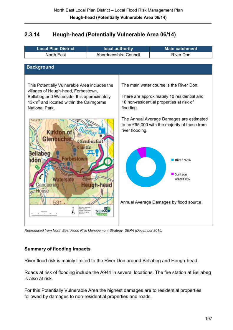
North East Local Plan District – Local Flood Risk Management Plan
Heugh-head (Potentially Vulnerable Area 06/14)
197
2.3.14 Heugh-head (Potentially Vulnerable Area 06/14)
Local Plan District local authority Main catchment North East Aberdeenshire Council River Don
Background
This Potentially Vulnerable Area includes the
villages of Heugh-head, Forbestown,
Bellabeg and Waterside. It is approximately
13km2 and located within the Cairngorms
National Park.
The main water course is the River Don.
There are approximately 10 residential and
10 non-residential properties at risk of
flooding.
The Annual Average Damages are estimated
to be £95,000 with the majority of these from
river flooding.
Annual Average Damages by flood source
Reproduced from North East Flood Risk Management Strategy, SEPA (December 2015)
Summary of flooding impacts
River flood risk is mainly limited to the River Don around Bellabeg and Heugh-head.
Roads at risk of flooding include the A944 in several locations. The fire station at Bellabeg
is also at risk.
For this Potentially Vulnerable Area the highest damages are to residential properties
followed by damages to non-residential properties and roads.
River 92%
Surfacewater 8%

North East Local Plan District – Local Flood Risk Management Plan
Heugh-head (Potentially Vulnerable Area 06/14)
198
History of flooding
There was a surface water flood in August 2006 affecting Strathdon, Waterside and
Bellabeg when water ponded in low points of the road. Heavy rainfall falling on steep
sloping fields to the south resulted in significant amounts of flood water on the road.
Objectives to manage flooding in Potentially Vulnerable Area 06/14
Objectives provide a common goal and shared ambition for managing floods. These
objectives have been set by SEPA and agreed with flood risk management authorities
following consultation. They were identified through an assessment of the underlying
evidence of the causes and impacts of flooding. Target areas have been set to focus
actions; they do not necessarily correspond to areas at risk in SEPA’s flood map. The objectives
below have been set for Heugh-head Potentially Vulnerable Area.
Reduce flood risk in Strathdon from the River Don
Indicators: Target area:
1 emergency service
1 healthcare facility
Objective ID: 601401
© Crown Copyright. All rights reserved. SEPA lic.no. 100016991 (2015)
Reproduced from North East Flood Risk Management Strategy, SEPA (December 2015)
North East Local Plan District – Local Flood Risk Management Plan
Heugh-head (Potentially Vulnerable Area 06/14)
199
Target area Objective ID Indicators within
PVA
Applies across
North East Local
Plan District
Avoid an overall increase in flood risk 600001 10 residential
properties
£95,000 Annual
Average Damages
Applies across
North East Local
Plan District
Reduce overall flood risk 600002 10 residential
properties
£95,000 Annual
Average Damages
Applies across
North East Local
Plan District
Organisation such as utility companies and
Historic Environment Scotland actively
maintain and manage their own assets,
including the risk of flooding. These
actions are not detailed further in the Flood
Risk Management Strategies.
Reproduced from North East Flood Risk Management Strategy, SEPA (December 2015)
Actions to manage flooding in Potentially Vulnerable Area 06/14
Actions describe where and how flood risk will be managed. These actions have been set
by SEPA and agreed with flood risk management authorities following consultation.
Selection of actions to deliver the agreed objectives was based on a detailed assessment
and comparison of economic, social and environmental criteria. The actions shaded and
then described below have been selected as the most appropriate for Heugh-head
Potentially Vulnerable Area.
Selected actions
Flood protection
scheme/works
Natural flood management
works
New flood warning
Community flood action
groups
Property level protection scheme
Site protection plans
Flood protection
study
Natural flood management
study
Maintain flood warning
Awareness raising
Surface water plan/study
Emergency plans/response
Maintain flood protection scheme
Strategic mapping and
modelling
Flood forecasting
Self Help Maintenance Planning policies

North East Local Plan District – Local Flood Risk Management Plan
Heugh-head (Potentially Vulnerable Area 06/14)
200
The delivery of selected actions by year over the six-year plan cycle is summarised below.
Delivery of selected actions
Year 1 (2016/17) Year 2
(2017/18)
Year 3
(2018/19)
Year 4
(2019/20)
Year 5
(2020/21)
Year 6
(2021/22)
Site protection plans
Awareness raising
Emergency plans/response
Flood forecasting
Self help
Maintenance
Planning Policy
Action (ID): SITE PROTECTION PLANS (6014010015)
Objective (ID): Reduce flood risk in Strathdon from the River Don (601401)
Delivery lead: Asset managers
Status: Scheduled Indicative delivery: 2016-2018
Description:
Site protection plans are developed to identify whether normal operation of a facility can be
maintained during a flood. This may be due to existing protection or resilience of the facility or the
network.
Aberdeenshire Council will engage with the asset managers for the fire station and a doctor's
surgery to advise on the requirements to develop their own site protection plans.
North East Local Plan District – Local Flood Risk Management Plan
Heugh-head (Potentially Vulnerable Area 06/14)
201
Action (ID): AWARENESS RAISING (6000020013)
Objective (ID): Reduce overall flood risk (600002)
Delivery lead: Responsible authorities
Status: Existing Indicative delivery: Ongoing
Description:
Aberdeenshire Council have a duty to raise public awareness of flood risk under the Flood Risk
Management (Scotland) Act 2009 and to plan and inform of risks to communities under the Civil
Contingencies Act 2004.
Over the six years of the Plan, 2016-2022, Aberdeenshire Council will seek opportunities to raise
awareness of both flood risk and actions that enable individuals, homes and businesses to
reduce the overall impact of flooding.
In partnership with Education Scotland Aberdeenshire Council will look to engage schools in
activities relating to flooding, extreme weather, climate change and other community resilience
issues.
Aberdeenshire Council will also develop emergency response plans and work with community
flood action groups where these exist.
Awareness raising will be funded from existing local authority flood revenue budgets.
From 2016 SEPA will engage with the community through local participation in national
initiatives, including partnership working with Neighbourhood Watch Scotland. In addition, SEPA
will engage with local authorities and community resilience groups where possible.
Across Scotland, SEPA will create and share communication and education resources with other
responsible authorities. These resources will include awareness campaigns, media and
marketing activities and promotion of SEPA's flood forecasting and warning service (Floodline).
Where they exist, SEPA will engage with community resilience groups and community safety
partnerships. Additionally, SEPA's awareness raising activities will be coordinated with the
activities of other responsible authorities as required.
SEPA's awareness raising activities are funded by Scottish Government through their grant in aid
settlement and will be coordinated with the activities of other responsible authorities as required.
Scottish Water will support SEPA and responsible authorities with their awareness raising
activities as required and provide targeted flooding communications for Scottish Water specific
activities. Scottish Water will raise awareness by producing and supplying targeted information to
the public on large capital projects and detailed local studies.
(continued)
North East Local Plan District – Local Flood Risk Management Plan
Heugh-head (Potentially Vulnerable Area 06/14)
202
Action (ID): EMERGENCY PLANS/RESPONSE (6000020014)
Objective (ID): Reduce overall flood risk (600002)
Delivery lead: Category 1 and 2 Responders
Status: Existing Indicative delivery: Ongoing
Description:
Providing an emergency response to flooding is the responsibility of many organisations,
including local authorities, the emergency services and SEPA. Effective management of an
emergency response relies on emergency plans that are prepared under the Civil Contingencies
Act 2004 by Category 1 and 2 Responders.
Aberdeenshire Council has an overarching Flood Response Plan, which is coordinated through
the Responders identified under the Civil Contingencies Act 2004. The aim of the plan is to set
out arrangements to deal effectively with flood risk. At predetermined trigger levels flood alerts
and warnings will be issued through SEPA's flood forecasting and warning service (Floodline)
and Aberdeenshire Council will conduct assessments at known hotspots and prepare resources
as required. Aberdeenshire Council will also coordinate measures in conjunction with the other
Responders. The emergency response process is coordinated through regional and local
resilience partnerships. This response may be supported by the work of voluntary organisations.
The Operational Flood Response Plan will undergo review on an annual basis to reflect
operational or responsibility changes. A debrief and plan review will also be carried out after the
Plan is activated during emergencies.
Aberdeenshire Council funding for emergency plans/response will be shared with other
organisations, emergency services and Responders, as appropriate, and will be subject to
Scottish Government’s block grant and capital support, and budget allocations over the six years
of the Plan, 2016-2022. SEPA's emergency plans/response are funded by Scottish Government
through SEPA’s grant in aid settlement.
More general information and flooding guidance will be available on the website at:
https://www.scottishwater.co.uk/you-and-your-home/your-home/flooding-information
Scottish Water will keep responsible authorities informed of its awareness raising activities
through the Local Plan District partnerships.
North East Local Plan District – Local Flood Risk Management Plan
Heugh-head (Potentially Vulnerable Area 06/14)
203
Action (ID): FLOOD FORECASTING (6000020009)
Objective (ID): Reduce overall flood risk (600002)
Delivery lead: SEPA
Status: Existing Indicative delivery: Ongoing
Description:
The Scottish Flood Forecasting Service is a joint initiative between SEPA and the Met Office that
produces daily, national flood guidance statements which are issued to Category 1 and 2
Responders. The flood guidance statements provide an assessment of the risk of flooding for a
five day period allowing responders time to put preparations in place to reduce the impact of
flooding. The service also provides information which allows SEPA to issue flood warnings,
giving people a better chance of reducing the impact of flooding on their home or business. For
more information, please visit SEPA’s website. The Potentially Vulnerable Area is within the
'Aberdeenshire and Aberdeen City' flood alert area.
SEPA / Met Office joint initiative. Hydrological information is provided by SEPA and
meteorological information is provided by the Met Office. SEPA uses the information to predict
the likelihood and timing of river, coastal and surface water flooding.
SEPA’s flood forecasting service is funded through Scottish Government’s grant in aid allocation.
The Met Office receives funding from the UK Government.
Action (ID): SELF HELP (6000020011)
Objective (ID): Reduce overall flood risk (600002)
Delivery lead: —
Status: Existing Indicative delivery: Ongoing
Description:
Everyone is responsible for protecting themselves and their property flooding. Property and
business owners can take simple steps to reduce damage and disruption to their homes and
businesses should flooding happen. This includes preparing a flood plan and flood kit, installing
property level protection, signing up to Floodline and Resilient Communities initiatives, and
ensuring that properties and businesses are insured against flood damage.
Aberdeenshire Council currently provide a small range of flood protection products for individual
property protection, which are available for all types of flooding, at cost price with free delivery
across Aberdeenshire.
North East Local Plan District – Local Flood Risk Management Plan
Heugh-head (Potentially Vulnerable Area 06/14)
204
Action (ID): MAINTENANCE (6000020007)
Objective (ID): Reduce overall flood risk (600002)
Delivery lead: Aberdeenshire Council, asset / land managers
Status: Existing Indicative delivery: Ongoing
Description:
Local authorities have a duty to assess watercourses and carry out clearance and repair works
where such works would substantially reduce flood risk. Aberdeenshire Council will produce
schedules of clearance and repair works and make these available for public inspection.
Maintenance will be funded from existing Flood revenue budgets, for works which are defined to
pose a significant flood risk.
Scottish Water undertake risk based inspection, maintenance and repair on the public sewer
network together with keeping responsible authorities informed of large scale capital
maintenance work to identify opportunities for co-ordination.

North East Local Plan District – Local Flood Risk Management Plan
Heugh-head (Potentially Vulnerable Area 06/14)
205
Action (ID): PLANNING POLICIES (6000010001)
Objective (ID): Avoid an overall increase in flood risk (600001)
Reduce overall flood risk (600002)
Delivery lead: Planning authority
Status: Existing Indicative delivery: Ongoing
Description:
Scottish Planning Policy and accompanying Planning Advice Notes set out Scottish Ministers’
priorities for the operation of the planning system and for the development and use of land. In
terms of flood risk management, the policy supports a catchment-scale approach to sustainable
flood risk management and aims to build the resilience of our cities and towns, encourage
sustainable land management in our rural areas, and to address the long-term vulnerability of
parts of our coasts and islands. Under this approach, new development in areas with medium to
high likelihood of flooding should be avoided. Planning authorities are responsible for
implementing this policy guidance when producing Local Development Plans and when
considering individual planning applications.
For further information on the application of national planning policies see Annex 5.
Aberdeenshire Council is a local planning authority and will work with the regional planning
authority, the Aberdeen City and Shire Strategic Development Planning Authority.
As a consultee on planning applications, Aberdeenshire Council’s Flood & Coast Protection team
will work directly with colleagues in the Planning Service to ensure that appropriate policies and
measures are put in place to reduce flood risk. Planning applications are assessed against the
flooding standards set out in the current Aberdeenshire Local Development Plan, and in future
those in the proposed Aberdeenshire Local Development Plan 2016.
SEPA has a statutory role in relation to the provision of flood risk advice to planning authorities.
This role is expressed in Section 72 of the FRM Act, 2009. SEPA also has a duty to cooperate
with planning authorities in the preparation of development plans. When consulted in relation to
planning applications for development or site allocations in development plans, and where the
planning authority considers there may be a risk of flooding, SEPA will provide advice. The
advice provided by SEPA will be with respect to the risk of flooding and on the basis of the
relevant information it holds which is suitable for planning purposes. It will also be in line with the
principles and duties set out in the FRM Act. Further information about how SEPA engages in
the planning system, including guidance on flood risk and planning is available on SEPA’s
website http://www.sepa.org.uk/environment/land/planning/
(continued)

North East Local Plan District – Local Flood Risk Management Plan
Heugh-head (Potentially Vulnerable Area 06/14)
206
SEPA's land use planning activities will be coordinated with the activities of other responsible
authorities as required and are funded by Scottish Government through SEPA’s grant in aid
settlement.
Scottish Water is a statutory consultee within the planning legislation and is required to comment
on all outline or full planning applications which are referred by a local authority. Scottish Water is
also defined as a key agency within development plan legislation, and therefore plays a key role
in providing advice to planning authorities during the production of Local Development Plans.
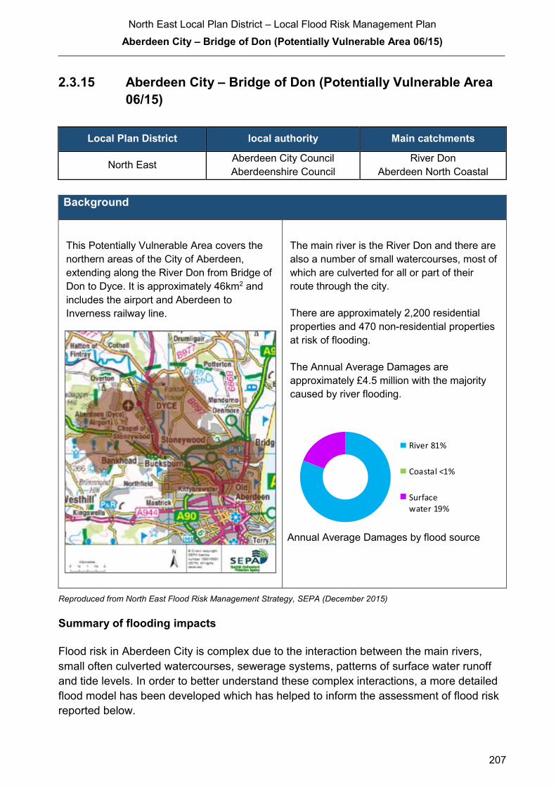
North East Local Plan District – Local Flood Risk Management Plan
Aberdeen City – Bridge of Don (Potentially Vulnerable Area 06/15)
207
2.3.15 Aberdeen City – Bridge of Don (Potentially Vulnerable Area
06/15)
Local Plan District local authority Main catchments
North East Aberdeen City Council
Aberdeenshire Council River Don
Aberdeen North Coastal
Background
This Potentially Vulnerable Area covers the
northern areas of the City of Aberdeen,
extending along the River Don from Bridge of
Don to Dyce. It is approximately 46km2 and
includes the airport and Aberdeen to
Inverness railway line.
The main river is the River Don and there are
also a number of small watercourses, most of
which are culverted for all or part of their
route through the city.
There are approximately 2,200 residential
properties and 470 non-residential properties
at risk of flooding.
The Annual Average Damages are
approximately £4.5 million with the majority
caused by river flooding.
Annual Average Damages by flood source
Reproduced from North East Flood Risk Management Strategy, SEPA (December 2015)
Summary of flooding impacts
Flood risk in Aberdeen City is complex due to the interaction between the main rivers,
small often culverted watercourses, sewerage systems, patterns of surface water runoff
and tide levels. In order to better understand these complex interactions, a more detailed
flood model has been developed which has helped to inform the assessment of flood risk
reported below.
River 81%
Coastal <1%
Surfacewater 19%

North East Local Plan District – Local Flood Risk Management Plan
Aberdeen City – Bridge of Don (Potentially Vulnerable Area 06/15)
208
A number of schools, healthcare facilities and an emergency services site are at risk of
flooding. Transport links affected by flooding include the A956, A90, A947 and A96 roads
and the Aberdeen to Inverness railway line. Flooding also affects a small number of
designated cultural heritage sites, utilities and buildings at the University of Aberdeen.
For this Potentially Vulnerable Area the highest damages are to non-residential properties
followed by damages to residential properties.
History of flooding
The earliest recorded flood was in 1916 when the River Don submerged land in the Dyce
area.
There was groundwater flooding in 2001, when the high water table flooded basements in
Hilton Avenue, Hilton. Heavy rain resulted in surface water on the A947 Parkhill Bridge in
February 2009, which caused a road traffic accident at the Newmachar to Parkhill
Crossroads.
Flooding from the Silverburn due to a blockage of the watercourse was reported at
Burnside Drive, Kingswell Park and Ride facility, Broadfold Drive and Cloverhill Road.
Incidents have been reported due to inadequate culvert capacity, affecting Farburn
Terrace and industrial units on Airport Commerce. There are reports of blockages causing
flooding in the University grounds, Hilton Avenue and Cummings Park Circle. Flood
incidents have also been reported at Kettock’s Mill, Polo Gardens in Stoneywood and
Laurel Place, Whitestripes Road, Muggiemoss Road, A96 Inverurie Road, Lade Crescent,
Union Road, North Kirkhill, and Manor Drive.
The only coastal flood on record was in 1921, when there was a particularly high tide.
Large parts of Aberdeen were affected by surface water flooding in July 2015. Many
manhole covers became dislodged, roads were submerged and Aberdeen Airport’s
terminal building was flooded.
Objectives to manage flooding in Potentially Vulnerable Area 06/15
Objectives provide a common goal and shared ambition for managing floods. These
objectives have been set by SEPA and agreed with flood risk management authorities
following consultation. They were identified through an assessment of the underlying
evidence of the causes and impacts of flooding. Target areas have been set to focus
actions; they do not necessarily correspond to areas at risk in SEPA’s flood map. The
objectives below have been set for Aberdeen City - Bridge of Don Potentially Vulnerable
Area.
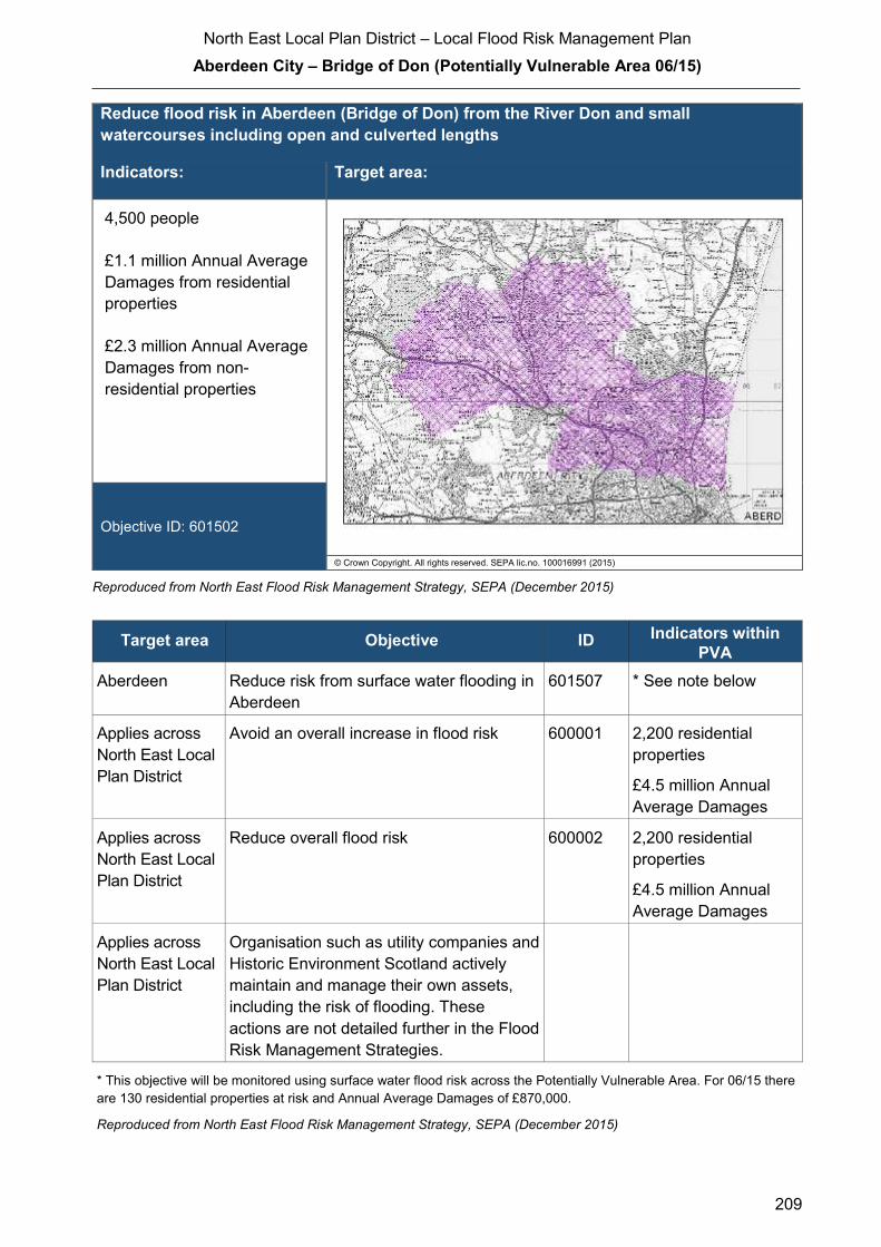
North East Local Plan District – Local Flood Risk Management Plan
Aberdeen City – Bridge of Don (Potentially Vulnerable Area 06/15)
209
Reduce flood risk in Aberdeen (Bridge of Don) from the River Don and small
watercourses including open and culverted lengths
Indicators: Target area:
4,500 people
£1.1 million Annual Average
Damages from residential
properties
£2.3 million Annual Average
Damages from non-
residential properties
Objective ID: 601502
© Crown Copyright. All rights reserved. SEPA lic.no. 100016991 (2015)
Reproduced from North East Flood Risk Management Strategy, SEPA (December 2015)
Target area Objective ID Indicators within
PVA
Aberdeen Reduce risk from surface water flooding in
Aberdeen
601507 * See note below
Applies across
North East Local
Plan District
Avoid an overall increase in flood risk 600001 2,200 residential
properties
£4.5 million Annual
Average Damages
Applies across
North East Local
Plan District
Reduce overall flood risk 600002 2,200 residential
properties
£4.5 million Annual
Average Damages
Applies across
North East Local
Plan District
Organisation such as utility companies and
Historic Environment Scotland actively
maintain and manage their own assets,
including the risk of flooding. These
actions are not detailed further in the Flood
Risk Management Strategies.
* This objective will be monitored using surface water flood risk across the Potentially Vulnerable Area. For 06/15 there
are 130 residential properties at risk and Annual Average Damages of £870,000.
Reproduced from North East Flood Risk Management Strategy, SEPA (December 2015)

North East Local Plan District – Local Flood Risk Management Plan
Aberdeen City – Bridge of Don (Potentially Vulnerable Area 06/15)
210
Actions to manage flooding in Potentially Vulnerable Area 06/15
Actions describe where and how flood risk will be managed. These actions have been set
by SEPA and agreed with flood risk management authorities following consultation.
Selection of actions to deliver the agreed objectives was based on a detailed assessment
and comparison of economic, social and environmental criteria. The actions shaded and
then described below have been selected as the most appropriate for Aberdeen City -
Bridge of Don Potentially Vulnerable Area.
Selected actions
Flood protection
scheme/works
Natural flood management
works
New flood warning
Community flood action
groups
Property level protection scheme
Site protection plans
Flood protection
study
Natural flood management
study
Maintain flood warning
Awareness raising
Surface water plan/study
Emergency plans/response
Maintain flood protection scheme
Strategic mapping and
modelling
Flood forecasting
Self Help Maintenance Planning policies

North East Local Plan District – Local Flood Risk Management Plan
Aberdeen City – Bridge of Don (Potentially Vulnerable Area 06/15)
211
The delivery of selected actions by year over the six-year plan cycle is summarised below.
Delivery of selected actions
Year 1 (2016/17) Year 2
(2017/18)
Year 3
(2018/19)
Year 4
(2019/20)
Year 5
(2020/21)
Year 6
(2021/22)
New flood warning
Flood protection study
Maintain flood warning
Awareness raising
Surface water plan/study
Emergency plans/response
Strategic mapping and modelling
(SEPA)
Strategic mapping and modelling
(Scottish Water)
Flood forecasting
Self help
Maintenance
Planning Policy

North East Local Plan District – Local Flood Risk Management Plan
Aberdeen City – Bridge of Don (Potentially Vulnerable Area 06/15)
212
Action (ID): NEW FLOOD WARNING (6000020010)
Objective (ID): Reduce overall flood risk (600002)
Delivery lead: SEPA
Status: Scheduled Indicative delivery: 2017 - 2018
Description:
Flood warning is required for communities at risk of coastal flooding along the Aberdeenshire
coast from Peterhead to Montrose. A flood warning system will be developed and implemented.
The geographical extent of specific flood warning areas will be developed as part of this process.
The maintenance of SEPA’s flood warning service is funded by Scottish Government through
SEPA’s grant in aid settlement.
In addition, Scottish Government provides grant funding to enable SEPA to implement new flood
warning schemes.
Action (ID): FLOOD PROTECTION STUDY (6015020005)
Objective (ID): Reduce risk from surface water flooding in Aberdeen (601507)
Reduce flood risk in Aberdeen (Bridge of Don) from the River Don and small
watercourses including open and culverted lengths (601502)
Delivery lead: Aberdeen City Council (ACC)
Priority: National: Within local authority:
1 and 5 of 168 1 and 2 of 4
Status: Scheduled Indicative delivery: 2016-2019
Description:
The Bridge of Don Flood protection studies will look at the flood risk from small watercourses and
surface water in this area and define type of solutions that may be applicable these areas to
prevent or reduce the flood risk.
For small watercourses and surface water flooding, the studies will be based on the outputs from
the Aberdeen Integrated Catchment study and coordinated with the surface water management
plan to take a comprehensive approach to flood risk management in Aberdeen
(continued)

North East Local Plan District – Local Flood Risk Management Plan
Aberdeen City – Bridge of Don (Potentially Vulnerable Area 06/15)
213
Delivery of the Flood Studies will be undertaken working with the following partners as a
minimum:-
− ACC Community, Housing and Infrastructure Directorate who are responsible for Roads
and Planning within ACC
− SEPA
− Local Residents
− Scottish Water
Funding for the Delivery of the Flood Studies is from ACC Capital Work Programme.
Potential impacts
Economic: Considering all three study areas in Aberdeen City, a total of 10,500
residential and 1,800 non-residential properties could benefit, with potential
damages avoided of up to £520 million. In reality the studies should look to
identify flooding hotspots, where actions should be targeted. Further study will
identify the true benefits of these actions.
Social: Thirteen educational buildings, 14 health care facilities, 33 utilities, and one
emergency service could benefit from any actions taken. Around 23,000
people could benefit from flood protection works. However, this will depend
on locations identified for actions. A reduction in flood risk would have a
positive benefit to the health and wellbeing of the community and socially
vulnerable people.
Environmental: To be in accord with the FRM Strategy, the Responsible Authority should
seek to ensure, as part of the studies, that the action will not have an adverse
effect on the integrity of the River Dee Special Area of Conservation. Cultural
heritage sites, including one garden and designed landscape site, could
benefit from flood protection works identified in the studies. However, this will
depend on the final location and extent of the works. The flood protection
studies should consider how to avoid/minimise potential impacts through
good design and timing of works and consider how to avoid or minimise
potential negative effects such as loss or disturbance of sediment, disruption
to natural processes and loss of habitat. The physical condition of the River
Don, River Dee and Bucks Burn (water body IDs 23265, 23315 and 23266)
are identified by river basin management planning to be at less than good
status. Future works could improve the condition of the rivers or degrade
them. Opportunities to improve the condition of the rivers should be
considered by coordinating with river basin management planning.
North East Local Plan District – Local Flood Risk Management Plan
Aberdeen City – Bridge of Don (Potentially Vulnerable Area 06/15)
214
Action (ID): MAINTAIN FLOOD WARNING (6000020030)
Objective (ID): Reduce overall flood risk (600002)
Delivery lead: SEPA
Status: Existing Indicative delivery: Ongoing
Description:
Continue to maintain the 'Aberdeen (Don)' flood warning area which is part of the Don river flood
warning scheme.
When flood events occur in an area with an existing flood warning service, SEPA will seek to
verify the flood forecasts and warnings. SEPA will use feedback and post-event data to ensure
that our flood warning service is timely and accurate.
A flood protection study is proposed for Aberdeen. SEPA will work with the local authority to
ensure that any new information about flood risk resulting from the proposed flood protection
study is considered in the existing flood warning system.
The maintenance of SEPA’s flood warning service is funded by Scottish Government through
SEPA’s grant in aid settlement.
Action (ID): AWARENESS RAISING (6000020013)
Objective (ID): Reduce overall flood risk (600002)
Delivery lead: Responsible authorities
Status: Existing Indicative delivery: Ongoing
Description:
ACC will be undertaking a number of community events to promote awareness to the risk of
flooding and what can be done to reduce the impact of flooding. As part of this we will be looking
to create flood action groups and community resilience groups with regards to flooding. These
groups will help promote the risk that flooding presents as well as provide practical advice to the
community they serve.
ACC will be working with the flooding groups as a minimum to promote awareness to flood risk:-
− Community Councils
− Local residents
− Education Scotland
− Aberdeen Education Department
− SEPA
(continued)

North East Local Plan District – Local Flood Risk Management Plan
Aberdeen City – Bridge of Don (Potentially Vulnerable Area 06/15)
215
A new flood warning scheme is proposed for the Aberdeenshire coast. To support the delivery of
the new SEPA flood warning scheme, we will carry out communications and engagement
activities. SEPA's awareness raising activities will be coordinated with activities of other
responsible authorities as required.
From 2016 SEPA will engage with the community through local participation in national
initiatives, including partnership working with Neighbourhood Watch Scotland. In addition, SEPA
will engage with local authorities and community resilience groups where possible. Across
Scotland, SEPA will create and share communication and education resources with other
responsible authorities. These resources will include awareness campaigns, media and
marketing activity and promotion of SEPA's flood forecasting and warning services (Floodline).
Where they exist, SEPA will engage with community resilience groups and community safety
partnerships.
To support the delivery of the new SEPA flood warning scheme, SEPA will carry out a local
launch event and engage directly with residents in the area. This will be supported by local and
national media communications. SEPA will also support and participate in local public awareness
events, in partnership with the local authority, community council or other local representative
organisations, including schools.
Activities undertaken by ACC will be funded by existing revenue budgets.
SEPA's awareness raising activities are funded by Scottish Government through SEPA’s grant in
aid settlement.
Aberdeenshire Council have a duty to raise public awareness of flood risk under the Flood Risk
Management (Scotland) Act 2009. Over the six-year planning cycle, Aberdeenshire Council will
seek opportunities to raise awareness of flood risk and actions that prepare individuals, homes
and businesses to reduce the overall impact of flooding.
Aberdeenshire Council will also develop emergency plans/response and work with any
community flood action groups.
Scottish Water will support SEPA and responsible authorities with their awareness raising
activities as required and provide targeted flooding communications for Scottish Water specific
activities. Scottish Water will raise awareness by producing and supplying targeted information to
the public on large capital projects and detailed local studies.
More general information and flooding guidance will be available on the website at:
https://www.scottishwater.co.uk/you-and-your-home/your-home/flooding-information
Scottish Water will keep responsible authorities informed of its awareness raising activities
through the Local Plan District partnerships.
North East Local Plan District – Local Flood Risk Management Plan
Aberdeen City – Bridge of Don (Potentially Vulnerable Area 06/15)
216
Action (ID): SURFACE WATER PLAN/STUDY (6015070018)
Objective (ID): Reduce risk from surface water flooding in Aberdeen (601507)
Delivery lead: Aberdeen City Council (ACC)
Status: Ongoing Indicative delivery: 2016-2018
Description:
ACC are creating a surface water management plan (SWMP). The plan will assess all of the
current data available with regards to flood risk from historical records of flooding/ maintenance
records and existing flood schemes.
Once the detailed assessment has been completed the SWMP will be undertaken and will cover
the following items:-
− Catchment assessment
− Maintenance regime
− Objectives to be achieved in that SWMP area
− Long list of all works required
− Short list of works for the plan area in 2016-2021
The surface water management plan will be delivered via the Surface Water Management
partnership.
An integrated catchment study covering the Aberdeen catchment was carried out in SR10 (2010-
2015) to support the surface water management planning process in Aberdeen, Westhill, and
Stonehaven. The study has improved knowledge and understanding of surface water flood risk
and interactions between the above ground and below ground drainage network e.g. with the
sewer network, watercourses and the sea. The Option appraisal phase of this study will be
carried out in SR15 (2015-2021).
Delivery of the SWMP will be undertaken working with the following partners as a minimum: -
− ACC Community, Housing and Infrastructure Directorate who are responsible for Roads
and Planning within ACC
− SEPA
− Scottish Water
− Local Residents where applicable
− Community council and elected Members
Funding for the Delivery of the Surface Water Management Plans is from ACC Capital
Programme and Revenue Budgets.
North East Local Plan District – Local Flood Risk Management Plan
Aberdeen City – Bridge of Don (Potentially Vulnerable Area 06/15)
217
Action (ID): EMERGENCY PLANS/RESPONSE (6000020014)
Objective (ID): Reduce overall flood risk (600002)
Delivery lead: Category 1 and 2 Responders
Status: Existing Indicative delivery: Ongoing
Description:
Aberdeen City Council will work with all CAT 1 and CAT 2 responders to deliver the emergency
response plan for Aberdeen City. Providing an emergency response to flooding is the
responsibility of many organisations, including local authorities, the emergency services and
SEPA. Effective management of an emergency response relies on emergency plans that are
prepared under the Civil Contingencies Act 2004 by Category 1 and 2 Responders. The
emergency response by these organisations is coordinated through regional and local resilience
partnerships.
Action (ID): STRATEGIC MAPPING AND MODELLING (6000020016)
Objective (ID): Reduce overall flood risk (600002)
Delivery lead: SEPA
Status: Scheduled Indicative delivery: 2016-2018
Description:
SEPA will be seeking to develop the flood hazard mapping in the Green Burn (right hand
tributary at Dyce) and in the Middle Don (from Kintore to Dyce) areas to improve understanding
of the flood risk. The extent and timing of the completed improvements will be dependent on
detailed scoping and data availability.
Flood protection studies are proposed for Aberdeen. SEPA will work with the responsible
authorities to ensure that new information about flood risk resulting from the proposed studies
are considered in SEPA's strategic mapping and modelling developments where appropriate and
relevant.
SEPA's strategic mapping and modelling activities are funded by the Scottish Government
through SEPA’s grant in aid settlement.

North East Local Plan District – Local Flood Risk Management Plan
Aberdeen City – Bridge of Don (Potentially Vulnerable Area 06/15)
218
Action (ID): STRATEGIC MAPPING AND MODELLING (6000020019)
Objective (ID): Reduce overall flood risk (600002)
Delivery lead: Scottish Water
Status: Scheduled Indicative delivery: 2016-2019
Description:
Scottish Water will undertake further investigation and modelling in the Nigg and Persley sewer
catchment areas to improve knowledge and understanding of flood risk in these areas as
required under Section 16 of the Flood Risk Management (Scotland) Act 2009.
Scottish Water will work with responsible authorities to incorporate relevant information into these
studies by regularly keeping the responsible authorities informed of their progress. Scottish
Water will provide responsible authorities with the outputs of the Section 16 assessment which,
where relevant, may be used to inform Surface Water Management Plans and SEPA flood
hazard and risk maps.
Scottish Water funding is committed in its capital programme through Q&S 4a (2015-2021) which
is approved by its regulators and customers.

North East Local Plan District – Local Flood Risk Management Plan
Aberdeen City – Bridge of Don (Potentially Vulnerable Area 06/15)
219
Action (ID): FLOOD FORECASTING (6000020009)
Objective (ID): Reduce overall flood risk (600002)
Delivery lead: SEPA
Status: Existing Indicative delivery: Ongoing
Description:
The Scottish Flood Forecasting Service is a joint initiative between SEPA and the Met Office that
produces daily, national flood guidance statements which are issued to Category 1 and 2
Responders.
Hydrological information is provided by SEPA and meteorological information is provided by the
Met Office.
SEPA uses the information to predict the likelihood and timing of river, coastal and surface water
flooding.
The flood guidance statements provide an assessment of the risk of flooding for a five day period
allowing responders time to put preparations in place to reduce the impact of flooding.
The service also provides information which allows SEPA to issue flood alerts, giving people a
better chance of reducing the impact of flooding on their home or business. For more information,
please visit SEPA’s website. The Potentially Vulnerable Area is within the 'Aberdeenshire and
Aberdeen City' flood alert area.
SEPA’s flood forecasting service is funded through Scottish Government’s grant in aid allocation.
The Met Office receives funding from the UK Government.

North East Local Plan District – Local Flood Risk Management Plan
Aberdeen City – Bridge of Don (Potentially Vulnerable Area 06/15)
220
Action (ID): SELF HELP (6000020011)
Objective (ID): Reduce overall flood risk (600002)
Delivery lead: —
Status: Existing Indicative delivery: 2016 -2021
Description:
Everyone is responsible for protecting themselves and their property from flooding. Property and
business owners can take simple steps to reduce damage and disruption to their homes and
businesses should flooding happen. This includes preparing a flood plan and flood kit, installing
property level protection, signing up to Floodline and Resilient Communities initiatives, and
ensuring that properties and businesses are insured against flood damage.
ACC will be promoting self-help through work with the community. This will include the creation
of a Flood Guard Grant Scheme to assist people with putting in Property Level Protection.
ACC will coordinate this through its Flood Team and seek advice from appropriate bodies such
as the Scottish Flood Forum when setting up the Grant scheme.
Funding of the scheme will be via the ACC Capital works Programme.
North East Local Plan District – Local Flood Risk Management Plan
Aberdeen City – Bridge of Don (Potentially Vulnerable Area 06/15)
221
Action (ID): MAINTENANCE (6000020007)
Objective (ID): Reduce overall flood risk (600002)
Delivery lead: Aberdeen City Council and asset / land managers
Status: Existing Indicative delivery: Ongoing
Description:
ACC has a duty to assess designated water bodies and carry out clearance and repair works
where such works would substantially reduce flood risk. ACC will produce schedules of
clearance and repair works and make these available for public inspection.
Delivery of the clearance and repair Schedule will be undertaken working with the following
partners as a minimum: -
− ACC Community, Housing and Infrastructure Directorate who are responsible for Roads
and Planning within ACC
− SEPA
− Scottish water
− Land Owners
− Aberdeenshire Council
Scottish Water undertake risk based inspection, maintenance and repair on the public sewer
network together with keeping responsible authorities informed of large scale capital
maintenance work to identify opportunities for co-ordination.
Asset owners and riparian landowners are responsible for the maintenance and management of
their own assets including those which help to reduce flooding.
Funding to come from existing ACC Flood revenue budget, for works which are defined to be
ACC responsibility or pose a significant flood risk.
North East Local Plan District – Local Flood Risk Management Plan
Aberdeen City – Bridge of Don (Potentially Vulnerable Area 06/15)
222
Action (ID): PLANNING POLICIES (6000010001)
Objective (ID): Avoid an overall increase in flood risk (600001)
Reduce overall flood risk (600002)
Delivery lead: Planning authority
Status: Existing Indicative delivery: Ongoing
Description:
National planning policies set out Scottish Ministers’ priorities for the operation of the planning
system and for the development and use of land. In terms of flood risk management, the policy
supports a catchment-scale approach to sustainable flood risk management and aims to build
the resilience of our cities and towns, encourage sustainable land management in our rural
areas, and to address the long-term vulnerability of parts of our coasts and islands. Under this
approach, development in areas with medium to high likelihood of flooding should be avoided.
ACC will be applying a catchment-scale approach to sustainable flood risk management and
aims to build the resilience of the city. We will encourage sustainable land management in our
rural areas, and to address the long-term vulnerability of parts of our coasts. Under this
approach, development in areas with medium to high likelihood of flooding should be avoided.
Scottish Planning Policy and accompanying Planning Advice Notes set out Scottish Ministers’
priorities for the operation of the planning system and for the development and use of land. In
terms of flood risk management, the policy supports a catchment-scale approach to sustainable
flood risk management and aims to build the resilience of our cities and towns, encourage
sustainable land management in our rural areas, and to address the long-term vulnerability of
parts of our coasts and islands. Under this approach, new development in areas with medium to
high likelihood of flooding should be avoided.
For further information on the application of national planning policies see Annex 5.
SEPA has a statutory role in relation to the provision of flood risk advice to planning authorities.
This role is expressed in Section 72 of the FRM Act, 2009. SEPA also has a duty to cooperate
with planning authorities in the preparation of development plans. When consulted in relation to
planning applications for development or site allocations in development plans, and where the
planning authority considers there may be a risk of flooding, SEPA will provide advice. The
advice provided by SEPA will be with respect to the risk of flooding and on the basis of the
relevant information it holds which is suitable for planning purposes. It will also be in line with the
principles and duties set out in the FRM Act.
Further information about how SEPA engages in the planning system, including guidance on
flood risk and planning is available on SEPA’s website:
http://www.sepa.org.uk/environment/land/planning/
(continued)

North East Local Plan District – Local Flood Risk Management Plan
Aberdeen City – Bridge of Don (Potentially Vulnerable Area 06/15)
223
SEPA's land use planning activities will be coordinated with the activities of other responsible
authorities as required and are funded by Scottish Government through SEPA’s grant in aid
settlement.
ACC will be working with all relevant bodies to coordinate the activities that are highlighted within
Planning Policy.
ACC will be funding the works associated with Planning Policy via its existing revenue budget.
SEPA's land use planning activities are funded by Scottish Government through SEPA’s grant in
aid settlement.
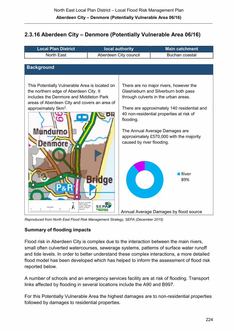
North East Local Plan District – Local Flood Risk Management Plan
Aberdeen City – Denmore (Potentially Vulnerable Area 06/16)
224
2.3.16 Aberdeen City – Denmore (Potentially Vulnerable Area 06/16)
Local Plan District local authority Main catchment North East Aberdeen City council Buchan coastal
Background
This Potentially Vulnerable Area is located on
the northern edge of Aberdeen City. It
includes the Denmore and Middleton Park
areas of Aberdeen City and covers an area of
approximately 5km2.
There are no major rivers, however the
Glashieburn and Silverburn both pass
through culverts in the urban areas.
There are approximately 140 residential and
40 non-residential properties at risk of
flooding.
The Annual Average Damages are
approximately £570,000 with the majority
caused by river flooding.
Annual Average Damages by flood source
Reproduced from North East Flood Risk Management Strategy, SEPA (December 2015)
Summary of flooding impacts
Flood risk in Aberdeen City is complex due to the interaction between the main rivers,
small often culverted watercourses, sewerage systems, patterns of surface water runoff
and tide levels. In order to better understand these complex interactions, a more detailed
flood model has been developed which has helped to inform the assessment of flood risk
reported below.
A number of schools and an emergency services facility are at risk of flooding. Transport
links affected by flooding in several locations include the A90 and B997.
For this Potentially Vulnerable Area the highest damages are to non-residential properties
followed by damages to residential properties.
River89%
North East Local Plan District – Local Flood Risk Management Plan
Aberdeen City – Denmore (Potentially Vulnerable Area 06/16)
225
History of flooding
The Bridge of Don area experienced flooding in 2000 and 2001, when problems with the
drainage system resulted in ponding. This was exacerbated by gullies unable to function
due to the high water level in the Glashieburn. Properties in Lochside Drive, Jesmond
Drive and Brook Crescent were affected. Regular flooding of the combined sewer in
Jesmond Drive has been reported. Flooding has also been reported at Ellon Road due to
debris building up and blocking the watercourse.
Large parts of Aberdeen were affected by surface water flooding in July 2015. Manhole
covers were dislodged by the force of the water. Many roads were affected by flooding,
including Ellon Road.
Objectives to manage flooding in Potentially Vulnerable Area 06/16
Objectives provide a common goal and shared ambition for managing floods. These
objectives have been set by SEPA and agreed with flood risk management authorities
following consultation. They were identified through an assessment of the underlying
evidence of the causes and impacts of flooding. Target areas have been set to focus
actions; they do not necessarily correspond to areas at risk in SEPA’s flood map. The
objectives below have been set for Aberdeen City - Denmore Potentially Vulnerable Area.

North East Local Plan District – Local Flood Risk Management Plan
Aberdeen City – Denmore (Potentially Vulnerable Area 06/16)
226
Reduce the risk of flooding from surface water and burns in Aberdeen (Denmore)
Indicators: Target area:
300 people
£250,000 Annual Average
Damages from residential
properties
£280,000 Annual Average
Damages from non-
residential properties
Objective ID: 601601
© Crown Copyright. All rights reserved. SEPA lic.no. 100016991 (2015)
Reproduced from North East Flood Risk Management Strategy, SEPA (December 2015)
Target area Objective ID Indicators within
PVA
Applies across
North East Local
Plan District
Avoid an overall increase in flood risk 600001 140 residential
properties
£570,000 Annual
Average Damages
Applies across
North East Local
Plan District
Reduce overall flood risk 600002 140 residential
properties
£570,000 Annual
Average Damages
Applies across
North East Local
Plan District
Organisation such as utility companies and
Historic Environment Scotland actively
maintain and manage their own assets,
including the risk of flooding. These
actions are not detailed further in the Flood
Risk Management Strategies.
Reproduced from North East Flood Risk Management Strategy, SEPA (December 2015)

North East Local Plan District – Local Flood Risk Management Plan
Aberdeen City – Denmore (Potentially Vulnerable Area 06/16)
227
Actions to manage flooding in Potentially Vulnerable Area 06/16
Actions describe where and how flood risk will be managed. These actions have been set
by SEPA and agreed with flood risk management authorities following consultation.
Selection of actions to deliver the agreed objectives was based on a detailed assessment
and comparison of economic, social and environmental criteria. The actions shaded and
then described below have been selected as the most appropriate for Aberdeen City -
Denmore Potentially Vulnerable Area.
Selected actions
Flood protection
scheme/works
Natural flood management
works
New flood warning
Community flood action
groups
Property level protection scheme
Site protection plans
Flood protection
study
Natural flood management
study
Maintain flood warning
Awareness raising
Surface water plan/study
Emergency plans/response
Maintain flood protection scheme
Strategic mapping and
modelling
Flood forecasting
Self Help Maintenance Planning policies
The delivery of selected actions by year over the six-year plan cycle is summarised below.
Delivery of selected actions
Year 1 (2016/17) Year 2
(2017/18)
Year 3
(2018/19)
Year 4
(2019/20)
Year 5
(2020/21)
Year 6
(2021/22)
Flood protection study
Awareness raising
Surface water plan/study
Emergency plans/response
Maintain flood protection scheme
Strategic mapping and modelling
Flood forecasting
Self help
Maintenance
Planning Policy
North East Local Plan District – Local Flood Risk Management Plan
Aberdeen City – Denmore (Potentially Vulnerable Area 06/16)
228
Action (ID): FLOOD PROTECTION STUDY (6016010005)
Objective (ID): Reduce the risk of flooding from surface water and burns in Aberdeen
(Denmore) (601601)
Delivery lead: Aberdeen City Council
Priority: National: Within local authority:
5 of 168 2 of 4
Status: Scheduled Indicative delivery: 2016-2021
Description:
The Bridge of Don Flood Protection Studies will look at the flood risk from small watercourses
and surface water in this area and define type of solutions that may be applicable these areas to
prevent or reduce the flood risk.
For small watercourses and surface water flooding, the studies will be based on the outputs from
the Aberdeen Integrated Catchment Study and coordinated with the surface water management
plan to take a comprehensive approach to flood risk management in Aberdeen
Delivery the Flood Studies will be undertaken working with the following partners as a minimum:-
− ACC Community, Housing and Infrastructure Directorate who are responsible for
Roads and Planning within ACC
− SEPA
− Local residents
− Scottish Water
Funding for the Delivery of the Flood Studies is from ACC Capital Work Programme
Potential impacts
Economic:
Considering all three study areas in Aberdeen City, a total of 10,500
residential and 1,800 non-residential properties could benefit, with potential
damages avoided of up to £520 million. In reality the studies should look to
identify flooding hotspots, where actions should be targeted. Further study
will identify the true benefits of these actions.
Social:
Thirteen educational buildings, 14 health care facilities, 33 utilities, and one
emergency service could benefit from any actions taken. However, this will
depend on locations identified for actions. Around 23,000 people could
benefit from flood protection works. However, this will depend on locations
identified for actions. A reduction in flood risk would have a positive benefit to
the health and wellbeing of the community and socially vulnerable people.
Environmental: To be in accord with the FRM Strategy, the Responsible Authority should
seek to ensure, as part of the studies, that the action will not have an
adverse effect on the integrity of the River Dee Special Area of
North East Local Plan District – Local Flood Risk Management Plan
Aberdeen City – Denmore (Potentially Vulnerable Area 06/16)
229
Conservation. Cultural heritage sites, including one garden and designed
landscape site, could benefit from flood protection works identified in the
studies. However, this will depend on the final location and extent of the
works. The flood protection studies should consider how to avoid/minimise
potential impacts through good design and timing of works and consider how
to avoid or minimise potential negative effects such as loss or disturbance of
sediment, disruption to natural processes and loss of habitat. The following
rivers are identified by river basin management planning to be at less than
good status for their physical condition: River Don, River Dee and Bucks
Burn (water body IDs 23265, 23315 and 23266). Future works could improve
the condition of the rivers or degrade them. Opportunities to improve the
condition of the rivers should be considered by coordinating with river basin
management planning.
North East Local Plan District – Local Flood Risk Management Plan
Aberdeen City – Denmore (Potentially Vulnerable Area 06/16)
230
Action (ID): AWARENESS RAISING (6000020013)
Objective (ID): Reduce overall flood risk (600002)
Delivery lead: Responsible authorities
Status: Existing Indicative delivery: Ongoing
Description:
ACC will be undertaking a number of community events to promote awareness to the risk of
flooding and what can be done to reduce the impact of flooding. As part of this we will be looking
to create flood action groups and community resilience groups with regards to flooding. These
groups will help promote the risk that flooding presents as well as provide practical advice to the
community they serve.
From 2016 SEPA will engage with the community through local participation in national
initiatives, including partnership working with Neighbourhood Watch Scotland. In addition, SEPA
will engage with local authorities and community resilience groups where possible.
Across Scotland, SEPA will create and share communication and education resources with other
responsible authorities. These resources will include awareness campaigns, media and
marketing activity and promotion of SEPA's flood forecasting and warning services (Floodline).
Where they exist, SEPA will engage with community resilience groups and community safety
partnerships.
To support the delivery of the new SEPA flood warning scheme, SEPA will carry out a local
launch event and engage directly with residents in the area. This will be supported by local and
national media communications. SEPA will also support and participate in local public awareness
events, in partnership with the local authority, community council or other local representative
organisations, including schools.
ACC will be working with the flooding groups as a minimum to promote awareness to flood risk:-
− Community Councils
− Local residents
− Education Scotland
− Aberdeen Education Department
− SEPA
Activities undertaken by ACC will be funded by existing revenue budgets
SEPA's awareness raising activities are funded by Scottish Government through SEPA’s grant in
aid settlement.
(continued)

North East Local Plan District – Local Flood Risk Management Plan
Aberdeen City – Denmore (Potentially Vulnerable Area 06/16)
231
Scottish Water will support SEPA and responsible authorities with their awareness raising
activities as required and provide targeted flooding communications for Scottish Water specific
activities. Scottish Water will raise awareness by producing and supplying targeted information to
the public on large capital projects and detailed local studies.
More general information and flooding guidance will be available on the website at:
https://www.scottishwater.co.uk/you-and-your-home/your-home/flooding-information
Scottish Water will keep responsible authorities informed of its awareness raising activities
through the Local Plan District partnerships.
North East Local Plan District – Local Flood Risk Management Plan
Aberdeen City – Denmore (Potentially Vulnerable Area 06/16)
232
Action (ID): SURFACE WATER PLAN/STUDY (6016010018)
Objective (ID): Reduce the risk of flooding from surface water and burns in Aberdeen
(Denmore) (601601)
Delivery lead: Aberdeen City Council
Status: Ongoing Indicative delivery: 2016-2018
Description:
ACC are creating a surface water management plan (SWMP). The plan will assess all of the
current data available with regards to flood risk from historical records of flooding/ maintenance
records and existing flood schemes.
Once the detailed assessment has been completed the SWMP will be undertaken and will cover
the following items:-
− Catchment assessment
− Maintenance regime
− Objectives to be achieved in that SWMP area
− Long list of all works required
− Short list of works for the plan area in 2016-2021
The surface water management plan will be delivered via the Surface Water Management
partnership.
An integrated catchment study covering the Aberdeen catchment was carried out in SR10 (2010-
2015) to support the surface water management planning process in Aberdeen, Westhill, and
Stonehaven. The study has improved knowledge and understanding of surface water flood risk
and interactions between the above ground and below ground drainage network e.g. with the
sewer network, watercourses and the sea. The Option appraisal phase of this study will be
carried out in SR15 (2015-2021).
Delivery of the SWMP will be undertaken working with the following partners as a minimum: -
− ACC Community, Housing and Infrastructure Directorate who are responsible for Roads
and Planning within ACC
− SEPA
− Scottish Water
− Local Residents where applicable
− Community council and elected Members
Funding for the Delivery of the Surface Water Management Plans is from ACC Capital
Programme and Revenue Budgets.
North East Local Plan District – Local Flood Risk Management Plan
Aberdeen City – Denmore (Potentially Vulnerable Area 06/16)
233
Action (ID): EMERGENCY PLANS/RESPONSE (6000020014)
Objective (ID): Reduce overall flood risk (600002)
Delivery lead: Category 1 and 2 Responders
Status: Existing Indicative delivery: Ongoing
Description:
Aberdeen City Council will work with all CAT 1 and CAT 2 responders to deliver the emergency
response plan for Aberdeen City. Providing an emergency response to flooding is the
responsibility of many organisations, including local authorities, the emergency services and
SEPA. Effective management of an emergency response relies on emergency plans that are
prepared under the Civil Contingencies Act 2004 by Category 1 and 2 Responders. The
emergency response by these organisations is coordinated through regional and local resilience
partnerships.
All Cat 1 and Cat 2 responders are to work together for decision making and to identify solutions
at the time of emergency response and for emergency planning.
Funding will be sourced through existing emergency response Budgets for the ACC elements of
this objective.
Action (ID): MAINTAIN FLOOD PROTECTION SCHEME (6016010017)
Objective (ID): Reduce the risk of flooding from surface water and burns in Aberdeen
(Denmore) (601601)
Delivery lead: Aberdeen City Council
Status: Existing Indicative delivery: Ongoing
Description:
ACC will continue to maintain the Glashie Burn Flood Protection Scheme (attenuation pond and
culverts) which reduce the risk of flooding to Lochside Drive from the Glashie Burn.
ACC will continue to work with local residents to maintain the scheme.
Activities undertaken by ACC will be funded by existing revenue budgets.

North East Local Plan District – Local Flood Risk Management Plan
Aberdeen City – Denmore (Potentially Vulnerable Area 06/16)
234
Action (ID): STRATEGIC MAPPING AND MODELLING (6000020019)
Objective (ID): Reduce overall flood risk (600002)
Delivery lead: Scottish Water
Status: Scheduled Indicative delivery: 2016-2019
Description:
Scottish Water will undertake further investigation and modelling in the Nigg and Persley sewer
catchment areas to improve knowledge and understanding of flood risk in these areas as
required under Section 16 of the Flood Risk Management (Scotland) Act 2009.
Scottish Water will work with responsible authorities to incorporate relevant information into these
studies by regularly keeping the responsible authorities informed of their progress. Scottish
Water will provide responsible authorities with the outputs of the Section 16 assessment which,
where relevant, may be used to inform Surface Water Management Plans and SEPA flood
hazard and risk maps.
Scottish Water funding is committed in its capital programme through Q&S 4a (2015-2021) which
is approved by its regulators and customers.
North East Local Plan District – Local Flood Risk Management Plan
Aberdeen City – Denmore (Potentially Vulnerable Area 06/16)
235
Action (ID): FLOOD FORECASTING (6000020009)
Objective (ID): Reduce overall flood risk (600002)
Delivery lead: SEPA
Status: Existing Indicative delivery: Ongoing
Description:
The Scottish Flood Forecasting Service is a joint initiative between SEPA and the Met Office that
produces daily, national flood guidance statements which are issued to Category 1 and 2
Responders.
Hydrological information is provided by SEPA and meteorological information is provided by the
Met Office. SEPA uses the information to predict the likelihood and timing of river, coastal and
surface water flooding.
The flood guidance statements provide an assessment of the risk of flooding for a five day period
allowing responders time to put preparations in place to reduce the impact of flooding.
The service also provides information which allows SEPA to issue flood alerts, giving people a
better chance of reducing the impact of flooding on their home or business. For more information,
please visit SEPA’s website. The Potentially Vulnerable Area is within the 'Aberdeenshire and
Aberdeen City' flood alert area.
SEPA’s flood forecasting service is funded through Scottish Government’s grant in aid allocation.
The Met Office receives funding from the UK Government.
Action (ID): SELF HELP (6000020011)
Objective (ID): Reduce overall flood risk (600002)
Delivery lead: —
Status: Existing Indicative delivery: Ongoing
Description:
ACC will be promoting self-help through work with the community. This will include the creation
of a Flood Guard Grant Scheme to assist people with putting in Property Level Protection.
ACC will Coordinate this through its Flood Team and seek advice from appropriate bodies such
as the Scottish Flood Forum when setting up the Grant scheme.
Funding of the scheme will be via the ACC Capital works Programme.

North East Local Plan District – Local Flood Risk Management Plan
Aberdeen City – Denmore (Potentially Vulnerable Area 06/16)
236
Action (ID): MAINTENANCE (6000020007)
Objective (ID): Reduce overall flood risk (600002)
Delivery lead: Aberdeen City Council, asset / land managers
Status: Existing Indicative delivery: Ongoing
Description:
ACC has a duty to assess designated water bodies and carry out clearance and repair works
where such works would substantially reduce flood risk. ACC will produce schedules of
clearance and repair works and make these available for public inspection.
Delivery of the clearance and repair Schedule will be undertaken working with the following
partners as a minimum: -
− ACC Community, Housing and Infrastructure Directorate who are responsible for Roads
and Planning within ACC
− SEPA
− Scottish water
− Land Owners
− Aberdeenshire Council
Scottish Water undertake risk based inspection, maintenance and repair on the public sewer
network.
Asset owners and riparian landowners are responsible for the maintenance and management of
their own assets including those which help to reduce flood risk. They will keep responsible
authorities informed of large scale capital maintenance work to identify opportunities for co-
ordination.
Funding will come from existing ACC flood revenue budget, for works which are defined to be
ACC responsibility or pose a significant flood risk

North East Local Plan District – Local Flood Risk Management Plan
Aberdeen City – Denmore (Potentially Vulnerable Area 06/16)
237
Action (ID): PLANNING POLICIES (6000010001)
Objective (ID): Avoid an overall increase in flood risk (600001) Reduce overall flood risk
(600002)
Delivery lead: Planning authority
Status: Existing Indicative delivery: Ongoing
Description:
ACC will be applying a catchment-scale approach to sustainable flood risk management and
aims to build the resilience of the city. We will encourage sustainable land management in our
rural areas, and to address the long-term vulnerability of parts of our coasts. Under this
approach, development in areas with medium to high likelihood of flooding should be avoided.
Scottish Planning Policy and accompanying Planning Advice Notes set out Scottish Ministers’
priorities for the operation of the planning system and for the development and use of land. In
terms of flood risk management, the policy supports a catchment-scale approach to sustainable
flood risk management and aims to build the resilience of our cities and towns, encourage
sustainable land management in our rural areas, and to address the long-term vulnerability of
parts of our coasts and islands. Under this approach, new development in areas with medium to
high likelihood of flooding should be avoided.
For further information on the application of national planning policies see Annex 5.
SEPA has a statutory role in relation to the provision of flood risk advice to planning authorities.
This role is expressed in Section 72 of the FRM Act, 2009. SEPA also has a duty to cooperate
with planning authorities in the preparation of development plans. When consulted in relation to
planning applications for development or site allocations in development plans, and where the
planning authority considers there may be a risk of flooding, SEPA will provide advice. The
advice provided by SEPA will be with respect to the risk of flooding and on the basis of the
relevant information it holds which is suitable for planning purposes. It will also be in line with the
principles and duties set out in the FRM Act.
Further information about how SEPA engages in the planning system, including guidance on
flood risk and planning is available on SEPA’s website
http://www.sepa.org.uk/environment/land/planning/
ACC will be working with all relevant bodies to coordinate the activities that are highlighted with
in Planning Policy.
SEPA's land use planning activities will be coordinated with the activities of other responsible
authorities as required and are funded by Scottish Government through SEPA’s grant in aid
settlement.
(continued)

North East Local Plan District – Local Flood Risk Management Plan
Aberdeen City – Denmore (Potentially Vulnerable Area 06/16)
238
ACC will be funding the works associated with Planning policy via its existing revenue budget.
SEPA's land use planning activities are funded by Scottish Government through SEPA’s grant in
aid settlement.
Scottish Water is a statutory consultee within the planning legislation and is required to comment
on all outline or full planning applications which are referred by a local authority.
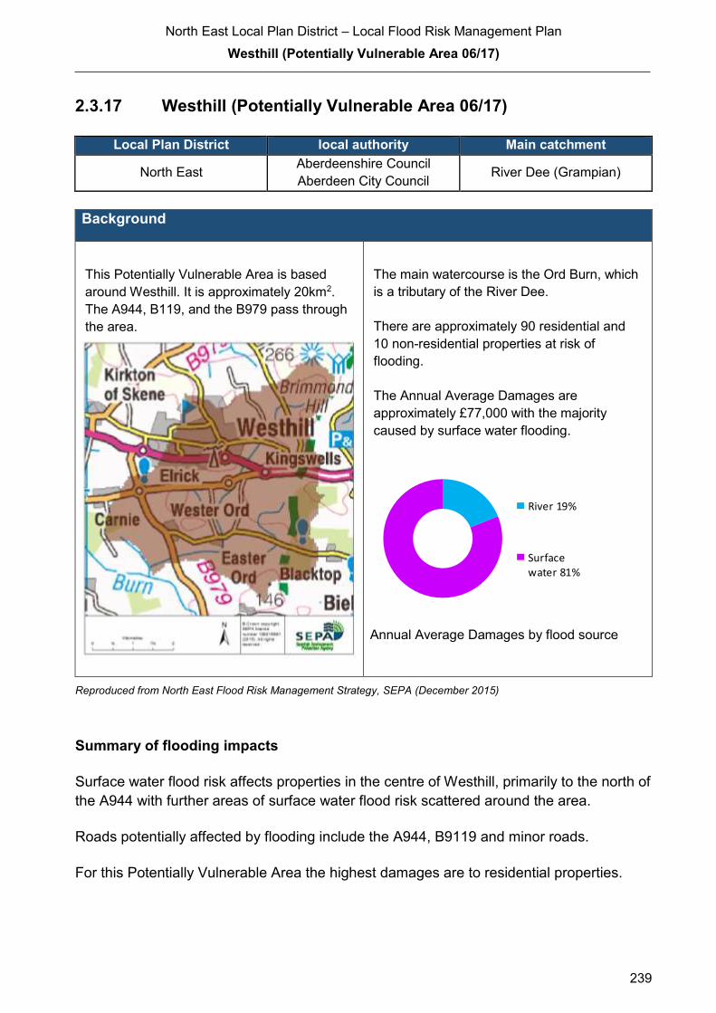
North East Local Plan District – Local Flood Risk Management Plan
Westhill (Potentially Vulnerable Area 06/17)
239
2.3.17 Westhill (Potentially Vulnerable Area 06/17)
Local Plan District local authority Main catchment
North East Aberdeenshire Council
Aberdeen City Council River Dee (Grampian)
Background
This Potentially Vulnerable Area is based
around Westhill. It is approximately 20km2.
The A944, B119, and the B979 pass through
the area.
The main watercourse is the Ord Burn, which
is a tributary of the River Dee.
There are approximately 90 residential and
10 non-residential properties at risk of
flooding.
The Annual Average Damages are
approximately £77,000 with the majority
caused by surface water flooding.
Annual Average Damages by flood source
Reproduced from North East Flood Risk Management Strategy, SEPA (December 2015)
Summary of flooding impacts
Surface water flood risk affects properties in the centre of Westhill, primarily to the north of
the A944 with further areas of surface water flood risk scattered around the area.
Roads potentially affected by flooding include the A944, B9119 and minor roads.
For this Potentially Vulnerable Area the highest damages are to residential properties.
River 19%
Surfacewater 81%
North East Local Plan District – Local Flood Risk Management Plan
Westhill (Potentially Vulnerable Area 06/17)
240
History of flooding
Surface water runoff has caused flooding in parts of Westhill in the past. Flooding has also
been reported at Brodiach Road near Cairdhillock and at Rotten of Gairn due to blocked
gully outlets. Locally, issues with ground water flooding have also been reported.
10 properties were affected as a result of flooding events in December 2015
Objectives to manage flooding in Potentially Vulnerable Area 06/17
Objectives provide a common goal and shared ambition for managing floods. These
objectives have been set by SEPA and agreed with flood risk management authorities
following consultation. They were identified through an assessment of the underlying
evidence of the causes and impacts of flooding. Target areas have been set to focus
actions; they do not necessarily correspond to areas at risk in SEPA’s flood map. The
objectives below have been set for Westhill Potentially Vulnerable Area.
Target area Objective ID Indicators within
PVA
Westhill Reduce risk from surface water flooding in
Westhill
601701 * See note below
Applies across
North East Local
Plan District
Avoid an overall increase in flood risk 600001 90 residential
properties
£77,000 Annual
Average Damages
Applies across
North East Local
Plan District
Reduce overall flood risk 600002 90 residential
properties
£77,000 Annual
Average Damages
Applies across
North East Local
Plan District
Organisation such as utility companies and
Historic Environment Scotland actively
maintain and manage their own assets,
including the risk of flooding. These
actions are not detailed further in the Flood
Risk Management Strategies.
* This objective will be monitored using surface water flood risk across the Potentially Vulnerable Area. For 06/17
there are 80 residential properties at risk and Annual Average Damages of £63,000.
Reproduced from North East Flood Risk Management Strategy, SEPA (December 2015)

North East Local Plan District – Local Flood Risk Management Plan
Westhill (Potentially Vulnerable Area 06/17)
241
Actions to manage flooding in Potentially Vulnerable Area 06/17
Actions describe where and how flood risk will be managed. These actions have been set
by SEPA and agreed with flood risk management authorities following consultation.
Selection of actions to deliver the agreed objectives was based on a detailed assessment
and comparison of economic, social and environmental criteria. The actions shaded and
then described below have been selected as the most appropriate for Westhill Potentially
Vulnerable Area.
Selected actions
Flood protection
scheme/works
Natural flood management
works
New flood warning
Community flood action
groups
Property level protection scheme
Site protection plans
Flood protection
study
Natural flood management
study
Maintain flood warning
Awareness raising
Surface water plan/study
Emergency plans/response
Maintain flood protection scheme
Strategic mapping and
modelling
Flood forecasting
Self Help Maintenance Planning policies
The delivery of selected actions by year over the six-year plan cycle is summarised below.
Delivery of selected actions
Year 1 (2016/17) Year 2
(2017/18)
Year 3
(2018/19)
Year 4
(2019/20)
Year 5
(2020/21)
Year 6
(2021/22)
Awareness raising
Surface water plan/study
Emergency plans/response
Strategic mapping and modelling
Flood forecasting
Self help
Maintenance
Planning Policy

North East Local Plan District – Local Flood Risk Management Plan
Westhill (Potentially Vulnerable Area 06/17)
242
Action (ID): AWARENESS RAISING (6000020013)
Objective (ID): Reduce overall flood risk (600002)
Delivery lead: Responsible authorities
Status: Existing Indicative delivery: Ongoing
Description:
Both Aberdeen City and Aberdeenshire Council have a duty to raise public awareness of flood
risk under the Flood Risk Management (Scotland) Act 2009 and to plan and inform of risks to
communities under the Civil Contingencies Act 2004.
Over the six years of the Plan, 2016-2022, Aberdeenshire Council will seek opportunities to raise
awareness of both flood risk and actions that enable individuals, homes and businesses to
reduce the overall impact of flooding.
In partnership with Education Scotland Aberdeenshire Council will look to engage schools in
activities relating to flooding, extreme weather, climate change and other community resilience
issues. Aberdeenshire Council will also develop emergency response plans and work with
community flood action groups where these exist.
Awareness raising will be funded from existing local authority flood revenue budgets.
From 2016 SEPA will engage with the community through local participation in national
initiatives, including partnership working with Neighbourhood Watch Scotland. In addition, SEPA
will engage with local authorities and community resilience groups where possible.
Across Scotland, SEPA will create and share communication and education resources with other
responsible authorities. These resources will include awareness campaigns, media and
marketing activities and promotion of SEPA's flood forecasting and warning service (Floodline).
Where they exist, SEPA will engage with community resilience groups and community safety
partnerships. Additionally, SEPA's awareness raising activities will be coordinated with the
activities of other responsible authorities as required.
SEPA's awareness raising activities are funded by Scottish Government through their grant in aid
settlement and will be coordinated with the activities of other responsible authorities as required.
Scottish Water will support SEPA and responsible authorities with their awareness raising
activities as required and provide targeted flooding communications for Scottish Water specific
activities. Scottish Water will raise awareness by producing and supplying targeted information to
the public on large capital projects and detailed local studies.
More general information and flooding guidance will be available on the website at:
https://www.scottishwater.co.uk/you-and-your-home/your-home/flooding-information
Scottish Water will keep responsible authorities informed of its awareness raising activities
through the Local Plan District partnerships.

North East Local Plan District – Local Flood Risk Management Plan
Westhill (Potentially Vulnerable Area 06/17)
243
Action (ID): SURFACE WATER PLAN/STUDY (6017010018)
Objective (ID): Reduce risk from surface water flooding in Westhill (601701)
Delivery lead: Aberdeenshire Council
Status: Ongoing Indicative delivery: 2016-2021
Description:
Aberdeenshire Council will undertake a study to prepare a Surface Water Management Plan
(SWMP) to generate increased understanding of the causes, probability and consequences of
surface water flooding and to evaluate options for surface water flood management in Westhill.
The SWMP will build upon the Integrated Catchment Study and will help in preparing a
coordinated action plan, supported by an understanding of the costs and benefits, to identify
measures to mitigate surface water flooding, identifying opportunities where SuDS and similar
sustainable measures can play a more significant role in managing surface water flood risk and
generate improved public engagement and understanding of surface water flooding as well as
inform future developments. The SWMP will be completed to coincide with the Option appraisal
phase of the Integrated Catchment Study which is planned to be carried out from 2015 to 2021.
The SWMP has the potential to benefit 80 residential properties and sections of road network at
risk of flooding in this location, with potential Average Annual Damages avoided of up to £63,000.
A reduction in flood risk would have a positive benefit to the health and wellbeing of the
community and socially vulnerable people located within the study area and may also contribute
to enhanced biodiversity and economic activity.
An Integrated Catchment Study covering the Aberdeen catchment was carried out in SR10
(2010-2015) to support the surface water management planning process in Westhill. The study
has improved knowledge and understanding of surface water flood risk and interactions between
the above ground and below ground drainage network e.g. with the sewer network, watercourses
and the sea. The Option appraisal phase of this study will be carried out in SR15 (2015-2021).
This project is being funded by Scottish Water in partnership with Aberdeen City and
Aberdeenshire Councils.
Scottish Water funding is committed in its capital programme through Q&S 4a (2015-2021) which
is approved by its regulators and customers.
The SWMP will consider interactions with drainage system and water bodies and additional data
and information will be procured or surveys commissioned to generate data to inform the plan.
The SWMP will take a sustainable and integrated approach by coordinating with the River Basin
Management Plan. It will explore opportunities for enhancing biodiversity and for promoting
economic activity and social wellbeing.
North East Local Plan District – Local Flood Risk Management Plan
Westhill (Potentially Vulnerable Area 06/17)
244
Aberdeenshire Council will coordinate with Aberdeen City Council, Scottish Water, SEPA and
community groups as well as other relevant agencies and organisations. Aberdeenshire Council
will undertake the SWMP through the Local Planning District (LPD) partnership and / or through
separate agreements.
Funding for the SWMP will be subject to Scottish Government’s block grant and capital support,
and budget allocations over the six years of the Plan, 2016-2022.
Action (ID): EMERGENCY PLANS/RESPONSE (6000020014)
Objective (ID): Reduce overall flood risk (600002)
Delivery lead: Category 1 and 2 Responders
Status: Existing Indicative delivery: Ongoing
Description:
Providing an emergency response to flooding is the responsibility of many organisations,
including local authorities, the emergency services and SEPA. Effective management of an
emergency response relies on emergency plans that are prepared under the Civil Contingencies
Act 2004 by Category 1 and 2 Responders.
Aberdeenshire Council has an overarching Flood Response Plan, which is coordinated through
the Responders identified under the Civil Contingencies Act 2004. The aim of the plan is to set
out arrangements to deal effectively with flood risk. At predetermined trigger levels flood alerts
and warnings will be issued through SEPA's flood forecasting and warning service (Floodline)
and Aberdeenshire Council will conduct assessments at known hotspots and prepare resources
as required. Aberdeenshire Council will also coordinate measures in conjunction with the other
Responders. The emergency response process is coordinated through regional and local
resilience partnerships. This response may be supported by the work of voluntary organisations.
The Operational Flood Response Plan will undergo review on an annual basis to reflect
operational or responsibility changes. A debrief and plan review will also be carried out after the
Plan is activated during emergencies.
Aberdeenshire Council funding for emergency plans/response will be shared with other
organisations, emergency services and Responders, as appropriate, and will be subject to
Scottish Government’s block grant and capital support, and budget allocations over the six years
of the Plan, 2016-2022. SEPA's emergency plans/response are funded by Scottish Government
through SEPA’s grant in aid settlement.

North East Local Plan District – Local Flood Risk Management Plan
Westhill (Potentially Vulnerable Area 06/17)
245
Action (ID): STRATEGIC MAPPING AND MODELLING (6000020019)
Objective (ID): Reduce overall flood risk (600002)
Delivery lead: Scottish Water
Status: Scheduled Indicative delivery: 2016-2019
Description:
Scottish Water will undertake further investigation and modelling in the Nigg sewer catchment to
improve knowledge and understanding of flood risk in this area as required under Section 16 of
the Flood Risk Management (Scotland) Act 2009.
Scottish Water will work with responsible authorities to incorporate relevant information into these
studies by regularly keeping the responsible authorities informed of their progress. Scottish
Water will provide responsible authorities with the outputs of the Section 16 assessment which,
where relevant, may be used to inform Surface Water Management Plans and SEPA flood
hazard and risk maps.
Scottish Water funding is committed in its capital programme through Q&S 4a (2015-2021) which
is approved by its regulators and customers.
Action (ID): FLOOD FORECASTING (6000020009)
Objective (ID): Reduce overall flood risk (600002)
Delivery lead: SEPA
Status: Existing Indicative delivery: Ongoing
Description:
The Scottish Flood Forecasting Service is a joint initiative between SEPA and the Met Office that
produces daily, national flood guidance statements which are issued to Category 1 and 2
Responders. The flood guidance statements provide an assessment of the risk of flooding for a
five day period allowing responders time to put preparations in place to reduce the impact of
flooding. The service also provides information which allows SEPA to issue flood warnings,
giving people a better chance of reducing the impact of flooding on their home or business. For
more information, please visit SEPA’s website. The Potentially Vulnerable Area is within the
'Aberdeenshire and Aberdeen City' flood alert area.
SEPA / Met Office joint initiative. Hydrological information is provided by SEPA and
meteorological information is provided by the Met Office. SEPA uses the information to predict
the likelihood and timing of river, coastal and surface water flooding.
SEPA’s flood forecasting service is funded through Scottish Government’s grant in aid allocation.
The Met Office receives funding from the UK Government.
North East Local Plan District – Local Flood Risk Management Plan
Westhill (Potentially Vulnerable Area 06/17)
246
Action (ID): SELF HELP (6000020011)
Objective (ID): Reduce overall flood risk (600002)
Delivery lead: —
Status: Existing Indicative delivery: Ongoing
Description:
Everyone is responsible for protecting themselves and their property flooding. Property and
business owners can take simple steps to reduce damage and disruption to their homes and
businesses should flooding happen. This includes preparing a flood plan and flood kit, installing
property level protection, signing up to Floodline and Resilient Communities initiatives, and
ensuring that properties and businesses are insured against flood damage.
Aberdeenshire Council currently provide a small range of flood protection products for individual
property protection, which are available for all types of flooding, at cost price with free delivery
across Aberdeenshire.
Aberdeen City Council provides grants towards the fitting of flood guards on individual properties.
Action (ID): MAINTENANCE (6000020007)
Objective (ID): Reduce overall flood risk (600002)
Delivery lead: Aberdeenshire and Aberdeen City Councils, asset / land managers
Status: Existing Indicative delivery: Ongoing
Description:
Local authorities have a duty to assess watercourses and carry out clearance and repair works
where such works would substantially reduce flood risk. Both Local Authorities will produce
schedules of clearance and repair works and make these available for public inspection.
Maintenance will be funded from existing Flood revenue budgets, for works which are defined to
pose a significant flood risk.
Scottish Water undertake risk based inspection, maintenance and repair on the public sewer
network. They will also keep responsible authorities informed of large scale capital maintenance
work to identify opportunities for co-ordination.

North East Local Plan District – Local Flood Risk Management Plan
Westhill (Potentially Vulnerable Area 06/17)
247
Action (ID): PLANNING POLICIES (6000010001)
Objective (ID): Avoid an overall increase in flood risk (600001) Reduce overall flood risk
(600002)
Delivery lead: Planning authority
Status: Existing Indicative delivery: Ongoing
Description:
Scottish Planning Policy and accompanying Planning Advice Notes set out Scottish Ministers’
priorities for the operation of the planning system and for the development and use of land. In
terms of flood risk management, the policy supports a catchment-scale approach to sustainable
flood risk management and aims to build the resilience of our cities and towns, encourage
sustainable land management in our rural areas, and to address the long-term vulnerability of
parts of our coasts and islands. Under this approach, new development in areas with medium to
high likelihood of flooding should be avoided.
For further information on the application of national planning policies see Annex 5.
Aberdeenshire Council is a local planning authority and will work with the regional planning
authority, the Aberdeen City and Shire Strategic Development Planning Authority.
As a consultee on planning applications, Aberdeenshire Council’s Flood & Coast Protection team
will work directly with colleagues in the Planning Service to ensure that appropriate policies and
measures are put in place to reduce flood risk. Planning applications are assessed against the
flooding standards set out in the current Aberdeenshire Local Development Plan, and in future
those in the proposed Aberdeenshire Local Development Plan 2016.
SEPA has a statutory role in relation to the provision of flood risk advice to planning authorities.
This role is expressed in Section 72 of the FRM Act, 2009. SEPA also has a duty to cooperate
with planning authorities in the preparation of development plans. When consulted in relation to
planning applications for development or site allocations in development plans, and where the
planning authority considers there may be a risk of flooding, SEPA will provide advice. The
advice provided by SEPA will be with respect to the risk of flooding and on the basis of the
relevant information it holds which is suitable for planning purposes. It will also be in line with the
principles and duties set out in the FRM Act. Further information about how SEPA engages in
the planning system, including guidance on flood risk and planning is available on SEPA’s
website http://www.sepa.org.uk/environment/land/planning/
SEPA's land use planning activities will be coordinated with the activities of other responsible
authorities as required and are funded by Scottish Government through SEPA’s grant in aid
settlement.
Scottish Water is a statutory consultee within the planning legislation and is required to comment
on all outline or full planning applications which are referred by a local authority.

North East Local Plan District – Local Flood Risk Management Plan
Aberdeen City - Deeside (Potentially Vulnerable Area 06/18)
248
2.3.18 Aberdeen City - Deeside (Potentially Vulnerable Area 06/18)
Local Plan District local authority Main catchments
North East Aberdeen City Council River Dee (Grampian)
Aberdeen South Coastal
Background
This Potentially Vulnerable Area includes the
centre and west of the city of Aberdeen. It is
approximately 75km2 and includes the centre
of Aberdeen City and several vital transport
routes which pass through it.
The main river is the River Dee and there are
also a number of small watercourses, most of
which are culverted for all or part of their
route through the city.
There are approximately 8,100 residential
and 2,000 non-residential properties at risk of
flooding.
The Annual Average Damages are
approximately £12 million with the majority
caused by river flooding.
Annual Average Damages by flood source
Reproduced from North East Flood Risk Management Strategy, SEPA (December 2015)
Summary of flooding impacts
Flood risk in Aberdeen City is complex due to the interaction between the main rivers,
small often culverted watercourses, sewerage systems, patterns of surface water runoff
and tide levels. In order to better understand these complex interactions, a more detailed
flood model has been developed which has helped to inform the assessment of flood risk
reported below.
A number of schools and healthcare facilities are at risk of flooding. Transport links
affected by flooding include the A90, A93, A96, A944, A956, A978 and the Aberdeen to
Dundee / Aberdeen to Inverness railway lines. The River Dee Special Area of
Conservation and one cultural heritage site are also at risk.
River 86%
Coastal 1%
Surfacewater 14%

North East Local Plan District – Local Flood Risk Management Plan
Aberdeen City - Deeside (Potentially Vulnerable Area 06/18)
249
For this Potentially Vulnerable Area the highest damages are to residential properties
followed by damages to non-residential properties.
History of flooding
Floods on the River Dee are reported in 1768, 1789, 1790, 1829, 1873, 1876, 1881, 1882,
1892, 1894, 1909, 1920, 1922, 1926, 1927, 1928, 1929, 1938 and 1946. The Denburn is
reported to have flooded in 1869, 1872, and 1874. In 1873 the Broadford Burn flooded
and surface water floods were reported in 1869, 1873, 1882, 1896, 1897, and 1940.
These historic floods affected property, agriculture, railway lines, roads, and a golf course.
Fatalities occurred in 1876, when a ferry sank during a high spate on the River Dee.
In October 2001 there was a surface water flood, which exceeded the capacity of the
drainage systems and subsequently affected properties at Berryden Road in Ashgrove,
Culter House Road in Milltimber, Hazeldene Road in Hazelhead, and Broomhill Avenue.
The high water table during this flood also led to groundwater flooding at Craigbuckler
Church in Springfield Road.
Further areas within Aberdeen City that have been affected from flooding include Links
Road, Frederick Street, Culter House Road, Bellenden Walk, Inchgarth Road, Boyd Orr
Avenue, Cranford Terrace, Craigton Road, Craigieburn Park, Springfield Place, Albyn
School playing fields, Countesswells Road, Hazelhead Policies, Kirk Brae, Baird’s Brae,
Manse Road, West Cults Farm, Deeside Gardens, Contlaw Brae, Baillieswells Road,
Abbotshall Road, Burnieboozle Crescent, Riverside Drive, and Polmuir Road. The causes
of the reported flooding include blocked or inadequate drainage systems, blockages and
overtopping of watercourses including the West Burn of Rubuslaw and the Cults Burn,
and choked drainage ditches.
Flooding has been reported from the North Burn of Rubislaw and the Gilcomstoun Burn,
as well as surface water incidents due to blocked or inadequate drainage. The areas
reported as being affected include Carden Place, Jack’s Brae, Fraser Street, Blenheim
Lane, Trinity Quay, Forest Road, Angusfield Avenue, Cornhill Gardens, Berryden Road,
Westburn Road and Springhall Road. The Polmuir Burn is reported to have caused
flooding to basements due to blockages at Brighton Place.
The Cults Burn is reported to have caused flooding at Inchgarth Road due to backing up
from the River Dee and blockages. Flooding has been reported at Milltimber Farm and
North Deeside Road in the Guttrie catchment and at Wellington Circle in the Tullos
catchment. There were three flood events at Fountain Hall, Albert Lane from the Denburn
and two sewer flood events in the Merchant Quarter in 2012.
Large parts of Aberdeen were affected by flooding in July 2015, when heavy rainfall
caused the drainage system to overflow, dislodging manhole covers. Many roads were
affected by flooding, including Market Street, Guild Street and Holburn Street. Cars on
Polmuir Road started to float due to the depth of the water. A nursery had to be evacuated
due to flooding in its basement.

North East Local Plan District – Local Flood Risk Management Plan
Aberdeen City - Deeside (Potentially Vulnerable Area 06/18)
250
The largest coastal event reported was a large storm surge event in 1949. Fittie / Footdee
has also been affected by overtopping of the sea wall.
Objectives to manage flooding in Potentially Vulnerable Area 06/18
Objectives provide a common goal and shared ambition for managing floods. These
objectives have been set by SEPA and agreed with flood risk management authorities
following consultation. They were identified through an assessment of the underlying
evidence of the causes and impacts of flooding. Target areas have been set to focus
actions; they do not necessarily correspond to areas at risk in SEPA’s flood map. The
objectives below have been set for Aberdeen City - Deeside Potentially Vulnerable Area.
Reduce flood risk in Aberdeen (Deeside) from the River Dee and from small watercourses
including open and culverted lengths
Indicators: Target area:
15,000 people
£6.0 million Annual Average
Damages from residential
properties
£3.8 million Annual Average
Damages from non-
residential properties
Objective ID: 601801
© Crown Copyright. All rights reserved. SEPA lic.no. 100016991 (2015)
Reproduced from North East Flood Risk Management Strategy, SEPA (December 2015)
North East Local Plan District – Local Flood Risk Management Plan
Aberdeen City - Deeside (Potentially Vulnerable Area 06/18)
251
Reduce risk from coastal flooding in the Footdee area of Aberdeen
Indicators: Target area:
210 people
£45,000 Annual Average
Damages from residential
properties
£11,000 Annual Average
Damages from non-
residential properties
Objective ID: 601802
© Crown Copyright. All rights reserved. SEPA lic.no. 100016991 (2015)
Reproduced from North East Flood Risk Management Strategy, SEPA (December 2015)
Target area Objective ID Indicators within
PVA
Aberdeen Reduce risk from surface water flooding in
Aberdeen (Deeside)
601810 * See note below
Applies across
North East Local
Plan District
Avoid an overall increase in flood risk 600001 8,100 residential
properties
£12 million Annual
Average Damages
Applies across
North East Local
Plan District
Reduce overall flood risk 600002 8,100 residential
properties
£12 million Annual
Average Damages
Applies across
North East Local
Plan District
Organisation such as utility companies and
Historic Environment Scotland actively
maintain and manage their own assets,
including the risk of flooding. These
actions are not detailed further in the Flood
Risk Management Strategies.
* This objective will be monitored using surface water flood risk across the Potentially Vulnerable Area. For 06/18
there are 1,200 residential properties at risk and Annual Average Damages of £1.7 million.
Reproduced from North East Flood Risk Management Strategy, SEPA (December 2015)
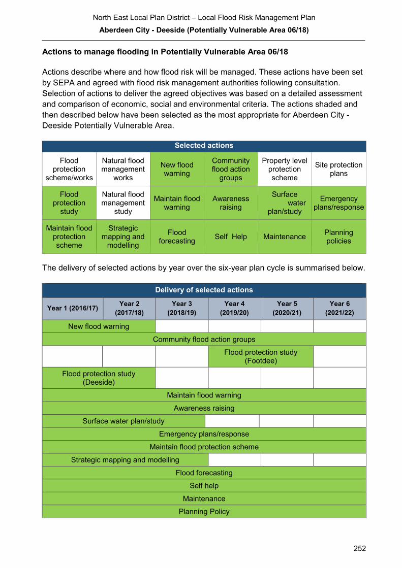
North East Local Plan District – Local Flood Risk Management Plan
Aberdeen City - Deeside (Potentially Vulnerable Area 06/18)
252
Actions to manage flooding in Potentially Vulnerable Area 06/18
Actions describe where and how flood risk will be managed. These actions have been set
by SEPA and agreed with flood risk management authorities following consultation.
Selection of actions to deliver the agreed objectives was based on a detailed assessment
and comparison of economic, social and environmental criteria. The actions shaded and
then described below have been selected as the most appropriate for Aberdeen City -
Deeside Potentially Vulnerable Area.
Selected actions
Flood protection
scheme/works
Natural flood management
works
New flood warning
Community flood action
groups
Property level protection scheme
Site protection plans
Flood protection
study
Natural flood management
study
Maintain flood warning
Awareness raising
Surface water
plan/study
Emergency plans/response
Maintain flood protection scheme
Strategic mapping and
modelling
Flood forecasting
Self Help Maintenance Planning policies
The delivery of selected actions by year over the six-year plan cycle is summarised below.
Delivery of selected actions
Year 1 (2016/17) Year 2
(2017/18)
Year 3
(2018/19)
Year 4
(2019/20)
Year 5
(2020/21)
Year 6
(2021/22)
New flood warning
Community flood action groups
Flood protection study
(Footdee)
Flood protection study (Deeside)
Maintain flood warning
Awareness raising
Surface water plan/study
Emergency plans/response
Maintain flood protection scheme
Strategic mapping and modelling
Flood forecasting
Self help
Maintenance
Planning Policy

North East Local Plan District – Local Flood Risk Management Plan
Aberdeen City - Deeside (Potentially Vulnerable Area 06/18)
253
Action (ID): NEW FLOOD WARNING (6000020010)
Objective (ID): Reduce overall flood risk (600002)
Delivery lead: SEPA
Status: Scheduled Indicative delivery: 2017 - 2018
Description:
Flood warning is required for communities at risk of coastal flooding along the Aberdeenshire
coast from Peterhead to Montrose. A flood warning system will be developed and implemented.
The geographical extent of specific flood warning areas will be developed as part of this process.
A flood protection study is proposed for Fittie. SEPA will work with the local authority to ensure
that new information about flood risk resulting from the proposed flood protection study is
considered in developing the new flood warning system.
The maintenance of SEPA’s flood warning service is funded by Scottish Government through
SEPA’s grant in aid settlement. In addition, Scottish Government provides grant funding to
enable SEPA to implement new flood warning schemes.
Action (ID): COMMUNITY FLOOD ACTION GROUPS (6000020012)
Objective (ID): Reduce overall flood risk (600002)
Delivery lead: Community
Status: Existing Indicative delivery: Ongoing
Description:
Aberdeen City Council will create flood action groups in the Merchant Quarter and in the Eday
Court and Summerhill area of Aberdeen.
ACC will be working with the following groups as a minim to promote awareness to flood risk: -
− Community Councils
− Local residents
− SEPA
− Scottish Flood Forum
Funding will be sourced through existing emergency response Budgets for the ACC elements of
this objective.
North East Local Plan District – Local Flood Risk Management Plan
Aberdeen City - Deeside (Potentially Vulnerable Area 06/18)
254
Action (ID): FLOOD PROTECTION STUDY (6018010005)
Objective (ID): Reduce flood risk in Aberdeen (Deeside) from the River Dee and from small
watercourses including open and culverted lengths (601801)
Delivery lead: Aberdeen City Council
Priority: National: Within local authority:
5 of 168 2 of 4
Status: Scheduled Indicative delivery: 2016-2018
Description:
The Aberdeen City flood protection studies will look at the flood risk from the River Dee, small
watercourses and surface water in this area and define the type of solutions that may be
applicable in these areas to prevent or reduce the flood risk.
For flood risk from the River Dee, particular focus will be on the following areas: -
− Inchgarth Road
− Bridge of Dee
− Riverside Drive (near Bon Accord Glass)
For flood risk from small watercourses and surface water flooding, the studies will be based on
the outputs from the Aberdeen Integrated Catchment Study and coordinated with the surface
water management plan to take a comprehensive approach to flood risk management in
Aberdeen.
Delivery of the Flood Studies will be undertaken working with the following partners as a
minimum: -
− ACC Community, Housing and Infrastructure Directorate who are responsible for Roads
and Planning within ACC
− SEPA
− Local Residents
− Scottish Water
Funding for the Delivery of the Flood Studies is from ACC Capital Work Programme
Potential impacts
Economic: Considering all three study areas in Aberdeen City, a total of 10,500
residential and 1,800 non-residential properties could benefit, with potential
damages avoided of up to £520 million. In reality the studies should look to
identify flooding hotspots, where actions should be targeted. Further study
will identify the true benefits of these actions.
Social: Thirteen educational buildings, 14 health care facilities, 33 utilities, and one
emergency service could benefit from any actions taken. Around 23,000
people could benefit from flood protections works. However, this will depend

North East Local Plan District – Local Flood Risk Management Plan
Aberdeen City - Deeside (Potentially Vulnerable Area 06/18)
255
on locations identified for actions. A reduction in flood risk would have a
positive benefit to the health and wellbeing of the community and socially
vulnerable people.
Environmental: To be in accord with the FRM Strategy, the Responsible Authority should
seek to ensure, as part of the studies, that the action will not have an adverse
effect on the integrity of the River Dee Special Area of Conservation. Cultural
heritage sites, including one garden and designed landscape site, could
benefit from flood protection works identified in the studies. However, this will
depend on the final location and extent of the works. The flood protection
studies should consider how to avoid/minimise potential impacts through
good design and timing of works and consider how to avoid or minimise
potential negative effects such as loss or disturbance of sediment, disruption
to natural processes and loss of habitat. The physical conditions of the River
Don and River Dee (water body IDs 23265 and 23315) are identified by river
basin management planning to be at less than good status. Future works
could improve the condition of the rivers or degrade them. Opportunities to
improve the condition of the rivers should be considered by coordinating with
river basin management planning.
Action (ID): FLOOD PROTECTION STUDY (6018020005)
Objective (ID): Reduce risk from coastal flooding in the Footdee area of Aberdeen
(601802)
Delivery lead: Aberdeen City Council
Priority: National: Within local authority:
131 of 168 4 of 4
Status: Scheduled Indicative delivery: 2019-2021
Description:
The current SEPA national coastal flood maps do not identify properties to be at flood risk.
However, there is a history of flooding due to wave overtopping. Therefore, a hydraulic study
should be undertaken to establish the risk of coastal flooding including wave overtopping. Once
the flood risk has been defined, the study should progress to find the most sustainable
combination of actions to manage the risk.
The Flood Studies will be undertaken working with the following partners as a minimum: -
− ACC Community, Housing and Infrastructure Directorate who are responsible for Roads
and Planning within ACC
− SEPA
− Local Residents
− Scottish Water
North East Local Plan District – Local Flood Risk Management Plan
Aberdeen City - Deeside (Potentially Vulnerable Area 06/18)
256
Funding for the Delivery of the Flood Studies is from ACC Capital Work Programme
Potential impacts
Economic: The study should confirm the number of properties at risk of coastal flooding
and the potential damages avoided, which are currently estimated at over
£1.5 million.
Social: The social impacts of potential actions will be considered when there is
improved understanding of the current flood risk. A reduction in flood risk
would have a positive benefit to the health and wellbeing of the community
and socially vulnerable people. Negative impacts through disturbance to the
local community during the construction phase should be considered.
Environmental: Flood protection studies should consider the positive and negative impacts of
proposed actions on the ecological quality of the environment. Opportunities to
mitigate any environmental impacts may include design and timing of works.
To be in accord with the FRM Strategy, the Responsible Authority should
seek to ensure as part of the study that the action will not have an adverse
effect on the integrity of the River Dee Special Area of Conservation (SAC) or
the Moray Firth SAC. The physical condition of the Dee (Aberdeen) Estuary
(water body ID 200103) is identified by river basin management planning to
be at less than good status. Future works could improve the condition of the
estuary or degrade it. Opportunities to improve the condition of the estuary
should be considered by coordinating with river basin management planning.
Action (ID): MAINTAIN FLOOD WARNING (6000020030)
Objective (ID): Reduce overall flood risk (600002)
Delivery lead: SEPA
Status: Existing Indicative delivery: Ongoing
Description:
Continue to maintain the 'Aberdeen (Dee)' and 'Maryculter' flood warning areas which are part of
the Dee river flood warning scheme. When flood events occur in an area with an existing flood
warning service, SEPA will seek to verify the flood forecasts and warnings. SEPA will use
feedback and post-event data to ensure that our flood warning service is timely and accurate.
A flood protection study is proposed for Aberdeen. SEPA will work with the local authority to
ensure that any new information about flood risk resulting from the proposed flood protection
study is considered in the existing flood warning system.
The maintenance of SEPA’s flood warning service is funded by Scottish Government through
SEPA’s grant in aid settlement
North East Local Plan District – Local Flood Risk Management Plan
Aberdeen City - Deeside (Potentially Vulnerable Area 06/18)
257
Action (ID): AWARENESS RAISING (6000020013)
Objective (ID): Reduce overall flood risk (600002)
Delivery lead: Responsible authorities
Status: Existing Indicative delivery: Ongoing
Description:
ACC will be undertaking a number of community events to promote awareness to the risk of
flooding and what can be done to reduce the impact of flooding. As part of this we will be looking
to create flood action groups and community resilience groups with regards to flooding. These
groups will help promote the risk that flooding presents as well as provide practical advice to the
community they serve.
From 2016 SEPA will engage with the community through local participation in national
initiatives, including partnership working with Neighbourhood Watch Scotland. In addition, SEPA
will engage with local authorities and community resilience groups where possible.
Across Scotland, SEPA will create and share communication and education resources with other
responsible authorities. These resources will include awareness campaigns, media and
marketing activity and promotion of SEPA's flood forecasting and warning services (Floodline).
Where they exist, SEPA will engage with community resilience groups and community safety
partnerships.
To support the delivery of the new SEPA flood warning scheme, SEPA will carry out a local
launch event and engage directly with residents in the area. This will be supported by local and
national media communications. SEPA will also support and participate in local public awareness
events, in partnership with the local authority, community council or other local representative
organisations, including schools.
ACC will be working with the flooding groups as a minimum to promote awareness to flood risk:-
− Community Councils − Local residents − Education Scotland − Aberdeen Education Department − SEPA
A new flood warning scheme is proposed for the Aberdeenshire coast. To support the delivery of
the new SEPA flood warning scheme, we will carry out communications and engagement
activities. SEPA's awareness raising activities will be coordinated with activities of other
responsible authorities as required.
Activities undertaken by ACC will be funded by existing revenge budgets
(continued)

North East Local Plan District – Local Flood Risk Management Plan
Aberdeen City - Deeside (Potentially Vulnerable Area 06/18)
258
SEPA's awareness raising activities are funded by Scottish Government through SEPA’s grant in
aid settlement.
Scottish Water will support SEPA and responsible authorities with their awareness raising
activities as required and provide targeted flooding communications for Scottish Water specific
activities. Scottish Water will raise awareness by producing and supplying targeted information to
the public on large capital projects and detailed local studies.
More general information and flooding guidance will be available on the website at:
https://www.scottishwater.co.uk/you-and-your-home/your-home/flooding-information
Scottish Water will keep responsible authorities informed of its awareness raising activities
through the Local Plan District partnerships.

North East Local Plan District – Local Flood Risk Management Plan
Aberdeen City - Deeside (Potentially Vulnerable Area 06/18)
259
Action (ID): SURFACE WATER PLAN/STUDY (6018100018)
Objective (ID): Reduce risk from surface water flooding in Aberdeen (Deeside) (601810)
Delivery lead: Aberdeen City Council
Status: Ongoing Indicative delivery: 2016-2018
Description:
ACC are creating a surface water management plan (SWMP). The plan will assess all of the
current data available with regards to flood risk from historical records of flooding/ maintenance
records and existing flood schemes.
Once the detailed assessment has been completed the SWMP will be undertaken and will cover
the following items: -
− Catchment assessment − Maintenance regime − Objectives to be achieved in that SWMP area − Long list of all works required − Short List of works for the plan area in 2016-2021
The surface water management plan will be delivered via the Surface Water Management
partnership.
An integrated catchment study covering the Aberdeen catchment was carried out in SR10 (2010-
2015) to support the surface water management planning process in Aberdeen, Westhill, and
Stonehaven. The study has improved knowledge and understanding of surface water flood risk
and interactions between the above ground and below ground drainage network e.g. with the
sewer network, watercourses and the sea. The Option appraisal phase of this study will be
carried out in SR15 (2015-2021).
Delivery of the SWMP will be undertaken working with the following partners as a minimum: -
− ACC Community, Housing and Infrastructure Directorate who are responsible for Roads and Planning within ACC
− SEPA − Scottish Water − Local Residents where applicable − Community council and elected Members
Funding for the Delivery of the Surface Water Management Plans is from ACC Capital
Programme and Revenue Budgets.
North East Local Plan District – Local Flood Risk Management Plan
Aberdeen City - Deeside (Potentially Vulnerable Area 06/18)
260
Action (ID): EMERGENCY PLANS/RESPONSE (6000020014)
Objective (ID): Reduce overall flood risk (600002)
Delivery lead: Category 1 and 2 Responders
Status: Existing Indicative delivery: Ongoing
Description
Providing an emergency response to flooding is the responsibility of organisations, including local
authorities, the emergency services and SEPA.
Effective management of an emergency response relies on emergency plans that are prepared
under the Civil Contingencies Act 2004 by Category 1 and 2 Responders.
The emergency response by these organisations is coordinated through regional and local
resilience partnerships. This response may be supported by the work of voluntary organisations.
Action (ID): MAINTAIN FLOOD PROTECTION SCHEME (6018030017)
Objective (ID): Reduce flood risk in Aberdeen (Deeside) from the River Dee and from small
watercourses including open and culverted lengths (601801)
Delivery lead: Aberdeen City Council
Status: Existing Indicative delivery: Ongoing
Description:
Aberdeen City Council will maintain the Fraser Road Flood Protection Scheme which reduces
the risk of flooding from the Gilcomston Burn, Stronsay Park Flood Protection works which
prevents flooding from the Denburn and the beach revetments.
Activities undertaken by ACC will be funded by existing revenge budgets.

North East Local Plan District – Local Flood Risk Management Plan
Aberdeen City - Deeside (Potentially Vulnerable Area 06/18)
261
Action (ID): STRATEGIC MAPPING AND MODELLING (6000020019)
Objective (ID): Reduce overall flood risk (600002)
Delivery lead: Scottish Water
Status: Scheduled Indicative delivery: 2016-2019
Description:
Scottish Water will undertake further investigation and modelling in the Nigg sewer catchment to
improve knowledge and understanding of flood risk in this area as required under Section 16 of
the Flood Risk Management (Scotland) Act 2009.
Scottish Water will work with responsible authorities to incorporate relevant information into these
studies by regularly keeping the responsible authorities informed of their progress. Scottish
Water will provide responsible authorities with the outputs of the Section 16 assessment which,
where relevant, may be used to inform Surface Water Management Plans and SEPA flood
hazard and risk maps.
Scottish Water funding is committed in its capital programme through Q&S 4a (2015-2021) which
is approved by its regulators and customers.
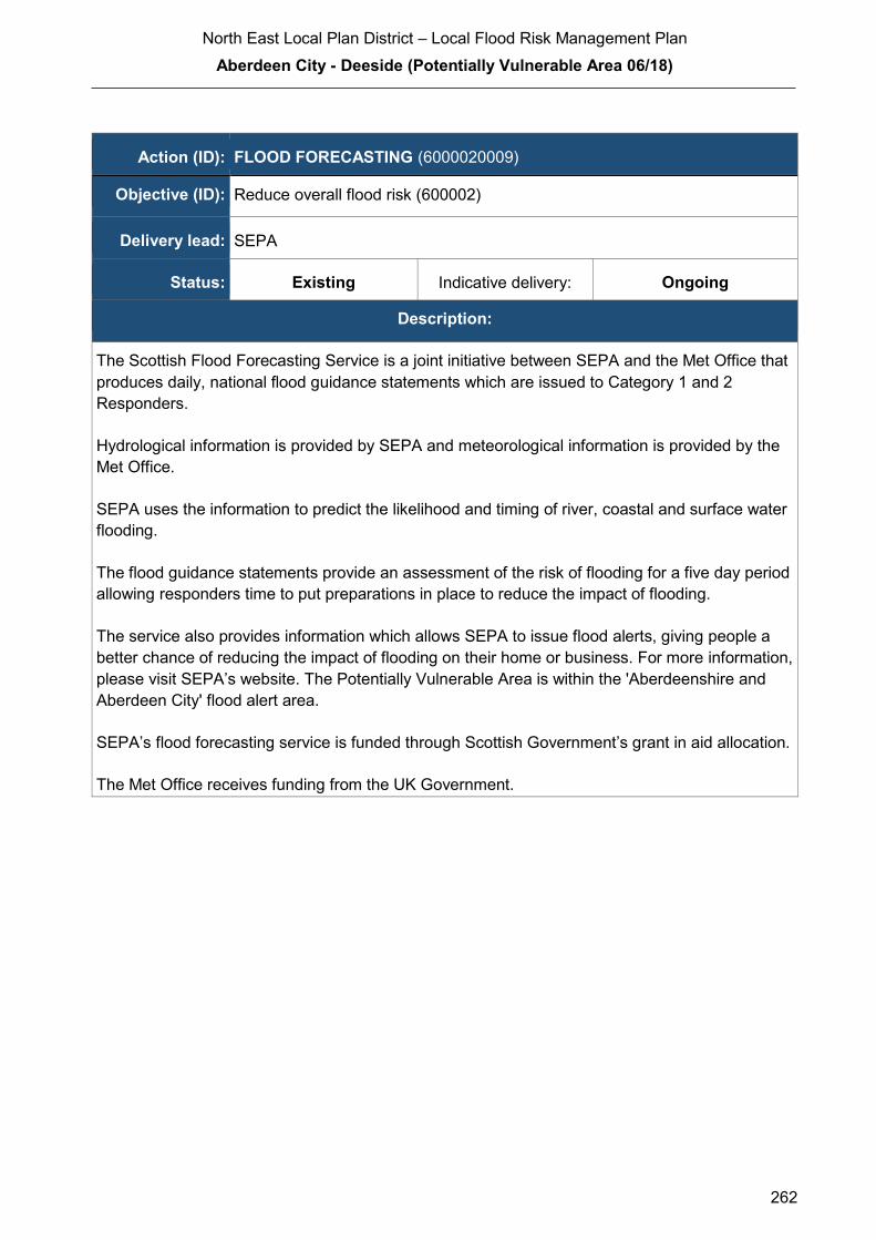
North East Local Plan District – Local Flood Risk Management Plan
Aberdeen City - Deeside (Potentially Vulnerable Area 06/18)
262
Action (ID): FLOOD FORECASTING (6000020009)
Objective (ID): Reduce overall flood risk (600002)
Delivery lead: SEPA
Status: Existing Indicative delivery: Ongoing
Description:
The Scottish Flood Forecasting Service is a joint initiative between SEPA and the Met Office that
produces daily, national flood guidance statements which are issued to Category 1 and 2
Responders.
Hydrological information is provided by SEPA and meteorological information is provided by the
Met Office.
SEPA uses the information to predict the likelihood and timing of river, coastal and surface water
flooding.
The flood guidance statements provide an assessment of the risk of flooding for a five day period
allowing responders time to put preparations in place to reduce the impact of flooding.
The service also provides information which allows SEPA to issue flood alerts, giving people a
better chance of reducing the impact of flooding on their home or business. For more information,
please visit SEPA’s website. The Potentially Vulnerable Area is within the 'Aberdeenshire and
Aberdeen City' flood alert area.
SEPA’s flood forecasting service is funded through Scottish Government’s grant in aid allocation.
The Met Office receives funding from the UK Government.

North East Local Plan District – Local Flood Risk Management Plan
Aberdeen City - Deeside (Potentially Vulnerable Area 06/18)
263
Action (ID): SELF HELP (6000020011)
Objective (ID): Reduce overall flood risk (600002)
Delivery lead: —
Status: Existing Indicative delivery: Ongoing
Description:
Everyone is responsible for protecting themselves and their property flooding. Property and
business owners can take simple steps to reduce damage and disruption to their homes and
businesses should flooding happen. This includes preparing a flood plan and flood kit, installing
property level protection, signing up to Floodline and Resilient Communities initiatives, and
ensuring that properties and businesses are insured against flood damage.
ACC will be promoting self-help through work with the community. This will include the creation
of a Flood Guard Grant Scheme to assist people in putting in Property Level Protection.
ACC will coordinate this through its Flood Team and seek advice from appropriate bodies such
as the Scottish Flood Forum when setting up the Grant scheme.
Funding of the scheme will be via the ACC Capital works Programme.

North East Local Plan District – Local Flood Risk Management Plan
Aberdeen City - Deeside (Potentially Vulnerable Area 06/18)
264
Action (ID): MAINTENANCE (6000020007)
Objective (ID): Reduce overall flood risk (600002)
Delivery lead: Aberdeen City Council, asset / land managers
Status: Existing Indicative delivery: Ongoing
Description:
Aberdeen City Council (ACC) has a duty to assess designated water bodies and carry out
clearance and repair works where such works would substantially reduce flood risk. ACC will
produce schedules of clearance and repair works and make these available for public inspection.
Scottish Water undertake risk based inspection, maintenance and repair on the public sewer
network together with keeping responsible authorities informed of large scale capital
maintenance work to identify opportunities for co-ordination.
Asset owners and riparian landowners are responsible for the maintenance and management of
their own assets including those which help to reduce flood risk.
Delivery of the clearance and repair Schedule will be undertaken working with the following
partners as a minimum: -
− ACC Community, Housing and Infrastructure Directorate who are responsible for Roads and Planning within ACC
− SEPA − Scottish Water − Land Owners − Aberdeenshire Council
Scottish Water will keep responsible authorities informed of large scale capital maintenance work
to identify opportunities for co-ordination.
Funding to come from existing ACC Flood revenue budget, for works which are defined to be
ACC responsibility or pose a significant flood risk

North East Local Plan District – Local Flood Risk Management Plan
Aberdeen City - Deeside (Potentially Vulnerable Area 06/18)
265
Action (ID): PLANNING POLICIES (6000010001)
Objective (ID): Avoid an overall increase in flood risk (600001) Reduce overall flood risk
(600002)
Delivery lead: Planning authority
Status: Existing Indicative delivery: Ongoing
Description:
Aberdeen City Council (ACC) will be applying a catchment-scale approach to sustainable flood
risk management and aims to build the resilience of the city. We will encourage sustainable land
management in our rural areas, and to address the long-term vulnerability of parts of our coasts.
Under this approach, development in areas with medium to high likelihood of flooding should be
avoided.
Scottish Planning Policy and accompanying Planning Advice Notes set out Scottish Ministers’
priorities for the operation of the planning system and for the development and use of land. In
terms of flood risk management, the policy supports a catchment-scale approach to sustainable
flood risk management and aims to build the resilience of our cities and towns, encourage
sustainable land management in our rural areas, and to address the long-term vulnerability of
parts of our coasts and islands. Under this approach, new development in areas with medium to
high likelihood of flooding should be avoided.
For further information on the application of national planning policies see Annex 5.
SEPA has a statutory role in relation to the provision of flood risk advice to planning authorities.
This role is expressed in Section 72 of the FRM Act, 2009. SEPA also has a duty to cooperate
with planning authorities in the preparation of development plans. When consulted in relation to
planning applications for development or site allocations in development plans, and where the
planning authority considers there may be a risk of flooding, SEPA will provide advice. The
advice provided by SEPA will be with respect to the risk of flooding and on the basis of the
relevant information it holds which is suitable for planning purposes. It will also be in line with the
principles and duties set out in the FRM Act. Further information about how SEPA engages in
the planning system, including guidance on flood risk and planning is available on SEPA’s
website http://www.sepa.org.uk/environment/land/planning/
SEPA's land use planning activities will be coordinated with the activities of other responsible
authorities as required and are funded by Scottish Government through SEPA’s grant in aid
settlement.
ACC will be working with all relevant bodies to coordinate the activities that are highlighted within
Planning Policy.
(continued)

North East Local Plan District – Local Flood Risk Management Plan
Aberdeen City - Deeside (Potentially Vulnerable Area 06/18)
266
ACC will be funding the works associated with Planning policy via its existing revenue budget.
SEPA's land use planning activities are funded by Scottish Government through SEPA’s grant in
aid settlement.
Scottish Water is a statutory consultee within the planning legislation and is required to comment
on all outline or full planning applications which are referred by a local authority.

North East Local Plan District – Local Flood Risk Management Plan
Peterculter (Potentially Vulnerable Area 06/19)
267
2.3.19 Peterculter (Potentially Vulnerable Area 06/19)
Local Plan District local authority Main catchment North East Aberdeen City Council River Dee (Grampian)
Background
This Potentially Vulnerable Area covers the
west of Peterculter and is approximately
4km2. The A93, North Deeside road, passes
through the area.
The main river is the Culter Burn which flows
through the south west of Peterculter before
discharging into the River Dee.
There are approximately 380 residential and
20 non-residential properties at risk of
flooding.
The Annual Average Damages are
approximately £300,000 with the majority
caused by river flooding.
Annual Average Damages by flood source
Reproduced from North East Flood Risk Management Strategy, SEPA (December 2015)
Summary of flooding impacts
The main source of flood risk in the area is from the Culter Burn. This affects properties in
the west and south west of Peterculter.
Roads affected by flooding include the A93.
For this Potentially Vulnerable Area the highest damages are to residential properties.
River 94%
Surfacewater 6%
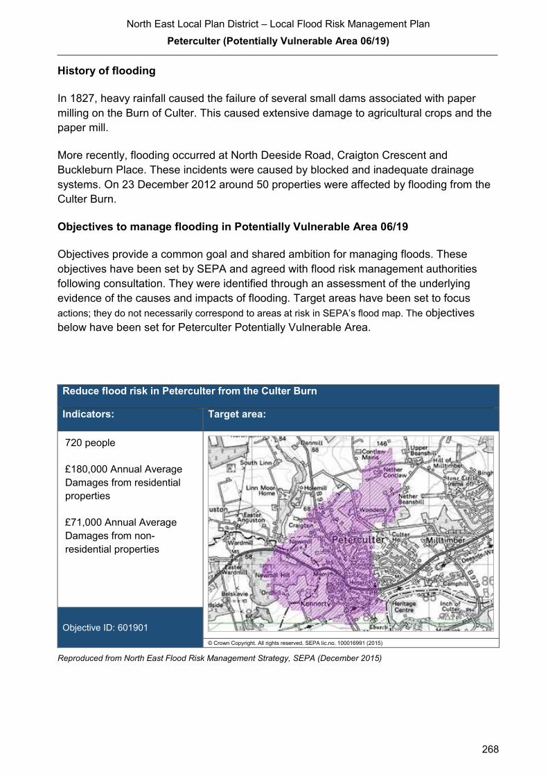
North East Local Plan District – Local Flood Risk Management Plan
Peterculter (Potentially Vulnerable Area 06/19)
268
History of flooding
In 1827, heavy rainfall caused the failure of several small dams associated with paper
milling on the Burn of Culter. This caused extensive damage to agricultural crops and the
paper mill.
More recently, flooding occurred at North Deeside Road, Craigton Crescent and
Buckleburn Place. These incidents were caused by blocked and inadequate drainage
systems. On 23 December 2012 around 50 properties were affected by flooding from the
Culter Burn.
Objectives to manage flooding in Potentially Vulnerable Area 06/19
Objectives provide a common goal and shared ambition for managing floods. These
objectives have been set by SEPA and agreed with flood risk management authorities
following consultation. They were identified through an assessment of the underlying
evidence of the causes and impacts of flooding. Target areas have been set to focus
actions; they do not necessarily correspond to areas at risk in SEPA’s flood map. The objectives
below have been set for Peterculter Potentially Vulnerable Area.
Reduce flood risk in Peterculter from the Culter Burn
Indicators: Target area:
720 people
£180,000 Annual Average
Damages from residential
properties
£71,000 Annual Average
Damages from non-
residential properties
Objective ID: 601901
© Crown Copyright. All rights reserved. SEPA lic.no. 100016991 (2015)
Reproduced from North East Flood Risk Management Strategy, SEPA (December 2015)

North East Local Plan District – Local Flood Risk Management Plan
Peterculter (Potentially Vulnerable Area 06/19)
269
Target area Objective ID Indicators within
PVA
Aberdeen Reduce risk from surface water flooding in
Peterculter
601906 * See note below
Applies across
North East Local
Plan District
Avoid an overall increase in flood risk 600001 380 residential
properties
£300,000 Annual
Average Damages
Applies across
North East Local
Plan District
Reduce overall flood risk 600002 380 residential
properties
£300,000 Annual
Average Damages
Applies across
North East Local
Plan District
Organisation such as utility companies and
Historic Environment Scotland actively
maintain and manage their own assets,
including the risk of flooding. These
actions are not detailed further in the Flood
Risk Management Strategies.
* This objective will be monitored using surface water flood risk across the Potentially Vulnerable Area. For 06/19
there are 50 residential properties at risk and Annual Average Damages of £17,000.
Reproduced from North East Flood Risk Management Strategy, SEPA (December 2015)
Actions to manage flooding in Potentially Vulnerable Area 06/19
Actions describe where and how flood risk will be managed. These actions have been set
by SEPA and agreed with flood risk management authorities following consultation.
Selection of actions to deliver the agreed objectives was based on a detailed assessment
and comparison of economic, social and environmental criteria. The actions shaded and
then described below have been selected as the most appropriate for Peterculter
Potentially Vulnerable Area.
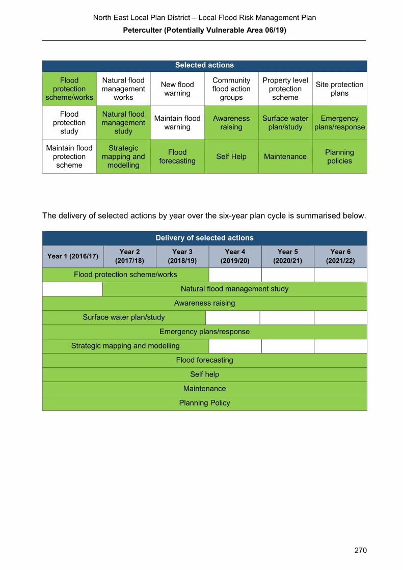
North East Local Plan District – Local Flood Risk Management Plan
Peterculter (Potentially Vulnerable Area 06/19)
270
Selected actions
Flood protection
scheme/works
Natural flood management
works
New flood warning
Community flood action
groups
Property level protection scheme
Site protection plans
Flood protection
study
Natural flood management
study
Maintain flood warning
Awareness raising
Surface water plan/study
Emergency plans/response
Maintain flood protection scheme
Strategic mapping and
modelling
Flood forecasting
Self Help Maintenance Planning policies
The delivery of selected actions by year over the six-year plan cycle is summarised below.
Delivery of selected actions
Year 1 (2016/17) Year 2
(2017/18)
Year 3
(2018/19)
Year 4
(2019/20)
Year 5
(2020/21)
Year 6
(2021/22)
Flood protection scheme/works
Natural flood management study
Awareness raising
Surface water plan/study
Emergency plans/response
Strategic mapping and modelling
Flood forecasting
Self help
Maintenance
Planning Policy
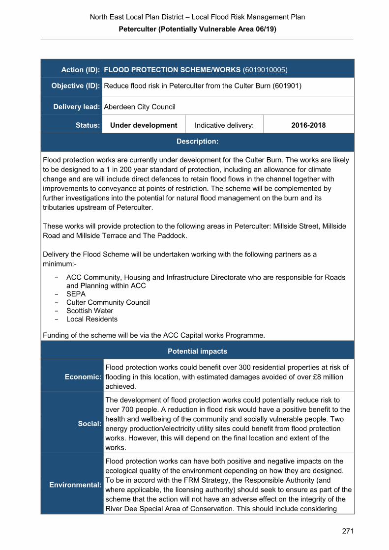
North East Local Plan District – Local Flood Risk Management Plan
Peterculter (Potentially Vulnerable Area 06/19)
271
Action (ID): FLOOD PROTECTION SCHEME/WORKS (6019010005)
Objective (ID): Reduce flood risk in Peterculter from the Culter Burn (601901)
Delivery lead: Aberdeen City Council
Status: Under development Indicative delivery: 2016-2018
Description:
Flood protection works are currently under development for the Culter Burn. The works are likely
to be designed to a 1 in 200 year standard of protection, including an allowance for climate
change and are will include direct defences to retain flood flows in the channel together with
improvements to conveyance at points of restriction. The scheme will be complemented by
further investigations into the potential for natural flood management on the burn and its
tributaries upstream of Peterculter.
These works will provide protection to the following areas in Peterculter: Millside Street, Millside
Road and Millside Terrace and The Paddock.
Delivery the Flood Scheme will be undertaken working with the following partners as a
minimum:-
− ACC Community, Housing and Infrastructure Directorate who are responsible for Roads and Planning within ACC
− SEPA − Culter Community Council − Scottish Water − Local Residents
Funding of the scheme will be via the ACC Capital works Programme.
Potential impacts
Economic:
Flood protection works could benefit over 300 residential properties at risk of
flooding in this location, with estimated damages avoided of over £8 million
achieved.
Social:
The development of flood protection works could potentially reduce risk to
over 700 people. A reduction in flood risk would have a positive benefit to the
health and wellbeing of the community and socially vulnerable people. Two
energy production/electricity utility sites could benefit from flood protection
works. However, this will depend on the final location and extent of the
works.
Environmental:
Flood protection works can have both positive and negative impacts on the
ecological quality of the environment depending on how they are designed.
To be in accord with the FRM Strategy, the Responsible Authority (and
where applicable, the licensing authority) should seek to ensure as part of the
scheme that the action will not have an adverse effect on the integrity of the
River Dee Special Area of Conservation. This should include considering

North East Local Plan District – Local Flood Risk Management Plan
Peterculter (Potentially Vulnerable Area 06/19)
272
how to avoid/minimise potential impacts through good design and timing of
works and consider how to avoid or minimise potential negative effects such
as loss or disturbance of sediment.
Action (ID): NATURAL FLOOD MANAGEMENT STUDY (6019010003)
Objective (ID): Reduce flood risk in Peterculter from the Culter Burn (601901)
Delivery lead: Various
Status: Scheduled Indicative delivery: 2017-2021
Description:
Aberdeen City Council will work with the Dee Catchment Partnership/SEPA and Aberdeenshire
Council to identify potential for natural flood management (NFM) works on the Gormack and
Leuchar Burns. These will be a trial with the anticipation to roll out further works in the future.
Delivery of the NFM studies and works will be undertaken working with the following partners as
a minimum: -
− ACC Community, Housing and Infrastructure Directorate who are responsible for Roads and Planning within ACC
− Deeside Catchment Partnership who have an active interest in improving the water biodiversity and water quality in the City
− SEPA − Aberdeenshire Council
Funding for the Delivery of the NFM study and works is from ACC capital grant allocated by
Scottish Government to support the delivery of flood risk management.
Potential impacts
Economic: Natural flood management actions could reduce risk to properties at risk from
the Culter Burn. The benefits provided by the actions should be defined in the
study. Any natural flood management works identified by the study will
complement the proposed flood protection scheme on the Culter Burn in
Peterculter
Social: Natural flood management actions have the potential to reduce flood risk from
the Culter Burn to people during a high likelihood flood. Natural flood
management actions can restore and enhance natural environments and
create opportunities for recreation and tourism. A reduction in flood risk would
have a positive benefit to the health and wellbeing of the community and
socially vulnerable people. Negative impacts through disturbance to the local
community during the construction phase should be considered.
Environmental: Flood protection studies should consider the positive and negative impacts of
proposed actions on the ecological quality of the environment. Natural flood
management actions can have a positive impact by restoring and enhancing
natural habitats. Opportunities to mitigate any environmental impacts may

North East Local Plan District – Local Flood Risk Management Plan
Peterculter (Potentially Vulnerable Area 06/19)
273
include design and timing of works. To be in accord with the FRM Strategy,
the Responsible Authority should seek to ensure as part of the study that the
action will not have an adverse effect on the integrity of the River Dee Special
Area of Conservation.
Action (ID): AWARENESS RAISING (6000020013)
Objective (ID): Reduce overall flood risk (600002)
Delivery lead: Responsible authorities
Status: Existing Indicative delivery: Ongoing
Description:
From 2016 SEPA will engage with the community through local participation in national
initiatives, including partnership working with Neighbourhood Watch Scotland. In addition, SEPA
will engage with local authorities and community resilience groups where possible.
Across Scotland, SEPA will create and share communication and education resources with other
responsible authorities. These resources will include awareness campaigns, media and
marketing activity and promotion of SEPA's flood forecasting and warning services (Floodline).
Where they exist, SEPA will engage with community resilience groups and community safety
partnerships.
ACC will be undertaking a number of community events to promote awareness to the risk of
flooding and what can be done to reduce the impact of flooding. As part of this we will be looking
to create flood action groups and community resilience groups with regards to flooding. These
groups will help promote the risk that flooding presents as well as provide practical advice to the
community they serve.
ACC will be working with the flowing groups as a minim to promote awareness to flood risk: -
− Community Councils − Local residents − Education Scotland − Aberdeen Education Department − SEPA
Activities undertaken by ACC will be funded by existing revenge budgets
SEPA's awareness raising activities are funded by Scottish Government through SEPA’s grant in
aid settlement.
(continued)

North East Local Plan District – Local Flood Risk Management Plan
Peterculter (Potentially Vulnerable Area 06/19)
274
Scottish Water will support SEPA and responsible authorities with their awareness raising
activities as required and provide targeted flooding communications for Scottish Water specific
activities. Scottish Water will raise awareness by producing and supplying targeted information to
the public on large capital projects and detailed local studies.
More general information and flooding guidance will be available on the website at:
https://www.scottishwater.co.uk/you-and-your-home/your-home/flooding-information
Scottish Water will keep responsible authorities informed of its awareness raising activities
through the Local Plan District partnerships.
North East Local Plan District – Local Flood Risk Management Plan
Peterculter (Potentially Vulnerable Area 06/19)
275
Action (ID): SURFACE WATER PLAN/STUDY (6019060018)
Objective (ID): Reduce risk from surface water flooding in Peterculter (601906)
Delivery lead: Aberdeen City Council (ACC)
Status: Ongoing Indicative delivery: 2016-2018
Description:
ACC are creating a surface water management plan (SWMP). The plan will assess all of the
current data available with regards to flood risk from historical records of flooding/ maintenance
records and existing flood schemes.
Once the detailed assessment has been completed the SWMP will be undertaken and will cover
the following items: -
− Catchment assessment − Maintenance regime − Objectives to be achieved in that SWMP area − Long list of all works required − Short List of works for the plan area in 2016-2021
The surface water management plan will be delivered via the Surface Water Management
partnership.
An integrated catchment study covering the Aberdeen catchment was carried out in SR10 (2010-
2015) to support the surface water management planning process in Aberdeen, Westhill, and
Stonehaven. The study has improved knowledge and understanding of surface water flood risk
and interactions between the above ground and below ground drainage network e.g. with the
sewer network, watercourses and the sea. The Option appraisal phase of this study will be
carried out in SR15 (2015-2021).
Delivery of the SWMP will be undertaken working with the following partners as a minimum: -
− ACC Community, Housing and Infrastructure Directorate who are responsible for Roads and Planning within ACC
− SEPA − Scottish Water − Local Residents where applicable − Community council and elected Members
Funding for the Delivery of the Surface Water Management Plans is from ACC Capital
Programme and Revenue Budgets.
North East Local Plan District – Local Flood Risk Management Plan
Peterculter (Potentially Vulnerable Area 06/19)
276
Action (ID): EMERGENCY PLANS/RESPONSE (6000020014)
Objective (ID): Reduce overall flood risk (600002)
Delivery lead: Category 1 and 2 Responders
Status: Existing Indicative delivery: Ongoing
Description:
ACC will Work with All CAT 1 and CAT 2 responders to deliver the emergency response plan for
Aberdeen City. Providing an emergency response to flooding is the responsibility of many
organisations, including local authorities, the emergency services and SEPA. Effective
management of an emergency response relies on emergency plans that are prepared under the
Civil Contingencies Act 2004 by Category 1 and 2 Responders. The emergency response by
these organisations is coordinated through regional and local resilience partnerships.
Aberdeenshire Council has an overarching Flood Response Plan, which is coordinated through
the Responders identified under the Civil Contingencies Act 2004. The aim of the plan is to set
out arrangements to deal effectively with flood risk. At predetermined trigger levels flood alerts
and warnings will be issued through SEPA's flood forecasting and warning service (Floodline)
and Aberdeenshire Council will conduct assessments at known hotspots and prepare resources
as required. Aberdeenshire Council will also coordinate measures in conjunction with the other
Responders. The emergency response process is coordinated through regional and local
resilience partnerships. This response may be supported by the work of voluntary organisations.
The Operational Flood Response Plan will undergo review on an annual basis to reflect
operational or responsibility changes. A debrief and plan review will also be carried out after the
Plan is activated during emergencies.
Funding will be sourced through existing emergency response Budgets for the ACC elements of
this objective.

North East Local Plan District – Local Flood Risk Management Plan
Peterculter (Potentially Vulnerable Area 06/19)
277
Action (ID): STRATEGIC MAPPING AND MODELLING (6000020019)
Objective (ID): Reduce overall flood risk (600002)
Delivery lead: Scottish Water
Status: Scheduled Indicative delivery: 2016-2019
Description:
Scottish Water will undertake further investigation and modelling in the Nigg sewer catchment to
improve knowledge and understanding of flood risk in this area as required under Section 16 of
the Flood Risk Management (Scotland) Act 2009.
Scottish Water will work with responsible authorities to incorporate relevant information into these
studies by regularly keeping the responsible authorities informed of their progress.
Scottish Water funding is committed in its capital programme through Q&S 4a (2015-2021) which
is approved by its regulators and customers.
North East Local Plan District – Local Flood Risk Management Plan
Peterculter (Potentially Vulnerable Area 06/19)
278
Action (ID): FLOOD FORECASTING (6000020009)
Objective (ID): Reduce overall flood risk (600002)
Delivery lead: SEPA
Status: Existing Indicative delivery: Ongoing
Description:
The Scottish Flood Forecasting Service is a joint initiative between SEPA and the Met Office that
produces daily, national flood guidance statements which are issued to Category 1 and 2
Responders.
Hydrological information is provided by SEPA and meteorological information is provided by the
Met Office. SEPA uses the information to predict the likelihood and timing of river, coastal and
surface water flooding.
The flood guidance statements provide an assessment of the risk of flooding for a five day period
allowing responders time to put preparations in place to reduce the impact of flooding.
The service also provides information which allows SEPA to issue flood warnings, giving people
a better chance of reducing the impact of flooding on their home or business. For more
information, please visit SEPA’s website. The Potentially Vulnerable Area is within the
'Aberdeenshire and Aberdeen City' flood alert area.
SEPA’s flood forecasting service is funded through Scottish Government’s grant in aid allocation.
The Met Office receives funding from the UK Government.
North East Local Plan District – Local Flood Risk Management Plan
Peterculter (Potentially Vulnerable Area 06/19)
279
Action (ID): SELF HELP (6000020011)
Objective (ID): Reduce overall flood risk (600002)
Delivery lead: —
Status: Existing Indicative delivery: Ongoing
Description:
Everyone is responsible for protecting themselves and their property from flooding. Property and
business owners can take simple steps to reduce damage and disruption to their homes and
businesses should flooding happen. This includes preparing a flood plan and flood kit, installing
property level protection, signing up to Floodline and Resilient Communities initiatives, and
ensuring that properties and businesses are insured against flood damage.
ACC will be promoting self-help through work with the community. This will include the creation
of a Flood Guard Grant Scheme to assist people in putting in Property Level Protection.
ACC will coordinate this through its Flood Team and seek advice from appropriate bodies such
as the Scottish Flood Forum when setting up the Grant scheme.
Funding of the scheme will be via the ACC Capital works Programme.

North East Local Plan District – Local Flood Risk Management Plan
Peterculter (Potentially Vulnerable Area 06/19)
280
Action (ID): MAINTENANCE (6000020007)
Objective (ID): Reduce overall flood risk (600002)
Delivery lead: Aberdeen City Council and Council, asset / land managers
Status: Existing Indicative delivery: Ongoing
Description:
ACC has a duty to assess designated water bodies and carry out clearance and repair works
where such works would substantially reduce flood risk. ACC will produce schedules of
clearance and repair works and make these available for public inspection.
Scottish Water undertake risk based inspection, maintenance and repair on the public sewer
network.
Asset owners and riparian landowners are responsible for the maintenance and management of
their own assets including those which help to reduce flood
Delivery of the clearance and repair Schedule will be undertaken working with the following
partners as a minimum: -
− ACC Community, Housing and Infrastructure Directorate who are responsible for Roads and Planning within ACC
− SEPA − Scottish Water − Land Owners − Aberdeenshire Council
Scottish Water will keep responsible authorities informed of large scale capital maintenance work
to identify opportunities for co-ordination.
Funding to come from existing ACC Flood revenue budget, for works which are defined to be
ACC responsibility or pose a significant flood risk

North East Local Plan District – Local Flood Risk Management Plan
Peterculter (Potentially Vulnerable Area 06/19)
281
Action (ID): PLANNING POLICIES (6000010001)
Objective (ID): Avoid an overall increase in flood risk (600001)
Reduce overall flood risk (600002)
Delivery lead: Planning authority
Status: Existing Indicative delivery: Ongoing
Description:
ACC will be applying a catchment-scale approach to sustainable flood risk management and
aims to build the resilience of the city. We will encourage sustainable land management in our
rural areas, and to address the long-term vulnerability of parts of our coasts. Under this
approach, development in areas with medium to high likelihood of flooding should be avoided.
Scottish Planning Policy and accompanying Planning Advice Notes set out Scottish Ministers’
priorities for the operation of the planning system and for the development and use of land. In
terms of flood risk management, the policy supports a catchment-scale approach to sustainable
flood risk management and aims to build the resilience of our cities and towns, encourage
sustainable land management in our rural areas, and to address the long-term vulnerability of
parts of our coasts and islands. Under this approach, new development in areas with medium to
high likelihood of flooding should be avoided.
For further information on the application of national planning policies see Annex 5.
Aberdeenshire Council is a local planning authority and will work with the regional planning
authority, the Aberdeen City and Shire Strategic Development Planning Authority.
As a consultee on planning applications, Aberdeenshire Council’s Flood & Coast Protection team
will work directly with colleagues in the Planning Service to ensure that appropriate policies and
measures are put in place to reduce flood risk. Planning applications are assessed against the
flooding standards set out in the current Aberdeenshire Local Development Plan, and in future
those in the proposed Aberdeenshire Local Development Plan 2016.
SEPA has a statutory role in relation to the provision of flood risk advice to planning authorities.
This role is expressed in Section 72 of the FRM Act, 2009. SEPA also has a duty to cooperate
with planning authorities in the preparation of development plans. When consulted in relation to
planning applications for development or site allocations in development plans, and where the
planning authority considers there may be a risk of flooding, SEPA will provide advice. The
advice provided by SEPA will be with respect to the risk of flooding and on the basis of the
relevant information it holds which is suitable for planning purposes. It will also be in line with the
principles and duties set out in the FRM Act. Further information about how SEPA engages in
the planning system, including guidance on flood risk and planning is available on SEPA’s
website http://www.sepa.org.uk/environment/land/planning/
(continued)
North East Local Plan District – Local Flood Risk Management Plan
Peterculter (Potentially Vulnerable Area 06/19)
282
SEPA's land use planning activities will be coordinated with the activities of other responsible
authorities as required and are funded by Scottish Government through SEPA’s grant in aid
settlement.
ACC will be working with all relevant bodies to coordinate the activities that are highlighted within
Planning Policy.
ACC will be funding the works associated with Planning policy via its existing revenue budget.
SEPA's land use planning activities are funded by Scottish Government through SEPA’s grant in
aid settlement.

North East Local Plan District – Local Flood Risk Management Plan
Aboyne (Potentially Vulnerable Area 06/20)
283
2.3.20 Aboyne (Potentially Vulnerable Area 06/20)
Local Plan District local authority Main catchment North East Aberdeenshire Council River Dee (Grampian)
Background
This Potentially Vulnerable Area includes
Tarland and Logie Coldstone, as well as the
northern part of the town of Aboyne. It is
approximately 125km2 and located on the
eastern edge of the Cairngorms National
Park. The A93 and the A97 pass through the
area.
The River Dee flows just to the south of the
Potentially Vulnerable Area. Several
tributaries of the Dee including the Tarland
Burn flow through the area.
There are approximately 60 residential and
20 non-residential properties at risk of
flooding.
The Annual Average Damages are
approximately £240,000 with the majority
from river flooding.
Annual Average Damages by flood source
Reproduced from North East Flood Risk Management Strategy, SEPA (December 2015)
Summary of flooding impacts
The main areas at risk of river flooding are along the Tarland Burn. This floods mainly
agricultural land south east of Tarland village and north east of Coull. Tarland Burn also
floods property in eastern Aboyne including Low Road and the A93 close to where it
where it joins the River Dee.
Logie Coldstone Primary School, several roads and 10 designated cultural heritage sites
are also at risk of flooding.
River 92%
Surfacewater 8%
North East Local Plan District – Local Flood Risk Management Plan
Aboyne (Potentially Vulnerable Area 06/20)
284
For this Potentially Vulnerable Area the highest damages are to residential properties
followed by damages to non-residential properties.
History of flooding
In 2000 and 2002 the Tarland Burn caused flooding in Aboyne and Tarland when it
overtopped its banks, flooding properties and roads. Flooding has occurred at Burnside
Road, Tarland, due to the Tarland Burn in March 2006 and again in February and
November 2009. In December 2005 and July 2009, surface water flooding impacted
residential properties in Tarland.
In June 2005 the Logie Burn overtopped its banks causing localised flooding. Surface
water flooding has also affected parts of Aboyne, south of the A93 which is just outside
the southern boundary of the Potentially Vulnerable Area.
Flooding in December 2015 resulted in damage to over 20 residential properties. This
event also resulted in Bonty Court care home being evacuated as precautionary measure,
residential properties on Low Road evacuated and roads flooded from the Dee in Aboyne
Objectives to manage flooding in Potentially Vulnerable Area 06/20
Objectives provide a common goal and shared ambition for managing floods. These
objectives have been set by SEPA and agreed with flood risk management authorities
following consultation. They were identified through an assessment of the underlying
evidence of the causes and impacts of flooding. Target areas have been set to focus
actions; they do not necessarily correspond to areas at risk in SEPA’s flood map. The
objectives below have been set for Aboyne Potentially Vulnerable Area.
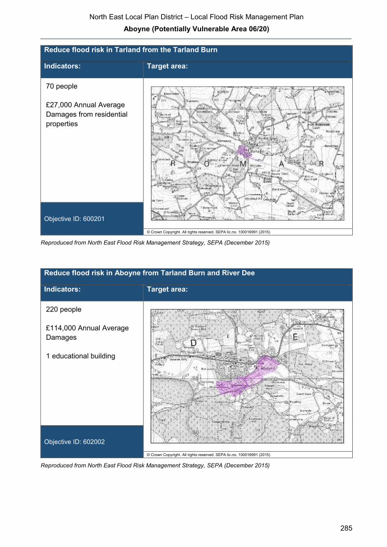
North East Local Plan District – Local Flood Risk Management Plan
Aboyne (Potentially Vulnerable Area 06/20)
285
Reduce flood risk in Tarland from the Tarland Burn
Indicators: Target area:
70 people
£27,000 Annual Average
Damages from residential
properties
Objective ID: 600201
© Crown Copyright. All rights reserved. SEPA lic.no. 100016991 (2015)
Reproduced from North East Flood Risk Management Strategy, SEPA (December 2015)
Reduce flood risk in Aboyne from Tarland Burn and River Dee
Indicators: Target area:
220 people
£114,000 Annual Average
Damages
1 educational building
Objective ID: 602002
© Crown Copyright. All rights reserved. SEPA lic.no. 100016991 (2015)
Reproduced from North East Flood Risk Management Strategy, SEPA (December 2015)
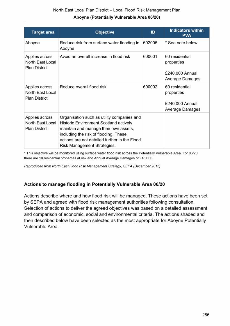
North East Local Plan District – Local Flood Risk Management Plan
Aboyne (Potentially Vulnerable Area 06/20)
286
Target area Objective ID Indicators within
PVA
Aboyne Reduce risk from surface water flooding in
Aboyne
602005 * See note below
Applies across
North East Local
Plan District
Avoid an overall increase in flood risk 600001 60 residential
properties
£240,000 Annual
Average Damages
Applies across
North East Local
Plan District
Reduce overall flood risk 600002 60 residential
properties
£240,000 Annual
Average Damages
Applies across
North East Local
Plan District
Organisation such as utility companies and
Historic Environment Scotland actively
maintain and manage their own assets,
including the risk of flooding. These
actions are not detailed further in the Flood
Risk Management Strategies.
* This objective will be monitored using surface water flood risk across the Potentially Vulnerable Area. For 06/20
there are 10 residential properties at risk and Annual Average Damages of £18,000.
Reproduced from North East Flood Risk Management Strategy, SEPA (December 2015)
Actions to manage flooding in Potentially Vulnerable Area 06/20
Actions describe where and how flood risk will be managed. These actions have been set
by SEPA and agreed with flood risk management authorities following consultation.
Selection of actions to deliver the agreed objectives was based on a detailed assessment
and comparison of economic, social and environmental criteria. The actions shaded and
then described below have been selected as the most appropriate for Aboyne Potentially
Vulnerable Area.
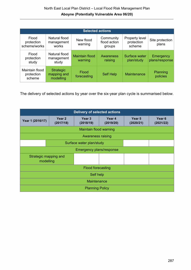
North East Local Plan District – Local Flood Risk Management Plan
Aboyne (Potentially Vulnerable Area 06/20)
287
Selected actions
Flood protection
scheme/works
Natural flood management
works
New flood warning
Community flood action
groups
Property level protection scheme
Site protection plans
Flood protection
study
Natural flood management
study
Maintain flood warning
Awareness raising
Surface water plan/study
Emergency plans/response
Maintain flood protection scheme
Strategic mapping and
modelling
Flood forecasting
Self Help Maintenance Planning policies
The delivery of selected actions by year over the six-year plan cycle is summarised below.
Delivery of selected actions
Year 1 (2016/17) Year 2
(2017/18)
Year 3
(2018/19)
Year 4
(2019/20)
Year 5
(2020/21)
Year 6
(2021/22)
Maintain flood warning
Awareness raising
Surface water plan/study
Emergency plans/response
Strategic mapping and
modelling
Flood forecasting
Self help
Maintenance
Planning Policy

North East Local Plan District – Local Flood Risk Management Plan
Aboyne (Potentially Vulnerable Area 06/20)
288
Delivery of selected actions
Aboyne Flood Protection Study - Cycle 2 (2022 – 2027)
A further Flood Protection Study is planned for this PVA in the next cycle of the Flood Risk
Management Plan (2022 – 2027). The study will look to reduce flood risk in Aboyne from
Tarland Burn and River Dee.
A flood study should be carried out to address flooding from the Tarland Burn and River Dee in
Aboyne. To reduce flood risk from the Tarland Burn it is recommended previous work carried
out by Aberdeenshire Council is developed further. The flood protection study should primarily
focus on direct defences, relocation of properties, runoff reduction, river or floodplain
restoration, sediment management and property level protection. Other actions may also be
considered to develop the most sustainable range of options.
Tarland Flood Protection Study - Cycle 2 (2022 – 2027)
A further Flood Protection Study is planned for this PVA in the next cycle of the Flood Risk
Management Plan (2022 – 2027). The study will look to reduce flood risk in Tarland from the
Tarland Burn.
A flood protection study is recommended to develop the previous work carried out by
Aberdeenshire Council to consider flood protection works to reduce the likelihood of flooding in
Tarland from the Tarland Burn. Development of the previous work should consider a
combination of actions to reduce risk from medium likelihood floods. The flood protection study
should primarily focus on modification of conveyance, construction of direct defences,
relocation of properties and property level protection, to compare against the previously
identified online storage options. Other actions may also be considered in order to develop the
most sustainable range of options.

North East Local Plan District – Local Flood Risk Management Plan
Aboyne (Potentially Vulnerable Area 06/20)
289
Action (ID): MAINTAIN FLOOD WARNING (6000020030)
Objective (ID): Reduce overall flood risk (600002)
Delivery lead: SEPA
Status: Existing Indicative delivery: Ongoing
Description:
SEPA will continue to maintain the 'Aboyne' flood warning area which is part of the Dee river
flood warning scheme.
When flood events occur in an area with an existing flood warning service, SEPA will seek to
verify the flood forecasts and warnings. SEPA will use feedback and post-event data to ensure
that our flood warning service is timely and accurate.
The maintenance of SEPA’s flood warning service is funded by Scottish Government through
SEPA’s grant in aid settlement.

North East Local Plan District – Local Flood Risk Management Plan
Aboyne (Potentially Vulnerable Area 06/20)
290
Action (ID): AWARENESS RAISING (6000020013)
Objective (ID): Reduce overall flood risk (600002)
Delivery lead: Responsible authorities
Status: Existing Indicative delivery: Ongoing
Description:
Aberdeenshire Council have a duty to raise public awareness of flood risk under the Flood Risk
Management (Scotland) Act 2009 and to plan and inform of risks to communities under the Civil
Contingencies Act 2004.
Over the six years of the Plan, 2016-2022, Aberdeenshire Council will seek opportunities to raise
awareness of both flood risk and actions that enable individuals, homes and businesses to
reduce the overall impact of flooding.
In partnership with Education Scotland Aberdeenshire Council will look to engage schools in
activities relating to flooding, extreme weather, climate change and other community resilience
issues.
Aberdeenshire Council will also develop emergency response plans and work with community
flood action groups where these exist.
Awareness raising will be funded from existing local authority flood revenue budgets.
From 2016 SEPA will engage with the community through local participation in national
initiatives, including partnership working with Neighbourhood Watch Scotland. In addition, SEPA
will engage with local authorities and community resilience groups where possible.
Across Scotland, SEPA will create and share communication and education resources with other
responsible authorities. These resources will include awareness campaigns, media and
marketing activities and promotion of SEPA's flood forecasting and warning service (Floodline).
Where they exist, SEPA will engage with community resilience groups and community safety
partnerships. Additionally, SEPA's awareness raising activities will be coordinated with the
activities of other responsible authorities as required.
SEPA's awareness raising activities are funded by Scottish Government through their grant in aid
settlement and will be coordinated with the activities of other responsible authorities as required.
Scottish Water will support SEPA and responsible authorities with their awareness raising
activities as required and provide targeted flooding communications for Scottish Water specific
activities. Scottish Water will raise awareness by producing and supplying targeted information to
the public on large capital projects and detailed local studies
(continued)

North East Local Plan District – Local Flood Risk Management Plan
Aboyne (Potentially Vulnerable Area 06/20)
291
More general information and flooding guidance will be available on the website at:
https://www.scottishwater.co.uk/you-and-your-home/your-home/flooding-information
Scottish Water will keep responsible authorities informed of its awareness raising activities
through the Local Plan District partnerships.
Action (ID): SURFACE WATER PLAN/STUDY (6020050018)
Objective (ID): Reduce risk from surface water flooding in Aboyne (602005)
Delivery lead: Aberdeenshire Council
Status: Ongoing Indicative delivery: 2018-2019
Description:
Aberdeenshire Council will undertake a study to prepare Surface Water Management Plan
(SWMP) to generate increased understanding of the causes, probability and consequences of
surface water flooding and to evaluate options for surface water flood management in Aboyne.
The study will help in preparing a coordinated action plan, supported by an understanding of the
costs and benefits, to identify actions to mitigate surface water flooding, identifying opportunities
where SuDS and similar sustainable actions can play a more significant role in managing surface
water flood risk and generate improved public engagement and understanding of surface water
flooding as well as inform future developments. The study will be completed by Summer 2019
The study has the potential to benefit 10 residential properties and sections of road network at
risk of flooding in this location, with potential Average Annual Damages avoided of up to £18,000.
A reduction in flood risk would have a positive benefit to the health and wellbeing of the
community and socially vulnerable people located within the study area and may also contribute
to enhanced biodiversity and economic activity.
The study will consider interactions with drainage system and water bodies. Additional data and
information will be procured or surveys commissioned to generate data to inform the study. The
study will take a sustainable and integrated approach by coordinating with the river basin
management plan. It will explore opportunities for enhancing biodiversity and for promoting
economic activity and social wellbeing.
Aberdeenshire Council will coordinate with Scottish Water, SEPA and community groups as well
as other relevant agencies and organisations. Aberdeenshire Council will undertake the study
through the Local Planning District (LPD) partnership and / or through separate agreements.
Funding for the study will be subject to Scottish Government’s block grant and capital support,
and budget allocations over the six years of the Plan, 2016-2022.

North East Local Plan District – Local Flood Risk Management Plan
Aboyne (Potentially Vulnerable Area 06/20)
292
Action (ID): EMERGENCY PLANS/RESPONSE (6000020014)
Objective (ID): Reduce overall flood risk (600002)
Delivery lead: Category 1 and 2 Responders
Status: Existing Indicative delivery: Ongoing
Description:
Providing an emergency response to flooding is the responsibility of many organisations,
including local authorities, the emergency services and SEPA. Effective management of an
emergency response relies on emergency plans that are prepared under the Civil Contingencies
Act 2004 by Category 1 and 2 Responders.
Aberdeenshire Council and the James Hutton Institute operate river level gauges on the Tarland
Burn which the Council use to assist with emergency response.
Aberdeenshire Council has an overarching Flood Response Plan, which is coordinated through
the Responders identified under the Civil Contingencies Act 2004. The aim of the plan is to set
out arrangements to deal effectively with flood risk. At predetermined trigger levels flood alerts
and warnings will be issued through SEPA's flood forecasting and warning service (Floodline)
and Aberdeenshire Council will conduct assessments at known hotspots and prepare resources
as required. Aberdeenshire Council will also coordinate measures in conjunction with the other
Responders. The emergency response process is coordinated through regional and local
resilience partnerships. This response may be supported by the work of voluntary organisations.
The Operational Flood Response Plan will undergo review on an annual basis to reflect
operational or responsibility changes. A debrief and plan review will also be carried out after the
Plan is activated during emergencies.
Aberdeenshire Council funding for emergency plans/response will be shared with other
organisations, emergency services and Responders, as appropriate, and will be subject to
Scottish Government’s block grant and capital support, and budget allocations over the six years
of the Plan, 2016-2022. SEPA's emergency plans/response are funded by Scottish Government
through SEPA’s grant in aid settlement.

North East Local Plan District – Local Flood Risk Management Plan
Aboyne (Potentially Vulnerable Area 06/20)
293
Action (ID): STRATEGIC MAPPING AND MODELLING (6000020019)
Objective (ID): Reduce overall flood risk (600002)
Delivery lead: Scottish Water
Status: Scheduled Indicative delivery: 2016-2017
Description:
Scottish Water will undertake further investigation and modelling in the Aboyne sewer catchment
to improve knowledge and understanding of flood risk in this area as required under Section 16
of the Flood Risk Management (Scotland) Act 2009.
Scottish Water will work with responsible authorities to incorporate relevant information into these
studies by regularly keeping the responsible authorities informed of their progress. Scottish
Water will provide responsible authorities with the outputs of the Section 16 assessment which,
where relevant, may be used to inform Surface Water Management Plans and SEPA flood
hazard and risk maps.
Scottish Water funding is committed in its capital programme through Q&S 4a (2015-2021) which
is approved by its regulators and customers

North East Local Plan District – Local Flood Risk Management Plan
Aboyne (Potentially Vulnerable Area 06/20)
294
Action (ID): FLOOD FORECASTING (6000020009)
Objective (ID): Reduce overall flood risk (600002)
Delivery lead: SEPA
Status: Existing Indicative delivery: Ongoing
Description:
The Scottish Flood Forecasting Service is a joint initiative between SEPA and the Met Office that
produces daily, national flood guidance statements which are issued to Category 1 and 2
Responders. The flood guidance statements provide an assessment of the risk of flooding for a
five day period allowing responders time to put preparations in place to reduce the impact of
flooding. The service also provides information which allows SEPA to issue flood warnings,
giving people a better chance of reducing the impact of flooding on their home or business. For
more information, please visit SEPA’s website. The Potentially Vulnerable Area is within the
'Aberdeenshire and Aberdeen City' flood alert area.
Hydrological information is provided by SEPA and meteorological information is provided by the
Met Office. SEPA uses the information to predict the likelihood and timing of river, coastal and
surface water flooding.
SEPA’s flood forecasting service is funded through Scottish Government’s grant in aid allocation.
The Met Office receives funding from the UK Government.
Action (ID): SELF HELP (6000020011)
Objective (ID): Reduce overall flood risk (600002)
Delivery lead: —
Status: Existing Indicative delivery: Ongoing
Description:
Everyone is responsible for protecting themselves and their property flooding. Property and
business owners can take simple steps to reduce damage and disruption to their homes and
businesses should flooding happen. This includes preparing a flood plan and flood kit, installing
property level protection, signing up to Floodline and Resilient Communities initiatives, and
ensuring that properties and businesses are insured against flood damage.
Aberdeenshire Council currently provide a small range of flood protection products for individual
property protection, which are available for all types of flooding, at cost price with free delivery
across Aberdeenshire.

North East Local Plan District – Local Flood Risk Management Plan
Aboyne (Potentially Vulnerable Area 06/20)
295
Action (ID): MAINTENANCE (6000020007)
Objective (ID): Reduce overall flood risk (600002)
Delivery lead: Aberdeenshire Council, asset / land managers
Status: Existing Indicative delivery: Ongoing
Description:
Local authorities have a duty to assess watercourses and carry out clearance and repair works
where such works would substantially reduce flood risk. Aberdeenshire Council will produce
schedules of clearance and repair works and make these available for public inspection.
Maintenance will be funded from existing Flood revenue budgets, for works which are defined to
pose a significant flood risk.
Scottish Water undertake risk based inspection, maintenance and repair on the public sewer
network together with keeping responsible authorities informed of large scale capital
maintenance work to identify opportunities for co-ordination.
North East Local Plan District – Local Flood Risk Management Plan
Aboyne (Potentially Vulnerable Area 06/20)
296
Action (ID): PLANNING POLICIES (6000010001)
Objective (ID): Avoid an overall increase in flood risk (600001) Reduce overall flood risk
(600002)
Delivery lead: Planning authority
Status: Existing Indicative delivery: Ongoing
Description:
Scottish Planning Policy and accompanying Planning Advice Notes set out Scottish Ministers’
priorities for the operation of the planning system and for the development and use of land. In
terms of flood risk management, the policy supports a catchment-scale approach to sustainable
flood risk management and aims to build the resilience of our cities and towns, encourage
sustainable land management in our rural areas, and to address the long-term vulnerability of
parts of our coasts and islands. Under this approach, new development in areas with medium to
high likelihood of flooding should be avoided. Planning authorities are responsible for
implementing this policy guidance when producing Local Development Plans and when
considering individual planning applications.
For further information on the application of national planning policies see Annex 5.
Aberdeenshire Council is a local planning authority and will work with the regional planning
authority, the Aberdeen City and Shire Strategic Development Planning Authority.
As a consultee on planning applications, Aberdeenshire Council’s Flood & Coast Protection team
will work directly with colleagues in the Planning Service to ensure that appropriate policies and
measures are put in place to reduce flood risk. Planning applications are assessed against the
flooding standards set out in the current Aberdeenshire Local Development Plan, and in future
those in the proposed Aberdeenshire Local Development Plan 2016.
SEPA has a statutory role in relation to the provision of flood risk advice to planning authorities.
This role is expressed in Section 72 of the FRM Act, 2009. SEPA also has a duty to cooperate
with planning authorities in the preparation of development plans. When consulted in relation to
planning applications for development or site allocations in development plans, and where the
planning authority considers there may be a risk of flooding, SEPA will provide advice. The
advice provided by SEPA will be with respect to the risk of flooding and on the basis of the
relevant information it holds which is suitable for planning purposes. It will also be in line with the
principles and duties set out in the FRM Act. Further information about how SEPA engages in
the planning system, including guidance on flood risk and planning is available on SEPA’s
website http://www.sepa.org.uk/environment/land/planning/
SEPA's land use planning activities will be coordinated with the activities of other responsible
authorities as required and are funded by Scottish Government through SEPA’s grant in aid
settlement.
(continued)
North East Local Plan District – Local Flood Risk Management Plan
Aboyne (Potentially Vulnerable Area 06/20)
297
Scottish Water is a statutory consultee within the planning legislation and is required to comment
on all outline or full planning applications which are referred by a local authority. Scottish Water is
also defined as a key agency within development plan legislation, and therefore plays a key role
in providing advice to planning authorities during the production of Local Development Plans.
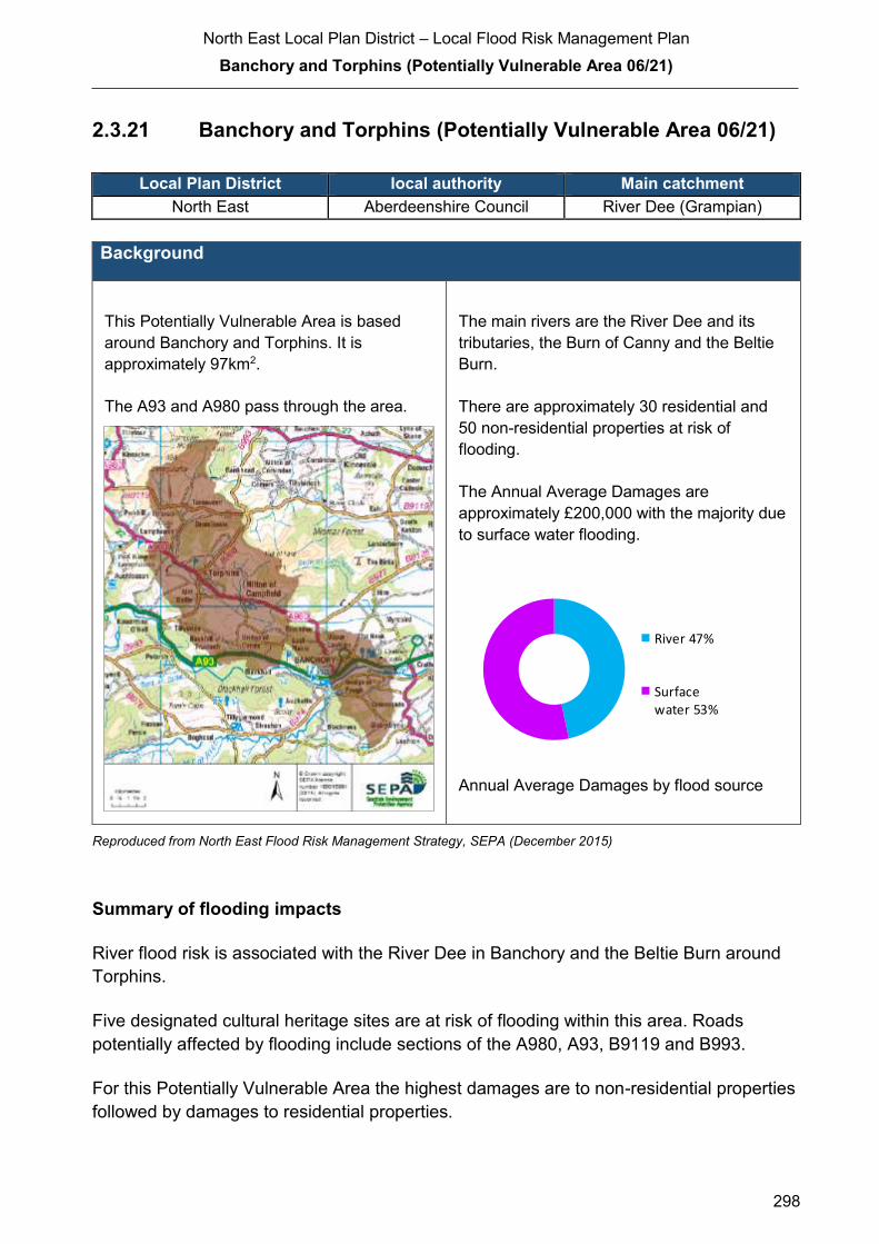
North East Local Plan District – Local Flood Risk Management Plan
Banchory and Torphins (Potentially Vulnerable Area 06/21)
298
2.3.21 Banchory and Torphins (Potentially Vulnerable Area 06/21)
Local Plan District local authority Main catchment North East Aberdeenshire Council River Dee (Grampian)
Background
This Potentially Vulnerable Area is based
around Banchory and Torphins. It is
approximately 97km2.
The A93 and A980 pass through the area.
The main rivers are the River Dee and its
tributaries, the Burn of Canny and the Beltie
Burn.
There are approximately 30 residential and
50 non-residential properties at risk of
flooding.
The Annual Average Damages are
approximately £200,000 with the majority due
to surface water flooding.
Annual Average Damages by flood source
Reproduced from North East Flood Risk Management Strategy, SEPA (December 2015)
Summary of flooding impacts
River flood risk is associated with the River Dee in Banchory and the Beltie Burn around
Torphins.
Five designated cultural heritage sites are at risk of flooding within this area. Roads
potentially affected by flooding include sections of the A980, A93, B9119 and B993.
For this Potentially Vulnerable Area the highest damages are to non-residential properties
followed by damages to residential properties.
River 47%
Surfacewater 53%

North East Local Plan District – Local Flood Risk Management Plan
Banchory and Torphins (Potentially Vulnerable Area 06/21)
299
History of flooding
The Beltie Burn flooded in 1799, 1829, 1872, and 1876 affecting the railway (now
abandoned) and damaging bridges. Flooding on the River Dee occurred in 1876 and
1902, which affected the railway at Glassel and Banchory. In 1998 and 2000 the Burn of
Canny overtopped its banks in several places causing flooding to properties at Millbank
and Inchmarlo.
More recently, there was flooding in Torphins at Craigour Avenue in 2000, Craigmyle
Road in 2002 from a small spring, Waulkmill Farm in 2002 from the Beltie Burn, Grove
Cottage in 2002 from ground water, Grove Terrace in 2003 and Kincardine Road in 2009.
There was surface water flooding reported at Briarwood, Upper Lochton at Banchory in
2002. Flooding due to the Burn of Canny overtopping and surface water runoff occurred in
Brathens in 2003. Following this flood, the river was realigned and rock armour used to
improve flows.
Objectives to manage flooding in Potentially Vulnerable Area 06/21
Objectives provide a common goal and shared ambition for managing floods. These
objectives have been set by SEPA and agreed with flood risk management authorities
following consultation. They were identified through an assessment of the underlying
evidence of the causes and impacts of flooding. Target areas have been set to focus
actions; they do not necessarily correspond to areas at risk in SEPA’s flood map. The
objectives below have been set for Banchory and Torphins Potentially Vulnerable Area.
Target area Objective ID Indicators within
PVA
Applies across
North East Local
Plan District
Avoid an overall increase in flood risk 600001 30 residential
properties
£200,000 Annual
Average Damages
Applies across
North East Local
Plan District
Reduce overall flood risk 600002 30 residential
properties
£200,000 Annual
Average Damages
Applies across
North East Local
Plan District
Organisation such as utility companies and
Historic Environment Scotland actively
maintain and manage their own assets,
including the risk of flooding. These
actions are not detailed further in the Flood
Risk Management Strategies.
Reproduced from North East Flood Risk Management Strategy, SEPA (December 2015)
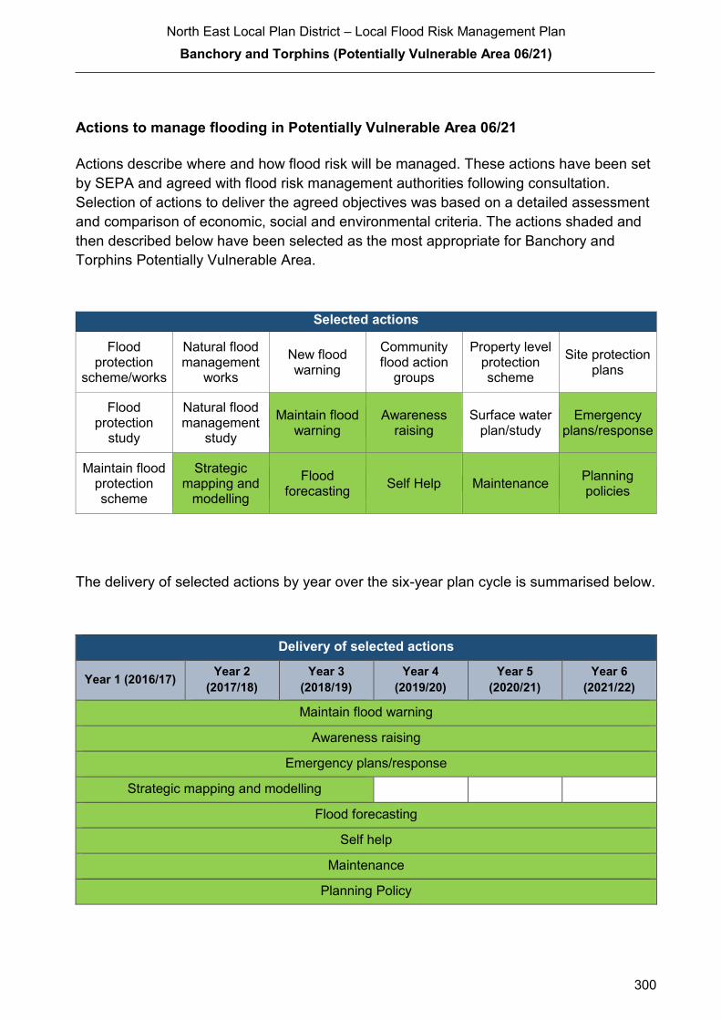
North East Local Plan District – Local Flood Risk Management Plan
Banchory and Torphins (Potentially Vulnerable Area 06/21)
300
Actions to manage flooding in Potentially Vulnerable Area 06/21
Actions describe where and how flood risk will be managed. These actions have been set
by SEPA and agreed with flood risk management authorities following consultation.
Selection of actions to deliver the agreed objectives was based on a detailed assessment
and comparison of economic, social and environmental criteria. The actions shaded and
then described below have been selected as the most appropriate for Banchory and
Torphins Potentially Vulnerable Area.
Selected actions
Flood protection
scheme/works
Natural flood management
works
New flood warning
Community flood action
groups
Property level protection scheme
Site protection plans
Flood protection
study
Natural flood management
study
Maintain flood warning
Awareness raising
Surface water plan/study
Emergency plans/response
Maintain flood protection scheme
Strategic mapping and
modelling
Flood forecasting
Self Help Maintenance Planning policies
The delivery of selected actions by year over the six-year plan cycle is summarised below.
Delivery of selected actions
Year 1 (2016/17) Year 2
(2017/18)
Year 3
(2018/19)
Year 4
(2019/20)
Year 5
(2020/21)
Year 6
(2021/22)
Maintain flood warning
Awareness raising
Emergency plans/response
Strategic mapping and modelling
Flood forecasting
Self help
Maintenance
Planning Policy

North East Local Plan District – Local Flood Risk Management Plan
Banchory and Torphins (Potentially Vulnerable Area 06/21)
301
Action (ID): MAINTAIN FLOOD WARNING (6000020030)
Objective (ID): Reduce overall flood risk (600002)
Delivery lead: SEPA
Status: Existing Indicative delivery: Ongoing
Description:
SEPA will continue to maintain the 'Banchory' flood warning area which is part of the Dee river
flood warning scheme. When flood events occur in an area with an existing flood warning
service, SEPA will seek to verify the flood forecasts and warnings. SEPA will use feedback and
post-event data to ensure that our flood warning service is timely and accurate.
The maintenance of SEPA’s flood warning service is funded by Scottish Government through
SEPA’s grant in aid settlement.

North East Local Plan District – Local Flood Risk Management Plan
Banchory and Torphins (Potentially Vulnerable Area 06/21)
302
Action (ID): AWARENESS RAISING (6000020013)
Objective (ID): Reduce overall flood risk (600002)
Delivery lead: Responsible authorities
Status: Existing Indicative delivery: Ongoing
Description:
Aberdeenshire Council have a duty to raise public awareness of flood risk under the Flood Risk
Management (Scotland) Act 2009 and to plan and inform of risks to communities under the Civil
Contingencies Act 2004.
Over the six years of the Plan, 2016-2022, Aberdeenshire Council will seek opportunities to raise
awareness of both flood risk and actions that enable individuals, homes and businesses to
reduce the overall impact of flooding.
In partnership with Education Scotland Aberdeenshire Council will look to engage schools in
activities relating to flooding, extreme weather, climate change and other community resilience
issues.
Aberdeenshire Council will also develop emergency response plans and work with community
flood action groups where these exist.
Awareness raising will be funded from existing local authority flood revenue budgets.
From 2016 SEPA will engage with the community through local participation in national
initiatives, including partnership working with Neighbourhood Watch Scotland. In addition, SEPA
will engage with local authorities and community resilience groups where possible.
Across Scotland, SEPA will create and share communication and education resources with other
responsible authorities. These resources will include awareness campaigns, media and
marketing activities and promotion of SEPA's flood forecasting and warning service (Floodline).
Where they exist, SEPA will engage with community resilience groups and community safety
partnerships. Additionally, SEPA's awareness raising activities will be coordinated with the
activities of other responsible authorities as required.
SEPA's awareness raising activities are funded by Scottish Government through their grant in aid
settlement and will be coordinated with the activities of other responsible authorities as required.
Scottish Water will support SEPA and responsible authorities with their awareness raising
activities as required and provide targeted flooding communications for Scottish Water specific
activities. Scottish Water will raise awareness by producing and supplying targeted information to
the public on large capital projects and detailed local studies.
(continued)

North East Local Plan District – Local Flood Risk Management Plan
Banchory and Torphins (Potentially Vulnerable Area 06/21)
303
Action (ID): EMERGENCY PLANS/RESPONSE (6000020014)
Objective (ID): Reduce overall flood risk (600002)
Delivery lead: Category 1 and 2 Responders
Status: Existing Indicative delivery: Ongoing
Description:
Providing an emergency response to flooding is the responsibility of many organisations,
including local authorities, the emergency services and SEPA. Effective management of an
emergency response relies on emergency plans that are prepared under the Civil Contingencies
Act 2004 by Category 1 and 2 Responders.
Aberdeenshire Council has an overarching Flood Response Plan, which is coordinated through
the Responders identified under the Civil Contingencies Act 2004. The aim of the plan is to set
out arrangements to deal effectively with flood risk. At predetermined trigger levels flood alerts
and warnings will be issued through SEPA's flood forecasting and warning service (Floodline)
and Aberdeenshire Council will conduct assessments at known hotspots and prepare resources
as required. Aberdeenshire Council will also coordinate measures in conjunction with the other
Responders. The emergency response process is coordinated through regional and local
resilience partnerships. This response may be supported by the work of voluntary organisations.
The Operational Flood Response Plan will undergo review on an annual basis to reflect
operational or responsibility changes. A debrief and plan review will also be carried out after the
Plan is activated during emergencies.
Aberdeenshire Council funding for emergency plans/response will be shared with other
organisations, emergency services and Responders, as appropriate, and will be subject to
Scottish Government’s block grant and capital support, and budget allocations over the six years
of the Plan, 2016-2022. SEPA's emergency plans/response are funded by Scottish Government
through SEPA’s grant in aid settlement.
More general information and flooding guidance will be available on the website at:
https://www.scottishwater.co.uk/you-and-your-home/your-home/flooding-information
Scottish Water will keep responsible authorities informed of its awareness raising activities
through the Local Plan District partnerships.

North East Local Plan District – Local Flood Risk Management Plan
Banchory and Torphins (Potentially Vulnerable Area 06/21)
304
Action (ID): STRATEGIC MAPPING AND MODELLING (6000020019)
Objective (ID): Reduce overall flood risk (600002)
Delivery lead: Scottish Water
Status: Scheduled Indicative delivery: 2016-2019
Description:
Scottish Water will undertake further investigation and modelling in the Banchory and Torphins
sewer catchment areas to improve knowledge and understanding of flood risk in these areas as
required under Section 16 of the Flood Risk Management (Scotland) Act 2009.
Scottish Water will work with responsible authorities to incorporate relevant information into these
studies by regularly keeping the responsible authorities informed of their progress. Scottish
Water will provide responsible authorities with the outputs of the Section 16 assessment which,
where relevant, may be used to inform Surface Water Management Plans and SEPA flood
hazard and risk maps.
Scottish Water funding is committed in its capital programme through Q&S 4a (2015-2021) which
is approved by its regulators and customers.

North East Local Plan District – Local Flood Risk Management Plan
Banchory and Torphins (Potentially Vulnerable Area 06/21)
305
Action (ID): FLOOD FORECASTING (6000020009)
Objective (ID): Reduce overall flood risk (600002)
Delivery lead: SEPA
Status: Existing Indicative delivery: Ongoing
Description:
The Scottish Flood Forecasting Service is a joint initiative between SEPA and the Met Office that
produces daily, national flood guidance statements which are issued to Category 1 and 2
Responders. The flood guidance statements provide an assessment of the risk of flooding for a
five day period allowing responders time to put preparations in place to reduce the impact of
flooding. The service also provides information which allows SEPA to issue flood warnings,
giving people a better chance of reducing the impact of flooding on their home or business. For
more information, please visit SEPA’s website. The Potentially Vulnerable Area is within the
'Aberdeenshire and Aberdeen City' flood alert area.
Hydrological information is provided by SEPA and meteorological information is provided by the
Met Office. SEPA uses the information to predict the likelihood and timing of river, coastal and
surface water flooding.
SEPA’s flood forecasting service is funded through Scottish Government’s grant in aid allocation.
The Met Office receives funding from the UK Government.
Action (ID): SELF HELP (6000020011)
Objective (ID): Reduce overall flood risk (600002)
Delivery lead: —
Status: Existing Indicative delivery: Ongoing
Description:
Everyone is responsible for protecting themselves and their property flooding. Property and
business owners can take simple steps to reduce damage and disruption to their homes and
businesses should flooding happen. This includes preparing a flood plan and flood kit, installing
property level protection, signing up to Floodline and Resilient Communities initiatives, and
ensuring that properties and businesses are insured against flood damage.
Aberdeenshire Council currently provide a small range of flood protection products for individual
property protection, which are available for all types of flooding, at cost price with free delivery
across Aberdeenshire.
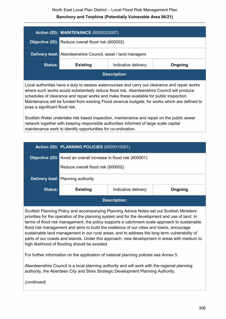
North East Local Plan District – Local Flood Risk Management Plan
Banchory and Torphins (Potentially Vulnerable Area 06/21)
306
Action (ID): MAINTENANCE (6000020007)
Objective (ID): Reduce overall flood risk (600002)
Delivery lead: Aberdeenshire Council, asset / land managers
Status: Existing Indicative delivery: Ongoing
Description:
Local authorities have a duty to assess watercourses and carry out clearance and repair works
where such works would substantially reduce flood risk. Aberdeenshire Council will produce
schedules of clearance and repair works and make these available for public inspection.
Maintenance will be funded from existing Flood revenue budgets, for works which are defined to
pose a significant flood risk.
Scottish Water undertake risk based inspection, maintenance and repair on the public sewer
network together with keeping responsible authorities informed of large scale capital
maintenance work to identify opportunities for co-ordination.
Action (ID): PLANNING POLICIES (6000010001)
Objective (ID): Avoid an overall increase in flood risk (600001)
Reduce overall flood risk (600002)
Delivery lead: Planning authority
Status: Existing Indicative delivery: Ongoing
Description:
Scottish Planning Policy and accompanying Planning Advice Notes set out Scottish Ministers’
priorities for the operation of the planning system and for the development and use of land. In
terms of flood risk management, the policy supports a catchment-scale approach to sustainable
flood risk management and aims to build the resilience of our cities and towns, encourage
sustainable land management in our rural areas, and to address the long-term vulnerability of
parts of our coasts and islands. Under this approach, new development in areas with medium to
high likelihood of flooding should be avoided.
For further information on the application of national planning policies see Annex 5.
Aberdeenshire Council is a local planning authority and will work with the regional planning
authority, the Aberdeen City and Shire Strategic Development Planning Authority.
(continued)

North East Local Plan District – Local Flood Risk Management Plan
Banchory and Torphins (Potentially Vulnerable Area 06/21)
307
As a consultee on planning applications, Aberdeenshire Council’s Flood & Coast Protection team
will work directly with colleagues in the Planning Service to ensure that appropriate policies and
measures are put in place to reduce flood risk. Planning applications are assessed against the
flooding standards set out in the current Aberdeenshire Local Development Plan, and in future
those in the proposed Aberdeenshire Local Development Plan 2016.
SEPA has a statutory role in relation to the provision of flood risk advice to planning authorities.
This role is expressed in Section 72 of the FRM Act, 2009. SEPA also has a duty to cooperate
with planning authorities in the preparation of development plans. When consulted in relation to
planning applications for development or site allocations in development plans, and where the
planning authority considers there may be a risk of flooding, SEPA will provide advice. The
advice provided by SEPA will be with respect to the risk of flooding and on the basis of the
relevant information it holds which is suitable for planning purposes. It will also be in line with the
principles and duties set out in the FRM Act.
Further information about how SEPA engages in the planning system, including guidance on
flood risk and planning is available on SEPA’s website
http://www.sepa.org.uk/environment/land/planning/
SEPA's land use planning activities will be coordinated with the activities of other responsible
authorities as required and are funded by Scottish Government through SEPA’s grant in aid
settlement.
Scottish Water is a statutory consultee within the planning legislation and is required to comment
on all outline or full planning applications which are referred by a local authority.
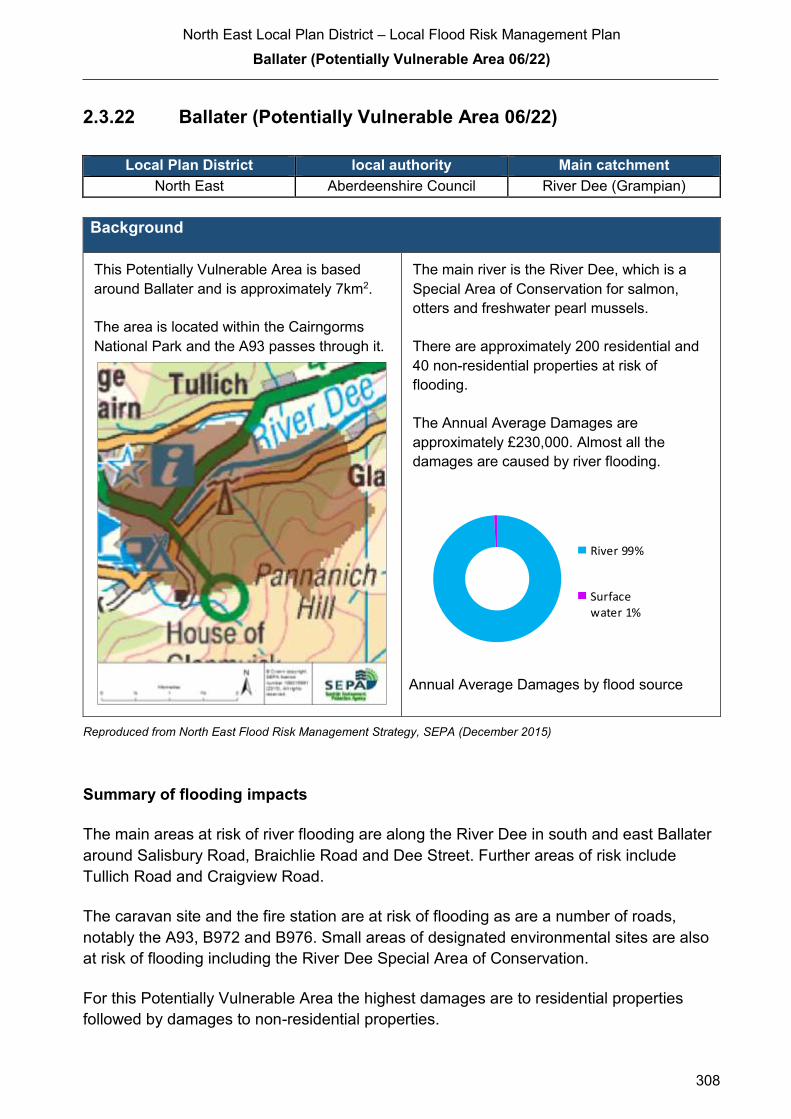
North East Local Plan District – Local Flood Risk Management Plan
Ballater (Potentially Vulnerable Area 06/22)
308
2.3.22 Ballater (Potentially Vulnerable Area 06/22)
Local Plan District local authority Main catchment North East Aberdeenshire Council River Dee (Grampian)
Background
This Potentially Vulnerable Area is based
around Ballater and is approximately 7km2.
The area is located within the Cairngorms
National Park and the A93 passes through it.
The main river is the River Dee, which is a
Special Area of Conservation for salmon,
otters and freshwater pearl mussels.
There are approximately 200 residential and
40 non-residential properties at risk of
flooding.
The Annual Average Damages are
approximately £230,000. Almost all the
damages are caused by river flooding.
Annual Average Damages by flood source
Reproduced from North East Flood Risk Management Strategy, SEPA (December 2015)
Summary of flooding impacts
The main areas at risk of river flooding are along the River Dee in south and east Ballater
around Salisbury Road, Braichlie Road and Dee Street. Further areas of risk include
Tullich Road and Craigview Road.
The caravan site and the fire station are at risk of flooding as are a number of roads,
notably the A93, B972 and B976. Small areas of designated environmental sites are also
at risk of flooding including the River Dee Special Area of Conservation.
For this Potentially Vulnerable Area the highest damages are to residential properties
followed by damages to non-residential properties.
River 99%
Surfacewater 1%

North East Local Plan District – Local Flood Risk Management Plan
Ballater (Potentially Vulnerable Area 06/22)
309
History of flooding
Flooding occurred on the River Dee in 1829, destroying the Ballater Bridge and in 1839,
the bridge at Tullich was damaged. In 1877, cellars in the lower part of Ballater were
flooded, and in 1920 and 1929 the town and roads were flooded.
Local reports are that in the late 1980s the bottom part of the village was badly flooded
with water coming up through the drains. Deebank Road, Bridge Street Richmond Place,
Braichlie Road were all affected. In 2008, surface runoff entered the Netherley Guest
House at Netherley Place.
In August 2014, the caravan park and a number of roads were closed due to flooding from
the River Dee. As a result, 150 people were evacuated from the caravan site.
Large areas of Ballater were affected by flooding from the River Dee in December 2015.
More than 100 residents had to be evacuated from Anderson Road, Deebank Road and
Albert Road. Over 300 Properties were flooded. A section of the A93 between Ballater
and Balmoral Castle (near Braemar) was washed away and the Cambus O’May Bridge
was extensively damaged.
The police station flooded and suffered substantial damage, leading it to operate mobile
surgeries a few days per week.
Victoria Barracks were used as emergency care centre and subsequent flood relief centre.
Objectives to manage flooding in Potentially Vulnerable Area 06/22
Objectives provide a common goal and shared ambition for managing floods. These
objectives have been set by SEPA and agreed with flood risk management authorities
following consultation. They were identified through an assessment of the underlying
evidence of the causes and impacts of flooding. Target areas have been set to focus
actions; they do not necessarily correspond to areas at risk in SEPA’s flood map. The
objectives below have been set for Ballater Potentially Vulnerable Area.
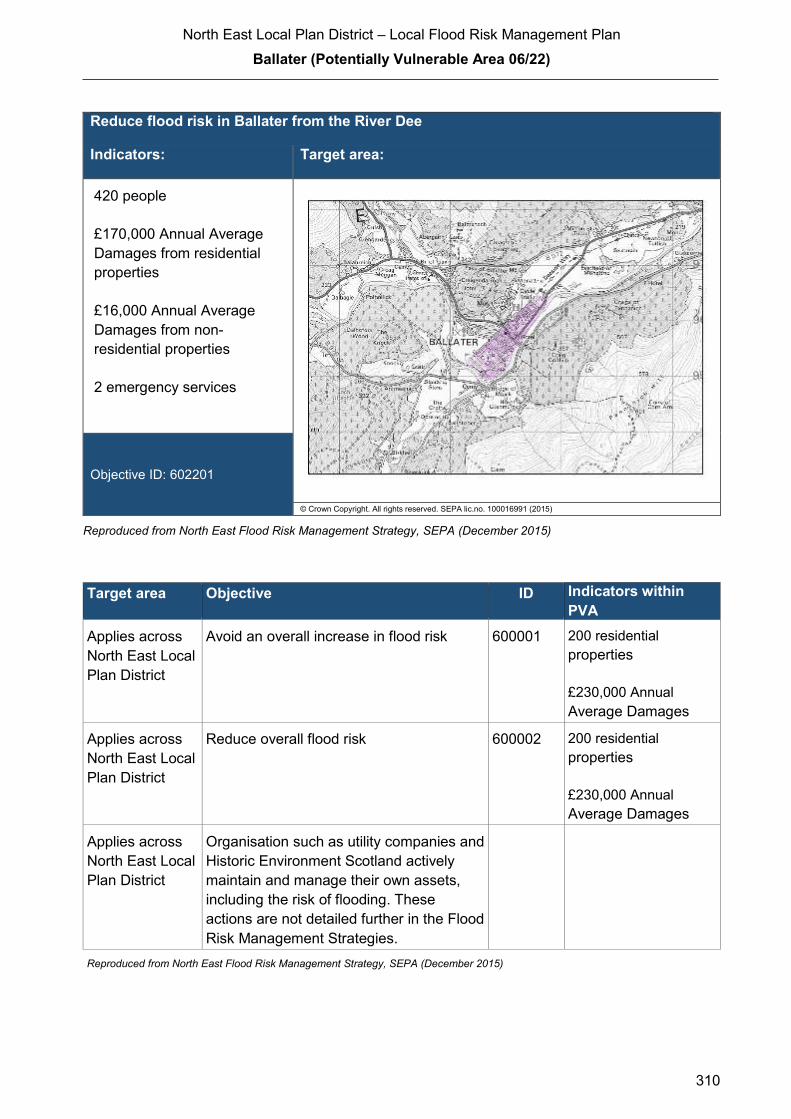
North East Local Plan District – Local Flood Risk Management Plan
Ballater (Potentially Vulnerable Area 06/22)
310
Reduce flood risk in Ballater from the River Dee
Indicators: Target area:
420 people
£170,000 Annual Average
Damages from residential
properties
£16,000 Annual Average
Damages from non-
residential properties
2 emergency services
Objective ID: 602201
© Crown Copyright. All rights reserved. SEPA lic.no. 100016991 (2015)
Reproduced from North East Flood Risk Management Strategy, SEPA (December 2015)
Target area Objective ID Indicators within
PVA
Applies across
North East Local
Plan District
Avoid an overall increase in flood risk 600001 200 residential
properties
£230,000 Annual
Average Damages
Applies across
North East Local
Plan District
Reduce overall flood risk 600002 200 residential
properties
£230,000 Annual
Average Damages
Applies across
North East Local
Plan District
Organisation such as utility companies and
Historic Environment Scotland actively
maintain and manage their own assets,
including the risk of flooding. These
actions are not detailed further in the Flood
Risk Management Strategies.
Reproduced from North East Flood Risk Management Strategy, SEPA (December 2015)

North East Local Plan District – Local Flood Risk Management Plan
Ballater (Potentially Vulnerable Area 06/22)
311
Actions to manage flooding in Potentially Vulnerable Area 06/22
Actions describe where and how flood risk will be managed. These actions have been set
by SEPA and agreed with flood risk management authorities following consultation.
Selection of actions to deliver the agreed objectives was based on a detailed assessment
and comparison of economic, social and environmental criteria. The actions shaded and
then described below have been selected as the most appropriate for Ballater Potentially
Vulnerable Area.
Selected actions
Flood protection
scheme/works
Natural flood management
works
New flood warning
Community flood action
groups
Property level protection scheme
Site protection plans
Flood protection
study
Natural flood management
study
Maintain flood warning
Awareness raising
Surface water plan/study
Emergency plans/response
Maintain flood protection scheme
Strategic mapping and
modelling
Flood forecasting
Self Help Maintenance Planning policies
The delivery of selected actions by year over the six-year plan cycle is summarised below.
Delivery of selected actions
Year 1 (2016/17) Year 2
(2017/18)
Year 3
(2018/19)
Year 4
(2019/20)
Year 5
(2020/21)
Year 6
(2021/22)
Community flood action groups
Maintain flood warning
Awareness raising
Emergency plans/response
Strategic mapping and
modelling
Flood forecasting
Self help
Maintenance
Planning Policy

North East Local Plan District – Local Flood Risk Management Plan
Ballater (Potentially Vulnerable Area 06/22)
312
Delivery of selected actions
Ballater Flood Protection Study - Outwith Local Flood Risk Management Plan
A further Flood Protection Study is planned for this PVA in the current cycle of the Flood Risk
Management Plan, but this will be undertaken outwith this Plan. The study will look to reduce
flood risk in Ballater from the River Dee.
A flood protection study is recommended to consider flood protection works to reduce the
likelihood of flooding in Ballater from the River Dee. The flood protection study should primarily
focus on direct defences, relocation of properties and property level protection, but other
actions may also be considered in order to develop the most sustainable range of options.

North East Local Plan District – Local Flood Risk Management Plan
Ballater (Potentially Vulnerable Area 06/22)
313
Action (ID): COMMUNITY FLOOD ACTION GROUPS (6000020012)
Objective (ID): Reduce overall flood risk (600002)
Delivery lead: Community
Status: Existing Indicative delivery: Ongoing
Description:
Aberdeenshire Council will work with the Ballater Flood Resilience Group to reduce flood risk,
improve preparedness and increase resilience against flooding.
Aberdeenshire Council will coordinate with the Group throughout the next 6 years on a priority
needs basis where resources allow.
Funding for Aberdeenshire Council’s own activities to support the Ballater Flood Resilience
Group will be subject to Scottish Government’s block grant and capital support, and budget
allocations over the six years of the Plan.
Action (ID): MAINTAIN FLOOD WARNING (6000020030)
Objective (ID): Reduce overall flood risk (600002)
Delivery lead: SEPA
Status: Existing Indicative delivery: Ongoing
Description:
SEPA will continue to maintain the 'Ballater' flood warning area which is part of the Dee river
flood warning scheme.
When flood events occur in an area with an existing flood warning service, SEPA will seek to
verify the flood forecasts and warnings. SEPA will use feedback and post-event data to ensure
that our flood warning service is timely and accurate.
The maintenance of SEPA’s flood warning service is funded by Scottish Government through
SEPA’s grant in aid settlement.

North East Local Plan District – Local Flood Risk Management Plan
Ballater (Potentially Vulnerable Area 06/22)
314
Action (ID): AWARENESS RAISING (6000020013)
Objective (ID): Reduce overall flood risk (600002)
Delivery lead: Responsible authorities
Status: Existing Indicative delivery: Ongoing
Description:
Aberdeenshire Council have a duty to raise public awareness of flood risk under the Flood Risk
Management (Scotland) Act 2009 and to plan and inform of risks to communities under the Civil
Contingencies Act 2004.
Over the six years of the Plan, 2016-2022, Aberdeenshire Council will seek opportunities to raise
awareness of both flood risk and actions that enable individuals, homes and businesses to
reduce the overall impact of flooding.
In partnership with Education Scotland Aberdeenshire Council will look to engage schools in
activities relating to flooding, extreme weather, climate change and other community resilience
issues.
Aberdeenshire Council will also develop emergency response plans and work with community
flood action groups where these exist.
Awareness raising will be funded from existing local authority flood revenue budgets.
From 2016 SEPA will engage with the community through local participation in national
initiatives, including partnership working with Neighbourhood Watch Scotland. In addition, SEPA
will engage with local authorities and community resilience groups where possible.
Across Scotland, SEPA will create and share communication and education resources with other
responsible authorities. These resources will include awareness campaigns, media and
marketing activities and promotion of SEPA's flood forecasting and warning service (Floodline).
Where they exist, SEPA will engage with community resilience groups and community safety
partnerships. Additionally, SEPA's awareness raising activities will be coordinated with the
activities of other responsible authorities as required.
SEPA's awareness raising activities are funded by Scottish Government through their grant in aid
settlement and will be coordinated with the activities of other responsible authorities as required.
Scottish Water will support SEPA and responsible authorities with their awareness raising
activities as required and provide targeted flooding communications for Scottish Water specific
activities. Scottish Water will raise awareness by producing and supplying targeted information to
the public on large capital projects and detailed local studies.
(continued)
North East Local Plan District – Local Flood Risk Management Plan
Ballater (Potentially Vulnerable Area 06/22)
315
Action (ID): EMERGENCY PLANS/RESPONSE (6000020014)
Objective (ID): Reduce overall flood risk (600002)
Delivery lead: Category 1 and 2 Responders
Status: Existing Indicative delivery: Ongoing
Description:
Providing an emergency response to flooding is the responsibility of many organisations,
including local authorities, the emergency services and SEPA. Effective management of an
emergency response relies on emergency plans that are prepared under the Civil Contingencies
Act 2004 by Category 1 and 2 Responders.
Aberdeenshire Council has an overarching Flood Response Plan, which is coordinated through
the Responders identified under the Civil Contingencies Act 2004. The aim of the plan is to set
out arrangements to deal effectively with flood risk. At predetermined trigger levels flood alerts
and warnings will be issued through SEPA's flood forecasting and warning service (Floodline)
and Aberdeenshire Council will conduct assessments at known hotspots and prepare resources
as required. Aberdeenshire Council will also coordinate measures in conjunction with the other
Responders. The emergency response process is coordinated through regional and local
resilience partnerships. This response may be supported by the work of voluntary organisations.
The Operational Flood Response Plan will undergo review on an annual basis to reflect
operational or responsibility changes. A debrief and plan review will also be carried out after the
Plan is activated during emergencies.
Aberdeenshire Council funding for emergency plans/response will be shared with other
organisations, emergency services and Responders, as appropriate, and will be subject to
Scottish Government’s block grant and capital support, and budget allocations over the six years
of the Plan, 2016-2022. SEPA's emergency plans/response are funded by Scottish Government
through SEPA’s grant in aid settlement.
More general information and flooding guidance will be available on the website at:
https://www.scottishwater.co.uk/you-and-your-home/your-home/flooding-information
Scottish Water will keep responsible authorities informed of its awareness raising activities
through the Local Plan District partnerships.
North East Local Plan District – Local Flood Risk Management Plan
Ballater (Potentially Vulnerable Area 06/22)
316
Action (ID): STRATEGIC MAPPING AND MODELLING (6000020019)
Objective (ID): Reduce overall flood risk (600002)
Delivery lead: Scottish Water
Status: Scheduled Indicative delivery: 2016-2017
Description:
Scottish Water will undertake further investigation and modelling in the Ballater sewer catchment
to improve knowledge and understanding of flood risk in this area as required under Section 16
of the Flood Risk Management (Scotland) Act 2009.
Scottish Water will work with responsible authorities to incorporate relevant information into these
studies by regularly keeping the responsible authorities informed of their progress. Scottish
Water will provide responsible authorities with the outputs of the Section 16 assessment which,
where relevant, may be used to inform Surface Water Management Plans and SEPA flood
hazard and risk maps.
Scottish Water funding is committed in its capital programme through Q&S 4a (2015-2021) which
is approved by its regulators and customers.
Action (ID): FLOOD FORECASTING (6000020009)
Objective (ID): Reduce overall flood risk (600002)
Delivery lead: SEPA
Status: Existing Indicative delivery: Ongoing
Description:
The Scottish Flood Forecasting Service is a joint initiative between SEPA and the Met Office that
produces daily, national flood guidance statements which are issued to Category 1 and 2
Responders. The flood guidance statements provide an assessment of the risk of flooding for a
five day period allowing responders time to put preparations in place to reduce the impact of
flooding. The service also provides information which allows SEPA to issue flood warnings,
giving people a better chance of reducing the impact of flooding on their home or business. For
more information, please visit SEPA’s website. The Potentially Vulnerable Area is within the
'Aberdeenshire and Aberdeen City' flood alert area.
SEPA / Met Office joint initiative. Hydrological information is provided by SEPA and
meteorological information is provided by the Met Office. SEPA uses the information to predict
the likelihood and timing of river, coastal and surface water flooding.
SEPA’s flood forecasting service is funded through Scottish Government’s grant in aid allocation.
The Met Office receives funding from the UK Government.
North East Local Plan District – Local Flood Risk Management Plan
Ballater (Potentially Vulnerable Area 06/22)
317
Action (ID): SELF HELP (6000020011)
Objective (ID): Reduce overall flood risk (600002)
Delivery lead: —
Status: Existing Indicative delivery: Ongoing
Description:
Everyone is responsible for protecting themselves and their property flooding. Property and
business owners can take simple steps to reduce damage and disruption to their homes and
businesses should flooding happen. This includes preparing a flood plan and flood kit, installing
property level protection, signing up to Floodline and Resilient Communities initiatives, and
ensuring that properties and businesses are insured against flood damage.
Aberdeenshire Council currently provide a small range of flood protection products for individual
property protection, which are available for all types of flooding, at cost price with free delivery
across Aberdeenshire.
Action (ID): MAINTENANCE (6000020007)
Objective (ID): Reduce overall flood risk (600002)
Delivery lead: Aberdeenshire Council, asset / land managers
Status: Existing Indicative delivery: Ongoing
Description:
Local authorities have a duty to assess watercourses and carry out clearance and repair works
where such works would substantially reduce flood risk. Aberdeenshire Council will produce
schedules of clearance and repair works and make these available for public inspection.
Maintenance will be funded from existing Flood revenue budgets, for works which are defined to
pose a significant flood risk.
Scottish Water undertake risk based inspection, maintenance and repair on the public sewer
network together with keeping responsible authorities informed of large scale capital
maintenance work to identify opportunities for co-ordination.

North East Local Plan District – Local Flood Risk Management Plan
Ballater (Potentially Vulnerable Area 06/22)
318
Action (ID): PLANNING POLICIES (6000010001)
Objective (ID): Avoid an overall increase in flood risk (600001)
Reduce overall flood risk (600002)
Delivery lead: Planning authority
Status: Existing Indicative delivery: Ongoing
Description:
Scottish Planning Policy and accompanying Planning Advice Notes set out Scottish Ministers’
priorities for the operation of the planning system and for the development and use of land. In
terms of flood risk management, the policy supports a catchment-scale approach to sustainable
flood risk management and aims to build the resilience of our cities and towns, encourage
sustainable land management in our rural areas, and to address the long-term vulnerability of
parts of our coasts and islands. Under this approach, new development in areas with medium to
high likelihood of flooding should be avoided. Planning authorities are responsible for
implementing this policy guidance when producing Local Development Plans and when
considering individual planning applications.
For further information on the application of national planning policies see Annex 5.
Aberdeenshire Council is a local planning authority and will work with the regional planning
authority, the Aberdeen City and Shire Strategic Development Planning Authority.
As a consultee on planning applications, Aberdeenshire Council’s Flood & Coast Protection team
will work directly with colleagues in the Planning Service to ensure that appropriate policies and
measures are put in place to reduce flood risk. Planning applications are assessed against the
flooding standards set out in the current Aberdeenshire Local Development Plan, and in future
those in the proposed Aberdeenshire Local Development Plan 2016.
SEPA has a statutory role in relation to the provision of flood risk advice to planning authorities.
This role is expressed in Section 72 of the FRM Act, 2009. SEPA also has a duty to cooperate
with planning authorities in the preparation of development plans. When consulted in relation to
planning applications for development or site allocations in development plans, and where the
planning authority considers there may be a risk of flooding, SEPA will provide advice. The
advice provided by SEPA will be with respect to the risk of flooding and on the basis of the
relevant information it holds which is suitable for planning purposes. It will also be in line with the
principles and duties set out in the FRM Act. Further information about how SEPA engages in the
planning system, including guidance on flood risk and planning is available on SEPA’s website
http://www.sepa.org.uk/environment/land/planning/
(continued)

North East Local Plan District – Local Flood Risk Management Plan
Ballater (Potentially Vulnerable Area 06/22)
319
SEPA's land use planning activities will be coordinated with the activities of other responsible
authorities as required and are funded by Scottish Government through SEPA’s grant in aid
settlement.
Scottish Water is a statutory consultee within the planning legislation and is required to comment
on all outline or full planning applications which are referred by a local authority.
Scottish Water is also defined as a key agency within development plan legislation, and therefore
plays a key role in providing advice to planning authorities during the production of Local
Development Plans.

North East Local Plan District – Local Flood Risk Management Plan
Stonehaven (Potentially Vulnerable Area 06/23)
320
2.3.23 Stonehaven (Potentially Vulnerable Area 06/23)
Local Plan District local authority Main catchments
North East Aberdeenshire Council Kincardine and Angus coastal
Background
This Potentially Vulnerable Area covers
Stonehaven and the surrounding rural area. It
is approximately 68km².
The Aberdeen to Dundee railway line, and
the A90, A957 and A92 pass through the
area.
The main rivers in the area are Carron and
the Cowie. Stonehaven has suffered from
major flooding in recent years from the River
Carron and from the sea.
There are approximately 860 residential and
240 non-residential properties at risk of
flooding.
The Annual Average Damages are
approximately £890,000, with the majority
due to river flooding.
Annual Average Damages by flood source
Reproduced from North East Flood Risk Management Strategy, SEPA (December 2015)
Summary of flooding impacts
River flood risk is mainly from the River Carron and the Glaslaw Burn. Floods from the
Carron can extend along Low Wood Road and Dunnottar Avenue in the south, and
throughout the low-lying parts of town along Barclay Street in the north. Flooding also
extends to the south east along High Street and Arbuthnott Court into the Old Town.
Surface water flooding also impacts on the town, particularly around the leisure centre and
in the Old Town. Flooding from wave overtopping is not fully represented in the general
assessment of flood risk and the number of properties at risk and the damages from
coastal flooding are known to currently be underestimated. Flooding from wave
overtopping has been included in the setting of objectives and selection of actions.
River 70%
Coastal4%
North East Local Plan District – Local Flood Risk Management Plan
Stonehaven (Potentially Vulnerable Area 06/23)
321
Dunnottar School, the police station and the main supermarket are at risk of flooding.
Transport routes affected by flooding include the A90, A92, A957 and the Aberdeen to
Dundee railway in several locations. Six designated cultural heritage sites and a small
area of designated environmental sites are at risk.
For this Potentially Vulnerable Area the highest damages are to residential properties
followed by damages to non-residential properties.
History of flooding
There is a long record of flooding in Stonehaven dating back to the early 1800s, with
flooding affecting property, agriculture, bridges and roads. A number of these floods
resulted in several feet of water in the town.
There is extensive and valuable local knowledge of historic flooding and further work is
required to fully reconcile this knowledge with existing recorded events listed below.
The earliest recorded flood on Carron Water was in 1829, with additional floods recorded
in 1835 (when large areas of the town were submerged by several feet of water) 1836,
1878 (when one fatality occurred), 1881, and 1895. There are floods recorded on Cowie in
1878, 1881, 1882, 1884, 1895, 1896 and 1949. In December 1985 there was a flood on
both the Carron and Cowie rivers, which affected Arduthie Street, Carron Terrace, and
Cameron Street. In 2002, the Carron flooded Low Wood Road.
In November 2009, the Carron burst its banks at the green bridge and flooded 97
properties in Stonehaven with 50 people needing to be evacuated. The River Carron and
its tributary, the Glaslaw Burn, flooded again in December 2012 when 40 properties were
evacuated and suffered significant damage. Surface water also contributed significantly to
this flood.
In 1998, the Farrochie Burn flooded Arduthie Gardens in Stonehaven affecting three
properties; it flooded again in 2002. In 2006, a trash screen became blocked with debris
and caused Farrochie Burn to flood a public park and road. In 2006, Victoria Street was
flooded from an unnamed watercourse, with a culvert blockage causing the water to back
up. In 2008 the gardens of Touck Cottages were affected by surface runoff from
agricultural land.
On 15 December 2012, a coastal storm overtopped the sea defences and around 20
properties were flooded internally. Around 25 vulnerable residents had to be evacuated
and there was significant structural damage to further seafront properties from wave
action. Seafront properties were again affected in October 2014 by wave overtopping and
many vulnerable people were evacuated from their homes.
Wave overtopping frequently impacts seafront businesses to the north of the River Cowie.
Residential properties in Cowie village are also affected during periods of high water
levels and wave activity.
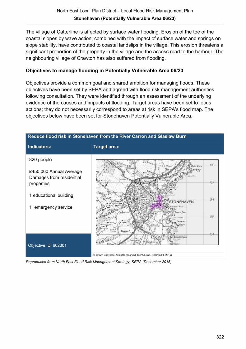
North East Local Plan District – Local Flood Risk Management Plan
Stonehaven (Potentially Vulnerable Area 06/23)
322
The village of Catterline is affected by surface water flooding. Erosion of the toe of the
coastal slopes by wave action, combined with the impact of surface water and springs on
slope stability, have contributed to coastal landslips in the village. This erosion threatens a
significant proportion of the property in the village and the access road to the harbour. The
neighbouring village of Crawton has also suffered from flooding.
Objectives to manage flooding in Potentially Vulnerable Area 06/23
Objectives provide a common goal and shared ambition for managing floods. These
objectives have been set by SEPA and agreed with flood risk management authorities
following consultation. They were identified through an assessment of the underlying
evidence of the causes and impacts of flooding. Target areas have been set to focus
actions; they do not necessarily correspond to areas at risk in SEPA’s flood map. The
objectives below have been set for Stonehaven Potentially Vulnerable Area.
Reduce flood risk in Stonehaven from the River Carron and Glaslaw Burn
Indicators: Target area:
820 people
£450,000 Annual Average
Damages from residential
properties
1 educational building
1 emergency service
Objective ID: 602301
© Crown Copyright. All rights reserved. SEPA lic.no. 100016991 (2015)
Reproduced from North East Flood Risk Management Strategy, SEPA (December 2015)

North East Local Plan District – Local Flood Risk Management Plan
Stonehaven (Potentially Vulnerable Area 06/23)
323
Reduce flood risk in Stonehaven from coastal flooding
Indicators: Target area:
110 people
£27,000 Annual Average
Damages from residential
properties
£3,100 Annual Average
Damages from non-
residential properties
Objective ID: 602302
© Crown Copyright. All rights reserved. SEPA lic.no. 100016991 (2015)
Reproduced from North East Flood Risk Management Strategy, SEPA (December 2015)
Target area Objective ID Indicators within
PVA
Stonehaven Reduce risk from surface water flooding in
Stonehaven
602307 * See note below
Applies across
North East Local
Plan District
Avoid an overall increase in flood risk 600001 860 residential
properties
£890,000 Annual
Average Damages
Applies across
North East Local
Plan District
Reduce overall flood risk 600002 860 residential
properties
£890,000 Annual
Average Damages
Applies across
North East Local
Plan District
Organisation such as utility companies and
Historic Environment Scotland actively
maintain and manage their own assets,
including the risk of flooding. These
actions are not detailed further in the Flood
Risk Management Strategies.
* This objective will be monitored using surface water flood risk across the Potentially Vulnerable Area. For 06/23
there are 180 residential properties at risk and Annual Average Damages of £230,000.
Reproduced from North East Flood Risk Management Strategy, SEPA (December 2015)

North East Local Plan District – Local Flood Risk Management Plan
Stonehaven (Potentially Vulnerable Area 06/23)
324
s to manage flooding in Potentially Vulnerable Area 06/23
Actions describe where and how flood risk will be managed. These actions have been set
by SEPA and agreed with flood risk management authorities following consultation.
Selection of actions to deliver the agreed objectives was based on a detailed assessment
and comparison of economic, social and environmental criteria. The actions shaded and
then described below have been selected as the most appropriate for Stonehaven
Potentially Vulnerable Area.
Selected actions
Flood protection
scheme/works
Natural flood management
works
New flood warning
Community flood action
groups
Property level protection scheme
Site protection plans
Flood protection
study
Natural flood management
study
Maintain flood warning
Awareness raising
Surface water plan/study
Emergency plans/response
Maintain flood protection scheme
Strategic mapping and
modelling
Flood forecasting
Self Help Maintenance Planning policies
The delivery of selected actions by year over the six-year plan cycle is summarised below.
Delivery of selected actions
Year 1
(2016/17)
Year 2
(2017/18)
Year 3
(2018/19)
Year 4
(2019/20)
Year 5
(2020/21)
Year 6
(2021/22)
Flood protection scheme/works
New flood warning
Community flood action groups
Flood protection study
Maintain flood warning
Awareness raising
Surface water plan/study
Maintain flood protection scheme
Emergency plans/response
Strategic mapping and modelling
Flood forecasting
Self help
Maintenance
Planning Policy

North East Local Plan District – Local Flood Risk Management Plan
Stonehaven (Potentially Vulnerable Area 06/23)
325
Action (ID): FLOOD PROTECTION SCHEME/WORKS (6023010006)
Objective (ID): Reduce flood risk in Stonehaven from the River Carron and Glaslaw Burn
(602301)
Delivery lead: Aberdeenshire Council
Priority: National: Within local authority:
32 of 42 1 of 2
Status: Under development Indicative delivery: 2016-2019
Description:
The proposed Stonehaven Flood Protection Scheme includes the following:
− Direct flood defences on both banks of the River Carron from immediately upstream of
the Red Bridge to the coast
− Modifications to the River Carron channel between the Green Bridge and Bridgefield
Bridge
− Raising of the Red Bridge
− Direct flood defences on the Glaslaw Burn from upstream of Carron Gardens to the
upstream face of Low Wood Road
− Raising and relocation of the Green Bridge
− Raising of the White Bridge
− Replacing the culvert under the Woodview Court Bridge with a box culvert
− Provision of pumping stations in low lying areas to alleviate surface water flooding from
overland flows
− Infilling of the parapets on Bridgefield Bridge to provide freeboard
Infrastructure Services Committee, on 28 January 2016, agreed to make the preliminary decision
that the proposed scheme should be progressed with modification; and to notify Scottish
Ministers of that decision.
It is anticipated that the Stonehaven Flood Protection Scheme will be eligible for 80% funding
from the Scottish Government’s Flooding Component of the general Capital Grant. The
remaining funding will be met from the Harbours, Coast & Flooding line from Aberdeenshire
Council’s Capital Plan 2015-2031.

North East Local Plan District – Local Flood Risk Management Plan
Stonehaven (Potentially Vulnerable Area 06/23)
326
Action (ID): NEW FLOOD WARNING (6000020010)
Objective (ID): Reduce overall flood risk (600002)
Delivery lead: SEPA
Status: Scheduled Indicative delivery: 2017- 2018
Description:
Flood warning is required for communities at risk of coastal flooding along the Aberdeenshire
coast from Peterhead to Montrose. A flood warning system will be developed and implemented.
The geographical extent of specific flood warning areas will be developed as part of this process.
A flood protection study is proposed for Stonehaven. SEPA will work with the local authority to
ensure that new information about flood risk resulting from the proposed flood protection study is
considered in developing the new flood warning system.
The maintenance of SEPA’s flood warning service is funded by Scottish Government through
SEPA’s grant in aid settlement. In addition, Scottish Government provides grant funding to
enable SEPA to implement new flood warning schemes.
Potential impacts
Economic:
A flood protection scheme could reduce flood risk to 372 residential properties
at risk of flooding in this location, with estimated damages avoided of £20
million. The benefit-cost ratio of the proposed works is 1.23.
Social:
A flood protection scheme could reduce risk to an estimated 818 people. A
reduction in flood risk would have a positive benefit to the health and
wellbeing of the community and socially vulnerable people. Two utility sites
(energy production/electricity), a school, an emergency service site and the
A957 could benefit from flood protection works.
Environmental:
Flood protection works can have both positive and negative impacts on the
ecological quality of the environment depending on how they are designed.
Direct defences will be set back from the river where possible to reduce
potential negative impacts on the ecological quality of the rivers and minimise
tree loss. The removal of the weir will improve fish passage along the river
which is important for salmon, trout and otter. The development of the design
should look to maintain and enhance the attractive build environment along
the riverside where possible, incorporating finishes, materials and details that
complement this.
North East Local Plan District – Local Flood Risk Management Plan
Stonehaven (Potentially Vulnerable Area 06/23)
327
Action (ID): COMMUNITY FLOOD ACTION GROUPS (6000020012)
Objective (ID): Reduce overall flood risk (600002)
Delivery lead: Community
Status: Existing Indicative delivery: Ongoing
Description:
Stonehaven Flood Action Group vigorously represent the local community on flood risk issues
and have been actively involved in working with Aberdeenshire Council and SEPA in seeking
and implementing solutions to flood risk in Stonehaven. Aberdeenshire Council will work with the
Stonehaven Flood Action Group to reduce flood risk, improve preparedness and increase
resilience against flooding. Aberdeenshire Council will coordinate with the Group throughout the
next 6 years on a priority needs basis where resources allow. Funding for Aberdeenshire
Council’s own activities to support the Stonehaven Flood Action Group will be subject to Scottish
Government’s block grant and capital support, and budget allocations over the six years of the
Plan, 2016-2022.
Action (ID): FLOOD PROTECTION STUDY (6023020005)
Objective (ID): Reduce risk in Stonehaven from coastal flooding (602302)
Delivery lead: Aberdeenshire Council
Priority: National: Within local authority:
86 of 168 4 of 12
Status: Scheduled Indicative delivery: 2016-2019
Description:
Aberdeenshire Council will undertake a flood protection study to evaluate options to reduce the
risk of flooding in Stonehaven from coastal flooding. It is currently estimated that the study will be
completed by Summer 2019.
The study has the potential to benefit 47 residential properties, seven non-residential properties
and sections of road network at risk of flooding in this location, with potential damages avoided of
up to £4 million. The number of properties at risk of flooding from wave overtopping will be
confirmed as part of the study. The estuary of the River Cowie up to the A957 road bridge will be
included in this study. A reduction in flood risk would have a positive benefit to the health and
wellbeing of the community and socially vulnerable people located within the study area and may
also contribute to enhanced biodiversity and economic activity.
(continued)

North East Local Plan District – Local Flood Risk Management Plan
Stonehaven (Potentially Vulnerable Area 06/23)
328
The study will take a sustainable and integrated approach by coordinating with the river basin
management plan and the planned surface water management plan/study. It will be undertaken
with due consideration to internationally, nationally and locally designated sites including listed
buildings. It will also explore opportunities for enhancing biodiversity and for promoting economic
activity and social wellbeing.
The interactions between actions and effects on coastal processes along the shoreline will also
be considered. The study will consider wave attenuation (beach management / recharge),
coastal management actions (revetments), the construction of direct defences, relocation of
properties and property level protection. Beach recharge will very often involve proposals to
obtain the donor sediment from the low intertidal or shallow sub tidal zone in the vicinity. There
are potential adverse effects on biodiversity, active coastal processes and even coastal flood risk
if sediment extraction allows greater wave attack inshore. The flood protection study will ensure
the proposed actions avoid or minimise the potential loss of natural habitat and detrimental
interference with coastal processes. The flood protection study will consider how to avoid or
minimise potential negative effects on the Garron Point Site of Special Scientific Interest to the
north. It is expected that the recommended flood protection scheme will comprise a combination
of such measures to ensure a sustainable and integrated approach to flood risk management by
due consideration of impacts on economy, society, environment and cultural heritage.
Aberdeenshire Council will coordinate with SEPA, Scottish Water, SNH, The Crown Estate,
Marine Scotland, Stonehaven Harbour and community groups as well as other relevant agencies
and organisations. Aberdeenshire Council will undertake the study through the Local Planning
District (LPD) partnership and / or through separate agreements.
Funding for the study will be subject to Scottish Government’s block grant and capital support,
and budget allocations over the six years of the Plan, 2016-2022.
Potential impacts
Economic: The study could benefit 47 residential and seven non-residential properties at
risk of flooding in this location, with potential damages avoided of up to £4
million. Flood protection works would have additional benefits of reducing
structural damage from direct wave action to property along the seafront.
Social: The development of flood protection works following the study would
potentially reduce risk to 106 people. A reduction in flood risk would have a
positive benefit to the health and wellbeing of the community and socially
vulnerable people. Natural flood management actions can restore and
enhance natural environments and create opportunities for recreation and
tourism. Negative impacts through disturbance to the local community during
the construction phase should be considered.
Environmental: Flood protection studies should consider the positive and negative impacts of
proposed actions on the ecological quality of the environment. Natural flood
management actions can have a positive impact by restoring and enhancing
natural habitats. Opportunities to mitigate any environmental impacts may
include design and timing of works. Beach recharge will very often involve
proposals to obtain the donor sediment from the low intertidal or shallow sub
North East Local Plan District – Local Flood Risk Management Plan
Stonehaven (Potentially Vulnerable Area 06/23)
329
Action (ID): MAINTAIN FLOOD WARNING (6000020030)
Objective (ID): Reduce overall flood risk (600002)
Delivery lead: SEPA
Status: Existing Indicative delivery: Ongoing
Description:
SEPA will continue to maintain the 'Stonehaven' flood warning area which is on the Carron Water
and is part of the Stonehaven river flood warning scheme. When flood events occur in an area
with an existing flood warning service, SEPA will seek to verify the flood forecasts and warnings.
SEPA will use feedback and post-event data to ensure that our flood warning service is timely
and accurate.
A flood protection scheme is proposed for Stonehaven. SEPA will work with the local authority to
ensure that changes to hydrology and flood risk as a result of the proposed flood protection
scheme are fully considered in the existing flood warning system.
The maintenance of SEPA’s flood warning service is funded by Scottish Government through
SEPA’s grant in aid settlement.
tidal zone in the vicinity. There are potential adverse effects on biodiversity,
active coastal processes, and even coastal flood risk if sediment extraction
allows greater wave attack inshore. The flood protection study should ensure
the actions avoid or minimise the potential loss of natural habitat and do not
interfere with coastal processes. The flood protection study should consider
how to avoid or minimise potential negative effects on the Garron Point Site of
Special Scientific Interest to the north.

North East Local Plan District – Local Flood Risk Management Plan
Stonehaven (Potentially Vulnerable Area 06/23)
330
Action (ID): AWARENESS RAISING (6000020013)
Objective (ID): Reduce overall flood risk (600002)
Delivery lead: Responsible authorities
Status: Existing Indicative delivery: Ongoing
Description:
Aberdeenshire Council have a duty to raise public awareness of flood risk under the Flood Risk
Management (Scotland) Act 2009 and to plan and inform of risks to communities under the Civil
Contingencies Act 2004.
Over the six years of the Plan, 2016-2022, Aberdeenshire Council will seek opportunities to raise
awareness of both flood risk and actions that enable individuals, homes and businesses to
reduce the overall impact of flooding.
In partnership with Education Scotland Aberdeenshire Council will look to engage schools in
activities relating to flooding, extreme weather, climate change and other community resilience
issues.
Aberdeenshire Council will also develop emergency response plans and work with community
flood action groups where these exist.
Awareness raising will be funded from existing local authority flood revenue budgets.
From 2016 SEPA will engage with the community through local participation in national
initiatives, including partnership working with Neighbourhood Watch Scotland. In addition, SEPA
will engage with local authorities and community resilience groups where possible.
A flood protection scheme is proposed for Stonehaven. SEPA will support the local authority’s
communications and engagement activities with media activity, local public awareness events
and education engagement with schools. SEPA will also deliver joint communications with local
authorities for Floodline customers in any newly protected flood warning area.
A new flood warning scheme is under consideration for Stonehaven. To support the delivery of
the new SEPA flood warning scheme, SEPA will carry out a local launch event and engage
directly with residents in the area. This will be supported by local and national media
communications. SEPA will also support and participate in local public awareness events, in
partnership with the local authority, community council or other local representative
organisations, including schools.
(continued)
North East Local Plan District – Local Flood Risk Management Plan
Stonehaven (Potentially Vulnerable Area 06/23)
331
Across Scotland, SEPA will create and share communication and education resources with other
responsible authorities. These resources will include awareness campaigns, media and
marketing activities and promotion of SEPA's flood forecasting and warning service (Floodline).
Where they exist, SEPA will engage with community resilience groups and community safety
partnerships. Additionally, SEPA's awareness raising activities will be coordinated with the
activities of other responsible authorities as required.
SEPA's awareness raising activities are funded by Scottish Government through their grant in aid
settlement and will be coordinated with the activities of other responsible authorities as required.
Scottish Water will support SEPA and responsible authorities with their awareness raising
activities as required and provide targeted flooding communications for Scottish Water specific
activities. Scottish Water will raise awareness by producing and supplying targeted information to
the public on large capital projects and detailed local studies.
More general information and flooding guidance will be available on the website at:
https://www.scottishwater.co.uk/you-and-your-home/your-home/flooding-information
Scottish Water will keep responsible authorities informed of its awareness raising activities
through the Local Plan District partnerships.

North East Local Plan District – Local Flood Risk Management Plan
Stonehaven (Potentially Vulnerable Area 06/23)
332
Action (ID): SURFACE WATER PLAN/STUDY (6023070018)
Objective (ID): Reduce risk from surface water flooding in Stonehaven (602307)
Delivery lead: Aberdeenshire Council
Status: Ongoing Indicative delivery: 2016-2021
Description:
Aberdeenshire Council will undertake a study to prepare Surface Water Management Plan
(SWMP) to generate increased understanding of the causes, probability and consequences of
surface water flooding and to evaluate options for surface water flood management in
Stonehaven. The study parameters will be likely to extend to Portlethen which is within the same
sewer catchment. The study will build upon the Integrated Catchment Study which was carried
out in from 2010 to 2015 to support the surface water management planning process in
Aberdeen, Westhill and Stonehaven.
The study will help in preparing a coordinated action plan, supported by an understanding of the
costs and benefits, to identify measures to mitigate surface water flooding, identifying
opportunities where SuDS and similar sustainable measures can play a more significant role in
managing surface water flood risk and generate improved public engagement and understanding
of surface water flooding as well as inform future developments. The study will be completed to
coincide with the Option appraisal phase of the Integrated Catchment Study which is planned to
be carried out from 2015 to 2021.
The study has the potential to benefit residential properties, non-residential properties and
sections of road network at risk of flooding in this location. A reduction in flood risk would have a
positive benefit to the health and wellbeing of the community and socially vulnerable people
located within the study area and may also contribute to enhanced biodiversity and economic
activity.
The study will consider interactions with drainage system, water bodies and the sea. Additional
data and information will be procured or surveys commissioned to generate data to inform the
study. The study will take a sustainable and integrated approach by coordinating with the river
basin management plan. It will explore opportunities for enhancing biodiversity and for
promoting economic activity and social wellbeing.
Aberdeenshire Council will coordinate with Aberdeen City Council, Scottish Water, SEPA and
community groups as well as other relevant agencies and organisations. Aberdeenshire Council
will undertake the study through the Local Planning District (LPD) partnership and / or through
separate agreements.
Funding for the study will be subject to Scottish Government’s block grant and capital support,
and budget allocations over the six years of the Plan, 2016-2022.

North East Local Plan District – Local Flood Risk Management Plan
Stonehaven (Potentially Vulnerable Area 06/23)
333
Action (ID): MAINTAIN FLOOD PROTECTION SCHEME (6023010017)
Objective (ID): Reduce flood risk in Stonehaven from the River Carron and Glaslaw Burn
(602301)
Delivery lead: Aberdeenshire Council
Status: Proposed Indicative delivery: 2019 onwards
Description:
Subject to the outcome of the statutory process, and assuming the Stonehaven Flood Protection
Scheme is completed within the first six-year flood risk management plan cycle 2016-2022, the
following maintenance measures will be undertaken:
− Hydraulic Flood Walls - Pressure testing / operation
− Walls Surface finishes - Repointing / re-facing
− Rock Armour - Replacement when required
Action (ID): EMERGENCY PLANS/RESPONSE (6000020014)
Objective (ID): Reduce overall flood risk (600002)
Delivery lead: Category 1 and 2 Responders
Status: Existing Indicative delivery: Ongoing
Description:
Providing an emergency response to flooding is the responsibility of many organisations,
including local authorities, the emergency services and SEPA. Effective management of an
emergency response relies on emergency plans that are prepared under the Civil Contingencies
Act 2004 by Category 1 and 2 Responders.
Aberdeenshire Council currently provides sandbags at pre-arranged locations in the town when
forecast conditions indicate that the likelihood of need is very high. Aberdeenshire Council also
deploys flood barriers in these conditions to help divert flood water away from properties and
back into the river channel where possible. Aberdeenshire Council operates a water level monitor
on the River Carron.
Aberdeenshire Council has an overarching Flood Response Plan, which is coordinated through
the Responders identified under the Civil Contingencies Act 2004. The aim of the plan is to set
out arrangements to deal effectively with flood risk. At predetermined trigger levels flood alerts
and warnings will be issued through SEPA's flood forecasting and warning service (Floodline)
and Aberdeenshire Council will conduct assessments at known hotspots and prepare resources
as required. Aberdeenshire Council will also coordinate measures in conjunction with the other
Responders. The emergency response process is coordinated through regional and local
resilience partnerships. This response may be supported by the work of voluntary organisations.

North East Local Plan District – Local Flood Risk Management Plan
Stonehaven (Potentially Vulnerable Area 06/23)
334
The Operational Flood Response Plan will undergo review on an annual basis to reflect
operational or responsibility changes. A debrief and plan review will also be carried out after the
Plan is activated during emergencies.
Aberdeenshire Council funding for emergency plans/response will be shared with other
organisations, emergency services and Responders, as appropriate, and will be subject to
Scottish Government’s block grant and capital support, and budget allocations over the six years
of the Plan, 2016-2022. SEPA's emergency plans/response are funded by Scottish Government
through SEPA’s grant in aid settlement.
Action (ID): STRATEGIC MAPPING AND MODELLING (6000020019)
Objective (ID): Reduce overall flood risk (600002)
Delivery lead: Scottish Water
Status: Scheduled Indicative delivery: 2016-2018
Description:
Scottish Water will undertake further investigation and modelling in the Cowie sewer catchment
to improve knowledge and understanding of flood risk in this area as required under Section 16
of the Flood Risk Management (Scotland) Act 2009.
Scottish Water will work with responsible authorities to incorporate relevant information into these
studies by regularly keeping the responsible authorities informed of their progress. Scottish
Water will provide responsible authorities with the outputs of the Section 16 assessment which,
where relevant, may be used to inform Surface Water Management Plans and SEPA flood
hazard and risk maps.
Scottish Water funding is committed in its capital programme through Q&S 4a (2015-2021) which
is approved by its regulators and customers.
North East Local Plan District – Local Flood Risk Management Plan
Stonehaven (Potentially Vulnerable Area 06/23)
335
Action (ID): FLOOD FORECASTING (6000020009)
Objective (ID): Reduce overall flood risk (600002)
Delivery lead: SEPA
Status: Existing Indicative delivery: Ongoing
Description:
The Scottish Flood Forecasting Service is a joint initiative between SEPA and the Met Office that
produces daily, national flood guidance statements which are issued to Category 1 and 2
Responders. The flood guidance statements provide an assessment of the risk of flooding for a
five day period allowing responders time to put preparations in place to reduce the impact of
flooding. The service also provides information which allows SEPA to issue flood warnings,
giving people a better chance of reducing the impact of flooding on their home or business. For
more information, please visit SEPA’s website. The Potentially Vulnerable Area is within the
'Aberdeenshire and Aberdeen City' flood alert area.
Hydrological information is provided by SEPA and meteorological information is provided by the
Met Office. SEPA uses the information to predict the likelihood and timing of river, coastal and
surface water flooding.
SEPA’s flood forecasting service is funded through Scottish Government’s grant in aid allocation.
The Met Office receives funding from the UK Government.
Action (ID): SELF HELP (6000020011)
Objective (ID): Reduce overall flood risk (600002)
Delivery lead: —
Status: Existing Indicative delivery: Ongoing
Description:
Everyone is responsible for protecting themselves and their property flooding. Property and
business owners can take simple steps to reduce damage and disruption to their homes and
businesses should flooding happen. This includes preparing a flood plan and flood kit, installing
property level protection, signing up to Floodline and Resilient Communities initiatives, and
ensuring that properties and businesses are insured against flood damage.
Aberdeenshire Council currently provide a small range of flood protection products for individual
property protection, which are available for all types of flooding, at cost price with free delivery
across Aberdeenshire.

North East Local Plan District – Local Flood Risk Management Plan
Stonehaven (Potentially Vulnerable Area 06/23)
336
Action (ID): MAINTENANCE (6000020007)
Objective (ID): Reduce overall flood risk (600002)
Delivery lead: Aberdeenshire Council, asset / land managers
Status: Existing Indicative delivery: Ongoing
Description:
Local authorities have a duty to assess watercourses and carry out clearance and repair works
where such works would substantially reduce flood risk. Aberdeenshire Council will produce
schedules of clearance and repair works and make these available for public inspection.
Maintenance will be funded from existing Flood revenue budgets, for works which are defined to
pose a significant flood risk.
Scottish Water undertake risk based inspection, maintenance and repair on the public sewer
network together with keeping responsible authorities informed of large scale capital
maintenance work to identify opportunities for co-ordination.
North East Local Plan District – Local Flood Risk Management Plan
Stonehaven (Potentially Vulnerable Area 06/23)
337
Action (ID): PLANNING POLICIES (6000010001)
Objective (ID): Avoid an overall increase in flood risk (600001)
Delivery lead: Planning authority
Status: Existing Indicative delivery: Ongoing
Description:
Scottish Planning Policy and accompanying Planning Advice Notes set out Scottish Ministers’
priorities for the operation of the planning system and for the development and use of land. In
terms of flood risk management, the policy supports a catchment-scale approach to sustainable
flood risk management and aims to build the resilience of our cities and towns, encourage
sustainable land management in our rural areas, and to address the long-term vulnerability of
parts of our coasts and islands. Under this approach, new development in areas with medium to
high likelihood of flooding should be avoided.
For further information on the application of national planning policies see Annex 5.
Aberdeenshire Council is a local planning authority and will work with the regional planning
authority, the Aberdeen City and Shire Strategic Development Planning Authority.
As a consultee on planning applications, Aberdeenshire Council’s Flood & Coast Protection team
will work directly with colleagues in the Planning Service to ensure that appropriate policies and
measures are put in place to reduce flood risk. Planning applications are assessed against the
flooding standards set out in the current Aberdeenshire Local Development Plan, and in future
those in the proposed Aberdeenshire Local Development Plan 2016.
SEPA has a statutory role in relation to the provision of flood risk advice to planning authorities.
This role is expressed in Section 72 of the FRM Act, 2009. SEPA also has a duty to cooperate
with planning authorities in the preparation of development plans. When consulted in relation to
planning applications for development or site allocations in development plans, and where the
planning authority considers there may be a risk of flooding, SEPA will provide advice. The
advice provided by SEPA will be with respect to the risk of flooding and on the basis of the
relevant information it holds which is suitable for planning purposes. It will also be in line with the
principles and duties set out in the FRM Act.
Further information about how SEPA engages in the planning system, including guidance on
flood risk and planning is available on SEPA’s website
http://www.sepa.org.uk/environment/land/planning/
SEPA's land use planning activities will be coordinated with the activities of other responsible
authorities as required and are funded by Scottish Government through SEPA’s grant in aid
settlement.
Scottish Water is a statutory consultee within the planning legislation and is required to comment
on all outline or full planning applications which are referred by a local authority.
North East Local Plan District – Local Flood Risk Management Plan
338
2.4 Other activities by local authorities in the North East Local Plan
District
The Plan presents the actions to manage flood risk in The North East Local Plan District.
These actions are at a LPD-wide scale or are targeted at specific PVA. In addition to the
actions in this Plan, responsible authorities are undertaking other activities to manage
flood risk. There are activities included in the Flood Risk Management (Scotland) Act 2009
that are undertaken by each local authority in the LPD. The main activities that have a
significant effect and should be considered in conjunction with the Plan are summarised
as follows:
Section 18 & 59: Works of Clearance and Repair
Based on an assessment of the condition of a body of water, local authorities must
prepare a schedule of clearance and repair works that would substantially reduce the risk
of flooding of land. This is commonly referred to as a Schedule 18, which is made
available by each local authority within the LPD for public inspection. Under Section 59 of
the Act, the local authority must carry out the works in the Schedule 18 if it considers that
this will contribute to the implementation of actions in the Plan, but that these works will
not affect the implementation of actions in this Plan.
Section 56: General Power to manage flood risk
Without affecting the implementation of actions in this Plan, a local authority may do
anything which it considers will contribute to the implementation of actions in the Plan or is
necessary to reduce the risk of a flood which is likely to occur imminently and have
serious adverse consequences for human health, the environment, cultural heritage or
economic activity in its area.
This may include carrying out flood protection works, which may not be identified as
actions in the Plan.
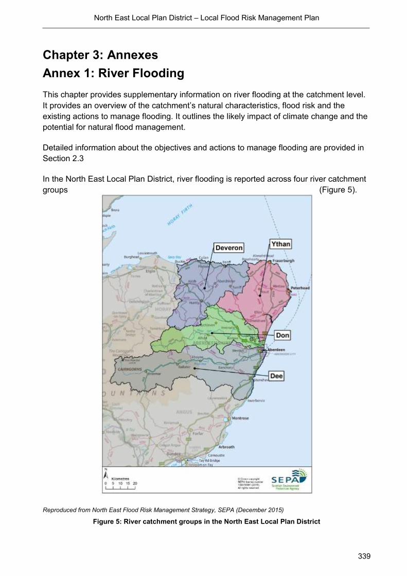
North East Local Plan District – Local Flood Risk Management Plan
339
Chapter 3: Annexes
Annex 1: River Flooding
This chapter provides supplementary information on river flooding at the catchment level.
It provides an overview of the catchment’s natural characteristics, flood risk and the
existing actions to manage flooding. It outlines the likely impact of climate change and the
potential for natural flood management.
Detailed information about the objectives and actions to manage flooding are provided in
Section 2.3
In the North East Local Plan District, river flooding is reported across four river catchment
groups (Figure 5).
Reproduced from North East Flood Risk Management Strategy, SEPA (December 2015)
Figure 5: River catchment groups in the North East Local Plan District

North East Local Plan District – Local Flood Risk Management Plan
340
A1.1 Deveron Catchment Group
Catchment Overview
The Deveron river catchment group covers an area in the north west of the Local Plan
District from Buckie along the coast to Pennan, and south to Rhynie. It has an area of
approximately 1,600km2 (Figure 6). The largest river is the River Deveron. Tributaries of
the Deveron include the Burn of Turriff, River Isla and River Bogie with their confluences
close to the towns of Turriff, Keith, and Huntly respectively. In the north and west of the
area, smaller watercourses including Burn of Boyne, Burn of Buckie and Burn of Durn flow
north straight out to the coast.
The predominant land covers are arable, horticulture and improved grassland, which
together cover 55% of the area. Heather and heather grassland in the south west of the
catchment and coniferous woodland are also important. The area has a highly variable
annual rainfall of between 400mm and1200mm with the wettest areas being inland.
The catchment contains seven Potentially Vulnerable Areas:
Portgordon (06/01)
Portsoy (06/02)
Banff (06/03)
Macduff (06/04)
Newmill (06/06)
Turriff (06/07)
Huntly (06/10)
Flood Risk in The Catchment the catchment
There are approximately 220 residential properties and 140 non-residential properties at
risk of river flooding. Around 46% of the residential and 32% of the non-residential
properties at risk are located within the Potentially Vulnerable Areas.
Main areas at risk
The main areas that have greater than 20 residential properties at risk of river flooding are
shown in Table 3.
Residential and non-residential properties
at risk of river flooding
Annual Average
Damages
Huntly 80 £370,000
Banff and Macduff 60 £220,000
Reproduced from North East Flood Risk Management Strategy, SEPA (December 2015)
Table 3: Main areas at risk of river flooding

Reproduced from North East Flood Risk Management Strategy, SEPA (December 2015)
Figure 6: Deveron river catchment group and Potentially Vulnerable Areas
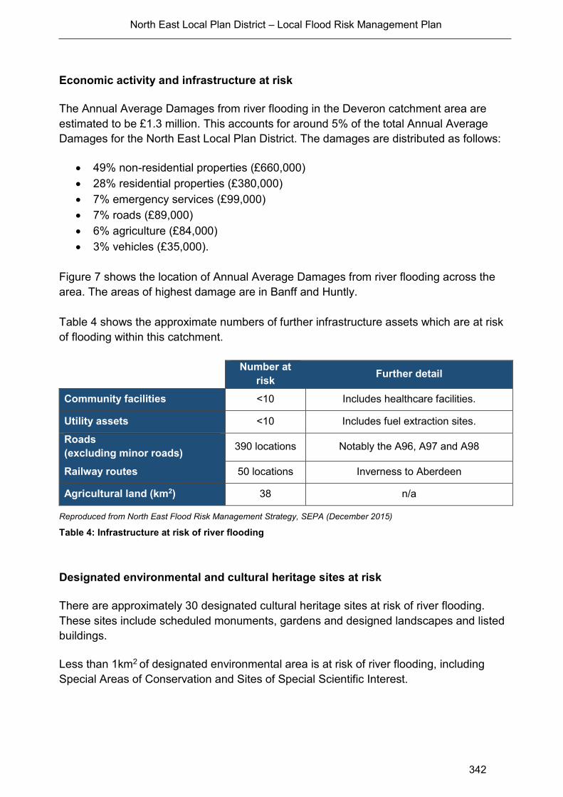
North East Local Plan District – Local Flood Risk Management Plan
342
Economic activity and infrastructure at risk
The Annual Average Damages from river flooding in the Deveron catchment area are
estimated to be £1.3 million. This accounts for around 5% of the total Annual Average
Damages for the North East Local Plan District. The damages are distributed as follows:
49% non-residential properties (£660,000)
28% residential properties (£380,000)
7% emergency services (£99,000)
7% roads (£89,000)
6% agriculture (£84,000)
3% vehicles (£35,000).
Figure 7 shows the location of Annual Average Damages from river flooding across the
area. The areas of highest damage are in Banff and Huntly.
Table 4 shows the approximate numbers of further infrastructure assets which are at risk
of flooding within this catchment.
Number at
risk Further detail
Community facilities <10 Includes healthcare facilities.
Utility assets <10 Includes fuel extraction sites.
Roads
(excluding minor roads) 390 locations Notably the A96, A97 and A98
Railway routes 50 locations Inverness to Aberdeen
Agricultural land (km2) 38 n/a
Reproduced from North East Flood Risk Management Strategy, SEPA (December 2015)
Table 4: Infrastructure at risk of river flooding
Designated environmental and cultural heritage sites at risk
There are approximately 30 designated cultural heritage sites at risk of river flooding.
These sites include scheduled monuments, gardens and designed landscapes and listed
buildings.
Less than 1km2 of designated environmental area is at risk of river flooding, including
Special Areas of Conservation and Sites of Special Scientific Interest.
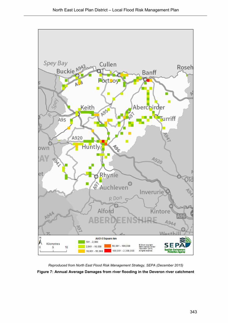
North East Local Plan District – Local Flood Risk Management Plan
343
Reproduced from North East Flood Risk Management Strategy, SEPA (December 2015)
Figure 7: Annual Average Damages from river flooding in the Deveron river catchment

North East Local Plan District – Local Flood Risk Management Plan
344
Managing Flood Risk
A range of public bodies have responsibility for managing flood risk in Scotland and they
are working closer than ever before to target action in the areas where the greatest benefit
can be gained. Members of the public also have a role to play and are the first line of
defence against flooding by taking action to protect themselves and their property from
flooding.
River Flood Warning Schemes
There are five flood warning areas for river flooding in the Deveron group river catchment,
which are listed in Table 5. These are the areas where SEPA has detailed models set up
to predict flooding on specific rivers. There are flood warning areas on the River Deveron
and Burn of Turriff at Turriff, the River Deveron and River Bogie at Huntly, the River Isla at
Keith, and the River Deveron at Banff (Figure 8).
Flood warning area Residential properties
within flood warning area
% of properties registered
(January 2014)
Banff 329 15%
Huntly (Bogie) 13 38%
Keith 34 32%
Milltown and The Meadows 68 100%
Turriff 11 27%
Reproduced from North East Flood Risk Management Strategy, SEPA (December 2015)
Table 5: Flood warning areas
North East Local Plan District – Local Flood Risk Management Plan
345
Reproduced from North East Flood Risk Management Strategy, SEPA (December 2015)
Figure 8: Flood warning areas in the Deveron river catchment
North East Local Plan District – Local Flood Risk Management Plan
346
Property Level Protection
Each local authority has its own incentives or subsidies to help property owners with
property level protection. In this area:
The Moray Council provides advice to members of the public regarding flood risk
and resilience. The Council also holds information events from time to time in
collaboration with Scottish Water, SEPA and the Scottish Flood Forum.
Aberdeenshire Council currently provide a small range of flood protection products
for individual property protection, which are available for all types of flooding, at
cost price with free delivery across Aberdeenshire.
Climate Change and Future Flood Risk
The UK Climate Projections (UKCP09) predicts that climate change may lead to warmer
and drier summers, warmer and wetter winters with less snow, and more extreme
temperature and rainfall. The predicted increase in rainfall and river flows may increase
the potential for river flooding.
Under the UKCP09 high emissions scenario for 2080, average peak river flows for the
Deveron catchment may increase by 24%1. This would potentially increase in the number
of residential properties at risk of river flooding from approximately 220 to 310 and the
number of non-residential properties from 140 to 170.
Potential for Natural Flood Management
The assessment of the potential for natural flood management is shown on SEPA’s flood
maps (http://www.sepa.org.uk/environment/water/flooding/flood-maps/). The maps
indicate the potential for runoff reduction, floodplain storage and sediment management.
They show areas where natural flood management could be effective and where further
detailed assessment should take place. This information was used to identify where local
authorities could include natural flood management as part of flood risk management
schemes and studies. The proposed schemes and studies are listed in the relevant
Potentially Vulnerable Area chapters of this document.
Runoff Reduction
The areas of potential for runoff reduction in the Deveron catchment group tend to be
small and scattered, with the only significant continuous area of potential in the south west
of the catchment. There is very little potential of runoff reduction either within or
immediately upstream of any of the Potentially Vulnerable Areas within the catchment,
with the exception of Portsoy (06/02). Therefore, it is unlikely that runoff reduction
1 From the study ‘An assessment of the vulnerability of Scotland’s river catchments and coasts to the impacts of climate change’ (CEH,
2011)
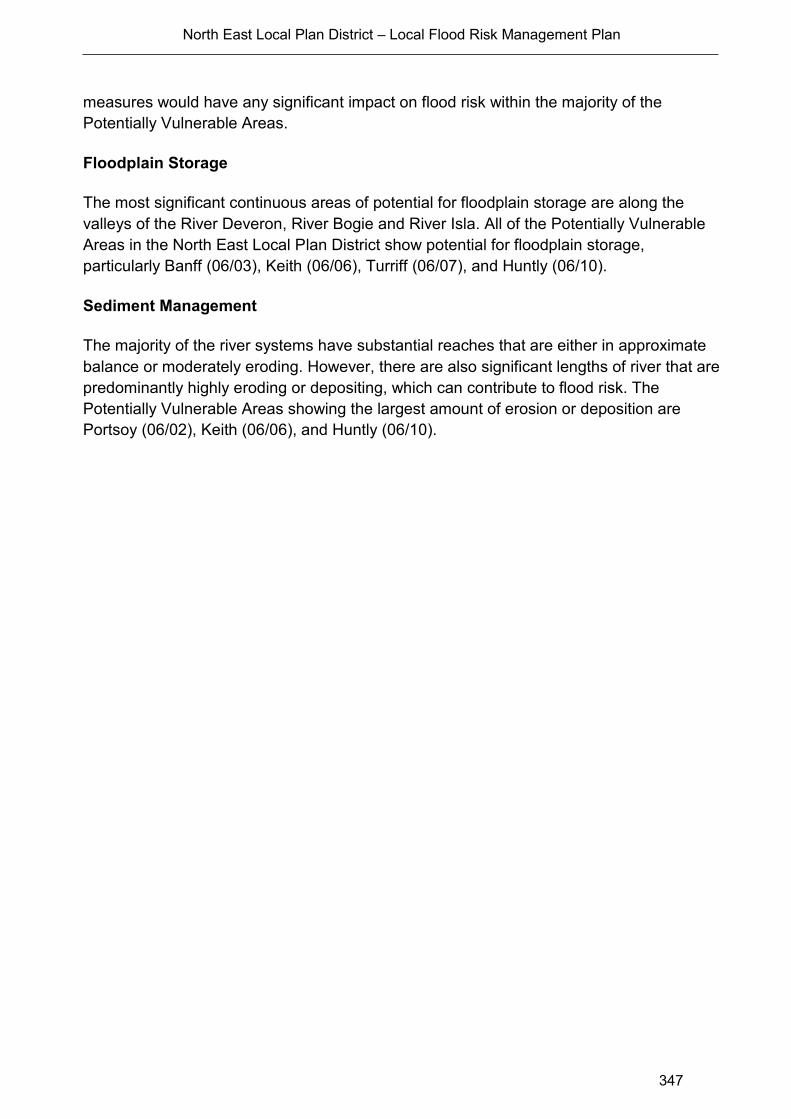
North East Local Plan District – Local Flood Risk Management Plan
347
measures would have any significant impact on flood risk within the majority of the
Potentially Vulnerable Areas.
Floodplain Storage
The most significant continuous areas of potential for floodplain storage are along the
valleys of the River Deveron, River Bogie and River Isla. All of the Potentially Vulnerable
Areas in the North East Local Plan District show potential for floodplain storage,
particularly Banff (06/03), Keith (06/06), Turriff (06/07), and Huntly (06/10).
Sediment Management
The majority of the river systems have substantial reaches that are either in approximate
balance or moderately eroding. However, there are also significant lengths of river that are
predominantly highly eroding or depositing, which can contribute to flood risk. The
Potentially Vulnerable Areas showing the largest amount of erosion or deposition are
Portsoy (06/02), Keith (06/06), and Huntly (06/10).

North East Local Plan District – Local Flood Risk Management Plan
348
A1.2 Dee Catchment Group
Catchment Overview
The Dee river catchment group covers the southern part of the North East Local Plan
District (Figure 9) and has an area of approximately 2,200km2. The largest river in the
catchment is the River Dee, which flows in a generally eastwards direction to the coast at
Aberdeen where it discharges to the sea. The catchment area also includes coastal rivers
to the south, including the River Carron and River Cowie in Stonehaven.
The predominant land cover in the upland areas in the west is montane habitat, which
covers 23% of the catchment. Coniferous woodland, heather and improved grassland
each cover around 15% of the area. Improved grassland, arable and horticulture dominate
the east of the catchment. The bulk of the catchment area has an annual rainfall of
between 400-900mm with the more mountainous areas in the west receiving between
900mm-1,200mm per annum.
The catchment includes seven Potentially Vulnerable Areas as follows:
Aberdeen – Westhill (06/17)
Aberdeen City – Deeside (06/18)
Peterculter (06/19)
Aboyne (06/20)
Banchory and Torphins (06/21)
Ballater (06/22)
Stonehaven (06/23).
Flood Risk in the Catchment
Note: The assessment of river flood risk in Aberdeen City and Peterculter is based on
more detailed modelling derived from the Aberdeen Integrated Catchment Study.
There are approximately 8,400 residential properties and 1,800 non-residential properties
at risk of river flooding in the River Dee catchment area. Approximately 97% of residential
and 91% of non-residential properties at risk of flooding are located within Potentially
Vulnerable Areas, with the majority in Aberdeen City Deeside (06/18).

Reproduced from North East Flood Risk Management Strategy, SEPA (December 2015)
Figure 9: Dee river catchment group and Potentially Vulnerable Areas

North East Local Plan District – Local Flood Risk Management Plan
350
Main Areas at Risk
The main areas that have greater than 20 residential properties at risk of river flooding are
shown in Table 6.
Area Residential and non-residential
properties at risk of river flooding
Annual Average
Damages
Aberdeen City - South 8,100 £10.5 million
Stonehaven 630 £620,000
Peterculter 200 £310,000
Ballater 190 £220,000
Aboyne and Tarland 90 £240,000
Banchory and Torphins 20 £60,000
Reproduced from North East Flood Risk Management Strategy, SEPA (December 2015)
Table 6: Main areas at risk of river flooding
Economic Activity and Infrastructure at Risk
The Annual Average Damages from river flooding in this catchment area are
approximately £13.5 million. This accounts for 46% of the Annual Average Damages for
the North East Local Plan District. The damages are distributed as follows:
57% residential properties (£7.7 million)
33% non-residential properties (£4.5 million)
5% emergency services (£670,000)
2% agriculture (£330,000)
2% vehicles (£210,000)
1% roads (£110,000)
Figure 10 shows the location of Annual Average Damages from river flooding. The areas
of highest damage are in Aberdeen City.
There are also significant damages shown in Stonehaven, Peterculter, Ballater, Aboyne
and Tarland.
Table 7 shows the approximate numbers of further infrastructure assets that are at risk of
flooding within this catchment.

North East Local Plan District – Local Flood Risk Management Plan
351
Number at
risk Further detail
Community facilities 10 Includes; healthcare facilities, educational
buildings and emergency services.
Utility assets 40
Includes; electricity sub-stations,
telecommunications and fuel extraction
sites.
Roads
(excluding minor roads) 550 locations Notably the A93
Railway routes 30 locations Inverness to Aberdeen
Aberdeen to Dundee
Agricultural land (km2) 71km2 n/a
Reproduced from North East Flood Risk Management Strategy, SEPA (December 2015)
Table 7: Infrastructure and agricultural land at risk of river flooding
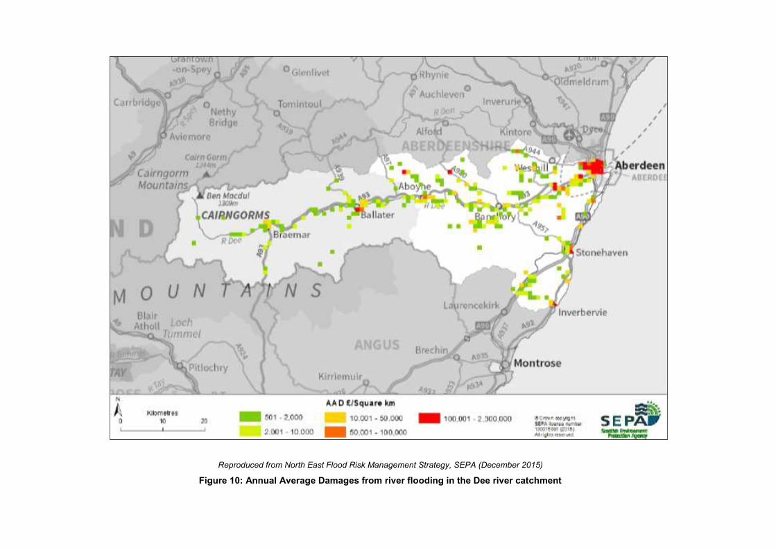
Reproduced from North East Flood Risk Management Strategy, SEPA (December 2015)
Figure 10: Annual Average Damages from river flooding in the Dee river catchment

North East Local Plan District – Local Flood Risk Management Plan
353
Designated Environmental and Cultural Heritage Sites at Risk
There are 63 cultural heritage sites at risk of river flooding, including A-listed buildings,
scheduled monuments, gardens and designed landscapes.
There are 63km2 of designated environmental sites at risk of flooding. These include Sites
of Special Scientific Interest, Special Protection Areas and Special Areas of Conservation,
including the River Dee Special Area of Conservation (SAC).
Managing Flood Risk
A range of public bodies have responsibility for managing flood risk in Scotland and they
are working closer than ever before to target action in the areas where the greatest benefit
can be gained. Members of the public also have a role to play and are the first line of
defence against flooding by taking action to protect themselves and their property from
flooding.
River Flood Warning Schemes
There are six flood warning areas for river flooding in the Dee (Aberdeenshire) river
catchment, listed in Table 8. These are the areas where SEPA has detailed models set up
to predict flooding on specific rivers. The locations of the flood warning areas are shown in
Figure 11.
Flood warning area Number of properties
within flood warning area
% of properties
registered (January 2014)
Aberdeen (Dee) 45 13%
Aboyne 92 22%
Ballater 218 35%
Banchory 49 29%
Maryculter 10 100%
Stonehaven 878 36%
Reproduced from North East Flood Risk Management Strategy, SEPA (December 2015)
Table 8: Flood warning areas

North East Local Plan District – Local Flood Risk Management Plan
354
Property Level Protection
Each local authority has its own incentives or subsidies to help property owners with
property level protection. In this area:
Aberdeenshire Council currently provide a small range of flood protection products
for individual property protection, which are available for all types of flooding, at
cost price with free delivery across Aberdeenshire.
Aberdeen City Council will be promoting self-help through work with the
community. This will include the creation of a Flood Guard Grant Scheme to assist
people with putting in Property Level Protection. This will be coordinated through
its Flood Team and seek advice from appropriate bodies such as the Scottish
Flood Forum when setting up the Grant scheme.
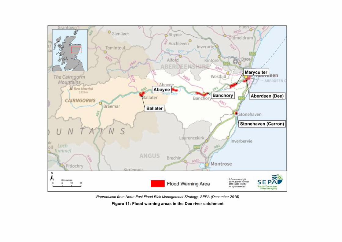
Reproduced from North East Flood Risk Management Strategy, SEPA (December 2015)
Figure 11: Flood warning areas in the Dee river catchment

North East Local Plan District – Local Flood Risk Management Plan
356
The UK Climate Projections (UKCP09) predicts that climate change may lead to warmer
and drier summers, warmer and wetter winters with less snow, and more extreme
temperature and rainfall. The predicted increase in rainfall and river flows may increase
the potential for river flooding.
Under the UKCP09 high emissions scenario for 2080, average peak river flows for the
Dee catchment by 2080 may increase by 24%2. This would potentially increase in the
number of residential properties at risk of river flooding from approximately 8,400 to
11,000 and the number of non-residential properties from 1,800 to 2,100.
Potential for Natural Flood Management
The assessment of the potential for natural flood management is shown on SEPA’s flood
maps (http://www.sepa.org.uk/environment/water/flooding/flood-maps/). The maps
indicate the potential for runoff reduction, floodplain storage and sediment management.
They show areas where natural flood management could be effective and where further
detailed assessment should take place. This information was used to identify where local
authorities could include natural flood management as part of flood risk management
schemes and studies. The proposed schemes and studies are listed in the relevant
Potentially Vulnerable Area chapters of this document.
Runoff Reduction
There are significant areas of potential for runoff reduction in the south and west of the
Dee catchment. However, these are a significant distance from the Potentially Vulnerable
Areas. None of the Potentially Vulnerable Areas themselves show any significant areas of
runoff reduction potential either within or immediately upstream of their boundaries.
Therefore, it is unlikely that runoff reduction measures would have any significant impact
on flood risk in the Dee catchment area. Runoff reduction may however be effective in the
case of localised flooding.
Floodplain Storage
There are significant areas of high potential for floodplain storage within the Dee
catchment area. All of the Potentially Vulnerable Areas show some areas of high potential
for floodplain storage.
2 From the study ‘An assessment of the vulnerability of Scotland’s river catchments and coasts to the impacts of climate change’ (CEH,
2011)

North East Local Plan District – Local Flood Risk Management Plan
357
Sediment Management
The majority of the river systems in the Dee catchment area have substantial reaches that
are either in approximate balance or moderately eroding. However, there are also
significant lengths of river that are predominantly highly eroding or depositing, which can
contribute to flood risk. The Potentially Vulnerable Areas showing the largest amount of
erosion or deposition are Aberdeen – Westhill (06/17), Aberdeen City - Deeside (06/18),
Aboyne (06/20), and Banchory and Torphins (06/21).

North East Local Plan District – Local Flood Risk Management Plan
358
A 1.3 Don Catchment Group
Catchment Overview
The River Don flows eastwards from the Cairngorm Mountains towards Aberdeen where it
flows into the North Sea. It has a catchment area of approximately 1,300km2 (Figure 12).
The predominant land covers are arable, horticulture, and improved grassland, which
together cover approximately half of the catchment, predominantly in the east. Coniferous
woodland is also significant in the east, with heather and montane habitats dominant in
the west. The catchment has an annual rainfall of between 400-900mm with the wettest
areas being in the west.
There are five Potentially Vulnerable Areas:
Insch (06/11)
Inverurie and Kintore (06/13)
Heugh-head (06/14)
Aberdeen City – Bridge of Don (06/15)
Aberdeen City – Denmore (06/16).
Flood Risk in the Catchment
Note: The assessment of river flood risk in Aberdeen City is based on more detailed
modelling derived from the Aberdeen Integrated Catchment Study.
There are approximately 2,600 residential properties and 530 non-residential properties at
risk of river flooding in the River Don catchment area. Approximately 96% of residential
properties and 82% of non-residential properties at risk of river flooding are located within
the Potentially Vulnerable Areas.
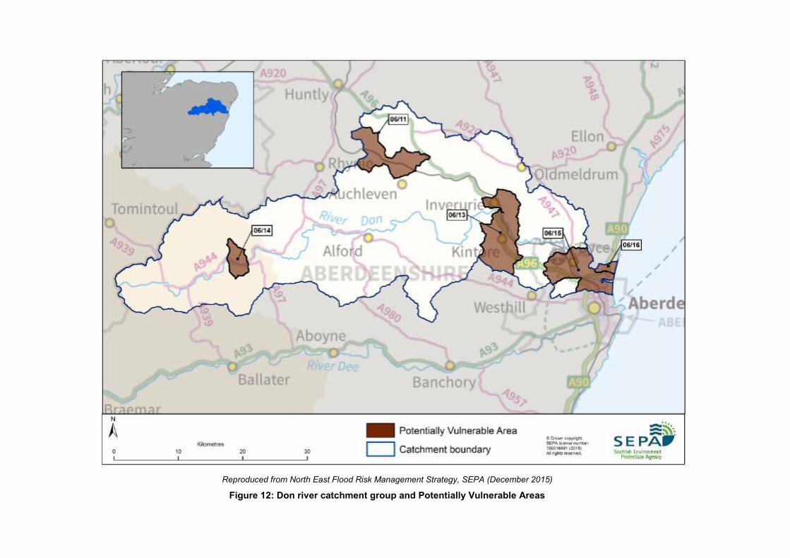
Reproduced from North East Flood Risk Management Strategy, SEPA (December 2015)
Figure 12: Don river catchment group and Potentially Vulnerable Areas
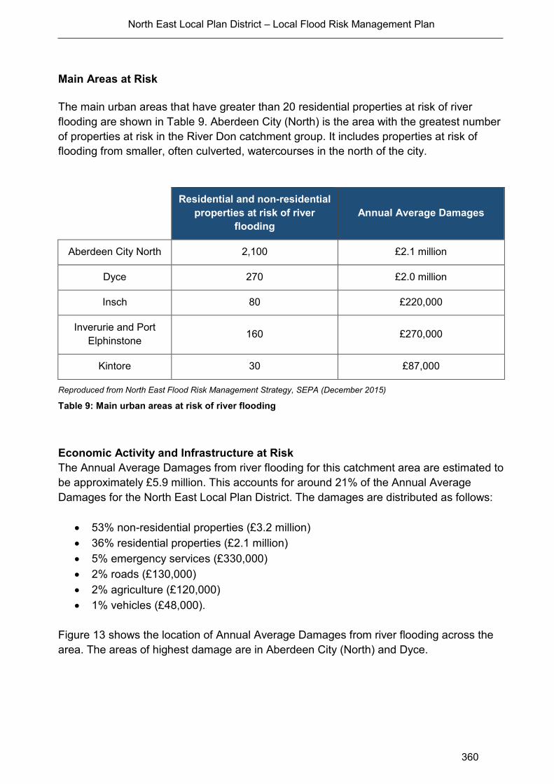
North East Local Plan District – Local Flood Risk Management Plan
360
Main Areas at Risk
The main urban areas that have greater than 20 residential properties at risk of river
flooding are shown in Table 9. Aberdeen City (North) is the area with the greatest number
of properties at risk in the River Don catchment group. It includes properties at risk of
flooding from smaller, often culverted, watercourses in the north of the city.
Residential and non-residential
properties at risk of river
flooding
Annual Average Damages
Aberdeen City North 2,100 £2.1 million
Dyce 270 £2.0 million
Insch 80 £220,000
Inverurie and Port
Elphinstone 160 £270,000
Kintore 30 £87,000
Reproduced from North East Flood Risk Management Strategy, SEPA (December 2015)
Table 9: Main urban areas at risk of river flooding
Economic Activity and Infrastructure at Risk
The Annual Average Damages from river flooding for this catchment area are estimated to
be approximately £5.9 million. This accounts for around 21% of the Annual Average
Damages for the North East Local Plan District. The damages are distributed as follows:
53% non-residential properties (£3.2 million)
36% residential properties (£2.1 million)
5% emergency services (£330,000)
2% roads (£130,000)
2% agriculture (£120,000)
1% vehicles (£48,000).
Figure 13 shows the location of Annual Average Damages from river flooding across the
area. The areas of highest damage are in Aberdeen City (North) and Dyce.
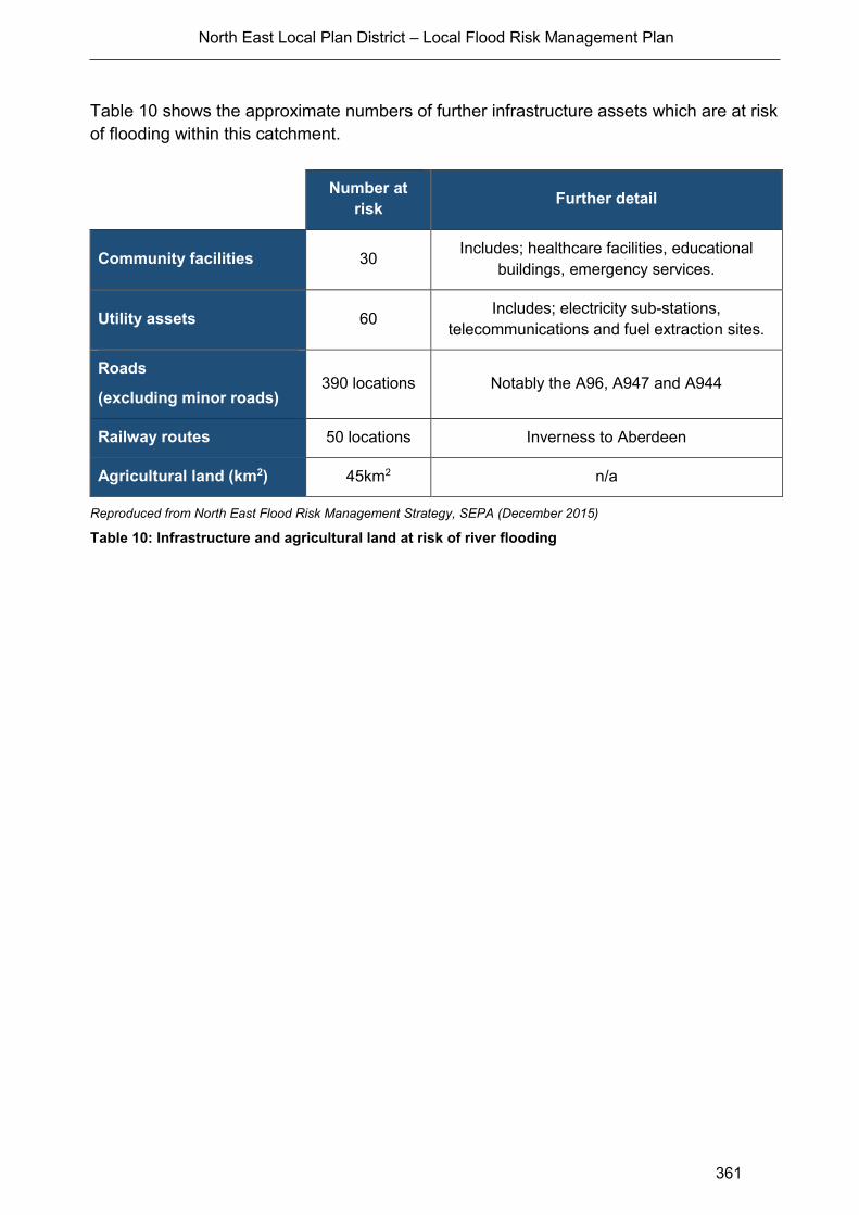
North East Local Plan District – Local Flood Risk Management Plan
361
Table 10 shows the approximate numbers of further infrastructure assets which are at risk
of flooding within this catchment.
Number at
risk Further detail
Community facilities 30 Includes; healthcare facilities, educational
buildings, emergency services.
Utility assets 60 Includes; electricity sub-stations,
telecommunications and fuel extraction sites.
Roads
(excluding minor roads) 390 locations Notably the A96, A947 and A944
Railway routes 50 locations Inverness to Aberdeen
Agricultural land (km2) 45km2 n/a
Reproduced from North East Flood Risk Management Strategy, SEPA (December 2015)
Table 10: Infrastructure and agricultural land at risk of river flooding
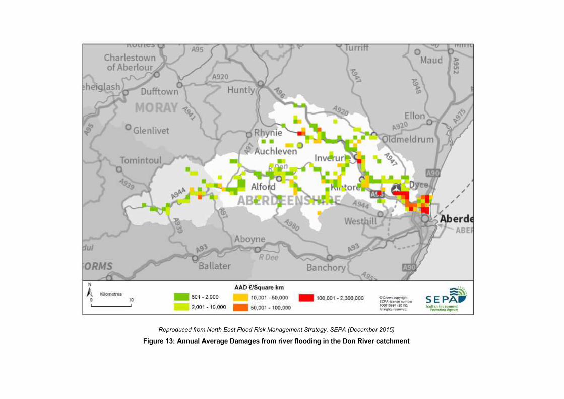
Reproduced from North East Flood Risk Management Strategy, SEPA (December 2015)
Figure 13: Annual Average Damages from river flooding in the Don River catchment
North East Local Plan District – Local Flood Risk Management Plan
363
Designated Environmental and Cultural Heritage Sites at Risk
There are approximately 40 cultural heritage sites at risk of river flooding in this
catchment, including A-listed buildings, scheduled monuments, gardens and designed
landscapes. Less than 1km2 of designated environmental area is at risk of river flooding.
Managing Flood Risk
A range of public bodies have responsibility for managing flood risk in Scotland and they
are working closer than ever before to target action in the areas where the greatest benefit
can be gained. Members of the public also have a role to play and are the first line of
defence against flooding by taking action to protect themselves and their property from
flooding.
River flood warning schemes
There are four flood warning areas for river flooding on the River Don catchment, which
are listed in Table 11. These are the areas where SEPA has detailed models set up to
predict flooding on specific rivers. The majority of the flood warning areas are associated
with the River Don. The locations of the flood warning areas are shown in Figure 14.
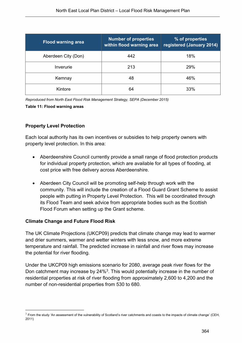
North East Local Plan District – Local Flood Risk Management Plan
364
Flood warning area Number of properties
within flood warning area
% of properties
registered (January 2014)
Aberdeen City (Don) 442 18%
Inverurie 213 29%
Kemnay 48 46%
Kintore 64 33%
Reproduced from North East Flood Risk Management Strategy, SEPA (December 2015)
Table 11: Flood warning areas
Property Level Protection
Each local authority has its own incentives or subsidies to help property owners with
property level protection. In this area:
Aberdeenshire Council currently provide a small range of flood protection products
for individual property protection, which are available for all types of flooding, at
cost price with free delivery across Aberdeenshire.
Aberdeen City Council will be promoting self-help through work with the
community. This will include the creation of a Flood Guard Grant Scheme to assist
people with putting in Property Level Protection. This will be coordinated through
its Flood Team and seek advice from appropriate bodies such as the Scottish
Flood Forum when setting up the Grant scheme.
Climate Change and Future Flood Risk
The UK Climate Projections (UKCP09) predicts that climate change may lead to warmer
and drier summers, warmer and wetter winters with less snow, and more extreme
temperature and rainfall. The predicted increase in rainfall and river flows may increase
the potential for river flooding.
Under the UKCP09 high emissions scenario for 2080, average peak river flows for the
Don catchment may increase by 24%3. This would potentially increase in the number of
residential properties at risk of river flooding from approximately 2,600 to 4,200 and the
number of non-residential properties from 530 to 680.
3 From the study ‘An assessment of the vulnerability of Scotland’s river catchments and coasts to the impacts of climate change’ (CEH,
2011)
Reproduced from North East Flood Risk Management Strategy, SEPA (December 2015)
Figure 14: Flood warning areas in the Don River catchment
North East Local Plan District – Local Flood Risk Management Plan
366
The assessment of the potential for natural flood management is shown on SEPA’s flood
maps (http://www.sepa.org.uk/environment/water/flooding/flood-maps/). The maps
indicate the potential for runoff reduction, floodplain storage and sediment management.
They show areas where natural flood management could be effective and where further
detailed assessment should take place. This information was used to identify where local
authorities could include natural flood management as part of flood risk management
schemes and studies. The proposed schemes and studies are listed in the relevant
Potentially Vulnerable Area chapters of this document.
Runoff Reduction
The main area with potential for runoff reduction in the River Don catchment group is
located in the west. Other areas of potential tend to be small and scattered. None of the
Potentially Vulnerable Areas show any significant areas of runoff reduction potential either
within or immediately upstream. Therefore, it is unlikely that runoff reduction measures
would have any significant impact on flood risk on the River Don although runoff reduction
may be effective on the smaller tributaries.
Floodplain Storage
There are significant areas of potential for floodplain storage within the River Don
catchment. All of the Potentially Vulnerable Areas show some areas of high potential for
floodplain storage. In particular, Inverurie and Kintore (06/13) and Aberdeen City Bridge of
Don (06/15) show significant potential and this is more evident when considered in
conjunction with Aberdeen City Denmore (06-16). It is likely that floodplain storage could
improve flood risk and should be considered further for these Potentially Vulnerable
Areas.
Sediment Management
The majority of the catchment is either in approximate balance or undergoing moderate
erosion. The reaches through Heugh-head (06/14) include areas of deposition and high
erosion. There are also long reaches of depositional areas through Inverurie and Kintore
(06/13). Therefore, measures to manage sediment in these Potentially Vulnerable Areas
could potentially reduce flood risk. Through Insch (06/11) and Aberdeen City Bridge of
Don (06/15) the rivers are either in approximate balance or undergoing moderate erosion
and consequently there is not as much opportunity to reduce flood risk through sediment
management measures in these Potentially Vulnerable Areas.

North East Local Plan District – Local Flood Risk Management Plan
367
A1.4 Ythan catchment Group
Catchment Overview
The Ythan river catchment group (Figure 15) covers the north eastern corner of the Local
Plan District, from north of Aberdeen to west of Rosehearty. It has an area of
approximately 1,400km2. The largest rivers are the River Ugie and the River Ythan, which
flow south-eastwards to the coast at Peterhead and Newburgh respectively. The River
Ugie drains the central area, whilst the River Ythan drains the southern area to the west of
Ellon. There are also numerous smaller watercourses that drain the area and flow straight
out to the coast.
The predominant land covers are arable and horticulture, and improved grassland, which
together cover 78% of the area. Annual rainfall is between 400-900mm with the wettest
areas being inland.
The catchment contains four Potentially Vulnerable Areas as follows:
Fraserburgh and Rosehearty (06/05)
Peterhead (06/08)
Methlick (06/09)
Ellon (06/12)
Flood Risk in the Community
There are an estimated 230 residential properties and 100 non-residential properties at
risk of river flooding. Approximately 36% of residential and non-residential properties at
risk are located within the Potentially Vulnerable Areas
Main areas at risk
The only urban area that has greater than 20 residential properties at risk of river flooding
is Ellon (Table 12).
Location Residential and non-residential
properties at risk of flooding Annual Average Damages
Ellon 80 £220,000
Reproduced from North East Flood Risk Management Strategy, SEPA (December 2015)
Table 12: Main areas at risk of river flooding
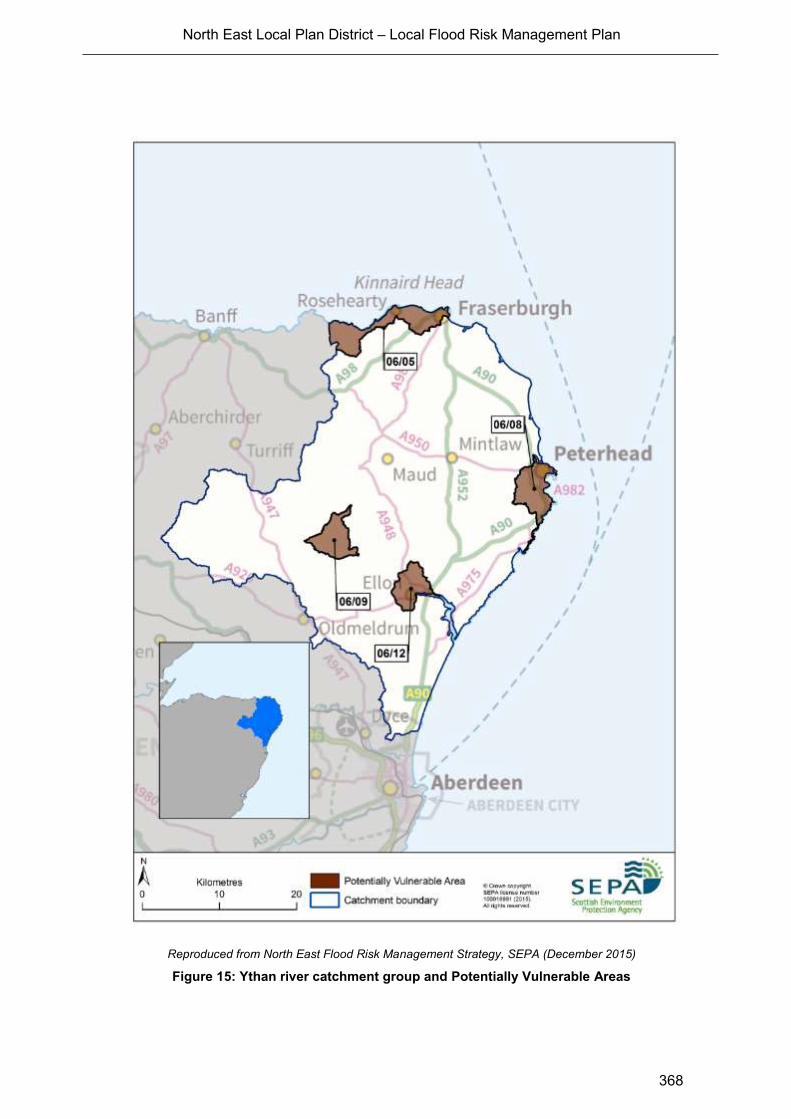
North East Local Plan District – Local Flood Risk Management Plan
368
Reproduced from North East Flood Risk Management Strategy, SEPA (December 2015)
Figure 15: Ythan river catchment group and Potentially Vulnerable Areas
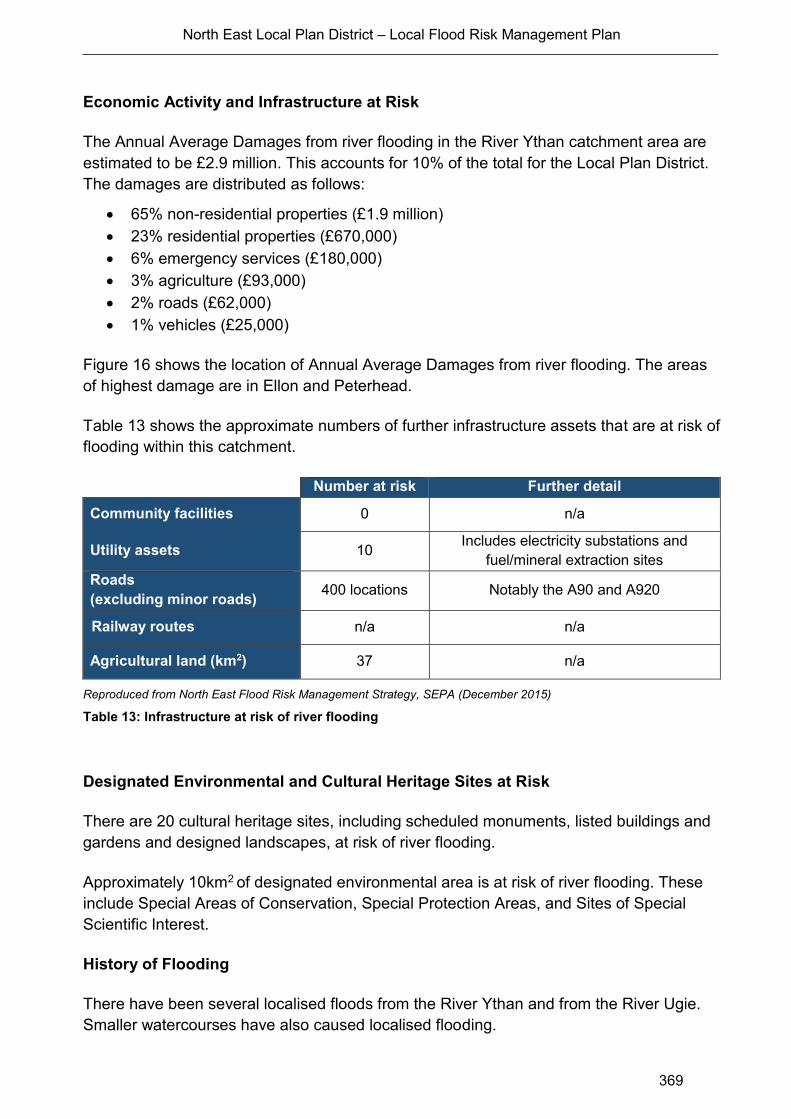
North East Local Plan District – Local Flood Risk Management Plan
369
Economic Activity and Infrastructure at Risk
The Annual Average Damages from river flooding in the River Ythan catchment area are
estimated to be £2.9 million. This accounts for 10% of the total for the Local Plan District.
The damages are distributed as follows:
65% non-residential properties (£1.9 million)
23% residential properties (£670,000)
6% emergency services (£180,000)
3% agriculture (£93,000)
2% roads (£62,000)
1% vehicles (£25,000)
Figure 16 shows the location of Annual Average Damages from river flooding. The areas
of highest damage are in Ellon and Peterhead.
Table 13 shows the approximate numbers of further infrastructure assets that are at risk of
flooding within this catchment.
Number at risk Further detail
Community facilities 0 n/a
Utility assets 10 Includes electricity substations and
fuel/mineral extraction sites
Roads
(excluding minor roads) 400 locations Notably the A90 and A920
Railway routes n/a n/a
Agricultural land (km2) 37 n/a
Reproduced from North East Flood Risk Management Strategy, SEPA (December 2015)
Table 13: Infrastructure at risk of river flooding
Designated Environmental and Cultural Heritage Sites at Risk
There are 20 cultural heritage sites, including scheduled monuments, listed buildings and
gardens and designed landscapes, at risk of river flooding.
Approximately 10km2 of designated environmental area is at risk of river flooding. These
include Special Areas of Conservation, Special Protection Areas, and Sites of Special
Scientific Interest.
History of Flooding
There have been several localised floods from the River Ythan and from the River Ugie.
Smaller watercourses have also caused localised flooding.
North East Local Plan District – Local Flood Risk Management Plan
370
Reproduced from North East Flood Risk Management Strategy, SEPA (December 2015)
Figure 16: Annual Average Damages from river flooding in the Ythan River catchment
North East Local Plan District – Local Flood Risk Management Plan
371
Managing Flood Risk
A range of public bodies have responsibility for managing flood risk in Scotland and they
are working closer than ever before to target action in the areas where the greatest benefit
can be gained. Members of the public also have a role to play and are the first line of
defence against flooding by taking action to protect themselves and their property from
flooding.
Property Level Protection
Each local authority has its own incentives or subsidies to help property owners with
property level protection. In this area Aberdeenshire Council currently provide a small
range of flood protection products for individual property protection, which are available for
all types of flooding, at cost price with free delivery across Aberdeenshire.
Climate Change and Future Flood Risk
The UK Climate Projections (UKCP09) predicts that climate change may lead to warmer
and drier summers, warmer and wetter winters with less snow, and more extreme
temperature and rainfall. The predicted increase in rainfall and river flows may increase
the potential for river flooding.
Under the UKCP09 high emissions scenario for 2080, average peak river flows for the
Ythan catchment may increase by 24%4. This would potentially increase in the number of
residential properties at risk of river flooding from approximately 230 to 280, while the
number of non-residential properties at risk does not change.
Potential for Natural Flood Management
The assessment of the potential for natural flood management is shown on SEPA’s flood
maps (http://www.sepa.org.uk/environment/water/flooding/flood-maps/). The maps
indicate the potential for runoff reduction, floodplain storage and sediment management.
They show areas where natural flood management could be effective and where further
detailed assessment should take place. This information was used to identify where local
authorities could include natural flood management as part of flood risk management
schemes and studies. The proposed schemes and studies are listed in the relevant
Potentially Vulnerable Area chapters of this document.
4 From the study ‘An assessment of the vulnerability of Scotland’s river catchments and coasts to the impacts of climate change’ (CEH,
2011)

North East Local Plan District – Local Flood Risk Management Plan
372
Runoff Reduction
There is limited potential for runoff reduction in the Ythan catchment group and what does
exist tends to be small scattered areas. None of the Potentially Vulnerable Areas show
any significant potential of runoff reduction either within or immediately upstream. Runoff
reduction measures would not have any significant impact on flood risk in the Ythan
catchment group, however may provide local benefits.
Floodplain Storage
There are significant areas of high potential for floodplain storage within the Ythan
catchment group. The most significant continuous areas of high potential are along the
valleys of the major rivers, including the River Ugie and its tributaries, and the River
Ythan. The Potentially Vulnerable Areas covering Peterhead (06/08), Methlick (06/09),
and Ellon (06/12) all show potential for floodplain storage. It is likely that floodplain storage
could reduce flood risk and may be considered further for these areas. The Potentially
Vulnerable Area covering Fraserburgh (06/05) shows less potential though and floodplain
storage may not provide as great an impact on flood risk here.
Sediment Management
The River Ugie system is predominantly in balance, therefore measures to manage
sediment is unlikely to reduce flood risk in the Peterhead (06/08). The River Ythan system
is more varied and has significant lengths of predominantly eroding or depositing reaches,
in particular through Methlick (06/09). The reaches through Ellon (06/12) include areas of
moderate erosion and deposition. Therefore, measures to manage sediment in these
Potentially Vulnerable Areas could potentially reduce flood risk.

North East Local Plan District – Local Flood Risk Management Plan
373
Annex 2: Coastal Flooding
This chapter provides supplementary information on coastal flooding at a coastal area
level. It provides an overview of the natural characteristics of the coast, a summary of
flood risk within the coastal area and a brief history of flooding. It further explains the
potential climate change effects on future flood risk and summarises the potential for
natural flood management.
Information about the objectives and actions to manage flood risk are provided in the
relevant Potentially Vulnerable Area chapters in Section 2.3.
In the North East Local Plan District, coastal flooding is reported in three coastal areas.
Reproduced from North East Flood Risk Management Strategy, SEPA (December 2015)
Figure 17: Coastal areas within the North East Local Plan District

North East Local Plan District – Local Flood Risk Management Plan
374
A2.1 Cairnbulg Point to Portgordon
Coastal Overview
The Cairnbulg Point to Portgordon coastal area covers approximately 88km of mainly
north facing coastline along the outer Moray Firth (Figure 17). There are several towns
and villages close to the coastline including Fraserburgh, Rosehearty, Macduff, Banff,
Portsoy, Portknockie, Findochty, and Buckie. The coastal area contains two local
authorities; The Moray Council and Aberdeenshire Council.
The coastal area is characterised by a sequence of small bays between rocky headlands
and cliffs. There are a few relatively short sections of sand and shingle beaches along the
coastline for example to the east of Fraserburgh. The nearshore bathymetry is variable
and the coastline indented, therefore the wave conditions at the coastline are highly
variable.
The River Deveron, which outfalls at Banff Bay, is the only major river which discharges to
the sea along this section of coast. However there are several smaller rivers and burns
which outfall to the Moray Firth.
There are five Potentially Vulnerable Areas:
Portgordon (06/01)
Portsoy (06/02)
Banff (06/03)
Macduff (06/04)
Fraserburgh and Rosehearty (06/05)
Flood Risk in the Coastal Area - Main Areas at Risk
Within the Cairnbulg Point to Portgordon coastal area there are approximately 30 non-
residential properties at risk of coastal flooding. An estimated 56% of these are located
within Potentially Vulnerable Areas, with the majority located in Fraserburgh and
Rosehearty (06/05). Although there are no residential properties identified to be at risk of
flooding, historically properties have been subject to flooding due to wave overtopping.
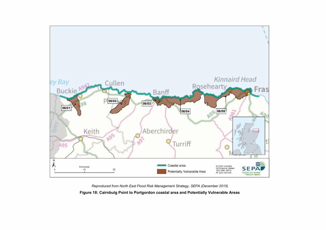
Reproduced from North East Flood Risk Management Strategy, SEPA (December 2015)
Figure 18: Cairnbulg Point to Portgordon coastal area and Potentially Vulnerable Areas

North East Local Plan District – Local Flood Risk Management Plan
376
Economic Activity and Infrastructure at Risk
The Annual Average Damages from coastal flooding in the Cairnbulg to Portgordon
coastal area are estimated to be approximately £66,000. The Annual Average Damages
are distributed as follows:
74% non-residential properties (£49,000)
10% residential properties (£6,400)
7% emergency services (£4,800)
7% roads (£4,700)
1% vehicles (£690)
1% agriculture (£560)
Flooding from wave overtopping is not fully represented in the general assessment of
flood risk. The number of properties at risk of flooding and the Annual Average Damages
from coastal flooding may be underestimated. Figure 19 shows the location of Annual
Average Damages from coastal flooding across the area.
Table 14 shows further information about infrastructure and agricultural land at risk of
coastal flooding.
Number at risk Further detail
Community facilities 0 n/a
Utility assets 0 n/a
Roads (excluding minor
roads) 10 sections Including A98 and the B9033
Railway routes 0 n/a
Agricultural land (km2) 0.4 n/a
Reproduced from North East Flood Risk Management Strategy, SEPA (December 2015)
Table 14: Infrastructure and agricultural land at risk of coastal flooding
Designated Environmental and Cultural Heritage Sites at Risk
There are 14 cultural heritage sites at risk of coastal flooding in this area including garden
and designed landscapes, scheduled monuments and listed buildings.
Approximately 2km2 of environmental designated area is at risk of coastal flooding
including Special Protection Areas and Sites of Special Scientific Interest. The sites
affected include Troup Head, Pennan Head, and Lion’s Head, Gamrie, together with
Pennan Coast, Whitehills to Melrose Coast, Rosehearty to Fraserburgh Coast, Spey Bay
and Cullen to Stake Ness Coast.

Reproduced from North East Flood Risk Management Strategy, SEPA (December 2015)
Figure 19: Annual Average Damages from coastal flooding in the Cairnbulg Point to Portgordon coastal area
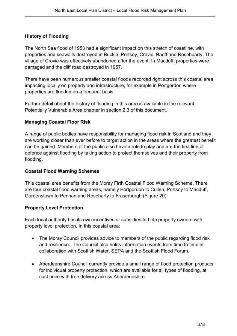
North East Local Plan District – Local Flood Risk Management Plan
378
History of Flooding
The North Sea flood of 1953 had a significant impact on this stretch of coastline, with
properties and seawalls destroyed in Buckie, Portsoy, Crovie, Banff and Rosehearty. The
village of Crovie was effectively abandoned after the event. In Macduff, properties were
damaged and the cliff road destroyed in 1957.
There have been numerous smaller coastal floods recorded right across this coastal area
impacting locally on property and infrastructure, for example in Portgordon where
properties are flooded on a frequent basis.
Further detail about the history of flooding in this area is available in the relevant
Potentially Vulnerable Area chapter in section 2.3 of this document.
Managing Coastal Floor Risk
A range of public bodies have responsibility for managing flood risk in Scotland and they
are working closer than ever before to target action in the areas where the greatest benefit
can be gained. Members of the public also have a role to play and are the first line of
defence against flooding by taking action to protect themselves and their property from
flooding.
Coastal Flood Warning Schemes
This coastal area benefits from the Moray Firth Coastal Flood Warning Scheme. There
are four coastal flood warning areas, namely Portgordon to Cullen, Portsoy to Macduff,
Gardenstown to Pennan and Roseharty to Fraserburgh (Figure 20).
Property Level Protection
Each local authority has its own incentives or subsidies to help property owners with
property level protection. In this coastal area:
The Moray Council provides advice to members of the public regarding flood risk
and resilience. The Council also holds information events from time to time in
collaboration with Scottish Water, SEPA and the Scottish Flood Forum.
Aberdeenshire Council currently provide a small range of flood protection products
for individual property protection, which are available for all types of flooding, at
cost price with free delivery across Aberdeenshire.
Reproduced from North East Flood Risk Management Strategy, SEPA (December 2015)
Figure 20: Flood warning areas in the Cairnbulg Point to Portgordon coastal area
North East Local Plan District – Local Flood Risk Management Plan
380
Climate Change and Future Flood Risk
UK Climate Projections (UKCP09) predicts that climate change may increase sea levels.
The magnitude of sea level rise varies around the coastline.
For the UKCP09 high emissions scenario, the predicted average sea level increase for the
Cairnbulg Point to Portgordon coastline is 0.5m by 2080. This may increase the number of
residential properties at risk of coastal flooding to approximately 390 and the number of
non-residential from 30 to approximately 280. Coastal flood modelling by SEPA has not
taken into account the impacts of a future climate on wave overtopping or storminess,
which could increase the number of people affected by coastal flooding.
Potential for Natural Flood Management
The assessment of the potential for natural flood management is shown on SEPA’s flood
maps (http://www.sepa.org.uk/environment/water/flooding/flood-maps/). The maps
indicate the potential for wave attenuation and estuarine surge attenuation. They show
areas where natural flood management could be effective and where further detailed
assessment should take place.
This information was used to identify where local authorities could include natural flood
management as part of flood risk management schemes and studies. The proposed
schemes and studies are listed in the relevant Potentially Vulnerable Area chapters of this
document.
Estuarine Surge
There is limited opportunity for estuarine surge attenuation in the Cairnbulg Point to
Portgordon Coastal Area. The only area which has any potential is in Banff Bay where
potential attenuation occurs between Macduff and Banff around the perimeter of Banff
Bay extending up the River Deveron to Banff Bridge.
Wave Energy
There are several areas along this section of coastline which have potential for wave
energy dissipation. There are significant areas of potential for dissipation around the
urban areas of Fraserburgh, Banff and Buckie with several of the bays also showing
potential including Cullen Bay, Sandend Bay, Gamrie Bay and Fraserburgh Bay.
North East Local Plan District – Local Flood Risk Management Plan
381
A2.2 Girdle Ness to Cairnbulg Point
The Girdle Ness to Cairnbulg Point coastal area covers approximately 80km of coastline
from Girdle Ness, Aberdeen in the south to the eastern end of the Moray Firth in the north
(Figure 21). There are several towns and villages located close to the coastline including
Aberdeen, Balmedie, Cruden Bay, Boddam, Peterhead and Inverallochy. The coastal area
contains two local authorities; Aberdeen City Council and Aberdeenshire Council.
The coastal area is characterised by wide sandy bays such as at Balmedie and Cruden
Bay and rocky cliffs with small bays enclosed by headlands. The nearshore bathymetry is
variable and the coastline indented, therefore the wave conditions at the coastline are
highly variable.
There are several large rivers which outfall along this stretch of coastline including the
River Dee and River Don in Aberdeen, the River Ythan at Newburgh and the River Ugie at
Peterhead.
There are five Potentially Vulnerable Areas:
Peterhead (06/08)
Ellon (06/12)
Aberdeen City – Bridge of Don (06/15)
Aberdeen City – Denmore (06/16)
Aberdeen City – Deeside (06/18).
Flood Risk in the Coastal Area - Main Areas at Risk
Within the Girdle Ness to Cairnbulg Point coastal area there are fewer than ten residential
properties and approximately 20 non-residential properties at risk of coastal flooding.
None of the residential properties and an estimated 83% of the non-residential properties
are located within Potentially Vulnerable Areas.
The majority of non-residential properties at risk are in Peterhead and Aberdeen City. The
residential properties at risk are all located in the Newburgh area where the River Ythan
flows into the sea. Although no residential properties were identified as being at risk of
coastal flooding in any of the Potentially Vulnerable Areas it is evident from historical
events that a number of residential properties in Potentially Vulnerable Areas are affected
by overtopping waves including in Peterhead and at Footdee in Aberdeen.
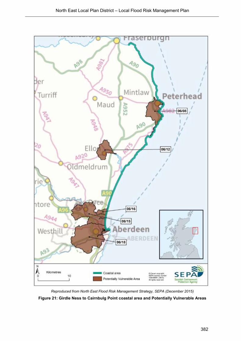
North East Local Plan District – Local Flood Risk Management Plan
382
Reproduced from North East Flood Risk Management Strategy, SEPA (December 2015)
Figure 21: Girdle Ness to Cairnbulg Point coastal area and Potentially Vulnerable Areas
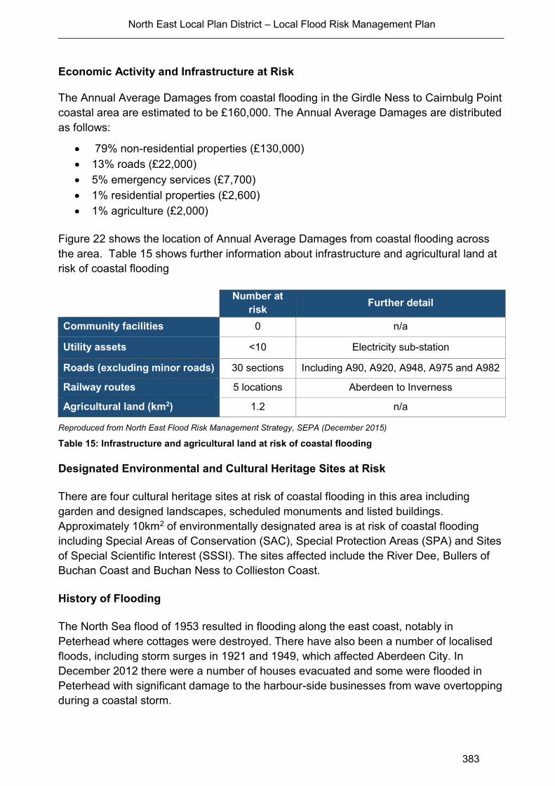
North East Local Plan District – Local Flood Risk Management Plan
383
Economic Activity and Infrastructure at Risk
The Annual Average Damages from coastal flooding in the Girdle Ness to Cairnbulg Point
coastal area are estimated to be £160,000. The Annual Average Damages are distributed
as follows:
79% non-residential properties (£130,000)
13% roads (£22,000)
5% emergency services (£7,700)
1% residential properties (£2,600)
1% agriculture (£2,000)
Figure 22 shows the location of Annual Average Damages from coastal flooding across
the area. Table 15 shows further information about infrastructure and agricultural land at
risk of coastal flooding
Number at
risk Further detail
Community facilities 0 n/a
Utility assets <10 Electricity sub-station
Roads (excluding minor roads) 30 sections Including A90, A920, A948, A975 and A982
Railway routes 5 locations Aberdeen to Inverness
Agricultural land (km2) 1.2 n/a
Reproduced from North East Flood Risk Management Strategy, SEPA (December 2015)
Table 15: Infrastructure and agricultural land at risk of coastal flooding
Designated Environmental and Cultural Heritage Sites at Risk
There are four cultural heritage sites at risk of coastal flooding in this area including
garden and designed landscapes, scheduled monuments and listed buildings.
Approximately 10km2 of environmentally designated area is at risk of coastal flooding
including Special Areas of Conservation (SAC), Special Protection Areas (SPA) and Sites
of Special Scientific Interest (SSSI). The sites affected include the River Dee, Bullers of
Buchan Coast and Buchan Ness to Collieston Coast.
History of Flooding
The North Sea flood of 1953 resulted in flooding along the east coast, notably in
Peterhead where cottages were destroyed. There have also been a number of localised
floods, including storm surges in 1921 and 1949, which affected Aberdeen City. In
December 2012 there were a number of houses evacuated and some were flooded in
Peterhead with significant damage to the harbour-side businesses from wave overtopping
during a coastal storm.
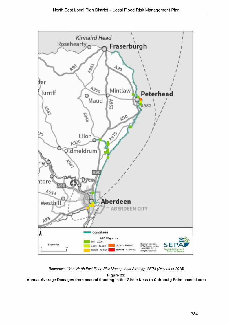
North East Local Plan District – Local Flood Risk Management Plan
384
Reproduced from North East Flood Risk Management Strategy, SEPA (December 2015)
Figure 22: Annual Average Damages from coastal flooding in the Girdle Ness to Cairnbulg Point coastal area
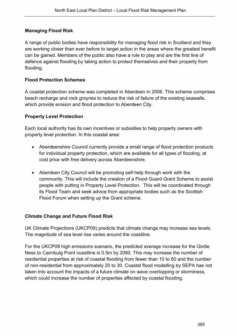
North East Local Plan District – Local Flood Risk Management Plan
385
Managing Flood Risk
A range of public bodies have responsibility for managing flood risk in Scotland and they
are working closer than ever before to target action in the areas where the greatest benefit
can be gained. Members of the public also have a role to play and are the first line of
defence against flooding by taking action to protect themselves and their property from
flooding.
Flood Protection Schemes
A coastal protection scheme was completed in Aberdeen in 2006. This scheme comprises
beach recharge and rock groynes to reduce the risk of failure of the existing seawalls,
which provide erosion and flood protection to Aberdeen City.
Property Level Protection
Each local authority has its own incentives or subsidies to help property owners with
property level protection. In this coastal area:
Aberdeenshire Council currently provide a small range of flood protection products
for individual property protection, which are available for all types of flooding, at
cost price with free delivery across Aberdeenshire.
Aberdeen City Council will be promoting self-help through work with the
community. This will include the creation of a Flood Guard Grant Scheme to assist
people with putting in Property Level Protection. This will be coordinated through
its Flood Team and seek advice from appropriate bodies such as the Scottish
Flood Forum when setting up the Grant scheme.
Climate Change and Future Flood Risk
UK Climate Projections (UKCP09) predicts that climate change may increase sea levels.
The magnitude of sea level rise varies around the coastline.
For the UKCP09 high emissions scenario, the predicted average increase for the Girdle
Ness to Cairnbulg Point coastline is 0.5m by 2080. This may increase the number of
residential properties at risk of coastal flooding from fewer than 10 to 60 and the number
of non-residential from approximately 20 to 30. Coastal flood modelling by SEPA has not
taken into account the impacts of a future climate on wave overtopping or storminess,
which could increase the number of properties affected by coastal flooding.
North East Local Plan District – Local Flood Risk Management Plan
386
Potential for Natural Flood Management
The assessment of the potential for natural flood management is shown on SEPA’s flood
maps (http://www.sepa.org.uk/environment/water/flooding/flood-maps/). The maps
indicate the potential for wave attenuation and estuarine surge attenuation. They show
areas where natural flood management could be effective and where further detailed
assessment should take place.
This information was used to identify where local authorities could include natural flood
management as part of flood risk management schemes and studies. The proposed
schemes and studies are listed in the relevant Potentially Vulnerable Area chapters of this
document.
Estuarine Surge
The assessment shows there is limited opportunity for estuarine surge attenuation in the
Girdle Ness to Cairnbulg Point coastal area. The areas of potential are relatively small and
not continuous.
Along the River Don in Aberdeen there is a limited amount of potential for estuarine surge
attenuation located between the A956 and Seaton Park. There are also some small areas
of potential on the River Ythan, mainly in the vicinity of Newburgh downstream of the
A975 road crossing and small isolated sections of potential for estuarine surge attenuation
close to Loch of Strathbeg and South Inch (south of St Combs).
Wave Energy
There is potential for wave energy dissipation along most of the coastline between Girdle
Ness and Cairnbulg Point. There are areas of potential along the Aberdeen City frontage
(where wave energy dissipation work in the form of beach replenishment has been carried
out previously), in the centre of Newburgh Bay, in the Bay of Cruden, along the Peterhead
frontage and between Rattray Head and Inverallochy.
North East Local Plan District – Local Flood Risk Management Plan
387
A2.3 Inverbervie to Girdle Ness
Coastal Overview
The Inverbervie to Girdle Ness coastal area covers approximately 55km of coastline from
Inverbervie in the south, to Girdle Ness, Aberdeen in the north (Figure 23). There are
several towns and villages located close to the coastline including the southern areas of
Aberdeen and the towns of Portlethen, Newtonhill, Stonehaven and Inverbervie. The
coastal area contains two local authorities; Aberdeen City Council and Aberdeenshire
Council.
The coastal area is characterised by cliffs with numerous headlands enclosing small bays.
There are few beaches along this section of coast and these tend to be pocket or bay
head type beaches bounded by headlands or rock abrasion platforms. The nearshore
bathymetry is variable and the coastline indented, therefore the wave conditions at the
coastline are highly variable.
The Bervie Water in Inverbervie and the Carron and Cowie rivers in Stonehaven are the
main rivers which outfall to the sea along this stretch of coastline. There is one Potentially
Vulnerable Area in this coastal area; Stonehaven (06/23).
Flood Risk in the Coastal Area - Main Areas at Risk
Within the Inverbervie to Girdle Ness coastal area, there are approximately 50 residential
properties and 20 non-residential properties at risk of coastal flooding. All of the residential
properties and an estimated 91% of the non-residential properties at risk of coastal
flooding are located within the Stonehaven Potentially Vulnerable Area.
Economic Activity and Infrastructure at Risk
The Annual Average Damages from coastal flooding in the Inverbervie to Girdle Ness
coastal area are approximately £40,000. The Annual Average Damages are distributed as
follows:
70% residential properties (£28,000)
16% non-residential properties (£6,300)
8% roads (£3,200)
4% emergency services (£1,600)
1% vehicles (£400)
<1% agriculture (£120)
Flooding from wave overtopping is not fully represented in the general assessment of
flood risk and the Annual Average Damages from coastal flooding are known to be
significantly underestimated. The number of properties at risk of flooding may also be
underestimated. In addition, some properties have suffered from structural damage due to
wave overtopping even if the properties themselves have not been flooded internally.
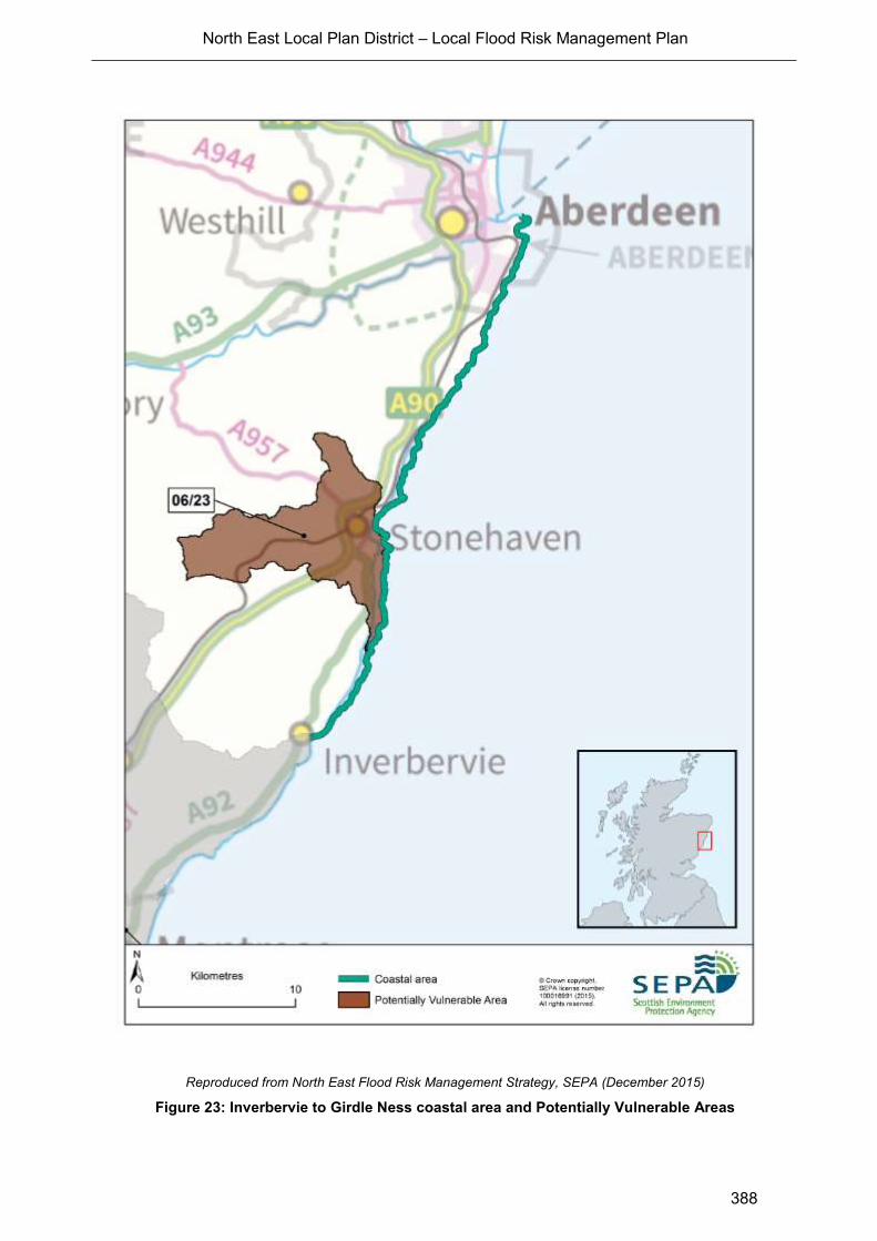
North East Local Plan District – Local Flood Risk Management Plan
388
Reproduced from North East Flood Risk Management Strategy, SEPA (December 2015)
Figure 23: Inverbervie to Girdle Ness coastal area and Potentially Vulnerable Areas
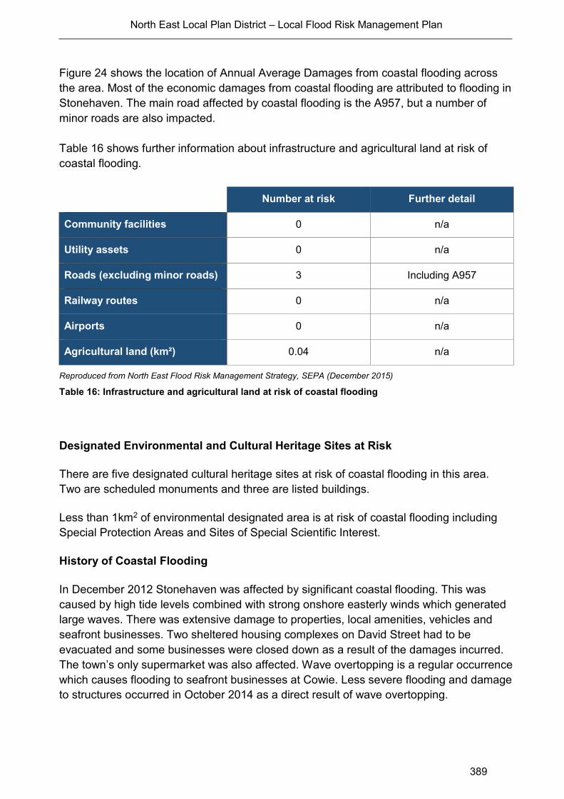
North East Local Plan District – Local Flood Risk Management Plan
389
Figure 24 shows the location of Annual Average Damages from coastal flooding across
the area. Most of the economic damages from coastal flooding are attributed to flooding in
Stonehaven. The main road affected by coastal flooding is the A957, but a number of
minor roads are also impacted.
Table 16 shows further information about infrastructure and agricultural land at risk of
coastal flooding.
Number at risk Further detail
Community facilities 0 n/a
Utility assets 0 n/a
Roads (excluding minor roads) 3 Including A957
Railway routes 0 n/a
Airports 0 n/a
Agricultural land (km²) 0.04 n/a
Reproduced from North East Flood Risk Management Strategy, SEPA (December 2015)
Table 16: Infrastructure and agricultural land at risk of coastal flooding
Designated Environmental and Cultural Heritage Sites at Risk
There are five designated cultural heritage sites at risk of coastal flooding in this area.
Two are scheduled monuments and three are listed buildings.
Less than 1km2 of environmental designated area is at risk of coastal flooding including
Special Protection Areas and Sites of Special Scientific Interest.
History of Coastal Flooding
In December 2012 Stonehaven was affected by significant coastal flooding. This was
caused by high tide levels combined with strong onshore easterly winds which generated
large waves. There was extensive damage to properties, local amenities, vehicles and
seafront businesses. Two sheltered housing complexes on David Street had to be
evacuated and some businesses were closed down as a result of the damages incurred.
The town’s only supermarket was also affected. Wave overtopping is a regular occurrence
which causes flooding to seafront businesses at Cowie. Less severe flooding and damage
to structures occurred in October 2014 as a direct result of wave overtopping.

North East Local Plan District – Local Flood Risk Management Plan
390
Reproduced from North East Flood Risk Management Strategy, SEPA (December 2015)
Figure 24:
Annual Average Damages from coastal flooding in the Inverbervie to Girdle Ness coastal area
North East Local Plan District – Local Flood Risk Management Plan
391
Managing Flood Risk
A range of public bodies have responsibility for managing flood risk in Scotland and they
are working closer than ever before to target action in the areas where the greatest benefit
can be gained. Members of the public also have a role to play and are the first line of
defence against flooding by taking action to protect themselves and their property from
flooding.
Property Level Protection
Each local authority has its own incentives or subsidies to help property owners with
property level protection. In this coastal area:
Aberdeenshire Council currently provide a small range of flood protection products
for individual property protection, which are available for all types of flooding, at
cost price with free delivery across Aberdeenshire.
Aberdeen City Council will be promoting self-help through work with the
community. This will include the creation of a Flood Guard Grant Scheme to assist
people with putting in Property Level Protection. This will be coordinated through
its Flood Team and seek advice from appropriate bodies such as the Scottish
Flood Forum when setting up the Grant scheme.
Climate Change and Future Flood Risk
UK Climate Projections (UKCP09) predicts that climate change may increase sea levels.
The magnitude of sea level rise varies around the coastline.
For the UKCP09 high emissions scenario, the predicted average sea level increase for the
Inverbervie to Girdle Ness coastline is 0.5m by 2080. This may increase the number of
residential properties at risk of coastal flooding from approximately 50 to 130 and for non-
residential properties from 20 to 60. Coastal flood modelling by SEPA has not taken into
account the impacts of a future climate on wave overtopping or storminess, which could
increase the number of properties affected by coastal flooding.
Potential for Natural Flood Management
The assessment of the potential for natural flood management is shown on SEPA’s flood
maps (http://www.sepa.org.uk/environment/water/flooding/flood-maps/). The maps
indicate the potential for wave attenuation and estuarine surge attenuation. They show
areas where natural flood management could be effective and where further detailed
assessment should take place.
This information was used to identify where local authorities could include natural flood
management as part of flood risk management schemes and studies. The proposed
North East Local Plan District – Local Flood Risk Management Plan
392
schemes and studies are listed in the relevant Potentially Vulnerable Area chapters of this
document.
Estuarine Surge
The assessment shows that there are no opportunities for estuarine surge attenuation in
the Inverbervie to Girdle Ness coastal area.
Wave Energy
There are several areas in this coastal area which have potential for wave energy
dissipation. The main area of potential is around Stonehaven. There are also smaller
areas of potential at Nigg Bay near Aberdeen, Braidon Bay and Bervie Bay, Crawton,
Doonie Point, and Cove Bay.
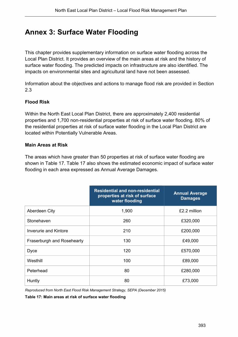
North East Local Plan District – Local Flood Risk Management Plan
393
Annex 3: Surface Water Flooding
This chapter provides supplementary information on surface water flooding across the
Local Plan District. It provides an overview of the main areas at risk and the history of
surface water flooding. The predicted impacts on infrastructure are also identified. The
impacts on environmental sites and agricultural land have not been assessed.
Information about the objectives and actions to manage flood risk are provided in Section
2.3
Flood Risk
Within the North East Local Plan District, there are approximately 2,400 residential
properties and 1,700 non-residential properties at risk of surface water flooding. 80% of
the residential properties at risk of surface water flooding in the Local Plan District are
located within Potentially Vulnerable Areas.
Main Areas at Risk
The areas which have greater than 50 properties at risk of surface water flooding are
shown in Table 17. Table 17 also shows the estimated economic impact of surface water
flooding in each area expressed as Annual Average Damages.
Reproduced from North East Flood Risk Management Strategy, SEPA (December 2015)
Table 17: Main areas at risk of surface water flooding
Residential and non-residential
properties at risk of surface water flooding
Annual Average Damages
Aberdeen City 1,900 £2.2 million
Stonehaven 260 £320,000
Inverurie and Kintore 210 £200,000
Fraserburgh and Rosehearty 130 £49,000
Dyce 120 £570,000
Westhill 100 £89,000
Peterhead 80 £280,000
Huntly 80 £73,000

North East Local Plan District – Local Flood Risk Management Plan
394
Economic Activity and Infrastructure at Risk
The Annual Average Damages in the North East Local Plan District from surface water
flooding are estimated to be £5.2 million. This accounts for 16% of the total flood damages
for the Local Plan District. The damages are distributed as follows:
54% non-residential properties (£2.8 million)
36% residential properties (£1.9 million)
5% emergency services (£270,000)
4% roads (£220,000)
1% vehicles (£46,000)
Figure 25 shows the location of Annual Average Damages from surface water flooding
across the Local Plan District. The area with the largest Annual Average Damages is
Aberdeen City. Table 18 shows the approximate numbers of further infrastructure assets
which are at risk of flooding within this catchment.
Number at risk Further detail
Community facilities 20 Includes educational buildings,
healthcare facilities and emergency services.
Utility assets 190 Includes electricity substations, fuel
extraction sites and telephone exchanges.
Roads (excluding minor roads)
3,800 locations Notably parts of the A9
Railway routes 300 locations Aberdeen to Inverness, Aberdeen to Dundee.
Airports 1 Aberdeen (Dyce) airport.
Reproduced from North East Flood Risk Management Strategy, SEPA (December 2015)
Table 18: Infrastructure at risk of surface water flooding
Designated Environmental and Cultural Heritage Sites at Risk
Within the North East Local Plan District, it is estimated that approximately 180 cultural heritage sites are at risk of surface water flooding. The sites at risk include scheduled monuments, designed gardens and landscapes, battlefields and listed buildings. The impact of surface water flooding on environmental sites has not been assessed and is assumed to be relatively low.
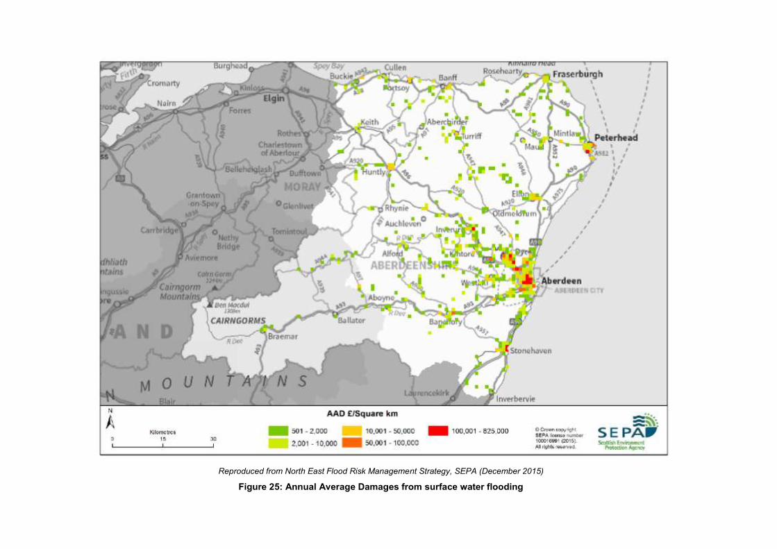
Reproduced from North East Flood Risk Management Strategy, SEPA (December 2015)
Figure 25: Annual Average Damages from surface water flooding
North East Local Plan District – Local Flood Risk Management Plan
396
Annex 4: Supporting information
Sources of flooding described in this plan
The Plan addresses the risk of flooding from rivers, the coast and surface water. The risk
of flooding from rivers is usually due to rainfall causing a river to rise above bank level
spreading out and inundating adjacent areas. Coastal flooding is where the risk is from the
sea. Sea levels can change in response to tidal cycles or atmospheric conditions. Over
the longer term sea levels and coastal flood risk may change due to climate change.
Surface water flooding happens when rainwater does not drain away through the normal
drainage systems or soak into the ground, but lies on or flows over the ground instead.
There can be interactions between these sources of flooding, but for the purposes of this
plan they are dealt with independently unless covered by the Aberdeen ICS.
The following aspects of flooding have not been incorporated to this plan:
Groundwater is generally a contributing factor to flooding rather than the primary
source. It is caused by water rising up from underlying rocks or flowing from
springs.
Reservoir breaches have been assessed under separate legislation. Further
information and maps can be found on SEPA’s website.
The Flood Risk Management Act (Scotland) 2009 does not include powers for
SEPA or responsible authorities to assess or manage coastal erosion. SEPA have
included consideration of erosion in the Flood Risk Management Strategies by
identifying areas that are likely to be vulnerable to erosion and therefore where
erosion can exacerbate flood risk. As part of considering where actions might
deliver multiple benefits, they have looked to see where the focus of coastal flood
risk management studies coincides with areas of high susceptibility to coastal
erosion. Subsequent detailed studies and scheme design will need to consider how
coastal actions interact with coastal erosion.
Wave overtopping. The information on coastal flooding in this plan is based on
SEPA modelling using still water level predictions. The method used simplifies the
coastal processes and flooding mechanisms at work during a storm. Wave
overtopping cannot be accurately modelled at a national scale due to the
importance of local factors such as prevailing wind conditions, the depth and profile
of the near-shore sea bed or the influence of any existing defences or management
structures. As a result, they may an underestimate of coastal flood risk in some
areas. In locations with wide and flat floodplains, the modelling may overestimate
flood risk because the volumes of water able to inundate an area over a tidal cycle
are not taken into account. To address this, in a number of locations where more
detailed local models were available they have been incorporated into the
development of the Flood Risk Management Strategies. Where wave overtopping
North East Local Plan District – Local Flood Risk Management Plan
397
has been specifically identified as a concern – but where no further detailed
modelling is available – particular compensation has been made in the selection of
appropriate actions to address coastal flood risk.
Below are explanatory notes for the approach taken in this plan and commonly used
terms in flood risk management. A glossary of terms is also available.
Reference to flood risk
During the development of this Plan flood risk has been assessed over a range of
likelihoods. For consistency in reporting information within the Strategies, unless
otherwise stated, all references to properties or other receptors being ‘at risk of flooding’
refer to a medium likelihood flood (up to a 1 in 200 chance of flooding in any given year).
By exception, references will be made to high or low risk flooding, which should be taken
to mean a 1 in 10 chance/likelihood or 1 in 1000 chance/likelihood of flooding in any given
year respectively.
Likelihood of flooding Return period
High 10 year
Medium 200 year
Low 1000 year
Annual Average Damages
have been used to assess the potential economic impact of flooding within an area. These
are the average economic damages per year when assessed over a very long period of
time. They are derived from the estimated economic damages from all sources of flooding
to the following receptors: agriculture, residential properties (direct and indirect), non-
residential properties, vehicles, emergency services and roads within the area.
National Flood Risk Assessment
SEPA published a National Flood Risk Assessment 2011. It significantly improved our
understanding of the causes and consequences of flooding, and identified areas most
vulnerable to floods. It was the first step to delivering a risk-based, sustainable and plan-
led approach to flood risk management.
The assessment considered the likelihood of flooding from rivers, groundwater and the
sea, as well as flooding caused when heavy rainfall is unable to enter drainage systems or

North East Local Plan District – Local Flood Risk Management Plan
398
the river network. The likelihood of flooding was examined alongside the estimated impact
on people, the economy, cultural heritage and the environment. This combined
understanding of where flooding is likely to occur, and the impact when it does, helped
target the efforts of organisations managing flood risk to people, the economy and the
environment.
Potentially Vulnerable Areas and Local Plan Districts
Based on the National Flood Risk Assessment, SEPA identified where the estimated
impact of flooding was considered to be nationally significant. These areas are based on
catchment units as it is within the context of the wider catchment that flooding can be best
understood and managed. These nationally significant catchments (or parts of
catchments) are referred to as Potentially Vulnerable Areas.
In Scotland, 243 Potentially Vulnerable Areas were identified. They are estimated to
contain 92% of the total number of properties at risk within Scotland.
For flood risk management purposes, Scotland was divided into 14 Local Plan Districts.
Each Local Plan District will have a Flood Risk Management Strategy and a Local Flood
Risk Management Plan.
Lead Local Authority
The FRM Act requires a Lead Local Authority to be identified for each Local Plan District.
The Lead Local Authority is crucial to the successful implementation of the FRM Act and,
as such, must perform several important functions over and above the general duties and
powers given to local authorities elsewhere in the FRM Act.
The Lead Local Authority, having contributed with other local authorities to the production
of the Flood Risk Management Strategy, must prepare a Local Flood Risk Management
Plan of coordinated actions to reduce flood risk within the Local Plan District. Although the
Lead Local Authority is responsible for the production of the plan, its content will be drawn
from and agreed by all local authorities, other responsible authorities and SEPA within the
Local Plan District.
Natural flood management assessment and mapping of artificial and natural
features
The new approach to Flood Risk Management requires SEPA to consider whether
techniques that restore, enhance or alter natural features and characteristics can
contribute to managing flood risk. This means looking at the potential to work with natural
hydrological and morphological processes.
North East Local Plan District – Local Flood Risk Management Plan
399
Because the National Flood Risk Assessment provides only a strategic assessment of
flood risk, further refined assessments may be required in Potentially Vulnerable Areas,
including the mapping of artificial and natural features whose removal could increase flood
risk.
SEPA developed catchment characteristics and methodologies, to assess the potential for
natural flood management as part of the appraisal process. The information was then
collated and published in 2013. The assessment of natural flood management was a
consideration in the setting of objectives and actions in the Flood Risk Management
Strategies.
Flood hazard and flood risk maps
The production of flood hazard and flood risk maps improved our understanding of
flooding and helped inform the selection of actions required to manage flood risk in
Potentially Vulnerable Areas. Work on production of these maps will begin in January
2012. These maps will show details of flood events for a range of probabilities and will
cover flooding from rivers, the sea, sewers, surface water run-off and groundwater.
The flood hazard maps will show information that describes the nature of a flood, such as
the extent of flooding, water level, depth and velocity where appropriate.
A flood risk map provides detail on the impacts on people, the economy, cultural heritage
and the environment.

North East Local Plan District – Local Flood Risk Management Plan
400
Annex 5: Land use planning
Flood risk management actions from national planning policies
Avoid development in medium to high risk areas
a) Planning authorities work in partnership undertaking catchment-wide Strategic Flood
Risk Assessments to inform their development plan allocations in line with SEPA’s
guidance and Land Use Vulnerability.
b) Planning authorities and SEPA require the submission of flood risk assessments that
accord with SEPA’s Technical Flood Risk Guidance for Stakeholders, to support
planning applications where there is a potential flood risk. The flood risk assessment
should be used to demonstrate as far as possible that the development will be safe for
its lifetime, without increasing flood risk elsewhere and, where possible, takes
opportunities to reduce flood risk overall.
c) SEPA ensures that its flood risk advice to planning authorities is clear and appropriate.
SEPA, in consultation with planning authorities, undertakes an annual assessment of
planning advice and its contribution to flood risk.
d) SEPA and planning authorities engage at an early stage of the development plan
process to agree appropriate forms of development to help inform the preparation and
implementation of Strategic Flood Risk Assessments.
Reduce impacts to existing buildings
SEPA, planning authorities and local communities are required to engage at an early
stage of the development plan process to agree the best long term land uses for areas
where relocation, abandonment and/or change of use have been identified to deliver
sustainable flood risk management. Where possible, new land uses should aim to
achieve multiple benefits for local communities such as the creation of blue / green
infrastructure and increased resilience to climate change.
Protect and enhance natural features that have a positive impact on reducing overall
flood risk
SEPA and planning authorities are required to engage early in the development plan
process to identify opportunities for the restoration and protection of natural features
which help manage flood risk. Opportunities should be maximised to achieve multiple
benefits such as the development of green / blue infrastructure and improved place
making. Areas of land that may contribute to flood management should be identified and
protected.

North East Local Plan District – Local Flood Risk Management Plan
401
New developments are designed to ensure that surface water drainage does not increase
flood risk on or off site
a) SEPA prepares guidance for planning authorities and developers on the use of surface
water hazard maps for land use planning purposes.
b) Planning authorities support the implementation of Surface Water Management Plans,
developed by the local authorities, through development plan allocations and policies.
Surface Water Management Plans should take account of development opportunities
that could contribute to the reduction of surface water flood risk.
c) SEPA engages at an early stage of the development plan process to progress exemplar
projects that demonstrate the potential for land use planning to mitigate surface water
flooding and contribute to wider environmental benefits.
New development is resilient to predicted future changes in climate
Planning authorities ensure that climate change is considered in Strategic Flood Risk
Assessments and Flood Risk Assessments, based upon the best scientific evidence and
the information requirements of planners to make informed decisions.
North East Local Plan District – Local Flood Risk Management Plan
402
Annex 6: Licensing acknowledgements
Ordnance Survey
Maps are based upon Ordnance Survey material with the permission of Ordnance Survey on
behalf of the Controller of Her Majesty’s Stationery Office © Crown Copyright. Any unauthorised
reproduction infringes Crown copyright and may lead to prosecution or civil proceedings. SEPA
Licence number 100016991 (2015).
The Centre for Ecology and Hydrology
Some features of these maps are based upon digital spatial data licensed from the Centre for
Ecology and Hydrology © NERC (CEH) and third party licensors.
The Met Office
Data provided by The Met Office has been used under licence in some areas of flood risk
information production. ©Crown Copyright (2015), the Met Office.
The James Hutton Institute
Data provided under licence from the James Hutton Institute has been applied in production of
flood risk management information. Copyright © The James Hutton Institute and third party
licensors.
British Geological Survey
Flood risk information has been derived from BGS digital data under licence. British Geological
Survey ©NERC
Scottish Water
SEPA acknowledges the inclusion of surface water flooding data generated by Scottish Water in
preparation of flood risk information.

North East Local Plan District – Local Flood Risk Management Plan
403
Annex 7: Glossary
Term Definition
Actions Actions describe where and how flood risk will be managed. These
actions have been set by SEPA and agreed with flood risk management
authorities following consultation. Selection of actions to deliver the
agreed objectives has been based on a detailed assessment and
comparison of economic, social and environmental criteria.
Annual Average
Damages (AAD)
Depending on its size or severity each flood will cause a different amount
of damage to a given area. Annual Average Damages are the theoretical
average economic damages caused by flooding when considered over a
very long period of time. It does not mean that damage will occur every
year: in many years there will be no damages, in some years minor
damages and in a few years major damages may occur. High likelihood
events, which occur more regularly, contribute proportionally more to
AADs than rarer events. Within the Flood Risk Management Strategies
AADs incorporate economic damages to the following receptors:
residential properties, non-residential properties, vehicles, emergency
services, agriculture and roads. They have been calculated based on the
principles set out in the Flood Hazard Research Centre Multi-Coloured
Handbook (2010).
Appraisal Appraisal is the process of defining objectives, examining options and
weighing up the costs, benefits, risks and uncertainties before a decision
is made. The FRM Strategy appraisal method is designed to set
objectives and identify the most sustainable combination of actions to
tackle flooding from rivers, sea and surface water.
Appraisal baseline Defines the existing level of flood risk under the current flood risk
management regime.
Awareness raising Public awareness, participation and community support are essential
components of sustainable flood risk management. SEPA and the
responsible authorities have a duty to raise public awareness of flood
risk. This is undertaken both individually and collaboratively by a range of
organisations. Improved awareness of flood risk and actions that prepare
individuals, homes and businesses for flooding can reduce the overall
impact.
Benefit cost ratio
(BCR)
A benefit cost ratio summarises the overall value for money of an action
or project. It is expressed as the ratio of benefits to costs (both
expressed as present value monetary values). A ratio of greater than 1:1
indicates that the economic benefits associated with an action are
greater than the economic costs of implementation; therefore, this is
taken as the threshold of economic viability. It should be acknowledged
that it is not always possible to accurately estimate economic values for
all elements of benefit, and BCR is just one a number of techniques used
in appraisal.
Blue infrastructure Blue infrastructure is often complementary to ‘green infrastructure’ and
includes sustainable drainage systems, swales (shallow, broad and
vegetated channels designed to store and/or convey runoff and remove

North East Local Plan District – Local Flood Risk Management Plan
404
Term Definition
pollutants), wetlands, rivers, canals (and their banks) and other
watercourses
Catchment All the land drained by a river and its tributaries.
Channel improvement Where work has been carried out on a river channel allowing an increase
in the volume of water it can carry.
Characterisation Provides a description of the natural characteristics of catchments,
coastlines and urban areas in terms of hydrology, geomorphology,
topography and land use. It also includes the characterisation of existing
levels of flood risk and existing flood risk management activity.
Coastal flooding Flooding that results from high sea levels or a combination of high sea
levels and stormy conditions. The term coastal flooding is used under the
Flood Risk Management (Scotland) Act 2009, but in some areas it is also
referred to as tidal flooding and covers areas such as estuaries and river
channels that are influenced by tidal flows.
Combined sewer Combined sewers transport sewage from homes and industry as well as
carrying surface water runoff from gutters, drains and some highways.
Heavy or prolonged rainfall can rapidly increase the flow in a combined
sewer until the amount of water exceeds sewer capacity.
Combined sewer
(overflow) (CSO)
Combined sewer overflows are purposely designed structures to ensure
any excess water from sewerage systems is discharged in a controlled
way and at a specific managed location.
Community facility Within the FRM Strategies this term includes: Emergency Services (Police,
Fire, Ambulance, Coastguard, Mountain Rescue) Educational Buildings
(crèche, nursery, primary, secondary, further, higher and special education
premises) Healthcare facilities: hospitals, health centres and residential
care homes
Community flood
action groups
Community flood action groups are community based resilience groups
which, on behalf of local residents and business, help to prepare for and
minimise the effects of flooding. They reflect the interests of their local
communities and may differ in composition and remit. There are over 60
groups already established in Scotland. The Scottish Flood Forum
provides support for both new and existing groups.
Confluence Where two or more rivers meet.
Conveyance Conveyance is a measure of the carrying capacity of a watercourse.
Increasing conveyance enables flow to pass more rapidly and reducing
conveyance slows flow down. Both actions can be effective in managing
flood risk depending on local conditions.
Cultural heritage site Historic Environment Scotland maintains lists of buildings of special
architectural or historic interest; these buildings are referred to as ‘listed
buildings’. The highest level of designation is a World Heritage Site. Other
designations included in this assessment are scheduled monuments,
gardens and designed landscapes, and battlefields.
Culvert A pipe, channel or tunnel used for the conveyance of a watercourse or
surface drainage water under a road, railway, canal or other obstacle.
Damages Flood damages are categorised as direct or indirect i.e. as a result of the
flood water itself, or subsequent knock on effects. Damage to buildings
and contents caused by flood water are an example of direct damages,

North East Local Plan District – Local Flood Risk Management Plan
405
Term Definition
whilst loss of industrial production, travel disruption or stress and anxiety
are indirect. Some damages can be quantified in monetary terms, and
others can only be described.
The potential damages avoided by implementation of a flood risk
management action are commonly referred to as the benefits of that
action. When comparing the effectiveness of different actions, it is useful
to consider estimated damages and damages avoided across the
lifespan of the action. Within the FRM Strategies, a 100 year appraisal
period has been used as standard. This allows costs, damages and
benefits across this time frame to be compared in present value terms.
See also ‘Annual Average Damages’
Deposition A natural process leading to an accumulation of sediment on a river bed,
floodplain or coastline.
Economic impact An assessment of the economic value of the positive and negative effects
of flooding and / or the actions taken to manage floods.
Embankment Flood embankments are engineered earth fill structures designed to
contain high river levels or protect against coastal flooding. They are
commonly grass-covered, but may need additional protection against
erosion by swiftly flowing water, waves or overtopping.
Emergency plans /
response
Emergency response plans are applicable for all types of flooding. They
set out the steps to be taken during flooding in order to maximise safety
and minimise impacts where possible. Under the Civil Contingencies Act,
Category 1 Responders have a duty to maintain emergency plans.
Emergency plans may also be prepared by individuals, businesses,
organisations or communities.
Environmental impact A change in the environment as a result of an action or activity. Impacts
can be positive or negative and may vary in significance, scale and
duration.
Environmental Impact
Assessment (EIA)
Environmental Impact Assessment (EIA) is a process which identifies the
potential environmental impacts, both negative and positive, of a
proposal.
Environmental sites /
environmental
designated areas/
environmentally
designated sites
Areas formally designated for environmental importance, such as Sites of
Special Scientific Interest (SSSI), Special Protection Area (SPA) or
Special Areas of Conservation (SAC).
Erosion A natural process leading to the removal of sediment from a river bed,
bank or floodplain or coastline.
Estuarine surge
attenuation
A reduction in the wave energy caused by storm surge. Breakwaters
(barriers built out into the sea to protect a coast or harbour from the force
of waves) or habitats such as saltmarsh can slow down and reduce the
inland impact of storm surges (the rising of the sea due to wind and
atmospheric pressure changes associated with storms), thereby reducing
coastal flood risk.
Estuary A coastal body of water usually found where a river meets the sea; the
part of the river that is affected by tides.
North East Local Plan District – Local Flood Risk Management Plan
406
Term Definition
Flash flood A flood that occurs a short period of time after high intensity rainfall or a
sudden snow melt. A sudden increase in the level and velocity of the
water body is often characteristic of these events, leaving a short time for
warning or actions.
Flashy watercourse A 'flashy' river or watercourse has a short lag time (the delay between
peak rainfall intensity and peak river discharge), high peak discharge, and
quickly returns to average flow. Rivers with these characteristics can be
prone to flooding and leave a short time for warning or actions.
Flood In the terms of the FRM Act, ‘flood’ means a temporary covering by
water, from any source, of land not normally covered by water. This does
not include a flood solely from a sewerage system, as a result of normal
weather or infrastructure drainage. A flood can cause significant adverse
impacts on people, property and the environment.
Flood bund A constructed retaining wall, embankment or dyke designed to protect
against flooding to a specified standard of protection.
Flood defence Infrastructure, such as flood walls, embankments or flood storage
intended to protect an area against flooding to a specified standard of
protection.
Flood extent The area that has been affected by flooding, or is at risk of flooding from
one or more sources for a particular likelihood.
Flood forecasting SEPA operates a network of over 250 rainfall, river and coastal
monitoring stations throughout Scotland that generate data 24 hours a
day. This hydrological information is combined with meteorological
information from the Met Office. A team of experts then predict the
likelihood and timing of river, coastal and surface water flooding. This
joint initiative between SEPA and the Met Office forms the Scottish Flood
Forecasting Service.
Flood frequency The probability that a particular size/severity of flood will occur in a given
year (see likelihood).
Flood gate An adjustable, sometimes temporary, barrier used as a flood defence to
control the flow of water within a water system or during a flood. Flood
gates can also be part of operational flood defences or protect individual
buildings or sites.
Flood guard Flood guards cover a variety of types of door and window barriers that
can be fitted to individual properties and operated by the owners /
occupiers prior to a flood event. They act as a physical barrier to water
entering the property and can provide protection against frequent and
relatively shallow flooding.
Flood hazard In terms of the FRM Act, hazard refers to the characteristics (extent,
depth, velocity) of a flood.
Flood hazard map Flood hazard maps are required by the FRM Act to show information that
describes the nature of a flood in terms of the source, extent, water level
or depth and, where appropriate, velocity of water. Flood hazard and risk
maps are referred to collectively as flood maps and are available on the
SEPA website.
Flood Prevention
Scheme / Flood
A flood protection scheme, as defined by the FRM Act, is a scheme by a
local authority for the management of flood risk within the authority area.

North East Local Plan District – Local Flood Risk Management Plan
407
Term Definition
Protection Scheme
(FPS)
This includes defence measures (flood prevention schemes) formerly
promoted under the Flood Prevention (Scotland) Act 1961.
Flood protection study Flood protection studies aim to refine understanding of the hazard and
risk associated with flooding in a particular area, catchment or coastline.
They will involve detailed assessment of flood hazard and / or risk and
may develop options for managing flood risk.
Flood protection works Flood protection works can include the same flood defence measures
that would make up a formal Flood Protection Scheme but without the
legal process, protections and requirements that would come by
delivering the works as a scheme.
Flood risk A measure of the combination of the likelihood of flooding occurring and
the associated impacts on people, the economy and the environment.
Flood Risk
Assessment (FRA)
Flood Risk Assessments are detailed studies of an area where flood risk
may be present. These are often used to inform planning decisions, may
help to develop flood schemes and have also contributed to the National
Flood Risk Assessment.
Flood Risk
Management
(Scotland) Act 2009
(FRM Act)
The flood risk management legislation for Scotland. It transposes the EC
Floods Directive into Scots Law and aims to reduce the adverse
consequences of flooding on communities, the environment, cultural
heritage and economic activity.
Flood risk
management cycle
Under the FRM Act flood risk management planning is undertaken in six
year cycles. The first planning cycle is 2015 – 2021. The first delivery
cycle is lagged by approximately 6 months and is from 2016 - 2022.
Flood Prevention
(Scotland) Act 1961
The Flood Prevention (Scotland) Act 1961 gave local authorities
discretionary powers to make and build flood prevention schemes. It was
superseded by the Flood Risk Management (Scotland) Act 2009.
Flood Risk
Management Local
Advisory Groups
FRM Local Advisory Groups are stakeholder groups convened to advise
SEPA and Lead Local Authorities in the preparation of Flood Risk
Management Plans. SEPA and Lead Local Authorities must have regard
to the advice they provide.
Flood Risk
Management Plans
(FRM Plans)
A term used in the FRM Act. FRM Plans set out the actions that will be
taken to reduce flood risk in a Local Plan District. They comprise Flood
Risk Management Strategies, developed by SEPA, and Local Flood Risk
Management Plans produced by Lead Local Authorities.
Flood Risk
Management Strategy
(FRM Strategy)
Sets out a long-term vision for the overall reduction of flood risk. They
contain a summary of flood risk in each Local Plan District, together with
information on catchment characteristics and a summary of objectives
and actions for Potentially Vulnerable Areas.
Flood risk map Complements the flood hazard maps published on the SEPA website
providing detail on the impacts of flooding on people, the economy and
the environment. Flood hazard and risk maps are referred to collectively
as flood maps and are available on the SEPA website.
Flood wall A flood defence feature used to defend an area from flood water to a
specified standard of protection.
Flood Warning area
(FWA)
A Flood Warning area is where SEPA operates a formal Flood
Monitoring Scheme to issue targeted Flood Warning messages for
properties located in the area.
North East Local Plan District – Local Flood Risk Management Plan
408
Term Definition
Flood warning scheme A flood warning scheme is the network of monitoring on a coastal stretch
or river, which provides SEPA with the ability to issue Flood Warnings.
Floods Directive European Directive 2007/60/EC on the Assessment and Management of
Flood Risks builds on and is closely related to the Water Framework
Directive (see river basin management planning). It was transposed into
Scots Law by the Flood Risk Management (Scotland) Act 2009. The
Directive requires Member States to assess if all watercourses and
coastlines are at risk from flooding, to map the flood extent, assets and
humans at risk in these areas and to take adequate and coordinated
measures to reduce this flood risk.
Floodplain Area of land that borders a watercourse, an estuary or the sea, over which
water flows in time of flood, or would naturally flow but for the presence of
flood defences and other structures where they exist.
Floodplain storage Floodplains naturally store water during high flows. Storage can be
increased through natural or man-made features to increase flood depth
or slow flows in order to reduce flooding elsewhere.
Gabion A metal cage filled with rocks often used in river bank protection.
Green infrastructure The European Commission defines green infrastructure as “the use of
ecosystems, green spaces and water in strategic land use planning to
deliver environmental and quality of life benefits. It includes parks, open
spaces, playing fields, woodlands, wetlands, road verges, allotments and
private gardens. Green infrastructure can contribute to climate change
mitigation and adaptation, natural disaster risk mitigation, protection
against flooding and erosion as well as biodiversity conservation.” See
also ‘blue infrastructure’
Groundwater flooding This type of flooding is caused by water rising up from underlying rocks
or flowing from springs. In Scotland groundwater is generally a
contributing factor to flooding rather than the primary source.
Integrated catchment
study (ICS)
In urban areas, the causes of flooding are complex because of the
interactions between rivers, surface water drainage and combined sewer
systems and tidal waters. Scottish Water works with SEPA and local
authorities to assess these interactions through detailed studies.
Land use planning
(LUP)
The process undertaken by public authorities to identify, evaluate and
decide on different options for the use of land, including consideration of
long term economic, social and environmental objectives and the
implications for different communities and interest groups.
Lead local Authority A local authority responsible for leading the production, consultation,
publication and review of a Local Flood Risk Management Plan.
Likelihood of flooding The chance of flooding occurring.
High likelihood: A flood is likely to occur in the defined area on average
once in every ten years (1:10). Or a 10% chance of happening in any
one year.
Medium likelihood: A flood is likely to occur in the defined area on
average once in every two hundred years (1:200). Or a 0.5% chance of
happening in any one year.
North East Local Plan District – Local Flood Risk Management Plan
409
Term Definition
Low likelihood: A flood is likely to occur in the defined area on average
once in every thousand years (1:1000). Or a 0.1% chance of happening
in any one year.
Local Flood Risk
Management Plans
(Local FRM Plan)
Local Flood Risk Management Plans, produced by Lead Local
Authorities, will take forward the objectives and actions set out in Flood
Risk Management Strategies. They will provide detail on the funding,
timeline of delivery, arrangements and co-ordination of actions at the local
level during each six year FRM planning cycle.
Local Nature Reserve
(LNR)
A Local Nature Reserve is a protected area of land designated by a local
authority because of its local special natural interest and / or educational
value. Local authorities select and designate local nature reserves using
their powers under the National Parks and Access to the Countryside Act
1949ix.
Local Plan District Geographical areas for the purposes of flood risk management planning.
There are 14 Local Plan Districts in Scotland.
Local Plan District
Partnerships
Each LPD has established a local partnership comprised of local
authorities, SEPA, Scottish Water and others as appropriate. These
partnerships are distinct from the FRM Local Advisory Groups and they
retain clear responsibility for delivery of the FRM actions set out in the
Local Flood Risk Management Plans. It is the local partnership that makes
decisions and supports the delivery of these plans.
Maintenance Sections 18 and 59 of the Flood Risk Management (Scotland) Act 2009
put duties of watercourse inspection, clearance and repair on local
authorities. In addition, local authorities may also be responsible for
maintenance of existing flood protection schemes or defences.
Montane habitat This habitat encompasses a range of natural or near-natural vegetation
occurring in the montane zone, lying above or beyond the natural tree-
line.
National Flood
Management Advisory
Group (NFMAG)
The National Flood Management Advisory Group provides advice and
support to SEPA and, where required, Scottish Water, local authorities
and other responsible authorities on the production of FRM Strategies
and Local FRM Plans.
National Flood Risk
Assessment (NFRA)
A national analysis of flood risk from all sources of flooding which also
considers climate change impacts. Completed in December 2011 this
provides the information required to undertake a strategic approach to
flood management that identifies areas at flood risk that require further
appraisal. The NFRA will be reviewed and updated for the second cycle
of FRM Planning by December 2018.
Natural flood
management (NFM)
A set of flood management techniques that aim to work with natural
processes (or nature) to manage flood risk.
Non-residential
properties
Properties that are not used for people to live in, such as shops or other
public, commercial or industrial buildings.
Objectives Objectives provide a common goal and shared ambition for managing
floods. These objectives have been set by SEPA and agreed with flood
risk management authorities following consultation. They were identified
through an assessment of the underlying evidence of the causes and
impacts of flooding.

North East Local Plan District – Local Flood Risk Management Plan
410
Term Definition
One in 200 year flood See ‘likelihood of flooding’ and ‘return period’.
Planning policies Current national planning policies, Scottish Planning Policy and
accompanying Planning Advice notes restrict development within the
floodplain and limit exposure of new receptors to flood risk. In addition to
national policies, local planning policies may place further requirements
within their area of operation to restrict inappropriate development and
prevent unacceptable risk.
Potentially Vulnerable
Areas (PVA)
Catchments identified as being at risk of flooding and where the impact
of flooding is sufficient to justify further assessment and appraisal. There
were 243 PVAs identified by SEPA in the National Flood Risk
Assessment and these are the focus of the first FRM planning cycle.
Property level
protection
Property level protection includes flood gates, sandbags and other
temporary barriers that can be used to prevent water from entering
individual properties during a flood.
Property level
protection scheme
Some responsible authorities may have a formal scheme to provide,
install and maintain property level protection for properties.
Ramsar sites Ramsar sites are wetlands of international importance designated under
the Ramsar Convention.
Receptor Refers to the entity that may be impacted by flooding (a person, property,
infrastructure or habitat). The vulnerability of a receptor can be reduced
by increasing its resilience to flooding.
Residual risk The risk that remains after risk management and mitigation. This may
include risk due to very severe (above design standard) storms or risks
from unforeseen hazards.
Resilience The ability of an individual, community or system to recover from
flooding.
Responsible authority Designated under the FRM (Scotland) Act 2009 and associated
legislation as local authorities, Scottish Water and, from 21 December
2013, the National Park Authorities and Forestry Commission Scotland.
Responsible authorities, along with SEPA and Scottish Ministers, have
specific duties in relation to their flood risk related functions.
Return period A measure of the rarity of a flood event. It is the statistical average length
of time separating flood events of a similar size. (see likelihood)
Revetment Sloping structures placed on banks or at the foot of cliffs in such a way
as to deflect the energy of incoming water.
Riparian The riparian area is the interface between land and a river or stream. For
the purposes of FRM this commonly refers to the riparian owner, which
denotes ownership of the land area beside a river or stream.
River basin
management planning
(RBMP)
The Water Environment and Water Services (Scotland) Act 2003
transposed the European Water Framework Directive into Scots law. The
Act created the River Basin Management Planning process to achieve
environmental improvements to protect and improve our water
environment. It also provided the framework for regulations to control the
negative impacts of all activities likely to have an impact on the water
environment.

North East Local Plan District – Local Flood Risk Management Plan
411
Term Definition
Runoff reduction Actions within a catchment or sub-catchment to reduce the amount of
runoff during rainfall events. This can include intercepting rainfall, storing
water, diverting flows or encouraging infiltration.
Scottish Advisory and
Implementation Forum
for Flooding (SAIFF)
The stakeholder forum on flooding set up by the Scottish Government to
ensure legislative and policy aims are met and to provide a platform for
sharing expertise and developing common aspirations and approaches to
reducing the impact of flooding on Scotland’s communities, environment,
cultural heritage and economy.
Scottish Flood Forum The Scottish Flood Forum is a Scottish charitable organisation that
provides support for those who are affected by, or are at risk of, flooding.
It provides flood advice, information, awareness, education and training
to individuals and communities to help reduce the risk of flooding; in
partnership with the local authority, provides support during the recovery
process following a flood incident and aims to support the development
of resilient communities.
Sediment balance Within a river where erosion and deposition processes are equal over the
medium to long-term resulting in channel dimensions (width, depth, and
slope) that are relatively stable.
Sediment
management
Sediment management covers a wide range of activities that includes
anything from the small scale removal of dry gravels to the dredging of
whole river channels and the reintroduction of removed sediment into the
water environment. Historically, sediment management has been carried
out for several reasons, including reducing flood risk, reducing bank
erosion, for use as aggregate and to improve land drainage.
Self help Self-help actions can be undertaken by any individuals, businesses,
organisations or communities at risk of flooding. They are applicable to
all sources, frequency and scales of flooding. They focus on awareness
raising and understanding of flood risk.
Sewer flooding (and
other artificial
drainage system
flooding)
Flooding as a result of the sewer or other artificial drainage system (e.g.
road drainage) capacity being exceeded by rainfall runoff or when the
drainage system cannot discharge water at the outfall due to high water
levels (river and sea levels) in receiving waters.
Site protection plans Site protection plans are developed to identify whether normal operation
of a facility can be maintained during a flood. This may be due to existing
protection or resilience of the facility or the network.
Shoreline
Management Plan
(SMP)
A Shoreline Management Plan is a large scale assessment of the coastal
flood and erosion risks to people and the developed, historic and natural
environment. It sets out a long-term framework for the management of
these risks in a sustainable manner.
Site of Special
Scientific Interest
(SSSI)
Sites of Special Scientific Interest are protected by law under the Nature
Conservation (Scotland) Act 2004 to conserve their plants, animals and
habitats, rocks and landforms.
Source of flooding The type of flooding. This can be coastal, river, surface water or
groundwater.
Special Area of
Conservation (SAC)
Special Areas of Conservation are strictly protected sites designated under
the European Habitats Directive. The Directive requires the establishment
North East Local Plan District – Local Flood Risk Management Plan
412
Term Definition
of a European network of protected areas which are internationally
important for threatened habitats and species.
Special Protection
Areas
(SPA)
Special Protection Areas are strictly protected sites classified in
accordance with the European Birds Directive. They are classified for
rare and vulnerable birds (as listed in the Directive), and for regularly
occurring migratory species.
Standard of protection
(SoP)
All flood protection structures are designed to be effective up to a
specified flood likelihood (Standard of Protection). For events beyond this
standard, flooding will occur. The chosen Standard of Protection will
determine the required defence height and / or capacity.
Storage area A feature that can be used to store floodwater, this can be natural in the
form of low lying land or manmade such as a reservoir or modified
landform.
Strategic
Environmental
Assessment (SEA)
A process for the early identification and assessment of the likely
significant environmental effects, positive and negative, of activities. Often
considered before actions are approved or adopted.
Strategic Flood Risk
Assessment
(SFRA)
A Strategic Flood Risk Assessment is designed for the purposes of
specifically informing the Development Plan Process. A SFRA involves
the collection, analysis and presentation of all existing and readily
available flood risk information (from any source) for the area of interest.
It constitutes a strategic overview of flood risk.
Strategic mapping and
modelling
Strategic mapping and modelling actions have been identified in
locations where SEPA is planning to undertake additional modelling or
analysis of catchments and coastlines, working collaboratively with local
authorities where appropriate, to improve the national understanding of
flood risk.
Surcharge Watercourses and culverts can carry a limited amount of water. When
they can no longer cope, they overflow, or ‘surcharge’.
Surface water flooding Flooding that occurs when rainwater does not drain away through the
normal drainage systems or soak into the ground, but lies on or flows
over the ground instead.
Surface water
management plan
(SWMP)
A plan that takes an integrated approach to drainage accounting for all
aspects of urban drainage systems and produces long term and
sustainable actions. The aim is to ensure that during a flood the flows
created can be managed in a way that will cause minimum harm to
people, buildings, the environment and business.
Surface water
plan/study
The management of flooding from surface water sewers, drains, small
watercourses and ditches that occurs, primarily in urban areas, during
heavy rainfall. FRM Strategy actions in this category include: Surface
Water Management Plans, Integrated Catchment Studies and assessment
of flood risk from sewerage systems (FRM Act Section 16) by Scottish
Water. These have been selected as appropriate for each Potentially
Vulnerable Area.
Sustainable flood risk
management
The sustainable flood risk management approach aims to meet human
needs, whilst preserving the environment so that these needs can be met
not only in the present, but also for future generations. The delivery of

North East Local Plan District – Local Flood Risk Management Plan
413
Term Definition
sustainable development is generally recognised to reconcile three pillars
of sustainability – environmental, social and economic.
Sustainable drainage
systems
(SuDS)
A set of techniques designed to slow the flow of water. They can
contribute to reducing flood risk by absorbing some of the initial rainfall
and then releasing it gradually, thereby reducing the flood peak and
helping to mitigate downstream problems. SuDS encourage us to take
account of quality, quantity and amenity / biodiversity.
UK Climate Change
Projections (UKCP09)
The leading source of climate change information for the UK. It can help
users to assess their climate risks and plan how to adapt to a changing
climate. The high emissions scenario refers to the SRES A1F1 emission
scenario. See Annex 1 of the UKCP09 Climate Change Projections
report for details
Utility assets Within the FRM Strategies this refers to electricity sub stations, mineral
and fuel extraction sites, telephone assets, television and radio assets.
Vulnerability A measure of how likely someone or something is to suffer long-term
damage as a result of flooding. It is a combination of the likelihood of
suffering harm or damage during a flood (susceptibility) and the ability to
recover following a flood (resilience).
Wave energy
dissipation
Process by which a wave loses its energy.
Wave overtopping Wave overtopping occurs when water passes over a flood wall or other
structure as a result of wave action. Wave overtopping may lead to
flooding particularly in exposed coastal locations.
i
Top Related