


Languages
Pages
Legal


Explore Google Earth
LINKING WITH SOCIAL SCIENCE

Getting familiar with the tools

► Street view of any destination by clicking on ‘person icon’.
► Know what the minus (-) and plus (+) sign mean
► Know what 2 D and 3 D means.► Know how to find your location.

What you can do with Google Earth?

► Measuring distance between any two different places. e.g. it may be your school, park, playground or your home.
► Finding locations using compass directions-North, South, East, West.
► To make it more interesting let your students to play problem solving games/task.

You can explore: ► World famous landmarks. e.g.. Natural (Sundarbans
delta, Ravines in Chambal ) or man-made (Statue of Unity, Taj mahal, Humayun Tomb)
► Countries, continents or largest countries in each continent.
► Natural vegetation/environments. e.g. deserts, rainy forests, grasslands, islands etc.

► Making of a project/biography on a given famous personality. e.g. Nelson Mandela, Adolf Hitler, Gandhi ji, Akbar, B. R. Ambedkar etc.
► Bring ‘Voyager’ in your class room to give students an interactive educational experience.
► Making portfolio/Passport/Enrich Bag to Social Studies

Demonstrations

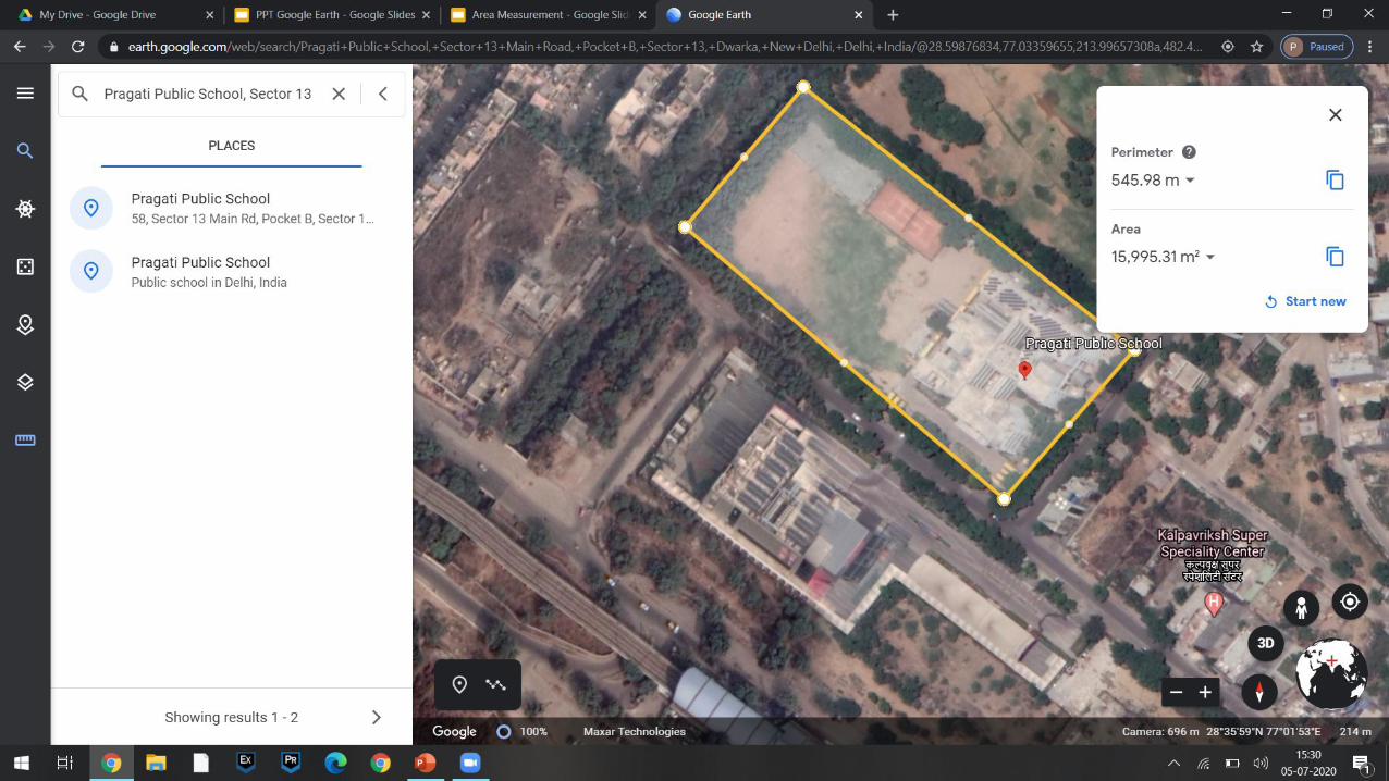
Area Measurement
Google Earth


► https://earth.google.com/web/data=Mj8KPQo7CiExLVNxeTJhZ2lkTTZMa3EzbDg0TmNCa3NuMjJGaWxpc04SFgoUMEI4QUEwNTBDMDE0NEVCMzk3MkM
► https://earth.google.com/web/data=Mj8KPQo7CiExeHBkWllubm5jOXdyVzlCaFlBX2NubU5GU2tzSExVZV8SFgoUMDIzNTcwNjhDMzE0NEZDOTczODc ( Delhi)

Indigenous Cultural Heritage
► https://earth.google.com/web/@48.41969695,-123.36634056,6.45891875a,0d,60y,275.42072673h,90.3987726t,0r/data=CjESLxIgYjU0YWFhNDI2ZTRhMTFlOGFjYjM0ZGJhNDk1NmM3YjQiC3ZveV9wb2ludF80IhoKFk9nQkctQTJMUXJVVGE3bjBxaGFkalEQAg
► Link for indigenous cultural heritage

Landforms
► https://earth.google.com/web/data=Mj8KPQo7CiExQlMyYWpKMG80RHRLd1hKR191UXFsZEROdzd5TGlzeGYSFgoUMDU2MUI2NEMyRjE0NEY5MTQ3NjU
► Link for Oslo fjord Inlet ► The Oslo fjord is an inlet in the south-east of Norway,
stretching from an imaginary line between the Torbjørnskjær and Færder lighthouses and down to Langesund in the south to Oslo in the north. It is part of the Skagerrak strait, connecting the North Sea and the Kattegat sea area, which leads to the Baltic Sea.

Fjords in Norway
► https://earth.google.com/web/search/Fjord+in+Norway/@64.05280202,12.80199418,819.10258117a,2603919.38955996d,35y,0h,0t,0r/data=CigiJgokCZ4wd7BVw01AEXW52aT4wk1AGS-NPGYa2yRAIb4GUJEk1SRAMicKJQojCiExQlMyYWpKMG80RHRLd1hKR191UXFsZEROdzd5TGlzeGY

Historical Monuments
► https://earth.google.com/web/data=Mj8KPQo7CiExRGkxYXp4YU14Yldka1JkOVE0VWxjeXV4ZGRMb3d0cGESFgoUMEU0NEIwQzk5OTE0NEZCRTZDNUE
► https://earth.google.com/web/data=Mj8KPQo7CiExeHBkWllubm5jOXdyVzlCaFlBX2NubU5GU2tzSExVZV8SFgoUMDIzNTcwNjhDMzE0NEZDOTczODc

River Geomorphological Features Latitude LongitudeConfluence of Indus and Zanskar 34° 9'57.82"N 77°19'58.98"E
Alluvial Fan 34° 5'16.81"N 77°34'13.17"E
Indus River Gorge Near Nanga Parbat 35°27'48.90"N 74°28'12.76"E
Grand Canyon USA 36°12'15.17"N 111°48'4.24"W
Gangotri Potholes 30°59'40.95"N 78°56'16.14"E
San Juan River USA Incised Meander 37° 9'19.60"N 109°56'13.75"W
Rangitikei Valley terraces, New Zealand 39°54'43.27"S 175°38'48.88"E
Sunderban Delta Ganga River 21°53'9.89"N 89°17'53.29"E
Yamuna River Meandering 27°14'2.03"N 77°55'17.51"E
Oxbow Lake Near Houston USA 29°15'25.69"N 95°34'15.42"W
Braided Brahmaputra River Assam 26°34'27.72"N 92°32'50.85"E

Thank you
Top Related