


Languages
Pages
Legal

Earth Observations from Space and The Australian Geoscience Data Cube: Analysing Australia in space and time.
Dr Stuart Minchin
Geoscience Australia

The Landsat Data Cube | Locate 2014
Acknowledgements Industry:
• Cooperative Research Centre for Spatial Information
• Lockheed-Martin
Research:
• CSIRO
• National Computational Infrastructure
• Victorian Partnership for Advanced Computing
International:
• NASA
• The United States Geological Survey

The Landsat Data Cube | Locate 2014

Workshop on Himawari-8/9 Applications, Canberra, 1 July 2014

Traditional remote sensing product process
The Landsat Data Cube | Locate 2014

The Data Cube Approach
The Landsat Data Cube | Locate 2014

‘Cubing’ Landsat images
The Landsat Data Cube | Locate 2014

‘Cubing’ Landsat images
The Landsat Data Cube | Locate 2014

‘Cubing’ Landsat images
The Landsat Data Cube | Locate 2014

The Data Cube concept
The Landsat Data Cube | Locate 2014

Traditional remote sensing product process
The Landsat Data Cube | Locate 2014
The Landsat Data Cube | Locate 2014
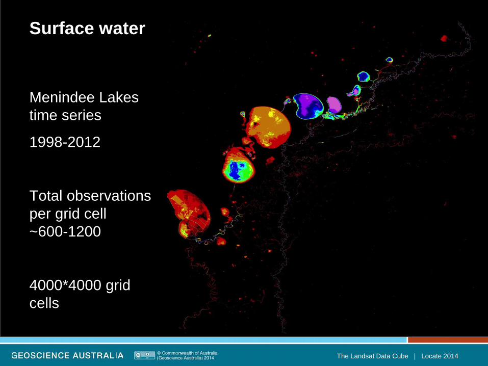
Surface water
Menindee Lakes time series
1998-2012
Total observations per grid cell ~600-1200
4000*4000 grid cells
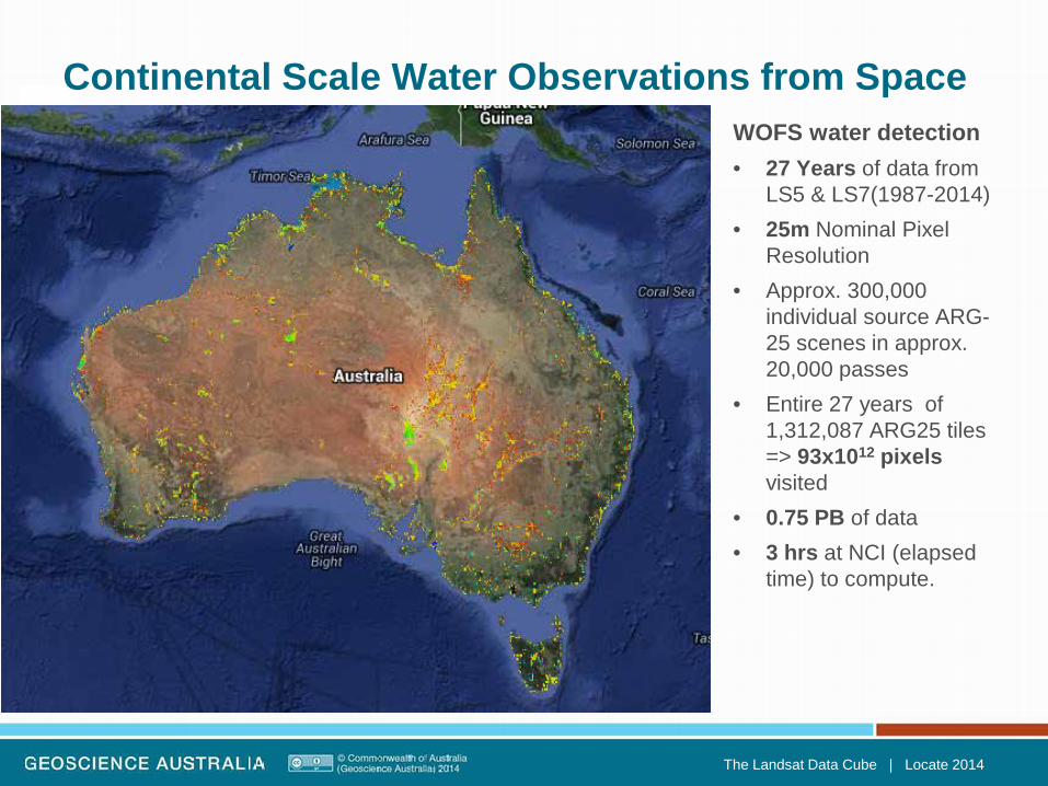
WOFS water detection • 27 Years of data from
LS5 & LS7(1987-2014) • 25m Nominal Pixel
Resolution • Approx. 300,000
individual source ARG-25 scenes in approx. 20,000 passes
• Entire 27 years of 1,312,087 ARG25 tiles => 93x1012 pixels visited
• 0.75 PB of data • 3 hrs at NCI (elapsed
time) to compute.
The Landsat Data Cube | Locate 2014
Continental Scale Water Observations from Space
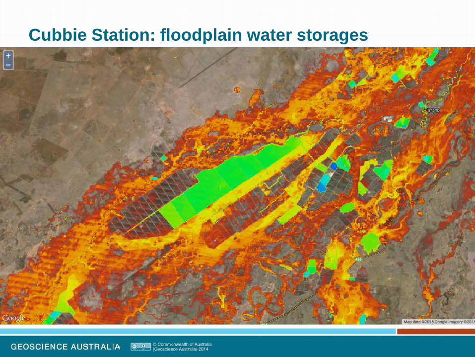
Cubbie Station: floodplain water storages

Cubbie Station: floodplain water storages

Cubbie Station: floodplain water storages

Cubbie Station: floodplain water storages

Coastal Change Detection
Aquatic Applications on the AGDC
LAND
WATER
WATER
LAND
1988 Landsat 5 First Water Observation Anomaly
2013 Landsat 7 Last Water Observation Anomaly
WATER
LAND

Land use change: Cropping patterns Land Management – Keytah Station. ‘Fractional cover’
The Landsat Data Cube | Locate 2014

Land Management – Keytah Station. ‘Fractional cover’
The Landsat Data Cube | Locate 2014
Land use change: Cropping patterns

Great Barrier Reef Water quality - history Hay point – major coal terminal
Dredging produces sediment plumes
December 2014 – all clear
2006/7 – Major dredging to expand the channel
Graph of estimated total suspended sediments shows peaks at 2007 corresponding with timing of works
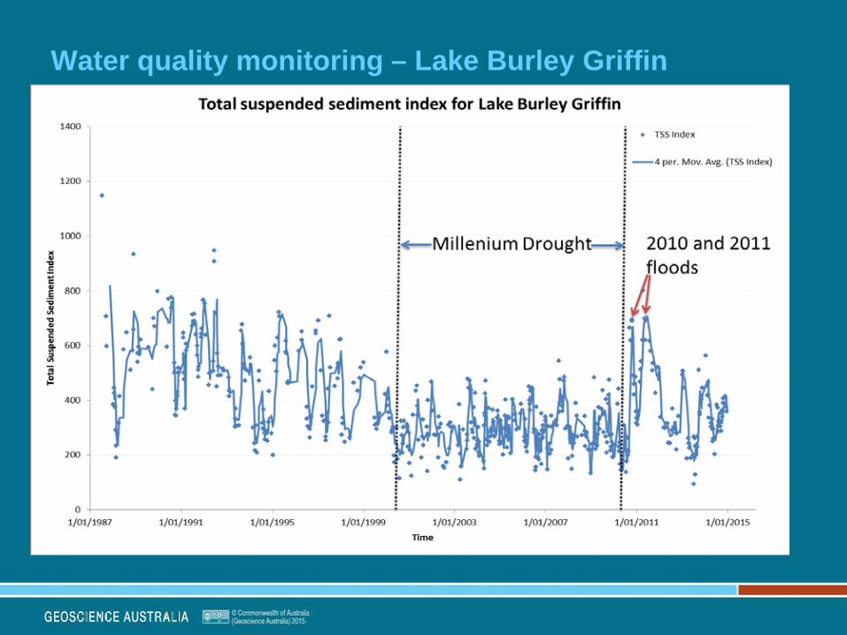
Water quality monitoring – Lake Burley Griffin

The potential for change detection: Mangroves Timing and strength of change for any (data cube) variable
National & regional shoreline erosion studies, mangrove change mapping
A B
1987 ----------------------------- TIME --------------------------- 2014

Data Cube Shallow Water Bathymetry Estimation
Aquatic Applications on the AGDC
• Adjusting Water Observations from Space to provide intertidal bathymetry
• Applying CSIRO’s SAMBUCA algorithm to data cube
• This research is currently being supported through a joint CSIRO-GA
project.

Moving to a National Scale Approach
• Fundamental shift from case study projects to national scale time series approaches
• Driven by the potential of the Australian Geoscience Data Cube (AGDC)
• Landsat 5 & 7 Archive from 1987-2014
• Landsat 8 (and other) data ingestion – even more opportunities for Aquatic applications
Aquatic Applications on the AGDC
AG-DC Tiles
(Currently approx. 4M tiles)
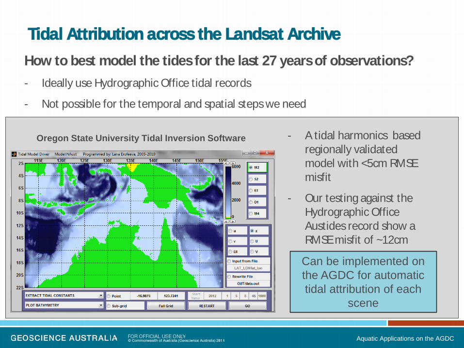
Tidal Attribution across the Landsat Archive How to best model the tides for the last 27 years of observations? - Ideally use Hydrographic Office tidal records
- Not possible for the temporal and spatial steps we need
Aquatic Applications on the AGDC
- A tidal harmonics based regionally validated model with <5cm RMSE misfit
- Our testing against the Hydrographic Office Austides record show a RMSE misfit of ~12cm
Oregon State University Tidal Inversion Software
Can be implemented on the AGDC for automatic tidal attribution of each
scene

Using tidal models to map tidal extents
Aquatic Applications on the AGDC
Tidal Zone Extent Can be attributed with offsets of LAT to lowest observed tide and HAT to highest
observed
Tidal Zone Morphology Fraction of water observations over the
time series. Can we attribute this with depths?
Tidal Range of >10m
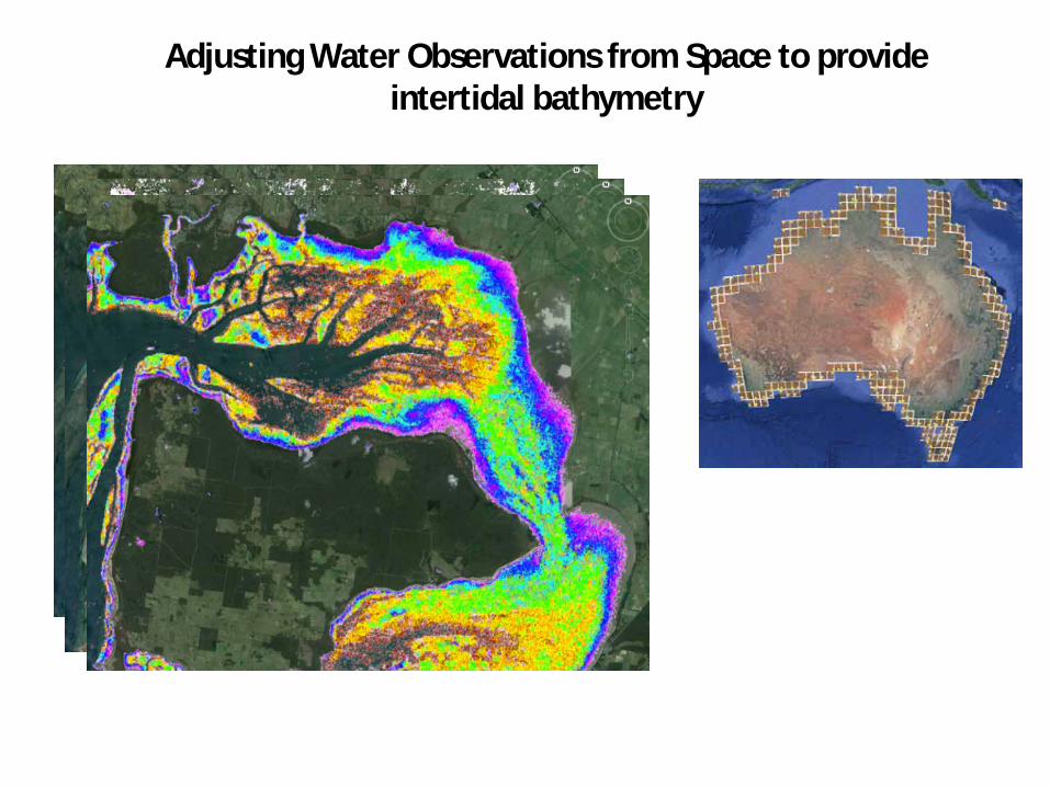
Adjusting Water Observations from Space to provide intertidal bathymetry

Physics-Based Inversion for Bathymetry Estimation
Aquatic Applications on the AGDC
Semi Analytical Model for Bathymetry Unmixing and Concentration Assessment SAMBUCA is an enhancement (by Brando et al. 2009) of the inversion/optimization method by Lee et al. (1998; 1999; 2001) to enable:
• Retrieval of chlorophyll-a, CDOM and NAP concentrations • Pure and mixed substratum-type compositions • Retrieval of vertical attenuation (for optically deep water) • Retrieval of bathymetry • Estimating the contribution of the substratum-type to the remote sensing signal (SDI)
A methodological approach • Characterization of coastal waters and substrates
• Model parameterization
• Remote sensing imagery data inversion
SAMBUCA inversion
Water Column Properties
SIOPs
Substrate Spectral
Reflectance
Concentration Ranges

Aquatic Applications on the AGDC
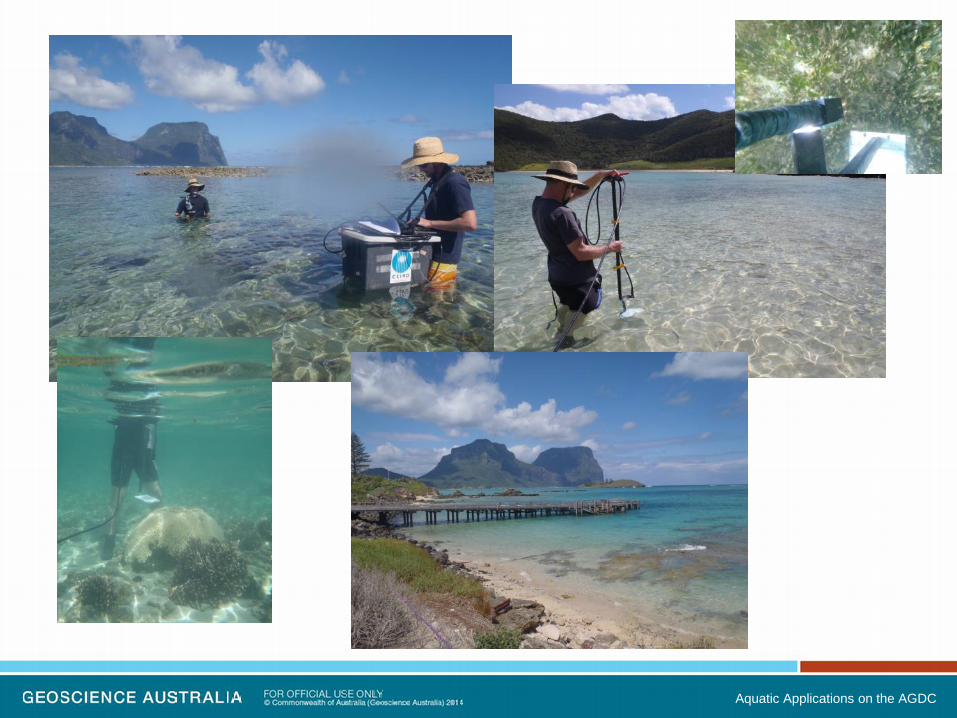
Aquatic Remote Sensing in NEMO Previous work has centred around physics-based shallow water
bathymetry estimation from high-resolution remote sensing data in case-study applications
Cocos (Keeling) Island ATWS
Ghizo Island, Solomons AusAID
Lord Howe Island Marine Biodiversity Hub
Aquatic Applications on the AGDC

Establishing National Databases 3 work packages being developed at CSIRO/GA:
Generic geographically tagged databases of SIOP (water quality), Substrate Libraries and Noise Characteristics for Landsat data.
Aquatic Applications on the AGDC
Moore, T. S., J. W. Campbell & M. D. Dowell (2009) A class-based approach to characterizing and mapping the uncertainty of the MODIS ocean chlorophyll product. Remote Sensing of Environment, 113, 2424-2430. Botha, E.J., Brando, V.E., Anstee, J.M., Dekker, A.G. and Sagar, S. (2013) Increased spectral resolution enhances coral detection under varying water conditions. Remote Sensing of Environment. 2013; 131:247-261. (details of the normalised Spectral Separability Metric). Mount R, Bricher P & Newton J. 2007. NISB Habitat Classification Scheme. Report to the National Land and Water Resources Audit. http://lwa.gov.au/products/pn21267

Aquatic Applications on the AGDC

Benefits of using the AGDC • Time Series Analysis can assist to regularize the inversion solution
• Ensemble results enable analysis of uncertainty
Aquatic Applications on the AGDC
Physics based processing is still challenging with Landsat Data, due to
Noise, Spatial Scale, Spectral and Radiometric Resolution
We are establishing a framework to enable processing on the NCI with any data that is ingested into the data cube

Some (already identified) applications for the data cube:
• Vegetation change, agricultural production
• Flood inundation mapping, farm dam development
• Wetland management and characterisation
• Carbon accounting
• Seagrass and substrate mapping
• Coastal change and water quality
• Shallow water bathymetry
• Mining footprint and urban development
• Bushfire scar mapping and forestry inventory
• Location-specific products for mobile platforms • “Map my paddock”
The Landsat Data Cube | Locate 2014

What questions do YOU have?…..J
The Landsat Data Cube | Locate 2014
Top Related