


Languages
Pages
Legal


DISCOVERING ARCHAEOLOGY AND THE BRONZE AGE
A subject knowledge and teaching guide
drawing on sites along the English Channel and North Sea
DISCOVERING ARCHAEOLOGY AND THE BRONZE AGE
A subject knowledge and teaching guide
A product of the European project ‘BOAT 1550 BC’
drawing on sites along the English Channel and North Sea

Design and production: unit for communication Lille 3/MESHS © BOAT 1550 BC, 2014
Many thanks to all involved in the 'BOAT 1550 BC' project for preparing and proofreading these texts
« Investir dans votre futur »Programme de coopération
transfontalière 2007-2013co-financé par l’Union européenne
(Fonds européen de développement régional)
« Investing in your future »Cross-border cooperation
programme 2007-2013part-financed by the European
Union (European RegionalDevelopment Fund)
« Investeren in je toekomst »Grensoverschrijdend
samenwerkingsprogramma2007-2013 Medegefinancierd door
de Europese Unie (Europees Fonds voor Regionale Ontwikkeling)

DISCOVERING ARCHAEOLOGY AND THE BRONZE AGE
A subject knowledge and teaching guide
drawing on sites along the English Channel and North Sea
SECTION 1The discovery of the boat
SECTION 2What do archaeologists do?
Introduction
The archaeologist: time detectiveThe science of decay and survivalTry an experiment
I. How are archaeological sites discovered?
1. Survey methodsSoil, a conductor of electricityArchaeology seen from the sky
2. Excavation during development work
II. The excavation site or ‘dig’
1. Tools and safety The excavation site The archaeologist’s tools
2. Topsoil stripping 3. Stratigraphy
History is a load of rubbish!4. Data recording
How to classify objects like an archaeologist How to record objects like an archaeologist
III. The science of archaeology
1. Pottery studiesHow to examine pottery like an archaeologistRestoring pottery
2. LithicsEvidence for tool use
3. Archaeometallurgy What did the invention of bronze mean for people's lives?
4. ArchaeozoologyExamining animal remainsWhat does an archaeozoologist do?
5. Malacology
p.9
p.17
p.20
p.19
p.28
p.27
p.30
p.31
p.42
p.40
p.36
p.35
p.38
p.39
p.22
p.24
p.32
p.44
p.46
p.50
p.54
p.53
p.56
p.58
p.70
p.74
p.75
p.60
p.62
p.76
p.64
p.68
CONTENTS
p.51
Activities for the classroom shown in bold

6. Osteo-archaeology What does an osteo-archaeologist do? The human skeleton
7. CarpologyExtracting seeds from soil using flotation
8. Palynology 9. Soil sciences
Soil colours 10. Anthracology 11. Dendrochronology
Dating trees 12. Carbon-14
IV. From excavation to exhibition – and beyond
1. The excavation report 2. Reaching a wide audience3. The Boat 1550 BC exhibition
SECTION 3Bronze Age settlement, funerary practice and ritual hoards along the Channel coasts
Introduction The Dover Bronze Age Boat and Bronze Age communities on the coasts of the English Channel
I. Funeral rites
1. The Fresnes-lès-Montauban site 2. Urn field site at Aalter 3. The Thanet Earth site
II. Domestic dwellings
1. A settlement site at Roeux2. A settlement site at Sint-Gillis-Waas 3. The St Margaret’s-at-Cliffe site
III. Hoards
1. The Courrières site 2. The Port Arthur site 3. The Aylesford site
SECTION 4The Dover Boat and Thanet Earth scheme of work: lesson plans for teachers and resource sheets for pupils
p.84
p.86
p.94
p.92
p.88
p.96
p.98
p.78
p.82
p.83
p.90
p.100
p.106
p.104
p.103
p.108
p.113
p.130
p.126
p.116
p.115
p.123
p.132
p.135
p.142
p.138
p.144
p.156
p.154
p.147
p.150
p.159


SECTION 1
The discovery of the boat

10
SECTION 1The discovery of the boat
Dover, Kent, England, Monday 28 September 1992, lunchtime. On the construction site of a new road running towards the ferry, without any warning, the bucket of a mechanical digger uncovered some wood nearly 6 metres down, its golden honey colour still visible when first exposed to the air. The machines stopped as the archaeologists on site looked down at the discovery, cleaning away the silts that covered it. There was no doubt about it, it was a very old but remarkably well-preserved piece of wood. Archaeologists from the Canterbury Archaeological Trust took over from the building contractors and began excavating as best they could under the time constraints of urban development. Conditions were exceptionally difficult. The excavation site, in the heart of the town, was very deep and the initial time given by the road builders for excavation was short, too short for a discovery of such importance. The archaeologists negotiated with the developer and managed to extend the deadline a little. Situated below sea level, not two hundred metres from the beach, the site was regularly flooded with water. Suction pumps worked from dawn until late at night so the work could continue, whilst at the same time the archaeologists sprayed the wood in order to stop it drying out. In less than a month, thanks to a tremendous effort amongst the racket of the machines and the media frenzy surrounding the event, one of the oldest sea-faring boats was brought into the light of day. The dig was completed on the 20th October after a period described by the excavators as chaotic, stressful – and fabulous.
To this day they regret that there was no possibility to open a third shaft in order to recover all of the boat. The position of the boat meant that they had to cut it into thirty-two pieces so that they could get it to the surface by means of a crane. It was restored by the Mary Rose Trust in Portsmouth, studied by an international team of experts for 12 years and has been on show in Dover Museum since November 1999.
Missing one end, which lay outside the area of excavation (and where it remains to this day), slightly crushed and partially dismantled, a length of 9.5 metres of the boat was recovered, with a width of over 2.2 metres. Experts in marine carpentry estimate that the original boat was about 18 metres long. It was propelled by paddles by a crew of sixteen men and could reach a speed of five knots in a force 3 wind. It was mainly made of oak planks. The original trees that were used, about 350 years old, must have been 11 metres high before the first branch appeared, with a diameter of 1.2 metres. Each of the two flat bottom planks were fashioned from half a log with a system of cleats and rails that allowed them to be joined together. They were joined along a central seam, with transverse timbers and wedges inserted through the cleats and central rails. Curving side planks were stitched to the bottom using twisted yew withies. These side planks also had cleats carved from the thickness of the wood.

11
The boat was partially dismantled and we need to imagine two additional planks on the original boat, which must have been dragged from the coast to its final resting place. The surviving remains do not suggest any navigational difficulties and we must seek other reasons than technical difficulties to explain why it was abandoned. It was made watertight by a mixture of beeswax and animal fat being pressed into the stitch-holes; while along the seams, pads of moss were positioned, compressed and held in place by long narrow oak lathes under the yew withies. All the organic material was remarkably well preserved. This is exceptional at these latitudes. It has been radiocarbon dated to c. 1550 BC, falling in the ‘middle Bronze Age’ (1600–1200 BC) according to the archaeological chronology of temperate Europe. Wear marks on the hull show that the boat was used several times, dragged over sandy beaches. Where had it been? Which seas had it crossed? Difficult questions. Oral societies of this period did not tell their story on tablets or parchment. They left behind them traces which the archaeologists bring to light and with which they reconstruct both the everyday or exceptional lives of these distant ancestors.
The excavators of the Dover boat and archaeological specialists in the Bronze Age wanted to share their findings and to make this period and the reality of an ancient cross-Channel community known to the general public. So experts from the south of England, the north of France and Belgian Flanders got together and came up with the European Interreg IVa 2 Mers/Seas/Zeeën ‘BOAT 1550 BC’ project. Led by the University of Lille 3 and the European Social Sciences and Humanities Research Institute (MESHS), the project brings together three countries, seven institutions and around 70 individuals involved at various levels.
The project developed slowly, step by step over the years until it finally took shape at the start of 2008, scheduled to celebrate the twentieth anniversary of the discovery of the Dover Boat and the latest in Bronze Age archaeology. Some of the initial dreams have had to be (temporarily) abandoned, in particular the desire to reconstruct the boat for a Channel crossing between Dover and Wissant (pas-de-Calais). This plan, seeking to renew ancestral connections, was thwarted by the difficulty in organising such a project in terms of time, cost and the need for trees over 350 years old! Begun in 2011, the project ran for 3 years. The programme was ambitious: a half-scale replica of the boat, experimental archaeology involving the production of metal axes identical to those used for making the boat, an itinerant trilingual exhibition in the three countries, a catalogue in three languages, fifteen public lectures, three international specialist conferences and the publication of the proceedings plus the creation of educational ‘kits’ produced for use with school children in the three countries with associated teacher training. The general objective was clear: to realise a specialist project based on the richest and most complex data archaeology has ever produced. The boat is a symbol at the heart of the project which seeks to disseminate the latest knowledge about a poorly known period, too rarely addressed in the school curriculum.

12
SECTION 1The discovery of the boat
The “BOAT 1550 BC” story starts with the discovery of the boat, so how can it not be granted pride of place? In January 2012, two archaeological experiments were launched: one in Dover for building the half-scale replica of the boat and the other in a bronzesmith’s workshop in France to make an axe. Reliving the actions carried out thousands of years ago is essential to understand the specialist crafts of those oral societies: taking into account the traces found on archaeological remains, the logical progression through the processes of fabrication, the duration of the work and the difficulties of manufacture. Making the replica has enabled the specialists to gain a better understanding of the original, even though the wood behaves a little differently at half scale. Facing practical reality meant that the timetable for construction had to be revised. The four months allowed were not enough for the completion and the launch of a correctly caulked boat. In the bronzesmith’s workshop, the time needed for making a beautiful golden yellow bronze axe took longer than planned. Should this be seen as a failure? Certainly not. Our modern day societies are accustomed to obtaining objects quickly from an assembly line, with scant concern for the difficulties involved in producing something complex, by hand.
The men and women of the Bronze Age had a different attitude to time and consumption. Experimental archaeology opens up the possibility of seeing another approach to manufacturing, where the craftsman’s patience and meticulousness were essential. The completed replica boat, the replica axe and the by-products of its manufacture (pieces of moulds, wax, metal, etc) were included in the exhibition when it opened in Boulogne-sur-Mer (France) in June 2012.
Website : http://boat1550bc.meshs.fr

13
Bibliography• CLARK Peter (ed.), The Dover Bronze Age Boat in Context: Society and Water Transport in Prehistoric Europe, Oxford, Oxbow Books, 2004.• CLARK Peter (ed.), Bronze Age Connections: Cultural Contact in Prehistoric Europe, Proceedings of the Dover Bronze Age Trust, Second Conference, Oxford, Oxbow Books, 2009.• LEHOËRFF Anne (ed.), with the collaboration of J. BOURGEOIS, P. CLARK and M. TALON, Par-delà l’horizon, Sociétés en Manche et mer du Nord il y a 3500 ans/ Beyond the Horizon. Societies of the Channel and North Sea 3,500 years ago/ Voorbij de Horizon. Samenlevingen in Kanaal en Noordzee 3500 jaren geleden, exhibition catalogue of the European project ‘BOAT 1550 BC’, Paris, Somogy, 2012.• LEHOËRFF Anne, TALON Marc (ed.), Au-delà des frontières. Voyager, échanger, communiquer en Europe du IIe au Ier millénaire avant notre ère, actes du colloque international du projet européen « BOAT 1550 BC » et de l’Association pour la promotion de la recherche sur l’Âge du bronze (APRAB), in preparation.

14
SECTION 1The discovery of the boat
The Discovery of the Dover Bronze Age Boat
The communities of the Bronze Age had efficient means of crossing the sea and a community was born out of the exchanges that were made. We know that around 1550 BC, the people of the Transmanche zone were making wooden boats around 20 metres long, as one example was mira-culously preserved in Dover. Its discovery and study have changed our understanding of that time.
In September 1992, builders were working in Dover on the construction of a road between the port and the Channel Tunnel. Six metres down, some timber was unexpec-tedly revealed, then the bottom of a ‘sewn plank’ boat, perfectly preserved and nearly 9 metres long, was found. The sediments had even preserved its organic stitches. It was a major discovery. The archaeolo-gists were able to extend the time available for excavation from 24 hours to 3 weeks. Although this very short time allowed them to salvage the boat, it meant they had to cut it into pieces in order to lift it to the surface. It was then treated with chemicals in order to conserve it. In 1999 the boat was put on display in a special gallery at Dover Museum where visitors can discover it today.
Dating and Understanding the Boat
The boat has been the subject of extensive examination, including the nature of its wood and stitches and the layout and size of its constituent parts. Laboratory techniques allow us to date many materials found by archaeology. Wood is suitable for two techniques: dendrochronology, which is based on the annual growth rings of trees and a base line which fixes a sample in time; and radiocarbon dating, which compares the amount of carbon 14 remaining in the wood at the time of its discovery with that found in living trees. In this way we can calculate that the boat was constructed in c. 1550 BC.
The Dover Bronze Age BoatAt one time it was possible to walk between Calais and Dover, but then the climate changed and sea levels rose, creating the English Channel. This was not a barrier to communication, but instead formed a new route for connection between the inhabitants of what had now become two coast lines. From the start of the Neolithic period, people settled and took up agriculture in new lands. This intensified during the Bronze Age, over short and long distances. People migrated, traded and no doubt there were also conflicts.

15
The Expertise and Status of the Boat builders
The creation of such a boat requires the expertise of different specialists: woodworking and plant experts, metallur-gists for making tools and carpenters for the construction of the finished product. This boat, the best preserved example of many that once existed, is therefore a result of col-laboration between specialist craftsmen.
The woodworking involved in making the boat is exceptional. The planks were hewn from oak logs 350 years old with a diameter of at least 1.2 metres and then carved to leave cleats and ridges upstanding in the wood of the flat bottom of the boat. The planks making up the vessel were joined and secured by stitches of vegetable fibre. Finally, the joints were made watertight by beeswax, animal fat and moss. These techniques, unique to the construction of these ‘sewn plank’ boats, no doubt originated during the Neolithic period in the Transmanche area and Northern Europe.
Archaeological remains like the boat, tools and miscellaneous metal objects testify to the existence of specialist craftsmen in Bronze Age society 3,500 years ago. To conceive the complex design of boats, to master the carving of the wood, to control the mix of metals in an alloy along with the melting temperatures and to select the processes of cold-hammering bronze require specific specialist skills. Certain individuals possessed this knowledge, but we do not know their status in these societies, which left no written record. We can nevertheless assume that their artistry conferred upon them a special place in society.
Peaceful sailors?
Weapons are among the most common metal finds from the Bronze Age. Excavated from graves or hoards, they make us wonder if the people of this time were not just peaceful farmers or merchants. Some weapons played a social role in ceremonies where their owners reaffirmed their privileged status. There is also the equipment of warriors, as shown by the damage that these objects so often bear. Furthermore, weapons seemed to have played a major role in the technical innovations in metallurgy at the start of the second millennium BC. Above all, the invention of the sword led to changes in the style of combat.


SECTION 2
What do archaeologists do?

Introduction

20
Desk Based Assessment is a stage which involves collating documentation for the area under investigation. The archaeologist has to search in books, in archives and in any other document for the slightest information on the area or the site where he or she is getting ready to dig. In France, one of the first documents to be studied is the Archaeological Map of Gaul, which maps, Département by Départment, all of the archaeological discoveries of France from the Iron Age to the beginning of the Middle Ages (800 BC–800 AD). Once the bibliography has been drawn up, all the historical documents that might provide information about the site, its story and its past need to be examined. It can be a question of archive documents, old maps, or even old monastic manuscripts. The archaeologist also consults aerial photographs (produced in France, for example, by the National Institute of Geographic and Forestry Information (IGN) every four to eight years)in order to produce topographical maps which reveal, for example, the presence of land ownership in the past or Roman routes.
Survey enables other information, which documentary investigation cannot obtain, to be collected in the field. The studied area can be surveyed in different ways, but the main aim is to collect clues that enable the archaeologist to confirm the presence of an archaeological site. Furthermore, a survey also enables a site’s potential to be assessed. In France, just like the dig itself, survey must be the subject of an application to the Prefecture. It is not necessarily followed by a dig but the data resulting from the survey allows the archaeological potential of an area to be known for future development.
The excavation involves the collection of information about ancient communities thanks to the material remains they have left behind and which the archaeologist tries to interpret. This information is usually buried in the ground (but may be in rivers or the sea) and requires meticulous excavation using specialist techniques.
Post-excavation enables the archaeologists to use the data collected during the excavation and to interpret it. A team of archaeologists with various specialisms order and integrate the site data (plans, drawings) and clean and catalogue the finds. This team works in offices, libraries and/or laboratories. The finds are studied and analysed. The results as a whole constitute the basis for the final excavation report.
In England, the principal record which collates archaeological data from across the country and for all periods, is the national Historic Environment Record.
SECTION 2What do archaeologists do?
The archaeologist: time detective
Bibliography• P. Thollard, C. Seillier, G. Leman-Delerive, R Delmaire (ed.), Carte archéologique de la Gaule : Le Nord, Paris: académie des belles lettres, 1997.• C. Seillier, A. Jacques, G. Leman-Delerive, R Delmaire (ed.), Carte archéologique de la Gaule : Le Pas-de-Calais, Paris : académie des belles lettres, 1997.• A. Ferdière (ed.), La prospection, Paris éditions Errance, 2006. • J.-P. Demoule, F. Giligny, A. Lehoërff, A. Schnapp, Guide des méthodes de l’archéologie, Paris : La découverte, 2009.• J McIntosh, The Practical Archaeologist, London, Thames & Hudson, 1999.
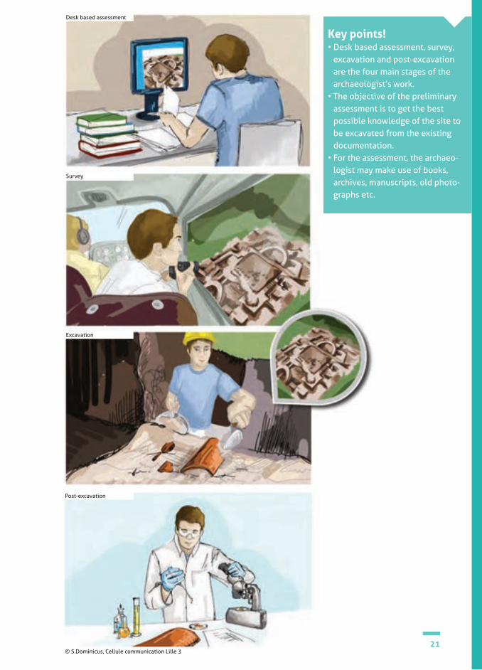
The archaeologist's work is very varied: every period of human history is involved and many specialisms exist. But an archaeologist follows a meticulous work plan, consisting of four major stages: Desk Based Assessment, Survey, Excavation and Post-Excavation.
21
Key points! • Desk based assessment, survey,
excavation and post-excavation are the four main stages of the archaeologist’s work.
• The objective of the preliminary assessment is to get the best possible knowledge of the site to be excavated from the existing documentation.
• For the assessment, the archaeo-logist may make use of books, archives, manuscripts, old photo-graphs etc.
© S.Dominicus, Cellule communication Lille 3
Desk based assessment
Survey
Post-excavation
Excavation

22
A lot of evidence is protected by being buried for centuries. Ruins and objects of fired clay, metals, glass and stone tend to survive well. Often the mi-neral part (which is mostly calcium) of human and animal bone will also survive. This is the material we see when we find a skeleton.
But many things are lost through decay. Food remains will be the first to go, broken down by small animals in the soil (ants, worms etc) especially if buried near the surface. In soil conditions where oxygen, warmth and moisture are present, objects made from organic materials e.g. natural textiles, leather, paper, wood, the soft tissue of humans and animals and the organic part of their bones (collagen), will gradually be broken down by bacteria.
If warmth, moisture or oxygen is absent there is a far greater chance of preservation. We find this on permanently frozen sites, desert sites and water-logged sites.
The wooden Bronze Age boat survived because it lay buried in waterlogged sediments on the coast of Dover.
The science of decay and survival
Roman pottery sherds (Kent, England) © Canterbury Archaeological Trust
The Dover Bronze Age boat on site (Kent, England) © Canterbury Archaeological Trust
Bibliography• English Heritage on the web:http://www.english-heritage.org.uk/publications/waterlogged-wood/waterlogged-wood.pdf
SECTION 2What do archaeologists do?

23
Key points!• What archaeologists find on a site is only a fraction of what once
existed.• Objects made of organic materials usually decompose in the soil.
Roman sandal soles on a Canterbury site (Kent, England) © Canterbury Archaeological Trust

24
Activity suggestion no 1Try an experiment
Objectives: • looking at materials and how they behave over time, collecting data, making a record.
Equipment needed: • (see below).
Digital support? • no.
Activity (as a class and in groups).
1. DiscussWhat kind of things do children think last a long time? What kind of things rot away?
Most children will have seen rotting food and some will have seen wildlife in various states of decom-position!
2. The experimentTry burying a variety of things in the ground e.g. apple, cheese sandwich, 50p coin, animal bone, pottery, paper bag, plastic pen. Dig them up again after a few months. You should not expect to see any change in most of these things after a short period but the food should be rotten! This is not an exercise for immediate results, so…
Near the start of the school year, children could be told the plan and could choose some things to bury. Make sure there are a variety of materials. Discuss with them what they think will have changed and what will look the same when you dig them up after Christmas (or later).
Keep a Before and After class record noting the condition of the objects on the day they were bu-ried and the day they were dug up. You could also take a photo of the things in their Before and After states.
SECTION 2What do archaeologists do?

25
We buried these things on (enter date) We dug the things up on (enter date)
Apple
Cheese sandwich
50p coin
etc
Whole, red, shiny
Fresh
Shiny
(Describe the condition of each object: smell, feel, appearance etc)


SECTION 2CHAPTER I
How are archaeological sites discovered?

28
Ground survey requires no particular tool, other than a keen sense of observation. On the ground, the ‘surveyors’ walk in a line, a few metres apart. They have to note any clue or trace which could indicate the presence of an archaeological site. Ground survey takes place for example in cultivated fields, espe-cially after ploughing, when archaeological finds are sometimes brought to the surface. They can be pottery sherds, building mate-rials, coins, worked stone and so on. Accor-ding to their quantity, the archaeological remains are either all collected or partially sampled. The precise location of these finds is recorded thanks to a Global Positioning System (GPS), which enables a distribution map to be produced.
Aerial survey involves looking for clues of ancient human activity while flying over the survey area at low and medium altitudes. Buried ancient structures such as walls leave traces in the modern landscape. In a field, for example, a range of geometric shapes depending on the kind of structure can be revealed by colour differences in the soil or crops.
The purpose of geophysical resistivity survey is to investigate the subsoil by using certain principles of physics. Its main merit is that it is not destructive; we can obtain information about what is in the ground without digging it up. The principle consists of sending an electric current into the soil at regular intervals and measuring its resistivity in order to be able to detect and map any archaeological remains. The presence of archaeological remains changes the soil’s resistivity: a stone wall will slow down the current and will therefore increase the resistivity, whereas a wet ditch will conduct the current better than ‘normal’ soil and will therefore decrease the resistivity.
Geophysical survey can be used throughout the period of excavation and is very use-ful when archaeological structures extend beyond the confines of the excavation area. For example, when excavations are car-ried out prior to motorway construction, they are limited to the confines of the road route and archaeologists are not allowed to extend into adjoining land. Geophysical sur-vey would however give the archaeologists a picture of the overall area.
Survey methods
SECTION 2CHAPTER I.1 How are archaeological sites discovered?
There are several kinds of survey: on foot (also called ‘ground survey’), geophysical and aerial. Survey is a method of archaeological investigation involving the location of any archaeological traces of human activity.
prospection pédestre
Ground survey © X.Deru Aerial photograph of circular structures at Koekelare-Pottebezem, Flanders, Belgium © University of Ghent

29
Key points! Surveys are undertaken on sites considered for excavation.
There are three types of survey:• Ground survey is carried
out by walking over an area looking for remains brought to the surface of the soil.
• An aerial survey can identify a site seen from a plane.
• A geophysical survey can give information about what is beneath the ground surface without having to break into it.
The archaeological site at Fresnes-
lès-Montauban was identified by aerial
survey
FR
Canterbury Young Archaeologist Club took
part in a ground survey at the
Thanet Earth site
Geophysical survey along the Seine-Nord Europe canal © Inrap
After F.Dieulafai, Copain de l'archéologie, Toulouse : Éditions Milan,1999, p.25
BE
UK
The magnetic field changes in intensity when near a buried structure.
Aerial survey in Flanders showed a significant amount
of Bronze Age funerary circles

30
Activity suggestion no 2Soil, a conductor of electricity
SECTION 2CHAPTER I.1 How are archaeological sites discovered?
Objectives: • to see a demonstration of electrical conductivity in the classroom;• to put this in the context of geophysical survey on an archaeological site.
Equipment needed: • light bulb;• scissors;• 4.5 volt battery;• demineralised water;• 2 electrical wires;• cooking salt;• glass beaker.
You will find in the teaching kit all the necessary equipment for performing and demonstrating this activity with your class.
Digital support? • no.
Activity (as a class or in groups):
1. fill a glass with some demineralised water;
2. place a different electrical wire on each post of the battery and connect them to the bulb > the bulb lights up, the current is passing through;
3. with scissors, cut one of the two wires> the bulb goes out, the current is no longer passing through;
4. plunge the two ends of the wire that you have just cut into the glass of water > the bulb remains unlit, the current is still not passing through;
5. put some salt into the glass beaker and wait until it dissolves in the water> the bulb lights up, the current passes through due to the mineral (salt) in the water.

31
Activity suggestion no 3Archaeology seen from the skyObjective:• to find out about aerial survey.
Equipment needed:• DVD in the kit, Fingerprints of the Past: Introduction to Aerial Archaeology. DVD. Amiens: CRDP, 2006. Ref. 800DVD01;• DVD player;• digital projector and whiteboard.
Digital support? • yes.
Activity (as a class):• watching and discussing the film.

32
Archaeological RegulationsIn France, the State Department issues ar-chaeological regulations of two kinds: regar-ding evaluation and regarding excavation.An evaluation seeks to assess the archaeological potential of a piece of land before the develop-ment work begins (road, car park etc). Mecha-nical investigation is preferred and archaeo-logists have to adapt to circumstances. Only the area affected by the development work is explored and not adjoining areas, except in the event of the results requiring further investi-gation in the context of a research excavation. Moreover, the presence of archaeology does not necessarily necessitate an excavation. There are four possibilities:• the evaluation is negative and the State autho-
rises the developer to undertake his work;• the evaluation is positive, i.e. some archaeo-
logical remains have been discovered, but the State considers that they are not of major scientific interest and the developer is autho-rised to undertake his work;
• the evaluation is positive and the State consi-ders the archaeology to be of scientific inte-rest and in a good state of preservation. It can decide that an archaeological excavation should go ahead;
• the evaluation has found a discovery of exceptional archaeology that will have to be conserved in situ. The State asks the developer to integrate the remains in the development or to relocate the construc-tion project.
In Belgium, archaeology is a regional matter as local laws apply for each region. Surveys and archaeological conditions are imposed by the archaeological curators of Agentschap Onroerend Erfgoed (Archaeological Heritage Agency), appointed by the Flemish government. The first step is checking the data available in the databank of CAI Flanders. Based on specific information and knowledge available about a threatened zone, a desktop investigation and/or trial trenching investigation and/or a drilling investigation could be undertaken by the relevant archaeological curators. Based on the results obtained it is then decided to release the area following a negative evaluation or to order an excavation if archaeological traces have been identified with sound scientific potential. The Flemish archaeological curators impose conditions on archaeologists and they are also responsible for writing a schedule of requirements, which may coincide with recommendations from existing regional archaeological services. Decisions concerning archaeological research are made on site.
In England, the planning departments of local government authorities decide on a site-by-site basis if archaeological intervention is necessary prior to building works. The national record of archaeological data for all periods is the Historic Environment Record and this is consulted by the planning authorities to decide if evaluation of the site in question is required. This work is usually carried out by commercial
Excavation during development work
SECTION 2CHAPTER I.2 How are archaeological sites discovered?
The nature of archaeological activity has evolved considerably since the beginning of the 20th century, particularly with the development of commercial archaeology where investigation is carried out prior to new building development schemes such as: industrial estates, roads, houses or shops.

33
The sites at Roeux and Fresnes-lès-Montauban were discovered along the route for the high-speed TGV Nord line
FR
Key points!
In France, ‘preventive’ exca-vations take place as a result of building development works.
In Belgium, archaeology is a regional matter where local laws apply for each region. Surveys and archaeological conditions are imposed by the archaeological curators of Agentschap Onroe-rend Erfgoed (Archaeological Heritage Agency). The first step is checking with CAI Flanders for any available data for the area. Depending upon results and pe-rhaps trial trenching, a decision is made whether an excavation is necessary.
In England, the planning departments of local government authorities decide on a site-by-site basis if archaeological intervention is necessary.
BE
Building development works © Communauté d'agglomération du Douaisis - Direction de l'archéologie préventive
Aerial photograph of the Estrées (France) site © P.Frutier - Altimage
UKThe Bronze Age boat
was discovered where a road was to be built
between the Dover port and the Channel Tunnel
archaeological companies employed by the developer. If significant archaeology is found to be present, then every attempt is made to avoid damage to the historic environment by changing the development plans. Only if this proves to be impractical will archaeological excavation take place.
Remains of Bronze Age and Iron Age
settlements were found on a commercial re-development site at
St-Denijs-Westrem


SECTION 2CHAPTER II
The excavation site or ‘dig’

36
EquipmentThis consists of a hard hat, which must be worn wherever there is a risk of falling ob-jects, like near site machinery or working in a trench. According to the fieldwork being done, people can wear safety gloves to pro-tect their hands when using tools or when the soil on the dig is polluted. Safety shoes support their ankles and protect their feet, safeguarding the arch of the foot and the toes with steel toecaps. They can be swap-ped for safety boots in muddy conditions. During work on polluted sites or on ones where there is a risk of gas, vapour or dust inhalation, the diggers are supplied with respirators. Safety glasses are worn when conditions are dusty or there is a risk of flying debris.
When working with site machinery the ar-chaeologist can also wear ear protectors, par-ticularly when noise levels exceed 85 deci-bels, as can be the case working alongside a mechanical digger during topsoil stripping.
It is above all very important that an indi-vidual can be seen on an excavation site. A high visibility vest or jacket is mandatory when working in the vicinity of plant machinery.
Safety RulesNear a machine, archaeologists should not remain in blind spots nor come within range of the machine without warning the operator and checking that they have properly understood. There are also traffic rules on a site, which itself must be secured and marked out with orange netting or fencing.
When cutting excavation trenches, it is forbidden to go deeper that 1.3 metres without special arrangements.
Public visits are not allowed without prior notification to the Site Health and Safety Officer. In areas that have experienced bombing, such as northern France, archaeologists can come across dangerous discoveries such as unexploded devices that are still live. In this case, the archaeologist must alert the authority’s special services and set up a safety zone of 100 to 150 metres until civil security officers can intervene.
Tools and safety
SECTION 2CHAPTER II.1 The excavation site or ‘dig’
Some of the work of the archaeologist takes place outside, often in the presence of site machi-nery. He or she uses tools specific to the profession, sometimes handling dangerous materials or digging in dangerous areas. An archaeologist must therefore wear specific equipment and have training in the basic rules of health and safety. Personal safety equipment is provided for the excavators and it is compulsory to wear it whilst digging.

37
Key points! • Archaeologists have a profession that can sometimes
be dangerous and they take safety seriously. • They must wear a hard hat, safety gloves and boots;
when necessary they also wear a hi-viz jacket, respi-rator, ear defenders and goggles.
• They never run on a site. There are strict rules about this.
Excavation of an archaeological site © Communauté d'agglomération du Douaisis - Direction de l'archéologie préventive
ToolsTo excavate the site and record what they find, archaeologists use specific tools, often tools of other trades like the gardener, dentist, mason and construction worker! The most symbolic tool of the trade is obviously the trowel, un-doubtedly the one that is most used on an exca-vation. It allows the excavator to remove just a few centimetres of soil. The earth is scraped off little by little, enabling very small objects to be found. This tool can also be used to remove soil from newly unearthed objects. There are various sizes of trowel, the smallest being used for the most meticulous work. For fine work, on a grave, for example, there is a whole va-riety of dentist’s tools. The brush is also emble-matic of the trade, used to remove sediment.But the archaeologist doesn’t only do meticu-lous work.
To uncover structures hidden under several square metres of soil, the archaeologist uses a shovel and a pickaxe. To make sure that no finds (especially the smallest) are missed in the excavated soil, the archaeologist puts it into buckets, in order to pass it through sieves. He
or she also uses a sieve to find organic remains such as charcoal (for Carbon-14 dating for example), or seeds.
In order to record the features in the ground and to create plans and drawings the archaeologist needs a tape measure, a plumb bob and a site level to measure height above OD. A theodolite or tacheo-meter allows the level of the site to be cal-culated relative to sea level. The levelling staff, along with the site level permits the relative level of each point on the site to be recorded.

38
Activity suggestion no 4 The excavation site
SECTION 2CHAPTER II.1 The excavation site or ‘dig’
Objective:• to identify the archaeologist’s professional equipment.
Equipment needed: • USB pen in the kit; • computer;• digital projector.
Digital support? • yes.
Activity (as a class): to show photographs of a site during excavation and to discuss the equipment and tools used by the archaeologists.

39
Activity suggestion no 5The archaeologist’s tools
Objective: • to �nd out and memorise the name of each tool.
Equipment needed:• game supplied in the kit. Digital Support? • no.
Activity (in groups):to start the game, place all the shuf-�ed cards face down on the table so that the images are not visible.
�e �rst player turns over two cards. If they are identical, he or she wins them, if not, they are turned face down again. �e next player then turns over two cards and so on.
�e goal is to try to memorise the position of the various cards in order to turn over a pair of identical cards. �e pupil will try to name the tools appearing on the cards that he or she turns over.
When a player wins a pair, it gives him or her the right to play again.
�e game is over when all the pairs have been found. �e player who has won the most cards has won the game.

40
UKAt Thanet Earth, soil
stripping revealed the brick steps of a
subterranean World War ll structure in one area of the siteTopsoil stripping
SECTION 2CHAPTER II.2 The excavation site or ‘dig’
This operation, which varies in duration accor-ding to the size of the site and the thickness of the soil, is carried out by means of a large mechanical digger equipped with a bucket between 2.5 and 3.0 metres wide. It is essen-tial that the soil is stripped in flat and regular successive phases so that features can be detec-ted. It is the archaeologist, positioned opposite the mechanical digger, who guides the machine operator. He or she lets him know whether he should go down more deeply or not and stops him if features appear. Good coordination and a good understanding between the archaeologist and the machine operator are essential.
The quantity of earth removed can vary from 20 centimetres to several metres, as is the case on some prehistoric sites. In the case of very deep discoveries, stripping in stages is neces-sary for safety reasons: the site then resembles an upside-down pyramid.
Topsoil stripping is a tricky business since we need to know how to remove as much earth as possible without damaging the archaeology. The archaeologist has several ways of spotting remains. The first clue is a variation in colour of the soil: a darker mark, brown to black, usually indicates an archaeological structure. Texture is an additional pointer: the earth around an archaeological structure is often less compact than the natural subsoil. The appearance of ob-jects (fragments of pottery, bones, flint tools, etc) or masonry indicates an imminent disco-very.
After the mechanical digger, we often need to move to a finer stripping phase. The archaeologists use a small hoe, a much smaller tool, the end of which must be sharp. They clean the surface of the archaeological layer so that it is really flat. Rain or drought can cause the marks of archaeological structures on the surface to disappear. For this reason, fluorescent paint is often used to mark the outlines of features before excavating them. As the stripping progresses, the gradual appearance of features makes it possible to see the human occupation on the site. The archaeologist can then begin the excavation.
The archaeologists are kitted out, the site’s safety arrangements are in place and so topsoil stripping can begin. This is the first concrete action that marks the beginning of a dig. The stripping of an area consists of removing the surface layer of earth until the archaeological levels are reached.
Soil stripping at the paleolithic site at Étricourt (Seine-Nord Europe canal) © Inrap

41
Key points!• Soil stripping entails removing layers of earth until you
reach the archaeological levels.• It is carried out with the help of a big mechanical
bucket, then a skimmer for a finer strip.• The ground must be stripped in successive phases,
regular and flat.• There are several ways remains can be detected;
variations in soil colour and texture; and appearance of objects or masonry.
FRAt Fresnes-lès-Montauban,
soil stripping brought to light 5 circular enclosures, not all the same size; the
smallest measured 10 metres in diameter, the
biggest 25 metres
Marking a feature on the Thanet Earth site (Kent, England) © Canterbury Archaeological Trust
BEThe dig at St-Denijs-Westrem brought to light several wells
Topsoil stripping © CG62

42
Archaeological traces can have several origins: • Construction. When a building is constructed, the ground must be levelled and foundations or post holes will be dug. It is the traces of these actions that allow the archaeologist to say if there had been a building on the site. How do we know if there had been a post in this or that place if it has completely disappeared? We know because the hole dug for holding the post has left evidence of its previous existence. Its presence is visible as a ‘negative feature’ in the strata. The archaeologists can see that the soil is of a different composition and colour. This is known as an ‘anomaly’.
• Occupation. The inhabitants organised their living space and used various kinds of objects, the traces of which, usually fragmented, were abandoned or thrown away. We can find these traces in the stratigraphy.
• Infilling. This involves bringing in earth, for example, to fill in a ditch or a hole or to level the ground. But the soil used may itself contain remains that pre-date the time of the infilling. The layers formed by these infillings will then contain a mixture of material derived from quite different periods.
• Destruction. Archaeologists infer that des-truction has occurred when they find, for example, traces of fire or a collapsed roof.
• Abandonment. A site can be said to be aban-doned when human activities are no longer present. Nature quite simply continues its work, and layers of sediment will build up.
Stratigraphy is a‘relative’ dating method, in contrast to methods that allow ‘absolute’ dating of features, like radiocarbon dating or den-drochronology, which can give more precise results. It must therefore be used with caution. Just because a pottery sherd is found in a stra-tigraphic layer belonging to this or that period doesn’t mean that the pottery was actually made in that period. Similarly, two pottery sherds can be found side by side during an exca-vation but not date from the same period. It’s like our crockery; we can still today keep plates in our cupboards made over a century ago! It is therefore the collection and detailed study of all the elements found on site and the integra-tion of the data obtained that allows the most precise dating possible of an archaeological site.
Stratigraphy
SECTION 2CHAPTER II.3 The excavation site or ‘dig’
The concept of stratigraphy was borrowed from geology in the 19th century. It is the science of describing stratigraphic units, otherwise known as strata or geological layers and studying their form, their chronological sequence and their history. The basic principle of stratigraphy is that the oldest layers are thought to be the deepest. But things are not so simple! Stratigraphic units are not formed by the action of nature alone, but also by the actions of people, by ‘cultural’ activities, which leave behind many traces.
The majority of archaeological sites were successively occupied over time, with each phase of occupation representing a different period. These strata of human occupation are examined in detail. For the archaeologist, interpreting them can be a complicated business.
BibliographyD. Tavernier, Découverte d’une maison gallo-romaine, Rennes : Ouest-France, 1985.

43
UK
BE
Reconstruction drawing of the fortification at the Chevincourt site (Oise) © B. Lambot 2011
Section drawing relating to the photograph above © S.Toron/E.Wyremblewski
The ditch of enclosure 1 at Fresnes-Lès-Mon-
tauban was filled with 5 different layers of
stratigraphy
FR
Key points! • Stratigraphy is the formation of layers in the ground
as a result of man’s activities and natural events.• The traces that the archaeologist finds can have
several origins, like a construction layer, occupation or the fill of a pit.
• Using the stratigraphy on a site enables a method of dating known as ‘relative’ dating.
The Dover Bronze Age boat lay 6 metres down in the stratigraphic sequence,
below medieval and Roman remains
Archaeological site at Chevincourt (Oise). Detail of the fortification © E. Wyremblewski
Topsoil
Blocks of limestone
Blocks of reddened limestone
Numerous carbon fragments
What remains of a wooden building tends
to be the post holes. The plan of these in
the ground allows us to reconstruct its shape

44
Activity suggestion no 6
SECTION 2CHAPTER II.3 The excavation site or ‘dig’
Picture 2. This is a simple drawing of the layers on an archaeological dig. It is like a huge rubbish bin. Here there may be 100s or 1000s of years represented between the top and the bottom. Which layer is the most recent? Which layer is the oldest?
Picture 1. On which day was the last layer of rubbish put into this bin? On which day was the first layer of rubbish put in? Which day do you think has the oldest rubbish?
Rubbish bin stratigraphy © Canterbury Archaeological Trust Simplified site stratigraphy © Canterbury Archaeological Trust
Objective :• to find out about stratigraphy.
Equipment needed:• USB pen in the kit; • computer;• digital projector.
Digital support? • yes.
Activity (as a class):
History is a load of rubbish!
Talk with pupils about the kinds of remains archaeologists find. A lot of it is old rubbish! But it is valuable rubbish because it is evidence for people’s everyday activities in the past.
Talk about how archaeologists find this evi-dence in layers which have built up over time. These pictures will help pupils to understand how. You can make photocopies or use the image files on the digital pen.

45
Picture 3. This is more like a real archaeologi-cal site. Which layer is the most recent? Which layer is the oldest? Find the rubbish pit dug by somebody in medieval times. See how the pit has cut down through the layers underneath. Which layers has it cut through? The pit is full of bits of building and objects from these times.
Realistic site stratigraphy © Canterbury Archaeological Trust

46
The process of excavation is based on the ‘plan’ and the ‘section’ of a site. The plan corresponds to the horizontal dimension of human activity. The section relates to the vertical dimension of human activity with strata being laid down over time. The section allows the establishment of a relative chro-nology.
Depending on the site, an archaeologist will emphasise the vertical view in order to get to grips with the stratigraphy, while on another site, the horizontal view may be essential in looking for the spatial relationships between objects and structures. Both dimensions have to be considered.
The objective of the topographic survey is to draw up an accurate plan of the site and to map discove-ries. The work is carried out in three dimensions, recording horizontal X and Y co-ordinates along with elevation above sea level. The archaeologists or surveyors use measuring instruments such as site levels, theodolites etc. Computerisation is stan-dard and the surveys are recorded precisely and quickly by increasingly improved instruments in addition to the use of a Global Positioning System (GPS).
Data recording
SECTION 2CHAPTER II.4 The excavation site or ‘dig’
Registering and recording an oven on site © CG62Measuring on site (Kent, England) © Canterbury Archaeological Trust

47
Recording the levels on the site of Fresnes-lès-Montauban, using a theodolite © Inrap
Computers assist the documentation process © communauté de commune douaisis, direction de l'archéologie preventive

48
SECTION 2CHAPTER II.4 The excavation site or ‘dig’
Archaeological drawing is an essential stage of excavation or post-excavation work. When illustrating an artefact, the drawing should both represent the object itself and highlight any technological information about it.
Tools used include graph paper, tracing paper, measuring instruments (rulers, tape measures, callipers etc.), pencils, a set square and a profile comb for drawing finds. The process involves making a series of measurements and using a continuous line to trace the outline of the object. In order to give an impression of volume, stippled sha-ding allows variation in light and shade to be expressed. The closer the dots are, the dar-ker the shade. The illustrator follows some strict conventions, for example the blade of
a sword or an axe is always facing downward, while a spearhead is always drawn with its point upward.
Photography is commonplace in archaeo-logy these days. It should enhance objects, stratigraphy, structures etc. A photograph is an archaeological record along with the drawing. All archaeological photographs must be catalogued and must include a scale and (on site) an arrow indicating North.
Set square
Callipers
Callipers
Notebook
Graph paper and tracing paper
Pencils and pens
Pro�le comb

49
Recording burials dated to the Gallo-Roman period at the site of Cléry-sur-Somme (Somme, France) © Inrap
Key points! • A plan drawing shows a horizontal view of the human
activity at a point in time, while a section drawing shows a vertical view, which may be of a succession of activities over a long period of time.
• Topographical survey can develop a precise plan of the site and location of its discoveries.
• Illustration enables us to show the artefacts found and highlight any technological information about them.
• Photography is also a technical process and com-pletes the principal set of data recording.
Topographical survey at the paleolithic site at Étricourt (Seine-Nord Europe canal) © Inrap
Surveying with theodolite (Kent, England) © Canterbury Archaeological Trust
Surveying with GPS (Kent, England) © Canterbury Archaeological Trust

50
Activity suggestion no 7How to classify objects like an archaeologist
SECTION 2CHAPTER II.4 The excavation site or ‘dig’
Objective : • to classify objects;
Equipment needed:• replicas and original finds in the kit;
Digital support?• no.
Activity (as a class or in groups):
Take all the objects from the kit, lay them out and allow pupils time to freely explore them.Next see how many ways they can group them.
They could make a list under each of their headings.
Here are some ways. The pupils may think of more.
• By function (e.g. Pottery, building materials etc);• by material (clay etc);• by whether manufactured (artefacts) or natural (ecofacts);• by date or period (start with ‘old’ and ‘mo-dern’; look in the kit booklet to find dates of the objects);• by whether an original artefact or a replica.
You could expand this activity by adding some other modern or older objects to the range.
51
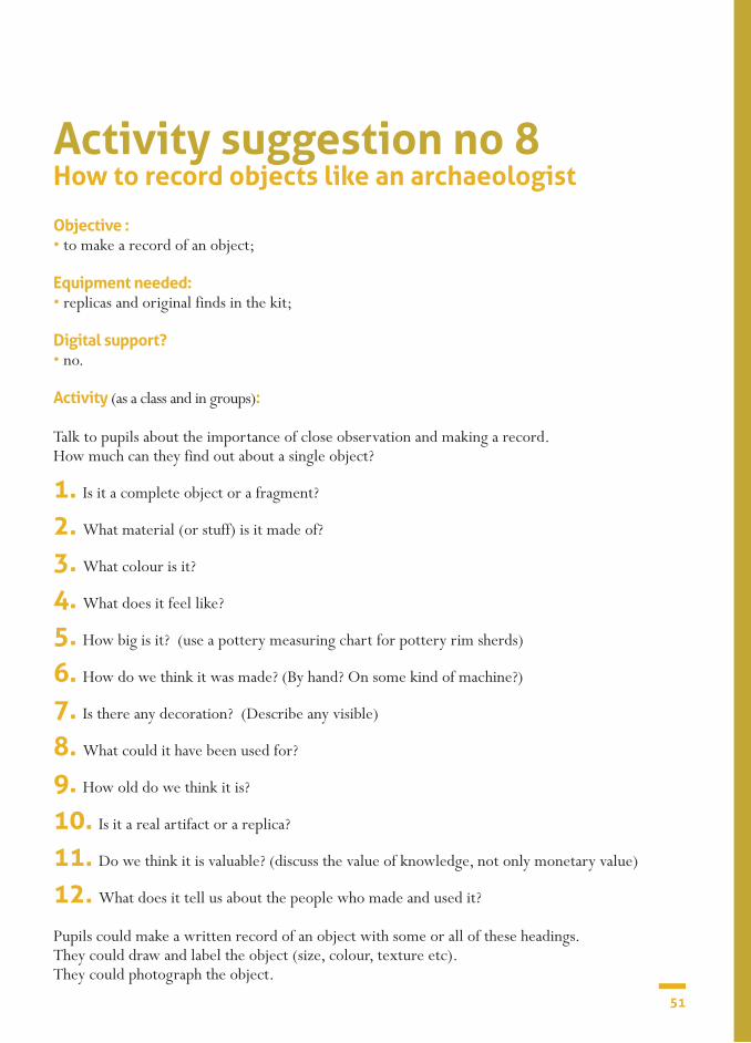
Objective : • to make a record of an object;
Equipment needed:• replicas and original finds in the kit;
Digital support?• no.
Activity (as a class and in groups):
Talk to pupils about the importance of close observation and making a record. How much can they find out about a single object?
1. Is it a complete object or a fragment?
2. What material (or stuff) is it made of?
3. What colour is it?
4. What does it feel like?
5. How big is it? (use a pottery measuring chart for pottery rim sherds)
6. How do we think it was made? (By hand? On some kind of machine?)
7. Is there any decoration? (Describe any visible)
8. What could it have been used for?
9. How old do we think it is?
10. Is it a real artifact or a replica?
11. Do we think it is valuable? (discuss the value of knowledge, not only monetary value)
12. What does it tell us about the people who made and used it?
Pupils could make a written record of an object with some or all of these headings. They could draw and label the object (size, colour, texture etc). They could photograph the object.
Activity suggestion no 8How to record objects like an archaeologist


SECTION 2CHAPTER III
The science of archaeology
54
Pottery studies
SECTION 2CHAPTER III.1 The science of archaeology
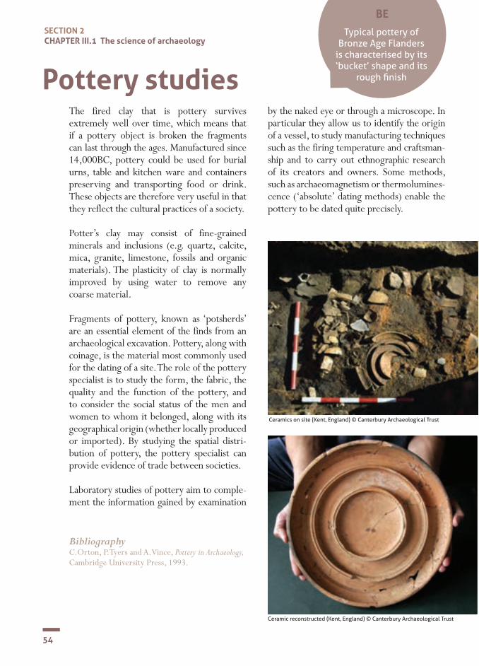
The fired clay that is pottery survives extremely well over time, which means that if a pottery object is broken the fragments can last through the ages. Manufactured since 14,000BC, pottery could be used for burial urns, table and kitchen ware and containers preserving and transporting food or drink. These objects are therefore very useful in that they reflect the cultural practices of a society.
Potter’s clay may consist of fine-grained minerals and inclusions (e.g. quartz, calcite, mica, granite, limestone, fossils and organic materials). The plasticity of clay is normally improved by using water to remove any coarse material.
Fragments of pottery, known as ‘potsherds’ are an essential element of the finds from an archaeological excavation. Pottery, along with coinage, is the material most commonly used for the dating of a site. The role of the pottery specialist is to study the form, the fabric, the quality and the function of the pottery, and to consider the social status of the men and women to whom it belonged, along with its geographical origin (whether locally produced or imported). By studying the spatial distri-bution of pottery, the pottery specialist can provide evidence of trade between societies.
Laboratory studies of pottery aim to comple-ment the information gained by examination
by the naked eye or through a microscope. In particular they allow us to identify the origin of a vessel, to study manufacturing techniques such as the firing temperature and craftsman-ship and to carry out ethnographic research of its creators and owners. Some methods, such as archaeomagnetism or thermolumines-cence (‘absolute’ dating methods) enable the pottery to be dated quite precisely.
Ceramics on site (Kent, England) © Canterbury Archaeological Trust
Ceramic reconstructed (Kent, England) © Canterbury Archaeological Trust
BibliographyC.Orton, P.Tyers and A.Vince, Pottery in Archaeology, Cambridge University Press, 1993.
BE
Typical pottery of Bronze Age Flanders
is characterised by its ‘bucket’ shape and its
rough finish
55
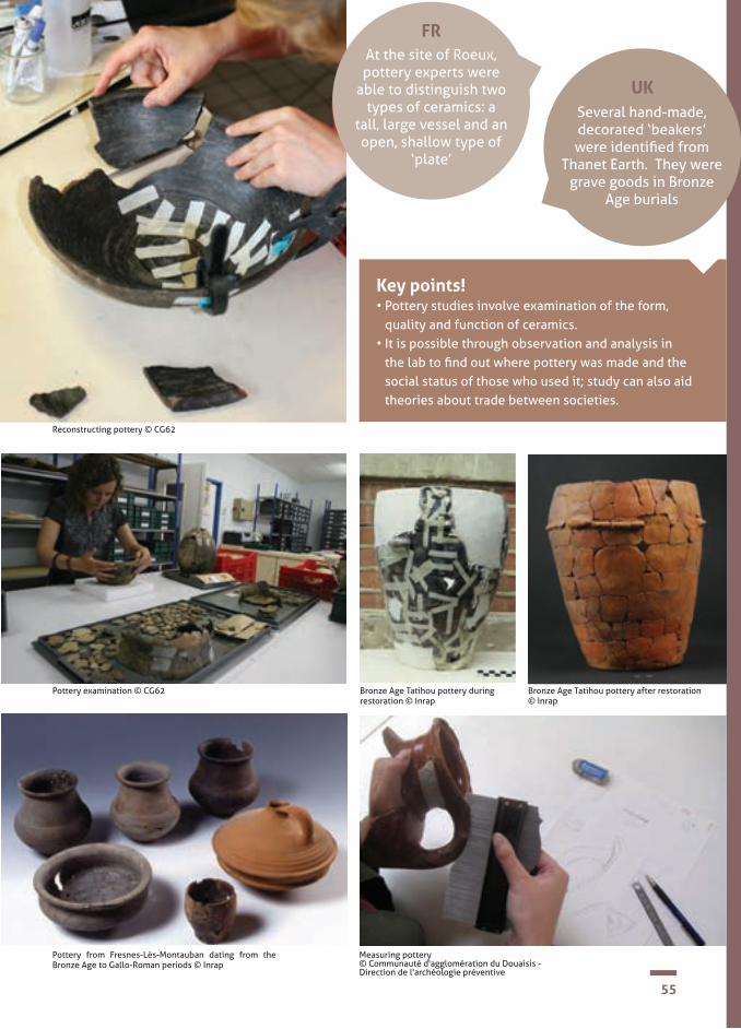
Key points! • Pottery studies involve examination of the form,
quality and function of ceramics. • It is possible through observation and analysis in
the lab to find out where pottery was made and the social status of those who used it; study can also aid theories about trade between societies.
Several hand-made, decorated ‘beakers’ were identified from
Thanet Earth. They were grave goods in Bronze
Age burials
Pottery from Fresnes-Lès-Montauban dating from the Bronze Age to Gallo-Roman periods © Inrap
Bronze Age Tatihou pottery after restoration © Inrap
Bronze Age Tatihou pottery during restoration © Inrap
UK
Measuring pottery © Communauté d'agglomération du Douaisis - Direction de l'archéologie préventive
At the site of Roeux, pottery experts were
able to distinguish two types of ceramics: a
tall, large vessel and an open, shallow type of
‘plate’
FR
Pottery examination © CG62
Reconstructing pottery © CG62

56
Activity suggestion no 9 How to examine pottery like an archaeologist
SECTION 2CHAPTER III.1 The science of archaeology
Objective : • close observation, asking questions, estimating, making interpretations, looking at materials and their uses, making a record;
Equipment needed:• pottery in the kit;• pottery measuring chart in the kit;
Digital support?• no.
Activity (as groups or individuals): Examine some pottery. How much can pupils find out?
1. Is it a complete vessel or a fragment?
2. What material (or stuff) is it made of?
3. What colour is it?
4. What does it feel like?
5. How big is it? (use a pottery measuring chart if you have a pottery rim sherd)
6. How do we think it was made? (By hand? On a machine?)
7. Is there any decoration? (Describe any you can see)
8. What could it have been used for?
9. How old do we think it is?
10. Do we think it is valuable?
Pupils could draw and label their pottery (size, colour, texture etc).

57
Here is my drawing of the pottery.
The drawing is smaller than / about the same size as / bigger than the real thing. (circle one of these)
If they have a fragment, they could also try drawing what they think the complete pot looked like.
Now I have finished my examination, this is what I have learnt.

58
Activity suggestion no 10 Restoring pottery
SECTION 2CHAPTER III.1 The science of archaeology
1. divide class into groups of maximum 5 in each group;
2. obtain and break the 2 ceramic vessels for each group;
3. once the pots have been broken, mix the sherds and leave them on the table. Swap the groups around so that the pupils do not recognise their pots;
4. explain how pottery specialists group sherds by colour, thickness, shape and pattern;
5. leave the pupils to work. Their aim is to try and reconstruct the vessels.
As it takes time to stick sherds together, this activity may be spread over several days – a little at a time!
Objective: • to find out about the pottery specialist’s work and try reconstructing some pottery.
Equipment needed: • the glue supplied in the kit;• 2 cheap ceramic vessels of different design per group.
Digital support? • yes. DVD: Archaeology Experts, The Pottery Specialist.
Activity (in groups):

59Reconstructing pottery © Denis Gliksman, Inrap

60
Lithics
SECTION 2CHAPTER III.2 The science of archaeology
The expert who studies stone artefacts is called a ‘lithics’ specialist. Since the 20th century, researchers have tried to establish a methodology for studying stone objects in order to learn about ancient communities. Flint knapping, often associated with Prehistory, is not in fact specific to any one period. This craft existed in every historical period up until the 19th century.
A stone object cannot be separated from its geological and archaeological context. Stone is a natural material. Flint is the best known material, but other rocks were used. The stone worker used all the materials at his disposal.
To ‘knap’ is a general term used by archaeologists to describe the process of intentionally fracturing rocks. The recognition of techniques by the specialist is based on long experience of studying archaeological examples but also on experi-mentation. Experimental archaeology holds an important place in the study of lithics: for example, you can knap stone using different techniques and compare the marks on these pieces with those on archaeological remains.
A stone artefact, such as a tool or a weapon, can perhaps be made in two ways: either by direct shaping of the raw material, because its form lends itself to its production, or, when the desired artefact cannot be obtained immediately, the raw material must be prepared by knapping. Here the goal is to produce flakes, which can be worked further or used as they are. The material which you strike is called the core. Shaping is a technique
that does not require flakes, because the material lends itself to the manufacture of the piece itself. The craftsman can work by knapping a nodule or a large blade of flint. Percussion is a technique that be used either for flaking, shaping or retouching. It can be direct or indirect. When it is direct, it is done by striking with a hard percussive device (such as a pebble or nodule), but it also can be done with perishable materials such as wood or bone. To apply the force exactly where it is wanted, the craftsman can knap by means of indirect percussion.
Once the material recovered from an excavation is catalogued, a lithics specialist must make a technical study of each object, e.g. what was the primary material used (flint, obsidian, etc) or what techniques were used for making the object (such as flaking or percussion). There are often many traces on these objects that can be thousands of years old, undetectable to the novice, but full of information for the specialist.
Microwear analysis, for example, is a discipline that aims to determine the function of objects by studying the traces produced during their use. It is based on an examination of wear marks at a microscopic scale. Each material ‘records’ traces that can be identified thanks to a collection of comparative material established during experimental archaeology.
BibliographyJ.-L. Peil-Desruisseaux, Outils préhistoriques. Du galet taillé au bistouri d’obsidienne, Paris : Dunod, 2013 (6e édition)

61
FR
BE
UK
Key points! • The expert who studies remains of flints is called a
lithics specialist.• ‘Knapping’ is the term an archaeologist uses to
describe the action of deliberately fracturing a rock.• The craft of flint knapping was practised from the
earliest times up to the 19th century.• Experimental archaeology plays an important role in
the study of lithics.
A prehistoric flint arrow head and flint scraper were found while sur-
veying the Thanet Earth site
At Roeux 820 flint objects were discovered
during the excavation
Bronze Age arrow heads are shaped like two wings, one either
side of a ‘stem’
Flint tools from The Meads, Sittingbourne (Kent, England) © Canterbury Archaeological Trust
62
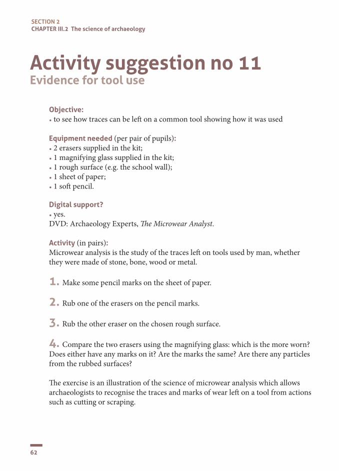
Activity suggestion no 11 Evidence for tool use
SECTION 2CHAPTER III.2 The science of archaeology
Objective: • to see how traces can be le� on a common tool showing how it was used
Equipment needed (per pair of pupils): • 2 erasers supplied in the kit;• 1 magnifying glass supplied in the kit;• 1 rough surface (e.g. the school wall);• 1 sheet of paper;• 1 so� pencil.
Digital support? • yes. DVD: Archaeology Experts, �e Microwear Analyst.
Activity (in pairs): Microwear analysis is the study of the traces le� on tools used by man, whether they were made of stone, bone, wood or metal.
1. Make some pencil marks on the sheet of paper.
2. Rub one of the erasers on the pencil marks.
3. Rub the other eraser on the chosen rough surface.
4. Compare the two erasers using the magnifying glass: which is the more worn? Does either have any marks on it? Are the marks the same? Are there any particles from the rubbed surfaces?
�e exercise is an illustration of the science of microwear analysis which allows archaeologists to recognise the traces and marks of wear le� on a tool from actions such as cutting or scraping.

63
Examining a flint with the aid of a computer © Inrap

64
Preparing and examining a sample For an initial examination, a binocular microscope is used together with the naked eye. The analyst will examine the surface of the metal for any severely corroded areas and any traces of how the object was made and used.
To analyse the microstructure of a metal, a fragment is cut from the artefact using a watchmaker’s saw (Fig. 1). A 2mm² fragment is enough (Fig. 2). The sample is then coated in synthetic resin to make it easier to handle (Fig.3).
The surface of the sample is then carefully polished. This is a delicate stage, the aim being to achieve a ‘mirror’ surface. With the help of a polishing machine (Fig 4), the sample is polished in several stages by increasingly fine discs. Between each polish, the surface is examined under a microscope (Fig 5).
To see even more detail, the metal is then treated with a solution of iron chloride, ethanol and hydrochloric acid (Fig. 6). The aim is to oxidize the surface, so that certain characteristics of the metal’s microstructure emerge and can be observed more effectively (Fig 7).
An optical microscope is used to see the various treatments the metal has gone through during its manufacture and use. The metal actually memorises certain information.
A scanning electronic microscope is used to see the composition of a metal alloy. This is capable of huge magnification, with an image obtained point by point, between six and ten nanometres. It can be coupled with an X-ray analysis system.
Archaeometallurgy
SECTION 2CHAPTER III.3 The science of archaeology
Archaeometallurgy is the scientific study of how metals were made and used by ancient societies. In the 1930s, new analytical methods were developed by physicists which were then applied to ancient metals. Observations with the naked eye and under the microscope, together with ana-lysis of the composition of a metal alloy, can reveal how the metal was made. Knowing this helps us appreciate the skills of the craftsman at that time.

65
fig.1 © E. Wyremblewski
fig.3 © A. Lehoërff
fig.2 © A. Lehoërff
fig.5 © E. Wyremblewski
fig.6 Sample before effect of chemical treatment © A. Lehoërff fig.7 Sample after chemical treatment © A. Lehoërff
fig.4 © E. Wyremblewski

66
SECTION 2CHAPTER III.3 The science of archaeology
BE
Palstave axe on Thanet Earth site (Kent, England) © Canterbury Archaeological Trust
FRA copper alloy axe head
was discovered at the Roeux site
A copper alloy axe head was found at Thanet
Earth. Axes were used in the making of the Dover
Bronze Age boat
UK
A copper alloy axe was also found at Lochristi.
It may have been made in Britain and then imported into
Flanders

67
Key points!
• Archaeometallurgy is the scientific study of how metals were made and used by ancient societies.
• Examination and analysis require many processes (sampling, polishing and chemical treatment) and highly sophisticated equipment (binocular microscopes, X-ray machine, etc).
Axe from Roeux (France) © Inrap

68
Activity suggestion no 12What did the invention of bronze mean for people’s lives?
SECTION 2CHAPTER III.3 The science of archaeology
Objective: • to explore replica bronze objects;• to learn about the kind of people who made and used these things, thousands of years ago.
Equipment needed: • replica bronze axe;• replica bronze pin;
Digital support? • no.
Activity (as a class or in groups):
In the kit are two bronze replicas of real Bronze Age objects. Explore the replica axe and replica pin to learn about the kind of people who made and used these things, thousands of years ago.
Examine each replica bronze object with pupils. Encourage them to think about:• what it was used for;• what it is made of;• how it was made;• what kind of person would have made it;• what kind of person would have used it;• what we would use today;
In the kit booklet, you will find information about the manufacture and use of the original objects, from which the replicas have been made:• a Bronze Age axe found in Picardie (France); • a Bronze Age pin found at Merendree, Eastern Flanders (Belgium).
Similar types of axe have been found in Belgium and England and similar types of pin have been found in France and England, indicating cultural links between these three countries in the Bronze Age.
Hopefully, you will be able to dispel the myth that prehistoric peoples were ‘primitive’!

69
Replica of the axe © F. Gendre / BOAT 1550 BC
Illustration of pin found at Merendree © University of Ghent

70
FR
An archaeozoologist uses the animal remains discovered on an archaeological site to try and reconstruct the role of animals in the ancient environment and their relationship with man.
There are several areas of study: identifica-tion of the species, how animals were used and analysis of the consequences of human intervention on an animal population.
On archaeological sites, we may find the bones of vertebrates and the shells of invertebrates. Other animal material (fur, feathers, leather or internal organs) can also be studied when it has been preserved in exceptional conditions like very cold, wet or dry environments. DNA analysis may also be undertaken.
Much of the material is found using site tools and the naked eye. But a shovel and pickaxe are no good for finding fish-bones! Small animal remains will usually only be found when soils are sieved.
Certain species have precise ecological requirements and therefore may indicate what the landscape was like and what activities were happening around the site. They also help us understand the function of a site: mouse remains can, for example, reveal the proximity of a human settlement
In archaeozoology, we also study the traces left on bones. These may be:• Cuts made by weapons and tools. • Marks made during craft work, for example
in making weapons, tools or ornaments. • Traces made by rodents or carnivores.
The animal bones are examined looking for known characteristics of a family or a spe-cies. The first stage is to identify and sort the categories of bone: those of the head, ribs, vertebrae etc
Archaeozoology
SECTION 2CHAPTER III.4 The science of archaeology
Bibliography• M.-P. Horard-Herbin, J.-D. Vigne, Animaux,
environnements et sociétés, Paris : Éditions Errance, 2006.
• L. Chaix, P. Méniel, Archéozoologie.Les ani-maux et l’archéologie, Paris : Éditions Errance, 2001.
• English Heritage on the web http://www.english-heritage.org.uk/publications/environ-mental-archaeology-2nd/environmental-ar-chaeology-2nd.pdf
At Roeux, the archaeologists recovered
1177 bones, mostly cattle, which was 6kg of material!
BE
UKBronze Age rubbish near
the Dover boat had bones of sheep, pig, cattle and
red deer, some with butchering marks.
In the sandy soils of Flanders, bones from
the Bronze Age are badly preserved

71Ox skull on site (Kent, England) © Canterbury Archaeological Trust

72
SECTION 2CHAPTER III.4 The science of archaeology
Determining the age is essential for unders-tanding animal management in the past. It is important to know, for example, if the hunter refrained from killing certain age groups or which type of stock rearing was practised. Age is determined by examining the teeth and to what extent the skeleton has formed.
The sex is also useful when looking at ani-mal management. This can be determined by comparing particular bone structure and measurements with known reference col-lections.
Being able to distinguish between wild and domestic forms of the same species allows us to see certain changes that have come about through domestication of animals.
One of the main changes is a reduction in height, in particular for cattle, pigs and sheep, starting in the Neolithic period.
The first signs of the domestication of the wolf can be traced back to at least the Meso-lithic Age. Now, the domestic dog is man’s best friend.
Animal jaw bones on site (Kent, England) © Canterbury Archaeological Trust

73
Key points!• An archaeozoologist uses the animal remains discovered
on an archaeological site to try and reconstruct the place of animals in the ancient environment and their relationship with man.
• By assessing the provenance of the animal remains and analysing them, an archaeozoologist can give us information about the landscape, domestication of animals, animal management and other activities in the past .
Cattle horn cores (Kent, England) © Canterbury Archaeological Trust Fish bones and fish scales (Kent, England) © Canterbury Archaeological Trust
Cat bones showing marks of skinning (Kent, England) © Canterbury Archaeological Trust
Porpoise jaw (Kent, England) © Canterbury Archaeological Trust
Chewed animal bones from cess pit (Kent, England) © Canterbury Archaeological Trust

74
Activity suggestion no 13Examining animal remains
SECTION 2CHAPTER III.4 The science of archaeology
Objectives: • using evidence; • asking questions; • classifying information; • looking at materials and their uses; • recording.
Equipment needed: • animal bone in the kit; • Canterbury Archaeological Trust website photos.
Digital support?• yes.
Activity (as a class, in groups or individual):Archaeologists divide objects into different groups. They classify them.Things made by people are often called artefacts.Remains of plants and animals are often called ecofacts or environmental finds.
1. Talk with children about artefacts and ecofacts.
How do they differ?
2. Find an animal bone in the kit. Can we find out what type of animal it
is from?
3. Discuss some of the things animal re-mains can tell us about. • What types of animal were around in
the past • How people farmed the land • What pets they had • Foods people ate • Clothing (for example rare survivals of
leather shoes or woollen cloth).
4. Children could try drawing a bone from the kit.
5. You could do some research on the Canterbury Archaeological Trust web-site and find photos of animals, skulls and artefacts made from animal bones. From prehistoric times until the early 20th century people used animal bones to make a variety of everyday things. www.canterburytrust.co.uk/learning/galleries/boney_bits/.
Pig skull (Kent, England) © Canterbury Archaeological Trust

75
Activity suggestion no 14What does an archaeozoologist do?
Objective : • to find out about the work of an archaeo-zoologist and how it helps us find out about the past.
Equipment needed: • DVD supplied in the kit: Archaeology Experts: The Archaeozoologist; • DVD player; • projector and whiteboard.
Digital support?yes.
Activity (as a class):• watching and discussing the film.
Objects made of animal bone in the past What they are made of today
Eg. Comb Plastic or metal
You could make two lists with the children.

76
Malacology is the study of molluscs from archaeological sites and is a sister subject of archaeozoology. All sediment contains mol-luscs that are either visible or invisible to the naked eye. They like certain conditions and can be terrestrial or aquatic (fresh or salt water). Their presence on an archaeo-logical site can therefore indicate whether that place was a terrestrial and/or aquatic environment in the past.
By becoming sedentary, man has altered his immediate environment and this can have consequences for mollusc populations as they are sensitive to climate change and changes in river and sea conditions.
Through malacology we can also learn how people have utilized these creatures in the past, as food or by using their shells in craft work.
Mollusc preservation is dependent on condi-tions in the soils, e.g. the presence and kind of vegetation, climate, geology and so on.
There are at least 100,000 species of mol-lusc, which makes them the second largest branch of the animal kingdom, after the arthropods (for example, scorpions, crabs, butterflies). They include many edible spe-cies, such as snails, oysters, and squids.
Malacology
SECTION 2CHAPTER III.5 The science of archaeology
FR
At Roeux 32 mollusc samples have been
analysed
Snail shells (Kent, England) © Canterbury Archaeological Trust
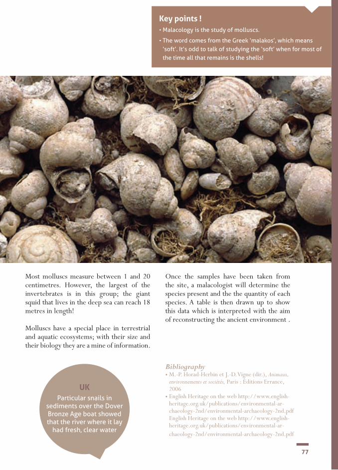
77
Key points !• Malacology is the study of molluscs.
• The word comes from the Greek ‘malakos’, which means ‘soft’. It’s odd to talk of studying the ‘soft’ when for most of the time all that remains is the shells!
UKParticular snails in
sediments over the Dover Bronze Age boat showed that the river where it lay
had fresh, clear water
Most molluscs measure between 1 and 20 centimetres. However, the largest of the invertebrates is in this group; the giant squid that lives in the deep sea can reach 18 metres in length!
Molluscs have a special place in terrestrial and aquatic ecosystems; with their size and their biology they are a mine of information.
Once the samples have been taken from the site, a malacologist will determine the species present and the the quantity of each species. A table is then drawn up to show this data which is interpreted with the aim of reconstructing the ancient environment .
Bibliography• M.-P. Horad-Herbin et J.-D. Vigne (dir.), Animaux,
environnements et sociétés, Paris : Éditions Errance, 2006
• English Heritage on the web http://www.english-heritage.org.uk/publications/environmental-ar-chaeology-2nd/environmental-archaeology-2nd.pdf English Heritage on the web http://www.english-heritage.org.uk/publications/environmental-ar-chaeology-2nd/environmental-archaeology-2nd.pdf

78
Ancient burials and cemeteries on archaeological sites have for a long time attracted interest, but it is only relatively recently that their bones have been studied. Through the study of bones we can learn about the evolution of man’s physical development, population groups, diet, funerary practices and sometimes occupational activities people engaged in.
In England, the person who studies human remains from an excavation site is an osteo-archaeologist, who may also draw on the work of anthropologists.
Each society has cultural practices associated with death. The deceased may be interred, perhaps with a shroud, singly or as a multiple burial; or the custom may be one of cremation. There may be evidence on the remains of other practices, such as dismemberment, decoration, mutilations, breaking of the bones and removal of body parts (like the hearts of the kings of France).
Advances in science have resulted in major ad-vances in osteo-archaeology.
For the past twenty years or so, the ability to extract DNA from bones has opened up new horizons and Paleobiology (the molecular study of human remains) can support research into genetics and diet.
Analysis is usually carried out on bone samples, human tissue having long since decomposed. But sometimes tissue is available from a preserved body, having lain in certain environmental condi-tions, for example waterlogged, very dry or very cold.
The sex of a skeleton is determined by examining the size of the bones (male bones are generally bigger) and their shape. In adults, the pelvis is the best indicator; a woman’s pelvis, designed for childbirth, is wider than a man’s. To determine the sex of juvenile skeletons, DNA analysis may be carried out on any bone that has preserved some organic matter.
It is difficult to determine the cause of death of an individual, unless there is a good indicator like a severe, unhealed skull fracture. But some diseases, for example osteoarthritis, tuberculosis and dental conditions are easily identified.
Family relationships may be suggested from stu-dying anatomical features shown in skeletons, but the archaeologist must be careful here. This type of interpretation cannot be made with any pre-cision.
Osteo-archaeology
SECTION 2CHAPTER III.6 The science of archaeology
Excavating a prehistoric skeleton (Kent, England) © Canterbury Archaeological Trust
Bibliography• O. Dutour, J.-J. Hublin, B. Vandermeersh(éds), Objets et
méthodes en paléoanthropologie, Paris : CTHS, 2005.• E. Cruzéby, É. Lorans, Cl. Masset, L’archéologie funéraire,
Paris : Éditions Errance, 2000.• A Handbook,C A Roberts, Human Remains in Archaeology Practical Archaeology Handbooks No. 19. Council for British Archaeology, York. 2009
• English Heritage on the web http://www.english-heritage.org.uk/publications/science-and-dead/science-and-dead.pdf Council for British Archaeology, York. 2009
FR
At Fresnes-lès- Montauban, bones from an urn were
identified as a male aged 18 to 35
years old

7991The osteo-archaeologist at work © Communauté d'agglomération du Douaisis - Direction de l'archéologie préventive
Key points!• Osteo-archaeology is the study of
human bones.• The study of bones tells us about
the evolution of man's physical development, population groups, diet, funerary practices and sometimes occupational activities.
• Advances in science, especially DNA analysis, have opened up new horizons for osteo-archaeology.
One of the Bronze Age skeletons at Thanet
Earth was of an active male who died at
between 36 and 45 years of age
UK
Child burial from the Late Bronze Age, Cross-Saint-Ouen site (Oise, France) © Inrap
Mass of cremated bone being excavated, Middle Bronze Age burial , Rue (Somme, France) © Inrap

80
SECTION 2CHAPTER III.6 The science of archaeology
SKELETON SHEETDescription of skeleton
Film Nos. Sample Nos.
Discussion
This context
Plan No. Section No.
Excavated by Recorded by Checked by Date
CANTERBURY
ARCHAEOLOGICAL
TRUST
Site Code Area
CONTEXT NO.GRID SQUARE
Rough plan (showing grid points & reduced levels) & sections - overleaf
Further interpretation
Grave cut no. Fill nos.
Description of material associated with the skeleton
1. Grave goods
2. Coffin furniture
The first records made for a human skeleton will include information about the skeleton itself, its position in the ground and anything found with it. More detailed records may be made after further examination.

81
Tick box if bone is present
Skull
Complete
Damaged
Unfused
Mandible
Sternum
Clavicle
Scapula
Ribs
R
R
R
R
L
L
L
L
Humerus
RadiusUlna
Hand
Pelvis
Patella
TibiaFibula
Foot
Unfused long
(arm and leg)
bones?
RIGHT LEFT
Cervical (7)
Details of skeletal remains
Thoracic (12)
Lumbar (5)
Coccyx
Sacrum
Alignment:
Completeness:
Condition of bones:
Body position:
Skull position:
Lower arm position:
Articulation: Articulated
> 95% 80-95% 60-80% 40-60% 20-40% 5-20% <5%
Orientation: Head at:
Excellent, all solid
Facing left
Skull not present
Facing rightAnatomically correct
Supine
Prone
Not present By side On chestOn pelvis On shoulder Other position Unknown
Right
Left
Extended
Flexed
Crouched on right Other (specify)
UnknownCrouched on left
Other (specify) Unknown
V. good, mainly solid
Some solid, some fragmented
Badly fragmented
V. badly fragmented
Stain
Dis-articulated Disturbed Other (specify)
Spine
NOTES: In young persons the ends of bones may be loose and the skull and pelvis unfused. Take care to collect
all fragments, especially teeth. Place each hand and foot in a separate bag and label them.
Sketch (stick) plan
(& section if appropriate)Showing grid points, planning discs, reduced levels
and north arrow. Also show associated grave
elements such as cuts, coffin furniture, grave goods
Femur
82
SECTION 2CHAPTER III.6 The science of archaeology
Objective: • to �nd out about the work of an osteo-archaeologist and how it helps us �nd out about the past.
Equipment needed: • DVD supplied in the kit: Archaeology Experts: �e Anthropologist(in England this work is done by an osteo-archaeologist); • DVD player; • projector and whiteboard.
Digital support?• yes.
Activity (as a class):• watching and discussing the �lm.
Activity suggestion no 15What does an osteo-archaeologist do?

83
Objectives: • to �nd out about human anatomy and recognise the bones of the human skeleton.
Equipment needed: • laminated cards supplied in the kit (one per pupil); • scissors; • fasteners supplied in the kit.
Digital support? • yes (to print extra sets of cards).
Activity (individual or in pairs):
1. cut out the model’s bones; 2. identify and name the various bones; 3. reconstruct the human skeleton
using the fasteners.
Skull
Mandible
Cervical vertebrae
Clavicle
Scapula
Lumbar vertebrae
Thoracic vertebraeRibs
Sternum
Pelvis
Ulna
Radius
Metacarpal bones
Finger phalanges
Toe phalanges
Carpal bones
Humerus
Femur
FibulaTibia
Tarsal bones
Metatarsal bones
Activity suggestion no 16The human skeleton

84
Carpologists study this material to find out about man and his environment in the past. Their aim is to find out about: • the history of plants as a food source;• the development of agriculture;• the natural environment;• cultural practices.
Paleo-seeds (ancient seeds) are present in practically every place of human activity: storage areas, dumps, human settlements, funerary sites, and so on. Their preservation depends on the environmental conditions.
There are several ways seeds can be preser-ved:• carbonisation, caused by fire, for example
charring during cooking or the use of ve-getation as fuel;
• mineralisation, for example when they have been in a flow of water laden with mineral salts;
• waterlogging: buried in saturated soils• imprints: impressions (probably acciden-
tal) of seeds or ears of cereal crops found in objects of fired clay, for example a brick or pot.
Soil samples are taken from an archaeologi-cal site to find any seeds and fruits. Usually each sample is sieved through various grades of mesh using a water hose. Then when dry, any erroneous material is removed. The re-maining material is then sorted using the naked eye or with a binocular microscope.
The isolated seeds and fruits are then identi-fied, grouped together by species, counted, measured and drawn or photographed, as necessary. Identification will be made by comparison with a reference collection and published works.
Carpology
SECTION 2CHAPTER III.7 The science of archaeology
Bibliography• C. Bourquin-Mignot, J.-E. Brochier, L. Chabal, La
botanique, Paris : Éditions Errance, 1999. • V. Matterne, Agriculture et alimentation végétale durant l’âge du fer et l’époque gallo-romaine en France septentrionale, Montagnac, Éditions : M. Mergoil, 2001.
• English Heritage on the web http://www.english-heritage.org.uk/publications/environmental-ar-chaeology-2nd/environmental-archaeology-2nd.pdf.
FRAnalysis has enabled us to say that inhabitants
at Roeux grew wheat and barley
and gathered hazelnuts
At the Dover Bronze Age boat site, finding seeds of weeds that
grow among crops tells us that there was arable
farming in the area
UK
Carpology is the analysis of seeds and fruit lost and thrown away by people in the past during their daily activities, which have then become preserved in sediments. Carpology became a major part of archaeological studies in the 1960s.

85
Key points! • Carpology is the analysis of seeds
and fruit preserved in archaeological sediment.
• Carpologists are interested in these paleo-seeds to find out about man and his environment in the past.
• The sieved and sorted material is identified using reference collections and published works.
Sieving in the laboratory © M. Derreumaux Sorting and identifying species under the binocular microscope © M. Derreumaux
Carbonised emmer wheat grains (Kent, England) © Canterbury Archaeological Trust
Detail of carbonised emmer wheat grains (Kent, England) © Canterbury Archaeological Trust

86
SECTION 2CHAPTER III.7 The science of archaeology
Objective : • to �nd out about the work of a carpologist.
Equipment needed (for each pair of pupils): • bottom half cut from a large plastic bottle; • 20g sesame seeds; • 20g soil.
Digital support?• no.
Activity (in pairs or class demonstration): 1. put water into the half bottle; 2. mix the seeds with the soil; 3. add the mixture to the water; 4. leave to settle for a few minutes; 5. observe what happens.
�e mineral material (the soil) will fall to the bottom and the organic material (the sesame seeds) will �oat to the top.
Activity suggestion no 17Extracting seeds from soil using flotation
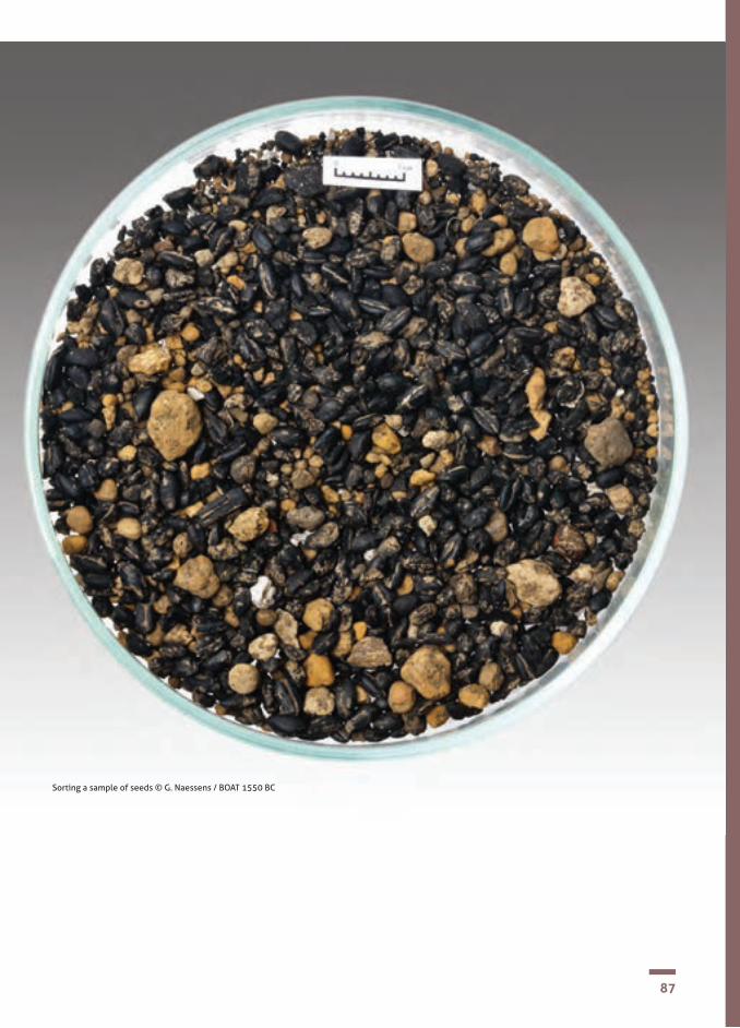
87
Sorting a sample of seeds © G. Naessens / BOAT 1550 BC

88
BE
Palynology is the study of pollen grains and spores. In archaeology it is used to recons-truct a picture of the plant life of an ancient environment; an environment which may have been affected by natural influences like the climate or human activity like deforesta-tion and cultivation.
The palynologist and archaeologist choose the area to be sampled together. The aim is to find the ideal ‘trap’ for the sediment and therefore for the pollen grains and spores that it may contain.
The pollen grains are placed on slides, exa-mined under the microscope, identified and counted. The wide variety of shapes and sizes of pollen grain and features visible on their outer coat enable the plant it comes from to be classified and identified. A pollen grain's structure is unique to its plant spe-cies.
The grain’s outer coat resists deterioration in certain conditions and pollen and spores can be preserved in several types of ancient sediment, sometimes for several thousand years. The best conditions for preservation are wet environments such as peat and silts.
The proportion of the various types of pol-len identified in a sample is presented in the form of a spectrum. By interpreting the va-riations, changes in the climate can be reco-gnised and the actions of ancient man on his environment.
Palynology
SECTION 2CHAPTER III.8 The science of archaeology
Bibliography• C. Bourquin-Mignot, J.-E. Brochier, L. Chabal,
La botanique, Paris : Éditions, 1999. • English Heritage on the web http://www.english-
heritage.org.uk/publications/environmental-ar-chaeology-2nd/environmental-archaeology-2nd.pdf.
FR
UK
Palynological analysis showed that the burial
enclosures at Fresnes- lès-
Montauban were situated in a semi-forest
environment
Pollen in the sediment burying the Dover
Bronze Age boat shows that near the river was mostly grassland, with
few trees
Analysis of pollens from Bronze Age
graves tells us whether they were
made in wooded areas

89
Key points!• Palynology is the study of pollen grains and spores. • In archaeology, it is used to reconstruct a picture of the
plant life of an ancient environment.
Extracting a core soil sample for pollen and spore analysis © Inrap
90
Soil sciences
SECTION 2CHAPTER III.9 The science of archaeology
The specialists in this field must bear in mind that man and nature are always interacting.
The term Soil Sciences embraces several areas of study. • geology is about oceans, volcanoes and
how layers or strata have been laid down over time;
• pedology is the study of soils: how the actions of man, animals and the environ-ment affect them;
• geomorphology is the science that studies and interprets the physical features on the Earth’s surface; how its plateaux, escarp-ments and so on are formed.
It is considered today that soil is not a stable environment, but one that is dynamic. It is formed at the point when the atmosphere (rain), the biosphere (animals, man) and the lithosphere (Earth’s crust) interact.
Soil has four vital functions :• biological: it shelters and protects many
animal and plant species; • food: it contains certain nutrients neces-
sary for life. It provides the plants and the animals with water and air. Man, who lives on plants and animals, is therefore utterly dependant on soil;
• filtering: being porous, soil is a filter. When water permeates soil, it leaves che-mical and biological deposits;
• material: some soils can be used as a building material and constructions e.g. houses, will be supported by the ground. Soil is also a source of many useful minerals.
Archaeologists will record in detail the soils they encounter on an excavation. They are interested in colour, texture, structure and what they may contain, for example stones or roots.

91
Bibliography• J.-P. Bravard, C. Cammans, P. Nehlig, P. Poupet, La
géologie : les sciences de la Terre appliquées à l’archéolo-gie, Paris : Errance, 2009.
• English Heritage on the web http://www.english-heritage.org.uk/publications/environmental-ar-chaeology-2nd/environmental-archaeology-2nd.pdf
Through his activities, man can alter his environment and the soil often undergoes changes.
What might these changes be?
• Subsidence that occurs during land clear-ance or building works;
• impoverishment of the soil’s biological make-up;
• soil pollution.
All these changes can be noticed by the specialist working alongside the archaeologist on the dig or through examining sediment samples taken from the site.
To try and re-create a history of past societies, we need to trace the history of the landscape, because it is people that have worked and transformed it over time. It is important that those working in the laboratory work closely with those working in the field.
Key points!• Soil has four vital functions: biological, food, filtering
and material.• Man and nature are always interacting: man transforms
the environment in which he lives and the soil is often changed through his activities. These changes can be seen on an archaeological site.
• There are various kinds of soil sciences: geomorphology, pedology and geology.

92
SECTION 2CHAPTER III.9 The science of archaeology
Objective: • an archaeologist can describe the archaeological layers on a site (or the colour of clays in pottery studies) using the universal Munsell Colour Chart. Pupils can try for themselves identifying colours using a chart.
Equipment needed: • a colour chart, supplied in the kit; • 10 sheets of card in di�erent colours.
Digital support?• no.
Activity (as a class and in groups):
1. choose a sheet of coloured card and show it to the class; 2. ask the pupils what colour they see. Individuals have their own perception
of colour and not all pupils will see the same colour;3. do the same with the other coloured cards; 4. arrange pupils in groups, maximum 5 in each; 5. give a set of 10 colour cards and a colour chart to each group; 6. ask them to �nd the reference code for each coloured card.
Activity suggestion no 18Soil colours

93
Munsell colour chart © J. Kelley, http://SoilScience.info

94
Anthracology
SECTION 2CHAPTER III.10 The science of archaeology
UK
Anthracology is the study of charcoal collected from an archaeological site or from natural sediments. The information gleaned can add to our knowledge about human settlement patterns and how people benefitted from their natural environment.
When wood is carbonised (through contact with fire) its microstructure remains largely unchanged, despite partial deformities (to a greater or lesser extent depending on the species).
Through close examination of a charcoal sample, a specialist is able to identify the species of tree the original wood came from.
It is possible to examine minute fragments, but reliable identification is only really possible for pieces larger than about 4 milli-metres.
The anthracologist, just like the carpologist or the palynologist, is not able to make a complete anatomical description of the species. But he or she is still able to identify it by comparing the charcoal sample to an up-to-date reference collection of carbonised wood and related photographs.
We can probably assume that in antiquity people would have collected wood for domestic fires close to their homes; so samples collected from a settlement site can tell us about the forest cover in the immediate locale.
The increasingly systematic study of fuels used for specialist purposes (for example in pottery kilns, metal working, cremations) and of wood used in building works is further adding to our knowledge about man’s exploitation of his environment in the distant past.
Bibliography• C. Bourquin-Mignot et al., La botanique, Paris :
Édition Errance, 1999.• English Heritage on the web http://www.english-
heritage.org.uk/publications/environmental-ar-chaeology-2nd/environmental-archaeology-2nd.pdf
There was no need for anthracological analysis
for the English sites chosen for this guide

95
FR
NL
Key points! • Anthracology is the study of
charcoal.• The anatomical structure of the
wood enables the species to be identified.
• Identification is made by comparing the charcoal sample to an up-to-date reference collection of carbonised wood and related photographs.
Studies of carbonised wood from
cremations is in its infancy in Flanders.
Nevertheless it seems that oak was used
BE
FRAt Roeux, carbon
analysis has yielded evidence for oak
being dominant with the presence of other species like plum and
elderberry
Carbonised wood from a building (Kent, England) © Canterbury Archaeological Trust
Excavating carbonised wood (Kent, England) © Canterbury Archaeological Trust

96
Dendrochronology, or tree ring dating as it is commonly known, has resulted from a knowledge of how wood grows and is one of the best known and most precise dating methods.
In temperate Europe, rings are formed each year in the growing tree, from the beginning of spring until autumn. Ring width varies according to major climatic events. Winter interrupts the growth of the tree each year and the limit of its growth is marked by the formation of a ring.
The number of rings therefore corresponds to the number of annual growth cycles and we can count the rings to find the age of the tree. The date of its death (when it was cut down) is ‘registered’ in the last ring it produced, under its bark. In some cases, this can be estimated down to the year and sometimes even down to the week.
To date an archaeological sample its growth is compared to wood of a known date. It has therefore been necessary to collect the growth sequences of a large number of trees and establish reference collections. Dendrochronological sequencing sometimes covers several thousands of years!
In Europe, it is the oak that has the longest and the most useful sequence; scientists in Ireland, have managed to reconstruct sequences of almost 9,000 years.
Wood from an archaeological context may come from an ancient building or object, or be found simply as dead wood and it has often deteriorated to some extent. A sample for dating can be fresh, dry, waterlogged or carbonised; what is essential is that its structure has been preserved.
Once taken, the samples are treated in order to improve the anatomical reading; dry wood is polished, waterlogged wood is refreshed using a razor blade. Usually the peripheral rings have been lost and then it is impossible to establish the date when the tree was felled.In France, there are currently four specialist dendrochronology laboratories: in Marseilles (for dating underwater wrecks), Champenoux (regarding evolution of the French forests), Rennes, (species analysis) and Besancon, (for dating historical material including works of art).
In England, there are also services specialising in dendrochronology which are available to archaeologists.
Dendrochronology
SECTION 2CHAPTER III.11 The science of archaeology
One of the archaeologist’s major preoccupations is attempting to establish a chronology for events that have taken place in the past. Archaeologists make a distinction between what they call ‘relative dating’ and ‘absolute dating’. Relative dating is achieved by studying the build up of layers on a site (the stratigraphy) and establishing when activities took place in relation to each other. Absolute dating is much more precise dating and can be obtained thanks to scientific techniques. One of these is dendrochronology.

97
Bibliography • J. Evin, A. Ferdière, G.N. Lambert, Les méthodes de
datation en laboratoire, Paris : Édition Errance,2005.• English Heritage on the web http://www.english-
heritage.org.uk/publications/dendrochronology-guidelines/dendrochronology.pdf
Key points! • Dendrochronology enables wood to be dated by counting
and analysing the rings formed during tree growth.• To be able to date wood, reference collections have to be
established so that comparisons can be made. • Analysis can be made using a sample that is fresh, dry,
waterlogged or carbonised.
FR
BE
UKA single sample of wood from the Dover boat was
available for analysis giving a date of 1742-1589 BC, relating to the growth of
the tree, not to when it was felled or used
Preservation of wood from the Bronze Age is rare in
our area, so this kind of study is rare
Tree rings © E.Wyremblewski
It is exceptional to have preserved
wood in our area, so dendrochronology
studies are rare

98
SECTION 2CHAPTER III.11 The science of archaeology
Activity suggestion no 19Dating trees
Objectives: • to �nd out about the growth of trees and how archaeologists use the information.
Equipment needed: • 5 cut discs of wood, each having the complete diameter of the trunk; • a magnifying glass, in the kit; • a sheet of paper and pencil for each pupil; • some crayons.
Digital support? • yes.
Activity : 1. divide the class into 5 groups; 2. give each group a disc of wood; 3. ask the pupils to draw what they see; 4. when �nished, as a class identify the di�erent parts of the disc: • at the centre is the heart, the �rst year of the tree’s growth; • next to the heart, the innermost layer is the sapwood; • the circular lines are called tree rings; • the outer layer is the bark;5. each group counts the rings on their disc of wood to �nd out the age of
the tree it came from.

99
Equipment for sampling ancient wood for dendrochronology © Hervé Paitier, Inrap

100
BE
Carbon-14 (or radio carbon) dating is a scientific process that enables the age of a material containing carbon to be calculated.
In theory, all materials containing carbon and formed less than 45,000 years ago, can be dated by the Carbon-14 process. The ma-terial may be in its natural state (e.g. bones, wood fragments, ivory tusk) or it may have been used to make something (e.g. fabrics, tapestries, prehistoric paintings, the Dover Bronze Age Boat).
Every living thing produces Carbon-14 throughout his, her or its life by interacting with the atmosphere. When the organism dies, the interaction stops and the Carbon-14 starts to disintegrate. The disintegration occurs at a constant speed, at a proportional rate.
It is therefore possible to determine how much time has passed since death, by measuring the Carbon-14 that is left in an archaeological sample and applying a known formula. Starting with 100% of active Carbon-14 in a living organism, following its death no more than 50% of it will remain after 5,568 years, 25% after 11,460 years, 12.5% after 17,190 years and so on.
Like dendrochronology, Carbon-14 analysis can give the archaeologist an ‘absolute’ (that is, a highly accurate) date making it possible to place the analysed remains in our calendar system.
Carbon-14
SECTION 2CHAPTER III.12 The science of archaeology
Bibliography J. Evin, A. Ferdière, G.N. Lambert, Les méthodes de datation en laboratoire, Paris : Édition Errance, 2005.
FR
UK
Wood, moss and shoots from the Dover Bronze Age boat have been analysed
for Carbon-14 dating. The results show that the boat was built between
1575 and 1520 BC
Radio carbon dating on cremated bone has
brought new information about when the ritual practice of cremation
began
At Fresnes-lès-Montauban Carbon-14 analysis on the inhumations showed that
the cemetery was used from the start of the Early Bronze Age until the start of the Middle Bronze Age

101
Key points! • Carbon-14 dating allows us to calculate the age of an
organic material. C-14 gives us a highly accurate date. • Every living thing produces Carbon-14 throughout his, her
or its life. When the organism dies, the interaction stops and the Carbon-14 starts to disintegrate. The disintegration occurs at a constant speed, at a proportional rate.
• By this method, archaeologists can date many kinds of organic materials and objects made from them.
Am
ount
of
Car
bon-
14 re
mai
ning
(%)
The star marks the amount of C-14 remaining in the Dover Bronze Age Boat


SECTION 2CHAPTER IV
From excavation to exhibition – and beyond

104
The excavation report
SECTION 2CHAPTER IV.1 From excavation to exhibition
Having completed an excavation, the archaeologist then moves on to the next stage – writing the site report. A certain amount of interpretation of the discoveries will have taken place while on site and now he or she will gather all the numerous written records, photographs and drawings that were made while the excavation was running in order to address this comprehensively. The site records together with specialist analyses of the finds and any samples taken in situ will all be assessed, sequenced and interpreted in order to tell the ‘story’ of the evolution of the site.
Particularly for a major dig, this ‘post-excavation’ work may take much longer than the excavation itself. There will be a great deal of data to interpret and there may be several specialists involved, some of whom may have a number of commitments running at the same time.
The final academic report, as well as being a single publication, may also contribute to a more extensive thematic work; for example several sites excavated in the same geographical area may be published together or sites dealing with the same subject matter, such as cemeteries of a particular period.
Following publication, in England all the original documentation for the site and for sample and finds analyses will be passed on to the local government authority where it will be added to the national record of archaeological data known as the Historic Environment Record. In France, all the documents will be transferred to the State archaeological service - institut national de recherches archéologiques préventives (INRAP).
Particularly for major projects, in addition to the academic report, the results of the excavation will usually also be published and disseminated in a number of ways for non-specialist audiences.

105
Writing the excavation report © Canterbury Archaeological Trust

106
Reaching a wide audience
SECTION 2CHAPTER IV.2 From excavation to exhibition
Little is gained from archaeological dis-coveries unless they are broadcast for the benefit of others! For the general public, many organisations have excavation tours, Open Days and volunteers may take part on site or with finds processing. Talks will be arranged for academic groups, archaeological and historical societies and special activities may be provided for national events like The Festival of Archaeology in England. Sometimes organisations will work together to put on an exhibition with an accompanying booklet or catalogue. In England, there are regional Young Archaeologist Clubs led by the Council for British Archaeology where young people get involved in activities throughout the year. Other provision is made to support formal teaching and learning in schools and universities. Academic publications are usually produced for an excavation or series of excavations. These are aimed at other archaeologists, college and university students and those with specialist interests. A practising archaeologist may give talks to university and college departments about discoveries from a recent excavation or evidence for a particular era in a particular geographical area.
Presenting archaeology to younger people and non-specialist teachers in schools re-quires a particular skill set. An organisation may have a member of staff who works with these and teacher training establish-ments to provide services and resources to support the school curriculum. These can include specially designed excavation visits, classroom visits, website resources, resource packs and loan boxes of original and replica objects for handling activities.
Because archaeology is about looking at remains of the past, it clearly plays a key role in schools’ History studies. Indeed, for the earliest periods of the past, archaeolo-gical remains may be the only evidence we have! Most subjects involve speaking and/or writing in pupils’ native language and archaeology themed activities can also offer different, exciting opportunities to develop these skills. In Science studies, pupils can learn about ancient environments, how soil conditions affect preservation of buried remains and how twenty-first century scientific techniques are being applied in archaeological practice. These are a few examples of where archaeology can benefit teaching and learning. A creative teacher will find more.
The European project, ‘Boat 1550 BC’, was designed to engage a wide public in ar-chaeology and a shared prehistory. Among its achievements are a travelling exhibition, a half scale replica Bronze Age Dover Boat, both enjoyed by many and handling kits, with associated teacher training, for schools to use in the participating countries of France, England and Belgium for years to come.
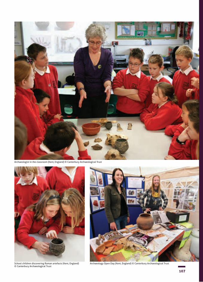
107
Archaeologist in the classroom (Kent, England) © Canterbury Archaeological Trust
School children discovering Roman artefacts (Kent, England) © Canterbury Archaeological Trust
Archaeology Open Day (Kent, England) © Canterbury Archaeological Trust
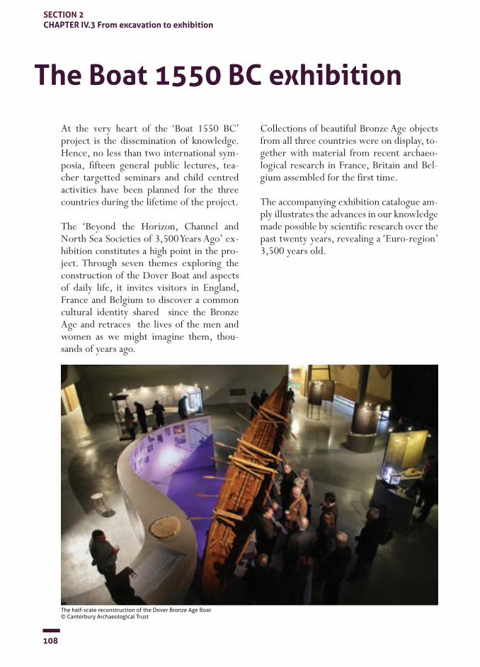
108
SECTION 2CHAPTER IV.3 From excavation to exhibition
The Boat 1550 BC exhibition
At the very heart of the ‘Boat 1550 BC’ project is the dissemination of knowledge. Hence, no less than two international sym-posia, fifteen general public lectures, tea-cher targetted seminars and child centred activities have been planned for the three countries during the lifetime of the project.
The ‘Beyond the Horizon, Channel and North Sea Societies of 3,500 Years Ago’ ex-hibition constitutes a high point in the pro-ject. Through seven themes exploring the construction of the Dover Boat and aspects of daily life, it invites visitors in England, France and Belgium to discover a common cultural identity shared since the Bronze Age and retraces the lives of the men and women as we might imagine them, thou-sands of years ago.
Collections of beautiful Bronze Age objects from all three countries were on display, to-gether with material from recent archaeo-logical research in France, Britain and Bel-gium assembled for the first time.
The accompanying exhibition catalogue am-ply illustrates the advances in our knowledge made possible by scientific research over the past twenty years, revealing a ‘Euro-region’ 3,500 years old.
The half-scale reconstruction of the Dover Bronze Age Boat © Canterbury Archaeological Trust
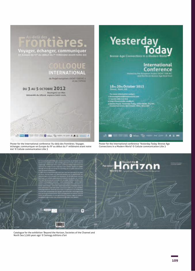
109
Poster for the international conference ‘Au-delà des frontières. Voyager, échanger, communiquer en Europe du IVe au début du Ier millénaire avant notre ère’ © Cellule communication Lille 3
Poster for the international conference ‘Yesterday Today: Bronze Age Connections in a Modern World’ © Cellule communication Lille 3
Catalogue for the exhibition ‘Beyond the Horizon, Societies of the Channel and North Sea 3,500 years ago’ © Somogy éditions d'art
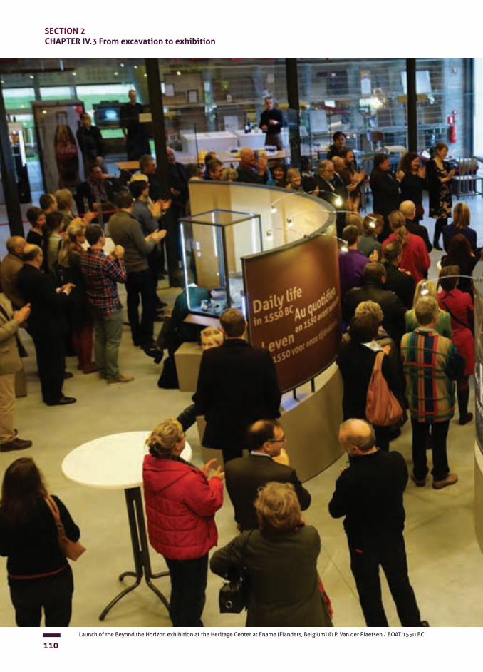
110
SECTION 2CHAPTER IV.3 From excavation to exhibition
Launch of the Beyond the Horizon exhibition at the Heritage Center at Ename (Flanders, Belgium) © P. Van der Plaetsen / BOAT 1550 BC

111Launch of the Beyond the Horizon exhibition at the Heritage Center at Ename (Flanders, Belgium) © P. Van der Plaetsen / BOAT 1550 BC


SECTION 3
Bronze Age settlement, funerary practice and ritual hoards along the Channel coasts: sites in France, England and Belgium

Introduction

116
SECTION 3Bronze Age settlement, funerary practice and ritual hoards along the Channel coasts
The Dover Bronze Age Boat and Bronze Age communities on the coasts of the English Channel
How do we know about the Bronze Age?
Bronze Age people in the Transmanche Region
Daily life
People build, they live, they eat, they throw things away. The evidence for these everyday activities survives depending on its nature and the environment it is buried in. Years, sometimes thousands of years later, archaeologists excavate the ‘rubbish bins’ of history. They uncover traces of houses, graves, fragments of pottery and metal etc. They take samples and analyse them in order to find about the environment, the types of plants and people’s eating habits. People create today, in their rubbish bins, the evidence for the archaeologists of tomorrow. What we leave for the people and the researchers of tomorrow is down to us.
Three thousand, five hundred years ago people were mostly simple farmers, wearing clothes of woven fabric, sometimes wearing jewellery, who made pottery for a multitude of purposes in the family and local community. Agriculture and stock-raising assured them a varied diet, along with seafood from the coasts.The peoples living on either side of the Channel had an almost identical way of life. One of the common links is the very specific type of pottery they used and which archaeologists have found. Outside of these coastal areas, the pottery is different.
Thanks to Archaeology, we know that people were living along the coasts of the English Channel 3,500 years ago in the region covered today by Kent, Pas de Calais and Flanders. Far from being different cultures (or we might say, societies), archaeological discoveries have shown us that these peoples had a lot in common and the sea was not a barrier for them. Indeed the remarkable Bronze Age boat discovered in Dover may well have carried our ancient ancestors back and forth across the Channel.

117
Community living Houses
The Bronze Age landscape was dictated by the agricultural lifestyle. There were small hamlets and isolated farms and buildings we call ‘round houses’ were characteristic of the region. As the Bronze Age progressed, villages began to develop.
Space was organised according to the activities that took place and archaeology today allows us to detect the kind of agricultural field system that was used. Settlements in the lowlands and the valley floors co-existed with upland sites. As you might expect, a village had an associated cemetery, close by or within a short distance. Being able to date the cemeteries shows that they were sometimes occupied for extended periods of time, from the Neolithic period until the Iron Age, for example. Deep ditches and even ramparts were sometimes built around the villages. These territorial markers were not necessarily intended for defence.
3,500 years ago the people of theTransmanche region lived in houses built to last at least a generation. Two house designs were in use at the same time. One was a rectangular structure between 20 and 30 metres long with one rounded end and was common along the Atlantic coast and northern Europe. The other, a circular type supported by about ten posts, was characteristic of theTransmanche region, from Normandy to the borders of Flanders and the south of Britain, and continued up until the Iron Age. The interior of the house was subdivided according to the everyday activities and crafts of its inhabitants.
The building materials available on the shores of the Transmanche region are common to a large part of temperate Europe: wood, thatch and clay. Being largely organic, they are unfortunately poorly preserved over time and often only traces survive. But the alignment of visible post holes mark out the house plan in the ground and their diameter suggests the height of the posts and the general structure. Recent excavations of sites covering several hectares (Aire-sur-la-Lys, Maroeuil, Sint-Gills-Waas), along with experimental reconstructions now offer a clearer picture of building techniques.
118
The importance of metal Pottery
Clothing and Ornament
Copper metal working existed in Europe as early as the Neolithic period. The making of bronze, an alloy of copper and tin, took off from the second millennium BC and transformed society. The new alloy was generally harder and more durable. It shone, could be recycled and allowed the creation of new forms. It therefore offered innovative possibilities for making tools, weapons and containers. Later, development of metal armour and helmets also had obvious consequences for the evolution of society. The bronze-workers knew the entire repertoire of techniques for manufacturing and for decoration. Bronze metal working was made possible by the development of supply networks for raw materials over thousands of kilometres in Europe.
Gold metal working was also common in this period. Examples of body ornaments have been found in the rich graves of Central Europe from the fifth millennium and no doubt certain individuals became rich at the start of the Bronze Age thanks to the trade in raw materials. The whole of the Atlantic coast was involved. Graves of the Early Bronze Age, from Brittany to Scotland, contain large ornaments made of gold leaf. By the late Bronze Age, particularly in the Transmanche region, hoards could contain many gold objects, weighing several kilos. These bracelets, rings, belts and torcs are the product of craftsmanship of the highest quality.
Manufactured since the Neolithic period, pottery was a very common product of Bronze Age societies and was made using various techniques. Vessels had their own local styles. On the coasts of the Transmanche region, very specific types of pottery were made, rarely found in other parts of Western Europe; carinated bowls, ‘Deverel-Rimbury’ types, ‘Food Vessels’ and ‘Pygmy Cups’ are among the characteristic types of the area. Pots had all kind of uses; for cooking food, eating and drinking, storing food and in burial rites. Easily broken, pottery sherds are an essential and commonplace source of information for archaeologists.
There is still a myth that our Bronze Age ancestors dressed only in animal skins. Nothing is further from the truth. Three thousand, five hundred years ago, fabrics were made from fibres derived from crops or wild plants. Poorly preserved in the Transmanche region however, their existence is recognised because archaeologists have found the clay loom-weights that weighed down the threads on the weaving loom. Clothing, varying according to individual and status, was complemented by various and sometimes exceptional orna-ments; bracelets, torcs, belts, rings and spiral greaves show that both men and women could look good and wanted to do so. Once again, finding the same types of jewellery on sites both sides of the Channel emphasises the strong links between these ancient communities.
SECTION 3Bronze Age settlement, funerary practice and ritual hoards along the Channel coasts

119
Food
What was on the menu of a family 3,500 years ago? Products that are familiar to us did not exist then, but the food was still relatively varied. Stock-raising offered a wide variety of meats, including beef, pork and mutton, as well as dairy produce. Agriculture brought a range of cereals that could be eaten cooked or mixed with other ingredients. Dressed six-row barley was developed, ensuring better yields. Emmer wheat, millet, spelt wheat, vegetables, flax, poppy and camelina completed the range of crops. Hunting, fishing in the rivers and the sea and foraging completed the picture. Salt, taken from along the coasts, allowed food to be preserved all year long.

120
The world of the dead Hoards
Signs and acts
The death of an individual is an experience that societies must deal with, each in their own way. The treatment of the deceased and the type of funerary monument in particular varies according to place, time and the people concerned. In the Transmanche region, from the second millennium BC, large circular monuments called barrows were erected. One or more circular ditches were dug, sometimes reaching 40 or 50 metres in diameter. At the centre, under an earthen mound, now ploughed away by modern farming, was placed a cremation or inhumation burial; sometimes there were secondary burials as well. These monuments for the social elite co- existed with more modest graves.
A complex ritual practice stands out in the European Bronze Age, that of depositing ‘hoards’. It involves the abandonment of objects at a given time and place and as such may be interpreted as an act of making an offering. As yet, further interpretation is difficult. Researchers in this field think that the hoards of gold and bronze objects have been given up or ‘sacrificed’ for some ritual purpose, considered more important than the recycling of the metals. The reasoning can be complex. A fragment of sword may represent the entire sword and its owner, a part for the whole. It may be that the death of individuals was marked by the breaking or ‘death’ of objects that symbolised them.
The Dover Bronze Age boat was found partially dismantled. Perhaps it is an example of this ritual practice…
Every society has rituals and acts of worship and it seems Bronze Age peoples were no exception. Societies developed practices whose meaning can be complex and hard to interpret. There are no texts from this period to enlighten us, just features in the ground and objects.
Ritualised actions can appear strange to us, as beliefs change. The grave or burial is a familiar monument, though the nature of its structure has evolved. The placing of the bones of a cremated individual directly into the earth may appear rather unusual. The burial of an animal in a pit especially dug for the purpose is another Bronze Age practice whose full significance escapes us. The differential treatment of individuals, including children, the often deliberate breaking of pottery vessels and the drawings on certain ceramics are all signs of complex beliefs. In this regard, once again the Transmanche region shows its uniqueness.
Rituals of the Bronze Age
SECTION 3Bronze Age settlement, funerary practice and ritual hoards along the Channel coasts

121Remains of a burial mound at Birchington, Isle of Thanet (Kent, England) © Canterbury Archaeological Trust

122

SECTION 3CHAPTER I
Funeral rites

124
Death is the inescapable end of every living being. Funerary rituals give us some insight into how a society deals with death in its community, the treatment of the deceased and the support for the living who remain.
In an archaeological context, we can see evidence for certain processes used for the deceased (for example, cremation, inhumation, preservation), the choices of objects or grave goods placed with him or her and the kind of monument (or not) in which the remains are buried. Because death is an experience which touches us all we might also envisage something of the ceremony that would accompany these actions, for which there are no tangible remains.
Peoples of the past have shown a certain imagination in how they dealt with their deceased and certain cultural groups can be identified by their burial practices, as seen on archaeological sites. Such is the case with people of the Bronze Age.
SECTION 3CHAPTER I Funeral rites

125Prehistoric inhumation burial at Broadstairs on the Isle of Thanet (Kent, England) © Canterbury Archaeological Trust

126
SECTION 3CHAPTER I.1 Funeral rites
The Fresnes-lès-Montauban site(Pas-de-Calais, France) How was the Fresnes-lès-Montauban
site discovered?
The excavation
Post-excavation: finds examination
and laboratory analyses
Pottery
Stone
The Fresnes-lès-Montauban site was found by aerial survey in 1988. The photographs taken from the plane showed large circles, quite visible on the surface of the ground. So the location of the site was precise enough for the archaeologists to proceed directly with the dig.
Soil stripping revealed 5 circular enclosures. They were not all the same size; the smallest had a 10 metre diameter, the largest, 25 metres. No less than 15 archaeologists and two months of work were needed for excavating the Fresnes-lès-Montauban site!
The archaeologists found mostly vases, dark brown or black in colour, measuring 20 to 30 centimetres in height. These vases, called funeral urns, were used to contain the ashes of the deceased following cremation.
Other pottery was also found in the form of sherds.
Overall, the archaeologists found only a small number of stone artefacts. As at the Roeux site, among these objects were some tools – scrapers, flakes, blades, knives plus some arrowheads. Analysis of these objects showed that they were always made of the same stone: flint.
The five circular enclosures contained three inhumations and four cremations. Two of the latter had been contained in funeral urns.

127
Gallo-Roman track way at the Fresnes-Lès-Montauban site ( Pas-de-Calais,France) © Inrap
Enclosures 1 and 3 at the Fresnes-Lès-Montauban site ( Pas-de-Calais,France) © Inrap

128
SECTION 3CHAPTER I.1 Funeral rites
Post-excavation: sciences and archaeology
Osteo-archaeology
Paleo-environmental analysis
Interpretation, publication of the results: from excavation to exhibition
Archaeozoology and Malacology
Cremation
Palynology
Anthracology
Inhumation
The animal bones that were found were not in a good state of preservation, but the archaeozoologists were nevertheless able to study them. Analysis has shown that they came mainly from cattle. It also revealed the presence of dog, hare and even stag bones.
Mollusc analysis made it possible to conclude that the Fresnes-lès-Montauban site had been near a wooded area, at the edge of a forest or on a meadow with copses.
Analysis of the bones collected from one of the two urns enabled the archaeologists to say that these bones belonged to a man who was between 18 and 35 years old. The other urn had been badly damaged by modern ploughing.
Pollen analysis has shown that the funerary enclosures had been built in a semi-forest environment.
The dating of the archaeological remains has indicated that the site had been occupied throughout the Early Bronze Age (2300-1600 BC) and perhaps even a little earlier. This explains the presence of two different burial practices: inhumation and cremation. The latter replaced inhumation in the Middle Bronze Age.
Charcoal analysis has revealed the presence of oak, with some other species such as plum, elder or ash.
One of the graves contained the skeleton of a woman about 30 years old, measuring 1.50 metres. A burnt flint and a pottery fragment lay beside her. Examination of another inhumation has made it possible to say that the person lying in the pit was a young man a little less than 20 years old, measuring 1.64 metres. These two individuals are smaller than people of the same age in modern times.
There can be several reasons. They may be remains of a fune-rary deposit of meat or leftovers from ritual meals. They may also
be waste from meals eaten by the individuals who built the funerary
structures. At Fresnes, the archaeo-logists think the bones are leftovers
of ritual meals or waste left by the workers of that period
Why are animal bones found on a funeral site?
Fresnes-lès-Montauban «le Motel», relevé de l’inhumation de l’enclos 5 et localisation du matériel associé (1, canines de chien et disque vertébral de poisson; 2, boucle d’oreille en bronze).
0 50cm
Inhumation burial from enclosure 5 at ‘le Motel’ site at Fresnes-Lès-Montauban, with associated finds (1, dog teeth; 2, bronze earring) © Inrap

129
o
Fresnes-lès-montauban 'le Motel', location of the site on the route of TGV Nord © Inrap
Aerial view of the enclosures at the site of Fresnes-Lès-Montauban (Pas-de-Calais, France) © Inrap
motel
Arras
Paris
50
55
55
50
50
R.N.50
Inhumation
InhumationIncinération
Incinération
Incinération
Cercle 2
Cercle 5
Cercle 3
Cercle 4 Cercle 1
Douai
T.G.V NORD
Echangeur RN 50/A1
0 100 m

130
SECTION 3CHAPTER I.2 Funeral rites
Urn field site at Aalter (Flanders, Belgium)
1. Discovery
3. Scientific research
2. Excavation
The ‘urn field’ site at Aalter was discovered between 1952 and 1954 when the first burials were found in a sand quarry. The Seminar of Archaeology at Ghent University, as it was known at the time, led by Prof S J De Laet, was informed and permission was given to take the work further. Osteo-archaeological analysis
Cremated bone material was studied in the 1950s by F Twiesselman at the Royal Institute of Natural Sciences in Brussels. The study of cremated bone remains was in its infancy at that time and the scientific standards of the time were applied. The largest group of individuals found was composed of adults between the ages of 20–40 years at the time of death. Children were less frequently found, which is surprising considering the high infant mortality rate of the time. It was more difficult to establish the sex of the individuals; 18 were found to be of indeterminate sex, while 2 were thought to be male and 2 were thought to be female, with some reservations. It could be interesting to study the bone material again considering the improved analysis techniques that are currently available.
During the latter part of the Bronze Age changes occurred in how the dead were buried. The deceased were no longer buried in burial mounds, but in cemeteries composed of shallow graves. A good example of a cremation cemetery site can be found in Aalter / Oostergem
Cremation burials were first noticed in 1952 and their recovery continued until 1954; but scientific archaeology was still being developed at this time in Flanders. Excavation was not done in the same way that we would do it today. Every time a cremation burial was found in the sand quarry, for instance, work was halted in that area and the Seminar of Archaeology was contacted to complete the required archaeological records. Twenty six burials were recovered and studied in this way.
Most cremated bone remains were interred in ceramic urns, but there were also a few examples of other practices; for example, where the bones were placed inside a lea-ther bag or other item and where the bones and ashes from a fire were deposited toge-ther as the burial. Some burials also contai-ned gifts, usually in the form of a cup or a beaker. Burial gifts were rather sparse in Flemish cemeteries from this period. The age of the burial site was established based on a study of the pottery found. It was thought that this cemetery was used during the Late Bronze Age and Early Iron Age.

131
Radio carbon (Carbon-14) analysis
A burial was recently dated using Carbon-14 analysis on a twig taken from remains of the funeral pyre. Surprisingly this identified the period to be Middle Bronze Age. The cemetery at Aalter therefore appears to be older than the original thinking, which was based on a study of the pottery found.
Cremation burial at the Aalter site © University of Ghent

132
SECTION 3CHAPTER I.3 Funeral rites
The Thanet Earth site (Kent, England) In 2007-8, the Canterbury Archaeological Trust team was digging on a site in Thanet, where huge green houses were going to be built. The archaeologists found two big circular ring ditches. The widest was 25 metres in diameter. They recognised these as evidence of a prehistoric burial mound. It must have taken a lot of people and time to build it.
In the centre of the ring ditches was a grave pit with a skeleton.
A crushed pottery ‘Beaker’ lay at its feet, an archer’s stone wrist guard under its left arm and a copper blade under its right shoulder. A 70 centimetre gap between the skeleton and the grave edge suggested something else was buried there, but had decomposed. Twelve other ‘crouch’ burials were found on the Thanet Earth dig, but none was as elaborate as this one.
Osteo-archaeology, Carbon-14 and Isotope analyses show this was a male aged 36 – 45 years when he died; he died 3980 – 4200 years ago; and he probably grew up in Thanet and could have spent some time in present day France or Belgium.
Bronze Age inhumation burial (Kent, England). Red and white scale: 20 cms © Canterbury Archaeological Trust

133The pottery © Canterbury Archaeological Trust
The copper object © Canterbury Archaeological Trust The stone object © Canterbury Archaeological Trust


SECTION 3CHAPTER II
Domestic dwellings
136
SECTION 3CHAPTER II Domestic dwellings
In Flanders, up until the Roman period, houses were made of wood and earth or clay. Wood was used to build a frame for the walls and roof and the wall sections were plastered over with earth or clay to keep out rain and wind. Perishable materials have not usually been preserved and the above ground parts of the building have usually broken down and decomposed with time. An exceptional case would be when, accidentally or otherwise, a building was set alight.
It is common to find fragments of the clay used in building a house; more rarely, imprints in clay fragments left by carbonized wood or actual charred posts may be found.
For archaeologists, the main traces left by these houses are generally the post holes, i.e. the hollows made in the ground in order to anchor the vertical wooden uprights which make up the walls and support the overall frame. By looking at the pattern of these post holes left in the ground, they can reconstruct the ground plan of the building – and it can be rectangular, oval or circular.
The layout of the postholes also indicates the type of frame used. There were indeed various technical solutions for solving the fundamental problem of the pressure exerted by the frame.
One solution is to have a frame where the pressure is taken by a central line of posts; in the ground, this would appear as three parallel rows of post holes (diagram no 1).
A second solution is to have a frame that rests on pairs of vertical uprights connected by horizontal ‘tie-beams’; in the ground, this would appear as two or four parallel rows of post holes (diagram nos 2 and 3).
Another technique is where the walls alone support the frame and it is important that the pressure from the frame is the same over the entire circumference of the building; the ground plan of post holes here will form a rounded, oval or circular shape (diagram no 4).
The absence of post holes on a site does not however mean that no building was ever erected there.
We know of above-ground construction methods, traces of which are only seldom preserved. In these cases, a framework of connecting vertical posts and horizontal beams could be constructed so that the whole thing rested directly on the ground or on a foundation slab (diagram no 5).
Also, the presence of domestic rubbish pits on a site suggests human habitation close by, even in the absence of any sign of a building.
In this section we illustrate particular domestic dwellings found on sites in England, France and Belgium, for comparison.
Prehistoric building techniques (Flanders, Belgium)

137
114
CHAPITRE VI
Dans nos régions, jusqu’à la période romaine,les matériaux de la maison sont le bois et laterre. Le bois constitue l’ossature des bâti-ments, des murs à la charpente, et la terre estutilisée comme remplissage, plaquée sur une
armature végétale, pour former les parois. Les matériauxpérissables ne se sont pas conservés et les parties en éléva-tion se sont désagrégées avec le temps, sauf lorsqu’ellesont subi accidentellement (ou non) l’action du feu. Il estainsi fréquent de retrouver des fragments de torchis, plusrarement des empreintes charbonneuses ou de vraispoteaux calcinés (fig. 172).Au regard des archéologues, les principales traces laisséespar ces maisons de terre et de bois sont généralement lestrous de poteau, c’est-à-dire les creusements réalisés dansle sol afin d’ancrer les montants de bois verticaux destinés
à supporter la charpente et à constituer les parois(fig. 173). Le plan matérialisé au sol par ces creusementspermet à l’archéologue de restituer la forme de l’édificerectangulaire, ovalaire ou circulaire.La distribution des trous de poteau témoigne aussi dusystème de charpente choisi. Il existe, en effet, différentessolutions techniques pour résoudre le problème fonda-mental des pressions exercées par la charpente. Dans lesystème à faîtière porteuse, les pressions sont supportéespar une rangée centrale de poteaux : au sol, cette solutionse matérialisera par trois alignements parallèles de trousde poteau (fig. 174). Dans les systèmes à entraits et àportique en « pi », la charpente s’appuie sur des couplesde montants verticaux reliés par des éléments horizon-taux (entraits) : au sol, cette solution se matérialisera pardeux ou quatre alignements parallèles de trous. Dans unsystème où les parois soutiennent la charpente, il importeque les contraintes de pression soient les mêmes sur toutle pourtour du bâtiment : les plans seront plutôt à anglesarrondis, ovalaires ou circulaires. L’absence de trous depoteau en un lieu ne signifie pas pour autant qu’aucunbâtiment n’y a jamais été érigé. La présence de fosses derejets qui bordent systématiquement les maisons entémoigne. De plus, on connaît des modes de constructionhors sol dont les traces ne sont que rarement conservées.Dans ces cas, la cohésion de l’ossature de bois est assuréepar les cadres horizontaux (sablières) qui relient lesmontants verticaux. L’ensemble peut alors reposer direc-tement sur le sol ou sur une semelle de fondation.
LES MATÉRIAUX ET LES TECHNIQUES DE CONSTRUCTIONPar Nathalie Buchez
Fig. 172. Fragments de parois en torchisdécouverts dans unefosse du Bronze final à Feuillères (Somme,France)
Fig. 174. Les principauxtypes de charpente sur poteaux plantés (d’après Audouze,Buchsenschutz, 1989,fig. 27 ; Valais, 1994)
à parois porteuses
hors sol à poteaux ancrés dans le solConstruction en pierre et bois
à faîtière porteuse à paroi porteuseà pièces d’entrait
et à portique en « pi »
Syst
ème
The main types of structure using poles inserted in the ground © extract Andouze, Buchsenschutz 1989, fig. 27; Valais 1994

138
A settlement site at Roeux (Pas-de-Calais, France)
Even if artefacts are discovered during ground survey, further evaluation using trial trenches does not always bring an
archaeological site to light once the topsoil has been removed.
This can be explained by repeated ploughing that literally destroys all
traces of the archaeological features. However, archaeologists can be
confronted with a totally different situation where ground survey
provides absolutely no archaeological evidence of a site that
is subsequently discovered during evaluation trenching.
At Roeux the site was probably hidden by colluvium
Why is ground survey not enough?
The site was discovered in 1989, prior to the construction of the Northern High Speed Train line.
Archaeologists began surveying the location of the future Northern High Speed Train line in 1988. The route itself, only 50 metres wide, stretched over several hundred kilo-metres of farmland. In a campaign lasting three months, teams comprising of two archaeologists on foot each surveyed a 110 kilometre stretch of track.
The stone artefacts that were collected led archaeologists to believe that the site at Roeux was quite old, however this type of surveying doesn’t provide enough evidence to characterise the site and further investigation was needed to confirm the existence of the archaeological site.
SECTION 3CHAPTER II.1 Domestic dwellings
How was the site discovered?
Survey
© S. Dominicus / BOAT 1550 BC
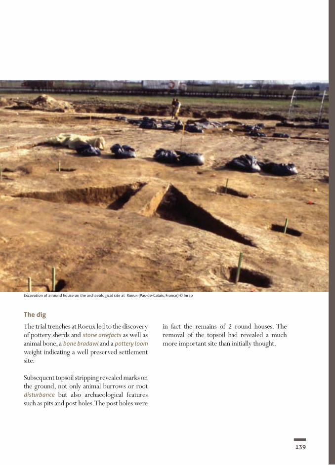
139
The dig
The trial trenches at Roeux led to the discovery of pottery sherds and stone artefacts as well as animal bone, a bone bradawl and a pottery loom weight indicating a well preserved settlement site.
Subsequent topsoil stripping revealed marks on the ground, not only animal burrows or root disturbance but also archaeological features such as pits and post holes. The post holes were
in fact the remains of 2 round houses. The removal of the topsoil had revealed a much more important site than initially thought.
Excavation of a round house on the archaeological site at Roeux (Pas-de-Calais, France) © Inrap

140
SECTION 3CHAPTER II.1 Domestic dwellings
Studying the finds Archaeozoology and malacology
The pottery
The stone artefacts
Metal
Palaeoenvironmental studies (carpology,
palynology and anthracology)
The archaeological features at Roeux were particularly well preserved, the site having been buried under a thick layer of colluvium. Finds were both abundant and varied.
A large amount of animal bone, 1,177 fragments weighing just over 6 kilograms, was found on the site. Most of the bone came from cattle; other animals such as sheep and pigs were also present on the site in much smaller numbers.
A large number of malacofauna (shell remains) was found in the fill of the pits and post holes. The 32 analysed samples revealed that the site’s environment included bushes and wooded areas but also open spaces. The settlement was probably located in open meadows with copses or on the edge of woodland.
Archaeologists discovered 5 objects made out of bronze including a 15 centimetre long axe found between the 2 round houses. The other objects were much smaller and included an earring, a ring, an awl and a hook.
The carpological remains indicated that wheat and barley were grown and that the inhabitants gathered hazel nuts. Palynological evidence revealed that their settlement was located in an open landscape.
The anthrocological study of the charcoal fragments has shown that mainly oak was used on the settlement, but also plum, ash, elder and hazel. Unfortunately there were not enough remains to determine which wood was used for building the houses.
About 800 pottery sherds were recovered from the site. The dark brown, black or beige coloured fragments were very small, probably about the size of a domino. Some sherds, which were black and very smooth, caught the eye of the archaeologists as they were finer than the others.
The pottery was sorted into two groups revealing two types of vessel; large, tall jars and open and low forms probably similar to plates
Eight hundred and twenty flint artefacts such as blades and discarded burin flakes were unearthed during the dig. Other objects, in particular tools were also discovered: scrapers, knives, a chisel, arrow heads and even fragments of a flint dagger.

141
Interpretation and publication of the findingsAll of the archaeological data allows us to paint a vivid picture of the Middle Bronze Age settlement at Roeux. The site itself was located on a low crest, surrounded by grazing land. The nearby wood and bushes provided firewood for the settlement and some of the trees also provided food. Livestock rearing played an important role in the settlement’s economy, much more so than crop growing.
The pottery, the stone artefacts, the roundhouses and the daily activities of the settlement have led archaeologists to compare Roeux with similar sites in the British Isles, which all share the same cultural identity during the Early and Middle Bronze Age.
Roeux site ‘le château d'eau’, general plan of the excavation © Inrap
Human occupation
Disturbance 1914–1918
Wind blown deposits
Modern ditch

142
SECTION 3CHAPTER II.2 Domestic dwellings
A settlement site at Sint-Gillis-Waas (Belgium)The Middle Bronze Age settlement at Sint-Gillis-Waas is part of a vast archaeological site used from the Mesolithic period to the Middle Ages that also includes a Middle Bronze Age cemetery and a Late Bronze Age/Early Iron Age settlement. Five typical houses were brought to light during the excavations carried out in 2010 (by the Archeologische Dienst Waasland).
The houses were all orientated north-west to south-east and in one case 2 house plans were superimposed suggesting at least 2 phases of the settlement. However it is impossible to know how many of the houses functioned simultaneously. Smaller annexes have also been found on the site, but have not been dated. A ditch running parallel to the houses could mark a certain organisation of the settlement’s plan or could even have been used to define different areas.
The longhouses had a short straight side to the southeast and an apsidal short side to the northwest. The roof was supported by outer posts and 2 rows of inner posts which divided the house into 3: a wide central space and 2 narrower aisles. Three of the 4 complete house plans were 18–21 metres long; the fourth was shorter, a mere 13 metres long. Their width was standardised at 5–6 metres with a regular spacing between the posts of 1 metre to 1.2 metres. The entrances were not marked but by comparison with examples from the Netherlands, it is probable that the entrance was in the middle of each long side or the straight short side of the building.
As the site has been eroded, it is impossible to discern a difference in the organisation of the buildings’ inner posts, which could have possibly divided the interior space, reserving a part of the building for livestock.
Without ‘absolute’ dating, which has still to be established, a date in the second half of the Middle Bronze Age seems probable. The presence of several barrow cemeteries dating from the Middle Bronze Age nearby and of a burial ground in close proximity raises questions about the relationship between the settlements and cemeteries and suggests the existence of other settlements in the surrounding area. The cemeteries seem to have been established close to the settlements, probably within sight of them.
Typical houses such as those found at Sint-Gillis-Waas have been discovered in Maldegem-Burkel (in East Flanders) and in Weelde (Province of Antwerp). This type of building is found all over north-western Europe, in the Netherlands and in Denmark for example. The fact that they have also been discovered in Flanders means that the region followed more northerly and continental trends, rather than the building traditions of the Transmanche area.
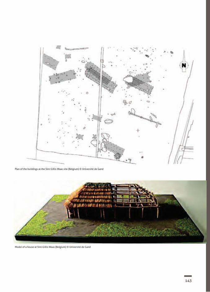
143
Model of a house at Sint-Gillis Waas (Belgium) © Université de Gand
Plan of the buildings at the Sint-Gillis Waas site (Belgium) © Université de Gand

144
In 2001, the Canterbury Archaeological Trust team was digging at St Margaret’s-at-Cliffe, near Dover, when the site director, Keith, found a pattern of holes in the ground. He used the evidence to find out what happened there in the past.
Keith had seen evidence similar to this before. He thought these were remains of a prehistoric ‘round house’ with a frame of posts surrounded by a wall made of small stakes. All houses need a roof, but there was no evidence for one here.
Keith said the house must have been made with wood and this has rotted away. He couldn’t be sure how the roof was made. On another dig like this, he had also found lumps of clay with impressions of small wooden stakes.
He thought about the tools people would have needed to build a house like this and wondered what it would have been like to live in one.
SECTION 3CHAPTER II.3 Domestic dwellings
What did Keith discover?
The St Margaret’s-at-Cliffe site(Kent, England)
A plan of the St Margarets-at-cliffe round house (Kent, England)© Canterbury Archaeological Trust

145
Reconstruction of a Bronze Age round house in Cambridgeshire, Eastern England. Archaeologists think families and their animals may have shared the bigger round houses. © Viv Hamilton, Wikimedia Commons


SECTION 3CHAPTER III
Hoards

148
SECTION 3CHAPTER III Hoards
HoardsBronze Age hoardsHoards have been discovered by arch-aeologists all over Europe. The phenomenon appears during the Early Bronze Age and the practice intensifies during the Middle and Late Bronze Age.
What is a hoard?A hoard can be described as one or several objects which were voluntarily placed in a small pit of varying depth. These objects are mainly made out of bronze (razors, pins, daggers, swords, rings and so on), but other objects such as amber beads, gold jewellery or even clay statuettes and pottery can also be included.
The hoards are usually found near water, places such as springs, marshes or in rivers. They have also been discovered near settlements and cemeteries.
What were hoards for?This practice is so far removed from the habits and customs of our own society that it is difficult to understand the whys and wherefores of hoarding. The many interpretations put forward by archaeologists have been hotly debated over the last few years.
Some think that hoards could have been used to hide away precious objects for protection against theft, or that they were stores of metal used by merchants and craftsmen. As some of the bronze objects are fragmented, others see a pre-monetary trading system, linked to the intrinsic value of the metal’s weight. This system already existed in the Near East at the same period.
The hoards could also have been votive offerings to aquatic gods, which could explain why they are so often found near to water. Water and in particular rivers could mark the boundary between the world of the living and the world of the dead and the offerings might have been used to placate the spirits.

149
Metal hoard from Crundale (Kent, England)© G. Naessens/BOAT 1550 BC

150
SECTION 3CHAPTER III.1 Hoards
Amber is fossilised conifer resin, a rare substance in the Nord-Pas-de-Calais area. Infra-red spectrometry allows us to determine the origin of the amber beads found at Courrières. Based on our present knowledge they could originate from the Paris basin or from the Baltic Sea. Amber is therefore a key indicator of long distance trade. Further study would allow us to know more of socio-economic and commercial links during the Bronze Age
Where does amber come from?
An archaeological evaluation was carried out in 2007 on a site where the Commune of Courrières was planning to build housing. As archaeological structures were found, the Regional Prefect ordered a preventive excavation which led to the discovery of the Courrières site.
After taking off the topsoil, manual excavation using trowel and shovel brought to light three post-holed structures and a pit with an amazing find. It contained a hoard of 12 particularly fragile objects that were removed in blocks of earth to be later excavated in the laboratory. Eleven archaeologists worked for 2 months on the Courrières excavation.
The dig
Post-excavation: laboratory techniques and the study of the finds
The metal objects
Beads and parts of a necklace
The small post-holed buildings discovered on the site were probably granaries used for the storage of cereals. The post holes contained only a few pottery sherds. In contrast, the pit contained 12 items of jewellery which were x-rayed and then restored in a laboratory.
Several of the objects were made out of copper alloy. A razor was placed in the centre of the pit. It has an openwork 2 ringed handle and its blade, unfortunately incomplete, is decorated with 3 perforations and 3 double lines of stamping.
A pin with a biconical head was placed near the razor. The head is decorated with an incised concentric pattern and the end of the stem is missing with an old break that archaeologists can distinguish from a recent break by its patinated appearance.
Three rings were also found; only 1 is complete, measuring 2.4 centimetres in diameter with a 2.5 millimetre thick shaft. The second ring could not be removed from its covering of earth because it was too fragile. A third fragment was discovered during the sieving of the pit fill.
A trefoil object was also discovered, composed of 3 small metal balls measuring 1.8 centimetres long.
Four translucent amber beads were also found. They are a blood red colour and are round, oval and bean shaped. They are perforated as they would have been threaded onto a necklace.
A rounded pebble had a natural perforation on its longest side and the other side seems to have been worked with a tool. It was probably also part of a necklace.
The Courrières site (Pas-de-Calais, France)

151
The Courrières hoard was probably not a funerary deposit, even though the composition of the hoard is very similar to the collections of small objects found in boxes or leather pouches in the cremation burials of the Seine valley to the east of Paris. The fine sieving of the pit fill did not reveal any burnt bone fragments or charcoal.
This seems therefore to be an unprecedented new hoard, the only one of its kind in the North of France. The objects of the Courrières hoard date from the beginning of the Late Bronze Age (1350–1150 BC). The other finds from the site indicate that it was used from the Middle Bronze Age to the Late Iron Age (1500–50 BC).
Interpretation and publication of the resultsPost-excavation: Science and archaeology
RadiographyX rays are particularly useful for studying metal objects as they show manufacturing and decoration details that are not always visible beneath the layers of corrosion.
X rays of the trefoil object revealed that it was in fact a single object rather than an amalgamation of several parts held together by corrosion.
MicroscopySpecial attention was paid to the amber beads which were examined under a binocular mi-croscope (60 x) under various types of light (overhead, underneath and side lighting) and under an environmental scanning elec-tron microscope. This technology allows us to observe abnormalities and tool marks on the polished surface and at the perforations. Unfortunately no marks were found on the beads from Courrières.
Finds from the hoard at Courrières (Pas-de-Calais, France)© G.Naessens

152
50 m0
N
Limites de fouilles
Transition Bronze - Fer
Ier Âge du Fer - début IIe Âge du Fer
Chablis
Tène IIa
Tène C2
Protohistoire
Indéterminée
Bronze moyen
Hallstatt C2 - D
Drains contemporains
Fossés modernes
Dir.
de
l'Arc
héol
ogie
Pré
vent
ive 450-07 courrières
Rues Casimir Beugnet, Pierre Bouchez
Figure 5 : Plan général phasé
����������� � �� ������������������� � ��� �������
31
SECTION 3CHAPTER III.1 Hoards

153
50 m0
N
Limites de fouilles
Transition Bronze - Fer
Ier Âge du Fer - début IIe Âge du Fer
Chablis
Tène IIa
Tène C2
Protohistoire
Indéterminée
Bronze moyen
Hallstatt C2 - D
Drains contemporains
Fossés modernesD
ir. d
e l'A
rché
olog
ie P
réve
ntiv
e 450-07 courrières
Rues Casimir Beugnet, Pierre Bouchez
Figure 5 : Plan général phasé
����������� � �� ������������������� � ��� �������
31
Limit of excavation
Middle Bronze Age
Late Bronze Age
Transition Bronze – Iron Age
Hallstatt C2 – D
1st Iron Age – start of 2nd Iron Age
Tène IIa
Tène C2
Protohistoric
Undated
Wind blown deposits
Modern ditches
Modern drains
450-07 Courrières, Rues Casimir Beugnet, Pierre Bouchez, plan général phasé. Topographie, A Leca-nuet; infographie, Cl Barbet. Dir de l'Archéologie Préventive

154
SECTION 3CHAPTER III.2 Hoards
The Port Arthur Site (Flanders, Belgium)How the bronze hoard was discovered Scientific research
The excavation
The hoard was discovered by chance between 1915 and 1917. During the First World War, the City of Ghent decided to build new docks to prevent the city’s men from being requisitioned to work in Germany. Excavations were carried out in the area of the current Central and South docks which had been known as Farman Square.
Bronze Age hoards are well researched and can vary in composition depending on the purpose the objects served, their chronological period and the geographical area in which they were found. The Port Arthur hoards are ranked among the top Plainseau hoards from the Late Bronze Age (900-800 BC), which are frequently found in Northern France and Belgium. The bronze objects found in all of these hoards are very similar and are therefore identified as being from the so called Plainseau Culture, named after a bronze foundry site near Amiens. Unlike the northern French hoards which sometimes contain hundreds of objects, the Belgian counterparts are somewhat more modest and often contain only a few dozen items. Most hoards have a similar composition of objects. The Port Arthur/Ghent hoard is considered a ‘female’ find as it only contains jewellery. Plainseau hoards do not associate weapons and jewellery; however some contain jewellery and axes, which are thought to have been used as tools rather than weapons.
It is not easy to establish why these hoards were buried. Because so many dating from this period have been discovered, some consider them to have some kind of economic value as bronze was being gradually replaced by iron and thus falling out of use. Due to over-production, a portion of this wealth was buried in order to remove it from circulation. Others take the view that hoards were a form of sacrifice to the underworld or to the gods.
Nobody knows the exact circumstances of the discovery of the hoard. During the excavation of the docks, workers came upon the find and other archaeological material, including the remains of a Merovingian cemetery. Large-scale excavations were closely followed by amateur archaeologists and a collector by the name of Achille Boterdaele. He was able to recover the find, but could not provide any information about its discovery. It is also not clear if the whole hoard was recovered and no information survived about the soil conditions of the find. In 1921, Maertens de Noordhout, who was responsible for the antiquities collection of Ghent University bought the objects for the University’s museum.
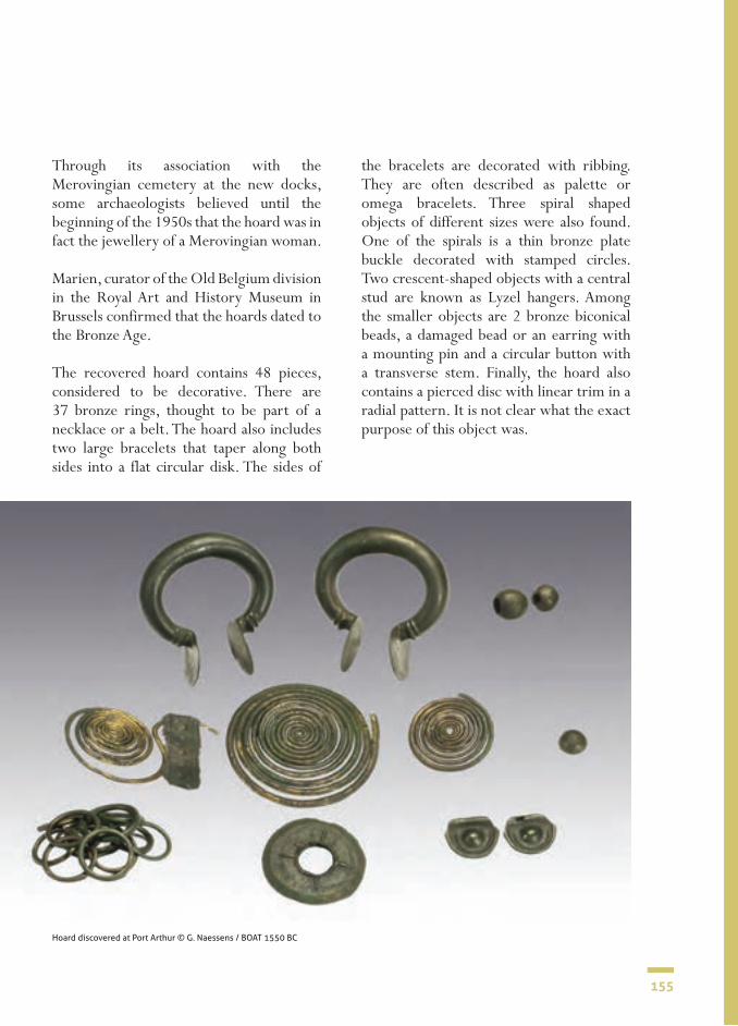
155
Through its association with the Merovingian cemetery at the new docks, some archaeologists believed until the beginning of the 1950s that the hoard was in fact the jewellery of a Merovingian woman.
Marien, curator of the Old Belgium division in the Royal Art and History Museum in Brussels confirmed that the hoards dated to the Bronze Age.
The recovered hoard contains 48 pieces, considered to be decorative. There are 37 bronze rings, thought to be part of a necklace or a belt. The hoard also includes two large bracelets that taper along both sides into a flat circular disk. The sides of
the bracelets are decorated with ribbing. They are often described as palette or omega bracelets. Three spiral shaped objects of different sizes were also found. One of the spirals is a thin bronze plate buckle decorated with stamped circles. Two crescent-shaped objects with a central stud are known as Lyzel hangers. Among the smaller objects are 2 bronze biconical beads, a damaged bead or an earring with a mounting pin and a circular button with a transverse stem. Finally, the hoard also contains a pierced disc with linear trim in a radial pattern. It is not clear what the exact purpose of this object was.
Hoard discovered at Port Arthur © G. Naessens / BOAT 1550 BC

156
SECTION 3CHAPTER III.3 Hoards
The Aylesford site (Kent, England)
Have you ever thrown a coin into a well or fountain and made a wish? It seems that people in the Bronze Age did something like this.
Bronze Age objects have been found in rivers, the sea and in ancient ponds. Others have been found in the ground. When a group of objects is found together, archaeologists think they were deliberately buried. They call this a ‘hoard’.
Bronze Age hoards have been found all over Europe. Sometimes there are a few things, sometimes hundreds! Sometimes objects had been broken, but not always.
Two gold hoards found in the Aylesford area (Kent, England). One of them was found in the River Medway © G.Naessens

157
Archaeologists do not know why people deliberately buried valuable things or threw them into watery places. They may have been gifts to their gods. People may have wanted favours in return – like a long and happy life


SECTION 4
The Dover Boat and Thanet Earth scheme of work:lesson plans for teachers and resource sheets for pupils

160
SECTION 4
What was life like in the Bronze Age?
This is a mini-scheme of work aimed at Key Stage 2 pupils. As written, it is aimed at Years 5 and 6, but can be adapted for Years 3 and 4.
In preparing the scheme, we have delib-erately kept the information provided for each lesson relatively brief as we do not want the lessons to become a ‘script’ and inhibit the creativity of individual teachers. Just like archaeologists and all good historians, we are also aiming for a truly investigative approach to be taken during the lessons and in investigative approaches we must allow for sidelines and individual interests to be pursued. Providing a prescriptive set of lessons would completely close this down.
Nevertheless, we hope this mini-scheme provides a framework from which to work in an exciting and original manner with your pupils. We believe they will enjoy the lessons and more importantly, learn a lot about the Bronze Age and how historians and archaeologists find out about the past. We also hope the same will be true for their teachers.
The four suggested lessons are all based on real archaeological digs carried out by the Canterbury Archaeological Trust. We want to immerse the pupils in the work of the archaeologists who carried out those digs and what they found out about the Bronze Age as a result.
Using real-life archaeological digs to investigate our past

161
Bronze Age burial at the Thanet Earth site (Kent, England) © Canterbury Archaeological Trust

162
SECTION 4
Lessons 1 and 2 - The Thanet Earth dig (Kent, England)
Background informationBefore major development work began on ‘Thanet Earth’ in 2007, a huge greenhouse complex just outside Ramsgate, the Canterbury Archeological Trust carried out a significant dig that lasted for over a year.
Several ‘plateaux’ were dug that matched the future site of the greenhouses and other new buildings. Significant evidence was found from several periods, principally the Bronze Age, Iron Age, Roman, Anglo-Saxon and Medieval periods and the finds suggested that there had been settlement at the site at all those times.
One of the areas investigated was a Bronze Age barrow. Barrows were where people from the Bronze Age buried important members of their society. Inside that barrow, the archaeologists found a grave with a skeleton and some artefacts.
A key find in the Thanet Earth dig was this incredible Bronze Age ‘barrow’. At the centre was an extraordinary ‘Beaker burial’ of an individual laying in the ‘crouch’ position. With the skeleton was a ceramic beaker vessel (sadly crushed) at the feet; the tantalizing tip of a copper alloy object, possibly a knife blade or spear head just visible beneath the right shoulder; and a flat stone archer's wrist guard beneath the left arm.

163
Bronze Age ‘barrow’ at the Thanet Earth site (Kent, England) © Canterbury Archaeological Trust

164
SECTION 4
Back
grou
ndA
ims
Intr
oduc
tion
Dev
elop
men
tPl
enar
yRe
sour
ces
A
maj
or
misc
once
ptio
n ab
out
arch
aeol
ogist
s is
that
all
they
do
is di
g ho
les i
n th
e gr
ound
! Bef
ore
doin
g th
is th
ey fi
rst h
ave
to d
ecid
e if
a sit
e is
wor
th d
iggi
ng a
nd if
so,
whe
re in
pa
rtic
ular
. Afte
r the
dig
is c
ompl
eted
, a
very
sig
nific
ant
amou
nt o
f tim
e is
then
sp
ent
inte
rpre
ting
wha
t w
as
foun
d on
sit
e an
d an
alysin
g an
d w
ritin
g ab
out t
he fi
nds.
This
first
les
son
imm
erse
s pu
pils
in
the
first
sta
ge,
the
desk
ass
essm
ent,
whe
re
arch
aeol
ogist
s ex
amin
e th
e co
llect
ive
sour
ces
of e
vide
nce
for
a sit
e. T
hen
base
d on
thi
s as
sess
men
t, th
ey
deci
de
whe
ther
or
no
t to
ex
cava
te.
Thes
e ar
e th
e sa
me
for
both
les
sons
on
the
Tha-
net E
arth
dig
• To
begi
n to
und
erst
and
the
wor
k of
re
al
life
arch
aeol
ogist
s th
roug
h im
mer
sive
and
inve
sti-
gativ
e ac
tiviti
es
• To
deve
lop
skill
s of u
sing
and
eval
uatin
g ev
iden
ce
befo
re m
akin
g de
cisio
ns
• To
enha
nce
skill
s of
sp
eaki
ng
and
liste
ning
, th
roug
h pr
esen
ting
ver-
bal a
nd w
ritte
n fin
ding
s
Qui
te d
elib
erat
ely,
give
the
pupi
ls ve
ry li
ttle
info
rma-
tion
abou
t the
Bro
nze A
ge
befo
re
start
ing,
pr
eser
ve
an ‘
air o
f m
yste
ry’
abou
t w
hat
they
are
doi
ng a
nd
allow
the
m t
o co
me
to
the
info
rmat
ion
for
them
-se
lves
.
• Tel
l the
chi
ldre
n th
at fo
r th
e ne
xt f
ew le
sson
s th
e sc
hool
has
bee
n as
ked
by
the
Can
terb
ury
Arch
aeo-
logi
cal
Trus
t to
pro
vide
ad
vice
on
a po
ssib
le d
ig
they
are
thi
nkin
g ab
out
carr
ying
out
.• L
et t
he c
hild
ren
know
th
ere
is a
vege
tabl
e co
m-
pany
who
are
thi
nkin
g ab
out
build
ing
gian
t gr
eenh
ouse
s on
a
site
near
Ram
sgat
e. B
ut t
he
Trus
t th
inks
the
re m
ay
be
impo
rtan
t an
cient
ev
iden
ce w
aitin
g to
be
foun
d th
ere.
• The
ir jo
b is
to b
e arc
haeo
-lo
gists
th
emse
lves
an
d he
lp t
he T
rust
with
the
ir w
ork.
Exp
lain
how
the
fir
st th
ing
they
mus
t do
is th
e ‘de
sk as
sess
men
t’:• I
s it
wor
th d
iggi
ng t
he
site
at al
l? If
so, w
here
?• T
he v
eget
able
com
pany
w
ill h
ave
to p
ay f
or t
he
dig
and
it co
uld
cost
a gr
eat
deal
mon
ey.
They
m
ight
get
very
ups
et w
ith
the T
rust
if th
ey d
on’t
find
anyt
hing
In g
roup
s, pr
ovid
e (s
ome
or a
ll, d
epen
ding
on
age/
abili
ty)
the
follo
win
g pi
eces
of e
vide
nce
(foun
d w
ith t
his
sche
me
and
on
the
USB
pen
in th
e K
it):
• arc
hite
ct’s
plan
s for
new
bu
ildin
gs• a
eria
l pho
togr
aphy
• fie
ld w
alki
ng re
sults
• doc
umen
tary
evi
denc
e• p
ast d
iscov
erie
s• g
eoph
ysic
al su
rvey
Each
gro
up m
ust
take
on
the
role
of
arch
aeol
ogy
team
s an
d fe
ed b
ack
to
ever
yone
el
se
on
thes
e ke
y qu
estio
ns:
1. Is
it w
orth
doi
ng a
dig
? W
hat
evid
ence
is
ther
e fo
r you
r dec
ision
?
2. If
so, w
here
on
the
site
shal
l we
star
t?
Each
gro
up in
turn
shou
ld
pres
ent t
heir
findi
ngs.
• Ea
ch g
roup
mus
t pr
o-vi
de
evid
ence
fo
r th
eir
conc
lusio
ns
• Eac
h gr
oup
shou
ld t
ake
ques
tions
fr
om
the
othe
r gro
ups a
bout
thei
r fin
ding
s
As a
cla
ss a
n ov
eral
l dec
i-sio
n sh
ould
be
take
n.
Shal
l we
dig?
If so
, whe
re?
Res
ourc
e A
• arc
hite
ct’s
plan
s for
ne
w b
uild
ings
Res
ourc
e B
• aer
ial p
hoto
grap
hy
repo
rt
Res
ourc
e C
• fie
ld w
alki
ng re
port
Res
ourc
e D
• hist
oric
doc
umen
ts
repo
rt
Res
ourc
e E
• pas
t disc
over
ies r
epor
t
Res
ourc
e F
• geo
phys
ical
surv
ey
repo
rt
Less
on 1
: the
Tha
net E
arth
des
k as
sess
men
t

165
Back
grou
ndA
ims
Intr
oduc
tion
Dev
elop
men
tPl
enar
yRe
sour
ces
The
(mal
e) s
kele
ton
foun
d in
the
ba
rrow
was
alm
ost c
erta
inly
som
eone
of
impo
rtan
ce. W
ith h
im w
ere
foun
d a
crus
hed
potte
ry
beak
er,
a co
pper
al
loy
knife
bla
de o
r sp
ear
head
and
a
flat s
tone
arch
er’s
wri
st gu
ard.
Seve
ral
scie
ntifi
c pr
oces
ses
wer
e ca
rrie
d ou
t on
the
skel
eton
. The
se w
ere:
Ost
eolo
gica
l exa
min
atio
n• O
steo
arch
aeol
ogy
is
the
stud
y of
bo
nes f
rom
arch
aeol
ogic
al si
tes
Isoto
pe an
alysis
• Iso
tope
s ar
e ch
emic
als
foun
d in
bo
ne a
nd t
ooth
ena
mel
. Sc
ient
ists
can
find
out,
from
ch
emic
als
in
bone
, wha
t ki
nd o
f foo
ds p
eopl
e at
e an
d, fr
om c
hem
ical
s in
tee
th, w
here
pe
ople
may
hav
e gr
own
up,
Rad
io-c
arbo
n da
ting
• Car
bon
is fo
und
in a
ll liv
ing
thin
gs.
Whe
n so
met
hing
di
es
the
carb
on
‘bre
aks d
own’
over
tim
e. B
y an
alyzi
ng
how
muc
h ca
rbon
has
bee
n lo
st i
n an
or
gani
c obj
ect,
scie
ntist
s can
est
imat
e w
hen
that
org
anic
mat
eria
l die
d.
Thes
e ar
e th
e sa
me
for
both
les-
sons
on
the
Tha-
net E
arth
dig
• To
begi
n to
un
ders
tand
th
e w
ork
of r
eal
life
arch
aeol
ogis
ts
thro
ugh
imm
er-
sive
and
inve
stig
a-tiv
e ac
tiviti
es
• To
deve
lop
skill
s of
usin
g an
d ev
a-lu
atin
g ev
iden
ce
befo
re
mak
ing
deci
sions
• To
enha
nce
skill
s of
sp
eaki
ng
and
liste
ning
, th
roug
h pr
esen
ting
verb
al
and
wri
tten
fin-
ding
s
Tell
the
pupi
ls th
at
you
told
the
Can
-te
rbur
y Ar
chae
olo-
gica
l Tru
st th
e cl
ass’
decis
ion
and
the
Trus
t th
ough
t th
e sa
me!
The
arch
aeol
ogist
s ha
ve n
ow s
ent
you
som
e in
form
atio
n on
the
dig
that
took
pl
ace.
The T
rust
wan
ts th
e pu
pils’
hel
p in
ana
-ly
sing
the
finds
.
At
this
stag
e, d
on’t
tell
the
pupi
ls an
y-th
ing
at a
ll ab
out
the
info
rmat
ion,
sim
-pl
y gi
ve t
he s
ame
grou
ps a
s be
fore
the
fo
llow
ing
info
rmat
ion
(foun
d w
ith t
his
sche
me
and
on th
e U
SB p
en in
the
Kit)
:
• Pho
to o
f the
bar
row
gra
ve• P
hoto
s of t
he g
rave
arte
fact
s• B
arro
w g
rave
exc
avat
ion
repo
rt• A
rtef
act r
epor
t• O
steo
arch
aeol
ogist
repo
rt• I
soto
pe an
alysis
repo
rt• R
adio
-car
bon
datin
g re
port
• And
the
Beak
er re
plic
a in
the
Kit
(to
shar
e be
twee
n gr
oups
)If
you
wan
t to,
you
cou
ld te
ll th
e pu
pils
that
this
is a r
eplic
a of t
he o
ne fo
und
bro-
ken
in th
e gr
ave
Afte
r exa
min
ing
the
evid
ence
the
pupi
ls ca
n co
mpl
ete
an a
rcha
eolo
gica
l re
port
su
mm
arisi
ng t
he k
ey p
oint
s th
at h
ave
been
disc
over
ed.
Thei
r re
port
cou
ld b
e in
man
y fo
rms,
for e
xam
ple:
• A w
ritte
n re
port
• A p
ower
poin
t pre
sent
atio
n to
a ‘s
peci
al
audi
ence
’• A
doc
umen
tary
‘Tim
e Te
am’ s
tyle
TV
sh
ow• A
new
s ite
m f
or M
erid
ian
Toni
ght
or
BBC
Sou
th E
ast
• A n
ewsp
aper
art
icle
for
the
ir lo
cal
pape
r
Dep
endi
ng o
n th
e ag
e an
d ab
ility
of t
he
clas
s and
the
time
allo
wed
for i
n th
is le
s-so
n, it
is p
ossib
le th
at th
e co
mpl
etio
n of
re
port
s str
etch
es o
ver a
mor
e pr
olon
ged
peri
od.
Dep
endi
ng o
n w
hich
re-
port
ing
optio
n w
as c
ho-
sen,
cho
ose
exam
ples
to
exam
ine.
H
owev
er,
this
shou
ldn'
t jus
t be
a sha
ring
ex
erci
se• P
robe
th
e pu
pils’
un
-de
rsta
ndin
g of
w
hat
they
’ve
foun
d ou
t abo
ut
the
Bron
ze
Age
an
d ab
out a
rcha
eolo
gy:
• Wha
t ha
ve t
hey
foun
d ou
t ab
out
the
time
the
pers
on w
as fr
om?
• Wha
t sor
t of l
ife d
o th
ey
thin
k he
had
?• W
as h
is lif
e sim
ilar
or
diffe
rent
to th
eirs
?• H
as a
nyth
ing
surp
rise
d th
em o
r int
eres
ted
them
ab
out
the
wor
k of
ar-
chae
olog
ists?
Afte
r th
e re
port
s ar
e co
mpl
eted
, let
the
pup
ils
know
yo
u've
re
ceiv
ed
som
e ex
citin
g ne
ws!
The
Can
terb
ury A
rcha
eo-
logi
cal T
rust
has
bee
n so
pl
ease
d w
ith h
ow t
hing
s ha
ve g
one
that
the
y ha
ve
been
bac
k in
tou
ch w
ith
info
rmat
ion
on
anot
her
dig
and
they
wan
t th
eir
help
agai
n!• G
ive
the
pupi
ls a
very
br
ief i
ntro
duct
ion
to th
e D
over
Bro
nze A
ge B
oat
• Cou
ld th
e pe
rson
in th
e gr
ave
have
had
any
thin
g to
do
with
it?
Res
ourc
e G
• pho
to o
f the
bar
row
gr
ave
Res
ourc
e H
• pho
tos o
f the
gra
ve
arte
fact
s
Res
ourc
e I
• bar
row
gra
ve
exca
vatio
n re
port
Res
ourc
e J
• art
efac
t rep
ort
Res
ourc
e K
• ost
eoar
chae
olog
y re
port
Res
ourc
e L
• Iso
tope
analy
sis re
port
Res
ourc
e M
• Rad
io- c
arbo
n da
ting
repo
rt
• the
Bea
ker r
eplic
a in
the
Kit
Less
on 2
: the
Tha
net E
arth
gra
ve

166
SECTION 4
Lessons 3 and 4: the Dover Bronze Age boat
Background informationIn 1992, archaeologists were working alongside construction men on a new road in Dover when they found the remains of a large wooden object. It soon became clear that the archaeologists had found something special. This was confirmed by examination, which suggested that they had found the world’s oldest known sea-going boat, dating to c. 1550 BC.
Only 9.5 meters of the boat could be safely removed from the site. After many years of conservation work it was put on display in Dover museum in 1998 where it remains to this day in a specially designed Bronze Age gallery.
The information below is purposefully designed to spread across two lessons or, practicalities allowing, a significant part of a whole day.

167The Dover Bronze Age boat in Dover Museun (Kent, England) © Canterbury Archaeological Trust

168
SECTION 4
Aim
sIn
trod
ucti
onD
evel
opm
ent
Plen
ary
Reso
urce
s• T
o us
e ev
iden
ce to
bui
ld
a pi
ctur
e of
life
in
the
past
• To
com
mun
icat
e to
ot
hers
why
fin
ding
out
ab
out
hist
ory
is im
por-
tant
• To
eval
uate
th
e sig
ni-
fican
ce
of
diffe
rent
so
urce
s of
inf
orm
atio
n fo
r the
pas
t
Rem
ind
the c
hild
ren
abou
t th
e di
scov
ery
of t
he b
oat
and
let
them
kno
w it
can
no
w b
e se
en in
the
Dov
er
Mus
eum
.
Tell
the
child
ren
that
the
Tr
ust
has
carr
ied
out
a se
ries
of t
ests
and
writ
ten
repo
rts o
n th
e boa
t and
the
site
whe
re it
was
foun
d.
They
wan
t the
pup
ils’ h
elp
with
a p
robl
em (b
ut d
on’t
say
wha
t it i
s).
Exam
ine
the
follo
win
g so
urce
s in
the
sam
e gr
oups
as b
efor
e (fo
und
with
this
sche
me
and
on th
e U
SB p
en in
the
Kit)
• Env
ironm
enta
l ana
lysis
repo
rt• T
echn
olog
y re
port
• Rad
io-c
arbo
n da
ting
repo
rt• P
hoto
of t
he b
oat w
here
it w
as fo
und
and
reco
nstr
uctio
n im
age
of th
e bo
at• L
angd
on B
ay D
iscov
ery
repo
rt• A
nd th
e re
plica
axe
in th
e K
it (to
shar
e be
twee
n gr
oups
) U
sing
the
sour
ces a
s evi
denc
e, in
gro
ups t
he p
upils
are
to p
rese
nt
thei
r ow
n th
eory
as to
wha
t the
y th
ink
the
boat
was
actu
ally
for a
nd
wha
t it t
ells
us ab
out t
he B
ronz
e Age
and
the p
eopl
e who
live
d th
en.
Each
gro
up sh
ould
pres
ent t
heir
main
find
ings
to th
e oth
ers.
Now
tell
the
clas
s the
Trus
t's p
robl
em:
• The
Trus
t has
bee
n ta
lkin
g to
Dov
er M
useu
m, w
here
the b
oat i
s on
disp
lay an
d th
ey ar
e w
orrie
d th
at n
ot e
noug
h pe
ople
are
visit
ing
it• T
hey
thin
k th
at m
any
peop
le d
on’t
know
abo
ut th
e bo
at a
nd w
hy
it’s i
mpo
rtan
t
The T
rust
and
Dov
er M
useu
m w
ant t
heir
help
in a
cam
paig
n to
get
m
ore
peop
le to
com
e. W
hat i
deas
do
the
pupi
ls ha
ve?
• Sca
ffold
the
pupi
ls’ id
eas i
n de
velo
ping
a PR
cam
paig
n. T
his c
ould
in
clud
e (b
ut is
not
exh
austi
ve a
s the
pup
ils m
ay h
ave
muc
h be
tter
idea
s whi
ch co
uld
be ta
ken
forw
ard)
o Le
afle
ts, p
oste
rs, l
ette
rs to
new
spap
ers,
com
petit
ions
etc
.
Pupi
ls ca
n th
en w
ork
on th
e ide
as g
ener
ated
. Dep
endi
ng o
n th
e age
, ab
ility
and
idea
s thi
s cou
ld b
e:• E
ach
pupi
l pro
duce
s one
of t
he id
eas
- e
.g. A
ll pu
pils
do th
e sa
me
thin
g, fo
r exa
mpl
e - a
pos
ter
• Diff
eren
t gro
ups a
re g
iven
resp
onsib
ility
for d
iffer
ent t
hing
s
- e.g.
One
gro
up d
oes a
pos
ter,
anot
her a
leaf
let e
tc• E
ach
grou
p ha
s to
prod
uce
seve
ral i
tem
s
- e.g.
Diff
eren
t peo
ple
in e
ach
grou
p ha
ve to
do
diffe
rent
thin
gs
Pupi
ls sh
ould
take
tim
e to
plan
the
item
s bef
ore
start
ing.
Som
e ve
ry
impo
rtan
t que
stion
s nee
d to
be c
onsid
ered
. Wha
teve
r the
y pro
duce
, th
eir i
tem
shou
ld sa
y:• W
hy th
e bo
at is
impo
rtan
t• W
hat t
he b
oat t
ells
us ab
out t
he p
ast
• Why
the
boat
is w
orth
visi
ting
• Whe
re/H
ow th
e bo
at w
as fo
und
Exam
ine
the
pupi
ls’
fi-ni
shed
pie
ces.
Dra
w o
ut
the
mos
t su
cces
sful
fea-
ture
s and
why
.
Prob
e th
e pu
pils’
und
ers-
tand
ing
of th
e Br
onze
Age
fr
om a
ll th
e le
sson
s:
• Wha
t ha
ve
they
fo
und
out
abou
t th
e tim
e th
e Th
anet
Ear
th p
erso
n an
d th
e Bo
at w
ere
from
?
• In
wha
t way
s was
life
dif-
fere
nt fo
r peo
ple
then
?
• In
wha
t w
ays
was
life
sim
ilar t
o no
w?
• Has
any
thin
g su
rpri
sed
them
?
Res
ourc
e N
• Env
ironm
enta
l an
alysis
repo
rt
Res
ourc
e O
• Tec
hnol
ogy
repo
rt
Res
ourc
e P
• Rad
io-c
arbo
n da
ting
repo
rt
Res
ourc
e Q
• Pho
to o
f the
boa
t w
here
it w
as fo
und
Res
ourc
e R
• Rec
onst
ruct
ion
imag
e of
the
boat
Res
ourc
e S
• Lan
gdon
Bay
D
iscov
ery
repo
rt
• The
repl
ica a
xe in
th
e K
it
Less
ons
3 an
d 4:
wha
t do
we
know
abo
ut th
e Br
onze
Age
boa
t and
the
peop
le w
ho b
uilt
it?

169
Optional lessons: what was the Bronze Age?Why have these optional lessons?
The four lessons on the Thanet Earth dig and the Dover Bronze Age Boat are deliberately constructed to allow pupils to discover information and knowledge about the Bronze Age for themselves.
The aim is for pupils to become inspired about what they have discovered and come to an understanding of the past not only through the four lessons, but also through subsequent independent research.
However, there may be scenarios in which teachers might like to provide additional lessons that provide further information on this period. This might be because individual teachers feel it necessary or because the class’ learning appetite has been ignited.
When would you teach them?
These optional lessons could be at any point in the unit; before, during or after the lessons on the Thanet Earth dig and the Boat. To aid the intention of children discovering and constructing historical knowledge for themselves, during or after (rather than before) may be better, but this is clearly a decision for the individual teacher.
There are six suggested optional lessons. Should I teach them all?
It is entirely down to each teacher and the characteristics of their teaching approaches, confidence in teaching history and the make-up of their individual classes. You could teach none of them or all of them. However, the intention is that if a teacher wanted to use them they would support and supplement the lessons on the Thanet Earth dig and the Boat - and not replace them.
What about the activities suggested elsewhere in the guide. Could I use those?
By all means. We genuinely want to provide teachers with choice and flexibility, enabling the Bronze Age and the work of archaeologists to be taught and amaze children of all abilities in key stage 2. They could, for example, try identifying and recording the archaeological finds in the kit. We hope that you find inspiration in any of the suggestions (or ideas of your own) to create a set of lessons that suits both you and the individual needs of your class.
Aim
sIn
trod
ucti
onD
evel
opm
ent
Plen
ary
Reso
urce
s• T
o us
e ev
iden
ce to
bui
ld
a pi
ctur
e of
life
in
the
past
• To
com
mun
icat
e to
ot
hers
why
fin
ding
out
ab
out
hist
ory
is im
por-
tant
• To
eval
uate
th
e sig
ni-
fican
ce
of
diffe
rent
so
urce
s of
inf
orm
atio
n fo
r the
pas
t
Rem
ind
the c
hild
ren
abou
t th
e di
scov
ery
of t
he b
oat
and
let
them
kno
w it
can
no
w b
e se
en in
the
Dov
er
Mus
eum
.
Tell
the
child
ren
that
the
Tr
ust
has
carr
ied
out
a se
ries
of t
ests
and
writ
ten
repo
rts o
n th
e boa
t and
the
site
whe
re it
was
foun
d.
They
wan
t the
pup
ils’ h
elp
with
a p
robl
em (b
ut d
on’t
say
wha
t it i
s).
Exam
ine
the
follo
win
g so
urce
s in
the
sam
e gr
oups
as b
efor
e (fo
und
with
this
sche
me
and
on th
e U
SB p
en in
the
Kit)
• Env
ironm
enta
l ana
lysis
repo
rt• T
echn
olog
y re
port
• Rad
io-c
arbo
n da
ting
repo
rt• P
hoto
of t
he b
oat w
here
it w
as fo
und
and
reco
nstr
uctio
n im
age
of th
e bo
at• L
angd
on B
ay D
iscov
ery
repo
rt• A
nd th
e re
plica
axe
in th
e K
it (to
shar
e be
twee
n gr
oups
) U
sing
the
sour
ces a
s evi
denc
e, in
gro
ups t
he p
upils
are
to p
rese
nt
thei
r ow
n th
eory
as to
wha
t the
y th
ink
the
boat
was
actu
ally
for a
nd
wha
t it t
ells
us ab
out t
he B
ronz
e Age
and
the p
eopl
e who
live
d th
en.
Each
gro
up sh
ould
pres
ent t
heir
main
find
ings
to th
e oth
ers.
Now
tell
the
clas
s the
Trus
t's p
robl
em:
• The
Trus
t has
bee
n ta
lkin
g to
Dov
er M
useu
m, w
here
the b
oat i
s on
disp
lay an
d th
ey ar
e w
orrie
d th
at n
ot e
noug
h pe
ople
are
visit
ing
it• T
hey
thin
k th
at m
any
peop
le d
on’t
know
abo
ut th
e bo
at a
nd w
hy
it’s i
mpo
rtan
t
The T
rust
and
Dov
er M
useu
m w
ant t
heir
help
in a
cam
paig
n to
get
m
ore
peop
le to
com
e. W
hat i
deas
do
the
pupi
ls ha
ve?
• Sca
ffold
the
pupi
ls’ id
eas i
n de
velo
ping
a PR
cam
paig
n. T
his c
ould
in
clud
e (b
ut is
not
exh
austi
ve a
s the
pup
ils m
ay h
ave
muc
h be
tter
idea
s whi
ch co
uld
be ta
ken
forw
ard)
o Le
afle
ts, p
oste
rs, l
ette
rs to
new
spap
ers,
com
petit
ions
etc
.
Pupi
ls ca
n th
en w
ork
on th
e ide
as g
ener
ated
. Dep
endi
ng o
n th
e age
, ab
ility
and
idea
s thi
s cou
ld b
e:• E
ach
pupi
l pro
duce
s one
of t
he id
eas
- e
.g. A
ll pu
pils
do th
e sa
me
thin
g, fo
r exa
mpl
e - a
pos
ter
• Diff
eren
t gro
ups a
re g
iven
resp
onsib
ility
for d
iffer
ent t
hing
s
- e.g.
One
gro
up d
oes a
pos
ter,
anot
her a
leaf
let e
tc• E
ach
grou
p ha
s to
prod
uce
seve
ral i
tem
s
- e.g.
Diff
eren
t peo
ple
in e
ach
grou
p ha
ve to
do
diffe
rent
thin
gs
Pupi
ls sh
ould
take
tim
e to
plan
the
item
s bef
ore
start
ing.
Som
e ve
ry
impo
rtan
t que
stion
s nee
d to
be c
onsid
ered
. Wha
teve
r the
y pro
duce
, th
eir i
tem
shou
ld sa
y:• W
hy th
e bo
at is
impo
rtan
t• W
hat t
he b
oat t
ells
us ab
out t
he p
ast
• Why
the
boat
is w
orth
visi
ting
• Whe
re/H
ow th
e bo
at w
as fo
und
Exam
ine
the
pupi
ls’
fi-ni
shed
pie
ces.
Dra
w o
ut
the
mos
t su
cces
sful
fea-
ture
s and
why
.
Prob
e th
e pu
pils’
und
ers-
tand
ing
of th
e Br
onze
Age
fr
om a
ll th
e le
sson
s:
• Wha
t ha
ve
they
fo
und
out
abou
t th
e tim
e th
e Th
anet
Ear
th p
erso
n an
d th
e Bo
at w
ere
from
?
• In
wha
t way
s was
life
dif-
fere
nt fo
r peo
ple
then
?
• In
wha
t w
ays
was
life
sim
ilar t
o no
w?
• Has
any
thin
g su
rpri
sed
them
?
Res
ourc
e N
• Env
ironm
enta
l an
alysis
repo
rt
Res
ourc
e O
• Tec
hnol
ogy
repo
rt
Res
ourc
e P
• Rad
io-c
arbo
n da
ting
repo
rt
Res
ourc
e Q
• Pho
to o
f the
boa
t w
here
it w
as fo
und
Res
ourc
e R
• Rec
onst
ruct
ion
imag
e of
the
boat
Res
ourc
e S
• Lan
gdon
Bay
D
iscov
ery
repo
rt
• The
repl
ica a
xe in
th
e K
it

170
SECTION 4
Titl
eA
ims
Info
rmat
ion
Poss
ible
Act
ivit
ies
Whe
n w
as th
e Br
onze
A
ge a
nd w
hy is
it c
alle
d th
at?
To u
nder
stan
d th
e pe
riod
’s ch
rono
logi
cal
plac
e in
the
past
To
eva
luat
e w
hy th
e in
vent
ion
of b
ronz
e w
as
so im
port
ant.
The
Bron
ze A
ge im
med
iate
ly fo
llow
ed th
e St
one A
ge a
nd
the
inve
ntio
n of
bro
nze
revo
lutio
nize
d lif
e. It
ena
bled
new
to
ols a
nd sk
ills t
o be
cre
ated
, thu
s tot
ally
cha
ngin
g lif
e. T
his
incl
uded
har
d w
eari
ng a
xes t
hat c
ould
mak
e ho
uses
, boa
ts e
tc.;
and
swor
ds, k
nife
s, fa
rmin
g to
ols e
tc.
As a
who
le c
lass
cre
ate
a tim
elin
e of
the
mai
n pe
riod
s bef
ore
and
afte
r the
Bro
nze A
ge. O
n th
e pl
aygr
ound
cre
ate
a hu
man
tim
elin
e to
dem
ons-
trat
e ho
w lo
ng a
go th
is pe
riod
was
. Und
erta
ke a
ca
rd so
rtin
g ac
tivity
of t
hing
s tha
t wer
e an
d w
ere
not p
ossib
le b
efor
e th
e in
vent
ion
of b
ronz
e.
Wer
e pe
ople
in th
e Br
onze
Age
skill
ed?
To u
se a
rtef
acts
to m
ake
dedu
ctio
ns a
bout
the
past
.
A c
omm
on m
iscon
cept
ion
of B
ronz
e Age
peo
ple
is th
at th
ey
wer
e ve
ry p
rim
itive
. In
fact
, the
y w
ere
capa
ble
of m
akin
g th
ings
requ
irin
g as
toni
shin
g sk
ill a
nd e
xten
sive
trad
e lin
ks.
Look
at th
ree
maj
or B
ronz
e Age
arte
fact
s fou
nd
in th
e Br
itish
Mus
eum
: the
Rin
glem
ere
Cup
, the
Th
ames
Cau
ldro
n an
d th
e M
old
Cap
e. W
hat d
o th
ese
finds
tell
us ab
out t
he p
eopl
e w
ho m
ade
them
?
Whe
re d
id B
ronz
e Age
pe
ople
live
?To
mak
e se
nsib
le
dedu
ctio
ns o
n lif
e in
the
Bron
ze A
ge fr
om in
vest
i-ga
ting
thei
r hou
ses.
Ano
ther
myt
h ab
out p
eopl
e in
the
Bron
ze A
ge is
that
they
liv
ed in
cav
es. T
hey
wer
e ac
tual
ly c
apab
le o
f bui
ldin
g ar
chi-
tect
ural
ly su
cces
sful a
nd c
ompl
ex h
omes
. The
se in
clud
ed la
ke
hom
es o
n st
ilts a
nd h
ouse
s with
two
floor
s.
Exam
ine
som
e re
cons
truc
tions
of B
ronz
e Age
ho
uses
. See
St M
arga
ret’s
– a
t – C
liffe
exa
mpl
e il-
lust
rate
d in
this
guid
e. Ta
ke o
n th
e ro
le o
f a ‘B
ronz
e A
ge a
rchi
tect
’, fir
stly
sket
chin
g a
cros
s sec
tion
of a
ho
use
desig
ned
for a
cus
tom
er, t
hen
listin
g al
l the
to
ols,
mat
eria
ls an
d sk
ills t
hat w
ill b
e ne
eded
in
orde
r to
cons
truc
t it.
Wha
t was
life
like
for
peop
le in
the
Bron
ze
Age
?
To u
se h
uman
rem
ains
to
mak
e hi
stor
ical
ly
accu
rate
ded
uctio
ns.
Skel
etal
find
s sug
gest
life
was
far f
rom
eas
y. In
fant
and
chi
ld
deat
hs w
ere
high
. Sur
viva
l int
o yo
ur te
ens m
eant
a g
ood
chan
ce o
f liv
ing
into
you
r 20s
or e
ven
30s b
ut it
was
unu
sual
to
get
bey
ond
45. Y
ou c
ould
say
it w
as a
‘lan
d of
the
youn
g’ in
m
oder
n te
rms.
Ost
eoar
chae
olog
ists h
ave
foun
d ev
iden
ce fo
r ar
thri
tis a
nd sp
ina
bifid
a. In
fect
ions
mus
t hav
e be
en c
omm
on.
One
infe
ctio
n ca
me
from
eat
ing
untr
eate
d da
iry
food
s and
ca
ttle
mea
t and
affe
cted
bon
e ar
ound
the
eye
sock
et. P
ain
thre
shol
d w
as n
o do
ubt h
ighe
r tha
n ou
rs a
nd h
erba
l and
hal
lu-
cino
geni
c re
med
ies w
ould
hav
e be
en c
omm
on.
Des
ign
a di
splay
pie
ce fo
r a m
useu
m th
at h
as a
sk
elet
on in
its a
rchi
ve. H
ow sh
ould
it b
e pr
esen
ted
and
wha
t sho
uld
the
labe
l say
?
Wha
t rel
igio
us b
elie
fs di
d th
e Br
onze
Age
pe
ople
hav
e?
To b
egin
to u
nder
stan
d th
e ev
eryd
ay b
elie
fs of
Br
onze
Age
peo
ple.
Litt
le is
und
erst
ood
abou
t Bro
nze A
ge re
ligio
n, b
ut it
is li
kely
th
ere
wer
e a
rang
e of
god
s and
relig
ious
supe
rstit
ions
. Sto
ne-
heng
e w
as st
arte
d in
the
Ston
e Age
, but
com
plet
ed a
nd u
sed
duri
ng th
e Br
onze
Age
. The
re a
re m
any
theo
ries
as t
o its
use
, in
clud
ing:
a c
eles
tial c
lock
, an
‘anc
ient
Lou
rdes
’ for
the
curi
ng
of th
e sic
k an
d a
gate
way
to th
e ‘la
nd o
f the
dea
d’.
Exam
ine
the
com
petin
g th
eori
es o
n w
hy S
tone
heng
e w
as b
uilt.
Hol
d a c
lass
deb
ate
on w
hich
of t
he th
eo-
ries
they
thin
k is
mos
t acc
urat
e. D
iffer
ent g
roup
s sh
ould
pre
pare
the
case
for a
diff
eren
t the
ory
and
a vo
te sh
ould
dec
ide
whi
ch is
mos
t con
vinc
ing.
Find
ou
t abo
ut ‘h
oard
s’ in
the
Bron
ze A
ge. S
ee so
me
illus
trat
ed in
this
guid
e.
Wha
t cam
e af
ter t
he
Bron
ze A
ge?
To u
nder
stand
the
perio
d’s
chro
nolo
gica
l plac
e in
the
pa
st. T
o ev
aluat
e w
hy t
he
perio
d is
of su
ch h
istor
ical
signi
fican
ce.
Com
petit
ion
over
land
, the
cre
atio
n of
trib
al c
ultu
re a
nd th
e m
eans
of c
onfli
ct (e
.g. B
ronz
e m
eant
the
crea
tion
of d
urab
le
wea
ponr
y), m
eant
that
life
at t
he e
nd o
f the
Bro
nze A
ge w
as
very
diff
eren
t to
that
at t
he st
art.
Aro
und
800-
600B
C a
new
m
ater
ial w
as sp
read
ing
that
furt
her c
hang
ed h
ow p
eopl
e liv
ed
and
gave
its n
ame
to a
new
per
iod
of ti
me:
Iron
.
Giv
e th
e cl
ass a
num
ber o
f key
eve
nts i
n Br
itish
hi
stor
y, on
e of
whi
ch sh
ould
be ‘
the
skill
of m
akin
g br
onze
was
firs
t use
d in
the
Briti
sh Is
les’
. The
ir ro
le
is to
ord
er th
e ke
y ev
ents
to m
ake
a dec
ision
abou
t th
e sig
nific
ance
of t
he B
ronz
e Age
. How
impo
rtan
t do
they
thin
k it
is?

171
Titl
eA
ims
Info
rmat
ion
Poss
ible
Act
ivit
ies
Whe
n w
as th
e Br
onze
A
ge a
nd w
hy is
it c
alle
d th
at?
To u
nder
stan
d th
e pe
riod
’s ch
rono
logi
cal
plac
e in
the
past
To
eva
luat
e w
hy th
e in
vent
ion
of b
ronz
e w
as
so im
port
ant.
The
Bron
ze A
ge im
med
iate
ly fo
llow
ed th
e St
one A
ge a
nd
the
inve
ntio
n of
bro
nze
revo
lutio
nize
d lif
e. It
ena
bled
new
to
ols a
nd sk
ills t
o be
cre
ated
, thu
s tot
ally
cha
ngin
g lif
e. T
his
incl
uded
har
d w
eari
ng a
xes t
hat c
ould
mak
e ho
uses
, boa
ts e
tc.;
and
swor
ds, k
nife
s, fa
rmin
g to
ols e
tc.
As a
who
le c
lass
cre
ate
a tim
elin
e of
the
mai
n pe
riod
s bef
ore
and
afte
r the
Bro
nze A
ge. O
n th
e pl
aygr
ound
cre
ate
a hu
man
tim
elin
e to
dem
ons-
trat
e ho
w lo
ng a
go th
is pe
riod
was
. Und
erta
ke a
ca
rd so
rtin
g ac
tivity
of t
hing
s tha
t wer
e an
d w
ere
not p
ossib
le b
efor
e th
e in
vent
ion
of b
ronz
e.
Wer
e pe
ople
in th
e Br
onze
Age
skill
ed?
To u
se a
rtef
acts
to m
ake
dedu
ctio
ns a
bout
the
past
.
A c
omm
on m
iscon
cept
ion
of B
ronz
e Age
peo
ple
is th
at th
ey
wer
e ve
ry p
rim
itive
. In
fact
, the
y w
ere
capa
ble
of m
akin
g th
ings
requ
irin
g as
toni
shin
g sk
ill a
nd e
xten
sive
trad
e lin
ks.
Look
at th
ree
maj
or B
ronz
e Age
arte
fact
s fou
nd
in th
e Br
itish
Mus
eum
: the
Rin
glem
ere
Cup
, the
Th
ames
Cau
ldro
n an
d th
e M
old
Cap
e. W
hat d
o th
ese
finds
tell
us ab
out t
he p
eopl
e w
ho m
ade
them
?
Whe
re d
id B
ronz
e Age
pe
ople
live
?To
mak
e se
nsib
le
dedu
ctio
ns o
n lif
e in
the
Bron
ze A
ge fr
om in
vest
i-ga
ting
thei
r hou
ses.
Ano
ther
myt
h ab
out p
eopl
e in
the
Bron
ze A
ge is
that
they
liv
ed in
cav
es. T
hey
wer
e ac
tual
ly c
apab
le o
f bui
ldin
g ar
chi-
tect
ural
ly su
cces
sful a
nd c
ompl
ex h
omes
. The
se in
clud
ed la
ke
hom
es o
n st
ilts a
nd h
ouse
s with
two
floor
s.
Exam
ine
som
e re
cons
truc
tions
of B
ronz
e Age
ho
uses
. See
St M
arga
ret’s
– a
t – C
liffe
exa
mpl
e il-
lust
rate
d in
this
guid
e. Ta
ke o
n th
e ro
le o
f a ‘B
ronz
e A
ge a
rchi
tect
’, fir
stly
sket
chin
g a
cros
s sec
tion
of a
ho
use
desig
ned
for a
cus
tom
er, t
hen
listin
g al
l the
to
ols,
mat
eria
ls an
d sk
ills t
hat w
ill b
e ne
eded
in
orde
r to
cons
truc
t it.
Wha
t was
life
like
for
peop
le in
the
Bron
ze
Age
?
To u
se h
uman
rem
ains
to
mak
e hi
stor
ical
ly
accu
rate
ded
uctio
ns.
Skel
etal
find
s sug
gest
life
was
far f
rom
eas
y. In
fant
and
chi
ld
deat
hs w
ere
high
. Sur
viva
l int
o yo
ur te
ens m
eant
a g
ood
chan
ce o
f liv
ing
into
you
r 20s
or e
ven
30s b
ut it
was
unu
sual
to
get
bey
ond
45. Y
ou c
ould
say
it w
as a
‘lan
d of
the
youn
g’ in
m
oder
n te
rms.
Ost
eoar
chae
olog
ists h
ave
foun
d ev
iden
ce fo
r ar
thri
tis a
nd sp
ina
bifid
a. In
fect
ions
mus
t hav
e be
en c
omm
on.
One
infe
ctio
n ca
me
from
eat
ing
untr
eate
d da
iry
food
s and
ca
ttle
mea
t and
affe
cted
bon
e ar
ound
the
eye
sock
et. P
ain
thre
shol
d w
as n
o do
ubt h
ighe
r tha
n ou
rs a
nd h
erba
l and
hal
lu-
cino
geni
c re
med
ies w
ould
hav
e be
en c
omm
on.
Des
ign
a di
splay
pie
ce fo
r a m
useu
m th
at h
as a
sk
elet
on in
its a
rchi
ve. H
ow sh
ould
it b
e pr
esen
ted
and
wha
t sho
uld
the
labe
l say
?
Wha
t rel
igio
us b
elie
fs di
d th
e Br
onze
Age
pe
ople
hav
e?
To b
egin
to u
nder
stan
d th
e ev
eryd
ay b
elie
fs of
Br
onze
Age
peo
ple.
Litt
le is
und
erst
ood
abou
t Bro
nze A
ge re
ligio
n, b
ut it
is li
kely
th
ere
wer
e a
rang
e of
god
s and
relig
ious
supe
rstit
ions
. Sto
ne-
heng
e w
as st
arte
d in
the
Ston
e Age
, but
com
plet
ed a
nd u
sed
duri
ng th
e Br
onze
Age
. The
re a
re m
any
theo
ries
as t
o its
use
, in
clud
ing:
a c
eles
tial c
lock
, an
‘anc
ient
Lou
rdes
’ for
the
curi
ng
of th
e sic
k an
d a
gate
way
to th
e ‘la
nd o
f the
dea
d’.
Exam
ine
the
com
petin
g th
eori
es o
n w
hy S
tone
heng
e w
as b
uilt.
Hol
d a c
lass
deb
ate
on w
hich
of t
he th
eo-
ries
they
thin
k is
mos
t acc
urat
e. D
iffer
ent g
roup
s sh
ould
pre
pare
the
case
for a
diff
eren
t the
ory
and
a vo
te sh
ould
dec
ide
whi
ch is
mos
t con
vinc
ing.
Find
ou
t abo
ut ‘h
oard
s’ in
the
Bron
ze A
ge. S
ee so
me
illus
trat
ed in
this
guid
e.
Wha
t cam
e af
ter t
he
Bron
ze A
ge?
To u
nder
stand
the
perio
d’s
chro
nolo
gica
l plac
e in
the
pa
st. T
o ev
aluat
e w
hy t
he
perio
d is
of su
ch h
istor
ical
signi
fican
ce.
Com
petit
ion
over
land
, the
cre
atio
n of
trib
al c
ultu
re a
nd th
e m
eans
of c
onfli
ct (e
.g. B
ronz
e m
eant
the
crea
tion
of d
urab
le
wea
ponr
y), m
eant
that
life
at t
he e
nd o
f the
Bro
nze A
ge w
as
very
diff
eren
t to
that
at t
he st
art.
Aro
und
800-
600B
C a
new
m
ater
ial w
as sp
read
ing
that
furt
her c
hang
ed h
ow p
eopl
e liv
ed
and
gave
its n
ame
to a
new
per
iod
of ti
me:
Iron
.
Giv
e th
e cl
ass a
num
ber o
f key
eve
nts i
n Br
itish
hi
stor
y, on
e of
whi
ch sh
ould
be ‘
the
skill
of m
akin
g br
onze
was
firs
t use
d in
the
Briti
sh Is
les’
. The
ir ro
le
is to
ord
er th
e ke
y ev
ents
to m
ake
a dec
ision
abou
t th
e sig
nific
ance
of t
he B
ronz
e Age
. How
impo
rtan
t do
they
thin
k it
is?
Resource sheets A to S

172
SECTION 4
Thanet Earth site: architect’s plans (sheet A)
What can these tell us? What did the archaeologists find out?
The vegetable company asked an architect to draw a plan showing where they want the glasshouses and other buildings to go. The archaeologists can use this to see how much ground would be disturbed by the new building works.
The site for the building work is 1.9 km long, from north to south and an average of 0.4 km in width, from east to west. The vegetable company want to have 7 glasshouses, 1 packing house, a research and education centre, reservoirs (to store water), a conveyor system and roadways (to move goods around) built in this space.The glasshouses are much bigger than a garden greenhouse! They need foundations. The archaeologists think that the depth the builders have to dig with their machines would damage or even destroy any ancient objects or buildings buried in the ground.
Pink area shows Thanet Earth site (Kent, England) Based on an Ordnance Survey map with the permission of the Controller of Her Majesty’s Stationery Office, © Crown Copyright. Licence No. AL100021009
Plan of buildings for growing vegetables Based on an Ordnance Survey map with the permission of the Controller of Her Majesty’s Stationery Office, © Crown Copyright. Licence No. AL100021009

173
Thanet Earth site: aerial photographs (sheet B) What can they show us?
Did they find any cropmarks at Thanet Earth?
A photograph taken from an aeroplane of a field of crops can show shapes of ancient evidence lying beneath the ground. Crops grow well over a ditch (deep and damp for their roots) but will be weak growing above a stone wall. These differences in crop growth make patterns in the field called cropmarks.
Aerial photographs show cropmarks of circular ditches beneath the ground where the vegetable company wants to build, especially at the bottom end of their site (the southern end). The archaeologists call them ring-ditches and think they are clues that ancient burial mounds once stood there. Photos of the fields around the Thanet Earth site show there are more ofthese ring-ditches in the surrounding area.You can see some in this photo.
Pink area shows Thanet Earth site
Pink area shows Thanet Earth site (Kent, England). Black rings on the pink area show where there were cropmarks Based on an Ordnance Survey map with the permission of the Controller of Her Majesty’s Stationery Office, © Crown Copyright. Licence No. AL100021009
© Canterbury Archaeological Trust

174
SECTION 4
What can this tell us?
What did the archaeologists find?
By slowly walking across an area of land, archaeologists can find things like fragments of pottery and coins that have been brought to the surface by ploughing. These show us what we might find if we do an excavation and how well things have survived in the ground.
When the farmer sold his land to the vegetable company, he had been using it to grow cauliflowers. When all the caulis had been picked and the fields were bare, the archaeologists chose an area to walk over.
First, they marked out an area measuring 25 metres by 25 metres. They divided this into smaller squares, 5 metres by 5 metres and children from Canterbury Young Archaeologist Club helped to look for ‘finds’ lying on the surface in each square. They found lots of flints, some fossils, somepottery sherds and a coin.
Thanet Earth site: field walking survey (sheet C)
© Canterbury Archaeological Trust
© Canterbury Archaeological Trust
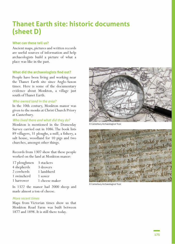
175
What can these tell us?
What did the archaeologists find out?
Ancient maps, pictures and written records are useful sources of information and help archaeologists build a picture of what a place was like in the past.
People have been living and working near the Thanet Earth site since Anglo-Saxon times. Here is some of the documentary evidence about Monkton, a village just south of Thanet Earth.
In the 10th century, Monkton manor was given to the monks at Christ Church Priory at Canterbury.
Maps from Victorian times show us that Monkton Road Farm was built between 1877 and 1898. It is still there today.
Monkton is mentioned in the Domesday Survey carried out in 1086. The book lists 89 villagers, 31 ploughs, a mill, a fishery, a salt house, woodland for 10 pigs and two churches, amongst other things.
Who owned land in the area?
More recent times
Who lived there and what did they do?
Records from 1307 show that these people worked on the land at Monkton manor:
17 ploughmen4 shepherds2 cowherds1 swineherd1 harrower
In 1322 the manor had 2000 sheep and made almost a ton of cheese.
3 stackers3 drovers1 lambherd1 sower1 cheese maker
Thanet Earth site: historic documents (sheet D)
© Canterbury Archaeological Trust
© Canterbury Archaeological Trust

176
SECTION 4
What can these tell us?
What did the archaeologists find?
The archaeologists search on the computer for any investigations that have already taken place in the area where the greenhouses are to be built, or nearby. If there have been some discoveries in the past, these are clues about what the archaeologists could find at Thanet Earth.
A farm (south of Thanet Earth).Pottery.
Graves with weapons, jewellery and glass vessels (south of Thanet Earth).Buildings.
A villa (0.25 km north of Thanet Earth).Possibly a shrine.Pottery and personal things like tweezers.
Small farms.Pottery.
Pottery.
Ring-ditches where burial mounds once stood.Graves (one with human skeleton, pottery,bronze bracelet and jet necklace).
There have been discoveries north, south, east and west of the Thanet Earth site. Here are some of them.
Medieval
Anglo-Saxon
Roman
Iron Age
Neolithic
Bronze Age
Pink area shows Thanet Earth site. Red dots show past discoveriesBased on an Ordnance Survey map with the permission of the Controller of Her Majesty’s Stationery Office, © Crown Copyright. Licence No. AL100021009
Thanet Earth site: researching past discoveries (sheet E)
© Canterbury Archaeological Trust
© Canterbury Archaeological Trust

177
What can this tell us? What did the archaeologists find out?Special equipment can give archaeologists an idea of what is buried in the ground before digging it. It works like this:
The Earth has its own magnetic field. When the ground has been disturbed, by building a stone wall or digging a ditch, the Earth’s magnetic field is also disturbed.
A magnetometer can detect these changes and store the information in its memory. The information is then transferred to a computer. On the screen, the stone wall or ditch shows up as a shape in the picture of the landscape.
When the magnetometer was used in the fields at Thanet Earth, there were still cauliflowers growing. So they could only use it where the land was bare. The results showed several shapes including what looked like big circular ditches and maybe some graves to the west of the site.There were other interesting shapes down at the south end of Thanet Earth suggesting ancient buried remains there too.
© Canterbury Archaeological Trust
Thanet Earth site: geophysical survey (sheet F)
© Canterbury Archaeological Trust
© Canterbury Archaeological Trust

178
SECTION 4
Red
and
whi
te s
cale
: 20
cms
©
Can
terb
ury
Arc
haeo
logi
cal T
rust
Thanet Earth site: grave 6026 (sheet G)
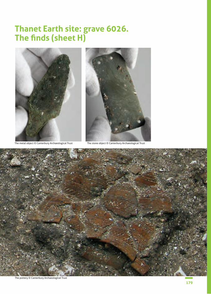
179
Thanet Earth site: grave 6026. The finds (sheet H)
The pottery © Canterbury Archaeological Trust
The metal object © Canterbury Archaeological Trust The stone object © Canterbury Archaeological Trust

180
SECTION 4
This was an extraordinary discovery in Area 6 at the dig. There were 2 big, circular ring ditches, one inside the other. The widest ring measured 25 metres in diameter. These were clues (evidence) that an ancient burial mound that once stood there, known as a barrow. Some of these circular mounds of earth still exist in other places, but many have been gradually destroyed in modern times when farmers plough their land. Often the only clues are the rings. At certain times of the year they show up in aerial photographs.
At the centre of the Thanet Earth ring ditches, Laura found a grave pit with a skeleton lying on its side in a crouched position.
A pottery container lay at its feet. It was crushed but it would have been complete
when it was buried. A small stone object and a metal object were lying beneath the skeleton. A 70 centimetre gap between the skeleton and the grave edge suggested something buried there had decomposed.
The width and depth of the two ring ditches show that this would have been a very big burial mound. It must have taken a lot of people and time to build it. They would not have had tools like we do today and probably used pick axes made from animal antlers.
Twelve other crouch burials were found on the Thanet Earth dig. Some were simple graves with no mound or artefacts, others had pottery containers. None were as elaborate as this grave.
Thanet Earth site: grave 6026. Excavation report (sheet I)
© Canterbury Archaeological Trust

181
The pottery
The stone object
The metal object
The pottery container was found in many sherds. The surfaces are a reddish-brown colour. The uneven feel of the sherds shows the pot was made by hand. The outside is covered with decoration using some kind of pointed tool. This style of pottery is known as a Beaker, used by people who lived about 3600 – 4000 years ago in the Bronze Age. We call them the Beaker People because of their pottery. Scientists have done tests on the inside surface of Beakers from other digs and found traces of a sweet alcoholic drink, like mead.
This was found under the left lower arm of the skeleton. It measures 92 millimetres by 41 millimetres by 1 millimetre. It is made of pale grey stone, possibly from the continent. It has 5 small, neat holes, probably made with a flint tool. It is a wrist guard. An archer wears a wrist guard to protect the skin when an arrow is released. This wrist guard is quite delicate and may have been a special one that wasn’t actually used.
This was found beneath the right shoulder of the skeleton. The green colour shows it is made with copper. The shape shows it fittedinto something which is no longer there. Originally this object was probably a dagger or a spear.
Thanet Earth site: grave 6026. Artefact report (sheet J)
© Canterbury Archaeological Trust

182
SECTION 4
Osteology is the very close examination of bones. By studying these we can work out lots of different things about the person (or animal) they came from. These include:• if the person was male or female; • how old the person was when he or she died; • if the person was healthy or whether there were any diseases; • if the person had any injuries.
Grave 6026 is an inhumation and the bones are in very good condition. Over 75% of the skeleton is present.
Examination of how the skull and pelvis have grown and how worn the teeth are tells us that this person died between 36 and 45 years of age. Examination of 16 parts of the pelvis and 13 parts of the skull tells us that this person is definitely male.
Measuring the arm and leg bones (femur, tibia, humerus and ulna) tells us that he was around 171 to 187 centimetres tall. His muscles have left impressions on these bones and show us he had a very active lifestyle. There is no evidence for how he died.
Thanet Earth site: grave 6026. Osteology report (sheet K)
© Canterbury Archaeological Trust

183
How it works The skeleton in grave 6026Examining bones
• Tiny amounts of the chemicals in the food we eat as children and adults are left in our bones. Scientists can examine these chemicals in bone samples to find out about a person’s diet.
Examining teeth
• Tooth enamel is formed during childhood and it stores chemicals from foods we eat and water we drink when we are young. The foods take the chemicals from the soils and environments they grow in. Scientists can find these chemicals in soils and water in different parts of the world. By matching them up with the tooth chemicals they can suggest where a person may have lived as a child.
Analysis of the chemicals of this skeleton’s bone gave us some clues about diet. It consisted of quite a lot of meat, some plants, but not a lot of seafood.
Analysis of the chemicals in the tooth enamel matches the chemicals found in the soils at the site. This suggests the person grew up in this area.
However, our findings suggest it is also possible that this person spent some time in a coastal region of western Europe… maybe somewhere in present day Belgium or the area where Paris is now.
Thanet Earth site: grave 6026. Isotope report (sheet L)
© Canterbury Archaeological Trust
© Svetlana Svyatko, 14Chrono Centre for Climate, the Environment and Chronology

184
SECTION 4
Thanet Earth site: grave 6026. Radio-carbon dating report (sheet M)
How it worksAll living things contain very tiny amounts of radioactive carbon (called C-14). When a plant or animal dies the C-14 slowly decays. So when the person found in grave 6026 died, this chemical began to decay. Scientists know how fast this happens and measuring how much C-14 is left can tell them how long ago this person died.
The result from the skeleton in grave 6026
A small piece was taken from one of the bones for radio-carbon analysis. This test can tell us how old the skeleton is. The test showed that the person died 3980-4200 years ago. This was in the Bronze Age.
© Svetlana Svyatko, 14Chrono Centre for Climate, the Environment and Chronology
© Svetlana Svyatko, 14Chrono Centre for Climate, the Environment and Chronology
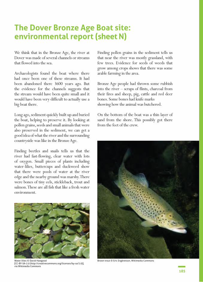
185
The Archer’s wirst guard
Thanet Earth site: grave 6026. Radio-carbon dating report (sheet M)
The Dover Bronze Age Boat site: environmental report (sheet N) We think that in the Bronze Age, the river at Dover was made of several channels or streams that flowed into the sea.
Archaeologists found the boat where there had once been one of these streams. It had been abandoned there 3600 years ago. But the evidence for the channels suggests that the stream would have been quite small and it would have been very difficult to actually use a big boat there.
Long ago, sediment quickly built up and buried the boat, helping to preserve it. By looking at pollen grains, seeds and small animals that were also preserved in the sediment, we can get a good idea of what the river and the surrounding countryside was like in the Bronze Age.
Finding beetles and snails tells us that the river had fast-flowing, clear water with lots of oxygen. Small pieces of plants including water-lilies, buttercups and duckweed show that there were pools of water at the river edge and the nearby ground was marshy. There were bones of tiny eels, stickleback, trout and salmon. These are all fish that like a fresh water environment.
Finding pollen grains in the sediment tells us that near the river was mostly grassland, with few trees. Evidence for seeds of weeds that grow among crops shows that there was some arable farming in the area.
Bronze Age people had thrown some rubbish into the river – scraps of flints, charcoal from their fires and sheep, pig, cattle and red deer bones. Some bones had knife marksshowing how the animal was butchered.
On the bottom of the boat was a thin layer of sand from the shore. This possibly got there from the feet of the crew.
Brown trout © Eric Engbretson, Wikimedia CommonsWater lilies © David Hawgood [CC-BY-SA-2.0 (http://creativecommons.org/licenses/by-sa/2.0)], via Wikimedia Commons

186
SECTION 4
The boat is a very good example of Bronze Age craftsmanship and the builders would have been highly skilled. The boat is made of oak and none of it is actually made of bronze.
The part of the boat that was excavated was 9.5 metres long. The archaeologists estimate that this was half or maybe two thirds of the original size. They could see it was 2.4 metres wide. Some of the boat had to be left buried in the ground.
Wood from three different oak trees was used to make the boat. Almost no knots were found in the wood so only the lower part of the trunk, where no branches grow, was used. Combined with the size of the boat, this suggests the oak trees must have been about 36m high and 1.5m thick. Trees of this size would have been over 350 years old and would have been found growing inland. Trees near the coast would have been unsuitable as sea winds would have stopped them growing straight.
The boat is made of 6 very large planks: 2 on the bottom and originally 2 on each side. Only 2 of the side planks have survived. There was probably a smaller section of wood at each end. The timbers are held together by wooden bars, wedges and giant stitches made from young shoots of yew trees. Moss, beeswax and animal fat fill the gaps in the joints to make it watertight.
The people who made the bronze tools would also have been highly skilled. By studying tool marks left in the wood we can tell that at least 5 types of bronze tool were used: 2 kinds of axe, an adze, a chisel and a gouge. Probably lots of each sort of tool were used to make the boat.
There is no evidence for saws, drills or nails being used. Bronze axes are only half as strong as modern steel axes, so the effort involved in making the boat was double that today. It is estimated that it would have taken 50 people 1 month to build the boat.
The Dover Bronze Age Boat site: technology report (sheet O)
© Canterbury Archaeological Trust
'Stitches' made of tree shoots
Bars helping to hold the planks together

187
The Dover Bronze Age Boat site: dating report (sheet P) 6 samples of wood were taken from different sections of the boat. Samples of the ‘stitches’ and the moss in the joints were also taken. It was very important to take different samples so we could get an accurate idea of when the boat was made. Tests would also say if the bottom was built at different times or had been repaired – which may have meant it was used over a long period of time.
The samples were sent away to be radio-carbon dated. All living things contain very tiny amounts of radioactive carbon atoms (called C-14). After a plant or animal dies the C-14 slowly decays. So when the trees used for the boat were cut down their C-14 began to decay.
Scientists know how fast this takes and measuring how much C-14 is left in the samples can tell us their age. In the case of the boat all the samples tested were found to come from around 1550 BC. This is almost 3600 years ago, in the Bronze Age.
Dendrochronology is another way of dating wood. Trees add a new ring of growth every year and the size of the ring depends on the weather. Scientists have an accurate record of how much oak trees in the area would have grown each year, in this period. Only one sample of wood from the boat was suitable for tree-ring dating. It gave a date of 1742-1589 BC. The sample only showed when the tree was growing and not when it was cut down and used.
Am
ount
of
Car
bon-
14 re
mai
ning
(%)
The star marks the amount of C-14 remaining in the Dover Bronze Age Boat
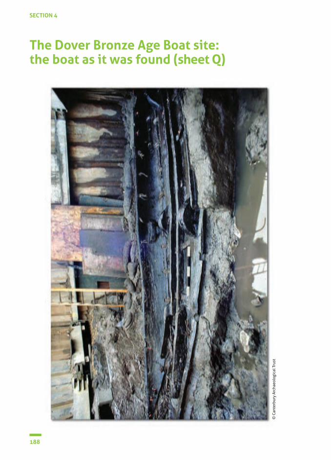
188
SECTION 4
The Dover Bronze Age Boat site: the boat as it was found (sheet Q)
© C
ante
rbur
y A
rcha
eolo
gica
l Tru
st
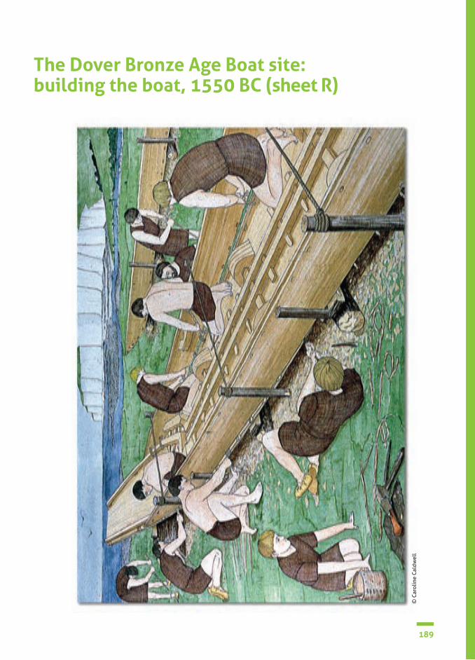
189
The Dover Bronze Age Boat site: building the boat, 1550 BC (sheet R)
© C
arol
ine
Cal
dwel
l

190
SECTION 4
Extraordinary discovery in Langdon Bay (Dover, England) in 1974 (sheet S)
Divers from the Dover Sub-Aqua Club were out diving near the White Cliffs of Dover. They were 500 metres from the English coast when, deep in the sea, they discovered some objects.
Further investigations were made and 360 bronze objects were eventually brought to the surface!
They are now in Dover Museum where you can see them on display
What can this discovery tell us?
There were bronze axe-heads, chisels, swords, knives and spear-heads. By examining the shapes and sizes, archae-ologists can say they were made in the Bronze Age. Highly skilled people must have made them. Several were types made in France.
These metal objects were made around the time the Dover Boat was made and used. Maybe there is a connection...
© G Naessens / Boat 1550 BC


Top Related