


Languages
Pages
Legal


Dep
artm
ent
of
Ru
ral D
evel
op
men
t an
d L
and
Ref
orm
20
09
FR
EE
ST
AT
E C
RD
P

1
TABLE OF CONTENTS
1. INTRODUCTION 1
1.1 Objectives of the Study 1
1.2 A brief overview of the CRDP 2
1.3 Methodology 3
1.4 Locality 4
1.4.1 Provincial Context 4
1.4.2 Regional Context 4
1.4.3 Local Context 4
2. SITUATIONAL ANALYSIS 9
2.1 Natural Systems 9
2.1.1 Topography 9
2.1.2 Geology 9
2.1.3 Land Capability 12
2.1.4 Climate 12
2.1.5 Environmentally Sensitive Areas 17
2.1.6 Hydrology 17
2.2 Built Systems 17
2.2.1 Land Uses 17
2.2.2 Water 20
2.2.3 Sanitation 20
2.2.4 Roads 20
2.2.5 Electricity 22
2.2.6 Housing 22
2.3 Socio – Economic 24
2.3.1 Demographics 24
2.3.2 Employment / Poverty 24
2.3.3 Income Levels 25
2.3.4 Education 26
2.3.5 Economic Activities 27
3. LAND REFORM 30
3.1 Land Reform Projects 30
3.2 Restitution / Claims 31
2
4. EXISTING PROJECTS / INITIATIVES 31
5. AREAS OF INTERVENTION 31
LIST OF MAPS
Provincial Context
Regional Context
Local Context
Topograhy
Geology
Land Capability
Climate
Environmentally Sensitive Areas
Hydrology
Transport & Pipeline
Electricity
Agriculture
School

1
1. INTRODUCTION
This following report highlights the situational analysis, analysis of findings and
recommendations related to the Free State Comprehensive Rural Development
Programme. The content of this report consists of the following:
(i) Background phase which covers the objectives of the study, methodology,
background, and locality.
(ii) The Situational Analysis of the study area covers natural characteristics of
the area; socio-economic conditions of the study area; current state of
infrastructure; Land Use Management and Land Reform; and other government
initiatives.
(iii) Analysis Phase consists of SWOT analysis based on the status quo report.
The analysis phase deals with core issues raised by the status quo report. This
phase analyzes information collected by means of interviews and data collection.
The analysis provides a picture of areas that need intervention and the impact
thereof.
(iv) Interventions this phase seeks to provide solutions, proposals and creative
approaches to the problems raised in the status quo and analysis phase. This
phase analyses of critical issues that need to be addressed for the development
of the area.
(v) Recommendations summarizes the content of the report with priorities that
require urgent attention from the state and way forward.
1.1 Objectives of the Study
The objective of the study is to undertake a status quo analysis for three selected
villages in the Maluti-a-Phofung Local Municipality which include: Diyatalawa,
Makgolokeong and TSHIAME. The analysis will assist in making
recommendations to uplift these identified areas through the implementation of a
Comprehensive Rural Development Programme (CRDP). The study will further
attempt to highlight the kind of resources required to make the programme a
success.

2
1.2 A Brief Overview of the CRDP.
The new National Department of Rural Development and Land Reform (DRDLR)
has been given the mandate by the President of South Africa to develop a
Comprehensive Rural Development Programme (CRDP) throughout the country.
To achieve this mandate the DRDLR embarked on developing a fresh approach
to rural development. The CRDP is focused on enabling rural people to take
control of their destiny, with the support from government, and thereby dealing
effectively with rural poverty through the optimal use and management of natural
resources. This will be achieved through a co-ordinated and integrated broad-
based agrarian transformation as well as the strategic investment in economic
and social infrastructure that will benefit the entire rural communities. The
programme will be successful when it becomes apparent that “sustainable and
vibrant rural communities” are succeeding throughout South Africa.
A three pronged strategy to ensure that the Department achieves its objective
are:
(i) Agrarian Transformation includes increasing all types of agricultural
production; optimal and sustainable use of natural resources; the use of
appropriate technologies; food security; and improving the quality of life for each
rural household.
(ii) Rural Development includes improving economic and social infrastructure.
(iii) Land Reform includes restitution, redistribution, land tenure reform.
3
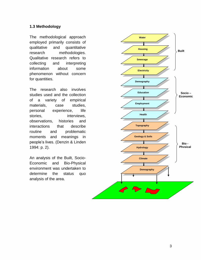
1.3 Methodology
The methodological approach
employed primarily consists of
qualitative and quantitative
research methodologies.
Qualitative research refers to
collecting and interpreting
information about some
phenomenon without concern
for quantities.
The research also involves
studies used and the collection
of a variety of empirical
materials, case studies,
personal experience, life
stories, interviews,
observations, histories and
interactions that describe
routine and problematic
moments and meanings in
people’s lives. (Denzin & Linden
1994: p. 2).
An analysis of the Built, Socio-
Economic and Bio-Physical
environment was undertaken to
determine the status quo
analysis of the area.
Water
Sewerage
Electricity
Demography
Education
Employment
Health
Topography
Geology & Soils
Hydrology
Climate
Demography
Housing
Built
Socio – Economic
Bio - Physical

4
1.4 Locality
1.4.1 Provincial Context (see Map 1)
The Free State province consists of 5 District Municipalities which Thabo
Mofutsanyane, Motheo, Xhariep, Lejweleputswa and Fezile DabI. The three
identified areas are located in the Thabo Mofutsanyane District. The Free State
Province which is in the heart of South Africa, with the Kingdom of Lesotho
nestling in the hollow of its bean – like shape. Lying between the Vaal River in
the north and the Orange River in the south, the Province is one of flat, rolling
grassland and crop fields, rising to lovely sandstone mountains in the west.
The province is the granary of South Africa with agriculture central to its
economy, while mining on the rich goldfields reef is its largest employer.
It has a population of 2.9 million and covers an area of 129 825 km.
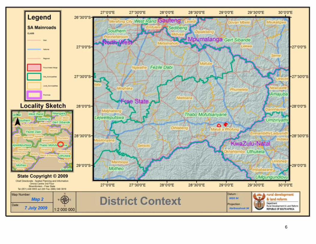
1.4.2 Regional Context (see Map 2)
Thabo Mofutsanyane is one of the five District Municipalities which lie in the
eastern part of the Free State Province. The study areas are found in this region.
The municipality is home to the Golden Gate National Park which is a sought
after tourist attraction. Clarens which is located close by is one of the most
sought after property markets in central South Africa. It has a population of 400
000 (in year 2000) and covers an area of 4 421 km²
1.4.3 Local Context (see Map 3)
Maluti–a–Phofung is the local municipality area in which the three identified areas
are located. The municipality is 35 km north of Phuthaditjhaba which is the urban
area of the municipality using the R57 and south of the N5 national road between
Kestell and Harrismith. This municipality is currently rated number six in South
Africa in terms of income at an estimated R1,6 billion.
Diyatalawa Apple project, as it is famously known, started in 1996. According to
Mr Maduna, who presently is the Chairperson, people were moved to this area to
start farming with apples.
Each household was given a hectare to cultivate apples. The people of
Diyatalawa were assisted by AgriEco which was a corporation between the

5
Provincial Context (Map 1)
6
Regional Context Map 2

7
Local Context – Map 3
8
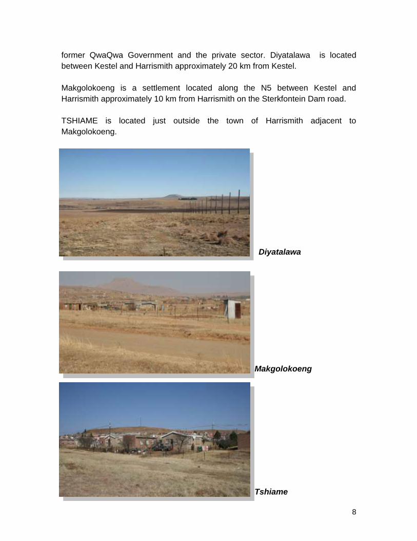
former QwaQwa Government and the private sector. Diyatalawa is located
between Kestel and Harrismith approximately 20 km from Kestel.
Makgolokoeng is a settlement located along the N5 between Kestel and
Harrismith approximately 10 km from Harrismith on the Sterkfontein Dam road.
TSHIAME is located just outside the town of Harrismith adjacent to
Makgolokoeng.
Diyatalawa
Makgolokoeng
Tshiame

9
2. SITUATIONAL ANALYSIS
2.1 Natural Systems
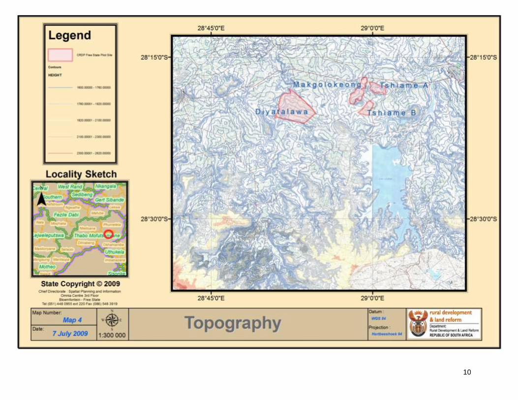
2.1.1 Topography (see Map 4)
The terrain in all three areas is relatively flat in terms of slope analysis and
compliments well for engineering services such as running of water. The
topography in the Free State is generally flat and all three areas display these
characteristics.
2.1.2 Geology (see Map 5)
The area is underlain by andesitic lava of the Drakensberg Formation, with
mudstones, shale and sandstones of the formations Clarens, Molteno and Elliot of
the Karoo Supergroup, and of the Tarkastad and Estcourt Formations of the Beaufort
Group, Karoo Supergroup. Post Karoo dolerite intrusions (dykes and sills) are
present. Alluvium is associated with drainage channels and talus is present on the
10
Topography Map 4

11
Geology Map 5
12
steep hillslopes. Excavation problems can be expected to occur during the
installation of services in some areas, due to the presence of sandstone, shale and
dolerite outcrop. Expansive colluvial soil may require specialised founding methods
such as rafts, split construction or founding on unweathered bedrock.
2.1.3 Land Capability (see Map 6)
In terms of land capability all three areas are very suitable for agriculture as it is
classified as moderately well adapted cultivation land. It is also well adapted for
stock farming such as cattle farming that has been done in the area with
relatively good success. Only approximately 30% of the soils in the province are not
suitable for arable agriculture owing to various reasons. Thus, the area has large
agricultural potential.
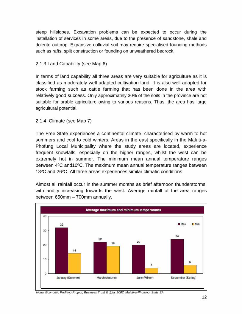
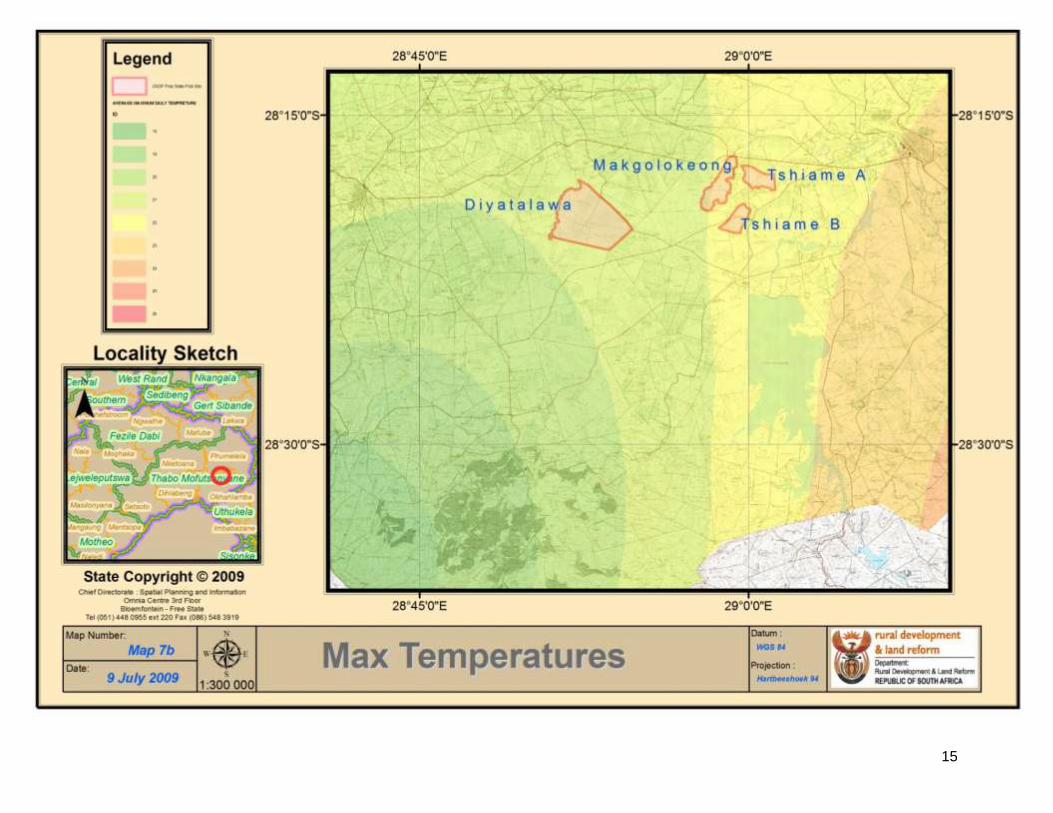
2.1.4 Climate (see Map 7)
The Free State experiences a continental climate, characterised by warm to hot
summers and cool to cold winters. Areas in the east specifically in the Maluti-a-
Phofung Local Municipality where the study areas are located, experience
frequent snowfalls, especially on the higher ranges, whilst the west can be
extremely hot in summer. The minimum mean annual temperature ranges
between 4ºC and10ºC. The maximum mean annual temperature ranges between
18ºC and 26ºC. All three areas experiences similar climatic conditions.
Almost all rainfall occur in the summer months as brief afternoon thunderstorms,
with aridity increasing towards the west. Average rainfall of the area ranges
between 650mm – 700mm annually.
Nodal Economic Profiling Project, Business Trust & dplg, 2007, Maluti-a-Phofung, Stats SA

13
Land Capability Map 6

14
Climate Map 7a
15
Climate Map 7b

16
Climate Map 7c

17
2.1.5 Environmentally Sensitive Areas (see Map 8)
The area is situated in an area almost entirely consisting of protected areas in
terms of National Parks and environmental sensitive areas. From the map it is
clear that the most sensitive areas are located towards the south of the Thabo
Mofutsanyane region. The most sensitive areas are:
South East of Harrismith – mountainous area at van Reenen’s Pass
Kestell and Golden Gate areas
Sterkfontein Dam area
The study areas do not have any major impacts on environmentally sensitive
areas.
2.1.6 Hydrology (see Map 9)
The study areas in the east around Harrismith, Bethlehem and Ficksburg have
good access to water supply as the area receives its water from the Elands river
which flows through the area. There are also a few non perennial rivers.
Furthermore, the local municipality receives its water supply from the Sterkfontein
dam. Although there is a good source of water to the area, water supply to these
areas is limited due to various challenges including limited or no internal water
reticulation systems.
2.2 Built Systems
In order to detail the built systems a table has been developed to compare all
three areas.
2.2.1 Land Uses
It should be noted that TSHIAME A is a well established area and Tshiame B is
also fairly well established.
DIYATALAWA MAKGOLOKOENG TSHIAME
Predominantly Agricultural Predominantly Residential Predominantly Residential
Apple Orchard 2 Crèches Primary / Secondary School
Primary School Informal Sports Field 1 Crèche
Informal Sports Ground Baking Project Sports Field

18
Environmentally Sensitive Ares Map 8

19
Hydrology Map 9

20
DIYATALAWA MAKGOLOKOENG TSHIAME
Broiler Plant
Community Gardens Police Station
Traditional Office Clinic
Church / Community Centre Industrial Activity on outskirts
The other two settlements of Diyatalwa and Makgolokoeng are unplanned and
scattered in nature. There is a formal layout plan for Makgolokeong which has
not been implemented.
2.2.2 Water
DIYATALAWA MAKGOLOKOENG TSHIAME
No water supply to households No water supply to households Household access
Water trucked from Qwa Qwa Water Trucked
Communal Stand Pipes (all
are not functional)
2.2.3 Sanitation
DIYATALAWA MAKGOLOKOENG TSHIAME
Dry Pit Latrines Dry Pit Latrines (some in poor
condition)
Water Borne / VIP
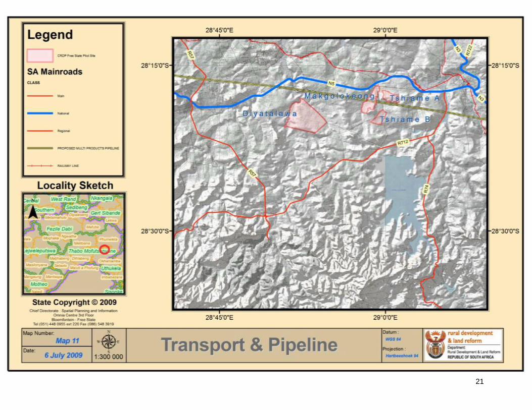
2.2.4 Roads (See Map 11)
DIYATALAWA MAKGOLOKOENG TSHIAME
Gravel access Road in poor
condition
Gravel access Road in poor
condition
Tarred Roads
Poor Internal Road Network Poor Internal Road Network Regular Taxis
No Public Transport Taxis twice a day
There is limited access to transport facilities both private and public hence the
communities travels longer distances to the N5 (National road), to Bethlehem and
Harrismith.
21
Transport & Pipeline – Map 11

22
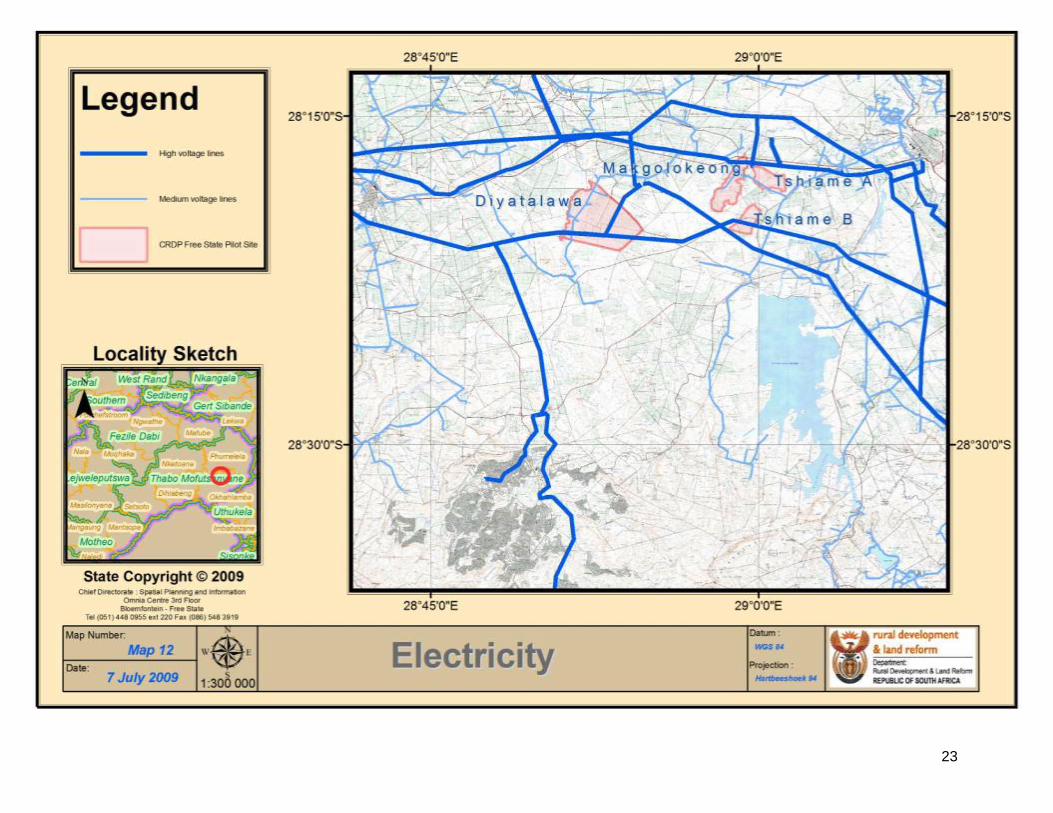
2.2.5 Electricity (see Map 12)
DIYATALAWA MAKGOLOKOENG TSHIAME
No household connection
except at School and Farm
House
No Electricity supply besides
at Chief’s Residence
Household Connections
2.2.6 Housing
DIYATALAWA MAKGOLOKOENG TSHIAME
Informal Brick Structures Traditional Brick Structures Formal Housing
Informal Structures
Housing Stock in Makgolokoeng
Housing Stock in TSHIAME
Housing Stock in Diyatalawa
23
Electricity Map 12
24
2.3 Socio – Economic
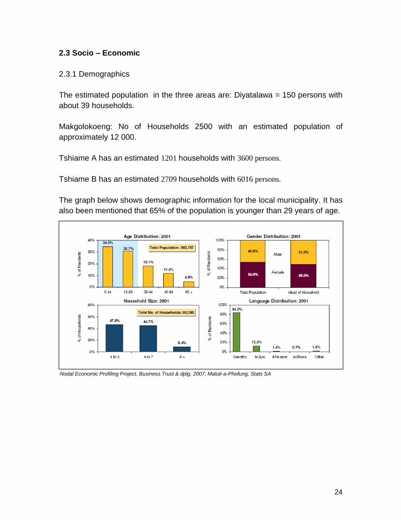
2.3.1 Demographics
The estimated population in the three areas are: Diyatalawa = 150 persons with
about 39 households.
Makgolokoeng: No of Households 2500 with an estimated population of
approximately 12 000.
Tshiame A has an estimated 1201 households with 3600 persons.
Tshiame B has an estimated 2709 households with 6016 persons.
The graph below shows demographic information for the local municipality. It has
also been mentioned that 65% of the population is younger than 29 years of age.
Nodal Economic Profiling Project, Business Trust & dplg, 2007, Maluti-a-Phofung, Stats SA
25
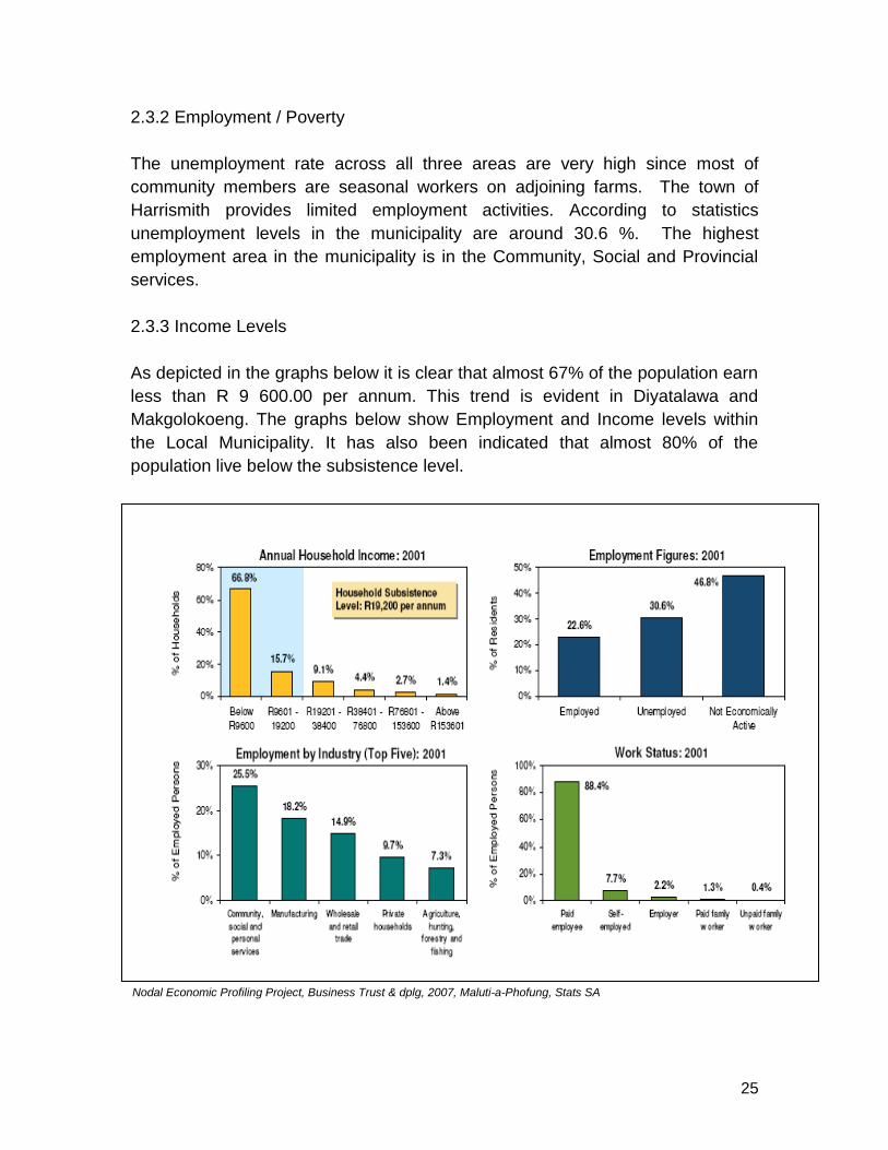
2.3.2 Employment / Poverty
The unemployment rate across all three areas are very high since most of
community members are seasonal workers on adjoining farms. The town of
Harrismith provides limited employment activities. According to statistics
unemployment levels in the municipality are around 30.6 %. The highest
employment area in the municipality is in the Community, Social and Provincial
services.
2.3.3 Income Levels
As depicted in the graphs below it is clear that almost 67% of the population earn
less than R 9 600.00 per annum. This trend is evident in Diyatalawa and
Makgolokoeng. The graphs below show Employment and Income levels within
the Local Municipality. It has also been indicated that almost 80% of the
population live below the subsistence level.
Nodal Economic Profiling Project, Business Trust & dplg, 2007, Maluti-a-Phofung, Stats SA

26
2.3.4 Education
It has been acknowledged that a low level of school attendance is one of the key
challenges within the local municipality. Below is a summary of educational
activities within the local municipality.
Below is a summary of educational facilities in the three study areas:
DIYATALAWA MAKGOLOKOENG TSHIAME
1 Primary school with 30
learners with 2 teachers with
ABET classes.
No School. Pupils go to
TSHIAME schools which has
two session to cater for
number of pupils. 2 EDC’s are
also available.
1 Primary School with 925
learners (TSHIAME A)
1 Secondary school with 410
learners (TSHIAME B)
Nodal Economic Profiling Project, Business Trust & dplg, 2007, Maluti-a-Phofung, Stats SA

27
2.3.5 Economic Activities
Below is a summary of the GDP data for the local municipality.
The main economic activities within the local municipality revolve around the
following sectors Agriculture, Tourism and Manufacturing.
Agriculture (Map 10)
The main agricultural activities within the local municipality involve the following:
Cattle, Dairy, Maize, Wheat, Dry Beans, Apples, Potatoes and Vegetables.
Within the study areas the following activities are evident Apple Farming, a
unused broiler, livestock farming and communal gardens. The diagram below
gives an overview of Agricultural activities within the local municipality.
Nodal Economic Profiling Project, Business Trust & dplg, 2007, Maluti-a-Phofung, Stats SA

28
Agriculture Map 10

29
Tourism
Below is a summary of Tourism activities within the local municipality:
Maluti-a-Phofung hosts a variety of attractions that could boost the level of domestic tourism
- The Golden Gate Highlands National Park, which includes the Basotho Cultural Village - The Sterkfontein Dam, with several water sports and activities (e.g. fishing, sailing) - The hiking and climbing experience at Sentinel Peak
Currently, most of these attractions are under-utilised - The Sterkfontein Dam is always fully booked on weekends and peak periods – At the Basotho Cultural Village, accommodation is ready but not operational – Sentinel Peak is completely under-developed
At the moment, the main kinds of tourism in the area are: – Businessmen and contractors staying in Harrismith B&Bs and guest houses, because of the lack of rentable houses – People travelling to Durban or Johannesburg on the N3, or going to Clarens and passing through the Golden Gate National Park
Maluti-a-Phofung should focus on the domestic adventure / eco- / sport tourism sector, and needs to develop and market tourism products in a much more efficient way
Manufacturing
Maluti-a-Phofung, formerly QwaQwa, benefited under the Regional Industrial Development Programme of the apartheid government. When the subsidies regime disappeared, a crisis occurred especially in terms of employment z Two areas, Phuthaditjhaba and Tshiame (Industriqwa), were specifically targeted for industrial development by the Free State Development Corporation (FDC)
Nodal Economic Profiling Project, Business Trust & dplg, 2007, Maluti-a-Phofung, Stats SA

30
– Large industrial premises were developed for large investors from outside the area
– Smaller factories were mainly developed for local business people
Below is a summary of the main 3 industrial areas within the local municipality.
In terms of the three study areas, Tshiame and Makgolokeong are located in close proximity to Industriqwa.
3. LAND REFORM
3.1 Land Reform Projects
There are no land reform projects identified within the study area however within
the 45km radius there are 30 land reform projects as summarised in the table
below:.
Total Number of projects
Total Number of Hectares
Total Number of beneficiaries
Total of Land Purchase Price
30 12422 464 R18 003 298
Nodal Economic Profiling Project, Business Trust & dplg, 2007, Maluti-a-Phofung, Stats SA

31
The land reform projects entail the following activities: Beef cattle farming, Dairy farming, Cash crop farming i.e. [Dry Beans, Soya Beans), Maize, Potatoes, Beef cattle farming and Small Stock farming
3.2 Restitution / Claims
There are no major restitution claims in the area. A claim was instituted by the
Makgolokeong community but has been dismissed by the Land Claims
Commission.
4. EXISTING PROJECTS / INITIATIVES PLAN
There are no major projects within the IDP which impact on the study area.
5. AREAS OF INTERVENTION
Tshiame is a formal area that need little intervention except for formally
demarcated grazing areas for their livestock.
5.1 Diyatalawa
NEEDS INTERVENTIONS
ELECTRICITY Electricity supply is a challenge as there are no house connections
except for the original farm house. The committee had talks with the
municipality regarding this but the municipality is saying it is not their
responsibility as it is a farm. The possibility of formalising the
residential area may assist in dealing with this issue. According to
the January 2005 Legotla report of the municipality TELKOM has
donated a line for the Diyatalawa apple project but according to
residents only cell phones are operational. This needs to be followed
up with the municipality and TELKOM.
ROADS The access road to Diyatalawa is in a poor state and needs to be
upgraded to a basic standard.
LACK OF
ADEQUATE
EQUIPMENT
Farmers at Diyatalawa need an orchard tractor (small tractor); tree
sprayer, grass cutter; nets and a pack house. Funding possibilities
should be explored with different stakeholders such as the Free
State Development Corporation (FDC). The possibility exists that the
emerging farmers could share a pack house with the farmer along
the N5 who also produce apples or with the apple corporation in
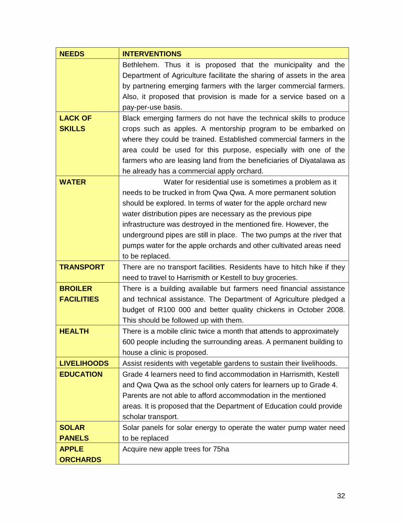
32
NEEDS INTERVENTIONS
Bethlehem. Thus it is proposed that the municipality and the
Department of Agriculture facilitate the sharing of assets in the area
by partnering emerging farmers with the larger commercial farmers.
Also, it proposed that provision is made for a service based on a
pay-per-use basis.
LACK OF
SKILLS
Black emerging farmers do not have the technical skills to produce
crops such as apples. A mentorship program to be embarked on
where they could be trained. Established commercial farmers in the
area could be used for this purpose, especially with one of the
farmers who are leasing land from the beneficiaries of Diyatalawa as
he already has a commercial apply orchard.
WATER Water for residential use is sometimes a problem as it
needs to be trucked in from Qwa Qwa. A more permanent solution
should be explored. In terms of water for the apple orchard new
water distribution pipes are necessary as the previous pipe
infrastructure was destroyed in the mentioned fire. However, the
underground pipes are still in place. The two pumps at the river that
pumps water for the apple orchards and other cultivated areas need
to be replaced.
TRANSPORT There are no transport facilities. Residents have to hitch hike if they
need to travel to Harrismith or Kestell to buy groceries.
BROILER
FACILITIES
There is a building available but farmers need financial assistance
and technical assistance. The Department of Agriculture pledged a
budget of R100 000 and better quality chickens in October 2008.
This should be followed up with them.
HEALTH There is a mobile clinic twice a month that attends to approximately
600 people including the surrounding areas. A permanent building to
house a clinic is proposed.
LIVELIHOODS Assist residents with vegetable gardens to sustain their livelihoods.
EDUCATION Grade 4 learners need to find accommodation in Harrismith, Kestell
and Qwa Qwa as the school only caters for learners up to Grade 4.
Parents are not able to afford accommodation in the mentioned
areas. It is proposed that the Department of Education could provide
scholar transport.
SOLAR
PANELS
Solar panels for solar energy to operate the water pump water need
to be replaced
APPLE
ORCHARDS
Acquire new apple trees for 75ha
33
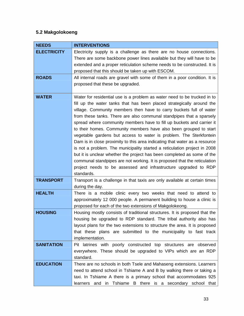
5.2 Makgolokoeng
NEEDS INTERVENTIONS
ELECTRICITY Electricity supply is a challenge as there are no house connections.
There are some backbone power lines available but they will have to be
extended and a proper reticulation scheme needs to be constructed. It is
proposed that this should be taken up with ESCOM.
ROADS All internal roads are gravel with some of them in a poor condition. It is
proposed that these be upgraded.
WATER Water for residential use is a problem as water need to be trucked in to
fill up the water tanks that has been placed strategically around the
village. Community members then have to carry buckets full of water
from these tanks. There are also communal standpipes that a sparsely
spread where community members have to fill up buckets and carrier it
to their homes. Community members have also been grouped to start
vegetable gardens but access to water is problem. The Sterkfontein
Dam is in close proximity to this area indicating that water as a resource
is not a problem. The municipality started a reticulation project in 2008
but it is unclear whether the project has been completed as some of the
communal standpipes are not working. It is proposed that the reticulation
project needs to be assessed and infrastructure upgraded to RDP
standards.
TRANSPORT Transport is a challenge in that taxis are only available at certain times
during the day.
HEALTH There is a mobile clinic every two weeks that need to attend to
approximately 12 000 people. A permanent building to house a clinic is
proposed for each of the two extensions of Makgolokeong.
HOUSING Housing mostly consists of traditional structures. It is proposed that the
housing be upgraded to RDP standard. The tribal authority also has
layout plans for the two extensions to structure the area. It is proposed
that these plans are submitted to the municipality to fast track
implementation.
SANITATION Pit latrines with poorly constructed top structures are observed
everywhere. These should be upgraded to VIPs which are an RDP
standard.
EDUCATION There are no schools in both Tsele and Mahaseng extensions. Learners
need to attend school in Tshiame A and B by walking there or taking a
taxi. In Tshiame A there is a primary school that accommodates 925
learners and in Tshiame B there is a secondary school that

34
NEEDS INTERVENTIONS
accommodates 410 people. The tribal office indicated that children are
abused as it is quite a distance to walk. This office applied for a school in
2002 and again in 2004. The Department of Education indicated,
however, that there is a long waiting list for schools and that they might
put up prefab buildings as school structures. However, nothing has
materialised as yet. Learners are also attending school at different times
of the day. Some only start at 12h00. It is proposed that a school
(primary and secondary?) be erected and that in the interim the
Department of Education provide scholar transport. There approximately
two crèches in the area.
LAND REFORM According to the tribal chief there are challenges in terms of
communication between Redistribution and Restitution. It is proposed
that this be rectified as it is halting the processing of the land claim of the
residents of Makgolokeong.
AGRICULTURE The area is too small for commercial livestock farming due to the
carrying capacity of the land
Compiled by:
Ahjum, L. (DRDLR: Spatial Development Frameworks: Northern Cape)
Hadebe, H. (DRDLR: Spatial Development Frameworks: Free State)
Makan, R. (DRDLR: Spatial Planning and Facilitation: National)
Minnie, S. (DRDLR: Spatial Development Frameworks: Free State)

35
Top Related