


Languages
Pages
Legal


Craig
Interagency
Fire Danger Operating and Preparedness Plan
Bureau of Land Management
Fish and Wildlife Service
State of Colorado
National Park Service (Adjective Rating Only)
USDA Forest Service (Adjective Rating Only)
Spring of 2012

2 | P a g e
Draft V 1.22 S:\FireDocs\NFDRS FDOP\2012
Craig Interagency
Fire Danger Operating and Preparedness Plan
Recommend By:
William Colt Mortenson, Fire Management Officer
Bureau of Land Management, NWCFMU
Date
Tracy Swenson, Fire Management Officer
U.S. Fish and Wildlife Service, Region 6
Date
Tim Foley, Fire Management Officer
Colorado State Forest Service
Date
Joe Flores, Fire Management Officer
US Park Service
Date
Approved By:
David Rosenkrance, Associate District Manager
Bureau of Land Management, Northwest Colorado
Date
Chris Dippel, Refuge Manager
U.S. Fish and Wildlife Service, Region 6
Date
Tim Foley, Fire Management Officer
Colorado State Forest Service
Date
Phil Cruz Medicine Forest Supervisor
Medicine Bow-Routt National Forest
Date
Mary Risser, Dinosaur Monument Superintendent
National Park Service
Date
3 | P a g e
Draft V 1.22 S:\FireDocs\NFDRS FDOP\2012
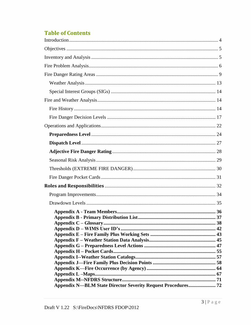
Table of Contents Introduction ......................................................................................................................... 4
Objectives ........................................................................................................................... 5
Inventory and Analysis ....................................................................................................... 5
Fire Problem Analysis......................................................................................................... 6
Fire Danger Rating Areas ................................................................................................... 9
Weather Analysis .......................................................................................................... 13
Special Interest Groups (SIGs) ..................................................................................... 14
Fire and Weather Analysis ................................................................................................ 14
Fire History ................................................................................................................... 14
Fire Danger Decision Levels ........................................................................................ 17
Operations and Applications ............................................................................................. 22
Preparedness Level ..................................................................................................... 24
Dispatch Level ............................................................................................................. 27
Adjective Fire Danger Rating .................................................................................... 28
Seasonal Risk Analysis ................................................................................................. 29
Thresholds (EXTREME FIRE DANGER) ................................................................... 30
Fire Danger Pocket Cards ............................................................................................. 31
Roles and Responsibilities .......................................................................................... 32
Program Improvements ................................................................................................. 34
Drawdown Levels ......................................................................................................... 35
Appendix A - Team Members ................................................................................ 36 Appendix B - Primary Distribution List ............................................................... 37
Appendix C – Glossary ........................................................................................... 38 Appendix D – WIMS User ID’s ............................................................................. 42 Appendix E – Fire Family Plus Working Sets ..................................................... 43 Appendix F – Weather Station Data Analysis ...................................................... 45 Appendix G – Preparedness Level Actions .......................................................... 47
Appendix H – Pocket Cards ................................................................................... 55 Appendix I--Weather Station Catalogs ................................................................. 57
Appendix J—Fire Family Plus Decision Points ................................................... 58 Appendix K—Fire Occurrence (by Agency) ........................................................ 64 Appendix L –Maps .................................................................................................. 67 Appendix M--NFDRS Structure ............................................................................ 71 Appendix N—BLM State Director Severity Request Procedures ...................... 72

4 | P a g e
Draft V 1.22 S:\FireDocs\NFDRS FDOP\2012
Introduction
This plan is intended to document a decision-making process for agency administrators, fire
managers, dispatchers, agency cooperators, and firefighters by establishing agency planning and
response levels using the best available scientific methods and historical weather/fire data.
An appropriate level of preparedness to meet wildland fire management objectives is based upon
an assessment of vegetation, climate, and topography utilizing the National Fire Danger Rating
System (NFDRS) modeling. This plan combines an Operating Plan with a Preparedness Plan for
four of the five primary wildland fire management agencies responsible for wildland fire
management in Northwestern Colorado (BLM, FWS, State of Colorado and NPS).
This Fire Danger Operating Plan (FDOP) documents the establishment and management
of the NWCFMU Interagency fire weather system and incorporates NFDRS fire danger
modeling into fire management decisions.
This plan also outlines procedures for developing seasonal risk analysis and defines fire
prevention action items by providing the direction necessary to convey fire danger
awareness especially of escalating fire potential, to fire management personnel.
Guidance and policy for development of a Fire Danger Operating and Preparedness Plan
can be found in the Interagency Standards for Fire & Aviation Operations (Red Book),
Wildland Fire and Aviation Program and Management and Operation Guide (Blue
Book), and Forest Service Manual 5120.
On July 6, 1994, the South Canyon Fire resulted in the deaths of 14 firefighters in
Colorado. In 1995, an Interagency Management Review Team for the South Canyon Fire
charged the National Advisory Group for Fire Danger Rating with developing “an
implementation plan to improve technical transfer of fire danger technology.” On July 10,
2001, four firefighters lost their lives on the Thirtymile Fire in Washington. The
Thirtymile tragedy prompted an Accident Prevention Plan which contained specific
actions to enhance firefighter safety, including the need to identify thresholds for critical
fuels and weather conditions that lead to extreme burning conditions and publishing these
on pocket cards for use by firefighters. On July 22, 2003, two firefighters lost their lives
in the Cramer Fire in central Idaho. OSHA levied serious violations which included the
failure to recognize fire danger thresholds for large fires and respond accordingly. In
addition, a Remote Automated Weather Station (RAWS) near the fire had not received
maintenance and calibration before the start of the fire season. This plan addresses action
items identified in these tragic fires by providing the direction necessary to convey fire
danger awareness especially of escalating fire potential to fire management personnel.
This awareness is critical when wildland fire danger levels exceed thresholds which may
significantly compromise safety and control.

5 | P a g e
Draft V 1.22 S:\FireDocs\NFDRS FDOP\2012
Objectives
Provide a tool for agency administrators, fire mangers, dispatchers, agency
cooperators and firefighters to correlate fire danger with appropriate fire business
decisions in Northwestern Colorado.
Delineate Fire Danger Rating Areas (FDRA’s) in northwestern Colorado with
similar climate, fuels and topography.
Establish a fire weather monitoring network consisting of RAWS, which comply
with NFDRS Weather Station Standards (PMS 426-3).
Determine fire business thresholds using Weather Information Management
System (WIMS), National Fire Danger Rating System (NFDRS), Fire Family Plus
software and by analyzing historical weather and fire occurrence data.
Ensure that agency administrators, fire mangers, cooperating agencies,
industry/commercial entities, and the public are notified of the potential fire danger.
Provide guidance to interagency personnel outlining specific daily actions to take at
each Preparedness Level.
Identify seasonal risk analysis criteria and establish general fire severity thresholds.
Develop and distribute fire danger pocket cards to all personnel involved with fire
suppression activities within the NWCFMU Fire Danger Rating Area.
Identify program needs and suggest improvements for the Fire Danger Operating
and Preparedness Plan.
Define roles and responsibilities in making fire preparedness decisions, managing
weather information, and briefing suppression personnel regarding current and
potential fire danger.
Inventory and Analysis
In order to apply a system that will assist managers with fire management decisions, the
problems must be inventoried and analyzed to determine the most appropriate system that
will adequately address the issues.
Involved Parties
This plan will affect a wide range of entities that can be grouped into three major
categories:
Agency: Employees of the Federal, State and local governments involved in the
cooperative effort to assist with wildland fires. These include BLM, FWS, NPS,
and State of Colorado employees, along with relevant volunteer fire departments.
Industry: Organizations that either utilize the natural resources or have permitted
activities on Federal, State or private wildland for commercial purposes. These
entities or activities include ranchers, wilderness camps, railroads, utility

6 | P a g e
Draft V 1.22 S:\FireDocs\NFDRS FDOP\2012
companies, mines, timber harvesting, filming, building construction, oil and gas,
etc.
Public: Individuals who use the land for recreational purposes such as off-
highway vehicle (OHV) use, camping, hunting, hiking, fishing, skiing, firewood
gathering, mountain biking or general travel. This group also includes those living
within the wildland/urban interface (WUI).
Fire Problem Analysis
The following table demonstrates the differences between the target groups (agency,
industry, and public). The ability to regulate, educate, or control a user group will be
based upon the interface method and how quickly they can react to the action taken. In
addition, each action will result in positive and/or negative impacts to the user groups.
Consequently, the decision tool which would be most appropriate would depend upon the
sensitivity of the target group to the implementation of the action. In selecting a
component and/or index, several factors must be considered:
1. Problem/Issue: This is the problem specific to the area of concern and includes
ignition causes. The problem is “framed” to focus on the wildland fire management issue,
such as the point when fire activity becomes a burden to the local suppression forces.
2. Management Action (Application): This is the decision(s) which will affect the
public, industry, or agency personnel. This includes fire management applications which
can be used to formulate decisions regarding the potential issues which have been
identified for the specific area. Management actions represent a way to link fire danger
information with fire management decisions which affect specific target groups. Consider
the appropriate set of decision thresholds to address the issue (i.e., Dispatch Level,
Staffing Level, Preparedness Level, Adjective Rating, Public/Industrial Restrictions,
etc.).
3. Target Group: The group of people commonly associated with the problem (agency,
industry, or public).
4. Degree of Control: This is a general description of how much control the agencies
have over these entities (High Low) and how quickly a target group can respond to
management actions.
5. Communication: Forms of communication used with the user group (face-to-face,
radio, telephone, email, newspaper, television, signing/posting, text-messaging, etc.).
6. Potential Impacts: The potential impacts on the target group and the likely
consequences of a good (or bad) decision.

7 | P a g e
Draft V 1.22 S:\FireDocs\NFDRS FDOP\2012
7. Component/Index: Sensitivity of the NFDRS outputs should be consistent with the
ability to react (or communicate) to the target group. Memory and variability of the
selected component or index must be understood to appropriately match the task and user
group. If a situation where control and ability to communicate with the target group is
high, the component and/or index which would be most appropriate should also be highly
reactive to changing conditions (i.e., Ignition Component, Spread Component). If the
situation was reversed where the control and ability to communicate with the target group
is low, the appropriate component and/or index should not vary significantly over time
(i.e., Energy release Component).

8 | P a g e
Draft V 1.22 S:\FireDocs\NFDRS FDOP\2012
Fire Problem Analysis Chart
Problem
Management
Action (Control
Mechanism)
Target Group Degree
of
Control
Communication Potential
Impacts Decision Tool
Agency Industry Public
Unattended (and
escaped) Campfires
around
recreation sites
Fire Restrictions (web, radio,
newspaper)
Roadside Prevention signs
based on Adjective Rating
Level
FWS
BLM
NPS
State of Colorado
Campers
Picnickers Moderate
Communicated by Dispatch Center staff
once per day to agency personnel for
implementation. The intent is to raise the
awareness of potential fire danger in
simple, easy to communicate terms via
local radio, newspaper, "Smokey's Arm"
sign at the entrance to developed recreation
areas.
Public Anger and
Resistance
Loss of Credibility
LEO, recreation,
and fire patrol
workload
Energy Release
Component & Adjective
Rating
Unattended (and
escaped) Campfires
Roadside Prevention Signs
based on Adjective Rating
Level
LEO patrols
Interagency
FWS
BLM
NPS
Low
Communicated by Dispatch Center staff
daily to agency personnel for
implementation. Prevention personnel
must be notified to change signs.
Educ/Mitigation
Workload
LEO Workload
Agency Prevention
Costs vs.
Suppression Costs
Energy Release
Component
Fires caused by
downed power lines during
periods of high wind events
Modify daily operational
activities based on Adjective
Rating Level Dispatch Center Power Companies Moderate
Dispatch Center staff retrieves the
forecasted fire danger from WIMS and
communicate this information to Duty
Officers. Duty Officers then work with
Educ/Mitig personnel to communicate with
Power companies.
Loss of Productivity
Loss of Credibility
Socio-Economic
Burning Index
Suppression
resources
committed to
multiple fires
Preposition resources based
on Dispatch Level
Dispatch Center High
Dispatch Center staff retrieves the actual
and forecasted fire danger indices from
WIMS and orders/releases resources based
upon the Step-up Plan and ZFMO and Duty
Officer input.
Staffing Cost vs.
Suppression Cost
Burning Index
Initial fire response
with little or no
information
available
Initial Response Plan based
upon Dispatch Level and
Dispatch Area Dispatch Center High
Dispatch Center staff retrieves the actual or
forecasted fire danger indices from WIMS
and dispatches pre-attack plan resources to
reported fire based on dispatch level/zone.
Agency Costs vs.
Suppression Costs Burning Index
Suppression resources
unavailable after work
hours and/or on scheduled
days off
Extended Staffing based on
Preparedness Level
Dispatch Center High
Moderate
Dispatch Center staff retrieves the actual or
forecasted fire danger indices from WIMS
and notifies Duty Officer(s). Duty Officer
notifies respective agency personnel via
telephone or radio.
Public Anger and
Resistance
Loss of Credibility
LEO/fire patrol
workload
Energy Release
Component
Fires resulting from
fuelwood cutting
activities
Modify daily operational
activities based on Adjective
Rating Level Loggers Wood Cutters Low
Permit stipulations. Post adjective fire
danger via web, newspaper, radio. Fire
prevention patrolling for face-to-face
communication and enforcement.
Public Anger
Loss of Credibility
LEO recreation, and
fire patrol workload
Energy Release
Component

9 | P a g e
Draft V 1.22 S:\FireDocs\NFDRS FDOP\2012
Fire Danger Rating Areas
Fire Danger Rating Areas are geographic areas relatively similar in climate, fuels, fire occurrence and
topography within which the fire danger can be assumed to be relatively uniform. The Craig Interagency Fire
Danger Planning Area has three FDRA’s. They are identified as the North, South and East Zone FDRA’s.
The North Zone encompasses all of Grand Junction fire weather zone 200 while the South Zone encompasses
all of weather zone 202. The East Zone contains weather zone 201, 030 and 032
North Zone FDRA (Weather Zone 200)
Location: The North Zone FDRA primarily encompasses the Little Snake Field Office in
northwest Colorado; however, the southwestern corner includes part of the White River Field
Office and Dinosaur National Monument. The eastern boundary is the Moffat/Routt county line
except where the Routt National Forest protrudes several miles into Moffat County. The southern
boundary is US highway 40, with the western boundary being the Utah/Colorado border and the
northern boundary being the Colorado/Wyoming border.
Fuels: The eastern portion of the FDRA from approximately the Little Snake River east is
dominated by rolling sagebrush rangelands with occasional juniper mesas and ridges. Wyoming
big sagebrush is the dominant shrub with some basin big sagebrush in draw bottoms with deeper
soils. Antelope bitterbrush is also common but has been reduced in extent by large fires that have
occurred over the last 25 years. Other shrubs present include greasewood, rabbitbrush, winterfat,
shadscale, fourwing saltbush, and mountain mahogany. Oakbrush, serviceberry, and snowberry are
common at higher elevations particularly on north aspects. Dominant grasses include
needleandthread, western wheatgrass, bluebunch wheatgrass, bluegrass, junegrass, and indian
ricegrass. Cheatgrass, while common, is not continuous except for isolated areas. Common forbs
that can be found in all areas of the FDRA include scarlet globemallow, lupine, buckwheat,
arrowleaf balsamroot, lupine, vetches, phloxes, asters, daisies, clover, penstomens, and many other
less common species. Fire frequency is lower in this portion of the FRDA but experiences the
largest fires due to fuel continuity.
The western portion of the FDRA from the Little Snake River west is approximately 50%
pinyon/juniper woodlands, 25% sagebrush shrublands, 20% salt desert shrub, and 5% coniferous
forest. Pinyon/juniper woodlands in this FDRA consists primarily Utah juniper. Pinyon pine
occurs with more frequency as elevation increases or on more mesic sites. Moderate to old age
pinyon juniper stands typically have very little understory; therefore fire spread is a function of
canopy bulk density, wind and relative humidity. The amount of dead/down material can also
affect fire spread as a result of spotting into this material. The sagebrush shrublands are similar to
that described for the eastern portion of the FDRA although fuel continuity is typically less.

10 | P a g e
Draft V 1.22 S:\FireDocs\NFDRS FDOP\2012
Much of the northern part of this portion of the FDRA is dominated by salt desert shrub in which
there is essentially no fire occurrence. This community consists of nuttal’s saltbush, shadscale, bud
sage, several species of sagebrush, and most of the common grasses and forbs.
Two types of coniferous forests are present in relatively small areas. Ponderosa pine occurs along
a narrow band running the length of Douglas Mountain. Most stands are mature or over-mature
with pinyon, juniper, sagebrush, mountain mahogany, and other shrubs growing in the understory.
Occasional fires occur in this forest type with some getting large mainly as a result of the
surrounding fuel types. The second coniferous forest type is dense lodgepole pine found on
Diamond Peak and Middle Mt. The majority of the area is an even aged stand with trees 4” to 8”
d.b.h., 30’ to 40’ tall with little understory other than low to moderate amounts of dead/down
material. Small aspen patches occur occasionally in and around this stand. Fire occurrence is
infrequent due to the high elevation and associated increased precipitation.
Climate: Hot and dry weather typically dominates the North Zone FDRA during fire season. This
part of Colorado is considered arid high mountain desert. The temperatures rise to the high 90’s,
relative humidity drops to the lower teens, and wetting rain events are scarce. Summer weather
patterns that affect the area are westerly and southwesterly flows. Westerly flows generally bring
hot and dry air into the region with little or no precipitation. The main concern is when low-
pressure systems or upper-level disturbances pass through the area with enough energy and
moisture to initiate thunderstorm activity and erratic winds. Fire activity is frequent, and the
potential for large fire growth is usually quite high. Southwesterly flows typically bring
monsoonal moisture into the region. Fire frequency may increase due to additional thunderstorm
activity, but fire growth potential could be lower due to increased moisture. Fires in this FDRA
are typically in climate class 1 (Arid/Semi-arid).
Topography: The North Zone FDRA consists of rolling hills with an elevation range between
5800’ and 7000’ with slopes of less than 25%. More mountainous areas with steeper slopes occur
around Dinosaur National Monument (DNM), the extreme eastern side, and in the very northwest
corner of the FDRA. Elevation ranges from 6500’ to 8500’ around DNM and the east very eastern
side, and 6500’ to 9500’ in the northwest corner.
East Zone FDRA
Location: The East Zone FDRA covers lands within the eastern portion of the NWCFMU. The
Northwestern border is the Park Mountain range, followed by the Gore mountain range to the
Southwest. The southern border runs from State Bridge over to Winter Park Colorado. The east
edge follows the Continental Divide up to Rocky Mountain National Park, then up the Medicine
Bow Mountains, and over to the Laramie Mountains. The northern border is the
Colorado/Wyoming State line. It primarily includes USFS and BLM administered lands, along
with and scattered tracts of private/state lands administered by the counties and the State. Fish and
Wildlife and National Park Service administered lands are also within the zone.
Fuels: The valleys which include BLM, State and private lands consist mostly of North Park Sage
Steppe, Middle Park Sage Steppe, and the Yarmony mountain area. North Park Sage Steppe is

11 | P a g e
Draft V 1.22 S:\FireDocs\NFDRS FDOP\2012
found in Jackson County and Middle Park Sage Steppe is found in Grand County, Yarmony
mountain area is located in the southwest portion of the zone.
North Park Sage Steppe: is a mixture of sagebrush with an understory of grasses and forbs.
Prominent grasses include bluebunch wheatgrass (Pseudoroegneria spicata), western wheatgrass
(Pascopyrum smithii), bluegrasses (Poa spp), fescues (Festuca spp), pine needlegrass
(Achnatherum pinetorum), Indian ricegrass (Achnatherum hymenoides), and bottlebrush squirreltail
(Elymus elymoides). Forbs include wild buckwheat (Eriogonim spp), daisies (Erigeron spp), phlox
(Phlox spp), pussytoes (Antennaria spp), and beard tongues (Penstemon spp).
Middle Park Sage Steppe areas: Are dominated by dense over-aged sagebrush with an
understory of native, cool season grasses and forbs. A few other shrubs such as snowberry
(Symphoricarpos spp) and serviceberry (Amelanchier alnifolia) occupy the area. Prominent
grasses include bluebunch wheatgrass (Pseudoroegneria spicata), western wheatgrass
(Pascopyrum smithii), bluegrasses (Poa spp), fescues (Festuca spp), pine needlegrass
(Achnatherum pinetorum), Indian ricegrass (Achnatherum hymenoides), and bottlebrush
squirreltail (Elymus elymoides). Forbs include wild buckwheat (Eriogonim spp), daisies
(Erigeron spp), phlox (Phlox spp), pussytoes (Antennaria spp), and beard tongues (Penstemon
spp).
Yarmony Mountain area is dominated by pinyon-juniper woodlands, sagebrush/bunchgrass
steppe, and mountain shrub plant communities. The sage species include Wyoming big sage,
(Artemisia rigidate), Low sage (Artemisia arbuscula), and Fringed Sage (Artemisia frigida).
Other mountain shrubs are mountain mahogany (Cercocarpus betuloides) and bitterbrush
(Purshia tridentate). Perennial grasses on the project site are Indian ricegrass (Acnatherum
hymenoides), bluebunch wheatgrass (Pseudoregnaria spicata), Idaho fescue (Festuca
idahoensis), Squirreltail, (Elymus elymoides) and blue gramma (Boutelous gracilis). Forbs will
vary from year to year in both species diversity and production.
Forested/upper elevations at about 8,000 feet the Sage Steppes’ transition to a lodgepole
pine/aspen forested areas, in these areas Serviceberry, Mountain Mahogany, Common Ground
Juniper, and Bitterbrush can be found. At 9,000 feet elevation a transition to mixed conifers
starts to occur, this includes lodgepole pine, sub-alpine fir, and Engelmann Spruce. Douglas fir
can be found from 7,000 feet up in isolated stands in the Zone.
Climate: The climate class ranges from high desert to alpine forest. Precipitation generally
increases with elevation. Lower elevations typically receive 12-15 inches per year with higher
peaks receiving up to 60 inches per year. February and April tend to be the wettest months while
summer and early fall are typically the driest. Summer temperatures can rise to the low 90’s at
lower elevations and mid-80’s at higher elevations. Predominate wind patterns during the fire
season are southwest except where modified by local topography. Strong up-canyon winds cause
control problems. Relative humidity can drop to the lower teens and occasionally into the single
digits. Fires in this FDRA are typically in climate class 2 (Sub humid).
Topography: The East Zone consists of 10 mountain ranges and two major watersheds. The
northern area of the zone is mostly in Jackson County; this is made up of the Park Mountain
Range to the west, the Rabbit Ears and Never Summer Ranges to the south, with the Medicine
Bow Range to the east and the north, with the Laramie mountain range to the east. In the middle of
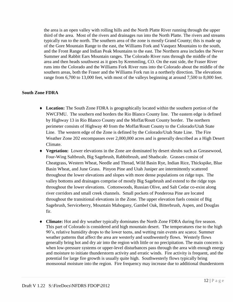
12 | P a g e
Draft V 1.22 S:\FireDocs\NFDRS FDOP\2012
the area is an open valley with rolling hills and the North Platte River running through the upper
third of the area. Most of the rivers and drainages run into the North Platte. The rivers and streams
typically run to the north. The southern area of the zone is mostly Grand County; this is made up
of the Gore Mountain Range to the east, the Williams Fork and Vasquez Mountains to the south,
and the Front Range and Indian Peak Mountains to the east. The Northern area includes the Never
Summer and Rabbit Ears Mountain ranges. The Colorado River runs through the middle of the
area and then heads southwest as it goes by Kremmling, CO. On the east side, the Fraser River
runs into the Colorado and the Williams Fork River runs into the Colorado about the middle of the
southern areas, both the Fraser and the Williams Fork run in a northerly direction. The elevations
range from 6,700 to 13,000 feet, with most of the valleys beginning at around 7,500 to 8,000 feet.
South Zone FDRA
Location: The South Zone FDRA is geographically located within the southern portion of the
NWCFMU. The southern end borders the Rio Blanco County line. The eastern edge is defined
by Highway 13 in Rio Blanco County and the Moffat/Routt County border. The northern
perimeter consists of Highway 40 from the Moffat/Routt County to the Colorado/Utah State
Line. The western edge of the Zone is defined by the Colorado/Utah State Line. The Fire
Weather Zone 202 encompasses over 2,000,000 acres and is generally described as a High Desert
Climate.
Vegetation: Lower elevations in the Zone are dominated by desert shrubs such as Greasewood,
Four-Wing Saltbrush, Big Sagebrush, Rabbitbrush, and Shadscale. Grasses consist of
Cheatgrass, Western Wheat, Needle and Thread, Wild Basin Rye, Indian Rice, Thickspike, Blue
Basin Wheat, and June Grass. Pinyon Pine and Utah Juniper are intermittently scattered
throughout the lower elevations and slopes with more dense populations on ridge tops. The
valley bottoms and drainages comprise of mostly Big Sagebrush and extend to the ridge tops
throughout the lower elevations. Cottonwoods, Russian Olive, and Salt Cedar co-exist along
river corridors and small creek channels. Small pockets of Ponderosa Pine are located
throughout the transitional elevations in the Zone. The upper elevation fuels consist of Big
Sagebrush, Serviceberry, Mountain Mahogany, Gambel Oak, Bitterbrush, Aspen, and Douglas
fir.
Climate: Hot and dry weather typically dominates the North Zone FDRA during fire season.
This part of Colorado is considered arid high mountain desert. The temperatures rise to the high
90’s, relative humidity drops to the lower teens, and wetting rain events are scarce. Summer
weather patterns that affect the area are westerly and southwesterly flows. Westerly flows
generally bring hot and dry air into the region with little or no precipitation. The main concern is
when low-pressure systems or upper-level disturbances pass through the area with enough energy
and moisture to initiate thunderstorm activity and erratic winds. Fire activity is frequent, and the
potential for large fire growth is usually quite high. Southwesterly flows typically bring
monsoonal moisture into the region. Fire frequency may increase due to additional thunderstorm

13 | P a g e
Draft V 1.22 S:\FireDocs\NFDRS FDOP\2012
activity, but fire growth potential could be lower due to increased moisture. Fires in this FDRA
are typically in climate class 1 (Arid/Semi-arid).
Topography: The South Zone is characterized by rolling hills and valleys. The eastern side of
the zone is bordered by the White River National Forest and the southern border follows the
Roan Plateau. Elevations range from 6000 to 9000 feet. The higher elevations occur along the
southern and eastern borders.
Weather Analysis
Weather is one of the three components that determines fire behavior, and the most variable component, thus
it is integral to determining fire danger. For this Plan, weather was analyzed using the data received from
fourteen remote RAWS within the Craig Interagency Dispatch Area. The NWCFMU (BLM) manages ten
active RAWS: Ladore, Great Divide, Calico, Independence, Gun sight, Dry Gulch, Pinto, Hunter Creek,
Dragon Road and Ernie Gulch. All of these stations comply with NWCG NFDRS Weather Station Standards.
The Dinosaur National Monument (NPS) manages the Dino Success RAWS while the Medicine Bow/Routt
National Forest manages three stations within the area, Dry Lake Willow Creek and Porcupine. The White
River National Forest manages the Dead Horse and Hangman RAWS. A map of the RAWS Station is in
Appendix F.
Table 2. RAWS summary of active and inactive station within the FDRA’s
Station ID Station Name Status Agency/Owner WIMS Data Years
050104 Ladore Active BLM-CO-CRD 1978-2011
050106 Great Divide Active BLM-CO-CRD 1985, 1998-2011
050108 Calico Active BLM-CO-CRD 2007-2011
050305 Independence Active BLM-CO-CRD 2009-2010
050404 Gun Sight Active BLM-CO-CRD 1964-1967, 1998-2011
050407 Dry Gulch Active BLM-CO-CRD 2009-2011
051402 Pinto Active BLM-CO-CRD 1972-1976, 1989-2011
051406 Hunter Creek Active BLM-CO-CRD 1984-2011
051407 Dragon Road Active BLM-CO-CRD 1984-2011
051408 Ernie Gulch Active BLM-CO-CRD 1984-2011

14 | P a g e
Draft V 1.22 S:\FireDocs\NFDRS FDOP\2012
050105 Dino Success Active NPS-CO-DINO 1993, 1998-2011
050102 Dinosaur NM HQ Inactive NPS-CO-DINO 1964-2001
050207 Dry Lake Active FS-CO-MBR 1984-2011
050304 Willow Creek Active FS-CO-MBR 1984-2011
050406 Porcupine Active FS-CO-MBR 1984-2011
51608 Hangman Active FS-CO-WRF 2006-2011
51404 Dead Horse Active FS-CO-WRF 1984-2010
Special Interest Groups (SIGs) RAWS located in different geographical locations with common sensitivity to NFDRS model inputs can be
grouped together to form a SIG. Laura Megel along with the Grand Junction Weather Service developed a
technique analyzing relative humidity, and temperature as the indicator of weather elements to help define fire
climate zones for both the North and South FDRA’s. RAWS with common modeling sensitivity have been
grouped into SIGs for each FDRA.
Fire and Weather Analysis
To get a better view of the interactions between weather and fire in the FDRA’s, fire history, weather history
and the relationship between historical fires and historical weather for each FDRA were analyzed using
FireFamily Plus. Break points, or thresholds that correspond to a change in historical fire activity were also
analyzed using Burning Index (BI) or the Energy Release Component (ERC) to create a Preparedness Level
Break Point (based on ERC), Dispatch Level Break Point (based on BI), and Adjective Rating Level Break
Point (based on ERC).
Fire History The most recent fifteen years (1995-2010) of fire occurrence data was used for the statistical analysis.
U.S.Department of Interior BLM, NPS, BIA, FWS fire occurrence data was obtained from the Wildland Fire
Management Information System. Department of Agriculture Forest Service fire occurrence data was obtained
from the National Interagency Fire Management Integrated Database (NIFMID) via Kansas City Fire Access
SofTware (KCFAST). The State of Colorado fires will be added to future FDOP’s. Since all four agencies
may have reported the same fire in their respective databases, the fires were cross-referenced and duplicate
fires were eliminated (in some instances, small fires are possibly duplicate). FireFamily Plus software was
utilized to produce statistics and graphs. A more detailed fire occurrence workload analysis (by agency) is in
Appendix K.

15 | P a g e
Draft V 1.22 S:\FireDocs\NFDRS FDOP\2012
Graphs 1, 2 and 3 illustrate the fire history for the North, East and South Zone FDRA’s. Graphs include
acres burned by year, month of fire, fire size, fire cause and multiple fire days (days when more than one fire
occurred). These graphs do not include state or county fires.
Graph 1. North Zone FDRA
Size Class: Cause Class: Fires per Fire-day
A = 0 - .2 acres 1 = Lightning 6 = Railroad
B = .3 - 9 acres 2 = Equipment 7 = Arson
C = 10 - 99 acres 3 = Smoking 8 = Children
D = 100 - 299 acres 4 = Campfire 9 = Miscellaneous
E = 300 - 999 acres 5 = Debris Burning
F = 1000 - 5000 acres
G = > 5000 acres

16 | P a g e
Draft V 1.22 S:\FireDocs\NFDRS FDOP\2012
Graph 2. East Zone FDRA
Size Class: Cause Class: Fires per Fire-day
A = 0 - .2 acres 1 = Lightning 6 = Railroad
B = .3 - 9 acres 2 = Equipment 7 = Arson
C = 10 - 99 acres 3 = Smoking 8 = Children
D = 100 - 299 acres 4 = Campfire 9 = Miscellaneous
E = 300 - 999 acres 5 = Debris Burning
F = 1000 - 5000 acres
G = > 5000 acres

17 | P a g e
Draft V 1.22 S:\FireDocs\NFDRS FDOP\2012
Graph 3. South Zone FDRA
Fire Danger Decision Levels
NFDRS utilizes the WIMS processor to analyze weather data and forecasted data stored in the NIFMID
database to produce fire danger ratings for corresponding weather stations (RAWS). NFDRS outputs
from the WIMS processor can be used to determine various levels of fire danger rating. The system is
designed to calculate worst-case scenario fire danger. NFDRS will be utilized in three ways for the
purpose of this plan: 1) To determine the Preparedness Level, which will help agency personnel
determine an appropriate state of readiness of suppression forces; 2) To determine the Dispatch Level,
which is a function of Burning Index, and is a decision tool for dispatchers to assign initial attack
resources to reported fires; and 3) To compute the Adjective Fire Danger for the purpose of
communicating fire danger to public and industrial interests . (e.g. fire danger signs). Although not used
for making fire business decisions, Climatological Percentiles are discussed in this section.
In order to determine the Preparedness Level, Dispatch Level and Adjective Fire Danger, “break points”
for each need to be calculated. Preparedness Level Break Points are thresholds that correspond to

18 | P a g e
Draft V 1.22 S:\FireDocs\NFDRS FDOP\2012
changes in historical fire activity based on a correlation of ERC and historical fires (termed “fire
business”). Dispatch Level Break Points correspond to changes in historical fire activity based on BI and
historical fires (fire business), and Adjective Fire Danger Rating (AFDR) Break Points are based on
staffing classes (divisions of fire danger) and ERC. Preparedness Level Break Points differ from AFDR
Break Points in that they take fire history into account in addition to weather data.
The FireFamily Plus software package was used to establish the fire business breakpoints. A statistical
analysis based on historical weather adjusted for fire activity determines the appropriate staffing index
and associated break points for each FDRA. Refer to Appendix K for information regarding the
Firefamily Plus analysis.
Preparedness Level Break Points: Table 3 details the break points and items analyzed for the
three FDRA’s. The final Preparedness Level determination will also incorporate fire activity, live
fuel moistures in the sagebrush and ERC’s. Daily index/component values will be obtained from
WIMS and used in Preparedness and Dispatch Level worksheets.
Table 3. Preparedness Level: Fire Family Plus Analysis Factors and Determinations
Rating Area RAWS Data Years
Available
Weight
Factor
Fuel
Model
NFDRS
Index
Fire Business
Break Point
Ranges
North Zone
SIG:
Calico
Dino Success
Great Divide
Lodore
2007 - 2010
1998 - 2010
1998 - 2010
1995 – 2010
1
1
1
1
G
ERC
PL 1
PL 2
PL 3
PL 4
PL 5
00 – 40
41 – 60
61 – 74
75 – 84
85 +
East Zone
SIG:
Dry Gulch
Dry Lake
Gun Sight
Independence
Porcupine
Willow Creek
Dead horse
Hangman
2009 - 2010
1995 - 2010
1998 - 2010
2009 - 2010
1995 - 2010
1995 - 2010
1984-2010
2006-2010
1
1
1
1
1
1
1
1
G
ERC
PL 1
PL 2
PL 3
PL 4
PL 5
00 – 32
33 –44
45 –54
55–64
65 +
South Zone
SIG:
Dragon Road
Ernie Gulch
Hunter Creek
Pinto
1995 - 2010
1995 - 2010
1995 - 2010
1995 – 2010
1
1
1
1
G ERC
PL 1
PL 2
PL 3
PL 4
PL 5
00 – 43
44 – 59
60 – 70
71 – 81
82 +

19 | P a g e
Draft V 1.22 S:\FireDocs\NFDRS FDOP\2012
Dispatch Level Break Points: Table 4 lists the Dispatch Level Break Points and the factors
included in the analysis.
Climatological Percentiles
Climatological breakpoints are points on the cumulative distribution of one fire weather/danger index
computed from climatology without regard for associated fire occurrence/business. For example, the value of
the 90th percentile ERC is the climatological breakpoint at which only 10 percent of the ERC values are
greater in value. The percentiles for climatological breakpoints predetermined by agency directive are shown
below. These percentiles are often used for agency severity requests
BLM - 80th and 95th percentiles
FWS - 90th and 97th percentiles
NPS - 90th and 97th percentiles
FS - 90th and 97th percentiles
It is equally important to identify the period or range of data analysis used to determine the agency percentiles.
The percentile values for 12 months of data will be different from the percentile values for the fire season.
Year round data should be evaluated for percentiles involving severity-type decisions.
Table 4. Dispatch Level: Fire Family Plus Analysis Factors and Determinations
Rating Area RAWS Data Years
Used
Weight
Factor
Fuel
Model
NFDRS
Index
Fire Business
Break Point
Ranges
North Zone
SIG:
Calico
Dino Success
Great Divide
Ladore
2007 - 2010
1998 - 2010
1998 - 2010
1995 – 2010
1
1
1
1
G
BI
Low
Moderate
High
00 – 48
49 – 72
73+
East Zone
SIG:
Dry Gulch
Dry Lake
Gun Sight
Independence
Porcupine
Willow Creek
Dead horse
Hangman
2009 - 2010
1995 - 2010
1998 - 2010
2009 - 2010
1995 - 2010
1995 - 2010
1984-2010
2006-2010
1
1
1
1
1
1
1
1
G
BI
Low
Moderate
High
00 – 40
41 – 57
58 +
South Zone
SIG:
Dragon Road
Ernie Gulch
Hunter Creek
Pinto
1995 - 2010
1995 - 2010
1995 - 2010
1995 – 2010
1
1
1
1
G BI
Low
Moderate
High
00 – 47
48 – 74
75 +

20 | P a g e
Draft V 1.22 S:\FireDocs\NFDRS FDOP\2012
Adjective Fire Danger Rating (AFDR)
The Adjective Fire Danger Rating will be used by agency personnel to inform the public of the current level of
fire danger associated with a specific Fire Danger Rating Area. The amount of public interaction will depend
on the magnitude of the adjective fire danger. Although NFDRS processors (such as WIMS) will
automatically calculate the daily adjective class rating, the adjective rating will be averaged over seven days to
create a smoothing effect. The daily adjective rating will be entered from WIMS then smoothed using a
Microsoft Excel calculation.
Five staffing class intervals (1-5) that correspond with five levels of adjective fire danger (low, moderate,
high, very high and extreme) will be used for all three FDRA’s. Table 5, 6 and 7 illustrate the AFDR Break
Points components for all three FDRA’s.
Table 5. North Zone AFDR Break Points (1995-2010)
Input Information Staffing Class and Percentile
Break Points
RAWS Fuel
Model
Staffing
Index 90
th 97
th
Ladore
50104 G ERC 93 99
Dino Success
50105 G ERC 94 98
Calico
50108 G ERC 84 89
Great Divide
50106 G ERC 83 90

21 | P a g e
Draft V 1.22 S:\FireDocs\NFDRS FDOP\2012
Table 6. East Zone AFDR Break Points (1995-2010)
Input Information Staffing Class and Percentile
Break Points
RAWS Fuel
Model
Staffing
Index 90
th 97
th
Independence
050305 G ERC 65 75
Dry Lake
050207 G ERC 72 78
Willow Creek
050304 G ERC 68 75
Gunsight
050404 G ERC 72 80
Porcupine
050406 G ERC 53 61
Dry Gulch
050407 G ERC 75 79
Dead Horse
051401 G ERC 70 77
Hangman
051608 G ERC 74 81
Table 7. South Zone AFDR Break Points (1995-2010)
Input Information Staffing Class and Percentile
Break Points
RAWS Fuel
Model
Staffing
Index 90
th 97
th
Pinto
51402 G ERC 87 93
Dragon Road
51407 G ERC 93 100
Ernie Gulch
51408 G ERC 87 95
Hunter Creek
51406 G ERC 86 95

22 | P a g e
Draft V 1.22 S:\FireDocs\NFDRS FDOP\2012
Operations and Applications
Worksheets (flowcharts) will be used to determine the daily Preparedness and Dispatch Levels from the
calculated break points. To reduce human error when completing the flowcharts, a self-calculating web
based flowchart has been developed and will be posted on the Craig Interagency Dispatch web page.
The resultant Preparedness and Dispatch Levels for the different FDRA’s will be broadcast in conjunction
with the morning information report and documented on the daily resource status report. The Adjective Fire
Danger Ratings will be broadcast and documented in the same manner.
Although fire danger ratings do not predict human-caused fires, a strong effort should be made to
communicate the fire danger as it changes throughout the fire season. The social, political, and financial
impacts of wildfires on agency, public, and industrial entities can be far-reaching. Loss of life, property, and
financial resources can potentially be associated with any wildfire. As the fire danger fluctuates, agency
personnel need to have pre-planned and appropriate responses. These actions should not only focus on
appropriate fire suppression, but also mitigation/education.
WIMS Setup and Application
The Weather Information Management System (WIMS) is a comprehensive system that enables users to
manage weather information.
WIMS can be accessed at http://fam.nwcg.gov/fam-web/. The WIMS User Guide can be downloaded
from the following web site:
http://www.fs.fed.us/fire/planning/nist/wims_web_ug/wims__ug_complete061803. pdf
The following instructions explain how to create a SIG for each FDRA:
1. NSIG: Create a Special Interest Groups (SIG)
Enter SIG name (i.e., “Desert”) and select
Enter the associated station numbers for the SIG. . . . then select

23 | P a g e
Draft V 1.22 S:\FireDocs\NFDRS FDOP\2012
East Zone Sig
Repeat these steps until all three SIGs have been created.
2. EAVG: Assign NFDRS Weighted Avg.
Enter the SIG name and select
By default, each station is weighted equally for the first priority fuel model. Keep the default value by
selecting
The following message will be displayed: Weighted average for sig “XXXXX’ has been successfully updated
The East Zone SIG looks as follows:

24 | P a g e
Draft V 1.22 S:\FireDocs\NFDRS FDOP\2012
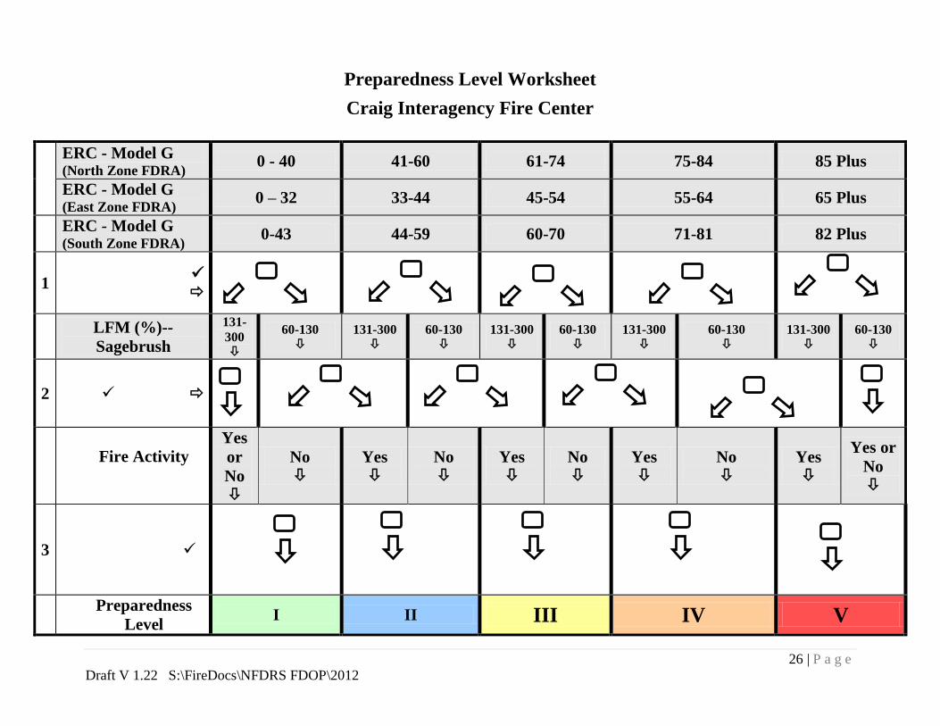
Preparedness Level
The Preparedness Level is a five-tier (1-5) fire danger rating system that will be based on Energy Release
Component and indicators of fire business. The fire business indicators used to calculate the Preparedness
Level include an indication of fire activity, Draw-down levels and live fuel moistures. A flow chart guides
personnel through the process. Several procedures and guidelines are to be followed once the Preparedness
Level has been determined. The break points for the Preparedness Level are set using an historical analysis
(Fire Family Plus) of fire business and its relationship to 1300 RAWS observations entered into the NIFMID
database and processed by WIMS, which calculates the staffing index values (BI, IC, SC, ERC, etc).
Worksheet Instructions:
Staffing Index Value: Place a checkmark in row one indicating the forecasted staffing index (ERC
value). These indices (forecasted by the Grand Junction and Boulder/Denver Weather Offices) are
based on the 1300 RAWS observations that are input to the WIMS processor by Craig Dispatch
personnel.
Live Fuel Moisture: Place a checkmark in row two indicating the appropriate Live Fuel Moisture for the
associated FDRA. Data can be obtained from the National Fuel Moisture Data (NFMD) Sample Site.
North Zone FDRA-Sagebrush LFM: Average of the most recent samples from Great Divide, Rye Grass,
Calico and Iron Springs Bench Sagebrush sites.
Great Divide:
http://72.32.186.224/nfmd/public/site.php?site_fuel=Great%20Divide&gacc=RMCC&state=CO&grup
=Little%20Snake%20Field%20Office&sitefuel=site&display_type=Table%20Only%20Bi
Rye Grass:
http://72.32.186.224/nfmd/public/site.php?site_fuel=Rye%20Grass&gacc=RMCC&state=CO&grup=L
ittle%20Snake%20Field%20Office&sitefuel=site&display_type=Table%20Only%20Bi
Calico:
http://72.32.186.224/nfmd/public/site.php?site_fuel=Calico&gacc=RMCC&state=CO&grup=Little%2
0Snake%20Field%20Office&sitefuel=site&display_type=Table%20Only%20Bi
Iron Springs Bench:
http://72.32.186.224/nfmd/public/site.php?site_fuel=Iron%20Springs%20Bench&gacc=RMCC&state=
CO&grup=Dinosaur%20National%20Park&sitefuel=site&display_type=Table%20Only%20Bi
East Zone FDRA-Sagebrush LFM: Use Live Fuel Moistures for the North Zone
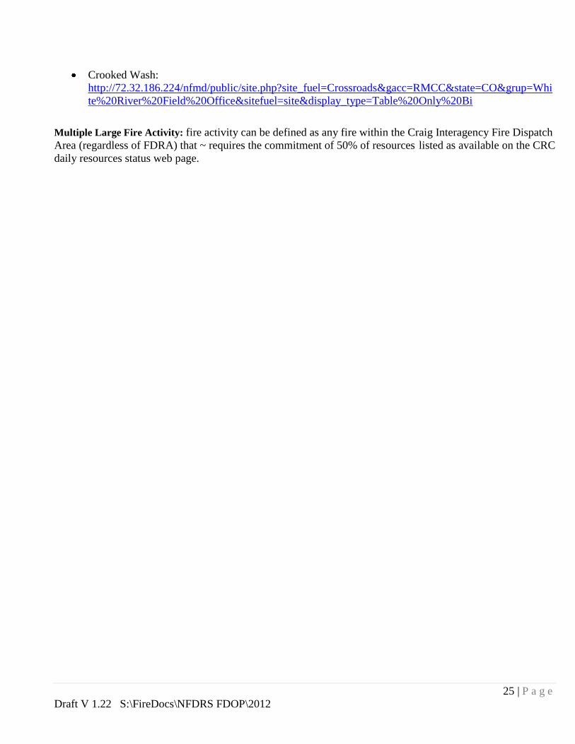
South Zone FDRA-Sagebrush LFM: Average of the most recent samples from Dragon Road, Crossroads
and crooked Wash Sagebrush sites.
Dragon Road:
http://72.32.186.224/nfmd/public/site.php?site_fuel=Dragon%20Road&gacc=RMCC&state=CO&grup
=White%20River%20Field%20Office&sitefuel=site&display_type=Table%20Only%20Bi
Crossroads:
http://72.32.186.224/nfmd/public/site.php?site_fuel=Crossroads&gacc=RMCC&state=CO&grup=Whi
te%20River%20Field%20Office&sitefuel=site&display_type=Table%20Only%20Bi
25 | P a g e
Draft V 1.22 S:\FireDocs\NFDRS FDOP\2012
Crooked Wash:
http://72.32.186.224/nfmd/public/site.php?site_fuel=Crossroads&gacc=RMCC&state=CO&grup=Whi
te%20River%20Field%20Office&sitefuel=site&display_type=Table%20Only%20Bi
Multiple Large Fire Activity: fire activity can be defined as any fire within the Craig Interagency Fire Dispatch
Area (regardless of FDRA) that ~ requires the commitment of 50% of resources listed as available on the CRC
daily resources status web page.
26 | P a g e
Draft V 1.22 S:\FireDocs\NFDRS FDOP\2012
Preparedness Level Worksheet
Craig Interagency Fire Center
ERC - Model G (North Zone FDRA)
0 - 40 41-60 61-74 75-84 85 Plus
ERC - Model G (East Zone FDRA)
0 – 32 33-44 45-54 55-64 65 Plus
ERC - Model G (South Zone FDRA)
0-43 44-59 60-70 71-81 82 Plus
1
LFM (%)--
Sagebrush
131-
300
60-130
131-300
60-130
131-300
60-130
131-300
60-130
131-300
60-130
2
Fire Activity
Yes
or
No
No
Yes
No
Yes
No
Yes
No
Yes
Yes or
No
3
Preparedness
Level I II III IV V

27 | P a g e
Draft V 1.22 S:\FireDocs\NFDRS FDOP\2012
Dispatch Level
Agency personnel use the Dispatch Level (response level) to assign initial attack
resources based on pre-planned interagency “Run Cards.” Combined with
predefined Dispatch Zones which are currently the Fire Management Units (A
through D polygons), the Dispatch Level is used to assign an appropriate mix of
suppression resources to a reported wildland fire based upon fire danger potential.
The Dispatch Levels is a two-tier fire danger rating system that is based on
Burning Index and the current Preparedness Level. Burning Index is the most
appropriate NFDRS index and/or component that correlate to fire occurrence. In
all FDRAs, Burning Index (BI) in NFDRS Fuel Model G has been determined to
be the best NFDRS index that statistically correlates to the potential for large fires
to occur. Due to the ability of BI to reflect the most current fire danger potential,
and the Dispatch Center’s ability to manage agency personnel throughout the
course of any given day, Dispatch Level will be computed and implemented for
initial attack response levels until a qualified Incident Commander arrives on
scene to validate the need for the dispatched resources.
Dispatch Level Worksheet
Craig Interagency Fire Center
FDRA Burning Index
BI - Model G (North FDRA) 0 - 48 49 - 72 73+
BI - Model G (East FDRA) 0 – 40 41 – 57 58+
BI - Model G (South FDRA) 0 - 47 48-74 75+
Preparedness Level 1-2 3-5 1-5 1-2 3-5
Dispatch level LOW Moderate High

28 | P a g e
Draft V 1.22 S:\FireDocs\NFDRS FDOP\2012
Adjective Fire Danger Rating In 1974, the USFS, BLM and State Forestry organizations established a standard
adjective description for five levels of fire danger for use in public information
releases and fire prevention signage. For this purpose only, fire danger is
expressed using the adjective levels and color codes described below.
Fire Danger Class
and Color Code Description
Low (L)
(Green)
Fuels do not ignite readily from small firebrands, although a more intense heat
source such as lightning may start fires in duff or punky wood. Fires in open
cured grasslands may burn freely a few hours after rain, but timber fires spread
slowly by creeping or smoldering, and burn in irregular fingers. There is little
danger of spotting.
Moderate (M)
(Blue)
Fires can start from most accidental causes, but with the exception of lightning
fires in some areas, the number of starts is generally low. Fires in open cured
grasslands will burn briskly and spread rapidly on windy days. Timber fires
spread slowly to moderately fast. The average fire is of moderate intensity,
although heavy concentrations of fuel, especially draped fuel, may burn hot.
Short-distance spotting may occur, but is not persistent. Fires are not likely to
become serious and control is relatively easy.
High (H)
(Yellow)
All fine dead fuels ignite readily and fires start easily from most causes.
Unattended brush and campfires are likely to escape. Fires spread rapidly and
short-distance spotting is common. High-intensity burning may develop on
slopes or in concentrations of fine fuels. Fires may become serious and their
control difficult unless they are hit hard and fast while small.
Very High (VH)
(Orange)
Fires start easily from all causes and, immediately after ignition, spread rapidly
and increase quickly in intensity. Spot fires are a constant danger. Fires burning
in light fuels may quickly develop high intensity characteristics such as long-
distance spotting and fire whirlwinds when they burn in heavier fuels.
Extreme (E)
(Red)
Fires start quickly, spread furiously, and burn intensely. All fires are potentially
serious. Development into high intensity burning will usually be faster and occur
from smaller fires than in the very high fire danger class. Direct attack is rarely
possible and may be dangerous except immediately after ignition. Fires that
develop headway in heavy slash or in conifer stands may be unmanageable while
the extreme burning condition lasts. Under these conditions the only effective
and safe control action is on the flanks until the weather changes or the fuel
supply lessens.
Agency personnel will use the resultant adjective fire danger information to
maintain the awareness of public and industrial entities. The amount of
interaction between agency and public/industry entities will depend on the
magnitude of the adjective fire danger.
Adjective Fire Danger Rating Determination
NFDRS processors automatically calculate the adjective class rating.
The adjective rating calculations use the staffing index (such as ERC
or BI) of the first priority fuel model listed in the station record in
the processor.

29 | P a g e
Draft V 1.22 S:\FireDocs\NFDRS FDOP\2012
The actual determination of the daily adjective rating is based on
the current or predicted value for a user-selected staffing index and
ignition component using the table below. The staffing index used
in the plan is ERC.
Staffing Levels Adjective Fire Danger Rating
1-, 1, 1+ L L L M M
2-, 2, 2+ L M M M H
3-, 3, 3+ M M H H VH
4-, 4, 4+ M H VH VH E
5 H VH VH E E
Ignition
Component 0-20 21-45 46-65 66-80 81-100
Given the same weather inputs, the NFDRS processor will
calculate the adjective fire danger for selected fuel models.
Seasonal Risk Analysis
Seasonal risk analysis is a comparison of the historic weather/fuels records with
current and forecasted weather/fuels information. Seasonal risk analysis is an on-
going responsibility for fire program managers. The most reliable indicators of
seasonal fire severity have been measurements of fine fuel loading, live fuel
moisture, 1000-hour (dead) fuel moisture, and ERC. These levels will be
graphically compared to historical maximum values and the average. The graphs
will be routinely updated and distributed to fire suppression personnel and
dispatch. Seasonal risk analysis information will be used as a basis for pre-
positioning critical resources, dispatching resources, and requests for fire severity
funding. The following are specific indicators that are useful in accurately
predicting fire season severity and duration in the North, South and East Zone
Fire Danger Rating Areas.
Fire Activity: The presence (or absence) of fire activity can be tracked and
compared to historical occurrences in order to anticipate severity conditions.
The Fire Summary module of FireFamily Plus provides an efficient means to
compare monthly fire activity.
Live Fuel Moisture: Live woody (juniper) and herbaceous (sagebrush) fuel
moisture plots were established in the North and South Zone FDRA, while
live woody conifer and oak brush fuel moistures have been taken in the East
Zone FDRA. Valuable data has been collected and a direct correlation has
been drawn between fire intensity (controllability) and live moisture levels.
Consequently, fire severity is determined by comparing current trends to
historical averages. Comparison of fuel moisture to historical conditions at
various locations within the Colorado and surrounding areas can be located

30 | P a g e
Draft V 1.22 S:\FireDocs\NFDRS FDOP\2012
on the National Live Fuels Moisture web site:
http://72.32.186.224/nfmd/public/states_map.php?state=CO
NFDRS Indicators: ERC and 1000-hr (3” – 8” diameter dead) fuel are used
as the primary indicators to track seasonal trends of fire danger potential.
NFDRS fuel model G has been chosen due to its good “fit” with the ERC and
1000-hour models. Other fuel models that might seem to be more
appropriate due to their classification (grass/brush) do not correlate very well
statistically with the NFDRS models. Consequently, fuel model G was
chosen due to its ability to predict fire occurrence, specifically a day when a
large fire is likely to occur.
Weather Trends: Seasonal weather assessments rely upon long-range (30-
90 day) forecasts. This information is available on the NIFC Predictive
Service Web Site. The site also contains daily and weekly fire danger
assessments.
Drought Indicators: The Keetch-Byrum Drought Index (KBDI) and Palmer
Drought Index track soil moisture and have been tailored to meet the needs of
fire risk assessment personnel. Current KBDI information is also located on
the Rocky Mountain Web Site. Tracking and comparing 1000-hour fuel
moisture is another method to assess drought condition
Normalized Difference Vegetation Index (NDVI): NDVI data is satellite
imagery, which displays vegetative growth and curing rates of live fuels. The
Wildland Fire Assessment System provides several different ways to analyze
current and historical greenness imagery, which can be a significant
contributor to seasonal risk assessments.
Season-Ending Event: Historical fire records were examined for both
FDRA’s to determine the combination of weather parameters that would
indicate the end of the fire season. The following season-ending events
have been identified:
North Zone FDRA: three consecutive days when the ERC is less
than 40 and measurable precipitation has occurred for at least a sum
of 12 hours (or measurable precipitation has occurred for at least a
sum of 25 hours) during that three-day period.
South Zone FDRA: three consecutive days when the ERC is less
than 40 and measurable precipitation has occurred for at least a sum
of 12 hours (or measurable precipitation has occurred for at least a
sum of 25 hours) during that three-day period.
East Zone FDRA: three consecutive days when the ERC is less than
40 and measurable precipitation has occurred for at least a sum of
12 hours (or measurable precipitation has occurred for at least a sum
of 25 hours) during that three-day period.
Thresholds (EXTREME FIRE DANGER)
Seasonal risk escalation in fuel complexes of the Craig Dispatch area relies upon
a combination of factors that will ultimately trigger an extreme state of fuel

31 | P a g e
Draft V 1.22 S:\FireDocs\NFDRS FDOP\2012
volatility and a high potential for large fire growth or multiple ignition scenarios.
These factors are:
Fire Activity: The occurrence of large/multiple fires is the best indicator of
severity conditions and the potential for seasonal risk. Any one incident
reaching type one or two complexity would be an indicator of severity. Two
or more type three incidents within a two to four week period would also be a
strong indicator. Three or more initial attack fires in the same day indicate a
point where resources are scarce. A progressive approach to assessing
seasonal risk will prepare the local unit for these occurrences and the
necessary tools will already be in place.
Live Fuel Moisture (Juniper): The average woody fuel moisture of juniper
typically fluctuates between 100% (June) and 75% (August). Any readings
below 80% indicate increased risk relating to large fire growth and severity
conditions. Below average readings may indicate an early or extended fire
season.
Live Fuel Moisture (Sagebrush): The average herbaceous fuel moisture of
sagebrush in the North and South Zone FDRA fluctuates between 200%
(June) and 80% (August). Readings below 75% indicate increased risk
relating to large fire growth and severity conditions. Below average readings
may indicate an early or extended fire season.
NFDRS Thresholds: The BI threshold for extreme fire potential is 73 (or
higher) for the North and South Zone FDRA; the BI threshold for extreme
fire potential is 58 (or higher) for the East Zone FDRA. It has been
statistically proven that large fire events will occur proportionally more often
when these thresholds are exceeded. The ERC threshold is 83 (or higher) for
the North and South Zone FDRA and 65 (or higher) for the East Zone FDRA.
Early and late-season readings that trend above average may indicate an
extension of the normal fire season.
Drought Indicators: Palmer Drought Index graphics display current
drought conditions while KBDI values of 500-800 indicate the potential for
rapid curing and drying of the fine fuels and potential for live fuel moisture to
drop. The 1000-hour fuel moisture is also a good drought indicator. Values
between six and ten percent indicate the potential risk for extreme burning
conditions.
Normalized Difference Vegetation Index (NDVI): An analysis of this imagery
will assist in the assessment of current fuel moisture conditions and provide
historical as well as average greenness comparisons.
Fire Danger Pocket Cards The Fire Danger Pocket Card is a tool which can help fire suppression personnel
to interpret NFDRS outputs and understand fire danger thresholds for a local area.
Pocket cards can relate current NFDRS outputs with the historical average and

32 | P a g e
Draft V 1.22 S:\FireDocs\NFDRS FDOP\2012
worst-case values in a specific geographic location. Visiting resources can use
the pocket card to familiarize themselves with local fire danger conditions.
ERC is a measure of fire controllability (Deeming et al. 1978). NFDRS fuel
model G was selected for all FDRA’s as it provides the best statistical correlation
with large fire occurrence and responds to changing weather and fuel conditions.
Refer to Appendix H for pocket card examples.
Roles and Responsibilities
Fire Danger Operating and Preparedness Plan
The NWCFMU FMO will ensure that necessary amendments or updates to this
plan are completed. Updates to this plan will be made at least every two years and
approved by the line officers (or delegates) from each agency. Revised copies
will be distributed to the individuals on the primary distribution list.
Suppression Resources
During periods when local preparedness levels are High to Extreme, the Fire
Management Officers from each agency will strive to achieve the most efficient
and effective organization to meet Fire Management Plan objectives. This may
require the pre-positioning of suppression resources. The FMO/AFMO/ZFMO
from each agency will also determine the need to request/release off unit
resources or support personnel throughout the fire season.
Duty Officer
For the purposes of this plan, a Duty Officer from each agency will be identified
to the Craig Interagency Fire Center Manager. The Duty Officer is a designated
fire operations specialist, who provides input and guidance regarding
preparedness and dispatch levels. It is the Duty Officer’s role to interpret and
modify the daily preparedness and dispatch levels as required by factors not
addressed by this plan. Modifications of the preparedness and/or dispatch levels
must be coordinated through the Fire Center Manager. The Duty Officer will
keep their respective agency’s fire and management staff updated (as needed).
Fire Weather Forecasting Daily fire weather forecasts will be developed by the National Weather Service,
Boulder/Denver and Grand Junction Weather Forecast Offices, and posted on the
Internet and in WIMS for the Craig Colorado Interagency Fire Center to retrieve.

33 | P a g e
Draft V 1.22 S:\FireDocs\NFDRS FDOP\2012
NFDRS Outputs and Indices The Center Manager will ensure that the daily fire weather forecast (including
NFDRS indices) is retrieved and that the daily preparedness, dispatch, and
adjective levels are calculated and distributed.
Risk Analysis Information
The FMO from each agency will ensure that seasonal risk assessments are
conducted during the fire season. The risk analysis will include information such
as live fuel moisture, 1000-hour fuel moisture, fuel loading, NFDRS (BI/IC/ERC)
trends, NDVI imagery, and other pertinent data. This information will be
distributed to agency staff and the CRC Manager. The Center Manager and
AFMO’s will ensure information is posted at fire suppression duty stations.
Weather Station Maintenance
The Remote Sensing Laboratory located at the National Interagency Fire Center
(NIFC) maintains and calibrates the BLM RAWS stations on an annual basis.
Local BLM Fire personnel are currently qualified as first responders to RAWS
malfunctions. It is unknown who assists with maintaining and calibrating the
USFS RAWS stations on an annual basis.
WIMS Access, Daily Observations, and Station Catalog Editing The BLM Center Manger is listed as the station owner for the BLM. The owner
maintains the WIMS Access Control List (ACL). The station owner will ensure
appropriate editing of the RAWS catalogs. The Center Manager will ensure the
timely editing of daily 1300 weather observations of all stations.
Preparedness, Dispatch, and Adjective Level Guidelines
Each agency’s fire management staff along with the Center Manager will be
responsible for establishing and reviewing the preparedness, dispatch, and
adjective level guidelines on a bi-annual basis (as a minimum).
Public and Industrial Awareness
Education and mitigation programs will be implemented by the agency Public
Information Officers, Law Enforcement Officers, FMO’s, AFMO’s, Fire
Wardens, and Prevention Specialists based on Preparedness Level Guidelines and
direction provided by the agency’s FMO and Duty Officer.
NFDRS and Adjective Fire Danger Break Points
The FDOP team will review weather and fire data at least every two years (when
the FDOP is re-analyzed). The team will ensure that the break points reflect the
most accurate information with the concurrence of the FMO’s.
Fire Danger Pocket Cards The FMO’s will ensure that pocket cards are prepared at least every two years and
are in compliance with NWCG standards. The cards will be distributed to all
interagency, local and incoming firefighters and Incident Management Teams
(IMTs). The pocket cards will be posted on Craig Dispatch and National Wildfire

34 | P a g e
Draft V 1.22 S:\FireDocs\NFDRS FDOP\2012
Coordinating Group (NWCG) pocket card web site (http://fam.nwcg.gov/fam-
web/pocketcards/default.htm). Fire suppression supervisors will utilize pockets
cards to train and brief suppression personnel.
Program Improvements
Training
Provide FDOP training to cooperators including county fire FMOs,
cooperating dispatch centers, and fire departments.
Train more personnel as first responders to RAWS malfunctions.
Establish local WIMS/NFDRS training courses for agency personnel.
Emphasize NFDRS training (S-491) at the geographic area level for mid-
level fire management personnel.
Inform agency fire suppression supervisors of FDOP applications by
integrating the training in unit orientation meetings. At a minimum, this
should include FMO’s, Fire Operations Supervisors, Area Managers, and
Fire Wardens.
RAWS
Find and input missing weather data into KCFAST.
Report errors of weather data to KCFAST.
Technology & Information Management
Integrate preparedness and dispatch level flow charts into a web based
package.
Improve the CRC Internet Site where pertinent seasonal risk assessment
information can be reviewed.
35 | P a g e
Draft V 1.22 S:\FireDocs\NFDRS FDOP\2012
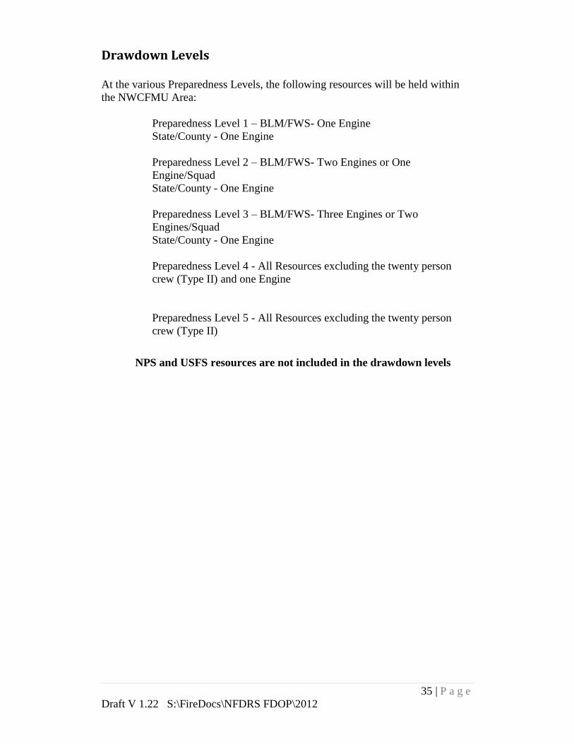
Drawdown Levels
At the various Preparedness Levels, the following resources will be held within
the NWCFMU Area:
Preparedness Level 1 – BLM/FWS- One Engine
State/County - One Engine
Preparedness Level 2 – BLM/FWS- Two Engines or One
Engine/Squad
State/County - One Engine
Preparedness Level 3 – BLM/FWS- Three Engines or Two
Engines/Squad
State/County - One Engine
Preparedness Level 4 - All Resources excluding the twenty person
crew (Type II) and one Engine
Preparedness Level 5 - All Resources excluding the twenty person
crew (Type II)
NPS and USFS resources are not included in the drawdown levels

36 | P a g e
Draft V 1.22 S:\FireDocs\NFDRS FDOP\2012
Appendix A - Team Members
Fire Danger Operating and Preparedness Plan
Colt Mortenson Kevin Thompson
Fire Management Officer East Zone Fuels FMO
Bureau of Land Management Bureau of Land Management
NWCFMU NWCFMU
Dave Toelle Lynn Barclay
Assistant Fire Management Officer Prevention and Mitigation Specialist
Bureau of Land Management Bureau of Land Management
NWCFMU NWCFMU
Stacy Gray Garner Harris
Dispatch Center Manager South Zone FMO
Craig Interagency Fire Center Bureau of Land Management
NWCFMU
Joe Flores
Fire Management Officer Kyle Frary
Dinosaur National Monument South Zone Fuels (Detailed)
NWCFMU Bureau of Land Management
NWCFMU
Dale Beckerman
North Zone Fire Mgt Specialist
Bureau of Land Management
Little Snake Field Office
NWCFMU
Tim Foley
State of Colorado
Pam Levitt
GIS Specialist
Bureau of Land Management
Little Snake Field Office
Marty Mortenson
Java Script and HTML Specialist
Consultant

37 | P a g e
Draft V 1.22 S:\FireDocs\NFDRS FDOP\2012
Appendix B - Primary Distribution List Name Title Agency Mailing Address E-mail
Joes Flores FMO NPS 4545 E Hwy 40
Dinosaur, Co 81610 [email protected]
Chris Dippel Refuge Manger FWS 1318 Hwy 318
Maybell, CO 81640 [email protected]
Mary Risser Superintendent NPS 4545 E Hwy 40
Dinosaur, Co 81610 [email protected]
Dave Stout Field Manger BLM
2103 E. Park Avenue
P.O. Box 68
Kremmling, Colorado
80459
Ann
Timberman Project Manager FWS
953 Jackson County
Road #32
Walden, Colorado
80480
Tracy Swensen FMO FWS
2155 W. Forest St.
Brigham City, UT
84302
Vern Bentley FMO FS 2468 Jackson St
Laramie, WY 82070 [email protected]
Mark Cahur ZFMO FS
925 Weiss Drive,
Steamboat Springs,
CO 80487 [email protected]
Wendy
Reynolds Field Manger BLM
455 Emerson St
Craig, CO 81625 [email protected]
John Twitchell District Forester State
PO Box 773657
Steamboat Springs,
CO 80477 [email protected]
Ron Cousineau District Forester State
PO Box 69
201 E. Jasper Ave.
Granby, CO 80446-
0069
Tim Foley FMO State
222 South 6th Street,
Room 416
Grand Junction, CO
81501-2771
Ken Kerr State FMO BLM 2850 Youngfield St
Lakewood, Co 80215 [email protected]
Kent Walter Field Manger BLM 220 E. Market Street
Meeker, CO 81641 [email protected]
Dave
Rosenkarance
Associate District
Manger BLM
2815 H Rd.
Grand Junction, CO [email protected]
Todd Wheeler FMO Moffat
Co
800 West 1st, Ste.
#100
Craig, CO 81625
The above list indicates key personnel associated with this plan. Copies of the FDOP will also be
distributed to Colorado Division of Forestry and State Lands Mangers, MBR National Forest
Personnel, Park Service Coordinators, Local fire departments, and surrounding County
Cooperators.
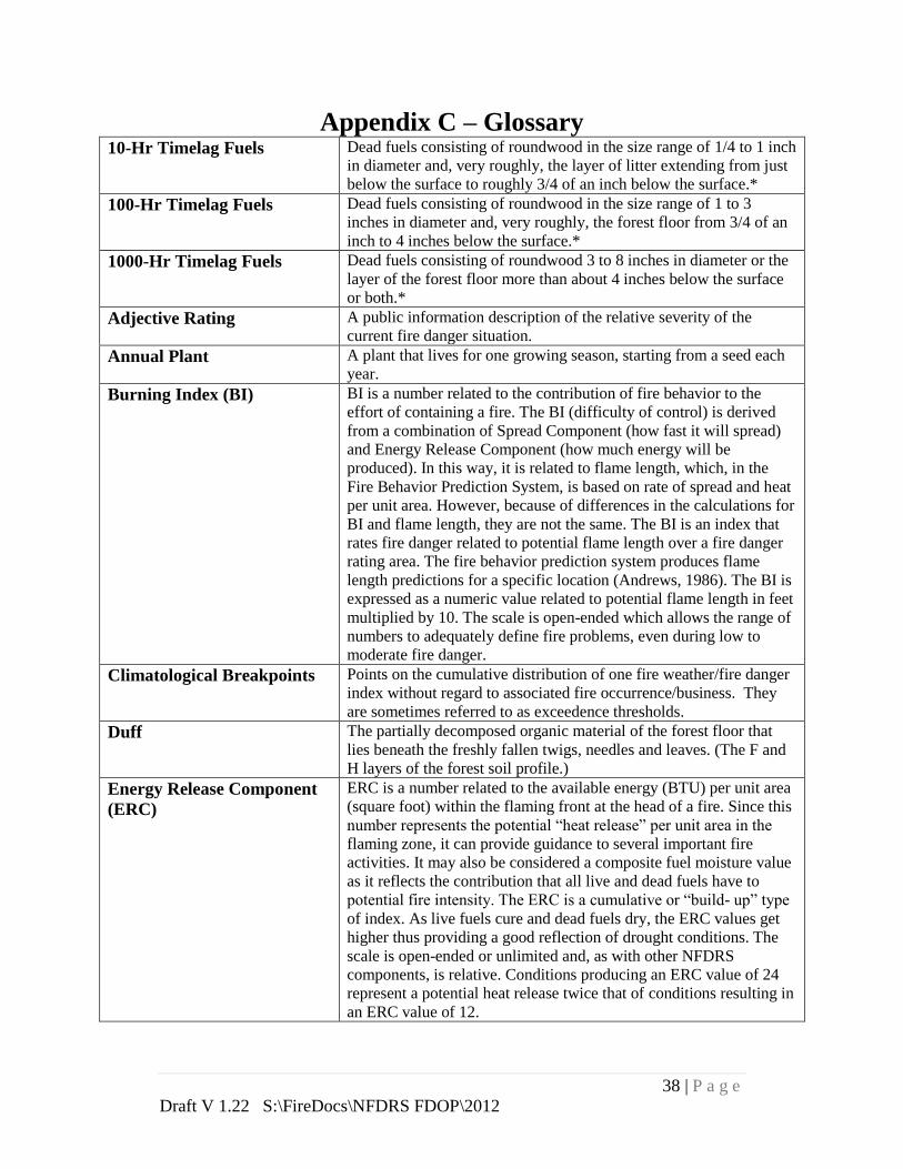
38 | P a g e
Draft V 1.22 S:\FireDocs\NFDRS FDOP\2012
Appendix C – Glossary 10-Hr Timelag Fuels Dead fuels consisting of roundwood in the size range of 1/4 to 1 inch
in diameter and, very roughly, the layer of litter extending from just
below the surface to roughly 3/4 of an inch below the surface.*
100-Hr Timelag Fuels Dead fuels consisting of roundwood in the size range of 1 to 3
inches in diameter and, very roughly, the forest floor from 3/4 of an
inch to 4 inches below the surface.*
1000-Hr Timelag Fuels Dead fuels consisting of roundwood 3 to 8 inches in diameter or the
layer of the forest floor more than about 4 inches below the surface
or both.*
Adjective Rating A public information description of the relative severity of the
current fire danger situation.
Annual Plant A plant that lives for one growing season, starting from a seed each
year.
Burning Index (BI) BI is a number related to the contribution of fire behavior to the
effort of containing a fire. The BI (difficulty of control) is derived
from a combination of Spread Component (how fast it will spread)
and Energy Release Component (how much energy will be
produced). In this way, it is related to flame length, which, in the
Fire Behavior Prediction System, is based on rate of spread and heat
per unit area. However, because of differences in the calculations for
BI and flame length, they are not the same. The BI is an index that
rates fire danger related to potential flame length over a fire danger
rating area. The fire behavior prediction system produces flame
length predictions for a specific location (Andrews, 1986). The BI is
expressed as a numeric value related to potential flame length in feet
multiplied by 10. The scale is open-ended which allows the range of
numbers to adequately define fire problems, even during low to
moderate fire danger.
Climatological Breakpoints Points on the cumulative distribution of one fire weather/fire danger
index without regard to associated fire occurrence/business. They
are sometimes referred to as exceedence thresholds.
Duff The partially decomposed organic material of the forest floor that
lies beneath the freshly fallen twigs, needles and leaves. (The F and
H layers of the forest soil profile.)
Energy Release Component
(ERC)
ERC is a number related to the available energy (BTU) per unit area
(square foot) within the flaming front at the head of a fire. Since this
number represents the potential “heat release” per unit area in the
flaming zone, it can provide guidance to several important fire
activities. It may also be considered a composite fuel moisture value
as it reflects the contribution that all live and dead fuels have to
potential fire intensity. The ERC is a cumulative or “build- up” type
of index. As live fuels cure and dead fuels dry, the ERC values get
higher thus providing a good reflection of drought conditions. The
scale is open-ended or unlimited and, as with other NFDRS
components, is relative. Conditions producing an ERC value of 24
represent a potential heat release twice that of conditions resulting in
an ERC value of 12.

39 | P a g e
Draft V 1.22 S:\FireDocs\NFDRS FDOP\2012
Equilibrium Moisture
Content
The moisture content that a fuel particle will attain if exposed for an
infinite period in an environment of specified constant temperature
and humidity. When a fuel particle has reached its equilibrium
moisture content, the net exchange of moisture between it and its
environment is zero.
Fire Business Thresholds Values of one or more fire weather/fire danger indexes that have
been statistically related to occurrence of fires (fire business).
Generally, the threshold is a value or range of values where
historical fire activity has significantly increased or decreased.
Fire Danger The resultant descriptor of the combination of both constant and
variable factors that affect the ignition, spread, and control difficulty
of control of wildfires on an area.
Fire Danger Continuum The range of possible values for a fire danger index or component,
given a set of NFDRS parameters and weather input.
Fire Danger Rating A system that integrates the effects of existing and expected states of
selected fire danger factors into one or more qualitative or numeric
indices that reflect an areas protection needs.
Fire Danger Rating Area A geographic area relatively homogeneous in climate, fuels and
topography, tens of thousands of acres in size, within which the fire
danger can be assumed to be uniform. Its size and shape is primarily
based on influences of fire danger, not political boundaries. It is the
basic, on the ground unit for which unique fire danger decisions are
made based on fire danger ratings. Weather is represented by one or
more NFDRS weather (RAWS) stations.
Fire Weather Forecast Zone A grouping of fire weather forecast stations that experience the same
weather change or trend. Zones are developed by the National
Weather Service to assist NWS production of fire weather forecasts
or trends for similar stations. Fire weather forecast zones are best
thought of as a list of similar weather stations, rather than an area on
a map.
Forb A non- grass-like herbaceous plant.
Fuel Class A group of fuels possessing common characteristics. In the NFDRS,
dead fuels are grouped according to their timelag (1, 10, 100, and
1000 hr) and live fuels are grouped by whether they are herbaceous
(annual or perennial) or woody.
Fuel Model A simulated fuel complex for which all fuel descriptions required by
the mathematical fire spread model have been supplied.
Fuel Moisture Content The water content of a fuel particle expressed as a percent of the
oven-dry weight of the particle. Can be expressed for either live or
dead fuels.
Fuels Non-decomposed material, living or dead, derived from herbaceous
plants.

40 | P a g e
Draft V 1.22 S:\FireDocs\NFDRS FDOP\2012
Green-up Green-up within the NFDRS model is defined as the beginning of a
new cycle of plant growth. Green- up occurs once a year, except in
desert areas where rainy periods can produce a flush of new growth
more than once a year. Green- up may be signaled at different dates
for different fuel models. Green-up should not be started when the
first flush of green occurs in the area. Instead, the vegetation that
will be the fire problem (represented by the NFDRS fuel model
associated with the weather station) when it matures and cures
should be identified. Green-up should start when the majority of this
vegetation starts to grow.
Herb A plant that does not develop woody, persistent tissue but is
relatively soft or succulent and sprouts from the base (perennials) or
develops from seed (annuals) each year. Included are grasses, forbs,
and ferns.
Herbaceous Vegetation
Moisture Content
The water content of a live herbaceous plant expressed as a percent
of the oven-dry weight of the plant.
Ignition Component (IC) IC is a rating of the probability that a firebrand will cause a fire
requiring suppression action. Since it is expressed as a probability, it
ranges on a scale of 0 to 100. An IC of 100 means that every
firebrand will cause a fire requiring action if it contacts a receptive
fuel.
Keetch-Byram Drought
Index (KBDI)
KBDI is a stand-alone index that can be used to measure the effects
of seasonal drought on fire potential. The actual numeric value of
the index is an estimate of the amount of precipitation (in 100ths of
inches) needed to bring the soil back to saturation (a value of 0 is
complete saturation of the soil). Since the index only deals with the
top 8 inches of the soil profile, the maximum KBDI value is 800 or
8.00 inches of precipitation would be needed to bring the soil back
to saturation. The Keetch-Byram Drought Index’s relationship to fire
danger is that as the index value increases, the vegetation is
subjected to increased stress due to moisture deficiency. At higher
values, desiccation occurs and live plant material is added to the
dead fuel loading on the site. Also, an increasing portion of the
duff/litter layer becomes available fuel at higher index values.
Litter The top layer of the forest floor, typically composed of loose debris
such as branches, twigs, and recently fallen leaves or needles; little
altered in structure by decomposition. (The layer of the forest soil
profile.)
Live Fuels Naturally occurring fuels whose moisture content is controlled by
the physiological processes within the plant. The National Fire
Danger Rating System considers only herbaceous plants and woody
material small enough (leaves, needles and twigs) to be consumed in
the flaming front of a fire.
Mitigation and Education
Specialist
Oversees fire prevention, education, mitigation, public
information, and the investigation and recovery of the cost of
human-caused fires.
Moisture of Extinction The theoretical dead fuel moisture content above which a fire will
not spread.
Perennial Plant A plant that lives for more than two growing seasons. For fire
danger rating purposes, biennial plants are classed with perennials.

41 | P a g e
Draft V 1.22 S:\FireDocs\NFDRS FDOP\2012
Roundwood Boles, stems, or limbs of woody material; that portion of the dead
wildland fuel which is roughly cylindrical in shape.
Shrub A woody perennial plant differing from a perennial herb by its
persistent and woody stem; and from a tree by its low stature and
habit of branching from the base.
Slash Branches, bark, tops, cull logs, uprooted stumps, and broken or
uprooted trees left on the ground after logging; also debris resulting
from thinning or wind storms.
Slope The rise or fall in terrain measured in feet per 100 feet of horizontal
distance measurement, expressed as a percentage.
Spread Component (SC) SC is a rating of the forward rate of spread of a head fire. Deeming,
et al. (1977), states that “the spread component is numerically equal
to the theoretical ideal rate of spread expressed in feet-per-minute.”
This carefully worded statement indicates both guidelines (it’s
theoretical) and cautions (its ideal) that must be used when applying
the Spread Component. Wind speed, slope and fine fuel moisture are
key inputs in the calculation of the spread component, thus
accounting for a high variability from day-to-day. The Spread
Component is expressed on an open-ended scale; thus it has no
upper limit.
Staffing Level The basis for decision support for daily staffing of initial attack
resources and other activities; a level of readiness and an indicator of
daily preparedness.
Surface-Area-to-Volume
Ratio
The ratio of the surface area of a fuel particle (in square- ft) to its
volume (in cubic-ft). The “finer” the fuel particle, the higher the
ratio; for example, for grass this ratio ranges above 2,000; while for
a ½ inch diameter stick it is 109.
Timelag The time necessary for a fuel particle to lose approximately 63% of
the difference between its initial moisture content and its equilibrium
moisture content.
Timelag Fuel Moisture
Content
The dead fuel moisture content corresponding to the various timelag
fuel classes.
X-1000 Hr Fuel Moisture X-1000 is the live fuel moisture recovery value derived from the
1000-hr fuel moisture value. It is an independent variable used in the
calculation of the herbaceous fuel moisture. The X-1000 is a
function of the daily change in the 1000-hour timelag fuel moisture,
and the average temperature. Its purpose is to better relate the
response of the live herbaceous fuel moisture model to the 1000-
hour timelag fuel moisture value. The X-1000 value is designed to
decrease at the same rate as the 1000-hour timelag fuel moisture, but
to have a slower rate of increase than the 1000-hour timelag fuel
moisture during periods of precipitation, hence limiting excessive
herbaceous fuel moisture recovery.

42 | P a g e
Draft V 1.22 S:\FireDocs\NFDRS FDOP\2012
Appendix D – WIMS User ID’s
Name
WIMS User
ID
Jenna Beckerman BLM1811
Colt Mortenson BLM2112
Janell Neubauer BLM2409
Taylor Welshimer BLM175
Dale Beckerman BLM2475
Dave Toelle BLM1417
Tim Foley BLM1684
Joe Flores NPS1403
Mark Cahur FS6741
Mick Hood FS11577
Daron Reynolds FS7113
Dezarae Stahlin BLM2452
Wendy Finnegan BLM1737
Vern Bentley FS11535
Tracy Swenson FS7002
Garner Harris BLM142
James Michels BLM1922
For assistance with passwords you may contact the WIMS help desk at 1-866-
224-7677 or 360-326-6002, email: [email protected].

43 | P a g e
Draft V 1.22 S:\FireDocs\NFDRS FDOP\2012
Appendix E – Fire Family Plus Working Sets North Zone Working Set
East Zone Working Set

44 | P a g e
Draft V 1.22 S:\FireDocs\NFDRS FDOP\2012
South Zone Working Set

45 | P a g e
Draft V 1.22 S:\FireDocs\NFDRS FDOP\2012
Appendix F – Weather Station Data Analysis
Weather Station Analysis from 1995-2010
Station ID
RAWS Station Name
Agency Owner
Fire Danger Zone
Date Solution Comments
50104 Ladore BLM CRD COZ200 5/27/1978 delete No Min/Max RH or Temp
50105 Ladore BLM CRD COZ200 5/30/1978 delete No Min/Max RH or Temp
50106 Ladore BLM CRD COZ200 6/22/1978 delete No Min/Max RH or Temp
50107 Ladore BLM CRD COZ200 7/24/1978 delete No Min/Max RH or Temp
50106 Great Divide BLM CRD COZ200 8/21/1996 delete No Max Temp
50106 Great Divide BLM CRD COZ200 9/16/1993 delete No Min/Max RH
50108 Calico BLM CRD COZ200 6/1/2009 delete 2.99 inches of rain in one hour
50305 Independence BLM CRD COZ201 Looks OK
50404 Gunsight BLM CRD COZ201 4/24/2000 delete 1300 temp 118
50404 Gunsight BLM CRD COZ201 07/30/00 thru 06/05/01 delete Poor Min/Max RH
50404 Gunsight BLM CRD COZ201 4/03/00 thru 04/28/00 delete Poor Min/Max RH
50404 Gunsight BLM CRD COZ201 06/24/05 thru 06/30/05 delete Poor Min/Max RH 2% for both
50404 Gunsight BLM CRD COZ201 4/25/2000 delete 1300 temp 112
50407 Dry Gulch BLM CRD COZ201 Looks OK
51402 Pinto BLM CRD COZ202 8/13/2000 delete No Min Temp
51406 Hunter Creek BLM CRD COZ202 Looks OK
51407 Dragon Road BLM CRD COZ202 4/15/1999 delete Min Temp -32
51408 Ernie Gulch BLM CRD COZ202 Looks OK
50105 Dino Success NPS COZ200 Missing Weather in Winter Months
50207 Dry Lake FS COZ201 Looks OK
50304 Willow Creek FS COZ201 Looks OK
50406 Porcupine FS COZ201 Looks OK
51404 Dead Horse FS WRF COZ201 06/25,26,27,28/03 delete Max RH didn't change 10%
51404 Dead Horse FS WRF COZ201 7/3/1999 delete Min/Max Rx is 1% for both
51404 Dead Horse FS WRF COZ201 9/26/1999 delete no min temp
51404 Dead Horse FS WRF COZ201 6/19/2008 delete Max RH of 67% but .35" rain in 7 hours
51404 Dead Horse FS WRF COZ201 6/18/2008 delete 3.36 inches of rain in one hour
51608 Hangman BLM UCR COZ201 9/28/2006 delete Min temp -32

46 | P a g e
Draft V 1.22 S:\FireDocs\NFDRS FDOP\2012
RAWS Locations (Map)

47 | P a g e
Draft V 1.22 S:\FireDocs\NFDRS FDOP\2012
Appendix G – Preparedness Level Actions The following Preparedness Level actions are guidelines for agency personnel. They are
discretionary in nature and usually will require a consensus between agency personnel prior to
implementation.
1. Agency Administrator
Responsible
Party Suggested Action
PL
1
PL
2
PL
3
PL
4
PL
5
Affected
Entity
Agency
Administrator
Ensure the office staff is
notifying CRC of their fire
availability. Agency
Ensure resource advisors are
designated and available for fire
assignments. Agency
Evaluate work/rest needs of fire
staff and crews. Agency
Consider need for fire
restriction or closures. See Fire
Restriction Plan for guidance.
Public
Industry
Provide appropriate political
support to fire staffs regarding
the implementation of
preparedness level actions.
Agency
Public
Industry
Review and transmit severity
requests submitted by the FMO
to the appropriate level. Agency
Issue guidance to staff
indicating severity of the season
and increased need and
availability for fire support
personnel. Agency

48 | P a g e
Draft V 1.22 S:\FireDocs\NFDRS FDOP\2012
2. Fire Management Officer
Responsible
Party Suggested Action
PL
1
PL
2
PL
3
PL
4
PL
5
Affected
Entity
FMO
1
If preparedness level is decreasing,
consult with FCO/Duty Officer/ Center
Manager and consider release of pre-
positioned or detailed personnel.
Agency
2
Evaluate season severity data (BI and
ERC trends for season, fuel loadings,
live FM, drought indices, and long term
forecasts).
Agency
3
Evaluate crew and staff work/rest
requirements.
Agency
4
Brief agency administrator on burning
conditions and fire activity.
Agency
5
Review geographical and national
preparedness levels and evaluate need
to suspend local prescribe fire activities.
Agency
6
Ensure Prevention Officer/MES has
initiated media contacts and public
education contacts.
Public
Industry
7
Ensure agency staff is briefed on
increasing fire activity.
Agency
8
Brief State/Regional FMO on
increasing fire activity.
Agency
9
Consider fire severity request and pre-
positioning of resources including:
suppression resources, aerial support,
aerial supervision, command positions,
dispatch, logistical support, and
prevention.
Agency
Public
Industry
10
Evaluate need for fire restrictions or
closures with interagency partners.
Public
Industry
11
Evaluate season Severity data (BI and
ERC trends for season, fuel loadings,
live FM, Drought indices and long term
forecasts
Agency

49 | P a g e
Draft V 1.22 S:\FireDocs\NFDRS FDOP\2012
Responsible
Party Suggested Action
PL
1
PL
2
PL
3
PL
4
PL
5
Affected
Entity
12
Request the Agency Administrator to
issue guidance to office staff regarding
the need for increased fire availability
in support positions.
Agency
13
Consult with the State FMO and agency
administrator regarding potential need
to pre-position a Type 3 or Type 2
Team.
Agency

50 | P a g e
Draft V 1.22 S:\FireDocs\NFDRS FDOP\2012
3. Duty Officer
Responsible
Party Suggested Action
PL
1
PL
2
PL
3
PL
4
PL
5
Affected
Entity
Duty
Officer
Confirm (or Adjust) the Preparedness and
Dispatch Levels with the CRC Manager.
Agency
If preparedness level is decreasing, consider
releasing pre-positioned and detailed
resources.
Agency
Ensure incoming pre-position or detailed
personnel are briefed on local conditions.
Agency
Evaluate work/rest needs of IA crews. Agency
Consider aerial detection flight. Agency
Evaluate need to change or shift duty hours
of IA resources.
Agency
Consider suspending prescribed fire
operations.
Agency
Consider extending staffing beyond normal
shift length.
Agency
Brief FMO on severity of conditions and
consider severity requests.
Agency
Consider pre-positioning and/or detailing of
additional IA resources from off-unit.
Agency
Consider pre-positioning and automatic
dispatch of ATGS aircraft.
Agency
Consider bringing in local IA resources from
scheduled days off.
Agency
Consider patrols and pre-positioning of local
IA resources in high risk areas.
Agency
Consider patrols in camping and recreation
areas.
Public
Consider suspension of project work away
from station or where response time will be
delayed
Agency
Consider automatic dispatch of, helicopter,
SEAT and/or heavy air tankers for IA.
Agency
Conduct daily morning briefing Agency

51 | P a g e
Draft V 1.22 S:\FireDocs\NFDRS FDOP\2012
4. Resource Advisor
Responsible
Party Suggested Action
PL
1
PL
2
PL
3
PL
4
PL
5 Affected
Entity
Coordinate efforts with the Duty Officer and
Incident Commanders. Agency
5. Engine/Crew Leaders
Responsible
Party Suggested Action
PL
1
PL
2
PL
3
PL
4
PL
5 Affected
Entity
Engine
Module
Leaders/
Crew
Leaders
Ensure IA crews are briefed on local
preparedness level, burning conditions, and
availability of IA resources and air support.
Agency
Evaluate work/rest needs of crew. Ensure
days off are taken and request relief if
needed.
Agency
Ensure that an adequate daily briefing is
provided.
Agency
Ensure equipment and crew preparedness. Agency
Provide Duty Officer/ZFMO/FMO feedback
regarding crew fatigue.
Agency
Participate in prevention activities as
required.
Public
Industry
Perform required check-ins - including
checking-in when moving locations during
the day.
Agency
Provide duty officer with feedback regarding
unique/unexpected fire behavior, severity
conditions, and the need to increase IA
capabilities.
Agency
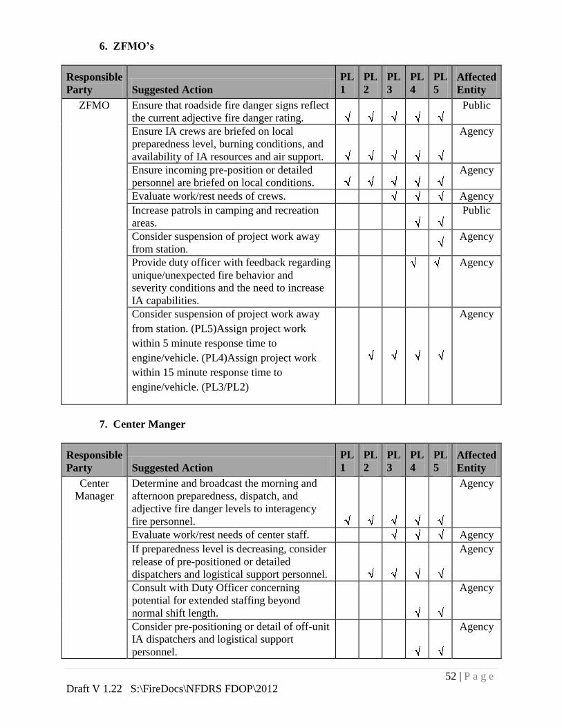
52 | P a g e
Draft V 1.22 S:\FireDocs\NFDRS FDOP\2012
6. ZFMO’s
Responsible
Party Suggested Action
PL
1
PL
2
PL
3
PL
4
PL
5 Affected
Entity
ZFMO Ensure that roadside fire danger signs reflect
the current adjective fire danger rating.
Public
Ensure IA crews are briefed on local
preparedness level, burning conditions, and
availability of IA resources and air support.
Agency
Ensure incoming pre-position or detailed
personnel are briefed on local conditions.
Agency
Evaluate work/rest needs of crews. Agency
Increase patrols in camping and recreation
areas.
Public
Consider suspension of project work away
from station.
Agency
Provide duty officer with feedback regarding
unique/unexpected fire behavior and
severity conditions and the need to increase
IA capabilities.
Agency
Consider suspension of project work away
from station. (PL5)Assign project work
within 5 minute response time to
engine/vehicle. (PL4)Assign project work
within 15 minute response time to
engine/vehicle. (PL3/PL2)
Agency
7. Center Manger
Responsible
Party Suggested Action
PL
1
PL
2
PL
3
PL
4
PL
5 Affected
Entity
Center
Manager
Determine and broadcast the morning and
afternoon preparedness, dispatch, and
adjective fire danger levels to interagency
fire personnel.
Agency
Evaluate work/rest needs of center staff. Agency
If preparedness level is decreasing, consider
release of pre-positioned or detailed
dispatchers and logistical support personnel.
Agency
Consult with Duty Officer concerning
potential for extended staffing beyond
normal shift length.
Agency
Consider pre-positioning or detail of off-unit
IA dispatchers and logistical support
personnel.
Agency

53 | P a g e
Draft V 1.22 S:\FireDocs\NFDRS FDOP\2012
Consider discussing activation of local area
MAC Group.
Agency
Consult with duty officer and FMO
regarding potential need for severity request.
Agency
Consider bringing additional dispatch
personnel in from scheduled days off.
Agency
Begin tracking weekly availability of
overhead personnel.
Agency
Establish weekly conference calls with
FMOs and Operations staff.
Agency
Input weather observations into WIMS. Agency
8. Fire Prevention Officer
Responsible
Party Suggested Action
PL
1
PL
2
PL
3
PL
4
PL
5
Affected
Entity
Fire
Prevention
Officer
Ensure that roadside fire danger signs reflect
the current adjective fire danger rating. Public
Contact local media to make the public
aware of the start of fire season and the
potential for local fire danger to increase.
Public
Industry
Provide public and industrial entities with
access to fire danger information, closures,
restrictions, and warnings. Public
Ensure the public and industrial entities are
aware of the policy of fire investigation and
potential consequences related with the cost
recovery process.
Public
Industry
Consider need for increased prevention
patrols. Agency
Contact local industrial entities to make
them aware of fire hazard and risk. Industry
Contact local fire chiefs to make them aware
of fire danger. Agency
Consider door-to-door contacts in rural
communities or ranch areas.
Public
Industry
Post signs and warnings in camp and
recreation areas. Public

54 | P a g e
Draft V 1.22 S:\FireDocs\NFDRS FDOP\2012
Notify local media of high/extreme fire
danger and of the need for increased public
caution.
Public
Industry
Consult with AFMO’s and FMO’s regarding
severity requests and the potential need for
additional prevention personnel or fire
prevention team. Agency
Consult with FMO regarding need for fire
restrictions or closures.
Agency
Public
Industry
9. Law Enforcement Rangers
Responsible
Party Suggested Action
PL
1
PL
2
PL
3
PL
4
PL
5 Affected
Entity
Law
Rangers
Check-in and notify dispatch of daily
availability for fire assignments and location
for day. Agency
Consider increased patrol in high fire danger
areas, such as campgrounds, OHV areas,
shooting areas. Public
Consider pre-positioning of or detailing in
fire investigation personnel. Agency
Consult with Fire Prevention Officer and
FMO regarding need for fire restrictions or
closures.
Public
Industry

55 | P a g e
Draft V 1.22 S:\FireDocs\NFDRS FDOP\2012
Appendix H – Pocket Cards
North and South Zone FDRA

56 | P a g e
Draft V 1.22 S:\FireDocs\NFDRS FDOP\2012
Routt National Forest (East Zone FDRA)

57 | P a g e
Draft V 1.22 S:\FireDocs\NFDRS FDOP\2012
Appendix I--Weather Station Catalogs (BLM Only)
Station
ID
Station
Name Priority Model
Staffing
Index
Decision
Classes
Staffing Index Breakpoints
Low High
SI% VAL SI% VAL
50104 Ladore 1 7G ERC 5 90 93 97 99
2 7U ERC 5 90 97
50106 Great Divide 1 7G ERC 5 90 83 97 90
2 7U ERC 5 90 97
50108 Calico 1 7G ERC 5 90 84 97 89
2 7U ERC 5 90 97
50305 Independence 1 7G ERC 5 90 65 97 75
2 7U ERC 5 90 97
50404 Gunsight 1 7G ERC 5 90 72 97 80
2 7U ERC 5 90 97
50407 Dry Gulch 1 7G ERC 5 90 75 97 79
2 7U ERC 5 90 97
51402 Pinto 1 7G ERC 5 90 87 97 93
2 7U ERC 5 90 97
51406 Hunter Creek 1 7G ERC 5 90 86 97 95
2 7U ERC 5 90 97
51407 Dragon Road 1 7G ERC 5 90 93 97 100
2 7U ERC 5 90 97
51408 Ernie Gulch 1 7G ERC 5 90 87 97 95
2 7U ERC 5 90 97

58 | P a g e
Draft V 1.22 S:\FireDocs\NFDRS FDOP\2012
Appendix J—Fire Family Plus Decision Points
Preparedness Level Decision Points (North Zone)
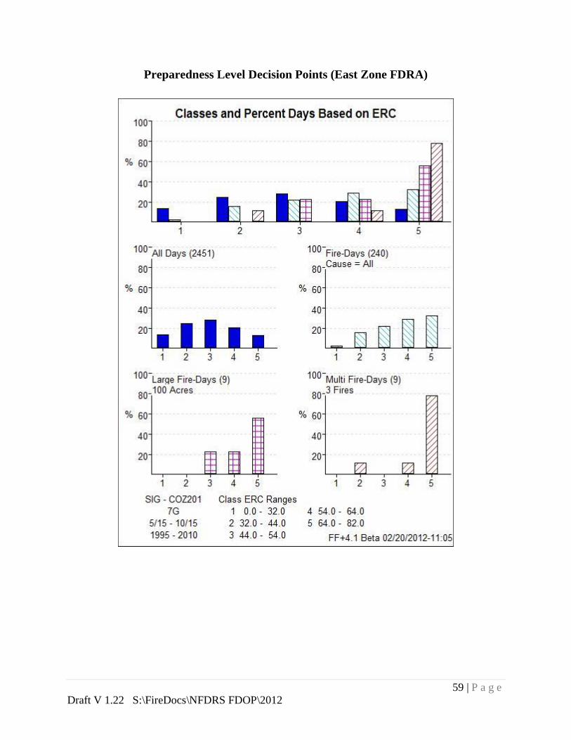
59 | P a g e
Draft V 1.22 S:\FireDocs\NFDRS FDOP\2012
Preparedness Level Decision Points (East Zone FDRA)

60 | P a g e
Draft V 1.22 S:\FireDocs\NFDRS FDOP\2012
Preparedness Level Decision Points (South Zone FDRA)

61 | P a g e
Draft V 1.22 S:\FireDocs\NFDRS FDOP\2012
Dispatch Level Decision Points (North Zone FDRA)
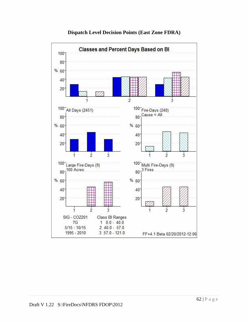
62 | P a g e
Draft V 1.22 S:\FireDocs\NFDRS FDOP\2012
Dispatch Level Decision Points (East Zone FDRA)

63 | P a g e
Draft V 1.22 S:\FireDocs\NFDRS FDOP\2012
Dispatch Level Decision Points (South Zone FDRA)

64 | P a g e
Draft V 1.22 S:\FireDocs\NFDRS FDOP\2012
Appendix K—Fire Occurrence (by Agency)
Less State and County Fires
FireFamily Plus Database (1984-2010)
Craig Interagency Fire Center
Agency
# of
Fires
% of Total
Fires
Acres
Burned % of Total Acres
BLM 5052 86% 236,327 72%
Fish and Wildlife 29 .4% 18,229 5.6%
Routt NF 450 7.7% 46,193 14%
NPS Dinosaur 342 5.9% 27,580 8.4%
TOTALS 5873 100% 328,329 100%
All Fires within Craig Dispatch Area

65 | P a g e
Draft V 1.22 S:\FireDocs\NFDRS FDOP\2012
Northwestern Colorado BLM Fires
Dinosaur National Monument Fires

66 | P a g e
Draft V 1.22 S:\FireDocs\NFDRS FDOP\2012
US Fish and Wildlife Service
Routt Portion of the MBR
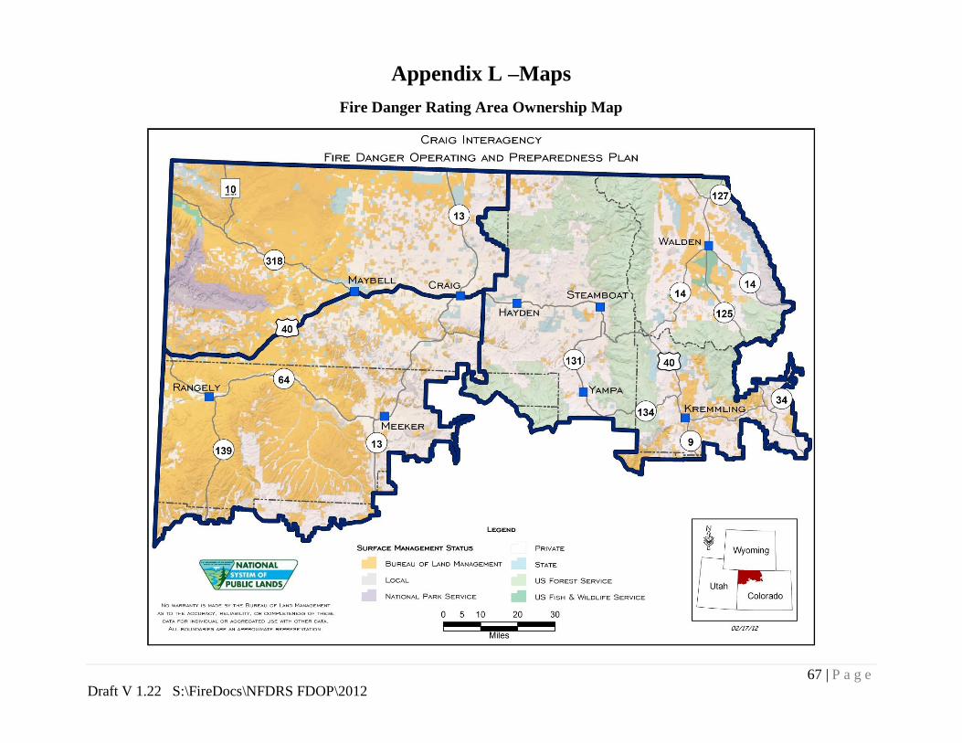
67 | P a g e
Draft V 1.22 S:\FireDocs\NFDRS FDOP\2012
Appendix L –Maps
Fire Danger Rating Area Ownership Map

68 | P a g e
Draft V 1.22 S:\FireDocs\NFDRS FDOP\2012
Point Layer Fires both Human and Lightning Excluding State and County Fires

69 | P a g e
Draft V 1.22 S:\FireDocs\NFDRS FDOP\2012
Large Fires Excluding Forest Service, State and County Fires

70 | P a g e
Draft V 1.22 S:\FireDocs\NFDRS FDOP\2012
Fire Danger Rating Areas

71 | P a g e
Draft V 1.22 S:\FireDocs\NFDRS FDOP\2012
Appendix M--NFDRS Structure

72 | P a g e
Draft V 1.22 S:\FireDocs\NFDRS FDOP\2012
Appendix N—BLM State Director Severity Request Procedures
Emergency Preparedness Step-Up Plan
To be completed later
Top Related