


Languages
Pages
Legal


Community Infrastructure Levy
Charging ScheduleJuly 2018
www.cornwall.gov.uk

July 2018 | 2Charging Schedule | Contents
Contents1 Introduction 3
2 Statutory Compliance 4
2.1 The Charging Authority 4
2.2 Date of Approval 4
2.3 DateofEffect 4
3 The Levy 5
3.1 CIL Rates 5
3.2 DefinitionsandApplicationofCIL 6
3.3 ReviewandMonitoring 6
4 Liability to Pay CIL 7
4.1 Chargeable Development 7
4.2 Exemptions 7
4.3 DiscretionaryRelief 7
5 Calculating the Chargeable Amount 8
5.1 Calculation 8
5.2 Section73 8
6 Payment of CIL 9
6.1 Instalments 9
6.2 In-kind 9
7 IndexationandInflation 9
8 Further Information 9
Appendix 1 - CIL Charging Zone Parish List 10
Appendix 2 - CIL Charging Zone map 11
Appendix 3 - Rural/Urban split: CIL Charging Zone map and Parish inset maps 12

July 2018 | 3Charging Schedule | Introduction
1 IntroductionThe Community Infrastructure Levy (CIL) is intended to provide funding to address the cumulative impact of development, whilst Section 106 (S106) agreements continuetoaddresssitespecificissuesrequiredtomake a development acceptable in planning terms. ThePlanningAct2008providesawidedefinitionoftheinfrastructure which can be funded by CIL, including transport,flooddefences,schools,hospitals,andotherhealthandsocialcarefacilities.ThisdefinitionallowsCILto be used to fund a very broad range of facilities such as play areas, parks and green spaces, cultural and sports facilities, district heating schemes, police stations and other community safety facilities.

July 2018 | 4Charging Schedule | Statutory Compliance
2 Statutory Compliance2.1 The Charging AuthorityCornwall Council is a Charging Authority for the purposes of Part 11 of the Planning Act 2008 and may therefore charge the Community Infrastructure Levy (CIL) in respect of development in its administrative area. The Council is both the CIL Charging Authority and Collecting Authority for its administrative area.
In preparing the Charging Schedule, Cornwall Council hascompliedwiththerequirementssetoutinPart11 of the Planning Act 2008 (as amended) and the CIL Regulations 2010 (as amended).
In setting the CIL rates, the Council has struck an appropriate balance between:
y The desirability of funding, from CIL in whole or in part,theestimatedcostofinfrastructurerequiredto support the development of its area, taking into account other actual and expected sources of funding, and
y Thepotentialeffects,takenasawhole,oftheimposition of CIL on the economic viability of development across its area.
2.2 Date of ApprovalThis Charging Schedule was approved by Full Council on 10 July 2018.
2.3 Date of EffectThisChargingScheduletakeseffectfrom1January2019.

July 2018 | 5Charging Schedule | The Levy
Table 1 - rates of CIL to be charged on new residential development 12345
Type of Development
Planning Use Class
Zone Rate £psm, all sites
of 1-5 dwellings,
and sites of 6-10 not in a DRA1/AONB2
Rate £psm, all sites of 11+
dwellings, and sites
of 6-10 in a DRA1/AONB2
Housing C3 & C4 1 £400 £200
2 £200 £100
3 £100 £60
4 £100 £35
5 £0 £0
Sheltered and Extra Care
Housing
C3 All £0 £0
Strategic sites3 C3 & C4 All £0 £0
Table 2 - rates of CIL to be charged on new non-residential development
Type of Development Planning Use Class
Zone Rate £sqm
Out of town centre convenience retail4
>280sqm
A1 All £100
Out of town centre, non-food retail5>280sqm
A1 All £100
Restaurant, out of town centre5>100sqm
A3/A5 All £100
All other non-residential All All £0
1 Designated Rural Area2 Area of Outstanding Natural Beauty3 ForCILpurposes,StrategicSitesaredefinedasresidentialdevelopments
which are shown on the Allocations Development Plan Document Strategic Maps as being ‘allocated’ or ‘with permission/under construction’. This includes the residential elements of mixed use developments.
4 Supermarkets–seedefinitioninsection3.25 Townboundary-seedefinitioninsection3.2
3 The Levy3.1 CIL RatesCILischargedinpoundspersquaremetreonnetadditionalincreaseininternalfloorspaceforqualifyingdevelopment, in accordance with the provisions of the CIL Regulations 2010 (as amended).
The CIL rates charged by Cornwall Council are set out in Tables1and2–seesection3.2forDefinitions.Alistofparishes in each CIL charging zone is given in Appendix 1. Maps of the CIL charging zones for housing development in Cornwall can be found in Appendix 2, and Appendix 3 applies to developments of 6-10 dwellings.

July 2018 | 6Charging Schedule | The Levy
Where an adopted (made) Neighbourhood Development Plan contains or introduces a Primary Residence Policy, development in the related Parishes will be charged at the CIL rate in the next lower charging zone, inordertoreflecttheuncertaintyofthemarketimpactof the Policy – see Appendices 1-3 for a list of Parishes and corresponding charging zones.
In planning terms, it is expected that individual dwellings that developers wish to use for holiday lettings would normally have a standard residential consent, and therefore be liable for CIL. This principle would also apply to change of use applications. However, housing development that is subject to a holiday occupancy condition will be zero rated for CIL.
Supermarkets (convenience retail) are shops that are ofasize,andofferarangeofgoods,thatmakesthemshopping destinations in their own right, including a dedicated car park. Supermarkets sell a full range of conveniencefoodsandusuallyalsoofferachoiceofnon-food items and some services such as banking.
Town boundariesareasdefinedbytheNationalPlanning Policy Framework, alongside the Cornwall LocalPlananddraftAllocationsDPD.
3.3 Review and MonitoringIn order to ensure the CIL rates remain appropriate to market conditions, a review of the CIL will be triggered by whichever of the following occurs soonest:
i. Every three years;
ii. If there has been a 10% increase in house prices; or
iii. Inthelightofanysignificantchangetonationalplanning policy or guidance
The Council is committed to undertake monitoring of the impact of the Cornwall CIL on an annual basis, with the key elements to be monitored set out in a document tobefinalisedandoperationalwithin12monthsofthe date of the adoption of the Cornwall CIL Charging Schedule.
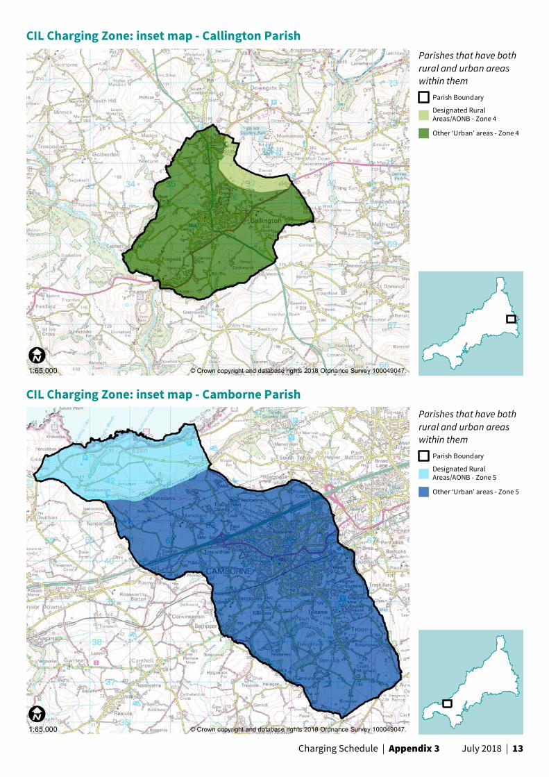
3.2 Definitions and Application of CILResidential sites charged at the higher rate in each zone aredonesobecausetheyarenotrequiredtoprovideaffordablehousing.Therequirementfortheprovisionofaffordablehousingshouldincludebothon-siteandoff-sitecontributions.Whetherasiteisrequiredtoprovideaffordablehousingisdeterminedbythedevelopmentsize, and whether the site is in a Designated Rural Area (DRA)asdefinedbytheHousingOrder1981,oranAreaof Outstanding Natural Beauty (AONB). In addition to the CIL Charging Zone map in Appendix 2, further maps are provided in Appendix 3 to show whether Parishes are in DRA/AONB’s, with detailed inset maps for the seventeen Parishes which are part covered by a DRA or AONB.
CIL will not be charged on affordable housing which meetsthedefinitionassetoutinthe2012 National Planning Policy Framework6.
CIL will not be charged on Rural Exception Sites (affordablehousing-leddevelopmentsallowingforaproportionofmarkethousingwhereitisrequiredtosupportdeliveryoftheaffordableelement).Inthesecases any value generated from the market housing isintendedtosubsidisethedeliveryoftheaffordablehousing and form part of the viability calculations on this basis. Rural Exception Sites will therefore be treated asAffordableHousingSchemes,andnotbechargedCIL.
CIL will not be charged on sheltered or extra care housing, and care homes on the grounds of viability.
For CIL purposes, Strategic Sitesaredefinedasresidential developments which are shown on the Allocations Development Plan Document (DPD)7 Strategic Maps as being ‘allocated’ or ‘with permission/under construction’. This includes the residential elements of mixed use developments.
Planning applications submitted on adopted (made) Neighbourhood Development Plan allocated sites will be charged CIL at the appropriate rate for the charging zone in which the development resides, unless they are identifiedintheAllocationsDPD,inwhichcasetheywillbeincludedunderthedefinitionofaStrategicSiteforCIL purposes.6 www.gov.uk/government/uploads/system/uploads/attachment_data/
file/6077/2116950.pdf7 www.cornwall.gov.uk/environment-and-planning/planning/planning-
policy/

July 2018 | 7Charging Schedule | Liability to pay CIL
y Buildings into which people go only intermittently forthepurposeofinspectingormaintainingfixedplant or machinery (see Regulation 6(2))
y Structures which are not buildings, such as pylons and wind turbines
y Vacant buildings brought back into the same use (see Regulation 40 as amended by the 2014 Regulations)
y Mezzaninefloors,insertedintoanexistingbuilding, are not liable for the levy unless they form part of a wider planning permission that seeks to provide other works as well.
Where the CIL liability is calculated to be less than £50, the chargeable amount is deemed to be zero so no payment is due.
Please note that relief or exemptions are not automatically applied, these must be claimed by using the relevant forms. An appropriate exemption/relief form must be submitted to Cornwall Council, and approval of the claim obtained in writing before work commences on the development. For guidance on how to claim relief or exemption, please visit www.cornwall.gov.uk/cil.
4.3 Discretionary ReliefRefer to Cornwall Council’s CIL Discretionary Relief Policy for more detail on additional exemptions and relief.
CIL will not be charged for Ministry of Defence Service Family Accommodation as these are not considered to be developments with commercial value.
All CIL exemptions and relief are subject to approval, by the Charging Authority, of a CIL Exemption Claim submittedbyarelevantlandowner,andthespecificdisqualifyingeventscontainedinPart6oftheCILRegulations 2010 (as amended).
If a development is initially granted CIL relief and then circumstances change so that the development nolongerqualifiesforrelief,thereisaclaw-backperiod of three to seven years (depending on the type of relief given, as set out in the Discretionary Relief Policy) within which the development will become liable for CIL.
4 Liability to Pay CIL4.1 Chargeable DevelopmentA chargeable development is one for which planning permission is granted and/or which is liable to pay CIL in accordance with the CIL Regulations 2010 (as amended). CILwillbechargeableonthenetadditionalfloorspaceof all new development, apart from those exempt under Part 2 and Part 6 of the CIL Regulations 2010 (as amended).
4.2 ExemptionsThose exempt from the charge can be summarised as:
y Affordablehousing
y Developmentoflessthan100squaremetres (see Regulation 42 on minor development exemptions) – unless this is a whole house, in which case the levy is payable
y Houses,flats,residentialannexesandresidentialextensions which are built by ‘self builders’ (see Regulations 42A, 42B, 54A and 54B, inserted by the 2014 Regulations)
y Social housing that meets the relief criteria set out in Regulation 49 or 49A (as amended by the 2014 Regulations) and where an exemption has been obtained, and a Commencement (of development) Notice served, prior to the commencement of the development
y Charitable development that meets the relief criteria set out in Regulations 43 to 48 and where an exemption has been obtained, and a Commencement (of development) Notice served, prior to the commencement of the development
y Buildings into which people do not normally go (see Regulation 6(2))

July 2018 | 8Charging Schedule | Calculating the chargeable amount
R x A x Ip Ic
Where:
y RistheCILratein£persqm
y Aisthenetincreaseingrossinternalfloorarea
y Ip is the All-in Tender Price Index for the year in which planning permission was granted
y Ic is the All-in Tender Price Index for the year in which the charging schedule started operation
CIL is calculated by multiplying the net increase in gross internalfloorarea(sqm)bytherelevantCILrate(£persqm),plusanyindexingforinflation/deflation(betweentheyearinwhichtheChargingScheduletookeffectandthe year in which planning permission was granted). Residential garages are included in the CIL calculation because they are included within the RICS Code of MeasuringdefinitionofGrossInternalArea.
The basic formula for calculating CIL, as set out in Regulation 40, is as follows:
5 Calculating the Chargeable Amount
5.1 CalculationThe chargeable amount will be calculated in accordance with Regulation 40 of the CIL Regulations 2010 (as amended).
5.2 Section 73Where an amendment to a previously approved planning permission is submitted via a Section 73 application, if the Section 73 permission does not change a developments CIL liability, only the original consent will be liable.
If the Section 73 permission does change the CIL liability, the most recently commenced scheme is liable for the CIL. In these circumstances, CIL payments made in relationtothepreviousplanningpermissionareoffsetagainst the new liability, and a refund is payable if the previous payment was greater than the new liability.
If the original planning permission was granted before the CIL came into force, and a Section 73 permission isgrantedafterthechargecameintoforce,Regulation 128A (as amended by the 2014 Regulations) provides for the Section 73 consent to only trigger levy liability for any additional liability it introduces to the development.
July 2018 | 9Charging Schedule | Payment of CIL | Indexation and inflation | Further Information
6 Payment of CIL6.1 InstalmentsPayment by instalments may be permitted for some developments. See Cornwall Council’s CIL Instalment Policy for more detail. If instalment terms are broken, full/outstandingpaymentwillberequiredimmediately.
Where no party assumes liability and/or no commencement notice is submitted before commencement,thedeveloperwillnotgetthebenefitof payment by instalments, and payment of CIL will be requiredimmediately.
6.2 In-kindCornwall Council will not accept payment of CIL ‘in kind’.
7 Indexation and Inflation The rates in the Charging Schedule will be updated annuallyforinflationinaccordancewiththeBuildingCost Information Service (BCIS) of the Royal Institution of Chartered Surveyors (RICS) “All In Tender Price Index”.
8 Further InformationFurther information on the Community Infrastructure Levy is available on the Council’s website at www.cornwall.gov.uk/cil.
Alternatively, contact the Local Plans team on 0300 1234 151 or email [email protected].

July 2018 | 10Charging Schedule | Appendix 1
Appendix 1 - CIL Charging Zone Parish ListValue Zone
Towns Other settlements
Parishes
1 Rock with Tredrizzick
Gerrans/Portscatho Fowey
BoconnocCP;BroadoakCP;CubyCP;FeockCP;FoweyCP;GerransCP; Lanhydrock CP; Maker-with- Rame CP; Mawnan CP; Mylor CP; North Tamerton CP; Philleigh CP; Ruanlanihorne CP; St. Anthony-in- Meneage CP; St. Clement CP; St. Just-in-Roseland CP; St. Mellion CP; St. Michael Penkevil CP; St. Minver Lowlands CP; St. Sampson CP; St. Veep CP; St. Wenn CP; Treneglos CP; Veryan CP; Withiel CP
2 St Ives Padstow, St Merryn/Shop,
Constantine
Constantine CP; Helland CP; Landulph CP; Lanlivery CP; Lanteglos CP; Manaccan CP; Mawgan-in-Pydar CP; Padstow CP; Paul CP; Perranarworthal CP; Sheviock CP; St. Austell Bay CP; St. Ewe CP; St. Ives CP; St. Merryn CP; St. Minver Highlands CP; St. Winnow CP; Tregoney CP; Zennor CP
3 Falmouth and Penryn
Truro with Threemilestone
Newquay
Lostwithiel
Mevagissey
Marazion
Antony CP; Blisland CP; Boyton CP; Budock CP; Cardinham CP; Carlyon CP; ChacewaterCP;CrantockCP;FalmouthCPGrampoundwithCreedCP; Jacobstow CP; Kea CP; Kenwyn CP; Lanivet CP; Launcells CP; Linkinhorne CP; Lostwithiel CP; Marazion CP; Mevagissey CP; Morvah CP; Morwenstow CP; NewquayCP;PenrynCP;PentewanValleyCP;PillatonCP;PoundstockCP; Sancreed CP; Sennen CP; South Hill CP; St. Allen CP; St. Dominick CP; St.EndellionCP;St.GermansCP;St.GoranCP;St.HilaryCP;St.LevanCP;Stokeclimsland CP; Towednack CP; Trewen CP; Truro CP
4 Bodmin
Bude with Stratton and Poughill
Callington
Camelford
Hayle
Launceston
Penzance with Newlyn Heamoor,Gulvaland Long Rock
Saltash
Wadebridge
Torpoint
Boscastle
Gunnislake
Kilkhampton
Looe
Mullion
Perranporth
Porthleven
St Agnes
St Blazey/Par
St. Columb Major
St Just
Tintagel
AdventCP;AltarnunCP;BodminCP;BotusflemingCP;BreageCP;Bude-StrattonCP;Callington CP; Calstock CP; Camelford CP; Colan CP; Cubert CP; Cury CP; Davidstow CP; Deviock CP; Duloe CP; Egloshayle CP; Egloskerry CP; Forrabury and MinsterCP;GermoeCP;Grade-RuanCP;GunwalloeCP;GweekCP;GwennapCP; Gwinear-GwithianCP;HayleCP;KilkhamptonCP;LadockCP;LandewednackCP; Landrake with St. Erney CP; Laneast CP; Lanreath CP; Lansallos CP; Launceston CP; Lewannick CP; Lezant CP; Looe CP; Ludgvan CP; Luxulyan CP; Mabe CP; Madron CP; Marhamchurch CP; Mawgan-in-Meneage CP; Michaelstow CP; Millbrook CP; Morval CP; Mullion CP; North Hill CP; North Petherwin; Otterham CP; Penzance CP; Perranuthnoe CP; Perranzabuloe CP; Porthleven CP; Portreath CP; Probus CP; Quethiock CP; Saltash CP; Sithney CP; St. Agnes CP; St. Blaise CP; St. Breock CP; St. Breward CP; St. Buryan CP; St. Clether CP; St. Columb Major CP; St. Erme CP; St.ErvanCP;St.GennysCP;St.GluviasCP;St.IsseyCP;St.IveCP;St.JohnCP; St. Juliot CP; St. Just CP; St. Keverne CP; St. Kew CP; St. Mabyn CP; St. Martin-in-Meneage CP; St. Mewan CP; St. Neot CP; St. Newlyn East CP; St. Stephens By Launceston Rural CP; St. Tudy CP; Stithians CP; Tintagel CP; Torpoint CP; Tremaine CP; Tywardreath and Par CP; Wadebridge CP; Warleggan CP; Week St. Mary CP; Wendron CP; Werrington CP; Whitstone CP
5 Camborne with Pool, Illogan and Redruth
Helston
Liskeard
St Austell
Indian Queens with St Columb Rd & Fraddon
Delabole
Camborne CP; Carharrack CP; Carn Brea CP; Crowan CP; Dobwalls and Trewidland CP; Helston CP; Illogan CP; Lanner CP; Lawhitton Rural CP; Lesnewth CP; Liskeard CP; Menheniot CP; Pelynt CP; Redruth CP; Roche CP; South Petherwin CP; St. Austell CP; St. Cleer CP; St. Day CP; St. Dennis CP; St. Enoder CP; St. Erth CP; St. Eval CP; St. Keyne CP; St. Martin-by-Looe CP; St. Michael Caerhays CP; St. Pinnock CP; St. Stephen-in-Brannel CP; St. Teath CP; St. Thomas the Apostle Rural CP; Tresmeer CP; Trevalga CP; Treverbyn CP; Warbstow CP

July 2018 | 11Charging Schedule | Appendix 2
No. Name1 Advent2 Altarnun3 Antony4 Blisland5 Boconnoc6 Bodmin7 Botusfleming8 Boyton9 Breage10 Broadoak11 Bude-Stratton12 Budock13 Callington14 Calstock15 Camborne16 Camelford17 Cardinham18 Carharrack19 Carlyon20 Carn Brea21 Chacewater22 Colan23 Constantine24 Crantock25 Crowan26 Cubert27 Cuby28 Cury29 Davidstow30 Deviock31 Dobwalls and Trewidland32 Duloe33 Egloshayle34 Egloskerry35 Falmouth36 Feock37 Forrabury and Minster38 Fowey39 Germoe40 Gerrans41 Grade-Ruan42 GrampoundwithCreed43 Gunwalloe44 Gweek45 Gwennap46 Gwinear-Gwithian47 Hayle48 Helland49 Helston50 Illogan51 Jacobstow52 Kea53 Kenwyn54 Kilkhampton55 Ladock56 Landewednack57 Landrake with St. Erney58 Landulph59 Laneast60 Lanhydrock61 Lanivet62 Lanlivery63 Lanner64 Lanreath65 Lansallos66 Lanteglos67 Launcells68 Launceston69 Lawhitton Rural70 Lesnewth71 Lewannick72 Lezant73 Linkinhorne
No. Name74 Liskeard75 Looe76 Lostwithiel77 Ludgvan78 Luxulyan79 Mabe80 Madron81 Maker-with-Rame82 Manaccan83 Marazion84 Marhamchurch85 Mawgan-in-Meneage86 Mawgan-in-Pydar87 Mawnan88 Menheniot89 Mevagissey90 Michaelstow91 Millbrook92 Morvah93 Morval94 Morwenstow95 Mullion96 Mylor97 Newquay98 North Hill99 North Petherwin100 North Tamerton101 Otterham102 Padstow103 Paul104 Pelynt105 Penryn106 Pentewan Valley107 Penzance108 Perranarworthal109 Perranuthnoe110 Perranzabuloe111 Philleigh112 Pillaton113 Porthleven114 Portreath115 Poundstock116 Probus117 Quethiock118 Redruth119 Roche120 Ruanlanihorne121 Saltash122 Sancreed123 Sennen124 Sheviock125 Sithney126 South Hill127 South Petherwin128 St. Agnes129 St. Allen130 St. Anthony-in-Meneage131 St. Austell132 St. Austell Bay133 St. Blaise134 St. Breock135 St. Breward136 St. Buryan137 St. Cleer138 St. Clement139 St. Clether140 St. Columb Major141 St. Day142 St. Dennis143 St. Dominic144 St. Endellion145 St. Enoder146 St. Erme
No. Name147 St. Erth148 St. Ervan149 St. Eval150 St. Ewe151 St.Gennys152 St.Germans153 St.Gluvias154 St.Goran155 St. Hilary156 St. Issey157 St. Ive158 St. Ives159 St. John160 St. Juliot161 St. Just162 St. Just-in-Roseland163 St. Keverne164 St. Kew165 St. Keyne166 St. Levan167 St. Mabyn168 St. Martin-by-Looe169 St. Martin-in-Meneage170 St. Mellion171 St. Merryn172 St. Mewan173 St. Michael Caerhays174 St. Michael Penkevil175 St. Michael's Mount176 St. Minver Highlands177 St. Minver Lowlands178 St. Neot179 St. Newlyn East180 St. Pinnock181 St. Sampson182 St. Stephen-in-Brannel183 St. Stephens By Launceston
Rural184 St. Teath185 St. Thomas the Apostle
Rural186 St. Tudy187 St. Veep188 St. Wenn189 St. Winnow190 Stithians191 Stokeclimsland192 Tintagel193 Torpoint194 Towednack195 Tregony196 Tremaine197 Treneglos198 Tresmeer199 Trevalga200 Treverbyn201 Trewen202 Truro203 Tywardreath and Par204 Veryan205 Wadebridge206 Warbstow207 Warleggan208 Week St. Mary209 Wendron210 Werrington211 Whitstone212 Withiel213 Zennor
2
4
9
178
17
54
8
94
99
1
80
73
110
88
25
46
140
137
98
61
163
23
15
55
53
29
6
20977
182
135
67
128
32
145
14
191
179
52
3
31
86
78
33
41
30
161
134
95
164
62
22
64
85
116
65
11
72
136
119
51151
156
121
200
5
208
71
184
157
96
97
37
176
57
40
20445
48
47
152
16
100
93
10
115
26
150
189
66
127
81
36
192 34
154
117
76
38
188
104
158
122
17450
213
20
190
118
44
28
42
21
84
13
171
211
167
58
146
74
49
79
87
210
180
144
59
147
125
206
129
102
12
69
7
27
183
138
106
107
101
186
68
143
187
126
56
148
142
212112
70
35
149
172
170
139
155
111
162
197
160
75
82
202
177
124
60
203
90
169
43166
194
123
114
120
63
103
153
39
24
185
92
168
113
108
89195
13391
181
131
198
201
207
19
130
199
193
83109
132
196
141
165
205
105
173
159
18
175
140000
140000
150000
150000
160000
160000
170000
170000
180000
180000
190000
190000
200000
200000
210000
210000
220000
220000
230000
230000
240000
240000
1000
0
1000
0
2000
0
2000
0
3000
0
3000
0
4000
0
4000
0
5000
0
5000
0
6000
0
6000
0
7000
0
7000
0
8000
0
8000
0
9000
0
9000
0
1000
00
1000
00
1100
00
1100
00
Zone 1Zone 2Zone 3Zone 4Zone 5
© Crown copyright and database rights 2018 Ordnance Survey 100049047.1:400,000
Appendix 2 - CIL Charging Zone mapMore detailed mapping can be accessed at www.cornwall.gov.uk/community-and-living/mapping/

July 2018 | 12Charging Schedule | Appendix 3
No. Name1 Advent2 Altarnun3 Antony4 Blisland5 Boconnoc6 Bodmin7 Botusfleming8 Boyton9 Breage10 Broadoak11 Bude-Stratton12 Budock13 Callington14 Calstock15 Camborne16 Camelford17 Cardinham18 Carharrack19 Carlyon20 Carn Brea21 Chacewater22 Colan23 Constantine24 Crantock25 Crowan26 Cubert27 Cuby28 Cury29 Davidstow30 Deviock31 Dobwalls and Trewidland32 Duloe33 Egloshayle34 Egloskerry35 Falmouth36 Feock37 Forrabury and Minster38 Fowey39 Germoe40 Gerrans41 Grade-Ruan42 GrampoundwithCreed43 Gunwalloe44 Gweek45 Gwennap46 Gwinear-Gwithian47 Hayle48 Helland49 Helston50 Illogan51 Jacobstow52 Kea53 Kenwyn54 Kilkhampton55 Ladock56 Landewednack57 Landrake with St. Erney58 Landulph59 Laneast60 Lanhydrock61 Lanivet62 Lanlivery63 Lanner64 Lanreath65 Lansallos66 Lanteglos67 Launcells68 Launceston69 Lawhitton Rural70 Lesnewth71 Lewannick72 Lezant73 Linkinhorne
No. Name74 Liskeard75 Looe76 Lostwithiel77 Ludgvan78 Luxulyan79 Mabe80 Madron81 Maker-with-Rame82 Manaccan83 Marazion84 Marhamchurch85 Mawgan-in-Meneage86 Mawgan-in-Pydar87 Mawnan88 Menheniot89 Mevagissey90 Michaelstow91 Millbrook92 Morvah93 Morval94 Morwenstow95 Mullion96 Mylor97 Newquay98 North Hill99 North Petherwin100 North Tamerton101 Otterham102 Padstow103 Paul104 Pelynt105 Penryn106 Pentewan Valley107 Penzance108 Perranarworthal109 Perranuthnoe110 Perranzabuloe111 Philleigh112 Pillaton113 Porthleven114 Portreath115 Poundstock116 Probus117 Quethiock118 Redruth119 Roche120 Ruanlanihorne121 Saltash122 Sancreed123 Sennen124 Sheviock125 Sithney126 South Hill127 South Petherwin128 St. Agnes129 St. Allen130 St. Anthony-in-Meneage131 St. Austell132 St. Austell Bay133 St. Blaise134 St. Breock135 St. Breward136 St. Buryan137 St. Cleer138 St. Clement139 St. Clether140 St. Columb Major141 St. Day142 St. Dennis143 St. Dominic144 St. Endellion145 St. Enoder146 St. Erme
No. Name147 St. Erth148 St. Ervan149 St. Eval150 St. Ewe151 St.Gennys152 St.Germans153 St.Gluvias154 St.Goran155 St. Hilary156 St. Issey157 St. Ive158 St. Ives159 St. John160 St. Juliot161 St. Just162 St. Just-in-Roseland163 St. Keverne164 St. Kew165 St. Keyne166 St. Levan167 St. Mabyn168 St. Martin-by-Looe169 St. Martin-in-Meneage170 St. Mellion171 St. Merryn172 St. Mewan173 St. Michael Caerhays174 St. Michael Penkevil175 St. Michael's Mount176 St. Minver Highlands177 St. Minver Lowlands178 St. Neot179 St. Newlyn East180 St. Pinnock181 St. Sampson182 St. Stephen-in-Brannel183 St. Stephens By Launceston
Rural184 St. Teath185 St. Thomas the Apostle
Rural186 St. Tudy187 St. Veep188 St. Wenn189 St. Winnow190 Stithians191 Stokeclimsland192 Tintagel193 Torpoint194 Towednack195 Tregony196 Tremaine197 Treneglos198 Tresmeer199 Trevalga200 Treverbyn201 Trewen202 Truro203 Tywardreath and Par204 Veryan205 Wadebridge206 Warbstow207 Warleggan208 Week St. Mary209 Wendron210 Werrington211 Whitstone212 Withiel213 Zennor
2
4
9
178
17
54
8
94
99
1
80
73
110
88
25
46
140
137
98
61
163
23
15
55
53
29
6
20977
182
135
67
128
32
145
14
191
179
52
3
31
86
78
33
41
30
161
134
95
164
62
22
64
85
116
65
11
72
136
119
51151
156
121
200
5
208
71
184
157
96
97
37
176
57
40
20445
48
47
152
16
100
93
10
115
26
150
189
66
127
81
36
192 34
154
117
76
38
188
104
158
122
17450
213
20
190
118
44
28
42
21
84
13
171
211
167
58
146
74
49
79
87
210
180
144
59
147
125
206
129
102
12
69
7
27
183
138
106
107
101
186
68
143
187
126
56
148
142
212112
70
35
149
172
170
139
155
111
162
197
160
75
82
202
177
124
60
203
90
169
43166
194
123
114
120
63
103
153
39
24
185
92
168
113
108
89195
13391
181
131
198
201
207
19
130
199
193
83109
132
196
141
165
205
105
173
159
18
175
140000
140000
150000
150000
160000
160000
170000
170000
180000
180000
190000
190000
200000
200000
210000
210000
220000
220000
230000
230000
240000
240000
1000
0
1000
0
2000
0
2000
0
3000
0
3000
0
4000
0
4000
0
5000
0
5000
0
6000
0
6000
0
7000
0
7000
0
8000
0
8000
0
9000
0
9000
0
1000
00
1000
00
1100
00
1100
00
© Crown copyright and database rights 2018 Ordnance Survey 100049047.1:400,000
DE
VO
N
Zone 1Zone 2Zone 3Zone 4Zone 5
CILCharging
Zones
Designated Rural Areas/Areas of Outstanding
Natural Beauty
Other‘Urban’areas
Appendix 3 - Rural/Urban split: CIL Charging Zone map and Parish inset maps More detailed mapping can be accessed at www.cornwall.gov.uk/community-and-living/mapping/
July 2018 | 13Charging Schedule | Appendix 3
© Crown copyright and database rights 2018 Ordnance Survey 100049047.1:65,000
Parishes that have bothrural and urban areaswithin them
Parish Boundary
Designated RuralAreas/AONB - Zone 4
Other ‘Urban’ areas - Zone 4
CIL Charging Zone: inset map - Callington Parish
© Crown copyright and database rights 2018 Ordnance Survey 100049047.1:65,000
Parishes that have bothrural and urban areaswithin them
Parish Boundary
Designated RuralAreas/AONB - Zone 5
Other ‘Urban’ areas - Zone 5
CIL Charging Zone: inset map - Camborne Parish

July 2018 | 14Charging Schedule | Appendix 3
© Crown copyright and database rights 2018 Ordnance Survey 100049047.1:65,000
Parishes that have bothrural and urban areaswithin them
Parish Boundary
Designated RuralAreas/AONB - Zone 1
Other ‘Urban’ areas - Zone 1
CIL Charging Zone: inset map - Feock Parish
© Crown copyright and database rights 2018 Ordnance Survey 100049047.1:65,000
Parishes that have bothrural and urban areaswithin them
Parish Boundary
Designated RuralAreas/AONB - Zone 1
Other ‘Urban’ areas - Zone 1
CIL Charging Zone: inset map - Fowey Parish

July 2018 | 15Charging Schedule | Appendix 3
© Crown copyright and database rights 2018 Ordnance Survey 100049047.1:65,000
Parishes that have bothrural and urban areaswithin them
Parish Boundary
Designated RuralAreas/AONB - Zone 5
Other ‘Urban’ areas - Zone 5
CIL Charging Zone: inset map - Helston Parish
© Crown copyright and database rights 2018 Ordnance Survey 100049047.1:65,000
Parishes that have bothrural and urban areaswithin them
Parish Boundary
Designated RuralAreas/AONB - Zone 5
Other ‘Urban’ areas - Zone 5
CIL Charging Zone: inset map - Illogan Parish

July 2018 | 16Charging Schedule | Appendix 3
© Crown copyright and database rights 2018 Ordnance Survey 100049047.1:65,000
Parishes that have bothrural and urban areaswithin them
Parish Boundary
Designated RuralAreas/AONB - Zone 4
Other ‘Urban’ areas - Zone 4
CIL Charging Zone: inset map - Looe Parish
© Crown copyright and database rights 2018 Ordnance Survey 100049047.1:65,000
Parishes that have bothrural and urban areaswithin them
Parish Boundary
Designated RuralAreas/AONB - Zone 2
Other ‘Urban’ areas - Zone 2
CIL Charging Zone: inset map - Padstow Parish

July 2018 | 17Charging Schedule | Appendix 3
© Crown copyright and database rights 2018 Ordnance Survey 100049047.1:65,000
Parishes that have bothrural and urban areaswithin them
Parish Boundary
Designated RuralAreas/AONB - Zone 3
Other ‘Urban’ areas - Zone 3
CIL Charging Zone: inset map - Pentewan Valley Parish
© Crown copyright and database rights 2018 Ordnance Survey 100049047.1:65,000
Parishes that have bothrural and urban areaswithin them
Parish Boundary
Designated RuralAreas/AONB - Zone 4
Other ‘Urban’ areas - Zone 4
CIL Charging Zone: inset map - Penzance Parish

July 2018 | 18Charging Schedule | Appendix 3
© Crown copyright and database rights 2018 Ordnance Survey 100049047.1:65,000
Parishes that have bothrural and urban areaswithin them
Parish Boundary
Designated RuralAreas/AONB - Zone 4
Other ‘Urban’ areas - Zone 4
CIL Charging Zone: inset map - Portreath Parish
© Crown copyright and database rights 2018 Ordnance Survey 100049047.1:65,000
Parishes that have bothrural and urban areaswithin them
Parish Boundary
Designated RuralAreas/AONB - Zone 4
Other ‘Urban’ areas - Zone 4
CIL Charging Zone: inset map - Saltash Parish

July 2018 | 19Charging Schedule | Appendix 3
© Crown copyright and database rights 2018 Ordnance Survey 100049047.1:65,000
Parishes that have bothrural and urban areaswithin them
Parish Boundary
Designated RuralAreas/AONB - Zone 2
Other ‘Urban’ areas - Zone 2
CIL Charging Zone: inset map - St. Austell Bay Parish
© Crown copyright and database rights 2018 Ordnance Survey 100049047.1:65,000
Parishes that have bothrural and urban areaswithin them
Parish Boundary
Designated RuralAreas/AONB - Zone 3
Other ‘Urban’ areas - Zone 3
CIL Charging Zone: inset map - St. Goran Parish

July 2018 | 20Charging Schedule | Appendix 3
© Crown copyright and database rights 2018 Ordnance Survey 100049047.1:65,000
Parishes that have bothrural and urban areaswithin them
Parish Boundary
Designated RuralAreas/AONB - Zone 2
Other ‘Urban’ areas - Zone 2
CIL Charging Zone: inset map - St. Ives Parish
© Crown copyright and database rights 2018 Ordnance Survey 100049047.1:65,000
Parishes that have bothrural and urban areaswithin them
Parish Boundary
Designated RuralAreas/AONB - Zone 5
Other ‘Urban’ areas - Zone 5
CIL Charging Zone: inset map - St. Michael Caerhays Parish

July 2018 | 21Charging Schedule | Appendix 3
© Crown copyright and database rights 2018 Ordnance Survey 100049047.1:65,000
Parishes that have bothrural and urban areaswithin them
Parish Boundary
Designated RuralAreas/AONB - Zone 1
Other ‘Urban’ areas - Zone 1
CIL Charging Zone: inset map - St. Sampson Parish

July 2018 | 22Charging Schedule | Appendix 3
If you would like this information in another format orlanguage please contact:Cornwall Council, County Hall, Treyew Road, Truro TR1 3AYTelephone: 0300 1234 100Email:[email protected]
PlanningandRegenerationGeneral\\17_012
More information The Community Infrastructure Levy Charging Schedule can be viewed on the Council’s websitewww.cornwall.gov.uk/cil
Top Related