


Languages
Pages
Legal

CHAPTER 2
GENERAL GEOLOGY OF ARAVALLI CRATONIC BLOCK AND
STRATIGRAPHY OF SOUTH DELHI FOLD BELT
2.1. Regional Geological Set up
In terms of lithological makeup, the Aravalli Mountain Range (AMR) consists
of an Archean basement and two main unconformity bound supracrustal sequences
deposited successively over the basement. Heron (1953), recognised the Banded
Gneissic Complex (popularly known as BGC) and the Bundelkhand massif (renamed
by Pascoe, 1950 as Berach Granite) as the basement upon which younger
supracrustals of Aravalli, Raialo and Delhis were deposited. This pioneering work of
Heron (1953), has remained the basis for all subsequent stratigraphic and structural
revisions (e.g. Naha and Halyburton, 1974; Raja Rao, 1976; Gupta et al., 1980).
The two major supergroups of supracrustals assemblage i.e. an older, Paleo-
Proterozoic Aravalli Supergroup and younger Mesoproterozoic Delhi Supergroup, are
believed to have been deposited by rifting of BGC (Crawford, 1970; Naha and
Halyburton, 1974; Choudhary et al., 1984; Sen, 1983; Naha and Roy, 1983; Sinha
Roy, 1984; Roy et al., 1984; Roy, 1985; Roy et al., 1988). Apart from the Archean
basement and Proterozoic supracrustals, there are several intrusions of granite, mafic,
ultramafic and alkaline rocks into the basement as well as the supracrustals.
Contact between BGC and the overlying supracrustals has been interpreted
variably. For example the unconformity between Aravalli Supergroup and BGC
(Heron 1953), was considered to be a migmatization front by Naha and Halyburton
(1974) and Naha and Roy (1983). Crookshank (1948) and Naha and Halyburton
(1974), were of the view that much of the BGC formed by migmatization of the
Aravalli sediments. Later on Naha revised his opinion (Naha and Roy, 1983; Naha
and Mohanty, 1998) and acknowledged the BGC as a basement complex that evolved
by extensive migmatization of meta sedimentary and possibly meta igneous rocks.
The unconformable relationship between the basement (BGC) and the Aravalli
Supergroup has been established by (i) the presence of a thick conglomerate occurring
at the BGC-Aravalli interface (Mohanty and Naha, 1986), (ii) structural discordance,
(iii) difference in the grade of metamorphism i.e. amphibolites to granulite grade in
the BGC and low i.e. lower greenschist to upper amphibolites facies (Roy and Jakhar,
2002) in the Aravalli rocks, (iv) presence of isolated pockets of pyrophyllite, which
are fine grained mica deposits (Roy and Paliwal, 1981) and (v) metallogenic studies
undertaken by Sudgen et al. (1990) who observed that BGC is barren in terms of any
11

significant mineral deposit. While, younger supracrustal rocks host Pb-Zn-Cu
deposits.
Moreover the geochronological data firmly attest the Archean antiquity of
BGC, as the Pb isochron data on Aravalli schists with a lot of detrital zircon by
Vinogradov et al. (1964), Sm-Nd isochron data by MacDougall et al. (1983) and the
Rb-Sr isochron age (2950+150 Ma) of granites of Untala and Gingla which intrude
the biotite gneisses, amphibolites and paragneisses of BGC (Choudhary et al., 1984),
all show that the BGC contain material as old as 3.3 Ma (Gopalan et al., 1990). The
Proterozoic age of the Aravalli Supergroup is confirmed by the age of Darwal granite
(Rb-Sr isochron age of 1900±80 Ma) (Choudhary et al., 1984) which intrudes both
BGC and Aravalli Supergroup. Recent work however, shows the age of Aravalli
Supergroup to be around 2.1 Ga based on Pb-Pb age of galena from the volcanic
sequence in its lowermost part (Deb et al., 1989).
There is no consensus among the geoscientists about the contact between
Aravalli and Delhi supergroups of rocks. It has been interpreted as a (i) structural
discordance (Gupta et al., 1980), (ii) an unconformity (Heron 1953, Saini et al., 2006)
and (iii) suture representing the closure of a Proterozoic ocean (Sudgen and Windley,
1984; Sudgen et al., 1990).
2.2. Banded Gneissic Complex (BGC)
The BGC as described by various workers like Gupta (1934), Heron (1953) is
an intimate admixture of igneous and sedimentary rocks and their metamorphic
derivatives. A number of intrusives ranging from felsic to mafic constitute a
significant part of the BGC. Following components have been identified in BGC by
various workers
1. Biotite or chlorite Gneisses: These make up largest volume of BGC.
Petrographically and chemically they are considered as tonalite–trondhjemite–
granodiorite (Ahmad and Tarney, 1994).
2. Granites: The granites are the second largest component of BGC. They show two
outcrop patterns one as intimate member of BGC terrain and other in the form of
inliers. Important bodies of BGC granites are Untala, Gingla, Berach and Ahar
granite.
3. Amphibolites: These occur in the form of linear bodies or as large mafic enclaves.
Dykes of orthoamphibolites (1900 ±80 Ma) within Berach granite are also observed.
12
4. Multiple phases of acidic veins: Number of thick pegmatite veins randomly
occurs all through BGC. But their length never exceeds to 20 meters.
5. Metasediments: Quartzite, marble, Cal–silicate rocks, ironstones, mica-schists are
the common metasediments in the BGC. However, only quartzite and marble occur as
mappable bodies.
BGC occurs in the form of two blocks designated as BGC North and BGC
South. BGC (N) is composed of high grade rocks (Sharma, 1988). It is bounded on
the west by a shear zone against the Delhi Supergroup and to the east by a major
lineament with mylonites and pseduotachylites against the Aravalli belt (formerly
Bhilwara belt). The BGC (S) comprises amphibolite facies gneisses with migmatites,
schists, meta-sedimentary intrusions and plutons of synorogenic granite.
Gupta et al., (1980, 1997) subdivided northern BGC into two groups viz. (a)
Sandmata complex which is an assemblage of meta igneous granulites and
supracrustals and (b) Mangalwar complex, a heterogeneous assemblage of
amphibolite facies supracrustal rocks, meta granitoids and amphibolites.
Recent structural, metamorphic and geochronological studies have indicated
that BGC at places contains some litho components of younger ages. For example,
Darwal Granite (Rb-Sr isochron age 1850 Ma, Choudhary et al., 1984) or migmatized
sediment cover rocks (Aravalli Supergroup). Zircon ages of magmatic gneisses,
which developed around granulite bodies within the Sandmata complex range
between 1725 and 1650 Ma (Wiedenbeck et al., 1996). A still younger single zircon
age of 1450 Ma has been recorded in the gneisses rocks occurring within the mica
schists that also host the lead-zinc deposits of Rampura-Agucha mine in the Bhilwara
belt. All these data clearly point out that all lithological facies of BGC are not
Archean.
Raja Rao and his colleagues from the Geological Survey of India (Raja Rao,
1976; Raja Rao et al., 1971) introduced a term Bhilwara Group for a litho assemblage
of late-Archean occurring in the northern part of BGC. This term was incorporated by
Gupta et al. (1980), in the revised geological map of the Aravalli Mountain Range and
the status of the Bhilwara Group was raised to Supergroup. Gupta et al. (1980),
maintained that meta sedimentary rocks in the eastern part of the AMR were intruded
by Berach Granite (2520 Ma, Sivaram and Odom, 1982) and were therefore, of
Archean age and need a separate stratigraphic grouping. Accordingly, they were
included under the Hindoli Group of the Bhilwara Supergroup. The other meta
13
sedimentary zone passing through Jahazpur and Bhilwara was also correlated with the
Hindoli rocks and included under the Bhilwara Supergroup by Gupta et al. (1980).The
Hindoli Group (previously correlated with the Gwalior Group, Pascoe, 1950; Heron,
1953) with a turbidite sequence and bimodal volcanics is considered a younger
(Mesoarchean) greenstone belt by Sinha Roy (1985). Bose and Sharma (1992)
however, disagreed with the observation of Gupta et al. (1980) and pointed out that
what appears to be an intrusive relationship is actually the result of marginal
remobilization of Berach Granite during late tectonic events. They therefore,
confirmed the earlier observations of Heron (1953) and Gupta (1934) and upheld the
Proterozoic cover status of the Hindoli Group. Keeping in view of these ambiguities,
the term Bhilwara Supergroup is not in use for geological mapping.
The BGC yields ages of around 3.3 to 2.5 Ga using various methods. In the
southern Aravalli Range, BGC tonalite-trondhjemite-granodiorite (TTG) suites and
granites have yielded 3300-2500 Ma emplacement ages (Gopalan et al., 1990;
Weidenbeck and Goswami, 1996; Roy and Kroner, 1996; Weidenbeck et al., 1996).
Recently Buick et al. (2006), dated samples of metasediments of BGC exposed in
central Aravalli Range and obtained zircon ages of around 2300-2200 Ma.
2.3. Aravalli Supergroup (ASG)
The meta sedimentary-meta volcanic rocks included into the Aravalli
Supergroup occupy a 200 km long belt which varies in width from 70 km in the south
to less than 10 km in the north. The sequence lies unconformably on the BGC. The
litho package of Aravalli Supergroup (ASG) is different than that of „Aravalli system‟
of Heron (1953). Presently apart from the Aravalli system of the Heron (1953), the
ASG also includes the marbles and associated rocks mapped by Heron (1953) as the
„Raialo series‟ since they are found to be in stratigraphic and structural continuation
with the „Aravalli system‟ rocks (Naha et al., 1973; Naha and Halyburton, 1974; Roy
and Paliwal, 1981; Roy et al., 1984; Naha and Majumdar, 1971). Furthermore, on the
basis of same field parameters applied to Raialo series, the quartzite, arkose and
conglomerate bodies described by Heron as outliers of the Delhi system have also
been included in the ASG (Poddar, 1965; Roy and Paliwal, 1981; Roy et al., 1984)
The ASG as described in the type area, includes two contrasting sedimentary
facies associations, distributed along two roughly north-south running belts namely
Udaipur and Jharol. These belts have developed in an inverted V shaped belt that
14

tapers near Nathdwara. Sand-shale-carbonate assemblage representing shelf sequence
constitutes the eastern arm of the belt. The western arm which comprises a totally
carbonate free sequence of mica schist with some bands of quartzites, has been
interpreted as a deep sea facies (Poddar and Mathur, 1965; Roy and Paliwal, 1981).
The shallow shelf sequence is designated as Udaipur belt while the deep water
sequence as the Jharol belt (Gupta et al., 1980).
The total package of rocks of ASG has been divided into two groups-lower
Aravalli Group and upper Aravalli Group (Roy, 1988), separated by an unconformity
marked by conglomerate and red beds. Extensive residual weathering leading to the
development of ferricrete, silcrete, laterite, ochreous shales and cave breccias in the
topmost beds of the carbonate sequence (of the lower Aravalli Group) indicate the
span of hiatus between the two groups.
The Udaipur and Jharol belts are considered to be in tectonic contact
juxtaposed with each other along a lineament referred to as Rakhabdev lineament.
Along this lineament there exists a north-south trending linear zone of mafic and
ultramafic rocks associated with quartzite bands. This magmatic sequence of rocks is
considered to be transitional oceanic crust (Hamatteh et al., 1994).
The age and time span of Aravalli sedimentation are poorly constrained.
Though the lithostratigraphic succession of the ASG which is characterised by the
presence of stromatolitic phosphorites, extensive development of uraniferous black
shale facies, occurrence of lead-zinc mineralisation and the lead and carbon isotopic
signatures in rocks (Deb, 1986) confirm the Proterozoic age of the ASG, Berach
Granite, which is the youngest intrusion in the Pre-Aravalli rocks is dated as 2500Ma
(Crawford, 1970) and 2600 Ma (Choudhary et al., 1984) by Rb-Sr method, 2610 Ma
(Sivaraman and Odom, 1982) by zircon dating marks the sedimentation initiation
boundary for ASG. While Rb-Sr age of synkinematically emplaced Darwal Granite is
around 1850 Ma (Choudhary et al., 1984). Accordingly, workers like Choudhary et al.
(1984), inferred that the Aravalli basin opened at around 2200Ma and closed at about
1850 Ma.
2.4. Delhi Supergroup (DSG)
Heron (1953) recognized the Delhi „System‟ as a sequence of arenaceous and
argillaceous rocks which unconformably overlies the Aravalli System. This major
group of rocks constitutes the backbone of the AMR in its central and southern
15
sectors. It lies between 26º45‟ N and 24
0 15
‟ respectively. The rocks of the Delhi
Supergroup (DSG) are traceable from Delhi in the northeast to Himmatnagar in the
southwest over a strike distance of about 850 kms in the form of a linear belt (Delhi
Fold Belt) with maximum outcrop width of over 200 kms along Khetri-Bayana-Alwar
tract in the north and minimum ~20 kms around Desuri in the northeast. In the
southwest, beyond Himmatnagar the solid geology is lost under the alluvium cover.
Nevertheless, good outcrops are exposed between Delhi, in the north and Palanpur in
the south.
Heron (1953), broadly divided the Delhi system into two groups on the basis
of their lithofacies assemblages viz. the Alwar and Ajabgarh groups. Gupta et al.
(1980), raised the status of Delhi “system” to Delhi “Supergroup” in their revised map
on 1:50,000 scale. There are two distinct outcrop patterns in Delhi Fold Belt (DFB).
Exposures north of Ajmer are scanty, isolated and of monotonous lithologies in the
form of ridges, hills or low relief geomorphic features according to erosive resistance
of rock types. In sharp contrast, outcrops south of Ajmer are continuous, linear and
show maximum positive relief of the AMR. In addition to this, there are significant
differences in terms of grade of metamorphism, deformation intensity, nature and
tightness of folds and sorting and maturity of lithologies on either side of Ajmer.
Moreover, the observation that extent and dimensions of litho assemblages of Delhi
Supergroup appear to have been controlled by major and minor faults initiated the
debate among geoscientists to revise the stratigraphy of Delhi Supergroup. In view of
this, proposals were made to divide the belt into tectonic zones, separated by
fault/shear zones. Assuming a Phanerozoic type plate tectonic model of evolution of
the Aravalli-Delhi orogen, Sen (1980) divided the DFB of central and southern
Rajasthan into five tectonic units from west to east. He suggested that units 1, 2, and 3
constitute the Delhi rocks and units 4 and 5 in the east are Pre-Delhi but Post-Aravalli.
However, Gupta et al. (1980), proposed that the rocks lying north and south of Ajmer
show different depositional environments and accordingly divided the DFB into two
belts i.e. older North Delhi Fold Belt (NDFB) and younger South Delhi Fold Belt
(SDFB). Later workers like Sinha Roy (1988), Deb et al. (1989), Deb and Sarkar
(1990), attested the view of Gupta et al. (1980). Sinha Roy (1988) identified the
Jaipur-Dusa transcurrent fault and considered it to be the boundary between NDFB
and SDFB. The geochronological studies showed that the ages of granitic plutons
intruding NDFB and SDFB rocks are in the range 1500-1700Ma and ~800Ma
16
respectively (Choudhary et al., 1984). Thus indicating that the supracrustals rocks in
these two parts evolved at different times and justified the division of DFB.
Furthermore, Deb and Sarkar (1990) and Deb et al. (1989) observed that despite
apparent similarities in the rock sequence of NDFB and SDFB as observed by Heron
(1953) and Roy et al. (1988), there are significant differences in terms of
volcanic/sedimentary ratio, nature of mafic-ultramafic rocks, occurrences of
carbonaceous and ferruginous rocks in the two belts. Deb et al. (1989), also observed
that the VMS type ores in the SDFB are about 1Ga old in contrast to the 1.8 Ga age of
the deposits north of Ajmer i.e. in NDFB. Sengupta (1984) suggested that Jaipur-
Dausa fault is not actual boundary between NDFB and SDFB rather it is Bithur-
Pisangan line which separates the two belts. But Fareeduddin et al., (1995) believe the
extension of the SDFB, beyond Pisangan-Bithur line.
Nevertheless, there is near unanimity among geologist about the diachronous
evolution of Delhi basin and its consequent division into north and south fold belts.
2.4.1. North Delhi Fold Belt (NDFB)
The rocks of North Delhi Fold Belt are considered to have been deposited in
three subparallel basins (Fig.1.2). These are from east to west, the Bayana-Lalsot
basin, the Alwar basin and the Khetri basin. The Alwar, Bayana-Lalsot and Khetri
basins taper out towards the south. The divisions of volcano sedimentary infills of
each of the basin into Alwar and Ajabgarh groups proposed by Heron (1953), are
maintained. The Alwar Group comprises arkosic schists, quartzites and meta
conglomerates whereas, the Ajabgarh Group comprises calc-schists, biotite schists
and calc-silicates and marbles.
2.4.2. South Delhi Fold Belt (SDFB)
On the eastern side, rocks of South Delhi Fold Belt directly rest over granite-
gneiss-granulite rocks of Sandmata complex (part of Archean basement BGC)
(Fig.1.2). Further south, SDFB overlies the metasediments of Aravalli Supergroup.
This boundary has been considered as paleosuture (Sen, 1980; Sychanthavong and
Merh, 1984). The western margin of the SDFB is characterized by a major tectonic
lineament which is referred to as Phulad lineament (Gupta et al., 1980). This
lineament runs for more than 500kms from south of Palanpur to the north of Pisangan.
The northward continuity of the lineament beyond Pisangan is lost under the thick
17
pile of alluvium. The thickness of this lineament is variable along its length with a
maximum of 6 km near Mt. Abu and a minimum of about 400 m near Barr, as is
inferred from remote sensing data and field observations. Geophysical studies
(Qureshi, 1964; Reddy and Ramakrishna, 1988) suggest that the Phulad lineament has
a deep crustal origin possibly rooted in the Moho. The origin and resurgence of
tectonic activity along this lineament has been tied up directly or indirectly with the
opening or closing of an oceanic basin (Sychanthavong and Desai, 1977; Sen, 1981;
Sudgen and Windley, 1984; Sinha Roy, 1988; Sudgen et al., 1990).
Apart from different types of metasediments, there exists wide spread
occurrences of mafic-ultramafic rocks along this lineament in SDFB. This mafic-
ultramafic association in SDFB is considered as ophiolite and named as Phulad
Ophiolite (Gupta et al., 1980). This ophiolite occurs in close association with the
Barotia-Sendra sediments of Gupta et al. (1991) or sedimentary rocks of Kumbalgarh
Group of Gupta et al. (1980), all along SDFB. In order to avoid nomenclature
problems due to complex geological set up in SDFB, the entire volcano-sedimentary
association comprising ophiolite and Kumbalgarh Group sediments is referred to as
Phulad ophiolite belt.
Different workers taking note of various geological parameters have attempted
to erect different stratigraphic successions for SDFB. Some of them are mentioned
below.
Sen (1980, 1981) divided the SDFB into 1, 2, 3, 4, and 5 longitudinal zones
west to east. He proposed that zones 1 to 3 are the rocks of Delhi Supergroup and
zone 4 and 5 are pre-Delhi but post Aravalli. His succession is as follows.
18

Ras marbles and Bar conglomerate
……………………………….Unconformity…………………………………………
Delhi Supergroup
Zone-1 Marble, calc silicate, orthoamphibolite, quartzite
and pelitic schist
Zone-2 Metavolcanics, calc schists/gneiss, phyllites,
quartzites and mica schist
Zone-3 Quartzite, quartz schist, pelitic schist, calc gneisses
and ultramafic rocks
Pre-Delhi
Zone-4 Calc gneiss, calc schist
Zone-5 Jharol belt
…………………………………………..Paleosuture………………………………….
Aravalli Supergroup/BGC
Gupta et al. (1980), divided the rocks of SDFB into two groups viz. the lower
Gogunda and upper Kumbalgarh Group (Gupta et al., 1980). Gogunda Group is
dominantly arenaceous comprising conglomerate, quartzite and phyllites and is
equated with Alwar Group of NDFB. The Kumbalgarh Group on the other hand is
predominantly calcareous facies with argillaceous and arenaceous sediments and is
correlated with Ajabgarh Group of NDFB.
The main lithologies of Kumbalgarh Group are pelitic schist, pelitic gneiss,
quartzite, phyllite, greywacke, and pure/impure marbles and calc-silicate rocks. The
Phulad ophiolite is associated with Kumbalgarh sediments. Because of this
characteristic, the Kumbalgarh Group in association with ophiolite component is often
described as Phulad ophiolite belt (Gupta et al., 1980, 1997). The metasediments of
the Kumbalgarh Group of the Phulad ophiolite belt are the subject of present study.
Henceforth, in subsequent discussions these metasediments will be referred to as
Kumbalgarh clastics, rocks of Kumbalgarh Group or Kumbalgarh
sediments/metasediments.
19
Gupta et al. (1980), on the basis of detailed mapping suggested following succession
Kumbalgarh Group
Basantgarh Formation
Ras Formation
Kalakot Formation
Barr Formation
Kotra Formation
Beawar Formation
Sendra Formation
Todgarh Formation
Gogunda Group
Kelwara Formation
Antalia Formation
Richer Formation
……………………………. Aravalli Supergroup and BGC……………………….
Gupta et al. (1980), divided the Kumbalgarh Group into eight formations on
the basis of lithological and structural homogeneity, strike persistence and
mappability of the individual units. These formations owe their names to the local
villages where the rocks are best exposed.
Subsequent studies particularly aimed to address specific geologic problems
like fold belt generations, their stratigraphic and tectonic evolution, assessment of
potentialities of base metals etc necessitated remapping of selected regions on
1:25,000 scale by Geological Survey of India (GSI records, 1993). Gupta et al. (1991)
and Bose et al. (1990) recognized three separate sub basins within the SDFB.
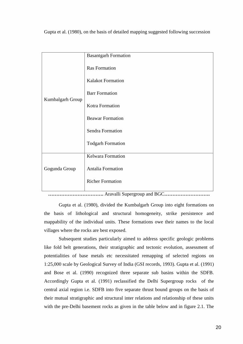
Accordingly Gupta et al. (1991) reclassified the Delhi Supergroup rocks of the
central axial region i.e. SDFB into five separate thrust bound groups on the basis of
their mutual stratigraphic and structural inter relations and relationship of these units
with the pre-Delhi basement rocks as given in the table below and in figure 2.1. The
20
direction of stratigraphic younging of different units recognized by Gupta et al.
(1991), is opposite to that perceived earlier by Gupta et al. (1980) and Sen (1980).
Delhi Supergroup
Bhim Group
Rajgarh Group
Sendra Group
Barotiya Group
Devgarh Group
………………………………….Unconformity……………………………………
Pre-Delhi rocks (Aravalli Supergroup and BGC
Figure-2.1- Geological map of northern part of SDFB showing distribution of sub
basins (After Gupta et al., 1991)
21
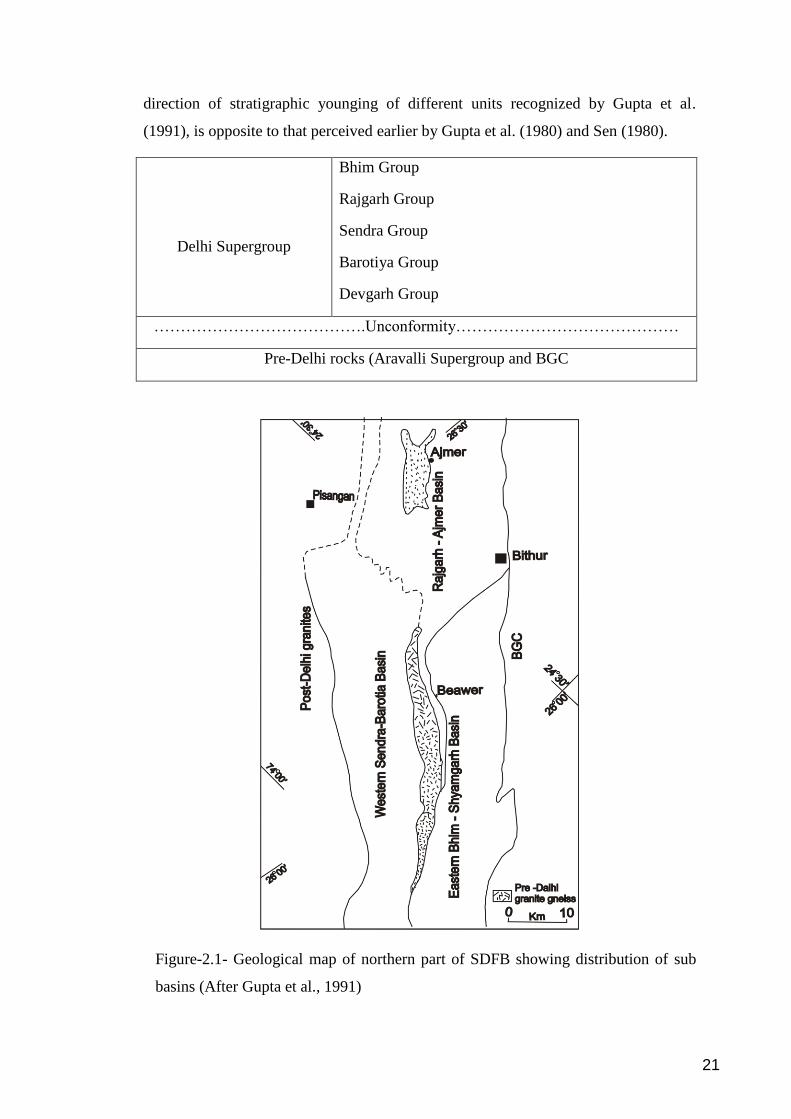
Fareeduddin and Bhattacharjee (2000) proposed that SDFB is an amalgam of
rocks deposited into three different geomorphic units. In their opinion, the northern
block represents continental sequence (platform), middle blocks as marginal basin
sequence (shelf) and southern block as oceanic wedge sequence (abyssal plain)
(Fig.2.2).
Figure-2.2: Geological map of SDFB indicating the accretion of three litho tectonic
domains (After Fareeduddin and Bhattacharjee, 2000), PLZ- Phulad Lineament
Zone, KSZ- Kaliguman Shear Zone
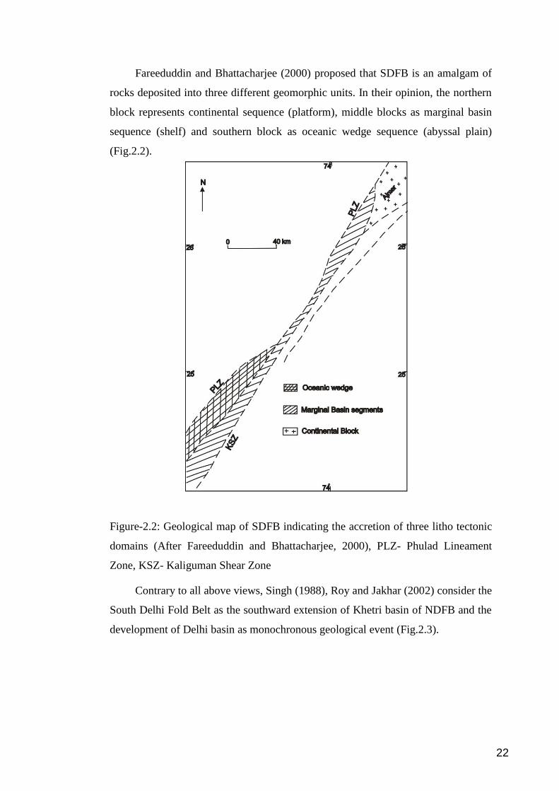
Contrary to all above views, Singh (1988), Roy and Jakhar (2002) consider the
South Delhi Fold Belt as the southward extension of Khetri basin of NDFB and the
development of Delhi basin as monochronous geological event (Fig.2.3).
22
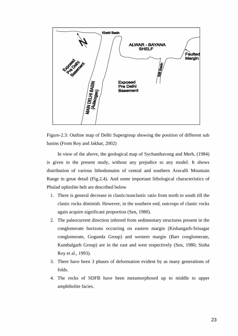
Figure-2.3: Outline map of Delhi Supergroup showing the position of different sub
basins (From Roy and Jakhar, 2002)
In view of the above, the geological map of Sychanthavong and Merh, (1984)
is given in the present study, without any prejudice to any model. It shows
distribution of various lithodomains of central and southern Aravalli Mountain
Range in great detail (Fig.2.4). And some important lithological characteristics of
Phulad ophiolite belt are described below
1. There is general decrease in clastic/nonclastic ratio from north to south till the
clastic rocks diminish. However, in the southern end, outcrops of clastic rocks
again acquire significant proportion (Sen, 1980).
2. The paleocurrent direction inferred from sedimentary structures present in the
conglomerate horizons occurring on eastern margin (Kishangarh-Srinagar
conglomerate, Gogunda Group) and western margin (Barr conglomerate,
Kumbalgarh Group) are in the east and west respectively (Sen, 1980; Sinha
Roy et al., 1993).
3. There have been 3 phases of deformation evident by as many generations of
folds.
4. The rocks of SDFB have been metamorphosed up to middle to upper
amphibolite facies.
23
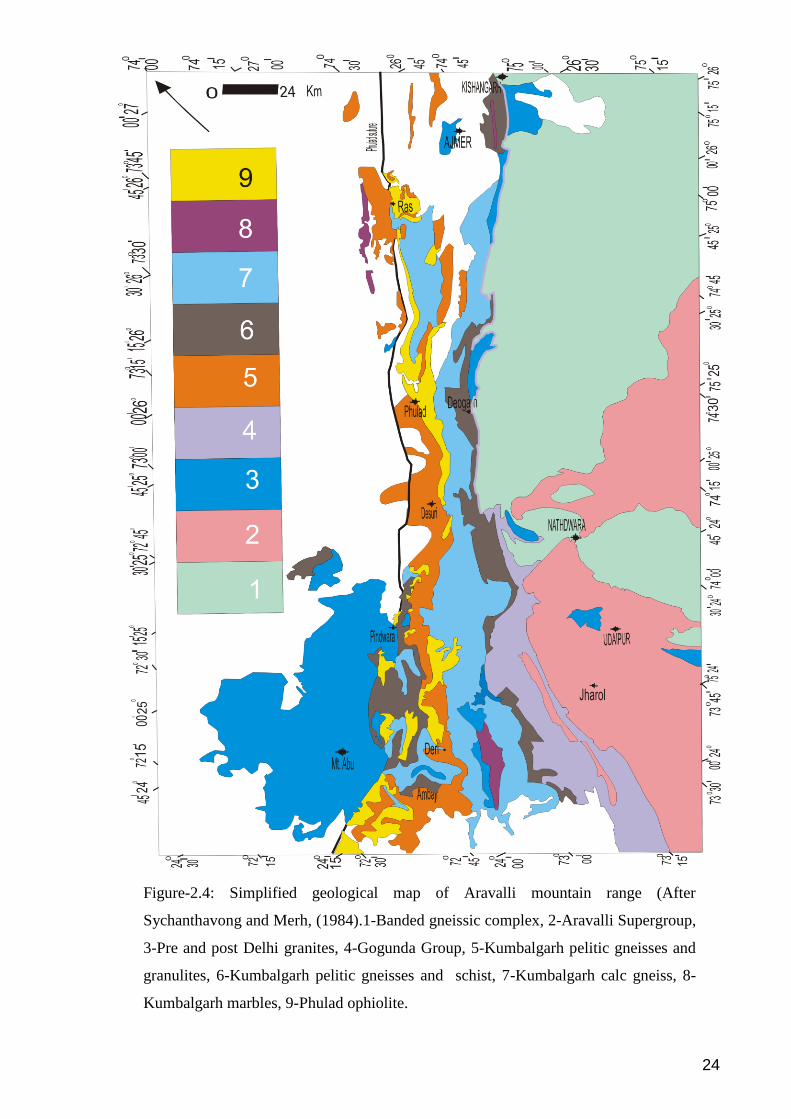
Figure-2.4: Simplified geological map of Aravalli mountain range (After
Sychanthavong and Merh, (1984).1-Banded gneissic complex, 2-Aravalli Supergroup,
3-Pre and post Delhi granites, 4-Gogunda Group, 5-Kumbalgarh pelitic gneisses and
granulites, 6-Kumbalgarh pelitic gneisses and schist, 7-Kumbalgarh calc gneiss, 8-
Kumbalgarh marbles, 9-Phulad ophiolite.
24
Top Related