


Languages
Pages
Legal


ASX MEDIA RELEASE 23RD
MAY, 2016
EXPLORATION UPDATE,
JUMA EAST
Fire assay result confirms
reliability of pre- oxidation
technique on hole JED-004 at
Guida, Juma East.
BBX (ASX: BBX) is pleased to announce that ongoing testwork has confirmed the reliability of the previously announced analytical technique (see media release of March 23, 2016) comprising a pre-oxidation step conducted at the Nomos laboratory, Rio de Janeiro followed by fire assay at the Intertek laboratory, Parauapebas. A series of tests have been conducted on the pulverised pulps from the 13.66m interval at the bottom of hole JED-004, which previously returned 4.06g/t by amalgamation and 4.58g/t by fire assay after pre-oxidation. The current tests included a replica of the previously reported pre-oxidation/fire assay methodology, returning a result of 3.70g/t Au and 0.16g/t Pd. Lower precious metal values were returned using alternative pre-treatment steps prior to fire assay. This result provides a sufficiently high level of confidence in the reliability of this technique to enable the initiation of re-assaying of previously assayed drill samples. Testwork is continuing at Brazilian laboratories and research institutes in order to further fine-tune both analytical and recovery techniques for gold and other precious metals in the Juma East mineralisation.
BBX Minerals Ltd
ASX: BBX
Level 1 35 Havelock Street West Perth WA 6005 Telephone +61 8 6955 2955 Fax +61 8 6210 1153
Av Jornalista Riccardo Marinho 360 Ed Cosmopolitan Sala Barra da Tijuca Rio de Janeiro Telephone +55 21 2439 5700
Av Web: www.bbxminerals.com.au Email: [email protected]
Brazil Projects: Juma East gold- silver- copper Ema gold Tres Estados gold-copper
Eldorado Do Juma: gold
For
per
sona
l use
onl
y

Guida target
The Guida target occurs within the 10km-long Guida-Boia Velha structural trend
containing extensive old gold workings where gold nuggets were reportedly recovered
from the saprolite/fresh rock interface. The trend is defined by a low magnetic corridor
interpreted as a magnetite-destructive zone and by a strong alkalic soil geochemical
signature. Extensive silica textures typical of low sulphidation epithermal systems have
been mapped and described in drill core.
Ongoing exploration
Geological mapping and soil sampling is due to commence in early June over the
areas of old gold workings at Ema and Tres Estados (appendix) to define targets for
a planned drilling programme in the second half of 2016. Additional soil sampling is
planned at Juma East along the Guida/Boia Velha trend during the third quarter of
2016.
Jeff McKenzie
CEO
BBX Minerals Ltd
+64 22 3421271
Competent Person Statement
The information in this report that relates to copper and gold style mineralization for
the Apui region in Brazil, is based on information compiled by Mr. Antonio de Castro,
BSc (Hons), MAusIMM, CREA, who is a Member of the Australasian Institute of Mining
and Metallurgy. He has sufficient experience which is relevant to the style of
mineralization and type of deposit under consideration and to the activity which he is
undertaking to qualify as a competent person as defined in the 2012 Edition of the
Joint Ore Reserves Committee (JORC) “Australasian Code for Reporting of
Exploration Results, Mineral Resources and Ore Reserves”, Mr. Castro is a BBX´s
Consulting Geologist and consents to the report being issued in the form and context
in which it appears.
Crea/RJ:02526-6D
AusIMM:230624
For
per
sona
l use
onl
y

About BBX Minerals Ltd
BBX Minerals Limited (ASX: BBX) is a mineral exploration and mining company listed on the Australian Securities Exchange. Its major focus is Brazil, mainly in the southern Amazon, a region BBX believes is vastly underexplored with high potential for the discovery of world class gold and copper deposits.
BBX´s key asset is the Juma East Gold Project in the Apuí region, Amazonas State. . The company has 58.1 km2 of exploration tenements within the Colider Group, a prospective geological environment for epithermal gold and Cu-Au porphyry deposits. The region, located adjacent to the prolific Tapajos Mineral Province which has produced around 30 million ounces of gold from near-surface workings, is under-explored and could provide BBX with a pipeline of high growth, greenfields gold discoveries.
Appendix
SUMMARY OF EMA & TRES ESTADOS GOLD PROJECTS
1. Location.
The Ema and Tres Estados prospects are located 30 km south and 60 km southeast
of Apui, respectively. both with year-round access by gravel roads. Both areas are
over the mapped Proterozoic Colider Group felsic volcanics, a prolific host unit for gold
and base metal deposits.
Fig 1 – Location of Ema (880107/08) and Tres Estados (880090/08) gold projects
For
per
sona
l use
onl
y

2. EMA GOLD PROJECT
Field reconnaissance at Ema has confirmed the presence of extensive old workings
associated with friable quartz veins within a broad zone of silicification. Coarse gold
was recovered from the groundmass of white friable silica hosted in a coarse-grained
hydrothermally altered rock.
The quartz veins present typical low temperature silica textures and the host rock
appears to be hydrothermally altered and shows no evidence of shearing, indicating a
brittle regime for the emplacement of the quartz veins and the gold-bearing silica
groundmass. Gold mineralisation is directly related to NW dilation structures (fig 2)
within the regional NE-SW fault system, which controls the distribution of the Colider
Group rocks within the NE-SW corridor.
Most of the old gold workings are also concentrated in a wide hydrothermally altered
zone with the white signature in the CPRM regional airborne radiometrics (fig 2).
Fig 2 – Ternary map K-U-Th with the dilation structures (black sigmoidal lines) controlling the
emplacement of quartz lodes with gold within a hydrothermally altered zone (white outline).
For
per
sona
l use
onl
y
The combination of a broad (6km x 2km) zone of intense hydrothermal alteration with
dilation structures and the presence of quartz lodes containing gold highlights the
potential for large- scale economic gold mineralisation at Ema.
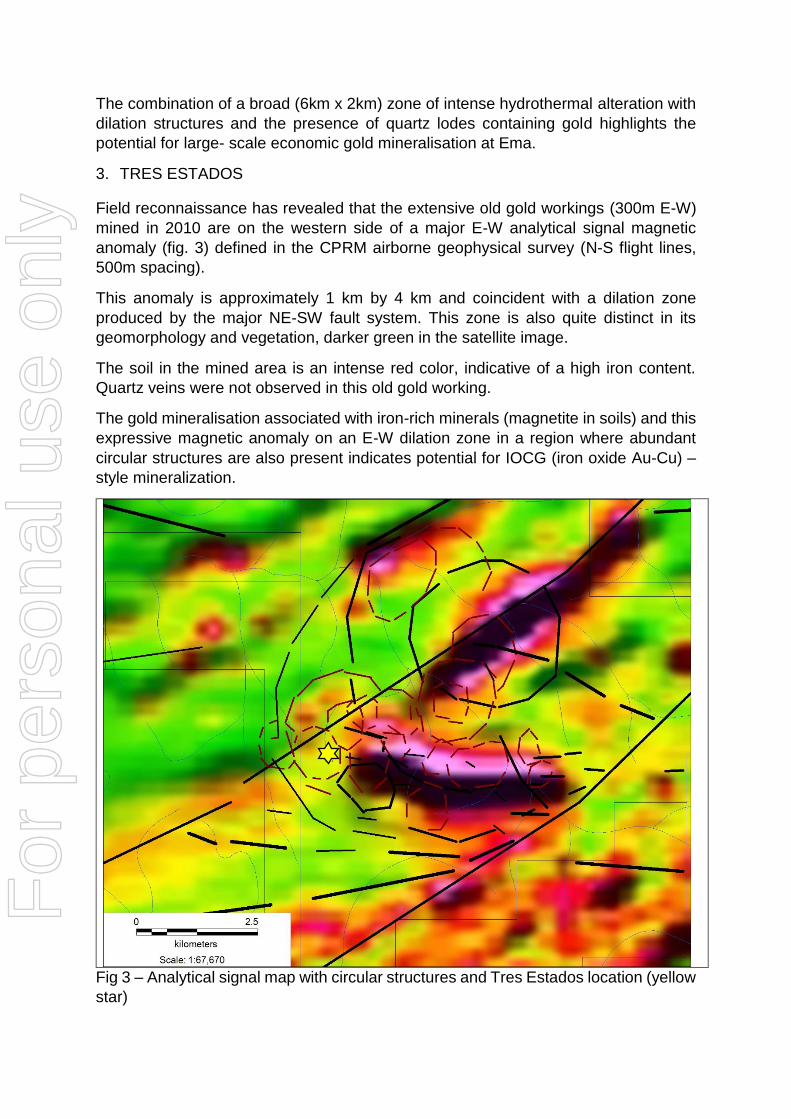
3. TRES ESTADOS
Field reconnaissance has revealed that the extensive old gold workings (300m E-W)
mined in 2010 are on the western side of a major E-W analytical signal magnetic
anomaly (fig. 3) defined in the CPRM airborne geophysical survey (N-S flight lines,
500m spacing).
This anomaly is approximately 1 km by 4 km and coincident with a dilation zone
produced by the major NE-SW fault system. This zone is also quite distinct in its
geomorphology and vegetation, darker green in the satellite image.
The soil in the mined area is an intense red color, indicative of a high iron content.
Quartz veins were not observed in this old gold working.
The gold mineralisation associated with iron-rich minerals (magnetite in soils) and this
expressive magnetic anomaly on an E-W dilation zone in a region where abundant
circular structures are also present indicates potential for IOCG (iron oxide Au-Cu) –
style mineralization.
Fig 3 – Analytical signal map with circular structures and Tres Estados location (yellow
star)
For
per
sona
l use
onl
y
The following Table and Sections are provided to ensure compliance with
JORC Code (2012 Edition).
TABLE 1 – Section 1: Sampling Techniques and Data
Criteria JORC Code Explanation Commentary Sampling Techniques
Nature and quality of sampling (e.g. cut channels, random chips, or specific specialised industry standard measurement tools appropriate to the minerals under investigation, such as down hole, gamma sondes, or handheld XRF instruments etc). These examples should not be taken as limiting the broad meaning of sampling.
The announcement refers to metallurgical testwork conducted on bulk sample rejects and drill core samples
Include reference to measures taken to ensure sample representivity and the appropriate calibration of any measurement tools or systems used.
The drill hole locations were determined by hand-held GPS, core lengths were verified against core recovery and measured with hand held metric tape. Drill core was logged noting lithology, alteration, mineralization, structure.
Sampling protocols and QA/QC are as per industry best-practice.
Aspects of the determination of mineralisation that are Material to the Public Report. In cases where “industry standard “ work has been done this would re relatively simple (e.g. ‘reverse circulation drilling was used to obtain 1m samples from which 3kg was pulverised to produce a 30g charge for fire assay). In other cases more explanation may be required, such as where there is coarse gold that has inherent sampling problems. Unusual commodities or mineralisation types (e.g. submarine nodules ) may warrant disclosure of detailed information.
The drill core was cut longitudinally and sampled only the right side of the half core, “blind sampling”, disregarding any visual mineralisation and bagged as 1 to 2 metre samples.
Criteria JORC Code Explanation Commentary
For
per
sona
l use
onl
y
Drilling Techniques Drill types (e.g. core, reverse circulation, open hole hammer, rotary air blast, auger, Bangka, sonic etc ) and details (e.g. core diameter, triple or standard tube, depth of diamond tails, face- sampling bit or other type, whether core is oriented and if so by what method etc).
Wireline diamond core drilling with a standard tube was used. Core diameter is NTW (57.1 mm diameter). The hole angle was oriented as per industry best practice and core was not oriented.
Drill Sample Recovery
Method of recording and assessing core and chip sample recoveries and results assayed.
Core barrel length was compared with the core length for each individual drilling run. No significant core loss was experienced.
Measures taken to maximise
sample recovery and ensure representative nature of the samples.
No significant core loss was experienced.
Whether a relationship exists between sample recovery and grade and whether sample bias may have occurred due to preferential loss/gain of fine /course material.
Not applicable – refer above. With no sample loss no bias, based on sample loss, would occur.
Logging Whether core and chip samples have been geologically and geotechnically logged to a level of detail to support appropriate Mineral Resource estimation, mining studies and metallurgical studies.
On-site geologist(s) logs lithology, alteration, mineralisation and structure, including RQD.
Core recoveries are noted.
Whether logging is qualitative or quantitative in nature. Core ( or costean, channel, etc) photography.
Core logging is both
qualitative and quantitative.
Each box with 3 m of core is
photographed dry and wet.
The total length and percentages of the relevant intersections logged.
100% of the core was logged.
Sub- Sampling Techniques and Sampling Procedures
If core, whether cut or sawn and whether quarter, half or all core taken.
Core was sawn in half. The
right side was bagged and
labelled, the remaining half
was returned to the core tray.
If non-core, whether riffled, tube sampled, rotary split etc and whether sample wet or dry.
Not applicable – all samples
subject of this announcement
were core samples.
For all sample types, the nature, quality and appropriateness of the sample preparation technique.
Core sampling followed
industry best practice.
For
per
sona
l use
onl
y

Quality control procedures adopted for all sub – sampling stages to maximise “representivity” of samples.
Results reported in this
announcement refer to
testwork on composite
pulverised drill core samples,
without sub-sampling
Measures taken to ensure that the sampling is representative of the in situ material collected, including for instance results for field duplicate/second –half sampling.
The core sawing orientation
was such that (apparent)
mineralization was equally
represented in both halves of
the core. Sample intervals are
fixed to whole-number down-
hole intervals and collected at
a minimum of 1 metre and a
maximum of 2 metre
intervals. Sampling is not
subject to visible signs of
mineralisation.
Whether sample sizes are appropriate to the grain size of the material being sampled.
The sample sizes are
considered adequate in terms
of the nature and distribution
of apparent mineralisation in
the core.
Quality of Assay Data and Laboratory Tests
The nature quality and appropriateness of the assaying and laboratory procedures used and whether the technique is considered partial or total.
Due to difficulties experienced with conventional analytical techniques a pre-treatment prior to fire assay is considered appropriate for this type of mineralisation.
As this methodology is still in the development phase it may represent only a partial recovery method for gold and other precious metals.
For geophysical tools, spectrometers, hand held XRF instruments, etc, the parameters used in determining the analysis including instrument make and model, reading times, calibrations factors applied and their derivation etc.
No geophysical tools or electronic device was used in the generation of sample results
Nature of quality control procedures adopted (e.g. standards, blanks, duplicates, external laboratory checks) and whether acceptable levels of accuracy (i.e. lack of bias) and precision have been established.
No specific quality control
procedures were adopted
with respect to the testwork
subject to this announcement.
The verification of significant intersections by either
No significant intersections were calculated
For
per
sona
l use
onl
y

Verification of Sampling and Assaying
independent or alternative company personnel.
The use of twinned holes No twinning of holes has been conducted
Documentation of primary data, data entry procedures, data verification, data storage (physical and electronic) protocols.
Primary assay data is supplied to the company from the laboratory in two forms: Microsoft Excel spreadsheet and PDF form (the latter serving as a certificate of authenticity). Both formats are captured on company desktops/laptops which are backed up from time to time. Only after critical assessment and public release of data (if appropriate), is the data entered directly into the BBX Microsoft Access database by company GIS personnel.
Discuss any adjustment to assays No adjustments were made. Location of Data Points
Accuracy and quality of surveys used to locate drill holes (collar and down hole surveys), trenches, mine workings and other locations used in Mine Resource estimation
Drill hole location has been determined using a hand-held GPS (Garmin).
Specification of grid system used WSG84Z21. Quality and adequacy of
topographic control. Topographic control is
achieved via the use of government topographic maps, in association with GPS and Digital Terrain Maps (DTM´s), the latter generated during an earlier detailed airborne geophysical survey.
Data Spacing and Distribution
Data spacing for reporting of Exploration results.
The holes subject of laboratory test result reporting in this announcement were logged on a continual basis (sub-10cm data capture). Samples were collected in 1 to 2 metre intervals. Spacing (distance) between data sets with respect to geology and assays is in line with industry best practise.
Whether the data spacing and distribution is sufficient to establish the degree of geological and grade continuity appropriate for the Mineral Resource and Ore
No representations of extensions, extrapolations or otherwise continuity of grade are made in this announcement.
For
per
sona
l use
onl
y

Reserve estimation procedure(s) and classification applied.
Whether sample compositing has been applied.
Sample compositing was not applied.
Orientation of Data in relation to Geological Structure
Whether the orientation of sampling achieves unbiased sampling of possible structures and the extent to which is known, considering the deposit type.
Sample orientation of the core is linear and thus directly related to hole orientation. Therefore, refer to the sub-section immediately below.
If the relationship between the drilling orientation and the orientation of key mineralised structures is considered to have introduced a sampling bias, this should be assessed and reported if material.
The geometry of mineralised zones is currently unknown; the relationship between down-hole lengths and true thicknesses is therefore uncertain.
Sample security The measures taken to ensure sample security.
All samples were sealed with a numbered cable tie in strong high density plastic bags by the on-site geologist and transported in a company vehicle from Apui-AM to Intertek´s preparation laboratory in Paraopebas-PA. Upon receipt at the laboratory, samples were checked in and the list of received samples immediately sent back to the company´s database administrator. Sealed prepared samples were subsequently air-freighted to the company´s office in Rio de Janeiro and personally delivered by the company´s Exploration Manager. to the Nomos laboratory for pre-treatment. The samples were then sealed and return couriered to the Intertek laboratory for fire-assay.
Audit or Reviews The results of any audits or reviews of sampling techniques and data.
No audits or external reviews of techniques have been conducted.
For
per
sona
l use
onl
y

Section 2: Reporting of Exploration Results
Criteria JORC Code Explanation Commentary Mineral Tenement and Land Tenure Status
Type, reference name/number, location and ownership including agreements or material issues with third parties such as joint ventures, partnerships, overriding royalties, native title interests, historical sites, wilderness or national park and environmental settings.
Juma East Exploration leases are 100% owned by BBX, agreement details were presented in
previous press releases, all
four leases have no issues in respect to native title interests, historical sites, wilderness or national park and environmental settings.
The security of the tenure held at the time of reporting along with any known impediments to obtaining a licence to operate in the area
The company is not aware of any impediment to obtain a licence to operate in the area
Exploration done by Other Parties
Acknowledgment and appraisal of exploration by other parties
No exploration by other parties has been conducted in the region
Geology Deposit type, geological setting and style of mineralisation
The geological setting of the area subject to drilling (and reported in this announcement) is that of Proterozoic volcanic rocks, with potential to host high sulphidation and/or low sulphidation gold mineralisation, Au-Cu porphyry mineralization and/or IOCG deposits.
For
per
sona
l use
onl
y
Drill Hole Information
A summary of all information material to the understanding of the exploration results including a tabulation of the following information for all Material drill holes
o Easting and northing of the drill hole collar
o Elevation or RL (Reduced Level – elevation above sea level in metres) of the drill hole collar.
o Dip and azimuth of the hole o Down hole length and
interception depth o Hole length
Coordinates and hole orientation of JED-004 has been reported in previous media reports.
If the exclusion of this information is justified on the basis that the information is not Material and that this exclusion does not detract from the understanding of the report, the Competent Person should clearly explain why this is the case.
No exclusion of information has occurred.
Data aggregation methods
In reporting Exploration Results, weighting averaging techniques, maximum and/or minimum grade truncations (e.g. cutting of high grades) and cut-off grades are usually material and should be stated
The result reported in this announcement refers to a single bulk sample generated by combining pulverised drill core samples on a weighted average basis.
Data aggregation methods
Where aggregate intercepts incorporate short lengths of high grade results and longer lengths of low grade results, the procedure used for such aggregation should be stated and some typical examples of such aggregations shown in detail.
Not applicable – results reported refer to a single bulk sample. Follow-up testwork will be conducted to establish grades of shorther intervals within this broad intercept.
Data aggregation methods
The assumptions used for any reporting of metal equivalent values should be clearly stated.
Not applicable – no equivalents were used in this announcement.
Relationship between mineralization widths and intercepted lengths
These relationships are particularly important in reporting of Exploration Results.
If the geometry of the mineralization with respect to the drill hole angle is known, its nature should be reported.
If it is not known and only the down hole lengths are reported, there should be a clear statement to this
Wherever mineralisation is reported in this announcement, clear reference is made to down-hole length. At this stage, the relationship between the geometry of potential mineralisation
For
per
sona
l use
onl
y
effect (e.g. ‘down hole length, true width not known’).
and the drill hole is not known.
Diagrams
Appropriate maps and sections (with scales) and tabulations of intercepts should be included for any significant discovery being reported. These should include, but not limited to plan view of drill hole collar locations and appropriate sectional views.
A plan and cross-section showing hole locations with coordinates and have been provided in previous media releases.
Balanced reporting
Where comprehensive reporting of all Exploration Results is not practicable, representative reporting of both low and high grades and/or widths should be practiced to avoid misleading reporting of Exploration Results.
The Company believes the ASX announcement provides a balanced report of the results of laboratory tests conducted on hole JED-004.
Other substantive exploration data
Other exploration data, if meaningful and material, should be reported including (but not limited to): geological observations, geophysical survey results; geochemical survey results; bulk samples – size and method of treatment; metallurgical test results; bulk density, groundwater, geotechnical and rock characteristics; potential deleterious or contaminating substances.
Airborne geophysical results and ground IP results were presented in previous announcements and are not referred to in this announcement.
Further Work The nature and scale of planned further work (eg tests for lateral extensions or depth extensions or large- scale step-out drilling)
Comments on the ongoing exploration programme are presented.
Diagrams clearly highlighting the areas of possible extensions, including the main geological interpretations and future drilling areas, provided this information is not commercially sensitive.
The geological map with the drill hole programme has been presented in previous announcements..
For
per
sona
l use
onl
y
Top Related