


Languages
Pages
Legal

"
"
"
""
"
"
"
"
""
"
"
""
"
"
"
"
"
"
"
"
"
"
""
"
"""
"
"
"
"
"
"
"
"
"
"
"
"
"
"
"
"
"
"
"
"
""
"
"
"
"
"
"
"
"
[_
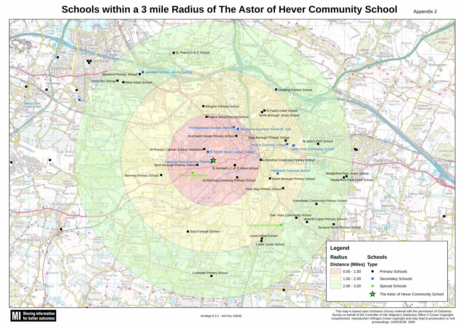
St. Peter's C.E.P. School
Aylesford School - Sports CollegeAylesford Primary. School
Ditton CEJ School Ditton Infant School
Sandling Primary School
St Paul's Infant SchoolNorth Borough Junior School
Allington Primary School
Palace Wood Primary School
Barming Primary School
East Farleigh School
The Maplesden Noakes School Maidstone Grammar School for Girls
Brunswick House Primary School
St Francis' Catholic School, MaidstoneSt. Simon Stock Catholic School
East Borough Primary School
Invicta Grammar SchoolValley Park Community School
St John's CEP School
Archbishop Courtenay Primary School
St Michael's C of E Infant SchoolWest Borough Primary School
Bower Grove School
Oakwood Park Grammar School
Archbishop Courtenay Primary School
Maidstone Grammar School
South Borough Primary School
Park Way Primary School
Madginford Park Junior School
Madginford Park Infant School
Greenfields Community Primary School
Oak Trees Community SchoolMolehill Copse Primary School
Senacre Wood Primary SchoolFive Acre Wood School
Loose Infant School
Loose Junior School
Coxheath Primary School
Schools within a 3 mile Radius of The Astor of Hever Community School
ArcMap 9.3.1 - Ad Hoc 10649This map is based upon Ordnance Survey material with the permission of Ordnance
Survey on behalf of the Controller of Her Majesty’s Stationery Office © Crown Copyright. Unauthorised reproduction infringes Crown copyright and may lead to prosecution or civil
proceedings. 100019238 2009
LegendRadiusDistance (Miles)
0.00 - 1.00
1.00 - 2.00
2.00 - 3.00
SchoolsType
" Primary Schools
" Secondary Schools
" Special Schools
[_ The Astor of Hever Community School
Appendix 2
Top Related