


Languages
Pages
Legal

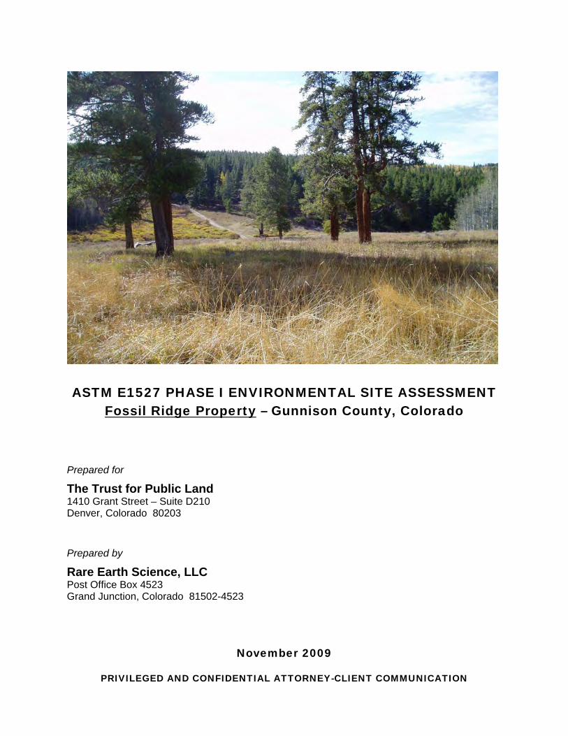
ASTM E1527 PHASE I ENVIRONMENTAL SITE ASSESSMENT
Fossil Ridge Property – Gunnison County, Colorado
Prepared for
The Trust for Public Land 1410 Grant Street – Suite D210 Denver, Colorado 80203
Prepared by
Rare Earth Science, LLC Post Office Box 4523 Grand Junction, Colorado 81502-4523
November 2009
PRIVILEGED AND CONFIDENTIAL ATTORNEY-CLIENT COMMUNICATION

This document presents the results of a Phase I Environmental Site Assessment conducted by Rare Earth Science, LLC for the 960-acre Fossil Ridge property in Gunnison County, Colorado. The ESA was performed in conformance with the American Society for Testing and Materials E1527-05 guidance document Standard Practice for Environmental Site Assessments: Phase I Environmental Site Assessment Process.
Prepared for: The Trust for Public Land 1410 Grant Street – Suite D210 Denver, CO 80203 303/837-1414 Prepared by: Rare Earth Science, LLC Post Office Box 4523 Grand Junction, CO 81502-4523 970/241-1762
I declare that, to the best of my professional knowledge and belief, I meet the definition of Environmental Professional as defined in §312.10 of 40 CFR Part 312 and have the specific qualifications based on education, training, and experience to assess the nature, history, and setting of the subject property. I have developed and performed the all appropriate inquiries in conformance with the standards and practices set forth in 40 CFR Part 312.
November 5, 2009 James C. Armstrong Date Principal Environmental Scientist

i November 2009
CONTENTS
EXECUTIVE SUMMARY ............................................................................................................. III
1.0 INTRODUCTION ............................................................................................................... 1 1.1 Purpose ................................................................................................................. 1 1.2 Detailed Scope-of-Services ................................................................................... 1 1.3 Significant Assumptions ........................................................................................ 1 1.4 Limitations and Exceptions .................................................................................... 2 1.5 Special Terms and Conditions .............................................................................. 2 1.6 User Reliance ........................................................................................................ 2
2.0 SITE DESCRIPTION ......................................................................................................... 3 2.1 Location ................................................................................................................. 3 2.2 Site and Vicinity General Characteristics .............................................................. 3 2.3 Current Use of the Property................................................................................... 3 2.4 Description of Structures, Roads, and Other Improvements on the Site ............... 3 2.5 Current Uses of the Adjoining Properties .............................................................. 3
3.0 USER-PROVIDED INFORMATION .................................................................................. 4 3.1 Title Records ......................................................................................................... 4 3.2 Environmental Liens or Activity and Use Limitations ............................................. 4 3.3 Specialized Knowledge ......................................................................................... 4 3.4 Commonly Known or Reasonably Ascertainable Information ............................... 4 3.5 Valuation Reduction for Environmental Issues ...................................................... 4 3.6 Owner, Property Manager, and Occupant Information .......................................... 4 3.7 Reason for Performing Phase I ESA ..................................................................... 4
4.0 GOVERNMENT AND HISTORICAL RECORDS REVIEW ............................................... 5 4.1 Standard Environmental Record Sources ............................................................. 5 4.2 Additional Environmental Record Sources ............................................................ 5 4.3 Physical Setting Sources ....................................................................................... 5
Topography and Surface Water ............................................................................ 5 Soil and Geologic Conditions ................................................................................ 5 Groundwater Conditions ........................................................................................ 6 Wetlands ............................................................................................................... 6 Radon .................................................................................................................... 6
4.4 Historical Use Information on the Site and Adjoining Properties ........................... 6
5.0 SITE RECONNAISSANCE ................................................................................................ 7 5.1 Methodology and Limiting Conditions ................................................................... 7 5.2 General Site Setting .............................................................................................. 7 5.3 Exterior Observations ............................................................................................ 7 5.4 Interior Observations ............................................................................................. 8
6.0 INTERVIEWS .................................................................................................................... 9 6.1 Interview with Site Owner ...................................................................................... 9 6.2 Interview with Others ............................................................................................. 9
7.0 FINDINGS ....................................................................................................................... 10
ii November 2009
8.0 OPINION ......................................................................................................................... 11
9.0 CONCLUSIONS .............................................................................................................. 12
10.0 DEVIATIONS .................................................................................................................. 13
11.0 ADDITIONAL SERVICES ................................................................................................ 14
12.0 REFERENCES ................................................................................................................ 15
APPENDICES
A. Site Location Maps B. Environmental Database Search Report C. Site Reconnaissance & Aerial Photographs D. Preparer’s Qualifications

Fossil Ridge Property (Gunnison County, Colorado) Phase I ESA
iii November 2009
EXECUTIVE SUMMARY
This document presents the results of a Phase I Environmental Site Assessment (ESA) conducted by Rare Earth Science, LLC ([Rare Earth] Grand Junction, CO) for the 960-acre Fossil Ridge property located northeast of Gunnison, Colorado. The ESA was prepared at the request of The Trust for Public Land’s (TPL’s) Denver office.
The ESA was performed in conformance with the American Society for Testing and Materials (ASTM) E1527-05 guidance document Standard Practice for Environmental Site Assessments: Phase I Environmental Site Assessment Process. The ESA encompassed a review of historical documents and regulatory records, an interview with people familiar with the property, reconnaissance of the property and the surrounding areas, and preparation of this report summarizing our findings and conclusions.
In the professional opinion of Rare Earth, all appropriate inquiry has been made into the previous uses of the property consistent with good commercial or customary practice in an effort to minimize environmental liability. Based upon the findings of this ESA, recognized environmental conditions were not revealed at the subject property; therefore, it is our opinion that no further inquiry is necessary.

Fossil Ridge Property (Gunnison County, Colorado) Phase I ESA
1 November 2009
1.0 INTRODUCTION
1.1 Purpose
The purpose of this ESA was to identify recognized environmental conditions and evaluate the likelihood that the Fossil Ridge property (hereafter, “Site”) has been impacted with hazardous materials or petroleum products from activities conducted on or near the Site.
ASTM defines the term recognized environmental conditions as the presence or likely presence of any hazardous substances or petroleum products on a property under circumstances that indicate an existing release, a past release, or a material threat of a release of any hazardous substances or petroleum products into structures on the property or into the ground, groundwater, or surface water of the property. A recognized environmental condition may include the presence or likely presence of hazardous substances or petroleum products under conditions in compliance with laws. Recognized environmental conditions do not include de minimus conditions that do not present a material risk of harm to public health or the environment and that generally would not be the subject of an enforcement action if brought to the attention of appropriate governmental agencies.
This report includes information gathered from federal, state, and local agencies; an interview with people familiar with the Site and adjoining properties; and a Site visit conducted by Rare Earth and TPL representatives. This report follows the format recommended in ASTM E1527-05.
1.2 Detailed Scope-of-Services
This Phase I ESA evaluates the Site and the adjoining properties. Rare Earth conducted the following tasks to accomplish the project objective:
• Inspected the Site for potential hazardous substances/petroleum products impact;
• Observed the condition of adjoining properties for any visual signs of potential environmental impact to the Site;
• Researched past activities that occurred at the Site and adjoining properties to identify any former operations that may have impacted the Site with hazardous substances or petroleum products. This task included interviewing the current owner of the Site;
• Reviewed local published government agency documents and databases to identify any properties within a 1-mile radius of the Site with a reported release of hazardous materials or petroleum products. Rare Earth obtained a government records search report from Environmental FirstSearch™ (FirstSearch); and
• Prepared this report with ESA findings, conclusions, and recommendations.
1.3 Significant Assumptions
ESAs provide information regarding the environmental condition of a particular property or facility. This report is a professional opinion and judgment, dependent upon information obtained during the course of performance of the services.

Fossil Ridge Property (Gunnison County, Colorado) Phase I ESA
2 November 2009
Environmental conditions may exist at the Site that cannot be identified only by visual observation. Where the scope of services is limited to observations made during Site reconnaissance, interviews, and/or review of readily available reports and literature, any conclusions and/or recommendations are necessarily based in part on information supplied by others, the accuracy or sufficiency of which may not be independently reviewed by Rare Earth.
No investigation is thorough enough to exclude the presence of hazardous substances, petroleum products, or contamination resulting from spills of these products at a given site. Therefore, if no hazardous substances or materials or petroleum products are identified during the ESA, such a finding should not be construed as a guarantee of the absence of such materials or contamination due to such materials on the property, but rather should only be considered the result of services performed within the scope, limitations, and cost of the work performed.
1.4 Limitations and Exceptions
Any opinions and/or recommendations presented in this report apply to Site conditions existing at the time of performance of services. Rare Earth is unable to report on or accurately predict events that may impact the Site following performance of the described services, whether occurring naturally or caused by external forces. Rare Earth assumes no responsibility for conditions that we were not authorized to investigate, or any recognized environmental conditions identified at the time our services were performed. Rare Earth is not responsible for changes in applicable environmental standards, practices or regulations following performance of services.
Preparation of this ESA did not include the collection or analysis of soil, surface water, groundwater, or air samples. In addition, other environmental issues not included in the ASTM standard (i.e., inspection of asbestos-containing building materials, wetlands, lead in paint or drinking water, cultural and historic resources, etc.) were not included as part of this ESA.
1.5 Special Terms and Conditions
The ESA activities were conducted in accordance with current ASTM guidelines (E1527-05) for ESAs, and practices and procedures generally accepted in the consulting engineering field. Our professional judgment to assess the potential for contamination is based on limited data; no other warranty is given or implied by this report.
1.6 User Reliance
This document was prepared for the sole use of TPL and the U.S. Forest Service (USFS). No other party should rely on the information contained herein without prior consent of TPL or the USFS.

Fossil Ridge Property (Gunnison County, Colorado) Phase I ESA
3 November 2009
2.0 SITE DESCRIPTION
2.1 Location
The Site covers portions of Sections 2, 3, 4, 10 and 11, Township 50 North, Range 2 East (New Mexico Principal Meridian) about 10 miles northeast of the City of Gunnison (see location maps in Appendix A). The Site is not identified with a physical address; however, the Gunnison County Tax Parcel Number is 3697-00-000-001.
2.2 Site and Vicinity General Characteristics
The 960-acre Site is located on heavily forested slopes and surrounded by Gunnison National Forest lands, west of the Fossil Ridge Wilderness Area. The Site is covered by aspen forest, coniferous forest, with some open meadow areas. Primary access to the Site is from unpaved Forest Road 743, which traverses the northwestern part of the property. According to the U.S. Geological Survey 7.5-minute Parlin & Signal Peak topographic maps (USGS, 1964 & 1979), the ground surface elevation at the Site averages approximately 10,300 feet above mean sea level (see topographic map in Appendix A).
2.3 Current Use of the Property
The Site is mostly undeveloped and used primarily for private & seasonal recreational purposes such as hiking, camping, and snowmobiling. A cabin at the Site is used for seasonal lodging.
2.4 Description of Structures, Roads, and Other Improvements on the Site
There is a small cabin at the Site, along with an outhouse, loafing shed, and old corrals. The cabin was not occupied at the time of the Site visit and appeared to be utilized only for occasional recreational purposes. Unpaved Forest Road 743 (a.k.a. Lost Canyon Road) traverses the northwest corner of the Site, which provides seasonal access to the unpaved main road across the Site and into the cabin setting. There are several other old tracks and roadbeds that provide access within the Site. No boundary fences were observed at the Site, with no other improvements identified. No utilities (i.e., electrical, telephone, natural gas or propane, sanitary sewer or septic systems) were identified serving any portion of the Site.
2.5 Current Uses of the Adjoining Properties
Adjoining properties are undeveloped USFS lands used for recreational purposes such as hiking, hunting, camping, snowmobiling, and other motorsports. No mining activity or commercial or industrial operations were identified in the project area.

Fossil Ridge Property (Gunnison County, Colorado) Phase I ESA
4 November 2009
3.0 USER-PROVIDED INFORMATION
3.1 Title Records
Title records were not reviewed by Rare Earth during preparation of this ESA. It is understood that TPL maintains these records in their Denver office.
3.2 Environmental Liens or Activity and Use Limitations
None indicated for the Site.
3.3 Specialized Knowledge
None indicated for the Site.
3.4 Commonly Known or Reasonably Ascertainable Information
None indicated for the Site.
3.5 Valuation Reduction for Environmental Issues
None indicated for the Site.
3.6 Owner, Property Manager, and Occupant Information
Ralph (“Butch”) E. Clark, III, et al are listed as current owners of the Site per the Gunnison County Assessor’s Office. Mr. Clark’s contact number is 970/641-2907, with a mailing address of 519 East Georgia Avenue, Gunnison, Colorado 81230.
3.7 Reason for Performing Phase I ESA
This ESA was performed at the request of TPL for purposes of evaluating the Site’s environmental conditions during acquisition of the Site for eventual transfer to the USFS.

Fossil Ridge Property (Gunnison County, Colorado) Phase I ESA
5 November 2009
4.0 GOVERNMENT AND HISTORICAL RECORDS REVIEW
4.1 Standard Environmental Record Sources
Regulatory agency database information was obtained from a FirstSearch Environmental Database Search report, which maps and lists sites in federal, state, and local government environmental databases with existing conditions or regulatory status that may have the potential to impact the Site. The Site and adjoining lands do not appear in the database report. Additional details can be found in the FirstSearch report (Appendix B).
4.2 Additional Environmental Record Sources
Rare Earth searched the Colorado Division of Oil and Public Safety’s (OPS’) Storage Tank Information System (COSTIS) online database (available at http://costis.cdle.state.co.us); the Colorado Division of Reclamation, Mining and Safety (DRMS) database for active and inactive mines (online at http://mining.state.co.us/GIS%20Data.htm); and the Colorado Oil & Gas Conservation Commission (COGCC) database for oil & gas wells (online at http://oil-gas.state.co.us/). The Site and adjoining properties do not appear in the COSTIS database for registered fuel storage tanks, leak/spill incidents, or tank closure & removal programs. There are no documented oil & gas wells or mining operations at or near the Site per the COGCC and DRMS databases.
4.3 Physical Setting Sources
Topography and Surface Water
The Site and surrounding area consists of mostly hilly, forested terrain with moderate to steep slopes along with isolated, fairly level park areas. According to the USGS 7.5-minute Parlin & Signal Peak topographic maps, the ground surface elevation ranges from approximately 9,800 feet above mean sea level near the northeast Site corner near Beaver Creek, to 10,794 feet on a high ridge located northeast of the cabin area. The Site is located west of the higher-elevation Fossil Ridge and within the Gunnison River drainage basin. Several unnamed drainages traverse the Site and flow north toward Beaver Creek, and the southern part of the Site has a south-southwesterly drainage pattern via Tents Creek, Cabin Creek, and Lost Canyon Gulch. All of these drainages are tributaries of the Gunnison River. The Site is located outside of areas mapped by the Federal Emergency Management Agency for flood purposes.
Soil and Geologic Conditions
Published soil surveys from the U.S. Department of Agriculture’s Natural Resources Conservation Service for the regional area do not provide coverage for the Site or adjoining properties, nor does the Natural Resources Conservation Service’s Web Soil Survey (online at http://websoilsurvey.nrcs.usda.gov/app/).
The Site is located within the Southern Rocky Mountains physiographic province, with its characteristic rugged, high-elevation peaks and glaciated valleys. In general, the topography and geology of this area was influenced by several major structures in western Colorado, including the Sawatch Uplift the east, the West Elk Volcanic Field to the west-northwest, the Gunnison Uplift to the west, and the San Juan Volcanic Field to the southwest. The Site lies within the Gunnison River Basin, encompassing approximately 8,000 square miles from the Continental Divide to the confluence with the Colorado River in Grand Junction.

Fossil Ridge Property (Gunnison County, Colorado) Phase I ESA
6 November 2009
USGS’ 2002 Geologic and Aeromagnetic Maps of the Fossil Ridge Area and Vicinity, Gunnison County, Colorado were reviewed for an understanding of local surface and subsurface geologic conditions. The Site consists primarily of bedrock Precambrian Metasedimentary Rocks (Map Unit Xs) and Upper Cambrian Sawatch Quartzite (Map Unit Єs). A fault zone trends generally north-south through the central portion of the Site, providing exposures of Upper Jurassic Junction Creek Sandstone (Map Unit Jj) and Lower Mississippian Leadville Limestone (Map Unit Ml), along with older Devonian and Ordovician rock units. The southwest-northwest trending Beaver Creek Fault zone is located very near the northeast corner of the Site.
Groundwater Conditions
Groundwater quality data, depth, and flow direction information were not available for the Site.
Wetlands
Wetland conditions and documentation were not reviewed as a part of this investigation; however, the Site likely includes jurisdictional wetland areas along the on-Site drainages.
Radon
The Federal Radon Zone for Gunnison County is Zone 1. Zone 1 areas have the highest potential for elevated indoor average radon levels (predicted levels greater than 4.0 pCi/L).
4.4 Historical Use Information on the Site and Adjoining Properties
Rare Earth reviewed historical use information to assess whether current or prior owners of the Site and adjoining properties may have conducted activities that could pose environmental concerns. Rare Earth’s research included review of the following:
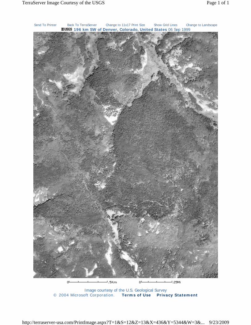
• Black & white, and color, aerial photographs taken in 1999 and 2005 provided by USGS and TPL (included in Appendix C);
• Geologic and Aeromagnetic Maps of the Fossil Ridge Area and Vicinity, Gunnison County, Colorado (USGS, 2002); and
• 1964 & 1979 USGS 7.5-minute Parlin & Signal Peak, Colorado topographic quadrangles (included in Appendix A).
The Site and adjoining lands appeared to be mostly undeveloped in the 1999 and 2005 aerial photographs, with the only manmade improvements being the cabin area and unpaved access roads. The historic USGS 7.5-minute topographic quadrangles show the Site and adjoining lands as mostly undeveloped with one small structure in the cabin area, along with access roads and jeep trails. Additionally, the USGS geologic map does not show any other notable structures, roads or mining activities at the Site and adjoining properties.
Sanborn Map (i.e., fire insurance map) and city directory coverage is not available for the Site; however, the lack of this type of historic information is not expected to affect the outcome/findings of this report, and this is not considered to be a significant data gap.

Fossil Ridge Property (Gunnison County, Colorado) Phase I ESA
7 November 2009
5.0 SITE RECONNAISSANCE
5.1 Methodology and Limiting Conditions
A Rare Earth representative visited the Site on September 24, 2009 to conduct a walk-around inspection and identify visible evidence of recognized environmental conditions at the Site and adjoining lands. The natural setting (i.e., geologic, hydrologic, topographic, and ecologic features) and interactions at, and between, the Site and adjoining parcels were also observed and documented. Primary access to the Site is achieved from Forest Road 743 to the west and along an unpaved road leading toward the Clark cabin. Field personnel compiled detailed notes and color photographs of important site features. Select photographs collected during the Site reconnaissance program are included in Appendix C. Weather conditions during the Site visit included overcast skies and broken clouds, with cool temperatures (approximately 45 degrees F) and no recent precipitation.
5.2 General Site Setting
The Site encompasses approximately 960 acres of mostly undeveloped, hilly land located on fairly heavily forested slopes west of Fossil Ridge and surrounded by undeveloped USFS lands. Fairly steep, forested slopes and relatively inaccessible drainages dominate much of the Site; however, there are also several open meadow areas in the west & southwest parts of the Site. The surrounding areas and adjoining lands consist of very similar undeveloped terrain.
5.3 Exterior Observations
The Site consists of mostly undeveloped land used only recreation purposes and wildlife habitat. No utilities, equipment or vehicles were noted. There are several unpaved roads and tracks that traverse the Site. The only structures at the Site include a small log cabin, wooden outhouse, and old loafing shed surrounded by wood-fenced corral areas. Also near the cabin were a fire pit, metal debris, and a concrete cistern for water storage. A small depression was noted south, and downslope, of the cabin with several old wooden timbers and rocks lining the pit area. According to the landowner, this was likely a rock-source area used during cabin, shed, and/or outhouse construction in the 1930’s.
There are two old lime kilns at the Site, which consist of rock walls and collapsed timber roofs. One kiln is located near the main Site entrance south of Forest Road 743, and the second kiln is located on a forested hillslope south of the jeep road along the central part of the northern Site boundary. The wood-fired kilns were likely used during the late 1800’s for converting locally mined Leadville Limestone into quick-lime, which was then used as a bonding agent in cement & mortar, as plaster for interior walls of buildings, or for chinking on log cabins. No chemical drums or unusual runoff were noted at the kiln locations.
Several crude wooden lean-to’s and small lumber shelters (made of pallets & plywood) were observed in the western part of the Site, south of Forest Road 743. According to the landowner, these were formerly utilized by a group of local youth who were engaged in “paint-ball” battles on what they believed was public land.

Fossil Ridge Property (Gunnison County, Colorado) Phase I ESA
8 November 2009
There was no evidence (e.g., standpipes, vents, pumps/dispensers/pads) of underground or aboveground storage tanks observed at the Site. No environmental concerns were apparent at the adjoining properties based upon exterior observations.
Other exterior observations at the Site included:
• No evidence of electrical transformers or powerlines • No evidence of treatment ponds or animal-dipping lagoons • No evidence of solid-waste disposal areas • No evidence of liquid or chemical storage • No evidence of petroleum-stained surface soils • No evidence of buried liquid-petroleum or natural-gas pipelines • No evidence of oil and/or gas wells • No evidence of methamphetamine laboratories • No evidence of regulated air-emission sources (e.g., equipment or chemical storage) • No evidence of metallic mineral mining or processing operations • No evidence of discharge or runoff of potential contaminants from adjoining properties
5.4 Interior Observations
The recreational cabin at the Site consists of an approximately 900 square-foot log structure with a sleeping loft that was constructed in the 1930’s. The cabin had a fireplace and small kitchen, and appeared to be tidy and used on occasion by members and friends of the Clark family. No environmental concerns were apparent at the cabin, outhouse structure, or loafing shed.
Fossil Ridge Property (Gunnison County, Colorado) Phase I ESA
9 November 2009
6.0 INTERVIEWS
6.1 Interview with Site Owner
Rare Earth contacted Butch Clark via telephone (970/641-2907) on November 3rd for information related to Site usage and history. Mr. Clark acquired the Site in 1972 and has used it over the years for recreational purposes. He stated that the Site was an agricultural homestead beginning in about 1908 and the cabin was built in the 1930’s by Mr. Jorgenson from Gunnison. He mentioned that there was a spring-fed, hand-dug (approximately 40-feet deep) water supply cistern/well on the east side of the structure. However, the water is not currently potable due to high levels of E. coli bacteria. Mr. Clark stated that a small community of individuals occupied part of the Site in the 1860’s when they built two kilns for cooking lime, after harvesting limestone from local outcrops. He was not aware of any environmental concerns with the kilns themselves. A small townsite is believed to have once existed on the north side of Forest Road 743 near the main road into the Site. Mr. Clark had no knowledge of any other hard-rock mining features or tailings piles, fuel tanks, transformers, landfills, or other potential environmental concerns at the Site. He knew about the paint-ball activity at the Site, and said that a local Boy Scout troop was scheduled to clean up the lumber and other debris. Additionally, Mr. Clark was not aware of historic mining activity or unusual drainage features on adjoining lands, or any industrial activity or environmental concern on the USFS lands adjoining the Site. 6.2 Interview with Others
Since the Site is fairly remote and not frequented by regulatory agency personnel, Rare Earth did not perform additional interviews. The lack of interviews with other parties is not expected to affect the outcome/findings of this report, and this is not considered to be a significant data gap.

Fossil Ridge Property (Gunnison County, Colorado) Phase I ESA
10 November 2009
7.0 FINDINGS
At the request of TPL, Rare Earth conducted this ESA for the 960-acre Fossil Ridge property in Gunnison County, Colorado. The ESA was performed in conformance with the scope and limitations of ASTM’s E1527-05 guidance document Standard Practice for Environmental Site Assessments: Phase I Environmental Site Assessment Process. The ESA encompassed a review of historical and regulatory records, interviews with persons familiar with the Site, reconnaissance of the Site and the surrounding area, and preparation of this report.
This ESA has revealed no evidence of recognized environmental conditions (as defined by ASTM) in connection with the Site. Additionally, no evidence of recognized environmental conditions was indicated at adjoining properties that might have the potential to impact the Site with hazardous materials.

Fossil Ridge Property (Gunnison County, Colorado) Phase I ESA
11 November 2009
8.0 OPINION
Based upon the findings described in Section 7.0 of this ESA, it is Rare Earth’s opinion that no further inquiry or additional investigations are necessary for the Site.

Fossil Ridge Property (Gunnison County, Colorado) Phase I ESA
12 November 2009
9.0 CONCLUSIONS
We have performed a Phase I Environmental Site Assessment in conformance with the scope and limitations of ASTM Practice E1527-05 for the 960-acre Fossil Ridge property in Gunnison County, Colorado, the Site. This assessment has revealed no evidence of recognized environmental conditions in connection with the Site.

Fossil Ridge Property (Gunnison County, Colorado) Phase I ESA
13 November 2009
10.0 DEVIATIONS
There are no significant deviations from ASTM Practice E1527-05 to report.

Fossil Ridge Property (Gunnison County, Colorado) Phase I ESA
14 November 2009
11.0 ADDITIONAL SERVICES
No additional services were performed by Rare Earth during this Phase I ESA.

Fossil Ridge Property (Gunnison County, Colorado) Phase I ESA
15 November 2009
12.0 REFERENCES
American Society for Testing and Materials. 2005. Standard Practice for Environmental Site Assessments: Phase I Environmental Site Assessment Process. Designation E1527-05.
United States Geological Survey (USGS). 1964. Parlin, Colorado topographic quadrangle.
USGS. 1979. Signal Peak, Colorado topographic quadrangle.
USGS. 2002. Geologic and Aeromagnetic Maps of the Fossil Ridge Area and Vicinity, Gunnison County, Colorado. Geologic Investigation Series Map I-2738.

ASTM E1527 ESA – Fossil Ridge Property (Gunnison County, CO)
November 2009
APPENDIX A
SITE LOCATION MAPS


LegendTax Parcel Boundaries
Ambigious
Block
T City & Tax
County
Federal
T Federal & Tax
Parcel
T Parcel & Tax
ROW
T ROW & Tax
Subdivision
T Subdivision & TaxLots or Other Boundaries! ! ! ! ! ! Archaic
City & Tax District
County
Lot or Other Feature
Parcel Not Split By Alley
Subdivision
T Subdivision & Tax District
T Tax DistrictEasements
EasementsGovernment Survey Breakdown
! ! ! Quarter Quarter, Lot or Tract! ! ! Quarter Section
Section
Township
Highways, Roads or Trails
Lakes
Rivers and StreamsShown on Another Map
Exempt PropertyBureau of Land Management
Colorado Division of Wildlife
Division of Property and Taxation
Gunnison County
Gunnison County and City of Gunnison
Municipal City
National Forest Service
National Park Service
Other Exempt Entity
Other Federal
State of Colorado
!!
!!
! ! ! ! ! ! ! !
!!
!!
!!
! ! ! ! ! ! ! ! ! ! ! ! ! ! ! ! !!
! ! ! ! ! ! ! !! !
! ! ! !! ! ! ! ! ! ! ! ! !
!!
!!
!!
!!
!!
!
!!
!
!!
!!
!!
! ! ! ! ! ! ! !
!!
!!
!!
!!
!!
!!
!!
!!
!!
!!
!!
! ! ! ! ! ! ! ! ! ! ! ! ! ! ! !
!!
!!
!!
!!
!!
!!
!!
!!
!!
!!
!!
!!
!!
!!
!!
!!
!!
!!
!!
!!
!!
!!
!!
!!
!!
!!
!!
!!
!!
! ! ! ! ! ! ! !
!!
!!
! ! ! ! ! ! ! ! !!
! ! ! ! ! ! ! !
!!
!!
!!
!!
!!
!!
!!
! ! ! ! ! ! ! ! ! ! ! ! ! ! !
!!
!
!!
!!
!!
! ! ! ! ! ! ! !
!!
!!
!!
!!
!!
!!
!!
! ! ! ! ! ! ! ! ! ! ! ! ! ! ! !
!!
!!
!!
!!
! ! ! ! ! ! ! ! ! ! ! ! ! ! ! !
!!
!
!!!!!!!!!!!!!!!!
!!
!!
!!
!!
!!
!!
!!
!!
Lost Canyon Gulch
Roundup Basin
CABIN
CRE
EK
BEAVER CREEK
LOST CANYON GULCH
CABIN
CREEK
TRACT 48
TRACT 38
TRACT 37
TRACT 45
TRACT 44
MES
SENG
ER 1
2479
A
UNCLE SAM 1 12479A
MA
GN
ET 1
2479
A
THE
CORT
LAN
DM
ILL
SITE
124
79B
FS RD 743
FS RD 586
BLM RD 3106BL
M RD 3
107
BLM RD 3106
BLM R
D 3105
BLM RD 3103
FS RD 743
BLM RD 3104
FS RD
583
BLM RD 3106
FS RD 812
BLM RD 310
7
001
009
005004
006
133
079 080
001
050
36 363534333231
01
12
02030405
08 09 10 11
16
0106
07 12
1314151718
19 20 2122
23 24
252627282930
31 32 33 34 35 36 31
010203040506 061 inch = 2,400 feet
G u n n i s o n C o u n t yG u n n i s o n C o u n t yC o l o r a d oC o l o r a d o
P a r c e l M a pP a r c e l M a pMap Updated On:
County Sheet Index
Current Page Index
601 T50N R2E, NEW MEXICO P.M.TAX AREA NO(S):3697
4043
4253
3715
3773
3987
4309
3709
3779
3985
4311
3509
3707
3983
4049
4247
4313
3781
3511
3705
3783
3981
4315
3513
3703
3785
3979
4317
3975
4057
4239
4321
3789
3973
3697
3791
3971
3695
3793
3969
3691
3795
3967
3689
3799
3963
3687
3801
3961
3713
3777
3977
4055
4241
4319
3797
3965
3693
31653167
3003
3169
2907
30013171
3261
2909
2999
3173
3259
2997
29132915
3179
3253
3439
2917
2991
31813251
3441
2651
3183
3249
3443
2727
2653
3185
3247
27252723
2923
2985
3187
3245
3447
3503
3445
3507
3505
31753177
36993521 35
2334313437
3435
35173519
3433
32573255
3267
32653263
35253527
3429 3427
40514053
42454243
4045
4251
4047
4249
3515
37013787
2919
2989
2921
2987
29952993
35
0607
353427
02
10
2536
29 28 27 2636
34
34
25
33323130 28
33
29
32
30
31
15
22
27
03 01
11 12
1314
23 24
2526
35 36
02030405
08 09 10 11
16
0106
07 12
1314151718
19 20 21 22 23 24
252627282930
31 32 33 34 35 36
04
09
16
21
28
0506
07 08
1718
19 20
2930
31 32 3302
10 11 12
010307
01020304050608 09 10 11 12
0408 09
05
3697
3791
3695
3793
3699
35213517 3519
3789
Feet1200 240002400
Map Text001001001
01001
1TYPICAL
Platted Parcel Number
Unplatted Parcel Number
Platted Improvement Only
Unplatted Improvement Only
Assessor Block NumberPlatted Block NumberTypical Lot Dimensions
36 Section Number
T T100601
Tax Area Numbers
8/8/2009

ASTM E1527 ESA – Fossil Ridge Property (Gunnison County, CO)
November 2009
APPENDIX B
ENVIRONMENTAL DATABASE SEARCH REPORT
InfoMapTechnologies Incorporated
Environmental FirstSearch ReportTM
Target Property: FOSSIL RIDGE PROPERTY
COUNTY ROAD 743
ALMONT CO 81210
Job Number: -
PREPARED FOR:
Rare Earth Science, LLC
P.O. Box 4523
Grand Junction, CO 81502by Satisfi, Inc
720-200-9472
09-17-09
Tel: (610) 430-7530 Fax: (610) 430-7535
Environmental FirstSearch is a registered trademark of FirstSearch Technology Corporation. All rights reserved.

Environmental FirstSearchSite Information Report
Request Date: 09-17-09 Search Type: COORDRequestor Name: Brian Peterson Job Number: -Standard: ASTM-05 Filtered Report
Target Site: COUNTY ROAD 743 ALMONT CO 81210
Demographics
Sites: 1 Non-Geocoded: 1 Population: NA
Radon: NA
Site Location
Degrees (Decimal) Degrees (Min/Sec) UTMs
Longitude: -106.728058 -106:43:41 Easting: 349549.318
Latitude: 38.615636 38:36:56 Northing: 4275333.789
Elevation: 10560 Zone: 13
Comment
Comment:
Additional Requests/Services
Adjacent ZIP Codes: 1 Mile(s) Services:
ZIPCode City Name ST Dist/Dir Sel
81230 GUNNISON CO 0.23 SE Y
Requested? Date
Fire Insurance Maps NoAerial Photographs NoHistorical Topos NoCity Directories NoTitle Search/Env Liens NoMunicipal Reports NoOnline Topos No

Environmental FirstSearch1 Mile Radius
Single Map:
COUNTY ROAD 743 , ALMONT CO 81210
Source: 2005 U.S. Census TIGER FilesTarget Site (Latitude: 38.615636 Longitude: -106.728058) .............................
Identified Site, Multiple Sites, Receptor ..........................................................
NPL, DELNPL, Brownfield, Solid Waste Landfill (SWL), Hazardous Waste
Triballand............................................................................................................
Railroads ...........................................................................................................
Black Rings Represent 1/4 Mile Radius; Red Ring Represents 500 ft. Radius

Environmental FirstSearch.25 Mile Radius
Single Map:
COUNTY ROAD 743 , ALMONT CO 81210
Source: 2005 U.S. Census TIGER FilesTarget Site (Latitude: 38.615636 Longitude: -106.728058) .............................
Identified Site, Multiple Sites, Receptor ..........................................................
NPL, DELNPL, Brownfield, Solid Waste Landfill (SWL), Hazardous Waste
Triballand............................................................................................................
Railroads ...........................................................................................................
Black Rings Represent 1/4 Mile Radius; Red Ring Represents 500 ft. Radius

Environmental FirstSearch3 Mile Radius
ASTM-05: NPL, RCRACOR
COUNTY ROAD 743 , ALMONT CO 81210
Source: 2005 U.S. Census TIGER FilesTarget Site (Latitude: 38.615636 Longitude: -106.728058) .............................
Identified Site, Multiple Sites, Receptor ..........................................................
NPL, DELNPL, Brownfield, Solid Waste Landfill (SWL), Hazardous Waste
Triballand............................................................................................................
Railroads ...........................................................................................................
Black Rings Represent 1/4 Mile Radius; Red Ring Represents 500 ft. Radius

Environmental FirstSearch2 Mile Radius
ASTM-05: Multiple Databases
COUNTY ROAD 743 , ALMONT CO 81210
Source: 2005 U.S. Census TIGER FilesTarget Site (Latitude: 38.615636 Longitude: -106.728058) .............................
Identified Site, Multiple Sites, Receptor ..........................................................
NPL, DELNPL, Brownfield, Solid Waste Landfill (SWL), Hazardous Waste
Triballand............................................................................................................
Railroads ...........................................................................................................
Black Rings Represent 1/4 Mile Radius; Red Ring Represents 500 ft. Radius

Environmental FirstSearch1 Mile RadiusSite Locus Map:
COUNTY ROAD 743 , ALMONT CO 81210
Source: 2005 U.S. Census TIGER FilesTarget Site (Latitude: 38.615636 Longitude: -106.728058) .............................
Identified Site, Multiple Sites, Receptor ..........................................................
NPL, DELNPL, Brownfield, Solid Waste Landfill (SWL), Hazardous Waste
Triballand............................................................................................................
Railroads ...........................................................................................................
Black Rings Represent 1/4 Mile Radius; Red Ring Represents 500 ft. Radius
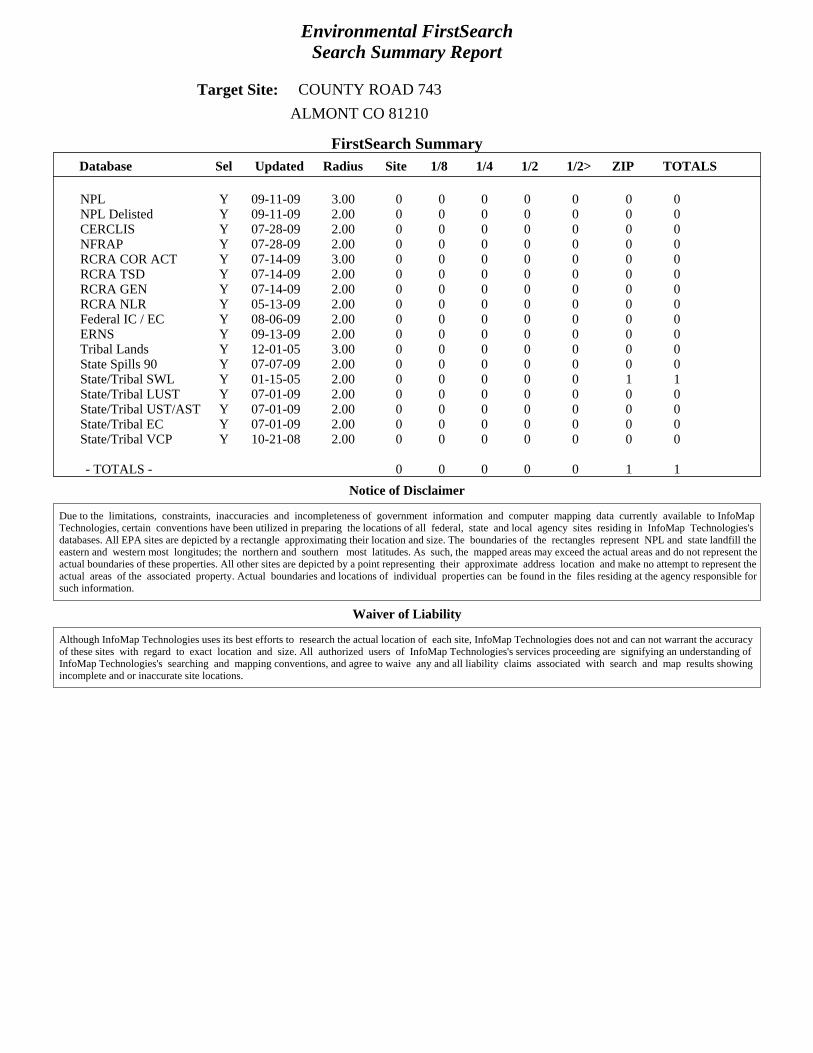
Environmental FirstSearchSearch Summary Report
Target Site: COUNTY ROAD 743 ALMONT CO 81210
FirstSearch SummaryDatabase Sel Updated Radius Site 1/8 1/4 1/2 1/2> ZIP TOTALS
NPL Y 09-11-09 3.00 0 0 0 0 0 0 0NPL Delisted Y 09-11-09 2.00 0 0 0 0 0 0 0CERCLIS Y 07-28-09 2.00 0 0 0 0 0 0 0NFRAP Y 07-28-09 2.00 0 0 0 0 0 0 0RCRA COR ACT Y 07-14-09 3.00 0 0 0 0 0 0 0RCRA TSD Y 07-14-09 2.00 0 0 0 0 0 0 0RCRA GEN Y 07-14-09 2.00 0 0 0 0 0 0 0RCRA NLR Y 05-13-09 2.00 0 0 0 0 0 0 0Federal IC / EC Y 08-06-09 2.00 0 0 0 0 0 0 0ERNS Y 09-13-09 2.00 0 0 0 0 0 0 0Tribal Lands Y 12-01-05 3.00 0 0 0 0 0 0 0State Spills 90 Y 07-07-09 2.00 0 0 0 0 0 0 0State/Tribal SWL Y 01-15-05 2.00 0 0 0 0 0 1 1State/Tribal LUST Y 07-01-09 2.00 0 0 0 0 0 0 0State/Tribal UST/AST Y 07-01-09 2.00 0 0 0 0 0 0 0State/Tribal EC Y 07-01-09 2.00 0 0 0 0 0 0 0State/Tribal VCP Y 10-21-08 2.00 0 0 0 0 0 0 0
- TOTALS - 0 0 0 0 0 1 1Notice of Disclaimer
Due to the limitations, constraints, inaccuracies and incompleteness of government information and computer mapping data currently available to InfoMapTechnologies, certain conventions have been utilized in preparing the locations of all federal, state and local agency sites residing in InfoMap Technologies'sdatabases. All EPA sites are depicted by a rectangle approximating their location and size. The boundaries of the rectangles represent NPL and state landfill theeastern and western most longitudes; the northern and southern most latitudes. As such, the mapped areas may exceed the actual areas and do not represent theactual boundaries of these properties. All other sites are depicted by a point representing their approximate address location and make no attempt to represent theactual areas of the associated property. Actual boundaries and locations of individual properties can be found in the files residing at the agency responsible forsuch information.
Waiver of Liability
Although InfoMap Technologies uses its best efforts to research the actual location of each site, InfoMap Technologies does not and can not warrant the accuracyof these sites with regard to exact location and size. All authorized users of InfoMap Technologies's services proceeding are signifying an understanding ofInfoMap Technologies's searching and mapping conventions, and agree to waive any and all liability claims associated with search and map results showingincomplete and or inaccurate site locations.

Environmental FirstSearchSites Summary Report
Target Property: COUNTY ROAD 743 JOB: -ALMONT CO 81210
TOTAL: 1 GEOCODED: 0 NON GEOCODED: 1 SELECTED: 1
Map ID Dist/Dir DB Type Site Name/ID/Status Address ElevDiff Page No.
NON GC SWL ALMONT ADDRESS NOT REPORTED N/A 112-0623/HISTORIC ALMONT CO
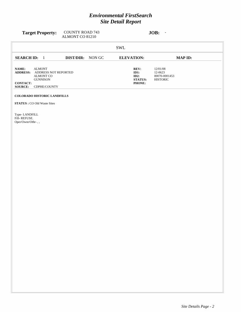
Environmental FirstSearchSite Detail Report
Target Property: COUNTY ROAD 743 JOB: -ALMONT CO 81210
SWL
SEARCH ID: 1 DIST/DIR: NON GC ELEVATION: MAP ID:
NAME: ALMONT REV: 12/01/08ADDRESS: ADDRESS NOT REPORTED ID1: 12-0623
ALMONT CO ID2: 00070-0001453GUNNISON STATUS: HISTORIC
CONTACT: PHONE: SOURCE: CDPHE/COUNTY
COLORADO HISTORIC LANDFILLS
STATUS : CO Old Waste Sites
Type- LANDFILLFill- REFUSE.Oper/Ownr/Othr- , ,
Site Details Page - 2
Environmental FirstSearch Descriptions
NPL: EPA NATIONAL PRIORITY LIST - The National Priorities List is a list of the worst hazardouswaste sites that have been identified by Superfund. Sites are only put on the list after they have been scoredusing the Hazard Ranking System (HRS), and have been subjected to public comment. Any site on the NPL iseligible for cleanup using Superfund Trust money.A Superfund site is any land in the United States that has been contaminated by hazardous waste and identifiedby the Environmental Protection Agency (EPA) as a candidate for cleanup because it poses a risk to humanhealth and/or the environment.FINAL - Currently on the Final NPLPROPOSED - Proposed for NPL
NPL DELISTED: EPA NATIONAL PRIORITY LIST Subset - Database of delisted NPL sites. TheNational Oil and Hazardous Substances Pollution Contingency Plan (NCP) establishes the criteria that the EPAuses to delete sites from the NPL. In accordance with 40 CFR 300.425.(e), sites may be deleted from the NPLwhere no further response is appropriate.DELISTED - Deleted from the Final NPL
CERCLIS: EPA COMPREHENSIVE ENVIRONMENTAL RESPONSE COMPENSATION ANDLIABILITY INFORMATION SYSTEM (CERCLIS)- CERCLIS is a database of potential and confirmedhazardous waste sites at which the EPA Superfund program has some involvement. It contains sites that areeither proposed to be or are on the National Priorities List (NPL) as well as sites that are in the screening andassessment phase for possible inclusion on the NPL.PART OF NPL- Site is part of NPL siteDELETED - Deleted from the Final NPLFINAL - Currently on the Final NPLNOT PROPOSED - Not on the NPLNOT VALID - Not Valid Site or IncidentPROPOSED - Proposed for NPLREMOVED - Removed from Proposed NPLSCAN PLAN - Pre-proposal SiteWITHDRAWN - Withdrawn
NFRAP: EPA COMPREHENSIVE ENVIRONMENTAL RESPONSE COMPENSATION ANDLIABILITY INFORMATION SYSTEM ARCHIVED SITES - database of Archive designated CERCLA sitesthat, to the best of EPA's knowledge, assessment has been completed and has determined no further steps willbe taken to list this site on the National Priorities List (NPL). This decision does not necessarily mean that thereis no hazard associated with a given site; it only means that, based upon available information, the location isnot judged to be a potential NPL site.NFRAP – No Further Remedial Action PlanP - Site is part of NPL siteD - Deleted from the Final NPLF - Currently on the Final NPLN - Not on the NPLO - Not Valid Site or IncidentP - Proposed for NPLR - Removed from Proposed NPLS - Pre-proposal SiteW – Withdrawn
RCRA COR ACT: EPA RESOURCE CONSERVATION AND RECOVERY INFORMATION SYSTEMSITES - Database of hazardous waste information contained in the Resource Conservation and Recovery ActInformation (RCRAInfo), a national program management and inventory system about hazardous wastehandlers. In general, all generators, transporters, treaters, storers, and disposers of hazardous waste are requiredto provide information about their activities to state environmental agencies. These agencies, in turn pass on theinformation to regional and national EPA offices. This regulation is governed by the Resource Conservationand Recovery Act (RCRA), as amended by the Hazardous and Solid Waste Amendments of 1984.RCRAInfo facilities that have reported violations and subject to corrective actions.

RCRA TSD: EPA RESOURCE CONSERVATION AND RECOVERY INFORMATION SYSTEMTREATMENT, STORAGE, and DISPOSAL FACILITIES. - Database of hazardous waste informationcontained in the Resource Conservation and Recovery Act Information (RCRAInfo), a national programmanagement and inventory system about hazardous waste handlers. In general, all generators, transporters,treaters, storers, and disposers of hazardous waste are required to provide information about their activities tostate environmental agencies. These agencies, in turn pass on the information to regional and national EPAoffices. This regulation is governed by the Resource Conservation and Recovery Act (RCRA), as amended bythe Hazardous and Solid Waste Amendments of 1984.Facilities that treat, store, dispose, or incinerate hazardous waste.
RCRA GEN: EPA/MA DEP/CT DEP RESOURCE CONSERVATION AND RECOVERYINFORMATION SYSTEM GENERATORS - Database of hazardous waste information contained in theResource Conservation and Recovery Act Information (RCRAInfo), a national program management andinventory system about hazardous waste handlers. In general, all generators, transporters, treaters, storers, anddisposers of hazardous waste are required to provide information about their activities to state environmentalagencies. These agencies, in turn pass on the information to regional and national EPA offices. This regulationis governed by the Resource Conservation and Recovery Act (RCRA), as amended by the Hazardous and SolidWaste Amendments of 1984.Facilities that generate or transport hazardous waste or meet other RCRA requirements.LGN - Large Quantity GeneratorsSGN - Small Quantity GeneratorsVGN – Conditionally Exempt Generator.Included are RAATS (RCRA Administrative Action Tracking System) and CMEL (Compliance Monitoring &Enforcement List) facilities.CONNECTICUT HAZARDOUS WASTE MANIFEST – Database of all shipments of hazardous waste within,into or from Connecticut. The data includes date of shipment, transporter and TSD info, and material shippedand quantity. This data is appended to the details of existing generator records.MASSACHUSETTES HAZARDOUS WASTE GENERATOR – database of generators that are regulatedunder the MA DEP.VQN-MA = generates less than 220 pounds or 27 gallons per month of hazardous waste or waste oil.SQN-MA = generates 220 to 2,200 pounds or 27 to 270 gallons per month of waste oil.LQG-MA = generates greater than 2,200 lbs of hazardous waste or waste oil per month.
RCRA NLR: EPA RESOURCE CONSERVATION AND RECOVERY INFORMATION SYSTEM SITES- Database of hazardous waste information contained in the Resource Conservation and Recovery ActInformation (RCRAInfo), a national program management and inventory system about hazardous wastehandlers. In general, all generators, transporters, treaters, storers, and disposers of hazardous waste are requiredto provide information about their activities to state environmental agencies. These agencies, in turn pass on theinformation to regional and national EPA offices. This regulation is governed by the Resource Conservationand Recovery Act (RCRA), as amended by the Hazardous and Solid Waste Amendments of 1984.Facilities not currently classified by the EPA but are still included in the RCRAInfo database. Reasons for nonclassification:Failure to report in a timely matter.No longer in business.No longer in business at the listed address.No longer generating hazardous waste materials in quantities which require reporting.
Federal IC / EC: EPA BROWNFIELD MANAGEMENT SYSTEM (BMS) - database designed to assistEPA in collecting, tracking, and updating information, as well as reporting on the major activities andaccomplishments of the various Brownfield grant Programs.FEDERAL ENGINEERING AND INSTITUTIONAL CONTROLS- Superfund sites that have either anengineering or an institutional control. The data includes the control and the media contaminated.
ERNS: EPA/NRC EMERGENCY RESPONSE NOTIFICATION SYSTEM (ERNS) - Database of incidentsreported to the National Response Center. These incidents include chemical spills, accidents involvingchemicals (such as fires or explosions), oil spills, transportation accidents that involve oil or chemicals, releasesof radioactive materials, sightings of oil sheens on bodies of water, terrorist incidents involving chemicals,incidents where illegally dumped chemicals have been found, and drills intended to prepare responders tohandle these kinds of incidents. Data since January 2001 has been received from the National Response System

database as the EPA no longer maintains this data.
Tribal Lands: DOI/BIA INDIAN LANDS OF THE UNITED STATES - Database of areas with boundariesestablished by treaty, statute, and (or) executive or court order, recognized by the Federal Government asterritory in which American Indian tribes have primary governmental authority. The Indian Lands of the UnitedStates map layer shows areas of 640 acres or more, administered by the Bureau of Indian Affairs. Included areFederally-administered lands within a reservation which may or may not be considered part of the reservation.BUREAU OF INDIAN AFFIARS CONTACT - Regional contact information for the Bureau of Indian Affairsoffices.
State Spills 90: CDPHE ENVIRONMENTAL RELEASE AND INCIDENT DATABASE - This is adatabase of reported spills in Colorado.
State/Tribal SWL: CDPHE DATABASE OF ACTIVE SOLID WASTE MANAGEMENT FACILITIES -Listing of Active solid waste facilities and transfer stations.
State/Tribal LUST: COSTIS DATABASE OF LEAKING UNDERGROUND STORAGE TANKS -Colorado Department of Labor and Employment’s Colorado Storage Tank Information System (COSTIS)provides this data.
State/Tribal UST/AST: COSTIS DATABASE OF UNDERGROUND STORAGE TANKS - ColoradoDepartment of Labor and Employment’s Colorado Storage Tank Information System (COSTIS) provides thisdata.
State/Tribal EC: CDPHE ENVIRONMENTAL COVENANTS - Senate Bill 01-145 gave authority to theColorado Department of Public Health and Environment to approve requests to restrict the future use of aproperty using an enforceable agreement called an environmental covenant. When a contaminated site is notcleaned up completely, land use restrictions may be used to ensure that the selected cleanup remedy isadequately protective of human health and the environment.
State/Tribal VCP: CDPHE THE VOLUNTARY CLEANUP AND REDEVELOPMENT PROGRAMPROGRAM - The Voluntary Cleanup and Redevelopment program was created in 1994. The objective of theprogram is to facilitate the redevelopment and transfer of contaminated properties. Cleanup decisions are basedon existing standards and the proposed use of the property. The actual cleanup and verification is the owner'sresponsibility.
RADON: NTIS NATIONAL RADON DATABASE - EPA radon data from 1990-1991 national radonproject collected for a variety of zip codes across the United States.

Environmental FirstSearch Database Sources
NPL: EPA Environmental Protection Agency
Updated quarterly
NPL DELISTED: EPA Environmental Protection Agency
Updated quarterly
CERCLIS: EPA Environmental Protection Agency
Updated quarterly
NFRAP: EPA Environmental Protection Agency.
Updated quarterly
RCRA COR ACT: EPA Environmental Protection Agency.
Updated quarterly
RCRA TSD: EPA Environmental Protection Agency.
Updated quarterly
RCRA GEN: EPA/MA DEP/CT DEP Environmental Protection Agency, Massachusetts Department ofEnvironmental Protection, Connecticut Department of Environmental Protection
Updated quarterly
RCRA NLR: EPA Environmental Protection Agency
Updated quarterly
Federal IC / EC: EPA Environmental Protection Agency
Updated quarterly
ERNS: EPA/NRC Environmental Protection Agency
Updated annually
Tribal Lands: DOI/BIA United States Department of the Interior
Updated annually

State Spills 90: CDPHE CDPHE Hazardous Materials and Waste Management Division
Updated annually
State/Tribal SWL: CDPHE The Colorado Department of Public Health and Environment HazardousMaterials and Waste Management DivisionPublic Safety
Updated annually
State/Tribal LUST: COSTIS The Colorado Department of Labor and Employment/Division of Oil andPublic Safety
Updated semi-annually
State/Tribal UST/AST: COSTIS The Colorado Department of Labor and Employment/Division of Oil andPublic Safety
Updated semi-annually
State/Tribal EC: CDPHE rado Department of Public Health and Environment Hazardous Materials andWaste Management Division
Updated annually
State/Tribal VCP: CDPHE The Colorado Department of Public Health and Environment HazardousMaterials and Waste Management Division
Updated annually
RADON: NTIS Environmental Protection Agency, National Technical Information Services
Updated periodically

ASTM E1527 ESA – Fossil Ridge Property (Gunnison County, CO)
November 2009
APPENDIX C
SITE RECONNAISSANCE & AERIAL PHOTOGRAPHS

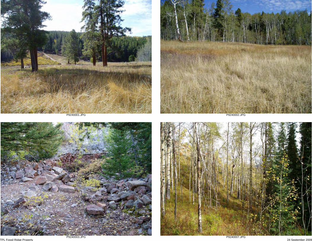
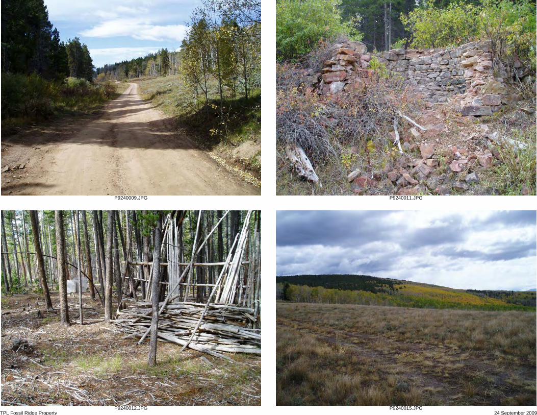
Photo Log: Fossil Ridge Property, 24 September 2009 Rare Earth Science, LLC
001 View SW across western Site boundary & main entrance road in area of old townsite 002 View N in western part of Site in area of old townsite; now a meadow 003 View S of remnants of old lime kiln along north Site boundary 007 View NW along forested slopes on north-central Site boundary 009 View W-SW along Forest Road 743 as it traverses western part of Site 011 View S of remnants of old lime kiln located near Site entrance road, south of Forest Road 743 012 View NW of paint-ball shelters in western part of Site 015 View E-SE across Site from western boundary 020 View W of Clark cabin and picnic / fire-pit area (concrete pad for water well/cistern to the right) 021 View of Clark cabin interior 022 View NW toward wooden corrals and loafing shed from west side of Clark cabin 023 View N along west exterior of Clark cabin 024 View S from south Site boundary west of Clark cabin 025 View NW of open meadow area northwest of Clark cabin 026 View E of former jeep trail (now used for hiking & horses) at USFS & east Site boundary 027 View N inside loafing shed area 028 View N of water well/cistern on east side of Clark cabin (old bed frame & wood planks for cover) 029 View S of old timbers covering depression downslope of Clark cabin 030 View E of outhouse structure located east of Clark cabin
TPL Fossil Ridge Property 24 September 2009
P9240001.JPG P9240002.JPG
P9240003.JPG P9240007.JPG
TPL Fossil Ridge Property 24 September 2009
P9240009.JPG P9240011.JPG
P9240012.JPG P9240015.JPG

TPL Fossil Ridge Property 24 September 2009
P9240020.JPG P9240021.JPG
P9240022.JPG P9240023.JPG

TPL Fossil Ridge Property 24 September 2009
P9240024.JPG P9240025.JPG
P9240026.JPG P9240027.JPG

TPL Fossil Ridge Property 24 September 2009
P9240028.JPG P9240029.JPG
P9240030.JPG

Cabin Creek
Beaver Creek
Lost Canyon Gulch
Tent
s C
reek
0 1,200 2,400600 Feet
LegendFossil Ridge Property (958 ac.)
RiversType
Perennial StreamDitch / CanalIntermittent Stream
Protected LandsFEDERAL (BOR, FWS, NPS)USFSBLMSTATELOCALNGO/LAND TRUST
Fossil Ridge PropertyAerial Map
Map created by The Trust for Public Landon 08/13/2009
Created in ArcMap 9.3® Map Projection:
TPL, The Trust for Public Land, and The Trust for Public Landlogo are trademarks of The Trust for Public Land.
Copyright © 2009 The Trust for Public Land.www.tpl.org
Information on this map is provided for purposes of discussion and visualization only.±
Send To Printer Back To TerraServer Change to 11x17 Print Size Show Grid Lines Change to Landscape 196 km SW of Denver, Colorado, United States 06 Sep 1999
Image courtesy of the U.S. Geological Survey © 2004 Microsoft Corporation. Terms of Use Privacy Statement
Page 1 of 1TerraServer Image Courtesy of the USGS
9/23/2009http://terraserver-usa.com/PrintImage.aspx?T=1&S=12&Z=13&X=436&Y=5344&W=3&...
ASTM E1527 ESA – Fossil Ridge Property (Gunnison County, CO)
November 2009
APPENDIX D
PREPARER’S QUALIFICATIONS

James Armstrong, Principal Environmental Scientist
Rare Earth Science, LLC November 2009
James Armstrong is an environmental scientist & geologist with extensive experience in project management, field studies, site characterization, air quality, remedial action, and regulatory compliance. For the past 19 years, he has worked as a consultant for oil/gas, mining, federal/state/local government, law firm, non-profit, and financial-institution clients in the western US. Mr. Armstrong’s areas of specialization include site research, environmental planning & permitting (including air, water, waste, wetlands, and mining permits), and development and evaluation of regulatory compliance programs. His selected project experience includes:
• Project manager and field scientist for Transaction Screen Process (TSP) and Phase I/II/III Environmental Site Assessments (ESAs) at 150+ locations in Alaska, Colorado, Hawaii, Montana, Oregon, Utah, and Washington. The ESAs were conducted in accordance with ASTM Standard Practices and performed at commercial, industrial, residential, agricultural, and undeveloped land parcels as part of the property-transfer process. The work was performed to characterize (and in some cases, remediate) potential sources of hazardous materials on or adjacent to the properties.
• Project manager and field scientist for Phase I and TSP ESAs and National Environmental Policy Act (NEPA) evaluations performed at 75 different locations in the western US for proposed telecommunication sites. Each site was physically inspected, current uses and site conditions were documented, and interviews and record searches were conducted. NEPA summary reports and biological assessments were also performed at each site, which included the evaluation of wetlands, threatened and endangered species, critical/priority habitat, and cultural/historical resources.
• Project geologist and field scientist for Phase I/II ESAs on 3,500 acres of mining claims in the Kantishna Hills area of Denali National Park, Alaska and approximately 1,000 acres of private mining claims in the Elk and Sawatch Mountains of Colorado. Responsible for evaluating present conditions and contamination resulting from 100+ years of placer and lode mining operations. Also responsible for extensive ground mapping, GPS surveys of claim locations, collection of numerous surface water and soil samples for laboratory analysis, and preparation of corrective action plans.
• Project manager and field scientist for research and evaluation services related to acquisition of several commercial mining properties in Garfield, Mesa, Routt, and San Miguel Counties. Projects included field reconnaissance to determine potential environmental liabilities; research and review of on-site geologic, soil, and hydrological conditions; preparation of mineral reserve estimates; preparation of sampling and remedial action documents; supervision of survey crews; oversight of cleanup contractors; and extensive reporting.
Education BS, Petroleum Geology, Kansas State University 1983 Graduate Studies, Environmental Engineering, University of Alaska, Anchorage 1993-1994
Consulting History Dames & Moore (Anchorage, AK) - 1990 to 1991 ENSR Consulting and Engineering (Anchorage, AK) - 1991 to 1995 Hoefler Consulting Group (Anchorage, AK) - 1995 to 1998 Harding Lawson Associates (Grand Junction, CO) - 1998 to 2000 OASIS Environmental, Inc. (Grand Junction, CO & Anchorage, AK) - 2000 to 2002 Rare Earth Science, LLC (Grand Junction, CO) - 2002 to present
Top Related