


Languages
Pages
Legal


Contents

ACAU Tainan Workshop Organization
messages from dean & directors
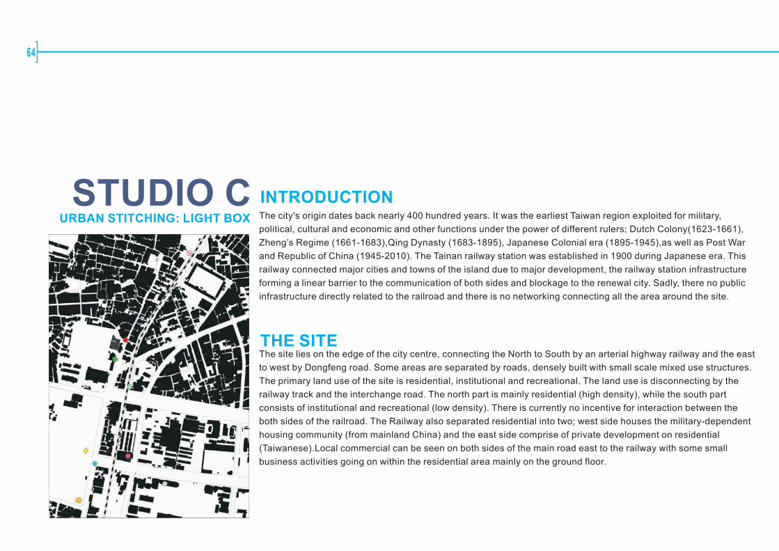
Abstract: Urban Stitching
Project Background:
Studio Workshop:
Participants
4
6
8
10
48
80
Activities82
Site1:Haian Road District
Site2:South of the Tainan Railway Station(districts along the railroad)
Site3:North of the Tainan Railway Station(districts along the railroad)
Site4:The Border of Tainan City and Yung-Kang(districts along the railroad)
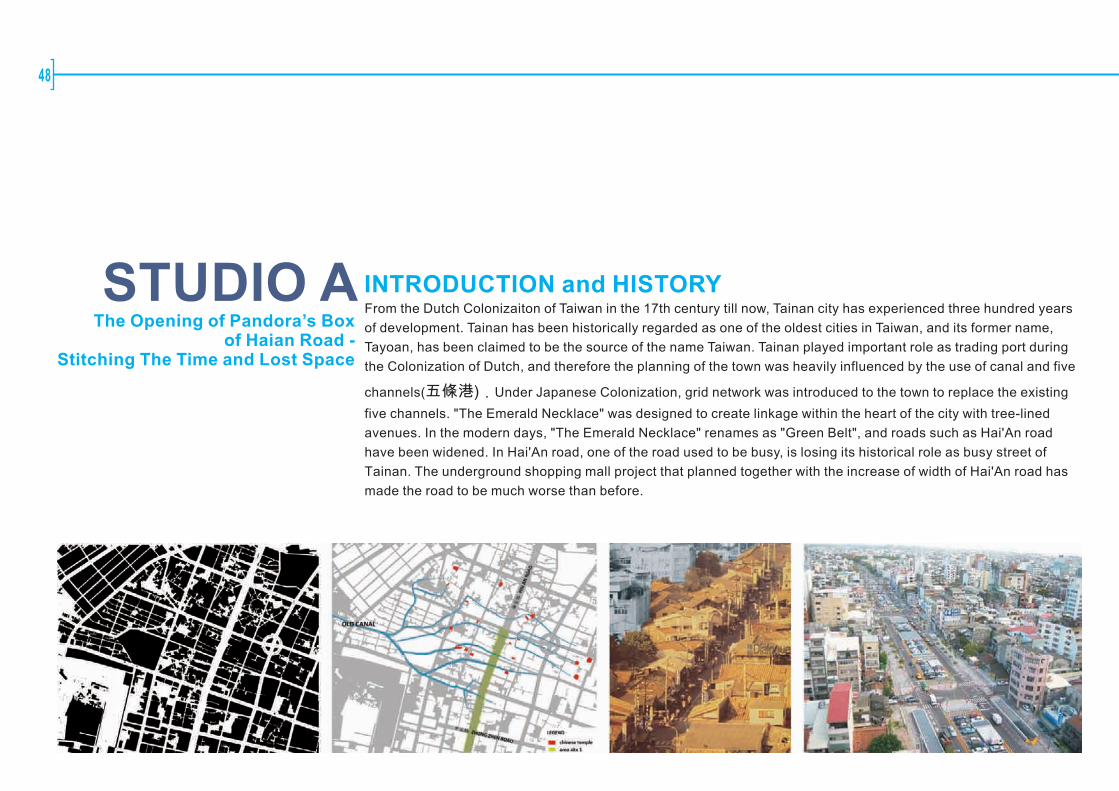
Studio 1:The Opening of Pandora's Box of Haian Road : Stitching The Time and Lost Space
Studio 2:Uni-Vers-City:Taiwan's Emergent City –Tainan
Studio 3:Light Box
Studio 4:Urban Stitching:The Border of Tainan City and Yung-Kang

Organization
04
Participating Universities University of Seoul, Thailand (UOS)
National Cheng Kung University, Taiwan (NCKU)
The University of Hong Kong (HKU)
National University of Singapore (NUS)
Assumption University, Bangkok (AU)
University of Malaya, Kuala Lumpur (UM)
Workshop Advisors Prof. Lin, Feng TyanProf. Yao, George CProf. Tsou, Ko WanProf. Kung, Shiann FarProf. Wu, Yu ChengProf. Hsieh, Horng ChangAr. Chang, Ma LoneAr. Chen, Yu LinAr. NikhomMr. Yen, Shih Hua
Organizing Committee Huang, Ting Shuo, Workshop Director(NCKU, Architecture)
Lai, Shuw Wei, Workshop Director(NCKU, Urban Design & Planning)
Chao, Chen Wei(NCKU, Urban Design & Planning)
Tsai, Chiung Yi(NCKU, Architecture)
Wang, Li Wu(NCKU, Architecture)
Chien, Chia Yu(NCKU, Architecture)
Chou, Chung Yan (NCKU, Urban Design & Planning)
Saraya Saengathit(NCKU, Architecture)
Cheng, Ya Lien(NCKU, Urban Design & Planning)
Participants
Urban Stitching
ACAU Tainan Workshop Organization
Paper Presentations Title: Megacity Network : Contemporary Korean Architecture
Presenter: Prof. Kim Sung Hong(UOS)
Title: Urban Cutting and Sewing
Presenter: Prof. Kung, Shiann-Far(NCKU)
Presenter: Prof. Tsang, Thomas K.H.(HKU)
Title: 1000 Singapores- A Model of the Compact City
Presenter: Mr. Florian Benjamin Schaetz(NUS)
Title: Urban Decoded: The Review of the City
Presenter: Ms. Bhumiwat, Anugool(AU)
Title: Urban Stitching of Old Market Places and New Sensibilities
Presenter: Ar. Lim Take Bane(UM)
Guest Lecture Urban Stitching:Delft Spoorzone Professor Vincent Nadin Chair of Spatial Planning & Strategy, Delft University of Technology
Keynote Speech City Transformation by Way of Continuous Urban Stitching Strategies and
Actions in Urban Developments: Case Studies on Taipei and Kaohsiung, Taiwan
Professor Lin, Chin Rong College of Hakka Studies, National Chiao Tung University
Tainan City Introduction
Mr. Hsu, Chung Chang General Director, Department of Urban Development, Tainan City Government
Studios Studio1:Haian Road DistrictProf. Yang Seung Woo (UOS), Ms. Anugool Bhumiwat (Assumption),
Prof. Wu, Yu Cheng (NCKU), Mr. Yen, Shih Hua (NCKU)
Studio2:South of The Tainan Railway StationAr. Lim Take Bane (UM), Prof. Tsang, Thomas K.H. (HKU), Prof Kung Shiann Far (NCKU), Ar. Nikhom (NCKU)
Studio3:North of The Tainan Railway StationProf. Shin, Bum Shik (UOS), Chong Eun Kyong (UOS), Mr. Veera Leelapattanaputi (Assumption), Prof. Hsieh, Horng Chang (NCKU)
Studio4:The Border of Tainan City and Yung-Kang CountyAr. Chang, Ma Lone (NCKU), Ar. Chen, Yu Lin (NCKU), Prof. Kim Sung Hong (UOS)Dr. Naziaty Mohd Yaacob (UM), Mr. Florian Benjamin Schaetz (NUS)
05

06
MESSAGE FROM DEAN
On behalf of the National Cheng Kung University, I would like to warmly welcome the participants of the Asian Coalition for Architecture and
Urbanism to the ACAU 2010 Tainan workshop. The workshop will build on the success of the previous ACAU workshops.
The ACAU provides a platform for students and teachers from member's faculties to exchange knowledge, ideas and experiences by
identifying and discussing the challenges and possible solutions to existing problems in Tainan city.
Prof. Feng-Tyan LIN
Dean, the College of Planning and Design National Cheng Kung University
Messages From Dean & Directors
Last year, the national government approved the Tainan Area Railway Underground project. Thus, it brings a challenge of stitching the two
separated city regions. We think that it is a suitable case for the 2010 Tainan Workshop. Districts along the railroad will be studied and play as
a suture zone. We expect to have good ideas for solving above-mentioned problems of urban environment by extensively discussions on the
workshop.
Tainan has a history of more than 350 years. Being the most ancient city in Taiwan, The Great Tainan City, which will merge the current Tainan
city and county from the next year, has been developing to a metropolitan area consisting of more than 1.87 million people, near 2200KM2,
with flourishing business and industrial services, and abundant heritages. Among various driving forces, the railroad built in 1900 has been
playing an important role to stimulate the city development. However, it also becomes a separator between the eastern and western parts of
Tainan nowadays. This segregation has caused negative impacts on the cities and lives of their inhabitants.
Urban Stitching
messages from dean & directors
MESSAGE FROM DIRECTOR
A heartily welcome to all of the ACAU2010 participants!
Shiann-Far Kung, Ph.D., Cantab.
Associate Professor, Department of Urban Planning
National Cheng Kung University
This year we select "urban stitching" as the theme for the ACAU2010 Workshop. "Urban stitching" is a direct translation from Chinese phrase
「都市縫合」which has been simultaneously used in the planning and design field in Taiwan for nearly a decade. It literally expressed the
idea of taking actions to seal the gaps between different parts of the city. Some commentators observed that, by using the term, the objectives
behind the stitching projects were neglected or implicit. Nevertheless, this may just reflect the complexity of issues that urban design has to
face, that the different interests and identity of people very often make it difficult to give a clear vision, especially in places where strict urban
growth control do not prevail and the societies are still transforming. As many Asian Cities are experiencing similar processes, this theme has
its merit for exploration, and ACAU2010 invites you to share your thoughts and expertise.
The fragmentation of urban areas may be attributed to various natural and human factors. Availability of flat land and water is usually critical,
steeple hills and wide rivers are often barriers to urban activities, thus human settlements basically evolve along navigable river valleys and
irrigated plains, and built-up areas expand until they reach strong natural barriers, the "organic" communities are thus formed. Human beings
developed technologies to overcome the natural barriers and created institutions to govern people and built-up areas. Following the fast
industrialization in the region since the mid-twentieth century, waves of infrastructure installation and urban boundary re-delineation have
drastically changed the urban patterns, many previously developed communities are conjoined or dissected.
In the case of Tainan, Hai-An Road Underground Project that cutting across the historic communities formed along the ancient ports and
waterways gives the City a lesson and is still waiting for sound solutions. Beyond that, the city's jurisdiction is going to be changed in the next
year, and the railway will be put underground in next few years. Many of the previously developed communities, facilities and urban fabric will
face new changes. I hope that all of you will find the selected sites interesting and challenging enough, and enjoy your stay in Tainan!
07

08
Urban Stitching
ABSTRACT
Abstract
URBAN STITCHING
The theme for ACAU 2010 Workshop is 〝Urban Stitching〞. Four sites along major infrastructural changes are
selected for study-three along the existing railway and one on the widened Haian Road, all strutting on historic
fabric and important node. Innovative planning and design for linking the urban fabric, the public realm and
urban form on those sites to reflect Tainan City's urban and cultural significance are expected.
The National Cheng Kung University (NCKU) has been selected by the Asian Coalition of Architecture and
Urbanism(ACAU)to host the ACAU 2010 Workshop in Tainan. For this fifth workshop, four sites from the city arechosen for study, and urban stitching has been set for the theme, wishing to draw innovative ideas and proposals for future development.
09

10
Urban Stitching
Project Background
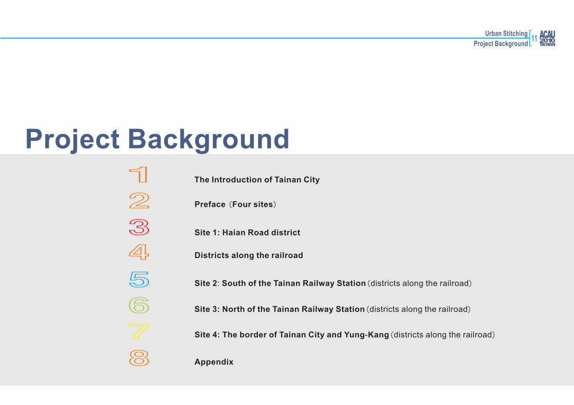
Project Background
1234567
The Introduction of Tainan City
Preface (Four sites)
Site 1: Haian Road district
Districts along the railroad
Site 2: South of the Tainan Railway Station(districts along the railroad)
Site 3: North of the Tainan Railway Station(districts along the railroad)
Site 4: The border of Tainan City and Yung-Kang(districts along the railroad)
8 Appendix
11

12
1The Introduction of Tainan City
Urban Stitching
Project Background
Taipei
Taichung
Annan District
North District
East District
West Central District
Anping District
South District
Tainan
Kaohsiung
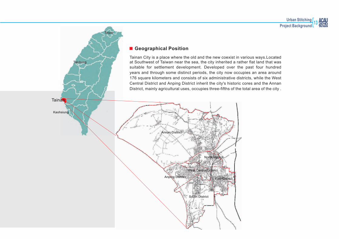
Tainan City is a place where the old and the new coexist in various ways.Locatedat Southwest of Taiwan near the sea, the city inherited a rather flat land that was
suitable for settlement development. Developed over the past four hundred
years and through some distinct periods, the city now occupies an area around
176 square kilometers and consists of six administrative districts, while the West
Central District and Anping District inherit the city's historic cores and the Annan
District, mainly agricultural uses, occupies three-fifths of the total area of the city .
Geographical Position
13

14
The city's origin dates back nearly four hundred years. It was the earliest
regionin Taiwan exploited for military, political, cultural and economic and other
functions under the power of different rulers. The history of Tainan City can
bedivided into several stages:
The Dutch settled in Tainan in 1622, using Tainan as a base for their trade with
Japan and China. The Dutch people devoted to the development of transport
facilities, the Salt River canal was thus excavated and the Anping District
assigned as the main international trading port. This marked the beginning of the development of surrounding areas of Tainan City. Flourishing trading activities induced the increase of population at the vicinity of the Chihkan near
the Provintia road, Chihkan road and Binhai (seafront). Under the Dutch
control, Taiwan's seaports became important entrepots for maritime trade and
transshipment of goods between Japan, China, Southeast Asia, South Asia
and Europe.
Dutch Colony (1623-1661)
Taiwan had a Chinese ruler for the first time in 1661. When the North- Anping
port was gradually silting, Luerhmen, Chihkan and Anping became the three
major ports along the banks of Taiwan River, forming the three earliest Tainan
settlements. During this period population growth forced its distribution to
expand across former settlements to the city's borders. In 1665 Zheng made the decision to construct the Confucian Temple at Ningxia Square to set up imperial college and to conduct official exams. Tainan then became the center
of culture and education of the island. Confucius Temple was not only an important place during the Ming Zheng era but is still a landmark and a key
open space in the city today.
Zheng's Regime (1661-1683)
Historical Background
台江內海
Zeelandia,1625

Urban Stitching
Project Background
In 1684, the Qing government claimed the island and established Taiwan prefecture.
Tainan was designated as the prefecture city. Since Qing government prohibited
Taiwan's cities to build city walls, Tainan had only a bamboo boundary in the beginning
, with six gates for the purposes of control. Thorny bamboos were added to the gates in 1733. In 1736 the seven gates were rebuilt with brick and stone and in 1788 the
walls were reconstructed with mixed masonry materials. In the mean time, developed
area of the city gradually extended from the central cross streets (Zhong-Yi road,
Ming-Quan road) outward to neighboring areas- to the east, south and north near the
city wall and to the west outside the city wall to the ports and some recreational areas.
The central cross streets were then congregations of shops; residential areas were
close to the government offices; while remote undeveloped areas and hills outside the
city walls were jungles and cemeteries.
Qing Dynasty (1683-1895)
大東門
小南門大南門
小西門
大西門
小北門
大北門
小東門
清代府城城垣範圍
大東門
小南門大南門
小西門
大西門
小北門
大北門
小東門
東安坊
寧南坊
鎮北坊
西定坊
民權路
忠義
路
City Wall of Ching Dynasty
Grand East Gate
Grand West Gate
Grand North Gate
Tainan City Wall,1752
Street map of Tainan City,1752
15
16
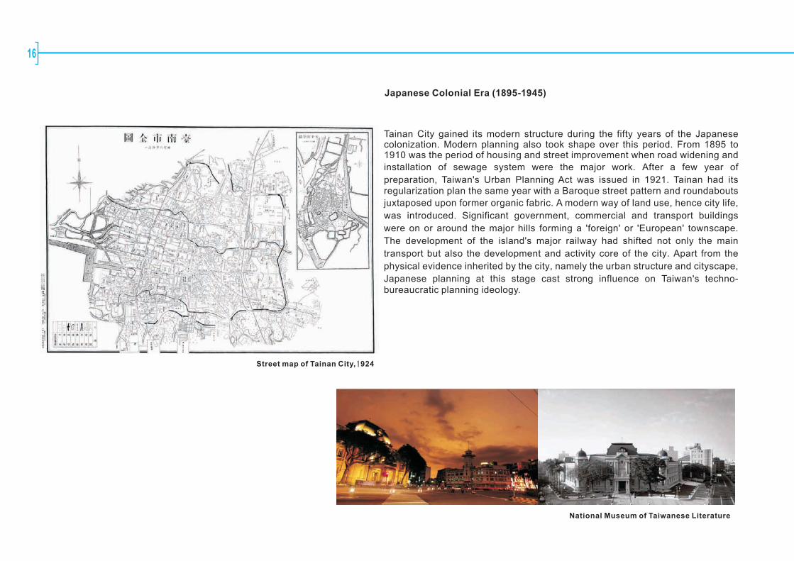
Tainan City gained its modern structure during the fifty years of the Japanese colonization. Modern planning also took shape over this period. From 1895 to 1910 was the period of housing and street improvement when road widening and
installation of sewage system were the major work. After a few year of
preparation, Taiwan's Urban Planning Act was issued in 1921. Tainan had its regularization plan the same year with a Baroque street pattern and roundabouts
juxtaposed upon former organic fabric. A modern way of land use, hence city life,
was introduced. Significant government, commercial and transport buildings
were on or around the major hills forming a 'foreign' or 'European' townscape.
The development of the island's major railway had shifted not only the main
transport but also the development and activity core of the city. Apart from the
physical evidence inherited by the city, namely the urban structure and cityscape,
Japanese planning at this stage cast strong influence on Taiwan's techno-bureaucratic planning ideology.
Japanese Colonial Era (1895-1945)
Street map of Tainan City,1924
National Museum of Taiwanese Literature
Urban Stitching
Project Background
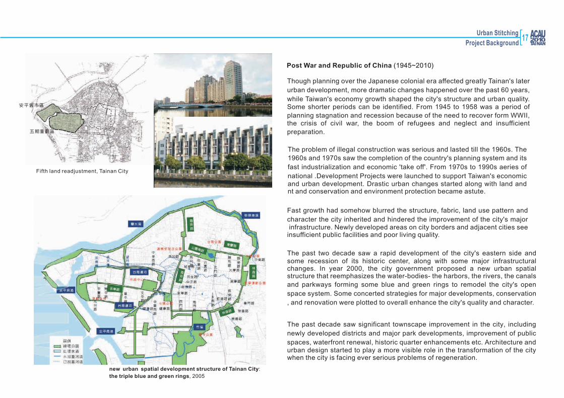
Post War and Republic of China (1945~2010)
Though planning over the Japanese colonial era affected greatly Tainan's later
urban development, more dramatic changes happened over the past 60 years,
while Taiwan's economy growth shaped the city's structure and urban quality. Some shorter periods can be identified. From 1945 to 1958 was a period of
planning stagnation and recession because of the need to recover form WWII,the crisis of civil war, the boom of refugees and neglect and insufficient
preparation.
The problem of illegal construction was serious and lasted till the 1960s. The
1960s and 1970s saw the completion of the country's planning system and its
fast industrialization and economic 'take off'. From 1970s to 1990s aeries of
national .Development Projects were launched to support Taiwan's economic and urban development. Drastic urban changes started along with land and nt and conservation and environment protection became astute.
The past decade saw significant townscape improvement in the city, including
newly developed districts and major park developments, improvement of public
spaces, waterfront renewal, historic quarter enhancements etc. Architecture and urban design started to play a more visible role in the transformation of the city when the city is facing ever serious problems of regeneration.
Fast growth had somehow blurred the structure, fabric, land use pattern and
character the city inherited and hindered the improvement of the city's major infrastructure. Newly developed areas on city borders and adjacent cities see insufficient public facilities and poor living quality.
The past two decade saw a rapid development of the city's eastern side and some recession of its historic center, along with some major infrastructural changes. In year 2000, the city government proposed a new urban spatial structure that reemphasizes the water-bodies- the harbors, the rivers, the canals
and parkways forming some blue and green rings to remodel the city's open
space system. Some concerted strategies for major developments, conservation
, and renovation were plotted to overall enhance the city's quality and character.
new urban spatial development structure of Tainan City:
the triple blue and green rings, 2005
五期重劃區
安平舊市區
Fifth land readjustment, Tainan City
17
18
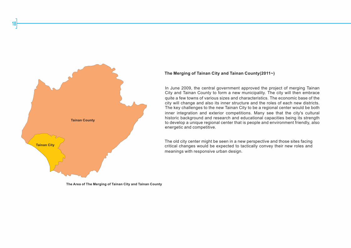
The Merging of Tainan City and Tainan County(2011~)
In June 2009, the central government approved the project of merging Tainan City and Tainan County to form a new municipality. The city will then embrace
quite a few towns of various sizes and characteristics. The economic base of the city will change and also its inner structure and the roles of each new districts. The key challenges to the new Tainan City to be a regional center would be both
inner integration and exterior competitions. Many see that the city's cultural historic background and research and educational capacities being its strength to develop a unique regional center that is people and environment friendly, alsoenergetic and competitive.
The old city center might be seen in a new perspective and those sites facing critical changes would be expected to tactically convey their new roles and
meanings with responsive urban design.
The Area of The Merging of Tainan City and Tainan County
Tainan City
Tainan County

Urban Stitching
Project Background
1、the loop of the (blue green) flow:
Tainan canal (blue belt) and the circular park system (green belt) are formed closely, Both system founded in Japanese colonial period, the only the urban
structure in Taiwan.
The features of the main spatial structure in Tainan city
as follows:
2、the texture in the ancient cityTainan city retains the spatial texture from Ching Dynasty, including the stub wall, Cross Street and Old Street in the alleyway
3、the spot (place) of the Baroque styleDuring the Japanese colonial period , the Japanese government created urban contexts of the Baroque style, including the radial roads and circular space.
4、The streams from the hill Salt River, Luerhmen River, Zhu-River, and Deqing River, Chai-tou kong river , etc. running through the city. Generally, there are few hills with flat terrain, is known as "7 Hills in Tainan " , has always been selected as important religious or political construction of the base. These are the natural topography of urbantexture, as the spatial structure of the bottom.
19

20
2Preface Four sites
Urban Stitching
Project Background
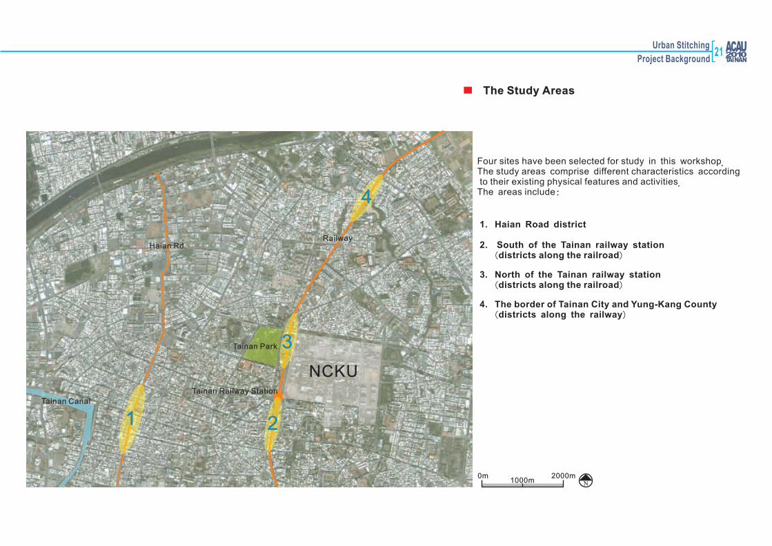
Four sites have been selected for study in this workshop. The study areas comprise different characteristics according to their existing physical features and activities.The areas include:
Tainan Canal
Tainan Park
Haian Rd.Railway
Tainan Railway Station
1 2
4
3
NCKU
1. Haian Road district
2. South of the Tainan railway station (districts along the railroad)
3. North of the Tainan railway station (districts along the railroad)
4. The border of Tainan City and Yung-Kang County (districts along the railway)
1000m N2000m0m
The Study Areas
21
22
3Site 1: Haian Road district

Urban Stitching
Project Background
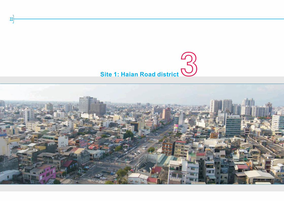
Haian road has gradually gained its life, but certainly not in the way former
projects anticipated. Enhancing the quality of the street and neighboring
areas is still a challenge to planners, designers, as well as to local
communities and the city.
Situating west of the city's central area and running south-north, Haian Road
is the major section of the city's west green way (major roads lined with trees
, not really boulevard). South to it was developed in the early 1990s while its development was hindered by an ill-thought-of plan of building an eight hundred meter long underground shopping arcade with parking spaces to enliven the old city center. Confronting serious design and engineering
problems, the prolonged construction period that lasted almost ten years
has made it a disaster- not only to the daily lives of residents around but to
neighboring businesses and the city as a whole.
The road was finally paved to serve its traffic function leaving quite a few
weird structures on the surface. All the ideas for using the underground structure and revitalizing neighboring districts debated over the passing
decade are thus rendered empty dreams. Some proposals were made to improve road use and the poor townscape, including car park provision,
artists' intervention in decorating building facades and the pavement space
and the city's design guidance for developments along the street.
Overview
750m 1500m0N Boundary of Site1
23
24
Historical Background
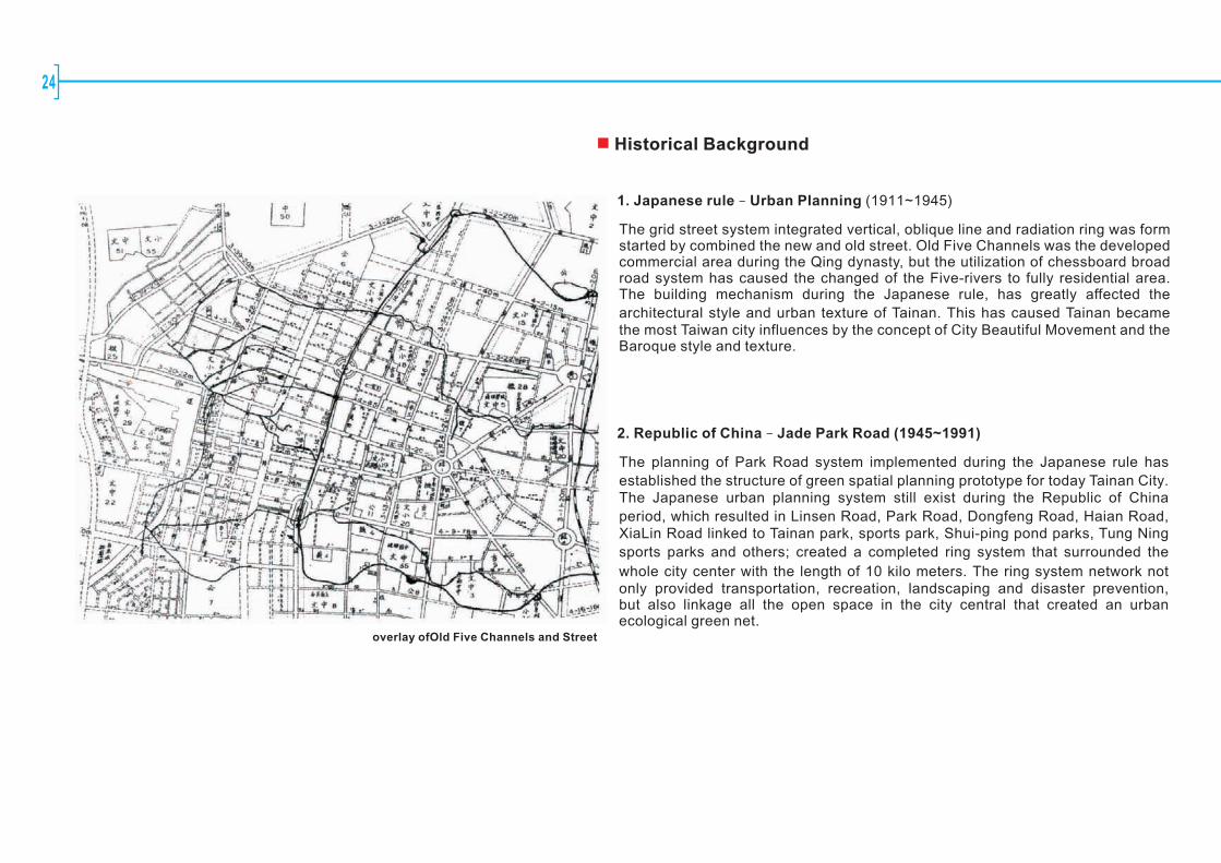
1. Japanese rule – Urban Planning (1911~1945)
The grid street system integrated vertical, oblique line and radiation ring was form started by combined the new and old street. Old Five Channels was the developed commercial area during the Qing dynasty, but the utilization of chessboard broad road system has caused the changed of the Five-rivers to fully residential area. The building mechanism during the Japanese rule, has greatly affected the
architectural style and urban texture of Tainan. This has caused Tainan became the most Taiwan city influences by the concept of City Beautiful Movement and the Baroque style and texture.
2. Republic of China – Jade Park Road (1945~1991)
The planning of Park Road system implemented during the Japanese rule has
established the structure of green spatial planning prototype for today Tainan City. The Japanese urban planning system still exist during the Republic of China
period, which resulted in Linsen Road, Park Road, Dongfeng Road, Haian Road, XiaLin Road linked to Tainan park, sports park, Shui-ping pond parks, Tung Ning
sports parks and others; created a completed ring system that surrounded the
whole city center with the length of 10 kilo meters. The ring system network not only provided transportation, recreation, landscaping and disaster prevention, but also linkage all the open space in the city central that created an urban ecological green net.
overlay ofOld Five Channels and Street
Urban Stitching
Project Background
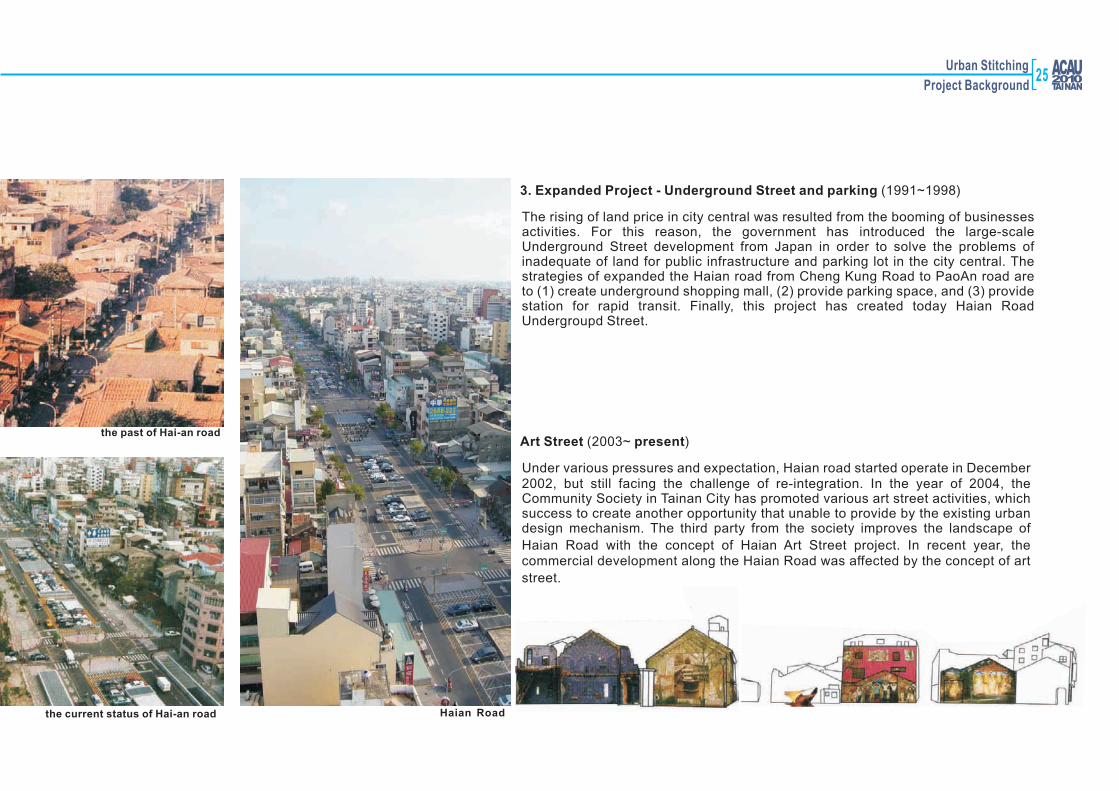
3. Expanded Project - Underground Street and parking (1991~1998)
The rising of land price in city central was resulted from the booming of businesses activities. For this reason, the government has introduced the large-scale Underground Street development from Japan in order to solve the problems of inadequate of land for public infrastructure and parking lot in the city central. The strategies of expanded the Haian road from Cheng Kung Road to PaoAn road are to (1) create underground shopping mall, (2) provide parking space, and (3) provide station for rapid transit. Finally, this project has created today Haian Road Undergroupd Street.
Art Street (2003~ present)
Under various pressures and expectation, Haian road started operate in December 2002, but still facing the challenge of re-integration. In the year of 2004, the Community Society in Tainan City has promoted various art street activities, which success to create another opportunity that unable to provide by the existing urban design mechanism. The third party from the society improves the landscape of
Haian Road with the concept of Haian Art Street project. In recent year, the commercial development along the Haian Road was affected by the concept of art
street.
the current status of Hai-an road
the past of Hai-an road
Haian Road
25

26
N
Urban Stitching
Project Background
60%
210%60%
250%
60%
210%
60%
210%
60%
250%
60%
210%
50%
150%
80%
320%
60%
160%
80%
320%
80%
320%
80%
320%80%
320%80%
320%60%
210%60%
210%
80%
320%
80%
320%
80%
320%80%
320%
80%
320%
80%
320%
80%
320%
80%
320%
80%
320%
80%
320%
80%
240%
80%
320%
80%
320%
80%
320%
80%
320%
80%
320%
0%
0%
0%
0%
80%
320%
80%
320%
80%
320%
80%
320%
80%
320%
80%
320%
80%
320%
60%
240%60%
240%
60%
240%80%
320% 80%
320%
80%
320% 80%
320%
80%
320%80%
320%0%
0%
80%
240%
80%
240%
80%
320%
80%
320%
80%
320%
80%
320%
80%
320%
80%
320%
80%
320%
80%
320%80%
320%
80%
320%
80%
320%
80%
320%
80%
320%
80%
320%
80%
320%
80%
320% 80%
320%
80%
320%
80%
320%
80%
320%80%
320%
80%
320%
0%
0%
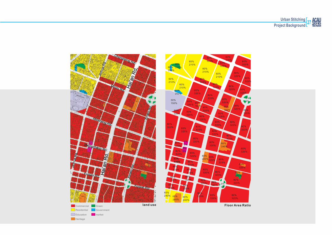
land use Floor Area RatioCommercial
Residential
Education
Heritage
Green
Government
market
27
28
4Districts along the railroad

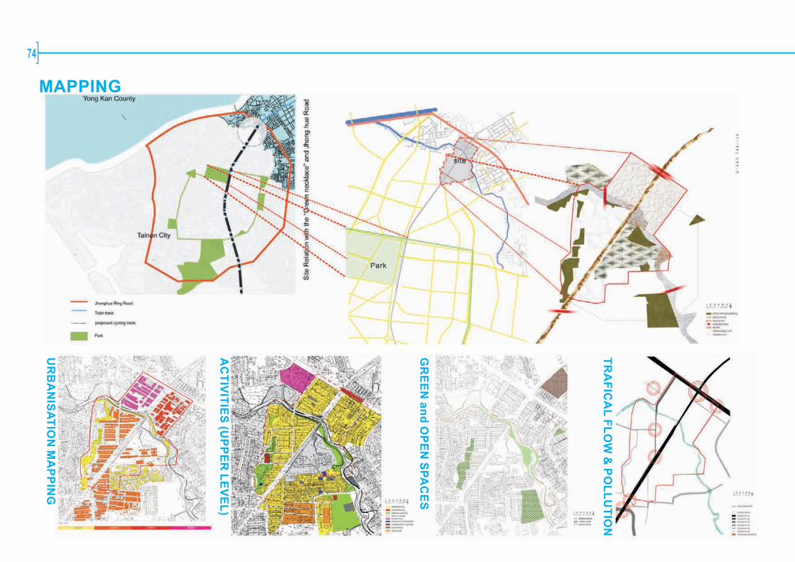
Urban Stitching
Project BackgroundOverview
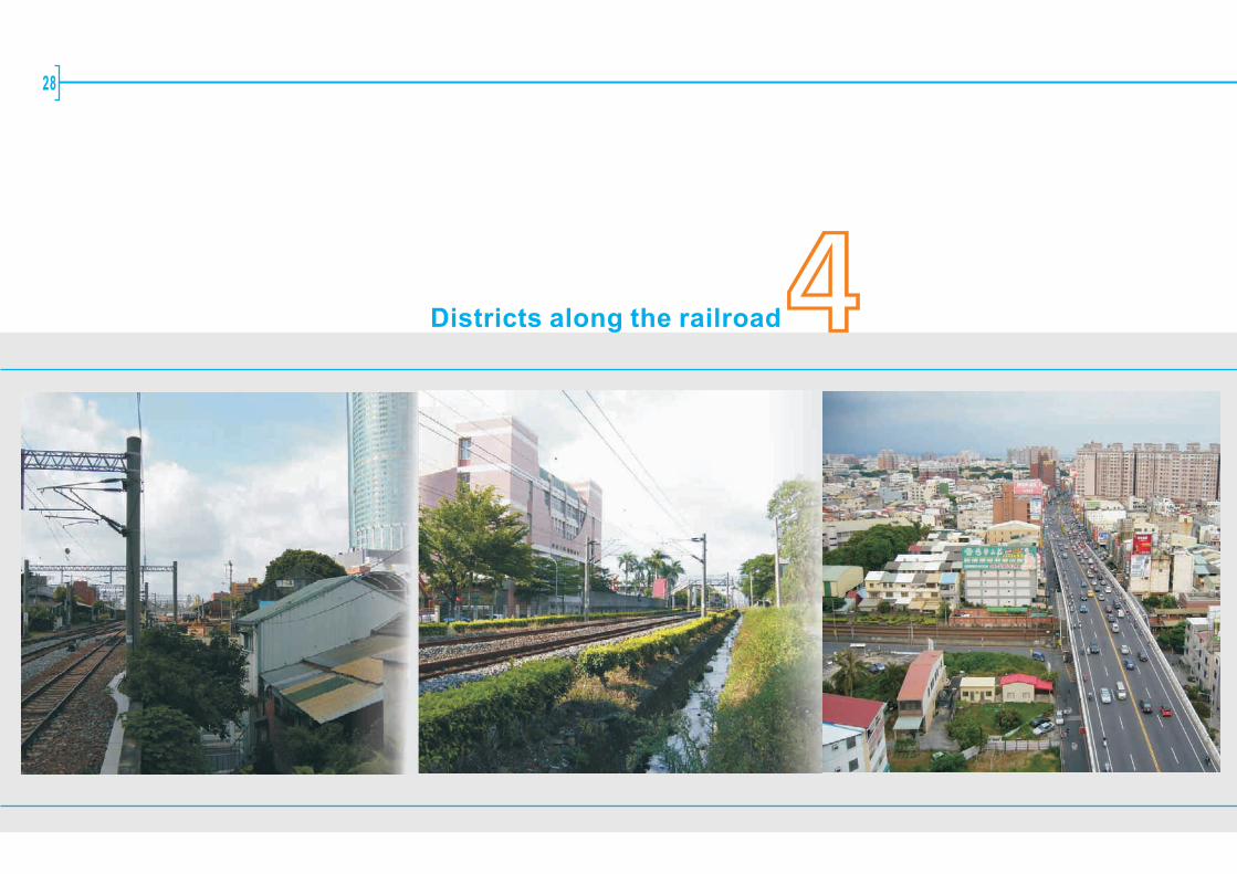
In year 1900 Tainan had its railway station. Railway then connected major cities
and towns west of the island. Over the century this then on the boundary
infrastructure has been incorporated into the city, seeing dense developments alongside and forming a linear barrier to the communication of both sides and a
blockage to the renewal of the city's transport and commercial center.
The plan to put the railway underground offers a great opportunity to stitch both
sides together. Apart from a new transport net and mode, a series of challenges
can be identified, such as the role of released lands and their relationship to
neighboring areas regarding function (land use), built form and meaning to both
this district and the city. The three sites selected for study are with varied
topographies, fabrics, natural assets and linkage problems thus raise similar planning issues with very different urban design challenges.
29
30
鐵路地下化計畫範圍示意圖
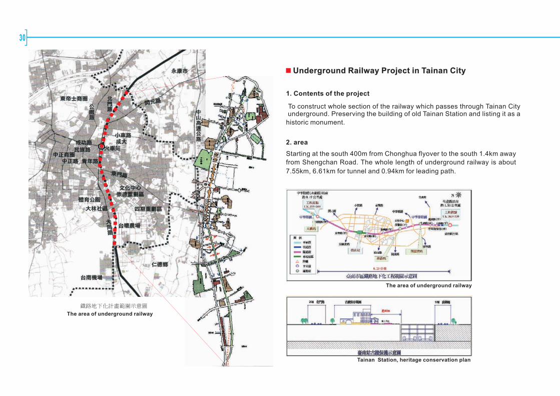
Underground Railway Project in Tainan City
1. Contents of the project
To construct whole section of the railway which passes through Tainan City underground. Preserving the building of old Tainan Station and listing it as a
historic monument.
2. area
Starting at the south 400m from Chonghua flyover to the south 1.4km away
from Shengchan Road. The whole length of underground railway is about
7.55km, 6.61km for tunnel and 0.94km for leading path.
The area of underground railway
Tainan Station, heritage conservation plan
The area of underground railway
Urban Stitching
Project Background
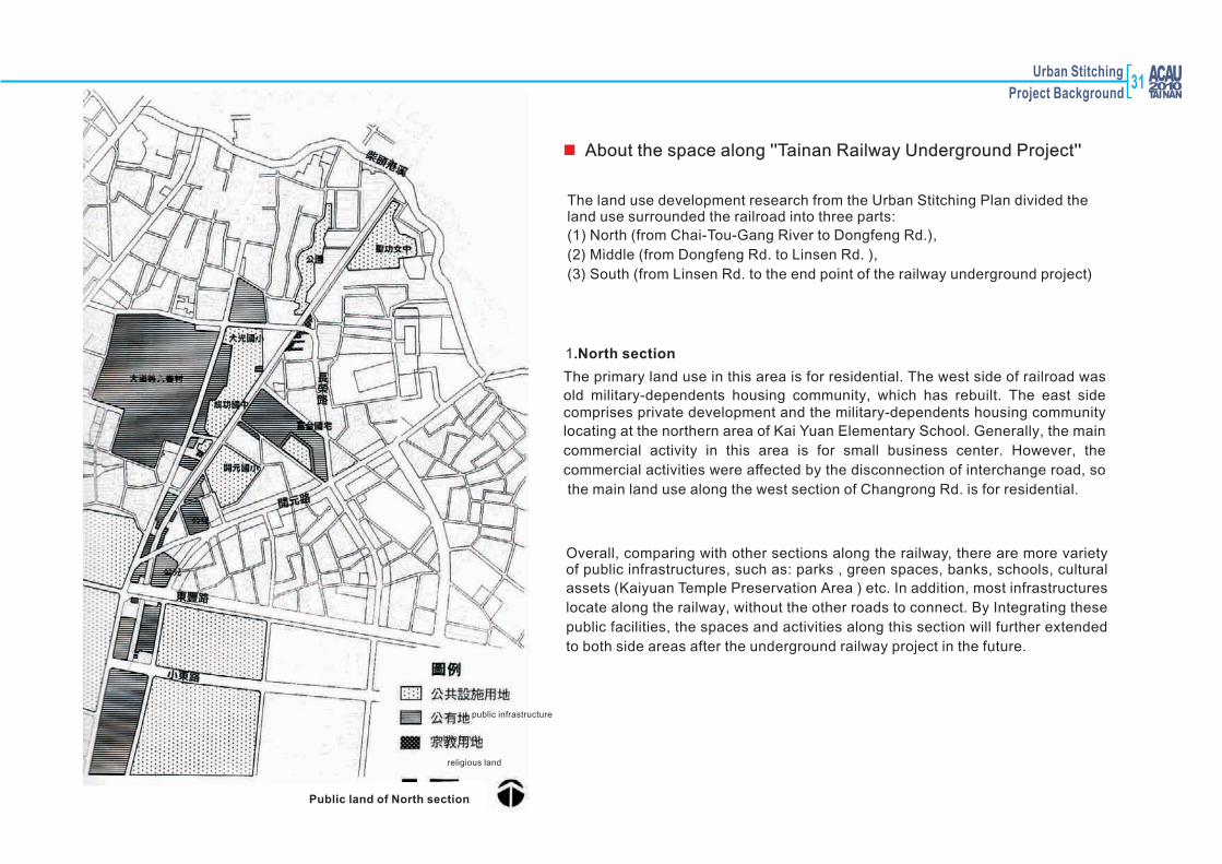
Public land of North section
The land use development research from the Urban Stitching Plan divided the land use surrounded the railroad into three parts:
(1) North (from Chai-Tou-Gang River to Dongfeng Rd.),
(2) Middle (from Dongfeng Rd. to Linsen Rd. ),
(3) South (from Linsen Rd. to the end point of the railway underground project)
About the space along ''Tainan Railway Underground Project''
1.North section
The primary land use in this area is for residential. The west side of railroad was
old military-dependents housing community, which has rebuilt. The east side comprises private development and the military-dependents housing community
locating at the northern area of Kai Yuan Elementary School. Generally, the main
commercial activity in this area is for small business center. However, the
commercial activities were affected by the disconnection of interchange road, so
the main land use along the west section of Changrong Rd. is for residential.
Overall, comparing with other sections along the railway, there are more variety of public infrastructures, such as: parks , green spaces, banks, schools, cultural
assets (Kaiyuan Temple Preservation Area ) etc. In addition, most infrastructures
locate along the railway, without the other roads to connect. By Integrating these
public facilities, the spaces and activities along this section will further extended
to both side areas after the underground railway project in the future.
public infrastructure
public land
religious land
31

32
The Tainan railway station located at the middle of Dongfeng road to Mingtzu road which closed to the central business district of Tainan City, the development at the both side along the railroad was different to each other. Excluding the Tainan station, the land use surrounded the middle part comprises the cargo space of Taiwan Tobacco and Liquor Corporation and Taiwan Railway Administration, as well as the terminal of Directorate General of Highways and commercial transportation, therefore the station become the important cargo and transportation hub. The back station situated at the east which closes to the NCKU campus,Liangmei commercial building, Tainan first high school and others. In other word, the east was mainly use for cultural and education. The west side was generally for commercial use. The north partpreviously populace by the military community, the urban renewing project implemented by the government has changed those area for public residential. The center part was the city center with highly commercial use. Consequently, there are three functions of land use surround this area, (1)commercial, (2) education, and (3) leisure. The railroad system has segregated the relationship between the three activities. Furthermore, there is no public infrastructure directly related to the railroad, for example, the Tainan Park, NCKU Guangfu campus and LiHsing campus. However, there is a need to relate those public infrastructures to the railway station in order to improve the spatial planning of Tainan City.
2.Middle section
public infrastructure
public land
religious land
Public land of middle section
Imagine Figure of Tainan Station

Urban Stitching
Project Background
The concept of spatial planning along the railroad
Concept Development
(1)rebuild the new spatial in education, recreation, culture and commercial through the coordinated the development form and land use along the railway(2)Integrate the existing activities along the railroad as well as planned an appropriate spatial scale of development by using the plane spaces
upper the Underground Railroad.(3)Provide the integration to the surrounded activities. (4)Suggest a reasonable procedure to the construction planning and transformation of land use.(5)Standardizes the form of land use development along the railroad, strengthen the efficiency of space
1.North section: Connecting the public facilities to the Life green belt
The specialty of this section is to organize the local activities and maintain the recreation spaces to fulfill and satisfy the needs of the populace as well as to improve the quality of environment.
2.Middle section: the core of recreation, culture, education, commercial and transportation hub.
The primarily development to this section is the train station; the southern was residential and commercial district. Due to strategically location of this section within the green belt system, therefore the future development position of this section must be offer the combination of culture, education, commercial and providing the convenience commuting as well as via the commercial space in Beimen Road.
3.South section: Access landscape road and urban farm
The essential planning of this section is to provide a north - south transit circulation. Hence, the development of the transit circulation needs to obtain the standard of access road. At the same time, contribute a circulation and leading the maintenance of green space at the both side of residential.
North section
Middle section
South section
The concept of spatial planning along the railroad
33
34
5Site 2: South of the Tainan Railway Station(districts along the railroad)
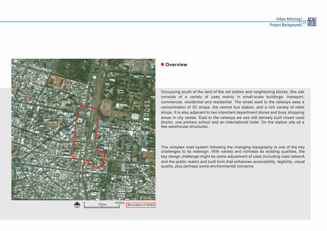
Urban Stitching
Project Background
Occupying south of the land of the rail station and neighboring blocks, this site
consists of a variety of uses mainly in small-scale buildings- transport,
commercial, residential and residential. The street west to the railways sees a
concentration of 3C shops, the central bus station, and a rich variety of retail
shops. It is also adjacent to two important department stores and busy shopping
areas in city center. East to the railways we see still densely built mixed used blocks, one primary school and an international hotel. On the station site sit a few warehouse structures.
The complex road system following the changing topography is one of the key challenges to its redesign. With variety and richness as existing qualities, the
key design challenge might be some adjustment of uses (including road network
and the public realm) and built form that enhances accessibility, legibility, visual quality, plus perhaps some environmental concerns.
Overview
750m 1500m0N Boundary of Site2
35

N
36
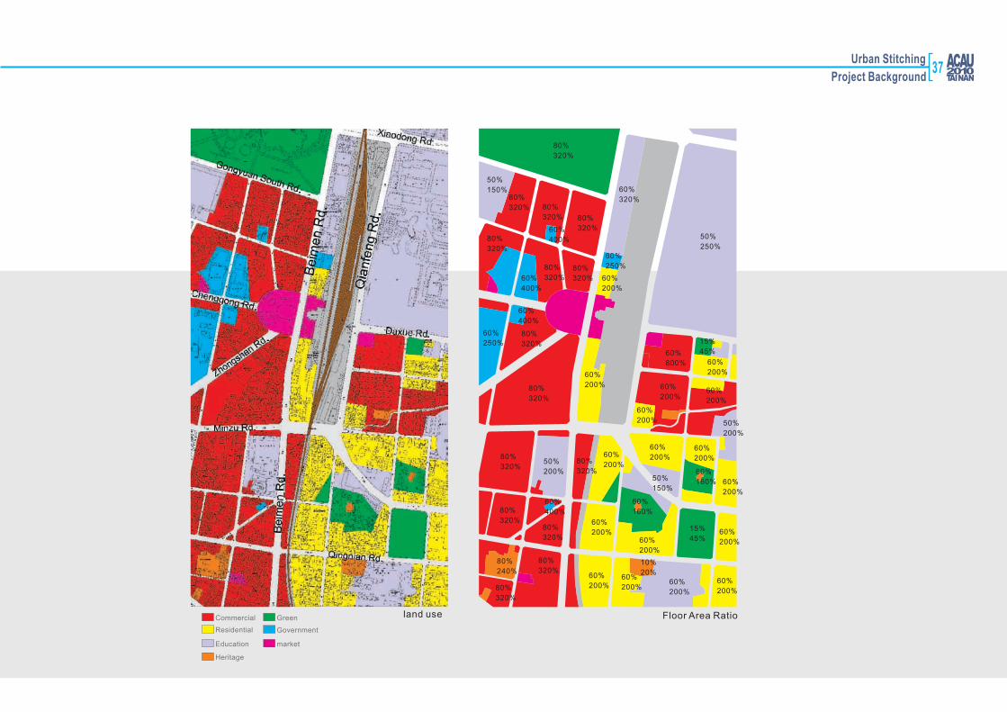
80%
320%
80%
320%
80%
320%
80%
320%
50%
150%
60%
400%
60%
400%
60%
250%
60%
200%
60%
320%
80%
320%
80%
320%
80%
320%
60%
200%
60%
400%
60%
250%80%
320%
80%
320%
80%
320%50%
200%
80%
320%80%
320%
80%
320%
80%
320%
60%
400%
80%
240%
80%
320%
60%
200%
60%
200%
60%
200%60%
200%60%
200%
10%
20%
60%
200%
60%
200%60%
200%
60%
200%
60%
200%
60%
200%
60%
200%
50%
150%
60%
160%
60%
160%
15%
45%
60%
200%
50%
200%
60%
200%
60%
800% 60%
200%
15%
45%
50%
250%
land use Floor Area RatioCommercial
Residential
Education
Heritage
Green
Government
market
Urban Stitching
Project Background37
38
6(districts along the railroad)
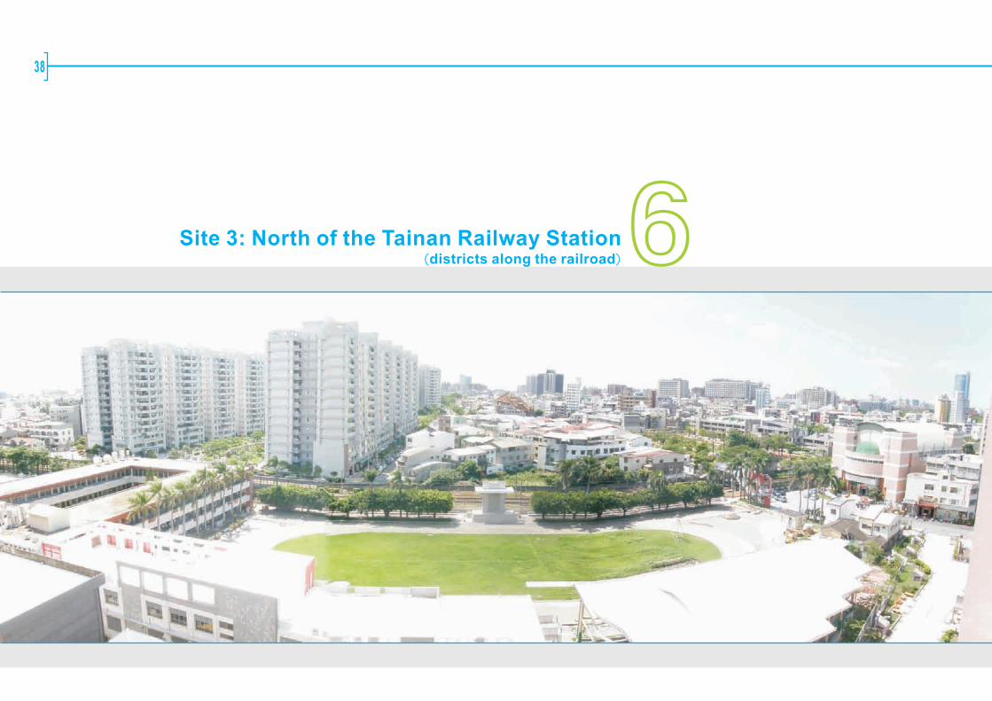
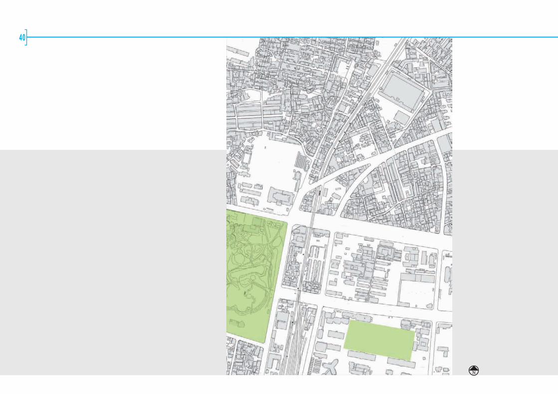
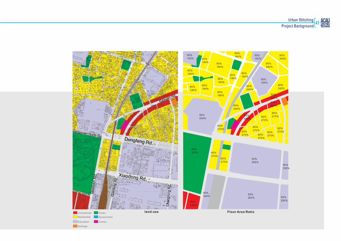
Site 3: North of the Tainan Railway Station

Urban Stitching
Project Background
This site is north to the railway station and occupies two narrow blocks flanked
by the city's central park and university campus and some areas cut out by roads, densely built with small scale mixed use structures. Local level retails can be seen on both sides of the main road east to the railway. The north section of
the city's green way that changes width here is one key element to be integrated
in the redevelopment. Accessibility, legibility and visual appropriateness might be the key qualities urban designer have to consider aside from the forming of a new public realm. Another challenge would be the relationship between the
northern and southern parts of the green way, regarding both land use and built
form.
750m 1500m0N Boundary of Site3
Overview
Overview
39
N
40
Urban Stitching
Project Background
land use Floor Area RatioCommercial
Residential
Education
Heritage
Green
Government
market
80%
320%
80%
320%
60%
320%50%
250% 50%
250%
50%
200%50%
200%
60%
270%60%
270%
50%
200%
60%
180%
60%
180%60%
180%
60%
180%
60%
180%
60%
180%
60%
180%
50%
150% 60%
180%
60%
180%50%
150%
60%
180%
60%
240%
60%
270%60%
270% 60%
270%
60%
270%
80%
480%
60%
240%
50%
150%
60%
240%
60%
240%
80%
480%
80%
320%
60%
270%
60%
270%
60%
270%
60%
270%
60%
240%
41
42
7(districts along the railroad)
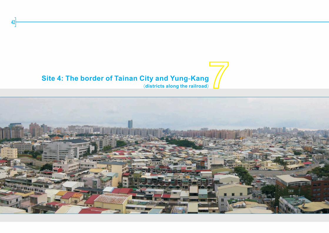
Site 4: The border of Tainan City and Yung-Kang

Urban Stitching
Project Background
750m 1500m0N Boundary of Site4
Overview
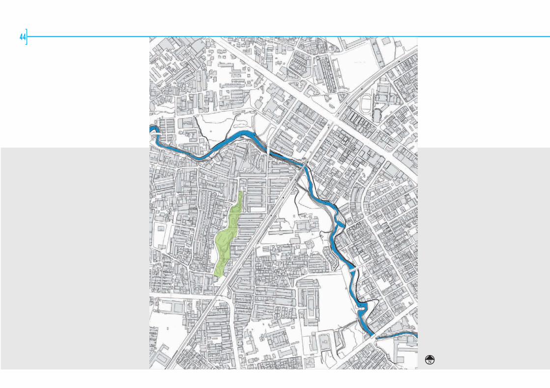
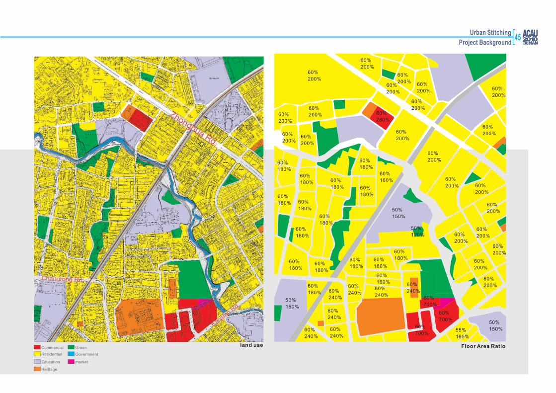
This site consists of a natural border between Tainan city and Yung Kang city (the Chaitougang River), the railway and neighboring blocks. Densely built residential areas with different patterns and a school are next to the river and therailway. The design of the land reclaimed from railway and the reconfiguration of some parcels of land would be significant to the enhancement of public spaces, and to fundamental urban design concerns regarding qualities of accessibility (especially to the river and needed open spaces), legibility, and variety etc.
Tainan City
Yung Kang city
Site location
Site 4
Present Development
Because of the good location and next to Tainan County, and with perfect urban
function services, convenient communications, adequate public infrastructures,
the development here is prosperous. The railroad passes through this area, and being the boundary between Liu-chia-ting area and Liu-chia-ting redevelopment
site. The Ta-chiao railway station is located on the site.
The site is located between Tainan County and Tainan City with indistinct administrative boundary. Both land use and the structure of urban space here are confused. Random developments toward the Chai-tou-kang gradually and make the spaces on the waterfront fragmentary.
1. highly mix with residential and commercial2. mix of new and old buildings
43
44
N
Urban Stitching
Project Background
land use Floor Area RatioCommercial
Residential
Education
Heritage
Green
Government
market
80%
280%
60%
200%
60%
200%
60%
200%
60%
200%
60%
200%60%
200%60%
200%
60%
180%60%
180%
60%
180%
60%
180%
60%
180%
60%
180% 60%
180% 60%
180%
60%
180%
60%
180%
60%
180%
60%
180%
60%
200%
60%
200%
60%
200%
60%
200%
60%
240%
50%
150%
50%
120%
60%
180%60%
180%
60%
180%
60%
180%
60%
240%
60%
240%60%
240%
60%
240%
60%
180%
60%
240%
50%
150%
60%
240%
60%
700%
60%
700%
60%
700%
50%
150%55%
165%
60%
200%
60%
200%
60%
200%
60%
200%
60%
200%
60%
200%60%
200%
60%
200%
60%
200%
60%
200%
60%
200%
45

46
8Appendix
Urban Stitching
Project Background
Reference Website
台南市政府 Tainan City Governmenthttp://www.tncg.gov.tw/
府城逍遙遊 The year of cultural tourismhttp://map.tncg.gov.tw/Default.aspx
台南市政府都發處 Department of Urban Development , Tainan City Governmenthttp://bud.tncg.gov.tw/bud_new/doc/main.asp
台南市政府文化觀光處 Department of Culture and Tourism , Tainan City Governmenthttp://culture.tncg.gov.tw/
台南市都市計畫書圖資訊系統 GIS urban planning mapshttp://bud.tncg.gov.tw/upmis/PUBhtml/index_PUB.htm
台南市電子地圖 GIS tourist mapshttp://map.tncg.gov.tw/english/MapIndex.aspx
美麗新世界-海安路藝術造街 Beautiful New Horizon—Art Street in Tainan
http://art138.myweb.hinet.net/01.htm
成功大學 National Cheng Kung Universityhttp://web.ncku.edu.tw/bin/home.php
47
48

Studio Workshop49
50
Studio Workshop51

52

Studio Workshop53
54

Studio Workshop55

56
57Studio Workshop

58

59Studio Workshop

60

61Studio Workshop

62

63Studio Workshop
64

65Studio Workshop

66
67Studio Workshop

68
69Studio Workshop

70
71Studio Workshop

72

73Studio Workshop
74

75Studio Workshop

768

77Studio Workshop
78

79Studio Workshop
80
Site:Haian Road District
Prof. Yang Seung Woo
Group 2
HKUNg Chi Yee, Corliss
Ng Yan KwanHKU
Chen NailuHKU
Lye Yee PeiNUS
Park, Yong RimUOS
Lee, Han BinUOS
Liang Tsu-YingNUS
Park, YoonUOS
Chung, Jun WooUOS
Srithongsuk, Kasin
Assumption
Lui Kam Fung Dennis
HKU
Aditya,Muhammad Bagus
Assumption
Shazana Binti Hashim
UM
Sawangsri, AlisaAssumption
Siti Yusrime Yusoff
UM
Lee Wei HongUM
Pricha, PimAssumption
Puan Shian YiUM
Weng, Yung FangNCKU
Liu, Fu MinNCKU
Chen, Ying RuNCKU
Lin, Huan ChunNCKU
Hsia, Fang WeiNCKU
Chiu, Yu ChenNCKU
Wang, Juei HsuanNCKU
Group 1
UOSMs.Anugool Bhumiwat
AssumptionProf. Wu, Yu Cheng
NCKUMr. Yen, Shih HuaNCKU
Ar. Lim Take BaneUM
Prof. Tsang, Thomas K.H.
HKUProf Kung Shiann Far
NCKUAr. NikhomNCKU
Site:South of The Tainan Railway Station

Urban Stitching
Group 3Site:The Border of Tainan City and Yung-Kang County
Dr. Naziaty Mohd Yaacob
Wong HarmonyHKU
Park, Dong ChoulUOS
Jang, Seong DoUOS
Son, Kyung MinUOS
Shaun Yeo Kee Aik
NUS
Kim, Se HyeonUOS
Somsantichai, Vorabhat
AssumptionNedup, Dechen Yangzom
Assumption
Suphavilai, LukAssumption
Nuriana HashimUM
Tsui Yu Yan, Natalie
HKU
Jaziah Binti Modh Ali
UM
Woo Yin ShanHKU
Murphy Wong Onn Tzuen
UM
Ahmad Faiz Noor Afandi
UM
Larissa Tan Jia YiNUS
Westchasart, Kwanchanok
Assumption
Huang, Jing WenNCKU
Weng, Yueh SungNCKU
Tsai, Wei JuNCKU
Greteman Daniel Alan
HKU
Yang, Ya TingNCKU
NCKUChang, Chia Fei
Wang, Shih TingNCKU
Ar. Chang,Ma LoneNCKU
Ar. Chen, Yu LinNCKU
Prof. Kim Sung Hong
UOS UOSMr. Florian
Benjamin Schaetz
NUSProf. Shin, Bum Shik
UOSChong Eun Kyong
UOSMr. Veera
Leelapattanaputi
AssumptionProf. Hsieh,
Horng Chang
NCKU
Group 4
Site:North of The Tainan Railway Station
81Participants

82
ACTIVITIES
Huang, Ting ShuoNCKU
Lai, Shuw WeiNCKU
Chao, Chen WeiNCKU
Tsai, Chiung YiNCKU
Wang, Li WuNCKU
Chou, Chung YanNCKU
Cheng, Ya LienNCKU
Saraya SaengathitNCKU
Chien, Chia YuNCKU

Urban Stitching
Activities83

84
Urban Stitching85
Activities
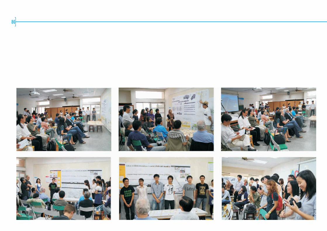
86

Urban Stitching87
Activities
Top Related