


Languages
Pages
Legal


A SELF-ADJUSTIVE GEOMETRIC CORRECTION METHOD FOR
SERIOUSLY OBLIQUE AERO IMAGE
IGARSS 2011 Vancouver, 24-29 July
Chunyuan Wang, Ye Zhang, Pigang Liu, Qi Xu, Yanfeng Gu
from Harbin Institute of Technology, China

Conclusion
Experiments & Results
Method & System
Analysis of the Projection Errors
Motivation
Content
Motivation
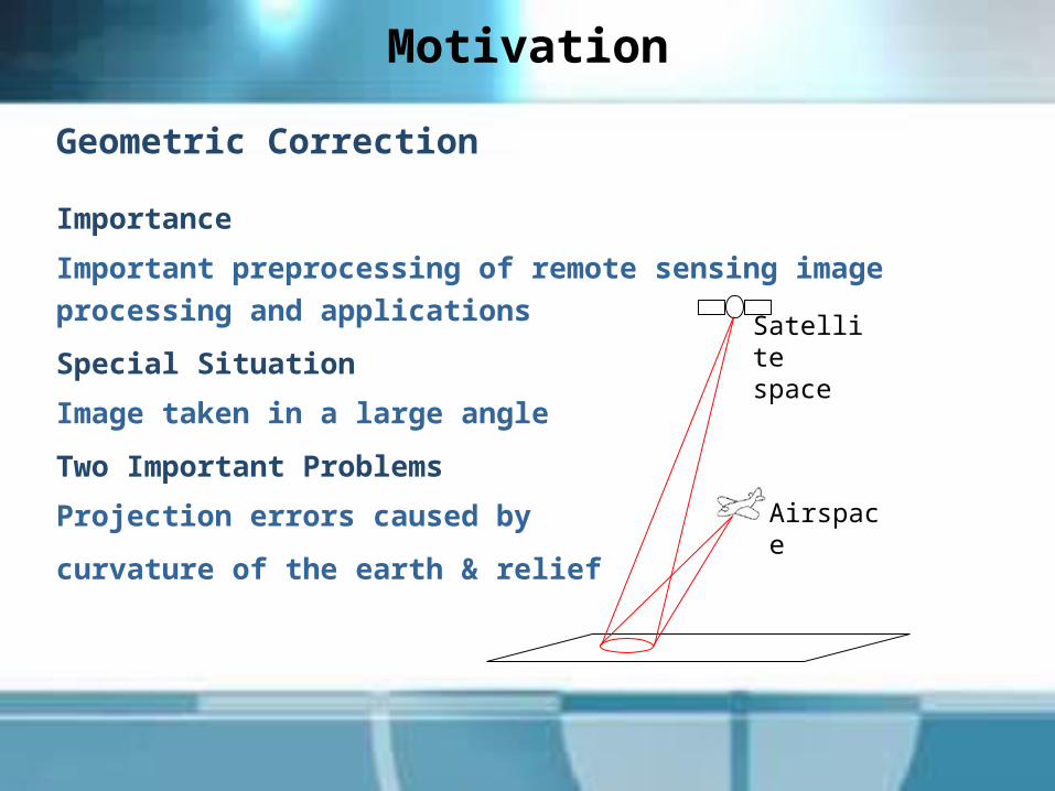
Geometric Correction
Importance
Important preprocessing of remote sensing image processing and
applications
Special Situation
Image taken in a large angle
Two Important Problems
Projection errors caused by
curvature of the earth & relief
Airspace
Satellite space
Conclusions
Experiments & Results
Method & System
Analysis of the Projection Errors
Motivation
Content

Analysis of the Projection Errors
1.Projection errors caused by relief
Linear displacement between image points
aa’: image point displacement caused by relief
f: the focal length of the sensorh: the relief height H: imaging height.
2)(aa'
tgHhH
tghf
Analysis of the Projection Errors
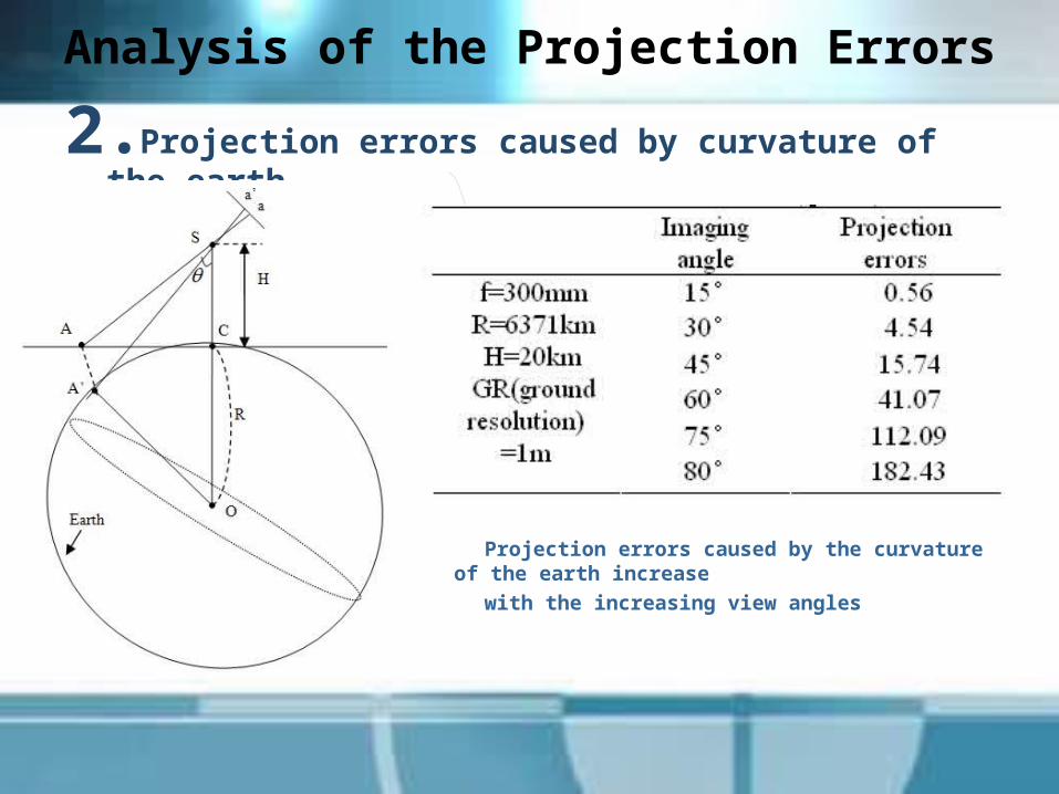
2.Projection errors caused by curvature of the earth
Projection errors caused by the curvature of the earth increase
with the increasing view angles

Conclusions
Experiments & Results
Method & System
Analysis of the Projection Errors
Starting point
Content

Method & System
Polynomial correction modelA fitting method using control points.
The quadratic term : effective correct projection errors caused
by the curvature of the earth The third dimension: effective correct projection errors
caused by relief via Digital Elevation
Model
Ternary quadratic polynomial
n
i
kin
j
jin
k
kjiijk
n
i
kin
j
jin
k
kjiijk
ZYXby
ZYXax
0 0 0
0 0 0
( for i,j,k=0,1,2 )
Method & System
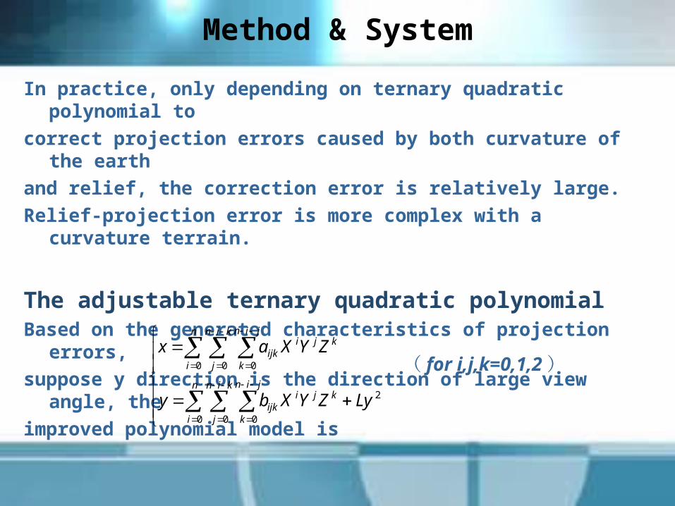
In practice, only depending on ternary quadratic polynomial to
correct projection errors caused by both curvature of the earth
and relief, the correction error is relatively large. Relief-projection error is more complex with a curvature
terrain.
The adjustable ternary quadratic polynomial Based on the generated characteristics of projection
errors, suppose y direction is the direction of large view angle,
the improved polynomial model is
n
i
kin
j
jin
k
kjiijk
n
i
kin
j
jin
k
kjiijk
LyZYXby
ZYXax
0 0 0
2
0 0 0 ( for i,j,k=0,1,2 )

Method & System
Polynomial correction process with self-adjustable model
Conclusions
Experiments & Results
Method & System
Analysis of the Projection Errors
Starting point
Content

Experiment
Dataset: gather from our simulation imaging systemImaging in the curvature surface on our earth model
with large view angles.
The control points and test points in all the experiments have
the same quantity and quality.
Two criterions :Root mean square error (RMSE) :
correction accuracy.Location errors of high objects (LER) : recovery accuracy of the roof location.

Experiment 1
1.Correction of curvature -projection error
80 degrees distorted image Quadratic polynomial Affine correction
The accuracy of correction (/pixels)

Experiment 2
2. Correction based on the self-adjustable model
65°distorted image
Ternary cubic polynomial Adjustable model
Reference image Ternary quadratic polynomial

Experiment 2
2. Correction based on the self-adjustable model

Conclusion
For correcting the seriously distorted image, the
new self-adjustable ternary quadratic polynomial
model alleviates the seriously distortions problem
caused by relief and earth curvature and recovers
the height objects’ location better. It is
experimentally demonstrated that self-adjustable
polynomial model outperforms the conventional
models and is effective for the seriously distorted
image acquired in large view angles.

Thank YouEmail: [email protected]
Top Related