


Languages
Pages
Legal


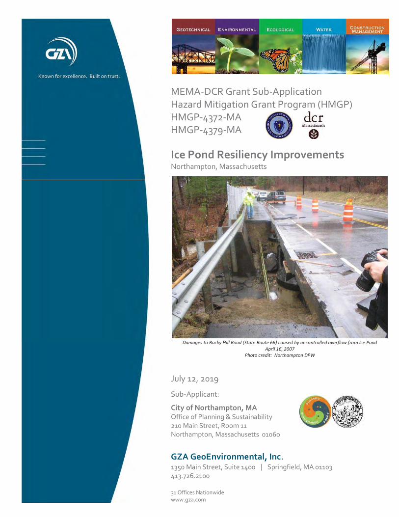
ICE POND RESILIENCY IMPROVEMENTS ROCKY HILL ROAD (RTE. 66)
NORTHAMPTON, MA
07/12/2019
TEJ
JRC
15.0166700.00
RFS
JRC
DMN
1 in = 2,000 ft
CITY OF NORTHAMPTON210 MAIN STREET,
NORTHAMPTON, MA 01060
1
0 2,000 4,0001,000
SCALE IN FEET
© 2
019
- GZA
Geo
Envi
ronm
enta
l, In
c. J
:\0 1
6670
0 - 0
166
799\
15.0
1667
00.0
0 N
orth
ampt
on G
reen
Infra
stru
ctur
e D
esig
ns\G
IS\m
xd\Ic
e Po
nd\L
ocus
_Map
.mxd
, Apr
il 11
, 201
9 - 3
:15:
44 P
M, j
acqu
elyn
.cla
ver
LOCUS MAP FIGURE
Service Layer Credits: Copyright:© 2013 National Geographic Society, i-cubed© 2019 Microsoft Corporation © 2019 DigitalGlobe ©CNES (2019) Distribution Airbus DS © 2019 HERE
DESIGNED BY:
PROJ MGR:
DATE:
REVIEWED BY:
DRAWN BY:PROJECT NO:
SCALE:
CHECKED BY:
PREPARED FOR:
REVISION NO:
PREPARED BY:
4
GZA GeoEnvironmental, Inc.Engineers and Scientists
www.gza.com
TRANSFER, REUSE, OR MODIFICATION TO THE DRAWING BY THE CLIENT OR OTHERS, WITHOUT THE PRIOR WRITTEN
UNLESS SPECIFICALLY STATED BY WRITTEN AGREEMENT, THIS DRAWING IS THE SOLE PROPERTY OF GZAGEOENVIRONMENTAL, INC. (GZA). THE INFORMATION SHOWN ON THE DRAWING IS SOLELY FOR THE USE BY GZA'SCLIENT OR THE CLIENT'S DESIGNATED REPRESENTATIVE FOR THE SPECIFIC PROJECT AND LOCATION IDENTIFIED ONTHE DRAWING. THE DRAWING SHALL NOT BE TRANSFERRED, REUSED, COPIED, OR ALTERED IN ANY MANNER FORUSE AT ANY OTHER LOCATION OR FOR ANY OTHER PURPOSE WITHOUT THE PRIOR WRITTEN CONSENT OF GZA, ANY
EXPRESS CONSENT OF GZA, WILL BE AT THE USER'S SOLE RISK AND WITHOUT ANY RISK OR LIABILITY TO GZA.
Project Location
17

LOT
29
MEMA-DCR Grant Sub-Application Hazard Mitigation Grant Program (HMGP) HMGP-4372-MA HMGP-4379-MA
Ice Pond Resiliency Improvements Northampton, Massachusetts
July 12, 2019
Sub-Applicant:
City of Northampton, MA Office of Planning & Sustainability 210 Main Street, Room 11 Northampton, Massachusetts 01060
GZA GeoEnvironmental, Inc. 1350 Main Street, Suite 1400 Springfield, MA 01103 413.726.2100
31 Offices Nationwide www.gza.com
Damages to Rocky Hill Road (State Route 66) caused by uncontrolled overflow from Ice Pond April 16, 2007
Photo credit: Northampton DPW

12
Photo 3. Rocky Hill Pond Brook as it enters the Ice Pond’s low-level outlet, showing excessive accumulations at the debris rack two days following overtopping of embankment and damages to Rocky Hill Road (April 18, 2007; NDPW)
Photo 4. Damages to Rocky Hill Road following embankment overtopping at Ice Pond (April 16, 2007; NDPW)
32
Top Related