


Languages
Pages
Legal


Special Notice The PIT Tag Specification Document is under revision. Much of the living content in the document, such as the Code Lists and the Steering Committee Member information, is updated regularly on the PTAGIS website. For the sections listed below, please use the corresponding link to the PTAGIS web page for the most up to date information.
Specification Doccument Section PTAGIS Web Page II, B: Data Use and Ethics Data Use Policy IV, A-K: Code Lists Current Validation Codes IV, L: PIT Tag Steering Committee Members PIT Tag Steering Committee Appendix C. Interrogation Site Configurations Interrogation Site Metadata

Columbia Basin PIT Tag Information System
2009
PIT Tag Specification
Document
Prepared by Pacific States Marine Fisheries Commission
for the PIT Tag Steering Committee
October 15, 2009
Compiled and Edited by
Dave Marvin and Jenn Nighbor

2009 PIT Tag Specification Document Table of Contents 2
Table of Contents
I. 2009 Changes .............................................................................................................................5
II. Overview ....................................................................................................................................6
A. PIT Tag Information System Data Event Model .................................................................6
B. Data Use and Ethics .............................................................................................................8
C. Procedure to Request a New Validation Code .....................................................................9
D. Separation by Code Support ................................................................................................9
III. Data File Definitions ................................................................................................................12
A. Tag Data File ......................................................................................................................12
B. MiniMon Interrogation File ...............................................................................................24
C. MultiMon File ....................................................................................................................27
IV. Code Lists ................................................................................................................................28
A. Species Codes ....................................................................................................................28
B. Run Codes ..........................................................................................................................28
C. Rearing Type Codes ...........................................................................................................29
D. Verbose Species Run and Rearing Type Codes .................................................................29
E. Coordinator ID Codes ........................................................................................................30
F. Conditional Comments (Flag Codes).................................................................................36
G. Hatchery Codes ..................................................................................................................39
H. Capture Method Codes ......................................................................................................41
I. Tagging Method Codes ......................................................................................................42
J. Organization Codes ............................................................................................................43
K. Tag, Release, and Recovery Site Codes .............................................................................44
L. PIT Tag Steering Committee Members, 2009 ...................................................................85
V. Glossary of Terms ....................................................................................................................86

2009 PIT Tag Specification Document Table of Contents 3
Appendix A. Hydrologic Unit Codes............................................................................................95
A1. Classification System .........................................................................................................95
A2. Explanation of Hydrologic Unit Codes..............................................................................96
A3. Hydrologic Unit Names .....................................................................................................96
A4. Columbia Basin Hydrologic Unit Codes ...........................................................................97
Appendix B. Antenna Group Naming Standards ..........................................................................99
B1. Naming Standard for PIT Tag Antenna Groups at Juvenile Fish Facilities ....................99
B2. Naming Standard Example ..............................................................................................100
Appendix C: Interrogation Site Configurations ..........................................................................101
C1. Bonneville Powerhouse 2 Juvenile (B2J).......................................................................102
C2. Bonneville Bradford Island Adult Fish Ladder (BO1)...................................................103
C3. Bonneville Cascades Island Adult Fish Ladder (BO2) ..................................................104
C4. Bonneville Washington Shore Adult Fish Ladder (BO3) ..............................................105
C5. Bonneville Washington Shore Ladder Vertical Slots (BO4) .........................................106
C6. Clark Flat Acclimation Site (CFJ) ..................................................................................107
C7. Easton Acclimation Site (ESJ) .......................................................................................108
C8. Little Goose Dam (GOJ) ................................................................................................109
C9. Lower Granite Dam Adult Fish Ladder and Trap (GRA) ..............................................110
C10. Lower Granite Dam Juvenile Fish Facility (GRJ) .......................................................111
C11. Ice Harbor Fish Ladders and Full Flow Bypass (ICH) ................................................112
C12. Jack Creek Acclimation Site (JCJ) ...............................................................................113
C13. John Day Dam (JDJ) ....................................................................................................114
C14. Lower Monumental Dam (LMJ) ..................................................................................115
C15. McNary Oregon Shore Ladder (MC1) .........................................................................116
C16. McNary Washington Shore Ladder (MC2) ..................................................................117

2009 PIT Tag Specification Document Table of Contents 4
C17. McNary Juvenile Fish Facility (MCJ) ..........................................................................118
C18. Priest Rapids Dam Fish Ladders (PRA) .......................................................................119
C19. Prosser Fish Ladders and Sampling Facility (PRO).....................................................120
C20. Rock Island Dam Fish Ladders (RIA)..........................................................................121
C21. Rocky Reach Dam Adult Fishway (RRF) ....................................................................122
C22. Roza Dam Adult Fishway (RZF) .................................................................................123
C23. Wells Dam Fish Ladders (WEA) ................................................................................124
C24. Interrogation Site Configuration History ......................................................................125
C25. Interrogation Site Operations History ...........................................................................187
Appendix D. Columbia Basin Hydrologic Unit Code (HUC) Maps ..........................................193
Appendix E. Perpetual Day-of-Year (DoY) Calendars ..............................................................198
E1. Perpetual DoY Calendar — Non-Leap Years ..................................................................198
E2. Perpetual DoY Calendar — Leap Years ..........................................................................199

2009 PIT Tag Specification Document I. 2009 Changes 5
I. 2009 Changes
The following is a list of significant changes made to the 2004 PIT Tag Specification Document resulting in this 2009 PIT Tag Specification Document:
1. Changed “2004” year references to “2009” throughout.
2. Section I now contains the list of changes from the previous document. Section II now contains the Program Overview.
3. Section II: Overview – Modified the “PIT Tag Data Event Model” and expanded the description.
4. Section II: Request PIT Tag Distribution – Removed section.
5. Section III: Updated all occurrences of “Tagging File” to “Tag Data File”, “Coil ID” to “Antenna ID”, “Checksum” to “Transceiver ID”, and “Monitor” to “Antenna Group”.
6. Section III: Updated the COORDINATOR ID tag header record definition to include references to a “long term project” as agreed to by the PTSC in 2005.
Section IV: Removed the redundant Tag, Release, Recovery Location Table sorted by River KM.

2009 PIT Tag Specification Document II. Overview 6
II. Overview
A. PIT Tag Information System Data Event Model Passive Integrated Transponder (PIT) tags have been used since 1987 to monitor the movement and behavior of anadromous salmonids in the Columbia and Snake River basins. The Columbia Basin PIT Tag Information System (PTAGIS) was implemented in 1991 to manage the collection, correlation, and exchange of Columbia Basin PIT tag data. PTAGIS encompasses dedicated data collection software, a centralized relational database management system, and standardized data descriptions and reporting processes. In 2002, the scope of the Columbia Basin PTAGIS program expanded to include entries for resident and semi-anadromous stocks of rainbow and cutthroat trout, bull trout, and lamprey, sturgeon and other species.
PIT Tag Data Event Model
Mark & Release
Detection & Recovery
Tag andReleaseEvent(TAG)
Interro-gationEvent(INT)
MortalityEvent(MOR)
Recapture &Re-release
Event(REC)
Figure 1: PIT Tag Data Event Model

2009 PIT Tag Specification Document II. Overview 7
Figure 1 illustrates the four general classes of PIT tag events represented in the PTAGIS database. First, every unique PIT tag code in the database is expected to have a single Tag and Release Event. This event is stored as a separate record in the database and is represented by record type “TAG”.
The second and third events, if they occur, happen subsequent to release. PIT-tagged fish may be physically recaptured one or more times, represented by record type “REC”. Each recapture is a separate Recapture and Re-release Event, and each of these events has a separate entry in the PTAGIS database. If, during a recapture event, a PIT-tagged fish dies, or a PIT tag from a previously released fish is recovered, then the observed or inferred death is recorded as a Mortality Event (record type “MOR”), and the PTAGIS database receives a single entry for each such event. Each of these events, in addition to the Tag and Release Event, is recorded and reported to PTAGIS in a Tag Data File. A single Tag Data File may contain entries for any one, two, or all three of the Tag and Release, Recapture and Re-release, and Mortality events.
In addition, fish may be interrogated one or more times as they pass fixed interrogation locations, represented by record type “INT”. PIT tag interrogation systems are deployed at numerous locations throughout the Columbia and Snake River basins. The tag codes of PIT-tagged fish are passively detected when the fish swim through or past one or more transceiver antennas at these locations. Each of these passive interrogations is recorded as an Interrogation Event, and entered into an Interrogation File. Many interrogation sites employ one or more groups of antennas, potentially resulting in multiple detections of an individual PIT tag per site. In addition, a single anadromous fish may encounter, and be passively detected at, multiple interrogation sites as the fish migrates downstream to the ocean, and yet again as it returns to freshwater to spawn. Most interrogation sites maintained by PTOC, and many of the sites maintained by other entities, detect essentially 100% of the PIT-tagged fish passing through the multiple antennae deployed at these sites. By default, every interrogation site is expected to operate to provide continuous and consistent detection capabilities, and the site’s Data Steward is responsible for documenting any conditions that reduce or impact those capabilities.
The design of the PTAGIS database has evolved to incorporate, relate, and report detailed information about PIT-tagged fish, using the four events defined in the PIT Tag Data Event Model. This Specification Document has been prepared to ensure that all PIT tag data entered into, and retrieved from, the PTAGIS database are consistent with the Model. Database flexibility exists to modify data inputs as the model evolves. However, all proposed changes to this document must be reviewed annually by the PIT Tag Steering Committee (PTSC). Review and modification of this Specification Document will occur annually prior to February, as PTAGIS project priorities and resources allow. Questions concerning this document should be addressed to the PTSC. (See PIT Tag Steering Committee Members, 2009 in Section IV.)

2009 PIT Tag Specification Document II. Overview 8
B. Data Use and Ethics At the March 24, 2004 PIT Tag Steering Committee meeting, the PTSC agreed to formalize the expectations of the community for the use of the PTAGIS data set. The consensus guidelines follow:
Those who submit data: 1. Data contributors recognize and accept that their data submitted to PTAGIS are
immediately available to other researchers and resource managers, who can use these data for their own, unpublished, analyses.
2. All data submitted to PTAGIS are associated with a Tag Data Coordinator, who can be contacted in order to verify the integrity of those data.
3. All data in the PTAGIS database are assumed to be preliminary, and as such unsuitable for formal analysis and review, until and unless the appropriate Tag Data Coordinator verifies the integrity of those data.
4. Data users will contact the appropriate Tag Data Coordinator(s) prior to including, summarizing, or referencing those data in any publication other than for internal distribution. This includes both peer-reviewed and non-reviewed documents. Data users will contact the Tag Data Coordinators in order to:
a) Obtain verification and context for data;
b) Secure appropriate permissions (in writing) prior to submission of this data for publication; and
c) Arrange appropriate acknowledgements, citations and/or authorships.
Those using data: The Data User is expected to contact the appropriate Tag Data Coordinator(s) prior to using data in any literature for other than internal distribution (both reviewed and non-reviewed documents) in order to:
a) Provide verification and context for data;
b) Secure appropriate permissions (in writing) prior to submission of this data for publication; and
c) Arrange appropriate acknowledgements, citations and/or authorships.

2009 PIT Tag Specification Document II. Overview 9
C. Procedure to Request a New Validation Code
Tag Data Coordinators are responsible for selecting the appropriate codes to use in marking, releasing and recapturing fish.
If Tag Data Coordinators require new codes in order to set up a new tagging, release, recapture or interrogation site, they should submit the new code request to their organization’s PIT Tag Steering Committee member for review and approval by the PTSC and inclusion into the next Specification Document. (See PIT Tag Steering Committee Members, 2009 in Section IV.)
If a Tag Data Coordinator has no PTSC representative, s/he may contact the PIT Tag Operations Center for assistance in setting up a new code.
D. Separation by Code Support
Introduction PIT tags have been used to track the movement of anadromous salmonids in the Columbia Basin since 1987. The automated PIT tag interrogation systems installed at hydroelectric dams within the Basin are integral to this mark/recapture system. Many of the smolts (including PIT-tagged fish) that approach these dams are diverted, concentrated, and routed through Juvenile Bypass Systems (JBSs) away from the turbines. The bypass systems at Lower Granite, Little Goose, Lower Monumental, and McNary dams include Juvenile Fish Facilities (JFFs), operated by the US Army Corps of Engineers (COE), from which smolts are collected and transported around the downstream dams. The bypass systems at these four sites, and at John Day and Bonneville dams, also include Juvenile Monitoring Facilities (JMFs); subsamples of fish are regularly diverted to the JMF and inspected to determine the magnitude, species composition, and condition of the collected population. Fish entering the various juvenile fish and/or monitoring facilities are routed through a series of flumes and pipes. These various routes are equipped with groups of PIT tag detection antennas, and provide a convenient and effective method to passively and non-lethally observe previously-tagged smolts as they migrate downstream.
Prior to 1993, the interrogation of PIT-tagged fish had no affect on the disposition of those fish as they migrated through the JFF. During those years, the majority of smolts collected at COE JFFs were transported below Bonneville Dam, and so most PIT-tagged fish were interrogated at no more than a single site. Beginning in 1993, control gates, activated by the detection of a PIT tag, were systematically employed at Lower Granite and Little Goose dams to return any PIT-tagged to the river, rather than to a barge or truck. PIT tag control gates were first employed at Lower Monumental Dam in 1994, and in 1995 at McNary dam. Returning tagged fish to the river increases the probability of multiple downstream detections, a key criterion for the generation of reach survival estimates.
Since 1997, PIT Tag Separation by Code (SbyC) activities have been implemented at the JFFs of various COE projects. In contrast to the diversion of any and all detected PIT-tagged fish, the SbyC technology allows the controlled segregation of individual marked fish as they are routed through a JFF. The SbyC technology has been used to satisfy both fisheries research and
2009 PIT Tag Specification Document II. Overview 10
management objectives. The National Marine Fisheries Service (now NOAA Fisheries) developed the SbyC protocol, including the creation of the MULTIMON.EXE software to link the tag recognition and segregation actions. A typical use of SbyC is to separate and sample individual marked fish from the general population of tagged and non-tagged animals. Another application of the SbyC technology is to divert a known proportion of a marked cohort either to or away from transportation vessels at a JFF, as part of a controlled study design. SbyC technology was first used to divert adult PIT-tagged fish at the Lower Granite Dam Adult Trap in 1997, and at the Bonneville Dam Adult Fish Facility in 2000.
PIT Tag Separation by Code in the Columbia Basin The PIT tag Separation by Code (SbyC) process allows researchers to selectively, automatically, and passively separate individual tagged fish from the general population as they swim or are swept through various juvenile and adult fish passage facilities in the Columbia and Snake rivers. Typical SbyC study objectives include detaining selected fish in a holding tank for further examination, or routing target fish directly to/from a transportation vessel. Computerized detection systems at these facilities recognize individual target fish as they are interrogated, and automatically send instructions that shunt the target fish to the requested destination. The desired SbyC action can be applied to an entire population of tagged fish, a proportion of that population, or a predefined number of individuals. Collection quotas can be set to limit the number of fish sampled, both daily and over the course of the study. Each SbyC action can be scheduled for a specified number of hours or days, or a specified pattern of days. Multiple populations can be identified and segregated at a given site, and separate SbyC actions can be assigned to each group at that site.
Please refer to http://www.ptagis.org/ptagis (and navigate to the Support → SbyC section) for details regarding the PIT tag Separation by Code capabilities at the various juvenile and adult passage facilities. If you have any questions about SbyC activities at these locations, please contact Dave Marvin at the PIT Tag Operations Center (503.595.3100). If you are contemplating an SbyC study of your own, please refer to the SbyC Coordination Overview.
SbyC Coordination Overview One requirement of a successful Separation by Code (SbyC) study is the coordination of that study with other Columbia Basin research and management programs. The successful study must also take into account the different capabilities and constraints of the SbyC facilities at the various hydroelectric projects. And, the successful SbyC program requires careful, coordinated implementation of the study parameters
Program Coordination
. All three of these coordination components must be addressed before the initiation of the SbyC study. The scope and duration of these coordination efforts will vary by study, but should generally be prioritized by "Program", "Project", and then "Study".
There are at least two, and potentially four, steps to coordinate SbyC projects at the regional, or Program level. All researchers must coordinate their prospective SbyC studies through the Columbia Basin Fish Passage Advisory Committee (FPAC), the regional forum for fisheries management and research. Each study must also be coordinated with the Columbia Basin PIT Tag Information System (PTAGIS). The PTAGIS program includes the PIT Tag Operations

2009 PIT Tag Specification Document II. Overview 11
Center (PTOC), which operates and maintains the Region's main stem PIT tag interrogation systems, including the SbyC components. Additionally, all research in the Columbia Basin is subject to the constraints of the Endangered Species Act (ESA). Essentially all SbyC activities will impact, directly or otherwise, one or more stocks of salmon or steelhead listed under the ESA, and must be covered by an ESA permit. Finally, SbyC activities are conducted at dams operated by the Army Corps of Engineers (COE), and may require coordination through the appropriate COE District office. Depending on the scope and complexity of the SbyC request, coordination with FPAC, PTAGIS, and the COE may require a lead time of anywhere from one month to one year. The initiation of any necessary ESA permit process requires a minimum of 90 days.
If your research targets another researcher's tagged fish, then you have the additional responsibility of first obtaining the permission of the original Tag Data Coordinator.
Project Coordination All researchers must coordinate their SbyC studies with the COE site biologist at each of the various fish facilities. At the juvenile fish facilities at Lower Granite (LGR), Little Goose (LGO), Lower Monumental (LMN), McNary (MCN), John Day (JDA), and Bonneville (BON) dams, prospective researchers must also contact the state-contracted Smolt Monitoring Program Leader. Researchers contemplating SbyC research at the Lower Granite Dam adult trap, operated by NOAA Fisheries (NMFS), must coordinate those activities with the NMFS on-site personnel. Any SbyC activity at the Bonneville Adult Fish Facility must be coordinated through FPAC. The amount and extent of coordination necessary at the Project level may vary from simple acknowledgement to a complex approval and scheduling process. Initial contact at the Project level should occur concurrent with, or soon after, the initial Program coordination.
Study Coordination All SbyC studies are implemented through the PIT Tag Operations Center (PTOC). At the Study level, researchers will define the individual tag codes of interest, and provide PTOC with any necessary scheduling information. PTOC requests a minimum of two weeks lead time between the receipt of the tag codes and scheduling information, and the implementation of the SbyC study. This lead time is in addition to the scoping and procedural development coordinated with PTOC through the Program-level coordination described above.

2009 PIT Tag Specification Document III. Data File Definitions 12
III. Data File Definitions PTAGIS recognizes three types of data files: Tag Data, MiniMon Interrogation, and MultiMon Interrogation. All files must be in ASCII format and cannot contain non-printable characters (e.g., <ESC> or <TAB>). Within each data class, all records must comply with the following specifications.
A. Tag Data File A Tag Data File is used to provide information on the tagging and release of newly marked fish. The Tag Data File may also include information on the recapture and/or mortality of previously PIT-tagged fish (See Recapture and Mortality definitions in the Glossary of Terms in Section V.). PTAGIS will accept Tag Data files created by the P3.EXE data entry and validation software. The current version of P3.EXE is available from the PTAGIS Web Portal at www.ptagis.org.
A Tag Data File consists of eight possible record categories. (1-4) PTAGIS requires that the Tag Data File contain a single record each of the File Type, Program Version, Session or Project Message, and End of File record types, and (5) exactly 19 Header records. (6) A Tag Data File contains zero or more Tag Detail records. (7) The inclusion of one or more Note records is optional. (8) A Variable Release Time Definition record is required for each unique release time variable used in one or more Tag Detail records.
In the ASCII output file, each Tag Detail record is distinguished by a right justified sequence number in columns 1-4. The contents of all other record types are preceded by spaces (ASCII character 32dec./ØH2Ø) in columns 1-4. The File Type, Program Version, Header, and End of File Record definitions are all formatted as follows: the record declaration begins in column five, a colon (":") appears in column 36, and the record contents are displayed beginning in column 38. The individual Tag Data File record types are defined in detail below.
1. File Type Record
Format: "FILE TYPE" starting in column 5; a colon (:) in column 36; and "TAGGING" starting in column 38. This record is generated by the software on the first line of the ASCII output file. This is a required record.
FILE TYPE : TAGGING

2009 PIT Tag Specification Document III. Data File Definitions 13
2. Program Version Record The only valid program version declaration is:
• PITTAG3 (version 1.0 or greater)
This record is generated by the software on the second line of the ASCII output file. This is a required record.
3. Session Message Text, 76 character input maximum. This required record is formatted by the software; and is delimited by dashed sequences on lines three and five of the ASCII output file. While the exact record content is left to the user's discretion, the Session Message should provide a summary of the purpose or scope of the tagging project.
4. Header Records The label contents, order, and format of the header records are standardized and cannot be changed. These are required records. The mandatory inclusion of record contents may be required, as individually noted.
FIELD NAME CONTENT MAND./OPT.
a. FILE TITLE xxxYYDDD.zzz Mandatory This required format is auto-generated by P3.EXE and consists of a valid
tagging data coordinator’s ID (initials) and the day-of-year (YYDDD). The contents of the extension (zzz) are required but left to the discretion of the tagging supervisor. However, as all data files submitted to PTAGIS must have unique titles, it is imperative that the “filename.extension” combination not conflict with any other PIT tag data file generated within the Columbia Basin.
b. TAG DATE MM/DD/YY hh:mm Mandatory This field records the date the tag data was collected. The value is generated by
the software, and defaults to the current computer date and time. This value can be modified in P3.EXE. When the Tag Data File contains records of PIT tag releases or recaptures/mortalities collected over multiple days then, by convention, the Tag Date field should contain the first day of sampling effort, the Release Date field (see below) should reference the last day of sampling effort, the actual dates of PIT tag release/recovery should be denoted using Variable Release Times (see below), and the procedure should be documented in a session Note (see below) preceding the first Tag Detail record (see below).
- - - - - - - - - - - - - - - - - - - - - - - - - - - - - - - SPCA habitat utilization study in Swimin River drainage, 2009 - - - - - - - - - - - - - - - - - - - - - - - - - - - - - - -

2009 PIT Tag Specification Document III. Data File Definitions 14
FIELD NAME CONTENT MAND./OPT.
c. TAGGER Lastname I Mandatory This field records the tagging supervisor or primary tagger's last name, a space,
and the tagger’s first initial, to a maximum of 15 characters.
d. HATCHERY SITE [Valid Hatchery] Optional When fish are obtained from a hatchery, this field contains the four-character
abbreviation from the domain of hatchery codes (See Hatchery Codes in Section IV.)
e. STOCK Text Optional This field contains a description of the genetic or geographic stock of fish, to a
maximum of 15 characters.
f. BROOD YR Nn Optional This field contains the last two digits of the calendar year when eggs were
deposited or collected, if known.
g. MIGRATORY YR Nn Mandatory This field contains the last two digits of the earliest possible calendar year
when juvenile anadromous fish will out-migrate. For a recapture/mortality event for resident species, or if anadromous adults are tagged, this value references the current calendar year.
h. TAG SITE [Valid Tag Site] Mandatory This field contains a code, from the domain of valid Tag and Release Site
codes, denoting the site where the fish were marked (see Tag, Release, and Recovery Site Codes in Section IV.) When reporting a recapture or mortality event, this code designates the recapture or mortality site.
i. RACEWAY/TRANSECT Text Optional This field contains an abbreviated description of the sampling location, to a
maximum of six characters.
j. CAPTURE METHOD [Valid Capture Method] Mandatory This field contains a code, from the domain of valid Capture Method codes,
denoting the method by which the fish were collected. (See Capture Method Codes in Section IV.)
k. TAGGING TEMP nn.n Mandatory This field contains the temperature (00.0-25.0°C, inclusive) of the tagging
water. A value of 25.0 should be entered if the water temperature is not obtained, or the value varies over the period of time the fish are tagged.

2009 PIT Tag Specification Document III. Data File Definitions 15
FIELD NAME CONTENT MAND./OPT.
l. POST TAGGING TEMP nn.n Optional When there is a significant time interval between the marking and release of
PIT-tagged fish, this field contains the temperature (00.0-25.0°C, inclusive) of the water in the post-tagging holding facilities (e.g., an outdoor raceway).
m. RELEASE WATER TEMP nn.n Cond. Mand.* This field contains the temperature (00.0-25.0°C, inclusive) of the water the
tagged fish were released into. This field is required when the Tag Data File provides Release Information. A value of 25.0 should be entered if the water temperature is not obtained, or the value varies over the period of time the fish are released.
n. TAGGING METHOD [Valid Tagging Method] Mandatory This field contains the four-character code, from the domain of valid Tagging
Method codes, denoting the method by which PIT tags were inserted into the fish. If all Tag Detail records in the file refer to the recapture or mortality of fish previously tagged, the value is “NONE”. (See Tagging Method Codes in Section IV.)
o. ORGANIZATION [Valid Organization] Mandatory This field contains the code, from the domain of valid Organization codes,
denoting the agency or entity responsible for the PIT tag marking or recovery activity. (See Organization Codes in Section IV.)
p. COORDINATOR ID [Valid Coordinator ID] Mandatory This field contains the code, from the domain of valid Coordinator ID codes,
identifying the individual or “long term” research program. The person associated with the COORDINATOR ID is responsible for the marking or recovery operation utilizing the PIT tags. He or she is also responsible for responding to inquiries from other entities regarding those operations. (See Rearing Type Codes in Section IV.) PTAGIS users must request new COORDINATOR ID codes from their PIT Tag Steering Committee representative. (See PIT Tag Steering Committee Members, 2009 in Section IV.)

2009 PIT Tag Specification Document III. Data File Definitions 16
FIELD NAME CONTENT MAND./OPT.
q. RELEASE DATE MM/DD/YY hh:mm Cond. Mand.* This field contains the date and time the tagged fish were released, in Pacific
Standard Time (PST). During a recapture event, this code designates the re-release date. This record is required when the Tag Data File provides Release Information. When the Tag Data File contains records of PIT tag releases or recaptures/mortalities collected over multiple days then, by convention, the Tag Date field (see above) should contain the first day of sampling effort, the Release Date field should reference the last day of sampling effort, the actual dates of PIT tag release/recovery should be denoted using Variable Release Times (see below), and the procedure should be documented in a session Note (see below) preceding the first Tag Detail record (see below).
r. RELEASE SITE [Valid Release Site] Cond. Mand.* This field contains a code (between four and six characters) denoting the site
where the tagged fish were released. When the file contains records detailing mortality or recapture events, this code denotes the mortality site or the re-release site. This field is required when the Tag Data File provides Release Information (see Tag, Release, and Recovery Site Codes in Section IV).
s. RELEASE RIVER KM nnn(.nnn) Cond. Mand.*
This field contains a series of three-digit values, separated by periods, corresponding to the lengths of river segments (in kilometers) between the mouth of the Columbia River and the release site. The total length of the field can not exceed 27 characters. This field is required when the Tag Data File provides Release Information (see Tag, Release, and Recovery Site Codes in Section IV).
*Cond. Mand. (Conditionally Mandatory): If any of the four header fields related to Release Information (Release Water Temp, Release Date, Release Site, or Release River KM) is submitted with data, then all four of those header records must contain data. In addition, if Variable Release Times are declared and defined within the Tag Detail records, all four Release Information header records must be completed.

2009 PIT Tag Specification Document III. Data File Definitions 17
5. Tag Detail Records Up to 9,999 Tag Detail records may appear in a Tag Data File.
FIELD NAME, DETAILS COLUMN # MAND./OPT.
a. SEQUENCE NUMBER 1-4 Mandatory This is a computer-generated value, incremented sequentially, and right-justified, with values between 1 and 9999, inclusive.
b. PITCODE 7-20 Mandatory1
Left-justified, hexadecimal. Two general formats are permitted. The first consists of a 10-character hex tag code, optionally trailed by two spaces (32dec./ØH2Ø) and a two-character hex checksum value. This mask is characteristic of 400 kHz PIT tags. (The P3.EXE software recognizes and reports 400 kHz PIT tags, but does not compute or include the checksum value in the Tag Detail record.) The second format consists of a 14-character hex tag code comprised of a three-character hex country code, a period (ASCII 46dec./ØH2E), and a 10-character hex ID code; this mask is typical of 134.2 kHz ISO-compliant Duplex-B PIT tags. PTAGIS also recognizes a series of 10 periods as a null PITCODE value.
c. FORKLENGTH 21-28 Optional Fork length of fish. Integer, right justified, in millimeters.
d. WEIGHT 29-38 Optional Weight of fish. Floating point numeric, right justified, and precise to a tenth of a gram.
e. COMMENTS There are three classes of comments: Positional, Conditional, and Textual. These comments are used to describe specific characteristics of individual fish.
1. POSITIONAL COMMENTS Only Positional Comments defined in this specification document may appear in columns 41-45 of the ASCII output file. The Positional Comments currently specified are as follows:
A. SPECIES 41 Mandatory Single alpha-numeric character. (See Species Codes in Section IV.)
1 PIT tags can only be re-used in the Columbia River system if each tag is removed from the fish and the tag code is changed to ten periods (. . . . . . . . . .), or the entire detail record is deleted from the Tag Data File prior to the submission of the file to PTAGIS. All other fields in the record should remain intact for future reference. PIT tags from recaptured fish CAN NOT be re-used, and MUST NOT be "dotted out."

2009 PIT Tag Specification Document III. Data File Definitions 18
FIELD NAME, DETAILS COLUMN # MAND./OPT.
B. RUN 42 Mandatory Single alpha-numeric character. (See Species Codes in Section IV.)
C. REARING TYPE 43 Mandatory Single-character text. (See Rearing Type Codes in Section IV.)
D. RELEASE TIME VARIABLE 44-45 Optional Two digits. These values allow users to specify multiple release times for Tag Detail records in a single file. Valid values are 00-99, inclusive. Each unique Release Time Variable used must have a corresponding Release Time Variable Definition that reports the actual date and time of release. (See Variable Release Time Declaration Records below.)
E. ADDITIONAL POSITIONAL COMMENTS Var. Optional Up to 45 columns of Additional Positional Comments, for use by individual research projects, may appear after column 45. These Additional Positional Comments are not recorded into the PTAGIS database.
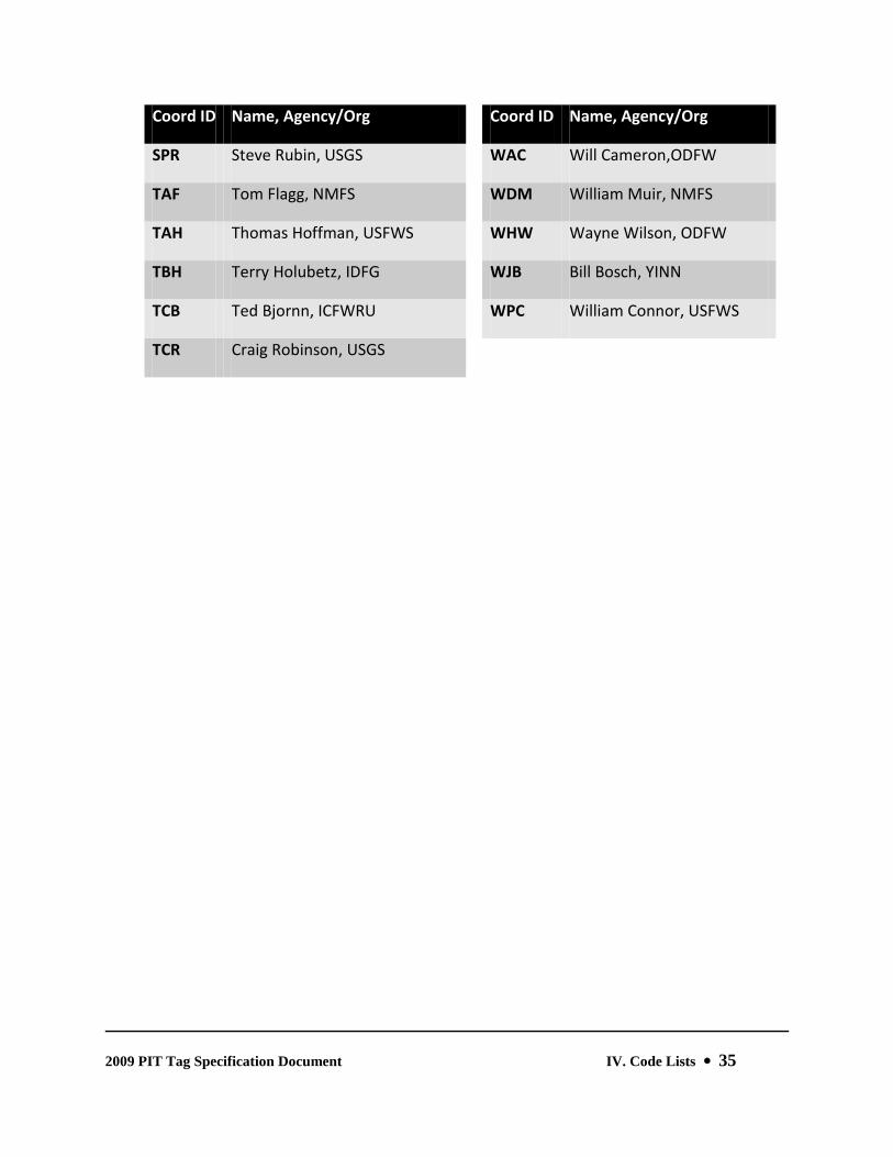
2. CONDITIONAL COMMENTS Var. Optional Conditional Comments, also known as Flag Codes, are used to systematically catalog a variety of morphological, environmental, and logical factors associated with a specific tagged fish. Conditional Comments, if present, appear after any Additional Positional Comments and are preceded by a single vertical bar symbol ("|", ASCII 124dec./ØH7C). Individual Conditional Comments are delimited with a single space. Only Conditional Comments approved by the PTSC will be recognized by PTAGIS. (See Conditional Comments (Flag Codes) in Section IV.)
By default, the Tag Detail Record describes a new Tagging event. However, the presence of a specific Flag Code in the Tag Detail Record can denote either a Recapture or Mortality event, as described below.
Recapture Events: A recapture is defined as a previously PIT-tagged fish that is handled subsequent to the release event. The Tag Data File is used to record captures. The Flag code RE or BT must be added to each recapture tag record in the Tag Data File. If all of the tag records in the Tag Data File reference recaptured fish, then the Header records will also reference those Recapture Events. In such a case, for example, the Tag Site will actually denote the Recapture Site, and the Release Date will serve as the re-Release Date.
For a list of the standard combinations of Species, Run, and Rearing Type Codes recognized by PTAGIS, (See Verbose Species Run and Rearing Type Codes in Section IV.)

2009 PIT Tag Specification Document III. Data File Definitions 19
Mortality Events: A mortality is defined as a PIT tag that is recovered, with or without its host animal, subsequent to the tagged release of that animal. One of the defined mortality flag codes (M, MB, MK, MS, L, SM) must be added to each corresponding mortality tag record in the Tag Data File. PIT tags recovered from Mortality Events are to be returned to the PTOC, if possible. The death of tagged fish and/or the retrieval of those tags prior to release are not
Adult Returns: Anadromous PIT-tagged fish returning to spawning locations may be recorded as Tagging, Recapture, or Mortality events. Any salmon or steelhead that has returned to the Columbia River Basin from the Pacific Ocean is considered to be a “Returning Fish” and should be flagged with the “RF’ code. Salmon and steelhead that are initially PIT-tagged as ocean returns should also be flagged with the “AT” code (Tagged as an Adult). In the case of all new tagging, recapture, or mortality events involving returning fish, the detail records should also be flagged with either an MT (for “Mature”), KL (for “Kelt”), JA (for “Jack”), or MJ (for “Minijack”) life stage code, as appropriate.
considered to be Mortality Events. In these circumstances, the original owner of the tag can remove ("dot-out") the reference to that tagging event in the original Tag Data File, submit the corrected file to PTAGIS, and then re-use the tag as part of a new tagging event.
FIELD NAME, DETAILS COLUMN # MAND./OPT.
3. TEXTUAL COMMENTS Var. Optional Textual Comments are separated from Conditional Comments by a single vertical bar symbol. If no Conditional Comments are present, Textual Comments are preceded by two vertical bar symbols "||". This field can hold up to 50 alphanumeric characters, including ASCII punctuation. While the contents of this field are unregulated, by convention Textual Comments are intended as ad hoc annotations unique to individual tag detail records rather than a common descriptor duplicated in all detail records.

2009 PIT Tag Specification Document III. Data File Definitions 20
6. Note Records Most Note Records are ad hoc annotations to the data file. Global comments pertaining to the tagging session are generally entered between the header and first Tagging Detail record, using the Session Note function in P3.EXE. Additional comments can be added within the Tagging Detail section during the tagging session. The format and content of all Note Records are ignored by PTAGIS.
7. Variable Release Time Declaration Records Format: VARIABLE RELEASE TIME DECLARATION: (One required for each unique release time variable used in the Tagging Detail records.) The VRT declaration begins with an upper case "V" in column five, followed by a two-digit release variable (nn) in columns six and seven, an equals sign "=" in column eight, the two digit month (MM) in columns nine and 10, a slash (/) in column 11, the two digit day (DD) in columns 12 and 13, a slash (/) in column 14, the two digit year (YY) in columns 15 and 16, a space in column 17, the two digit military-style hour of release (hh, 00-23), in Pacific Standard Time, in columns 18 and 19, a colon (:) in column 20, and the two digit minutes (mm) of release in columns 21 and 22.
Vnn=MM/DD/YY hh:mm
e.g., V01=04/08/09 16:45
When the Tag Data File contains records of PIT tag releases or recaptures/mortalities collected over multiple days then, by convention, the Tag Date field (see above) should contain the first day of sampling effort, the Release Date field (see above) should reference the last day of sampling effort, the actual dates of PIT tag release/recovery should be denoted using Variable Release Times (see above), and the procedure should be documented in a session Note (see above) preceding the first Tag Detail record (see above).
8. End of File Record The End of File record uses the same positional formatting as HEADER records. The record is created by P3.EXE and is required by PTAGIS as the last record in the file.
Format: “CLOSE DATE” beginning in column 5, a colon (":") at column 36, and a date/time stamp (MM/DD/YY hh:mm) starting at column 38. The time is reported in Pacific Standard Time (PST).
CLOSE DATE : 06/09/09 14:50

2009 PIT Tag Specification Document III. Data File Definitions 21
Example 1. Tag Data File with Predominantly New Tags
FILE TYPE : TAGGING PROGRAM VERSION : PITTAG3 1.4.5 - - - - - - - - - - - - - - - - - - - - - - - - - - - - - - - - - - - - - - TAGGING FILE EXAMPLE FOR 2009 SPECIFICATION DOCUMENT - - - - - - - - - - - - - - - - - - - - - - - - - - - - - - - - - - - - - - FILE TITLE : ATL09118.KF1 TAG DATE : 04/28/09 04:30 TAGGER : LOSER A HATCHERY SITE : STOCK : BROOD YR : MIGRATORY YR : 09 TAG SITE : KILFAT RACEWAY/TRANSECT : CAPTURE METHOD : SCREWT TAGGING TEMP : 8.9 POST TAGGING TEMP : RELEASE WATER TEMP : 8.9 TAGGING METHOD : HAND ORGANIZATION : SPCA COORDINATOR ID : ATL RELEASE DATE : 04/28/09 05:15 RELEASE SITE : KILFAT RELEASE RIVER KM : 999.748.048 MARKING AT KILLUM FALLS TRAP FOR AMERICAN SPCA. ONLY SALMONIDS MARKED. ALL FISH CAPTURED WERE TREATED WITH RESPECT AND WITHOUT CONSIDERATION OF EXTERNAL APPEARANCE, ECONOMIC IMPORTANCE, OR POSITION IN FOOD CHAIN. CLIP #Z194 1 3D9.1F5F6B187F 231 32H01 | AD | 2 3D9.1F565D5A54 223 32H01 | AD LV | 3 .......... 133 32H01 | AD L | THE BRUTE RESPONSIBLE FOR THE MURDER ABOVE HAS BEEN FIRED. 4 3D9.1F56304D0E 111 11H01 | AD RV | 5 3D9.200F03034B 118 11W01 | | 6 3D9.1F5F47310C 190 32H01 | AD 1> | 7 3D9.1F5627D4FA 213 32H01 | AD LV | 8 3D9.200F0E3112 240 32H01 | AD | < TIME CHECK > 04 APRIL 2009 AT 07:02 9 3D9.200F0E6E55 246 32W02 | RE | 10 3D9.1F57080B77 262 32H02 | AD LV 11 3D9.200F1D072D 186 32W02 | GS | 12 3D9.524336416C 224 110.7 32H02RART4| AD <2 PB| ROCKING "T" FREEZE BRAND . . . 1234 3D9.12349809D4 137 15.6 90U ||COCKROACH. BIG SUCKER. WITHOUT A VARIABLE RELEASE DECLARATION, THE PREVIOUS RECORD USES THE DEFAULT RELEASE DATE/TIME PROVIDED IN THE HEADER. 1235 3D9.42D980FD14 137 15.6 11H05 || 1236 3D9.5612FE09D3 104 11H05 || 1237 3D9.7DCA27F3B1 185 25.1 32W05 || V01=04/28/09 06:30 V02=04/28/09 07:20 V03=04/28/09 07:50 V04=04/28/09 07:55 V05=04/28/09 08:15 CLOSE DATE : 04/28/09 09:34

2009 PIT Tag Specification Document III. Data File Definitions 22
Example 2. Tag Data File Containing Recaptures of Previously-Tagged Fish
FILE TYPE : TAGGING PROGRAM VERSION : PITTAG3 1.4.5 - - - - - - - - - - - - - - - - - - - - - - - - - - - - - - - - - - - - - - 2009 SPCA HABITAT UTILIZATION AND BEHAVIOR STUDY; PIT TAG RECAPTURES - - - - - - - - - - - - - - - - - - - - - - - - - - - - - - - - - - - - - - FILE TITLE : ATL09091.KF1 TAG DATE : 04/01/09 10:30 TAGGER : LOSER A HATCHERY SITE : STOCK : BROOD YR : MIGRATORY YR : 09 TAG SITE : KILFAT RACEWAY/TRANSECT : CAPTURE METHOD : SCREWT TAGGING TEMP : 10.0 POST TAGGING TEMP : RELEASE WATER TEMP : 10.0 TAGGING METHOD : NONE ORGANIZATION : SPCA COORDINATOR ID : ATL RELEASE DATE : 06/01/09 12:00 RELEASE SITE : KILFAT RELEASE RIVER KM : 999.748.048 SEASONAL SUMMARY OF PIT TAG RECAPTURES AT KILLUM FALLS TRAP. SAMPLING OCCURRED 24x7 BETWEEN 4/1/09 AND 6/1/09, AS SHOWN IN THE TAG DATE AND HEADER RELEASE DATE FIELDS. TRAP WAS CHECKED DAILY. COLLECTED FISH WERE RE-RELEASED 100M ABOVE TRAP. WHEN USING P3.EXE, A NOTE IN THE TAG DETAIL SECTION IS LOGICALLY ASSOCIATED WITH THE TAG DETAIL RECORD IN WHICH IT IS CREATED, BUT THE NOTE IS REPORTED BELOW THAT TAG DETAIL RECORD IN THE ASCII TAGGING FILE. IF TAG DETAIL NOTES ARE CREATED AS VISUAL, RATHER THAN LOGICAL, CUES, THEN IT'S MORE LEGIBLE TO
REFERENCE THOSE RECORDS HERE IN THE SUMMARY. SO... THE ADULT IN RECORD #5 WAS RETRIEVED FROM THE MOUTH OF THE TRAP, SCANNED, AND ALLOWED TO RECOVER BEFORE BEING RE-RELEASED UPSTREAM. REGARDING THE FISH IN RECORD #1236: HE'S DEAD, JIM. 1 3D9.1F5F6B187F 231 32H01 | RE AD | 2 3D9.1F565D5A54 223 32H01 | RE AD LV | 3 3D9.1E004238E5 133 15U02 | RE | 4 3D9.1F56304D0E 111 15H03 | RE AD RV | 5 3D9.200F03034B 818 15W04 | RE RF MT MA | PRE-SPAWNER 6 3D9.1F5F47310A 190 32H05 | RE AD 1> | ... ... 1235 3D9.42D980FD14 137 15.6 45W78 | RE | 1236 3D9.5612FE09D3 104 15H78 | RE AD >2 M | IMPINGED BY DEBRIS 1237 3D9.7DCA27F3B1 185 25.1 32W79 | RE | V01=04/02/09 12:00 V02=04/04/09 12:00 V03=04/05/09 12:00 V04=04/06/09 12:00 V05=04/08/09 08:15 ... V78=05/29/09 12:00 V79=05/30/09 12:00 CLOSE DATE : 06/28/09 09:34

2009 PIT Tag Specification Document III. Data File Definitions 23
Example 3. Tag Data File Containing Mortalities of Previously-Tagged Fish
FILE TYPE : TAGGING PROGRAM VERSION : PITTAG3 1.4.5 - - - - - - - - - - - - - - - - - - - - - - - - - - - - - - - - - - - - - - 2009 RETURNS TO SWIMIN HATCHERY - - - - - - - - - - - - - - - - - - - - - - - - - - - - - - - - - - - - - - FILE TITLE : ATL09091.SIH TAG DATE : 04/01/09 10:30 TAGGER : LOSER A HATCHERY SITE : STOCK : BROOD YR : MIGRATORY YR : 09 TAG SITE : SWIH RACEWAY/TRANSECT : CAPTURE METHOD : HATCH TAGGING TEMP : 10.0 POST TAGGING TEMP : RELEASE WATER TEMP : 10.0 TAGGING METHOD : NONE ORGANIZATION : SPCA COORDINATOR ID : ATL RELEASE DATE : 09/01/09 12:00 RELEASE SITE : SWIH RELEASE RIVER KM : 999.888.777 SEASONAL SUMMARY OF PIT TAG RETURNS TO SWIMIN HATCHERY IN 2009. COLLECTION INCLUDED NATURAL AND SUPPLEMENTATION STOCKS. THESE WERE SEGREGATED, TUBE-SCANNED, AND RETURNED TO THE SWIMIN RIVER DAILY. ALL HATCHERY STOCK WERE COLLECTED, SCANNED, AND SPAWNED. ADULTS WERE PONDED FROM 4/01/09 THROUGH 9/01/09, AS SHOWN IN THE TAG DATE AND HEADER RELEASE DATE FIELDS. THE ACTUAL DATES OF TAKE OR RE-RELEASE ARE REPORTED IN THE DETAIL RECORDS.
1 3D9.1F5F6B187F 834 12H01 | RF MT RE M | 2 3D9.7F7F5D5A54 982 12H01 | RF MT RE M | 3 3D9.7F7E4238E5 913 12H02 | RF MT RE M | 4 3D9.1F56304D0E 15U03 | RF MT RE | NATIVE 5 3D9.200F03034B 1043 12H04 | RF MT RE M | 6 3D9.1F5F47310A 967 12H05 | RF MT RE M |
... ...
272 7F7D629176 15U78 | RF MT RE | NATIVE 273 3D9.5612FE09D3 982 12H78 | RF MT RE M | 274 3D9.7DCA27F3B1 991 12H79 | RF MT RE M |
V01=04/09/09 12:00 V02=04/09/09 12:00 V03=04/19/09 12:00 V04=04/20/09 12:00 V05=04/21/09 09:15
...
... V78=08/19/09 12:00 V79=08/28/09 12:00
CLOSE DATE : 09/21/09 15:12

2009 PIT Tag Specification Document III. Data File Definitions 24
B. MiniMon Interrogation File Interrogation files are computer-generated using the MINIMON.EXE program. The format is described below. Interrogation Site Codes, transceiver ID Codes, and Antenna ID codes must be defined by PTAGIS before data can be incorporated into the PTAGIS database.
Interrogation files consist of five record categories: File Type, Start Message Records, Interrogation Data Records, Other Record Types, and an End of File Record.
1. File Type Record
2. Start Message Records Like the File Type record, Start Message Records begin in column 5, followed by a colon (“:”) in column 36 and the correctly formatted value beginning in column 38.
FIELD NAME FORMAT MANDATORY
a. FILE TITLE SSSYYJJJ.Aaa Mandatory File Titles contain a maximum of 12 alpha-numeric characters. The format consists of a three-character site code (SSS), two-digit year (YY), and three-digit day-of-year (JJJ). The file extension (Aaa) is at least one and no more than three alphanumeric characters. This record is generated by the software on the second line of the ASCII file. This is a required record.
b. FILE CREATED DD Month YYYY AT HH:MM Mandatory Date and time (e.g., 24 April 2009 AT 16:45). This record is generated by the software on the third line of the ASCII file. The format is in “little endian form”, which is common to the vast majority of the world’s countries. The format is space separated, beginning with the two digit day of the month, followed by the full month name followed by a four digit year, two digit hour based upon twenty-four hour clock time and two digit minutes of the hour. The date and time, in Pacific Standard Time, denotes when passive interrogation monitoring began for this file. This is a required record.
c. PROGRAM VERSION MINIMON v.1.x.x Optional
Format: "FILE TYPE" beginning in column 5; a colon (“:”) in column 36; and "INTERROGATION" starting in column 38. This record is generated by the software on the first line of the ASCII file. This is a required record.
FILE TYPE : INTERROGATION

2009 PIT Tag Specification Document III. Data File Definitions 25
3. Interrogation Data Records Individual records, if present, consist of the following required components. Optional
FIELD NAME FORMAT COLUMN #
a. DATA TOKEN "|" (a "vertical bar" or "pipe" 1 symbol, ASCII 124dec./ØH7C)
b. PORT ID 2-char Hexadecimal 3-4
c. DATE MM/DD/YY 6-13
d. TIME hh:mm:ss (PST) 15-22
e. PITCODE 14-char (3.10) hexadecimal 24-37
f. TRANSCEIVER ID "XX" or FS1001M transceiver ID 39-40
g. ANTENNA ID 2-char hexadecimal 42-43
4. Other Record Types a. Status and Warning Messages Optional
Records prefaced with a tilde ("~") in the first column contain information regarding site and transceiver operations.
b. Annotations Optional Records prefaced with an exclamation point ("!") contain manually-appended annotated notes and documentation.
c. Buffered Records Optional Records prefaced with an asterisk ("*") have been downloaded from a transceiver buffer and contain date and time stamps assigned by the transceiver’s clock.
d. Blank Lines Optional

2009 PIT Tag Specification Document III. Data File Definitions 26
5. End of File Record
FILE CLOSED DD MONTH YYYY AT HH:MM Mandatory Date and time (e.g., 24 April 2009 AT 16:45). The format is identical to the FILE CREATED record, beginning with the two digit day of the month, followed by the full month name followed by a four digit year, two digit hour based upon twenty-four hour clock time and two digit minutes of the hour. The date and time, in Pacific Standard Time, denotes when passive interrogation monitoring concluded. This is a required record generated by MINIMON.EXE on the last line of the ASCII file.
Test Tags
Test tags are used to monitor the operation of an interrogation unit. There are two types of test tags. The first type is referred to colloquially as a stick tag, or formally as a Variable Reference Tag. These tags are usually embedded in a piece of wood and passed through the detection field of an antenna or antenna group. The second type of test tag is referred to colloquially as a timer tag or formally as a Fixed Reference Tag. These "tags" are passive, electronic devices powered by the electro-magnetic field of the interrogation unit they are testing. Each timer tag is permanently mounted in the unit and fires at a specified frequency.
ALL TEST TAGS MUST BE REGISTERED WITH PTOC BEFORE USE.
(See http://www.ptagis.org/ptagis; after logging in, select Services → Register Test Tags)

2009 PIT Tag Specification Document III. Data File Definitions 27
C. MultiMon File The MULTIMON.EXE program was developed by the National Marine Fisheries Service (NOAA-Fisheries) for the interrogation of PIT-tagged fish at main stem Columbia and Snake River collection and sampling facilities. In addition to simply recording interrogation data, MULTIMON.EXE is designed to react to the presence of specific fish and trigger electrical or mechanical operations to control the routing of those fish through research facilities. This capability is a keystone of Separation by Code activities. The MULTIMON.EXE ASCII file output includes not only interrogation records, but configuration and diagnostic records relating to the program's logical processes. PTAGIS only recognizes MultiMon data collected at detection sites maintained by PTOC.
Example 4. Interrogation File
FILE TYPE : INTERROGATION FILE TITLE : DOJ09121.C FILE CREATED : 30 APRIL 2009 AT 12:00 PROGRAM VERSION : MINIMON v.1.5.3
~04/30/09 13:00:05 | 06 04/30/09 13:09:05 3D9.1BF0F0DC2F XX 10 | 05 04/30/09 13:09:06 3D9.1BF0F0DC2F XX 11 ~04/30/09 14:00:05 ~04/30/09 15:00:04 | 06 04/30/09 15:01:51 3D9.1BF0E974D5 XX 10 | 05 04/30/09 15:01:52 3D9.1BF0E974D5 XX 11 | 06 04/30/09 15:22:51 3D9.1BF0E59874 XX 10 | 05 04/30/09 15:22:52 3D9.1BF0E59874 XX 11 | 06 04/30/09 15:33:13 3D9.1BF0F123E1 XX 10 | 05 04/30/09 15:33:14 3D9.1BF0F123E1 XX 11 | 06 04/30/09 15:49:10 3D9.1BF0E677B0 XX 10 | 05 04/30/09 15:49:11 3D9.1BF0E677B0 XX 11 | 06 04/30/09 15:56:29 3D9.1BF0E68597 XX 10 | 05 04/30/09 15:56:30 3D9.1BF0E68597 XX 11 ~04/30/09 16:00:03 | 06 04/30/09 16:07:42 3D9.1BF0F195C7 XX 10 | 05 04/30/09 16:07:43 3D9.1BF0F195C7 XX 11 | 06 04/30/09 16:07:44 3D9.1BF0E96F68 XX 10 | 06 04/30/09 16:33:06 3D9.1BF0F5D3EF XX 10 | 05 04/30/09 16:33:07 3D9.1BF0F5D3EF XX 11 ~04/30/09 17:00:03 | 06 04/30/09 17:19:11 3D9.1BF0E67D24 XX 10 | 05 04/30/09 17:19:12 3D9.1BF0E67D24 XX 11 | 06 04/30/09 17:45:17 3D9.1BF0E6A631 XX 10 | 05 04/30/09 17:45:18 3D9.1BF0E6A631 XX 11 ~04/30/09 18:00:02

2009 PIT Tag Specification Document IV. Code Lists 28
IV. Code Lists The following standardized codes are used in the Columbia River Basin PIT Tag Information System (PTAGIS). Tag Data Coordinators can submit additional codes and definitions to their respective PIT Tag Steering Committee representative for review and approval.
The code domains listed below are complete as of September 1, 2009. However, codes may be added or modified at any time. The current values of all code lists can be accessed and downloaded from the PTAGIS Web Portal at http://www.ptagis.org.
A. Species Codes
Code Species Code Species
0 Unknown A Lamprey
1 Chinook B White Sturgeon
2 Coho C Green Sturgeon
3 Steelhead D Northern Pikeminnow
4 Sockeye E Brook Trout
5 Chum F American Shad
6 Pink G Mountain Whitefish
7 Bull Trout H Walleye
8 Cutthroat Trout I Channel Catfish
9 Other J Smallmouth Bass
B. Run Codes
Code Run Code Run
0 N/A 4 Winter

2009 PIT Tag Specification Document IV. Code Lists 29
1 Spring 5 Unknown
2 Summer R Resident
3 Fall
C. Rearing Type Codes
Code Rearing Type
H Hatchery Reared
U Unknown
W Wild Fish or Natural Production
D. Verbose Species Run and Rearing Type Codes
Code Verbose Description Code Verbose Description
00U Unknown (fish not observed) 42H Hat. Summer Sockeye
11H Hat. Spring Chinook 42U Summer Sockeye (unknown r/t)
11U Spring Chinook (unknown r/t) 42W Wild Summer Sockeye
11W Wild Spring Chinook 45H Hat. Sockeye (unknown run)
12H Hat. Summer Chinook 45U Sockeye (unknown run & r/t)
12U Summer Chinook (unknown r/t) 45W Wild Sockeye (unknown run)
12W Wild Summer Chinook 65W Wild Pink
13H Hat. Fall Chinook 7RW Bull Trout
13U Fall Chinook (unknown r/t) 85H Hat. Coastal Cutthroat
13W Wild Fall Chinook 85U Coastal Cutthroat (unknown r/t)

2009 PIT Tag Specification Document IV. Code Lists 30
15H Hat. Chinook (unknown run) 85W Wild Coastal Cutthroat
15U Chinook (unknown run & r/t) 8RW Wild Resident Cutthroat
15W Wild Chinook (unknown run) 90U Other
25H Hat. Coho A0W Lamprey
25U Coho (unknown r/t) B0W White Sturgeon
25W Wild Coho C0W Green Sturgeon
32H Hat. Summer Steelhead D0W Northern Pikeminnow
32U Summer Steelhead (unknown r/t) ERU Brook Trout
32W Wild Summer Steelhead F0W American Shad
34H Hat. Winter Steelhead G0W Mountain Whitefish
34W Wild Winter Steelhead H0W Walleye
35H Hat. Steelhead (unknown run) I0W Channel Catfish
35U Steelhead (unknown run & r/t) JOW Smallmouth Bass
35W Wild Steelhead (unknown run)
3RH Hat. Rainbow Trout
3RU Rainbow Trout (unknown r/t)
3RW Wild Rainbow Trout
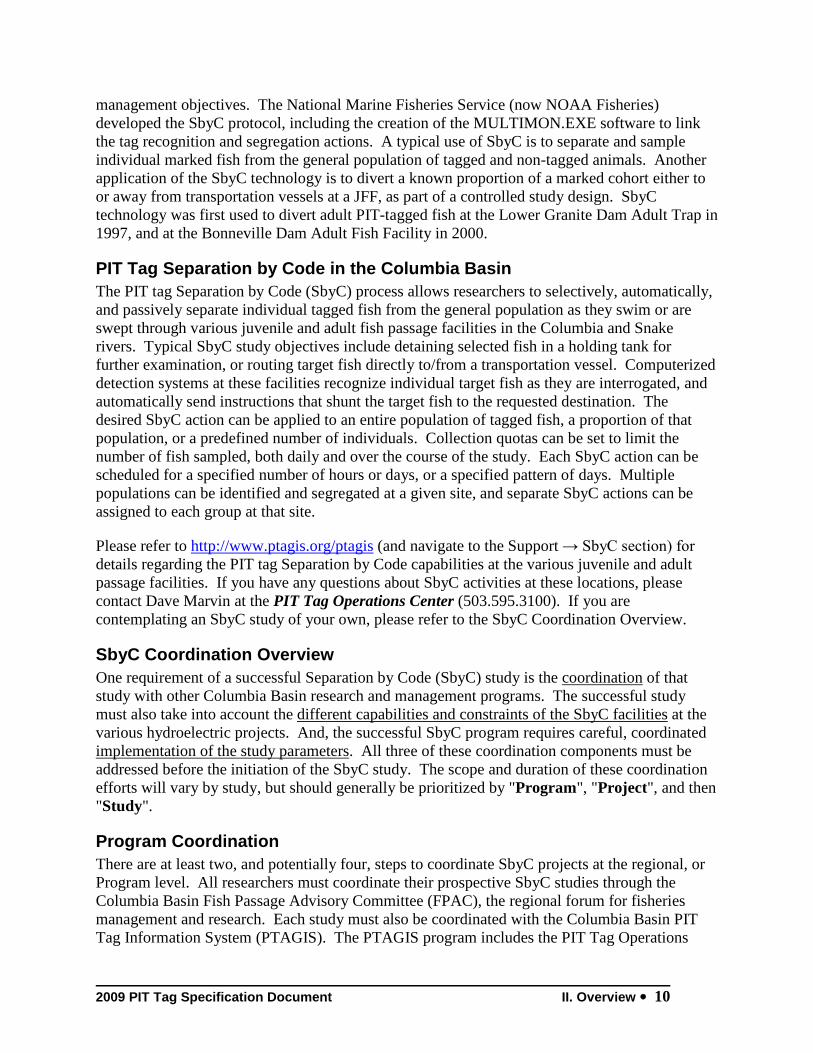
E. Coordinator ID Codes
Coord ID Name, Agency/Org Coord ID Name, Agency/Org
AAB Alan Byrne, IDFG CRC Craig Contor, CTUIR
ACG Andrew Grassell, CPUD CSM Scott McCutcheon, BIOMRK
AFB Arnie Brimmer, IDFG CSS Comparative Survival Study

2009 PIT Tag Specification Document IV. Code Lists 31
Coord ID Name, Agency/Org Coord ID Name, Agency/Org
AFE Allen Evans, RTR DAB Dean Brege, NMFS
AJV Alexis Vaivoda, CTWSR DAC Dave Cannamela, IDFG
ALS Ann Setter, ODFW DAN Duane A. Neitzel, PNL
AMR Michelle Rub, NMFS DAV David Venditti, IDFG
APD Scott Sebring, NMFS DAW David Wills, USFWS
APR Andrew Reasoner, DUCKSU DBJ David Johnson, NPT
BAR Brad Ryan, NMFS DDT Doug Taki, ShoBan
BCJ Brian Jonasson, ODFW DJD Dan Donima, PGE
BDA Bill Arnsberg, NPT DJN Doug Nemeth, IDFG
BDB Brian Benjamin, ODFW DMH David Hand, USFWS
BDL Brian Leth, IDFG DMM Doug Marsh, NMFS
BDM Brian Michaels, NPT DPC Doug Cramer, PGE
BDW Bruce Watson, YINN DPM Dave Marvin, PSMFC
BGK Barry Keesee, CPUD DRH Doug Hatch, CRITFC
BGT Behr Turner, GPUD DSF Derek Fryer, COE
BHM Bruce Monk, NMFS DTL David Lind, YINN
BJB Brett Bowersox, IDFG DTV Dimitri Vidergar, IDFG
BPK Brian Kennedy, UIDAHO DWW David Welch, KRC
BRB Brian Beckman, NMFS EDL Eric Lauver, GPUD
CAP Chris Peery, USFWS EEH Eric Hockersmith, NMFS
CAR Chris Reighn, ShoBan EES Eric Schulz, PGE
CCC Chris Caudill, ICFWRU EFP Sandy Downing, NMFS

2009 PIT Tag Specification Document IV. Code Lists 32
Coord ID Name, Agency/Org Coord ID Name, Agency/Org
CCP Charlie Cochran, WDFW EJL Eric Leitzinger, IDFG
CCW Catherine Willard, IDFG EMD Earl Dawley, NMFS
CDR Craig Rabe, NPT EVD Erick Van Dyke, ODFW
CEJ Chris Jordan, NMFS EWB Ed Buettner, IDFG
CFB Cyndi Baker, DUCKSU FAG Fred Goetz, COE
CFM Charles Morrill, WDFW GAA Gordon Axel, NMFS
CGN Courtney Newlon, USFWS GAM Geoff McMichael, PNL
CGS Charles Snow, WDFW GBZ Gayle Zydlewski, USFWS
CLD Curt Dotson, GPUD GCV Greg Volkhardt, WDFW
CM Christine Mallette, ODFW GES Gene Shippentower, CTUIR
CMK Cory Kamphaus, YINN GRP Gene Ploskey, PNL
CMP Chuck Peven, CPUD GSH Glen Holmberg, USGS
HLB Howard Burge, USFWS MBL Mike Lambert, CTUIR
HRP Hood River Production Program MGM Matt Mesa, USGS
IGJ Ian Jezorek, USGS MH Michael Hudson, USFWS
IMW Kelly Kiyohara, WDFW MHG Michael Gessel, NMFS
JAH Jay Hesse, NPT MJP Mike Parsley, USGS
JAR Jesse Rivera, USFWS MLB Mike Blenden, NPT
JAS Jen Stone, USFWS MLS Mark Schuck, WDFW
JAY Jeff Yanke, ODFW MPF Mike Faler, USFWS
JDZ Joe Zydlewski, USFWS MPP Mike Peterson, IDFG
JJL Jeff Lutch, IDFG MRC Matt Cooper, USFWS

2009 PIT Tag Specification Document IV. Code Lists 33
Coord ID Name, Agency/Org Coord ID Name, Agency/Org
JJP Jay Pravecek, IDFG MSH Megan Hill, PGE
JKB Jody Brostrom, USFWS NAJ Nicola Johnson, IDFG
JKF Jeff Fryer, CRITFC NRB Nathan Brindza, IDFG
JLC Jim Congleton, ICFWRU OTD Steve Springston, ODFW
JLH Lance Hebdon, IDFG PAK Paul Kucera, NPT
JLV Jason Vogel, NPT PCS Carter Stein, PSMFC
JMH Jon Hansen, NPT PEB Patricia Bigelow, USFWS
JMO Jill Olson, USFWS PHB Phaedra Budy, UCFWRU
JMP John Plumb, USGS PJC Peter Cleary, NPT
JMS Jennifer Schoolcraft, CPUD PKL Paul Kline, IDFG
JNL Jerry Lockhart, NPT PMS Paul Sankovich, USFWS
JPA Jeff Abrams, IDFG PTL Peter Lofy, CTUIR
JPW Jody Walters, IDFG RAM Regan McNatt, NMFS
JRH Jim Harbeck, NPT RBK Russ Kiefer, IDFG
JTH Josh Hanson, ODFW RBR Ralph Roseberg, USFWS
JVT J. Vince Tranquilli, ODFW RDL Dick Ledgerwood, NMFS
KAA Kim Apperson, IDFG RDM Rick Martinson, NMFS
KB Kent Ball, IDFG RED Rhonda Dasher, CCT
KCM Kent Mayer, WDFW RER Robert Reagan, ODFW
KDM Kyle Martens, USGS RFA Randy Absolon, NMFS
KEP Kurtis E. Plaster, IDFG RFW Robert Warren, CREST
KFT Ken Tiffan, USGS RGP Russell Porter, PSMFC

2009 PIT Tag Specification Document IV. Code Lists 34
Coord ID Name, Agency/Org Coord ID Name, Agency/Org
KGM Keely Murdoch, YINN RHW Robert Wertheimer, COE
KGO Kenneth Ostrand, USFWS RKS Kirk Schroeder, ODFW
KMC Ken Collis, CRITFC RLM Lynn McComas, NMFS
LCS Lowel Stuehrenburg, NMFS RLT Rosanna Tudor, WDFW
LGG Lyle Gilbreath, NMFS RLW Rey Weldert, CTUIR
LPD Lytle Denny, SHOBAN RMC Robert McDonald, CPUD
LRB Larry Basham, FPC RMK Robert Keith, ShoBan
MBE Brad Eppard, NMFS RNI Robert Iwamoto, NMFS
RPM Bob Mueller, PNL TDR T. Dean Rhine, IDFG
RRR Jeffrey Seggerman, IDFG TEC Tim Copeland, IDFG
RWP Russell Perry, USGS TER Tom Ruehle, NMFS
RWS Wes Stonecypher, ODFW TGC Tim Cochnauer, IDFG
SA Steve Achord, NMFS THK Tom Kahler, DC1PUD
SAH Susan Hinton, NMFS TIM Todd Miller, WDFW
SCS Sherman Sprague, NPT TJS Jason Seals, ODFW
SEJ Steve Jacobs, ODFW TKN Tom Nelson, ODFW
SGH Steve Hays, CPUD TLL Theresa Liedtke, USGS
SJB Steve Boe, CTUIR TLM Todd Miller, WDFW
SJR Steve Rocklage, NPT TMS Tim Shibahara, PGE
SLH Steve Hemstrom, CPUD TRM Thaddeus Mosey, CPUD
SMF Shannon Jewett, ODFW TRW Tim Walters, ODFW
SMP Smolt Monitoring Program TSC Tom Curet, IDFG
2009 PIT Tag Specification Document IV. Code Lists 35
Coord ID Name, Agency/Org Coord ID Name, Agency/Org
SPR Steve Rubin, USGS WAC Will Cameron,ODFW
TAF Tom Flagg, NMFS WDM William Muir, NMFS
TAH Thomas Hoffman, USFWS WHW Wayne Wilson, ODFW
TBH Terry Holubetz, IDFG WJB Bill Bosch, YINN
TCB Ted Bjornn, ICFWRU WPC William Connor, USFWS
TCR Craig Robinson, USGS
2009 PIT Tag Specification Document IV. Code Lists 36
F. Conditional Comments (Flag Codes)
Code Comment Code Comment
0 Possible 0-Aged Chinook FU Fungus
1< Descaled Less than 10 Percent FX Fish Examination
1> Descaled Greater than 10 Percent GB Gas Bubble Trauma
1P Descaled - Patchy GS Gill Sample
1S Descaled - Scattered HE Hemmorhage
<2 Descaled Between 11 and 20% I Body Injury - Prior to Tagging
>2 Descaled Greater than 20% IM Immature
AD Adipose Fin Clip JA Jack
AF Adipose Fin Damage JT Jaw Tagged
AI Adipose Intact (not clipped) JW Jaw Damage
AN Anal Fin Damage KD Possible BKD
AT Tagged as Adult KL Kelt
B Bleeding after Tagged L Fish Lost/Rejected Tag before Release
BL Bloated LA Lacerations
BR Brood Stock LF Large Fish Flume from Separator
BS Body Scars LP Left Pectoral Fin Ray Sample
BT Bare Tag Recovered after Release LT Light Body Color
CA Caudal Fin Damage LV Left Ventral Fin Clip
CL Lower Caudal Lobe Clip M Mortality
CU Upper Caudal Lobe Clip MA Male

2009 PIT Tag Specification Document IV. Code Lists 37
Code Comment Code Comment
CW Coded Wire Tag MB Bleeding at Tagging/Died Pre-Release
CY Cyst MJ Minijack
D Dropped MK Removed from Release Group (Killed)
DB Double PIT-tagged ML Left Maxillary Clip
DF Dorsal Fin Damage MR Right Maxillary Clip
DI Deep Insertion MS Sample Mort (Intentional Sacrifice)
DK Dark Body Color MT Mature
DO Dis-orbited Eye NF Non-Functional Tag also in Fish
DT Duplicate Tag NM No Mucous
EB Electro-Shocker Burn OP Opercule Damage
EF Fin Erosion PA Parasite
EJ Elastomer Jet / Photonic Fin Mark PB Previously Branded
EL Damaged Eye - Left - after Tagging PC Poor Fin Clip
EM Excessive Mucous PD Peterson Disc
ER Damaged Eye - Right - after Tagging PO Passive Observation
FE Female PR Precocious
PT Pectoral Fin Damage SF Small Fish Flume from Separator
PV Pelvic Fin Damage SI Sonic (Acoustic) Tag Implant
Q1 Complete and Legible Freeze Brand SM Subsequent Mort
Q2 Brand is Legible but Incomplete SP Spaghetti Tag
Q3 Brand is not Legible ST Streamer Tag
Q4 Brand Rotation or Position Wrong SU Surgery

2009 PIT Tag Specification Document IV. Code Lists 38
Code Comment Code Comment
Q5 No Brand SV Silvery Body Color
Q6 Brand Caused Light to Excessive Burn TM Tagged In Muscle
RE Recapture UL Ulcer
RF Returning Fish VI Visual Implant / Eye Adipose
RP Right Pectoral Fin Ray Sample WD Possible Whirling Disease
RT Radio Tagged X Duplicate Tag for Pre-Release Mort
RV Right Ventral Fin Clip Y Possible Age One (Yearling)
SC Scoliosis

2009 PIT Tag Specification Document IV. Code Lists 39
G. Hatchery Codes
Code Hatchery Code Hatchery
ABEH Abernathy SCTC LYFE Lyons Ferry Hatchery
BEAH Beaver Creek Hatchery MARI Marion Forks Hatchery
BIGC Big Creek Hatchery (ODFW) MAVA
Magic Valley Hatchery
BONH
Bonneville Hatchery MCCA
McCall Hatchery
BURL Burley Hatchery, Puget Sound MCKE
McKenzie Hatchery
CARS Carson NFH MERH
Merwin Hatchery
CASC Cascade Hatchery METH
Methow Hatchery
CASS Cassimer Bar Hatchery MONT
Montlake Hatchery
CHEL Chelan PUD Hatchery NCHH
Naches Hatchery
CLAH Clackamas Hatchery NISP Niagara Springs Hatchery
CLEE Cle Elum Hatchery NPTH Nez Perce Tribal Hatchery
CLWH
Clearwater Hatchery OASP Oak Springs Hatchery
COWS
Cowlitz Salmon Hatchery (now Salkum H.)
OXBH
Oxbow Hatchery, Cascades Locks, OR (ODFW)
COWT
Cowlitz Trout Hatchery (now Blue Creek H.)
OXBO
Oxbow Hatchery, Hells Canyon (IDFG)

2009 PIT Tag Specification Document IV. Code Lists 40
Code Hatchery Code Hatchery
CROP Crooked River Rearing Pond PAHH
Pahsimeroi Hatchery
DWOR
Dworshak NFH POWP
Powell Rearing Pond
EAGH Eagle Creek NFH PRDH Priest Rapids Hatchery
EAGL Eagle Hatchery PROH
Prosser Hatchery
EBNK East Bank Hatchery Facility RAPH Rapid River Hatchery
ELRH Elochoman River (Washington) Hatchery
REDP Red River Rearing Pond
ENTH Entiat NFH RINH Ringold Hatchery
GNAT Gnat Creek Hatchery ROAR
Roaring River Hatchery
GRAY Grays River Hatchery ROBU
Round Butte Hatchery
HAGE Hagerman NFH RRHH Rocky Reach Hatchery (Archaic - use TURO)
IRRI Irrigon Hatchery SAND Sandy Hatchery
ISQH Issaquah Hatchery SAWT
Sawtooth Hatchery
KALA Kalama Falls Hatchery, WDFW SERH Sea Resources Hatchery (Chinook River, WA)
KLAS Klaskanine Hatchery SIMP Similkameen Pond/Hatchery
KLIH Klickitat Hatchery SKAM
Skamania Hatchery
KOOS Kooskia NFH SOSA South Santiam Hatchery

2009 PIT Tag Specification Document IV. Code Lists 41
Code Hatchery Code Hatchery
LEAB Leaburg Hatchery SPEE Speelyai Hatchery
LEAV Leavenworth NFH SPRC Spring Creek NFH
LEWH Lewis River Hatchery SWSP Sweetwater Springs Hatchery
LOOH Lookingglass Hatchery TOUT North Toutle Hatchery, WDFW
LOWK
Lower Kalama Hatchery TRAS Trask Hatchery
LWSH Little White Salmon NFH TUCH Tucannon Hatchery
TURO Turtle Rock Hatchery WHSH
Warrenton (OR) High School Hatchery
UMAH
Umatilla Hatchery WILH Willamette Hatchery
VANC Vancouver Hatchery WILL Willard NFH
WAHA
Washougal Hatchery, WDFW WINT Winthrop NFH
WALH
Wallowa Hatchery WSPH
Warm Springs NFH
WELH Wells Hatchery YAKH Yakima Hatchery
H. Capture Method Codes
Code Capture Method Code Capture Method
BPRCOL Bypass Facility Raceway Collection HATRAK Hatchery Rack
BPSUB Bypass Sub-Sample HOOK Hook and Line
BSEINE Beach Seine LADDER Adult Passage Ladder
BTRAP Box Trap MTRAP Minnow Trap

2009 PIT Tag Specification Document IV. Code Lists 42
CMTRAP Cray-Meeken Trap NONE Not Applicable
CREEL Sport Fishery PRED Predation Mark Recovery
DIPNET Dip Net PSEINE Purse Seine
DIPTRP Dipper Trap SCOTRP Scoop Trap
DIVSYS Diversion System SCREWT Screw Trap
FYKNET Fyke Net SHOCK Electro-Shock
GILNET Commercial or Tribal Gillnet Fishery SURVEY Spawning Survey
GWAIRL Gatewell Airlift TNGLNT Tangle net fishery or research
GWDIP Gatewell Dip Net TRAWL Trawl Net
GWFYKE Gatewell Fyke Net TROLL Ocean Troll Fishery
HATCH Hatchery Returns WTRAP Weir Trap
I. Tagging Method Codes
Code Tagging Method
AUTO Auto Tagger
GAST Gastric Implantation
HAND Hand-Held Syringe
NONE None
SURG Surgically Implanted

2009 PIT Tag Specification Document IV. Code Lists 43
J. Organization Codes
Code Organization
BIOMRK Biomark
CCT Colville Confederated Tribes
COE U.S. Army Corps of Engineers
CPUD Chelan County Public Utility District
CREST Columbia River Estuary Study Taskforce
CRITFC Columbia River Inter-Tribal Fish Commission
CTUIR Confed. Tribes of the Umatilla Indian Reser.
CTWSR Confed. Tribes of the Warm Springs Reser.
DC1PUD Douglas County Public Utility District No. 1
DUCKSU Ducks Unlimited
FPC Fish Passage Center
GPUD Grant County Public Utility District
ICFWRU Idaho Cooperative F&W Research Unit
IDFG Idaho Dept. of Fish and Game
KRC Kintama Research Corporation
NMFS NOAA Fisheries
NPT Nez Perce Tribe
ODFW Oregon Dept. of Fish and Wildlife
PGE Portland General Electric
PNL Pacific Northwest Labs (Battelle)
PNW U.S. Dept. of Agriculture

2009 PIT Tag Specification Document IV. Code Lists 44
PSMFC Pacific States Marine Fisheries Commission
RTR Real Time Research, Inc.
SEARES Sea Resources
SHOBAN Shoshone-Bannock Tribes
UCFWRU Utah Cooperative F&W Research Unit
UIDAHO University of Idaho
USFWS U.S. Fish and Wildlife Service
USGS U.S. Geological Survey
WDF Washington Dept. of Fish (archaic)
WDFW Washington Dept. of Fish and Wildlife
WDW Washington Dept. of Wildlife (archaic)
WFC Wild Fish Conservancy
YINN Yakama Nation
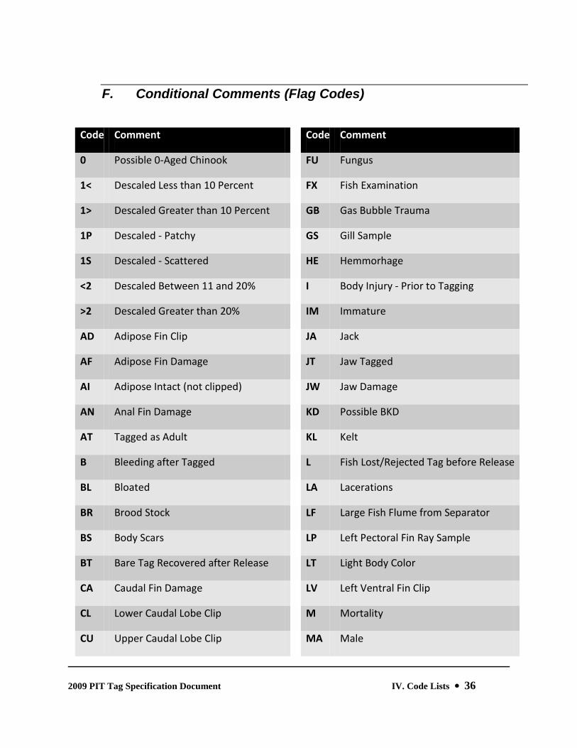
K. Tag, Release, and Recovery Site Codes
1. Site Codes The site code is an abbreviated description (four to six characters) of the tagging and/or release location. A site descriptor, if present, will be found in the last one to three characters. For all site codes that replicate an already established code, a number (2 through 9) will immediately precede the site descriptor.
For example:
ELKC: Elk Creek ELK2C: A second Elk Creek
ELK3C: A third Elk Creek
Rivers and streams that extend through two or more USGS Hydrologic Units are assigned specific River Reach codes for each corresponding Hydrologic Unit Code (HUC). The

2009 PIT Tag Specification Document IV. Code Lists 45
River Reach codes terminate in a single-digit integer starting with ‘1’, corresponding with the mouth of the river or stream, and incrementing to the maximum number of distinct HUCs. For example, the Columbia River passes through nine HUCs between its mouth and Chief Joseph Dam (blocking anadromous fish passage), and thus there are nine Columbia River Reach codes (COLR1 – COLR9).
The following are valid site descriptors:
B: Bridge C: Creek CH: Channel
CN: Canal D: Dam FK: fork of a river, but not part of a name ( e.g., Salmon River, East Fork, but not Brushy Fork Creek)
I or IS: Island P: Pond
R: River S: Screen
SL: Slough T or TRP: Trap W: Weir
2. River Kilometer Code The river kilometer code uses a hierarchical coding scheme: kilometers from the mouth of the Columbia River to the Release site (up to a 7th order stream for point release sites), with each tributary delimited with a period (e.g., the code for the location of the Lower Granite Dam is 522.173 = 522 km from the mouth of the Columbia to the mouth of the Snake, and 173 km from the mouth of the Snake to the dam). Each segment of the code is three characters long, zero-padded from the left. When kilometers are calculated from measurements in miles, a standard conversion of 0.6214 m/km is used and the result is rounded to the nearest integer.
If additional sites are required, contact your PIT Tag Steering Committee member to add your requests to the list. River kilometer codes have a minimum length of three characters and a maximum length of 27 characters; the domain of characters is generally limited to integers and the period. There is an exception for the OCEAN code (“~~~”), and landlocked site definitions (such as Potholes Reservoir) that use the “___” code. Sites within the Columbia Basin that do not provide direct release of fish are assigned a River Kilometer Code of “*”; sites outside of the Columbia Basin are assigned a River Kilometer Code of “***”.
When releasing or recovering fish in-river (as opposed to releasing or recovering at one of the listed fixed-site locations), the distance upstream from the mouth of the river, stream, or creek, is appended (in kilometers) to the base river kilometer code for that river.
For example, a project that is tagging 10 kilometers above the mouth of the South Fork Salmon River would be identified as:
SALRSF 522.303.215.010

2009 PIT Tag Specification Document IV. Code Lists 46
3. GIS Hydrologic Unit Codes
The USGS Hydrologic Unit Code (HUC) is an eight-digit number, comprised of four two-digit fields, used to identify part or all of a surface drainage basin. In the Pacific Northwest, these are generally the same sub-basins or “provinces” identified in the Northwest Power and Conservation Council’s Fish & Wildlife Program. Each river or fixed location listed in Table IV.5 (!X!X!X!X!X Cross-reference this!) is specific to a single quaternary HUC. See Appendix A (!X!X!X!X!X Cross-reference this!) for a more formal treatment of this topic.
4. Stream and River Definitions vs. Fixed Release Sites In the following table, the column labeled “FS" contains a "Y" or an "N". The column contains a "Y" if the Tag/Release/Recovery Site is a "Fixed Site"; otherwise, the column contains an "N".
The River Kilometer Code of a fixed site cannot be modified with an additional suffix or segment. Examples of fixed release sites are weirs, traps, bridges, intra-dam release sites, etc.
When reporting instream release and recovery events, a three-digit suffix is appended to the base river kilometer code to denote the actual distance upstream from the mouth of the stream or river that the release or recovery events occurred.

2009 PIT Tag Specification Document IV. Code Lists 47
5. Tag, Release, and Recovery Site Codes
Site Code
Location Name
F S
River Kilometer Code
Total RKM
HUC ID
15MILC Fifteen Mile Creek, near The Dalles, Oregon
N 309 309 17070105
18MILC Eighteenmile Creek, Lemhi River Basin N 522.303.416.092 1333 17060204
3LINKC Three Links Creek N 522.224.120.037.051 954 17060302
3MILIS Three Mile Canyon Island (Col. R. below Blalock Island)
Y 412 412 17070101
4JULYC Fourth of July Creek N 522.303.630 1455 17060201
ABEH Abernathy SCTC Y 087.005 92 17080003
ABERC Abernathy Creek, Lower Columbia River, Washington
N 087 87 17080003
AGNCYC Agency Creek, Lemhi River Basin N 522.303.416.039 1280 17060204
AHTANC Ahtanum Creek, Yakima River N 539.172 711 17030003
ALTULC Alturas Lake Creek N 522.303.633 1458 17060201
ALTURL Alturas Lake Y 522.303.633.011 1469 17060201
AMERR American River N 522.224.120.101 967 17060305
ASOTIC Asotin Creek, Snake River above Clarkston
N 522.234 756 17060103
BADGEI Badger Island, Columbia River Y 512 512 17070101
BANKSL Banks Lake, Grant County, Washington Y ___ 17020014
BARGAC Bargamin Creek N 522.303.255 1080 17060207
BASINC Basin Creek, Lemhi River Basin N 522.303.416.049.006 1296 17060204
BBC Big Beef Creek N * 17110018

2009 PIT Tag Specification Document IV. Code Lists 48
Site Code
Location Name
F S
River Kilometer Code
Total RKM
HUC ID
BCANF Big Canyon Facility Y 522.271.131.018.001 943 17060105
BCCAP Big Canyon Creek Acclimation Facility (Clearwater River)
Y 522.224.057 803 17060306
BCHINL Lake Billy Chinook Y 328.177 505 17070301
BCKROC Buckaroo Creek, Umatilla River N 465.117 582 17070103
BCTRAP Lake Washington, Bear Creek Trap Y *** 17110012
BEAR2C Bear Creek, John Day River Basin N 351.218.009 578 17070204
BEAR3C Bear Creek, Columbia River Estuary, Oregon
N 033 33 17080006
BEARC Bear Creek N 522.224.120.037.081 984 17060301
BEARVC Bear Valley Creek N 522.303.319.170 1314 17060205
BEAV2C Beaver Creek, Methow River N 843.057 900 17020008
BEAV3C Beaver Creek, Wenatchee River Basin N 754.075 829 17020011
BEAV3P Beaver Creek Acclimation Pond, Wenatchee River Basin
Y 754.075.001 830 17020011
BEAV4C Beaver Creek, Big Creek watershed, MF Salmon River
N 522.303.319.029.049 1222 17060206
BEAVEC Beaver Creek N 522.303.642 1467 17060201
BEDRKC Bedrock Creek N 522.224.042 788 17060306
BGM Burlingame Diversion Dam, Walla Walla River
N * 568 17070102
BIG1C Big Creek, lower Columbia River near Knappa, OR
N 043 43 17080006
BIG2C Big Creek, Middle Fork Salmon River N 522.303.319.029 1173 17060206

2009 PIT Tag Specification Document IV. Code Lists 49
Site Code
Location Name
F S
River Kilometer Code
Total RKM
HUC ID
BIG8MC Big Eightmile Creek, Lemhi River Basin N 522.303.416.073 1314 17060204
BIGB2C Big Bear Creek, Lemhi River Basin N 522.303.416.092.019 1352 17060204
BIGBEC Big Bear Creek, Potlatch River N 522.224.024.023 793 17060306
BIGC Big Creek Hatchery (ODFW) near Knappa
Y 043.006 49 17080006
BIGCAC Big Canyon Creek N 522.224.057 803 17060306
BIGFLC Big Flat Creek N 522.224.120.037.113.026 1042 17060303
BIGMAC Big Mallard Creek N 522.303.247 1072 17060207
BIGWSP Big White Salmon Ponds Y 271.002 273 17070105
BIRCHC Birch Creek, Umatilla River N 465.077 542 17070103
BIRCHE East Fork Birch Creek, Umatilla River N 465.077.026 568 17070103
BIRCHW West Fork Birch Creek, Umatilla River N 465.077.026 568 17070103
BLNDSL Blind Slough Net Pens (Oregon side of Columbia River Estuary)
Y 047 47 17080006
BO1 Bonneville Dam PH1 (Archaic - replaced with generic BON designation)
N * 17070105
BO2 Bonneville Dam PH2 (Archaic - replaced with generic BON designation)
N * 17070105
BOBSC Bobs Creek, Potlatch River watershed N 522.224.024.065.019 854 17060306
BOHANC Bohannon Creek, Lemhi River Basin N 522.303.416.017 1258 17060204
BON Bonneville Dam Complex N * 234 17070105
BONH Bonneville Hatchery Y 232.001 233 17080001

2009 PIT Tag Specification Document IV. Code Lists 50
Site Code
Location Name
F S
River Kilometer Code
Total RKM
HUC ID
BONP Bonifer Springs Acclimation Pond Y 465.127.003 595 17070103
BOSTCC Boston Canyon Creek, Umatilla River N 465.127.003 595 17070103
BOUL2C Boulder Creek, Little Salmon River watershed
N 522.303.140.029 994 17060210
BOUL3C Boulder Creek, Potlatch River watershed
N 522.224.024.041 811 17060306
BOULDC Boulder Creek N 522.224.120.037.042 945 17060303
BOUNDC Boundary Creek N 522.303.319.154 1298 17060205
BOUTRP Boulder Creek Trap Y 522.224.120.037.042.001 946 17060303
BRAMYC Big Ramey Creek, Big Creek watershed, MF Salmon River
N 522.303.319.029.042 1215 17060206
BRIDGC Bridge Creek, John Day River Basin N 351.218 569 17070204
BRIDWB West Branch Bridge Creek, John Day River Basin
N 351.218.020 589 17070204
BRUSHC Brushy Fork Creek N 522.224.120.037.113.011 1027 17060303
BSHEEC Big Sheep Creek N 522.308.032 862 17060102
BTIMBC Big Timber Creek, Lemhi River Basin N 522.303.416.089 1330 17060204
BUCK2C Buck Creek, Big Creek watershed, MF Salmon River
N 522.303.319.029.026 1199 17060206
BUCK3C Buck Creek, White Salmon River Basin (WA)
N 271.008 279 17070105
BUCKC Buck Creek, Umatilla River N 465.145.002 612 17070103
BURL Burley Creek Hatchery, Puget Sound Y *** 17110019
BURNLC Burnt Log Creek N 522.303.215.060.024.024 1148 17060208

2009 PIT Tag Specification Document IV. Code Lists 51
Site Code
Location Name
F S
River Kilometer Code
Total RKM
HUC ID
BUTCHC Butcher Creek, Umatilla River N 465.127.034 626 17070103
BUTCHP Butcher Creek Acclimation Pond, Wenatchee River Basin
Y 754.089.013 856 17020011
BVAL2C Bear Valley Creek, Lemhi River Basin N 522.303.416.049.014 1304 17060204
BVRLYI Beverly Islands, Columbia River below Wanapum Dam
Y 666 666 17020010
CABINC Cabin Creek, Big Creek watershed, MF Salmon River
N 522.303.319.029.019 1192 17060206
CALAPR Calapooia River N 163.192 355 17090003
CAMASC Camas Creek, Middle Fork Salmon River
N 522.303.319.057 1201 17060206
CAMP2C Camp Creek, Middle Fork John Day River
N 351.298.052.076 777 17070203
CAMPC Camp Creek, Umatilla River N 465.127.018 610 17070103
CANY2C Canyon Creek, Lemhi River Basin N 522.303.416.090 1331 17060204
CANYOC Canyon Creek N 522.224.120.037.012 915 17060303
CAPEHC Capehorn Creek N 522.303.319.170.010 1324 17060205
CARP Carlton Acclimation Pond Y 843.058 901 17020008
CARS Carson National Fish Hatchery Y 251.028 279 17070105
CASC Cascade Hatchery (ODFW) near Cascade Locks
N * 235 17070105
CASS Cassimer Bar Hatchery N * 17020006
CATCMF Middle Fork Catherine Creek N 522.271.232.052.005 1082 17060104
CATCNF North Fork Catherine Creek N 522.271.232.052 1077 17060104
2009 PIT Tag Specification Document IV. Code Lists 52
Site Code
Location Name
F S
River Kilometer Code
Total RKM
HUC ID
CATCSF South Fork Catherine Creek N 522.271.232.052 1077 17060104
CATHEC Catherine Creek N 522.271.232 1025 17060104
CATHEP Catherine Creek Pond Y 522.271.232.048 1073 17060104
CATHEW Catherine Creek Weir Y 522.271.232.032 1057 17060104
CAVEC Cave Creek, Big Creek watershed, MF Salmon River
N 522.303.319.029.022 1195 17060206
CEDA2C Cedar Creek, Potlatch River watershed N 522.224.024.033 803 17060306
CEDARC Cedar Creek, tributary to Lewis River N 140.025 165 17080002
CEFLAF Cedar Flats Acclimation Facility, Selway River
Y 522.224.120.037.008 911 17060302
CFCTRP Crooked Fork Creek Trap Y 522.224.120.037.113.003 1019 17060303
CGR Cougar Dam N * 548 17090004
CHAMBC Chamberlain Creek N 522.303.282 1107 17060207
CHAMPC Champion Creek N 522.303.631 1456 17060201
CHAMWF West Fork Chamberlain Creek N 522.303.282.024 1131 17060207
CHANDL Chandler Canal (Prosser Dam) - headgate to diversion screen (km 000-002)
N 539.076 615 17030003
CHEL Chelan PUD Hatchery N * 17020010
CHELAR Chelan River N 810 810 17020009
CHEWUP Chewuch Acclimation Pond (WDFW) Y 843.080.010 933 17020008
CHEWUR Chewuch River N 843.080 923 17020008
CHINOR Chinook River, Washington (Columbia River Estuary)
N 006 6 17080006

2009 PIT Tag Specification Document IV. Code Lists 53
Site Code
Location Name
F S
River Kilometer Code
Total RKM
HUC ID
CHIP Chiwawa Rearing Pond Y 754.077.002 833 17020011
CHIWAC Chiwaukum Creek, tributary to Wenatchee River
N 754.057 811 17020011
CHIWAR Chiwawa River N 754.077 831 17020011
CHIWAT Chiwawa River Trap, 0.5 km below CHIP acclimation pond
Y 754.077.002 833 17020011
CJRAP Captain John Rapids Acclimation Pond Y 522.263 785 17060103
CLARFP Clark Flat Acclimation Pond Y 539.270 809 17030001
CLE Cle Elum Dam N * 838 17030001
CLEARC Clear Creek N 522.224.120.004 870 17060304
CLEE Cle Elum Hatchery Y 539.293 832 17030001
CLELMD Cle Elum Dam (Archaic - replaced with CLE)
N 539.299.013 851 17030001
CLELMR Cle Elum River N 539.299 838 17030001
CLWH Clearwater Hatchery N * 17060306
CLWR Clearwater River N 522.224 746 17060306
CLWRMF Middle Fork Clearwater River N 522.224.120 866 17060304
CLWRNF North Fork Clearwater River N 522.224.065 811 17060308
CLWRSF South Fork Clearwater River N 522.224.120 866 17060305
CLWTRP Clearwater Trap Y 522.224.010 756 17060306
COLR Columbia River (Archaic - replaced with reach-specific definitions)
N 000 170*
COLR1 Columbia River - mouth to Three Tree Point, WA (km 0-49)
N 000 0 17080006

2009 PIT Tag Specification Document IV. Code Lists 54
Site Code
Location Name
F S
River Kilometer Code
Total RKM
HUC ID
COLR2 Columbia River - Three Tree Point, WA to Lewis River (km 49-140)
N 000 0 17080003
COLR3 Columbia River - Lewis River to Bonneville Dam (km 140-234)
N 000 0 17080001
COLR4 Columbia River - Bonneville Dam to John Day Dam (km 234-347)
N 000 0 17070105
COLR5 Columbia River - John Day Dam to Snake River (km 347-522)
N 000 0 17070101
COLR6 Columbia River - Snake River to Lower Crab Creek (km 522-661)
N 000 0 17020016
COLR7 Columbia River - Lower Crab Creek to Chelan Falls, WA (km 661-809)
N 000 0 17020010
COLR8 Columbia River - Chelan Falls, WA to Grand Coulee Dam (km 809-960)
N 000 0 17020005
COLTC Colt Creek N 522.224.120.037.113.020 1036 17060303
COLTKC Colt Kill Creek - Replaces WHITSC N 522.224.120.037.113 1016 17060303
COONSC Coonskin Creek, Umatilla River N 465.109 574 17070103
CORRAC Corral Creek, Potlatch River watershed N 522.224.024.052 822 17060306
COTNWC Cottonwood Creek N 522.224.031 777 17060306
COTP Cottonwood Acclimation Pond Y 522.271.046 839 17060106
COTTWC Cottonwood Creek, Umatilla River N 465.105 570 17070103
COUG2C Cougar Creek, Potlatch River watershed
N 522.224.024.083.005 858 17060306
COUGRC Cougar Creek, Grande Ronde Basin N 522.271.049 842 17060106
COULTC Coulter Creek, Wenatchee River Basin N 754.089.014 857 17020011

2009 PIT Tag Specification Document IV. Code Lists 55
Site Code
Location Name
F S
River Kilometer Code
Total RKM
HUC ID
COULTP Coulter Creek Acclimation Pond, Wenatchee River Basin
Y 754.089.014.001 858 17020011
COWLR1 Cowlitz River - mouth to Crispus River (km 0-145)
N 111 111 17080005
COWLR2 Cowlitz River - Crispus River to headwaters (km 145-216)
N 111 111 17080004
COWS Cowlitz Salmon Hatchery Y 111.080 191 17080005
COWT Cowlitz Trout Hatchery Y 111.071 182 17080005
COYOTC Coyote Creek, Umatilla River N 465.145.005 615 17070103
CRESIS Crescent Island, Columbia River Y 510 510 17070101
CROO2C Crooked Creek, Big Creek watershed, MF Salmon River
N 522.303.319.029.038 1211 17060206
CROOC Crooked Creek N 522.303.200 1025 17060207
CROOK1 Crooked River - Lake Billy Chinook to Prineville Reservoir (km 0-113)
N 328.177 505 17070305
CROOKC Crooked Fork Creek N 522.224.120.037.113 1016 17060303
CROOKP Crooked River Pond Y 522.224.120.094.015 975 17060305
CROOKR Crooked River N 522.224.120.094 960 17060305
CROP Crooked River Pond (Archaic - use CROOKP)
N 522.224.120.094.015 975 17060305
CROTRP Crooked River Trap Y 522.224.120.094.001 961 17060305
CRTRAP Lake Washington, Cedar River Trap Y *** 17110012
CRUIKS Cruikshank Creek, Lemhi River Basin N 522.303.416.090.014 1345 17060204
CUNNSL Cunningham Slough N 139.000 139 17090012

2009 PIT Tag Specification Document IV. Code Lists 56
Site Code
Location Name
F S
River Kilometer Code
Total RKM
HUC ID
CURP Curl Lake Rearing Pond Y 522.100.066 688 17060107
DAGGEC Dagger Creek N 522.303.319.155 1299 17060205
DAYP Dayton Acclimation Pond Y 509.035.087 631 17070102
DEADMC Deadman Creek N 522.224.120.037.016 919 17060303
DECKEC Decker Creek N 522.303.624.001 1450 17060201
DEERC Deer Creek, upper Lemhi River Basin N 522.303.416.092.022 1355 17060204
DESCH1 Deschutes River - mouth to Round Butte Dam (0-177 km)
N 328 328 17070306
DESCH2 Deschutes River - Round Butte Dam to headwaters (177-393 km)
N 328.177 505 17070301
DOGRVR Dog River, tributary to EF Hood River (OR)
N 273.023.016 312 17070105
DRANOL Drano Lake Y 261 261 17070105
DRNP Deep River Net Pens (Deep River, Washington)
Y 035.002 37 17080006
DRY Dryden Diversion Dam, Wenatchee River
N * 782 17020011
DRYP Dryden Acclimation Pond Y 754.026 780 17020011
DWOR Dworshak National Fish Hatchery N * 811 17060306
DWORMS Dworshak NFH, release into main stem Clearwater River
Y 522.224.065 811 17060306
DWORNF Dworshak NFH, release into North Fork Clearwater River
Y 522.224.065.000 811 17060308
EAGH Eagle Creek National Fish Hatchery, in Clackamas River Basin
Y 163.040.027.016 246 17090011

2009 PIT Tag Specification Document IV. Code Lists 57
Site Code
Location Name
F S
River Kilometer Code
Total RKM
HUC ID
EAGL Eagle Hatchery N * 17050114
EAGLEC Eagle Creek N 522.224.120.037.253.003 1159 17060301
EASTOP Easton Acclimation Pond Y 539.325 864 17030001
EBNK East Bank Hatchery N * 17020010
EFHORC East Fork Horse Creek, McKenzie River Basin
N 163.282.107 552 17090004
EIGHTC Eightmile Creek, Chewuch River N 843.080.018 941 17020008
ELDORC Eldorado Creek N 522.224.087.041 874 17060306
ELKC Elk Creek N 522.303.319.170.014 1328 17060205
ELRH Elochoman River Hatchery (Elochoman River, Washington)
Y 058.019 77 17080003
ENTH Entiat NFH Y 778.011 789 17020010
ENTIAR Entiat River N 778 778 17020010
ESANIS East Sand Island, Columbia River Y 008 8 17080006
FALLC Fall Creek N 522.303.319.163 1307 17060205
FDD Feed Diversion Dam, Umatilla River N * 538 17070103
FEATHC Feather Creek, Potlatch River watershed
N 522.224.024.083.001 854 17060306
FEEDCN Feed Diversion Canal - headgate to diversion screen (km 000-001)
N 465.047 512 17070103
FISHC Fish Creek N 522.224.120.037.039 942 17060303
FISHEC Fisher Creek N 522.303.628 1453 17060201
FISTRP Fish Creek Trap Y 522.224.120.037.039.002 944 17060303

2009 PIT Tag Specification Document IV. Code Lists 58
Site Code
Location Name
F S
River Kilometer Code
Total RKM
HUC ID
FIVEMC Five Mile Creek N 522.224.120.094.018 978 17060305
FLOSSC Flossie Creek N 522.303.282.027 1134 17060207
FLUMEC Flume Creek, Lemhi River Basin N 522.303.416.039.014 1294 17060204
FOGDEW Foggy Dew Creek, Methow River watershed
N 843.035.009 887 17020008
FOUNDI Foundation Island, Columbia River Y 518 518 17070101
FRENCC Frenchman Creek N 522.303.647 1472 17060201
FRENCH French Creek N 522.303.169 994 17060209
GABLEC Gable Creek, John Day River Basin N 351.218.022 591 17070204
GEDCWF West Fork Gedney Creek N 522.224.120.037.029.005 937 17060302
GEDNEC Gedney Creek N 522.224.120.037.029 932 17060302
GEECR Gee Creek, Washington, lower Columbia River
N 140 140 17080002
GERMC Germany Creek, Lower Columbia River, Washington
N 090 90 17080003
GOLD2C Gold Creek, Methow River N 843.035 878 17020008
GOLDC Gold Creek N 522.303.621 1446 17060201
GOOS2I Goose Island, Columbia River above Priest Rapids Dam
Y 641 641 17020010
GOOSEI Goose Island, lower Snake River Y 522.014 536 17060110
GRAND1 Grande Ronde River - mouth to Wallowa River (km 0-131)
N 522.271 793 17060106
GRAND2 Grande Ronde River - Wallowa River to headwaters (km 131-325)
N 522.271 793 17060104

2009 PIT Tag Specification Document IV. Code Lists 59
Site Code
Location Name
F S
River Kilometer Code
Total RKM
HUC ID
GRANDP Grande Ronde River Pond Y 522.271.320 1113 17060104
GRANDR Grande Ronde River (Archaic - replaced with reach-specific definitions)
N 522.271 793 170601*
GRANDW Grande Ronde River Weir Y 522.271.307 1100 17060104
GRAYSR Grays River, Washington, lower Columbia River
N 032 32 17070203
GRBLDC Granite Boulder Creek, Middle Fork John Day River
N 351.298.052.090 791 17070203
GREENR Green River, trib. to NF Toutle River N 111.032.028.018 189 17080005
GREEPC Green Point Creek (tributary to West Fork Hood River)
N 273.020.002 295 17070105
GRNTRP Grande Ronde River Trap Y 522.271.002 795 17060106
HAGE Hagerman NFH N * 17040212
HARDC Hard Creek N 522.303.140.031.002 998 17060210
HATRCK Hat Rock State Park (Oregon) Y 480 480 17070101
HAWLYC Hawley Creek, Lemhi River Basin N 522.303.416.092.004 1337 17060204
HAYDNC Hayden Creek, Lemhi River Basin N 522.303.416.049 1290 17060204
HAYNSC Haynes Creek, Lemhi River Basin N 522.303.416.026 1267 17060204
HAZARC Hazard Creek N 522.303.140.031 996 17060210
HCD Hells Canyon Dam N * 919 17060101
HELLRC Hell Roaring Creek N 522.303.631 1456 17060201
HERDC Herd Creek N 522.303.552.014 1391 17060201
HERMAC Herman Creek, Columbia River Gorge N 243 243 17070105

2009 PIT Tag Specification Document IV. Code Lists 60
Site Code
Location Name
F S
River Kilometer Code
Total RKM
HUC ID
(OR)
HLK Hemlock Dam, Wind River (WA) watershed
N * 270 17070105
HOODEF East Fork Hood River N 273.023 296 17070105
HOODMF Middle Fork Hood River N 273.023 296 17070105
HOODR Hood River N 273 273 17070105
HOODWF West Fork Hood River N 273.020 293 17070105
HORS2C Horse Creek, upper McKenzie River Basin
N 163.282.107 552 17090004
HORSEC Horse Creek N 522.303.301 1126 17060207
HUCKLC Huckleberry Creek N 522.303.624 1449 17060201
HUNGC Hungery Creek (Lochsa River Basin) N 522.224.120.037.039.007 949 17060303
I-90B I-90 bridge over Columbia River upstream of Wannapum Dam
Y 677 677 17020010
ICICLC Icicle Creek N 754.041 795 17020011
ICTRAP Lake Washington, Issaquah Creek Trap Y *** 17110012
IHR Ice Harbor Dam N * 538 17060110
IMNAHR Imnaha River N 522.308 830 17060102
IMNAHW Imnaha River Weir Y 522.308.074 904 17060102
IMNTRP Imnaha Trap Y 522.308.007 837 17060102
IMQP Imeques Acclimation Pond Y 465.123 588 17070103
INDIAC Indian Creek, Middle Fork Salmon River
N 522.303.319.110 1254 17060205

2009 PIT Tag Specification Document IV. Code Lists 61
Site Code
Location Name
F S
River Kilometer Code
Total RKM
HUC ID
IRRI Irrigon Hatchery N * 17070101
IS18 Island 18, Columbia River Y 549 549 17020016
JACK2C Jack Creek, tributary of Icicle Creek, Wenatchee River Watershed
N 754.041.027 818 17020011
JACKCP Jack Creek Acclimation Pond Y 539.284.017.009 849 17030001
JACKSC Jacks Creek N 522.224.047 793 17060306
JDA John Day Dam N * 347 17070105
JDAR John Day River (Archaic - replaced with reach-specific definitions)
N 351 351 170702*
JDAR1 John Day River - mouth to North Fork John Day River (km 0-298)
N 351 351 17070204
JDAR2 John Day River - North Fork John Day River to headwaters (km 298-454)
N 351 351 17070201
JDARMF Middle Fork John Day River N 351.298.052 701 17070203
JDARNF North Fork John Day River N 351.298 649 17070202
JDARSF South Fork John Day River N 351.341 692 17070201
JERSEC Jersey Creek N 522.303.223 1048 17060207
JOHNC Johns Creek N 522.224.120.056 922 17060305
JOHNSC Johnson Creek N 522.303.215.060.024 1124 17060208
JOHTRP Johnson Creek Trap Y 522.303.215.060.024.007 1131 17060208
JSFBC Black Canyon Creek, South Fork John Day River
N 351.341.023 715 17070201
JSFDC Deer Creek, South Fork John Day River N 351.341.028 720 17070201
JSFMC Murderers Creek, South Fork John Day N 351.341.027 719 17070201

2009 PIT Tag Specification Document IV. Code Lists 62
Site Code
Location Name
F S
River Kilometer Code
Total RKM
HUC ID
River
JSFWC Wind Creek, South Fork John Day River N 351.341.033 725 17070201
KALA Kalama Falls Hatchery, WDFW Y 118.017 135 17080003
KALAMR Kalama River N 118 118 17080003
KENYC Kenney Creek, Lemhi River Basin N 522.303.416.029 1270 17060204
KLIH Klickitat Hatchery Y 290.069 359 17070106
KLIR Klickitat River N 290 290 17070106
KNAPPC Knapp Creek N 522.303.319.170.015 1329 17060205
KNOXB Knox Bridge, SF Salmon River Y 522.303.215.118 1158 17060208
KOOS Kooskia National Fish Hatchery Y 522.224.120.004.001 871 17060304
LAKE2C Lake Creek, Metolius River watershed N 328.177.061.003.004 573 17070301
LAKEBR Lake Branch (tributary to West Fork Hood River)
N 273.020.009 302 17070105
LAKEC Lake Creek N 522.303.215.059.045 1144 17060208
LAPC Lapwai Creek N 522.224.019 765 17060306
LBCWF West Fork Little Bear Creek, Potlatch River watershed
N 522.224.024.023.002.008 803 17060306
LBEARC Little Bear Creek, Potlatch River watershed
N 522.224.024.023.002 795 17060306
LBOULC Little Boulder Creek, Potlatch River watershed
N 522.224.024.059 829 17060306
LCATHC Little Catherine Creek N 522.271.232.044 1069 17060104
LEA Leaburg Dam N * 501 17090004
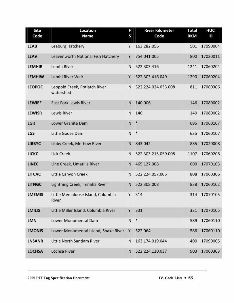
2009 PIT Tag Specification Document IV. Code Lists 63
Site Code
Location Name
F S
River Kilometer Code
Total RKM
HUC ID
LEAB Leaburg Hatchery Y 163.282.056 501 17090004
LEAV Leavenworth National Fish Hatchery Y 754.041.005 800 17020011
LEMHIR Lemhi River N 522.303.416 1241 17060204
LEMHIW Lemhi River Weir Y 522.303.416.049 1290 17060204
LEOPOC Leopold Creek, Potlatch River watershed
N 522.224.024.033.008 811 17060306
LEWIEF East Fork Lewis River N 140.006 146 17080002
LEWISR Lewis River N 140 140 17080002
LGR Lower Granite Dam N * 695 17060107
LGS Little Goose Dam N * 635 17060107
LIBBYC Libby Creek, Methow River N 843.042 885 17020008
LICKC Lick Creek N 522.303.215.059.008 1107 17060208
LINEC Line Creek, Umatilla River N 465.127.008 600 17070103
LITCAC Little Canyon Creek N 522.224.057.005 808 17060306
LITNGC Lightning Creek, Imnaha River N 522.308.008 838 17060102
LMEMIS Little Memaloose Island, Columbia River
Y 314 314 17070105
LMILIS Little Miller Island, Columbia River Y 331 331 17070105
LMN Lower Monumental Dam N * 589 17060110
LMONIS Lower Monumental Island, Snake River Y 522.064 586 17060110
LNSANR Little North Santiam River N 163.174.019.044 400 17090005
LOCHSA Lochsa River N 522.224.120.037 903 17060303

2009 PIT Tag Specification Document IV. Code Lists 64
Site Code
Location Name
F S
River Kilometer Code
Total RKM
HUC ID
LOGANC Logan Creek, Big Creek watershed, MF Salmon River
N 522.303.319.029.058 1231 17060206
LOLOC Lolo Creek N 522.224.087 833 17060306
LOOH Lookingglass Hatchery Y 522.271.137.003 933 17060104
LOOKGC Lookingglass Creek N 522.271.137 930 17060104
LOONC Loon Creek N 522.303.319.073 1217 17060205
LOSTIP Lostine River Pond Y 522.271.131.042.021 987 17060105
LOSTIR Lostine River N 522.271.131.042 966 17060105
LOSTIW Lostine River Weir Y 522.271.131.042.001 967 17060105
LSALR Little Salmon River N 522.303.140 965 17060210
LSFTRP Lower SF Salmon River Trap at rkm 61 Y 522.303.215.061 1101 17060208
LSHEEF Little Sheep Facility Y 522.308.032.005.008 875 17060102
LUGUAF Lukes Gulch Acclimation Facility, SF Clearwater River
Y 522.224.120.014 880 17060305
LUNION Lake Union Y *** 17110012
LWBEAR Bear Creek, Lake Washington below Redmond Way Bridge
Y *** 17110012
LWCEDR Cedar River, Lake Washington at Logan Street Bridge
Y *** 17110012
LWD Lowden Diversion Dam II, Walla Walla River
N * 560 17070102
LWENAT Little Wenatchee River N 754.090.008 852 17020011
LWISSQ Lake Washington, Issaquah Creek at SE 56th Street Bridge
Y *** 17110012

2009 PIT Tag Specification Document IV. Code Lists 65
Site Code
Location Name
F S
River Kilometer Code
Total RKM
HUC ID
LWSALR Little White Salmon River N 261 261 17070105
LWSCCL Ballard Locks Y *** 17110012
LWSCFC Ship Canal, Lake Washington at Fremont Cut/Bridge
Y *** 17110012
LWSCMC Ship Canal, Lake Washington at Montlake Cut/Bridge
Y *** 17110012
LWSCML Ship Canal, Lake Washington at King County/Metro Environmental Lab
Y *** 17110012
LWSH Little White Salmon National Fish Hatchery
Y 261.002 263 17070105
LYFE Lyons Ferry Hatchery Y 522.095 617 17060107
MADRVR Mad River (Entiat River watershed) N 778.017 795 17020010
MANCRS Manchester Research Station, Puget Sound
Y *** 17110019
MARSHC Marsh Creek N 522.303.319.170 1314 17060205
MARTRP Marsh Creek Trap Y 522.303.319.170.011 1325 17060205
MAVA Magic Valley Hatchery N * 17040212
MCCA McCall Hatchery N * 17050123
MCDEVC McDevitt Creek, Lemhi River Basin N 522.303.416.042 1283 17060204
MCKA2C McKay Creek, Crooked River N 328.177.072 577 17070305
MCKAYC McKay Creek, Umatilla River N 465.082 547 17070103
MCKE McKenzie Hatchery Y 163.282.053 498 17090004
MCKER McKenzie River N 163.282 445 17090004
MCKESF South Fork McKenzie River N 163.282.096 541 17090004

2009 PIT Tag Specification Document IV. Code Lists 66
Site Code
Location Name
F S
River Kilometer Code
Total RKM
HUC ID
MCN McNary Dam N * 470 17070101
MEACHC Meacham Creek, Umatilla River N 465.127 592 17070103
MEACHE East Fork Meacham Creek N 465.127.031 623 17070103
MEACHN North Fork Meacham Creek N 465.127.024 616 17070103
MEAD2C Meadow Creek, South Fork Clearwater N 522.224.120.053 919 17060305
MEADOC Meadow Creek, Selway River N 522.224.120.037.031 934 17060302
MERH Merwin Hatchery (WDFW) N * 17080002
METH Methow Hatchery Y 843.085 928 17020008
METHR Methow River N 843 843 17020008
METOLR Metolius River N 328.177 505 17070301
METRO King County/Metro Environmental Lab Y *** 17110012
METTRP Methow Smolt Trap at McFarland Creek Road Bridge
Y 843.030 873 17020008
MILL2C Mill Creek, SF Clearwater River N 522.224.120.052 918 17060305
MILL3C Mill Creek, Columbia River at The Dalles, OR
N 304 304 17070105
MILL4C Mill Creek, Lower Columbia River, Washington
N 087 87 17080003
MILLC Mill Creek, Walla Walla River N 509.054 563 17070102
MINAMR Minam River N 522.271.131.016 940 17060105
MINKC Mink Creek N 522.224.120.037.051 954 17060302
MINP Minthorn Acclimation Pond Y 465.109 574 17070103
MISSC Mission Creek N 522.224.019.016 781 17060306

2009 PIT Tag Specification Document IV. Code Lists 67
Site Code
Location Name
F S
River Kilometer Code
Total RKM
HUC ID
MISSNC Mission Creek, Umatilla River N 465.098 563 17070103
MLAK2C Middle Fork Lake Creek, Metolius River watershed
N 328.177.061.003 569 17070301
MLRSNI Miller Sands Island, Columbia River Estuary
Y 038 38 17080006
MOLALR Molalla River N 163.057 220 17090009
MONCWF West Fork Monumental Creek, Big Creek watershed, MF Salmon River
N 522.303.319.029.038.024 1235 17060206
MONT Montlake Hatchery N * 17110012
MONUMC Monumental Creek, Big Creek watershed, MF Salmon River
N 522.303.319.029.038 1211 17060206
MOONSC Moonshine Creek, Umatilla River N 465.108 573 17070103
MOOS2C Moose Creek (Selway River) N 522.224.120.037.065 968 17060302
MOOS2N North Fork Moose Creek, Selway River N 522.224.120.037.065.006 974 17060302
MOOS3C Moose Creek, Potlatch River watershed
N 522.224.024.076 846 17060306
MOOSEC Moose Creek N 522.303.282.031 1138 17060207
MSANTR Middle Santiam River, Oregon N 163.174.019.064 420 17090006
MSLA2C Middle Fk South Fk Lake Creek, Metolius River watershed
N 328.177.061 566 17070301
MULTCH Multnomah Channel, Columbia River N 139 139 17090012
MXWLCN Maxwell Diversion Canal - headgate to diversion screen (km 000-002)
N 465.024 479 17070103
NASONC Nason Creek (tributary to Wenatchee River)
N 754.089 843 17020011

2009 PIT Tag Specification Document IV. Code Lists 68
Site Code
Location Name
F S
River Kilometer Code
Total RKM
HUC ID
NATCHR Natches River N 539.187 726 17030002
NBG Nursery Bridge Diversion Dam, Walla Walla River
N * 581 17070102
NEALC Neal Creek, tributary to Hood River (OR)
N 273.007 280 17070105
NEWSOC Newsome Creek N 522.224.120.084 950 17060305
NFTEAN North Fork Teanaway River N 539.284.017 840 17030001
NISP Niagara Springs Hatchery N * 17040212
NLVP North Lapwai Valley Acclimation Pond Y 522.224.019.001 766 17060306
NONE Deprecated null value used only to support legacy data.
N * 99999999
NPTH Nez Perce Tribal Hatchery Y 522.224.038 784 17060306
NSANTR North Santiam River, Oregon N 163.174.019 356 17090005
NSCAPC North Scappoose Creek N 139.003.004.009 155 17090012
OASP Oak Springs Hatchery N * 404 17070306
OCEAN Ocean Recovery Y ~~~ N/A
OCHOCC Ochoco Creek, Crooked River N 328.177.072 577 17070305
OHARAC O'Hara Creek N 522.224.120.037.012 915 17060302
OKANR Okanogan River N 858 858 17020006
OLDMAC Old Man Creek N 522.224.120.037.028 931 17060303
OMAKC Omak Creek (tributary to Okanogan River)
N 858.064 922 17020006
OROFC Orofino Creek N 522.224.072 818 17060306

2009 PIT Tag Specification Document IV. Code Lists 69
Site Code
Location Name
F S
River Kilometer Code
Total RKM
HUC ID
OSOL Osoyoos Lake Y 858.130 988 17020006
OXBH Oxbox Hatchery, Cascade Locks, OR (ODFW)
N * 244 17070105
OXBO Oxbow Hatchery (IDFG) N * 17050201
PAHH Pahsimeroi Hatchery Y * 1316 17060202
PAHP Pahsimeroi Pond Y 522.303.489.011 1325 17060202
PAHSIR Pahsimeroi River N 522.303.489 1314 17060202
PAHSIW Pahsimeroi Weir Y 522.303.489.002 1316 17060202
PAHTRP Pahsimeroi River Trap Y 522.303.489.002 1316 17060202
PANT2C Panther Creek (trib. to Wind River, Wash.)
N 251.007 258 17070105
PANTHC Panther Creek (Salmon River) N 522.303.338 1163 17060203
PAPOOC Papoose Creek N 522.224.120.037.105 1008 17060303
PARTRC Partridge Creek N 522.303.160 985 17060209
PATTEC Pattee Creek, Lemhi River Basin N 522.303.416.037 1278 17060204
PEARSC Pearson Creek, Umatilla River N 465.077.026.018 586 17070103
PELTON Pelton Ladder (Deschutes River) Acclimation Pond
Y 328.161 489 17070306
PENP Pendleton Acclimation Pond Y 465.090 555 17070103
PER Pelton Reregulating Dam N * 489 17070306
PESHAR Peshastin River N 754.029 783 17020011
PETEKC Pete King Creek N 522.224.120.037.003 906 17060303
PETTL Pettit Lake Y 522.303.633.002.002 1462 17060201

2009 PIT Tag Specification Document IV. Code Lists 70
Site Code
Location Name
F S
River Kilometer Code
Total RKM
HUC ID
PETTLC Pettit Lake Creek N 522.303.633.002 1460 17060201
PINE2C Pine Creek, Potlatch River watershed N 522.224.024.028 798 17060306
PINEC Pine Creek, Walla Walla River N 509.038 547 17070102
PISTOC Pistol Creek, Middle Fork Salmon River N 522.303.319.118 1262 17060205
PIVASC Pivash Creek, Potlatch River watershed N 522.224.024.065.022 857 17060306
PLAP Pittsburg Landing Acclimation Facility Y 522.346 868 17060101
POLEC Pole Creek N 522.303.642 1467 17060201
POSTOC Post Office Creek N 522.224.120.037.082 985 17060303
POTHOL Potholes Reservoir, Grant County, Washington
Y ___ 17020015
POTR Potlatch River N 522.224.024 770 17060306
POTREF East Fork Potlatch River N 522.224.024.065 835 17060306
POTRWF West Fork Potlatch River N 522.224.024.083 853 17060306
POWP Powell Rearing Pond Y 522.224.120.037.113 1016 17060303
PRD Priest Rapids Dam N * 639 17020016
PRDH Priest Rapids Hatchery Y 639 639 17020016
PRKDLF Parkdale Acclimation Facility Y 273.023.005.000 301 17070105
PRO Prosser Diversion Dam, Yakima River N * 615 17030003
PROH Prosser Hatchery Y 539.075 614 17030003
PROSRD Prosser Dam (Archaic - replaced with PRO)
N 539.076 615 17030003
PROTRP Prosser Trap (Archaic) N 539.076 615 17030003

2009 PIT Tag Specification Document IV. Code Lists 71
Site Code
Location Name
F S
River Kilometer Code
Total RKM
HUC ID
PURDUC Purdue Creek, Potlatch River watershed
N 522.224.024.080 850 17060306
PWD Powerdale Dam, Hood River N * 280 17070105
QKASPC Quaking Asp Creek, Lemhi River Basin N 522.303.416.092.021 1354 17060204
RAPH Rapid River Hatchery Y 522.303.140.007.006 978 17060210
RAPIDR Rapid River, Little Salmon River N 522.303.140.007 972 17060210
RAPIWF West Fork Rapid River N 522.303.140.007.012 984 17060210
RAPR Rapid River, Middle Fork Salmon River N 522.303.319.124 1268 17060205
RATTLC Rattlesnake Creek N 271.012 283 17070105
REDFL Redfish Lake Y 522.303.615.005 1445 17060201
REDFLC Redfish Lake Creek N 522.303.615 1440 17060201
REDP Red River Rearing Pond Y 522.224.120.101.027 994 17060305
REDR Red River N 522.224.120.101 967 17060305
REDRSF South Fork Red River N 522.224.120.101.028 995 17060305
REDTRP Red River Trap Y 522.224.120.101.006 973 17060305
RELIEC Relief Creek N 522.224.120.094.013 973 17060305
RESVRC Reservoir Creek, Lemhi River Basin N 522.303.416.092.019 1352 17060204
RGRSPC Roger's Spring Creek, Middle Fork Hood River
N 273.023.005 301 17070105
RICEIS Rice Island Y 034 34 17080006
RICHIS Richland Island, Columbia River Y 545 545 17020016
RINH Ringold Hatchery Y 567 567 17020016

2009 PIT Tag Specification Document IV. Code Lists 72
Site Code
Location Name
F S
River Kilometer Code
Total RKM
HUC ID
RIS Rock Island Dam N * 730 17020010
RLCTRP Redfish Lake Creek Trap Y 522.303.615.003 1443 17060201
ROBU Round Butte Hatchery N * 17070306
ROCK2C Rock Creek, Columbia River (WA) N 363 363 17070101
ROCKC Rock Creek, tributary to East Fork Lewis River
N 140.006.042 188 17080002
ROCKIS Rock Island, Columbia River near Boardman, OR.
Y 441 441 17070101
ROLFIP Rolfing Acclimation Pond, Wenatchee River Basin
Y 754.089.021 864 17020011
ROSAD Roza Dam (Archaic - replaced with ROZ)
N 539.206 745 17030001
ROU Round Butte Dam N * 505 17070301
ROZ Roza Dam N * 745 17030001
RPDTRP Rapid River Smolt Trap Y 522.303.140.007.006 978 17060210
RRE Rocky Reach Dam N * 763 17020010
RSSNIS Russian Island, Columbia River Estuary Y 036 36 17080006
RUNNIC Running Creek N 522.224.120.037.253 1156 17060301
RUSHC Rush Creek, tributary of Big Creek, Middle Fork Salmon River
N 522.303.319.029.011 1184 17060206
RUSHWF West Fork Rush Creek, Big Creek watershed, MF Salmon River
N 522.303.319.029.011.013 1197 17060206
RYANC Ryan Creek, Umatilla River N 465.132 597 17070103
SABEC Sabe Creek N 522.303.272 1097 17060207

2009 PIT Tag Specification Document IV. Code Lists 73
Site Code
Location Name
F S
River Kilometer Code
Total RKM
HUC ID
SAEFSF East Fork South Fork Salmon River N 522.303.215.060 1100 17060208
SALEFT East Fork Salmon River Trap Y 522.303.552.029 1406 17060201
SALEFW East Fork Salmon River Weir (Archaic - use SALEFT)
N 522.303.552.030 1407 17060201
SALMF1 Middle Fork Salmon River - mouth to Loon Creek (km 0-73)
N 522.303.319 1144 17060206
SALMF2 Middle Fork Salmon River - Loon Creek to headwaters (km 73-170)
N 522.303.319 1144 17060205
SALMOC Salmon Creek (tributary to Okanogan River)
N 858.055 913 17020006
SALR Salmon River (Archaic - replaced with reach-specific definitions)
N 522.303 825 170602*
SALR1 Salmon River - mouth to above French Creek (km 0-171)
N 522.303 825 17060209
SALR2 Salmon River - above French Creek to Middle Fork Salmon River (km 171-319)
N 522.303 825 17060207
SALR3 Salmon River - Middle Fork Salmon River to Pahsimeroi River (km 319-489)
N 522.303 825 17060203
SALR4 Salmon River - Pahsimeroi River to headwaters (km 489-650)
N 522.303 825 17060201
SALREF East Fork Salmon River N 522.303.552 1377 17060201
SALRMF Middle Fork Salmon River (Archaic - replaced with reach-specific definitions)
N 522.303.319 1144 17060206
SALRNF North Fork Salmon River N 522.303.381 1206 17060203

2009 PIT Tag Specification Document IV. Code Lists 74
Site Code
Location Name
F S
River Kilometer Code
Total RKM
HUC ID
SALRSF South Fork Salmon River N 522.303.215 1040 17060208
SALSFW South Fork Salmon River Weir Y 522.303.215.115 1155 17060208
SALTRP Salmon Trap Y 522.303.103 928 17060209
SANTIR Santiam River, Oregon N 163.174 337 17090005
SATUSC Satus Creek, Yakima River N 539.112 651 17030003
SAWT Sawtooth Hatchery Y 522.303.617 1442 17060201
SAWTRP Sawtooth Trap Y 522.303.617 1442 17060201
SCAPPB Scappoose Bay, Oregon N 139.003 142 17090012
SCAPPC Scappoose Creek N 139.003.004 146 17090012
SECESR Secesh River N 522.303.215.059 1099 17060208
SECTRP Secesh River Screw Trap Y 522.303.215.059.007 1106 17060208
SELWY1 Selway River - mouth to Moose Creek (km 0-65)
N 522.224.120.037 903 17060302
SELWY2 Selway River - Moose Creek to headwaters (km 65-147)
N 522.224.120.037 903 17060301
SELWYR Selway River (Archaic - replaced with reach-specific definitions)
N 522.224.120.037 903 170603*
SERH Sea Resources Hatchery (Chinook River, Washington)
Y 006.006 12 17080006
SFSTRP SF Salmon River Trap (Archaic - replaced with SALRSF or KNOXB)
N 522.303.215.118 1158 17060208
SGOLDC South Fork Gold Creek, Methow River watershed
N 843.035.002 880 17020008
SHEEPC Sheep Creek N 522.303.188 1013 17060207

2009 PIT Tag Specification Document IV. Code Lists 75
Site Code
Location Name
F S
River Kilometer Code
Total RKM
HUC ID
SHEPC Sheep Creek, Middle Fork Salmon River
N 522.303.319.049 1193 17060206
SHERFT Sherars Falls Fishway Trap, Deschutes River
Y 328.071 399 17070306
SHIMC Shimmihorn Creek, Umatilla River N 465.145.008 618 17070103
SIMCNF North Fork Simcoe Creek, Toppenish Creek drainage
N 539.130.053.030 752 17030003
SIMCOC Simcoe Creek, Toppenish Creek drainage
N 539.130.053 722 17030003
SIMILP Similkameen Acclimation Pond (replaces archaic SIMP)
Y 858.119.008 985 17020007
SIMILR Similkameen River N 858.119 977 17020007
SIMP Similkameen Pond (Archaic - replaced by SIMILP)
N 941.121.008 1070 17020007
SKIPAR Skipanon River N 013.003 16 17080006
SKIPAW Skipanon Waterway N 013 13 17080006
SLAT2C Slate Creek, upper Salmon River N 522.303.576 1401 17060201
SLATEC Slate Creek, lower Salmon River N 522.303.106 931 17060209
SMILEC Smiley Creek N 522.303.644 1469 17060201
SMITHC Smith Creek, Big Creek watershed, MF Salmon River
N 522.303.319.029.054 1227 17060206
SNAKE1 Snake River - mouth to Palouse River (km 0-96)
N 522 522 17060110
SNAKE2 Snake River - Palouse River to Clearwater River (km 96-224)
N 522 522 17060107

2009 PIT Tag Specification Document IV. Code Lists 76
Site Code
Location Name
F S
River Kilometer Code
Total RKM
HUC ID
SNAKE3 Snake River - Clearwater River to Salmon River (km 224-303)
N 522 522 17060103
SNAKE4 Snake River - Salmon River to Hells Canyon Dam (km 303-397)
N 522 522 17060101
SNAKER Snake River (Archaic - replaced with reach-specific definitions)
N 522 522 170601*
SNKTRP Snake Trap Y 522.225 747 17060103
SNOSLC Snowslide Creek, Big Creek watershed, MF Salmon River
N 522.303.319.029.038.009 1230 17060206
SPRC Spring Creek National Fish Hatchery Y 269 269 17070105
SQAW2C Squaw Creek, Salmon River N 522.303.564 1389 17060201
SQAWC Squaw Creek, Umatilla River N 465.124 589 17070103
SQUAWC Squaw Creek, Lochsa River N 522.224.120.037.096 999 17060303
SQUAWP Squaw Creek Acclimation Pond Y 522.303.564.001 1390 17060201
SSANTR South Santiam River, Oregon N 163.174.019 356 17090006
SSD Sunnyside Dam N * 706 17030003
SSIDEC Sunnyside Canal - headgate to diversion screen (km 000-001)
N 539.167 706 17030003
SSIDES Sunnyside Screen (Archaic - use SSIDEC)
N 539.167.001 707 17030003
STANLC Stanley Lake Creek N 522.303.609.009 1443 17060201
STANLE Stanley; Gage 2945 (Archaic - use SALR4)
N 522.303.609 1434 17060201
STAPAC Stapaloop Creek, in Okanogan River basin
N 858.064.022 944 17020006
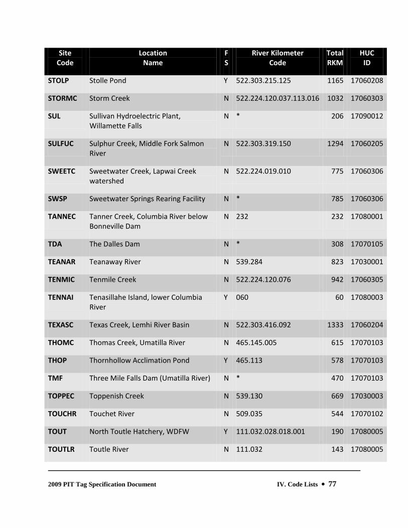
2009 PIT Tag Specification Document IV. Code Lists 77
Site Code
Location Name
F S
River Kilometer Code
Total RKM
HUC ID
STOLP Stolle Pond Y 522.303.215.125 1165 17060208
STORMC Storm Creek N 522.224.120.037.113.016 1032 17060303
SUL Sullivan Hydroelectric Plant, Willamette Falls
N * 206 17090012
SULFUC Sulphur Creek, Middle Fork Salmon River
N 522.303.319.150 1294 17060205
SWEETC Sweetwater Creek, Lapwai Creek watershed
N 522.224.019.010 775 17060306
SWSP Sweetwater Springs Rearing Facility N * 785 17060306
TANNEC Tanner Creek, Columbia River below Bonneville Dam
N 232 232 17080001
TDA The Dalles Dam N * 308 17070105
TEANAR Teanaway River N 539.284 823 17030001
TENMIC Tenmile Creek N 522.224.120.076 942 17060305
TENNAI Tenasillahe Island, lower Columbia River
Y 060 60 17080003
TEXASC Texas Creek, Lemhi River Basin N 522.303.416.092 1333 17060204
THOMC Thomas Creek, Umatilla River N 465.145.005 615 17070103
THOP Thornhollow Acclimation Pond Y 465.113 578 17070103
TMF Three Mile Falls Dam (Umatilla River) N * 470 17070103
TOPPEC Toppenish Creek N 539.130 669 17030003
TOUCHR Touchet River N 509.035 544 17070102
TOUT North Toutle Hatchery, WDFW Y 111.032.028.018.001 190 17080005
TOUTLR Toutle River N 111.032 143 17080005

2009 PIT Tag Specification Document IV. Code Lists 78
Site Code
Location Name
F S
River Kilometer Code
Total RKM
HUC ID
TOUTNF North Fork Toutle River N 111.032.028 171 17080005
TROU2C Trout Creek, Deschutes River Watershed
N 328.140 468 17070307
TROUTC Trout Creek (trib. to Wind River, Wash.)
N 251.017 268 17070105
TUCH Tucannon River Hatchery Y 522.100.058 680 17060107
TUCR Tucannon River N 522.100 622 17060107
TUM Tumwater Dam, Wenatchee River N * 798 17020011
TURO Turtle Rock Pond Y 765 765 17020010
TUTUIC Tutuilla Creek, Umatilla River N 465.084 549 17070103
TWIS2P Twisp Acclimation Pond (Methow Salmon Recovery Foundation)
Y 843.066.002 911 17020008
TWISPP Twisp Acclimation Pond (WDFW) Y 843.066.008 917 17020008
TWISPR Twisp River N 843.066 909 17020008
TWNMIC Twentymile Creek N 522.224.120.069 935 17060305
TWNMIT Twentymile Creek Trap Y 522.224.120.069.003 938 17060305
UMAH Umatilla Hatchery N * 17070101
UMAR Umatilla River N 465 465 17070103
UMATNF North Fork Umatilla River N 465.145 610 17070103
UMATSF South Fork Umatilla River N 465.145 610 17070103
UWH University of Washington Hatchery Y *** 17110012
VALEYC Valley Creek N 522.303.609 1434 17060201
VATC Vat Creek N 522.303.633.003 1461 17060201

2009 PIT Tag Specification Document IV. Code Lists 79
Site Code
Location Name
F S
River Kilometer Code
Total RKM
HUC ID
VGISNB Van Giesen Road Bridge, Yakima River Y 539.014 553 17030003
VIENTC Viento Creek, Columbia River Gorge (OR)
N 258 258 17070105
WAHA Washougal Hatchery, WDFW Y 193.032 225 17080001
WALH Wallowa Hatchery Y 522.271.131.063.001 988 17060105
WALLAR Walla Walla River N 509 509 17070102
WALLNF North Fork Walla Walla River N 509.081 590 17070102
WALLOR Wallowa River N 522.271.131 924 17060105
WALLSF South Fork Walla Walla River N 509.081 590 17070102
WAN Wannapum Dam N * 669 17020010
WAP Wapato Diversion Dam, Yakima River N * 711 17030003
WAPATC Wapato Canal - headgate to diversion screen (km 000-001)
N 539.172 711 17030003
WAPATD Wapato Dam (Archaic - replaced with WAP)
N 539.172 711 17030003
WAPATS Wapato Screen (Archaic) N 539.172.001 712 17030003
WARMSC Warm Springs Creek N 522.224.120.037.092 995 17060303
WARMSR Warm Springs River, Deschutes River Watershed
N 328.135 463 17070306
WASHOR Washougal River N 193 193 17080001
WBIRDC Whitebird Creek N 522.303.086 911 17060209
WEBBC Webb Creek, Lapwai Creek watershed N 522.224.019.010.006 781 17060306
WEL Wells Dam N * 830 17020005

2009 PIT Tag Specification Document IV. Code Lists 80
Site Code
Location Name
F S
River Kilometer Code
Total RKM
HUC ID
WELH Wells Hatchery Y 830 830 17020005
WENA2T Upper Wenatchee smolt trap just below Lake Wenatchee
Y 754.086 840 17020011
WENATL Lake Wenatchee Y 754.090 844 17020011
WENATR Wenatchee River N 754 754 17020011
WENATT Wenatchee River trap at West Monitor Bridge
Y 754.010 764 17020011
WENR Wenaha River N 522.271.073 866 17060106
WENRNF North Fork Wenaha River N 522.271.073.035 901 17060106
WENRSF South Fork Wenaha River N 522.271.073.035 901 17060106
WHITCC White Cap Creek N 522.224.120.037.264 1167 17060301
WHITER White River, Wenatchee River Basin N 754.090 844 17020011
WHITSC White Sand Creek - replaced by COLTKC
N 522.224.120.037.113 1016 17060303
WHITSR White Salmon River N 271 271 17070105
WHSH Warrenton (OR) High School Hatchery N * 21 17080006
WILDCC Wildcat Creek, Lemhi River Basin N 522.303.416.090.014.003 1348 17060204
WILH Willamette Hatchery (ODFW) at Oakridge
N * 17090001
WILL Willard National Fish Hatchery Y 261.009 270 17070105
WILLIC Williams Creek N 522.303.622 1447 17060201
WILLR Willamette River (Archaic - replaced with reach-specific definitions)
N 163 163 170900*
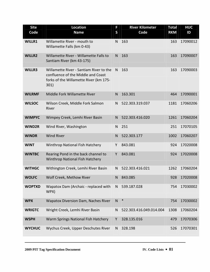
2009 PIT Tag Specification Document IV. Code Lists 81
Site Code
Location Name
F S
River Kilometer Code
Total RKM
HUC ID
WILLR1 Willamette River - mouth to Willamette Falls (km 0-43)
N 163 163 17090012
WILLR2 Willamette River - Willamette Falls to Santiam River (km 43-175)
N 163 163 17090007
WILLR3 Willamette River - Santiam River to the confluence of the Middle and Coast forks of the Willamette River (km 175-301)
N 163 163 17090003
WILRMF Middle Fork Willamette River N 163.301 464 17090001
WILSOC Wilson Creek, Middle Fork Salmon River
N 522.303.319.037 1181 17060206
WIMPYC Wimpey Creek, Lemhi River Basin N 522.303.416.020 1261 17060204
WIND2R Wind River, Washington N 251 251 17070105
WINDR Wind River N 522.303.177 1002 17060207
WINT Winthrop National Fish Hatchery Y 843.081 924 17020008
WINTBC Rearing Pond in the back channel to Winthrop National Fish Hatchery
Y 843.081 924 17020008
WITHGC Withington Creek, Lemhi River Basin N 522.303.416.021 1262 17060204
WOLFC Wolf Creek, Methow River N 843.085 928 17020008
WOPTXD Wapatox Dam (Archaic - replaced with WPX)
N 539.187.028 754 17030002
WPX Wapatox Diversion Dam, Naches River N * 754 17030002
WRIGTC Wright Creek, Lemhi River Basin N 522.303.416.049.014.004 1308 17060204
WSPH Warm Springs National Fish Hatchery Y 328.135.016 479 17070306
WYCHUC Wychus Creek, Upper Deschutes River N 328.198 526 17070301

2009 PIT Tag Specification Document IV. Code Lists 82
Site Code
Location Name
F S
River Kilometer Code
Total RKM
HUC ID
Basin
YAKIM1 Yakima River - mouth to Naches River (km 0-187)
N 539 539 17030003
YAKIM2 Yakima River - Naches River to headwaters (km 187-345)
N 539 539 17030001
YAKIMR Yakima River (Archaic - replaced with reach-specific definitions)
N 539 539 170300*
YANKFK Yankee Fork Salmon River N 522.303.591 1416 17060201
YANKWF West Fork Yankee Fork Salmon River N 522.303.591.011 1427 17060201
YELHKC Yellowhawk Creek, Walla Walla River N 509.070 579 17070102
YELLJC Yellowjacket Creek, tributary of Camas Creek, Middle Fork Salmon River
N 522.303.319.057.007 1208 17060206
YELLLC Yellowbelly Lake Creek N 522.303.633.001 1459 17060201
YRIANC Yearian Creek, Lemhi River Basin N 522.303.416.057 1298 17060204

2009 PIT Tag Specification Document IV. Code Lists 83
6. Intra-Dam Release Site Codes These codes are appended as a suffix to the three-character dam site code and provide a specific location for release at, above, or below hydroelectric facilities. For example, a release into a gatewell at Lower Granite Dam would be coded as LGRGWL.
Code Intra-dam Location
BCC Release into the Facility Bypass Corner Collector
BPS Release into the PIT-Tag Diversion System between the Diversion Gate and the furthest downstream PIT-Tag Detector
BYP Release into the Facility Bypass Flume/Pipe
COL Release into the Collection Channel upstream of the Dewatering Facility
DTG Release into the Collection Flume/Pipe between the Dewatering Facility and the Collection/Bypass Gate
DWT Release into the Dewatering Facility
FBY Release into the Forebay within 0.5 km upstream of Dam
FDS Release above the Fish Diversion Screen
FTF Release into the Fish Transfer Facility
GAT Release into Flume between Separator Exit and the Primary PIT-Tag Diversion Gate
GWL Release into Gatewell(s)
ICE Release into the Ice/Trash Sluiceway
LD1 Release into the Left Bank (facing downstream) Adult Fish Ladder {at a site with multiple ladders}
LD2 Release into the [Right Bank or Middle] (facing downstream) Adult Fish Ladder {at a site with 2 or 3 ladders}
LD3 Release into the Right Bank (facing downstream) Adult Fish Ladder {at a site with 3 ladders}
LDR Release into the Adult Fish Ladder {at a site with a single ladder}

2009 PIT Tag Specification Document IV. Code Lists 84
Code Intra-dam Location
MRT Mortality Recovery
OFL Release into the PIT-Tag Diversion System downstream of the Last PIT-Tag Detector
ORI Release into Orifice(s)
RBR Release below the PIT-Tag Diversion System Gate with subsequent Barge Transportation from the Facility
RRR Release below the PIT-Tag Diversion System Gate with subsequent Return to the River at the Facility
RTR Release below the PIT-Tag Diversion System Gate with subsequent Truck Transportation from the Facility
RXR Release below the PIT-Tag Diversion System Gate with subsequent Transportation from the Facility
SEP Release into the Flume downstream of the Collection/Bypass Gate or into the Separator
SPF Release into the Forebay within 0.5 km upstream of Spillway
SPL Release directly into Spill Bay(s)
SPT Release into the Tailrace within 0.5 km downstream of Spillway
SRR Release into the Separator Return Flume/Pipe with Direct Return to the River
STS Release onto the Submerged Traveling Screen
TAL Release into the Tailrace within 0.5 km downstream of Dam
TRB Release into Turbine(s)

2009 PIT Tag Specification Document IV. Code Lists 85
L. PIT Tag Steering Committee Members, 2009
Steve Pastor, Chair Doug Marsh U.S. Fish and Wildlife Service CRFPO National Marine Fisheries Service 1211 SE Cardinal Ct., Suite 100 2725 Montlake Blvd. Vancouver, WA 98683 Seattle, WA 98112 [email protected] [email protected] Ph: (360) 604-2500 Ph: (206) 860-3235 Fax: (360) 604-2505 Ph: (206) 860-3267 Charles Morrill Pat Keniry Washington Department of Fish & Wildlife Oregon Department of Fish & Wildlife 600 N. Capitol Way One University Blvd., 203 Badgley Hall, EOU Olympia, WA 98504 La Grande, OR 97850 [email protected] [email protected] Ph: (360) 902-2747 Ph: (541) 962-3026 Fax: (360) 902-2183 Fax: (541) 962-3067 Ed Buettner Jeff Fryer Idaho Department of Fish & Game Columbia River Intertribal Fish Commission 1540 Warner Ave. 729 NE Oregon Street Lewiston, ID 83501 Portland, OR 97232 [email protected] [email protected] Ph: (208) 799-5010 Ph: (503) 731-1266 Fax: (208) 799-5012 Fax: (503) 235-4228 Jack Tuomikoski
Fish Passage Center 1827 NE 44th Ave., Suite 240 Portland, OR 97213 [email protected] Ph: (503) 230-4287 Fax: (503) 230-7559

2009 PIT Tag Specification Document IV. Code Lists 86
V. Glossary of Terms
ANTENNA A loop antenna, made from a coil of wire, which transmits a signal that excites a PIT tag, and then receives a return signal from the PIT tag. Antennas are found in all interrogation equipment, from tabletop detectors to automatic interrogation systems.
ANTENNA GROUP A group of antennas around the same pipe or flume within the same or adjoining shielding boxes, with no gates between them; a set of PIT tag antennas within one shielded unit.
ANTENNA ID The unique identifier associated with each antenna in an automatic interrogation system.
ASSOCIATED MARKS A field in a Release Information File (obsolete since 1998) used to record identifying marks, other than PIT tags, associated with a group of fish being released, (e.g., freeze brands, fin clips, coded wire tags or VI tags).
BROOD YEAR A field in a Tag Data File used, if applicable, to record the last two digits of the year a hatchery stock was spawned.
CAPTURE METHOD A field in a Tag Data File used to record the method used to collect fish.
CHECKSUM An (archaic) field in a Tag Data File detail record used to record a two-character hexadecimal value that confirms the validity of a 400 kHz PIT tag code.
COLLECTION SITE A field in a Mortality File (obsolete since 1998) used to record the six-character code of the denoting the point of collection. The RELEASE SITE field in the Tag Data File serves the same purpose when referencing detail records denoting mortality events.
COIL See ANTENNA.

2009 PIT Tag Specification Document V. Glossary of Terms 87
COIL ID
See ANTENNA ID.
CONDITIONAL COMMENT A field in a Tag Data File detail record used to record coded references to fish condition, and other key criteria. PTAGIS will not accept data files containing unrecognized Conditional Comments.
COORDINATOR ID A field in a Tag Data File used to record the (generally) three-character initials of the Coordinator. The Coordinator is responsible for the marking or recovery operation utilizing the PIT tags, and for responding to queries from other entities regarding those operations. Coordinators are not necessarily directly involved in data collection.
CREATION DATE A field in a Mortality File (obsolete since 1998) used to record the date the file was created, and used as the default date of observed mortality. Obsolete. The TAG DATE field in the Tag Data File serves the same purpose when referencing detail records denoting mortality events.
DETECTION A single PIT tag interrogation event.
DETECTOR A colloquial term used to describe one or more antenna assemblies used to interrogate PIT-tagged fish.
DIVERSION GATE A mechanical gate (such as a rotating- or slide gate) used to selectively route or segregate fish.
EPA-REACH See USGS HYDROLOGIC UNIT.
EVENT Any of the tagging and release, recovery (recapture or mortality) or interrogation activities associated with PIT tag mark/recapture studies.
FILE TITLE The file ID or name given to a PIT tag data file. Each File Title must be unique from all others in the Columbia River Basin and therefore it is very important to follow the formats described in the PIT tag Specification Document for each individual file type. Files containing computer-generated File Title declarations cannot be renamed without also editing the declaration within the file.

2009 PIT Tag Specification Document V. Glossary of Terms 88
FILE TYPE RECORD This record is present in Tagging and Interrogation files. It designates the format, content, and function of PIT tag data files.
FIXED REFERENCE TAG A tag having a unique code and an internal clock that is permanently attached to a PIT tag antenna at an interrogation site, and used to monitor the operation and performance of an individual antenna. It receives power from the excitation coil and automatically transmits its code at a regular interval. Also known as a “Timer Tag.”
FLAG CODE See Conditional Comment.
FORK LENGTH A field in a Tag Data File detail record used to record the length of a fish from the tip of the snout to the fork of the tail, recorded in millimeters.
GIS HYDRO UNIT See USGS HYDROLOGIC UNIT.
HATCHERY SITE A field in a Tag Data File used, if applicable, to record a four-character abbreviation of the hatchery at which the fish were reared.
HEADER RECORD A record found at the beginning of a Tag Data File describing parameters global to the detail records in the file.
INTERROGATION FILE A data file of passive PIT tag detections, created with the MiniMon.exe or MultiMon.exe software programs, and containing the PIT tag codes, dates and times of interrogation, and the antenna IDs on which the tags were interrogated.
ISO International Standards Organization.
ISO 11784 and 11785 These are the international standards related to the Radio Frequency ID technology used in PIT tags. 11784 defines the 128 bits of the tag telegram message, also referred to as the datagram. 11785 defines the technical parameters of the tag. For example, the ISO tag activation frequency is 134.2 kHz.

2009 PIT Tag Specification Document V. Glossary of Terms 89
LOCATION A tag, release, recapture, or mortality site. Fixed locations include hatcheries, main stem dams, and some traps and weirs. Stream and river locations may support PIT tag events at points along the length of the entire stream from its mouth to its headwaters.
MAIN SITE For the purpose of PTAGIS database reports, specific main stem interrogation sites are classified as a “Main” site. Special database processing occurs for sites that are classified as “Main” sites. Specifically, the first interrogation of a PIT tag at a “Main” site will create an “obs_main” record in the database. Subsequent interrogations of this PIT tag record at other “Main” sites will not generate further obs_main records.
MIGRATION YEAR A field in a Tag Data File used to record the last two digits of the earliest
MINIMON.EXE
calendar year when fish are expected to smolt and out-migrate to the ocean. In the case of adult or recaptured salmon and steelhead, or resident fish species, this value will generally reference the current year.
A 32-bit Windows™ software program that provides automated data entry of PIT tag passive interrogation data.
MONITOR See ANTENNA GROUP.
MORTALITY A PIT tag that is recovered with or without the host animal, subsequent to the tagged release of the animal. See “Mortality Events” in Section III.A.5.e.2: Conditional Comments.
MORTALITY FILE An obsolete data input file format originally used to report PIT tag mortality events. These events are now recorded and reported to PTAGIS using the standard Tag Data File.
MULTIMON.EXE A DOS software program that provides automated data entry of PIT tag passive interrogation data. In addition, the MULTIMON.EXE program provides logical control for the operation of fish diversion gates, and includes a “Separation by Code” (SbyC) capability that permits the identification and segregation of individual PIT-tagged fish based on each tag’s unique hexadecimal code.
NOTE RECORD A comment section in a Tag Data File. Depending on the context in which they are recorded and used, note records can pertain to a group of fish or to an individual fish. Note records are not processed by, or incorporated into, the PTAGIS database.

2009 PIT Tag Specification Document V. Glossary of Terms 90
OBSERVATION A colloquial name for an interrogation event recorded in an Interrogation File.
ORGANIZATION A field in a Tag Data file used to record the code for the entity responsible for data collection.
P3.EXE A 32-bit Windows™ data entry software program used to record tagging and release, recapture, and mortality events. P3.EXE integrates real-time, context-sensitive data validation into its data collection process.
PASS-THROUGH REFERENCE TAG A PIT tag embedded in a wooden block and passed through an interrogation system to determine coil, interrogation unit, and system reading efficiencies. Also called a STICK TAG.
PIFF.EXE A 32-bit Windows™ software program used to generate a formatted interrogation data file from text files containing raw device data.
PIT (Passive Integrated Transponder) TAG A computer chip attached to a wire antenna and encapsulated in a biologically inert glass capsule. The tag is excited when it is passed through the electro- magnetic field of a detector and the Tag ID encoded on the computer chip is transmitted to the detector.
PIT TAG DIVERSION GATE Any mechanical device used to route or divert PIT-tagged fish. The gate is activated by a Programmable Logic Controller (PLC) attached to a PIT tag detector.
PIT TAG INTERROGATION SYSTEM All of the equipment at an interrogation site related to detecting and reporting PIT tags.
PIT TAG STEERING COMMITTEE (PTSC) A subcommittee of the Fish Passage Advisory Committee of the Columbia Basin Fish and Wildlife Authority. The Committee is made up of technical representatives of the Basin’s fisheries agencies and tribes. The Committee’s function is to provide guidance in the development of tagging methodologies and data standards and to serve as a technical forum for the operation of PTAGIS and the PIT tag data collection and distribution system.
PIT CODE A unique 10- or 14-character hexadecimal code recorded on the computer chip in the PIT tag. PTAGIS applications refer to this value as the Tag ID.
2009 PIT Tag Specification Document V. Glossary of Terms 91
POSITIONAL COMMENT A field in a Tag Data File detail record used to record specific, pre-formatted codes pertaining to an individual fish. Currently there are predefined values and formats for Species, Run, Rearing Type, and Release Time Variable codes. Individual researchers can designate their own additional positional comments for their own use, but they will not be recognized and processed by the PTAGIS data system.
POST TAGGING TEMP
A field in a Tag Data File used to record the water temperature (Cº) in a pond or raceway when fish are held for an extended period of time prior to release. This variable should be left blank if the fish are released immediately.
PTAGIS The PIT Tag Information System. This is the central repository of all PIT tag information collected in the Columbia Basin. PTAGIS is managed by the Pacific States Marine Fisheries Commission with funding from the Bonneville Power Administration.
PTOC The PIT Tag Operations Center. PTOC provides the operational components of the Columbia Basin PIT Tag Information System (PTAGIS) project. This acronym is from the Charter agreement for the PIT Tag Steering Committee between the Columbia Basin Fish and Wildlife Authority and the Pacific States Marine Fisheries Commission. According to the Charter, PTOC administers the PTAGIS database, operates and maintains all detection equipment at the main-stem Columbia and Snake river dams, and creates and updates data collection software for the Columbia River Basin PIT Tag Information System – this by definition is the PTAGIS project.
RACEWAY/TRANSECT This refers to a field in a Tag Data File used, as needed, to record the raceway or transect number or designation used to identify a group of PIT-tagged fish.
REARING TYPE A one-character code within the Positional Comments section of a Tag Data File detail record used to indicate the rearing status (hatchery, wild, or unknown) of a fish.
RECAPTURE A PIT-tagged fish that is handled subsequent to the release event. A recaptured fish must be designated with the “RE” flag code.
RECOVERY ORGANIZATION
A field in the Mortality File (obsolete since 1998) used to record the code of the agency or organization responsible for the collection of mortality data. The ORGANIZATION field in the Tag Data File serves the same purpose when referencing detail records denoting mortality events.

2009 PIT Tag Specification Document V. Glossary of Terms 92
RELEASE DATE A field in a Tag Data File used to record the date that fish are released after being PIT-tagged to rear or out-migrate naturally.
RELEASE INFORMATION FILE The Release Information File consisted of information about a Tag Data File or files that was not available at the time of tagging. Obsolete since 1998. Release information is now incorporated directly into the Tag Data File.
RELEASE RIVER KM A field in a Tag Data File used to record the location of release, in river kilometers. This is a hierarchical coding scheme denoting the distance of release locations and intermediate tributaries from the mouth of the Columbia River. For example, the Release River KM of 522.173 for Lower Granite Dam reflects a distance of 522 km from the mouth of the Columbia River to the mouth of the Snake River, and 173 km from the mouth of the Snake River to Lower Granite Dam.
RELEASE SITE A field in a Tag Data File containing the fixed location or stream name that PIT-tagged fish are released into.
RELEASE WATER TEMP A field in a Tag Data File containing the temperature (Cº) of the body of water that PIT-tagged fish are released into to migrate downstream.
RIVER REACH See USGS HYDROLOGIC UNIT.
RUN A one-digit code within the Positional Comments section of a Tag Data File detail record used to indicate the season the adult fish return from saltwater (e.g., spring Chinook, summer steelhead, etc).
SESSION MESSAGE A field in a Tag Data File used to summarize the purpose and function of the data set.
SITE An interrogation system location.
SITE CODE A unique three-character interrogation site identifier.
2009 PIT Tag Specification Document V. Glossary of Terms 93
SPECIES A one-digit code within the Positional Comments section of a Tag Data File detail record use to indicate the species of the fish being tagged.
STICK TAG See PASS-THROUGH REFERENCE TAG.
STOCK A field in a Tag Data File used, as needed, to record a brief descriptor of the brood stock, such as “Rapid River” or “Wells”.
TAG DATE A field in a Tag Data File used to record the date the fish were tagged or recovered. The P3.EXE software program defaults to the current date and time.
TAG DETAIL RECORD That portion of a Tag Data File containing the PIT code, length, weight, species, race, rearing type, and any comments associated with each individual tagged fish.
TAG SITE A field in a Tag Data File used to record the location code (four to six characters) of the tagging or recovery operation.
TAGGER This field in a Tag Data File can be used to record the last name and first initial of the tagging or project supervisor.
TAG DATA FILE A data file containing information pertaining to the original marking and release, recapture, or mortality of PIT-tagged fish.
TAGGING METHOD A field in a Tag Data File used to record the method of injecting tags into fish. If the data file contains only recapture or mortality information, the Tagging Method is denoted as “NONE.”
TAGGING TEMP The temperature (Cº) of the tagging bath during the marking operation.
TEST TAG A special tag (e.g., “Stick Tag” or “Fixed Reference Tag”) registered by PTOC and used to test equipment at interrogation sites.

2009 PIT Tag Specification Document V. Glossary of Terms 94
TEXTUAL COMMENT A field in a Tag Data File detail record containing an ad hoc text descriptor pertaining to an individual fish.
TIMER TAG See FIXED REFERENCE TAG.
TRANSPORTATION DURATION A field in a Release Information file (obsolete since 1998) used to report the duration of time from loading of fish onto the transport vehicle until they are released into the stream.
TRANSPORTATION TYPE A field in a Release Information file (obsolete since 1998) used to report the method of transport to the release site.
USGS HYDROLOGIC UNIT An eight-digit watershed code representing the primary through quaternary classifications of geographic mapping in the United States.
VARIABLE RELEASE TIME A method of assigning multiple Release Dates (including times) to groups of fish within a Tag Data File. If groups of fish within a Tag Data File are tagged and released to a stream independently of other groups within the same Tag Data File then release date and times must be recorded for each group of fish. This is done with the Release Time Variable, which is a Positional Comment value ranging from 00 to 99. There must be a corresponding Variable Release Time declaration in the Tag Data File to define each unique Release Time Variable reference in the Tag Detail section.
WEIGHT A field in a Tag Data File used to report the weight of the fish, recorded in tenths of grams.

2009 PIT Tag Specification Document Appendix A. Hydrologic Unit Codes 95
Appendix A. Hydrologic Unit Codes Adapted from Seaber, P.R., Kapinos, F.P., and Knapp, G.L., 1987, Hydrologic Unit Maps: U.S. Geological Survey Water-Supply Paper 2294, 63 p.
A1. Classification System The United States was divided and sub-divided into successively smaller hydrologic units which were classified into four levels: regions, sub-regions, accounting units, and cataloging units. The hydrologic units are arranged within each other, from the smallest (cataloging units) to the largest (regions). Each hydrologic unit is identified by a unique hydrologic unit code (HUC) consisting of two to eight digits based on the four levels of classification in the hydrologic unit system.
The first level of classification divides the Nation into 21 major geographic area, or regions. These geographic areas (hydrologic areas based on surface topography) contain either the drainage area of a major river, such as the Missouri region, or the combined drainage areas of a series of rivers, such as the Texas-Gulf region, which includes a number of rivers draining into the Gulf of Mexico.
The second level of classification divides the 21 regions into 222 sub-regions. A sub-region includes the area drained by a river system, a reach of a river and its tributaries in that reach, a closed basin(s), or a group of streams forming a coastal drainage area.
The third level of classification subdivides many of the sub- regions into accounting units.
The fourth level of classification is the cataloging unit, the smallest element in the hierarchy of hydrologic units. A cataloging unit is a geographic area representing part or all of a surface drainage basin, a combination of basins, or a distinct hydrologic feature.

2009 PIT Tag Specification Document Appendix A. Hydrologic Unit Codes 96
A2. Explanation of Hydrologic Unit Codes An eight-digit code uniquely identifies each of the four levels of classification within four two-digit fields. The first two digits identify the water-resources region; the first four digits identify the sub-region; the first six digits identify the accounting unit, and the addition of two more digits for the cataloging unit completes the eight-digit code. An example is given here using hydrologic unit code (HUC) 01080204:
01 - the region
0108 - the sub-region
010802 - the accounting unit
01080204 - the cataloging unit
An 00 in the two-digit accounting unit field indicates that the accounting unit and the sub-region are the same. Likewise, if the cataloging unit field is 00, it is the same as the accounting unit.
A3. Hydrologic Unit Names In addition to hydrologic unit codes, each hydrologic unit has been assigned a name corresponding to the principal hydrologic feature(s) within the unit. In the absence of such features, the assigned name may reflect a cultural or political feature within the unit. All regions and sub-regions are uniquely named; however, the accounting units are uniquely named only within each region, and the cataloging units are uniquely named only within each accounting unit. Duplication of some names at the cataloging unit level is unavoidable because a large number of streams found throughout the Nation share the same names.

2009 PIT Tag Specification Document Appendix A. Hydrologic Unit Codes 97
A4. Columbia Basin Hydrologic Unit Codes
170200 Upper Columbia
170602 Salmon
17020001 Franklin D. Roosevelt Lake
17060201 Upper Salmon
17020002 Kettle
17060202 Pahsimeroi
17020003 Colville
17060203 Middle Salmon-Panther
17020004 Sanpoil
17060204 Lemhi
17020005 Chief Joseph
17060205 Upper Middle Fork Salmon
17020006 Okanogan (United States)
17060206 Lower Middle Fork Salmon
17020007 Similkameen (United States)
17060207 Middle Salmon-Chamberlain
17020008 Methow
17060208 South Fork Salmon
17020009 Lake Chelan
17060209 Lower Salmon
17020010 Upper Columbia-Entiat
17060210 Little Salmon
17020011 Wenatchee
17020012 Moses Coulee
170701 Middle Columbia
17020013 Upper Crab
17070101 Middle Columbia-Lake Wallula
17020014 Banks Lake
17070102 Walla Walla
17020015 Lower Crab
17070103 Umatilla
17020016 Upper Columbia-Priest Rapids
17070104 Willow
17070105 Middle Columbia-Hood
170300 Yakima
17070106 Klickitat
17030001 Upper Yakima
17030002 Naches
170703 Deschutes
17030003 Lower Yakima
17070301 Upper Deschutes
17070302 Little Deschutes
170601 Lower Snake
17070303 Beaver-South Fork
17060101 Hells Canyon
17070304 Upper Crooked
17060102 Imnaha
17070305 Lower Crooked
17060103 Lower Snake-Asotin
17070306 Lower Deschutes
17060104 Upper Grande Ronde
17070307 Trout
17060105 Wallowa
17060106 Lower Grande Ronde
170800 Lower Columbia
17060107 Lower Snake-Tucannon
17080001 Lower Columbia-Sandy
17060108 Palouse
17080002 Lewis
17060109 Rock
17080003 Lower Columbia-Clatskanie
17060110 Lower Snake
17080004 Upper Cowlitz
17080005 Lower Cowlitz
170603 Clearwater
17080006 Lower Columbia
17060301 Upper Selway
17060302 Lower Selway
170900 Willamette
17060303 Lochsa
17090001 Middle Fork Willamette
17060304 Middle Fork Clearwater
17090002 Coast Fork Willamette
17060305 South Fork Clearwater
17090003 Upper Willamette
17060306 Clearwater
17090004 Mckenzie
17060307 Upper North Fork Clearwater
17090005 North Santiam
17060308 Lower North Fork Clearwater
17090006 South Santiam
17090007 Middle Willamette
170702 John Day
17090008 Yamhill
17070201 Upper John Day
17090009 Molalla-Pudding
17070202 North Fork John Day
17090010 Tualatin
17070203 Middle Fork John Day
17090011 Clackamas
17070204 Lower John Day
17090012 Lower Willamette

2009 PIT Tag Specification Document Appendix A. Hydrologic Unit Codes 98
This Page Intentionally Left Blank

2009 PIT Tag Specification Document Appendix B. Antenna Group Naming Standards 99
Appendix B. Antenna Group Naming Standards
B1. Naming Standard for PIT Tag Antenna Groups at Juvenile Fish Facilities
Begin at the first antenna group(s) the fish encounter upon entering the facility (generally, this will be at the debris and size separator). To name each antenna group, take the first of the following that applies to the antenna group's location within the plumbing.
1. If the antenna group comes directly from the separator, such that all fish leaving the separator through that flume pass through that antenna group (with no intervening gates or splits), name it "SEPARATOR".
2. If the antenna group is not in the PIT Tag diversion system, but leads to any one of the following (trace the pipes and flumes downstream of the antenna group), name the antenna group after what it goes to:
RACEWAY Raceway(s): If a particular set, append that set's name.
RIVER Back to the river
TRUCK Truck loading
BARGE Barge loading TRANSPORT Either truck or barge loading
EXIT Back to the river, or truck or barge loading
If one term completely describes the antenna group's location, use it. Otherwise, use all necessary terms to describe the antenna group (e.g., RACEWAY/EXIT).
3. If the antenna group is located between the Corps sample gate and the sample holding tank (the antenna group may be before or after the sample head box), name it "SUBSAMPLE".
4. If the antenna group is between the Corps sample holding tank and the lab, name it "SAMPLE ROOM".
5. If the antenna group is the first antenna group encountered after a PIT Tag diversion gate, name it "DIVERSION".
6. If the antenna group is in the PIT Tag diversion system, but is not the first antenna group encountered, call it "DIVERSION" plus the applicable term(s) from item 2 above (e.g., "DIVERSION EXIT").
Some of these naming conventions will be modified based on certain design features if the facility:

2009 PIT Tag Specification Document Appendix B. Antenna Group Naming Standards 100
1. If there are two parallel paths through part or all of the facility, beginning with the separator, add the prefix "A" or "B" to each antenna group in the parallel portion; "A" will be the first encountered by the flow through the separator; and "B" the second (such as "A SEPARATOR", "B TRANSPORT"). If there are more than two parallel paths, continue with "C" and "D", etc. as prefixes. Only use these prefixes for as long as the paths are parallel from the separator.
2. If there are two parallel paths through part of the facility, but they diverge from a point other than the separator, include the suffix "1" or "2" to each antenna group in the parallel portion; "1" will be the first encountered by the flow into the parallel sections, "2" the second (e.g., "DIVERSION 1", "DIVERSION 2"). If there are more than two parallel paths, continue with "3", "4", etc. Only use these suffixes for as long as the paths are parallel.
3. If the antenna group controls a diversion gate, suffix "GATE" to the antenna group. NOTE: If there are several coils in line, some controlling a diversion gate and others not, those that control the gate should be designated as a separate antenna group from the others.
4. Abbreviations may be used to shorten the name of an antenna group, providing the abbreviations are commonly know (e.g., "E" for "EAST") and do not create a situation where two antenna groups have the same name.
B2. Naming Standard Example At Little Goose, there are 10 antenna groups. The first four coming from the separator are two 2-coil units that control the diversion gates and an additional 2-coil unit in line with each of the first. These are parallel; two are gate controllers. They are called "A SEPARATOR", "A SEPARATOR GATE", "B SEPARATOR", and "B SEPARATOR GATE".
Continuing down the undiverted path, each side has an antenna group just after the Corps sample gates. The flow from these antenna groups can be sent to the raceways, truck loading, barge loading, or to the river. Since they are still parallel; these antenna groups are called "A RACEWAY/EXIT" and "B RACEWAY/EXIT".
Going down the diversion system, the flumes which carry the fish from the diversion gates lead to separate head boxes, then down separate pipes with antenna groups to holding tanks. Since these are also parallel, they are called "A DIVERSION" and "B DIVERSION".
There is one more antenna group in the diversion system; this one leads to truck loading, barge loading, or to the river. The two sides come together before this antenna group; therefore it is called "DIVERSION/EXIT".
The last antenna group is in the Corps Sample; it leads into the lab, after the holding tank. It is called "SAMPLE ROOM".

2009 PIT Tag Specification Document Appendix C. Interrogation Site Configurations 101
Appendix C: Interrogation Site Configurations This appendix contains diagrams of Interrogation Sites currently maintained by the PIT Tag Operations Center (PTOC), and the complete configuration history for all Interrogation Site data defined in the PIT Tag Information System (PTAGIS). If you need additional information about any Interrogation Site, please contact PTAGIS.

2009 PIT Tag Specification Document Appendix C. Interrogation Site Configurations 102
C1. Bonneville Powerhouse 2 Juvenile (B2J)

2009 PIT Tag Specification Document Appendix C. Interrogation Site Configurations 103
C2. Bonneville Bradford Island Adult Fish Ladder (BO1)

2009 PIT Tag Specification Document Appendix C. Interrogation Site Configurations 104
C3. Bonneville Cascades Island Adult Fish Ladder (BO2)

2009 PIT Tag Specification Document Appendix C. Interrogation Site Configurations 105
C4. Bonneville Washington Shore Adult Fish Ladder (BO3)

2009 PIT Tag Specification Document Appendix C. Interrogation Site Configurations 106
C5. Bonneville Washington Shore Ladder Vertical Slots (BO4)

2009 PIT Tag Specification Document Appendix C. Interrogation Site Configurations 107
C6. Clark Flat Acclimation Site (CFJ)

2009 PIT Tag Specification Document Appendix C. Interrogation Site Configurations 108
C7. Easton Acclimation Site (ESJ)

2009 PIT Tag Specification Document Appendix C. Interrogation Site Configurations 109
C8. Little Goose Dam (GOJ)

2009 PIT Tag Specification Document Appendix C. Interrogation Site Configurations 110
C9. Lower Granite Dam Adult Fish Ladder and Trap (GRA)

2009 PIT Tag Specification Document Appendix C. Interrogation Site Configurations 111
C10. Lower Granite Dam Juvenile Fish Facility (GRJ)

2009 PIT Tag Specification Document Appendix C. Interrogation Site Configurations 112
C11. Ice Harbor Fish Ladders and Full Flow Bypass (ICH)

2009 PIT Tag Specification Document Appendix C. Interrogation Site Configurations 113
C12. Jack Creek Acclimation Site (JCJ)
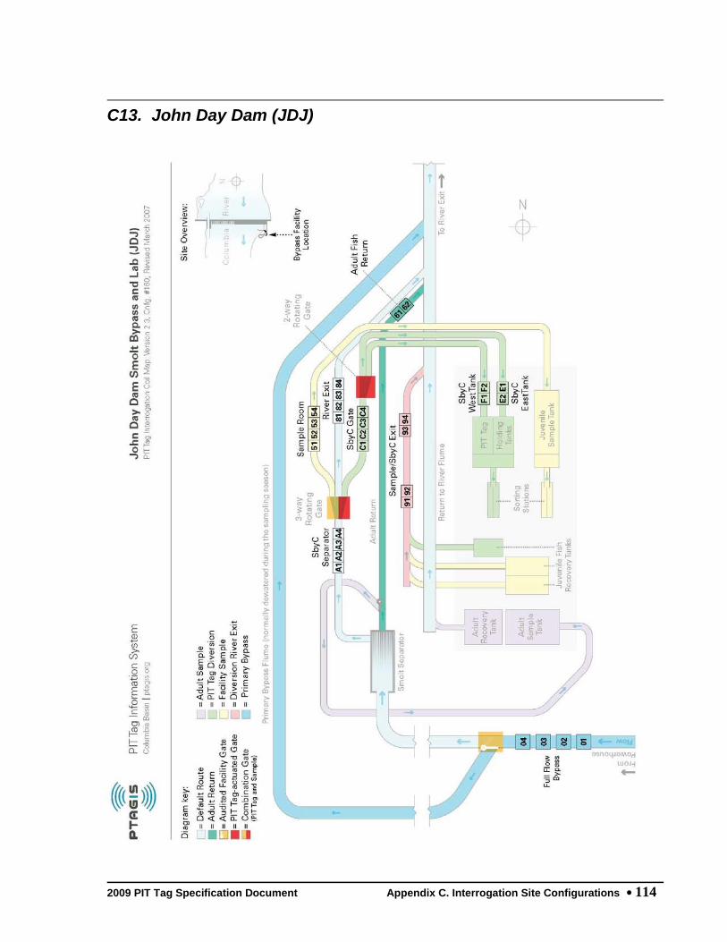
2009 PIT Tag Specification Document Appendix C. Interrogation Site Configurations 114
C13. John Day Dam (JDJ)

2009 PIT Tag Specification Document Appendix C. Interrogation Site Configurations 115
C14. Lower Monumental Dam (LMJ)

2009 PIT Tag Specification Document Appendix C. Interrogation Site Configurations 116
C15. McNary Oregon Shore Ladder (MC1)

2009 PIT Tag Specification Document Appendix C. Interrogation Site Configurations 117
C16. McNary Washington Shore Ladder (MC2)

2009 PIT Tag Specification Document Appendix C. Interrogation Site Configurations 118
C17. McNary Juvenile Fish Facility (MCJ)

2009 PIT Tag Specification Document Appendix C. Interrogation Site Configurations 119
C18. Priest Rapids Dam Fish Ladders (PRA)

2009 PIT Tag Specification Document Appendix C. Interrogation Site Configurations 120
C19. Prosser Fish Ladders and Sampling Facility (PRO)

2009 PIT Tag Specification Document Appendix C. Interrogation Site Configurations 121
C20. Rock Island Dam Fish Ladders (RIA)

2009 PIT Tag Specification Document Appendix C. Interrogation Site Configurations 122
C21. Rocky Reach Dam Adult Fishway (RRF)

2009 PIT Tag Specification Document Appendix C. Interrogation Site Configurations 123
C22. Roza Dam Adult Fishway (RZF)

2009 PIT Tag Specification Document Appendix C. Interrogation Site Configurations 124
C23. Wells Dam Fish Ladders (WEA)

2009 PIT Tag Specification Document Appendix C. Interrogation Site Configurations 125
C24. Interrogation Site Configuration History PIT Tag Interrogation Site transceiver and antenna ID codes are defined by the agency maintaining the detection equipment. The current configuration information must be made available to PTAGIS before any detection data are submitted for processing. The following table (accessible online at ftp://ftp.ptagis.org/Reports/TMT/site_con_spec.txt) provides the complete history of PIT tag antenna configurations at all registered interrogation sites.
PACIFIC STATES MARINE FISHERIES COMMISSION
PIT Tag Database
SITE CONFIGURATION HISTORY
As of 01-Sep-09
Site Name Monitor Name ---------Coil---------
1 2 3 4 5 6
AB1: Abernathy Creek FWS Tech Cntr.
Prototype multiplexer installed to control three existing
antennas.
Seq. #110: From 24-Sep-03 To Present
RIGHT 01
CENTER 02
LEFT 03
Seq. #100: From 24-Sep-01 To 24-Sep-03
RIGHT A1
CENTER A2
LEFT A3

2009 PIT Tag Specification Document Appendix C. Interrogation Site Configurations 126
AB2: Abernathy Creek Farmers Bridge
4 x 1.5 meter antennas for USFWS in stream tests.
Seq. #100: From 24-Sep-01 To 6-Nov-06
RIGHT B1
LEFT B2
AB3: Lower Abernathy Creek
Initial configuration.
Seq. #100: From 1-Apr-09 To Present
In-stream Array 01 02 03
B1J: BONNEVILLE PH1 JUVENILE
Downstream Migrant Channel 1 (DSM1) Trap with flat plate
detector. Not detecting when trap operates.
Seq. #100: From 20-Feb-03 To 31-Jul-03
FLAT PLATE 01 02
Site Name Monitor Name ---------Coil---------
1 2 3 4 5 6
B2A: BONNEVILLE ADULT WA SHORE
Installed dual ISO/400kHz monitors
Seq. #110: From 22-Jan-01 To 6-Dec-02
400 KHZ NORTH 00 02 04
400 KHZ SOUTH 10 12 14
ISO NORTH A4 A5
ISO SOUTH B4 B5
Seq. #100: From 7-May-98 To 22-Jan-01
NORTH 00 02 04 06

2009 PIT Tag Specification Document Appendix C. Interrogation Site Configurations 127
SOUTH 10 12 14 16
ISO NORTH AA BB
ISO SOUTH CC DD
B2J: Bonneville PH2 Juvenile
Installed FULL FLOW BYPASS
Seq. #150: From 1-Mar-06 To Present
FULL FLOW BYPASS 01 02 03 04
SbyC SEPARATOR GATE A1 A2 A3 A4
RIVER EXIT 81 82
SAMPLE ROOM 51 52
SbyC EAST TANK E1 E2
SbyC WEST TANK F1 F2
SAMPLE / SbyC EXIT 91 92 93
Seq. #140: From 22-Jan-01 To 1-Mar-06
SbyC SEPARATOR GATE A1 A2 A3 A4
RIVER EXIT 81 82
SAMPLE ROOM 51 52
SbyC EAST TANK E1 E2
SbyC WEST TANK F1 F2
SAMPLE / SbyC EXIT 91 92 93
Seq. #130: From 22-Dec-99 To 22-Jan-01
SbyC SEPARATOR GATE A1 A2 A3 A4
RIVER EXIT 81 82
SbyC EAST TANK E1 E2
SbyC WEST TANK F1 F2
SAMPLE / SbyC EXIT 91 92 93
Seq. #120: From 19-Mar-99 To 22-Dec-99
2009 PIT Tag Specification Document Appendix C. Interrogation Site Configurations 128
MAIN 02 04 06 08
Seq. #110: From 8-Feb-97 To 19-Mar-99
MAIN 02 04 06 08
Seq. #100: From 1-Apr-96 To 8-Feb-97
SUBSAMPLE D0
BCC: BON PH2 Corner Collector
Initial configuration, Bonneville Dam Second Powerhouse
Corner Collector outfall channel detector
Seq. #100: From 8-Apr-06 To Present
15x15 FULL-FLOW ANTE 01
BCP: Butcher Creek Acclimation Pond
Operated by Yakama Nation. Monitored release using
FS-2001F-ISO transceivers and custom antennas.
Seq. #100: From 1-Jan-03 To Present
POND EXIT 01 02
Site Name Monitor Name ---------Coil---------
1 2 3 4 5 6
BGM: Burlingame Dam and Canal
Added new canal exit antenna.
Seq. #110: From 12-Aug-08 To Present
Adult Fishway F3 F4
Bypass Slot F5 F6
Canal Intake F1 F2
Canal Exit FB
Seq. #100: From 30-Oct-06 To 12-Aug-08
2009 PIT Tag Specification Document Appendix C. Interrogation Site Configurations 129
Adult Fishway F3 F4
Bypass Slot F5 F6
Canal Intake F1 F2
BO1: Bonneville Bradford Is. Ladder
Includes new vertical slot antennas, plus existing orifice
antennas in A- and B-Branch notched weirs
Seq. #110: From 24-Feb-06 To Present
VERTICAL SLOT DETECT 01 02 03 04
A-BRANCH WEIR 50 05 06
A-BRANCH WEIR 49 07 08
A-BRANCH WEIR 48 09 0A
A-BRANCH WEIR 47 0B 0C
A-BRANCH WEIR 46 0D 0E
A-BRANCH WEIR 45 0F 10
A-BRANCH WEIR 44 11 12
A-BRANCH WEIR 43 13 14
B-BRANCH WEIR 50 15 16
B-BRANCH WEIR 49 17 18
B-BRANCH WEIR 48 19 1A
B-BRANCH WEIR 47 1B 1C
B-BRANCH WEIR 46 1D 1E
B-BRANCH WEIR 45 1F 20
B-BRANCH WEIR 44 21 22
B-BRANCH WEIR 43 23 24
Seq. #100: From 7-Mar-02 To 24-Feb-06
LEFT BRANCH WEIR 50 01 02
LEFT BRANCH WEIR 49 03 04

2009 PIT Tag Specification Document Appendix C. Interrogation Site Configurations 130
LEFT BRANCH WEIR 48 05 06
LEFT BRANCH WEIR 47 07 08
LEFT BRANCH WEIR 46 09 0A
LEFT BRANCH WEIR 45 0B 0C
LEFT BRANCH WEIR 44 0D 0E
LEFT BRANCH WEIR 43 0F 10
RIGHT BRANCH WEIR 50 11 12
RIGHT BRANCH WEIR 49 13 14
RIGHT BRANCH WEIR 48 15 16
RIGHT BRANCH WEIR 47 17 18
RIGHT BRANCH WEIR 46 19 1A
RIGHT BRANCH WEIR 45 1B 1C
RIGHT BRANCH WEIR 44 1D 1E
RIGHT BRANCH WEIR 43 1F 20
Site Name Monitor Name ---------Coil---------
1 2 3 4 5 6
BO2: Bonneville Cascades Is. Ladder
24 x 24 inch orifice detectors. Fish passing over weirs are
undetectable. Initial installation.
Seq. #100: From 13-Mar-02 To Present
WEIR 45 0F 10
WEIR 46 0D 0E
WEIR 47 0B 0C
WEIR 48 09 0A
WEIR 49 07 08
WEIR 50 05 06
WEIR 51 03 04

2009 PIT Tag Specification Document Appendix C. Interrogation Site Configurations 131
WEIR 52 01 02
BO3: Bonneville WA Shore Ladder/AFF
Removed 400kHz monitors.
Seq. #110: From 15-Dec-03 To Present
WEIR 59 01 02
WEIR 58 03 04
WEIR 57 05 06
WEIR 56 07 08
WEIR 55 09 0A
WEIR 54 0B 0C
WEIR 53 0D 0E
WEIR 52 0F 10
WEIR 37 11 12
WEIR 36 13 14
WEIR 35 15 16
WEIR 34 17 18
AFF NORTH FLUME [ISO 22 24 26 28
AFF SOUTH FLUME [ISO 32 34 36 38
Seq. #100: From 6-Dec-02 To 15-Dec-03
WEIR 59 01 02
WEIR 36 13 14
WEIR 35 15 16
WEIR 34 17 18
AFF NORTH FLUME [ISO 20 22
AFF NORTH FLUME [400 24 26 28
AFF SOUTH FLUME [ISO 30 32
AFF SOUTH FLUME [400 34 36 38

2009 PIT Tag Specification Document Appendix C. Interrogation Site Configurations 132
WEIR 58 03 04
WEIR 57 05 06
WEIR 56 07 08
WEIR 55 09 0A
WEIR 54 0B 0C
WEIR 53 0D 0E
WEIR 52 0F 10
WEIR 37 11 12
BO4: Bonneville WA Ladder Slots
Initial vertical slot configuration. This system is
up-stream of both BO2 and BO3.
Seq. #100: From 28-Feb-05 To Present
VERTICAL SLOT DETECT 01 02 03 04
Site Name Monitor Name ---------Coil---------
1 2 3 4 5 6
BVC: Beaver Creek, Methow River
Initial configuration for Beaver Creek (Stokes).
Seq. #100: From 1-Jan-09 To Present
Upper In-stream Arra B1 B2
Middle In-stream Arr B3 B4
Lower In-stream Arra B5 B6
BVJ: BONNEVILLE DAM DMS1 SUBSAMPLE
Single coil subsample monitor. SMP sub-sample in PH 1 DSM
channel. Made Main site 3/19/99.
Seq. #110: From 1-Jan-94 To 20-Feb-03

2009 PIT Tag Specification Document Appendix C. Interrogation Site Configurations 133
SAMPLE ROOM C0
Seq. #100: From 1-May-92 To 1-Jan-94
SAMPLE ROOM C0
BVP: Beaver Creek Acclimation Pond
New Inlet antenna 01; Outlet antennas renumbered to 02 and
03.
Seq. #110: From 1-Jan-07 To Present
POND INLET 01
POND EXIT 02 03
Seq. #100: From 1-Jan-06 To 1-Jan-07
POND EXIT 01 02
BVX: Bonneville PH1 Juvenile (Exp.)
Change coil numbers to begin with 01 rather than 00
Seq. #120: From 28-Jul-00 To 20-Feb-03
FLAT PLATE NW QUAD 04
FLAT PLATE NE QUAD 03
FLAT PLATE SE QUAD 01
FLAT PLATE SW QUAD 02
Seq. #110: From 6-Mar-00 To 28-Jul-00
FLAT PLATE NW QUAD 03
FLAT PLATE NE QUAD 02
FLAT PLATE SE QUAD 00
FLAT PLATE SW QUAD 01
Seq. #100: From 6-May-96 To 6-Mar-00
FLAT PLATE 01 02

2009 PIT Tag Specification Document Appendix C. Interrogation Site Configurations 134
Site Name Monitor Name ---------Coil---------
1 2 3 4 5 6
BWL: Bonneville WA Shore Ladder
ADULT LADDER PROTOTYPE OF UNDERWATER ORIFICE PIT TAG
DETECTORS
Seq. #100: From 23-Mar-01 To 3-Dec-02
Weir 34 AA AB
Weir 35 BA BB
Weir 36 CA CB
Weir 37 DA DB
Weir 44 - AFF 44
Weir 45 - AFF 45
Weir 47 - AFF 47
Weir 48 - AFF 48
Weir 52 2A 2B
Weir 53 3A 3B
Weir 54 4A 4B
Weir 55 5A 5B
Weir 56 6A 6B
Weir 57 7A 7B
Weir 58 8A 8B
Weir 59 9A 9B
CAP: Carlton Acc. Pond
Originally reported as Monitored Release file. Converted to
Interrogation data March, 2001.
Seq. #100: From 1-Jan-95 To 31-Dec-95
MAIN AA

2009 PIT Tag Specification Document Appendix C. Interrogation Site Configurations 135
CCP: Catherine Creek Acc. Pond
Associated specific DF-2001F transceivers with each of the
four ponds.
Seq. #120: From 1-Mar-09 To Present
POND 1 01
POND 2 02
POND 3 03
POND 4 04
Seq. #110: From 1-Apr-01 To 1-Mar-09
MAIN 1 01 02
MAIN 2 03 04
MAIN 3 05 06
MAIN 4 07 08
Seq. #100: From 1-Jan-00 To 1-Apr-01
MAIN 04
CFJ: Clark Flat Acc. Pond
Standardized coil and monitor names.
Seq. #110: From 22-Jan-01 To Present
EAST RIVER EXIT A1 A2
WEST RIVER EXIT B1 B2
Seq. #100: From 19-Mar-99 To 22-Jan-01
RIVER EXIT A 00 02
RIVER EXIT B 10 12

2009 PIT Tag Specification Document Appendix C. Interrogation Site Configurations 136
Site Name Monitor Name ---------Coil---------
1 2 3 4 5 6
CHL: Lower Chiwawa River
Initial configuration.
Seq. #100: From 1-Apr-08 To Present
Upper In-stream Arra 81 82 83
Lower In-stream Arra 84 85 86
CHN: CHALLIS DIVERSION NORTH
Swapped CHN and CHS coils and controllers
Seq. #110: From 15-Sep-91 To 20-Oct-93
NORTH F1
Seq. #100: From 1-Sep-91 To 15-Sep-91
NORTH F5
CHP: Chiwawa Acc. Pond
Monitored releases from two individual ponds.
Seq. #110: From 1-Mar-07 To Present
Pond 1 03 04
Pond 2 01 02
Seq. #100: From 1-Jan-95 To 31-May-96
MAIN AA
CHS: CHALLIS DIVERSION SOUTH
Swapped CHN and CHS coils and controllers
Seq. #110: From 15-Sep-91 To 3-Nov-92
SOUTH F5
Seq. #100: From 1-Sep-91 To 15-Sep-91

2009 PIT Tag Specification Document Appendix C. Interrogation Site Configurations 137
SOUTH F1
CHU: Upper Chiwawa River
Initial configuration.
Seq. #100: From 1-Apr-08 To Present
Upper In-stream Arra 91 92 93
Lower In-stream Arra 94 95 96
CLE: Cle Elum Dam Interim Bypass
Initial configuration; two 5'x5' custom antennas pushed by
FS-1001A transceivers.
Seq. #100: From 1-Jun-06 To Present
Upstream Detector 01
Downstream Detector 02
CLJ: Clearwater River Trap
Operated by IDFG.
Seq. #110: From 1-Jan-94 To Present
MAIN D0 D2
Seq. #100: From 30-Mar-89 To 1-Jan-94
MAIN D0 D2
CLP: Coulter Creek Acclimation Pond
Operated by Yakama Nation. Two antennas at pond exits; one
antenna downstream at channel confluence.
Seq. #100: From 1-Jan-06 To Present
POND EXIT 01 02 03

2009 PIT Tag Specification Document Appendix C. Interrogation Site Configurations 138
Site Name Monitor Name ---------Coil---------
1 2 3 4 5 6
CR1: Chinook River Sea Resources CF
Site operated by FWS at the Sea Resources Adult Capture
Facility UTM 10 T 428419; 5124255
Seq. #100: From 8-Sep-02 To 31-Oct-06
DOWNSTREAM 01
UPSTREAM 02
CR2: Chinook River HWY 101 Bridge
Reconfigured site with FS1001M multiplexed system.
Seq. #110: From 14-Sep-04 To 25-Jul-06
EAST ANTENNA 04
MIDDLE ANTENNA 02
WEST ANTENNA 03
Seq. #100: From 1-Oct-02 To 14-Sep-04
EAST ANTENNA A1
MIDDLE ANTENNA A2
WEST ANTENNA A3
CR3: Chinook River at Culvert
Site operated by FWS. UTM 10T 427864; 5125771
Seq. #100: From 1-Sep-03 To 6-Oct-06
MAIN 01
DRP: Dryden Acc. Pond
Originally reported as Monitored Release file. Converted to
Interrogation file March 2001.

2009 PIT Tag Specification Document Appendix C. Interrogation Site Configurations 139
Seq. #100: From 1-Jan-94 To 31-Dec-96
MAIN AA
EMC: Eightmile Creek, Methow River
Initial configuration for Eightmile Creek.
Seq. #100: From 1-Dec-08 To Present
Single In-Stream Ant 21
ENL: Lower Entiat River
Initial configuration.
Seq. #100: From 1-Oct-07 To Present
Upper In-stream Arra 21 22 23
Lower In-stream Arra 24 25 26
ENM: Middle Entiat River
Initial configuration.
Seq. #100: From 1-Mar-08 To Present
Upper In-stream Arra 51 52 53
Lower In-stream Arra 54 55 56
ESJ: Easton Acc. Pond
Standardized coil and monitor names.
Seq. #110: From 22-Jan-01 To Present
EAST RIVER EXIT A1 A2
WEST RIVER EXIT B1 B2
Seq. #100: From 19-Mar-99 To 22-Jan-01
RIVER EXIT A 20 22
RIVER EXIT B 30 32

2009 PIT Tag Specification Document Appendix C. Interrogation Site Configurations 140
Site Name Monitor Name ---------Coil---------
1 2 3 4 5 6
ESS: EFSF Salmon River at Parks Cr.
Initial configuration for the East Fork South Fork Salmon
River Instream Arrays at Parks Creek
Seq. #100: From 1-Mar-09 To Present
Upper In-stream Arra A1 A2 A3 A4 A5 A6
Lower In-stream Arra B1 B2 B3 B4 B5 B6
ESX: Estuary Saltwater Experiment
Experimental trawl detector; combined into TWX after 2005.
Seq. #100: From 1-Mar-03 To 9-Jun-05
MAIN F1
FDC: Feed Canal
Initial configuration.
Seq. #100: From 1-Mar-07 To Present
Headgate A1 A2 A3 A4 A5 A6
Diversion Screen B1 B2 B3 B4 B5
FDD: Feed Diversion Dam
Initial Configuration for Feed Diversion Dam.
Seq. #100: From 1-Nov-08 To Present
Upper Dam Notch B1
Lower Dam Notch B2
Adult Ladder Right, B3
Adult Ladder Left, f B4

2009 PIT Tag Specification Document Appendix C. Interrogation Site Configurations 141
GL2: SF Gold Creek, Methow River
Initial configuration for S.F. Gold Creek.
Seq. #100: From 1-Jan-09 To Present
Single In-stream Ant D6
GLC: Gold Creek, Methow River
Initial configuration for Gold Creek.
Seq. #100: From 1-Jan-09 To Present
Upper In-stream Arra E1 E2
Middle In-stream Arr E3 E4
Lower In-stream Arra E5 E6
GOJ: Little Goose Dam Juvenile
Added FULL FLOW BYPASS monitor to this configuration
Seq. #150: From 6-Feb-09 To Present
FULL FLOW BYPASS 01 02 03 04
A-SEPARATOR GATE A1 A2 A3 A4
B-SEPARATOR GATE B1 B2 B3 B4
DIVERSION SBYC GATE C1 C2 C3 C4
DIVERSION RIVER EXIT 91 92 93
SBYC RIVER EXIT E1 E2 E3
A-RACEWAY / RIVER EX 11 12 13
B-RACEWAY / RIVER EX 21 22 23
SAMPLE ROOM 51 52
ADULT FISH RETURN F1 F2

2009 PIT Tag Specification Document Appendix C. Interrogation Site Configurations 142
Site Name Monitor Name ---------Coil---------
1 2 3 4 5 6
Seq. #140: From 1-Jan-06 To 5-Feb-09
A-SEPARATOR GATE A1 A2 A3 A4
B-SEPARATOR GATE B1 B2 B3 B4
DIVERSION SBYC GATE C1 C2 C3 C4
DIVERSION RIVER EXIT 91 92 93
SBYC RIVER EXIT E1 E2 E3
A-RACEWAY / RIVER EX 11 12 13
B-RACEWAY / RIVER EX 21 22 23
SAMPLE ROOM 51 52
ADULT FISH RETURN F1 F2
Seq. #130: From 7-Mar-02 To 1-Jan-06
A-SEPARATOR GATE A1 A2 A3 A4
B-SEPARATOR GATE B1 B2 B3 B4
DIVERSION SBYC GATE C1 C2 C3 C4
DIVERSION RIVER EXIT 91 92 93
SBYC RIVER EXIT E1 E2 E3
A-RACEWAY / RIVER EX 11 12 13
B-RACEWAY / RIVER EX 21 22 23
SAMPLE ROOM 51 52
Seq. #120: From 10-Jan-00 To 7-Mar-02
A-SEPARATOR GATE A1 A2 A3 A4
A-RACEWAY / RIVER EX 11 12 13
A-DIVERSION / SbyC G C1 C2 C3
B-SEPARATOR GATE B1 B2 B3 B4
B-RACEWAY / RIVER EX 21 22 23
B-DIVERSION / SbyC G D1 D2 D3

2009 PIT Tag Specification Document Appendix C. Interrogation Site Configurations 143
SAMPLE ROOM 51 52
DIVERSION RIVER EXIT 91 92 93
Seq. #110: From 1-Apr-90 To 10-Jan-00
A-SEPARATOR GATE 40 42 44 46
A-RACEWAY/EXIT 90 92 94 96
A-DIVERSION A0 A2 A4
B-SEPARATOR GATE 48 4A 4C 4E
B-RACEWAY/EXIT 98 9A 9C 9E
B-DIVERSION A6 A8 AA
SAMPLE ROOM 50 52
DIVERSION EXIT 54 56 58 5A
Seq. #100: From 1-Jan-86 To 1-Apr-90
UNKNOWN GROUP 1 30 32 34 36 38 3A
UNKNOWN GROUP 2 3C 3E 48 4A 4C 4E
A-MAIN 40 42 44 46
B-MAIN 90 92 94 96
SAMPLE ROOM A0 A2 A4
GRA: Lower Granite Dam Adult
Removed 400kHz monitors.
Seq. #140: From 15-Dec-03 To Present
WEIR 733 01 02
WEIR 732 03 04
WEIR 731 05 06
WEIR 730 07 08
ISO WEST 12 14 16 18
ISO EAST 22 24 26 28

2009 PIT Tag Specification Document Appendix C. Interrogation Site Configurations 144
Site Name Monitor Name ---------Coil---------
1 2 3 4 5 6
Seq. #130: From 20-Feb-03 To 15-Dec-03
WEIR 733 01 02
WEIR 732 03 04
WEIR 731 05 06
WEIR 730 07 08
400 KHZ WEST 14 16 18
ISO WEST 10 12
400 KHZ EAST 24 26 28
ISO EAST 20 22
Seq. #120: From 22-Jan-01 To 20-Feb-03
400 KHZ EAST 00 02 04
ISO EAST A4 A5
400 KHZ WEST 10 12 14
ISO WEST B4 B5
Seq. #110: From 1-Feb-95 To 22-Jan-01
EAST 00 02 04 06 08
WEST 10 12 14 16 18
Seq. #100: From 1-Jan-87 To 1-Feb-95
EAST 00 02 08 0A
WEST 04 06 0C 0E
GRJ: Lower Granite Dam Juvenile
Added new EAST RACEWAY 10, BYPASS RIVER EXIT and RCWY-10
DIVERSION monitors.
Seq. #140: From 1-Mar-07 To Present
A-SEPARATOR GATE A1 A2

2009 PIT Tag Specification Document Appendix C. Interrogation Site Configurations 145
B-SEPARATOR GATE B1 B2
RACEWAY WEST / RIVER 21 22 23
RCWY-10 GATE 11 12
RACEWAY EAST 71 72
EAST RACEWAY 10 31 32
BYPASS RIVER EXIT 81 82
DIVERSION / SbyC GAT C1 C2
SbyC GATE D1 D2
DIVERSION RIVER EXIT 91 92
SAMPLE TANK 51 52 53
ADULT FISH RETURN F1 F2
Seq. #130: From 1-Jan-06 To 1-Mar-07
A-SEPARATOR GATE A1 A2
B-SEPARATOR GATE B1 B2
DIVERSION / SbyC GAT C1 C2 C3 C4
DIVERSION RIVER EXIT 91 92 93
SbyC GATE D1 D2 D3
RACEWAY WEST / RIVER 21 22 23
RACEWAY EAST / RIVER 11 12 13
SAMPLE TANK 51 52 53
ADULT FISH RETURN F1 F2

2009 PIT Tag Specification Document Appendix C. Interrogation Site Configurations 146
Site Name Monitor Name ---------Coil---------
1 2 3 4 5 6
Seq. #120: From 3-Jan-00 To 1-Jan-06
A-SEPARATOR GATE A1 A2
B-SEPARATOR GATE B1 B2
DIVERSION / SbyC GAT C1 C2 C3 C4
DIVERSION RIVER EXIT 91 92 93
SbyC GATE D1 D2 D3
RACEWAY WEST / RIVER 21 22 23
RACEWAY EAST 11 12 13
SAMPLE TANK 51 52 53
Seq. #110: From 1-Jan-94 To 20-Jan-00
A-SEPARATOR GATE 28 2A
B-SEPARATOR GATE 2C 2E
RACEWAY EAST 10 12 14 16
RACEWAY WEST/EXIT 18 1A 1C 1E
DIVERSION 1 36 38 3A
DIVERSION 2 30 32 34
SUBSAMPLE 20 22 24 26
Seq. #100: From 25-Mar-88 To 1-Jan-94
A-SEPARATOR GATE 28 2A
B-SEPARATOR GATE 2C 2E
RACEWAY EAST 10 12 14 16
RACEWAY WEST/EXIT 18 1A 1C 1E
DIVERSION 1 36 38 3A
DIVERSION 2 30 32 34
SUBSAMPLE 20 22 24 26

2009 PIT Tag Specification Document Appendix C. Interrogation Site Configurations 147
GRP: Grande Ronde Acc. Pond
Grande Ronde Pond -- Using FS2001 Portable Detectors. RM 198
above Vey Meadows. ODFW.
Seq. #100: From 1-Feb-02 To Present
MAIN 1 01
MAIN 2 02
MAIN 3 03
MAIN 4 04
GRX: LOWER GRANITE EXPERIMENTAL
Separation by code experimental sub-site.
Seq. #100: From 27-Feb-96 To 1-Sep-99
DIVERSION RIVER GATE 70 72 74 76
DIVERSION RIVER EXIT 80 82 84 86
DIVERSION HOLD TANK 90 92 94 96
HLX: Hemlock Dam Fish Ladder Exp.
Initial Configuration. Hemlock Dam is located on Trout Creek
a tributary of the Wind River in WA
Seq. #100: From 12-Jul-04 To 1-Jul-09
UPSTREAM 15
DOWNSTREAM 22
HYC: Hayden Creek In-stream Array
Initial configuration: parallel antennae A1 and A2.
Seq. #100: From 1-Aug-09 To Present
In-stream Array A1 A2

2009 PIT Tag Specification Document Appendix C. Interrogation Site Configurations 148
Site Name Monitor Name ---------Coil---------
1 2 3 4 5 6
ICH: Ice Harbor Dam (Combined)
ICH supersedes IHA. This configuration incorporates a Full
Flow Bypass monitor with the adult ladder
Seq. #100: From 1-Apr-05 To Present
LEFT LADDER WEIR 438 01 02
LEFT LADDER WEIR 437 03 04
LEFT LADDER WEIR 436 05 06
LEFT LADDER WEIR 435 07 08
RIGHT LADDER WEIR 43 09 0A
RIGHT LADDER WEIR 43 0B 0C
RIGHT LADDER WEIR 43 0D 0E
RIGHT LADDER WEIR 43 0F 10
FULL FLOW BYPASS A1 A2 A3 A4
IHA: Ice Harbor Adult
Ice Harbor Fish Ladders consist of a vertical slotweir and
orifice (S/O).
Seq. #100: From 1-Mar-03 To 1-Apr-05
Left Ladder Weir 438 01 02
Left Ladder Weir 437 03 04
Left Ladder Weir 436 05 06
Left Ladder Weir 435 07 08
Right Ladder Weir 43 09 0A
Right Ladder Weir 43 0B 0C
Right Ladder Weir 43 0D 0E
Right Ladder Weir 43 0F 10

2009 PIT Tag Specification Document Appendix C. Interrogation Site Configurations 149
IMJ: Imnaha River Trap
Coil ID changed from AA to B8; controller ID unchanged
Seq. #110: From 1-Jan-95 To 19-Apr-99
MAIN B8
Seq. #100: From 12-Apr-94 To 1-Jan-95
MAIN AA
JCJ: Jack Creek Acc. Pond
Standardized coil and monitor names.
Seq. #110: From 22-Jan-01 To Present
NORTH RIVER EXIT A1 A2
SOUTH RIVER EXIT B1 B2
Seq. #100: From 25-Feb-00 To 22-Jan-01
RIVER EXIT A 40 42
RIVER EXIT B 50 52
JD1: John Day River, McDonald Ferry
Initial site definition.
Seq. #100: From 1-Sep-07 To Present
Lower In-stream Arra 04 05 06
Upper In-stream Arra 01 02 03

2009 PIT Tag Specification Document Appendix C. Interrogation Site Configurations 150
Site Name Monitor Name ---------Coil---------
1 2 3 4 5 6
JDJ: John Day Dam Juvenile
Added new Full Flow Bypass array, with antennas 01 - 04.
Seq. #160: From 1-Mar-07 To Present
FULL FLOW BYPASS 01 02 03 04
SbyC SEPARATOR GATE A1 A2 A3 A4
RIVER EXIT 81 82 83 84
SAMPLE ROOM 51 52 53 54
SbyC GATE C1 C2 C3 C4
SbyC EAST TANK E1 E2
SbyC WEST TANK F1 F2
SAMPLE / SbyC EXIT 91 92 93 94
ADULT FISH RETURN 61 62
Seq. #150: From 1-Mar-05 To 1-Mar-07
SbyC SEPARATOR GATE A1 A2 A3 A4
RIVER EXIT 81 82 83 84
SAMPLE ROOM 51 52 53 54
SbyC GATE C1 C2 C3 C4
SbyC EAST TANK E1 E2
SbyC WEST TANK F1 F2
SAMPLE / SbyC EXIT 91 92 93 94
ADULT FISH RETURN 61 62
Seq. #140: From 16-Dec-99 To 1-Mar-05
SbyC SEPARATOR GATE A1 A2 A3 A4
SAMPLE ROOM 51 52 53 54
RIVER EXIT 81 82 83 84
SbyC GATE C1 C2 C3 C4
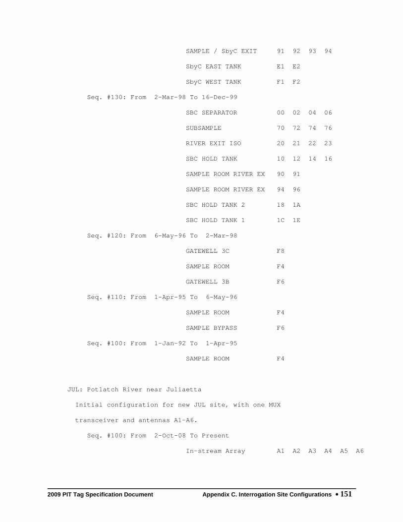
2009 PIT Tag Specification Document Appendix C. Interrogation Site Configurations 151
SAMPLE / SbyC EXIT 91 92 93 94
SbyC EAST TANK E1 E2
SbyC WEST TANK F1 F2
Seq. #130: From 2-Mar-98 To 16-Dec-99
SBC SEPARATOR 00 02 04 06
SUBSAMPLE 70 72 74 76
RIVER EXIT ISO 20 21 22 23
SBC HOLD TANK 10 12 14 16
SAMPLE ROOM RIVER EX 90 91
SAMPLE ROOM RIVER EX 94 96
SBC HOLD TANK 2 18 1A
SBC HOLD TANK 1 1C 1E
Seq. #120: From 6-May-96 To 2-Mar-98
GATEWELL 3C F8
SAMPLE ROOM F4
GATEWELL 3B F6
Seq. #110: From 1-Apr-95 To 6-May-96
SAMPLE ROOM F4
SAMPLE BYPASS F6
Seq. #100: From 1-Jan-92 To 1-Apr-95
SAMPLE ROOM F4
JUL: Potlatch River near Juliaetta
Initial configuration for new JUL site, with one MUX
transceiver and antennas A1-A6.
Seq. #100: From 2-Oct-08 To Present
In-stream Array A1 A2 A3 A4 A5 A6

2009 PIT Tag Specification Document Appendix C. Interrogation Site Configurations 152
Site Name Monitor Name ---------Coil---------
1 2 3 4 5 6
KCB: Kiwanis Camp Bridge, Mill C
Mill Creek, Walla Walla River Subbasin. ODFW, USFWS and USFS
project.
Seq. #100: From 10-May-05 To Present
COIL 1 01
COIL 2 02
COIL 3 03
COIL 4 04
COIL 5 05
KHS: Big Bear Cr. @ Kendrick HS
Antenna A4 moved from upstream array to downstream array.
Seq. #110: From 9-Oct-08 To Present
Upper In-stream Arra A1 A2 A3
Lower In-stream Arra A4 A5 A6
Seq. #100: From 1-Dec-07 To 22-Oct-08
Upstream Pass-Over A A1 A2 A3 A4
Downstream Pass-Over A5 A6
KRS: SF Salmon River at Krassel Cr.
Initial configuration.
Seq. #100: From 22-Jan-08 To Present
In-river Pass-over M 01 02 03 04 05
LAP: Lapwai Creek, near its mouth
Initial configuration for Lapwai Creek.
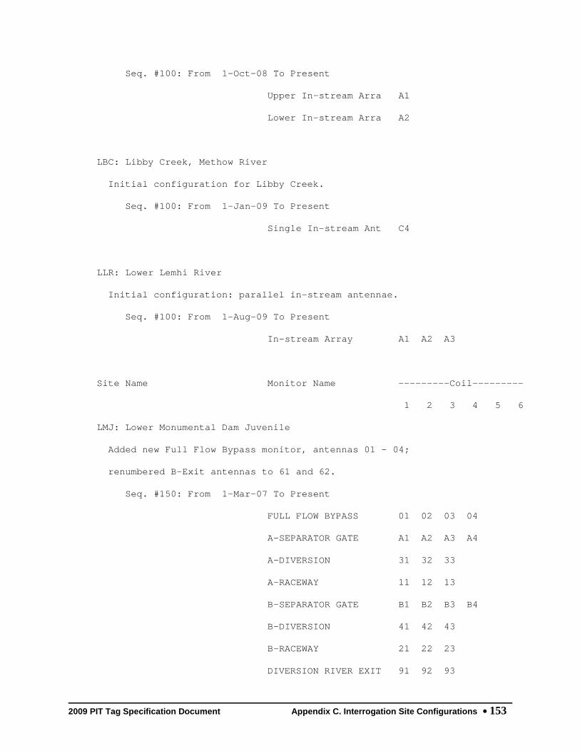
2009 PIT Tag Specification Document Appendix C. Interrogation Site Configurations 153
Seq. #100: From 1-Oct-08 To Present
Upper In-stream Arra A1
Lower In-stream Arra A2
LBC: Libby Creek, Methow River
Initial configuration for Libby Creek.
Seq. #100: From 1-Jan-09 To Present
Single In-stream Ant C4
LLR: Lower Lemhi River
Initial configuration: parallel in-stream antennae.
Seq. #100: From 1-Aug-09 To Present
In-stream Array A1 A2 A3
Site Name Monitor Name ---------Coil---------
1 2 3 4 5 6
LMJ: Lower Monumental Dam Juvenile
Added new Full Flow Bypass monitor, antennas 01 - 04;
renumbered B-Exit antennas to 61 and 62.
Seq. #150: From 1-Mar-07 To Present
FULL FLOW BYPASS 01 02 03 04
A-SEPARATOR GATE A1 A2 A3 A4
A-DIVERSION 31 32 33
A-RACEWAY 11 12 13
B-SEPARATOR GATE B1 B2 B3 B4
B-DIVERSION 41 42 43
B-RACEWAY 21 22 23
DIVERSION RIVER EXIT 91 92 93

2009 PIT Tag Specification Document Appendix C. Interrogation Site Configurations 154
SAMPLE ROOM 51 52
A-EXIT 81 82
B-EXIT 61 62
ADULT FISH RETURN F1 F2
Seq. #140: From 1-Jan-06 To 1-Mar-07
A-SEPARATOR GATE A1 A2 A3 A4
A-DIVERSION 31 32 33
A-RACEWAY 11 12 13
B-SEPARATOR GATE B1 B2 B3 B4
B-DIVERSION 41 42 43
B-RACEWAY 21 22 23
DIVERSION RIVER EXIT 91 92 93
SAMPLE ROOM 51 52
A-EXIT 81 82
B-EXIT 01 02
ADULT FISH RETURN F1 F2
Seq. #130: From 26-Jan-00 To 1-Jan-06
A-SEPARATOR GATE A1 A2 A3 A4
A-DIVERSION 31 32 33
A-RACEWAY 11 12 13
B-SEPARATOR GATE B1 B2 B3 B4
B-DIVERSION 41 42 43
B-RACEWAY 21 22 23
DIVERSION RIVER EXIT 91 92 93
SAMPLE ROOM 51 52
A-EXIT 81 82
B-EXIT 01 02
Seq. #120: From 27-Feb-96 To 22-Jan-00

2009 PIT Tag Specification Document Appendix C. Interrogation Site Configurations 155
A-SEPARATOR GATE 00 02 04 06
A-DIVERSION 20 22 24 26
A-RACEWAY 10 12 14 16
A-EXIT 30 32 34 36
B-SEPARATOR GATE 08 0A 0C 0E
B-DIVERSION 28 2A 2C 2E
B-RACEWAY 18 1A 1C 1E
B-EXIT 38 3A 3C 3E
DIVERSION EXIT 40 42 44 46
SAMPLE ROOM 48 4A
Site Name Monitor Name ---------Coil---------
1 2 3 4 5 6
Seq. #110: From 1-Jan-94 To 27-Feb-96
A-SEPARATOR 00 02
A-SEPARATOR GATE 04 06
A-DIVERSION 20 22 24 26
A-RACEWAY 10 12 14 16
A-EXIT 30 32 34 36
B-SEPARATOR 08 0A
B-SEPARATOR GATE 0C 0E
B-DIVERSION 28 2A 2C 2E
B-RACEWAY 18 1A 1C 1E
B-EXIT 38 3A 3C 3E
DIVERSION EXIT 40 42 44 46
SAMPLE ROOM 48 4A
Seq. #100: From 25-Apr-93 To 1-Jan-94
A-SEPARATOR 00 02

2009 PIT Tag Specification Document Appendix C. Interrogation Site Configurations 156
A-SEPARATOR GATE 04 06
A-DIVERSION 20 22 24 26
A-RACEWAY 10 12 14 16
A-EXIT 30 32 34 36
B-SEPARATOR 08 0A
B-SEPARATOR GATE 0C 0E
B-DIVERSION 28 2A 2C 2E
B-RACEWAY 18 1A 1C 1E
B-EXIT 38 3A 3C 3E
DIVERSION EXIT 40 42 44 46
SAMPLE ROOM 48 4A
LMR: Lower Methow River at Pateros
Initial configuration for Lower Methow River Instream Arrays
Seq. #100: From 1-Mar-09 To Present
In-stream Array A1 A2 A3 A4 A5 A6
LOP: Lostine River Acc. Pond
Initial Configuration
Seq. #100: From 1-Jan-02 To Present
SOUTH RIVER EXIT 01 02
NORTH RIVER EXIT 11 12
LRW: Lemhi River Weir
Initial configuration: parallel in-stream antennae.
Seq. #100: From 1-Aug-09 To Present
In-stream Array A1 A2
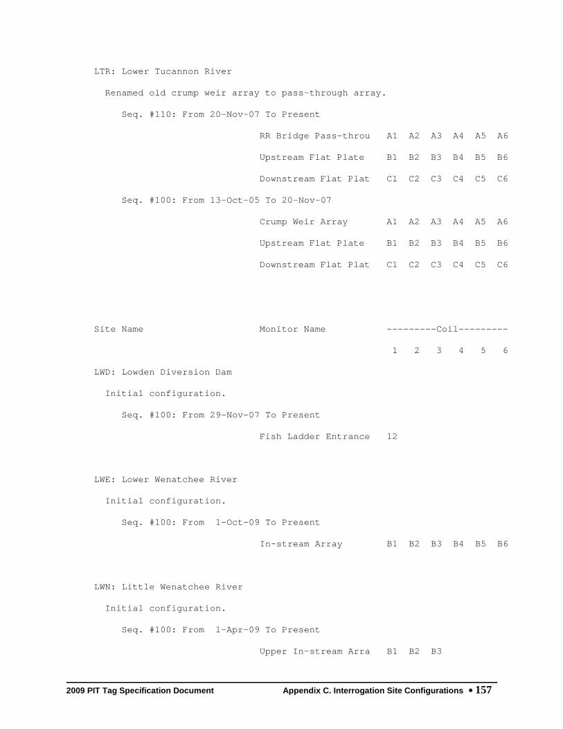
2009 PIT Tag Specification Document Appendix C. Interrogation Site Configurations 157
LTR: Lower Tucannon River
Renamed old crump weir array to pass-through array.
Seq. #110: From 20-Nov-07 To Present
RR Bridge Pass-throu A1 A2 A3 A4 A5 A6
Upstream Flat Plate B1 B2 B3 B4 B5 B6
Downstream Flat Plat C1 C2 C3 C4 C5 C6
Seq. #100: From 13-Oct-05 To 20-Nov-07
Crump Weir Array A1 A2 A3 A4 A5 A6
Upstream Flat Plate B1 B2 B3 B4 B5 B6
Downstream Flat Plat C1 C2 C3 C4 C5 C6
Site Name Monitor Name ---------Coil---------
1 2 3 4 5 6
LWD: Lowden Diversion Dam
Initial configuration.
Seq. #100: From 29-Nov-07 To Present
Fish Ladder Entrance 12
LWE: Lower Wenatchee River
Initial configuration.
Seq. #100: From 1-Oct-09 To Present
In-stream Array B1 B2 B3 B4 B5 B6
LWN: Little Wenatchee River
Initial configuration.
Seq. #100: From 1-Apr-09 To Present
Upper In-stream Arra B1 B2 B3

2009 PIT Tag Specification Document Appendix C. Interrogation Site Configurations 158
Lower In-stream Arra B4 B5 B6
MAD: Mad River, Entiat River Basin
Initial configuration.
Seq. #100: From 1-Oct-07 To Present
Upper In-stream Arra 31 32
Middle In-stream Arr 33 34
Lower In-stream Arra 35 36
MC1: McNary Oregon Shore Ladder
Includes counting window detector. Orifice detectors 26 x 26
inches. Initial installation.
Seq. #100: From 7-Mar-02 To Present
COUNTING WINDOW 01 02
WEIR 288 03 04
WEIR 287 05 06
WEIR 286 07 08
WEIR 284 09 0A
WEIR 283 0B 0C
WEIR 282 0D 0E
WEIR 280 0F 10
WEIR 279 11 12
MC2: McNary Washington Shore Ladder
Added COUNTING WINDOW
Seq. #120: From 1-Mar-06 To Present
COUNTING WINDOW 01 02 03
WEIR 312 04 05

2009 PIT Tag Specification Document Appendix C. Interrogation Site Configurations 159
WEIR 311 06 07
WEIR 309 08 09
WEIR 308 0A 0B
WEIR 306 0C 0D
WEIR 305 0E 0F
WEIR 303 10 11
WEIR 302 12 13
Site Name Monitor Name ---------Coil---------
1 2 3 4 5 6
Seq. #110: From 7-Mar-02 To 1-Mar-06
WEIR 312 01 02
WEIR 311 03 04
WEIR 309 05 06
WEIR 308 07 08
WEIR 306 09 0A
WEIR 305 0B 0C
WEIR 303 0D 0E
WEIR 302 0F 10
MCD: Mill Creek Diversion Project
Now MUXed at Division Works Fish Ladder; added new 'A2'
antenna.
Seq. #160: From 1-Nov-08 To Present
Diversion Dam Fish L 02 03
Diversion Dam Lo-Flo 01 04 05
Division Works Fish A1 A2
Seq. #150: From 27-Nov-07 To 3-Nov-08
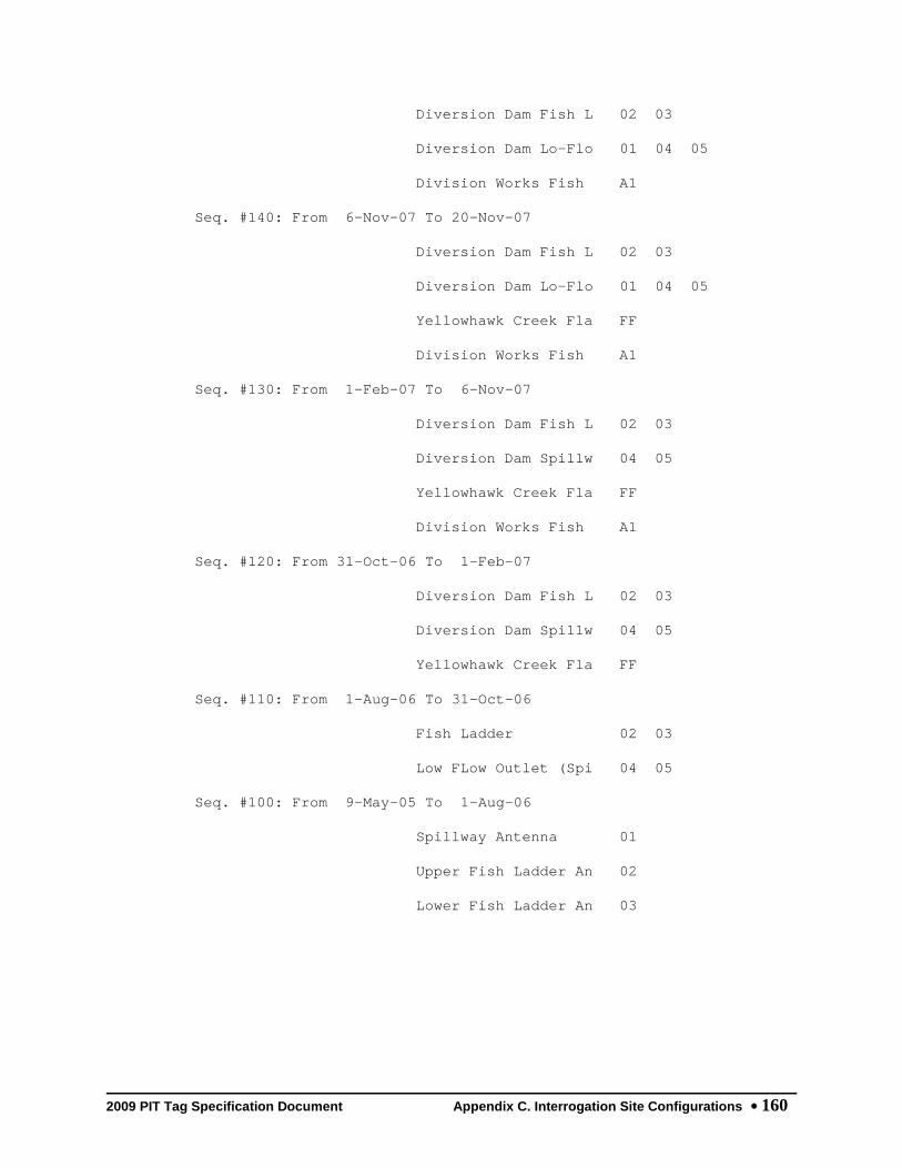
2009 PIT Tag Specification Document Appendix C. Interrogation Site Configurations 160
Diversion Dam Fish L 02 03
Diversion Dam Lo-Flo 01 04 05
Division Works Fish A1
Seq. #140: From 6-Nov-07 To 20-Nov-07
Diversion Dam Fish L 02 03
Diversion Dam Lo-Flo 01 04 05
Yellowhawk Creek Fla FF
Division Works Fish A1
Seq. #130: From 1-Feb-07 To 6-Nov-07
Diversion Dam Fish L 02 03
Diversion Dam Spillw 04 05
Yellowhawk Creek Fla FF
Division Works Fish A1
Seq. #120: From 31-Oct-06 To 1-Feb-07
Diversion Dam Fish L 02 03
Diversion Dam Spillw 04 05
Yellowhawk Creek Fla FF
Seq. #110: From 1-Aug-06 To 31-Oct-06
Fish Ladder 02 03
Low FLow Outlet (Spi 04 05
Seq. #100: From 9-May-05 To 1-Aug-06
Spillway Antenna 01
Upper Fish Ladder An 02
Lower Fish Ladder An 03

2009 PIT Tag Specification Document Appendix C. Interrogation Site Configurations 161
Site Name Monitor Name ---------Coil---------
1 2 3 4 5 6
MCJ: McNary Dam Juvenile
Added Adult Fish Return Monitor to site.
Seq. #160: From 17-Jun-03 To Present
FULL FLOW BYPASS 01 02 03 04
SBYC A-SEPARATOR GAT A1 A2 A3 A4
A-DIVERSION 31 32 33
SBYC A-RACEWAY RIVER C1 C2 C3 C4
A-RACEWAY 11 12 13
A-SUBSAMPLE 61 62 63
SBYC B-SEPARATOR GAT B1 B2 B3 B4
B-DIVERSION 41 42 43
SBYC B-RACEWAY RIVER D1 D2 D3 D4
B-RACEWAY 21 22 23
B-SUBSAMPLE 71 72 73
SAMPLE ROOM 51 52
RIVER-1 EXIT 81 82 83 84
RIVER-2 EXIT 91 92 93
ADULT FISH RETURN F1 F2
Seq. #150: From 20-Feb-03 To 17-Jun-03
FULL FLOW BYPASS 01 02 03 04
SBYC A-SEPARATOR GAT A1 A2 A3 A4
A-SUBSAMPLE 61 62 63
A-RACEWAY 11 12 13
A-DIVERSION 31 32 33
RIVER-1 EXIT 81 82 83 84
SBYC A-RACEWAY RIVER C1 C2 C3 C4

2009 PIT Tag Specification Document Appendix C. Interrogation Site Configurations 162
SBYC B-SEPARATOR GAT B1 B2 B3 B4
B-SUBSAMPLE 71 72 73
B-RACEWAY 21 22 23
B-DIVERSION 41 42 43
RIVER-2 EXIT 91 92 93
SBYC B-RACEWAY RIVER D1 D2 D3 D4
SAMPLE ROOM 51 52
Seq. #140: From 21-Jan-00 To 20-Feb-03
A-SEPARATOR GATE A1 A2 A3 A4
A-SUBSAMPLE 61 62 63
A-RACEWAY 11 12 13
A-DIVERSION 31 32 33
RIVER-1 EXIT 81 82 83 84
B-SEPARATOR GATE B1 B2 B3 B4
B-SUBSAMPLE 71 72 73
B-RACEWAY 21 22 23
B-DIVERSION 41 42 43
RIVER-2 EXIT 91 92 93
SAMPLE ROOM 51 52
Site Name Monitor Name ---------Coil---------
1 2 3 4 5 6
Seq. #130: From 2-Mar-98 To 21-Jan-00
A-SEPARATOR GATE 00 02 50 52
A-SUBSAMPLE 30 32 34
A-RACEWAY 10 12 14 16
A-DIVERSION 20 22 24 26
RIVER-1 40 42 44 46

2009 PIT Tag Specification Document Appendix C. Interrogation Site Configurations 163
B-SEPARATOR GATE 08 0A 54 56
B-SUBSAMPLE 36 38 3A
B-RACEWAY 18 1A 1C 1E
B-DIVERSION 28 2A 2C 2E
RIVER-2 48 4A 4C 4E
SAMPLE ROOM 3C 3E
B-RACEWAY ISO A1 A2 A3 A4
RIVER-2 ISO B1 B2 B3 B4
RIVER-1 ISO C1 C2 C3 C4
400 Test 80 82 84 86
Seq. #120: From 27-Feb-96 To 2-Mar-98
A-SEPARATOR GATE 00 02 50 52
A-SUBSAMPLE 30 32 34
A-RACEWAY 10 12 14 16
A-DIVERSION 20 22 24 26
RIVER-1 40 42 44 46
B-SEPARATOR GATE 08 0A 54 56
B-SUBSAMPLE 36 38 3A
B-RACEWAY 18 1A 1C 1E
B-DIVERSION 28 2A 2C 2E
RIVER-2 48 4A 4C 4E
SAMPLE ROOM 3C 3E
Seq. #110: From 1-Jan-94 To 27-Feb-96
A-SEPARATOR 50 52
A-SEPARATOR GATE 00 02
A-SUBSAMPLE 30 32 34
A-RACEWAY 10 12 14 16
A-DIVERSION 20 22 24 26

2009 PIT Tag Specification Document Appendix C. Interrogation Site Configurations 164
A-RIVER 40 42 44 46
B-SEPARATOR 54 56
B-SEPARATOR GATE 08 0A
B-SUBSAMPLE 36 38 3A
B-RACEWAY 18 1A 1C 1E
B-DIVERSION 28 2A 2C 2E
B-RIVER 48 4A 4C 4E
SAMPLE ROOM 3C 3E
UNKNOWN 01 07 09
Seq. #100: From 1-Jan-86 To 1-Jan-94
A-MAIN 68 6A 6C 6E
B-MAIN 60 62 64 66
A-SUB 70 72 74 76
SAMPLE ROOM 80 82
Site Name Monitor Name ---------Coil---------
1 2 3 4 5 6
MCX: MCNARY JUVENILE EXPERIMENTAL
INITIAL INSTALLATION OF LARGE INTERROGATION COILS ON MAIN
BYPASS FLUME: FULL FLOW BYPASS
Seq. #110: From 13-Mar-02 To 20-Feb-03
FULL FLOW BYPASS 38 01 02 03 04
Seq. #100: From 20-Feb-98 To 31-Dec-98
ISO B-RACEWAY A1 A2 A3 A4
ISO RIVER-1 B1 B2 B3 B4
MRB: Methow River Basin
Initial configuration for instream detections in the lower

2009 PIT Tag Specification Document Appendix C. Interrogation Site Configurations 165
Methow River Basin below Twisp.
Seq. #100: From 15-Sep-04 To 1-Jan-09
Upper Beaver Creek a A2
Beaver Creek MUX at B1 B2 B3 B4 B5 B6
Beaver Creek at RKM A4
Lower Beaver Creek a A6
Libby Creek at RKM 2 C2
Libby Creek near mou C4
Gold Creek at RKM 9 D2
Foggy Dew Creek near D4
South Fork Gold Cree D6
Gold Creek near mout E1 E2 E3 E4 E5 E6
MSC: Methow River Side Channels
Initial configuration for Methow River side channels.
Seq. #100: From 1-Jan-09 To Present
Upper In-stream Ante 32
Lower In-stream Ante 34
MWC: Maxwell Canal
Initial configuration.
Seq. #100: From 1-Mar-07 To Present
Headgate A1
Diversion Screen B1
MWE: Middle Wenatchee River
Initial configuration.
Seq. #100: From 1-Mar-09 To Present

2009 PIT Tag Specification Document Appendix C. Interrogation Site Configurations 166
In-stream Array 71 72 73 74 75 76
NAL: Lower Nason Creek
Initial configuration.
Seq. #100: From 1-Apr-08 To Present
Upper In-stream Arra 61 62 63
Lower In-stream Arra 64 65 66
NAU: Upper Nason Creek
Initial configuration.
Seq. #100: From 1-Oct-07 To Present
Upper In-stream Arra 41 42 43
Lower In-stream Arra 44 45 46
Site Name Monitor Name ---------Coil---------
1 2 3 4 5 6
NBA: Nursery Bridge Adult
Added new antenna "03" to the low flow spillway antenna
group.
Seq. #140: From 1-Sep-07 To Present
East [New] Ladder 01 02
West [Old] Ladder B1
Low Flow Spillway 03 04 05
Seq. #130: From 1-Mar-07 To 1-Sep-07
East [New] Ladder 01 02
West [Old] Ladder B1
Low Flow Spillway 04 05

2009 PIT Tag Specification Document Appendix C. Interrogation Site Configurations 167
Seq. #120: From 20-Jul-06 To 1-Mar-07
East (New) Ladder 01 02
West (Old) Ladder B1
Seq. #110: From 25-May-04 To 20-Jul-06
Coil 01 01
Coil B1 B1
Seq. #100: From 31-Oct-03 To 25-May-04
Coil 01 01
OMK: Omak Creek Instream Array
Initial configuration for Instream Array on lower Omak
Creek.
Seq. #100: From 1-Jan-06 To Present
In-stream Array 01 02 03 04 05 06
ORB: Oasis Road Bridge
Combines u/s and d/s antennas on a single MUX. Antennas are
listed left to right facing downstream.
Seq. #120: From 21-Jan-09 To Present
Pass-through [downst B1
Pass-over [upstream] B2
Pass-through [downst B3
Pass-over [upstream] B4
Pass-over [upstream] B5
Pass-through [downst B6
Seq. #110: From 1-Oct-06 To 21-Jan-09
Upstream Flat-plate A1 A2 A3 A4 A5 A6
Downstream Pass-thro B1 B2 B3 B4 B5 B6

2009 PIT Tag Specification Document Appendix C. Interrogation Site Configurations 168
Seq. #100: From 6-Sep-05 To 1-Oct-06
Coil 1 01
Coil 2 02
Coil 3 03
Coil 4 04
Coil 5 05
Coil 6 06
PES: Peshastin Creek
Initial configuration.
Seq. #100: From 1-May-07 To Present
Upper In-stream Arra 11 12 13
Lower In-stream Arra 14 15 16
Site Name Monitor Name ---------Coil---------
1 2 3 4 5 6
PRA: Priest Rapids Adult
Added MUXed antennas A1 - A3 in the left [East] Off-Ladder
Adult Fish Trap [OLAFT]
Seq. #110: From 5-Jun-07 To Present
Left [East] Ladder A A1 A2 A3
Left [East] Ladder W 01 02
Left [East] Ladder W 03 04
Right [West] Ladder 05 06
Right [West] Ladder 07 08
Seq. #100: From 6-Dec-02 To 5-Jun-07
Left Ladder Weir 3 01 02

2009 PIT Tag Specification Document Appendix C. Interrogation Site Configurations 169
Left Ladder Weir 7 03 04
Right Ladder Weir 3 05 06
Right Ladder Weir 5 07 08
PRJ: Prosser Dam (Chandler Dvrsn.)
Initial ISO Configuration. Superceded by PRO Oct. 19, 2004.
Seq. #120: From 10-Nov-99 To 3-Jul-04
SEPARATOR / SAMPLE A1 A2 A3
SAMPLE ROOM EXIT 51 52
Seq. #110: From 1-Jan-94 To 10-Nov-99
SEPARATOR C8 CA CC CE
SAMPLE ROOM C4 C6
Seq. #100: From 25-Apr-89 To 1-Jan-94
SEPARATOR C8 CA CC CE
SAMPLE ROOM C4 C6
PRO: Prosser Diversion Dam Combined
This configuration adds counting window detectors from the
middle and right ladders to previous.
Seq. #110: From 30-Aug-05 To Present
Smolt Bypass Separat A1 A2 A3
Smolt Bypass Sample 51 52
Left Bank LDR Counti 01 02
Middle LDR Counting 03 04
Right Bank LDR Count 05 06
Seq. #100: From 19-Oct-04 To 30-Aug-05
Separator / Sample A1 A2 A3
Sample Room Exit 51 52

2009 PIT Tag Specification Document Appendix C. Interrogation Site Configurations 170
Left Bank LDR Counti 01 02
RBF: Round Butte Fish Xfer Facility
Initial configuration for Round Butte Dam Fish Transfer
Facility site
Seq. #100: From 1-Mar-09 To Present
Fish Transfer Pipe 01 02 03 04
Site Name Monitor Name ---------Coil---------
1 2 3 4 5 6
RCX: Rattlesnake Creek Flat Plates
Six coil Multiplexer configuration
Seq. #120: From 1-Nov-03 To Present
Coil 1 01
Coil 2 02
Coil 3 03
Coil 4 04
Coil 5 05
Coil 6 06
Seq. #110: From 15-May-03 To 1-Nov-03
Coil 1 01
Coil 2 02
Coil 3 03
Coil 4 04
Seq. #100: From 21-Aug-01 To 15-May-03
Upstream Flat-Plate AA
Downstream Flat-Plat BB

2009 PIT Tag Specification Document Appendix C. Interrogation Site Configurations 171
RFA: REDFISH LK CR TRAP JUVENILE A
Redfish Lake Creek Trap operated by IDFG.
Seq. #100: From 13-Apr-95 To 1-Jun-95
RIVER EXIT F3
RFB: REDFISH LK CR TRAP JUVENILE B
Redfish Lake Creek Trap (B) operated by IDFG; No detections
were ever reported at this location.
Seq. #100: From 13-Apr-95 To 1-Jun-95
RIVER EXIT F5
RFP: Rolfing Acclimation Pond
Operated by Yakama Nation. Monitored release using
FS-2001F-ISO transceivers and custom antennas.
Seq. #100: From 1-Jan-04 To Present
POND EXIT 01 02
RIA: Rock Island Adult
Rock Island Dam is owned and operated by Chelan County PUD.
Seq. #100: From 1-Feb-03 To Present
Left Ladder Baffle 4 01 02
Left Ladder Baffle 2 03 04
Middle Ladder Baffle 05 06
Middle Ladder Baffle 07 08
Right Ladder Baffle 09 0A
Right Ladder Baffle 0B 0C

2009 PIT Tag Specification Document Appendix C. Interrogation Site Configurations 172
ROZ: ROSA DAM JUVENILE
Dates are accurate; equipment configuration must be
established
Seq. #100: From 26-Mar-92 To 30-May-92
MAIN C0
Site Name Monitor Name ---------Coil---------
1 2 3 4 5 6
RPJ: Rapid River Hatchery Pond
Underwater unit coil failed. Replaced underwater orifice
with underwater U shaped antenna.
Seq. #120: From 15-Mar-02 To Present
UPSTREAM EXIT ARRAY 01 02 03 04
DOWNSTREAM EXIT ARRA 05 06 07 08
Seq. #110: From 1-Mar-01 To 15-Mar-02
UNDERFLOW ORIFICE 01 02 03
OVERFLOW U-ANTENNEA 04 05 06 07
Seq. #100: From 19-Apr-99 To 1-Mar-01
UNDERFLOW ORIFICE 00 01 02
OVERFLOW DOWNSTREAM 03 04 05 06
OVERFLOW UPSTREAM 07 08 09 0A
RRF: Rocky Reach Fishway
Initial configuration
Seq. #100: From 1-Mar-06 To Present
WEIR 6 01 02
WEIR 4 03 04

2009 PIT Tag Specification Document Appendix C. Interrogation Site Configurations 173
RRJ: Rocky Reach Dam Juvenile
2000 Update. Site converted to ISO 134.2kHz exceptfor coils
77 and 88 which are 134.2kHz Non-ISO.
Seq. #140: From 25-Feb-00 To 23-Aug-02
SURFACE COLLECTOR 1 11 22 33 44
SURF COL 2/UNIT 1,2 05 06
BACKUP GATEWELL/SURF 77 88
JUV COLLECTION FACIL 55
Seq. #130: From 26-Apr-99 To 25-Feb-00
SURFACE COLLECTOR 24 11 22 33 44
GATEWELL SAMPLE 05 06 A0 A2 A4 A6
BACKUP GATEWELL/SURF 77 88
SAMPLE AA
Seq. #120: From 11-Mar-98 To 26-Apr-99
SURFACE COLLECTOR 24 11 22 33 44
GATEWELL SAMPLE A0 A2 A4 A6
BACKUP GATEWELL/SURF 77 88
Seq. #110: From 4-Apr-97 To 11-Mar-98
SURFACE COLLECTOR 24 11 22 33 44
GATEWELL COLLECTION 05 06
BACKUP GATEWELL/SURF 77 88
Seq. #100: From 10-Apr-96 To 4-Apr-97
SURFACE COLLECTOR 24 11 22 33 44
GATEWELL COLLECTOR 6 55 88
SURFACE COLLECTOR 6 66 77
RZF: Roza Dam Fishway

2009 PIT Tag Specification Document Appendix C. Interrogation Site Configurations 174
Initial configuration for new installation in the adult
fishway at Roza Dam.
Seq. #100: From 1-Sep-07 To Present
Upstream Weir 01
Middle Weir 02
Downstream Weir 03
Site Name Monitor Name ---------Coil---------
1 2 3 4 5 6
SAJ: Salmon River Trap
Salmon River Juvenile trap operated by IDFG.
Seq. #110: From 1-Jan-94 To Present
MAIN D8
Seq. #100: From 28-Mar-93 To 1-Jan-94
MAIN D8
SCP: Spring Creek Acclimation Pond
Initial configuration for Spring Creek Acc. Pond, at the
back channel of Winthrop NFH.
Seq. #100: From 1-Mar-08 To Present
Pond Exit 1 01
Pond Exit 2 02
SFG: SF Salmon at Guard Station Br.
Initial configuration for the SF Salmon River Instream Array
at the Guard Station Road Bridge
Seq. #100: From 1-Mar-09 To Present
In-stream Array A1 A2 A3 A4 A5 A6

2009 PIT Tag Specification Document Appendix C. Interrogation Site Configurations 175
SFL: Shipherd Falls Ladder
Initial configuration.
Seq. #100: From 1-Apr-09 To Present
Ladder Slot #2 - ups F1
Ladder Slot #3 - dow F2
SIP: Similkameen Acc. Pond
Originally reported as Monitored Release file. Converted to
Interrogation data Mar. 2001.
Seq. #100: From 1-Jan-96 To 31-Dec-96
MAIN AA
SNJ: Snake River Trap
Snake River Juvenile Trap operated by IDFG.
Seq. #110: From 1-Jan-94 To Present
MAIN D4 D6
Seq. #100: From 23-Mar-89 To 1-Jan-94
MAIN D4 D6
SSJ: SUNNYSIDE JUVENILE
Dates and coil/controller data accurate; monitor name must
be researched
Seq. #100: From 11-Apr-91 To 5-Jun-91
MAIN FF
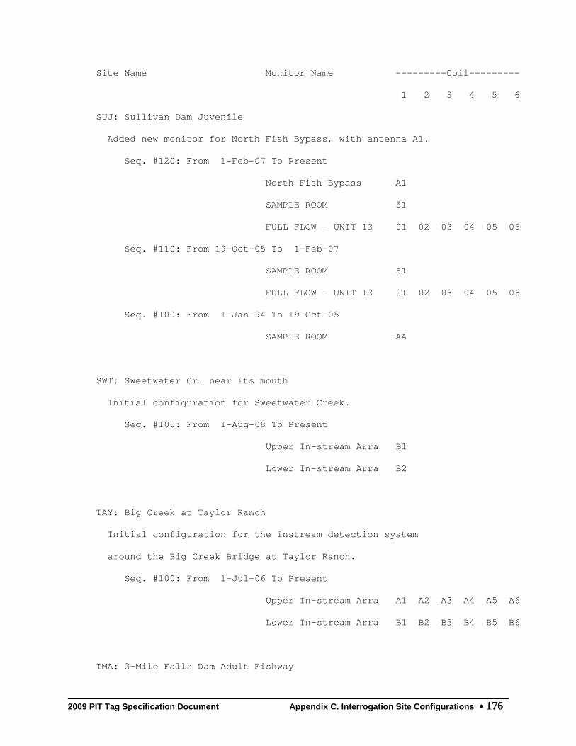
2009 PIT Tag Specification Document Appendix C. Interrogation Site Configurations 176
Site Name Monitor Name ---------Coil---------
1 2 3 4 5 6
SUJ: Sullivan Dam Juvenile
Added new monitor for North Fish Bypass, with antenna A1.
Seq. #120: From 1-Feb-07 To Present
North Fish Bypass A1
SAMPLE ROOM 51
FULL FLOW - UNIT 13 01 02 03 04 05 06
Seq. #110: From 19-Oct-05 To 1-Feb-07
SAMPLE ROOM 51
FULL FLOW - UNIT 13 01 02 03 04 05 06
Seq. #100: From 1-Jan-94 To 19-Oct-05
SAMPLE ROOM AA
SWT: Sweetwater Cr. near its mouth
Initial configuration for Sweetwater Creek.
Seq. #100: From 1-Aug-08 To Present
Upper In-stream Arra B1
Lower In-stream Arra B2
TAY: Big Creek at Taylor Ranch
Initial configuration for the instream detection system
around the Big Creek Bridge at Taylor Ranch.
Seq. #100: From 1-Jul-06 To Present
Upper In-stream Arra A1 A2 A3 A4 A5 A6
Lower In-stream Arra B1 B2 B3 B4 B5 B6
TMA: 3-Mile Falls Dam Adult Fishway

2009 PIT Tag Specification Document Appendix C. Interrogation Site Configurations 177
An FS-1001M MUX transceiver now powers a single pass-by
antenna at the counting window.
Seq. #110: From 24-Apr-06 To 8-Nov-06
Fish Ladder Viewing 01 02 03 04 05 06
Seq. #100: From 7-Mar-02 To 24-Apr-06
FS2001 PORTABLE WITH 01
TMF: Three Mile Falls Dam Combined
Initial configuration. Combines and replaces old TMJ and
TMA detections sites.
Seq. #100: From 8-Nov-06 To Present
Juvenile Fish Sub-sa 51 52
Juvenile Fish Bypass 81
Adult Fish Ladder 01
TMJ: 3-Mile Falls Dam Smolt Bypass
Revised existing RIVER EXIT monitor name to SAMPLE FACILITY
and added a new RIVER EXIT monitor.
Seq. #130: From 1-Jan-06 To 12-Jul-06
Sample Facility 10 11
River Exit 91
Seq. #120: From 28-Jan-04 To 1-Jan-06
RIVER EXIT 10 11
Seq. #110: From 6-Mar-00 To 28-Jan-04
RIVER EXIT 10 11
Seq. #100: From 19-Mar-99 To 6-Mar-00
RIVER EXIT 10

2009 PIT Tag Specification Document Appendix C. Interrogation Site Configurations 178
Site Name Monitor Name ---------Coil---------
1 2 3 4 5 6
TRB: Tucannon Railroad Bridge
Initial configuration for new Tucannon Railroad Bridge site.
Seq. #100: From 1-Nov-05 To Present
Crump Weir Array 01 02 03 04 05 06
TRC: Trout Creek, Wind River
Initial site configuration.
Seq. #100: From 1-Sep-07 To Present
Upper In-stream Arra 01 02
Middle In-stream Arr 03 04
Lower In-stream Arra 05 06
TST: Test Site
THIS SITE CODE USED FOR PSMFC TESTING PURPOSES
Seq. # 10: From 22-Apr-00 To Present
TEST MONITOR 1 01 02 03 04 05 06
TEST MONITOR 2 07 08 09 0A 0B 0C
TUF: Tumwater Dam Adult Fishway
Initial configuration.
Seq. #100: From 15-Jan-08 To Present
Weir 18 A1
Weir 15 A2
TWR: Lwr Twisp Rvr near MSRF Ponds
Initial configuration for lower Twisp River Instream Arrays

2009 PIT Tag Specification Document Appendix C. Interrogation Site Configurations 179
Seq. #100: From 15-Jul-08 To Present
Upper In-stream Arra B1 B2 B3
Lower In-stream Arra B4 B5 B6
TWX: Estuary Towed Array (Exp.)
Contains new Shoreline and Matrix (experimental) detectors
as well as Primary Trawl detector
Seq. #160: From 1-Mar-06 To Present
Primary Trawl A1 A2 A3 A4 A5 A6
Shoreline Sampler B1 B2 B3 B4 B5 B6
Matrix [Experimental C1 C2 C3 C4 C5 C6
Seq. #150: From 13-Mar-02 To 1-Mar-06
LARGE TRAWL 00 01
SMALL TRAWL F1
Seq. #140: From 1-Apr-01 To 13-Mar-02
RIVER EXIT 00 01
Seq. #130: From 30-Mar-00 To 1-Apr-01
RIVER EXIT 00
Seq. #120: From 26-Apr-99 To 30-Mar-00
RIVER EXIT 9E
RIVER EXIT 36
RIVER EXIT 00 02
RIVER EXIT 5A
Seq. #110: From 1-Mar-98 To 26-Apr-99
RIVER EXIT 9E
RIVER EXIT 36
RIVER EXIT 5A

2009 PIT Tag Specification Document Appendix C. Interrogation Site Configurations 180
Site Name Monitor Name ---------Coil---------
1 2 3 4 5 6
Seq. #100: From 13-Apr-95 To 1-Mar-98
RIVER EXIT 20 22
RIVER EXIT 10 12
UM1: Umatilla River USFWS
NF Umatilla R. at Umatilla Forks Nat. Cmpgrnd. (USFWS)
Seq. #100: From 20-Oct-04 To Present
Left Antenna 01
Right Antenna 02
UM2: Umatilla River Instream Array
Initial configuration for new instream flat-plate
installation on the main stem Umatilla River.
Seq. #100: From 1-Aug-07 To Present
In-stream Array F1 F2 F3 F4 F5 F6
UWE: Upper Wenatchee River
Initial configuration.
Seq. #100: From 1-Oct-09 To Present
In-stream Array A1 A2 A3 A4 A5 A6
VC1: Valley Creek, Upstream Site
New MUX installation with at least two speedbump-style
antennas.
Seq. #110: From 6-Sep-07 To Present
Speedbump Antenna Ar 01 02 03 04 05 06

2009 PIT Tag Specification Document Appendix C. Interrogation Site Configurations 181
Seq. #100: From 10-Jul-02 To 6-Sep-07
MAIN A1
VC2: Valley Creek, Downstream Site
New MUX installation with at least two speedbump-style
antennas.
Seq. #110: From 6-Sep-07 To Present
Speedbump Antenna Ar 01 02 03 04 05 06
Seq. #100: From 10-Jul-02 To 6-Sep-07
MAIN A1
WAJ: WANAPUM DAM JUVENILE (G-DIP)
Date and coil/controller data accurate; monitor name must be
verified
Seq. #100: From 28-Apr-94 To 3-Jun-94
MAIN F0
WEA: Wells Dam, DCPUD Adult Ladders
New antenna IDs B1 - B3 at the West Trap entrance
Seq. #120: From 12-May-08 To Present
Left Ladder Pool 68 01 02
Left Ladder Pool 67 03 04
Right Ladder Pool 68 05 06
Right Ladder Pool 67 07 08
East Trap 09 0A
West Trap B1 B2 B3

2009 PIT Tag Specification Document Appendix C. Interrogation Site Configurations 182
Site Name Monitor Name ---------Coil---------
1 2 3 4 5 6
Seq. #110: From 28-Jun-04 To 13-May-08
Left Ladder Pool 68 01 02
Left Ladder Pool 67 03 04
Right Ladder Pool 68 05 06
Right Ladder Pool 67 07 08
East Trap 09 0A
West Trap 0B 0C
Seq. #100: From 2-Jan-02 To 28-Jun-04
Left Ladder Pool 68 01 02
Left Ladder Pool 67 03 04
Right Ladder Pool 68 05 06
Right Ladder Pool 67 07 08
WFC: Wolf Creek, Methow River
Initial configuration for Wolf Creek.
Seq. #100: From 1-Dec-08 To Present
Single In-stream Ant 11
WFF: Willamette Falls Fishway
All fish must pass these weirs on either side of the
counting window at Willamette Falls fish ladder
Seq. #100: From 28-Dec-05 To Present
WEIR UPSTREAM OF WIN 01 02
WEIR DOWNSTREAM OF W 03 04
WPJ: WAPATO DIVERSION JUVENILE

2009 PIT Tag Specification Document Appendix C. Interrogation Site Configurations 183
Dates and coil/controller data are accurate; monitor name
must be reviewed
Seq. #100: From 8-May-91 To 5-Jun-91
MAIN FB
WSH: Warm Springs Hatchery
Initial configuration for adult fishway detectors at Warm
Springs NFH.
Seq. #100: From 1-Feb-08 To Present
Adult Fishway 01 02
WTL: White River, Wenatchee Basin
Initial configuration.
Seq. #100: From 1-Apr-09 To Present
Upper In-stream Arra B1 B2 B3
Lower In-stream Arra B4 B5 B6
WW1: Harris Bridge S F Walla Walla
MUX transceiver with antennas upstream and downstream of the
Bridge at Harris Park.
Seq. #120: From 7-Oct-06 To Present
Upstream of Bridge 01 02 03
Downstream of Bridge 04 05 06
Seq. #110: From 3-Sep-02 To 7-Oct-06
LEFT A1
RIGHT A2
Seq. #100: From 3-Sep-02 To 3-Sep-02
LEFT A1

2009 PIT Tag Specification Document Appendix C. Interrogation Site Configurations 184
RIGHT A2
Site Name Monitor Name ---------Coil---------
1 2 3 4 5 6
WW2: SF Walla Walla at Bear Creek
Original FS-1001A transceivers replaced with FS-1001M MUX
transceiver.
Seq. #110: From 17-Nov-05 To Present
LEFT 01
RIGHT 02
Seq. #100: From 3-Sep-02 To 17-Nov-05
LEFT A1
RIGHT A2
Y1J: YAKIMA RIVER TRAP JUVENILE
Dates and coil/controller data are correct; monitor name
must be verified
Seq. #100: From 4-May-90 To 11-Jun-90
MAIN B8
YHC: Yellowhawk Creek
Original definition for new Yellowhawk Creek site, with
headgate (A1) and Wa-High (B1) antennas.
Seq. #100: From 1-Dec-06 To Present
Instream antenna at A1
Instream antenna at B1

2009 PIT Tag Specification Document Appendix C. Interrogation Site Configurations 185
ZEN: Secesh River at Zena Cr. Ranch
Initial configuration for the Secesh River Instream Arrays
near Zena Creek Ranch
Seq. #100: From 1-Mar-09 To Present
Upper In-stream Arra A1 A2 A3 A4 A5 A6
Lower In-stream Arra B1 B2 B3 B4 B5 B6

2009 PIT Tag Specification Document Appendix C. Interrogation Site Configurations 186
This Page Intentionally Left Blank

2009 PIT Tag Specification Document Appendix C. Interrogation Site Configurations 187
C25. Interrogation Site Operations History
Site Code
Interrogation Site Name
Organ- ization
Date Range
AB1 Abernathy Creek, Technology Center Bridge USFWS 2001 -
AB2 Abernathy Creek, Farmer's Bridge USFWS 2001 - 2006
AB3 Lower Abernathy Creek USFWS 2009 -
B1J Bonneville Dam DSM1 Flat Plate Detector PSMFC 2003 - 2003
B2A Bonneville Dam Adult Fish Facility PSMFC 1998 - 2002
B2J Bonneville Dam PH2 Juvenile Bypass System PSMFC 1996 -
BCC Bonneville Dam PH2 Corner Collector PSMFC 2006 -
BCP Butcher Creek Acclimation Pond YINN 2004 -
BGM Burlingame Diversion Dam USFWS 2007 -
BO1 Bonneville Dam Bradford Island Fishway PSMFC 2002 -
BO2 Bonneville Dam Cascades Island Fishway PSMFC 2002 -
BO3 Bonneville Dam WA Shore Fishway & AFF PSMFC 2003 -
BO4 Bonneville Dam WA Shore Vertical Slots PSMFC 2005 -
BVC Beaver Creek In-stream Array, Methow River USGS 2009 -
BVJ Bonneville Dam DSM1 Subsample PSMFC 1992 - 1999
BVP Beaver Creek Acclimation Pond YINN 2006 -
BVX Bonneville Dam PH1 Flat Plate (Experimental) PSMFC 1996 - 2002
BWL Bonneville Dam Washington Shore Fishway PSMFC 2001 - 2002
CAP Carlton Acc. Pond Unknown 1995 - 1995
CCP Catherine Creek Acclimation Pond CTUIR 2000 -
CFJ Clark Flat Acclimation Ponds PSMFC 1999 -

2009 PIT Tag Specification Document Appendix C. Interrogation Site Configurations 188
Site Code
Interrogation Site Name
Organ- ization
Date Range
CHL Lower Chiwawa River WDFW 2008 -
CHN Challis - North Unknown 1991 - 1993
CHP Chiwawa Acclimation Pond BIOMRK 1995 -
CHS Challis - South Unknown 1991 - 1992
CHU Upper Chiwawa River WDFW 2008 -
CLE Cle Elum Dam Interim Spillway Bypass YINN 2006 -
CLJ Clearwater River Trap IDFG 1989 -
CLP Coulter Creek Acclimation Pond YINN 2006 -
CR1 Chinook River at Sea Resources Hatchery SEARES 2002 - 2006
CR2 Chinook River at HWY 101 Bridge SEARES 2002 - 2006
CR3 Chinook River at a Culvert SEARES 2004 - 2006
DRP Dryden Acc. Pond Unknown 1994 - 1996
EMC Eightmile Creek In-stream Array, Methow River USGS 2008 -
ENL Lower Entiat River USFWS 2007 -
ENM Middle Entiat River USFWS 2008 -
ESJ Easton Acclimation Pond PSMFC 1999 -
ESS East Fk South Fk Salmon River at Parks Cr. NNPT 2009 -
ESX Estuary Saltwater Trawl (Experimental) NNMFS 2004 - 2005
FDC Feed Canal, Umatilla River USFWS 2006 -
FDD Feed Diversion Dam USFWS 2008 -
GL2 SF Gold Creek In-stream Array, Methow River USGS 2009 -
GLC Gold Creek In-stream Array, Methow River USGS 2009 -
GOJ Little Goose Dam Juvenile Bypass System PSMFC 1987 -

2009 PIT Tag Specification Document Appendix C. Interrogation Site Configurations 189
Site Code
Interrogation Site Name
Organ- ization
Date Range
GRA Lower Granite Dam Adult Fishway and Trap PSMFC 1988 -
GRJ Lower Granite Dam Juvenile Bypass System PSMFC 1988 -
GRP Grande Ronde Acclimation Pond CTUIR 2002 -
GRX Lower Granite Dam Sep-by-Code (Experimental) PSMFC 1995 - 1999
HLX Hemlock Dam (Trout Cr, Wind River) Fishway USGS 2004 - 2009
HYC Hayden Creek in-stream array, Lemhi Basin IDFG 2009 -
ICH Ice Harbor Dam Fishways and Juvenile Bypass PSMFC 2005 -
IHA Ice Harbor Adult Fishways PSMFC 2003 - 2005
IMJ Imnaha River Juvenile Trap Unknown 1994 - 1999
JCJ Jack Creek Acclimation Pond PSMFC 2000 -
JD1 John Day River near McDonald Ferry at RM 20 NNMFS 2007 -
JDJ John Day Dam Juvenile Bypass System PSMFC 1992 -
JUL Potlatch River near Juliaetta IDFG 2008 -
KCB Kiwanis Camp Bridge, upper Mill Creek USFWS 2005 -
KHS Big Bear Cr. at Kendrick HS IDFG 2007 -
KRS SF Salmon River at Krassel Cr. NNPT 2008 -
LAP Lapwai Creek near the mouth UIDAHO 2008 -
LBC Libby Creek In-stream Array, Methow River USGS 2009 -
LLR Lower Lemhi River ISA at Salmon IDFG 2009 -
LMJ Lower Monumental Dam Juvenile Bypass System PSMFC 1993 -
LMR Lower Methow River near Pateros WDFW 2009 -
LOP Lostine River Acclimation Pond NNPT 2002 -
LRW Lemhi River ISA below the IDFG weir IDFG 2009 -

2009 PIT Tag Specification Document Appendix C. Interrogation Site Configurations 190
Site Code
Interrogation Site Name
Organ- ization
Date Range
LTR Lower Tucannon River, near the river mouth USFWS 2005 -
LWD Lowden Diversion Dam USFWS 2007 -
LWE Lower Wenatchee River WDFW 2009 -
LWN Little Wenatchee River WDFW 2009 -
MAD Mad River, Entiat River Basin USFWS 2008 -
MC1 McNary Dam Oregon Shore Fishway PSMFC 2002 -
MC2 McNary Dam Washington Shore Fishway PSMFC 2002 -
MCD Mill Creek Diversion Project USFWS 2005 -
MCJ McNary Dam Juvenile Bypass System PSMFC 1988 -
MCX McNary Dam Juvenile Experimental Site PSMFC 1996 - 2002
MRB Lower Methow River Basin below Twisp USGS 2004 - 2008
MSC Methow River Side Channel Array USGS 2009 -
MWC Maxwell Canal, Umatilla River USFWS 2007 -
MWE Middle Wenatchee River WDFW 2009 -
NAL Lower Nason Creek YINN 2008 -
NAU Upper Nason Creek YINN 2007 -
NBA Nursery Bridge Diversion Dam Fishways USFWS 2003 -
OMK Omak Creek Crump Weir CCT 2006 -
ORB Oasis Road Bridge, lower Walla Walla River USFWS 2005 -
PES Peshastin Creek WDFW 2007 -
PRA Priest Rapids Dam Adult Fishways GPUD 2003 -
PRJ Prosser Dam screened Juvenile Diversion PSMFC 1989 - 2004
PRO Prosser Dam Fishways and screened Diversion PSMFC 2004 -

2009 PIT Tag Specification Document Appendix C. Interrogation Site Configurations 191
Site Code
Interrogation Site Name
Organ- ization
Date Range
RBF Round Butte Dam Fish Transfer Facility PGE 2009 -
RCX Rattlesnake Creek Flat Plates (Experimental) USGS 2001 - 2007
RFP Rolfing Acclimation Pond YINN 2004 -
RIA Rock Island Dam Adult Fishways CPUD 2003 -
ROZ Roza Dam Juvenile Diversion Unknown 1992 - 1992
RPJ Rapid River Hat. Juvenile Volitional Release PSMFC 1999 -
RRF Rocky Reach Fishway CPUD 2006 -
RRJ Rocky Reach Dam Juvenile Bypass System PSMFC 1996 - 2002
RZF Roza Dam Adult Fishway PSMFC 2007 -
SAJ Salmon River Trap IDFG 1993 -
SCP Spring Creek Acc. Pond behind Winthrop NFH YINN 2008 -
SFG SF Salmon River near Guard Station Rd. Bridge NNPT 2009 -
SFL Shipherd Falls Ladder WDFW 2009 -
SIP Similkameen Acc. Pond Unknown 1996 - 1996
SNJ Snake River Trap IDFG 1989 -
SSJ Sunnyside Dam Juvenile Diversion Unknown 1991 - 1991
SUJ Sullivan Dam Juvenile Bypass System PGE 1999 -
SWT Sweetwater Creek near its mouth UIDAHO 2008 -
TAY Big Creek (Idaho) at Taylor Ranch NNMFS 2006 -
TMA Three Mile Falls Dam Adult Fishway USFWS 2002 - 2006
TMF Three Mile Falls Dam Fishway and Diversion USFWS 2006 -
TMJ Three Mile Falls Dam Juvenile Diversion USFWS 1999 - 2006
TRC Trout Creek In-stream Detection, Wind River USGS 2007 -

2009 PIT Tag Specification Document Appendix C. Interrogation Site Configurations 192
Site Code
Interrogation Site Name
Organ- ization
Date Range
TST PTAGIS Test Site PSMFC 2000 -
TUF Tumwater Dam Adult Fishway CPUD 2008 -
TWR Lower Twisp River near MSRF Ponds WDFW 2008 -
TWX Estuary Towed Array (Experimental) NNMFS 1996 -
UM1 NF Umatilla River at Forks Campground Bridge USFWS 2004 -
UM2 Umatilla River Array above Imeques Acc. Pond USFWS 2007 -
UWE Upper Wenatchee River WDFW 2009 -
VC1 Valley Creek, in-river at Stanley, ID NNMFS 2002 -
VC2 Valley Creek, in-river below Stanley, ID NNMFS 2002 -
WAJ Wanapum Dam Juvenile (gatewell dip) Unknown 1994 - 1994
WEA Wells Dam Adult Fishways DC1PUD 2002 -
WFC Wolf Creek In-stream Array, Chewuck River USGS 2008 -
WFF Willamette Falls Adult Fishway ODFW 2005 -
WPJ Wapato Dam Juvenile Diversion Unknown 1991 - 1991
WSH Adult fishway at Warm Springs NFH USFWS 2008 -
WTL White River, Wenatchee Basin WDFW 2009 -
WW1 SF Walla Walla River at Harris Park Bridge USFWS 2002 -
WW2 SF Walla Walla River at Bear Creek USFWS 2002 -
Y1J Yakima River Trap Unknown 1990 - 1990
YHC Yellowhawk Creek USFWS 2006 -
ZEN Secesh River near Zena Creek Ranch NNPT 2009 -

2009 PIT Tag Specification Document Appendix D. Columbia Basin Hydrologic Unit Codes 193
Appendix D. Columbia Basin Hydrologic Unit Code (HUC) Maps

2009 PIT Tag Specification Document Appendix D. Columbia Basin Hydrologic Unit Codes 194
VI.

2009 PIT Tag Specification Document Appendix D. Columbia Basin Hydrologic Unit Codes 195

2009 PIT Tag Specification Document Appendix D. Columbia Basin Hydrologic Unit Codes 196
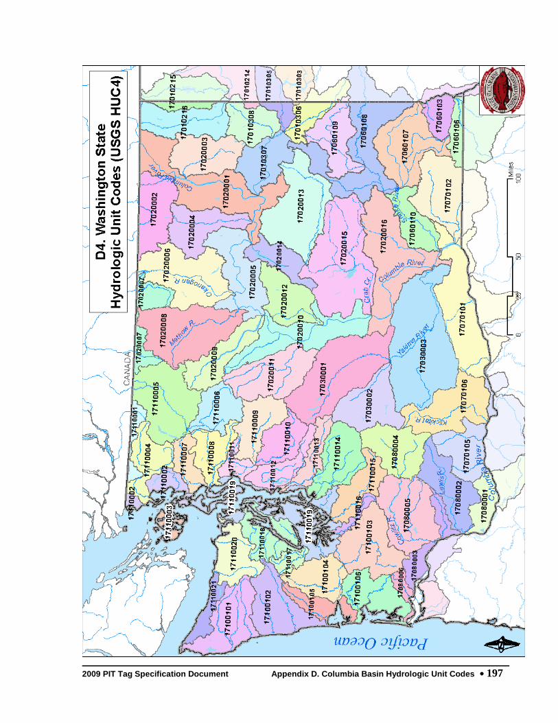
2009 PIT Tag Specification Document Appendix D. Columbia Basin Hydrologic Unit Codes 197
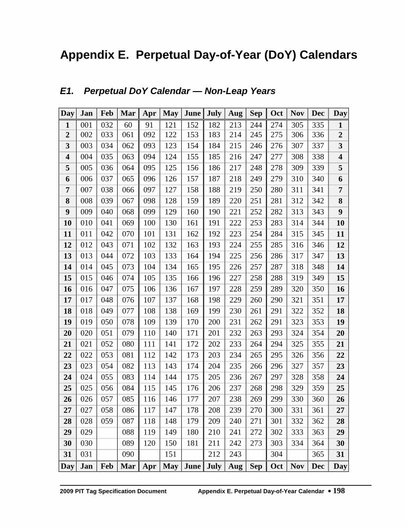
2009 PIT Tag Specification Document Appendix E. Perpetual Day-of-Year Calendar 198
Appendix E. Perpetual Day-of-Year (DoY) Calendars
E1. Perpetual DoY Calendar — Non-Leap Years
Day Jan Feb Mar Apr May June July Aug Sep Oct Nov Dec Day 1 001 032 60 91 121 152 182 213 244 274 305 335 1 2 002 033 061 092 122 153 183 214 245 275 306 336 2 3 003 034 062 093 123 154 184 215 246 276 307 337 3 4 004 035 063 094 124 155 185 216 247 277 308 338 4 5 005 036 064 095 125 156 186 217 248 278 309 339 5 6 006 037 065 096 126 157 187 218 249 279 310 340 6 7 007 038 066 097 127 158 188 219 250 280 311 341 7 8 008 039 067 098 128 159 189 220 251 281 312 342 8 9 009 040 068 099 129 160 190 221 252 282 313 343 9 10 010 041 069 100 130 161 191 222 253 283 314 344 10 11 011 042 070 101 131 162 192 223 254 284 315 345 11 12 012 043 071 102 132 163 193 224 255 285 316 346 12 13 013 044 072 103 133 164 194 225 256 286 317 347 13 14 014 045 073 104 134 165 195 226 257 287 318 348 14 15 015 046 074 105 135 166 196 227 258 288 319 349 15 16 016 047 075 106 136 167 197 228 259 289 320 350 16 17 017 048 076 107 137 168 198 229 260 290 321 351 17 18 018 049 077 108 138 169 199 230 261 291 322 352 18 19 019 050 078 109 139 170 200 231 262 291 323 353 19 20 020 051 079 110 140 171 201 232 263 293 324 354 20 21 021 052 080 111 141 172 202 233 264 294 325 355 21 22 022 053 081 112 142 173 203 234 265 295 326 356 22 23 023 054 082 113 143 174 204 235 266 296 327 357 23 24 024 055 083 114 144 175 205 236 267 297 328 358 24 25 025 056 084 115 145 176 206 237 268 298 329 359 25 26 026 057 085 116 146 177 207 238 269 299 330 360 26 27 027 058 086 117 147 178 208 239 270 300 331 361 27 28 028 059 087 118 148 179 209 240 271 301 332 362 28 29 029 088 119 149 180 210 241 272 302 333 363 29 30 030 089 120 150 181 211 242 273 303 334 364 30 31 031 090 151 212 243 304 365 31
Day Jan Feb Mar Apr May June July Aug Sep Oct Nov Dec Day

2009 PIT Tag Specification Document Appendix E. Perpetual Day-of-Year Calendar 199
E2. Perpetual DoY Calendar — Leap Years Day Jan Feb Mar Apr May June July Aug Sep Oct Nov Dec Day
1 001 032 061 092 122 153 183 214 245 275 306 336 1 2 002 033 062 093 123 154 184 215 246 276 307 337 2 3 003 034 063 094 124 155 185 216 247 277 308 338 3 4 004 035 064 095 125 156 186 217 248 278 309 339 4 5 005 036 065 096 126 157 187 218 249 279 310 340 5 6 006 037 066 097 127 158 188 219 250 280 311 341 6 7 007 038 067 098 128 159 189 220 251 281 312 342 7 8 008 039 068 099 129 160 190 221 252 282 313 343 8 9 009 040 069 100 130 161 191 222 253 283 314 344 9 10 010 041 070 101 131 162 192 223 254 284 315 345 10 11 011 042 071 102 132 163 193 224 255 285 316 346 11 12 012 043 072 103 133 164 194 225 256 286 317 347 12 13 013 044 073 104 134 165 195 226 257 287 318 348 13 14 014 045 074 105 135 166 196 227 258 288 319 349 14 15 015 046 075 106 136 167 197 228 259 289 320 350 15 16 016 047 076 107 137 168 198 229 260 290 321 351 16 17 017 048 077 108 138 169 199 230 261 291 322 352 17 18 018 049 078 109 139 170 200 231 262 291 323 353 18 19 019 050 079 110 140 171 201 232 263 293 324 354 19 20 020 051 080 111 141 172 202 233 264 294 325 355 20 21 021 052 081 112 142 173 203 234 265 295 326 356 21 22 022 053 082 113 143 174 204 235 266 296 327 357 22 23 023 054 083 114 144 175 205 236 267 297 328 358 23 24 024 055 084 115 145 176 206 237 268 298 329 359 24 25 025 056 085 116 146 177 207 238 269 299 330 360 25 26 026 057 086 117 147 178 208 239 270 300 331 361 26 27 027 058 087 118 148 179 209 240 271 301 332 362 27 28 028 059 088 119 149 180 210 241 272 302 333 363 28 29 029 060 089 120 150 181 211 242 273 303 334 364 29 30 030 090 121 151 182 212 243 274 304 335 365 30 31 031 091 152 213 244 305 366 31
Day Jan Feb Mar Apr May June July Aug Sep Oct Nov Dec Day
Top Related