


Languages
Pages
Legal


1622–1640 POINT BREEZE AVEMulti-family Residential Development
Civic Design Review Submission 2020.08.18
Civic Design Review 2020.09.01

2020.08.18Page 2
1622-1640 POINT BREEZE AVE
CONTENTS
PROJECT SUMMARY
1622-40 Point Breeze Avenue is a proposed development of a multi-family residential
building. The building is sited on the southern edge of the 17,600 SF site, with
frontages on Point Breeze Ave and Fernon St. The addition of street trees to the
bordering sidewalks will activate the pedestrian experience and supplement the
residential character of the street. The building features a residential lobby fronting
on Point Breeze Avenue with bike storage, 69 apartments, a green roof, and a roof
deck. Composed of brick and metal panel in warm, complementing tones, the facades
have been designed to respect the residential nature of the site's surroundings. This
development and the open space next to it helps to activate the streetscape, fostering
a relationship between this property and those surrounding it.
CONTENTS
1–2 ............................................
3 ...............................................
4 ..............................................
5-6 ...........................................
7 ..............................................
8 ..............................................
9 ..............................................
10 ..............................................
11 ..............................................
12 ..............................................
13 ..............................................
14 ..............................................
15 ..............................................
16 ..............................................
17 ..............................................
18 ..............................................
19 ..............................................
20 ..............................................
21-22 ........................................
Intro
CDR Application Form
Aerial Site Context
Zoning Analysis
Site Context Map
Site Photos
Context Photos
Existing Site Survey
Conditional Zoning Permit
Proposed Site Plan
Zoning Notes
Ground Floor Plan
Typical Floor Plan
Roof and Landscape Plan
Sustainability Questionnaire
Site Sections
Elevations & Building Materials
Massing in Context
Rendered Perspectives
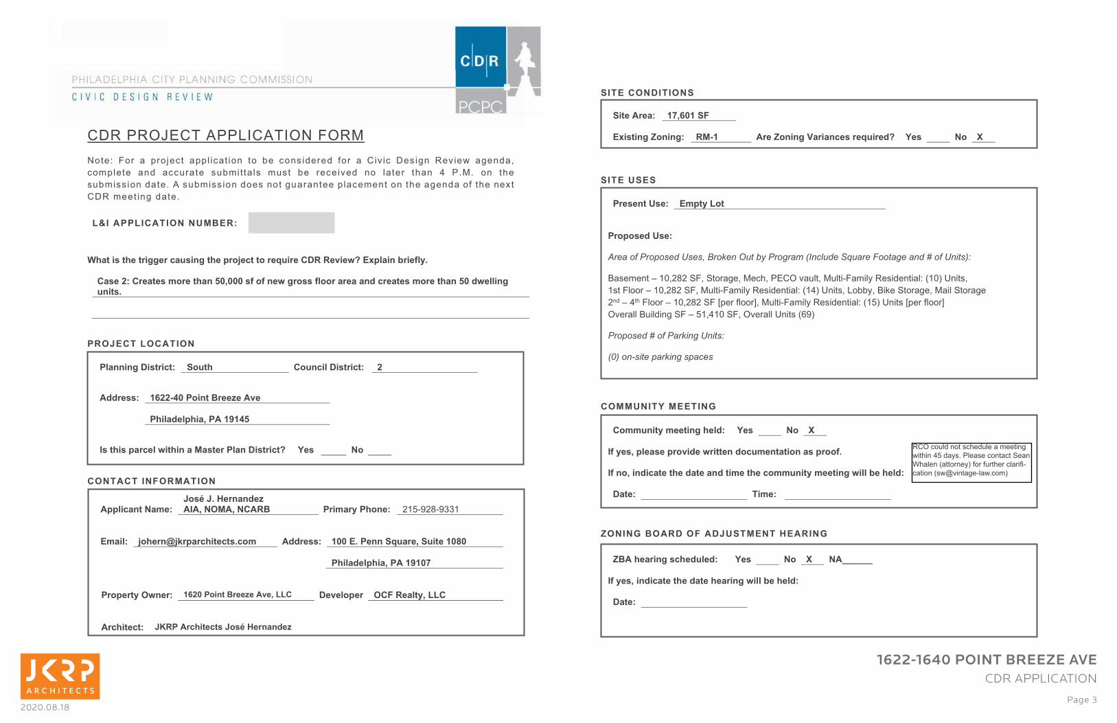
2020.08.18Page 3
1622-1640 POINT BREEZE AVE
CDR APPLICATION
������������������ ������
����� ��� � �� ������� � ���� ���� ���� ��� ��� ���� ������� ��� � �� �� �� � ��� �!�� �� ��"� �!����#�
��$������ ���� ���%����� �%�$���� �� � $%��� ��� ����� ��� ��� ����� � �&��� '� �(�(� ��� �&��
�%�$��� ��������( ���%�$��� ������������ �!%��������� ����$��������&���!������� ��&����)��
����$��� ��!�����( �
���������������� ���� ��
�
��������������������������������������������� ������!����"��#$��%�&����'���(&)*�
�����+����������,���������-./...��(��(���#�������(&�����������0���������,���������-.�0#�&&���������*��
��
�
��1����������
�
�
�
�
�
�
�������2������
�
�
�
�
�
�&�������!��������� 3����� ������&�!��������� +�
�
�00������ 45++67.������� ���8���"��
����&�0�&����/����4947-�
�
�������������&�#����������������&���!�������$� :��� � �� �
�
���&�������,����1��;�1*�<�����0�8����/���/���� � ���,��)�������� *+,-.*/-.00+�
�
�,��&�� ������=�>������������*��,� �00������ 4..��*������3 ����/�3�����4.?.�
� � � �� � � ���&�0�&����/����494.@�
�
�������)�#����� 45+.������� ���8���"�/����� !�"�&����� �2����&�)/�����
�
����������� 1A��������������1��;�<�����0�8�
�
�
�
3�����!���3�
�
�
�
3�����3�3�
�
�
�
�
�
�
�
�
�
������:������B�
�
�
�
�
�
C�B� ��!�2��!1�3�����<����B�
��,,����)�,���������&0�� :��� � �� D�
��(�)��/��&��������"�0��#�������0���,����������������(*�
�(���/���0����������0������0���,��������,,����)�,�������#�&&�'����&0��
!����� 9E.@E+.+.� ��,��� 5�F.���
�
������������� �,��)�����
�
�������0������
����������������� ���������������������������������������������������������� �!"��
1���$����2�+3#*/*�4�#�4����!�#����&#������ �%��#��%���-��$��5��������������6+37�8����#�
+���������2�+3#*/*�4�#��%���-��$��5��������������6+'7�8����#�����5#�1�9��4����!�#������4����!��
*���2�'�&�������2�+3#*/*�4��:���������;#��%���-��$��5��������������6+,7�8�����:���������;�
� ������1%�����!�4��2�,+#'+3�4�#�� ������8�����6<.7�
���������������� ����� �"�
�#!���$ ������ �������
�
3���������� 4@/5.4�32�
��%�������C������� ��64� ����C������G����������� ����0$� :��� � �� D�
�
C ��������������0�&�0�� :��� � �� D� �HHHHHH�
�����(�)��/���0����������0������������#�&&�'����&0��
!����� � �
�
�
RCO could not schedule a meeting
within 45 days. Please contact Sean
Whalen (attorney) for further clarifi -
cation ([email protected])

2020.08.18Page 4
1622-1640 POINT BREEZE AVE
SITE CONTEXT
NORTH EAST AXON
SOUTH WEST AXONAERIAL VIEW

2020.08.18Page 5
1622-1640 POINT BREEZE AVE
ZONING ANALYSIS
RM-1
RSA-5 CMX-1 I-2
ICMX IRMX CMX-3
Max. Occupied Area
Lot: Intermediate
Lot: Corner
Min. Front Yard Depth:
Min. Side Yard Width:
Min. Rear Yard Depth:
Max. Height:
Max. Floor Area:
Max. Occupied Area
Lot: Intermediate
Lot: Corner
Min. Side Yard Width:
Max. Floor Area:
Max. Occupied Area
Min. Front Yard Depth:
Min. Side Yard Width:
Min. Rear Yard Depth:
Max. Height:
Max. Floor Area:
Max. Occupied Area
Min. Front Yard Depth:
Min. Side Yard Width:
Min. Rear Yard Depth:
Max. Height:
If abutting a residential
or SP-PO District:
Otherwise:
Max. Floor Area Ratio:
75%
80%
0 ft.
0 ft.
0 ft.
60 ft.
500%
75%
80%
100%
0 ft.
8 ft.
8 ft.
60 ft.
500%
100%
0 ft.
6 ft.
8 ft.
60 ft.
No Limit
500%
Min. Lot Width:
Min. Lot Area:
Min. Open Area:
Min. Front Setback:
Min. Side Yard Width:
Detached
Semi-Detached
Min. Rear Yard Depth:
Max. Height
50 ft.
5,000 sq. ft.
70%
25 ft.
7-10 ft.
25 ft.
25 ft.
38 ft.
CMX-1 Occupied Area, Building
Dimensions, and Height are
based on the requirements
of adjacent residential zoning
districts in order to match the
neighborhood surroundings.
8 ft. if used for buildings
containing dwelling units
500%; up to an additional
300% with bonuses
ZONING ANALYSIS
RM-1

2020.08.18Page 6
1622-1640 POINT BREEZE AVE
ZONING ANALYSIS
RM-1

2020.08.18Page 7
1622-1640 POINT BREEZE AVE
SITE CONTEXT
FERNON ST
LOT AREA: 17,601 SF
LOT COVERAGE: 10,275 SF (58%)
FERNON ST
MOUNTAIN ST
MORRIS ST MORRIS ST
S 2
3R
D S
T
S 2
2N
D S
T
PO
INT
BR
EE
ZE
AV
E
MORRIS ST
MOUNTAIN ST
FERNON ST
1
2
3
4
5
67891011
12
64'
148
'
49
'
45
'
75'
109
' 6"
35'
111'
13'
1
3
4
7 89
5
6
12 10
2
11
29'
50
'

2020.08.18Page 8
1622-1640 POINT BREEZE AVE
SITE PHOTOS
1
6
11
2
7
12
3
8
4
9
5
10
Fernon Street Fernon StreetPoint Breeze Ave Point Breeze Ave
Point Breeze Ave Point Breeze AvePoint Breeze Ave Point Breeze Ave
Point Breeze Ave Point Breeze AvePoint Breeze AvePoint Breeze Ave

2020.08.18Page 9
1622-1640 POINT BREEZE AVE
CONTEXT PHOTOS
Point Breeze Ave South 23rd St.Tasker St. Point Breeze Ave
Point Breeze Ave Point Breeze AvePoint Breeze Ave Point Breeze Ave
Morris Street Point Breeze AvePoint Breeze AvePoint Breeze Ave
1 2 3 4
5 6 7 8
9 10 11 12

2020.08.18Page 10
1622-1640 POINT BREEZE AVE
EXISTING SITE SURVEY
RIGHT OF WAY/ADJACENT PROPERTY LINE
DEPRESSED CURB
INLET
UTILITY POLE W/ STREET LIGHT
UTILITY POLE
TRAFFIC SIGNAL POLE
VENT
UNKNOWN VALVE
SANITARY CLEANOUT
GAS VALVE
WATER VALVE
TREE
STREET LIGHT
HYDRANT
MANHOLE
DIRECTION OF TRAFFIC FLOW
LEGEND
XX ERSA PHOTO ID
PROPERTY LINE
LIMIT OF DISTURBANCE
U/G TELEPHONE LINE
U/G ELECTRIC LINE
OVERHEAD WIRE
WATER LINE
GAS LINE
COMBINED SEWER
GUTTER ELEVATION
TOP OF CURB ELEVATION
SPOT ELEVATION
BOTTOM OF CURB ELEVATION
MAJOR CONTOUR
MINOR CONTOUR
FENCE
BUILDING AREA

2020.08.18Page 11
1622-1640 POINT BREEZE AVE
CONDITIONAL ZONING PERMIT
�
����������������� �����
�������������������
�
������������ ������ ����� ������� �� ����
���� ����������������� ������������
��������
���������������������� ���
��������������������
��������������������� ���� ������������ !"�
����� ������������������ �#�$ ��������������%#���� ������� �&����� � � ������������������ �������� �������� ����������� &���'��()�)*+,*-,.#%��������������%�������������$����� �������� ����������� ������ ��������������������# ������ � $ ���� ����������%��������� � �� �%��������������$��������� ������������������ ���� /��� ��� � �������� ��� �����%��� ������� ����������������$��������#���� �# ��� ������� �
���� ��0�+��(�������#� �$ .������ �����.��
���� ����&� �0�+�������#� �$ .��� ������������������� �
���� ��0��������� ����.������ �����.���1��2
���� ��0�1)+&����������$ ������ �����.���1��+
����� � ��������� ��(� ���� ����%��%� *�2������,����� �3��� �� �#���������%� &��� � $���������*�+2��,.#������ �&����� �����*����������4��#%������� ����������/ ������ ��%����#��%���� ���� � �������(4��*)��,�����%���(��������%� ������$���*��/��*+�,�& �����%����,*%� ��� �����#��%��� ���� �*��,�& �����%������� ���� � �������(+��*4,,�����/ �%� ��� ��� ����� *��� *1,%������� ���� � �������(4��*)��,,������������������%����%���*���,������&����& ���*��,�������#����� ���� �������� ���#� ��%� ����� �� #%��������� ����������������&����� ��������������� 0����� ����������� ������������ ����������������� ����&���# ���% �%�������������������������������$ ����������� �%#��$�����5� &������%�����
���� �������� �$ �#��� ���%��� ������� ���������� ������ �����#��������6%��� ��*#�,���������%������������������� ��.�� �� ��������� #�����2(+7+(���1��
��2(+7+(��)��
����� ������ �����������%� �����$������������� ��� � ����� ���.��� 8%�� ������� ���� ������� �������� �����%�����.��� �� .�������� �����������$���������� ��� ������ ������������� ��%��# ������ �&���.&� �� ��� ���� �� � ��������
�������% ����������� ��������������%�%������������� �� ��� �
�������������������0��(��������������� 0
����� /���� �0�� ����������% ��� 0�5��5����

2020.08.18Page 12
10 10 20
SCALE : 1" = 10'
0
2019\1
9002972A
\Engi
nee
ring\
Zonin
g\R
ev-3
\C-L
AY
T.d
wg\
Z-0
1-Z
ON
ING
PLA
N
By:
MB
UST
OS
ABBREVIATIONSP.D.S = PHILADELPHIA DISTRICT STANDARD
U.S.S= UNITED STATE STANDARD
FF= FINISH FLOOR
UV= UNKNOWN VALVE
DEP.= DEPRESSED
CL= CENTER LINE
D.C. = DEPRESSED CURB
BC= BOTTOM OF CURB
TC = TOP OF CURB
UP = UTILITY POLE
LP= LIGHT POLE
TBR= TO BE REMOVED
MH= MANHOLE
BOL= BOLLARD
GR= GRATE
TR= TO REMAIN
TW= TOP OF WALL
BW= BOTTOM OF WALL
CP= CITY PLAN
RIG OF WAY/ADJACENT PROPERTY LINE
DEP
LEGEND
PROPERTY LINE
LIMIT OF DISTURBANCE
FENCE
BUILDING AREA
EXISTING PROPOSED EXISTING
CONCRETE SIDEWALK
DECK AREA
S
W
NO
RT
H
PERMEABLE PAVERS
LANDSCAPE AREA
EAST ELEVATION
BUILDING ELEVATIONSNOT TO SCALE
ZONING BOUNDARY
FLOOR PLAN LEVELSNOT TO SCALE
BASEMENT FLOOR
’ ’
***PAYMENT TO CITY IN LIEU OF PROVIDING AFFORDABLE HOUSING: ESTIMATED PAYMENT $690,000.00
GREEN ROOF BONUS CALCULATION: [(1,440SQ.FT./360SQ. FT.)+((17,601SQ. FT.- 1,440SQ. FT)/480SQ. FT.)*.25] = 9 ADDITIONAL UNITS
LOW INCOME BONUS CALCULATION: [(1,440SQ.FT./360SQ. FT.)+((17,601SQ. FT.- 1,440SQ. FT)/480SQ. FT.)*1.50]*.25 ] = 23 ADDITIONAL UNITS
PROPOSED GREEN ROOFTO BE DESIGNED AND
CONSTRUCTED BY PWDSTANDARDS
OF WAY/ADJACENT PROPERTY LINE
DEPRESSED CURB
INLET
UTILITY POLE W/ STREET LIGHT
UTILITY POLE
TRAFFIC SIGNAL POLE
VENTUNKNOWN VALVE
CLEANOUT
GAS VALVE
WATER VALVE
TREE
STREET LIGHT
HYDRANT
MANHOLE
N OF TRAFFIC FLOW
LEGEND
PROPERTY LINE
LIMIT OF DISTURBANCE
FENCE
BUILDING AREA
EXISTING PROPOSED EXISTING PROPOSED
CONCRETE SIDEWALK
HOUSE TRAP
ROOF DRAIN
YARD DRAIN
DECK AREA
PERMEABLE PAVERS
LANDSCAPE AREA
X X
ZONING BOUNDARY
RIGHT OF WAY/ADJACENT PROPERTY LINE
DEPRESSED CURB
INLET
UTILITY POLE W/ STREET LIGHT
UTILITY POLE
TRAFFIC SIGNAL POLE
VENTUNKNOWN VALVE
CLEANOUT
GAS VALVE
WATER VALVE
TREE
STREET LIGHT
HYDRANT
MANHOLE
DIRECTION OF TRAFFIC FLOW
LEGEND
PROPERTY LINE
LIMIT OF DISTURBANCE
FENCE
BUILDING AREA
EXISTING PROPOSED EXISTING PROPOSED
CONCRETE SIDEWALK
HOUSE TRAP
ROOF DRAIN
YARD DRAIN
DECK AREA
PERMEABLE PAVERS
LANDSCAPE AREA
X X
ZONING BOUNDARY
7,601SQ. FT.- 1,440SQ. FT)/480SQ. FT.)*.25] = 9 ADDITIONAL UNITS
7,601SQ. FT.- 1,440SQ. FT)/480SQ. FT.)*1.50]*.25 ] = 23 ADDITIONAL UNITS
1622-1640 POINT BREEZE AVE
PROPOSED SITE PLAN

2020.08.18Page 13
1622-1640 POINT BREEZE AVE
ZONING NOTES
OF WAY/T PROPERTY LINE
INLET
POLE W/ STREET LIGHT
POLE
FIC SIGNAL POLE
UNKNOWN VALVE
CLEANOUT
GAS VALVE
VALVE
LIGHT
NT
MANHOLE
N OF TRAFFIC FLOW
LEGEND
PROPERTY LINE
LIMIT OF DISTURBANCE
FENCE
G AREA
EXISTING PROPOSED EXISTING PROPOSED
CONCRETE SIDEWALK
HOUSE TRAP
ROOF DRAIN
AREA
PERMEABLE PAVERS
LANDSCAPE AREA
ZONING BOUNDARY
OF WAY/T PROPERTY LINE
INLET
UTILITY POLE W/ STREET LIGHT
LITY POLE
FFIC SIGNAL POLE
VENTUNKNOWN VALVE
CLEANOUT
GAS VALVE
VALVE
LIGHT
HYDRANT
MANHOLE
N OF TRAFFIC FLOW
LEGEND
PROPERTY LINE
LIMIT OF DISTURBANCE
FENCE
G AREA
EXISTING PROPOSED EXISTING PROPOSED
CONCRETE SIDEWALK
HOUSE TRAP
ROOF DRAIN
YARD DRAIN
AREA
PERMEABLE PAVERS
LANDSCAPE AREA
ZONING BOUNDARY
7,601SQ. FT.- 1,440SQ. FT)/480SQ. FT.)*.25] = 9 ADDITIONAL UNITS
7,601SQ. FT.- 1,440SQ. FT)/480SQ. FT.)*1.50]*.25 ] = 23 ADDITIONAL UNITS
14-803(1)(c)(.01)
(.1) ADDITIONAL REGULATIONS FOR RSA-5, RM-1, AND CMX-2 DISTRICTS.454
IN THE RSA-5, RM-1, AND CMX-2 DISTRICTS, ACCESSORY PARKING FOR ANY SINGLE-FAMILY, TWO-
FAMILY, OR MULTI-FAMILY USE IN ATTACHED OR SEMI-DETACHED BUILDING SHALL BE PROHIBITED
UNLESS IT CAN BE ACESSED FROM A SHARED DRIVEWAY, ALLEY, OR REAR STREET ON WHICH NO ON-
STREET PARKING IS PERMITTED ON THE SIDE OF THE REAR STREET DIRECTLY ABUTTING THE LOT. IN
MAKIG A DETERMINATION OF WHETHER ON-STREET PARKING IS PERMITTED, L&I MAY RELY ON
CERTIFICATION AND DOCUMENTATION FROM THE APPLICANT

2020.08.18Page 14
1622-1640 POINT BREEZE AVE
GROUND FLOOR PLAN
BASEMENT: 10 UNITS
1ST FLOOR: 14 UNITS
2ND FLOOR: 15 UNITS
3RD FLOOR: 15 UNITS
4TH FLOOR: 15 UNITS
TOTAL: 69 UNITS
BACK OF HOUSE
CIRCULATION
STUDIO
1 BEDROOM
LOT AREA: 17,601 SF
BASEMENT FLOOR: 10,282 SF (58%)
UNIT TYPE ‘A’531 SF
ST-02
UNIT TYPE ‘A’
STORAGE
STORAGE
MECH / ELEC.
MECH / ELEC.
PECO
WATER
531 SFUNIT TYPE ‘A’
531 SFUNIT TYPE ‘A’
531 SF
UNIT TYPE ‘C’570 SF
UNIT TYPE ‘D’531 SF
UNIT TYPE ‘E’632 SF
UNIT TYPE ‘F’606 SF
UNIT TYPE ‘G’
UNIT TYPE ‘G’
424 SF
424 SF
TRASH
ELEV.
MECH.
ST-01

2020.08.18Page 15
1622-1640 POINT BREEZE AVE
GROUND FLOOR PLAN
PO
INT
BR
EE
ZE
AV
E
FERNON ST
S 2
3R
D S
T
BACK OF HOUSE
CIRCULATION
STUDIO
1 BEDROOM
TYPE A: 32
TYPE B: 4
TYPE C: 5
TYPE D: 2
TYPE E: 5
TYPE F: 5
TYPE G: 10
TYPE H: 3
TYPE K: 3
TOTAL: 69
UNIT COUNT
UNIT TYPE ‘A’531 SF
ST-02
UNIT TYPE ‘A’
UNIT TYPE ‘A’
UNIT TYPE ‘A’
UNIT TYPE ‘A’
531 SF
531 SF
4' FURNISHING ZONE
6' WALKING ZONE
531 SF
531 SF
UNIT TYPE ‘A’531 SF
UNIT TYPE ‘A’531 SF
UNIT TYPE ‘C’570 SF
UNIT TYPE ‘D’531 SF
UNIT TYPE ‘E’632 SF
UNIT TYPE ‘F’606 SF
UNIT TYPE ‘G’
UNIT TYPE ‘G’
424 SF
424 SF
TRASH
ELEV.
UNIT TYPE ‘B’768 SF
BIKE ROOM
LOBBY+/- 450 SF
LOT AREA: 17,601 SF
GROUND FLOOR: 10,282 SF (58%)
3' FURNISHING ZONE
5' WALKING ZONE
MECH.
ST-01

2020.08.18Page 16
1622-1640 POINT BREEZE AVE
TYPICAL FLOOR PLAN
UNIT TYPE ‘H’460 SF
BACK OF HOUSE
CIRCULATION
STUDIO
1 BEDROOM
UNIT TYPE ‘A’531 SF
ST-02
UNIT TYPE ‘A’
UNIT TYPE ‘A’
UNIT TYPE ‘A’
UNIT TYPE ‘A’
531 SF
531 SF
531 SF
531 SF
UNIT TYPE ‘A’531 SF
UNIT TYPE ‘A’531 SF
UNIT TYPE ‘C’570 SF
UNIT TYPE ‘D’531 SF
UNIT TYPE ‘E’632 SF
UNIT TYPE ‘F’606 SF
UNIT TYPE ‘G’
UNIT TYPE ‘G’
424 SF
424 SFTRASH
MECH.
ELEV.
ST-01
UNIT TYPE ‘B’768 SF
TYPE A: 32
TYPE B: 4
TYPE C: 5
TYPE D: 2
TYPE E: 5
TYPE F: 5
TYPE G: 10
TYPE H: 3
TYPE K: 3
TOTAL: 69
UNIT COUNT

2020.08.18Page 17
1622-1640 POINT BREEZE AVE
LANDSCAPE PLAN
vapor control layer
plywood deck
insulation
pictorial meadowsgreen roof seed mix
protection mat
drainage layer
green estategreen roof substrate
waterproof membrane
RO
(4) STREET TREES AT GRADE ALONG FERNON ST
(4) STREET TREES IN PLANTER BOXES ALONG POINT BREEZE AVE
GREEN ROOF VEGETATED AREA TO MANAGE RUNOFF
AND REDUCE URBAN HEAT ISLAND EFFECT.
(8) NEW STREET TREES
AMELANCHIER LAEVIS
ALLEGHENY SERVICEBERRY
SPECIES:
COMMON NAME:
ROOF DECK
GREEN ROOF
RTU
+/- 1,700 SF
STAPHYLEA TRIFOLIA
AMERICAN BLADDERNUT
SPECIES:
COMMON NAME:
PO
INT
BR
EE
ZE
AV
E
FERNON ST
S 2
3R
D S
T

2020.08.18Page 18
1622-1640 POINT BREEZE AVE
SUSTAINABILITY QUESTIONAIRE
Civic Sustainable Design Checklist Updated September 3, 2019
1
Civic Design Review Sustainable Design Checklist
Sustainable design represents important city-wide concerns about environmental conservation and
energy use. Development teams should try to integrate elements that meet many goals, including:
· Reuse of existing building stock
· Incorporation of existing on-site natural habitats and landscape elements
· Inclusion of high-performing stormwater control
· Site and building massing to maximize daylight and reduce shading on adjacent sites
· Reduction of energy use and the production of greenhouse gases
· Promotion of reasonable access to transportation alternatives
The Sustainable Design Checklist asks for responses to specific benchmarks. These metrics go above and
beyond the minimum requirements in the Zoning and Building codes. All benchmarks are based on
adaptions from Leadership in Energy and Environmental Design (LEED) v4 unless otherwise noted.
Categories
Benchmark
Does project meet
benchmark? If yes, please
explain how. If no, please
explain why not.
Location and Transportation
(1) Access to Quality Transit
Locate a functional entry of the project
within a ¼-mile (400-meter) walking
distance of existing or planned bus,
streetcar, or rideshare stops, bus rapid
transit stops, light or heavy rail stations.
(2) Reduced Parking Footprint
All new parking areas will be in the rear
yard of the property or under the
building, and unenclosed or uncovered
parking areas are 40% or less of the site
area.
(3) Green Vehicles
Designate 5% of all parking spaces used
by the project as preferred parking for
green vehicles or car share vehicles.
Clearly identify and enforce for sole use
by car share or green vehicles, which
include plug-in electric vehicles and
alternative fuel vehicles.
(4) Railway Setbacks
(Excluding frontages facing
trolleys/light rail or enclosed
subsurface rail lines or subways)
To foster safety and maintain a quality
of life protected from excessive noise
and vibration, residential development
with railway frontages should be setback
from rail lines and the building’s exterior
envelope, including windows, should
reduce exterior sound transmission to
60dBA. (If setback used, specify
distance)i
(5) Bike Share Station
Incorporate a bike share station in
coordination with and conformance to
the standards of Philadelphia Bike Share.
Yes- Located along theSEPTA Bust stop #29 and#7 located at the corner ofTasker and 22nd Streets
N/A.
Civic Sustainable Design Checklist Updated September 3, 2019
2
Water Efficiency
(6) Outdoor Water Use
Maintain on-site vegetation without
irrigation. OR, Reduce of watering
requirements at least 50% from the
calculated baseline for the site's peak
watering month.
Sustainable Sites
(7) Pervious Site Surfaces
Provides vegetated and/or pervious
open space that is 30% or greater of the
site's Open Area, as defined by the
zoning code. Vegetated and/or green
roofs can be included in this calculation.
(8) Rainwater Management
Conform to the stormwater
requirements of the Philadelphia Water
Department(PWD) and either: A)
Develop a green street and donate it to
PWD, designed and constructed in
accordance with the PWD Green Streets
Design Manual, OR B) Manage
additional runoff from adjacent streets
on the development site, designed and
constructed in accordance with
specifications of the PWD Stormwater
Management Regulations
(9) Heat Island Reduction
(excluding roofs)
Reduce the heat island effect through
either of the following strategies for
50% or more of all on-site hardscapes:
A) Hardscapes that have a high
reflectance, an SRI>29. B) Shading by
trees, structures, or solar panels.
Energy and Atmosphere
(10) Energy Commissioning and
Energy Performance - Adherence
to the New Building Code
PCPC notes that as of April 1, 2019 new
energy conservation standards are
required in the Philadelphia Building
Code, based on recent updates of the
International Energy Conservation Code
(IECC) and the option to use ASHRAE
90.01-2016. PCPC staff asks the
applicant to state which path they are
taking for compliance, including their
choice of code and any options being
pursued under the 2018 IECC.ii
(11) Energy Commissioning and
Energy Performance - Going
beyond the code
Will the project pursue energy
performance measures beyond what is
required in the Philadelphia code by
meeting any of these benchmarks? iii
·Reduce energy consumption by
achieving 10% energy savings or more
from an established baseline using
Yes- The proposed developmentprovides vegetated, green roof andprevious area is approximately 9,471SF which is (48%) greater than 3,942SF (20%) of the required open area.
No-However, all on-sitestromwater is beingmanaged on-site,conforming to thestormwaterrequirements of thePhiladelphia WaterDepartment
Yes-Combination ofshading by trees,paversand green roof areas

2020.08.18Page 19
1622-1640 POINT BREEZE AVE
SITE SECTIONS
FERNON ST
POINT BREEZE AVE
ROOF
ROOF
LEVEL 4
LEVEL 4
LEVEL 3
LEVEL 3
LEVEL 2
LEVEL 2
BASEMENT
BASEMENT
LEVEL 1
LEVEL 1
45' - 0"
45' - 0"
33' - 3"
33' - 3"
22' - 2"
22' - 2"
11' - 1"
11' - 1"
8' - 4"
8' - 4"
0' - 0"
0' - 0"
SITE SECTION B
SITE SECTION A
A
B

2020.08.18Page 20
1622-1640 POINT BREEZE AVE
ELEVATIONS
EAST ELEVATION (POINT BREEZE AVE)
NORTH ELEVATION
SOUTH ELEVATION WEST ELEVATION
BUILDING MATERIALS
Brick
CLassic Red
Vinyl Siding
Light Gray
5
1
Composite Metal Panel
Medium Gray
3
Composite Metal Panel
Dark Gray
Corrugated Metal Panel
Light Gray
2
4
1
1
1
2
2
2
2
3
3
4 4
5
5
5
5
4 4
ROOF
45' - 0"
ROOF
45' - 0"
LEVEL 4
33' - 3"
LEVEL 4
33' - 3"
LEVEL 3
22' - 2"
LEVEL 3
22' - 2"
LEVEL 2
11' - 1"
LEVEL 2
11' - 1"
LEVEL 1
0' - 0"
LEVEL 1
0' - 0"
ROOF
45' - 0"
LEVEL 4
33' - 3"
LEVEL 3
22' - 2"
LEVEL 2
11' - 1"
LEVEL 1
0' - 0"
ROOF
45' - 0"
LEVEL 4
33' - 3"
LEVEL 3
22' - 2"
LEVEL 2
11' - 1"
LEVEL 1
0' - 0"
4
6 6
6
Cast Stone
Natural
6

2020.08.18Page 21
1622-1640 POINT BREEZE AVE
MASSING IN CONTEXT

2020.08.18Page 22
1622-1640 POINT BREEZE AVE
RENDERED PERSPECTIVE LOOKING SOUTH WEST AT POINT BREEZE AVE & FERNON ST

2020.08.18Page 23
1622-1640 POINT BREEZE AVE
RENDERED PERSPECTIVE LOOKING WEST ON POINT BREEZE AVE
Top Related