


Languages
Pages
Legal


UN
IT
11
THE CALIFORNIA COORDINATE SYSTEM Vincent J Sincek LS RCE Western Land Surveying Inc Carlsbad California
Introduction A 1986 change to the Public Resources Code of the State of California (sectsect 8801 et seq) created the California Coordinate System of 1983 (CCS83) The implementation is to be phased in by January 1 1995 when state plane work must refer to it instead of the previous California Coordinate System of 1927 (CCS27) The law defined the zones for CCS27 and CCS83 It specified certain constants for each zone and defined the US Survey ft
Surveyors who are preparing for the LS examination should be aware that the new coordinate system will be phased in through the beginning of 1995 However nothing prevents the State Board of Registration from asking questions about the older system on future examinations Examinees need to prepare for both While this presentation concentrates on the California Coordinate System of 1983 it is broadly applicable to the System of 1927 Calculations for the older system are not as sophisticated as now required Therefore surveyors who understand the System of 1983 will find it much easier to master the older system
Caltrans LSLSIT Video Exam Preparation Course
The North American Datum of 1927 (NAD27) developed by the US Coast and Geodetic Survey was the basis for CCS27 It used Clarkersquos spheroid of 1866 as its spheroid of reference The North American Datum of 1983 (NAD83) developed by the National Geodetic Survey (NGS) underlies CCS83 NGS adjusted NAD83 during the period 1975-1986 and based it on a new ellipsoid the Geodetic Reference System of 1980 (GRS80) To date NGS has implemented NAD83 as a metric system
Because the reference spheroids differ the NAD27 latitude and longitude of a station differ from the NAD83 latitude and longitude for the same station In fact the differences between the two systems vary inconsistently making only approximate transforms possible Rigorous computation of coordinates is only possible by returning to the original field observations readjusting them and then computing positions from them
Six Lambert conformal zones NGS zones 0401 through 0406 comprise CCS83 Each zone is based upon a secant cone whose axis is coincident with the GRS80 axis of rotation The secant cone intersects the surface of the ellipsoid at two standard parallels The specification of a central meridian fixes the cone relative to the ellipsoid
As enacted units can be either m or US Survey ft One US Survey ft equals exactly 12003937 m To convert US Survey ft to m multiply by 123937 to convert m to US Survey ft multiply by 393712 The NGS has chosen to publish all CCS83 station data in m State plane coordinates expressed in m or ft can be converted to the other units simply by multiplying the northing and easting by the appropriate conversion factor
The NGS recommends using polynomial coefficients to simplify conversions between NAD83 geodetic and plane coordinates They also allow accurate calculation of grid scale factor Polynomial coefficients are easy to use Therefore they are appropriate for both manual and programmed applications Through their use projection tables and interpolation become unnecessary The polynomial coefficients are used in algebraic equations that enable the use of handheld calculators They can produce millimeter accuracy using calculators capable of carrying 10 significant digits
The NGS developed the coefficients by polynomial curve fitting I have translated the NGS metric coefficients into US Survey ft coefficients by using the m-ft factor raised to the appropriate power The US Survey ft coefficients were not independently determined by curve fitting directly
11-2
The California Coordinate System
The California Land Surveyorrsquos Association (CLSA) has published a book of projection tables as Special Publication No 5588 It is similar in form to the tables the USCGS published for NAD27 Written by Ira H Alexander and Robert J Alexander it is a tool for the surveyor who has worked with CCS27 and who wishes to do work in CCS83 with little modification Calculations for state plane coordinate systems fall into five broad classes
1 Transformations of coordinates between ellipsoid and grid
2 Manipulations of observations The adjustments applied to lengths and azimuths in converting between ground ellipsoid and grid
3 Transformations from zone to zone
4 Coordinate geometry with adjusted observations on the grid
5 Calculations directly on the ellipsoid
This presentation deals with the first four types of calculations
Performance Expected on the Exams Convert geodetic coordinates to plane coordinates (CCS 83)
Convert plane coordinates (CCS 83) to geodetic coordinates
Calculate the convergence angle of a station
Convert geodetic (astronomic azimuth) to grid azimuth (CCS 83)
Calculate scale factors
Calculate combined scale factor and apply it to field measurements
Key Terms Convergence Second term correction
Geodetic azimuth Geodetic height
Grid azimuth Geoid separation
NAD 27 Geodetic distance
NAD 83 Scale factor
US Survey ft Grid distance
Polynomial coefficients Combined factor
11-3
Caltrans LSLSIT Video Exam Preparation Course
Video Presentation Outline
The State Plane Coordinate System
Bo
Customary Limits of the Zone
Bo
Equator of Ellipsoid
Axi
s of
Rot
atio
n of
Elli
psoi
d an
d C
one
R o
R b
k
Bb
Bs
BnLatitude of
Projection Origin
Central Meridian Through Origin of Projection and Grid
Figure 11-1 Ellipsoid and secant cone
11-4
Easting Axis
Nor
thin
gA
xis
Rb
Ro
Apex of Secant Cone amp Center of Mapping Radii
(Central Angle = 360deg x Sin Bo)
Convergence Angle [(Lo- L) Sin Bo]
Figure 11-2 Developed cone
Central Meridian Lo Approximate Through Origin of East-West
Customary Projection and Grid Extent of ZoneNorth-South Limits of Zone
Bn
Central Parallel Bo
Bs
Bb
Origin of Grid Origin of Projection (Bb Lo) amp (Nb Eo)
Nor
thin
g
Axi
s
(Bo Lo) amp (No Eo)
Figure 11-3 Developed cone detail
The California Coordinate System
11-5
Parallel ofLatitude B
Central Parallel Bo
Projection Origin
R C
os
(ne)
R Sin
R (O
n Meridian of Longitude L)
Convergence Angle [(Lo- L) Sin Bo]
Rb
R Sin
(ne)u
R o
Easting AxisNb
Eo
Figure 11-4 Conversion triangle
Nor
thin
gA
xis
Caltrans LSLSIT Video Exam Preparation Course
11-6
The California Coordinate System
Example Problems
Direct or Forward Computation Conversion From Geodetic Latitude and Longitude to Plane Coordinates
NOTE When working on calculators having only ten significant digits such as a HP41 it is necessary when adding and subtracting latitudes or longitudes to truncate tens and hundreds of degrees (ie truncate 33040048312deg to 3040048312deg)
Direct or forward mapping equations are used to compute state plane coordinates from geodetic coordinates L polynomial coefficients are used for direct computation The L coefficients are used to convert the length of the meridian arc between B and Bo to the length ldquourdquo which is Ro - R This permits the calculation of the mapping radius and subsequently the northing and easting
Conversion of geodetic coordinates that is latitude B (oslash) and longitude L (A) to plane coordinates (n e) proceeds as follows
Determine Radial Difference u if Projection Tables Will Not be Used
ΔB = B - Bo in decimal degrees (see note above)
u = L1ΔB + L2ΔB2 + L3ΔB3 + L4ΔB4
or for hand calculation
u = ΔB[L1 + ΔB(L2 + ΔB(L3 + L4ΔB))]
Where B = north latitude of station also noted as oslash Bo = latitude of the projection origin central parallel a tabled constant u = radial distance from station to the central parallel Ro - R L1 L2 L3 L4 = polynomial coefficients for direct computation tabled with the zone constants
Determine Mapping Radius R
The mapping radius may be determined in two ways
1 By the formula
R = R - u o
Where R = mapping radius of station Ro = mapping radius of the projection origin u = radial distance from station to the central parallel Ro - R
11-7
Caltrans LSLSIT Video Exam Preparation Course
2 If projection tables are provided the mapping radius also may be interpolated by entering the tables with the argument of latitude against mapping radius
Determine Plane Convergence +
+ = (Lo - L) sinBo (see note page 7)
Where + = convergence angle (Carry all significant digits for this calculation) L = west longitude of station also noted as A Lo = longitude of central meridian longitude of projection and gridorigin a
tabled constant sinBo= a tabled constant sine of the latitude of the projection origin
Determine Northing and Easting
For polynomial solutions +
n = No + u + [(R sin+) tan 2
For polynomial solution or projection tables
n = Rb + Nb - R cos+
e = Eo + R sin+
Where + = convergence angle e = easting of station Eo = easting of projection and grid origin 6561666667 ft or
20000000000 m in all zones n = northing of station No = northing of the projection origin a tabled constant R = mapping radius of station u = radial distance from station to the central parallel Ro - R Rb = mapping radius of the grid base a tabled constant Nb = northing of the grid base 1640416667 ft or 5000000000 m in all zones
11-8
The California Coordinate System
Inverse Computation Conversion of Plane Coordinate Position to Geodetic Latitude and Longitude
Inverse mapping equations are used to compute geodetic coordinates from state plane coordinates The geodetic coordinates latitude and longitude are on the ellipsoid of reference
The G coefficients are used for inverse conversion The G coefficients are used to convert the northing and easting of the station to the length ldquourdquo which is Ro - R This permits the calculation of the length of the meridian arc between B and Bo Adding that length to Bo the latitude is obtained Longitude is calculated with conventional formulas Be careful to use the correct algebraic sign for each value in the formulas
The applicable formulas to be solved in the order given are
Determine Plane Convergence +
NOTE The value of the convergence angle must be carried to all available digits Register or stack mathematics is recommended
e - E + = arctan o
Rb-n + Nb
Where + = convergence angle at the station carry to all available digits e = easting of station Eo = easting of projection and grid origin 6561666667 ft or
20000000000 m for all zones Rb = mapping radius of the grid base a tabled constant n = northing of station Nb = northing of the grid base 1640416667 ft or
5000000000 m for all zones
Determine Longitude L
L = Lo -+
(see note above)sin B o
Where + = convergence angle at the station sin Bo = a tabled constant sine of the latitude of the projection origin L = west longitude of station also noted as A Lo = central meridian longitude of projection and grid origin a tabled
constant
11-9
Caltrans LSLSIT Video Exam Preparation Course
Determine Radial Difference u
u = n - No - [(e - Eo) tan +
]2
Where
+ = convergence angle at the station e = easting of station Eo = easting of projection and grid origin 6561666667 ft or
20000000000 m for all zones n = northing of station No = northing of the projection origin u = radial distance from station to the central parallel Ro - R
Determine Latitude B
Where B = B + G u + G u2 + G u3 + G u4 (see note on page 7)o 1 2 3 4
B = B + u [G + u (G + u (G + G u))] for handheld calculationo 1 2 3 4
(see note on page 7) B = north latitude of station also noted as Bo = latitude of the projection origin central parallel u = radial distance from station to the central parallel Ro - R G1 G2 G3 G4 = polynomial coefficients for inverse conversion tabled with
the zone constants
Only if Projection Tables are to be Used
Determine mapping radius for interpolation arguing mapping radius against latitude by the following formula
R = radic(e - Eo)2 + (Rb - n + Nb)
2
Where R = mapping radius of station e = easting of station Eo = easting of projection and grid origin 6561666667 ft or
20000000000 m for all zones Rb = mapping radius of the grid base a tabled constant n = northing of station Nb = northing of the grid base 1640416667 ft or
5000000000 m in all zones
11-10
The California Coordinate System
Determining Plane Convergence (Mapping) Angle and Geodetic Azimuth to Grid Azimuth
F
Grid Azimuth = Geodetic Azimuth - Convergence + 2nd Team
Grid Azimuth
To Station
Geode
tic N
orth
Cen
tral
Mer
idia
n an
d
Nor
thin
g A
xis
Grid
Nor
th
t = a - + + o
Central Parallel NoBo
Easting Axis Eo
igure 11-5 Convergence (mapping angle)
For CCS83 (NAD83) both geodetic and grid azimuths are reckoned from north NGS surveys for NAD83 are reckoned from north rather than from south which had been used for NAD27 Inverses between stations having state plane coordinates give grid azimuth and may be used directly for calculations on the grid Plane convergence varies with longitude therefore the station for which convergence was determined must be specified
11-11Ecirc
Caltrans LSLSIT Video Exam Preparation Course
Determine the Plane Convergence +
The plane convergence may be determined in two ways
1 Where the longitude is not known without calculation the plane convergence may be calculated from the constants of the projection and the plane coordinates
e - E + = arctan o
Rb-n + NWhere
b
+ = plane convergence angle e = easting of station Eo = easting of projection origin 6561666667 ft or
20000000000 m for all zones Rb = mapping radius of the grid base a tabled constant n = northing of station Nb= northing of the grid base 1640416667 ft or
5000000000 m for all zones
2 The plane convergence also may be calculated using the difference in longitude between the central meridian and the point of question and a tabled constant Be careful to use the correct algebraic signs
+ = sinBo(Lo - L)
Where + = plane convergence sinBo = sine of the latitude of the projection origin which is also the
ratio between + and longitude in decimals of a degree a tabled constant
Lo = longitude of central meridian a tabled constant L = west longitude of station of the desired plane convergence
The Second Term Correction o
The second term correction is usually minute and can be neglected for most courses under five miles long This correction is also noted as ldquot - Trdquo It is the difference between the grid azimuth ldquotrdquo and the projected geodetic azimuth ldquoTrdquo It increases directly with the change in eastings of the line and with the distance of the occupied station from the central parallel It is neglected in this presentation
11-12
The California Coordinate System
Determine Grid t or Geodetic Azimuth a
t = a - + + o
Where
t = grid azimuth the clockwise angle at a station between the grid meridian (grid north) and the grid line to the observed object All grid meridians are straight and parallel
a = geodetic azimuth the clockwise angle between the geodetic meridian (geodetic north) and the geodetic line to the object observed
g = plane convergence mapping angle the major component of the difference between geodetic azimuth and grid azimuth
o = arc to chord correction known as second term or t - T a correction applied to long lines of precise surveys to compensate for distortion of straight lines when projected onto a grid This correction is usually minute and can be neglected for most courses under five miles long Use 0deg in those cases
Reducing Measured Distance to Geodetic Length and then to Grid Length
Figure 11-6 Distance reductions
D
S
L c
Geoid Surface
Ellipsoid Surface
Ground Surface
h
N
H
11-13Ecirc
Caltrans LSLSIT Video Exam Preparation Course
Reduce Measured Length to Ellipsoidal Chord Length
Surveyors performing high precision work with NAD83 must consider the difference in elevation between the GRS80 ellipsoid and the geoid Elevation based upon the ellipsoid is geodetic height h Elevation based upon the geoid (mean sea-level) is noted as H The difference between the two surfaces is the geoid separation or height N
Determine Approximate Radius of Curvature of the Ellipsoid Ra
An approximate radius of the ellipsoid for each zone is the geometric mean radius of curvature at the projection origin It is close enough for all but the most precise work It can be obtained by the following formula
rR
a plusmn = o
k o
Where R
a plusmn = geometric mean radius of curvature of the ellipsoid at the
projection origin ro = geometric mean radius of the ellipsoid at the projection origin
scaled to the grid ko = grid scale factor of the central parallel
Determine Ellipsoidal Reduction Factor r Also Known as Elevation Factor
e
R r = a
e (Ra + N + H)
Where re = ellipsoidal reduction factor R
a = radius of curvature of the ellipsoid in the azimuth from equation above
N = geoid separation which is a negative value within the contiguous 48 states H = elevation based on mean sea level to which the measured line was
reduced to horizontal The elevation to be used is usually one of the following for measured lengths
1 Triangulation - average elevation of base line 2 EDM - elevation to which slope length was reduced 3 Taped - average elevation of the line
Each one meter error in N or H contributes 016 ppm of error to the distance
11-14
The California Coordinate System
Determine Ellipsoidal Chord Length Lc
L = r D c e
Where Lc = ellipsoidal chord length re = ellipsoidal reduction factor D = ground level horizontal measured distance
Determine Correction of Ellipsoidal Chord Length to Geodetic Length Geodetic lengths are ellipsoidal arc lengths When precise geodetic lengths s are desired a correction from ellipsoidal chord length Lc to the geodetic length on the ellipsoid surface may be applied to lines generally greater than 5 mi long Shorter lengths and lines measured in segments are essentially arcs and need not be corrected The correction to be applied is
Determine Chord Correction for Geodetic Length
Lc equals nearly 9 mi before c equals 001 ft and over 19 mi before equaling 010 ft
L3
c = c
24R2 a
Where c = correction in same units as used for Lc and Ra
Lc = ellipsoidal chord length Ra = radius of curvature of the ellipsoid in the azimuth from equation for
approximating radius of curvature of ellipsoid above
Determine Geodetic Length s
s = L + c c
Where c = correction in same units as used for Lc and Ra
Lc = ellipsoidal chord length s = geodetic length
11-15Ecirc
Caltrans LSLSIT Video Exam Preparation Course
Project Geodetic Length (or Ellipsoidal Chord Length) to Obtain Grid Length
Grid length L(grid) is obtained by multiplying the geodetic length by a grid scale factor Grid scale factor is an expression of the amount of distortion imposed on the length of a line on the ellipsoid as it is projected onto the grid cone It is represented by the letter ldquokrdquo It is the ratio of the length on the grid to the length on the ellipsoid Scale factor is dependent upon latitude It is less than unity between the standard parallels and greater than unity outside them Scale factors can be calculated for points or lines For this presentation point scale factors are used exclusively If greater accuracy is needed for a long line the point scale factor of the mid-point or the mean of the point scale factors at each end may be used
In a Lambert zone if the north-south extent is not great sufficient accuracy often may be obtained by using an average scale factor determined for the average latitude of the survey
Determine Point Scale Factor k
A method which is precise enough for any work performed uses polynomial coefficients It does not require projection tables and is easy to do using a handheld calculator with storage registers It also readily lends itself to programmed applications The coefficients for each zone are tabled at the end of this paper Approximate point scale factor k may be interpolated from projection tables
if + and plane coordinates are known
u = n - N - [(e - E ) tan + 2 ]o o
when plane coordinates are known
u = Ro - radic(Rb + Nb - n)2 + (e - Eo)2
when geodetic latitude and longitude are known
u = L1ΔB + L2ΔB2 + L3ΔB3 + L4ΔB4
rearranged for handheld calculators
u = ΔB[L1 + ΔB(L2 + ΔB(L3 + L4ΔB))]
11-16
The California Coordinate System
Where u = radial distance on the projection from the central parallel to the
station Ro - R No = northing of projection origin n = northing of station e = easting of station Eo = easting of central meridian 6561666667 ft or 20000000000 m for all
zones (also noted as C) + = convergence angle at the station Ro = mapping radius through the projection origin a tabled constant Rb = mapping radius through grid base a tabled constant Nb = northing of grid base a tabled constant equaling 1640416667 ft
or 5000000000 m L1 L2 L3 L4 = polynomial coefficients tabled with the zone constants B = latitude of station (also noted as oslash) Bo = the latitude of the projection origin a tabled constant for each zone
(also noted as oslasho) ΔB= B - B o
k = F1 + F2u2 + F3u
3
Where k = point scale factor F1 F2 F3 = polynomial coefficients tabled with the zone constants u = radial distance on the projection
Determine Grid Length L (grid)
L = s k(grid)
Where L = length on grid(grid)
s = geodetic length k = point scale factor of midpoint of line or as appropriate
11-17Ecirc
Caltrans LSLSIT Video Exam Preparation Course
Combined Factor
If no correction from ellipsoidal chord length to geodetic length is warranted and latitude and elevation differences are not great the measured lengths may be multiplied with a combined factor cf to obtain grid lengths L (grid)
Determine Combined Factor cf
cf = r k e
Where cf = combined factor re = ellipsoidal reduction factor k = point scale factor calculated for mid-latitude of the survey
Determine Grid Length L (grid)
L = cf D(grid)
Where L(grid)= length on grid cf = combined factor D = ground level horizontal measured distance
Conversion of Grid Length to Ground Length
Grid length L(grid) may be converted to ground length D by reversing the above procedures For measurements of similar elevation latitude and short length a combined correction factor may be divided into the grid length
Area and State Plane Coordinates
Areas derived from state plane coordinates must be corrected to yield ground-level areas when they are desired
A(grid)A = cf2
Where A = land area at ground level A(grid) = area of figure on the grid cf = combined factor
11-18
The California Coordinate System
Conversion of Coordinates from One Zone to Another To convert plane coordinates in the overlap of zones from one zone to the other of the CCS83 system convert the plane coordinates from the original zone using the constants for that zone to GRS80 geodetic latitude and longitude Then using the constants for the new zone convert the geodetic latitude and longitude to plane coordinates in the new zone
MetricndashFoot Equivalency
The US Survey ft the linear unit of the State coordinate system is defined by the equivalence 1 international meter = 3937 inches exactly
A coordinate system in ft may be converted to a coordinate system in m by multiplying the coordinate values by a scale factor of 0304800609601 An exact conversion can be accomplished by first multiplying by 12 and then dividing by 3937
A coordinate system in m may be converted to a system in ft by multiplying the coordinate values by a scale factor of 328083333333 An exact conversion can be accomplished by first multiplying by 3937 and then dividing by 12
Sample Test Questions 1 Convert the position of station ldquoSan Ysidro Levee 1975rdquo from its NAD83
geodetic coordinates of latitude 32deg 32 3633328 N longitude 117deg 02 2417391 W to its CCS83 Zone 6 metric plane coordinates
2 What are the CCS83 Zone V plane coordinates for a station at latitude 34deg 08 131201 N longitude 118deg 19 329502 W Use projection tables for your solution
3 Convert the position of station ldquoSan Ysidro Levee 1975rdquo from its CCS83 Zone 6 plane coordinates of 542065352m N 1925786624 m E to its equivalent NAD83 geodetic coordinates
4 In CCS83 Zone V a station has plane coordinates 187239080 ft N 646307210 ft E What are its NAD83 geodetic coordinates Use projection tables for your solution
5 A line has been determined to have a geodetic azimuth of 135deg 00 00 in CCS83 Zone VI The station is at longitude 117deg 25 W What is its grid azimuth
11-19Ecirc
Caltrans LSLSIT Video Exam Preparation Course
6 The geodetic azimuth a is desired between two stations on the CCS83 Zone VI grid The azimuth from Station 1 is desired Given Station 1 coordinates are 1660578090 ft N 6570078800 ft E Station 2 coordinates are 1653507022 ft N 6577149868 ft E
7 A survey party occupied station San Javier 1919 which has NGS NAD83 published CCS83 Zone 6 coordinates of 539034888 m northing 1977009714 m easting San Javier also has a published elevation of 121958 m and a geoid height of -3357 m All field measured distances were reduced to the elevation of station San Javier 1919 The field distance to a foresighted station is 1300000 ft What is the grid distance to the foresighted station What is the combined factor
8 In CCS83 Zone VI a length of 6000000 ft is measured at 5200 ft elevation The mid-point of the line is at latitude 32deg 36 20 N What is the grid length What is the combined factor
9 A line in CCS83 Zone VI has a grid length of 200000000 ft and its mid-point is at latitude 32deg 31 N What is its ground length at 3800 ft elevation
Answer Key 1 Direct forward computation
Determine radial difference
ΔB= B - B o
ΔB= 32543425911deg - 33333922945deg (truncate 30deg from B and Bo for HP41s) ΔB= -0790497034deg
u = ΔB [L1 + ΔB (L2 + ΔB (L3 + L4ΔB))] u = ΔB [L1 + ΔB (L2 + ΔB (L3 + (0016171) (-0790497034)))] u = ΔB [L1 + ΔB (L2 + (-0790497034) (565087 - 0012783))] u = ΔB [L1 + (-0790497034) (894188 - 445689)] u = (-0790497034) (1109053274 - 35454) u = -876675297 m
Determine mapping radius
R = R o - u R = 9706640076 - (-87667530) R = 9794307606 m
11-20
The California Coordinate System
Determine plane convergence
+ = (Lo - L) sinBo
+ = (116deg 15 - 117deg 02 2417391) (05495175758) truncate 110deg from Lo
and L for HP41s + = -0deg 26 02923552 (carry all significant digits)
Determine northing and easting +
n = N + u + [(R sin+o ) tan ]2 n = N o + u + [(9794307606) (-000757719469) (-000378865173)] n = 6294517134 - 876675297 + 2811686 n = 542065352 m (exactly as published by NGS)
e = E + R sin+ o
e = 20000000000 + [(9794307606) (-000757719469)] e = 1925786624 m (exactly as published by NGS)
2 Direct forward computation (using projection tables) Determine mapping radius R = 3041825688
for 34deg 08 from Projection Table 10108844 x 131201 = -132629 less diff1 lat from column 5 R = 3041693059 then for 34deg 08 131201 N
Determine plane convergence
+ = (Lo - L) sinBo
+ = (118deg 00 - 118deg 19 329502) (0570011896174) truncate 110deg from L o and L for HP41s
+ = -018572099101deg + = -0deg 11 085956 (carry to all significant digits)
Determine northing and easting
n = Rb + Nb - R cos+ n = 3064874493 + 164041667 - 3041693059 cos(-018572099101deg) n = 187239080 ft N
e = E + R sin+ o
e = 656166667 + 3041693059 sin (-018572099101deg) e = 646307210 ft E
11-21Ecirc
Caltrans LSLSIT Video Exam Preparation Course
3 Inverse computation Determine plane convergence
e - E + = arctan [ o ]Rb - n + Nb
+ = arctan [(1925786624 m - 2000000000 m)
(9836091790 m - 542065352 m + 500000000 m)] + = arctan (-742133769794026438) + = arctan (-0007577412259) + = -0deg 26 02923559 (carry all significant digits)
Determine longitude +
L = L o - ( )sinB o
L = 11625deg - (-0434145433105495175758) truncate 110deg from L for HP41s
L = 117040048312deg L = 117deg 02 2417392 W (versus 117deg 02 2417391 published by NGS)
Determine radial difference +
u = n - No - [(e - Eo) tan ]2 u = n - No - [(1925786624m - 20000000000 m) (-000378865173)] u = 542065352 m - 6294517134 m - 2811686 m u = -87667530 m
Determine latitude
B = B o + u [G1 + u (G2 + u (G3 + G4u))]B = B o + u [G1 + u (G2 + u (G3 + (-82753 x 10-28) (-87667530 m)))] B = B + u [G + u (G + (-87667530 m) (-373318 x 10-20 + 725475 x 10-23
o 1 2 ))] B = B o + u [G1 + (-87667530 m) (-655499 x 10-15 + 3266426 x 10-15)] B = B + (-87667530 m) (9016699372 x 10-6 -10
o + 28830022 x 10 ) B = 33333922945deg - 07904970372deg truncate 30deg from B for HP41s B = 32deg 32 3633327 N (versus 32deg 32 3633328 published by NGS)
11-22
The California Coordinate System
4 Inverse computation (using projecting tables) Determine plane convergence
e - E + = arctan [ o ]Rb - n + Nb
(646307210 ft - 656166667 ft) + = arctan [ ]
(3064874493 ft + 164041667 ft - 18739080 ft) + = arctan (-9859457 3041677080) + = arctan (-000324145422) + = -018572099571deg + = -0deg 11 0859558 (carry seconds to at least the fourth decimal place)
Determine longitude +
L = L o shy sinB o
L = 118deg 00 - (-018572099571deg0570011896174) truncate 110deg from L for HP41s
L = 118deg 00 - (-0325819500deg) L = 118325819500deg W L = 118deg 19 329502 W
Determine mapping radius for use with projection tables
R = radic(e - E )2 + (R - n + N )2 o b b
R = radic -98594572 + 30416770802
R = 3041693059 ft
Determine the latitude Interpolate R in Projection Table to find latitude (oslash)
(34deg 08) R = 3041825688 (unk) R = 3041693059 Diff 132629
using column 5 of Projection Table
13262910108844 = 31201 therefore B = 34deg 08 131201 N
11-23Ecirc
Caltrans LSLSIT Video Exam Preparation Course
5 Determine the plane convergence
+ = sinBo(Lo - L) + = 0549517575763 (116deg 15 - 117deg 25) + = -0deg 38 2797382
The second term will be neglected
Calculate the grid azimuth
t = a - + + o t = 135deg 00 00 - (-0deg 38 2797382) + 0deg t = 135deg 38 2797382
6 Inverse from Station 1 to Station 2 The inversed grid azimuth is t = 135deg0000
Calculate the plane convergence
e - E + = arctan [ o ]Rb- n + Nb
(6570078800 ft - 6561666667 ft) + = arctan [ ](32270577813 ft - 1660578090 ft + 1640416667 ft)
+ = arctan (000026083797) + = +0deg 00 538017
The second term correction is neglected here
Calculate the geodetic azimuth t = a - + + o
135deg 00 00 = a - (+0deg 00 538017) + 0deg) a = 135deg 00 00 + 0deg 00 538017 + 0deg a = 135deg 00 538017
7 Convert elevation geoid height and measured distance to the same units Here feet were chosen
Determine radius of curvature of ellipsoid
r R o
a plusmn =k o
R a plusmn = 20896729860 ft 0999954142490
R a plusmn = 20897688176 ft
11-24
The California Coordinate System
Determine ellipsoidal reduction factor
Ra
e r =(Ra + N + H)
re = 20897688176 ft (20897688176 ft - 11014 ft + 400124 ft) r = 0999813837 e
Determine ellipsoidal chord length
L = r D c e
L = 0999813837 x 1300000 ft c
L = 1299758 ft c
Determine chord correction and geodetic length
L 3
c = c
24R 2 a
c = 12997583 24 (208976881762) c = 00002 ft
Determine geodetic length The chord correction is negligible therefore the geodetic length
s = 1299758 ft
Determine point scale factor
u = R o - radic(Rb + Nb - n)2 + (e - Eo)2
u = 31845868317 ft shyradic(322770577813 ft + 1640416667 ft - 176848363)2 + (648623937 ft - 656166667)2
u = 31845868317 ft - [1033141004 x 1015 + 568927758529]2
u = 31845868317 ft - 32142599351 ft u = -29673103 ft
k = F1 + F2u2 + F3u
3
k = 0999954142490 + [114504 x 10-15 (88049304 x 1010)] + [118 x 10-23 (-26126960 x 1016)]
k = 0999954142490 + 0000100820 - 0000000308 k = 1000054654
Determine grid length
L = s k(grid)
L = 1299758 ft (1000054654) (grid)
L = 1299829 (grid)
11-25Ecirc
Caltrans LSLSIT Video Exam Preparation Course
8
Determine combined factor
cf = re k = (0999813837) 1000054654 = 0999868481
Reducing measured distance Determine radius of curvature of ellipsoid
r oR plusmn = a k o
R a plusmn = 20896729860 ft0999954142490 R plusmn = 20897688176 ft a
Determine ellipsoidal reduction factor
R a
e r = (Ra + N + H)
re = 20897688176 ft(20897688176 ft + 0 + 5200 ft) r = 09997512306 e
Determine ellipsoidal chord length
L = r D c e
Lc = (09997512306) (6000000 ft) L = 5998507 ft c
Determine chord correction
L3 c c = 24R2
a
c = 59985073(24)(208976881762) c = 0000021 ft
Determine geodetic length
The chord correction is negligible therefore the geodetic length s = 5998507 ft
Determine point scale factor
Scale factor for 32deg 36 from Project Table = 10000356 2060 diff = (0333) (-00000037) = -00000012 k = 10000344
Determine grid length
L = s k (grid)
L = (5998507 ft) (10000344)(grid)
L = 5998713 ft(grid)
11-26
The California Coordinate System
Determine combined factor
cf = r k e
cf = (09997512306) (10000344) cf = 09997856
Determine grid length
L = cf (D)(grid)
L = 09997856 x 600000 ft(grid)
L = 5998714 ft(grid)
9 Convert grid length to ground length Determine point scale factor
ΔB= B - B o
ΔB= 325166666667deg - 333339229447deg ΔB= -08172562780deg
u = ΔB [L1 + ΔB (L2 + ΔB (L3 + (-004335871457)))] u = ΔB [L1 + ΔB (L2 + ΔB(184962412854))] u = ΔB [L1 + ΔB (L2 + (-151161693099))] u = ΔB [L1 + ΔB (142206306901)] u = ΔB [L1 + (-116218997086)] u = ΔB [3638502731] u = -2973589199 ft
k = F1 + F2u2 + F3u
3
k = 0999954142490 + (114504 x 10-15) (-29735891992) + (118 x 10-23) (-29735891993)
k = 100005507933
Determine geodetic length
L(grid)= s k 200000000 ft = s x 100005507933 s = 200000000 ft100005507933 s = 199988985 ft
Determine radius of curvature of the ellipsoid
oR plusmn =r
a k o
Ra plusmn = 20896729860 ft 0999954142490 R plusmn = 20897688176 ft a
11-27Ecirc
Caltrans LSLSIT Video Exam Preparation Course
Determine chord correction L3
c c = 24R2 a
c = 1999889853[(24) (208976881762)] use geodetic length as approximate ellipsoidal chord c = 0763 ft
Determine ellipsoidal chord length
s = L + c c
L + 0763 ft = 199988985 ft c
L = 199988222 ft c
Determine ellipsoidal reduction factor
Rare = (Ra + N + H)
re = 20897688176 ft(20897688176 ft + 0 + 3800) r = 099981819476 e
Determine level ground length
L = r D c e
199988222 ft = 099981819476 x D D = 199988222 ft099981819476 D = 200024587
11-28Ecirc
The California Coordinate System
Appendix 1 State of California Public Resources Code Division 8 Surveying and Mapping Chapter 1 California Coordinate System
Section 8801 California Coordinate System Defined
(a) The system of plane coordinates which has been established by the United States Coast and Geodetic Survey for defining and stating the positions or locations of points on the surface of the earth within the State of California is based on the North American Datum of 1927 and is identified as the ldquoCalifornia Coordinate Systemrdquo After January 1 1987 this system shall be known as the ldquoCalifornia Coordinate System of 1927rdquo
(b) The system of plane coordinates which has been established by the National Geodetic Survey for defining and stating the positions or locations of points on the surface of the earth within the State of California and which is based on the North American Datum of 1983 shall be known as the ldquoCalifornia Coordinate System of 1983rdquo
(c) As used in this chapter (1) ldquoNAD27rdquo means the North American Datum of 1927 (2) ldquoCCS27rdquo means the California Coordinate System of 1927 (3) ldquoNAD83rdquo means the North American Datum of 1983 (4) ldquoCCS83rdquo means the California Coordinate System of 1983 (5) ldquoUSCampGSrdquo means the United States Coast and Geodetic Survey (6) ldquoNGSrdquo means the National Geodetic Survey (7) ldquoFGCCrdquo means the Federal Geodetic Control Committee
(d) The use of the term ldquoState Plane Coordinatesrdquo refers only to CCS27 and CCS83 coordinates
Section 8802 Delineation of Zones
For CCS27 the state is divided into seven zones For CCS83 the state is divided into six zones Zone 7 of CCS27 which encompasses Los Angeles County is eliminated and the area is included in Zone 5
11-29Ecirc
Caltrans LSLSIT Video Exam Preparation Course
Each zone of CCS27 is a Lambert conformal conic projection based on Clarkersquos Spheroid of 1866 which is the basis of NAD27 The points of control of zones one to six inclusive bear the coordinates Northing (y) = 00000 feet and Easting (x) = 2000000 feet The point of control of Zone 7 bears the coordinates Northing (y) = 416092674 feet and Easting (x) = 418669258 feet
Each zone of CCS83 is a Lambert conformal conic projection based on the Geodetic Reference System of 1980 which is the basis of NAD83 The point of control of each of the six zones bear the coordinates Northing (y) = 500000 meters and Easting (x) = 2000000 meters
The area included in the following counties constitutes Zone 1 of CCS27 and CCS83 Del Norte Humboldt Lassen Modoc Plumas Shasta Siskiyou Tehama and Trinity
The area included in the following counties constitutes Zone 2 of CCS27 and CCS83 Alpine Amador Butte Colusa El Dorado Glenn Lake Mendocino Napa Nevada Placer Sacramento Sierra Solano Sonoma Sutter Yolo Yuba
The area included in the following counties constitutes Zone 3 of CCS27 and CCS83 Alameda Calaveras Contra Costa Madera Marin Mariposa Merced Mono San Francisco San Joaquin San Mateo Santa Clara Santa Cruz Stanislaus and Tuolumne
The area included in the following counties constitutes Zone 4 of CCS27 and CCS83 Fresno Inyo Kings Monterey San Benito and Tulare
The area included in the following counties and Channel Islands constitutes Zone 5 of CCS27 Kern San Bernardino San Luis Obispo Santa Barbara (excepting Santa Barbara Island) and Ventura (excepting San Nicholas Island) and the Channel Islands of Santa Cruz Santa Rosa San Miguel and Anacapa
The area included in the following counties and Channel Islands constitutes Zone 5 of CCS83 Kern Los Angeles (excepting San Clemente and Santa Catalina Islands) San Bernardino San Luis Obispo Santa Barbara (excepting Santa Barbara Island) and Ventura excepting San Nicholas Island) and the Channel Islands of Santa Cruz Santa Rosa San Miguel and Anacapa
The area included in the following counties and Channel Islands constitutes Zone 6 of CCS27 and CCS83 Imperial Orange Riverside and San Diego and the Channel Islands of San Clemente Santa Catalina Santa Barbara and San Nicholas
The area included in Los Angeles County constitutes Zone 7 of CCS27
11-30
The California Coordinate System
Section 8803 Definition of Zone 1
Zone 1 coordinates shall be named and on any map on which they are used they shall be designated as ldquoCCS27 Zone 1 or CCS83 Zone 1rdquo
On their respective spheroids of reference (1) the standard parallels of CCS27 Zone 1 and CCS83 Zone 1 are at north latitudes 40 degrees 00 minutes and 41 degrees 40 minutes along which parallels the scale shall be exact and (2) the point of control of coordinates is at the intersection of the zonersquos central meridian which is at 122 degrees 00 minutes west longitude with the parallel 39 degrees 20 minutes north latitude
Section 8804 Definition of Zone 2
Zone 2 coordinates shall be named and on any map on which they are used they shall be designated as ldquoCCS27 Zone 2 or CCS83 Zone 2rdquo
On their respective spheroids of reference (1) the standard parallels of CCS27 Zone 2 and CCS83 Zone 2 are at north latitudes 38 degrees 20 minutes and 39 degrees 50 minutes along which parallels the scale shall be exact and (2) the point of control of coordinates is at the intersection of the zonersquos central meridian which is at 122 degrees 00 minutes west longitude with the parallel 37 degrees 40 minutes north latitude
Section 8805 Definition of Zone 3
Zone 3 coordinates shall be named and on any map on which they are used they shall be designated as ldquoCCS27 Zone 3 or CCS83 Zone 3rdquo
On their respective spheroids of reference (1) the standard parallels of CCS27 Zone 3 and CCS83 Zone 3 are at north latitudes 37 degrees 04 minutes and 38 degrees 26 minutes along which parallels the scale shall be exact and (2) the point of control of coordinates is at the intersection of the zonersquos central meridian which is at 120 degrees 30 minutes west longitude with the parallel 36 degrees 30 minutes north latitude
Section 8806 Definition of Zone 4
Zone 4 coordinates shall be named and on any map on which they are used they shall be designated as ldquoCCS27 Zone 4 or CCS83 Zone 4rdquo
On their respective spheroids of reference (1) the standard parallels of CCS27 Zone 4 and CCS83 Zone 4 are at north latitudes 36 degrees 00 minutes and 37 degrees 15 minutes along which parallels the scale shall be exact and (2) the point of control of coordinates is at the intersection of the zonersquos central meridian which is at 119 degrees 00 minutes west longitude with the parallel 35 degrees 20 minutes north latitude
11-31Ecirc
Caltrans LSLSIT Video Exam Preparation Course
Section 8807 Definition of Zone 5
Zone 5 coordinates shall be named and on any map on which they are used they shall be designated as ldquoCCS27 Zone 5 or CCS83 Zone 5rdquo
On their respective spheroids of reference (1) the standard parallels of CCS27 Zone 5 and CCS83 Zone 5 are at north latitudes 34 degrees 02 minutes and 35 degrees 28 minutes along which parallels the scale shall be exact and (2) the point of control of coordinates is at the intersection of the zonersquos central meridian which is at 118 degrees 00 minutes west longitude with the parallel 33 degrees 30 minutes north latitude
Section 8808 Definition of Zone 6
Zone 6 coordinates shall be named and on any map on which they are used they shall be designated as ldquoCCS27 Zone 6 or CCS83 Zone 6rdquo
On their respective spheroids of reference (1) the standard parallels of CCS27 Zone 6 and CCS83 Zone 6 are at north latitudes 32 degrees 47 minutes and 33 degrees 53 minutes along which parallels the scale shall be exact and (2) the point of control of coordinates is at the intersection of the zonersquos central meridian which is at 116 degrees 15 minutes west longitude with the parallel 32 degrees 10 minutes north latitude
Section 8809 Definition of Zone 7
Zone 7 coordinates shall be named and on any map on which they are used they shall be designated as ldquoCCS27 Zone 7rdquo
On its respective spheroid of reference (1) the standard parallels of CCS27 Zone 7 are at north latitudes 33 degrees 52 minutes and 34 degrees 25 minutes along which parallels the scale shall be exact and (2) the point of control of coordinates is at the intersection of the zonersquos central meridian which is at 118 degrees 20 minutes west longitude with the parallel 34 degrees 08 minutes north latitude
Section 8810 Definition of US Survey Foot and Coordinates
The plane coordinates of a point on the earthrsquos surface to be used in expressing the position or location of the point in the appropriate zone of CCS27 or CCS83 shall consist of two distances expressed in feet and decimals of a foot or meters and decimals of a meter When the values are expressed in feet the ldquoUS Survey footrdquo (one foot = 12003937 meters) shall be used as the standard foot for CCS27 and CCS83 One of these distances to be known as the ldquoEast x-coordinaterdquo shall give the distance east of the Y axis the other to be known as the ldquoNorth y-coordinaterdquo shall give the distance north of the X axis The Y axis of any zone shall be parallel with the
11-32
The California Coordinate System
central meridian of that zone The X axis of any zone shall be at right angles to the central meridian of that zone
Section 8811 Sources of Plane Coordinates
The state plane coordinates of a point in any zone shall be based upon the plane coordinates of published horizontal control stations or derived from published horizontal control stations of the USCampGS and the NGS or their successors
Section 8813 Requires Accuracy of Stations and Data Required
The CCS27 and CCS83 shall be based on monumented first- and second-order stations which have been published by USCampGS and NGS or their successors The geodetic positions of CCS27 and CCS83 stations which are used to increase the density of control and which purport to be of first- or second-order accuracy shall have been surveyed in conformity with first- or second-order survey standards and specifications in effect at the time of the survey as defined by the Federal Geodetic Control Committee Any survey or map which is to be based on state plane coordinates shall show established field-measured connections to at least two stations of corresponding accuracy or better whose credentials are based upon published stations of USCampGS or NGS or their successors If an FGCC order of accuracy is claimed for a survey or a map it shall be justified by additional written data that shows equipment procedures closures adjustments and a control diagram
Section 8814 Use of Coordinates and Constructive Notice
State plane coordinates may be used for property identification on any map survey conveyance or other instrument which delineates or affects the title to real property or which delineates describes or refers to the property or any part thereof However to constitute when recorded constructive notice thereof under the recording laws the delineating describing or referring to the property or part thereof shall also refer to data appearing of record in any office the records of which constitute constructive notice under the recording laws That record data shall be sufficient to identify the property without recourse to those coordinates and in case of conflict between them the references to that recorded data shall be controlling for the purpose of determining constructive notice under the recording laws
Section 8815 Identification of California Coordinate System
The use of the term ldquoCalifornia Coordinate Systemrdquo on any map or document or any field notes shall be suffixed either with ldquo27rdquo (shown as ldquoCCS27rdquo) for coordinates based on NAD27 or with ldquo83rdquo (shown as ldquoCCS83rdquo) for coordinates based on NAD83
11-33Ecirc
Caltrans LSLSIT Video Exam Preparation Course
Section 8816 Use Optional
The use of the State Plane Coordinates by any person corporation or governmental agency engaged in land surveying or mapping is optional
Section 8817 CCS83 Use After January 1 1995
Prior to January 1 1995 use of State Plane Coordinates for new projects may be based either on CCS27 or CCS83 On or after January 1 1995 when State Plane Coordinates are used on new surveys and new mapping projects the use shall be limited to CCS83
Section 8818 Land Titles Referred to CCS27
This chapter does not impair or invalidate land titles legal descriptions or jurisdictional or land boundaries and further this chapter does not impair or invalidate references to or the use of CCS27 coordinates except as provided in Section 8817
Section 8819 Use of New Technologies
This chapter does not prohibit the use of new geodetic surveying technologies for which FGCC specifications have not yet been published except that if first- or second-order accuracy is claimed for any of the resulting monumented stations the state plane coordinates shall conform to FGCC accuracy standards
11-34
The California Coordinate System
Appendix 2
Symbols and Notations a = geodetic azimuth the clockwise angle between geodetic north and
the geodetic line to the object observed
+ = the plane convergence angle the major component of the difference between geodetic azimuth and grid azimuth also sometimes called mapping angle
o = arc to chord correction also known as second term or ldquot - Trdquo (A correction applied to long lines of precise surveys to compensate for distortion of straight lines when projected onto the grid This correction is usually minute and can be neglected for most courses under five miles long)
a = 6378137 m (exact) or 209256044742 ft the equatorial radius of the GRS80 ellipsoid
b = 6356752314140347 m = 208554448840 ft = the semiminor axis of the GRS80 ellipsoid
B = north geodetic latitude of a station also noted as oslash
Bb = north geodetic latitude of the parallel passing through grid origin a tabled constant
Bn = north geodetic latitude of the northerly standard parallel where the cone intersects the ellipsoid (Line of exact scale)
Bo = the latitude of the central parallel passing through the projection origin a tabled constant for each zone also noted as _o
Bs = north geodetic latitude of the southerly standard parallel where the cone intersects the ellipsoid (Line of exact scale)
cf = combined factor for simultaneously applying average ellipsoidal reduction and scale factors
D = ground level horizontal measured distance
Eo = easting of projection origin and central meridian 6561666667 ft or 20000000000 m for all zones
e2 = 0006694380022903416 = the square of the first eccentricity of the GRS80 ellipsoid
e ft2 = 0006739496775481622 = the square of the second eccentricity of the GRS80 ellipsoid
11-35Ecirc
Caltrans LSLSIT Video Exam Preparation Course
F1 F2 F3 = polynomial coefficients tabled with the zone constants
G1 G2 G3 G4 = polynomial coefficients for inverse conversion tabled with the zone constants
h = geodetic height elevation using the ellipsoid for its datum Related to MSL datum by the formula h = N + H
H = elevation using the geoid for its datum this is approximately elevation based on mean sea level
k = point grid scale factor
K = mapping radius on the cone at the equatorial plane of the ellipsoid
ko = grid scale factor of the central parallel Bo a tabled constant
L = west geodetic longitude of station also noted as A
Lc = ellipsoidal chord length
L(grid) = grid length distance between two points on the grid plane
Lo = longitude of the central meridian passing through the projection and grid origin a tabled constant also noted as A o
Ls = measured slope length
L1 L2 L3 L4 = polynomial coefficients for direct computation tabled with the zone constants
Mo = radius of curvature of the ellipsoid in the meridian at the projection origin scaled to the grid
N = geoid separation or height the distance at a station from the geoid to the ellipsoid it is negative within the contiguous 48 states
Nb = northing of grid base a tabled constant equalling 1640416667 ft or 5000000000 m for all zones
No = northing of the projection origin a tabled constant
p = 1f = flattening-1 = 2982572221008827 for GRS80
R = mapping radius through a station
R a = radius of curvature of the ellipsoid in the azimuth
Rb = mapping radius through the grid base a tabled constant
re = ellipsoidal reduction factor also known as elevation factor
ro = geometric mean radius of the ellipsoid at the projection origin scaled to the grid
11-36
The California Coordinate System
Ro = mapping radius through the projection origin a tabled constant
s = geodetic length the ellipsoidal arc length of a line
sinBo = sine of the latitude of the projection origin which is also the ratio between + and longitude in decimals of a degree a tabled constant
t = grid azimuth the clockwise angle at a station between the grid meridian (grid north) and the grid line to the observed object (All grid meridians are straight and parallel Grid azimuths are related to geodetic azimuths by the formula t = a - + + ogt
T = projected geodetic azimuth (Azimuth of a straight line of the ellipsoid when projected onto the grid is slightly curved)
u = radial distance on the projection from the station to the central parallel Ro - R
Constants for the Geodetic Reference System of 1980 GRS80 Ellipsoid
a = 6378137 m (exact) = 209256044742 ft = the equatorial radius of the ellipsoid
b = 6356752314140347 m = 208554448840 ft = the semiminor axis
p = 1f = 2982572221008827 = flattening-1
e2 = 0006694380022903416 = the square of the first eccentricity
e ft2 = 0006739496775481622 = the square of the second eccentricity
11-37Ecirc
Caltrans LSLSIT Video Exam Preparation Course
Appendix 3 North American Datum 1983 (NAD83) ndash California Coordinate System 1983 (CCS83)
CALIFORNIA ZONE 1 CA01 ZONE 0401 Meters US Survey Feet Bs = 40deg 00 N Bs = 40deg 00 N Bn = 41deg 40 N B = 41deg 40 N Bb = 39deg 20 N Bb
n
= 39deg 20 N Lo = 122deg 00 W Lo = 122deg 00 W Nb = 5000000000 m Nb = 1640416667 ft Eo = 20000000000 m E = 6561666667 ft o
Bo = 408351061249deg N B = 408351061249deg N o SinBo = 0653884305400 SinB = 0653884305400 o Rb = 75565546408 m Rb = 24791796351 ft Ro = 73898020597 m R = 24244708924 ft o No = 6667525811 m N = 2187504093 ft o K = 122878263052 m K = 40314310136 ft ko = 0999894636561 k = 0999894636561 o Mo = 63620672798 m M = 20872882401 ft o ro = 6374328 m ro = 20913107780 ft
L1 = 1110390203 L1 = 3643005191 L2 = 965524 L2 = 316772 L3 = 563491 L3 = 184872 L4 = 0021275 L4 = 0069800
G1 = 9005843038E-06 G1 = 2744986448E-06 G2 = -705240E-15 G2 = -655192E-16 G3 = -370393E-20 G3 = -104884E-21 G4 = -11142E-27 G4 = -96167E-30
F1 = 0999894636561 F1 = 0999894636561 F2 = 123062E-14 F2 = 114329E-15 F3 = 547E-22 F3 = 155E-23
The customary limits of the zone are from 39deg 20 N to 42deg 20 N
11-38
The California Coordinate System
North American Datum 1983 (NAD83) ndash California Coordinate System 1983 (CCS83)
CALIFORNIA ZONE 2 CA02 ZONE 0402
Meters US Survey Feet B = 38deg 20 N B = 38deg 20 N s s
B = 39deg 50 N B = 39deg 50 N n n
Bb = 37deg 40 N Bb = 37deg 40 N L = 122deg 00 W L = 122deg 00 W o o
Nb = 5000000000 m Nb = 1640416667 ft E = 20000000000 m E = 6561666667 ft o o
B = 390846839219deg N B = 390846839219deg N o o
SinB = 0630468335285 SinB = 0630468335285 o o
Rb = 80197889307 m Rb = 26311590850 ft R = 78623814027 m R = 25795162985 ft o o
N = 6574075280 m N = 2156844531 ft o o
K = 125203516538 m K = 41077187051 ft k = 0999914672977 k = 0999914672977 o o
M = 63602683937 m M = 20866980555 ft o o
r = 6373169 m r = 20909305294 ft o o
L1 = 1110076240 L1 = 3641975131 L2 = 954628 L2 = 313198 L3 = 563874 L3 = 184998 L4 = 0019988 L4 = 0065577
G1 = 9008390180E-06 G1 = 2745762818E-06 G2 = -697872E-15 G2 = -648347E-16 G3 = -371084E-20 G3 = -105080E-21 G4 = -10411E-27 G4 = -89858E-30
F1 = 0999914672977 F1 = 0999914672977 F2 = 123106E-14 F2 = 114370E-15 F3 = 514E-22 F3 = 146E-23
The customary limits of the zone are from 37deg 40 N to 40deg 30 N
11-39Ecirc
Caltrans LSLSIT Video Exam Preparation Course
North American Datum 1983 (NAD83) ndash California Coordinate System 1983 (CCS83)
CALIFORNIA ZONE 3 CA03 ZONE 0403
Meters US Survey Feet B = 37deg 04 N B = 37deg 04 N
s s
Bn = 38deg 26 N Bn = 38deg 26 N Bb = 36deg 30 N Bb = 36deg 30 N L = 120deg 30 W L = 120deg 30 W
o o
Nb = 5000000000 m Nb = 1640416667 ft E = 20000000000 m E = 6561666667 ft
o o
B = 377510694363deg N B = 377510694363deg N o o
SinBo = 0612232038295 SinBo = 0612232038295 Rb = 83857751723 m Rb = 27512330711 ft R = 82469303684 m R = 27056804050 ft
o o
N = 6388448039 m N = 2095943327 ft o o
K = 127245749735 m K = 41747209726 ft k = 0999929178853 k = 0999929178853
o o
M = 63589096841 m M = 20862522855 ft o o
ro = 6372292 m ro = 20906428003 ft
L1 = 1109839104 L1 = 3641197127 L2 = 943943 L2 = 309692 L3 = 564142 L3 = 185086 L4 = 0019048 L4 = 0062493
G1 = 9010315015E-06 G1 = 2746349509E-06 G2 = -690503E-15 G2 = -641501E-16 G3 = -371614E-20 G3 = -105230E-21 G4 = -98819E-28 G4 = -85291E-30
F1 = 0999929178853 F1 = 0999929178853 F2 = 123137E-14 F2 = 114398E-15 F3 = 489E-22 F3 = 138E-23
The customary limits of the zone are from 36deg 30 N to 39deg 00 N
11-40
The California Coordinate System
North American Datum 1983 (NAD83) ndash California Coordinate System 1983 (CCS83)
CALIFORNIA ZONE 4 CA04 ZONE 0404
Meters US Survey Feet B = 36deg 00 N B = 36deg 00 N s s
B = 37deg 15 N B = 37deg 15 N n n
Bb = 35deg 20 N Bb = 35deg 20 N L = 119deg 00 W L = 119deg 00 W o o
Nb = 5000000000 m Nb = 1640416667 ft E = 20000000000 m E = 6561666667 ft o o
B = 366258593071deg N B = 366258593071deg N o o
SinB = 0596587149880 SinB = 0596587149880 o o
Rb = 87332273793 m Rb = 28652263494 ft R = 85898068935 m R = 28181724783 ft o o
N = 6434204858 m N = 2110955377 ft o o
K = 129169860281 m K = 42378478327 ft k = 0999940761703 k = 0999940761703 o o
M = 63577728978 m M = 20858793249 ft o o
r = 6371557 m r = 20904016591 ft o o
L1 = 1109640696 L1 = 3640546183 L2 = 933334 L2 = 306211 L3 = 564410 L3 = 185174 L4 = 0018382 L4 = 0060308
G1 = 9011926076E-06 G1 = 2746840562E-06 G2 = -683121E-15 G2 = -634643E-16 G3 = -372043E-20 G3 = -105351E-21 G4 = -94223E-28 G4 = -81324E-30
F1 = 0999940761703 F1 = 0999940761703 F2 = 123168E-14 F2 = 114427E-15 F3 = 470E-22 F3 = 133E-23
The customary limits of the zone are from 35deg 20 N to 38deg 00 N
11-41Ecirc
Caltrans LSLSIT Video Exam Preparation Course
North American Datum 1983 (NAD83) ndash California Coordinate System 1983 (CCS83)
CALIFORNIA ZONE 5 CA05 ZONE 0405
Meters US Survey Feet B = 34deg 02 N B = 34deg 02 N s s
B = 35deg 28 N B = 35deg 28 N n n
Bb = 33deg 30 N Bb = 33deg 30 N L = 118deg 00 W L = 118deg 00 W o o
Nb = 5000000000 m Nb = 1640416667 ft E = 20000000000 m E = 6561666667 ft o o
B = 347510553142deg N B = 347510553142deg N o o
SinB = 0570011896174 SinB = 0570011896174 o o
Rb = 93417561389 m Rb = 30648744932 ft R = 92029831099 m R = 30193453753 ft o o
N = 6387730290 m N = 2095707846 ft o o
K = 132826248345 m K = 43578078311 ft k = 0999922127209 k = 0999922127209 o o
M = 63556709697 m M = 20851897173 ft o o
r = 6370113 m r = 20899279068 ft o o
L1 = 1109273840 L1 = 3639342590 L2 = 912439 L2 = 299356 L3 = 564805 L3 = 185303 L4 = 0017445 L4 = 0057234
G1 = 9014906468E-06 G1 = 2747748987E-06 G2 = -668534E-15 G2 = -621091E-16 G3 = -372796E-20 G3 = -105565E-21 G4 = -86394E-28 G4 = -74567E-30
F1 = 0999922127209 F1 = 0999922127209 F2 = 123221E-14 F2 = 114477E-15 F3 = 441E-22 F3 = 125E-23
The customary limits of the zone are from 33deg 30 N to 36deg 20 N
11-42
The California Coordinate System
North American Datum 1983 (NAD83) ndash California Coordinate System 1983 (CCS83)
CALIFORNIA ZONE 6 CA06 ZONE 0406
Meters US Survey Feet B = 32deg 47 N B = 32deg 47 N s s
B = 33deg 53 N B = 33deg 53 N n n
Bb = 32deg 10 N Bb = 32deg 10 N L = 116deg 15 W L = 116deg 15 W o o
Nb = 5000000000 m Nb = 1640416667 ft E = 20000000000 m E = 6561666667 ft o o
B = 333339229447deg N B = 333339229447deg N o o
SinB = 0549517575763 SinB = 0549517575763 o o
Rb = 98360917896 m Rb = 32270577813 ft R = 97066400762 m R = 31845868317 ft o o
N = 6294517134 m N = 2065126163 ft o o
K = 136020267133 m K = 44625982642 ft k = 0999954142490 k = 0999954142490 o o
M = 63544072007 m M = 20847750958 ft o o
r = 6369336 m r = 20896729860 ft o o
L1 = 1109053274 L1 = 3638618950 L2 = 894188 L2 = 293368 L3 = 565087 L3 = 185396 L4 = 0016171 L4 = 0053054
G1 = 9016699372E-06 G1 = 2748295465E-06 G2 = -655499E-15 G2 = -608981E-16 G3 = -373318E-20 G3 = -105713E-21 G4 = -82753E-28 G4 = -71424E-30
F1 = 0999954142490 F1 = 0999954142490 F2 = 123251E-14 F2 = 114504E-15 F3 = 415E-22 F3 = 118E-23
The customary limits of the zone are from 32deg 10 N to 34deg 30 N
11-43Ecirc
Caltrans LSLSIT Video Exam Preparation Course
References Alexander I A and Alexander R J (1989) ldquoProjection Tables California
Coordinate System NAD83rdquo California Land Surveyors Association Special Publication No 5588
Burkholder E F (1984) ldquoGeometrical Parameters of the Geodetic Reference System 1980rdquo Surveying and Mapping Vol 44 No 4 pp 339shy340
Fronczek C J (1980) ldquoUse of Calibration Base Linesrdquo NOAA Technical Memorandum NOS NGS- 10 National Geodetic Information Center NOAA Rockville MD 20852
Meade B K (1987) ldquoProgram for Computing Universal Mercator (UTM) Coordinates for Latitudes North or South and Longitudes East or Westrdquo Surveying and Mapping Vol 47 No 1 pp 37-49
Stem J E (1989) ldquoState Plane Coordinate System of 1983rdquo NOAA Manual NOS NGS 5 National Geodetic Information Center NOAA Rockville MD 20852
Stoughton H W and Berry R M (1985) ldquoSimple Algorithms for Calculation of Scale Factors for Plane Coordinate Systems (1927 NAD and 1983 NAD)rdquo Surveying and Mapping Vol 45 No 3 pp 247-259
Vincenty T (1985) ldquoPrecise Determination of the Scale Factor from Lambert Conical Projection Coordinatesrdquo Surveying and Mapping Vol 45 No 4 pp 315-318
Vincenty T (1986) ldquoGeometric Reduction of Measured Linesrdquo Surveying and Mapping Vol 46 No 3 pp 225-229
Vincenty T (1986) ldquoUse of Polynomial Coefficients in Conversions of Coordinates on the Lambert Conformal Conic Projectionrdquo Surveying and Mapping Vol 46 No 1 pp 15-18
Vincenty T (1986) ldquoLambert Conformal Conic Projection Arc-to-chord Correctionrdquo Surveying and Mapping Vol 46 No 2 pp 163-167
Vincenty T (1986) ldquoApplication of the Chord Method to Solutions of Geodetic Linesrdquo Surveying and Mapping Vol 46 No 4 pp 287-292
State Plane Coordinate System of 1983 by James E Stem is an excellent source of information concerning NAD83 procedures for the surveyor It thoroughly deals with corrections to lengths and azimuths It and other publications are available by phone The National Geodetic Information Center number for phone orders is currently (301) 443-8631 They accept credit cards and have a listing of their publications which they will mail free of charge
11-44

Caltrans LSLSIT Video Exam Preparation Course
The North American Datum of 1927 (NAD27) developed by the US Coast and Geodetic Survey was the basis for CCS27 It used Clarkersquos spheroid of 1866 as its spheroid of reference The North American Datum of 1983 (NAD83) developed by the National Geodetic Survey (NGS) underlies CCS83 NGS adjusted NAD83 during the period 1975-1986 and based it on a new ellipsoid the Geodetic Reference System of 1980 (GRS80) To date NGS has implemented NAD83 as a metric system
Because the reference spheroids differ the NAD27 latitude and longitude of a station differ from the NAD83 latitude and longitude for the same station In fact the differences between the two systems vary inconsistently making only approximate transforms possible Rigorous computation of coordinates is only possible by returning to the original field observations readjusting them and then computing positions from them
Six Lambert conformal zones NGS zones 0401 through 0406 comprise CCS83 Each zone is based upon a secant cone whose axis is coincident with the GRS80 axis of rotation The secant cone intersects the surface of the ellipsoid at two standard parallels The specification of a central meridian fixes the cone relative to the ellipsoid
As enacted units can be either m or US Survey ft One US Survey ft equals exactly 12003937 m To convert US Survey ft to m multiply by 123937 to convert m to US Survey ft multiply by 393712 The NGS has chosen to publish all CCS83 station data in m State plane coordinates expressed in m or ft can be converted to the other units simply by multiplying the northing and easting by the appropriate conversion factor
The NGS recommends using polynomial coefficients to simplify conversions between NAD83 geodetic and plane coordinates They also allow accurate calculation of grid scale factor Polynomial coefficients are easy to use Therefore they are appropriate for both manual and programmed applications Through their use projection tables and interpolation become unnecessary The polynomial coefficients are used in algebraic equations that enable the use of handheld calculators They can produce millimeter accuracy using calculators capable of carrying 10 significant digits
The NGS developed the coefficients by polynomial curve fitting I have translated the NGS metric coefficients into US Survey ft coefficients by using the m-ft factor raised to the appropriate power The US Survey ft coefficients were not independently determined by curve fitting directly
11-2
The California Coordinate System
The California Land Surveyorrsquos Association (CLSA) has published a book of projection tables as Special Publication No 5588 It is similar in form to the tables the USCGS published for NAD27 Written by Ira H Alexander and Robert J Alexander it is a tool for the surveyor who has worked with CCS27 and who wishes to do work in CCS83 with little modification Calculations for state plane coordinate systems fall into five broad classes
1 Transformations of coordinates between ellipsoid and grid
2 Manipulations of observations The adjustments applied to lengths and azimuths in converting between ground ellipsoid and grid
3 Transformations from zone to zone
4 Coordinate geometry with adjusted observations on the grid
5 Calculations directly on the ellipsoid
This presentation deals with the first four types of calculations
Performance Expected on the Exams Convert geodetic coordinates to plane coordinates (CCS 83)
Convert plane coordinates (CCS 83) to geodetic coordinates
Calculate the convergence angle of a station
Convert geodetic (astronomic azimuth) to grid azimuth (CCS 83)
Calculate scale factors
Calculate combined scale factor and apply it to field measurements
Key Terms Convergence Second term correction
Geodetic azimuth Geodetic height
Grid azimuth Geoid separation
NAD 27 Geodetic distance
NAD 83 Scale factor
US Survey ft Grid distance
Polynomial coefficients Combined factor
11-3
Caltrans LSLSIT Video Exam Preparation Course
Video Presentation Outline
The State Plane Coordinate System
Bo
Customary Limits of the Zone
Bo
Equator of Ellipsoid
Axi
s of
Rot
atio
n of
Elli
psoi
d an
d C
one
R o
R b
k
Bb
Bs
BnLatitude of
Projection Origin
Central Meridian Through Origin of Projection and Grid
Figure 11-1 Ellipsoid and secant cone
11-4
Easting Axis
Nor
thin
gA
xis
Rb
Ro
Apex of Secant Cone amp Center of Mapping Radii
(Central Angle = 360deg x Sin Bo)
Convergence Angle [(Lo- L) Sin Bo]
Figure 11-2 Developed cone
Central Meridian Lo Approximate Through Origin of East-West
Customary Projection and Grid Extent of ZoneNorth-South Limits of Zone
Bn
Central Parallel Bo
Bs
Bb
Origin of Grid Origin of Projection (Bb Lo) amp (Nb Eo)
Nor
thin
g
Axi
s
(Bo Lo) amp (No Eo)
Figure 11-3 Developed cone detail
The California Coordinate System
11-5
Parallel ofLatitude B
Central Parallel Bo
Projection Origin
R C
os
(ne)
R Sin
R (O
n Meridian of Longitude L)
Convergence Angle [(Lo- L) Sin Bo]
Rb
R Sin
(ne)u
R o
Easting AxisNb
Eo
Figure 11-4 Conversion triangle
Nor
thin
gA
xis
Caltrans LSLSIT Video Exam Preparation Course
11-6
The California Coordinate System
Example Problems
Direct or Forward Computation Conversion From Geodetic Latitude and Longitude to Plane Coordinates
NOTE When working on calculators having only ten significant digits such as a HP41 it is necessary when adding and subtracting latitudes or longitudes to truncate tens and hundreds of degrees (ie truncate 33040048312deg to 3040048312deg)
Direct or forward mapping equations are used to compute state plane coordinates from geodetic coordinates L polynomial coefficients are used for direct computation The L coefficients are used to convert the length of the meridian arc between B and Bo to the length ldquourdquo which is Ro - R This permits the calculation of the mapping radius and subsequently the northing and easting
Conversion of geodetic coordinates that is latitude B (oslash) and longitude L (A) to plane coordinates (n e) proceeds as follows
Determine Radial Difference u if Projection Tables Will Not be Used
ΔB = B - Bo in decimal degrees (see note above)
u = L1ΔB + L2ΔB2 + L3ΔB3 + L4ΔB4
or for hand calculation
u = ΔB[L1 + ΔB(L2 + ΔB(L3 + L4ΔB))]
Where B = north latitude of station also noted as oslash Bo = latitude of the projection origin central parallel a tabled constant u = radial distance from station to the central parallel Ro - R L1 L2 L3 L4 = polynomial coefficients for direct computation tabled with the zone constants
Determine Mapping Radius R
The mapping radius may be determined in two ways
1 By the formula
R = R - u o
Where R = mapping radius of station Ro = mapping radius of the projection origin u = radial distance from station to the central parallel Ro - R
11-7
Caltrans LSLSIT Video Exam Preparation Course
2 If projection tables are provided the mapping radius also may be interpolated by entering the tables with the argument of latitude against mapping radius
Determine Plane Convergence +
+ = (Lo - L) sinBo (see note page 7)
Where + = convergence angle (Carry all significant digits for this calculation) L = west longitude of station also noted as A Lo = longitude of central meridian longitude of projection and gridorigin a
tabled constant sinBo= a tabled constant sine of the latitude of the projection origin
Determine Northing and Easting
For polynomial solutions +
n = No + u + [(R sin+) tan 2
For polynomial solution or projection tables
n = Rb + Nb - R cos+
e = Eo + R sin+
Where + = convergence angle e = easting of station Eo = easting of projection and grid origin 6561666667 ft or
20000000000 m in all zones n = northing of station No = northing of the projection origin a tabled constant R = mapping radius of station u = radial distance from station to the central parallel Ro - R Rb = mapping radius of the grid base a tabled constant Nb = northing of the grid base 1640416667 ft or 5000000000 m in all zones
11-8
The California Coordinate System
Inverse Computation Conversion of Plane Coordinate Position to Geodetic Latitude and Longitude
Inverse mapping equations are used to compute geodetic coordinates from state plane coordinates The geodetic coordinates latitude and longitude are on the ellipsoid of reference
The G coefficients are used for inverse conversion The G coefficients are used to convert the northing and easting of the station to the length ldquourdquo which is Ro - R This permits the calculation of the length of the meridian arc between B and Bo Adding that length to Bo the latitude is obtained Longitude is calculated with conventional formulas Be careful to use the correct algebraic sign for each value in the formulas
The applicable formulas to be solved in the order given are
Determine Plane Convergence +
NOTE The value of the convergence angle must be carried to all available digits Register or stack mathematics is recommended
e - E + = arctan o
Rb-n + Nb
Where + = convergence angle at the station carry to all available digits e = easting of station Eo = easting of projection and grid origin 6561666667 ft or
20000000000 m for all zones Rb = mapping radius of the grid base a tabled constant n = northing of station Nb = northing of the grid base 1640416667 ft or
5000000000 m for all zones
Determine Longitude L
L = Lo -+
(see note above)sin B o
Where + = convergence angle at the station sin Bo = a tabled constant sine of the latitude of the projection origin L = west longitude of station also noted as A Lo = central meridian longitude of projection and grid origin a tabled
constant
11-9
Caltrans LSLSIT Video Exam Preparation Course
Determine Radial Difference u
u = n - No - [(e - Eo) tan +
]2
Where
+ = convergence angle at the station e = easting of station Eo = easting of projection and grid origin 6561666667 ft or
20000000000 m for all zones n = northing of station No = northing of the projection origin u = radial distance from station to the central parallel Ro - R
Determine Latitude B
Where B = B + G u + G u2 + G u3 + G u4 (see note on page 7)o 1 2 3 4
B = B + u [G + u (G + u (G + G u))] for handheld calculationo 1 2 3 4
(see note on page 7) B = north latitude of station also noted as Bo = latitude of the projection origin central parallel u = radial distance from station to the central parallel Ro - R G1 G2 G3 G4 = polynomial coefficients for inverse conversion tabled with
the zone constants
Only if Projection Tables are to be Used
Determine mapping radius for interpolation arguing mapping radius against latitude by the following formula
R = radic(e - Eo)2 + (Rb - n + Nb)
2
Where R = mapping radius of station e = easting of station Eo = easting of projection and grid origin 6561666667 ft or
20000000000 m for all zones Rb = mapping radius of the grid base a tabled constant n = northing of station Nb = northing of the grid base 1640416667 ft or
5000000000 m in all zones
11-10
The California Coordinate System
Determining Plane Convergence (Mapping) Angle and Geodetic Azimuth to Grid Azimuth
F
Grid Azimuth = Geodetic Azimuth - Convergence + 2nd Team
Grid Azimuth
To Station
Geode
tic N
orth
Cen
tral
Mer
idia
n an
d
Nor
thin
g A
xis
Grid
Nor
th
t = a - + + o
Central Parallel NoBo
Easting Axis Eo
igure 11-5 Convergence (mapping angle)
For CCS83 (NAD83) both geodetic and grid azimuths are reckoned from north NGS surveys for NAD83 are reckoned from north rather than from south which had been used for NAD27 Inverses between stations having state plane coordinates give grid azimuth and may be used directly for calculations on the grid Plane convergence varies with longitude therefore the station for which convergence was determined must be specified
11-11Ecirc
Caltrans LSLSIT Video Exam Preparation Course
Determine the Plane Convergence +
The plane convergence may be determined in two ways
1 Where the longitude is not known without calculation the plane convergence may be calculated from the constants of the projection and the plane coordinates
e - E + = arctan o
Rb-n + NWhere
b
+ = plane convergence angle e = easting of station Eo = easting of projection origin 6561666667 ft or
20000000000 m for all zones Rb = mapping radius of the grid base a tabled constant n = northing of station Nb= northing of the grid base 1640416667 ft or
5000000000 m for all zones
2 The plane convergence also may be calculated using the difference in longitude between the central meridian and the point of question and a tabled constant Be careful to use the correct algebraic signs
+ = sinBo(Lo - L)
Where + = plane convergence sinBo = sine of the latitude of the projection origin which is also the
ratio between + and longitude in decimals of a degree a tabled constant
Lo = longitude of central meridian a tabled constant L = west longitude of station of the desired plane convergence
The Second Term Correction o
The second term correction is usually minute and can be neglected for most courses under five miles long This correction is also noted as ldquot - Trdquo It is the difference between the grid azimuth ldquotrdquo and the projected geodetic azimuth ldquoTrdquo It increases directly with the change in eastings of the line and with the distance of the occupied station from the central parallel It is neglected in this presentation
11-12
The California Coordinate System
Determine Grid t or Geodetic Azimuth a
t = a - + + o
Where
t = grid azimuth the clockwise angle at a station between the grid meridian (grid north) and the grid line to the observed object All grid meridians are straight and parallel
a = geodetic azimuth the clockwise angle between the geodetic meridian (geodetic north) and the geodetic line to the object observed
g = plane convergence mapping angle the major component of the difference between geodetic azimuth and grid azimuth
o = arc to chord correction known as second term or t - T a correction applied to long lines of precise surveys to compensate for distortion of straight lines when projected onto a grid This correction is usually minute and can be neglected for most courses under five miles long Use 0deg in those cases
Reducing Measured Distance to Geodetic Length and then to Grid Length
Figure 11-6 Distance reductions
D
S
L c
Geoid Surface
Ellipsoid Surface
Ground Surface
h
N
H
11-13Ecirc
Caltrans LSLSIT Video Exam Preparation Course
Reduce Measured Length to Ellipsoidal Chord Length
Surveyors performing high precision work with NAD83 must consider the difference in elevation between the GRS80 ellipsoid and the geoid Elevation based upon the ellipsoid is geodetic height h Elevation based upon the geoid (mean sea-level) is noted as H The difference between the two surfaces is the geoid separation or height N
Determine Approximate Radius of Curvature of the Ellipsoid Ra
An approximate radius of the ellipsoid for each zone is the geometric mean radius of curvature at the projection origin It is close enough for all but the most precise work It can be obtained by the following formula
rR
a plusmn = o
k o
Where R
a plusmn = geometric mean radius of curvature of the ellipsoid at the
projection origin ro = geometric mean radius of the ellipsoid at the projection origin
scaled to the grid ko = grid scale factor of the central parallel
Determine Ellipsoidal Reduction Factor r Also Known as Elevation Factor
e
R r = a
e (Ra + N + H)
Where re = ellipsoidal reduction factor R
a = radius of curvature of the ellipsoid in the azimuth from equation above
N = geoid separation which is a negative value within the contiguous 48 states H = elevation based on mean sea level to which the measured line was
reduced to horizontal The elevation to be used is usually one of the following for measured lengths
1 Triangulation - average elevation of base line 2 EDM - elevation to which slope length was reduced 3 Taped - average elevation of the line
Each one meter error in N or H contributes 016 ppm of error to the distance
11-14
The California Coordinate System
Determine Ellipsoidal Chord Length Lc
L = r D c e
Where Lc = ellipsoidal chord length re = ellipsoidal reduction factor D = ground level horizontal measured distance
Determine Correction of Ellipsoidal Chord Length to Geodetic Length Geodetic lengths are ellipsoidal arc lengths When precise geodetic lengths s are desired a correction from ellipsoidal chord length Lc to the geodetic length on the ellipsoid surface may be applied to lines generally greater than 5 mi long Shorter lengths and lines measured in segments are essentially arcs and need not be corrected The correction to be applied is
Determine Chord Correction for Geodetic Length
Lc equals nearly 9 mi before c equals 001 ft and over 19 mi before equaling 010 ft
L3
c = c
24R2 a
Where c = correction in same units as used for Lc and Ra
Lc = ellipsoidal chord length Ra = radius of curvature of the ellipsoid in the azimuth from equation for
approximating radius of curvature of ellipsoid above
Determine Geodetic Length s
s = L + c c
Where c = correction in same units as used for Lc and Ra
Lc = ellipsoidal chord length s = geodetic length
11-15Ecirc
Caltrans LSLSIT Video Exam Preparation Course
Project Geodetic Length (or Ellipsoidal Chord Length) to Obtain Grid Length
Grid length L(grid) is obtained by multiplying the geodetic length by a grid scale factor Grid scale factor is an expression of the amount of distortion imposed on the length of a line on the ellipsoid as it is projected onto the grid cone It is represented by the letter ldquokrdquo It is the ratio of the length on the grid to the length on the ellipsoid Scale factor is dependent upon latitude It is less than unity between the standard parallels and greater than unity outside them Scale factors can be calculated for points or lines For this presentation point scale factors are used exclusively If greater accuracy is needed for a long line the point scale factor of the mid-point or the mean of the point scale factors at each end may be used
In a Lambert zone if the north-south extent is not great sufficient accuracy often may be obtained by using an average scale factor determined for the average latitude of the survey
Determine Point Scale Factor k
A method which is precise enough for any work performed uses polynomial coefficients It does not require projection tables and is easy to do using a handheld calculator with storage registers It also readily lends itself to programmed applications The coefficients for each zone are tabled at the end of this paper Approximate point scale factor k may be interpolated from projection tables
if + and plane coordinates are known
u = n - N - [(e - E ) tan + 2 ]o o
when plane coordinates are known
u = Ro - radic(Rb + Nb - n)2 + (e - Eo)2
when geodetic latitude and longitude are known
u = L1ΔB + L2ΔB2 + L3ΔB3 + L4ΔB4
rearranged for handheld calculators
u = ΔB[L1 + ΔB(L2 + ΔB(L3 + L4ΔB))]
11-16
The California Coordinate System
Where u = radial distance on the projection from the central parallel to the
station Ro - R No = northing of projection origin n = northing of station e = easting of station Eo = easting of central meridian 6561666667 ft or 20000000000 m for all
zones (also noted as C) + = convergence angle at the station Ro = mapping radius through the projection origin a tabled constant Rb = mapping radius through grid base a tabled constant Nb = northing of grid base a tabled constant equaling 1640416667 ft
or 5000000000 m L1 L2 L3 L4 = polynomial coefficients tabled with the zone constants B = latitude of station (also noted as oslash) Bo = the latitude of the projection origin a tabled constant for each zone
(also noted as oslasho) ΔB= B - B o
k = F1 + F2u2 + F3u
3
Where k = point scale factor F1 F2 F3 = polynomial coefficients tabled with the zone constants u = radial distance on the projection
Determine Grid Length L (grid)
L = s k(grid)
Where L = length on grid(grid)
s = geodetic length k = point scale factor of midpoint of line or as appropriate
11-17Ecirc
Caltrans LSLSIT Video Exam Preparation Course
Combined Factor
If no correction from ellipsoidal chord length to geodetic length is warranted and latitude and elevation differences are not great the measured lengths may be multiplied with a combined factor cf to obtain grid lengths L (grid)
Determine Combined Factor cf
cf = r k e
Where cf = combined factor re = ellipsoidal reduction factor k = point scale factor calculated for mid-latitude of the survey
Determine Grid Length L (grid)
L = cf D(grid)
Where L(grid)= length on grid cf = combined factor D = ground level horizontal measured distance
Conversion of Grid Length to Ground Length
Grid length L(grid) may be converted to ground length D by reversing the above procedures For measurements of similar elevation latitude and short length a combined correction factor may be divided into the grid length
Area and State Plane Coordinates
Areas derived from state plane coordinates must be corrected to yield ground-level areas when they are desired
A(grid)A = cf2
Where A = land area at ground level A(grid) = area of figure on the grid cf = combined factor
11-18
The California Coordinate System
Conversion of Coordinates from One Zone to Another To convert plane coordinates in the overlap of zones from one zone to the other of the CCS83 system convert the plane coordinates from the original zone using the constants for that zone to GRS80 geodetic latitude and longitude Then using the constants for the new zone convert the geodetic latitude and longitude to plane coordinates in the new zone
MetricndashFoot Equivalency
The US Survey ft the linear unit of the State coordinate system is defined by the equivalence 1 international meter = 3937 inches exactly
A coordinate system in ft may be converted to a coordinate system in m by multiplying the coordinate values by a scale factor of 0304800609601 An exact conversion can be accomplished by first multiplying by 12 and then dividing by 3937
A coordinate system in m may be converted to a system in ft by multiplying the coordinate values by a scale factor of 328083333333 An exact conversion can be accomplished by first multiplying by 3937 and then dividing by 12
Sample Test Questions 1 Convert the position of station ldquoSan Ysidro Levee 1975rdquo from its NAD83
geodetic coordinates of latitude 32deg 32 3633328 N longitude 117deg 02 2417391 W to its CCS83 Zone 6 metric plane coordinates
2 What are the CCS83 Zone V plane coordinates for a station at latitude 34deg 08 131201 N longitude 118deg 19 329502 W Use projection tables for your solution
3 Convert the position of station ldquoSan Ysidro Levee 1975rdquo from its CCS83 Zone 6 plane coordinates of 542065352m N 1925786624 m E to its equivalent NAD83 geodetic coordinates
4 In CCS83 Zone V a station has plane coordinates 187239080 ft N 646307210 ft E What are its NAD83 geodetic coordinates Use projection tables for your solution
5 A line has been determined to have a geodetic azimuth of 135deg 00 00 in CCS83 Zone VI The station is at longitude 117deg 25 W What is its grid azimuth
11-19Ecirc
Caltrans LSLSIT Video Exam Preparation Course
6 The geodetic azimuth a is desired between two stations on the CCS83 Zone VI grid The azimuth from Station 1 is desired Given Station 1 coordinates are 1660578090 ft N 6570078800 ft E Station 2 coordinates are 1653507022 ft N 6577149868 ft E
7 A survey party occupied station San Javier 1919 which has NGS NAD83 published CCS83 Zone 6 coordinates of 539034888 m northing 1977009714 m easting San Javier also has a published elevation of 121958 m and a geoid height of -3357 m All field measured distances were reduced to the elevation of station San Javier 1919 The field distance to a foresighted station is 1300000 ft What is the grid distance to the foresighted station What is the combined factor
8 In CCS83 Zone VI a length of 6000000 ft is measured at 5200 ft elevation The mid-point of the line is at latitude 32deg 36 20 N What is the grid length What is the combined factor
9 A line in CCS83 Zone VI has a grid length of 200000000 ft and its mid-point is at latitude 32deg 31 N What is its ground length at 3800 ft elevation
Answer Key 1 Direct forward computation
Determine radial difference
ΔB= B - B o
ΔB= 32543425911deg - 33333922945deg (truncate 30deg from B and Bo for HP41s) ΔB= -0790497034deg
u = ΔB [L1 + ΔB (L2 + ΔB (L3 + L4ΔB))] u = ΔB [L1 + ΔB (L2 + ΔB (L3 + (0016171) (-0790497034)))] u = ΔB [L1 + ΔB (L2 + (-0790497034) (565087 - 0012783))] u = ΔB [L1 + (-0790497034) (894188 - 445689)] u = (-0790497034) (1109053274 - 35454) u = -876675297 m
Determine mapping radius
R = R o - u R = 9706640076 - (-87667530) R = 9794307606 m
11-20
The California Coordinate System
Determine plane convergence
+ = (Lo - L) sinBo
+ = (116deg 15 - 117deg 02 2417391) (05495175758) truncate 110deg from Lo
and L for HP41s + = -0deg 26 02923552 (carry all significant digits)
Determine northing and easting +
n = N + u + [(R sin+o ) tan ]2 n = N o + u + [(9794307606) (-000757719469) (-000378865173)] n = 6294517134 - 876675297 + 2811686 n = 542065352 m (exactly as published by NGS)
e = E + R sin+ o
e = 20000000000 + [(9794307606) (-000757719469)] e = 1925786624 m (exactly as published by NGS)
2 Direct forward computation (using projection tables) Determine mapping radius R = 3041825688
for 34deg 08 from Projection Table 10108844 x 131201 = -132629 less diff1 lat from column 5 R = 3041693059 then for 34deg 08 131201 N
Determine plane convergence
+ = (Lo - L) sinBo
+ = (118deg 00 - 118deg 19 329502) (0570011896174) truncate 110deg from L o and L for HP41s
+ = -018572099101deg + = -0deg 11 085956 (carry to all significant digits)
Determine northing and easting
n = Rb + Nb - R cos+ n = 3064874493 + 164041667 - 3041693059 cos(-018572099101deg) n = 187239080 ft N
e = E + R sin+ o
e = 656166667 + 3041693059 sin (-018572099101deg) e = 646307210 ft E
11-21Ecirc
Caltrans LSLSIT Video Exam Preparation Course
3 Inverse computation Determine plane convergence
e - E + = arctan [ o ]Rb - n + Nb
+ = arctan [(1925786624 m - 2000000000 m)
(9836091790 m - 542065352 m + 500000000 m)] + = arctan (-742133769794026438) + = arctan (-0007577412259) + = -0deg 26 02923559 (carry all significant digits)
Determine longitude +
L = L o - ( )sinB o
L = 11625deg - (-0434145433105495175758) truncate 110deg from L for HP41s
L = 117040048312deg L = 117deg 02 2417392 W (versus 117deg 02 2417391 published by NGS)
Determine radial difference +
u = n - No - [(e - Eo) tan ]2 u = n - No - [(1925786624m - 20000000000 m) (-000378865173)] u = 542065352 m - 6294517134 m - 2811686 m u = -87667530 m
Determine latitude
B = B o + u [G1 + u (G2 + u (G3 + G4u))]B = B o + u [G1 + u (G2 + u (G3 + (-82753 x 10-28) (-87667530 m)))] B = B + u [G + u (G + (-87667530 m) (-373318 x 10-20 + 725475 x 10-23
o 1 2 ))] B = B o + u [G1 + (-87667530 m) (-655499 x 10-15 + 3266426 x 10-15)] B = B + (-87667530 m) (9016699372 x 10-6 -10
o + 28830022 x 10 ) B = 33333922945deg - 07904970372deg truncate 30deg from B for HP41s B = 32deg 32 3633327 N (versus 32deg 32 3633328 published by NGS)
11-22
The California Coordinate System
4 Inverse computation (using projecting tables) Determine plane convergence
e - E + = arctan [ o ]Rb - n + Nb
(646307210 ft - 656166667 ft) + = arctan [ ]
(3064874493 ft + 164041667 ft - 18739080 ft) + = arctan (-9859457 3041677080) + = arctan (-000324145422) + = -018572099571deg + = -0deg 11 0859558 (carry seconds to at least the fourth decimal place)
Determine longitude +
L = L o shy sinB o
L = 118deg 00 - (-018572099571deg0570011896174) truncate 110deg from L for HP41s
L = 118deg 00 - (-0325819500deg) L = 118325819500deg W L = 118deg 19 329502 W
Determine mapping radius for use with projection tables
R = radic(e - E )2 + (R - n + N )2 o b b
R = radic -98594572 + 30416770802
R = 3041693059 ft
Determine the latitude Interpolate R in Projection Table to find latitude (oslash)
(34deg 08) R = 3041825688 (unk) R = 3041693059 Diff 132629
using column 5 of Projection Table
13262910108844 = 31201 therefore B = 34deg 08 131201 N
11-23Ecirc
Caltrans LSLSIT Video Exam Preparation Course
5 Determine the plane convergence
+ = sinBo(Lo - L) + = 0549517575763 (116deg 15 - 117deg 25) + = -0deg 38 2797382
The second term will be neglected
Calculate the grid azimuth
t = a - + + o t = 135deg 00 00 - (-0deg 38 2797382) + 0deg t = 135deg 38 2797382
6 Inverse from Station 1 to Station 2 The inversed grid azimuth is t = 135deg0000
Calculate the plane convergence
e - E + = arctan [ o ]Rb- n + Nb
(6570078800 ft - 6561666667 ft) + = arctan [ ](32270577813 ft - 1660578090 ft + 1640416667 ft)
+ = arctan (000026083797) + = +0deg 00 538017
The second term correction is neglected here
Calculate the geodetic azimuth t = a - + + o
135deg 00 00 = a - (+0deg 00 538017) + 0deg) a = 135deg 00 00 + 0deg 00 538017 + 0deg a = 135deg 00 538017
7 Convert elevation geoid height and measured distance to the same units Here feet were chosen
Determine radius of curvature of ellipsoid
r R o
a plusmn =k o
R a plusmn = 20896729860 ft 0999954142490
R a plusmn = 20897688176 ft
11-24
The California Coordinate System
Determine ellipsoidal reduction factor
Ra
e r =(Ra + N + H)
re = 20897688176 ft (20897688176 ft - 11014 ft + 400124 ft) r = 0999813837 e
Determine ellipsoidal chord length
L = r D c e
L = 0999813837 x 1300000 ft c
L = 1299758 ft c
Determine chord correction and geodetic length
L 3
c = c
24R 2 a
c = 12997583 24 (208976881762) c = 00002 ft
Determine geodetic length The chord correction is negligible therefore the geodetic length
s = 1299758 ft
Determine point scale factor
u = R o - radic(Rb + Nb - n)2 + (e - Eo)2
u = 31845868317 ft shyradic(322770577813 ft + 1640416667 ft - 176848363)2 + (648623937 ft - 656166667)2
u = 31845868317 ft - [1033141004 x 1015 + 568927758529]2
u = 31845868317 ft - 32142599351 ft u = -29673103 ft
k = F1 + F2u2 + F3u
3
k = 0999954142490 + [114504 x 10-15 (88049304 x 1010)] + [118 x 10-23 (-26126960 x 1016)]
k = 0999954142490 + 0000100820 - 0000000308 k = 1000054654
Determine grid length
L = s k(grid)
L = 1299758 ft (1000054654) (grid)
L = 1299829 (grid)
11-25Ecirc
Caltrans LSLSIT Video Exam Preparation Course
8
Determine combined factor
cf = re k = (0999813837) 1000054654 = 0999868481
Reducing measured distance Determine radius of curvature of ellipsoid
r oR plusmn = a k o
R a plusmn = 20896729860 ft0999954142490 R plusmn = 20897688176 ft a
Determine ellipsoidal reduction factor
R a
e r = (Ra + N + H)
re = 20897688176 ft(20897688176 ft + 0 + 5200 ft) r = 09997512306 e
Determine ellipsoidal chord length
L = r D c e
Lc = (09997512306) (6000000 ft) L = 5998507 ft c
Determine chord correction
L3 c c = 24R2
a
c = 59985073(24)(208976881762) c = 0000021 ft
Determine geodetic length
The chord correction is negligible therefore the geodetic length s = 5998507 ft
Determine point scale factor
Scale factor for 32deg 36 from Project Table = 10000356 2060 diff = (0333) (-00000037) = -00000012 k = 10000344
Determine grid length
L = s k (grid)
L = (5998507 ft) (10000344)(grid)
L = 5998713 ft(grid)
11-26
The California Coordinate System
Determine combined factor
cf = r k e
cf = (09997512306) (10000344) cf = 09997856
Determine grid length
L = cf (D)(grid)
L = 09997856 x 600000 ft(grid)
L = 5998714 ft(grid)
9 Convert grid length to ground length Determine point scale factor
ΔB= B - B o
ΔB= 325166666667deg - 333339229447deg ΔB= -08172562780deg
u = ΔB [L1 + ΔB (L2 + ΔB (L3 + (-004335871457)))] u = ΔB [L1 + ΔB (L2 + ΔB(184962412854))] u = ΔB [L1 + ΔB (L2 + (-151161693099))] u = ΔB [L1 + ΔB (142206306901)] u = ΔB [L1 + (-116218997086)] u = ΔB [3638502731] u = -2973589199 ft
k = F1 + F2u2 + F3u
3
k = 0999954142490 + (114504 x 10-15) (-29735891992) + (118 x 10-23) (-29735891993)
k = 100005507933
Determine geodetic length
L(grid)= s k 200000000 ft = s x 100005507933 s = 200000000 ft100005507933 s = 199988985 ft
Determine radius of curvature of the ellipsoid
oR plusmn =r
a k o
Ra plusmn = 20896729860 ft 0999954142490 R plusmn = 20897688176 ft a
11-27Ecirc
Caltrans LSLSIT Video Exam Preparation Course
Determine chord correction L3
c c = 24R2 a
c = 1999889853[(24) (208976881762)] use geodetic length as approximate ellipsoidal chord c = 0763 ft
Determine ellipsoidal chord length
s = L + c c
L + 0763 ft = 199988985 ft c
L = 199988222 ft c
Determine ellipsoidal reduction factor
Rare = (Ra + N + H)
re = 20897688176 ft(20897688176 ft + 0 + 3800) r = 099981819476 e
Determine level ground length
L = r D c e
199988222 ft = 099981819476 x D D = 199988222 ft099981819476 D = 200024587
11-28Ecirc
The California Coordinate System
Appendix 1 State of California Public Resources Code Division 8 Surveying and Mapping Chapter 1 California Coordinate System
Section 8801 California Coordinate System Defined
(a) The system of plane coordinates which has been established by the United States Coast and Geodetic Survey for defining and stating the positions or locations of points on the surface of the earth within the State of California is based on the North American Datum of 1927 and is identified as the ldquoCalifornia Coordinate Systemrdquo After January 1 1987 this system shall be known as the ldquoCalifornia Coordinate System of 1927rdquo
(b) The system of plane coordinates which has been established by the National Geodetic Survey for defining and stating the positions or locations of points on the surface of the earth within the State of California and which is based on the North American Datum of 1983 shall be known as the ldquoCalifornia Coordinate System of 1983rdquo
(c) As used in this chapter (1) ldquoNAD27rdquo means the North American Datum of 1927 (2) ldquoCCS27rdquo means the California Coordinate System of 1927 (3) ldquoNAD83rdquo means the North American Datum of 1983 (4) ldquoCCS83rdquo means the California Coordinate System of 1983 (5) ldquoUSCampGSrdquo means the United States Coast and Geodetic Survey (6) ldquoNGSrdquo means the National Geodetic Survey (7) ldquoFGCCrdquo means the Federal Geodetic Control Committee
(d) The use of the term ldquoState Plane Coordinatesrdquo refers only to CCS27 and CCS83 coordinates
Section 8802 Delineation of Zones
For CCS27 the state is divided into seven zones For CCS83 the state is divided into six zones Zone 7 of CCS27 which encompasses Los Angeles County is eliminated and the area is included in Zone 5
11-29Ecirc
Caltrans LSLSIT Video Exam Preparation Course
Each zone of CCS27 is a Lambert conformal conic projection based on Clarkersquos Spheroid of 1866 which is the basis of NAD27 The points of control of zones one to six inclusive bear the coordinates Northing (y) = 00000 feet and Easting (x) = 2000000 feet The point of control of Zone 7 bears the coordinates Northing (y) = 416092674 feet and Easting (x) = 418669258 feet
Each zone of CCS83 is a Lambert conformal conic projection based on the Geodetic Reference System of 1980 which is the basis of NAD83 The point of control of each of the six zones bear the coordinates Northing (y) = 500000 meters and Easting (x) = 2000000 meters
The area included in the following counties constitutes Zone 1 of CCS27 and CCS83 Del Norte Humboldt Lassen Modoc Plumas Shasta Siskiyou Tehama and Trinity
The area included in the following counties constitutes Zone 2 of CCS27 and CCS83 Alpine Amador Butte Colusa El Dorado Glenn Lake Mendocino Napa Nevada Placer Sacramento Sierra Solano Sonoma Sutter Yolo Yuba
The area included in the following counties constitutes Zone 3 of CCS27 and CCS83 Alameda Calaveras Contra Costa Madera Marin Mariposa Merced Mono San Francisco San Joaquin San Mateo Santa Clara Santa Cruz Stanislaus and Tuolumne
The area included in the following counties constitutes Zone 4 of CCS27 and CCS83 Fresno Inyo Kings Monterey San Benito and Tulare
The area included in the following counties and Channel Islands constitutes Zone 5 of CCS27 Kern San Bernardino San Luis Obispo Santa Barbara (excepting Santa Barbara Island) and Ventura (excepting San Nicholas Island) and the Channel Islands of Santa Cruz Santa Rosa San Miguel and Anacapa
The area included in the following counties and Channel Islands constitutes Zone 5 of CCS83 Kern Los Angeles (excepting San Clemente and Santa Catalina Islands) San Bernardino San Luis Obispo Santa Barbara (excepting Santa Barbara Island) and Ventura excepting San Nicholas Island) and the Channel Islands of Santa Cruz Santa Rosa San Miguel and Anacapa
The area included in the following counties and Channel Islands constitutes Zone 6 of CCS27 and CCS83 Imperial Orange Riverside and San Diego and the Channel Islands of San Clemente Santa Catalina Santa Barbara and San Nicholas
The area included in Los Angeles County constitutes Zone 7 of CCS27
11-30
The California Coordinate System
Section 8803 Definition of Zone 1
Zone 1 coordinates shall be named and on any map on which they are used they shall be designated as ldquoCCS27 Zone 1 or CCS83 Zone 1rdquo
On their respective spheroids of reference (1) the standard parallels of CCS27 Zone 1 and CCS83 Zone 1 are at north latitudes 40 degrees 00 minutes and 41 degrees 40 minutes along which parallels the scale shall be exact and (2) the point of control of coordinates is at the intersection of the zonersquos central meridian which is at 122 degrees 00 minutes west longitude with the parallel 39 degrees 20 minutes north latitude
Section 8804 Definition of Zone 2
Zone 2 coordinates shall be named and on any map on which they are used they shall be designated as ldquoCCS27 Zone 2 or CCS83 Zone 2rdquo
On their respective spheroids of reference (1) the standard parallels of CCS27 Zone 2 and CCS83 Zone 2 are at north latitudes 38 degrees 20 minutes and 39 degrees 50 minutes along which parallels the scale shall be exact and (2) the point of control of coordinates is at the intersection of the zonersquos central meridian which is at 122 degrees 00 minutes west longitude with the parallel 37 degrees 40 minutes north latitude
Section 8805 Definition of Zone 3
Zone 3 coordinates shall be named and on any map on which they are used they shall be designated as ldquoCCS27 Zone 3 or CCS83 Zone 3rdquo
On their respective spheroids of reference (1) the standard parallels of CCS27 Zone 3 and CCS83 Zone 3 are at north latitudes 37 degrees 04 minutes and 38 degrees 26 minutes along which parallels the scale shall be exact and (2) the point of control of coordinates is at the intersection of the zonersquos central meridian which is at 120 degrees 30 minutes west longitude with the parallel 36 degrees 30 minutes north latitude
Section 8806 Definition of Zone 4
Zone 4 coordinates shall be named and on any map on which they are used they shall be designated as ldquoCCS27 Zone 4 or CCS83 Zone 4rdquo
On their respective spheroids of reference (1) the standard parallels of CCS27 Zone 4 and CCS83 Zone 4 are at north latitudes 36 degrees 00 minutes and 37 degrees 15 minutes along which parallels the scale shall be exact and (2) the point of control of coordinates is at the intersection of the zonersquos central meridian which is at 119 degrees 00 minutes west longitude with the parallel 35 degrees 20 minutes north latitude
11-31Ecirc
Caltrans LSLSIT Video Exam Preparation Course
Section 8807 Definition of Zone 5
Zone 5 coordinates shall be named and on any map on which they are used they shall be designated as ldquoCCS27 Zone 5 or CCS83 Zone 5rdquo
On their respective spheroids of reference (1) the standard parallels of CCS27 Zone 5 and CCS83 Zone 5 are at north latitudes 34 degrees 02 minutes and 35 degrees 28 minutes along which parallels the scale shall be exact and (2) the point of control of coordinates is at the intersection of the zonersquos central meridian which is at 118 degrees 00 minutes west longitude with the parallel 33 degrees 30 minutes north latitude
Section 8808 Definition of Zone 6
Zone 6 coordinates shall be named and on any map on which they are used they shall be designated as ldquoCCS27 Zone 6 or CCS83 Zone 6rdquo
On their respective spheroids of reference (1) the standard parallels of CCS27 Zone 6 and CCS83 Zone 6 are at north latitudes 32 degrees 47 minutes and 33 degrees 53 minutes along which parallels the scale shall be exact and (2) the point of control of coordinates is at the intersection of the zonersquos central meridian which is at 116 degrees 15 minutes west longitude with the parallel 32 degrees 10 minutes north latitude
Section 8809 Definition of Zone 7
Zone 7 coordinates shall be named and on any map on which they are used they shall be designated as ldquoCCS27 Zone 7rdquo
On its respective spheroid of reference (1) the standard parallels of CCS27 Zone 7 are at north latitudes 33 degrees 52 minutes and 34 degrees 25 minutes along which parallels the scale shall be exact and (2) the point of control of coordinates is at the intersection of the zonersquos central meridian which is at 118 degrees 20 minutes west longitude with the parallel 34 degrees 08 minutes north latitude
Section 8810 Definition of US Survey Foot and Coordinates
The plane coordinates of a point on the earthrsquos surface to be used in expressing the position or location of the point in the appropriate zone of CCS27 or CCS83 shall consist of two distances expressed in feet and decimals of a foot or meters and decimals of a meter When the values are expressed in feet the ldquoUS Survey footrdquo (one foot = 12003937 meters) shall be used as the standard foot for CCS27 and CCS83 One of these distances to be known as the ldquoEast x-coordinaterdquo shall give the distance east of the Y axis the other to be known as the ldquoNorth y-coordinaterdquo shall give the distance north of the X axis The Y axis of any zone shall be parallel with the
11-32
The California Coordinate System
central meridian of that zone The X axis of any zone shall be at right angles to the central meridian of that zone
Section 8811 Sources of Plane Coordinates
The state plane coordinates of a point in any zone shall be based upon the plane coordinates of published horizontal control stations or derived from published horizontal control stations of the USCampGS and the NGS or their successors
Section 8813 Requires Accuracy of Stations and Data Required
The CCS27 and CCS83 shall be based on monumented first- and second-order stations which have been published by USCampGS and NGS or their successors The geodetic positions of CCS27 and CCS83 stations which are used to increase the density of control and which purport to be of first- or second-order accuracy shall have been surveyed in conformity with first- or second-order survey standards and specifications in effect at the time of the survey as defined by the Federal Geodetic Control Committee Any survey or map which is to be based on state plane coordinates shall show established field-measured connections to at least two stations of corresponding accuracy or better whose credentials are based upon published stations of USCampGS or NGS or their successors If an FGCC order of accuracy is claimed for a survey or a map it shall be justified by additional written data that shows equipment procedures closures adjustments and a control diagram
Section 8814 Use of Coordinates and Constructive Notice
State plane coordinates may be used for property identification on any map survey conveyance or other instrument which delineates or affects the title to real property or which delineates describes or refers to the property or any part thereof However to constitute when recorded constructive notice thereof under the recording laws the delineating describing or referring to the property or part thereof shall also refer to data appearing of record in any office the records of which constitute constructive notice under the recording laws That record data shall be sufficient to identify the property without recourse to those coordinates and in case of conflict between them the references to that recorded data shall be controlling for the purpose of determining constructive notice under the recording laws
Section 8815 Identification of California Coordinate System
The use of the term ldquoCalifornia Coordinate Systemrdquo on any map or document or any field notes shall be suffixed either with ldquo27rdquo (shown as ldquoCCS27rdquo) for coordinates based on NAD27 or with ldquo83rdquo (shown as ldquoCCS83rdquo) for coordinates based on NAD83
11-33Ecirc
Caltrans LSLSIT Video Exam Preparation Course
Section 8816 Use Optional
The use of the State Plane Coordinates by any person corporation or governmental agency engaged in land surveying or mapping is optional
Section 8817 CCS83 Use After January 1 1995
Prior to January 1 1995 use of State Plane Coordinates for new projects may be based either on CCS27 or CCS83 On or after January 1 1995 when State Plane Coordinates are used on new surveys and new mapping projects the use shall be limited to CCS83
Section 8818 Land Titles Referred to CCS27
This chapter does not impair or invalidate land titles legal descriptions or jurisdictional or land boundaries and further this chapter does not impair or invalidate references to or the use of CCS27 coordinates except as provided in Section 8817
Section 8819 Use of New Technologies
This chapter does not prohibit the use of new geodetic surveying technologies for which FGCC specifications have not yet been published except that if first- or second-order accuracy is claimed for any of the resulting monumented stations the state plane coordinates shall conform to FGCC accuracy standards
11-34
The California Coordinate System
Appendix 2
Symbols and Notations a = geodetic azimuth the clockwise angle between geodetic north and
the geodetic line to the object observed
+ = the plane convergence angle the major component of the difference between geodetic azimuth and grid azimuth also sometimes called mapping angle
o = arc to chord correction also known as second term or ldquot - Trdquo (A correction applied to long lines of precise surveys to compensate for distortion of straight lines when projected onto the grid This correction is usually minute and can be neglected for most courses under five miles long)
a = 6378137 m (exact) or 209256044742 ft the equatorial radius of the GRS80 ellipsoid
b = 6356752314140347 m = 208554448840 ft = the semiminor axis of the GRS80 ellipsoid
B = north geodetic latitude of a station also noted as oslash
Bb = north geodetic latitude of the parallel passing through grid origin a tabled constant
Bn = north geodetic latitude of the northerly standard parallel where the cone intersects the ellipsoid (Line of exact scale)
Bo = the latitude of the central parallel passing through the projection origin a tabled constant for each zone also noted as _o
Bs = north geodetic latitude of the southerly standard parallel where the cone intersects the ellipsoid (Line of exact scale)
cf = combined factor for simultaneously applying average ellipsoidal reduction and scale factors
D = ground level horizontal measured distance
Eo = easting of projection origin and central meridian 6561666667 ft or 20000000000 m for all zones
e2 = 0006694380022903416 = the square of the first eccentricity of the GRS80 ellipsoid
e ft2 = 0006739496775481622 = the square of the second eccentricity of the GRS80 ellipsoid
11-35Ecirc
Caltrans LSLSIT Video Exam Preparation Course
F1 F2 F3 = polynomial coefficients tabled with the zone constants
G1 G2 G3 G4 = polynomial coefficients for inverse conversion tabled with the zone constants
h = geodetic height elevation using the ellipsoid for its datum Related to MSL datum by the formula h = N + H
H = elevation using the geoid for its datum this is approximately elevation based on mean sea level
k = point grid scale factor
K = mapping radius on the cone at the equatorial plane of the ellipsoid
ko = grid scale factor of the central parallel Bo a tabled constant
L = west geodetic longitude of station also noted as A
Lc = ellipsoidal chord length
L(grid) = grid length distance between two points on the grid plane
Lo = longitude of the central meridian passing through the projection and grid origin a tabled constant also noted as A o
Ls = measured slope length
L1 L2 L3 L4 = polynomial coefficients for direct computation tabled with the zone constants
Mo = radius of curvature of the ellipsoid in the meridian at the projection origin scaled to the grid
N = geoid separation or height the distance at a station from the geoid to the ellipsoid it is negative within the contiguous 48 states
Nb = northing of grid base a tabled constant equalling 1640416667 ft or 5000000000 m for all zones
No = northing of the projection origin a tabled constant
p = 1f = flattening-1 = 2982572221008827 for GRS80
R = mapping radius through a station
R a = radius of curvature of the ellipsoid in the azimuth
Rb = mapping radius through the grid base a tabled constant
re = ellipsoidal reduction factor also known as elevation factor
ro = geometric mean radius of the ellipsoid at the projection origin scaled to the grid
11-36
The California Coordinate System
Ro = mapping radius through the projection origin a tabled constant
s = geodetic length the ellipsoidal arc length of a line
sinBo = sine of the latitude of the projection origin which is also the ratio between + and longitude in decimals of a degree a tabled constant
t = grid azimuth the clockwise angle at a station between the grid meridian (grid north) and the grid line to the observed object (All grid meridians are straight and parallel Grid azimuths are related to geodetic azimuths by the formula t = a - + + ogt
T = projected geodetic azimuth (Azimuth of a straight line of the ellipsoid when projected onto the grid is slightly curved)
u = radial distance on the projection from the station to the central parallel Ro - R
Constants for the Geodetic Reference System of 1980 GRS80 Ellipsoid
a = 6378137 m (exact) = 209256044742 ft = the equatorial radius of the ellipsoid
b = 6356752314140347 m = 208554448840 ft = the semiminor axis
p = 1f = 2982572221008827 = flattening-1
e2 = 0006694380022903416 = the square of the first eccentricity
e ft2 = 0006739496775481622 = the square of the second eccentricity
11-37Ecirc
Caltrans LSLSIT Video Exam Preparation Course
Appendix 3 North American Datum 1983 (NAD83) ndash California Coordinate System 1983 (CCS83)
CALIFORNIA ZONE 1 CA01 ZONE 0401 Meters US Survey Feet Bs = 40deg 00 N Bs = 40deg 00 N Bn = 41deg 40 N B = 41deg 40 N Bb = 39deg 20 N Bb
n
= 39deg 20 N Lo = 122deg 00 W Lo = 122deg 00 W Nb = 5000000000 m Nb = 1640416667 ft Eo = 20000000000 m E = 6561666667 ft o
Bo = 408351061249deg N B = 408351061249deg N o SinBo = 0653884305400 SinB = 0653884305400 o Rb = 75565546408 m Rb = 24791796351 ft Ro = 73898020597 m R = 24244708924 ft o No = 6667525811 m N = 2187504093 ft o K = 122878263052 m K = 40314310136 ft ko = 0999894636561 k = 0999894636561 o Mo = 63620672798 m M = 20872882401 ft o ro = 6374328 m ro = 20913107780 ft
L1 = 1110390203 L1 = 3643005191 L2 = 965524 L2 = 316772 L3 = 563491 L3 = 184872 L4 = 0021275 L4 = 0069800
G1 = 9005843038E-06 G1 = 2744986448E-06 G2 = -705240E-15 G2 = -655192E-16 G3 = -370393E-20 G3 = -104884E-21 G4 = -11142E-27 G4 = -96167E-30
F1 = 0999894636561 F1 = 0999894636561 F2 = 123062E-14 F2 = 114329E-15 F3 = 547E-22 F3 = 155E-23
The customary limits of the zone are from 39deg 20 N to 42deg 20 N
11-38
The California Coordinate System
North American Datum 1983 (NAD83) ndash California Coordinate System 1983 (CCS83)
CALIFORNIA ZONE 2 CA02 ZONE 0402
Meters US Survey Feet B = 38deg 20 N B = 38deg 20 N s s
B = 39deg 50 N B = 39deg 50 N n n
Bb = 37deg 40 N Bb = 37deg 40 N L = 122deg 00 W L = 122deg 00 W o o
Nb = 5000000000 m Nb = 1640416667 ft E = 20000000000 m E = 6561666667 ft o o
B = 390846839219deg N B = 390846839219deg N o o
SinB = 0630468335285 SinB = 0630468335285 o o
Rb = 80197889307 m Rb = 26311590850 ft R = 78623814027 m R = 25795162985 ft o o
N = 6574075280 m N = 2156844531 ft o o
K = 125203516538 m K = 41077187051 ft k = 0999914672977 k = 0999914672977 o o
M = 63602683937 m M = 20866980555 ft o o
r = 6373169 m r = 20909305294 ft o o
L1 = 1110076240 L1 = 3641975131 L2 = 954628 L2 = 313198 L3 = 563874 L3 = 184998 L4 = 0019988 L4 = 0065577
G1 = 9008390180E-06 G1 = 2745762818E-06 G2 = -697872E-15 G2 = -648347E-16 G3 = -371084E-20 G3 = -105080E-21 G4 = -10411E-27 G4 = -89858E-30
F1 = 0999914672977 F1 = 0999914672977 F2 = 123106E-14 F2 = 114370E-15 F3 = 514E-22 F3 = 146E-23
The customary limits of the zone are from 37deg 40 N to 40deg 30 N
11-39Ecirc
Caltrans LSLSIT Video Exam Preparation Course
North American Datum 1983 (NAD83) ndash California Coordinate System 1983 (CCS83)
CALIFORNIA ZONE 3 CA03 ZONE 0403
Meters US Survey Feet B = 37deg 04 N B = 37deg 04 N
s s
Bn = 38deg 26 N Bn = 38deg 26 N Bb = 36deg 30 N Bb = 36deg 30 N L = 120deg 30 W L = 120deg 30 W
o o
Nb = 5000000000 m Nb = 1640416667 ft E = 20000000000 m E = 6561666667 ft
o o
B = 377510694363deg N B = 377510694363deg N o o
SinBo = 0612232038295 SinBo = 0612232038295 Rb = 83857751723 m Rb = 27512330711 ft R = 82469303684 m R = 27056804050 ft
o o
N = 6388448039 m N = 2095943327 ft o o
K = 127245749735 m K = 41747209726 ft k = 0999929178853 k = 0999929178853
o o
M = 63589096841 m M = 20862522855 ft o o
ro = 6372292 m ro = 20906428003 ft
L1 = 1109839104 L1 = 3641197127 L2 = 943943 L2 = 309692 L3 = 564142 L3 = 185086 L4 = 0019048 L4 = 0062493
G1 = 9010315015E-06 G1 = 2746349509E-06 G2 = -690503E-15 G2 = -641501E-16 G3 = -371614E-20 G3 = -105230E-21 G4 = -98819E-28 G4 = -85291E-30
F1 = 0999929178853 F1 = 0999929178853 F2 = 123137E-14 F2 = 114398E-15 F3 = 489E-22 F3 = 138E-23
The customary limits of the zone are from 36deg 30 N to 39deg 00 N
11-40
The California Coordinate System
North American Datum 1983 (NAD83) ndash California Coordinate System 1983 (CCS83)
CALIFORNIA ZONE 4 CA04 ZONE 0404
Meters US Survey Feet B = 36deg 00 N B = 36deg 00 N s s
B = 37deg 15 N B = 37deg 15 N n n
Bb = 35deg 20 N Bb = 35deg 20 N L = 119deg 00 W L = 119deg 00 W o o
Nb = 5000000000 m Nb = 1640416667 ft E = 20000000000 m E = 6561666667 ft o o
B = 366258593071deg N B = 366258593071deg N o o
SinB = 0596587149880 SinB = 0596587149880 o o
Rb = 87332273793 m Rb = 28652263494 ft R = 85898068935 m R = 28181724783 ft o o
N = 6434204858 m N = 2110955377 ft o o
K = 129169860281 m K = 42378478327 ft k = 0999940761703 k = 0999940761703 o o
M = 63577728978 m M = 20858793249 ft o o
r = 6371557 m r = 20904016591 ft o o
L1 = 1109640696 L1 = 3640546183 L2 = 933334 L2 = 306211 L3 = 564410 L3 = 185174 L4 = 0018382 L4 = 0060308
G1 = 9011926076E-06 G1 = 2746840562E-06 G2 = -683121E-15 G2 = -634643E-16 G3 = -372043E-20 G3 = -105351E-21 G4 = -94223E-28 G4 = -81324E-30
F1 = 0999940761703 F1 = 0999940761703 F2 = 123168E-14 F2 = 114427E-15 F3 = 470E-22 F3 = 133E-23
The customary limits of the zone are from 35deg 20 N to 38deg 00 N
11-41Ecirc
Caltrans LSLSIT Video Exam Preparation Course
North American Datum 1983 (NAD83) ndash California Coordinate System 1983 (CCS83)
CALIFORNIA ZONE 5 CA05 ZONE 0405
Meters US Survey Feet B = 34deg 02 N B = 34deg 02 N s s
B = 35deg 28 N B = 35deg 28 N n n
Bb = 33deg 30 N Bb = 33deg 30 N L = 118deg 00 W L = 118deg 00 W o o
Nb = 5000000000 m Nb = 1640416667 ft E = 20000000000 m E = 6561666667 ft o o
B = 347510553142deg N B = 347510553142deg N o o
SinB = 0570011896174 SinB = 0570011896174 o o
Rb = 93417561389 m Rb = 30648744932 ft R = 92029831099 m R = 30193453753 ft o o
N = 6387730290 m N = 2095707846 ft o o
K = 132826248345 m K = 43578078311 ft k = 0999922127209 k = 0999922127209 o o
M = 63556709697 m M = 20851897173 ft o o
r = 6370113 m r = 20899279068 ft o o
L1 = 1109273840 L1 = 3639342590 L2 = 912439 L2 = 299356 L3 = 564805 L3 = 185303 L4 = 0017445 L4 = 0057234
G1 = 9014906468E-06 G1 = 2747748987E-06 G2 = -668534E-15 G2 = -621091E-16 G3 = -372796E-20 G3 = -105565E-21 G4 = -86394E-28 G4 = -74567E-30
F1 = 0999922127209 F1 = 0999922127209 F2 = 123221E-14 F2 = 114477E-15 F3 = 441E-22 F3 = 125E-23
The customary limits of the zone are from 33deg 30 N to 36deg 20 N
11-42
The California Coordinate System
North American Datum 1983 (NAD83) ndash California Coordinate System 1983 (CCS83)
CALIFORNIA ZONE 6 CA06 ZONE 0406
Meters US Survey Feet B = 32deg 47 N B = 32deg 47 N s s
B = 33deg 53 N B = 33deg 53 N n n
Bb = 32deg 10 N Bb = 32deg 10 N L = 116deg 15 W L = 116deg 15 W o o
Nb = 5000000000 m Nb = 1640416667 ft E = 20000000000 m E = 6561666667 ft o o
B = 333339229447deg N B = 333339229447deg N o o
SinB = 0549517575763 SinB = 0549517575763 o o
Rb = 98360917896 m Rb = 32270577813 ft R = 97066400762 m R = 31845868317 ft o o
N = 6294517134 m N = 2065126163 ft o o
K = 136020267133 m K = 44625982642 ft k = 0999954142490 k = 0999954142490 o o
M = 63544072007 m M = 20847750958 ft o o
r = 6369336 m r = 20896729860 ft o o
L1 = 1109053274 L1 = 3638618950 L2 = 894188 L2 = 293368 L3 = 565087 L3 = 185396 L4 = 0016171 L4 = 0053054
G1 = 9016699372E-06 G1 = 2748295465E-06 G2 = -655499E-15 G2 = -608981E-16 G3 = -373318E-20 G3 = -105713E-21 G4 = -82753E-28 G4 = -71424E-30
F1 = 0999954142490 F1 = 0999954142490 F2 = 123251E-14 F2 = 114504E-15 F3 = 415E-22 F3 = 118E-23
The customary limits of the zone are from 32deg 10 N to 34deg 30 N
11-43Ecirc
Caltrans LSLSIT Video Exam Preparation Course
References Alexander I A and Alexander R J (1989) ldquoProjection Tables California
Coordinate System NAD83rdquo California Land Surveyors Association Special Publication No 5588
Burkholder E F (1984) ldquoGeometrical Parameters of the Geodetic Reference System 1980rdquo Surveying and Mapping Vol 44 No 4 pp 339shy340
Fronczek C J (1980) ldquoUse of Calibration Base Linesrdquo NOAA Technical Memorandum NOS NGS- 10 National Geodetic Information Center NOAA Rockville MD 20852
Meade B K (1987) ldquoProgram for Computing Universal Mercator (UTM) Coordinates for Latitudes North or South and Longitudes East or Westrdquo Surveying and Mapping Vol 47 No 1 pp 37-49
Stem J E (1989) ldquoState Plane Coordinate System of 1983rdquo NOAA Manual NOS NGS 5 National Geodetic Information Center NOAA Rockville MD 20852
Stoughton H W and Berry R M (1985) ldquoSimple Algorithms for Calculation of Scale Factors for Plane Coordinate Systems (1927 NAD and 1983 NAD)rdquo Surveying and Mapping Vol 45 No 3 pp 247-259
Vincenty T (1985) ldquoPrecise Determination of the Scale Factor from Lambert Conical Projection Coordinatesrdquo Surveying and Mapping Vol 45 No 4 pp 315-318
Vincenty T (1986) ldquoGeometric Reduction of Measured Linesrdquo Surveying and Mapping Vol 46 No 3 pp 225-229
Vincenty T (1986) ldquoUse of Polynomial Coefficients in Conversions of Coordinates on the Lambert Conformal Conic Projectionrdquo Surveying and Mapping Vol 46 No 1 pp 15-18
Vincenty T (1986) ldquoLambert Conformal Conic Projection Arc-to-chord Correctionrdquo Surveying and Mapping Vol 46 No 2 pp 163-167
Vincenty T (1986) ldquoApplication of the Chord Method to Solutions of Geodetic Linesrdquo Surveying and Mapping Vol 46 No 4 pp 287-292
State Plane Coordinate System of 1983 by James E Stem is an excellent source of information concerning NAD83 procedures for the surveyor It thoroughly deals with corrections to lengths and azimuths It and other publications are available by phone The National Geodetic Information Center number for phone orders is currently (301) 443-8631 They accept credit cards and have a listing of their publications which they will mail free of charge
11-44

The California Coordinate System
The California Land Surveyorrsquos Association (CLSA) has published a book of projection tables as Special Publication No 5588 It is similar in form to the tables the USCGS published for NAD27 Written by Ira H Alexander and Robert J Alexander it is a tool for the surveyor who has worked with CCS27 and who wishes to do work in CCS83 with little modification Calculations for state plane coordinate systems fall into five broad classes
1 Transformations of coordinates between ellipsoid and grid
2 Manipulations of observations The adjustments applied to lengths and azimuths in converting between ground ellipsoid and grid
3 Transformations from zone to zone
4 Coordinate geometry with adjusted observations on the grid
5 Calculations directly on the ellipsoid
This presentation deals with the first four types of calculations
Performance Expected on the Exams Convert geodetic coordinates to plane coordinates (CCS 83)
Convert plane coordinates (CCS 83) to geodetic coordinates
Calculate the convergence angle of a station
Convert geodetic (astronomic azimuth) to grid azimuth (CCS 83)
Calculate scale factors
Calculate combined scale factor and apply it to field measurements
Key Terms Convergence Second term correction
Geodetic azimuth Geodetic height
Grid azimuth Geoid separation
NAD 27 Geodetic distance
NAD 83 Scale factor
US Survey ft Grid distance
Polynomial coefficients Combined factor
11-3
Caltrans LSLSIT Video Exam Preparation Course
Video Presentation Outline
The State Plane Coordinate System
Bo
Customary Limits of the Zone
Bo
Equator of Ellipsoid
Axi
s of
Rot
atio
n of
Elli
psoi
d an
d C
one
R o
R b
k
Bb
Bs
BnLatitude of
Projection Origin
Central Meridian Through Origin of Projection and Grid
Figure 11-1 Ellipsoid and secant cone
11-4
Easting Axis
Nor
thin
gA
xis
Rb
Ro
Apex of Secant Cone amp Center of Mapping Radii
(Central Angle = 360deg x Sin Bo)
Convergence Angle [(Lo- L) Sin Bo]
Figure 11-2 Developed cone
Central Meridian Lo Approximate Through Origin of East-West
Customary Projection and Grid Extent of ZoneNorth-South Limits of Zone
Bn
Central Parallel Bo
Bs
Bb
Origin of Grid Origin of Projection (Bb Lo) amp (Nb Eo)
Nor
thin
g
Axi
s
(Bo Lo) amp (No Eo)
Figure 11-3 Developed cone detail
The California Coordinate System
11-5
Parallel ofLatitude B
Central Parallel Bo
Projection Origin
R C
os
(ne)
R Sin
R (O
n Meridian of Longitude L)
Convergence Angle [(Lo- L) Sin Bo]
Rb
R Sin
(ne)u
R o
Easting AxisNb
Eo
Figure 11-4 Conversion triangle
Nor
thin
gA
xis
Caltrans LSLSIT Video Exam Preparation Course
11-6
The California Coordinate System
Example Problems
Direct or Forward Computation Conversion From Geodetic Latitude and Longitude to Plane Coordinates
NOTE When working on calculators having only ten significant digits such as a HP41 it is necessary when adding and subtracting latitudes or longitudes to truncate tens and hundreds of degrees (ie truncate 33040048312deg to 3040048312deg)
Direct or forward mapping equations are used to compute state plane coordinates from geodetic coordinates L polynomial coefficients are used for direct computation The L coefficients are used to convert the length of the meridian arc between B and Bo to the length ldquourdquo which is Ro - R This permits the calculation of the mapping radius and subsequently the northing and easting
Conversion of geodetic coordinates that is latitude B (oslash) and longitude L (A) to plane coordinates (n e) proceeds as follows
Determine Radial Difference u if Projection Tables Will Not be Used
ΔB = B - Bo in decimal degrees (see note above)
u = L1ΔB + L2ΔB2 + L3ΔB3 + L4ΔB4
or for hand calculation
u = ΔB[L1 + ΔB(L2 + ΔB(L3 + L4ΔB))]
Where B = north latitude of station also noted as oslash Bo = latitude of the projection origin central parallel a tabled constant u = radial distance from station to the central parallel Ro - R L1 L2 L3 L4 = polynomial coefficients for direct computation tabled with the zone constants
Determine Mapping Radius R
The mapping radius may be determined in two ways
1 By the formula
R = R - u o
Where R = mapping radius of station Ro = mapping radius of the projection origin u = radial distance from station to the central parallel Ro - R
11-7
Caltrans LSLSIT Video Exam Preparation Course
2 If projection tables are provided the mapping radius also may be interpolated by entering the tables with the argument of latitude against mapping radius
Determine Plane Convergence +
+ = (Lo - L) sinBo (see note page 7)
Where + = convergence angle (Carry all significant digits for this calculation) L = west longitude of station also noted as A Lo = longitude of central meridian longitude of projection and gridorigin a
tabled constant sinBo= a tabled constant sine of the latitude of the projection origin
Determine Northing and Easting
For polynomial solutions +
n = No + u + [(R sin+) tan 2
For polynomial solution or projection tables
n = Rb + Nb - R cos+
e = Eo + R sin+
Where + = convergence angle e = easting of station Eo = easting of projection and grid origin 6561666667 ft or
20000000000 m in all zones n = northing of station No = northing of the projection origin a tabled constant R = mapping radius of station u = radial distance from station to the central parallel Ro - R Rb = mapping radius of the grid base a tabled constant Nb = northing of the grid base 1640416667 ft or 5000000000 m in all zones
11-8
The California Coordinate System
Inverse Computation Conversion of Plane Coordinate Position to Geodetic Latitude and Longitude
Inverse mapping equations are used to compute geodetic coordinates from state plane coordinates The geodetic coordinates latitude and longitude are on the ellipsoid of reference
The G coefficients are used for inverse conversion The G coefficients are used to convert the northing and easting of the station to the length ldquourdquo which is Ro - R This permits the calculation of the length of the meridian arc between B and Bo Adding that length to Bo the latitude is obtained Longitude is calculated with conventional formulas Be careful to use the correct algebraic sign for each value in the formulas
The applicable formulas to be solved in the order given are
Determine Plane Convergence +
NOTE The value of the convergence angle must be carried to all available digits Register or stack mathematics is recommended
e - E + = arctan o
Rb-n + Nb
Where + = convergence angle at the station carry to all available digits e = easting of station Eo = easting of projection and grid origin 6561666667 ft or
20000000000 m for all zones Rb = mapping radius of the grid base a tabled constant n = northing of station Nb = northing of the grid base 1640416667 ft or
5000000000 m for all zones
Determine Longitude L
L = Lo -+
(see note above)sin B o
Where + = convergence angle at the station sin Bo = a tabled constant sine of the latitude of the projection origin L = west longitude of station also noted as A Lo = central meridian longitude of projection and grid origin a tabled
constant
11-9
Caltrans LSLSIT Video Exam Preparation Course
Determine Radial Difference u
u = n - No - [(e - Eo) tan +
]2
Where
+ = convergence angle at the station e = easting of station Eo = easting of projection and grid origin 6561666667 ft or
20000000000 m for all zones n = northing of station No = northing of the projection origin u = radial distance from station to the central parallel Ro - R
Determine Latitude B
Where B = B + G u + G u2 + G u3 + G u4 (see note on page 7)o 1 2 3 4
B = B + u [G + u (G + u (G + G u))] for handheld calculationo 1 2 3 4
(see note on page 7) B = north latitude of station also noted as Bo = latitude of the projection origin central parallel u = radial distance from station to the central parallel Ro - R G1 G2 G3 G4 = polynomial coefficients for inverse conversion tabled with
the zone constants
Only if Projection Tables are to be Used
Determine mapping radius for interpolation arguing mapping radius against latitude by the following formula
R = radic(e - Eo)2 + (Rb - n + Nb)
2
Where R = mapping radius of station e = easting of station Eo = easting of projection and grid origin 6561666667 ft or
20000000000 m for all zones Rb = mapping radius of the grid base a tabled constant n = northing of station Nb = northing of the grid base 1640416667 ft or
5000000000 m in all zones
11-10
The California Coordinate System
Determining Plane Convergence (Mapping) Angle and Geodetic Azimuth to Grid Azimuth
F
Grid Azimuth = Geodetic Azimuth - Convergence + 2nd Team
Grid Azimuth
To Station
Geode
tic N
orth
Cen
tral
Mer
idia
n an
d
Nor
thin
g A
xis
Grid
Nor
th
t = a - + + o
Central Parallel NoBo
Easting Axis Eo
igure 11-5 Convergence (mapping angle)
For CCS83 (NAD83) both geodetic and grid azimuths are reckoned from north NGS surveys for NAD83 are reckoned from north rather than from south which had been used for NAD27 Inverses between stations having state plane coordinates give grid azimuth and may be used directly for calculations on the grid Plane convergence varies with longitude therefore the station for which convergence was determined must be specified
11-11Ecirc
Caltrans LSLSIT Video Exam Preparation Course
Determine the Plane Convergence +
The plane convergence may be determined in two ways
1 Where the longitude is not known without calculation the plane convergence may be calculated from the constants of the projection and the plane coordinates
e - E + = arctan o
Rb-n + NWhere
b
+ = plane convergence angle e = easting of station Eo = easting of projection origin 6561666667 ft or
20000000000 m for all zones Rb = mapping radius of the grid base a tabled constant n = northing of station Nb= northing of the grid base 1640416667 ft or
5000000000 m for all zones
2 The plane convergence also may be calculated using the difference in longitude between the central meridian and the point of question and a tabled constant Be careful to use the correct algebraic signs
+ = sinBo(Lo - L)
Where + = plane convergence sinBo = sine of the latitude of the projection origin which is also the
ratio between + and longitude in decimals of a degree a tabled constant
Lo = longitude of central meridian a tabled constant L = west longitude of station of the desired plane convergence
The Second Term Correction o
The second term correction is usually minute and can be neglected for most courses under five miles long This correction is also noted as ldquot - Trdquo It is the difference between the grid azimuth ldquotrdquo and the projected geodetic azimuth ldquoTrdquo It increases directly with the change in eastings of the line and with the distance of the occupied station from the central parallel It is neglected in this presentation
11-12
The California Coordinate System
Determine Grid t or Geodetic Azimuth a
t = a - + + o
Where
t = grid azimuth the clockwise angle at a station between the grid meridian (grid north) and the grid line to the observed object All grid meridians are straight and parallel
a = geodetic azimuth the clockwise angle between the geodetic meridian (geodetic north) and the geodetic line to the object observed
g = plane convergence mapping angle the major component of the difference between geodetic azimuth and grid azimuth
o = arc to chord correction known as second term or t - T a correction applied to long lines of precise surveys to compensate for distortion of straight lines when projected onto a grid This correction is usually minute and can be neglected for most courses under five miles long Use 0deg in those cases
Reducing Measured Distance to Geodetic Length and then to Grid Length
Figure 11-6 Distance reductions
D
S
L c
Geoid Surface
Ellipsoid Surface
Ground Surface
h
N
H
11-13Ecirc
Caltrans LSLSIT Video Exam Preparation Course
Reduce Measured Length to Ellipsoidal Chord Length
Surveyors performing high precision work with NAD83 must consider the difference in elevation between the GRS80 ellipsoid and the geoid Elevation based upon the ellipsoid is geodetic height h Elevation based upon the geoid (mean sea-level) is noted as H The difference between the two surfaces is the geoid separation or height N
Determine Approximate Radius of Curvature of the Ellipsoid Ra
An approximate radius of the ellipsoid for each zone is the geometric mean radius of curvature at the projection origin It is close enough for all but the most precise work It can be obtained by the following formula
rR
a plusmn = o
k o
Where R
a plusmn = geometric mean radius of curvature of the ellipsoid at the
projection origin ro = geometric mean radius of the ellipsoid at the projection origin
scaled to the grid ko = grid scale factor of the central parallel
Determine Ellipsoidal Reduction Factor r Also Known as Elevation Factor
e
R r = a
e (Ra + N + H)
Where re = ellipsoidal reduction factor R
a = radius of curvature of the ellipsoid in the azimuth from equation above
N = geoid separation which is a negative value within the contiguous 48 states H = elevation based on mean sea level to which the measured line was
reduced to horizontal The elevation to be used is usually one of the following for measured lengths
1 Triangulation - average elevation of base line 2 EDM - elevation to which slope length was reduced 3 Taped - average elevation of the line
Each one meter error in N or H contributes 016 ppm of error to the distance
11-14
The California Coordinate System
Determine Ellipsoidal Chord Length Lc
L = r D c e
Where Lc = ellipsoidal chord length re = ellipsoidal reduction factor D = ground level horizontal measured distance
Determine Correction of Ellipsoidal Chord Length to Geodetic Length Geodetic lengths are ellipsoidal arc lengths When precise geodetic lengths s are desired a correction from ellipsoidal chord length Lc to the geodetic length on the ellipsoid surface may be applied to lines generally greater than 5 mi long Shorter lengths and lines measured in segments are essentially arcs and need not be corrected The correction to be applied is
Determine Chord Correction for Geodetic Length
Lc equals nearly 9 mi before c equals 001 ft and over 19 mi before equaling 010 ft
L3
c = c
24R2 a
Where c = correction in same units as used for Lc and Ra
Lc = ellipsoidal chord length Ra = radius of curvature of the ellipsoid in the azimuth from equation for
approximating radius of curvature of ellipsoid above
Determine Geodetic Length s
s = L + c c
Where c = correction in same units as used for Lc and Ra
Lc = ellipsoidal chord length s = geodetic length
11-15Ecirc
Caltrans LSLSIT Video Exam Preparation Course
Project Geodetic Length (or Ellipsoidal Chord Length) to Obtain Grid Length
Grid length L(grid) is obtained by multiplying the geodetic length by a grid scale factor Grid scale factor is an expression of the amount of distortion imposed on the length of a line on the ellipsoid as it is projected onto the grid cone It is represented by the letter ldquokrdquo It is the ratio of the length on the grid to the length on the ellipsoid Scale factor is dependent upon latitude It is less than unity between the standard parallels and greater than unity outside them Scale factors can be calculated for points or lines For this presentation point scale factors are used exclusively If greater accuracy is needed for a long line the point scale factor of the mid-point or the mean of the point scale factors at each end may be used
In a Lambert zone if the north-south extent is not great sufficient accuracy often may be obtained by using an average scale factor determined for the average latitude of the survey
Determine Point Scale Factor k
A method which is precise enough for any work performed uses polynomial coefficients It does not require projection tables and is easy to do using a handheld calculator with storage registers It also readily lends itself to programmed applications The coefficients for each zone are tabled at the end of this paper Approximate point scale factor k may be interpolated from projection tables
if + and plane coordinates are known
u = n - N - [(e - E ) tan + 2 ]o o
when plane coordinates are known
u = Ro - radic(Rb + Nb - n)2 + (e - Eo)2
when geodetic latitude and longitude are known
u = L1ΔB + L2ΔB2 + L3ΔB3 + L4ΔB4
rearranged for handheld calculators
u = ΔB[L1 + ΔB(L2 + ΔB(L3 + L4ΔB))]
11-16
The California Coordinate System
Where u = radial distance on the projection from the central parallel to the
station Ro - R No = northing of projection origin n = northing of station e = easting of station Eo = easting of central meridian 6561666667 ft or 20000000000 m for all
zones (also noted as C) + = convergence angle at the station Ro = mapping radius through the projection origin a tabled constant Rb = mapping radius through grid base a tabled constant Nb = northing of grid base a tabled constant equaling 1640416667 ft
or 5000000000 m L1 L2 L3 L4 = polynomial coefficients tabled with the zone constants B = latitude of station (also noted as oslash) Bo = the latitude of the projection origin a tabled constant for each zone
(also noted as oslasho) ΔB= B - B o
k = F1 + F2u2 + F3u
3
Where k = point scale factor F1 F2 F3 = polynomial coefficients tabled with the zone constants u = radial distance on the projection
Determine Grid Length L (grid)
L = s k(grid)
Where L = length on grid(grid)
s = geodetic length k = point scale factor of midpoint of line or as appropriate
11-17Ecirc
Caltrans LSLSIT Video Exam Preparation Course
Combined Factor
If no correction from ellipsoidal chord length to geodetic length is warranted and latitude and elevation differences are not great the measured lengths may be multiplied with a combined factor cf to obtain grid lengths L (grid)
Determine Combined Factor cf
cf = r k e
Where cf = combined factor re = ellipsoidal reduction factor k = point scale factor calculated for mid-latitude of the survey
Determine Grid Length L (grid)
L = cf D(grid)
Where L(grid)= length on grid cf = combined factor D = ground level horizontal measured distance
Conversion of Grid Length to Ground Length
Grid length L(grid) may be converted to ground length D by reversing the above procedures For measurements of similar elevation latitude and short length a combined correction factor may be divided into the grid length
Area and State Plane Coordinates
Areas derived from state plane coordinates must be corrected to yield ground-level areas when they are desired
A(grid)A = cf2
Where A = land area at ground level A(grid) = area of figure on the grid cf = combined factor
11-18
The California Coordinate System
Conversion of Coordinates from One Zone to Another To convert plane coordinates in the overlap of zones from one zone to the other of the CCS83 system convert the plane coordinates from the original zone using the constants for that zone to GRS80 geodetic latitude and longitude Then using the constants for the new zone convert the geodetic latitude and longitude to plane coordinates in the new zone
MetricndashFoot Equivalency
The US Survey ft the linear unit of the State coordinate system is defined by the equivalence 1 international meter = 3937 inches exactly
A coordinate system in ft may be converted to a coordinate system in m by multiplying the coordinate values by a scale factor of 0304800609601 An exact conversion can be accomplished by first multiplying by 12 and then dividing by 3937
A coordinate system in m may be converted to a system in ft by multiplying the coordinate values by a scale factor of 328083333333 An exact conversion can be accomplished by first multiplying by 3937 and then dividing by 12
Sample Test Questions 1 Convert the position of station ldquoSan Ysidro Levee 1975rdquo from its NAD83
geodetic coordinates of latitude 32deg 32 3633328 N longitude 117deg 02 2417391 W to its CCS83 Zone 6 metric plane coordinates
2 What are the CCS83 Zone V plane coordinates for a station at latitude 34deg 08 131201 N longitude 118deg 19 329502 W Use projection tables for your solution
3 Convert the position of station ldquoSan Ysidro Levee 1975rdquo from its CCS83 Zone 6 plane coordinates of 542065352m N 1925786624 m E to its equivalent NAD83 geodetic coordinates
4 In CCS83 Zone V a station has plane coordinates 187239080 ft N 646307210 ft E What are its NAD83 geodetic coordinates Use projection tables for your solution
5 A line has been determined to have a geodetic azimuth of 135deg 00 00 in CCS83 Zone VI The station is at longitude 117deg 25 W What is its grid azimuth
11-19Ecirc
Caltrans LSLSIT Video Exam Preparation Course
6 The geodetic azimuth a is desired between two stations on the CCS83 Zone VI grid The azimuth from Station 1 is desired Given Station 1 coordinates are 1660578090 ft N 6570078800 ft E Station 2 coordinates are 1653507022 ft N 6577149868 ft E
7 A survey party occupied station San Javier 1919 which has NGS NAD83 published CCS83 Zone 6 coordinates of 539034888 m northing 1977009714 m easting San Javier also has a published elevation of 121958 m and a geoid height of -3357 m All field measured distances were reduced to the elevation of station San Javier 1919 The field distance to a foresighted station is 1300000 ft What is the grid distance to the foresighted station What is the combined factor
8 In CCS83 Zone VI a length of 6000000 ft is measured at 5200 ft elevation The mid-point of the line is at latitude 32deg 36 20 N What is the grid length What is the combined factor
9 A line in CCS83 Zone VI has a grid length of 200000000 ft and its mid-point is at latitude 32deg 31 N What is its ground length at 3800 ft elevation
Answer Key 1 Direct forward computation
Determine radial difference
ΔB= B - B o
ΔB= 32543425911deg - 33333922945deg (truncate 30deg from B and Bo for HP41s) ΔB= -0790497034deg
u = ΔB [L1 + ΔB (L2 + ΔB (L3 + L4ΔB))] u = ΔB [L1 + ΔB (L2 + ΔB (L3 + (0016171) (-0790497034)))] u = ΔB [L1 + ΔB (L2 + (-0790497034) (565087 - 0012783))] u = ΔB [L1 + (-0790497034) (894188 - 445689)] u = (-0790497034) (1109053274 - 35454) u = -876675297 m
Determine mapping radius
R = R o - u R = 9706640076 - (-87667530) R = 9794307606 m
11-20
The California Coordinate System
Determine plane convergence
+ = (Lo - L) sinBo
+ = (116deg 15 - 117deg 02 2417391) (05495175758) truncate 110deg from Lo
and L for HP41s + = -0deg 26 02923552 (carry all significant digits)
Determine northing and easting +
n = N + u + [(R sin+o ) tan ]2 n = N o + u + [(9794307606) (-000757719469) (-000378865173)] n = 6294517134 - 876675297 + 2811686 n = 542065352 m (exactly as published by NGS)
e = E + R sin+ o
e = 20000000000 + [(9794307606) (-000757719469)] e = 1925786624 m (exactly as published by NGS)
2 Direct forward computation (using projection tables) Determine mapping radius R = 3041825688
for 34deg 08 from Projection Table 10108844 x 131201 = -132629 less diff1 lat from column 5 R = 3041693059 then for 34deg 08 131201 N
Determine plane convergence
+ = (Lo - L) sinBo
+ = (118deg 00 - 118deg 19 329502) (0570011896174) truncate 110deg from L o and L for HP41s
+ = -018572099101deg + = -0deg 11 085956 (carry to all significant digits)
Determine northing and easting
n = Rb + Nb - R cos+ n = 3064874493 + 164041667 - 3041693059 cos(-018572099101deg) n = 187239080 ft N
e = E + R sin+ o
e = 656166667 + 3041693059 sin (-018572099101deg) e = 646307210 ft E
11-21Ecirc
Caltrans LSLSIT Video Exam Preparation Course
3 Inverse computation Determine plane convergence
e - E + = arctan [ o ]Rb - n + Nb
+ = arctan [(1925786624 m - 2000000000 m)
(9836091790 m - 542065352 m + 500000000 m)] + = arctan (-742133769794026438) + = arctan (-0007577412259) + = -0deg 26 02923559 (carry all significant digits)
Determine longitude +
L = L o - ( )sinB o
L = 11625deg - (-0434145433105495175758) truncate 110deg from L for HP41s
L = 117040048312deg L = 117deg 02 2417392 W (versus 117deg 02 2417391 published by NGS)
Determine radial difference +
u = n - No - [(e - Eo) tan ]2 u = n - No - [(1925786624m - 20000000000 m) (-000378865173)] u = 542065352 m - 6294517134 m - 2811686 m u = -87667530 m
Determine latitude
B = B o + u [G1 + u (G2 + u (G3 + G4u))]B = B o + u [G1 + u (G2 + u (G3 + (-82753 x 10-28) (-87667530 m)))] B = B + u [G + u (G + (-87667530 m) (-373318 x 10-20 + 725475 x 10-23
o 1 2 ))] B = B o + u [G1 + (-87667530 m) (-655499 x 10-15 + 3266426 x 10-15)] B = B + (-87667530 m) (9016699372 x 10-6 -10
o + 28830022 x 10 ) B = 33333922945deg - 07904970372deg truncate 30deg from B for HP41s B = 32deg 32 3633327 N (versus 32deg 32 3633328 published by NGS)
11-22
The California Coordinate System
4 Inverse computation (using projecting tables) Determine plane convergence
e - E + = arctan [ o ]Rb - n + Nb
(646307210 ft - 656166667 ft) + = arctan [ ]
(3064874493 ft + 164041667 ft - 18739080 ft) + = arctan (-9859457 3041677080) + = arctan (-000324145422) + = -018572099571deg + = -0deg 11 0859558 (carry seconds to at least the fourth decimal place)
Determine longitude +
L = L o shy sinB o
L = 118deg 00 - (-018572099571deg0570011896174) truncate 110deg from L for HP41s
L = 118deg 00 - (-0325819500deg) L = 118325819500deg W L = 118deg 19 329502 W
Determine mapping radius for use with projection tables
R = radic(e - E )2 + (R - n + N )2 o b b
R = radic -98594572 + 30416770802
R = 3041693059 ft
Determine the latitude Interpolate R in Projection Table to find latitude (oslash)
(34deg 08) R = 3041825688 (unk) R = 3041693059 Diff 132629
using column 5 of Projection Table
13262910108844 = 31201 therefore B = 34deg 08 131201 N
11-23Ecirc
Caltrans LSLSIT Video Exam Preparation Course
5 Determine the plane convergence
+ = sinBo(Lo - L) + = 0549517575763 (116deg 15 - 117deg 25) + = -0deg 38 2797382
The second term will be neglected
Calculate the grid azimuth
t = a - + + o t = 135deg 00 00 - (-0deg 38 2797382) + 0deg t = 135deg 38 2797382
6 Inverse from Station 1 to Station 2 The inversed grid azimuth is t = 135deg0000
Calculate the plane convergence
e - E + = arctan [ o ]Rb- n + Nb
(6570078800 ft - 6561666667 ft) + = arctan [ ](32270577813 ft - 1660578090 ft + 1640416667 ft)
+ = arctan (000026083797) + = +0deg 00 538017
The second term correction is neglected here
Calculate the geodetic azimuth t = a - + + o
135deg 00 00 = a - (+0deg 00 538017) + 0deg) a = 135deg 00 00 + 0deg 00 538017 + 0deg a = 135deg 00 538017
7 Convert elevation geoid height and measured distance to the same units Here feet were chosen
Determine radius of curvature of ellipsoid
r R o
a plusmn =k o
R a plusmn = 20896729860 ft 0999954142490
R a plusmn = 20897688176 ft
11-24
The California Coordinate System
Determine ellipsoidal reduction factor
Ra
e r =(Ra + N + H)
re = 20897688176 ft (20897688176 ft - 11014 ft + 400124 ft) r = 0999813837 e
Determine ellipsoidal chord length
L = r D c e
L = 0999813837 x 1300000 ft c
L = 1299758 ft c
Determine chord correction and geodetic length
L 3
c = c
24R 2 a
c = 12997583 24 (208976881762) c = 00002 ft
Determine geodetic length The chord correction is negligible therefore the geodetic length
s = 1299758 ft
Determine point scale factor
u = R o - radic(Rb + Nb - n)2 + (e - Eo)2
u = 31845868317 ft shyradic(322770577813 ft + 1640416667 ft - 176848363)2 + (648623937 ft - 656166667)2
u = 31845868317 ft - [1033141004 x 1015 + 568927758529]2
u = 31845868317 ft - 32142599351 ft u = -29673103 ft
k = F1 + F2u2 + F3u
3
k = 0999954142490 + [114504 x 10-15 (88049304 x 1010)] + [118 x 10-23 (-26126960 x 1016)]
k = 0999954142490 + 0000100820 - 0000000308 k = 1000054654
Determine grid length
L = s k(grid)
L = 1299758 ft (1000054654) (grid)
L = 1299829 (grid)
11-25Ecirc
Caltrans LSLSIT Video Exam Preparation Course
8
Determine combined factor
cf = re k = (0999813837) 1000054654 = 0999868481
Reducing measured distance Determine radius of curvature of ellipsoid
r oR plusmn = a k o
R a plusmn = 20896729860 ft0999954142490 R plusmn = 20897688176 ft a
Determine ellipsoidal reduction factor
R a
e r = (Ra + N + H)
re = 20897688176 ft(20897688176 ft + 0 + 5200 ft) r = 09997512306 e
Determine ellipsoidal chord length
L = r D c e
Lc = (09997512306) (6000000 ft) L = 5998507 ft c
Determine chord correction
L3 c c = 24R2
a
c = 59985073(24)(208976881762) c = 0000021 ft
Determine geodetic length
The chord correction is negligible therefore the geodetic length s = 5998507 ft
Determine point scale factor
Scale factor for 32deg 36 from Project Table = 10000356 2060 diff = (0333) (-00000037) = -00000012 k = 10000344
Determine grid length
L = s k (grid)
L = (5998507 ft) (10000344)(grid)
L = 5998713 ft(grid)
11-26
The California Coordinate System
Determine combined factor
cf = r k e
cf = (09997512306) (10000344) cf = 09997856
Determine grid length
L = cf (D)(grid)
L = 09997856 x 600000 ft(grid)
L = 5998714 ft(grid)
9 Convert grid length to ground length Determine point scale factor
ΔB= B - B o
ΔB= 325166666667deg - 333339229447deg ΔB= -08172562780deg
u = ΔB [L1 + ΔB (L2 + ΔB (L3 + (-004335871457)))] u = ΔB [L1 + ΔB (L2 + ΔB(184962412854))] u = ΔB [L1 + ΔB (L2 + (-151161693099))] u = ΔB [L1 + ΔB (142206306901)] u = ΔB [L1 + (-116218997086)] u = ΔB [3638502731] u = -2973589199 ft
k = F1 + F2u2 + F3u
3
k = 0999954142490 + (114504 x 10-15) (-29735891992) + (118 x 10-23) (-29735891993)
k = 100005507933
Determine geodetic length
L(grid)= s k 200000000 ft = s x 100005507933 s = 200000000 ft100005507933 s = 199988985 ft
Determine radius of curvature of the ellipsoid
oR plusmn =r
a k o
Ra plusmn = 20896729860 ft 0999954142490 R plusmn = 20897688176 ft a
11-27Ecirc
Caltrans LSLSIT Video Exam Preparation Course
Determine chord correction L3
c c = 24R2 a
c = 1999889853[(24) (208976881762)] use geodetic length as approximate ellipsoidal chord c = 0763 ft
Determine ellipsoidal chord length
s = L + c c
L + 0763 ft = 199988985 ft c
L = 199988222 ft c
Determine ellipsoidal reduction factor
Rare = (Ra + N + H)
re = 20897688176 ft(20897688176 ft + 0 + 3800) r = 099981819476 e
Determine level ground length
L = r D c e
199988222 ft = 099981819476 x D D = 199988222 ft099981819476 D = 200024587
11-28Ecirc
The California Coordinate System
Appendix 1 State of California Public Resources Code Division 8 Surveying and Mapping Chapter 1 California Coordinate System
Section 8801 California Coordinate System Defined
(a) The system of plane coordinates which has been established by the United States Coast and Geodetic Survey for defining and stating the positions or locations of points on the surface of the earth within the State of California is based on the North American Datum of 1927 and is identified as the ldquoCalifornia Coordinate Systemrdquo After January 1 1987 this system shall be known as the ldquoCalifornia Coordinate System of 1927rdquo
(b) The system of plane coordinates which has been established by the National Geodetic Survey for defining and stating the positions or locations of points on the surface of the earth within the State of California and which is based on the North American Datum of 1983 shall be known as the ldquoCalifornia Coordinate System of 1983rdquo
(c) As used in this chapter (1) ldquoNAD27rdquo means the North American Datum of 1927 (2) ldquoCCS27rdquo means the California Coordinate System of 1927 (3) ldquoNAD83rdquo means the North American Datum of 1983 (4) ldquoCCS83rdquo means the California Coordinate System of 1983 (5) ldquoUSCampGSrdquo means the United States Coast and Geodetic Survey (6) ldquoNGSrdquo means the National Geodetic Survey (7) ldquoFGCCrdquo means the Federal Geodetic Control Committee
(d) The use of the term ldquoState Plane Coordinatesrdquo refers only to CCS27 and CCS83 coordinates
Section 8802 Delineation of Zones
For CCS27 the state is divided into seven zones For CCS83 the state is divided into six zones Zone 7 of CCS27 which encompasses Los Angeles County is eliminated and the area is included in Zone 5
11-29Ecirc
Caltrans LSLSIT Video Exam Preparation Course
Each zone of CCS27 is a Lambert conformal conic projection based on Clarkersquos Spheroid of 1866 which is the basis of NAD27 The points of control of zones one to six inclusive bear the coordinates Northing (y) = 00000 feet and Easting (x) = 2000000 feet The point of control of Zone 7 bears the coordinates Northing (y) = 416092674 feet and Easting (x) = 418669258 feet
Each zone of CCS83 is a Lambert conformal conic projection based on the Geodetic Reference System of 1980 which is the basis of NAD83 The point of control of each of the six zones bear the coordinates Northing (y) = 500000 meters and Easting (x) = 2000000 meters
The area included in the following counties constitutes Zone 1 of CCS27 and CCS83 Del Norte Humboldt Lassen Modoc Plumas Shasta Siskiyou Tehama and Trinity
The area included in the following counties constitutes Zone 2 of CCS27 and CCS83 Alpine Amador Butte Colusa El Dorado Glenn Lake Mendocino Napa Nevada Placer Sacramento Sierra Solano Sonoma Sutter Yolo Yuba
The area included in the following counties constitutes Zone 3 of CCS27 and CCS83 Alameda Calaveras Contra Costa Madera Marin Mariposa Merced Mono San Francisco San Joaquin San Mateo Santa Clara Santa Cruz Stanislaus and Tuolumne
The area included in the following counties constitutes Zone 4 of CCS27 and CCS83 Fresno Inyo Kings Monterey San Benito and Tulare
The area included in the following counties and Channel Islands constitutes Zone 5 of CCS27 Kern San Bernardino San Luis Obispo Santa Barbara (excepting Santa Barbara Island) and Ventura (excepting San Nicholas Island) and the Channel Islands of Santa Cruz Santa Rosa San Miguel and Anacapa
The area included in the following counties and Channel Islands constitutes Zone 5 of CCS83 Kern Los Angeles (excepting San Clemente and Santa Catalina Islands) San Bernardino San Luis Obispo Santa Barbara (excepting Santa Barbara Island) and Ventura excepting San Nicholas Island) and the Channel Islands of Santa Cruz Santa Rosa San Miguel and Anacapa
The area included in the following counties and Channel Islands constitutes Zone 6 of CCS27 and CCS83 Imperial Orange Riverside and San Diego and the Channel Islands of San Clemente Santa Catalina Santa Barbara and San Nicholas
The area included in Los Angeles County constitutes Zone 7 of CCS27
11-30
The California Coordinate System
Section 8803 Definition of Zone 1
Zone 1 coordinates shall be named and on any map on which they are used they shall be designated as ldquoCCS27 Zone 1 or CCS83 Zone 1rdquo
On their respective spheroids of reference (1) the standard parallels of CCS27 Zone 1 and CCS83 Zone 1 are at north latitudes 40 degrees 00 minutes and 41 degrees 40 minutes along which parallels the scale shall be exact and (2) the point of control of coordinates is at the intersection of the zonersquos central meridian which is at 122 degrees 00 minutes west longitude with the parallel 39 degrees 20 minutes north latitude
Section 8804 Definition of Zone 2
Zone 2 coordinates shall be named and on any map on which they are used they shall be designated as ldquoCCS27 Zone 2 or CCS83 Zone 2rdquo
On their respective spheroids of reference (1) the standard parallels of CCS27 Zone 2 and CCS83 Zone 2 are at north latitudes 38 degrees 20 minutes and 39 degrees 50 minutes along which parallels the scale shall be exact and (2) the point of control of coordinates is at the intersection of the zonersquos central meridian which is at 122 degrees 00 minutes west longitude with the parallel 37 degrees 40 minutes north latitude
Section 8805 Definition of Zone 3
Zone 3 coordinates shall be named and on any map on which they are used they shall be designated as ldquoCCS27 Zone 3 or CCS83 Zone 3rdquo
On their respective spheroids of reference (1) the standard parallels of CCS27 Zone 3 and CCS83 Zone 3 are at north latitudes 37 degrees 04 minutes and 38 degrees 26 minutes along which parallels the scale shall be exact and (2) the point of control of coordinates is at the intersection of the zonersquos central meridian which is at 120 degrees 30 minutes west longitude with the parallel 36 degrees 30 minutes north latitude
Section 8806 Definition of Zone 4
Zone 4 coordinates shall be named and on any map on which they are used they shall be designated as ldquoCCS27 Zone 4 or CCS83 Zone 4rdquo
On their respective spheroids of reference (1) the standard parallels of CCS27 Zone 4 and CCS83 Zone 4 are at north latitudes 36 degrees 00 minutes and 37 degrees 15 minutes along which parallels the scale shall be exact and (2) the point of control of coordinates is at the intersection of the zonersquos central meridian which is at 119 degrees 00 minutes west longitude with the parallel 35 degrees 20 minutes north latitude
11-31Ecirc
Caltrans LSLSIT Video Exam Preparation Course
Section 8807 Definition of Zone 5
Zone 5 coordinates shall be named and on any map on which they are used they shall be designated as ldquoCCS27 Zone 5 or CCS83 Zone 5rdquo
On their respective spheroids of reference (1) the standard parallels of CCS27 Zone 5 and CCS83 Zone 5 are at north latitudes 34 degrees 02 minutes and 35 degrees 28 minutes along which parallels the scale shall be exact and (2) the point of control of coordinates is at the intersection of the zonersquos central meridian which is at 118 degrees 00 minutes west longitude with the parallel 33 degrees 30 minutes north latitude
Section 8808 Definition of Zone 6
Zone 6 coordinates shall be named and on any map on which they are used they shall be designated as ldquoCCS27 Zone 6 or CCS83 Zone 6rdquo
On their respective spheroids of reference (1) the standard parallels of CCS27 Zone 6 and CCS83 Zone 6 are at north latitudes 32 degrees 47 minutes and 33 degrees 53 minutes along which parallels the scale shall be exact and (2) the point of control of coordinates is at the intersection of the zonersquos central meridian which is at 116 degrees 15 minutes west longitude with the parallel 32 degrees 10 minutes north latitude
Section 8809 Definition of Zone 7
Zone 7 coordinates shall be named and on any map on which they are used they shall be designated as ldquoCCS27 Zone 7rdquo
On its respective spheroid of reference (1) the standard parallels of CCS27 Zone 7 are at north latitudes 33 degrees 52 minutes and 34 degrees 25 minutes along which parallels the scale shall be exact and (2) the point of control of coordinates is at the intersection of the zonersquos central meridian which is at 118 degrees 20 minutes west longitude with the parallel 34 degrees 08 minutes north latitude
Section 8810 Definition of US Survey Foot and Coordinates
The plane coordinates of a point on the earthrsquos surface to be used in expressing the position or location of the point in the appropriate zone of CCS27 or CCS83 shall consist of two distances expressed in feet and decimals of a foot or meters and decimals of a meter When the values are expressed in feet the ldquoUS Survey footrdquo (one foot = 12003937 meters) shall be used as the standard foot for CCS27 and CCS83 One of these distances to be known as the ldquoEast x-coordinaterdquo shall give the distance east of the Y axis the other to be known as the ldquoNorth y-coordinaterdquo shall give the distance north of the X axis The Y axis of any zone shall be parallel with the
11-32
The California Coordinate System
central meridian of that zone The X axis of any zone shall be at right angles to the central meridian of that zone
Section 8811 Sources of Plane Coordinates
The state plane coordinates of a point in any zone shall be based upon the plane coordinates of published horizontal control stations or derived from published horizontal control stations of the USCampGS and the NGS or their successors
Section 8813 Requires Accuracy of Stations and Data Required
The CCS27 and CCS83 shall be based on monumented first- and second-order stations which have been published by USCampGS and NGS or their successors The geodetic positions of CCS27 and CCS83 stations which are used to increase the density of control and which purport to be of first- or second-order accuracy shall have been surveyed in conformity with first- or second-order survey standards and specifications in effect at the time of the survey as defined by the Federal Geodetic Control Committee Any survey or map which is to be based on state plane coordinates shall show established field-measured connections to at least two stations of corresponding accuracy or better whose credentials are based upon published stations of USCampGS or NGS or their successors If an FGCC order of accuracy is claimed for a survey or a map it shall be justified by additional written data that shows equipment procedures closures adjustments and a control diagram
Section 8814 Use of Coordinates and Constructive Notice
State plane coordinates may be used for property identification on any map survey conveyance or other instrument which delineates or affects the title to real property or which delineates describes or refers to the property or any part thereof However to constitute when recorded constructive notice thereof under the recording laws the delineating describing or referring to the property or part thereof shall also refer to data appearing of record in any office the records of which constitute constructive notice under the recording laws That record data shall be sufficient to identify the property without recourse to those coordinates and in case of conflict between them the references to that recorded data shall be controlling for the purpose of determining constructive notice under the recording laws
Section 8815 Identification of California Coordinate System
The use of the term ldquoCalifornia Coordinate Systemrdquo on any map or document or any field notes shall be suffixed either with ldquo27rdquo (shown as ldquoCCS27rdquo) for coordinates based on NAD27 or with ldquo83rdquo (shown as ldquoCCS83rdquo) for coordinates based on NAD83
11-33Ecirc
Caltrans LSLSIT Video Exam Preparation Course
Section 8816 Use Optional
The use of the State Plane Coordinates by any person corporation or governmental agency engaged in land surveying or mapping is optional
Section 8817 CCS83 Use After January 1 1995
Prior to January 1 1995 use of State Plane Coordinates for new projects may be based either on CCS27 or CCS83 On or after January 1 1995 when State Plane Coordinates are used on new surveys and new mapping projects the use shall be limited to CCS83
Section 8818 Land Titles Referred to CCS27
This chapter does not impair or invalidate land titles legal descriptions or jurisdictional or land boundaries and further this chapter does not impair or invalidate references to or the use of CCS27 coordinates except as provided in Section 8817
Section 8819 Use of New Technologies
This chapter does not prohibit the use of new geodetic surveying technologies for which FGCC specifications have not yet been published except that if first- or second-order accuracy is claimed for any of the resulting monumented stations the state plane coordinates shall conform to FGCC accuracy standards
11-34
The California Coordinate System
Appendix 2
Symbols and Notations a = geodetic azimuth the clockwise angle between geodetic north and
the geodetic line to the object observed
+ = the plane convergence angle the major component of the difference between geodetic azimuth and grid azimuth also sometimes called mapping angle
o = arc to chord correction also known as second term or ldquot - Trdquo (A correction applied to long lines of precise surveys to compensate for distortion of straight lines when projected onto the grid This correction is usually minute and can be neglected for most courses under five miles long)
a = 6378137 m (exact) or 209256044742 ft the equatorial radius of the GRS80 ellipsoid
b = 6356752314140347 m = 208554448840 ft = the semiminor axis of the GRS80 ellipsoid
B = north geodetic latitude of a station also noted as oslash
Bb = north geodetic latitude of the parallel passing through grid origin a tabled constant
Bn = north geodetic latitude of the northerly standard parallel where the cone intersects the ellipsoid (Line of exact scale)
Bo = the latitude of the central parallel passing through the projection origin a tabled constant for each zone also noted as _o
Bs = north geodetic latitude of the southerly standard parallel where the cone intersects the ellipsoid (Line of exact scale)
cf = combined factor for simultaneously applying average ellipsoidal reduction and scale factors
D = ground level horizontal measured distance
Eo = easting of projection origin and central meridian 6561666667 ft or 20000000000 m for all zones
e2 = 0006694380022903416 = the square of the first eccentricity of the GRS80 ellipsoid
e ft2 = 0006739496775481622 = the square of the second eccentricity of the GRS80 ellipsoid
11-35Ecirc
Caltrans LSLSIT Video Exam Preparation Course
F1 F2 F3 = polynomial coefficients tabled with the zone constants
G1 G2 G3 G4 = polynomial coefficients for inverse conversion tabled with the zone constants
h = geodetic height elevation using the ellipsoid for its datum Related to MSL datum by the formula h = N + H
H = elevation using the geoid for its datum this is approximately elevation based on mean sea level
k = point grid scale factor
K = mapping radius on the cone at the equatorial plane of the ellipsoid
ko = grid scale factor of the central parallel Bo a tabled constant
L = west geodetic longitude of station also noted as A
Lc = ellipsoidal chord length
L(grid) = grid length distance between two points on the grid plane
Lo = longitude of the central meridian passing through the projection and grid origin a tabled constant also noted as A o
Ls = measured slope length
L1 L2 L3 L4 = polynomial coefficients for direct computation tabled with the zone constants
Mo = radius of curvature of the ellipsoid in the meridian at the projection origin scaled to the grid
N = geoid separation or height the distance at a station from the geoid to the ellipsoid it is negative within the contiguous 48 states
Nb = northing of grid base a tabled constant equalling 1640416667 ft or 5000000000 m for all zones
No = northing of the projection origin a tabled constant
p = 1f = flattening-1 = 2982572221008827 for GRS80
R = mapping radius through a station
R a = radius of curvature of the ellipsoid in the azimuth
Rb = mapping radius through the grid base a tabled constant
re = ellipsoidal reduction factor also known as elevation factor
ro = geometric mean radius of the ellipsoid at the projection origin scaled to the grid
11-36
The California Coordinate System
Ro = mapping radius through the projection origin a tabled constant
s = geodetic length the ellipsoidal arc length of a line
sinBo = sine of the latitude of the projection origin which is also the ratio between + and longitude in decimals of a degree a tabled constant
t = grid azimuth the clockwise angle at a station between the grid meridian (grid north) and the grid line to the observed object (All grid meridians are straight and parallel Grid azimuths are related to geodetic azimuths by the formula t = a - + + ogt
T = projected geodetic azimuth (Azimuth of a straight line of the ellipsoid when projected onto the grid is slightly curved)
u = radial distance on the projection from the station to the central parallel Ro - R
Constants for the Geodetic Reference System of 1980 GRS80 Ellipsoid
a = 6378137 m (exact) = 209256044742 ft = the equatorial radius of the ellipsoid
b = 6356752314140347 m = 208554448840 ft = the semiminor axis
p = 1f = 2982572221008827 = flattening-1
e2 = 0006694380022903416 = the square of the first eccentricity
e ft2 = 0006739496775481622 = the square of the second eccentricity
11-37Ecirc
Caltrans LSLSIT Video Exam Preparation Course
Appendix 3 North American Datum 1983 (NAD83) ndash California Coordinate System 1983 (CCS83)
CALIFORNIA ZONE 1 CA01 ZONE 0401 Meters US Survey Feet Bs = 40deg 00 N Bs = 40deg 00 N Bn = 41deg 40 N B = 41deg 40 N Bb = 39deg 20 N Bb
n
= 39deg 20 N Lo = 122deg 00 W Lo = 122deg 00 W Nb = 5000000000 m Nb = 1640416667 ft Eo = 20000000000 m E = 6561666667 ft o
Bo = 408351061249deg N B = 408351061249deg N o SinBo = 0653884305400 SinB = 0653884305400 o Rb = 75565546408 m Rb = 24791796351 ft Ro = 73898020597 m R = 24244708924 ft o No = 6667525811 m N = 2187504093 ft o K = 122878263052 m K = 40314310136 ft ko = 0999894636561 k = 0999894636561 o Mo = 63620672798 m M = 20872882401 ft o ro = 6374328 m ro = 20913107780 ft
L1 = 1110390203 L1 = 3643005191 L2 = 965524 L2 = 316772 L3 = 563491 L3 = 184872 L4 = 0021275 L4 = 0069800
G1 = 9005843038E-06 G1 = 2744986448E-06 G2 = -705240E-15 G2 = -655192E-16 G3 = -370393E-20 G3 = -104884E-21 G4 = -11142E-27 G4 = -96167E-30
F1 = 0999894636561 F1 = 0999894636561 F2 = 123062E-14 F2 = 114329E-15 F3 = 547E-22 F3 = 155E-23
The customary limits of the zone are from 39deg 20 N to 42deg 20 N
11-38
The California Coordinate System
North American Datum 1983 (NAD83) ndash California Coordinate System 1983 (CCS83)
CALIFORNIA ZONE 2 CA02 ZONE 0402
Meters US Survey Feet B = 38deg 20 N B = 38deg 20 N s s
B = 39deg 50 N B = 39deg 50 N n n
Bb = 37deg 40 N Bb = 37deg 40 N L = 122deg 00 W L = 122deg 00 W o o
Nb = 5000000000 m Nb = 1640416667 ft E = 20000000000 m E = 6561666667 ft o o
B = 390846839219deg N B = 390846839219deg N o o
SinB = 0630468335285 SinB = 0630468335285 o o
Rb = 80197889307 m Rb = 26311590850 ft R = 78623814027 m R = 25795162985 ft o o
N = 6574075280 m N = 2156844531 ft o o
K = 125203516538 m K = 41077187051 ft k = 0999914672977 k = 0999914672977 o o
M = 63602683937 m M = 20866980555 ft o o
r = 6373169 m r = 20909305294 ft o o
L1 = 1110076240 L1 = 3641975131 L2 = 954628 L2 = 313198 L3 = 563874 L3 = 184998 L4 = 0019988 L4 = 0065577
G1 = 9008390180E-06 G1 = 2745762818E-06 G2 = -697872E-15 G2 = -648347E-16 G3 = -371084E-20 G3 = -105080E-21 G4 = -10411E-27 G4 = -89858E-30
F1 = 0999914672977 F1 = 0999914672977 F2 = 123106E-14 F2 = 114370E-15 F3 = 514E-22 F3 = 146E-23
The customary limits of the zone are from 37deg 40 N to 40deg 30 N
11-39Ecirc
Caltrans LSLSIT Video Exam Preparation Course
North American Datum 1983 (NAD83) ndash California Coordinate System 1983 (CCS83)
CALIFORNIA ZONE 3 CA03 ZONE 0403
Meters US Survey Feet B = 37deg 04 N B = 37deg 04 N
s s
Bn = 38deg 26 N Bn = 38deg 26 N Bb = 36deg 30 N Bb = 36deg 30 N L = 120deg 30 W L = 120deg 30 W
o o
Nb = 5000000000 m Nb = 1640416667 ft E = 20000000000 m E = 6561666667 ft
o o
B = 377510694363deg N B = 377510694363deg N o o
SinBo = 0612232038295 SinBo = 0612232038295 Rb = 83857751723 m Rb = 27512330711 ft R = 82469303684 m R = 27056804050 ft
o o
N = 6388448039 m N = 2095943327 ft o o
K = 127245749735 m K = 41747209726 ft k = 0999929178853 k = 0999929178853
o o
M = 63589096841 m M = 20862522855 ft o o
ro = 6372292 m ro = 20906428003 ft
L1 = 1109839104 L1 = 3641197127 L2 = 943943 L2 = 309692 L3 = 564142 L3 = 185086 L4 = 0019048 L4 = 0062493
G1 = 9010315015E-06 G1 = 2746349509E-06 G2 = -690503E-15 G2 = -641501E-16 G3 = -371614E-20 G3 = -105230E-21 G4 = -98819E-28 G4 = -85291E-30
F1 = 0999929178853 F1 = 0999929178853 F2 = 123137E-14 F2 = 114398E-15 F3 = 489E-22 F3 = 138E-23
The customary limits of the zone are from 36deg 30 N to 39deg 00 N
11-40
The California Coordinate System
North American Datum 1983 (NAD83) ndash California Coordinate System 1983 (CCS83)
CALIFORNIA ZONE 4 CA04 ZONE 0404
Meters US Survey Feet B = 36deg 00 N B = 36deg 00 N s s
B = 37deg 15 N B = 37deg 15 N n n
Bb = 35deg 20 N Bb = 35deg 20 N L = 119deg 00 W L = 119deg 00 W o o
Nb = 5000000000 m Nb = 1640416667 ft E = 20000000000 m E = 6561666667 ft o o
B = 366258593071deg N B = 366258593071deg N o o
SinB = 0596587149880 SinB = 0596587149880 o o
Rb = 87332273793 m Rb = 28652263494 ft R = 85898068935 m R = 28181724783 ft o o
N = 6434204858 m N = 2110955377 ft o o
K = 129169860281 m K = 42378478327 ft k = 0999940761703 k = 0999940761703 o o
M = 63577728978 m M = 20858793249 ft o o
r = 6371557 m r = 20904016591 ft o o
L1 = 1109640696 L1 = 3640546183 L2 = 933334 L2 = 306211 L3 = 564410 L3 = 185174 L4 = 0018382 L4 = 0060308
G1 = 9011926076E-06 G1 = 2746840562E-06 G2 = -683121E-15 G2 = -634643E-16 G3 = -372043E-20 G3 = -105351E-21 G4 = -94223E-28 G4 = -81324E-30
F1 = 0999940761703 F1 = 0999940761703 F2 = 123168E-14 F2 = 114427E-15 F3 = 470E-22 F3 = 133E-23
The customary limits of the zone are from 35deg 20 N to 38deg 00 N
11-41Ecirc
Caltrans LSLSIT Video Exam Preparation Course
North American Datum 1983 (NAD83) ndash California Coordinate System 1983 (CCS83)
CALIFORNIA ZONE 5 CA05 ZONE 0405
Meters US Survey Feet B = 34deg 02 N B = 34deg 02 N s s
B = 35deg 28 N B = 35deg 28 N n n
Bb = 33deg 30 N Bb = 33deg 30 N L = 118deg 00 W L = 118deg 00 W o o
Nb = 5000000000 m Nb = 1640416667 ft E = 20000000000 m E = 6561666667 ft o o
B = 347510553142deg N B = 347510553142deg N o o
SinB = 0570011896174 SinB = 0570011896174 o o
Rb = 93417561389 m Rb = 30648744932 ft R = 92029831099 m R = 30193453753 ft o o
N = 6387730290 m N = 2095707846 ft o o
K = 132826248345 m K = 43578078311 ft k = 0999922127209 k = 0999922127209 o o
M = 63556709697 m M = 20851897173 ft o o
r = 6370113 m r = 20899279068 ft o o
L1 = 1109273840 L1 = 3639342590 L2 = 912439 L2 = 299356 L3 = 564805 L3 = 185303 L4 = 0017445 L4 = 0057234
G1 = 9014906468E-06 G1 = 2747748987E-06 G2 = -668534E-15 G2 = -621091E-16 G3 = -372796E-20 G3 = -105565E-21 G4 = -86394E-28 G4 = -74567E-30
F1 = 0999922127209 F1 = 0999922127209 F2 = 123221E-14 F2 = 114477E-15 F3 = 441E-22 F3 = 125E-23
The customary limits of the zone are from 33deg 30 N to 36deg 20 N
11-42
The California Coordinate System
North American Datum 1983 (NAD83) ndash California Coordinate System 1983 (CCS83)
CALIFORNIA ZONE 6 CA06 ZONE 0406
Meters US Survey Feet B = 32deg 47 N B = 32deg 47 N s s
B = 33deg 53 N B = 33deg 53 N n n
Bb = 32deg 10 N Bb = 32deg 10 N L = 116deg 15 W L = 116deg 15 W o o
Nb = 5000000000 m Nb = 1640416667 ft E = 20000000000 m E = 6561666667 ft o o
B = 333339229447deg N B = 333339229447deg N o o
SinB = 0549517575763 SinB = 0549517575763 o o
Rb = 98360917896 m Rb = 32270577813 ft R = 97066400762 m R = 31845868317 ft o o
N = 6294517134 m N = 2065126163 ft o o
K = 136020267133 m K = 44625982642 ft k = 0999954142490 k = 0999954142490 o o
M = 63544072007 m M = 20847750958 ft o o
r = 6369336 m r = 20896729860 ft o o
L1 = 1109053274 L1 = 3638618950 L2 = 894188 L2 = 293368 L3 = 565087 L3 = 185396 L4 = 0016171 L4 = 0053054
G1 = 9016699372E-06 G1 = 2748295465E-06 G2 = -655499E-15 G2 = -608981E-16 G3 = -373318E-20 G3 = -105713E-21 G4 = -82753E-28 G4 = -71424E-30
F1 = 0999954142490 F1 = 0999954142490 F2 = 123251E-14 F2 = 114504E-15 F3 = 415E-22 F3 = 118E-23
The customary limits of the zone are from 32deg 10 N to 34deg 30 N
11-43Ecirc
Caltrans LSLSIT Video Exam Preparation Course
References Alexander I A and Alexander R J (1989) ldquoProjection Tables California
Coordinate System NAD83rdquo California Land Surveyors Association Special Publication No 5588
Burkholder E F (1984) ldquoGeometrical Parameters of the Geodetic Reference System 1980rdquo Surveying and Mapping Vol 44 No 4 pp 339shy340
Fronczek C J (1980) ldquoUse of Calibration Base Linesrdquo NOAA Technical Memorandum NOS NGS- 10 National Geodetic Information Center NOAA Rockville MD 20852
Meade B K (1987) ldquoProgram for Computing Universal Mercator (UTM) Coordinates for Latitudes North or South and Longitudes East or Westrdquo Surveying and Mapping Vol 47 No 1 pp 37-49
Stem J E (1989) ldquoState Plane Coordinate System of 1983rdquo NOAA Manual NOS NGS 5 National Geodetic Information Center NOAA Rockville MD 20852
Stoughton H W and Berry R M (1985) ldquoSimple Algorithms for Calculation of Scale Factors for Plane Coordinate Systems (1927 NAD and 1983 NAD)rdquo Surveying and Mapping Vol 45 No 3 pp 247-259
Vincenty T (1985) ldquoPrecise Determination of the Scale Factor from Lambert Conical Projection Coordinatesrdquo Surveying and Mapping Vol 45 No 4 pp 315-318
Vincenty T (1986) ldquoGeometric Reduction of Measured Linesrdquo Surveying and Mapping Vol 46 No 3 pp 225-229
Vincenty T (1986) ldquoUse of Polynomial Coefficients in Conversions of Coordinates on the Lambert Conformal Conic Projectionrdquo Surveying and Mapping Vol 46 No 1 pp 15-18
Vincenty T (1986) ldquoLambert Conformal Conic Projection Arc-to-chord Correctionrdquo Surveying and Mapping Vol 46 No 2 pp 163-167
Vincenty T (1986) ldquoApplication of the Chord Method to Solutions of Geodetic Linesrdquo Surveying and Mapping Vol 46 No 4 pp 287-292
State Plane Coordinate System of 1983 by James E Stem is an excellent source of information concerning NAD83 procedures for the surveyor It thoroughly deals with corrections to lengths and azimuths It and other publications are available by phone The National Geodetic Information Center number for phone orders is currently (301) 443-8631 They accept credit cards and have a listing of their publications which they will mail free of charge
11-44
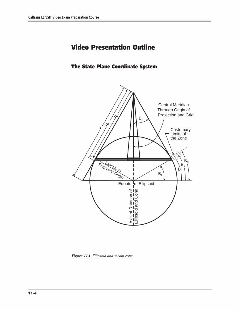
Caltrans LSLSIT Video Exam Preparation Course
Video Presentation Outline
The State Plane Coordinate System
Bo
Customary Limits of the Zone
Bo
Equator of Ellipsoid
Axi
s of
Rot
atio
n of
Elli
psoi
d an
d C
one
R o
R b
k
Bb
Bs
BnLatitude of
Projection Origin
Central Meridian Through Origin of Projection and Grid
Figure 11-1 Ellipsoid and secant cone
11-4
Easting Axis
Nor
thin
gA
xis
Rb
Ro
Apex of Secant Cone amp Center of Mapping Radii
(Central Angle = 360deg x Sin Bo)
Convergence Angle [(Lo- L) Sin Bo]
Figure 11-2 Developed cone
Central Meridian Lo Approximate Through Origin of East-West
Customary Projection and Grid Extent of ZoneNorth-South Limits of Zone
Bn
Central Parallel Bo
Bs
Bb
Origin of Grid Origin of Projection (Bb Lo) amp (Nb Eo)
Nor
thin
g
Axi
s
(Bo Lo) amp (No Eo)
Figure 11-3 Developed cone detail
The California Coordinate System
11-5
Parallel ofLatitude B
Central Parallel Bo
Projection Origin
R C
os
(ne)
R Sin
R (O
n Meridian of Longitude L)
Convergence Angle [(Lo- L) Sin Bo]
Rb
R Sin
(ne)u
R o
Easting AxisNb
Eo
Figure 11-4 Conversion triangle
Nor
thin
gA
xis
Caltrans LSLSIT Video Exam Preparation Course
11-6
The California Coordinate System
Example Problems
Direct or Forward Computation Conversion From Geodetic Latitude and Longitude to Plane Coordinates
NOTE When working on calculators having only ten significant digits such as a HP41 it is necessary when adding and subtracting latitudes or longitudes to truncate tens and hundreds of degrees (ie truncate 33040048312deg to 3040048312deg)
Direct or forward mapping equations are used to compute state plane coordinates from geodetic coordinates L polynomial coefficients are used for direct computation The L coefficients are used to convert the length of the meridian arc between B and Bo to the length ldquourdquo which is Ro - R This permits the calculation of the mapping radius and subsequently the northing and easting
Conversion of geodetic coordinates that is latitude B (oslash) and longitude L (A) to plane coordinates (n e) proceeds as follows
Determine Radial Difference u if Projection Tables Will Not be Used
ΔB = B - Bo in decimal degrees (see note above)
u = L1ΔB + L2ΔB2 + L3ΔB3 + L4ΔB4
or for hand calculation
u = ΔB[L1 + ΔB(L2 + ΔB(L3 + L4ΔB))]
Where B = north latitude of station also noted as oslash Bo = latitude of the projection origin central parallel a tabled constant u = radial distance from station to the central parallel Ro - R L1 L2 L3 L4 = polynomial coefficients for direct computation tabled with the zone constants
Determine Mapping Radius R
The mapping radius may be determined in two ways
1 By the formula
R = R - u o
Where R = mapping radius of station Ro = mapping radius of the projection origin u = radial distance from station to the central parallel Ro - R
11-7
Caltrans LSLSIT Video Exam Preparation Course
2 If projection tables are provided the mapping radius also may be interpolated by entering the tables with the argument of latitude against mapping radius
Determine Plane Convergence +
+ = (Lo - L) sinBo (see note page 7)
Where + = convergence angle (Carry all significant digits for this calculation) L = west longitude of station also noted as A Lo = longitude of central meridian longitude of projection and gridorigin a
tabled constant sinBo= a tabled constant sine of the latitude of the projection origin
Determine Northing and Easting
For polynomial solutions +
n = No + u + [(R sin+) tan 2
For polynomial solution or projection tables
n = Rb + Nb - R cos+
e = Eo + R sin+
Where + = convergence angle e = easting of station Eo = easting of projection and grid origin 6561666667 ft or
20000000000 m in all zones n = northing of station No = northing of the projection origin a tabled constant R = mapping radius of station u = radial distance from station to the central parallel Ro - R Rb = mapping radius of the grid base a tabled constant Nb = northing of the grid base 1640416667 ft or 5000000000 m in all zones
11-8
The California Coordinate System
Inverse Computation Conversion of Plane Coordinate Position to Geodetic Latitude and Longitude
Inverse mapping equations are used to compute geodetic coordinates from state plane coordinates The geodetic coordinates latitude and longitude are on the ellipsoid of reference
The G coefficients are used for inverse conversion The G coefficients are used to convert the northing and easting of the station to the length ldquourdquo which is Ro - R This permits the calculation of the length of the meridian arc between B and Bo Adding that length to Bo the latitude is obtained Longitude is calculated with conventional formulas Be careful to use the correct algebraic sign for each value in the formulas
The applicable formulas to be solved in the order given are
Determine Plane Convergence +
NOTE The value of the convergence angle must be carried to all available digits Register or stack mathematics is recommended
e - E + = arctan o
Rb-n + Nb
Where + = convergence angle at the station carry to all available digits e = easting of station Eo = easting of projection and grid origin 6561666667 ft or
20000000000 m for all zones Rb = mapping radius of the grid base a tabled constant n = northing of station Nb = northing of the grid base 1640416667 ft or
5000000000 m for all zones
Determine Longitude L
L = Lo -+
(see note above)sin B o
Where + = convergence angle at the station sin Bo = a tabled constant sine of the latitude of the projection origin L = west longitude of station also noted as A Lo = central meridian longitude of projection and grid origin a tabled
constant
11-9
Caltrans LSLSIT Video Exam Preparation Course
Determine Radial Difference u
u = n - No - [(e - Eo) tan +
]2
Where
+ = convergence angle at the station e = easting of station Eo = easting of projection and grid origin 6561666667 ft or
20000000000 m for all zones n = northing of station No = northing of the projection origin u = radial distance from station to the central parallel Ro - R
Determine Latitude B
Where B = B + G u + G u2 + G u3 + G u4 (see note on page 7)o 1 2 3 4
B = B + u [G + u (G + u (G + G u))] for handheld calculationo 1 2 3 4
(see note on page 7) B = north latitude of station also noted as Bo = latitude of the projection origin central parallel u = radial distance from station to the central parallel Ro - R G1 G2 G3 G4 = polynomial coefficients for inverse conversion tabled with
the zone constants
Only if Projection Tables are to be Used
Determine mapping radius for interpolation arguing mapping radius against latitude by the following formula
R = radic(e - Eo)2 + (Rb - n + Nb)
2
Where R = mapping radius of station e = easting of station Eo = easting of projection and grid origin 6561666667 ft or
20000000000 m for all zones Rb = mapping radius of the grid base a tabled constant n = northing of station Nb = northing of the grid base 1640416667 ft or
5000000000 m in all zones
11-10
The California Coordinate System
Determining Plane Convergence (Mapping) Angle and Geodetic Azimuth to Grid Azimuth
F
Grid Azimuth = Geodetic Azimuth - Convergence + 2nd Team
Grid Azimuth
To Station
Geode
tic N
orth
Cen
tral
Mer
idia
n an
d
Nor
thin
g A
xis
Grid
Nor
th
t = a - + + o
Central Parallel NoBo
Easting Axis Eo
igure 11-5 Convergence (mapping angle)
For CCS83 (NAD83) both geodetic and grid azimuths are reckoned from north NGS surveys for NAD83 are reckoned from north rather than from south which had been used for NAD27 Inverses between stations having state plane coordinates give grid azimuth and may be used directly for calculations on the grid Plane convergence varies with longitude therefore the station for which convergence was determined must be specified
11-11Ecirc
Caltrans LSLSIT Video Exam Preparation Course
Determine the Plane Convergence +
The plane convergence may be determined in two ways
1 Where the longitude is not known without calculation the plane convergence may be calculated from the constants of the projection and the plane coordinates
e - E + = arctan o
Rb-n + NWhere
b
+ = plane convergence angle e = easting of station Eo = easting of projection origin 6561666667 ft or
20000000000 m for all zones Rb = mapping radius of the grid base a tabled constant n = northing of station Nb= northing of the grid base 1640416667 ft or
5000000000 m for all zones
2 The plane convergence also may be calculated using the difference in longitude between the central meridian and the point of question and a tabled constant Be careful to use the correct algebraic signs
+ = sinBo(Lo - L)
Where + = plane convergence sinBo = sine of the latitude of the projection origin which is also the
ratio between + and longitude in decimals of a degree a tabled constant
Lo = longitude of central meridian a tabled constant L = west longitude of station of the desired plane convergence
The Second Term Correction o
The second term correction is usually minute and can be neglected for most courses under five miles long This correction is also noted as ldquot - Trdquo It is the difference between the grid azimuth ldquotrdquo and the projected geodetic azimuth ldquoTrdquo It increases directly with the change in eastings of the line and with the distance of the occupied station from the central parallel It is neglected in this presentation
11-12
The California Coordinate System
Determine Grid t or Geodetic Azimuth a
t = a - + + o
Where
t = grid azimuth the clockwise angle at a station between the grid meridian (grid north) and the grid line to the observed object All grid meridians are straight and parallel
a = geodetic azimuth the clockwise angle between the geodetic meridian (geodetic north) and the geodetic line to the object observed
g = plane convergence mapping angle the major component of the difference between geodetic azimuth and grid azimuth
o = arc to chord correction known as second term or t - T a correction applied to long lines of precise surveys to compensate for distortion of straight lines when projected onto a grid This correction is usually minute and can be neglected for most courses under five miles long Use 0deg in those cases
Reducing Measured Distance to Geodetic Length and then to Grid Length
Figure 11-6 Distance reductions
D
S
L c
Geoid Surface
Ellipsoid Surface
Ground Surface
h
N
H
11-13Ecirc
Caltrans LSLSIT Video Exam Preparation Course
Reduce Measured Length to Ellipsoidal Chord Length
Surveyors performing high precision work with NAD83 must consider the difference in elevation between the GRS80 ellipsoid and the geoid Elevation based upon the ellipsoid is geodetic height h Elevation based upon the geoid (mean sea-level) is noted as H The difference between the two surfaces is the geoid separation or height N
Determine Approximate Radius of Curvature of the Ellipsoid Ra
An approximate radius of the ellipsoid for each zone is the geometric mean radius of curvature at the projection origin It is close enough for all but the most precise work It can be obtained by the following formula
rR
a plusmn = o
k o
Where R
a plusmn = geometric mean radius of curvature of the ellipsoid at the
projection origin ro = geometric mean radius of the ellipsoid at the projection origin
scaled to the grid ko = grid scale factor of the central parallel
Determine Ellipsoidal Reduction Factor r Also Known as Elevation Factor
e
R r = a
e (Ra + N + H)
Where re = ellipsoidal reduction factor R
a = radius of curvature of the ellipsoid in the azimuth from equation above
N = geoid separation which is a negative value within the contiguous 48 states H = elevation based on mean sea level to which the measured line was
reduced to horizontal The elevation to be used is usually one of the following for measured lengths
1 Triangulation - average elevation of base line 2 EDM - elevation to which slope length was reduced 3 Taped - average elevation of the line
Each one meter error in N or H contributes 016 ppm of error to the distance
11-14
The California Coordinate System
Determine Ellipsoidal Chord Length Lc
L = r D c e
Where Lc = ellipsoidal chord length re = ellipsoidal reduction factor D = ground level horizontal measured distance
Determine Correction of Ellipsoidal Chord Length to Geodetic Length Geodetic lengths are ellipsoidal arc lengths When precise geodetic lengths s are desired a correction from ellipsoidal chord length Lc to the geodetic length on the ellipsoid surface may be applied to lines generally greater than 5 mi long Shorter lengths and lines measured in segments are essentially arcs and need not be corrected The correction to be applied is
Determine Chord Correction for Geodetic Length
Lc equals nearly 9 mi before c equals 001 ft and over 19 mi before equaling 010 ft
L3
c = c
24R2 a
Where c = correction in same units as used for Lc and Ra
Lc = ellipsoidal chord length Ra = radius of curvature of the ellipsoid in the azimuth from equation for
approximating radius of curvature of ellipsoid above
Determine Geodetic Length s
s = L + c c
Where c = correction in same units as used for Lc and Ra
Lc = ellipsoidal chord length s = geodetic length
11-15Ecirc
Caltrans LSLSIT Video Exam Preparation Course
Project Geodetic Length (or Ellipsoidal Chord Length) to Obtain Grid Length
Grid length L(grid) is obtained by multiplying the geodetic length by a grid scale factor Grid scale factor is an expression of the amount of distortion imposed on the length of a line on the ellipsoid as it is projected onto the grid cone It is represented by the letter ldquokrdquo It is the ratio of the length on the grid to the length on the ellipsoid Scale factor is dependent upon latitude It is less than unity between the standard parallels and greater than unity outside them Scale factors can be calculated for points or lines For this presentation point scale factors are used exclusively If greater accuracy is needed for a long line the point scale factor of the mid-point or the mean of the point scale factors at each end may be used
In a Lambert zone if the north-south extent is not great sufficient accuracy often may be obtained by using an average scale factor determined for the average latitude of the survey
Determine Point Scale Factor k
A method which is precise enough for any work performed uses polynomial coefficients It does not require projection tables and is easy to do using a handheld calculator with storage registers It also readily lends itself to programmed applications The coefficients for each zone are tabled at the end of this paper Approximate point scale factor k may be interpolated from projection tables
if + and plane coordinates are known
u = n - N - [(e - E ) tan + 2 ]o o
when plane coordinates are known
u = Ro - radic(Rb + Nb - n)2 + (e - Eo)2
when geodetic latitude and longitude are known
u = L1ΔB + L2ΔB2 + L3ΔB3 + L4ΔB4
rearranged for handheld calculators
u = ΔB[L1 + ΔB(L2 + ΔB(L3 + L4ΔB))]
11-16
The California Coordinate System
Where u = radial distance on the projection from the central parallel to the
station Ro - R No = northing of projection origin n = northing of station e = easting of station Eo = easting of central meridian 6561666667 ft or 20000000000 m for all
zones (also noted as C) + = convergence angle at the station Ro = mapping radius through the projection origin a tabled constant Rb = mapping radius through grid base a tabled constant Nb = northing of grid base a tabled constant equaling 1640416667 ft
or 5000000000 m L1 L2 L3 L4 = polynomial coefficients tabled with the zone constants B = latitude of station (also noted as oslash) Bo = the latitude of the projection origin a tabled constant for each zone
(also noted as oslasho) ΔB= B - B o
k = F1 + F2u2 + F3u
3
Where k = point scale factor F1 F2 F3 = polynomial coefficients tabled with the zone constants u = radial distance on the projection
Determine Grid Length L (grid)
L = s k(grid)
Where L = length on grid(grid)
s = geodetic length k = point scale factor of midpoint of line or as appropriate
11-17Ecirc
Caltrans LSLSIT Video Exam Preparation Course
Combined Factor
If no correction from ellipsoidal chord length to geodetic length is warranted and latitude and elevation differences are not great the measured lengths may be multiplied with a combined factor cf to obtain grid lengths L (grid)
Determine Combined Factor cf
cf = r k e
Where cf = combined factor re = ellipsoidal reduction factor k = point scale factor calculated for mid-latitude of the survey
Determine Grid Length L (grid)
L = cf D(grid)
Where L(grid)= length on grid cf = combined factor D = ground level horizontal measured distance
Conversion of Grid Length to Ground Length
Grid length L(grid) may be converted to ground length D by reversing the above procedures For measurements of similar elevation latitude and short length a combined correction factor may be divided into the grid length
Area and State Plane Coordinates
Areas derived from state plane coordinates must be corrected to yield ground-level areas when they are desired
A(grid)A = cf2
Where A = land area at ground level A(grid) = area of figure on the grid cf = combined factor
11-18
The California Coordinate System
Conversion of Coordinates from One Zone to Another To convert plane coordinates in the overlap of zones from one zone to the other of the CCS83 system convert the plane coordinates from the original zone using the constants for that zone to GRS80 geodetic latitude and longitude Then using the constants for the new zone convert the geodetic latitude and longitude to plane coordinates in the new zone
MetricndashFoot Equivalency
The US Survey ft the linear unit of the State coordinate system is defined by the equivalence 1 international meter = 3937 inches exactly
A coordinate system in ft may be converted to a coordinate system in m by multiplying the coordinate values by a scale factor of 0304800609601 An exact conversion can be accomplished by first multiplying by 12 and then dividing by 3937
A coordinate system in m may be converted to a system in ft by multiplying the coordinate values by a scale factor of 328083333333 An exact conversion can be accomplished by first multiplying by 3937 and then dividing by 12
Sample Test Questions 1 Convert the position of station ldquoSan Ysidro Levee 1975rdquo from its NAD83
geodetic coordinates of latitude 32deg 32 3633328 N longitude 117deg 02 2417391 W to its CCS83 Zone 6 metric plane coordinates
2 What are the CCS83 Zone V plane coordinates for a station at latitude 34deg 08 131201 N longitude 118deg 19 329502 W Use projection tables for your solution
3 Convert the position of station ldquoSan Ysidro Levee 1975rdquo from its CCS83 Zone 6 plane coordinates of 542065352m N 1925786624 m E to its equivalent NAD83 geodetic coordinates
4 In CCS83 Zone V a station has plane coordinates 187239080 ft N 646307210 ft E What are its NAD83 geodetic coordinates Use projection tables for your solution
5 A line has been determined to have a geodetic azimuth of 135deg 00 00 in CCS83 Zone VI The station is at longitude 117deg 25 W What is its grid azimuth
11-19Ecirc
Caltrans LSLSIT Video Exam Preparation Course
6 The geodetic azimuth a is desired between two stations on the CCS83 Zone VI grid The azimuth from Station 1 is desired Given Station 1 coordinates are 1660578090 ft N 6570078800 ft E Station 2 coordinates are 1653507022 ft N 6577149868 ft E
7 A survey party occupied station San Javier 1919 which has NGS NAD83 published CCS83 Zone 6 coordinates of 539034888 m northing 1977009714 m easting San Javier also has a published elevation of 121958 m and a geoid height of -3357 m All field measured distances were reduced to the elevation of station San Javier 1919 The field distance to a foresighted station is 1300000 ft What is the grid distance to the foresighted station What is the combined factor
8 In CCS83 Zone VI a length of 6000000 ft is measured at 5200 ft elevation The mid-point of the line is at latitude 32deg 36 20 N What is the grid length What is the combined factor
9 A line in CCS83 Zone VI has a grid length of 200000000 ft and its mid-point is at latitude 32deg 31 N What is its ground length at 3800 ft elevation
Answer Key 1 Direct forward computation
Determine radial difference
ΔB= B - B o
ΔB= 32543425911deg - 33333922945deg (truncate 30deg from B and Bo for HP41s) ΔB= -0790497034deg
u = ΔB [L1 + ΔB (L2 + ΔB (L3 + L4ΔB))] u = ΔB [L1 + ΔB (L2 + ΔB (L3 + (0016171) (-0790497034)))] u = ΔB [L1 + ΔB (L2 + (-0790497034) (565087 - 0012783))] u = ΔB [L1 + (-0790497034) (894188 - 445689)] u = (-0790497034) (1109053274 - 35454) u = -876675297 m
Determine mapping radius
R = R o - u R = 9706640076 - (-87667530) R = 9794307606 m
11-20
The California Coordinate System
Determine plane convergence
+ = (Lo - L) sinBo
+ = (116deg 15 - 117deg 02 2417391) (05495175758) truncate 110deg from Lo
and L for HP41s + = -0deg 26 02923552 (carry all significant digits)
Determine northing and easting +
n = N + u + [(R sin+o ) tan ]2 n = N o + u + [(9794307606) (-000757719469) (-000378865173)] n = 6294517134 - 876675297 + 2811686 n = 542065352 m (exactly as published by NGS)
e = E + R sin+ o
e = 20000000000 + [(9794307606) (-000757719469)] e = 1925786624 m (exactly as published by NGS)
2 Direct forward computation (using projection tables) Determine mapping radius R = 3041825688
for 34deg 08 from Projection Table 10108844 x 131201 = -132629 less diff1 lat from column 5 R = 3041693059 then for 34deg 08 131201 N
Determine plane convergence
+ = (Lo - L) sinBo
+ = (118deg 00 - 118deg 19 329502) (0570011896174) truncate 110deg from L o and L for HP41s
+ = -018572099101deg + = -0deg 11 085956 (carry to all significant digits)
Determine northing and easting
n = Rb + Nb - R cos+ n = 3064874493 + 164041667 - 3041693059 cos(-018572099101deg) n = 187239080 ft N
e = E + R sin+ o
e = 656166667 + 3041693059 sin (-018572099101deg) e = 646307210 ft E
11-21Ecirc
Caltrans LSLSIT Video Exam Preparation Course
3 Inverse computation Determine plane convergence
e - E + = arctan [ o ]Rb - n + Nb
+ = arctan [(1925786624 m - 2000000000 m)
(9836091790 m - 542065352 m + 500000000 m)] + = arctan (-742133769794026438) + = arctan (-0007577412259) + = -0deg 26 02923559 (carry all significant digits)
Determine longitude +
L = L o - ( )sinB o
L = 11625deg - (-0434145433105495175758) truncate 110deg from L for HP41s
L = 117040048312deg L = 117deg 02 2417392 W (versus 117deg 02 2417391 published by NGS)
Determine radial difference +
u = n - No - [(e - Eo) tan ]2 u = n - No - [(1925786624m - 20000000000 m) (-000378865173)] u = 542065352 m - 6294517134 m - 2811686 m u = -87667530 m
Determine latitude
B = B o + u [G1 + u (G2 + u (G3 + G4u))]B = B o + u [G1 + u (G2 + u (G3 + (-82753 x 10-28) (-87667530 m)))] B = B + u [G + u (G + (-87667530 m) (-373318 x 10-20 + 725475 x 10-23
o 1 2 ))] B = B o + u [G1 + (-87667530 m) (-655499 x 10-15 + 3266426 x 10-15)] B = B + (-87667530 m) (9016699372 x 10-6 -10
o + 28830022 x 10 ) B = 33333922945deg - 07904970372deg truncate 30deg from B for HP41s B = 32deg 32 3633327 N (versus 32deg 32 3633328 published by NGS)
11-22
The California Coordinate System
4 Inverse computation (using projecting tables) Determine plane convergence
e - E + = arctan [ o ]Rb - n + Nb
(646307210 ft - 656166667 ft) + = arctan [ ]
(3064874493 ft + 164041667 ft - 18739080 ft) + = arctan (-9859457 3041677080) + = arctan (-000324145422) + = -018572099571deg + = -0deg 11 0859558 (carry seconds to at least the fourth decimal place)
Determine longitude +
L = L o shy sinB o
L = 118deg 00 - (-018572099571deg0570011896174) truncate 110deg from L for HP41s
L = 118deg 00 - (-0325819500deg) L = 118325819500deg W L = 118deg 19 329502 W
Determine mapping radius for use with projection tables
R = radic(e - E )2 + (R - n + N )2 o b b
R = radic -98594572 + 30416770802
R = 3041693059 ft
Determine the latitude Interpolate R in Projection Table to find latitude (oslash)
(34deg 08) R = 3041825688 (unk) R = 3041693059 Diff 132629
using column 5 of Projection Table
13262910108844 = 31201 therefore B = 34deg 08 131201 N
11-23Ecirc
Caltrans LSLSIT Video Exam Preparation Course
5 Determine the plane convergence
+ = sinBo(Lo - L) + = 0549517575763 (116deg 15 - 117deg 25) + = -0deg 38 2797382
The second term will be neglected
Calculate the grid azimuth
t = a - + + o t = 135deg 00 00 - (-0deg 38 2797382) + 0deg t = 135deg 38 2797382
6 Inverse from Station 1 to Station 2 The inversed grid azimuth is t = 135deg0000
Calculate the plane convergence
e - E + = arctan [ o ]Rb- n + Nb
(6570078800 ft - 6561666667 ft) + = arctan [ ](32270577813 ft - 1660578090 ft + 1640416667 ft)
+ = arctan (000026083797) + = +0deg 00 538017
The second term correction is neglected here
Calculate the geodetic azimuth t = a - + + o
135deg 00 00 = a - (+0deg 00 538017) + 0deg) a = 135deg 00 00 + 0deg 00 538017 + 0deg a = 135deg 00 538017
7 Convert elevation geoid height and measured distance to the same units Here feet were chosen
Determine radius of curvature of ellipsoid
r R o
a plusmn =k o
R a plusmn = 20896729860 ft 0999954142490
R a plusmn = 20897688176 ft
11-24
The California Coordinate System
Determine ellipsoidal reduction factor
Ra
e r =(Ra + N + H)
re = 20897688176 ft (20897688176 ft - 11014 ft + 400124 ft) r = 0999813837 e
Determine ellipsoidal chord length
L = r D c e
L = 0999813837 x 1300000 ft c
L = 1299758 ft c
Determine chord correction and geodetic length
L 3
c = c
24R 2 a
c = 12997583 24 (208976881762) c = 00002 ft
Determine geodetic length The chord correction is negligible therefore the geodetic length
s = 1299758 ft
Determine point scale factor
u = R o - radic(Rb + Nb - n)2 + (e - Eo)2
u = 31845868317 ft shyradic(322770577813 ft + 1640416667 ft - 176848363)2 + (648623937 ft - 656166667)2
u = 31845868317 ft - [1033141004 x 1015 + 568927758529]2
u = 31845868317 ft - 32142599351 ft u = -29673103 ft
k = F1 + F2u2 + F3u
3
k = 0999954142490 + [114504 x 10-15 (88049304 x 1010)] + [118 x 10-23 (-26126960 x 1016)]
k = 0999954142490 + 0000100820 - 0000000308 k = 1000054654
Determine grid length
L = s k(grid)
L = 1299758 ft (1000054654) (grid)
L = 1299829 (grid)
11-25Ecirc
Caltrans LSLSIT Video Exam Preparation Course
8
Determine combined factor
cf = re k = (0999813837) 1000054654 = 0999868481
Reducing measured distance Determine radius of curvature of ellipsoid
r oR plusmn = a k o
R a plusmn = 20896729860 ft0999954142490 R plusmn = 20897688176 ft a
Determine ellipsoidal reduction factor
R a
e r = (Ra + N + H)
re = 20897688176 ft(20897688176 ft + 0 + 5200 ft) r = 09997512306 e
Determine ellipsoidal chord length
L = r D c e
Lc = (09997512306) (6000000 ft) L = 5998507 ft c
Determine chord correction
L3 c c = 24R2
a
c = 59985073(24)(208976881762) c = 0000021 ft
Determine geodetic length
The chord correction is negligible therefore the geodetic length s = 5998507 ft
Determine point scale factor
Scale factor for 32deg 36 from Project Table = 10000356 2060 diff = (0333) (-00000037) = -00000012 k = 10000344
Determine grid length
L = s k (grid)
L = (5998507 ft) (10000344)(grid)
L = 5998713 ft(grid)
11-26
The California Coordinate System
Determine combined factor
cf = r k e
cf = (09997512306) (10000344) cf = 09997856
Determine grid length
L = cf (D)(grid)
L = 09997856 x 600000 ft(grid)
L = 5998714 ft(grid)
9 Convert grid length to ground length Determine point scale factor
ΔB= B - B o
ΔB= 325166666667deg - 333339229447deg ΔB= -08172562780deg
u = ΔB [L1 + ΔB (L2 + ΔB (L3 + (-004335871457)))] u = ΔB [L1 + ΔB (L2 + ΔB(184962412854))] u = ΔB [L1 + ΔB (L2 + (-151161693099))] u = ΔB [L1 + ΔB (142206306901)] u = ΔB [L1 + (-116218997086)] u = ΔB [3638502731] u = -2973589199 ft
k = F1 + F2u2 + F3u
3
k = 0999954142490 + (114504 x 10-15) (-29735891992) + (118 x 10-23) (-29735891993)
k = 100005507933
Determine geodetic length
L(grid)= s k 200000000 ft = s x 100005507933 s = 200000000 ft100005507933 s = 199988985 ft
Determine radius of curvature of the ellipsoid
oR plusmn =r
a k o
Ra plusmn = 20896729860 ft 0999954142490 R plusmn = 20897688176 ft a
11-27Ecirc
Caltrans LSLSIT Video Exam Preparation Course
Determine chord correction L3
c c = 24R2 a
c = 1999889853[(24) (208976881762)] use geodetic length as approximate ellipsoidal chord c = 0763 ft
Determine ellipsoidal chord length
s = L + c c
L + 0763 ft = 199988985 ft c
L = 199988222 ft c
Determine ellipsoidal reduction factor
Rare = (Ra + N + H)
re = 20897688176 ft(20897688176 ft + 0 + 3800) r = 099981819476 e
Determine level ground length
L = r D c e
199988222 ft = 099981819476 x D D = 199988222 ft099981819476 D = 200024587
11-28Ecirc
The California Coordinate System
Appendix 1 State of California Public Resources Code Division 8 Surveying and Mapping Chapter 1 California Coordinate System
Section 8801 California Coordinate System Defined
(a) The system of plane coordinates which has been established by the United States Coast and Geodetic Survey for defining and stating the positions or locations of points on the surface of the earth within the State of California is based on the North American Datum of 1927 and is identified as the ldquoCalifornia Coordinate Systemrdquo After January 1 1987 this system shall be known as the ldquoCalifornia Coordinate System of 1927rdquo
(b) The system of plane coordinates which has been established by the National Geodetic Survey for defining and stating the positions or locations of points on the surface of the earth within the State of California and which is based on the North American Datum of 1983 shall be known as the ldquoCalifornia Coordinate System of 1983rdquo
(c) As used in this chapter (1) ldquoNAD27rdquo means the North American Datum of 1927 (2) ldquoCCS27rdquo means the California Coordinate System of 1927 (3) ldquoNAD83rdquo means the North American Datum of 1983 (4) ldquoCCS83rdquo means the California Coordinate System of 1983 (5) ldquoUSCampGSrdquo means the United States Coast and Geodetic Survey (6) ldquoNGSrdquo means the National Geodetic Survey (7) ldquoFGCCrdquo means the Federal Geodetic Control Committee
(d) The use of the term ldquoState Plane Coordinatesrdquo refers only to CCS27 and CCS83 coordinates
Section 8802 Delineation of Zones
For CCS27 the state is divided into seven zones For CCS83 the state is divided into six zones Zone 7 of CCS27 which encompasses Los Angeles County is eliminated and the area is included in Zone 5
11-29Ecirc
Caltrans LSLSIT Video Exam Preparation Course
Each zone of CCS27 is a Lambert conformal conic projection based on Clarkersquos Spheroid of 1866 which is the basis of NAD27 The points of control of zones one to six inclusive bear the coordinates Northing (y) = 00000 feet and Easting (x) = 2000000 feet The point of control of Zone 7 bears the coordinates Northing (y) = 416092674 feet and Easting (x) = 418669258 feet
Each zone of CCS83 is a Lambert conformal conic projection based on the Geodetic Reference System of 1980 which is the basis of NAD83 The point of control of each of the six zones bear the coordinates Northing (y) = 500000 meters and Easting (x) = 2000000 meters
The area included in the following counties constitutes Zone 1 of CCS27 and CCS83 Del Norte Humboldt Lassen Modoc Plumas Shasta Siskiyou Tehama and Trinity
The area included in the following counties constitutes Zone 2 of CCS27 and CCS83 Alpine Amador Butte Colusa El Dorado Glenn Lake Mendocino Napa Nevada Placer Sacramento Sierra Solano Sonoma Sutter Yolo Yuba
The area included in the following counties constitutes Zone 3 of CCS27 and CCS83 Alameda Calaveras Contra Costa Madera Marin Mariposa Merced Mono San Francisco San Joaquin San Mateo Santa Clara Santa Cruz Stanislaus and Tuolumne
The area included in the following counties constitutes Zone 4 of CCS27 and CCS83 Fresno Inyo Kings Monterey San Benito and Tulare
The area included in the following counties and Channel Islands constitutes Zone 5 of CCS27 Kern San Bernardino San Luis Obispo Santa Barbara (excepting Santa Barbara Island) and Ventura (excepting San Nicholas Island) and the Channel Islands of Santa Cruz Santa Rosa San Miguel and Anacapa
The area included in the following counties and Channel Islands constitutes Zone 5 of CCS83 Kern Los Angeles (excepting San Clemente and Santa Catalina Islands) San Bernardino San Luis Obispo Santa Barbara (excepting Santa Barbara Island) and Ventura excepting San Nicholas Island) and the Channel Islands of Santa Cruz Santa Rosa San Miguel and Anacapa
The area included in the following counties and Channel Islands constitutes Zone 6 of CCS27 and CCS83 Imperial Orange Riverside and San Diego and the Channel Islands of San Clemente Santa Catalina Santa Barbara and San Nicholas
The area included in Los Angeles County constitutes Zone 7 of CCS27
11-30
The California Coordinate System
Section 8803 Definition of Zone 1
Zone 1 coordinates shall be named and on any map on which they are used they shall be designated as ldquoCCS27 Zone 1 or CCS83 Zone 1rdquo
On their respective spheroids of reference (1) the standard parallels of CCS27 Zone 1 and CCS83 Zone 1 are at north latitudes 40 degrees 00 minutes and 41 degrees 40 minutes along which parallels the scale shall be exact and (2) the point of control of coordinates is at the intersection of the zonersquos central meridian which is at 122 degrees 00 minutes west longitude with the parallel 39 degrees 20 minutes north latitude
Section 8804 Definition of Zone 2
Zone 2 coordinates shall be named and on any map on which they are used they shall be designated as ldquoCCS27 Zone 2 or CCS83 Zone 2rdquo
On their respective spheroids of reference (1) the standard parallels of CCS27 Zone 2 and CCS83 Zone 2 are at north latitudes 38 degrees 20 minutes and 39 degrees 50 minutes along which parallels the scale shall be exact and (2) the point of control of coordinates is at the intersection of the zonersquos central meridian which is at 122 degrees 00 minutes west longitude with the parallel 37 degrees 40 minutes north latitude
Section 8805 Definition of Zone 3
Zone 3 coordinates shall be named and on any map on which they are used they shall be designated as ldquoCCS27 Zone 3 or CCS83 Zone 3rdquo
On their respective spheroids of reference (1) the standard parallels of CCS27 Zone 3 and CCS83 Zone 3 are at north latitudes 37 degrees 04 minutes and 38 degrees 26 minutes along which parallels the scale shall be exact and (2) the point of control of coordinates is at the intersection of the zonersquos central meridian which is at 120 degrees 30 minutes west longitude with the parallel 36 degrees 30 minutes north latitude
Section 8806 Definition of Zone 4
Zone 4 coordinates shall be named and on any map on which they are used they shall be designated as ldquoCCS27 Zone 4 or CCS83 Zone 4rdquo
On their respective spheroids of reference (1) the standard parallels of CCS27 Zone 4 and CCS83 Zone 4 are at north latitudes 36 degrees 00 minutes and 37 degrees 15 minutes along which parallels the scale shall be exact and (2) the point of control of coordinates is at the intersection of the zonersquos central meridian which is at 119 degrees 00 minutes west longitude with the parallel 35 degrees 20 minutes north latitude
11-31Ecirc
Caltrans LSLSIT Video Exam Preparation Course
Section 8807 Definition of Zone 5
Zone 5 coordinates shall be named and on any map on which they are used they shall be designated as ldquoCCS27 Zone 5 or CCS83 Zone 5rdquo
On their respective spheroids of reference (1) the standard parallels of CCS27 Zone 5 and CCS83 Zone 5 are at north latitudes 34 degrees 02 minutes and 35 degrees 28 minutes along which parallels the scale shall be exact and (2) the point of control of coordinates is at the intersection of the zonersquos central meridian which is at 118 degrees 00 minutes west longitude with the parallel 33 degrees 30 minutes north latitude
Section 8808 Definition of Zone 6
Zone 6 coordinates shall be named and on any map on which they are used they shall be designated as ldquoCCS27 Zone 6 or CCS83 Zone 6rdquo
On their respective spheroids of reference (1) the standard parallels of CCS27 Zone 6 and CCS83 Zone 6 are at north latitudes 32 degrees 47 minutes and 33 degrees 53 minutes along which parallels the scale shall be exact and (2) the point of control of coordinates is at the intersection of the zonersquos central meridian which is at 116 degrees 15 minutes west longitude with the parallel 32 degrees 10 minutes north latitude
Section 8809 Definition of Zone 7
Zone 7 coordinates shall be named and on any map on which they are used they shall be designated as ldquoCCS27 Zone 7rdquo
On its respective spheroid of reference (1) the standard parallels of CCS27 Zone 7 are at north latitudes 33 degrees 52 minutes and 34 degrees 25 minutes along which parallels the scale shall be exact and (2) the point of control of coordinates is at the intersection of the zonersquos central meridian which is at 118 degrees 20 minutes west longitude with the parallel 34 degrees 08 minutes north latitude
Section 8810 Definition of US Survey Foot and Coordinates
The plane coordinates of a point on the earthrsquos surface to be used in expressing the position or location of the point in the appropriate zone of CCS27 or CCS83 shall consist of two distances expressed in feet and decimals of a foot or meters and decimals of a meter When the values are expressed in feet the ldquoUS Survey footrdquo (one foot = 12003937 meters) shall be used as the standard foot for CCS27 and CCS83 One of these distances to be known as the ldquoEast x-coordinaterdquo shall give the distance east of the Y axis the other to be known as the ldquoNorth y-coordinaterdquo shall give the distance north of the X axis The Y axis of any zone shall be parallel with the
11-32
The California Coordinate System
central meridian of that zone The X axis of any zone shall be at right angles to the central meridian of that zone
Section 8811 Sources of Plane Coordinates
The state plane coordinates of a point in any zone shall be based upon the plane coordinates of published horizontal control stations or derived from published horizontal control stations of the USCampGS and the NGS or their successors
Section 8813 Requires Accuracy of Stations and Data Required
The CCS27 and CCS83 shall be based on monumented first- and second-order stations which have been published by USCampGS and NGS or their successors The geodetic positions of CCS27 and CCS83 stations which are used to increase the density of control and which purport to be of first- or second-order accuracy shall have been surveyed in conformity with first- or second-order survey standards and specifications in effect at the time of the survey as defined by the Federal Geodetic Control Committee Any survey or map which is to be based on state plane coordinates shall show established field-measured connections to at least two stations of corresponding accuracy or better whose credentials are based upon published stations of USCampGS or NGS or their successors If an FGCC order of accuracy is claimed for a survey or a map it shall be justified by additional written data that shows equipment procedures closures adjustments and a control diagram
Section 8814 Use of Coordinates and Constructive Notice
State plane coordinates may be used for property identification on any map survey conveyance or other instrument which delineates or affects the title to real property or which delineates describes or refers to the property or any part thereof However to constitute when recorded constructive notice thereof under the recording laws the delineating describing or referring to the property or part thereof shall also refer to data appearing of record in any office the records of which constitute constructive notice under the recording laws That record data shall be sufficient to identify the property without recourse to those coordinates and in case of conflict between them the references to that recorded data shall be controlling for the purpose of determining constructive notice under the recording laws
Section 8815 Identification of California Coordinate System
The use of the term ldquoCalifornia Coordinate Systemrdquo on any map or document or any field notes shall be suffixed either with ldquo27rdquo (shown as ldquoCCS27rdquo) for coordinates based on NAD27 or with ldquo83rdquo (shown as ldquoCCS83rdquo) for coordinates based on NAD83
11-33Ecirc
Caltrans LSLSIT Video Exam Preparation Course
Section 8816 Use Optional
The use of the State Plane Coordinates by any person corporation or governmental agency engaged in land surveying or mapping is optional
Section 8817 CCS83 Use After January 1 1995
Prior to January 1 1995 use of State Plane Coordinates for new projects may be based either on CCS27 or CCS83 On or after January 1 1995 when State Plane Coordinates are used on new surveys and new mapping projects the use shall be limited to CCS83
Section 8818 Land Titles Referred to CCS27
This chapter does not impair or invalidate land titles legal descriptions or jurisdictional or land boundaries and further this chapter does not impair or invalidate references to or the use of CCS27 coordinates except as provided in Section 8817
Section 8819 Use of New Technologies
This chapter does not prohibit the use of new geodetic surveying technologies for which FGCC specifications have not yet been published except that if first- or second-order accuracy is claimed for any of the resulting monumented stations the state plane coordinates shall conform to FGCC accuracy standards
11-34
The California Coordinate System
Appendix 2
Symbols and Notations a = geodetic azimuth the clockwise angle between geodetic north and
the geodetic line to the object observed
+ = the plane convergence angle the major component of the difference between geodetic azimuth and grid azimuth also sometimes called mapping angle
o = arc to chord correction also known as second term or ldquot - Trdquo (A correction applied to long lines of precise surveys to compensate for distortion of straight lines when projected onto the grid This correction is usually minute and can be neglected for most courses under five miles long)
a = 6378137 m (exact) or 209256044742 ft the equatorial radius of the GRS80 ellipsoid
b = 6356752314140347 m = 208554448840 ft = the semiminor axis of the GRS80 ellipsoid
B = north geodetic latitude of a station also noted as oslash
Bb = north geodetic latitude of the parallel passing through grid origin a tabled constant
Bn = north geodetic latitude of the northerly standard parallel where the cone intersects the ellipsoid (Line of exact scale)
Bo = the latitude of the central parallel passing through the projection origin a tabled constant for each zone also noted as _o
Bs = north geodetic latitude of the southerly standard parallel where the cone intersects the ellipsoid (Line of exact scale)
cf = combined factor for simultaneously applying average ellipsoidal reduction and scale factors
D = ground level horizontal measured distance
Eo = easting of projection origin and central meridian 6561666667 ft or 20000000000 m for all zones
e2 = 0006694380022903416 = the square of the first eccentricity of the GRS80 ellipsoid
e ft2 = 0006739496775481622 = the square of the second eccentricity of the GRS80 ellipsoid
11-35Ecirc
Caltrans LSLSIT Video Exam Preparation Course
F1 F2 F3 = polynomial coefficients tabled with the zone constants
G1 G2 G3 G4 = polynomial coefficients for inverse conversion tabled with the zone constants
h = geodetic height elevation using the ellipsoid for its datum Related to MSL datum by the formula h = N + H
H = elevation using the geoid for its datum this is approximately elevation based on mean sea level
k = point grid scale factor
K = mapping radius on the cone at the equatorial plane of the ellipsoid
ko = grid scale factor of the central parallel Bo a tabled constant
L = west geodetic longitude of station also noted as A
Lc = ellipsoidal chord length
L(grid) = grid length distance between two points on the grid plane
Lo = longitude of the central meridian passing through the projection and grid origin a tabled constant also noted as A o
Ls = measured slope length
L1 L2 L3 L4 = polynomial coefficients for direct computation tabled with the zone constants
Mo = radius of curvature of the ellipsoid in the meridian at the projection origin scaled to the grid
N = geoid separation or height the distance at a station from the geoid to the ellipsoid it is negative within the contiguous 48 states
Nb = northing of grid base a tabled constant equalling 1640416667 ft or 5000000000 m for all zones
No = northing of the projection origin a tabled constant
p = 1f = flattening-1 = 2982572221008827 for GRS80
R = mapping radius through a station
R a = radius of curvature of the ellipsoid in the azimuth
Rb = mapping radius through the grid base a tabled constant
re = ellipsoidal reduction factor also known as elevation factor
ro = geometric mean radius of the ellipsoid at the projection origin scaled to the grid
11-36
The California Coordinate System
Ro = mapping radius through the projection origin a tabled constant
s = geodetic length the ellipsoidal arc length of a line
sinBo = sine of the latitude of the projection origin which is also the ratio between + and longitude in decimals of a degree a tabled constant
t = grid azimuth the clockwise angle at a station between the grid meridian (grid north) and the grid line to the observed object (All grid meridians are straight and parallel Grid azimuths are related to geodetic azimuths by the formula t = a - + + ogt
T = projected geodetic azimuth (Azimuth of a straight line of the ellipsoid when projected onto the grid is slightly curved)
u = radial distance on the projection from the station to the central parallel Ro - R
Constants for the Geodetic Reference System of 1980 GRS80 Ellipsoid
a = 6378137 m (exact) = 209256044742 ft = the equatorial radius of the ellipsoid
b = 6356752314140347 m = 208554448840 ft = the semiminor axis
p = 1f = 2982572221008827 = flattening-1
e2 = 0006694380022903416 = the square of the first eccentricity
e ft2 = 0006739496775481622 = the square of the second eccentricity
11-37Ecirc
Caltrans LSLSIT Video Exam Preparation Course
Appendix 3 North American Datum 1983 (NAD83) ndash California Coordinate System 1983 (CCS83)
CALIFORNIA ZONE 1 CA01 ZONE 0401 Meters US Survey Feet Bs = 40deg 00 N Bs = 40deg 00 N Bn = 41deg 40 N B = 41deg 40 N Bb = 39deg 20 N Bb
n
= 39deg 20 N Lo = 122deg 00 W Lo = 122deg 00 W Nb = 5000000000 m Nb = 1640416667 ft Eo = 20000000000 m E = 6561666667 ft o
Bo = 408351061249deg N B = 408351061249deg N o SinBo = 0653884305400 SinB = 0653884305400 o Rb = 75565546408 m Rb = 24791796351 ft Ro = 73898020597 m R = 24244708924 ft o No = 6667525811 m N = 2187504093 ft o K = 122878263052 m K = 40314310136 ft ko = 0999894636561 k = 0999894636561 o Mo = 63620672798 m M = 20872882401 ft o ro = 6374328 m ro = 20913107780 ft
L1 = 1110390203 L1 = 3643005191 L2 = 965524 L2 = 316772 L3 = 563491 L3 = 184872 L4 = 0021275 L4 = 0069800
G1 = 9005843038E-06 G1 = 2744986448E-06 G2 = -705240E-15 G2 = -655192E-16 G3 = -370393E-20 G3 = -104884E-21 G4 = -11142E-27 G4 = -96167E-30
F1 = 0999894636561 F1 = 0999894636561 F2 = 123062E-14 F2 = 114329E-15 F3 = 547E-22 F3 = 155E-23
The customary limits of the zone are from 39deg 20 N to 42deg 20 N
11-38
The California Coordinate System
North American Datum 1983 (NAD83) ndash California Coordinate System 1983 (CCS83)
CALIFORNIA ZONE 2 CA02 ZONE 0402
Meters US Survey Feet B = 38deg 20 N B = 38deg 20 N s s
B = 39deg 50 N B = 39deg 50 N n n
Bb = 37deg 40 N Bb = 37deg 40 N L = 122deg 00 W L = 122deg 00 W o o
Nb = 5000000000 m Nb = 1640416667 ft E = 20000000000 m E = 6561666667 ft o o
B = 390846839219deg N B = 390846839219deg N o o
SinB = 0630468335285 SinB = 0630468335285 o o
Rb = 80197889307 m Rb = 26311590850 ft R = 78623814027 m R = 25795162985 ft o o
N = 6574075280 m N = 2156844531 ft o o
K = 125203516538 m K = 41077187051 ft k = 0999914672977 k = 0999914672977 o o
M = 63602683937 m M = 20866980555 ft o o
r = 6373169 m r = 20909305294 ft o o
L1 = 1110076240 L1 = 3641975131 L2 = 954628 L2 = 313198 L3 = 563874 L3 = 184998 L4 = 0019988 L4 = 0065577
G1 = 9008390180E-06 G1 = 2745762818E-06 G2 = -697872E-15 G2 = -648347E-16 G3 = -371084E-20 G3 = -105080E-21 G4 = -10411E-27 G4 = -89858E-30
F1 = 0999914672977 F1 = 0999914672977 F2 = 123106E-14 F2 = 114370E-15 F3 = 514E-22 F3 = 146E-23
The customary limits of the zone are from 37deg 40 N to 40deg 30 N
11-39Ecirc
Caltrans LSLSIT Video Exam Preparation Course
North American Datum 1983 (NAD83) ndash California Coordinate System 1983 (CCS83)
CALIFORNIA ZONE 3 CA03 ZONE 0403
Meters US Survey Feet B = 37deg 04 N B = 37deg 04 N
s s
Bn = 38deg 26 N Bn = 38deg 26 N Bb = 36deg 30 N Bb = 36deg 30 N L = 120deg 30 W L = 120deg 30 W
o o
Nb = 5000000000 m Nb = 1640416667 ft E = 20000000000 m E = 6561666667 ft
o o
B = 377510694363deg N B = 377510694363deg N o o
SinBo = 0612232038295 SinBo = 0612232038295 Rb = 83857751723 m Rb = 27512330711 ft R = 82469303684 m R = 27056804050 ft
o o
N = 6388448039 m N = 2095943327 ft o o
K = 127245749735 m K = 41747209726 ft k = 0999929178853 k = 0999929178853
o o
M = 63589096841 m M = 20862522855 ft o o
ro = 6372292 m ro = 20906428003 ft
L1 = 1109839104 L1 = 3641197127 L2 = 943943 L2 = 309692 L3 = 564142 L3 = 185086 L4 = 0019048 L4 = 0062493
G1 = 9010315015E-06 G1 = 2746349509E-06 G2 = -690503E-15 G2 = -641501E-16 G3 = -371614E-20 G3 = -105230E-21 G4 = -98819E-28 G4 = -85291E-30
F1 = 0999929178853 F1 = 0999929178853 F2 = 123137E-14 F2 = 114398E-15 F3 = 489E-22 F3 = 138E-23
The customary limits of the zone are from 36deg 30 N to 39deg 00 N
11-40
The California Coordinate System
North American Datum 1983 (NAD83) ndash California Coordinate System 1983 (CCS83)
CALIFORNIA ZONE 4 CA04 ZONE 0404
Meters US Survey Feet B = 36deg 00 N B = 36deg 00 N s s
B = 37deg 15 N B = 37deg 15 N n n
Bb = 35deg 20 N Bb = 35deg 20 N L = 119deg 00 W L = 119deg 00 W o o
Nb = 5000000000 m Nb = 1640416667 ft E = 20000000000 m E = 6561666667 ft o o
B = 366258593071deg N B = 366258593071deg N o o
SinB = 0596587149880 SinB = 0596587149880 o o
Rb = 87332273793 m Rb = 28652263494 ft R = 85898068935 m R = 28181724783 ft o o
N = 6434204858 m N = 2110955377 ft o o
K = 129169860281 m K = 42378478327 ft k = 0999940761703 k = 0999940761703 o o
M = 63577728978 m M = 20858793249 ft o o
r = 6371557 m r = 20904016591 ft o o
L1 = 1109640696 L1 = 3640546183 L2 = 933334 L2 = 306211 L3 = 564410 L3 = 185174 L4 = 0018382 L4 = 0060308
G1 = 9011926076E-06 G1 = 2746840562E-06 G2 = -683121E-15 G2 = -634643E-16 G3 = -372043E-20 G3 = -105351E-21 G4 = -94223E-28 G4 = -81324E-30
F1 = 0999940761703 F1 = 0999940761703 F2 = 123168E-14 F2 = 114427E-15 F3 = 470E-22 F3 = 133E-23
The customary limits of the zone are from 35deg 20 N to 38deg 00 N
11-41Ecirc
Caltrans LSLSIT Video Exam Preparation Course
North American Datum 1983 (NAD83) ndash California Coordinate System 1983 (CCS83)
CALIFORNIA ZONE 5 CA05 ZONE 0405
Meters US Survey Feet B = 34deg 02 N B = 34deg 02 N s s
B = 35deg 28 N B = 35deg 28 N n n
Bb = 33deg 30 N Bb = 33deg 30 N L = 118deg 00 W L = 118deg 00 W o o
Nb = 5000000000 m Nb = 1640416667 ft E = 20000000000 m E = 6561666667 ft o o
B = 347510553142deg N B = 347510553142deg N o o
SinB = 0570011896174 SinB = 0570011896174 o o
Rb = 93417561389 m Rb = 30648744932 ft R = 92029831099 m R = 30193453753 ft o o
N = 6387730290 m N = 2095707846 ft o o
K = 132826248345 m K = 43578078311 ft k = 0999922127209 k = 0999922127209 o o
M = 63556709697 m M = 20851897173 ft o o
r = 6370113 m r = 20899279068 ft o o
L1 = 1109273840 L1 = 3639342590 L2 = 912439 L2 = 299356 L3 = 564805 L3 = 185303 L4 = 0017445 L4 = 0057234
G1 = 9014906468E-06 G1 = 2747748987E-06 G2 = -668534E-15 G2 = -621091E-16 G3 = -372796E-20 G3 = -105565E-21 G4 = -86394E-28 G4 = -74567E-30
F1 = 0999922127209 F1 = 0999922127209 F2 = 123221E-14 F2 = 114477E-15 F3 = 441E-22 F3 = 125E-23
The customary limits of the zone are from 33deg 30 N to 36deg 20 N
11-42
The California Coordinate System
North American Datum 1983 (NAD83) ndash California Coordinate System 1983 (CCS83)
CALIFORNIA ZONE 6 CA06 ZONE 0406
Meters US Survey Feet B = 32deg 47 N B = 32deg 47 N s s
B = 33deg 53 N B = 33deg 53 N n n
Bb = 32deg 10 N Bb = 32deg 10 N L = 116deg 15 W L = 116deg 15 W o o
Nb = 5000000000 m Nb = 1640416667 ft E = 20000000000 m E = 6561666667 ft o o
B = 333339229447deg N B = 333339229447deg N o o
SinB = 0549517575763 SinB = 0549517575763 o o
Rb = 98360917896 m Rb = 32270577813 ft R = 97066400762 m R = 31845868317 ft o o
N = 6294517134 m N = 2065126163 ft o o
K = 136020267133 m K = 44625982642 ft k = 0999954142490 k = 0999954142490 o o
M = 63544072007 m M = 20847750958 ft o o
r = 6369336 m r = 20896729860 ft o o
L1 = 1109053274 L1 = 3638618950 L2 = 894188 L2 = 293368 L3 = 565087 L3 = 185396 L4 = 0016171 L4 = 0053054
G1 = 9016699372E-06 G1 = 2748295465E-06 G2 = -655499E-15 G2 = -608981E-16 G3 = -373318E-20 G3 = -105713E-21 G4 = -82753E-28 G4 = -71424E-30
F1 = 0999954142490 F1 = 0999954142490 F2 = 123251E-14 F2 = 114504E-15 F3 = 415E-22 F3 = 118E-23
The customary limits of the zone are from 32deg 10 N to 34deg 30 N
11-43Ecirc
Caltrans LSLSIT Video Exam Preparation Course
References Alexander I A and Alexander R J (1989) ldquoProjection Tables California
Coordinate System NAD83rdquo California Land Surveyors Association Special Publication No 5588
Burkholder E F (1984) ldquoGeometrical Parameters of the Geodetic Reference System 1980rdquo Surveying and Mapping Vol 44 No 4 pp 339shy340
Fronczek C J (1980) ldquoUse of Calibration Base Linesrdquo NOAA Technical Memorandum NOS NGS- 10 National Geodetic Information Center NOAA Rockville MD 20852
Meade B K (1987) ldquoProgram for Computing Universal Mercator (UTM) Coordinates for Latitudes North or South and Longitudes East or Westrdquo Surveying and Mapping Vol 47 No 1 pp 37-49
Stem J E (1989) ldquoState Plane Coordinate System of 1983rdquo NOAA Manual NOS NGS 5 National Geodetic Information Center NOAA Rockville MD 20852
Stoughton H W and Berry R M (1985) ldquoSimple Algorithms for Calculation of Scale Factors for Plane Coordinate Systems (1927 NAD and 1983 NAD)rdquo Surveying and Mapping Vol 45 No 3 pp 247-259
Vincenty T (1985) ldquoPrecise Determination of the Scale Factor from Lambert Conical Projection Coordinatesrdquo Surveying and Mapping Vol 45 No 4 pp 315-318
Vincenty T (1986) ldquoGeometric Reduction of Measured Linesrdquo Surveying and Mapping Vol 46 No 3 pp 225-229
Vincenty T (1986) ldquoUse of Polynomial Coefficients in Conversions of Coordinates on the Lambert Conformal Conic Projectionrdquo Surveying and Mapping Vol 46 No 1 pp 15-18
Vincenty T (1986) ldquoLambert Conformal Conic Projection Arc-to-chord Correctionrdquo Surveying and Mapping Vol 46 No 2 pp 163-167
Vincenty T (1986) ldquoApplication of the Chord Method to Solutions of Geodetic Linesrdquo Surveying and Mapping Vol 46 No 4 pp 287-292
State Plane Coordinate System of 1983 by James E Stem is an excellent source of information concerning NAD83 procedures for the surveyor It thoroughly deals with corrections to lengths and azimuths It and other publications are available by phone The National Geodetic Information Center number for phone orders is currently (301) 443-8631 They accept credit cards and have a listing of their publications which they will mail free of charge
11-44

The California Coordinate System
Example Problems
Direct or Forward Computation Conversion From Geodetic Latitude and Longitude to Plane Coordinates
NOTE When working on calculators having only ten significant digits such as a HP41 it is necessary when adding and subtracting latitudes or longitudes to truncate tens and hundreds of degrees (ie truncate 33040048312deg to 3040048312deg)
Direct or forward mapping equations are used to compute state plane coordinates from geodetic coordinates L polynomial coefficients are used for direct computation The L coefficients are used to convert the length of the meridian arc between B and Bo to the length ldquourdquo which is Ro - R This permits the calculation of the mapping radius and subsequently the northing and easting
Conversion of geodetic coordinates that is latitude B (oslash) and longitude L (A) to plane coordinates (n e) proceeds as follows
Determine Radial Difference u if Projection Tables Will Not be Used
ΔB = B - Bo in decimal degrees (see note above)
u = L1ΔB + L2ΔB2 + L3ΔB3 + L4ΔB4
or for hand calculation
u = ΔB[L1 + ΔB(L2 + ΔB(L3 + L4ΔB))]
Where B = north latitude of station also noted as oslash Bo = latitude of the projection origin central parallel a tabled constant u = radial distance from station to the central parallel Ro - R L1 L2 L3 L4 = polynomial coefficients for direct computation tabled with the zone constants
Determine Mapping Radius R
The mapping radius may be determined in two ways
1 By the formula
R = R - u o
Where R = mapping radius of station Ro = mapping radius of the projection origin u = radial distance from station to the central parallel Ro - R
11-7
Caltrans LSLSIT Video Exam Preparation Course
2 If projection tables are provided the mapping radius also may be interpolated by entering the tables with the argument of latitude against mapping radius
Determine Plane Convergence +
+ = (Lo - L) sinBo (see note page 7)
Where + = convergence angle (Carry all significant digits for this calculation) L = west longitude of station also noted as A Lo = longitude of central meridian longitude of projection and gridorigin a
tabled constant sinBo= a tabled constant sine of the latitude of the projection origin
Determine Northing and Easting
For polynomial solutions +
n = No + u + [(R sin+) tan 2
For polynomial solution or projection tables
n = Rb + Nb - R cos+
e = Eo + R sin+
Where + = convergence angle e = easting of station Eo = easting of projection and grid origin 6561666667 ft or
20000000000 m in all zones n = northing of station No = northing of the projection origin a tabled constant R = mapping radius of station u = radial distance from station to the central parallel Ro - R Rb = mapping radius of the grid base a tabled constant Nb = northing of the grid base 1640416667 ft or 5000000000 m in all zones
11-8
The California Coordinate System
Inverse Computation Conversion of Plane Coordinate Position to Geodetic Latitude and Longitude
Inverse mapping equations are used to compute geodetic coordinates from state plane coordinates The geodetic coordinates latitude and longitude are on the ellipsoid of reference
The G coefficients are used for inverse conversion The G coefficients are used to convert the northing and easting of the station to the length ldquourdquo which is Ro - R This permits the calculation of the length of the meridian arc between B and Bo Adding that length to Bo the latitude is obtained Longitude is calculated with conventional formulas Be careful to use the correct algebraic sign for each value in the formulas
The applicable formulas to be solved in the order given are
Determine Plane Convergence +
NOTE The value of the convergence angle must be carried to all available digits Register or stack mathematics is recommended
e - E + = arctan o
Rb-n + Nb
Where + = convergence angle at the station carry to all available digits e = easting of station Eo = easting of projection and grid origin 6561666667 ft or
20000000000 m for all zones Rb = mapping radius of the grid base a tabled constant n = northing of station Nb = northing of the grid base 1640416667 ft or
5000000000 m for all zones
Determine Longitude L
L = Lo -+
(see note above)sin B o
Where + = convergence angle at the station sin Bo = a tabled constant sine of the latitude of the projection origin L = west longitude of station also noted as A Lo = central meridian longitude of projection and grid origin a tabled
constant
11-9
Caltrans LSLSIT Video Exam Preparation Course
Determine Radial Difference u
u = n - No - [(e - Eo) tan +
]2
Where
+ = convergence angle at the station e = easting of station Eo = easting of projection and grid origin 6561666667 ft or
20000000000 m for all zones n = northing of station No = northing of the projection origin u = radial distance from station to the central parallel Ro - R
Determine Latitude B
Where B = B + G u + G u2 + G u3 + G u4 (see note on page 7)o 1 2 3 4
B = B + u [G + u (G + u (G + G u))] for handheld calculationo 1 2 3 4
(see note on page 7) B = north latitude of station also noted as Bo = latitude of the projection origin central parallel u = radial distance from station to the central parallel Ro - R G1 G2 G3 G4 = polynomial coefficients for inverse conversion tabled with
the zone constants
Only if Projection Tables are to be Used
Determine mapping radius for interpolation arguing mapping radius against latitude by the following formula
R = radic(e - Eo)2 + (Rb - n + Nb)
2
Where R = mapping radius of station e = easting of station Eo = easting of projection and grid origin 6561666667 ft or
20000000000 m for all zones Rb = mapping radius of the grid base a tabled constant n = northing of station Nb = northing of the grid base 1640416667 ft or
5000000000 m in all zones
11-10
The California Coordinate System
Determining Plane Convergence (Mapping) Angle and Geodetic Azimuth to Grid Azimuth
F
Grid Azimuth = Geodetic Azimuth - Convergence + 2nd Team
Grid Azimuth
To Station
Geode
tic N
orth
Cen
tral
Mer
idia
n an
d
Nor
thin
g A
xis
Grid
Nor
th
t = a - + + o
Central Parallel NoBo
Easting Axis Eo
igure 11-5 Convergence (mapping angle)
For CCS83 (NAD83) both geodetic and grid azimuths are reckoned from north NGS surveys for NAD83 are reckoned from north rather than from south which had been used for NAD27 Inverses between stations having state plane coordinates give grid azimuth and may be used directly for calculations on the grid Plane convergence varies with longitude therefore the station for which convergence was determined must be specified
11-11Ecirc
Caltrans LSLSIT Video Exam Preparation Course
Determine the Plane Convergence +
The plane convergence may be determined in two ways
1 Where the longitude is not known without calculation the plane convergence may be calculated from the constants of the projection and the plane coordinates
e - E + = arctan o
Rb-n + NWhere
b
+ = plane convergence angle e = easting of station Eo = easting of projection origin 6561666667 ft or
20000000000 m for all zones Rb = mapping radius of the grid base a tabled constant n = northing of station Nb= northing of the grid base 1640416667 ft or
5000000000 m for all zones
2 The plane convergence also may be calculated using the difference in longitude between the central meridian and the point of question and a tabled constant Be careful to use the correct algebraic signs
+ = sinBo(Lo - L)
Where + = plane convergence sinBo = sine of the latitude of the projection origin which is also the
ratio between + and longitude in decimals of a degree a tabled constant
Lo = longitude of central meridian a tabled constant L = west longitude of station of the desired plane convergence
The Second Term Correction o
The second term correction is usually minute and can be neglected for most courses under five miles long This correction is also noted as ldquot - Trdquo It is the difference between the grid azimuth ldquotrdquo and the projected geodetic azimuth ldquoTrdquo It increases directly with the change in eastings of the line and with the distance of the occupied station from the central parallel It is neglected in this presentation
11-12
The California Coordinate System
Determine Grid t or Geodetic Azimuth a
t = a - + + o
Where
t = grid azimuth the clockwise angle at a station between the grid meridian (grid north) and the grid line to the observed object All grid meridians are straight and parallel
a = geodetic azimuth the clockwise angle between the geodetic meridian (geodetic north) and the geodetic line to the object observed
g = plane convergence mapping angle the major component of the difference between geodetic azimuth and grid azimuth
o = arc to chord correction known as second term or t - T a correction applied to long lines of precise surveys to compensate for distortion of straight lines when projected onto a grid This correction is usually minute and can be neglected for most courses under five miles long Use 0deg in those cases
Reducing Measured Distance to Geodetic Length and then to Grid Length
Figure 11-6 Distance reductions
D
S
L c
Geoid Surface
Ellipsoid Surface
Ground Surface
h
N
H
11-13Ecirc
Caltrans LSLSIT Video Exam Preparation Course
Reduce Measured Length to Ellipsoidal Chord Length
Surveyors performing high precision work with NAD83 must consider the difference in elevation between the GRS80 ellipsoid and the geoid Elevation based upon the ellipsoid is geodetic height h Elevation based upon the geoid (mean sea-level) is noted as H The difference between the two surfaces is the geoid separation or height N
Determine Approximate Radius of Curvature of the Ellipsoid Ra
An approximate radius of the ellipsoid for each zone is the geometric mean radius of curvature at the projection origin It is close enough for all but the most precise work It can be obtained by the following formula
rR
a plusmn = o
k o
Where R
a plusmn = geometric mean radius of curvature of the ellipsoid at the
projection origin ro = geometric mean radius of the ellipsoid at the projection origin
scaled to the grid ko = grid scale factor of the central parallel
Determine Ellipsoidal Reduction Factor r Also Known as Elevation Factor
e
R r = a
e (Ra + N + H)
Where re = ellipsoidal reduction factor R
a = radius of curvature of the ellipsoid in the azimuth from equation above
N = geoid separation which is a negative value within the contiguous 48 states H = elevation based on mean sea level to which the measured line was
reduced to horizontal The elevation to be used is usually one of the following for measured lengths
1 Triangulation - average elevation of base line 2 EDM - elevation to which slope length was reduced 3 Taped - average elevation of the line
Each one meter error in N or H contributes 016 ppm of error to the distance
11-14
The California Coordinate System
Determine Ellipsoidal Chord Length Lc
L = r D c e
Where Lc = ellipsoidal chord length re = ellipsoidal reduction factor D = ground level horizontal measured distance
Determine Correction of Ellipsoidal Chord Length to Geodetic Length Geodetic lengths are ellipsoidal arc lengths When precise geodetic lengths s are desired a correction from ellipsoidal chord length Lc to the geodetic length on the ellipsoid surface may be applied to lines generally greater than 5 mi long Shorter lengths and lines measured in segments are essentially arcs and need not be corrected The correction to be applied is
Determine Chord Correction for Geodetic Length
Lc equals nearly 9 mi before c equals 001 ft and over 19 mi before equaling 010 ft
L3
c = c
24R2 a
Where c = correction in same units as used for Lc and Ra
Lc = ellipsoidal chord length Ra = radius of curvature of the ellipsoid in the azimuth from equation for
approximating radius of curvature of ellipsoid above
Determine Geodetic Length s
s = L + c c
Where c = correction in same units as used for Lc and Ra
Lc = ellipsoidal chord length s = geodetic length
11-15Ecirc
Caltrans LSLSIT Video Exam Preparation Course
Project Geodetic Length (or Ellipsoidal Chord Length) to Obtain Grid Length
Grid length L(grid) is obtained by multiplying the geodetic length by a grid scale factor Grid scale factor is an expression of the amount of distortion imposed on the length of a line on the ellipsoid as it is projected onto the grid cone It is represented by the letter ldquokrdquo It is the ratio of the length on the grid to the length on the ellipsoid Scale factor is dependent upon latitude It is less than unity between the standard parallels and greater than unity outside them Scale factors can be calculated for points or lines For this presentation point scale factors are used exclusively If greater accuracy is needed for a long line the point scale factor of the mid-point or the mean of the point scale factors at each end may be used
In a Lambert zone if the north-south extent is not great sufficient accuracy often may be obtained by using an average scale factor determined for the average latitude of the survey
Determine Point Scale Factor k
A method which is precise enough for any work performed uses polynomial coefficients It does not require projection tables and is easy to do using a handheld calculator with storage registers It also readily lends itself to programmed applications The coefficients for each zone are tabled at the end of this paper Approximate point scale factor k may be interpolated from projection tables
if + and plane coordinates are known
u = n - N - [(e - E ) tan + 2 ]o o
when plane coordinates are known
u = Ro - radic(Rb + Nb - n)2 + (e - Eo)2
when geodetic latitude and longitude are known
u = L1ΔB + L2ΔB2 + L3ΔB3 + L4ΔB4
rearranged for handheld calculators
u = ΔB[L1 + ΔB(L2 + ΔB(L3 + L4ΔB))]
11-16
The California Coordinate System
Where u = radial distance on the projection from the central parallel to the
station Ro - R No = northing of projection origin n = northing of station e = easting of station Eo = easting of central meridian 6561666667 ft or 20000000000 m for all
zones (also noted as C) + = convergence angle at the station Ro = mapping radius through the projection origin a tabled constant Rb = mapping radius through grid base a tabled constant Nb = northing of grid base a tabled constant equaling 1640416667 ft
or 5000000000 m L1 L2 L3 L4 = polynomial coefficients tabled with the zone constants B = latitude of station (also noted as oslash) Bo = the latitude of the projection origin a tabled constant for each zone
(also noted as oslasho) ΔB= B - B o
k = F1 + F2u2 + F3u
3
Where k = point scale factor F1 F2 F3 = polynomial coefficients tabled with the zone constants u = radial distance on the projection
Determine Grid Length L (grid)
L = s k(grid)
Where L = length on grid(grid)
s = geodetic length k = point scale factor of midpoint of line or as appropriate
11-17Ecirc
Caltrans LSLSIT Video Exam Preparation Course
Combined Factor
If no correction from ellipsoidal chord length to geodetic length is warranted and latitude and elevation differences are not great the measured lengths may be multiplied with a combined factor cf to obtain grid lengths L (grid)
Determine Combined Factor cf
cf = r k e
Where cf = combined factor re = ellipsoidal reduction factor k = point scale factor calculated for mid-latitude of the survey
Determine Grid Length L (grid)
L = cf D(grid)
Where L(grid)= length on grid cf = combined factor D = ground level horizontal measured distance
Conversion of Grid Length to Ground Length
Grid length L(grid) may be converted to ground length D by reversing the above procedures For measurements of similar elevation latitude and short length a combined correction factor may be divided into the grid length
Area and State Plane Coordinates
Areas derived from state plane coordinates must be corrected to yield ground-level areas when they are desired
A(grid)A = cf2
Where A = land area at ground level A(grid) = area of figure on the grid cf = combined factor
11-18
The California Coordinate System
Conversion of Coordinates from One Zone to Another To convert plane coordinates in the overlap of zones from one zone to the other of the CCS83 system convert the plane coordinates from the original zone using the constants for that zone to GRS80 geodetic latitude and longitude Then using the constants for the new zone convert the geodetic latitude and longitude to plane coordinates in the new zone
MetricndashFoot Equivalency
The US Survey ft the linear unit of the State coordinate system is defined by the equivalence 1 international meter = 3937 inches exactly
A coordinate system in ft may be converted to a coordinate system in m by multiplying the coordinate values by a scale factor of 0304800609601 An exact conversion can be accomplished by first multiplying by 12 and then dividing by 3937
A coordinate system in m may be converted to a system in ft by multiplying the coordinate values by a scale factor of 328083333333 An exact conversion can be accomplished by first multiplying by 3937 and then dividing by 12
Sample Test Questions 1 Convert the position of station ldquoSan Ysidro Levee 1975rdquo from its NAD83
geodetic coordinates of latitude 32deg 32 3633328 N longitude 117deg 02 2417391 W to its CCS83 Zone 6 metric plane coordinates
2 What are the CCS83 Zone V plane coordinates for a station at latitude 34deg 08 131201 N longitude 118deg 19 329502 W Use projection tables for your solution
3 Convert the position of station ldquoSan Ysidro Levee 1975rdquo from its CCS83 Zone 6 plane coordinates of 542065352m N 1925786624 m E to its equivalent NAD83 geodetic coordinates
4 In CCS83 Zone V a station has plane coordinates 187239080 ft N 646307210 ft E What are its NAD83 geodetic coordinates Use projection tables for your solution
5 A line has been determined to have a geodetic azimuth of 135deg 00 00 in CCS83 Zone VI The station is at longitude 117deg 25 W What is its grid azimuth
11-19Ecirc
Caltrans LSLSIT Video Exam Preparation Course
6 The geodetic azimuth a is desired between two stations on the CCS83 Zone VI grid The azimuth from Station 1 is desired Given Station 1 coordinates are 1660578090 ft N 6570078800 ft E Station 2 coordinates are 1653507022 ft N 6577149868 ft E
7 A survey party occupied station San Javier 1919 which has NGS NAD83 published CCS83 Zone 6 coordinates of 539034888 m northing 1977009714 m easting San Javier also has a published elevation of 121958 m and a geoid height of -3357 m All field measured distances were reduced to the elevation of station San Javier 1919 The field distance to a foresighted station is 1300000 ft What is the grid distance to the foresighted station What is the combined factor
8 In CCS83 Zone VI a length of 6000000 ft is measured at 5200 ft elevation The mid-point of the line is at latitude 32deg 36 20 N What is the grid length What is the combined factor
9 A line in CCS83 Zone VI has a grid length of 200000000 ft and its mid-point is at latitude 32deg 31 N What is its ground length at 3800 ft elevation
Answer Key 1 Direct forward computation
Determine radial difference
ΔB= B - B o
ΔB= 32543425911deg - 33333922945deg (truncate 30deg from B and Bo for HP41s) ΔB= -0790497034deg
u = ΔB [L1 + ΔB (L2 + ΔB (L3 + L4ΔB))] u = ΔB [L1 + ΔB (L2 + ΔB (L3 + (0016171) (-0790497034)))] u = ΔB [L1 + ΔB (L2 + (-0790497034) (565087 - 0012783))] u = ΔB [L1 + (-0790497034) (894188 - 445689)] u = (-0790497034) (1109053274 - 35454) u = -876675297 m
Determine mapping radius
R = R o - u R = 9706640076 - (-87667530) R = 9794307606 m
11-20
The California Coordinate System
Determine plane convergence
+ = (Lo - L) sinBo
+ = (116deg 15 - 117deg 02 2417391) (05495175758) truncate 110deg from Lo
and L for HP41s + = -0deg 26 02923552 (carry all significant digits)
Determine northing and easting +
n = N + u + [(R sin+o ) tan ]2 n = N o + u + [(9794307606) (-000757719469) (-000378865173)] n = 6294517134 - 876675297 + 2811686 n = 542065352 m (exactly as published by NGS)
e = E + R sin+ o
e = 20000000000 + [(9794307606) (-000757719469)] e = 1925786624 m (exactly as published by NGS)
2 Direct forward computation (using projection tables) Determine mapping radius R = 3041825688
for 34deg 08 from Projection Table 10108844 x 131201 = -132629 less diff1 lat from column 5 R = 3041693059 then for 34deg 08 131201 N
Determine plane convergence
+ = (Lo - L) sinBo
+ = (118deg 00 - 118deg 19 329502) (0570011896174) truncate 110deg from L o and L for HP41s
+ = -018572099101deg + = -0deg 11 085956 (carry to all significant digits)
Determine northing and easting
n = Rb + Nb - R cos+ n = 3064874493 + 164041667 - 3041693059 cos(-018572099101deg) n = 187239080 ft N
e = E + R sin+ o
e = 656166667 + 3041693059 sin (-018572099101deg) e = 646307210 ft E
11-21Ecirc
Caltrans LSLSIT Video Exam Preparation Course
3 Inverse computation Determine plane convergence
e - E + = arctan [ o ]Rb - n + Nb
+ = arctan [(1925786624 m - 2000000000 m)
(9836091790 m - 542065352 m + 500000000 m)] + = arctan (-742133769794026438) + = arctan (-0007577412259) + = -0deg 26 02923559 (carry all significant digits)
Determine longitude +
L = L o - ( )sinB o
L = 11625deg - (-0434145433105495175758) truncate 110deg from L for HP41s
L = 117040048312deg L = 117deg 02 2417392 W (versus 117deg 02 2417391 published by NGS)
Determine radial difference +
u = n - No - [(e - Eo) tan ]2 u = n - No - [(1925786624m - 20000000000 m) (-000378865173)] u = 542065352 m - 6294517134 m - 2811686 m u = -87667530 m
Determine latitude
B = B o + u [G1 + u (G2 + u (G3 + G4u))]B = B o + u [G1 + u (G2 + u (G3 + (-82753 x 10-28) (-87667530 m)))] B = B + u [G + u (G + (-87667530 m) (-373318 x 10-20 + 725475 x 10-23
o 1 2 ))] B = B o + u [G1 + (-87667530 m) (-655499 x 10-15 + 3266426 x 10-15)] B = B + (-87667530 m) (9016699372 x 10-6 -10
o + 28830022 x 10 ) B = 33333922945deg - 07904970372deg truncate 30deg from B for HP41s B = 32deg 32 3633327 N (versus 32deg 32 3633328 published by NGS)
11-22
The California Coordinate System
4 Inverse computation (using projecting tables) Determine plane convergence
e - E + = arctan [ o ]Rb - n + Nb
(646307210 ft - 656166667 ft) + = arctan [ ]
(3064874493 ft + 164041667 ft - 18739080 ft) + = arctan (-9859457 3041677080) + = arctan (-000324145422) + = -018572099571deg + = -0deg 11 0859558 (carry seconds to at least the fourth decimal place)
Determine longitude +
L = L o shy sinB o
L = 118deg 00 - (-018572099571deg0570011896174) truncate 110deg from L for HP41s
L = 118deg 00 - (-0325819500deg) L = 118325819500deg W L = 118deg 19 329502 W
Determine mapping radius for use with projection tables
R = radic(e - E )2 + (R - n + N )2 o b b
R = radic -98594572 + 30416770802
R = 3041693059 ft
Determine the latitude Interpolate R in Projection Table to find latitude (oslash)
(34deg 08) R = 3041825688 (unk) R = 3041693059 Diff 132629
using column 5 of Projection Table
13262910108844 = 31201 therefore B = 34deg 08 131201 N
11-23Ecirc
Caltrans LSLSIT Video Exam Preparation Course
5 Determine the plane convergence
+ = sinBo(Lo - L) + = 0549517575763 (116deg 15 - 117deg 25) + = -0deg 38 2797382
The second term will be neglected
Calculate the grid azimuth
t = a - + + o t = 135deg 00 00 - (-0deg 38 2797382) + 0deg t = 135deg 38 2797382
6 Inverse from Station 1 to Station 2 The inversed grid azimuth is t = 135deg0000
Calculate the plane convergence
e - E + = arctan [ o ]Rb- n + Nb
(6570078800 ft - 6561666667 ft) + = arctan [ ](32270577813 ft - 1660578090 ft + 1640416667 ft)
+ = arctan (000026083797) + = +0deg 00 538017
The second term correction is neglected here
Calculate the geodetic azimuth t = a - + + o
135deg 00 00 = a - (+0deg 00 538017) + 0deg) a = 135deg 00 00 + 0deg 00 538017 + 0deg a = 135deg 00 538017
7 Convert elevation geoid height and measured distance to the same units Here feet were chosen
Determine radius of curvature of ellipsoid
r R o
a plusmn =k o
R a plusmn = 20896729860 ft 0999954142490
R a plusmn = 20897688176 ft
11-24
The California Coordinate System
Determine ellipsoidal reduction factor
Ra
e r =(Ra + N + H)
re = 20897688176 ft (20897688176 ft - 11014 ft + 400124 ft) r = 0999813837 e
Determine ellipsoidal chord length
L = r D c e
L = 0999813837 x 1300000 ft c
L = 1299758 ft c
Determine chord correction and geodetic length
L 3
c = c
24R 2 a
c = 12997583 24 (208976881762) c = 00002 ft
Determine geodetic length The chord correction is negligible therefore the geodetic length
s = 1299758 ft
Determine point scale factor
u = R o - radic(Rb + Nb - n)2 + (e - Eo)2
u = 31845868317 ft shyradic(322770577813 ft + 1640416667 ft - 176848363)2 + (648623937 ft - 656166667)2
u = 31845868317 ft - [1033141004 x 1015 + 568927758529]2
u = 31845868317 ft - 32142599351 ft u = -29673103 ft
k = F1 + F2u2 + F3u
3
k = 0999954142490 + [114504 x 10-15 (88049304 x 1010)] + [118 x 10-23 (-26126960 x 1016)]
k = 0999954142490 + 0000100820 - 0000000308 k = 1000054654
Determine grid length
L = s k(grid)
L = 1299758 ft (1000054654) (grid)
L = 1299829 (grid)
11-25Ecirc
Caltrans LSLSIT Video Exam Preparation Course
8
Determine combined factor
cf = re k = (0999813837) 1000054654 = 0999868481
Reducing measured distance Determine radius of curvature of ellipsoid
r oR plusmn = a k o
R a plusmn = 20896729860 ft0999954142490 R plusmn = 20897688176 ft a
Determine ellipsoidal reduction factor
R a
e r = (Ra + N + H)
re = 20897688176 ft(20897688176 ft + 0 + 5200 ft) r = 09997512306 e
Determine ellipsoidal chord length
L = r D c e
Lc = (09997512306) (6000000 ft) L = 5998507 ft c
Determine chord correction
L3 c c = 24R2
a
c = 59985073(24)(208976881762) c = 0000021 ft
Determine geodetic length
The chord correction is negligible therefore the geodetic length s = 5998507 ft
Determine point scale factor
Scale factor for 32deg 36 from Project Table = 10000356 2060 diff = (0333) (-00000037) = -00000012 k = 10000344
Determine grid length
L = s k (grid)
L = (5998507 ft) (10000344)(grid)
L = 5998713 ft(grid)
11-26
The California Coordinate System
Determine combined factor
cf = r k e
cf = (09997512306) (10000344) cf = 09997856
Determine grid length
L = cf (D)(grid)
L = 09997856 x 600000 ft(grid)
L = 5998714 ft(grid)
9 Convert grid length to ground length Determine point scale factor
ΔB= B - B o
ΔB= 325166666667deg - 333339229447deg ΔB= -08172562780deg
u = ΔB [L1 + ΔB (L2 + ΔB (L3 + (-004335871457)))] u = ΔB [L1 + ΔB (L2 + ΔB(184962412854))] u = ΔB [L1 + ΔB (L2 + (-151161693099))] u = ΔB [L1 + ΔB (142206306901)] u = ΔB [L1 + (-116218997086)] u = ΔB [3638502731] u = -2973589199 ft
k = F1 + F2u2 + F3u
3
k = 0999954142490 + (114504 x 10-15) (-29735891992) + (118 x 10-23) (-29735891993)
k = 100005507933
Determine geodetic length
L(grid)= s k 200000000 ft = s x 100005507933 s = 200000000 ft100005507933 s = 199988985 ft
Determine radius of curvature of the ellipsoid
oR plusmn =r
a k o
Ra plusmn = 20896729860 ft 0999954142490 R plusmn = 20897688176 ft a
11-27Ecirc
Caltrans LSLSIT Video Exam Preparation Course
Determine chord correction L3
c c = 24R2 a
c = 1999889853[(24) (208976881762)] use geodetic length as approximate ellipsoidal chord c = 0763 ft
Determine ellipsoidal chord length
s = L + c c
L + 0763 ft = 199988985 ft c
L = 199988222 ft c
Determine ellipsoidal reduction factor
Rare = (Ra + N + H)
re = 20897688176 ft(20897688176 ft + 0 + 3800) r = 099981819476 e
Determine level ground length
L = r D c e
199988222 ft = 099981819476 x D D = 199988222 ft099981819476 D = 200024587
11-28Ecirc
The California Coordinate System
Appendix 1 State of California Public Resources Code Division 8 Surveying and Mapping Chapter 1 California Coordinate System
Section 8801 California Coordinate System Defined
(a) The system of plane coordinates which has been established by the United States Coast and Geodetic Survey for defining and stating the positions or locations of points on the surface of the earth within the State of California is based on the North American Datum of 1927 and is identified as the ldquoCalifornia Coordinate Systemrdquo After January 1 1987 this system shall be known as the ldquoCalifornia Coordinate System of 1927rdquo
(b) The system of plane coordinates which has been established by the National Geodetic Survey for defining and stating the positions or locations of points on the surface of the earth within the State of California and which is based on the North American Datum of 1983 shall be known as the ldquoCalifornia Coordinate System of 1983rdquo
(c) As used in this chapter (1) ldquoNAD27rdquo means the North American Datum of 1927 (2) ldquoCCS27rdquo means the California Coordinate System of 1927 (3) ldquoNAD83rdquo means the North American Datum of 1983 (4) ldquoCCS83rdquo means the California Coordinate System of 1983 (5) ldquoUSCampGSrdquo means the United States Coast and Geodetic Survey (6) ldquoNGSrdquo means the National Geodetic Survey (7) ldquoFGCCrdquo means the Federal Geodetic Control Committee
(d) The use of the term ldquoState Plane Coordinatesrdquo refers only to CCS27 and CCS83 coordinates
Section 8802 Delineation of Zones
For CCS27 the state is divided into seven zones For CCS83 the state is divided into six zones Zone 7 of CCS27 which encompasses Los Angeles County is eliminated and the area is included in Zone 5
11-29Ecirc
Caltrans LSLSIT Video Exam Preparation Course
Each zone of CCS27 is a Lambert conformal conic projection based on Clarkersquos Spheroid of 1866 which is the basis of NAD27 The points of control of zones one to six inclusive bear the coordinates Northing (y) = 00000 feet and Easting (x) = 2000000 feet The point of control of Zone 7 bears the coordinates Northing (y) = 416092674 feet and Easting (x) = 418669258 feet
Each zone of CCS83 is a Lambert conformal conic projection based on the Geodetic Reference System of 1980 which is the basis of NAD83 The point of control of each of the six zones bear the coordinates Northing (y) = 500000 meters and Easting (x) = 2000000 meters
The area included in the following counties constitutes Zone 1 of CCS27 and CCS83 Del Norte Humboldt Lassen Modoc Plumas Shasta Siskiyou Tehama and Trinity
The area included in the following counties constitutes Zone 2 of CCS27 and CCS83 Alpine Amador Butte Colusa El Dorado Glenn Lake Mendocino Napa Nevada Placer Sacramento Sierra Solano Sonoma Sutter Yolo Yuba
The area included in the following counties constitutes Zone 3 of CCS27 and CCS83 Alameda Calaveras Contra Costa Madera Marin Mariposa Merced Mono San Francisco San Joaquin San Mateo Santa Clara Santa Cruz Stanislaus and Tuolumne
The area included in the following counties constitutes Zone 4 of CCS27 and CCS83 Fresno Inyo Kings Monterey San Benito and Tulare
The area included in the following counties and Channel Islands constitutes Zone 5 of CCS27 Kern San Bernardino San Luis Obispo Santa Barbara (excepting Santa Barbara Island) and Ventura (excepting San Nicholas Island) and the Channel Islands of Santa Cruz Santa Rosa San Miguel and Anacapa
The area included in the following counties and Channel Islands constitutes Zone 5 of CCS83 Kern Los Angeles (excepting San Clemente and Santa Catalina Islands) San Bernardino San Luis Obispo Santa Barbara (excepting Santa Barbara Island) and Ventura excepting San Nicholas Island) and the Channel Islands of Santa Cruz Santa Rosa San Miguel and Anacapa
The area included in the following counties and Channel Islands constitutes Zone 6 of CCS27 and CCS83 Imperial Orange Riverside and San Diego and the Channel Islands of San Clemente Santa Catalina Santa Barbara and San Nicholas
The area included in Los Angeles County constitutes Zone 7 of CCS27
11-30
The California Coordinate System
Section 8803 Definition of Zone 1
Zone 1 coordinates shall be named and on any map on which they are used they shall be designated as ldquoCCS27 Zone 1 or CCS83 Zone 1rdquo
On their respective spheroids of reference (1) the standard parallels of CCS27 Zone 1 and CCS83 Zone 1 are at north latitudes 40 degrees 00 minutes and 41 degrees 40 minutes along which parallels the scale shall be exact and (2) the point of control of coordinates is at the intersection of the zonersquos central meridian which is at 122 degrees 00 minutes west longitude with the parallel 39 degrees 20 minutes north latitude
Section 8804 Definition of Zone 2
Zone 2 coordinates shall be named and on any map on which they are used they shall be designated as ldquoCCS27 Zone 2 or CCS83 Zone 2rdquo
On their respective spheroids of reference (1) the standard parallels of CCS27 Zone 2 and CCS83 Zone 2 are at north latitudes 38 degrees 20 minutes and 39 degrees 50 minutes along which parallels the scale shall be exact and (2) the point of control of coordinates is at the intersection of the zonersquos central meridian which is at 122 degrees 00 minutes west longitude with the parallel 37 degrees 40 minutes north latitude
Section 8805 Definition of Zone 3
Zone 3 coordinates shall be named and on any map on which they are used they shall be designated as ldquoCCS27 Zone 3 or CCS83 Zone 3rdquo
On their respective spheroids of reference (1) the standard parallels of CCS27 Zone 3 and CCS83 Zone 3 are at north latitudes 37 degrees 04 minutes and 38 degrees 26 minutes along which parallels the scale shall be exact and (2) the point of control of coordinates is at the intersection of the zonersquos central meridian which is at 120 degrees 30 minutes west longitude with the parallel 36 degrees 30 minutes north latitude
Section 8806 Definition of Zone 4
Zone 4 coordinates shall be named and on any map on which they are used they shall be designated as ldquoCCS27 Zone 4 or CCS83 Zone 4rdquo
On their respective spheroids of reference (1) the standard parallels of CCS27 Zone 4 and CCS83 Zone 4 are at north latitudes 36 degrees 00 minutes and 37 degrees 15 minutes along which parallels the scale shall be exact and (2) the point of control of coordinates is at the intersection of the zonersquos central meridian which is at 119 degrees 00 minutes west longitude with the parallel 35 degrees 20 minutes north latitude
11-31Ecirc
Caltrans LSLSIT Video Exam Preparation Course
Section 8807 Definition of Zone 5
Zone 5 coordinates shall be named and on any map on which they are used they shall be designated as ldquoCCS27 Zone 5 or CCS83 Zone 5rdquo
On their respective spheroids of reference (1) the standard parallels of CCS27 Zone 5 and CCS83 Zone 5 are at north latitudes 34 degrees 02 minutes and 35 degrees 28 minutes along which parallels the scale shall be exact and (2) the point of control of coordinates is at the intersection of the zonersquos central meridian which is at 118 degrees 00 minutes west longitude with the parallel 33 degrees 30 minutes north latitude
Section 8808 Definition of Zone 6
Zone 6 coordinates shall be named and on any map on which they are used they shall be designated as ldquoCCS27 Zone 6 or CCS83 Zone 6rdquo
On their respective spheroids of reference (1) the standard parallels of CCS27 Zone 6 and CCS83 Zone 6 are at north latitudes 32 degrees 47 minutes and 33 degrees 53 minutes along which parallels the scale shall be exact and (2) the point of control of coordinates is at the intersection of the zonersquos central meridian which is at 116 degrees 15 minutes west longitude with the parallel 32 degrees 10 minutes north latitude
Section 8809 Definition of Zone 7
Zone 7 coordinates shall be named and on any map on which they are used they shall be designated as ldquoCCS27 Zone 7rdquo
On its respective spheroid of reference (1) the standard parallels of CCS27 Zone 7 are at north latitudes 33 degrees 52 minutes and 34 degrees 25 minutes along which parallels the scale shall be exact and (2) the point of control of coordinates is at the intersection of the zonersquos central meridian which is at 118 degrees 20 minutes west longitude with the parallel 34 degrees 08 minutes north latitude
Section 8810 Definition of US Survey Foot and Coordinates
The plane coordinates of a point on the earthrsquos surface to be used in expressing the position or location of the point in the appropriate zone of CCS27 or CCS83 shall consist of two distances expressed in feet and decimals of a foot or meters and decimals of a meter When the values are expressed in feet the ldquoUS Survey footrdquo (one foot = 12003937 meters) shall be used as the standard foot for CCS27 and CCS83 One of these distances to be known as the ldquoEast x-coordinaterdquo shall give the distance east of the Y axis the other to be known as the ldquoNorth y-coordinaterdquo shall give the distance north of the X axis The Y axis of any zone shall be parallel with the
11-32
The California Coordinate System
central meridian of that zone The X axis of any zone shall be at right angles to the central meridian of that zone
Section 8811 Sources of Plane Coordinates
The state plane coordinates of a point in any zone shall be based upon the plane coordinates of published horizontal control stations or derived from published horizontal control stations of the USCampGS and the NGS or their successors
Section 8813 Requires Accuracy of Stations and Data Required
The CCS27 and CCS83 shall be based on monumented first- and second-order stations which have been published by USCampGS and NGS or their successors The geodetic positions of CCS27 and CCS83 stations which are used to increase the density of control and which purport to be of first- or second-order accuracy shall have been surveyed in conformity with first- or second-order survey standards and specifications in effect at the time of the survey as defined by the Federal Geodetic Control Committee Any survey or map which is to be based on state plane coordinates shall show established field-measured connections to at least two stations of corresponding accuracy or better whose credentials are based upon published stations of USCampGS or NGS or their successors If an FGCC order of accuracy is claimed for a survey or a map it shall be justified by additional written data that shows equipment procedures closures adjustments and a control diagram
Section 8814 Use of Coordinates and Constructive Notice
State plane coordinates may be used for property identification on any map survey conveyance or other instrument which delineates or affects the title to real property or which delineates describes or refers to the property or any part thereof However to constitute when recorded constructive notice thereof under the recording laws the delineating describing or referring to the property or part thereof shall also refer to data appearing of record in any office the records of which constitute constructive notice under the recording laws That record data shall be sufficient to identify the property without recourse to those coordinates and in case of conflict between them the references to that recorded data shall be controlling for the purpose of determining constructive notice under the recording laws
Section 8815 Identification of California Coordinate System
The use of the term ldquoCalifornia Coordinate Systemrdquo on any map or document or any field notes shall be suffixed either with ldquo27rdquo (shown as ldquoCCS27rdquo) for coordinates based on NAD27 or with ldquo83rdquo (shown as ldquoCCS83rdquo) for coordinates based on NAD83
11-33Ecirc
Caltrans LSLSIT Video Exam Preparation Course
Section 8816 Use Optional
The use of the State Plane Coordinates by any person corporation or governmental agency engaged in land surveying or mapping is optional
Section 8817 CCS83 Use After January 1 1995
Prior to January 1 1995 use of State Plane Coordinates for new projects may be based either on CCS27 or CCS83 On or after January 1 1995 when State Plane Coordinates are used on new surveys and new mapping projects the use shall be limited to CCS83
Section 8818 Land Titles Referred to CCS27
This chapter does not impair or invalidate land titles legal descriptions or jurisdictional or land boundaries and further this chapter does not impair or invalidate references to or the use of CCS27 coordinates except as provided in Section 8817
Section 8819 Use of New Technologies
This chapter does not prohibit the use of new geodetic surveying technologies for which FGCC specifications have not yet been published except that if first- or second-order accuracy is claimed for any of the resulting monumented stations the state plane coordinates shall conform to FGCC accuracy standards
11-34
The California Coordinate System
Appendix 2
Symbols and Notations a = geodetic azimuth the clockwise angle between geodetic north and
the geodetic line to the object observed
+ = the plane convergence angle the major component of the difference between geodetic azimuth and grid azimuth also sometimes called mapping angle
o = arc to chord correction also known as second term or ldquot - Trdquo (A correction applied to long lines of precise surveys to compensate for distortion of straight lines when projected onto the grid This correction is usually minute and can be neglected for most courses under five miles long)
a = 6378137 m (exact) or 209256044742 ft the equatorial radius of the GRS80 ellipsoid
b = 6356752314140347 m = 208554448840 ft = the semiminor axis of the GRS80 ellipsoid
B = north geodetic latitude of a station also noted as oslash
Bb = north geodetic latitude of the parallel passing through grid origin a tabled constant
Bn = north geodetic latitude of the northerly standard parallel where the cone intersects the ellipsoid (Line of exact scale)
Bo = the latitude of the central parallel passing through the projection origin a tabled constant for each zone also noted as _o
Bs = north geodetic latitude of the southerly standard parallel where the cone intersects the ellipsoid (Line of exact scale)
cf = combined factor for simultaneously applying average ellipsoidal reduction and scale factors
D = ground level horizontal measured distance
Eo = easting of projection origin and central meridian 6561666667 ft or 20000000000 m for all zones
e2 = 0006694380022903416 = the square of the first eccentricity of the GRS80 ellipsoid
e ft2 = 0006739496775481622 = the square of the second eccentricity of the GRS80 ellipsoid
11-35Ecirc
Caltrans LSLSIT Video Exam Preparation Course
F1 F2 F3 = polynomial coefficients tabled with the zone constants
G1 G2 G3 G4 = polynomial coefficients for inverse conversion tabled with the zone constants
h = geodetic height elevation using the ellipsoid for its datum Related to MSL datum by the formula h = N + H
H = elevation using the geoid for its datum this is approximately elevation based on mean sea level
k = point grid scale factor
K = mapping radius on the cone at the equatorial plane of the ellipsoid
ko = grid scale factor of the central parallel Bo a tabled constant
L = west geodetic longitude of station also noted as A
Lc = ellipsoidal chord length
L(grid) = grid length distance between two points on the grid plane
Lo = longitude of the central meridian passing through the projection and grid origin a tabled constant also noted as A o
Ls = measured slope length
L1 L2 L3 L4 = polynomial coefficients for direct computation tabled with the zone constants
Mo = radius of curvature of the ellipsoid in the meridian at the projection origin scaled to the grid
N = geoid separation or height the distance at a station from the geoid to the ellipsoid it is negative within the contiguous 48 states
Nb = northing of grid base a tabled constant equalling 1640416667 ft or 5000000000 m for all zones
No = northing of the projection origin a tabled constant
p = 1f = flattening-1 = 2982572221008827 for GRS80
R = mapping radius through a station
R a = radius of curvature of the ellipsoid in the azimuth
Rb = mapping radius through the grid base a tabled constant
re = ellipsoidal reduction factor also known as elevation factor
ro = geometric mean radius of the ellipsoid at the projection origin scaled to the grid
11-36
The California Coordinate System
Ro = mapping radius through the projection origin a tabled constant
s = geodetic length the ellipsoidal arc length of a line
sinBo = sine of the latitude of the projection origin which is also the ratio between + and longitude in decimals of a degree a tabled constant
t = grid azimuth the clockwise angle at a station between the grid meridian (grid north) and the grid line to the observed object (All grid meridians are straight and parallel Grid azimuths are related to geodetic azimuths by the formula t = a - + + ogt
T = projected geodetic azimuth (Azimuth of a straight line of the ellipsoid when projected onto the grid is slightly curved)
u = radial distance on the projection from the station to the central parallel Ro - R
Constants for the Geodetic Reference System of 1980 GRS80 Ellipsoid
a = 6378137 m (exact) = 209256044742 ft = the equatorial radius of the ellipsoid
b = 6356752314140347 m = 208554448840 ft = the semiminor axis
p = 1f = 2982572221008827 = flattening-1
e2 = 0006694380022903416 = the square of the first eccentricity
e ft2 = 0006739496775481622 = the square of the second eccentricity
11-37Ecirc
Caltrans LSLSIT Video Exam Preparation Course
Appendix 3 North American Datum 1983 (NAD83) ndash California Coordinate System 1983 (CCS83)
CALIFORNIA ZONE 1 CA01 ZONE 0401 Meters US Survey Feet Bs = 40deg 00 N Bs = 40deg 00 N Bn = 41deg 40 N B = 41deg 40 N Bb = 39deg 20 N Bb
n
= 39deg 20 N Lo = 122deg 00 W Lo = 122deg 00 W Nb = 5000000000 m Nb = 1640416667 ft Eo = 20000000000 m E = 6561666667 ft o
Bo = 408351061249deg N B = 408351061249deg N o SinBo = 0653884305400 SinB = 0653884305400 o Rb = 75565546408 m Rb = 24791796351 ft Ro = 73898020597 m R = 24244708924 ft o No = 6667525811 m N = 2187504093 ft o K = 122878263052 m K = 40314310136 ft ko = 0999894636561 k = 0999894636561 o Mo = 63620672798 m M = 20872882401 ft o ro = 6374328 m ro = 20913107780 ft
L1 = 1110390203 L1 = 3643005191 L2 = 965524 L2 = 316772 L3 = 563491 L3 = 184872 L4 = 0021275 L4 = 0069800
G1 = 9005843038E-06 G1 = 2744986448E-06 G2 = -705240E-15 G2 = -655192E-16 G3 = -370393E-20 G3 = -104884E-21 G4 = -11142E-27 G4 = -96167E-30
F1 = 0999894636561 F1 = 0999894636561 F2 = 123062E-14 F2 = 114329E-15 F3 = 547E-22 F3 = 155E-23
The customary limits of the zone are from 39deg 20 N to 42deg 20 N
11-38
The California Coordinate System
North American Datum 1983 (NAD83) ndash California Coordinate System 1983 (CCS83)
CALIFORNIA ZONE 2 CA02 ZONE 0402
Meters US Survey Feet B = 38deg 20 N B = 38deg 20 N s s
B = 39deg 50 N B = 39deg 50 N n n
Bb = 37deg 40 N Bb = 37deg 40 N L = 122deg 00 W L = 122deg 00 W o o
Nb = 5000000000 m Nb = 1640416667 ft E = 20000000000 m E = 6561666667 ft o o
B = 390846839219deg N B = 390846839219deg N o o
SinB = 0630468335285 SinB = 0630468335285 o o
Rb = 80197889307 m Rb = 26311590850 ft R = 78623814027 m R = 25795162985 ft o o
N = 6574075280 m N = 2156844531 ft o o
K = 125203516538 m K = 41077187051 ft k = 0999914672977 k = 0999914672977 o o
M = 63602683937 m M = 20866980555 ft o o
r = 6373169 m r = 20909305294 ft o o
L1 = 1110076240 L1 = 3641975131 L2 = 954628 L2 = 313198 L3 = 563874 L3 = 184998 L4 = 0019988 L4 = 0065577
G1 = 9008390180E-06 G1 = 2745762818E-06 G2 = -697872E-15 G2 = -648347E-16 G3 = -371084E-20 G3 = -105080E-21 G4 = -10411E-27 G4 = -89858E-30
F1 = 0999914672977 F1 = 0999914672977 F2 = 123106E-14 F2 = 114370E-15 F3 = 514E-22 F3 = 146E-23
The customary limits of the zone are from 37deg 40 N to 40deg 30 N
11-39Ecirc
Caltrans LSLSIT Video Exam Preparation Course
North American Datum 1983 (NAD83) ndash California Coordinate System 1983 (CCS83)
CALIFORNIA ZONE 3 CA03 ZONE 0403
Meters US Survey Feet B = 37deg 04 N B = 37deg 04 N
s s
Bn = 38deg 26 N Bn = 38deg 26 N Bb = 36deg 30 N Bb = 36deg 30 N L = 120deg 30 W L = 120deg 30 W
o o
Nb = 5000000000 m Nb = 1640416667 ft E = 20000000000 m E = 6561666667 ft
o o
B = 377510694363deg N B = 377510694363deg N o o
SinBo = 0612232038295 SinBo = 0612232038295 Rb = 83857751723 m Rb = 27512330711 ft R = 82469303684 m R = 27056804050 ft
o o
N = 6388448039 m N = 2095943327 ft o o
K = 127245749735 m K = 41747209726 ft k = 0999929178853 k = 0999929178853
o o
M = 63589096841 m M = 20862522855 ft o o
ro = 6372292 m ro = 20906428003 ft
L1 = 1109839104 L1 = 3641197127 L2 = 943943 L2 = 309692 L3 = 564142 L3 = 185086 L4 = 0019048 L4 = 0062493
G1 = 9010315015E-06 G1 = 2746349509E-06 G2 = -690503E-15 G2 = -641501E-16 G3 = -371614E-20 G3 = -105230E-21 G4 = -98819E-28 G4 = -85291E-30
F1 = 0999929178853 F1 = 0999929178853 F2 = 123137E-14 F2 = 114398E-15 F3 = 489E-22 F3 = 138E-23
The customary limits of the zone are from 36deg 30 N to 39deg 00 N
11-40
The California Coordinate System
North American Datum 1983 (NAD83) ndash California Coordinate System 1983 (CCS83)
CALIFORNIA ZONE 4 CA04 ZONE 0404
Meters US Survey Feet B = 36deg 00 N B = 36deg 00 N s s
B = 37deg 15 N B = 37deg 15 N n n
Bb = 35deg 20 N Bb = 35deg 20 N L = 119deg 00 W L = 119deg 00 W o o
Nb = 5000000000 m Nb = 1640416667 ft E = 20000000000 m E = 6561666667 ft o o
B = 366258593071deg N B = 366258593071deg N o o
SinB = 0596587149880 SinB = 0596587149880 o o
Rb = 87332273793 m Rb = 28652263494 ft R = 85898068935 m R = 28181724783 ft o o
N = 6434204858 m N = 2110955377 ft o o
K = 129169860281 m K = 42378478327 ft k = 0999940761703 k = 0999940761703 o o
M = 63577728978 m M = 20858793249 ft o o
r = 6371557 m r = 20904016591 ft o o
L1 = 1109640696 L1 = 3640546183 L2 = 933334 L2 = 306211 L3 = 564410 L3 = 185174 L4 = 0018382 L4 = 0060308
G1 = 9011926076E-06 G1 = 2746840562E-06 G2 = -683121E-15 G2 = -634643E-16 G3 = -372043E-20 G3 = -105351E-21 G4 = -94223E-28 G4 = -81324E-30
F1 = 0999940761703 F1 = 0999940761703 F2 = 123168E-14 F2 = 114427E-15 F3 = 470E-22 F3 = 133E-23
The customary limits of the zone are from 35deg 20 N to 38deg 00 N
11-41Ecirc
Caltrans LSLSIT Video Exam Preparation Course
North American Datum 1983 (NAD83) ndash California Coordinate System 1983 (CCS83)
CALIFORNIA ZONE 5 CA05 ZONE 0405
Meters US Survey Feet B = 34deg 02 N B = 34deg 02 N s s
B = 35deg 28 N B = 35deg 28 N n n
Bb = 33deg 30 N Bb = 33deg 30 N L = 118deg 00 W L = 118deg 00 W o o
Nb = 5000000000 m Nb = 1640416667 ft E = 20000000000 m E = 6561666667 ft o o
B = 347510553142deg N B = 347510553142deg N o o
SinB = 0570011896174 SinB = 0570011896174 o o
Rb = 93417561389 m Rb = 30648744932 ft R = 92029831099 m R = 30193453753 ft o o
N = 6387730290 m N = 2095707846 ft o o
K = 132826248345 m K = 43578078311 ft k = 0999922127209 k = 0999922127209 o o
M = 63556709697 m M = 20851897173 ft o o
r = 6370113 m r = 20899279068 ft o o
L1 = 1109273840 L1 = 3639342590 L2 = 912439 L2 = 299356 L3 = 564805 L3 = 185303 L4 = 0017445 L4 = 0057234
G1 = 9014906468E-06 G1 = 2747748987E-06 G2 = -668534E-15 G2 = -621091E-16 G3 = -372796E-20 G3 = -105565E-21 G4 = -86394E-28 G4 = -74567E-30
F1 = 0999922127209 F1 = 0999922127209 F2 = 123221E-14 F2 = 114477E-15 F3 = 441E-22 F3 = 125E-23
The customary limits of the zone are from 33deg 30 N to 36deg 20 N
11-42
The California Coordinate System
North American Datum 1983 (NAD83) ndash California Coordinate System 1983 (CCS83)
CALIFORNIA ZONE 6 CA06 ZONE 0406
Meters US Survey Feet B = 32deg 47 N B = 32deg 47 N s s
B = 33deg 53 N B = 33deg 53 N n n
Bb = 32deg 10 N Bb = 32deg 10 N L = 116deg 15 W L = 116deg 15 W o o
Nb = 5000000000 m Nb = 1640416667 ft E = 20000000000 m E = 6561666667 ft o o
B = 333339229447deg N B = 333339229447deg N o o
SinB = 0549517575763 SinB = 0549517575763 o o
Rb = 98360917896 m Rb = 32270577813 ft R = 97066400762 m R = 31845868317 ft o o
N = 6294517134 m N = 2065126163 ft o o
K = 136020267133 m K = 44625982642 ft k = 0999954142490 k = 0999954142490 o o
M = 63544072007 m M = 20847750958 ft o o
r = 6369336 m r = 20896729860 ft o o
L1 = 1109053274 L1 = 3638618950 L2 = 894188 L2 = 293368 L3 = 565087 L3 = 185396 L4 = 0016171 L4 = 0053054
G1 = 9016699372E-06 G1 = 2748295465E-06 G2 = -655499E-15 G2 = -608981E-16 G3 = -373318E-20 G3 = -105713E-21 G4 = -82753E-28 G4 = -71424E-30
F1 = 0999954142490 F1 = 0999954142490 F2 = 123251E-14 F2 = 114504E-15 F3 = 415E-22 F3 = 118E-23
The customary limits of the zone are from 32deg 10 N to 34deg 30 N
11-43Ecirc
Caltrans LSLSIT Video Exam Preparation Course
References Alexander I A and Alexander R J (1989) ldquoProjection Tables California
Coordinate System NAD83rdquo California Land Surveyors Association Special Publication No 5588
Burkholder E F (1984) ldquoGeometrical Parameters of the Geodetic Reference System 1980rdquo Surveying and Mapping Vol 44 No 4 pp 339shy340
Fronczek C J (1980) ldquoUse of Calibration Base Linesrdquo NOAA Technical Memorandum NOS NGS- 10 National Geodetic Information Center NOAA Rockville MD 20852
Meade B K (1987) ldquoProgram for Computing Universal Mercator (UTM) Coordinates for Latitudes North or South and Longitudes East or Westrdquo Surveying and Mapping Vol 47 No 1 pp 37-49
Stem J E (1989) ldquoState Plane Coordinate System of 1983rdquo NOAA Manual NOS NGS 5 National Geodetic Information Center NOAA Rockville MD 20852
Stoughton H W and Berry R M (1985) ldquoSimple Algorithms for Calculation of Scale Factors for Plane Coordinate Systems (1927 NAD and 1983 NAD)rdquo Surveying and Mapping Vol 45 No 3 pp 247-259
Vincenty T (1985) ldquoPrecise Determination of the Scale Factor from Lambert Conical Projection Coordinatesrdquo Surveying and Mapping Vol 45 No 4 pp 315-318
Vincenty T (1986) ldquoGeometric Reduction of Measured Linesrdquo Surveying and Mapping Vol 46 No 3 pp 225-229
Vincenty T (1986) ldquoUse of Polynomial Coefficients in Conversions of Coordinates on the Lambert Conformal Conic Projectionrdquo Surveying and Mapping Vol 46 No 1 pp 15-18
Vincenty T (1986) ldquoLambert Conformal Conic Projection Arc-to-chord Correctionrdquo Surveying and Mapping Vol 46 No 2 pp 163-167
Vincenty T (1986) ldquoApplication of the Chord Method to Solutions of Geodetic Linesrdquo Surveying and Mapping Vol 46 No 4 pp 287-292
State Plane Coordinate System of 1983 by James E Stem is an excellent source of information concerning NAD83 procedures for the surveyor It thoroughly deals with corrections to lengths and azimuths It and other publications are available by phone The National Geodetic Information Center number for phone orders is currently (301) 443-8631 They accept credit cards and have a listing of their publications which they will mail free of charge
11-44

Caltrans LSLSIT Video Exam Preparation Course
2 If projection tables are provided the mapping radius also may be interpolated by entering the tables with the argument of latitude against mapping radius
Determine Plane Convergence +
+ = (Lo - L) sinBo (see note page 7)
Where + = convergence angle (Carry all significant digits for this calculation) L = west longitude of station also noted as A Lo = longitude of central meridian longitude of projection and gridorigin a
tabled constant sinBo= a tabled constant sine of the latitude of the projection origin
Determine Northing and Easting
For polynomial solutions +
n = No + u + [(R sin+) tan 2
For polynomial solution or projection tables
n = Rb + Nb - R cos+
e = Eo + R sin+
Where + = convergence angle e = easting of station Eo = easting of projection and grid origin 6561666667 ft or
20000000000 m in all zones n = northing of station No = northing of the projection origin a tabled constant R = mapping radius of station u = radial distance from station to the central parallel Ro - R Rb = mapping radius of the grid base a tabled constant Nb = northing of the grid base 1640416667 ft or 5000000000 m in all zones
11-8
The California Coordinate System
Inverse Computation Conversion of Plane Coordinate Position to Geodetic Latitude and Longitude
Inverse mapping equations are used to compute geodetic coordinates from state plane coordinates The geodetic coordinates latitude and longitude are on the ellipsoid of reference
The G coefficients are used for inverse conversion The G coefficients are used to convert the northing and easting of the station to the length ldquourdquo which is Ro - R This permits the calculation of the length of the meridian arc between B and Bo Adding that length to Bo the latitude is obtained Longitude is calculated with conventional formulas Be careful to use the correct algebraic sign for each value in the formulas
The applicable formulas to be solved in the order given are
Determine Plane Convergence +
NOTE The value of the convergence angle must be carried to all available digits Register or stack mathematics is recommended
e - E + = arctan o
Rb-n + Nb
Where + = convergence angle at the station carry to all available digits e = easting of station Eo = easting of projection and grid origin 6561666667 ft or
20000000000 m for all zones Rb = mapping radius of the grid base a tabled constant n = northing of station Nb = northing of the grid base 1640416667 ft or
5000000000 m for all zones
Determine Longitude L
L = Lo -+
(see note above)sin B o
Where + = convergence angle at the station sin Bo = a tabled constant sine of the latitude of the projection origin L = west longitude of station also noted as A Lo = central meridian longitude of projection and grid origin a tabled
constant
11-9
Caltrans LSLSIT Video Exam Preparation Course
Determine Radial Difference u
u = n - No - [(e - Eo) tan +
]2
Where
+ = convergence angle at the station e = easting of station Eo = easting of projection and grid origin 6561666667 ft or
20000000000 m for all zones n = northing of station No = northing of the projection origin u = radial distance from station to the central parallel Ro - R
Determine Latitude B
Where B = B + G u + G u2 + G u3 + G u4 (see note on page 7)o 1 2 3 4
B = B + u [G + u (G + u (G + G u))] for handheld calculationo 1 2 3 4
(see note on page 7) B = north latitude of station also noted as Bo = latitude of the projection origin central parallel u = radial distance from station to the central parallel Ro - R G1 G2 G3 G4 = polynomial coefficients for inverse conversion tabled with
the zone constants
Only if Projection Tables are to be Used
Determine mapping radius for interpolation arguing mapping radius against latitude by the following formula
R = radic(e - Eo)2 + (Rb - n + Nb)
2
Where R = mapping radius of station e = easting of station Eo = easting of projection and grid origin 6561666667 ft or
20000000000 m for all zones Rb = mapping radius of the grid base a tabled constant n = northing of station Nb = northing of the grid base 1640416667 ft or
5000000000 m in all zones
11-10
The California Coordinate System
Determining Plane Convergence (Mapping) Angle and Geodetic Azimuth to Grid Azimuth
F
Grid Azimuth = Geodetic Azimuth - Convergence + 2nd Team
Grid Azimuth
To Station
Geode
tic N
orth
Cen
tral
Mer
idia
n an
d
Nor
thin
g A
xis
Grid
Nor
th
t = a - + + o
Central Parallel NoBo
Easting Axis Eo
igure 11-5 Convergence (mapping angle)
For CCS83 (NAD83) both geodetic and grid azimuths are reckoned from north NGS surveys for NAD83 are reckoned from north rather than from south which had been used for NAD27 Inverses between stations having state plane coordinates give grid azimuth and may be used directly for calculations on the grid Plane convergence varies with longitude therefore the station for which convergence was determined must be specified
11-11Ecirc
Caltrans LSLSIT Video Exam Preparation Course
Determine the Plane Convergence +
The plane convergence may be determined in two ways
1 Where the longitude is not known without calculation the plane convergence may be calculated from the constants of the projection and the plane coordinates
e - E + = arctan o
Rb-n + NWhere
b
+ = plane convergence angle e = easting of station Eo = easting of projection origin 6561666667 ft or
20000000000 m for all zones Rb = mapping radius of the grid base a tabled constant n = northing of station Nb= northing of the grid base 1640416667 ft or
5000000000 m for all zones
2 The plane convergence also may be calculated using the difference in longitude between the central meridian and the point of question and a tabled constant Be careful to use the correct algebraic signs
+ = sinBo(Lo - L)
Where + = plane convergence sinBo = sine of the latitude of the projection origin which is also the
ratio between + and longitude in decimals of a degree a tabled constant
Lo = longitude of central meridian a tabled constant L = west longitude of station of the desired plane convergence
The Second Term Correction o
The second term correction is usually minute and can be neglected for most courses under five miles long This correction is also noted as ldquot - Trdquo It is the difference between the grid azimuth ldquotrdquo and the projected geodetic azimuth ldquoTrdquo It increases directly with the change in eastings of the line and with the distance of the occupied station from the central parallel It is neglected in this presentation
11-12
The California Coordinate System
Determine Grid t or Geodetic Azimuth a
t = a - + + o
Where
t = grid azimuth the clockwise angle at a station between the grid meridian (grid north) and the grid line to the observed object All grid meridians are straight and parallel
a = geodetic azimuth the clockwise angle between the geodetic meridian (geodetic north) and the geodetic line to the object observed
g = plane convergence mapping angle the major component of the difference between geodetic azimuth and grid azimuth
o = arc to chord correction known as second term or t - T a correction applied to long lines of precise surveys to compensate for distortion of straight lines when projected onto a grid This correction is usually minute and can be neglected for most courses under five miles long Use 0deg in those cases
Reducing Measured Distance to Geodetic Length and then to Grid Length
Figure 11-6 Distance reductions
D
S
L c
Geoid Surface
Ellipsoid Surface
Ground Surface
h
N
H
11-13Ecirc
Caltrans LSLSIT Video Exam Preparation Course
Reduce Measured Length to Ellipsoidal Chord Length
Surveyors performing high precision work with NAD83 must consider the difference in elevation between the GRS80 ellipsoid and the geoid Elevation based upon the ellipsoid is geodetic height h Elevation based upon the geoid (mean sea-level) is noted as H The difference between the two surfaces is the geoid separation or height N
Determine Approximate Radius of Curvature of the Ellipsoid Ra
An approximate radius of the ellipsoid for each zone is the geometric mean radius of curvature at the projection origin It is close enough for all but the most precise work It can be obtained by the following formula
rR
a plusmn = o
k o
Where R
a plusmn = geometric mean radius of curvature of the ellipsoid at the
projection origin ro = geometric mean radius of the ellipsoid at the projection origin
scaled to the grid ko = grid scale factor of the central parallel
Determine Ellipsoidal Reduction Factor r Also Known as Elevation Factor
e
R r = a
e (Ra + N + H)
Where re = ellipsoidal reduction factor R
a = radius of curvature of the ellipsoid in the azimuth from equation above
N = geoid separation which is a negative value within the contiguous 48 states H = elevation based on mean sea level to which the measured line was
reduced to horizontal The elevation to be used is usually one of the following for measured lengths
1 Triangulation - average elevation of base line 2 EDM - elevation to which slope length was reduced 3 Taped - average elevation of the line
Each one meter error in N or H contributes 016 ppm of error to the distance
11-14
The California Coordinate System
Determine Ellipsoidal Chord Length Lc
L = r D c e
Where Lc = ellipsoidal chord length re = ellipsoidal reduction factor D = ground level horizontal measured distance
Determine Correction of Ellipsoidal Chord Length to Geodetic Length Geodetic lengths are ellipsoidal arc lengths When precise geodetic lengths s are desired a correction from ellipsoidal chord length Lc to the geodetic length on the ellipsoid surface may be applied to lines generally greater than 5 mi long Shorter lengths and lines measured in segments are essentially arcs and need not be corrected The correction to be applied is
Determine Chord Correction for Geodetic Length
Lc equals nearly 9 mi before c equals 001 ft and over 19 mi before equaling 010 ft
L3
c = c
24R2 a
Where c = correction in same units as used for Lc and Ra
Lc = ellipsoidal chord length Ra = radius of curvature of the ellipsoid in the azimuth from equation for
approximating radius of curvature of ellipsoid above
Determine Geodetic Length s
s = L + c c
Where c = correction in same units as used for Lc and Ra
Lc = ellipsoidal chord length s = geodetic length
11-15Ecirc
Caltrans LSLSIT Video Exam Preparation Course
Project Geodetic Length (or Ellipsoidal Chord Length) to Obtain Grid Length
Grid length L(grid) is obtained by multiplying the geodetic length by a grid scale factor Grid scale factor is an expression of the amount of distortion imposed on the length of a line on the ellipsoid as it is projected onto the grid cone It is represented by the letter ldquokrdquo It is the ratio of the length on the grid to the length on the ellipsoid Scale factor is dependent upon latitude It is less than unity between the standard parallels and greater than unity outside them Scale factors can be calculated for points or lines For this presentation point scale factors are used exclusively If greater accuracy is needed for a long line the point scale factor of the mid-point or the mean of the point scale factors at each end may be used
In a Lambert zone if the north-south extent is not great sufficient accuracy often may be obtained by using an average scale factor determined for the average latitude of the survey
Determine Point Scale Factor k
A method which is precise enough for any work performed uses polynomial coefficients It does not require projection tables and is easy to do using a handheld calculator with storage registers It also readily lends itself to programmed applications The coefficients for each zone are tabled at the end of this paper Approximate point scale factor k may be interpolated from projection tables
if + and plane coordinates are known
u = n - N - [(e - E ) tan + 2 ]o o
when plane coordinates are known
u = Ro - radic(Rb + Nb - n)2 + (e - Eo)2
when geodetic latitude and longitude are known
u = L1ΔB + L2ΔB2 + L3ΔB3 + L4ΔB4
rearranged for handheld calculators
u = ΔB[L1 + ΔB(L2 + ΔB(L3 + L4ΔB))]
11-16
The California Coordinate System
Where u = radial distance on the projection from the central parallel to the
station Ro - R No = northing of projection origin n = northing of station e = easting of station Eo = easting of central meridian 6561666667 ft or 20000000000 m for all
zones (also noted as C) + = convergence angle at the station Ro = mapping radius through the projection origin a tabled constant Rb = mapping radius through grid base a tabled constant Nb = northing of grid base a tabled constant equaling 1640416667 ft
or 5000000000 m L1 L2 L3 L4 = polynomial coefficients tabled with the zone constants B = latitude of station (also noted as oslash) Bo = the latitude of the projection origin a tabled constant for each zone
(also noted as oslasho) ΔB= B - B o
k = F1 + F2u2 + F3u
3
Where k = point scale factor F1 F2 F3 = polynomial coefficients tabled with the zone constants u = radial distance on the projection
Determine Grid Length L (grid)
L = s k(grid)
Where L = length on grid(grid)
s = geodetic length k = point scale factor of midpoint of line or as appropriate
11-17Ecirc
Caltrans LSLSIT Video Exam Preparation Course
Combined Factor
If no correction from ellipsoidal chord length to geodetic length is warranted and latitude and elevation differences are not great the measured lengths may be multiplied with a combined factor cf to obtain grid lengths L (grid)
Determine Combined Factor cf
cf = r k e
Where cf = combined factor re = ellipsoidal reduction factor k = point scale factor calculated for mid-latitude of the survey
Determine Grid Length L (grid)
L = cf D(grid)
Where L(grid)= length on grid cf = combined factor D = ground level horizontal measured distance
Conversion of Grid Length to Ground Length
Grid length L(grid) may be converted to ground length D by reversing the above procedures For measurements of similar elevation latitude and short length a combined correction factor may be divided into the grid length
Area and State Plane Coordinates
Areas derived from state plane coordinates must be corrected to yield ground-level areas when they are desired
A(grid)A = cf2
Where A = land area at ground level A(grid) = area of figure on the grid cf = combined factor
11-18
The California Coordinate System
Conversion of Coordinates from One Zone to Another To convert plane coordinates in the overlap of zones from one zone to the other of the CCS83 system convert the plane coordinates from the original zone using the constants for that zone to GRS80 geodetic latitude and longitude Then using the constants for the new zone convert the geodetic latitude and longitude to plane coordinates in the new zone
MetricndashFoot Equivalency
The US Survey ft the linear unit of the State coordinate system is defined by the equivalence 1 international meter = 3937 inches exactly
A coordinate system in ft may be converted to a coordinate system in m by multiplying the coordinate values by a scale factor of 0304800609601 An exact conversion can be accomplished by first multiplying by 12 and then dividing by 3937
A coordinate system in m may be converted to a system in ft by multiplying the coordinate values by a scale factor of 328083333333 An exact conversion can be accomplished by first multiplying by 3937 and then dividing by 12
Sample Test Questions 1 Convert the position of station ldquoSan Ysidro Levee 1975rdquo from its NAD83
geodetic coordinates of latitude 32deg 32 3633328 N longitude 117deg 02 2417391 W to its CCS83 Zone 6 metric plane coordinates
2 What are the CCS83 Zone V plane coordinates for a station at latitude 34deg 08 131201 N longitude 118deg 19 329502 W Use projection tables for your solution
3 Convert the position of station ldquoSan Ysidro Levee 1975rdquo from its CCS83 Zone 6 plane coordinates of 542065352m N 1925786624 m E to its equivalent NAD83 geodetic coordinates
4 In CCS83 Zone V a station has plane coordinates 187239080 ft N 646307210 ft E What are its NAD83 geodetic coordinates Use projection tables for your solution
5 A line has been determined to have a geodetic azimuth of 135deg 00 00 in CCS83 Zone VI The station is at longitude 117deg 25 W What is its grid azimuth
11-19Ecirc
Caltrans LSLSIT Video Exam Preparation Course
6 The geodetic azimuth a is desired between two stations on the CCS83 Zone VI grid The azimuth from Station 1 is desired Given Station 1 coordinates are 1660578090 ft N 6570078800 ft E Station 2 coordinates are 1653507022 ft N 6577149868 ft E
7 A survey party occupied station San Javier 1919 which has NGS NAD83 published CCS83 Zone 6 coordinates of 539034888 m northing 1977009714 m easting San Javier also has a published elevation of 121958 m and a geoid height of -3357 m All field measured distances were reduced to the elevation of station San Javier 1919 The field distance to a foresighted station is 1300000 ft What is the grid distance to the foresighted station What is the combined factor
8 In CCS83 Zone VI a length of 6000000 ft is measured at 5200 ft elevation The mid-point of the line is at latitude 32deg 36 20 N What is the grid length What is the combined factor
9 A line in CCS83 Zone VI has a grid length of 200000000 ft and its mid-point is at latitude 32deg 31 N What is its ground length at 3800 ft elevation
Answer Key 1 Direct forward computation
Determine radial difference
ΔB= B - B o
ΔB= 32543425911deg - 33333922945deg (truncate 30deg from B and Bo for HP41s) ΔB= -0790497034deg
u = ΔB [L1 + ΔB (L2 + ΔB (L3 + L4ΔB))] u = ΔB [L1 + ΔB (L2 + ΔB (L3 + (0016171) (-0790497034)))] u = ΔB [L1 + ΔB (L2 + (-0790497034) (565087 - 0012783))] u = ΔB [L1 + (-0790497034) (894188 - 445689)] u = (-0790497034) (1109053274 - 35454) u = -876675297 m
Determine mapping radius
R = R o - u R = 9706640076 - (-87667530) R = 9794307606 m
11-20
The California Coordinate System
Determine plane convergence
+ = (Lo - L) sinBo
+ = (116deg 15 - 117deg 02 2417391) (05495175758) truncate 110deg from Lo
and L for HP41s + = -0deg 26 02923552 (carry all significant digits)
Determine northing and easting +
n = N + u + [(R sin+o ) tan ]2 n = N o + u + [(9794307606) (-000757719469) (-000378865173)] n = 6294517134 - 876675297 + 2811686 n = 542065352 m (exactly as published by NGS)
e = E + R sin+ o
e = 20000000000 + [(9794307606) (-000757719469)] e = 1925786624 m (exactly as published by NGS)
2 Direct forward computation (using projection tables) Determine mapping radius R = 3041825688
for 34deg 08 from Projection Table 10108844 x 131201 = -132629 less diff1 lat from column 5 R = 3041693059 then for 34deg 08 131201 N
Determine plane convergence
+ = (Lo - L) sinBo
+ = (118deg 00 - 118deg 19 329502) (0570011896174) truncate 110deg from L o and L for HP41s
+ = -018572099101deg + = -0deg 11 085956 (carry to all significant digits)
Determine northing and easting
n = Rb + Nb - R cos+ n = 3064874493 + 164041667 - 3041693059 cos(-018572099101deg) n = 187239080 ft N
e = E + R sin+ o
e = 656166667 + 3041693059 sin (-018572099101deg) e = 646307210 ft E
11-21Ecirc
Caltrans LSLSIT Video Exam Preparation Course
3 Inverse computation Determine plane convergence
e - E + = arctan [ o ]Rb - n + Nb
+ = arctan [(1925786624 m - 2000000000 m)
(9836091790 m - 542065352 m + 500000000 m)] + = arctan (-742133769794026438) + = arctan (-0007577412259) + = -0deg 26 02923559 (carry all significant digits)
Determine longitude +
L = L o - ( )sinB o
L = 11625deg - (-0434145433105495175758) truncate 110deg from L for HP41s
L = 117040048312deg L = 117deg 02 2417392 W (versus 117deg 02 2417391 published by NGS)
Determine radial difference +
u = n - No - [(e - Eo) tan ]2 u = n - No - [(1925786624m - 20000000000 m) (-000378865173)] u = 542065352 m - 6294517134 m - 2811686 m u = -87667530 m
Determine latitude
B = B o + u [G1 + u (G2 + u (G3 + G4u))]B = B o + u [G1 + u (G2 + u (G3 + (-82753 x 10-28) (-87667530 m)))] B = B + u [G + u (G + (-87667530 m) (-373318 x 10-20 + 725475 x 10-23
o 1 2 ))] B = B o + u [G1 + (-87667530 m) (-655499 x 10-15 + 3266426 x 10-15)] B = B + (-87667530 m) (9016699372 x 10-6 -10
o + 28830022 x 10 ) B = 33333922945deg - 07904970372deg truncate 30deg from B for HP41s B = 32deg 32 3633327 N (versus 32deg 32 3633328 published by NGS)
11-22
The California Coordinate System
4 Inverse computation (using projecting tables) Determine plane convergence
e - E + = arctan [ o ]Rb - n + Nb
(646307210 ft - 656166667 ft) + = arctan [ ]
(3064874493 ft + 164041667 ft - 18739080 ft) + = arctan (-9859457 3041677080) + = arctan (-000324145422) + = -018572099571deg + = -0deg 11 0859558 (carry seconds to at least the fourth decimal place)
Determine longitude +
L = L o shy sinB o
L = 118deg 00 - (-018572099571deg0570011896174) truncate 110deg from L for HP41s
L = 118deg 00 - (-0325819500deg) L = 118325819500deg W L = 118deg 19 329502 W
Determine mapping radius for use with projection tables
R = radic(e - E )2 + (R - n + N )2 o b b
R = radic -98594572 + 30416770802
R = 3041693059 ft
Determine the latitude Interpolate R in Projection Table to find latitude (oslash)
(34deg 08) R = 3041825688 (unk) R = 3041693059 Diff 132629
using column 5 of Projection Table
13262910108844 = 31201 therefore B = 34deg 08 131201 N
11-23Ecirc
Caltrans LSLSIT Video Exam Preparation Course
5 Determine the plane convergence
+ = sinBo(Lo - L) + = 0549517575763 (116deg 15 - 117deg 25) + = -0deg 38 2797382
The second term will be neglected
Calculate the grid azimuth
t = a - + + o t = 135deg 00 00 - (-0deg 38 2797382) + 0deg t = 135deg 38 2797382
6 Inverse from Station 1 to Station 2 The inversed grid azimuth is t = 135deg0000
Calculate the plane convergence
e - E + = arctan [ o ]Rb- n + Nb
(6570078800 ft - 6561666667 ft) + = arctan [ ](32270577813 ft - 1660578090 ft + 1640416667 ft)
+ = arctan (000026083797) + = +0deg 00 538017
The second term correction is neglected here
Calculate the geodetic azimuth t = a - + + o
135deg 00 00 = a - (+0deg 00 538017) + 0deg) a = 135deg 00 00 + 0deg 00 538017 + 0deg a = 135deg 00 538017
7 Convert elevation geoid height and measured distance to the same units Here feet were chosen
Determine radius of curvature of ellipsoid
r R o
a plusmn =k o
R a plusmn = 20896729860 ft 0999954142490
R a plusmn = 20897688176 ft
11-24
The California Coordinate System
Determine ellipsoidal reduction factor
Ra
e r =(Ra + N + H)
re = 20897688176 ft (20897688176 ft - 11014 ft + 400124 ft) r = 0999813837 e
Determine ellipsoidal chord length
L = r D c e
L = 0999813837 x 1300000 ft c
L = 1299758 ft c
Determine chord correction and geodetic length
L 3
c = c
24R 2 a
c = 12997583 24 (208976881762) c = 00002 ft
Determine geodetic length The chord correction is negligible therefore the geodetic length
s = 1299758 ft
Determine point scale factor
u = R o - radic(Rb + Nb - n)2 + (e - Eo)2
u = 31845868317 ft shyradic(322770577813 ft + 1640416667 ft - 176848363)2 + (648623937 ft - 656166667)2
u = 31845868317 ft - [1033141004 x 1015 + 568927758529]2
u = 31845868317 ft - 32142599351 ft u = -29673103 ft
k = F1 + F2u2 + F3u
3
k = 0999954142490 + [114504 x 10-15 (88049304 x 1010)] + [118 x 10-23 (-26126960 x 1016)]
k = 0999954142490 + 0000100820 - 0000000308 k = 1000054654
Determine grid length
L = s k(grid)
L = 1299758 ft (1000054654) (grid)
L = 1299829 (grid)
11-25Ecirc
Caltrans LSLSIT Video Exam Preparation Course
8
Determine combined factor
cf = re k = (0999813837) 1000054654 = 0999868481
Reducing measured distance Determine radius of curvature of ellipsoid
r oR plusmn = a k o
R a plusmn = 20896729860 ft0999954142490 R plusmn = 20897688176 ft a
Determine ellipsoidal reduction factor
R a
e r = (Ra + N + H)
re = 20897688176 ft(20897688176 ft + 0 + 5200 ft) r = 09997512306 e
Determine ellipsoidal chord length
L = r D c e
Lc = (09997512306) (6000000 ft) L = 5998507 ft c
Determine chord correction
L3 c c = 24R2
a
c = 59985073(24)(208976881762) c = 0000021 ft
Determine geodetic length
The chord correction is negligible therefore the geodetic length s = 5998507 ft
Determine point scale factor
Scale factor for 32deg 36 from Project Table = 10000356 2060 diff = (0333) (-00000037) = -00000012 k = 10000344
Determine grid length
L = s k (grid)
L = (5998507 ft) (10000344)(grid)
L = 5998713 ft(grid)
11-26
The California Coordinate System
Determine combined factor
cf = r k e
cf = (09997512306) (10000344) cf = 09997856
Determine grid length
L = cf (D)(grid)
L = 09997856 x 600000 ft(grid)
L = 5998714 ft(grid)
9 Convert grid length to ground length Determine point scale factor
ΔB= B - B o
ΔB= 325166666667deg - 333339229447deg ΔB= -08172562780deg
u = ΔB [L1 + ΔB (L2 + ΔB (L3 + (-004335871457)))] u = ΔB [L1 + ΔB (L2 + ΔB(184962412854))] u = ΔB [L1 + ΔB (L2 + (-151161693099))] u = ΔB [L1 + ΔB (142206306901)] u = ΔB [L1 + (-116218997086)] u = ΔB [3638502731] u = -2973589199 ft
k = F1 + F2u2 + F3u
3
k = 0999954142490 + (114504 x 10-15) (-29735891992) + (118 x 10-23) (-29735891993)
k = 100005507933
Determine geodetic length
L(grid)= s k 200000000 ft = s x 100005507933 s = 200000000 ft100005507933 s = 199988985 ft
Determine radius of curvature of the ellipsoid
oR plusmn =r
a k o
Ra plusmn = 20896729860 ft 0999954142490 R plusmn = 20897688176 ft a
11-27Ecirc
Caltrans LSLSIT Video Exam Preparation Course
Determine chord correction L3
c c = 24R2 a
c = 1999889853[(24) (208976881762)] use geodetic length as approximate ellipsoidal chord c = 0763 ft
Determine ellipsoidal chord length
s = L + c c
L + 0763 ft = 199988985 ft c
L = 199988222 ft c
Determine ellipsoidal reduction factor
Rare = (Ra + N + H)
re = 20897688176 ft(20897688176 ft + 0 + 3800) r = 099981819476 e
Determine level ground length
L = r D c e
199988222 ft = 099981819476 x D D = 199988222 ft099981819476 D = 200024587
11-28Ecirc
The California Coordinate System
Appendix 1 State of California Public Resources Code Division 8 Surveying and Mapping Chapter 1 California Coordinate System
Section 8801 California Coordinate System Defined
(a) The system of plane coordinates which has been established by the United States Coast and Geodetic Survey for defining and stating the positions or locations of points on the surface of the earth within the State of California is based on the North American Datum of 1927 and is identified as the ldquoCalifornia Coordinate Systemrdquo After January 1 1987 this system shall be known as the ldquoCalifornia Coordinate System of 1927rdquo
(b) The system of plane coordinates which has been established by the National Geodetic Survey for defining and stating the positions or locations of points on the surface of the earth within the State of California and which is based on the North American Datum of 1983 shall be known as the ldquoCalifornia Coordinate System of 1983rdquo
(c) As used in this chapter (1) ldquoNAD27rdquo means the North American Datum of 1927 (2) ldquoCCS27rdquo means the California Coordinate System of 1927 (3) ldquoNAD83rdquo means the North American Datum of 1983 (4) ldquoCCS83rdquo means the California Coordinate System of 1983 (5) ldquoUSCampGSrdquo means the United States Coast and Geodetic Survey (6) ldquoNGSrdquo means the National Geodetic Survey (7) ldquoFGCCrdquo means the Federal Geodetic Control Committee
(d) The use of the term ldquoState Plane Coordinatesrdquo refers only to CCS27 and CCS83 coordinates
Section 8802 Delineation of Zones
For CCS27 the state is divided into seven zones For CCS83 the state is divided into six zones Zone 7 of CCS27 which encompasses Los Angeles County is eliminated and the area is included in Zone 5
11-29Ecirc
Caltrans LSLSIT Video Exam Preparation Course
Each zone of CCS27 is a Lambert conformal conic projection based on Clarkersquos Spheroid of 1866 which is the basis of NAD27 The points of control of zones one to six inclusive bear the coordinates Northing (y) = 00000 feet and Easting (x) = 2000000 feet The point of control of Zone 7 bears the coordinates Northing (y) = 416092674 feet and Easting (x) = 418669258 feet
Each zone of CCS83 is a Lambert conformal conic projection based on the Geodetic Reference System of 1980 which is the basis of NAD83 The point of control of each of the six zones bear the coordinates Northing (y) = 500000 meters and Easting (x) = 2000000 meters
The area included in the following counties constitutes Zone 1 of CCS27 and CCS83 Del Norte Humboldt Lassen Modoc Plumas Shasta Siskiyou Tehama and Trinity
The area included in the following counties constitutes Zone 2 of CCS27 and CCS83 Alpine Amador Butte Colusa El Dorado Glenn Lake Mendocino Napa Nevada Placer Sacramento Sierra Solano Sonoma Sutter Yolo Yuba
The area included in the following counties constitutes Zone 3 of CCS27 and CCS83 Alameda Calaveras Contra Costa Madera Marin Mariposa Merced Mono San Francisco San Joaquin San Mateo Santa Clara Santa Cruz Stanislaus and Tuolumne
The area included in the following counties constitutes Zone 4 of CCS27 and CCS83 Fresno Inyo Kings Monterey San Benito and Tulare
The area included in the following counties and Channel Islands constitutes Zone 5 of CCS27 Kern San Bernardino San Luis Obispo Santa Barbara (excepting Santa Barbara Island) and Ventura (excepting San Nicholas Island) and the Channel Islands of Santa Cruz Santa Rosa San Miguel and Anacapa
The area included in the following counties and Channel Islands constitutes Zone 5 of CCS83 Kern Los Angeles (excepting San Clemente and Santa Catalina Islands) San Bernardino San Luis Obispo Santa Barbara (excepting Santa Barbara Island) and Ventura excepting San Nicholas Island) and the Channel Islands of Santa Cruz Santa Rosa San Miguel and Anacapa
The area included in the following counties and Channel Islands constitutes Zone 6 of CCS27 and CCS83 Imperial Orange Riverside and San Diego and the Channel Islands of San Clemente Santa Catalina Santa Barbara and San Nicholas
The area included in Los Angeles County constitutes Zone 7 of CCS27
11-30
The California Coordinate System
Section 8803 Definition of Zone 1
Zone 1 coordinates shall be named and on any map on which they are used they shall be designated as ldquoCCS27 Zone 1 or CCS83 Zone 1rdquo
On their respective spheroids of reference (1) the standard parallels of CCS27 Zone 1 and CCS83 Zone 1 are at north latitudes 40 degrees 00 minutes and 41 degrees 40 minutes along which parallels the scale shall be exact and (2) the point of control of coordinates is at the intersection of the zonersquos central meridian which is at 122 degrees 00 minutes west longitude with the parallel 39 degrees 20 minutes north latitude
Section 8804 Definition of Zone 2
Zone 2 coordinates shall be named and on any map on which they are used they shall be designated as ldquoCCS27 Zone 2 or CCS83 Zone 2rdquo
On their respective spheroids of reference (1) the standard parallels of CCS27 Zone 2 and CCS83 Zone 2 are at north latitudes 38 degrees 20 minutes and 39 degrees 50 minutes along which parallels the scale shall be exact and (2) the point of control of coordinates is at the intersection of the zonersquos central meridian which is at 122 degrees 00 minutes west longitude with the parallel 37 degrees 40 minutes north latitude
Section 8805 Definition of Zone 3
Zone 3 coordinates shall be named and on any map on which they are used they shall be designated as ldquoCCS27 Zone 3 or CCS83 Zone 3rdquo
On their respective spheroids of reference (1) the standard parallels of CCS27 Zone 3 and CCS83 Zone 3 are at north latitudes 37 degrees 04 minutes and 38 degrees 26 minutes along which parallels the scale shall be exact and (2) the point of control of coordinates is at the intersection of the zonersquos central meridian which is at 120 degrees 30 minutes west longitude with the parallel 36 degrees 30 minutes north latitude
Section 8806 Definition of Zone 4
Zone 4 coordinates shall be named and on any map on which they are used they shall be designated as ldquoCCS27 Zone 4 or CCS83 Zone 4rdquo
On their respective spheroids of reference (1) the standard parallels of CCS27 Zone 4 and CCS83 Zone 4 are at north latitudes 36 degrees 00 minutes and 37 degrees 15 minutes along which parallels the scale shall be exact and (2) the point of control of coordinates is at the intersection of the zonersquos central meridian which is at 119 degrees 00 minutes west longitude with the parallel 35 degrees 20 minutes north latitude
11-31Ecirc
Caltrans LSLSIT Video Exam Preparation Course
Section 8807 Definition of Zone 5
Zone 5 coordinates shall be named and on any map on which they are used they shall be designated as ldquoCCS27 Zone 5 or CCS83 Zone 5rdquo
On their respective spheroids of reference (1) the standard parallels of CCS27 Zone 5 and CCS83 Zone 5 are at north latitudes 34 degrees 02 minutes and 35 degrees 28 minutes along which parallels the scale shall be exact and (2) the point of control of coordinates is at the intersection of the zonersquos central meridian which is at 118 degrees 00 minutes west longitude with the parallel 33 degrees 30 minutes north latitude
Section 8808 Definition of Zone 6
Zone 6 coordinates shall be named and on any map on which they are used they shall be designated as ldquoCCS27 Zone 6 or CCS83 Zone 6rdquo
On their respective spheroids of reference (1) the standard parallels of CCS27 Zone 6 and CCS83 Zone 6 are at north latitudes 32 degrees 47 minutes and 33 degrees 53 minutes along which parallels the scale shall be exact and (2) the point of control of coordinates is at the intersection of the zonersquos central meridian which is at 116 degrees 15 minutes west longitude with the parallel 32 degrees 10 minutes north latitude
Section 8809 Definition of Zone 7
Zone 7 coordinates shall be named and on any map on which they are used they shall be designated as ldquoCCS27 Zone 7rdquo
On its respective spheroid of reference (1) the standard parallels of CCS27 Zone 7 are at north latitudes 33 degrees 52 minutes and 34 degrees 25 minutes along which parallels the scale shall be exact and (2) the point of control of coordinates is at the intersection of the zonersquos central meridian which is at 118 degrees 20 minutes west longitude with the parallel 34 degrees 08 minutes north latitude
Section 8810 Definition of US Survey Foot and Coordinates
The plane coordinates of a point on the earthrsquos surface to be used in expressing the position or location of the point in the appropriate zone of CCS27 or CCS83 shall consist of two distances expressed in feet and decimals of a foot or meters and decimals of a meter When the values are expressed in feet the ldquoUS Survey footrdquo (one foot = 12003937 meters) shall be used as the standard foot for CCS27 and CCS83 One of these distances to be known as the ldquoEast x-coordinaterdquo shall give the distance east of the Y axis the other to be known as the ldquoNorth y-coordinaterdquo shall give the distance north of the X axis The Y axis of any zone shall be parallel with the
11-32
The California Coordinate System
central meridian of that zone The X axis of any zone shall be at right angles to the central meridian of that zone
Section 8811 Sources of Plane Coordinates
The state plane coordinates of a point in any zone shall be based upon the plane coordinates of published horizontal control stations or derived from published horizontal control stations of the USCampGS and the NGS or their successors
Section 8813 Requires Accuracy of Stations and Data Required
The CCS27 and CCS83 shall be based on monumented first- and second-order stations which have been published by USCampGS and NGS or their successors The geodetic positions of CCS27 and CCS83 stations which are used to increase the density of control and which purport to be of first- or second-order accuracy shall have been surveyed in conformity with first- or second-order survey standards and specifications in effect at the time of the survey as defined by the Federal Geodetic Control Committee Any survey or map which is to be based on state plane coordinates shall show established field-measured connections to at least two stations of corresponding accuracy or better whose credentials are based upon published stations of USCampGS or NGS or their successors If an FGCC order of accuracy is claimed for a survey or a map it shall be justified by additional written data that shows equipment procedures closures adjustments and a control diagram
Section 8814 Use of Coordinates and Constructive Notice
State plane coordinates may be used for property identification on any map survey conveyance or other instrument which delineates or affects the title to real property or which delineates describes or refers to the property or any part thereof However to constitute when recorded constructive notice thereof under the recording laws the delineating describing or referring to the property or part thereof shall also refer to data appearing of record in any office the records of which constitute constructive notice under the recording laws That record data shall be sufficient to identify the property without recourse to those coordinates and in case of conflict between them the references to that recorded data shall be controlling for the purpose of determining constructive notice under the recording laws
Section 8815 Identification of California Coordinate System
The use of the term ldquoCalifornia Coordinate Systemrdquo on any map or document or any field notes shall be suffixed either with ldquo27rdquo (shown as ldquoCCS27rdquo) for coordinates based on NAD27 or with ldquo83rdquo (shown as ldquoCCS83rdquo) for coordinates based on NAD83
11-33Ecirc
Caltrans LSLSIT Video Exam Preparation Course
Section 8816 Use Optional
The use of the State Plane Coordinates by any person corporation or governmental agency engaged in land surveying or mapping is optional
Section 8817 CCS83 Use After January 1 1995
Prior to January 1 1995 use of State Plane Coordinates for new projects may be based either on CCS27 or CCS83 On or after January 1 1995 when State Plane Coordinates are used on new surveys and new mapping projects the use shall be limited to CCS83
Section 8818 Land Titles Referred to CCS27
This chapter does not impair or invalidate land titles legal descriptions or jurisdictional or land boundaries and further this chapter does not impair or invalidate references to or the use of CCS27 coordinates except as provided in Section 8817
Section 8819 Use of New Technologies
This chapter does not prohibit the use of new geodetic surveying technologies for which FGCC specifications have not yet been published except that if first- or second-order accuracy is claimed for any of the resulting monumented stations the state plane coordinates shall conform to FGCC accuracy standards
11-34
The California Coordinate System
Appendix 2
Symbols and Notations a = geodetic azimuth the clockwise angle between geodetic north and
the geodetic line to the object observed
+ = the plane convergence angle the major component of the difference between geodetic azimuth and grid azimuth also sometimes called mapping angle
o = arc to chord correction also known as second term or ldquot - Trdquo (A correction applied to long lines of precise surveys to compensate for distortion of straight lines when projected onto the grid This correction is usually minute and can be neglected for most courses under five miles long)
a = 6378137 m (exact) or 209256044742 ft the equatorial radius of the GRS80 ellipsoid
b = 6356752314140347 m = 208554448840 ft = the semiminor axis of the GRS80 ellipsoid
B = north geodetic latitude of a station also noted as oslash
Bb = north geodetic latitude of the parallel passing through grid origin a tabled constant
Bn = north geodetic latitude of the northerly standard parallel where the cone intersects the ellipsoid (Line of exact scale)
Bo = the latitude of the central parallel passing through the projection origin a tabled constant for each zone also noted as _o
Bs = north geodetic latitude of the southerly standard parallel where the cone intersects the ellipsoid (Line of exact scale)
cf = combined factor for simultaneously applying average ellipsoidal reduction and scale factors
D = ground level horizontal measured distance
Eo = easting of projection origin and central meridian 6561666667 ft or 20000000000 m for all zones
e2 = 0006694380022903416 = the square of the first eccentricity of the GRS80 ellipsoid
e ft2 = 0006739496775481622 = the square of the second eccentricity of the GRS80 ellipsoid
11-35Ecirc
Caltrans LSLSIT Video Exam Preparation Course
F1 F2 F3 = polynomial coefficients tabled with the zone constants
G1 G2 G3 G4 = polynomial coefficients for inverse conversion tabled with the zone constants
h = geodetic height elevation using the ellipsoid for its datum Related to MSL datum by the formula h = N + H
H = elevation using the geoid for its datum this is approximately elevation based on mean sea level
k = point grid scale factor
K = mapping radius on the cone at the equatorial plane of the ellipsoid
ko = grid scale factor of the central parallel Bo a tabled constant
L = west geodetic longitude of station also noted as A
Lc = ellipsoidal chord length
L(grid) = grid length distance between two points on the grid plane
Lo = longitude of the central meridian passing through the projection and grid origin a tabled constant also noted as A o
Ls = measured slope length
L1 L2 L3 L4 = polynomial coefficients for direct computation tabled with the zone constants
Mo = radius of curvature of the ellipsoid in the meridian at the projection origin scaled to the grid
N = geoid separation or height the distance at a station from the geoid to the ellipsoid it is negative within the contiguous 48 states
Nb = northing of grid base a tabled constant equalling 1640416667 ft or 5000000000 m for all zones
No = northing of the projection origin a tabled constant
p = 1f = flattening-1 = 2982572221008827 for GRS80
R = mapping radius through a station
R a = radius of curvature of the ellipsoid in the azimuth
Rb = mapping radius through the grid base a tabled constant
re = ellipsoidal reduction factor also known as elevation factor
ro = geometric mean radius of the ellipsoid at the projection origin scaled to the grid
11-36
The California Coordinate System
Ro = mapping radius through the projection origin a tabled constant
s = geodetic length the ellipsoidal arc length of a line
sinBo = sine of the latitude of the projection origin which is also the ratio between + and longitude in decimals of a degree a tabled constant
t = grid azimuth the clockwise angle at a station between the grid meridian (grid north) and the grid line to the observed object (All grid meridians are straight and parallel Grid azimuths are related to geodetic azimuths by the formula t = a - + + ogt
T = projected geodetic azimuth (Azimuth of a straight line of the ellipsoid when projected onto the grid is slightly curved)
u = radial distance on the projection from the station to the central parallel Ro - R
Constants for the Geodetic Reference System of 1980 GRS80 Ellipsoid
a = 6378137 m (exact) = 209256044742 ft = the equatorial radius of the ellipsoid
b = 6356752314140347 m = 208554448840 ft = the semiminor axis
p = 1f = 2982572221008827 = flattening-1
e2 = 0006694380022903416 = the square of the first eccentricity
e ft2 = 0006739496775481622 = the square of the second eccentricity
11-37Ecirc
Caltrans LSLSIT Video Exam Preparation Course
Appendix 3 North American Datum 1983 (NAD83) ndash California Coordinate System 1983 (CCS83)
CALIFORNIA ZONE 1 CA01 ZONE 0401 Meters US Survey Feet Bs = 40deg 00 N Bs = 40deg 00 N Bn = 41deg 40 N B = 41deg 40 N Bb = 39deg 20 N Bb
n
= 39deg 20 N Lo = 122deg 00 W Lo = 122deg 00 W Nb = 5000000000 m Nb = 1640416667 ft Eo = 20000000000 m E = 6561666667 ft o
Bo = 408351061249deg N B = 408351061249deg N o SinBo = 0653884305400 SinB = 0653884305400 o Rb = 75565546408 m Rb = 24791796351 ft Ro = 73898020597 m R = 24244708924 ft o No = 6667525811 m N = 2187504093 ft o K = 122878263052 m K = 40314310136 ft ko = 0999894636561 k = 0999894636561 o Mo = 63620672798 m M = 20872882401 ft o ro = 6374328 m ro = 20913107780 ft
L1 = 1110390203 L1 = 3643005191 L2 = 965524 L2 = 316772 L3 = 563491 L3 = 184872 L4 = 0021275 L4 = 0069800
G1 = 9005843038E-06 G1 = 2744986448E-06 G2 = -705240E-15 G2 = -655192E-16 G3 = -370393E-20 G3 = -104884E-21 G4 = -11142E-27 G4 = -96167E-30
F1 = 0999894636561 F1 = 0999894636561 F2 = 123062E-14 F2 = 114329E-15 F3 = 547E-22 F3 = 155E-23
The customary limits of the zone are from 39deg 20 N to 42deg 20 N
11-38
The California Coordinate System
North American Datum 1983 (NAD83) ndash California Coordinate System 1983 (CCS83)
CALIFORNIA ZONE 2 CA02 ZONE 0402
Meters US Survey Feet B = 38deg 20 N B = 38deg 20 N s s
B = 39deg 50 N B = 39deg 50 N n n
Bb = 37deg 40 N Bb = 37deg 40 N L = 122deg 00 W L = 122deg 00 W o o
Nb = 5000000000 m Nb = 1640416667 ft E = 20000000000 m E = 6561666667 ft o o
B = 390846839219deg N B = 390846839219deg N o o
SinB = 0630468335285 SinB = 0630468335285 o o
Rb = 80197889307 m Rb = 26311590850 ft R = 78623814027 m R = 25795162985 ft o o
N = 6574075280 m N = 2156844531 ft o o
K = 125203516538 m K = 41077187051 ft k = 0999914672977 k = 0999914672977 o o
M = 63602683937 m M = 20866980555 ft o o
r = 6373169 m r = 20909305294 ft o o
L1 = 1110076240 L1 = 3641975131 L2 = 954628 L2 = 313198 L3 = 563874 L3 = 184998 L4 = 0019988 L4 = 0065577
G1 = 9008390180E-06 G1 = 2745762818E-06 G2 = -697872E-15 G2 = -648347E-16 G3 = -371084E-20 G3 = -105080E-21 G4 = -10411E-27 G4 = -89858E-30
F1 = 0999914672977 F1 = 0999914672977 F2 = 123106E-14 F2 = 114370E-15 F3 = 514E-22 F3 = 146E-23
The customary limits of the zone are from 37deg 40 N to 40deg 30 N
11-39Ecirc
Caltrans LSLSIT Video Exam Preparation Course
North American Datum 1983 (NAD83) ndash California Coordinate System 1983 (CCS83)
CALIFORNIA ZONE 3 CA03 ZONE 0403
Meters US Survey Feet B = 37deg 04 N B = 37deg 04 N
s s
Bn = 38deg 26 N Bn = 38deg 26 N Bb = 36deg 30 N Bb = 36deg 30 N L = 120deg 30 W L = 120deg 30 W
o o
Nb = 5000000000 m Nb = 1640416667 ft E = 20000000000 m E = 6561666667 ft
o o
B = 377510694363deg N B = 377510694363deg N o o
SinBo = 0612232038295 SinBo = 0612232038295 Rb = 83857751723 m Rb = 27512330711 ft R = 82469303684 m R = 27056804050 ft
o o
N = 6388448039 m N = 2095943327 ft o o
K = 127245749735 m K = 41747209726 ft k = 0999929178853 k = 0999929178853
o o
M = 63589096841 m M = 20862522855 ft o o
ro = 6372292 m ro = 20906428003 ft
L1 = 1109839104 L1 = 3641197127 L2 = 943943 L2 = 309692 L3 = 564142 L3 = 185086 L4 = 0019048 L4 = 0062493
G1 = 9010315015E-06 G1 = 2746349509E-06 G2 = -690503E-15 G2 = -641501E-16 G3 = -371614E-20 G3 = -105230E-21 G4 = -98819E-28 G4 = -85291E-30
F1 = 0999929178853 F1 = 0999929178853 F2 = 123137E-14 F2 = 114398E-15 F3 = 489E-22 F3 = 138E-23
The customary limits of the zone are from 36deg 30 N to 39deg 00 N
11-40
The California Coordinate System
North American Datum 1983 (NAD83) ndash California Coordinate System 1983 (CCS83)
CALIFORNIA ZONE 4 CA04 ZONE 0404
Meters US Survey Feet B = 36deg 00 N B = 36deg 00 N s s
B = 37deg 15 N B = 37deg 15 N n n
Bb = 35deg 20 N Bb = 35deg 20 N L = 119deg 00 W L = 119deg 00 W o o
Nb = 5000000000 m Nb = 1640416667 ft E = 20000000000 m E = 6561666667 ft o o
B = 366258593071deg N B = 366258593071deg N o o
SinB = 0596587149880 SinB = 0596587149880 o o
Rb = 87332273793 m Rb = 28652263494 ft R = 85898068935 m R = 28181724783 ft o o
N = 6434204858 m N = 2110955377 ft o o
K = 129169860281 m K = 42378478327 ft k = 0999940761703 k = 0999940761703 o o
M = 63577728978 m M = 20858793249 ft o o
r = 6371557 m r = 20904016591 ft o o
L1 = 1109640696 L1 = 3640546183 L2 = 933334 L2 = 306211 L3 = 564410 L3 = 185174 L4 = 0018382 L4 = 0060308
G1 = 9011926076E-06 G1 = 2746840562E-06 G2 = -683121E-15 G2 = -634643E-16 G3 = -372043E-20 G3 = -105351E-21 G4 = -94223E-28 G4 = -81324E-30
F1 = 0999940761703 F1 = 0999940761703 F2 = 123168E-14 F2 = 114427E-15 F3 = 470E-22 F3 = 133E-23
The customary limits of the zone are from 35deg 20 N to 38deg 00 N
11-41Ecirc
Caltrans LSLSIT Video Exam Preparation Course
North American Datum 1983 (NAD83) ndash California Coordinate System 1983 (CCS83)
CALIFORNIA ZONE 5 CA05 ZONE 0405
Meters US Survey Feet B = 34deg 02 N B = 34deg 02 N s s
B = 35deg 28 N B = 35deg 28 N n n
Bb = 33deg 30 N Bb = 33deg 30 N L = 118deg 00 W L = 118deg 00 W o o
Nb = 5000000000 m Nb = 1640416667 ft E = 20000000000 m E = 6561666667 ft o o
B = 347510553142deg N B = 347510553142deg N o o
SinB = 0570011896174 SinB = 0570011896174 o o
Rb = 93417561389 m Rb = 30648744932 ft R = 92029831099 m R = 30193453753 ft o o
N = 6387730290 m N = 2095707846 ft o o
K = 132826248345 m K = 43578078311 ft k = 0999922127209 k = 0999922127209 o o
M = 63556709697 m M = 20851897173 ft o o
r = 6370113 m r = 20899279068 ft o o
L1 = 1109273840 L1 = 3639342590 L2 = 912439 L2 = 299356 L3 = 564805 L3 = 185303 L4 = 0017445 L4 = 0057234
G1 = 9014906468E-06 G1 = 2747748987E-06 G2 = -668534E-15 G2 = -621091E-16 G3 = -372796E-20 G3 = -105565E-21 G4 = -86394E-28 G4 = -74567E-30
F1 = 0999922127209 F1 = 0999922127209 F2 = 123221E-14 F2 = 114477E-15 F3 = 441E-22 F3 = 125E-23
The customary limits of the zone are from 33deg 30 N to 36deg 20 N
11-42
The California Coordinate System
North American Datum 1983 (NAD83) ndash California Coordinate System 1983 (CCS83)
CALIFORNIA ZONE 6 CA06 ZONE 0406
Meters US Survey Feet B = 32deg 47 N B = 32deg 47 N s s
B = 33deg 53 N B = 33deg 53 N n n
Bb = 32deg 10 N Bb = 32deg 10 N L = 116deg 15 W L = 116deg 15 W o o
Nb = 5000000000 m Nb = 1640416667 ft E = 20000000000 m E = 6561666667 ft o o
B = 333339229447deg N B = 333339229447deg N o o
SinB = 0549517575763 SinB = 0549517575763 o o
Rb = 98360917896 m Rb = 32270577813 ft R = 97066400762 m R = 31845868317 ft o o
N = 6294517134 m N = 2065126163 ft o o
K = 136020267133 m K = 44625982642 ft k = 0999954142490 k = 0999954142490 o o
M = 63544072007 m M = 20847750958 ft o o
r = 6369336 m r = 20896729860 ft o o
L1 = 1109053274 L1 = 3638618950 L2 = 894188 L2 = 293368 L3 = 565087 L3 = 185396 L4 = 0016171 L4 = 0053054
G1 = 9016699372E-06 G1 = 2748295465E-06 G2 = -655499E-15 G2 = -608981E-16 G3 = -373318E-20 G3 = -105713E-21 G4 = -82753E-28 G4 = -71424E-30
F1 = 0999954142490 F1 = 0999954142490 F2 = 123251E-14 F2 = 114504E-15 F3 = 415E-22 F3 = 118E-23
The customary limits of the zone are from 32deg 10 N to 34deg 30 N
11-43Ecirc
Caltrans LSLSIT Video Exam Preparation Course
References Alexander I A and Alexander R J (1989) ldquoProjection Tables California
Coordinate System NAD83rdquo California Land Surveyors Association Special Publication No 5588
Burkholder E F (1984) ldquoGeometrical Parameters of the Geodetic Reference System 1980rdquo Surveying and Mapping Vol 44 No 4 pp 339shy340
Fronczek C J (1980) ldquoUse of Calibration Base Linesrdquo NOAA Technical Memorandum NOS NGS- 10 National Geodetic Information Center NOAA Rockville MD 20852
Meade B K (1987) ldquoProgram for Computing Universal Mercator (UTM) Coordinates for Latitudes North or South and Longitudes East or Westrdquo Surveying and Mapping Vol 47 No 1 pp 37-49
Stem J E (1989) ldquoState Plane Coordinate System of 1983rdquo NOAA Manual NOS NGS 5 National Geodetic Information Center NOAA Rockville MD 20852
Stoughton H W and Berry R M (1985) ldquoSimple Algorithms for Calculation of Scale Factors for Plane Coordinate Systems (1927 NAD and 1983 NAD)rdquo Surveying and Mapping Vol 45 No 3 pp 247-259
Vincenty T (1985) ldquoPrecise Determination of the Scale Factor from Lambert Conical Projection Coordinatesrdquo Surveying and Mapping Vol 45 No 4 pp 315-318
Vincenty T (1986) ldquoGeometric Reduction of Measured Linesrdquo Surveying and Mapping Vol 46 No 3 pp 225-229
Vincenty T (1986) ldquoUse of Polynomial Coefficients in Conversions of Coordinates on the Lambert Conformal Conic Projectionrdquo Surveying and Mapping Vol 46 No 1 pp 15-18
Vincenty T (1986) ldquoLambert Conformal Conic Projection Arc-to-chord Correctionrdquo Surveying and Mapping Vol 46 No 2 pp 163-167
Vincenty T (1986) ldquoApplication of the Chord Method to Solutions of Geodetic Linesrdquo Surveying and Mapping Vol 46 No 4 pp 287-292
State Plane Coordinate System of 1983 by James E Stem is an excellent source of information concerning NAD83 procedures for the surveyor It thoroughly deals with corrections to lengths and azimuths It and other publications are available by phone The National Geodetic Information Center number for phone orders is currently (301) 443-8631 They accept credit cards and have a listing of their publications which they will mail free of charge
11-44

The California Coordinate System
Inverse Computation Conversion of Plane Coordinate Position to Geodetic Latitude and Longitude
Inverse mapping equations are used to compute geodetic coordinates from state plane coordinates The geodetic coordinates latitude and longitude are on the ellipsoid of reference
The G coefficients are used for inverse conversion The G coefficients are used to convert the northing and easting of the station to the length ldquourdquo which is Ro - R This permits the calculation of the length of the meridian arc between B and Bo Adding that length to Bo the latitude is obtained Longitude is calculated with conventional formulas Be careful to use the correct algebraic sign for each value in the formulas
The applicable formulas to be solved in the order given are
Determine Plane Convergence +
NOTE The value of the convergence angle must be carried to all available digits Register or stack mathematics is recommended
e - E + = arctan o
Rb-n + Nb
Where + = convergence angle at the station carry to all available digits e = easting of station Eo = easting of projection and grid origin 6561666667 ft or
20000000000 m for all zones Rb = mapping radius of the grid base a tabled constant n = northing of station Nb = northing of the grid base 1640416667 ft or
5000000000 m for all zones
Determine Longitude L
L = Lo -+
(see note above)sin B o
Where + = convergence angle at the station sin Bo = a tabled constant sine of the latitude of the projection origin L = west longitude of station also noted as A Lo = central meridian longitude of projection and grid origin a tabled
constant
11-9
Caltrans LSLSIT Video Exam Preparation Course
Determine Radial Difference u
u = n - No - [(e - Eo) tan +
]2
Where
+ = convergence angle at the station e = easting of station Eo = easting of projection and grid origin 6561666667 ft or
20000000000 m for all zones n = northing of station No = northing of the projection origin u = radial distance from station to the central parallel Ro - R
Determine Latitude B
Where B = B + G u + G u2 + G u3 + G u4 (see note on page 7)o 1 2 3 4
B = B + u [G + u (G + u (G + G u))] for handheld calculationo 1 2 3 4
(see note on page 7) B = north latitude of station also noted as Bo = latitude of the projection origin central parallel u = radial distance from station to the central parallel Ro - R G1 G2 G3 G4 = polynomial coefficients for inverse conversion tabled with
the zone constants
Only if Projection Tables are to be Used
Determine mapping radius for interpolation arguing mapping radius against latitude by the following formula
R = radic(e - Eo)2 + (Rb - n + Nb)
2
Where R = mapping radius of station e = easting of station Eo = easting of projection and grid origin 6561666667 ft or
20000000000 m for all zones Rb = mapping radius of the grid base a tabled constant n = northing of station Nb = northing of the grid base 1640416667 ft or
5000000000 m in all zones
11-10
The California Coordinate System
Determining Plane Convergence (Mapping) Angle and Geodetic Azimuth to Grid Azimuth
F
Grid Azimuth = Geodetic Azimuth - Convergence + 2nd Team
Grid Azimuth
To Station
Geode
tic N
orth
Cen
tral
Mer
idia
n an
d
Nor
thin
g A
xis
Grid
Nor
th
t = a - + + o
Central Parallel NoBo
Easting Axis Eo
igure 11-5 Convergence (mapping angle)
For CCS83 (NAD83) both geodetic and grid azimuths are reckoned from north NGS surveys for NAD83 are reckoned from north rather than from south which had been used for NAD27 Inverses between stations having state plane coordinates give grid azimuth and may be used directly for calculations on the grid Plane convergence varies with longitude therefore the station for which convergence was determined must be specified
11-11Ecirc
Caltrans LSLSIT Video Exam Preparation Course
Determine the Plane Convergence +
The plane convergence may be determined in two ways
1 Where the longitude is not known without calculation the plane convergence may be calculated from the constants of the projection and the plane coordinates
e - E + = arctan o
Rb-n + NWhere
b
+ = plane convergence angle e = easting of station Eo = easting of projection origin 6561666667 ft or
20000000000 m for all zones Rb = mapping radius of the grid base a tabled constant n = northing of station Nb= northing of the grid base 1640416667 ft or
5000000000 m for all zones
2 The plane convergence also may be calculated using the difference in longitude between the central meridian and the point of question and a tabled constant Be careful to use the correct algebraic signs
+ = sinBo(Lo - L)
Where + = plane convergence sinBo = sine of the latitude of the projection origin which is also the
ratio between + and longitude in decimals of a degree a tabled constant
Lo = longitude of central meridian a tabled constant L = west longitude of station of the desired plane convergence
The Second Term Correction o
The second term correction is usually minute and can be neglected for most courses under five miles long This correction is also noted as ldquot - Trdquo It is the difference between the grid azimuth ldquotrdquo and the projected geodetic azimuth ldquoTrdquo It increases directly with the change in eastings of the line and with the distance of the occupied station from the central parallel It is neglected in this presentation
11-12
The California Coordinate System
Determine Grid t or Geodetic Azimuth a
t = a - + + o
Where
t = grid azimuth the clockwise angle at a station between the grid meridian (grid north) and the grid line to the observed object All grid meridians are straight and parallel
a = geodetic azimuth the clockwise angle between the geodetic meridian (geodetic north) and the geodetic line to the object observed
g = plane convergence mapping angle the major component of the difference between geodetic azimuth and grid azimuth
o = arc to chord correction known as second term or t - T a correction applied to long lines of precise surveys to compensate for distortion of straight lines when projected onto a grid This correction is usually minute and can be neglected for most courses under five miles long Use 0deg in those cases
Reducing Measured Distance to Geodetic Length and then to Grid Length
Figure 11-6 Distance reductions
D
S
L c
Geoid Surface
Ellipsoid Surface
Ground Surface
h
N
H
11-13Ecirc
Caltrans LSLSIT Video Exam Preparation Course
Reduce Measured Length to Ellipsoidal Chord Length
Surveyors performing high precision work with NAD83 must consider the difference in elevation between the GRS80 ellipsoid and the geoid Elevation based upon the ellipsoid is geodetic height h Elevation based upon the geoid (mean sea-level) is noted as H The difference between the two surfaces is the geoid separation or height N
Determine Approximate Radius of Curvature of the Ellipsoid Ra
An approximate radius of the ellipsoid for each zone is the geometric mean radius of curvature at the projection origin It is close enough for all but the most precise work It can be obtained by the following formula
rR
a plusmn = o
k o
Where R
a plusmn = geometric mean radius of curvature of the ellipsoid at the
projection origin ro = geometric mean radius of the ellipsoid at the projection origin
scaled to the grid ko = grid scale factor of the central parallel
Determine Ellipsoidal Reduction Factor r Also Known as Elevation Factor
e
R r = a
e (Ra + N + H)
Where re = ellipsoidal reduction factor R
a = radius of curvature of the ellipsoid in the azimuth from equation above
N = geoid separation which is a negative value within the contiguous 48 states H = elevation based on mean sea level to which the measured line was
reduced to horizontal The elevation to be used is usually one of the following for measured lengths
1 Triangulation - average elevation of base line 2 EDM - elevation to which slope length was reduced 3 Taped - average elevation of the line
Each one meter error in N or H contributes 016 ppm of error to the distance
11-14
The California Coordinate System
Determine Ellipsoidal Chord Length Lc
L = r D c e
Where Lc = ellipsoidal chord length re = ellipsoidal reduction factor D = ground level horizontal measured distance
Determine Correction of Ellipsoidal Chord Length to Geodetic Length Geodetic lengths are ellipsoidal arc lengths When precise geodetic lengths s are desired a correction from ellipsoidal chord length Lc to the geodetic length on the ellipsoid surface may be applied to lines generally greater than 5 mi long Shorter lengths and lines measured in segments are essentially arcs and need not be corrected The correction to be applied is
Determine Chord Correction for Geodetic Length
Lc equals nearly 9 mi before c equals 001 ft and over 19 mi before equaling 010 ft
L3
c = c
24R2 a
Where c = correction in same units as used for Lc and Ra
Lc = ellipsoidal chord length Ra = radius of curvature of the ellipsoid in the azimuth from equation for
approximating radius of curvature of ellipsoid above
Determine Geodetic Length s
s = L + c c
Where c = correction in same units as used for Lc and Ra
Lc = ellipsoidal chord length s = geodetic length
11-15Ecirc
Caltrans LSLSIT Video Exam Preparation Course
Project Geodetic Length (or Ellipsoidal Chord Length) to Obtain Grid Length
Grid length L(grid) is obtained by multiplying the geodetic length by a grid scale factor Grid scale factor is an expression of the amount of distortion imposed on the length of a line on the ellipsoid as it is projected onto the grid cone It is represented by the letter ldquokrdquo It is the ratio of the length on the grid to the length on the ellipsoid Scale factor is dependent upon latitude It is less than unity between the standard parallels and greater than unity outside them Scale factors can be calculated for points or lines For this presentation point scale factors are used exclusively If greater accuracy is needed for a long line the point scale factor of the mid-point or the mean of the point scale factors at each end may be used
In a Lambert zone if the north-south extent is not great sufficient accuracy often may be obtained by using an average scale factor determined for the average latitude of the survey
Determine Point Scale Factor k
A method which is precise enough for any work performed uses polynomial coefficients It does not require projection tables and is easy to do using a handheld calculator with storage registers It also readily lends itself to programmed applications The coefficients for each zone are tabled at the end of this paper Approximate point scale factor k may be interpolated from projection tables
if + and plane coordinates are known
u = n - N - [(e - E ) tan + 2 ]o o
when plane coordinates are known
u = Ro - radic(Rb + Nb - n)2 + (e - Eo)2
when geodetic latitude and longitude are known
u = L1ΔB + L2ΔB2 + L3ΔB3 + L4ΔB4
rearranged for handheld calculators
u = ΔB[L1 + ΔB(L2 + ΔB(L3 + L4ΔB))]
11-16
The California Coordinate System
Where u = radial distance on the projection from the central parallel to the
station Ro - R No = northing of projection origin n = northing of station e = easting of station Eo = easting of central meridian 6561666667 ft or 20000000000 m for all
zones (also noted as C) + = convergence angle at the station Ro = mapping radius through the projection origin a tabled constant Rb = mapping radius through grid base a tabled constant Nb = northing of grid base a tabled constant equaling 1640416667 ft
or 5000000000 m L1 L2 L3 L4 = polynomial coefficients tabled with the zone constants B = latitude of station (also noted as oslash) Bo = the latitude of the projection origin a tabled constant for each zone
(also noted as oslasho) ΔB= B - B o
k = F1 + F2u2 + F3u
3
Where k = point scale factor F1 F2 F3 = polynomial coefficients tabled with the zone constants u = radial distance on the projection
Determine Grid Length L (grid)
L = s k(grid)
Where L = length on grid(grid)
s = geodetic length k = point scale factor of midpoint of line or as appropriate
11-17Ecirc
Caltrans LSLSIT Video Exam Preparation Course
Combined Factor
If no correction from ellipsoidal chord length to geodetic length is warranted and latitude and elevation differences are not great the measured lengths may be multiplied with a combined factor cf to obtain grid lengths L (grid)
Determine Combined Factor cf
cf = r k e
Where cf = combined factor re = ellipsoidal reduction factor k = point scale factor calculated for mid-latitude of the survey
Determine Grid Length L (grid)
L = cf D(grid)
Where L(grid)= length on grid cf = combined factor D = ground level horizontal measured distance
Conversion of Grid Length to Ground Length
Grid length L(grid) may be converted to ground length D by reversing the above procedures For measurements of similar elevation latitude and short length a combined correction factor may be divided into the grid length
Area and State Plane Coordinates
Areas derived from state plane coordinates must be corrected to yield ground-level areas when they are desired
A(grid)A = cf2
Where A = land area at ground level A(grid) = area of figure on the grid cf = combined factor
11-18
The California Coordinate System
Conversion of Coordinates from One Zone to Another To convert plane coordinates in the overlap of zones from one zone to the other of the CCS83 system convert the plane coordinates from the original zone using the constants for that zone to GRS80 geodetic latitude and longitude Then using the constants for the new zone convert the geodetic latitude and longitude to plane coordinates in the new zone
MetricndashFoot Equivalency
The US Survey ft the linear unit of the State coordinate system is defined by the equivalence 1 international meter = 3937 inches exactly
A coordinate system in ft may be converted to a coordinate system in m by multiplying the coordinate values by a scale factor of 0304800609601 An exact conversion can be accomplished by first multiplying by 12 and then dividing by 3937
A coordinate system in m may be converted to a system in ft by multiplying the coordinate values by a scale factor of 328083333333 An exact conversion can be accomplished by first multiplying by 3937 and then dividing by 12
Sample Test Questions 1 Convert the position of station ldquoSan Ysidro Levee 1975rdquo from its NAD83
geodetic coordinates of latitude 32deg 32 3633328 N longitude 117deg 02 2417391 W to its CCS83 Zone 6 metric plane coordinates
2 What are the CCS83 Zone V plane coordinates for a station at latitude 34deg 08 131201 N longitude 118deg 19 329502 W Use projection tables for your solution
3 Convert the position of station ldquoSan Ysidro Levee 1975rdquo from its CCS83 Zone 6 plane coordinates of 542065352m N 1925786624 m E to its equivalent NAD83 geodetic coordinates
4 In CCS83 Zone V a station has plane coordinates 187239080 ft N 646307210 ft E What are its NAD83 geodetic coordinates Use projection tables for your solution
5 A line has been determined to have a geodetic azimuth of 135deg 00 00 in CCS83 Zone VI The station is at longitude 117deg 25 W What is its grid azimuth
11-19Ecirc
Caltrans LSLSIT Video Exam Preparation Course
6 The geodetic azimuth a is desired between two stations on the CCS83 Zone VI grid The azimuth from Station 1 is desired Given Station 1 coordinates are 1660578090 ft N 6570078800 ft E Station 2 coordinates are 1653507022 ft N 6577149868 ft E
7 A survey party occupied station San Javier 1919 which has NGS NAD83 published CCS83 Zone 6 coordinates of 539034888 m northing 1977009714 m easting San Javier also has a published elevation of 121958 m and a geoid height of -3357 m All field measured distances were reduced to the elevation of station San Javier 1919 The field distance to a foresighted station is 1300000 ft What is the grid distance to the foresighted station What is the combined factor
8 In CCS83 Zone VI a length of 6000000 ft is measured at 5200 ft elevation The mid-point of the line is at latitude 32deg 36 20 N What is the grid length What is the combined factor
9 A line in CCS83 Zone VI has a grid length of 200000000 ft and its mid-point is at latitude 32deg 31 N What is its ground length at 3800 ft elevation
Answer Key 1 Direct forward computation
Determine radial difference
ΔB= B - B o
ΔB= 32543425911deg - 33333922945deg (truncate 30deg from B and Bo for HP41s) ΔB= -0790497034deg
u = ΔB [L1 + ΔB (L2 + ΔB (L3 + L4ΔB))] u = ΔB [L1 + ΔB (L2 + ΔB (L3 + (0016171) (-0790497034)))] u = ΔB [L1 + ΔB (L2 + (-0790497034) (565087 - 0012783))] u = ΔB [L1 + (-0790497034) (894188 - 445689)] u = (-0790497034) (1109053274 - 35454) u = -876675297 m
Determine mapping radius
R = R o - u R = 9706640076 - (-87667530) R = 9794307606 m
11-20
The California Coordinate System
Determine plane convergence
+ = (Lo - L) sinBo
+ = (116deg 15 - 117deg 02 2417391) (05495175758) truncate 110deg from Lo
and L for HP41s + = -0deg 26 02923552 (carry all significant digits)
Determine northing and easting +
n = N + u + [(R sin+o ) tan ]2 n = N o + u + [(9794307606) (-000757719469) (-000378865173)] n = 6294517134 - 876675297 + 2811686 n = 542065352 m (exactly as published by NGS)
e = E + R sin+ o
e = 20000000000 + [(9794307606) (-000757719469)] e = 1925786624 m (exactly as published by NGS)
2 Direct forward computation (using projection tables) Determine mapping radius R = 3041825688
for 34deg 08 from Projection Table 10108844 x 131201 = -132629 less diff1 lat from column 5 R = 3041693059 then for 34deg 08 131201 N
Determine plane convergence
+ = (Lo - L) sinBo
+ = (118deg 00 - 118deg 19 329502) (0570011896174) truncate 110deg from L o and L for HP41s
+ = -018572099101deg + = -0deg 11 085956 (carry to all significant digits)
Determine northing and easting
n = Rb + Nb - R cos+ n = 3064874493 + 164041667 - 3041693059 cos(-018572099101deg) n = 187239080 ft N
e = E + R sin+ o
e = 656166667 + 3041693059 sin (-018572099101deg) e = 646307210 ft E
11-21Ecirc
Caltrans LSLSIT Video Exam Preparation Course
3 Inverse computation Determine plane convergence
e - E + = arctan [ o ]Rb - n + Nb
+ = arctan [(1925786624 m - 2000000000 m)
(9836091790 m - 542065352 m + 500000000 m)] + = arctan (-742133769794026438) + = arctan (-0007577412259) + = -0deg 26 02923559 (carry all significant digits)
Determine longitude +
L = L o - ( )sinB o
L = 11625deg - (-0434145433105495175758) truncate 110deg from L for HP41s
L = 117040048312deg L = 117deg 02 2417392 W (versus 117deg 02 2417391 published by NGS)
Determine radial difference +
u = n - No - [(e - Eo) tan ]2 u = n - No - [(1925786624m - 20000000000 m) (-000378865173)] u = 542065352 m - 6294517134 m - 2811686 m u = -87667530 m
Determine latitude
B = B o + u [G1 + u (G2 + u (G3 + G4u))]B = B o + u [G1 + u (G2 + u (G3 + (-82753 x 10-28) (-87667530 m)))] B = B + u [G + u (G + (-87667530 m) (-373318 x 10-20 + 725475 x 10-23
o 1 2 ))] B = B o + u [G1 + (-87667530 m) (-655499 x 10-15 + 3266426 x 10-15)] B = B + (-87667530 m) (9016699372 x 10-6 -10
o + 28830022 x 10 ) B = 33333922945deg - 07904970372deg truncate 30deg from B for HP41s B = 32deg 32 3633327 N (versus 32deg 32 3633328 published by NGS)
11-22
The California Coordinate System
4 Inverse computation (using projecting tables) Determine plane convergence
e - E + = arctan [ o ]Rb - n + Nb
(646307210 ft - 656166667 ft) + = arctan [ ]
(3064874493 ft + 164041667 ft - 18739080 ft) + = arctan (-9859457 3041677080) + = arctan (-000324145422) + = -018572099571deg + = -0deg 11 0859558 (carry seconds to at least the fourth decimal place)
Determine longitude +
L = L o shy sinB o
L = 118deg 00 - (-018572099571deg0570011896174) truncate 110deg from L for HP41s
L = 118deg 00 - (-0325819500deg) L = 118325819500deg W L = 118deg 19 329502 W
Determine mapping radius for use with projection tables
R = radic(e - E )2 + (R - n + N )2 o b b
R = radic -98594572 + 30416770802
R = 3041693059 ft
Determine the latitude Interpolate R in Projection Table to find latitude (oslash)
(34deg 08) R = 3041825688 (unk) R = 3041693059 Diff 132629
using column 5 of Projection Table
13262910108844 = 31201 therefore B = 34deg 08 131201 N
11-23Ecirc
Caltrans LSLSIT Video Exam Preparation Course
5 Determine the plane convergence
+ = sinBo(Lo - L) + = 0549517575763 (116deg 15 - 117deg 25) + = -0deg 38 2797382
The second term will be neglected
Calculate the grid azimuth
t = a - + + o t = 135deg 00 00 - (-0deg 38 2797382) + 0deg t = 135deg 38 2797382
6 Inverse from Station 1 to Station 2 The inversed grid azimuth is t = 135deg0000
Calculate the plane convergence
e - E + = arctan [ o ]Rb- n + Nb
(6570078800 ft - 6561666667 ft) + = arctan [ ](32270577813 ft - 1660578090 ft + 1640416667 ft)
+ = arctan (000026083797) + = +0deg 00 538017
The second term correction is neglected here
Calculate the geodetic azimuth t = a - + + o
135deg 00 00 = a - (+0deg 00 538017) + 0deg) a = 135deg 00 00 + 0deg 00 538017 + 0deg a = 135deg 00 538017
7 Convert elevation geoid height and measured distance to the same units Here feet were chosen
Determine radius of curvature of ellipsoid
r R o
a plusmn =k o
R a plusmn = 20896729860 ft 0999954142490
R a plusmn = 20897688176 ft
11-24
The California Coordinate System
Determine ellipsoidal reduction factor
Ra
e r =(Ra + N + H)
re = 20897688176 ft (20897688176 ft - 11014 ft + 400124 ft) r = 0999813837 e
Determine ellipsoidal chord length
L = r D c e
L = 0999813837 x 1300000 ft c
L = 1299758 ft c
Determine chord correction and geodetic length
L 3
c = c
24R 2 a
c = 12997583 24 (208976881762) c = 00002 ft
Determine geodetic length The chord correction is negligible therefore the geodetic length
s = 1299758 ft
Determine point scale factor
u = R o - radic(Rb + Nb - n)2 + (e - Eo)2
u = 31845868317 ft shyradic(322770577813 ft + 1640416667 ft - 176848363)2 + (648623937 ft - 656166667)2
u = 31845868317 ft - [1033141004 x 1015 + 568927758529]2
u = 31845868317 ft - 32142599351 ft u = -29673103 ft
k = F1 + F2u2 + F3u
3
k = 0999954142490 + [114504 x 10-15 (88049304 x 1010)] + [118 x 10-23 (-26126960 x 1016)]
k = 0999954142490 + 0000100820 - 0000000308 k = 1000054654
Determine grid length
L = s k(grid)
L = 1299758 ft (1000054654) (grid)
L = 1299829 (grid)
11-25Ecirc
Caltrans LSLSIT Video Exam Preparation Course
8
Determine combined factor
cf = re k = (0999813837) 1000054654 = 0999868481
Reducing measured distance Determine radius of curvature of ellipsoid
r oR plusmn = a k o
R a plusmn = 20896729860 ft0999954142490 R plusmn = 20897688176 ft a
Determine ellipsoidal reduction factor
R a
e r = (Ra + N + H)
re = 20897688176 ft(20897688176 ft + 0 + 5200 ft) r = 09997512306 e
Determine ellipsoidal chord length
L = r D c e
Lc = (09997512306) (6000000 ft) L = 5998507 ft c
Determine chord correction
L3 c c = 24R2
a
c = 59985073(24)(208976881762) c = 0000021 ft
Determine geodetic length
The chord correction is negligible therefore the geodetic length s = 5998507 ft
Determine point scale factor
Scale factor for 32deg 36 from Project Table = 10000356 2060 diff = (0333) (-00000037) = -00000012 k = 10000344
Determine grid length
L = s k (grid)
L = (5998507 ft) (10000344)(grid)
L = 5998713 ft(grid)
11-26
The California Coordinate System
Determine combined factor
cf = r k e
cf = (09997512306) (10000344) cf = 09997856
Determine grid length
L = cf (D)(grid)
L = 09997856 x 600000 ft(grid)
L = 5998714 ft(grid)
9 Convert grid length to ground length Determine point scale factor
ΔB= B - B o
ΔB= 325166666667deg - 333339229447deg ΔB= -08172562780deg
u = ΔB [L1 + ΔB (L2 + ΔB (L3 + (-004335871457)))] u = ΔB [L1 + ΔB (L2 + ΔB(184962412854))] u = ΔB [L1 + ΔB (L2 + (-151161693099))] u = ΔB [L1 + ΔB (142206306901)] u = ΔB [L1 + (-116218997086)] u = ΔB [3638502731] u = -2973589199 ft
k = F1 + F2u2 + F3u
3
k = 0999954142490 + (114504 x 10-15) (-29735891992) + (118 x 10-23) (-29735891993)
k = 100005507933
Determine geodetic length
L(grid)= s k 200000000 ft = s x 100005507933 s = 200000000 ft100005507933 s = 199988985 ft
Determine radius of curvature of the ellipsoid
oR plusmn =r
a k o
Ra plusmn = 20896729860 ft 0999954142490 R plusmn = 20897688176 ft a
11-27Ecirc
Caltrans LSLSIT Video Exam Preparation Course
Determine chord correction L3
c c = 24R2 a
c = 1999889853[(24) (208976881762)] use geodetic length as approximate ellipsoidal chord c = 0763 ft
Determine ellipsoidal chord length
s = L + c c
L + 0763 ft = 199988985 ft c
L = 199988222 ft c
Determine ellipsoidal reduction factor
Rare = (Ra + N + H)
re = 20897688176 ft(20897688176 ft + 0 + 3800) r = 099981819476 e
Determine level ground length
L = r D c e
199988222 ft = 099981819476 x D D = 199988222 ft099981819476 D = 200024587
11-28Ecirc
The California Coordinate System
Appendix 1 State of California Public Resources Code Division 8 Surveying and Mapping Chapter 1 California Coordinate System
Section 8801 California Coordinate System Defined
(a) The system of plane coordinates which has been established by the United States Coast and Geodetic Survey for defining and stating the positions or locations of points on the surface of the earth within the State of California is based on the North American Datum of 1927 and is identified as the ldquoCalifornia Coordinate Systemrdquo After January 1 1987 this system shall be known as the ldquoCalifornia Coordinate System of 1927rdquo
(b) The system of plane coordinates which has been established by the National Geodetic Survey for defining and stating the positions or locations of points on the surface of the earth within the State of California and which is based on the North American Datum of 1983 shall be known as the ldquoCalifornia Coordinate System of 1983rdquo
(c) As used in this chapter (1) ldquoNAD27rdquo means the North American Datum of 1927 (2) ldquoCCS27rdquo means the California Coordinate System of 1927 (3) ldquoNAD83rdquo means the North American Datum of 1983 (4) ldquoCCS83rdquo means the California Coordinate System of 1983 (5) ldquoUSCampGSrdquo means the United States Coast and Geodetic Survey (6) ldquoNGSrdquo means the National Geodetic Survey (7) ldquoFGCCrdquo means the Federal Geodetic Control Committee
(d) The use of the term ldquoState Plane Coordinatesrdquo refers only to CCS27 and CCS83 coordinates
Section 8802 Delineation of Zones
For CCS27 the state is divided into seven zones For CCS83 the state is divided into six zones Zone 7 of CCS27 which encompasses Los Angeles County is eliminated and the area is included in Zone 5
11-29Ecirc
Caltrans LSLSIT Video Exam Preparation Course
Each zone of CCS27 is a Lambert conformal conic projection based on Clarkersquos Spheroid of 1866 which is the basis of NAD27 The points of control of zones one to six inclusive bear the coordinates Northing (y) = 00000 feet and Easting (x) = 2000000 feet The point of control of Zone 7 bears the coordinates Northing (y) = 416092674 feet and Easting (x) = 418669258 feet
Each zone of CCS83 is a Lambert conformal conic projection based on the Geodetic Reference System of 1980 which is the basis of NAD83 The point of control of each of the six zones bear the coordinates Northing (y) = 500000 meters and Easting (x) = 2000000 meters
The area included in the following counties constitutes Zone 1 of CCS27 and CCS83 Del Norte Humboldt Lassen Modoc Plumas Shasta Siskiyou Tehama and Trinity
The area included in the following counties constitutes Zone 2 of CCS27 and CCS83 Alpine Amador Butte Colusa El Dorado Glenn Lake Mendocino Napa Nevada Placer Sacramento Sierra Solano Sonoma Sutter Yolo Yuba
The area included in the following counties constitutes Zone 3 of CCS27 and CCS83 Alameda Calaveras Contra Costa Madera Marin Mariposa Merced Mono San Francisco San Joaquin San Mateo Santa Clara Santa Cruz Stanislaus and Tuolumne
The area included in the following counties constitutes Zone 4 of CCS27 and CCS83 Fresno Inyo Kings Monterey San Benito and Tulare
The area included in the following counties and Channel Islands constitutes Zone 5 of CCS27 Kern San Bernardino San Luis Obispo Santa Barbara (excepting Santa Barbara Island) and Ventura (excepting San Nicholas Island) and the Channel Islands of Santa Cruz Santa Rosa San Miguel and Anacapa
The area included in the following counties and Channel Islands constitutes Zone 5 of CCS83 Kern Los Angeles (excepting San Clemente and Santa Catalina Islands) San Bernardino San Luis Obispo Santa Barbara (excepting Santa Barbara Island) and Ventura excepting San Nicholas Island) and the Channel Islands of Santa Cruz Santa Rosa San Miguel and Anacapa
The area included in the following counties and Channel Islands constitutes Zone 6 of CCS27 and CCS83 Imperial Orange Riverside and San Diego and the Channel Islands of San Clemente Santa Catalina Santa Barbara and San Nicholas
The area included in Los Angeles County constitutes Zone 7 of CCS27
11-30
The California Coordinate System
Section 8803 Definition of Zone 1
Zone 1 coordinates shall be named and on any map on which they are used they shall be designated as ldquoCCS27 Zone 1 or CCS83 Zone 1rdquo
On their respective spheroids of reference (1) the standard parallels of CCS27 Zone 1 and CCS83 Zone 1 are at north latitudes 40 degrees 00 minutes and 41 degrees 40 minutes along which parallels the scale shall be exact and (2) the point of control of coordinates is at the intersection of the zonersquos central meridian which is at 122 degrees 00 minutes west longitude with the parallel 39 degrees 20 minutes north latitude
Section 8804 Definition of Zone 2
Zone 2 coordinates shall be named and on any map on which they are used they shall be designated as ldquoCCS27 Zone 2 or CCS83 Zone 2rdquo
On their respective spheroids of reference (1) the standard parallels of CCS27 Zone 2 and CCS83 Zone 2 are at north latitudes 38 degrees 20 minutes and 39 degrees 50 minutes along which parallels the scale shall be exact and (2) the point of control of coordinates is at the intersection of the zonersquos central meridian which is at 122 degrees 00 minutes west longitude with the parallel 37 degrees 40 minutes north latitude
Section 8805 Definition of Zone 3
Zone 3 coordinates shall be named and on any map on which they are used they shall be designated as ldquoCCS27 Zone 3 or CCS83 Zone 3rdquo
On their respective spheroids of reference (1) the standard parallels of CCS27 Zone 3 and CCS83 Zone 3 are at north latitudes 37 degrees 04 minutes and 38 degrees 26 minutes along which parallels the scale shall be exact and (2) the point of control of coordinates is at the intersection of the zonersquos central meridian which is at 120 degrees 30 minutes west longitude with the parallel 36 degrees 30 minutes north latitude
Section 8806 Definition of Zone 4
Zone 4 coordinates shall be named and on any map on which they are used they shall be designated as ldquoCCS27 Zone 4 or CCS83 Zone 4rdquo
On their respective spheroids of reference (1) the standard parallels of CCS27 Zone 4 and CCS83 Zone 4 are at north latitudes 36 degrees 00 minutes and 37 degrees 15 minutes along which parallels the scale shall be exact and (2) the point of control of coordinates is at the intersection of the zonersquos central meridian which is at 119 degrees 00 minutes west longitude with the parallel 35 degrees 20 minutes north latitude
11-31Ecirc
Caltrans LSLSIT Video Exam Preparation Course
Section 8807 Definition of Zone 5
Zone 5 coordinates shall be named and on any map on which they are used they shall be designated as ldquoCCS27 Zone 5 or CCS83 Zone 5rdquo
On their respective spheroids of reference (1) the standard parallels of CCS27 Zone 5 and CCS83 Zone 5 are at north latitudes 34 degrees 02 minutes and 35 degrees 28 minutes along which parallels the scale shall be exact and (2) the point of control of coordinates is at the intersection of the zonersquos central meridian which is at 118 degrees 00 minutes west longitude with the parallel 33 degrees 30 minutes north latitude
Section 8808 Definition of Zone 6
Zone 6 coordinates shall be named and on any map on which they are used they shall be designated as ldquoCCS27 Zone 6 or CCS83 Zone 6rdquo
On their respective spheroids of reference (1) the standard parallels of CCS27 Zone 6 and CCS83 Zone 6 are at north latitudes 32 degrees 47 minutes and 33 degrees 53 minutes along which parallels the scale shall be exact and (2) the point of control of coordinates is at the intersection of the zonersquos central meridian which is at 116 degrees 15 minutes west longitude with the parallel 32 degrees 10 minutes north latitude
Section 8809 Definition of Zone 7
Zone 7 coordinates shall be named and on any map on which they are used they shall be designated as ldquoCCS27 Zone 7rdquo
On its respective spheroid of reference (1) the standard parallels of CCS27 Zone 7 are at north latitudes 33 degrees 52 minutes and 34 degrees 25 minutes along which parallels the scale shall be exact and (2) the point of control of coordinates is at the intersection of the zonersquos central meridian which is at 118 degrees 20 minutes west longitude with the parallel 34 degrees 08 minutes north latitude
Section 8810 Definition of US Survey Foot and Coordinates
The plane coordinates of a point on the earthrsquos surface to be used in expressing the position or location of the point in the appropriate zone of CCS27 or CCS83 shall consist of two distances expressed in feet and decimals of a foot or meters and decimals of a meter When the values are expressed in feet the ldquoUS Survey footrdquo (one foot = 12003937 meters) shall be used as the standard foot for CCS27 and CCS83 One of these distances to be known as the ldquoEast x-coordinaterdquo shall give the distance east of the Y axis the other to be known as the ldquoNorth y-coordinaterdquo shall give the distance north of the X axis The Y axis of any zone shall be parallel with the
11-32
The California Coordinate System
central meridian of that zone The X axis of any zone shall be at right angles to the central meridian of that zone
Section 8811 Sources of Plane Coordinates
The state plane coordinates of a point in any zone shall be based upon the plane coordinates of published horizontal control stations or derived from published horizontal control stations of the USCampGS and the NGS or their successors
Section 8813 Requires Accuracy of Stations and Data Required
The CCS27 and CCS83 shall be based on monumented first- and second-order stations which have been published by USCampGS and NGS or their successors The geodetic positions of CCS27 and CCS83 stations which are used to increase the density of control and which purport to be of first- or second-order accuracy shall have been surveyed in conformity with first- or second-order survey standards and specifications in effect at the time of the survey as defined by the Federal Geodetic Control Committee Any survey or map which is to be based on state plane coordinates shall show established field-measured connections to at least two stations of corresponding accuracy or better whose credentials are based upon published stations of USCampGS or NGS or their successors If an FGCC order of accuracy is claimed for a survey or a map it shall be justified by additional written data that shows equipment procedures closures adjustments and a control diagram
Section 8814 Use of Coordinates and Constructive Notice
State plane coordinates may be used for property identification on any map survey conveyance or other instrument which delineates or affects the title to real property or which delineates describes or refers to the property or any part thereof However to constitute when recorded constructive notice thereof under the recording laws the delineating describing or referring to the property or part thereof shall also refer to data appearing of record in any office the records of which constitute constructive notice under the recording laws That record data shall be sufficient to identify the property without recourse to those coordinates and in case of conflict between them the references to that recorded data shall be controlling for the purpose of determining constructive notice under the recording laws
Section 8815 Identification of California Coordinate System
The use of the term ldquoCalifornia Coordinate Systemrdquo on any map or document or any field notes shall be suffixed either with ldquo27rdquo (shown as ldquoCCS27rdquo) for coordinates based on NAD27 or with ldquo83rdquo (shown as ldquoCCS83rdquo) for coordinates based on NAD83
11-33Ecirc
Caltrans LSLSIT Video Exam Preparation Course
Section 8816 Use Optional
The use of the State Plane Coordinates by any person corporation or governmental agency engaged in land surveying or mapping is optional
Section 8817 CCS83 Use After January 1 1995
Prior to January 1 1995 use of State Plane Coordinates for new projects may be based either on CCS27 or CCS83 On or after January 1 1995 when State Plane Coordinates are used on new surveys and new mapping projects the use shall be limited to CCS83
Section 8818 Land Titles Referred to CCS27
This chapter does not impair or invalidate land titles legal descriptions or jurisdictional or land boundaries and further this chapter does not impair or invalidate references to or the use of CCS27 coordinates except as provided in Section 8817
Section 8819 Use of New Technologies
This chapter does not prohibit the use of new geodetic surveying technologies for which FGCC specifications have not yet been published except that if first- or second-order accuracy is claimed for any of the resulting monumented stations the state plane coordinates shall conform to FGCC accuracy standards
11-34
The California Coordinate System
Appendix 2
Symbols and Notations a = geodetic azimuth the clockwise angle between geodetic north and
the geodetic line to the object observed
+ = the plane convergence angle the major component of the difference between geodetic azimuth and grid azimuth also sometimes called mapping angle
o = arc to chord correction also known as second term or ldquot - Trdquo (A correction applied to long lines of precise surveys to compensate for distortion of straight lines when projected onto the grid This correction is usually minute and can be neglected for most courses under five miles long)
a = 6378137 m (exact) or 209256044742 ft the equatorial radius of the GRS80 ellipsoid
b = 6356752314140347 m = 208554448840 ft = the semiminor axis of the GRS80 ellipsoid
B = north geodetic latitude of a station also noted as oslash
Bb = north geodetic latitude of the parallel passing through grid origin a tabled constant
Bn = north geodetic latitude of the northerly standard parallel where the cone intersects the ellipsoid (Line of exact scale)
Bo = the latitude of the central parallel passing through the projection origin a tabled constant for each zone also noted as _o
Bs = north geodetic latitude of the southerly standard parallel where the cone intersects the ellipsoid (Line of exact scale)
cf = combined factor for simultaneously applying average ellipsoidal reduction and scale factors
D = ground level horizontal measured distance
Eo = easting of projection origin and central meridian 6561666667 ft or 20000000000 m for all zones
e2 = 0006694380022903416 = the square of the first eccentricity of the GRS80 ellipsoid
e ft2 = 0006739496775481622 = the square of the second eccentricity of the GRS80 ellipsoid
11-35Ecirc
Caltrans LSLSIT Video Exam Preparation Course
F1 F2 F3 = polynomial coefficients tabled with the zone constants
G1 G2 G3 G4 = polynomial coefficients for inverse conversion tabled with the zone constants
h = geodetic height elevation using the ellipsoid for its datum Related to MSL datum by the formula h = N + H
H = elevation using the geoid for its datum this is approximately elevation based on mean sea level
k = point grid scale factor
K = mapping radius on the cone at the equatorial plane of the ellipsoid
ko = grid scale factor of the central parallel Bo a tabled constant
L = west geodetic longitude of station also noted as A
Lc = ellipsoidal chord length
L(grid) = grid length distance between two points on the grid plane
Lo = longitude of the central meridian passing through the projection and grid origin a tabled constant also noted as A o
Ls = measured slope length
L1 L2 L3 L4 = polynomial coefficients for direct computation tabled with the zone constants
Mo = radius of curvature of the ellipsoid in the meridian at the projection origin scaled to the grid
N = geoid separation or height the distance at a station from the geoid to the ellipsoid it is negative within the contiguous 48 states
Nb = northing of grid base a tabled constant equalling 1640416667 ft or 5000000000 m for all zones
No = northing of the projection origin a tabled constant
p = 1f = flattening-1 = 2982572221008827 for GRS80
R = mapping radius through a station
R a = radius of curvature of the ellipsoid in the azimuth
Rb = mapping radius through the grid base a tabled constant
re = ellipsoidal reduction factor also known as elevation factor
ro = geometric mean radius of the ellipsoid at the projection origin scaled to the grid
11-36
The California Coordinate System
Ro = mapping radius through the projection origin a tabled constant
s = geodetic length the ellipsoidal arc length of a line
sinBo = sine of the latitude of the projection origin which is also the ratio between + and longitude in decimals of a degree a tabled constant
t = grid azimuth the clockwise angle at a station between the grid meridian (grid north) and the grid line to the observed object (All grid meridians are straight and parallel Grid azimuths are related to geodetic azimuths by the formula t = a - + + ogt
T = projected geodetic azimuth (Azimuth of a straight line of the ellipsoid when projected onto the grid is slightly curved)
u = radial distance on the projection from the station to the central parallel Ro - R
Constants for the Geodetic Reference System of 1980 GRS80 Ellipsoid
a = 6378137 m (exact) = 209256044742 ft = the equatorial radius of the ellipsoid
b = 6356752314140347 m = 208554448840 ft = the semiminor axis
p = 1f = 2982572221008827 = flattening-1
e2 = 0006694380022903416 = the square of the first eccentricity
e ft2 = 0006739496775481622 = the square of the second eccentricity
11-37Ecirc
Caltrans LSLSIT Video Exam Preparation Course
Appendix 3 North American Datum 1983 (NAD83) ndash California Coordinate System 1983 (CCS83)
CALIFORNIA ZONE 1 CA01 ZONE 0401 Meters US Survey Feet Bs = 40deg 00 N Bs = 40deg 00 N Bn = 41deg 40 N B = 41deg 40 N Bb = 39deg 20 N Bb
n
= 39deg 20 N Lo = 122deg 00 W Lo = 122deg 00 W Nb = 5000000000 m Nb = 1640416667 ft Eo = 20000000000 m E = 6561666667 ft o
Bo = 408351061249deg N B = 408351061249deg N o SinBo = 0653884305400 SinB = 0653884305400 o Rb = 75565546408 m Rb = 24791796351 ft Ro = 73898020597 m R = 24244708924 ft o No = 6667525811 m N = 2187504093 ft o K = 122878263052 m K = 40314310136 ft ko = 0999894636561 k = 0999894636561 o Mo = 63620672798 m M = 20872882401 ft o ro = 6374328 m ro = 20913107780 ft
L1 = 1110390203 L1 = 3643005191 L2 = 965524 L2 = 316772 L3 = 563491 L3 = 184872 L4 = 0021275 L4 = 0069800
G1 = 9005843038E-06 G1 = 2744986448E-06 G2 = -705240E-15 G2 = -655192E-16 G3 = -370393E-20 G3 = -104884E-21 G4 = -11142E-27 G4 = -96167E-30
F1 = 0999894636561 F1 = 0999894636561 F2 = 123062E-14 F2 = 114329E-15 F3 = 547E-22 F3 = 155E-23
The customary limits of the zone are from 39deg 20 N to 42deg 20 N
11-38
The California Coordinate System
North American Datum 1983 (NAD83) ndash California Coordinate System 1983 (CCS83)
CALIFORNIA ZONE 2 CA02 ZONE 0402
Meters US Survey Feet B = 38deg 20 N B = 38deg 20 N s s
B = 39deg 50 N B = 39deg 50 N n n
Bb = 37deg 40 N Bb = 37deg 40 N L = 122deg 00 W L = 122deg 00 W o o
Nb = 5000000000 m Nb = 1640416667 ft E = 20000000000 m E = 6561666667 ft o o
B = 390846839219deg N B = 390846839219deg N o o
SinB = 0630468335285 SinB = 0630468335285 o o
Rb = 80197889307 m Rb = 26311590850 ft R = 78623814027 m R = 25795162985 ft o o
N = 6574075280 m N = 2156844531 ft o o
K = 125203516538 m K = 41077187051 ft k = 0999914672977 k = 0999914672977 o o
M = 63602683937 m M = 20866980555 ft o o
r = 6373169 m r = 20909305294 ft o o
L1 = 1110076240 L1 = 3641975131 L2 = 954628 L2 = 313198 L3 = 563874 L3 = 184998 L4 = 0019988 L4 = 0065577
G1 = 9008390180E-06 G1 = 2745762818E-06 G2 = -697872E-15 G2 = -648347E-16 G3 = -371084E-20 G3 = -105080E-21 G4 = -10411E-27 G4 = -89858E-30
F1 = 0999914672977 F1 = 0999914672977 F2 = 123106E-14 F2 = 114370E-15 F3 = 514E-22 F3 = 146E-23
The customary limits of the zone are from 37deg 40 N to 40deg 30 N
11-39Ecirc
Caltrans LSLSIT Video Exam Preparation Course
North American Datum 1983 (NAD83) ndash California Coordinate System 1983 (CCS83)
CALIFORNIA ZONE 3 CA03 ZONE 0403
Meters US Survey Feet B = 37deg 04 N B = 37deg 04 N
s s
Bn = 38deg 26 N Bn = 38deg 26 N Bb = 36deg 30 N Bb = 36deg 30 N L = 120deg 30 W L = 120deg 30 W
o o
Nb = 5000000000 m Nb = 1640416667 ft E = 20000000000 m E = 6561666667 ft
o o
B = 377510694363deg N B = 377510694363deg N o o
SinBo = 0612232038295 SinBo = 0612232038295 Rb = 83857751723 m Rb = 27512330711 ft R = 82469303684 m R = 27056804050 ft
o o
N = 6388448039 m N = 2095943327 ft o o
K = 127245749735 m K = 41747209726 ft k = 0999929178853 k = 0999929178853
o o
M = 63589096841 m M = 20862522855 ft o o
ro = 6372292 m ro = 20906428003 ft
L1 = 1109839104 L1 = 3641197127 L2 = 943943 L2 = 309692 L3 = 564142 L3 = 185086 L4 = 0019048 L4 = 0062493
G1 = 9010315015E-06 G1 = 2746349509E-06 G2 = -690503E-15 G2 = -641501E-16 G3 = -371614E-20 G3 = -105230E-21 G4 = -98819E-28 G4 = -85291E-30
F1 = 0999929178853 F1 = 0999929178853 F2 = 123137E-14 F2 = 114398E-15 F3 = 489E-22 F3 = 138E-23
The customary limits of the zone are from 36deg 30 N to 39deg 00 N
11-40
The California Coordinate System
North American Datum 1983 (NAD83) ndash California Coordinate System 1983 (CCS83)
CALIFORNIA ZONE 4 CA04 ZONE 0404
Meters US Survey Feet B = 36deg 00 N B = 36deg 00 N s s
B = 37deg 15 N B = 37deg 15 N n n
Bb = 35deg 20 N Bb = 35deg 20 N L = 119deg 00 W L = 119deg 00 W o o
Nb = 5000000000 m Nb = 1640416667 ft E = 20000000000 m E = 6561666667 ft o o
B = 366258593071deg N B = 366258593071deg N o o
SinB = 0596587149880 SinB = 0596587149880 o o
Rb = 87332273793 m Rb = 28652263494 ft R = 85898068935 m R = 28181724783 ft o o
N = 6434204858 m N = 2110955377 ft o o
K = 129169860281 m K = 42378478327 ft k = 0999940761703 k = 0999940761703 o o
M = 63577728978 m M = 20858793249 ft o o
r = 6371557 m r = 20904016591 ft o o
L1 = 1109640696 L1 = 3640546183 L2 = 933334 L2 = 306211 L3 = 564410 L3 = 185174 L4 = 0018382 L4 = 0060308
G1 = 9011926076E-06 G1 = 2746840562E-06 G2 = -683121E-15 G2 = -634643E-16 G3 = -372043E-20 G3 = -105351E-21 G4 = -94223E-28 G4 = -81324E-30
F1 = 0999940761703 F1 = 0999940761703 F2 = 123168E-14 F2 = 114427E-15 F3 = 470E-22 F3 = 133E-23
The customary limits of the zone are from 35deg 20 N to 38deg 00 N
11-41Ecirc
Caltrans LSLSIT Video Exam Preparation Course
North American Datum 1983 (NAD83) ndash California Coordinate System 1983 (CCS83)
CALIFORNIA ZONE 5 CA05 ZONE 0405
Meters US Survey Feet B = 34deg 02 N B = 34deg 02 N s s
B = 35deg 28 N B = 35deg 28 N n n
Bb = 33deg 30 N Bb = 33deg 30 N L = 118deg 00 W L = 118deg 00 W o o
Nb = 5000000000 m Nb = 1640416667 ft E = 20000000000 m E = 6561666667 ft o o
B = 347510553142deg N B = 347510553142deg N o o
SinB = 0570011896174 SinB = 0570011896174 o o
Rb = 93417561389 m Rb = 30648744932 ft R = 92029831099 m R = 30193453753 ft o o
N = 6387730290 m N = 2095707846 ft o o
K = 132826248345 m K = 43578078311 ft k = 0999922127209 k = 0999922127209 o o
M = 63556709697 m M = 20851897173 ft o o
r = 6370113 m r = 20899279068 ft o o
L1 = 1109273840 L1 = 3639342590 L2 = 912439 L2 = 299356 L3 = 564805 L3 = 185303 L4 = 0017445 L4 = 0057234
G1 = 9014906468E-06 G1 = 2747748987E-06 G2 = -668534E-15 G2 = -621091E-16 G3 = -372796E-20 G3 = -105565E-21 G4 = -86394E-28 G4 = -74567E-30
F1 = 0999922127209 F1 = 0999922127209 F2 = 123221E-14 F2 = 114477E-15 F3 = 441E-22 F3 = 125E-23
The customary limits of the zone are from 33deg 30 N to 36deg 20 N
11-42
The California Coordinate System
North American Datum 1983 (NAD83) ndash California Coordinate System 1983 (CCS83)
CALIFORNIA ZONE 6 CA06 ZONE 0406
Meters US Survey Feet B = 32deg 47 N B = 32deg 47 N s s
B = 33deg 53 N B = 33deg 53 N n n
Bb = 32deg 10 N Bb = 32deg 10 N L = 116deg 15 W L = 116deg 15 W o o
Nb = 5000000000 m Nb = 1640416667 ft E = 20000000000 m E = 6561666667 ft o o
B = 333339229447deg N B = 333339229447deg N o o
SinB = 0549517575763 SinB = 0549517575763 o o
Rb = 98360917896 m Rb = 32270577813 ft R = 97066400762 m R = 31845868317 ft o o
N = 6294517134 m N = 2065126163 ft o o
K = 136020267133 m K = 44625982642 ft k = 0999954142490 k = 0999954142490 o o
M = 63544072007 m M = 20847750958 ft o o
r = 6369336 m r = 20896729860 ft o o
L1 = 1109053274 L1 = 3638618950 L2 = 894188 L2 = 293368 L3 = 565087 L3 = 185396 L4 = 0016171 L4 = 0053054
G1 = 9016699372E-06 G1 = 2748295465E-06 G2 = -655499E-15 G2 = -608981E-16 G3 = -373318E-20 G3 = -105713E-21 G4 = -82753E-28 G4 = -71424E-30
F1 = 0999954142490 F1 = 0999954142490 F2 = 123251E-14 F2 = 114504E-15 F3 = 415E-22 F3 = 118E-23
The customary limits of the zone are from 32deg 10 N to 34deg 30 N
11-43Ecirc
Caltrans LSLSIT Video Exam Preparation Course
References Alexander I A and Alexander R J (1989) ldquoProjection Tables California
Coordinate System NAD83rdquo California Land Surveyors Association Special Publication No 5588
Burkholder E F (1984) ldquoGeometrical Parameters of the Geodetic Reference System 1980rdquo Surveying and Mapping Vol 44 No 4 pp 339shy340
Fronczek C J (1980) ldquoUse of Calibration Base Linesrdquo NOAA Technical Memorandum NOS NGS- 10 National Geodetic Information Center NOAA Rockville MD 20852
Meade B K (1987) ldquoProgram for Computing Universal Mercator (UTM) Coordinates for Latitudes North or South and Longitudes East or Westrdquo Surveying and Mapping Vol 47 No 1 pp 37-49
Stem J E (1989) ldquoState Plane Coordinate System of 1983rdquo NOAA Manual NOS NGS 5 National Geodetic Information Center NOAA Rockville MD 20852
Stoughton H W and Berry R M (1985) ldquoSimple Algorithms for Calculation of Scale Factors for Plane Coordinate Systems (1927 NAD and 1983 NAD)rdquo Surveying and Mapping Vol 45 No 3 pp 247-259
Vincenty T (1985) ldquoPrecise Determination of the Scale Factor from Lambert Conical Projection Coordinatesrdquo Surveying and Mapping Vol 45 No 4 pp 315-318
Vincenty T (1986) ldquoGeometric Reduction of Measured Linesrdquo Surveying and Mapping Vol 46 No 3 pp 225-229
Vincenty T (1986) ldquoUse of Polynomial Coefficients in Conversions of Coordinates on the Lambert Conformal Conic Projectionrdquo Surveying and Mapping Vol 46 No 1 pp 15-18
Vincenty T (1986) ldquoLambert Conformal Conic Projection Arc-to-chord Correctionrdquo Surveying and Mapping Vol 46 No 2 pp 163-167
Vincenty T (1986) ldquoApplication of the Chord Method to Solutions of Geodetic Linesrdquo Surveying and Mapping Vol 46 No 4 pp 287-292
State Plane Coordinate System of 1983 by James E Stem is an excellent source of information concerning NAD83 procedures for the surveyor It thoroughly deals with corrections to lengths and azimuths It and other publications are available by phone The National Geodetic Information Center number for phone orders is currently (301) 443-8631 They accept credit cards and have a listing of their publications which they will mail free of charge
11-44

Caltrans LSLSIT Video Exam Preparation Course
Determine Radial Difference u
u = n - No - [(e - Eo) tan +
]2
Where
+ = convergence angle at the station e = easting of station Eo = easting of projection and grid origin 6561666667 ft or
20000000000 m for all zones n = northing of station No = northing of the projection origin u = radial distance from station to the central parallel Ro - R
Determine Latitude B
Where B = B + G u + G u2 + G u3 + G u4 (see note on page 7)o 1 2 3 4
B = B + u [G + u (G + u (G + G u))] for handheld calculationo 1 2 3 4
(see note on page 7) B = north latitude of station also noted as Bo = latitude of the projection origin central parallel u = radial distance from station to the central parallel Ro - R G1 G2 G3 G4 = polynomial coefficients for inverse conversion tabled with
the zone constants
Only if Projection Tables are to be Used
Determine mapping radius for interpolation arguing mapping radius against latitude by the following formula
R = radic(e - Eo)2 + (Rb - n + Nb)
2
Where R = mapping radius of station e = easting of station Eo = easting of projection and grid origin 6561666667 ft or
20000000000 m for all zones Rb = mapping radius of the grid base a tabled constant n = northing of station Nb = northing of the grid base 1640416667 ft or
5000000000 m in all zones
11-10
The California Coordinate System
Determining Plane Convergence (Mapping) Angle and Geodetic Azimuth to Grid Azimuth
F
Grid Azimuth = Geodetic Azimuth - Convergence + 2nd Team
Grid Azimuth
To Station
Geode
tic N
orth
Cen
tral
Mer
idia
n an
d
Nor
thin
g A
xis
Grid
Nor
th
t = a - + + o
Central Parallel NoBo
Easting Axis Eo
igure 11-5 Convergence (mapping angle)
For CCS83 (NAD83) both geodetic and grid azimuths are reckoned from north NGS surveys for NAD83 are reckoned from north rather than from south which had been used for NAD27 Inverses between stations having state plane coordinates give grid azimuth and may be used directly for calculations on the grid Plane convergence varies with longitude therefore the station for which convergence was determined must be specified
11-11Ecirc
Caltrans LSLSIT Video Exam Preparation Course
Determine the Plane Convergence +
The plane convergence may be determined in two ways
1 Where the longitude is not known without calculation the plane convergence may be calculated from the constants of the projection and the plane coordinates
e - E + = arctan o
Rb-n + NWhere
b
+ = plane convergence angle e = easting of station Eo = easting of projection origin 6561666667 ft or
20000000000 m for all zones Rb = mapping radius of the grid base a tabled constant n = northing of station Nb= northing of the grid base 1640416667 ft or
5000000000 m for all zones
2 The plane convergence also may be calculated using the difference in longitude between the central meridian and the point of question and a tabled constant Be careful to use the correct algebraic signs
+ = sinBo(Lo - L)
Where + = plane convergence sinBo = sine of the latitude of the projection origin which is also the
ratio between + and longitude in decimals of a degree a tabled constant
Lo = longitude of central meridian a tabled constant L = west longitude of station of the desired plane convergence
The Second Term Correction o
The second term correction is usually minute and can be neglected for most courses under five miles long This correction is also noted as ldquot - Trdquo It is the difference between the grid azimuth ldquotrdquo and the projected geodetic azimuth ldquoTrdquo It increases directly with the change in eastings of the line and with the distance of the occupied station from the central parallel It is neglected in this presentation
11-12
The California Coordinate System
Determine Grid t or Geodetic Azimuth a
t = a - + + o
Where
t = grid azimuth the clockwise angle at a station between the grid meridian (grid north) and the grid line to the observed object All grid meridians are straight and parallel
a = geodetic azimuth the clockwise angle between the geodetic meridian (geodetic north) and the geodetic line to the object observed
g = plane convergence mapping angle the major component of the difference between geodetic azimuth and grid azimuth
o = arc to chord correction known as second term or t - T a correction applied to long lines of precise surveys to compensate for distortion of straight lines when projected onto a grid This correction is usually minute and can be neglected for most courses under five miles long Use 0deg in those cases
Reducing Measured Distance to Geodetic Length and then to Grid Length
Figure 11-6 Distance reductions
D
S
L c
Geoid Surface
Ellipsoid Surface
Ground Surface
h
N
H
11-13Ecirc
Caltrans LSLSIT Video Exam Preparation Course
Reduce Measured Length to Ellipsoidal Chord Length
Surveyors performing high precision work with NAD83 must consider the difference in elevation between the GRS80 ellipsoid and the geoid Elevation based upon the ellipsoid is geodetic height h Elevation based upon the geoid (mean sea-level) is noted as H The difference between the two surfaces is the geoid separation or height N
Determine Approximate Radius of Curvature of the Ellipsoid Ra
An approximate radius of the ellipsoid for each zone is the geometric mean radius of curvature at the projection origin It is close enough for all but the most precise work It can be obtained by the following formula
rR
a plusmn = o
k o
Where R
a plusmn = geometric mean radius of curvature of the ellipsoid at the
projection origin ro = geometric mean radius of the ellipsoid at the projection origin
scaled to the grid ko = grid scale factor of the central parallel
Determine Ellipsoidal Reduction Factor r Also Known as Elevation Factor
e
R r = a
e (Ra + N + H)
Where re = ellipsoidal reduction factor R
a = radius of curvature of the ellipsoid in the azimuth from equation above
N = geoid separation which is a negative value within the contiguous 48 states H = elevation based on mean sea level to which the measured line was
reduced to horizontal The elevation to be used is usually one of the following for measured lengths
1 Triangulation - average elevation of base line 2 EDM - elevation to which slope length was reduced 3 Taped - average elevation of the line
Each one meter error in N or H contributes 016 ppm of error to the distance
11-14
The California Coordinate System
Determine Ellipsoidal Chord Length Lc
L = r D c e
Where Lc = ellipsoidal chord length re = ellipsoidal reduction factor D = ground level horizontal measured distance
Determine Correction of Ellipsoidal Chord Length to Geodetic Length Geodetic lengths are ellipsoidal arc lengths When precise geodetic lengths s are desired a correction from ellipsoidal chord length Lc to the geodetic length on the ellipsoid surface may be applied to lines generally greater than 5 mi long Shorter lengths and lines measured in segments are essentially arcs and need not be corrected The correction to be applied is
Determine Chord Correction for Geodetic Length
Lc equals nearly 9 mi before c equals 001 ft and over 19 mi before equaling 010 ft
L3
c = c
24R2 a
Where c = correction in same units as used for Lc and Ra
Lc = ellipsoidal chord length Ra = radius of curvature of the ellipsoid in the azimuth from equation for
approximating radius of curvature of ellipsoid above
Determine Geodetic Length s
s = L + c c
Where c = correction in same units as used for Lc and Ra
Lc = ellipsoidal chord length s = geodetic length
11-15Ecirc
Caltrans LSLSIT Video Exam Preparation Course
Project Geodetic Length (or Ellipsoidal Chord Length) to Obtain Grid Length
Grid length L(grid) is obtained by multiplying the geodetic length by a grid scale factor Grid scale factor is an expression of the amount of distortion imposed on the length of a line on the ellipsoid as it is projected onto the grid cone It is represented by the letter ldquokrdquo It is the ratio of the length on the grid to the length on the ellipsoid Scale factor is dependent upon latitude It is less than unity between the standard parallels and greater than unity outside them Scale factors can be calculated for points or lines For this presentation point scale factors are used exclusively If greater accuracy is needed for a long line the point scale factor of the mid-point or the mean of the point scale factors at each end may be used
In a Lambert zone if the north-south extent is not great sufficient accuracy often may be obtained by using an average scale factor determined for the average latitude of the survey
Determine Point Scale Factor k
A method which is precise enough for any work performed uses polynomial coefficients It does not require projection tables and is easy to do using a handheld calculator with storage registers It also readily lends itself to programmed applications The coefficients for each zone are tabled at the end of this paper Approximate point scale factor k may be interpolated from projection tables
if + and plane coordinates are known
u = n - N - [(e - E ) tan + 2 ]o o
when plane coordinates are known
u = Ro - radic(Rb + Nb - n)2 + (e - Eo)2
when geodetic latitude and longitude are known
u = L1ΔB + L2ΔB2 + L3ΔB3 + L4ΔB4
rearranged for handheld calculators
u = ΔB[L1 + ΔB(L2 + ΔB(L3 + L4ΔB))]
11-16
The California Coordinate System
Where u = radial distance on the projection from the central parallel to the
station Ro - R No = northing of projection origin n = northing of station e = easting of station Eo = easting of central meridian 6561666667 ft or 20000000000 m for all
zones (also noted as C) + = convergence angle at the station Ro = mapping radius through the projection origin a tabled constant Rb = mapping radius through grid base a tabled constant Nb = northing of grid base a tabled constant equaling 1640416667 ft
or 5000000000 m L1 L2 L3 L4 = polynomial coefficients tabled with the zone constants B = latitude of station (also noted as oslash) Bo = the latitude of the projection origin a tabled constant for each zone
(also noted as oslasho) ΔB= B - B o
k = F1 + F2u2 + F3u
3
Where k = point scale factor F1 F2 F3 = polynomial coefficients tabled with the zone constants u = radial distance on the projection
Determine Grid Length L (grid)
L = s k(grid)
Where L = length on grid(grid)
s = geodetic length k = point scale factor of midpoint of line or as appropriate
11-17Ecirc
Caltrans LSLSIT Video Exam Preparation Course
Combined Factor
If no correction from ellipsoidal chord length to geodetic length is warranted and latitude and elevation differences are not great the measured lengths may be multiplied with a combined factor cf to obtain grid lengths L (grid)
Determine Combined Factor cf
cf = r k e
Where cf = combined factor re = ellipsoidal reduction factor k = point scale factor calculated for mid-latitude of the survey
Determine Grid Length L (grid)
L = cf D(grid)
Where L(grid)= length on grid cf = combined factor D = ground level horizontal measured distance
Conversion of Grid Length to Ground Length
Grid length L(grid) may be converted to ground length D by reversing the above procedures For measurements of similar elevation latitude and short length a combined correction factor may be divided into the grid length
Area and State Plane Coordinates
Areas derived from state plane coordinates must be corrected to yield ground-level areas when they are desired
A(grid)A = cf2
Where A = land area at ground level A(grid) = area of figure on the grid cf = combined factor
11-18
The California Coordinate System
Conversion of Coordinates from One Zone to Another To convert plane coordinates in the overlap of zones from one zone to the other of the CCS83 system convert the plane coordinates from the original zone using the constants for that zone to GRS80 geodetic latitude and longitude Then using the constants for the new zone convert the geodetic latitude and longitude to plane coordinates in the new zone
MetricndashFoot Equivalency
The US Survey ft the linear unit of the State coordinate system is defined by the equivalence 1 international meter = 3937 inches exactly
A coordinate system in ft may be converted to a coordinate system in m by multiplying the coordinate values by a scale factor of 0304800609601 An exact conversion can be accomplished by first multiplying by 12 and then dividing by 3937
A coordinate system in m may be converted to a system in ft by multiplying the coordinate values by a scale factor of 328083333333 An exact conversion can be accomplished by first multiplying by 3937 and then dividing by 12
Sample Test Questions 1 Convert the position of station ldquoSan Ysidro Levee 1975rdquo from its NAD83
geodetic coordinates of latitude 32deg 32 3633328 N longitude 117deg 02 2417391 W to its CCS83 Zone 6 metric plane coordinates
2 What are the CCS83 Zone V plane coordinates for a station at latitude 34deg 08 131201 N longitude 118deg 19 329502 W Use projection tables for your solution
3 Convert the position of station ldquoSan Ysidro Levee 1975rdquo from its CCS83 Zone 6 plane coordinates of 542065352m N 1925786624 m E to its equivalent NAD83 geodetic coordinates
4 In CCS83 Zone V a station has plane coordinates 187239080 ft N 646307210 ft E What are its NAD83 geodetic coordinates Use projection tables for your solution
5 A line has been determined to have a geodetic azimuth of 135deg 00 00 in CCS83 Zone VI The station is at longitude 117deg 25 W What is its grid azimuth
11-19Ecirc
Caltrans LSLSIT Video Exam Preparation Course
6 The geodetic azimuth a is desired between two stations on the CCS83 Zone VI grid The azimuth from Station 1 is desired Given Station 1 coordinates are 1660578090 ft N 6570078800 ft E Station 2 coordinates are 1653507022 ft N 6577149868 ft E
7 A survey party occupied station San Javier 1919 which has NGS NAD83 published CCS83 Zone 6 coordinates of 539034888 m northing 1977009714 m easting San Javier also has a published elevation of 121958 m and a geoid height of -3357 m All field measured distances were reduced to the elevation of station San Javier 1919 The field distance to a foresighted station is 1300000 ft What is the grid distance to the foresighted station What is the combined factor
8 In CCS83 Zone VI a length of 6000000 ft is measured at 5200 ft elevation The mid-point of the line is at latitude 32deg 36 20 N What is the grid length What is the combined factor
9 A line in CCS83 Zone VI has a grid length of 200000000 ft and its mid-point is at latitude 32deg 31 N What is its ground length at 3800 ft elevation
Answer Key 1 Direct forward computation
Determine radial difference
ΔB= B - B o
ΔB= 32543425911deg - 33333922945deg (truncate 30deg from B and Bo for HP41s) ΔB= -0790497034deg
u = ΔB [L1 + ΔB (L2 + ΔB (L3 + L4ΔB))] u = ΔB [L1 + ΔB (L2 + ΔB (L3 + (0016171) (-0790497034)))] u = ΔB [L1 + ΔB (L2 + (-0790497034) (565087 - 0012783))] u = ΔB [L1 + (-0790497034) (894188 - 445689)] u = (-0790497034) (1109053274 - 35454) u = -876675297 m
Determine mapping radius
R = R o - u R = 9706640076 - (-87667530) R = 9794307606 m
11-20
The California Coordinate System
Determine plane convergence
+ = (Lo - L) sinBo
+ = (116deg 15 - 117deg 02 2417391) (05495175758) truncate 110deg from Lo
and L for HP41s + = -0deg 26 02923552 (carry all significant digits)
Determine northing and easting +
n = N + u + [(R sin+o ) tan ]2 n = N o + u + [(9794307606) (-000757719469) (-000378865173)] n = 6294517134 - 876675297 + 2811686 n = 542065352 m (exactly as published by NGS)
e = E + R sin+ o
e = 20000000000 + [(9794307606) (-000757719469)] e = 1925786624 m (exactly as published by NGS)
2 Direct forward computation (using projection tables) Determine mapping radius R = 3041825688
for 34deg 08 from Projection Table 10108844 x 131201 = -132629 less diff1 lat from column 5 R = 3041693059 then for 34deg 08 131201 N
Determine plane convergence
+ = (Lo - L) sinBo
+ = (118deg 00 - 118deg 19 329502) (0570011896174) truncate 110deg from L o and L for HP41s
+ = -018572099101deg + = -0deg 11 085956 (carry to all significant digits)
Determine northing and easting
n = Rb + Nb - R cos+ n = 3064874493 + 164041667 - 3041693059 cos(-018572099101deg) n = 187239080 ft N
e = E + R sin+ o
e = 656166667 + 3041693059 sin (-018572099101deg) e = 646307210 ft E
11-21Ecirc
Caltrans LSLSIT Video Exam Preparation Course
3 Inverse computation Determine plane convergence
e - E + = arctan [ o ]Rb - n + Nb
+ = arctan [(1925786624 m - 2000000000 m)
(9836091790 m - 542065352 m + 500000000 m)] + = arctan (-742133769794026438) + = arctan (-0007577412259) + = -0deg 26 02923559 (carry all significant digits)
Determine longitude +
L = L o - ( )sinB o
L = 11625deg - (-0434145433105495175758) truncate 110deg from L for HP41s
L = 117040048312deg L = 117deg 02 2417392 W (versus 117deg 02 2417391 published by NGS)
Determine radial difference +
u = n - No - [(e - Eo) tan ]2 u = n - No - [(1925786624m - 20000000000 m) (-000378865173)] u = 542065352 m - 6294517134 m - 2811686 m u = -87667530 m
Determine latitude
B = B o + u [G1 + u (G2 + u (G3 + G4u))]B = B o + u [G1 + u (G2 + u (G3 + (-82753 x 10-28) (-87667530 m)))] B = B + u [G + u (G + (-87667530 m) (-373318 x 10-20 + 725475 x 10-23
o 1 2 ))] B = B o + u [G1 + (-87667530 m) (-655499 x 10-15 + 3266426 x 10-15)] B = B + (-87667530 m) (9016699372 x 10-6 -10
o + 28830022 x 10 ) B = 33333922945deg - 07904970372deg truncate 30deg from B for HP41s B = 32deg 32 3633327 N (versus 32deg 32 3633328 published by NGS)
11-22
The California Coordinate System
4 Inverse computation (using projecting tables) Determine plane convergence
e - E + = arctan [ o ]Rb - n + Nb
(646307210 ft - 656166667 ft) + = arctan [ ]
(3064874493 ft + 164041667 ft - 18739080 ft) + = arctan (-9859457 3041677080) + = arctan (-000324145422) + = -018572099571deg + = -0deg 11 0859558 (carry seconds to at least the fourth decimal place)
Determine longitude +
L = L o shy sinB o
L = 118deg 00 - (-018572099571deg0570011896174) truncate 110deg from L for HP41s
L = 118deg 00 - (-0325819500deg) L = 118325819500deg W L = 118deg 19 329502 W
Determine mapping radius for use with projection tables
R = radic(e - E )2 + (R - n + N )2 o b b
R = radic -98594572 + 30416770802
R = 3041693059 ft
Determine the latitude Interpolate R in Projection Table to find latitude (oslash)
(34deg 08) R = 3041825688 (unk) R = 3041693059 Diff 132629
using column 5 of Projection Table
13262910108844 = 31201 therefore B = 34deg 08 131201 N
11-23Ecirc
Caltrans LSLSIT Video Exam Preparation Course
5 Determine the plane convergence
+ = sinBo(Lo - L) + = 0549517575763 (116deg 15 - 117deg 25) + = -0deg 38 2797382
The second term will be neglected
Calculate the grid azimuth
t = a - + + o t = 135deg 00 00 - (-0deg 38 2797382) + 0deg t = 135deg 38 2797382
6 Inverse from Station 1 to Station 2 The inversed grid azimuth is t = 135deg0000
Calculate the plane convergence
e - E + = arctan [ o ]Rb- n + Nb
(6570078800 ft - 6561666667 ft) + = arctan [ ](32270577813 ft - 1660578090 ft + 1640416667 ft)
+ = arctan (000026083797) + = +0deg 00 538017
The second term correction is neglected here
Calculate the geodetic azimuth t = a - + + o
135deg 00 00 = a - (+0deg 00 538017) + 0deg) a = 135deg 00 00 + 0deg 00 538017 + 0deg a = 135deg 00 538017
7 Convert elevation geoid height and measured distance to the same units Here feet were chosen
Determine radius of curvature of ellipsoid
r R o
a plusmn =k o
R a plusmn = 20896729860 ft 0999954142490
R a plusmn = 20897688176 ft
11-24
The California Coordinate System
Determine ellipsoidal reduction factor
Ra
e r =(Ra + N + H)
re = 20897688176 ft (20897688176 ft - 11014 ft + 400124 ft) r = 0999813837 e
Determine ellipsoidal chord length
L = r D c e
L = 0999813837 x 1300000 ft c
L = 1299758 ft c
Determine chord correction and geodetic length
L 3
c = c
24R 2 a
c = 12997583 24 (208976881762) c = 00002 ft
Determine geodetic length The chord correction is negligible therefore the geodetic length
s = 1299758 ft
Determine point scale factor
u = R o - radic(Rb + Nb - n)2 + (e - Eo)2
u = 31845868317 ft shyradic(322770577813 ft + 1640416667 ft - 176848363)2 + (648623937 ft - 656166667)2
u = 31845868317 ft - [1033141004 x 1015 + 568927758529]2
u = 31845868317 ft - 32142599351 ft u = -29673103 ft
k = F1 + F2u2 + F3u
3
k = 0999954142490 + [114504 x 10-15 (88049304 x 1010)] + [118 x 10-23 (-26126960 x 1016)]
k = 0999954142490 + 0000100820 - 0000000308 k = 1000054654
Determine grid length
L = s k(grid)
L = 1299758 ft (1000054654) (grid)
L = 1299829 (grid)
11-25Ecirc
Caltrans LSLSIT Video Exam Preparation Course
8
Determine combined factor
cf = re k = (0999813837) 1000054654 = 0999868481
Reducing measured distance Determine radius of curvature of ellipsoid
r oR plusmn = a k o
R a plusmn = 20896729860 ft0999954142490 R plusmn = 20897688176 ft a
Determine ellipsoidal reduction factor
R a
e r = (Ra + N + H)
re = 20897688176 ft(20897688176 ft + 0 + 5200 ft) r = 09997512306 e
Determine ellipsoidal chord length
L = r D c e
Lc = (09997512306) (6000000 ft) L = 5998507 ft c
Determine chord correction
L3 c c = 24R2
a
c = 59985073(24)(208976881762) c = 0000021 ft
Determine geodetic length
The chord correction is negligible therefore the geodetic length s = 5998507 ft
Determine point scale factor
Scale factor for 32deg 36 from Project Table = 10000356 2060 diff = (0333) (-00000037) = -00000012 k = 10000344
Determine grid length
L = s k (grid)
L = (5998507 ft) (10000344)(grid)
L = 5998713 ft(grid)
11-26
The California Coordinate System
Determine combined factor
cf = r k e
cf = (09997512306) (10000344) cf = 09997856
Determine grid length
L = cf (D)(grid)
L = 09997856 x 600000 ft(grid)
L = 5998714 ft(grid)
9 Convert grid length to ground length Determine point scale factor
ΔB= B - B o
ΔB= 325166666667deg - 333339229447deg ΔB= -08172562780deg
u = ΔB [L1 + ΔB (L2 + ΔB (L3 + (-004335871457)))] u = ΔB [L1 + ΔB (L2 + ΔB(184962412854))] u = ΔB [L1 + ΔB (L2 + (-151161693099))] u = ΔB [L1 + ΔB (142206306901)] u = ΔB [L1 + (-116218997086)] u = ΔB [3638502731] u = -2973589199 ft
k = F1 + F2u2 + F3u
3
k = 0999954142490 + (114504 x 10-15) (-29735891992) + (118 x 10-23) (-29735891993)
k = 100005507933
Determine geodetic length
L(grid)= s k 200000000 ft = s x 100005507933 s = 200000000 ft100005507933 s = 199988985 ft
Determine radius of curvature of the ellipsoid
oR plusmn =r
a k o
Ra plusmn = 20896729860 ft 0999954142490 R plusmn = 20897688176 ft a
11-27Ecirc
Caltrans LSLSIT Video Exam Preparation Course
Determine chord correction L3
c c = 24R2 a
c = 1999889853[(24) (208976881762)] use geodetic length as approximate ellipsoidal chord c = 0763 ft
Determine ellipsoidal chord length
s = L + c c
L + 0763 ft = 199988985 ft c
L = 199988222 ft c
Determine ellipsoidal reduction factor
Rare = (Ra + N + H)
re = 20897688176 ft(20897688176 ft + 0 + 3800) r = 099981819476 e
Determine level ground length
L = r D c e
199988222 ft = 099981819476 x D D = 199988222 ft099981819476 D = 200024587
11-28Ecirc
The California Coordinate System
Appendix 1 State of California Public Resources Code Division 8 Surveying and Mapping Chapter 1 California Coordinate System
Section 8801 California Coordinate System Defined
(a) The system of plane coordinates which has been established by the United States Coast and Geodetic Survey for defining and stating the positions or locations of points on the surface of the earth within the State of California is based on the North American Datum of 1927 and is identified as the ldquoCalifornia Coordinate Systemrdquo After January 1 1987 this system shall be known as the ldquoCalifornia Coordinate System of 1927rdquo
(b) The system of plane coordinates which has been established by the National Geodetic Survey for defining and stating the positions or locations of points on the surface of the earth within the State of California and which is based on the North American Datum of 1983 shall be known as the ldquoCalifornia Coordinate System of 1983rdquo
(c) As used in this chapter (1) ldquoNAD27rdquo means the North American Datum of 1927 (2) ldquoCCS27rdquo means the California Coordinate System of 1927 (3) ldquoNAD83rdquo means the North American Datum of 1983 (4) ldquoCCS83rdquo means the California Coordinate System of 1983 (5) ldquoUSCampGSrdquo means the United States Coast and Geodetic Survey (6) ldquoNGSrdquo means the National Geodetic Survey (7) ldquoFGCCrdquo means the Federal Geodetic Control Committee
(d) The use of the term ldquoState Plane Coordinatesrdquo refers only to CCS27 and CCS83 coordinates
Section 8802 Delineation of Zones
For CCS27 the state is divided into seven zones For CCS83 the state is divided into six zones Zone 7 of CCS27 which encompasses Los Angeles County is eliminated and the area is included in Zone 5
11-29Ecirc
Caltrans LSLSIT Video Exam Preparation Course
Each zone of CCS27 is a Lambert conformal conic projection based on Clarkersquos Spheroid of 1866 which is the basis of NAD27 The points of control of zones one to six inclusive bear the coordinates Northing (y) = 00000 feet and Easting (x) = 2000000 feet The point of control of Zone 7 bears the coordinates Northing (y) = 416092674 feet and Easting (x) = 418669258 feet
Each zone of CCS83 is a Lambert conformal conic projection based on the Geodetic Reference System of 1980 which is the basis of NAD83 The point of control of each of the six zones bear the coordinates Northing (y) = 500000 meters and Easting (x) = 2000000 meters
The area included in the following counties constitutes Zone 1 of CCS27 and CCS83 Del Norte Humboldt Lassen Modoc Plumas Shasta Siskiyou Tehama and Trinity
The area included in the following counties constitutes Zone 2 of CCS27 and CCS83 Alpine Amador Butte Colusa El Dorado Glenn Lake Mendocino Napa Nevada Placer Sacramento Sierra Solano Sonoma Sutter Yolo Yuba
The area included in the following counties constitutes Zone 3 of CCS27 and CCS83 Alameda Calaveras Contra Costa Madera Marin Mariposa Merced Mono San Francisco San Joaquin San Mateo Santa Clara Santa Cruz Stanislaus and Tuolumne
The area included in the following counties constitutes Zone 4 of CCS27 and CCS83 Fresno Inyo Kings Monterey San Benito and Tulare
The area included in the following counties and Channel Islands constitutes Zone 5 of CCS27 Kern San Bernardino San Luis Obispo Santa Barbara (excepting Santa Barbara Island) and Ventura (excepting San Nicholas Island) and the Channel Islands of Santa Cruz Santa Rosa San Miguel and Anacapa
The area included in the following counties and Channel Islands constitutes Zone 5 of CCS83 Kern Los Angeles (excepting San Clemente and Santa Catalina Islands) San Bernardino San Luis Obispo Santa Barbara (excepting Santa Barbara Island) and Ventura excepting San Nicholas Island) and the Channel Islands of Santa Cruz Santa Rosa San Miguel and Anacapa
The area included in the following counties and Channel Islands constitutes Zone 6 of CCS27 and CCS83 Imperial Orange Riverside and San Diego and the Channel Islands of San Clemente Santa Catalina Santa Barbara and San Nicholas
The area included in Los Angeles County constitutes Zone 7 of CCS27
11-30
The California Coordinate System
Section 8803 Definition of Zone 1
Zone 1 coordinates shall be named and on any map on which they are used they shall be designated as ldquoCCS27 Zone 1 or CCS83 Zone 1rdquo
On their respective spheroids of reference (1) the standard parallels of CCS27 Zone 1 and CCS83 Zone 1 are at north latitudes 40 degrees 00 minutes and 41 degrees 40 minutes along which parallels the scale shall be exact and (2) the point of control of coordinates is at the intersection of the zonersquos central meridian which is at 122 degrees 00 minutes west longitude with the parallel 39 degrees 20 minutes north latitude
Section 8804 Definition of Zone 2
Zone 2 coordinates shall be named and on any map on which they are used they shall be designated as ldquoCCS27 Zone 2 or CCS83 Zone 2rdquo
On their respective spheroids of reference (1) the standard parallels of CCS27 Zone 2 and CCS83 Zone 2 are at north latitudes 38 degrees 20 minutes and 39 degrees 50 minutes along which parallels the scale shall be exact and (2) the point of control of coordinates is at the intersection of the zonersquos central meridian which is at 122 degrees 00 minutes west longitude with the parallel 37 degrees 40 minutes north latitude
Section 8805 Definition of Zone 3
Zone 3 coordinates shall be named and on any map on which they are used they shall be designated as ldquoCCS27 Zone 3 or CCS83 Zone 3rdquo
On their respective spheroids of reference (1) the standard parallels of CCS27 Zone 3 and CCS83 Zone 3 are at north latitudes 37 degrees 04 minutes and 38 degrees 26 minutes along which parallels the scale shall be exact and (2) the point of control of coordinates is at the intersection of the zonersquos central meridian which is at 120 degrees 30 minutes west longitude with the parallel 36 degrees 30 minutes north latitude
Section 8806 Definition of Zone 4
Zone 4 coordinates shall be named and on any map on which they are used they shall be designated as ldquoCCS27 Zone 4 or CCS83 Zone 4rdquo
On their respective spheroids of reference (1) the standard parallels of CCS27 Zone 4 and CCS83 Zone 4 are at north latitudes 36 degrees 00 minutes and 37 degrees 15 minutes along which parallels the scale shall be exact and (2) the point of control of coordinates is at the intersection of the zonersquos central meridian which is at 119 degrees 00 minutes west longitude with the parallel 35 degrees 20 minutes north latitude
11-31Ecirc
Caltrans LSLSIT Video Exam Preparation Course
Section 8807 Definition of Zone 5
Zone 5 coordinates shall be named and on any map on which they are used they shall be designated as ldquoCCS27 Zone 5 or CCS83 Zone 5rdquo
On their respective spheroids of reference (1) the standard parallels of CCS27 Zone 5 and CCS83 Zone 5 are at north latitudes 34 degrees 02 minutes and 35 degrees 28 minutes along which parallels the scale shall be exact and (2) the point of control of coordinates is at the intersection of the zonersquos central meridian which is at 118 degrees 00 minutes west longitude with the parallel 33 degrees 30 minutes north latitude
Section 8808 Definition of Zone 6
Zone 6 coordinates shall be named and on any map on which they are used they shall be designated as ldquoCCS27 Zone 6 or CCS83 Zone 6rdquo
On their respective spheroids of reference (1) the standard parallels of CCS27 Zone 6 and CCS83 Zone 6 are at north latitudes 32 degrees 47 minutes and 33 degrees 53 minutes along which parallels the scale shall be exact and (2) the point of control of coordinates is at the intersection of the zonersquos central meridian which is at 116 degrees 15 minutes west longitude with the parallel 32 degrees 10 minutes north latitude
Section 8809 Definition of Zone 7
Zone 7 coordinates shall be named and on any map on which they are used they shall be designated as ldquoCCS27 Zone 7rdquo
On its respective spheroid of reference (1) the standard parallels of CCS27 Zone 7 are at north latitudes 33 degrees 52 minutes and 34 degrees 25 minutes along which parallels the scale shall be exact and (2) the point of control of coordinates is at the intersection of the zonersquos central meridian which is at 118 degrees 20 minutes west longitude with the parallel 34 degrees 08 minutes north latitude
Section 8810 Definition of US Survey Foot and Coordinates
The plane coordinates of a point on the earthrsquos surface to be used in expressing the position or location of the point in the appropriate zone of CCS27 or CCS83 shall consist of two distances expressed in feet and decimals of a foot or meters and decimals of a meter When the values are expressed in feet the ldquoUS Survey footrdquo (one foot = 12003937 meters) shall be used as the standard foot for CCS27 and CCS83 One of these distances to be known as the ldquoEast x-coordinaterdquo shall give the distance east of the Y axis the other to be known as the ldquoNorth y-coordinaterdquo shall give the distance north of the X axis The Y axis of any zone shall be parallel with the
11-32
The California Coordinate System
central meridian of that zone The X axis of any zone shall be at right angles to the central meridian of that zone
Section 8811 Sources of Plane Coordinates
The state plane coordinates of a point in any zone shall be based upon the plane coordinates of published horizontal control stations or derived from published horizontal control stations of the USCampGS and the NGS or their successors
Section 8813 Requires Accuracy of Stations and Data Required
The CCS27 and CCS83 shall be based on monumented first- and second-order stations which have been published by USCampGS and NGS or their successors The geodetic positions of CCS27 and CCS83 stations which are used to increase the density of control and which purport to be of first- or second-order accuracy shall have been surveyed in conformity with first- or second-order survey standards and specifications in effect at the time of the survey as defined by the Federal Geodetic Control Committee Any survey or map which is to be based on state plane coordinates shall show established field-measured connections to at least two stations of corresponding accuracy or better whose credentials are based upon published stations of USCampGS or NGS or their successors If an FGCC order of accuracy is claimed for a survey or a map it shall be justified by additional written data that shows equipment procedures closures adjustments and a control diagram
Section 8814 Use of Coordinates and Constructive Notice
State plane coordinates may be used for property identification on any map survey conveyance or other instrument which delineates or affects the title to real property or which delineates describes or refers to the property or any part thereof However to constitute when recorded constructive notice thereof under the recording laws the delineating describing or referring to the property or part thereof shall also refer to data appearing of record in any office the records of which constitute constructive notice under the recording laws That record data shall be sufficient to identify the property without recourse to those coordinates and in case of conflict between them the references to that recorded data shall be controlling for the purpose of determining constructive notice under the recording laws
Section 8815 Identification of California Coordinate System
The use of the term ldquoCalifornia Coordinate Systemrdquo on any map or document or any field notes shall be suffixed either with ldquo27rdquo (shown as ldquoCCS27rdquo) for coordinates based on NAD27 or with ldquo83rdquo (shown as ldquoCCS83rdquo) for coordinates based on NAD83
11-33Ecirc
Caltrans LSLSIT Video Exam Preparation Course
Section 8816 Use Optional
The use of the State Plane Coordinates by any person corporation or governmental agency engaged in land surveying or mapping is optional
Section 8817 CCS83 Use After January 1 1995
Prior to January 1 1995 use of State Plane Coordinates for new projects may be based either on CCS27 or CCS83 On or after January 1 1995 when State Plane Coordinates are used on new surveys and new mapping projects the use shall be limited to CCS83
Section 8818 Land Titles Referred to CCS27
This chapter does not impair or invalidate land titles legal descriptions or jurisdictional or land boundaries and further this chapter does not impair or invalidate references to or the use of CCS27 coordinates except as provided in Section 8817
Section 8819 Use of New Technologies
This chapter does not prohibit the use of new geodetic surveying technologies for which FGCC specifications have not yet been published except that if first- or second-order accuracy is claimed for any of the resulting monumented stations the state plane coordinates shall conform to FGCC accuracy standards
11-34
The California Coordinate System
Appendix 2
Symbols and Notations a = geodetic azimuth the clockwise angle between geodetic north and
the geodetic line to the object observed
+ = the plane convergence angle the major component of the difference between geodetic azimuth and grid azimuth also sometimes called mapping angle
o = arc to chord correction also known as second term or ldquot - Trdquo (A correction applied to long lines of precise surveys to compensate for distortion of straight lines when projected onto the grid This correction is usually minute and can be neglected for most courses under five miles long)
a = 6378137 m (exact) or 209256044742 ft the equatorial radius of the GRS80 ellipsoid
b = 6356752314140347 m = 208554448840 ft = the semiminor axis of the GRS80 ellipsoid
B = north geodetic latitude of a station also noted as oslash
Bb = north geodetic latitude of the parallel passing through grid origin a tabled constant
Bn = north geodetic latitude of the northerly standard parallel where the cone intersects the ellipsoid (Line of exact scale)
Bo = the latitude of the central parallel passing through the projection origin a tabled constant for each zone also noted as _o
Bs = north geodetic latitude of the southerly standard parallel where the cone intersects the ellipsoid (Line of exact scale)
cf = combined factor for simultaneously applying average ellipsoidal reduction and scale factors
D = ground level horizontal measured distance
Eo = easting of projection origin and central meridian 6561666667 ft or 20000000000 m for all zones
e2 = 0006694380022903416 = the square of the first eccentricity of the GRS80 ellipsoid
e ft2 = 0006739496775481622 = the square of the second eccentricity of the GRS80 ellipsoid
11-35Ecirc
Caltrans LSLSIT Video Exam Preparation Course
F1 F2 F3 = polynomial coefficients tabled with the zone constants
G1 G2 G3 G4 = polynomial coefficients for inverse conversion tabled with the zone constants
h = geodetic height elevation using the ellipsoid for its datum Related to MSL datum by the formula h = N + H
H = elevation using the geoid for its datum this is approximately elevation based on mean sea level
k = point grid scale factor
K = mapping radius on the cone at the equatorial plane of the ellipsoid
ko = grid scale factor of the central parallel Bo a tabled constant
L = west geodetic longitude of station also noted as A
Lc = ellipsoidal chord length
L(grid) = grid length distance between two points on the grid plane
Lo = longitude of the central meridian passing through the projection and grid origin a tabled constant also noted as A o
Ls = measured slope length
L1 L2 L3 L4 = polynomial coefficients for direct computation tabled with the zone constants
Mo = radius of curvature of the ellipsoid in the meridian at the projection origin scaled to the grid
N = geoid separation or height the distance at a station from the geoid to the ellipsoid it is negative within the contiguous 48 states
Nb = northing of grid base a tabled constant equalling 1640416667 ft or 5000000000 m for all zones
No = northing of the projection origin a tabled constant
p = 1f = flattening-1 = 2982572221008827 for GRS80
R = mapping radius through a station
R a = radius of curvature of the ellipsoid in the azimuth
Rb = mapping radius through the grid base a tabled constant
re = ellipsoidal reduction factor also known as elevation factor
ro = geometric mean radius of the ellipsoid at the projection origin scaled to the grid
11-36
The California Coordinate System
Ro = mapping radius through the projection origin a tabled constant
s = geodetic length the ellipsoidal arc length of a line
sinBo = sine of the latitude of the projection origin which is also the ratio between + and longitude in decimals of a degree a tabled constant
t = grid azimuth the clockwise angle at a station between the grid meridian (grid north) and the grid line to the observed object (All grid meridians are straight and parallel Grid azimuths are related to geodetic azimuths by the formula t = a - + + ogt
T = projected geodetic azimuth (Azimuth of a straight line of the ellipsoid when projected onto the grid is slightly curved)
u = radial distance on the projection from the station to the central parallel Ro - R
Constants for the Geodetic Reference System of 1980 GRS80 Ellipsoid
a = 6378137 m (exact) = 209256044742 ft = the equatorial radius of the ellipsoid
b = 6356752314140347 m = 208554448840 ft = the semiminor axis
p = 1f = 2982572221008827 = flattening-1
e2 = 0006694380022903416 = the square of the first eccentricity
e ft2 = 0006739496775481622 = the square of the second eccentricity
11-37Ecirc
Caltrans LSLSIT Video Exam Preparation Course
Appendix 3 North American Datum 1983 (NAD83) ndash California Coordinate System 1983 (CCS83)
CALIFORNIA ZONE 1 CA01 ZONE 0401 Meters US Survey Feet Bs = 40deg 00 N Bs = 40deg 00 N Bn = 41deg 40 N B = 41deg 40 N Bb = 39deg 20 N Bb
n
= 39deg 20 N Lo = 122deg 00 W Lo = 122deg 00 W Nb = 5000000000 m Nb = 1640416667 ft Eo = 20000000000 m E = 6561666667 ft o
Bo = 408351061249deg N B = 408351061249deg N o SinBo = 0653884305400 SinB = 0653884305400 o Rb = 75565546408 m Rb = 24791796351 ft Ro = 73898020597 m R = 24244708924 ft o No = 6667525811 m N = 2187504093 ft o K = 122878263052 m K = 40314310136 ft ko = 0999894636561 k = 0999894636561 o Mo = 63620672798 m M = 20872882401 ft o ro = 6374328 m ro = 20913107780 ft
L1 = 1110390203 L1 = 3643005191 L2 = 965524 L2 = 316772 L3 = 563491 L3 = 184872 L4 = 0021275 L4 = 0069800
G1 = 9005843038E-06 G1 = 2744986448E-06 G2 = -705240E-15 G2 = -655192E-16 G3 = -370393E-20 G3 = -104884E-21 G4 = -11142E-27 G4 = -96167E-30
F1 = 0999894636561 F1 = 0999894636561 F2 = 123062E-14 F2 = 114329E-15 F3 = 547E-22 F3 = 155E-23
The customary limits of the zone are from 39deg 20 N to 42deg 20 N
11-38
The California Coordinate System
North American Datum 1983 (NAD83) ndash California Coordinate System 1983 (CCS83)
CALIFORNIA ZONE 2 CA02 ZONE 0402
Meters US Survey Feet B = 38deg 20 N B = 38deg 20 N s s
B = 39deg 50 N B = 39deg 50 N n n
Bb = 37deg 40 N Bb = 37deg 40 N L = 122deg 00 W L = 122deg 00 W o o
Nb = 5000000000 m Nb = 1640416667 ft E = 20000000000 m E = 6561666667 ft o o
B = 390846839219deg N B = 390846839219deg N o o
SinB = 0630468335285 SinB = 0630468335285 o o
Rb = 80197889307 m Rb = 26311590850 ft R = 78623814027 m R = 25795162985 ft o o
N = 6574075280 m N = 2156844531 ft o o
K = 125203516538 m K = 41077187051 ft k = 0999914672977 k = 0999914672977 o o
M = 63602683937 m M = 20866980555 ft o o
r = 6373169 m r = 20909305294 ft o o
L1 = 1110076240 L1 = 3641975131 L2 = 954628 L2 = 313198 L3 = 563874 L3 = 184998 L4 = 0019988 L4 = 0065577
G1 = 9008390180E-06 G1 = 2745762818E-06 G2 = -697872E-15 G2 = -648347E-16 G3 = -371084E-20 G3 = -105080E-21 G4 = -10411E-27 G4 = -89858E-30
F1 = 0999914672977 F1 = 0999914672977 F2 = 123106E-14 F2 = 114370E-15 F3 = 514E-22 F3 = 146E-23
The customary limits of the zone are from 37deg 40 N to 40deg 30 N
11-39Ecirc
Caltrans LSLSIT Video Exam Preparation Course
North American Datum 1983 (NAD83) ndash California Coordinate System 1983 (CCS83)
CALIFORNIA ZONE 3 CA03 ZONE 0403
Meters US Survey Feet B = 37deg 04 N B = 37deg 04 N
s s
Bn = 38deg 26 N Bn = 38deg 26 N Bb = 36deg 30 N Bb = 36deg 30 N L = 120deg 30 W L = 120deg 30 W
o o
Nb = 5000000000 m Nb = 1640416667 ft E = 20000000000 m E = 6561666667 ft
o o
B = 377510694363deg N B = 377510694363deg N o o
SinBo = 0612232038295 SinBo = 0612232038295 Rb = 83857751723 m Rb = 27512330711 ft R = 82469303684 m R = 27056804050 ft
o o
N = 6388448039 m N = 2095943327 ft o o
K = 127245749735 m K = 41747209726 ft k = 0999929178853 k = 0999929178853
o o
M = 63589096841 m M = 20862522855 ft o o
ro = 6372292 m ro = 20906428003 ft
L1 = 1109839104 L1 = 3641197127 L2 = 943943 L2 = 309692 L3 = 564142 L3 = 185086 L4 = 0019048 L4 = 0062493
G1 = 9010315015E-06 G1 = 2746349509E-06 G2 = -690503E-15 G2 = -641501E-16 G3 = -371614E-20 G3 = -105230E-21 G4 = -98819E-28 G4 = -85291E-30
F1 = 0999929178853 F1 = 0999929178853 F2 = 123137E-14 F2 = 114398E-15 F3 = 489E-22 F3 = 138E-23
The customary limits of the zone are from 36deg 30 N to 39deg 00 N
11-40
The California Coordinate System
North American Datum 1983 (NAD83) ndash California Coordinate System 1983 (CCS83)
CALIFORNIA ZONE 4 CA04 ZONE 0404
Meters US Survey Feet B = 36deg 00 N B = 36deg 00 N s s
B = 37deg 15 N B = 37deg 15 N n n
Bb = 35deg 20 N Bb = 35deg 20 N L = 119deg 00 W L = 119deg 00 W o o
Nb = 5000000000 m Nb = 1640416667 ft E = 20000000000 m E = 6561666667 ft o o
B = 366258593071deg N B = 366258593071deg N o o
SinB = 0596587149880 SinB = 0596587149880 o o
Rb = 87332273793 m Rb = 28652263494 ft R = 85898068935 m R = 28181724783 ft o o
N = 6434204858 m N = 2110955377 ft o o
K = 129169860281 m K = 42378478327 ft k = 0999940761703 k = 0999940761703 o o
M = 63577728978 m M = 20858793249 ft o o
r = 6371557 m r = 20904016591 ft o o
L1 = 1109640696 L1 = 3640546183 L2 = 933334 L2 = 306211 L3 = 564410 L3 = 185174 L4 = 0018382 L4 = 0060308
G1 = 9011926076E-06 G1 = 2746840562E-06 G2 = -683121E-15 G2 = -634643E-16 G3 = -372043E-20 G3 = -105351E-21 G4 = -94223E-28 G4 = -81324E-30
F1 = 0999940761703 F1 = 0999940761703 F2 = 123168E-14 F2 = 114427E-15 F3 = 470E-22 F3 = 133E-23
The customary limits of the zone are from 35deg 20 N to 38deg 00 N
11-41Ecirc
Caltrans LSLSIT Video Exam Preparation Course
North American Datum 1983 (NAD83) ndash California Coordinate System 1983 (CCS83)
CALIFORNIA ZONE 5 CA05 ZONE 0405
Meters US Survey Feet B = 34deg 02 N B = 34deg 02 N s s
B = 35deg 28 N B = 35deg 28 N n n
Bb = 33deg 30 N Bb = 33deg 30 N L = 118deg 00 W L = 118deg 00 W o o
Nb = 5000000000 m Nb = 1640416667 ft E = 20000000000 m E = 6561666667 ft o o
B = 347510553142deg N B = 347510553142deg N o o
SinB = 0570011896174 SinB = 0570011896174 o o
Rb = 93417561389 m Rb = 30648744932 ft R = 92029831099 m R = 30193453753 ft o o
N = 6387730290 m N = 2095707846 ft o o
K = 132826248345 m K = 43578078311 ft k = 0999922127209 k = 0999922127209 o o
M = 63556709697 m M = 20851897173 ft o o
r = 6370113 m r = 20899279068 ft o o
L1 = 1109273840 L1 = 3639342590 L2 = 912439 L2 = 299356 L3 = 564805 L3 = 185303 L4 = 0017445 L4 = 0057234
G1 = 9014906468E-06 G1 = 2747748987E-06 G2 = -668534E-15 G2 = -621091E-16 G3 = -372796E-20 G3 = -105565E-21 G4 = -86394E-28 G4 = -74567E-30
F1 = 0999922127209 F1 = 0999922127209 F2 = 123221E-14 F2 = 114477E-15 F3 = 441E-22 F3 = 125E-23
The customary limits of the zone are from 33deg 30 N to 36deg 20 N
11-42
The California Coordinate System
North American Datum 1983 (NAD83) ndash California Coordinate System 1983 (CCS83)
CALIFORNIA ZONE 6 CA06 ZONE 0406
Meters US Survey Feet B = 32deg 47 N B = 32deg 47 N s s
B = 33deg 53 N B = 33deg 53 N n n
Bb = 32deg 10 N Bb = 32deg 10 N L = 116deg 15 W L = 116deg 15 W o o
Nb = 5000000000 m Nb = 1640416667 ft E = 20000000000 m E = 6561666667 ft o o
B = 333339229447deg N B = 333339229447deg N o o
SinB = 0549517575763 SinB = 0549517575763 o o
Rb = 98360917896 m Rb = 32270577813 ft R = 97066400762 m R = 31845868317 ft o o
N = 6294517134 m N = 2065126163 ft o o
K = 136020267133 m K = 44625982642 ft k = 0999954142490 k = 0999954142490 o o
M = 63544072007 m M = 20847750958 ft o o
r = 6369336 m r = 20896729860 ft o o
L1 = 1109053274 L1 = 3638618950 L2 = 894188 L2 = 293368 L3 = 565087 L3 = 185396 L4 = 0016171 L4 = 0053054
G1 = 9016699372E-06 G1 = 2748295465E-06 G2 = -655499E-15 G2 = -608981E-16 G3 = -373318E-20 G3 = -105713E-21 G4 = -82753E-28 G4 = -71424E-30
F1 = 0999954142490 F1 = 0999954142490 F2 = 123251E-14 F2 = 114504E-15 F3 = 415E-22 F3 = 118E-23
The customary limits of the zone are from 32deg 10 N to 34deg 30 N
11-43Ecirc
Caltrans LSLSIT Video Exam Preparation Course
References Alexander I A and Alexander R J (1989) ldquoProjection Tables California
Coordinate System NAD83rdquo California Land Surveyors Association Special Publication No 5588
Burkholder E F (1984) ldquoGeometrical Parameters of the Geodetic Reference System 1980rdquo Surveying and Mapping Vol 44 No 4 pp 339shy340
Fronczek C J (1980) ldquoUse of Calibration Base Linesrdquo NOAA Technical Memorandum NOS NGS- 10 National Geodetic Information Center NOAA Rockville MD 20852
Meade B K (1987) ldquoProgram for Computing Universal Mercator (UTM) Coordinates for Latitudes North or South and Longitudes East or Westrdquo Surveying and Mapping Vol 47 No 1 pp 37-49
Stem J E (1989) ldquoState Plane Coordinate System of 1983rdquo NOAA Manual NOS NGS 5 National Geodetic Information Center NOAA Rockville MD 20852
Stoughton H W and Berry R M (1985) ldquoSimple Algorithms for Calculation of Scale Factors for Plane Coordinate Systems (1927 NAD and 1983 NAD)rdquo Surveying and Mapping Vol 45 No 3 pp 247-259
Vincenty T (1985) ldquoPrecise Determination of the Scale Factor from Lambert Conical Projection Coordinatesrdquo Surveying and Mapping Vol 45 No 4 pp 315-318
Vincenty T (1986) ldquoGeometric Reduction of Measured Linesrdquo Surveying and Mapping Vol 46 No 3 pp 225-229
Vincenty T (1986) ldquoUse of Polynomial Coefficients in Conversions of Coordinates on the Lambert Conformal Conic Projectionrdquo Surveying and Mapping Vol 46 No 1 pp 15-18
Vincenty T (1986) ldquoLambert Conformal Conic Projection Arc-to-chord Correctionrdquo Surveying and Mapping Vol 46 No 2 pp 163-167
Vincenty T (1986) ldquoApplication of the Chord Method to Solutions of Geodetic Linesrdquo Surveying and Mapping Vol 46 No 4 pp 287-292
State Plane Coordinate System of 1983 by James E Stem is an excellent source of information concerning NAD83 procedures for the surveyor It thoroughly deals with corrections to lengths and azimuths It and other publications are available by phone The National Geodetic Information Center number for phone orders is currently (301) 443-8631 They accept credit cards and have a listing of their publications which they will mail free of charge
11-44
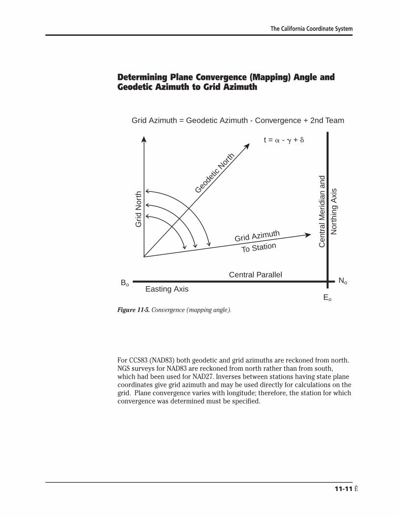
The California Coordinate System
Determining Plane Convergence (Mapping) Angle and Geodetic Azimuth to Grid Azimuth
F
Grid Azimuth = Geodetic Azimuth - Convergence + 2nd Team
Grid Azimuth
To Station
Geode
tic N
orth
Cen
tral
Mer
idia
n an
d
Nor
thin
g A
xis
Grid
Nor
th
t = a - + + o
Central Parallel NoBo
Easting Axis Eo
igure 11-5 Convergence (mapping angle)
For CCS83 (NAD83) both geodetic and grid azimuths are reckoned from north NGS surveys for NAD83 are reckoned from north rather than from south which had been used for NAD27 Inverses between stations having state plane coordinates give grid azimuth and may be used directly for calculations on the grid Plane convergence varies with longitude therefore the station for which convergence was determined must be specified
11-11Ecirc
Caltrans LSLSIT Video Exam Preparation Course
Determine the Plane Convergence +
The plane convergence may be determined in two ways
1 Where the longitude is not known without calculation the plane convergence may be calculated from the constants of the projection and the plane coordinates
e - E + = arctan o
Rb-n + NWhere
b
+ = plane convergence angle e = easting of station Eo = easting of projection origin 6561666667 ft or
20000000000 m for all zones Rb = mapping radius of the grid base a tabled constant n = northing of station Nb= northing of the grid base 1640416667 ft or
5000000000 m for all zones
2 The plane convergence also may be calculated using the difference in longitude between the central meridian and the point of question and a tabled constant Be careful to use the correct algebraic signs
+ = sinBo(Lo - L)
Where + = plane convergence sinBo = sine of the latitude of the projection origin which is also the
ratio between + and longitude in decimals of a degree a tabled constant
Lo = longitude of central meridian a tabled constant L = west longitude of station of the desired plane convergence
The Second Term Correction o
The second term correction is usually minute and can be neglected for most courses under five miles long This correction is also noted as ldquot - Trdquo It is the difference between the grid azimuth ldquotrdquo and the projected geodetic azimuth ldquoTrdquo It increases directly with the change in eastings of the line and with the distance of the occupied station from the central parallel It is neglected in this presentation
11-12
The California Coordinate System
Determine Grid t or Geodetic Azimuth a
t = a - + + o
Where
t = grid azimuth the clockwise angle at a station between the grid meridian (grid north) and the grid line to the observed object All grid meridians are straight and parallel
a = geodetic azimuth the clockwise angle between the geodetic meridian (geodetic north) and the geodetic line to the object observed
g = plane convergence mapping angle the major component of the difference between geodetic azimuth and grid azimuth
o = arc to chord correction known as second term or t - T a correction applied to long lines of precise surveys to compensate for distortion of straight lines when projected onto a grid This correction is usually minute and can be neglected for most courses under five miles long Use 0deg in those cases
Reducing Measured Distance to Geodetic Length and then to Grid Length
Figure 11-6 Distance reductions
D
S
L c
Geoid Surface
Ellipsoid Surface
Ground Surface
h
N
H
11-13Ecirc
Caltrans LSLSIT Video Exam Preparation Course
Reduce Measured Length to Ellipsoidal Chord Length
Surveyors performing high precision work with NAD83 must consider the difference in elevation between the GRS80 ellipsoid and the geoid Elevation based upon the ellipsoid is geodetic height h Elevation based upon the geoid (mean sea-level) is noted as H The difference between the two surfaces is the geoid separation or height N
Determine Approximate Radius of Curvature of the Ellipsoid Ra
An approximate radius of the ellipsoid for each zone is the geometric mean radius of curvature at the projection origin It is close enough for all but the most precise work It can be obtained by the following formula
rR
a plusmn = o
k o
Where R
a plusmn = geometric mean radius of curvature of the ellipsoid at the
projection origin ro = geometric mean radius of the ellipsoid at the projection origin
scaled to the grid ko = grid scale factor of the central parallel
Determine Ellipsoidal Reduction Factor r Also Known as Elevation Factor
e
R r = a
e (Ra + N + H)
Where re = ellipsoidal reduction factor R
a = radius of curvature of the ellipsoid in the azimuth from equation above
N = geoid separation which is a negative value within the contiguous 48 states H = elevation based on mean sea level to which the measured line was
reduced to horizontal The elevation to be used is usually one of the following for measured lengths
1 Triangulation - average elevation of base line 2 EDM - elevation to which slope length was reduced 3 Taped - average elevation of the line
Each one meter error in N or H contributes 016 ppm of error to the distance
11-14
The California Coordinate System
Determine Ellipsoidal Chord Length Lc
L = r D c e
Where Lc = ellipsoidal chord length re = ellipsoidal reduction factor D = ground level horizontal measured distance
Determine Correction of Ellipsoidal Chord Length to Geodetic Length Geodetic lengths are ellipsoidal arc lengths When precise geodetic lengths s are desired a correction from ellipsoidal chord length Lc to the geodetic length on the ellipsoid surface may be applied to lines generally greater than 5 mi long Shorter lengths and lines measured in segments are essentially arcs and need not be corrected The correction to be applied is
Determine Chord Correction for Geodetic Length
Lc equals nearly 9 mi before c equals 001 ft and over 19 mi before equaling 010 ft
L3
c = c
24R2 a
Where c = correction in same units as used for Lc and Ra
Lc = ellipsoidal chord length Ra = radius of curvature of the ellipsoid in the azimuth from equation for
approximating radius of curvature of ellipsoid above
Determine Geodetic Length s
s = L + c c
Where c = correction in same units as used for Lc and Ra
Lc = ellipsoidal chord length s = geodetic length
11-15Ecirc
Caltrans LSLSIT Video Exam Preparation Course
Project Geodetic Length (or Ellipsoidal Chord Length) to Obtain Grid Length
Grid length L(grid) is obtained by multiplying the geodetic length by a grid scale factor Grid scale factor is an expression of the amount of distortion imposed on the length of a line on the ellipsoid as it is projected onto the grid cone It is represented by the letter ldquokrdquo It is the ratio of the length on the grid to the length on the ellipsoid Scale factor is dependent upon latitude It is less than unity between the standard parallels and greater than unity outside them Scale factors can be calculated for points or lines For this presentation point scale factors are used exclusively If greater accuracy is needed for a long line the point scale factor of the mid-point or the mean of the point scale factors at each end may be used
In a Lambert zone if the north-south extent is not great sufficient accuracy often may be obtained by using an average scale factor determined for the average latitude of the survey
Determine Point Scale Factor k
A method which is precise enough for any work performed uses polynomial coefficients It does not require projection tables and is easy to do using a handheld calculator with storage registers It also readily lends itself to programmed applications The coefficients for each zone are tabled at the end of this paper Approximate point scale factor k may be interpolated from projection tables
if + and plane coordinates are known
u = n - N - [(e - E ) tan + 2 ]o o
when plane coordinates are known
u = Ro - radic(Rb + Nb - n)2 + (e - Eo)2
when geodetic latitude and longitude are known
u = L1ΔB + L2ΔB2 + L3ΔB3 + L4ΔB4
rearranged for handheld calculators
u = ΔB[L1 + ΔB(L2 + ΔB(L3 + L4ΔB))]
11-16
The California Coordinate System
Where u = radial distance on the projection from the central parallel to the
station Ro - R No = northing of projection origin n = northing of station e = easting of station Eo = easting of central meridian 6561666667 ft or 20000000000 m for all
zones (also noted as C) + = convergence angle at the station Ro = mapping radius through the projection origin a tabled constant Rb = mapping radius through grid base a tabled constant Nb = northing of grid base a tabled constant equaling 1640416667 ft
or 5000000000 m L1 L2 L3 L4 = polynomial coefficients tabled with the zone constants B = latitude of station (also noted as oslash) Bo = the latitude of the projection origin a tabled constant for each zone
(also noted as oslasho) ΔB= B - B o
k = F1 + F2u2 + F3u
3
Where k = point scale factor F1 F2 F3 = polynomial coefficients tabled with the zone constants u = radial distance on the projection
Determine Grid Length L (grid)
L = s k(grid)
Where L = length on grid(grid)
s = geodetic length k = point scale factor of midpoint of line or as appropriate
11-17Ecirc
Caltrans LSLSIT Video Exam Preparation Course
Combined Factor
If no correction from ellipsoidal chord length to geodetic length is warranted and latitude and elevation differences are not great the measured lengths may be multiplied with a combined factor cf to obtain grid lengths L (grid)
Determine Combined Factor cf
cf = r k e
Where cf = combined factor re = ellipsoidal reduction factor k = point scale factor calculated for mid-latitude of the survey
Determine Grid Length L (grid)
L = cf D(grid)
Where L(grid)= length on grid cf = combined factor D = ground level horizontal measured distance
Conversion of Grid Length to Ground Length
Grid length L(grid) may be converted to ground length D by reversing the above procedures For measurements of similar elevation latitude and short length a combined correction factor may be divided into the grid length
Area and State Plane Coordinates
Areas derived from state plane coordinates must be corrected to yield ground-level areas when they are desired
A(grid)A = cf2
Where A = land area at ground level A(grid) = area of figure on the grid cf = combined factor
11-18
The California Coordinate System
Conversion of Coordinates from One Zone to Another To convert plane coordinates in the overlap of zones from one zone to the other of the CCS83 system convert the plane coordinates from the original zone using the constants for that zone to GRS80 geodetic latitude and longitude Then using the constants for the new zone convert the geodetic latitude and longitude to plane coordinates in the new zone
MetricndashFoot Equivalency
The US Survey ft the linear unit of the State coordinate system is defined by the equivalence 1 international meter = 3937 inches exactly
A coordinate system in ft may be converted to a coordinate system in m by multiplying the coordinate values by a scale factor of 0304800609601 An exact conversion can be accomplished by first multiplying by 12 and then dividing by 3937
A coordinate system in m may be converted to a system in ft by multiplying the coordinate values by a scale factor of 328083333333 An exact conversion can be accomplished by first multiplying by 3937 and then dividing by 12
Sample Test Questions 1 Convert the position of station ldquoSan Ysidro Levee 1975rdquo from its NAD83
geodetic coordinates of latitude 32deg 32 3633328 N longitude 117deg 02 2417391 W to its CCS83 Zone 6 metric plane coordinates
2 What are the CCS83 Zone V plane coordinates for a station at latitude 34deg 08 131201 N longitude 118deg 19 329502 W Use projection tables for your solution
3 Convert the position of station ldquoSan Ysidro Levee 1975rdquo from its CCS83 Zone 6 plane coordinates of 542065352m N 1925786624 m E to its equivalent NAD83 geodetic coordinates
4 In CCS83 Zone V a station has plane coordinates 187239080 ft N 646307210 ft E What are its NAD83 geodetic coordinates Use projection tables for your solution
5 A line has been determined to have a geodetic azimuth of 135deg 00 00 in CCS83 Zone VI The station is at longitude 117deg 25 W What is its grid azimuth
11-19Ecirc
Caltrans LSLSIT Video Exam Preparation Course
6 The geodetic azimuth a is desired between two stations on the CCS83 Zone VI grid The azimuth from Station 1 is desired Given Station 1 coordinates are 1660578090 ft N 6570078800 ft E Station 2 coordinates are 1653507022 ft N 6577149868 ft E
7 A survey party occupied station San Javier 1919 which has NGS NAD83 published CCS83 Zone 6 coordinates of 539034888 m northing 1977009714 m easting San Javier also has a published elevation of 121958 m and a geoid height of -3357 m All field measured distances were reduced to the elevation of station San Javier 1919 The field distance to a foresighted station is 1300000 ft What is the grid distance to the foresighted station What is the combined factor
8 In CCS83 Zone VI a length of 6000000 ft is measured at 5200 ft elevation The mid-point of the line is at latitude 32deg 36 20 N What is the grid length What is the combined factor
9 A line in CCS83 Zone VI has a grid length of 200000000 ft and its mid-point is at latitude 32deg 31 N What is its ground length at 3800 ft elevation
Answer Key 1 Direct forward computation
Determine radial difference
ΔB= B - B o
ΔB= 32543425911deg - 33333922945deg (truncate 30deg from B and Bo for HP41s) ΔB= -0790497034deg
u = ΔB [L1 + ΔB (L2 + ΔB (L3 + L4ΔB))] u = ΔB [L1 + ΔB (L2 + ΔB (L3 + (0016171) (-0790497034)))] u = ΔB [L1 + ΔB (L2 + (-0790497034) (565087 - 0012783))] u = ΔB [L1 + (-0790497034) (894188 - 445689)] u = (-0790497034) (1109053274 - 35454) u = -876675297 m
Determine mapping radius
R = R o - u R = 9706640076 - (-87667530) R = 9794307606 m
11-20
The California Coordinate System
Determine plane convergence
+ = (Lo - L) sinBo
+ = (116deg 15 - 117deg 02 2417391) (05495175758) truncate 110deg from Lo
and L for HP41s + = -0deg 26 02923552 (carry all significant digits)
Determine northing and easting +
n = N + u + [(R sin+o ) tan ]2 n = N o + u + [(9794307606) (-000757719469) (-000378865173)] n = 6294517134 - 876675297 + 2811686 n = 542065352 m (exactly as published by NGS)
e = E + R sin+ o
e = 20000000000 + [(9794307606) (-000757719469)] e = 1925786624 m (exactly as published by NGS)
2 Direct forward computation (using projection tables) Determine mapping radius R = 3041825688
for 34deg 08 from Projection Table 10108844 x 131201 = -132629 less diff1 lat from column 5 R = 3041693059 then for 34deg 08 131201 N
Determine plane convergence
+ = (Lo - L) sinBo
+ = (118deg 00 - 118deg 19 329502) (0570011896174) truncate 110deg from L o and L for HP41s
+ = -018572099101deg + = -0deg 11 085956 (carry to all significant digits)
Determine northing and easting
n = Rb + Nb - R cos+ n = 3064874493 + 164041667 - 3041693059 cos(-018572099101deg) n = 187239080 ft N
e = E + R sin+ o
e = 656166667 + 3041693059 sin (-018572099101deg) e = 646307210 ft E
11-21Ecirc
Caltrans LSLSIT Video Exam Preparation Course
3 Inverse computation Determine plane convergence
e - E + = arctan [ o ]Rb - n + Nb
+ = arctan [(1925786624 m - 2000000000 m)
(9836091790 m - 542065352 m + 500000000 m)] + = arctan (-742133769794026438) + = arctan (-0007577412259) + = -0deg 26 02923559 (carry all significant digits)
Determine longitude +
L = L o - ( )sinB o
L = 11625deg - (-0434145433105495175758) truncate 110deg from L for HP41s
L = 117040048312deg L = 117deg 02 2417392 W (versus 117deg 02 2417391 published by NGS)
Determine radial difference +
u = n - No - [(e - Eo) tan ]2 u = n - No - [(1925786624m - 20000000000 m) (-000378865173)] u = 542065352 m - 6294517134 m - 2811686 m u = -87667530 m
Determine latitude
B = B o + u [G1 + u (G2 + u (G3 + G4u))]B = B o + u [G1 + u (G2 + u (G3 + (-82753 x 10-28) (-87667530 m)))] B = B + u [G + u (G + (-87667530 m) (-373318 x 10-20 + 725475 x 10-23
o 1 2 ))] B = B o + u [G1 + (-87667530 m) (-655499 x 10-15 + 3266426 x 10-15)] B = B + (-87667530 m) (9016699372 x 10-6 -10
o + 28830022 x 10 ) B = 33333922945deg - 07904970372deg truncate 30deg from B for HP41s B = 32deg 32 3633327 N (versus 32deg 32 3633328 published by NGS)
11-22
The California Coordinate System
4 Inverse computation (using projecting tables) Determine plane convergence
e - E + = arctan [ o ]Rb - n + Nb
(646307210 ft - 656166667 ft) + = arctan [ ]
(3064874493 ft + 164041667 ft - 18739080 ft) + = arctan (-9859457 3041677080) + = arctan (-000324145422) + = -018572099571deg + = -0deg 11 0859558 (carry seconds to at least the fourth decimal place)
Determine longitude +
L = L o shy sinB o
L = 118deg 00 - (-018572099571deg0570011896174) truncate 110deg from L for HP41s
L = 118deg 00 - (-0325819500deg) L = 118325819500deg W L = 118deg 19 329502 W
Determine mapping radius for use with projection tables
R = radic(e - E )2 + (R - n + N )2 o b b
R = radic -98594572 + 30416770802
R = 3041693059 ft
Determine the latitude Interpolate R in Projection Table to find latitude (oslash)
(34deg 08) R = 3041825688 (unk) R = 3041693059 Diff 132629
using column 5 of Projection Table
13262910108844 = 31201 therefore B = 34deg 08 131201 N
11-23Ecirc
Caltrans LSLSIT Video Exam Preparation Course
5 Determine the plane convergence
+ = sinBo(Lo - L) + = 0549517575763 (116deg 15 - 117deg 25) + = -0deg 38 2797382
The second term will be neglected
Calculate the grid azimuth
t = a - + + o t = 135deg 00 00 - (-0deg 38 2797382) + 0deg t = 135deg 38 2797382
6 Inverse from Station 1 to Station 2 The inversed grid azimuth is t = 135deg0000
Calculate the plane convergence
e - E + = arctan [ o ]Rb- n + Nb
(6570078800 ft - 6561666667 ft) + = arctan [ ](32270577813 ft - 1660578090 ft + 1640416667 ft)
+ = arctan (000026083797) + = +0deg 00 538017
The second term correction is neglected here
Calculate the geodetic azimuth t = a - + + o
135deg 00 00 = a - (+0deg 00 538017) + 0deg) a = 135deg 00 00 + 0deg 00 538017 + 0deg a = 135deg 00 538017
7 Convert elevation geoid height and measured distance to the same units Here feet were chosen
Determine radius of curvature of ellipsoid
r R o
a plusmn =k o
R a plusmn = 20896729860 ft 0999954142490
R a plusmn = 20897688176 ft
11-24
The California Coordinate System
Determine ellipsoidal reduction factor
Ra
e r =(Ra + N + H)
re = 20897688176 ft (20897688176 ft - 11014 ft + 400124 ft) r = 0999813837 e
Determine ellipsoidal chord length
L = r D c e
L = 0999813837 x 1300000 ft c
L = 1299758 ft c
Determine chord correction and geodetic length
L 3
c = c
24R 2 a
c = 12997583 24 (208976881762) c = 00002 ft
Determine geodetic length The chord correction is negligible therefore the geodetic length
s = 1299758 ft
Determine point scale factor
u = R o - radic(Rb + Nb - n)2 + (e - Eo)2
u = 31845868317 ft shyradic(322770577813 ft + 1640416667 ft - 176848363)2 + (648623937 ft - 656166667)2
u = 31845868317 ft - [1033141004 x 1015 + 568927758529]2
u = 31845868317 ft - 32142599351 ft u = -29673103 ft
k = F1 + F2u2 + F3u
3
k = 0999954142490 + [114504 x 10-15 (88049304 x 1010)] + [118 x 10-23 (-26126960 x 1016)]
k = 0999954142490 + 0000100820 - 0000000308 k = 1000054654
Determine grid length
L = s k(grid)
L = 1299758 ft (1000054654) (grid)
L = 1299829 (grid)
11-25Ecirc
Caltrans LSLSIT Video Exam Preparation Course
8
Determine combined factor
cf = re k = (0999813837) 1000054654 = 0999868481
Reducing measured distance Determine radius of curvature of ellipsoid
r oR plusmn = a k o
R a plusmn = 20896729860 ft0999954142490 R plusmn = 20897688176 ft a
Determine ellipsoidal reduction factor
R a
e r = (Ra + N + H)
re = 20897688176 ft(20897688176 ft + 0 + 5200 ft) r = 09997512306 e
Determine ellipsoidal chord length
L = r D c e
Lc = (09997512306) (6000000 ft) L = 5998507 ft c
Determine chord correction
L3 c c = 24R2
a
c = 59985073(24)(208976881762) c = 0000021 ft
Determine geodetic length
The chord correction is negligible therefore the geodetic length s = 5998507 ft
Determine point scale factor
Scale factor for 32deg 36 from Project Table = 10000356 2060 diff = (0333) (-00000037) = -00000012 k = 10000344
Determine grid length
L = s k (grid)
L = (5998507 ft) (10000344)(grid)
L = 5998713 ft(grid)
11-26
The California Coordinate System
Determine combined factor
cf = r k e
cf = (09997512306) (10000344) cf = 09997856
Determine grid length
L = cf (D)(grid)
L = 09997856 x 600000 ft(grid)
L = 5998714 ft(grid)
9 Convert grid length to ground length Determine point scale factor
ΔB= B - B o
ΔB= 325166666667deg - 333339229447deg ΔB= -08172562780deg
u = ΔB [L1 + ΔB (L2 + ΔB (L3 + (-004335871457)))] u = ΔB [L1 + ΔB (L2 + ΔB(184962412854))] u = ΔB [L1 + ΔB (L2 + (-151161693099))] u = ΔB [L1 + ΔB (142206306901)] u = ΔB [L1 + (-116218997086)] u = ΔB [3638502731] u = -2973589199 ft
k = F1 + F2u2 + F3u
3
k = 0999954142490 + (114504 x 10-15) (-29735891992) + (118 x 10-23) (-29735891993)
k = 100005507933
Determine geodetic length
L(grid)= s k 200000000 ft = s x 100005507933 s = 200000000 ft100005507933 s = 199988985 ft
Determine radius of curvature of the ellipsoid
oR plusmn =r
a k o
Ra plusmn = 20896729860 ft 0999954142490 R plusmn = 20897688176 ft a
11-27Ecirc
Caltrans LSLSIT Video Exam Preparation Course
Determine chord correction L3
c c = 24R2 a
c = 1999889853[(24) (208976881762)] use geodetic length as approximate ellipsoidal chord c = 0763 ft
Determine ellipsoidal chord length
s = L + c c
L + 0763 ft = 199988985 ft c
L = 199988222 ft c
Determine ellipsoidal reduction factor
Rare = (Ra + N + H)
re = 20897688176 ft(20897688176 ft + 0 + 3800) r = 099981819476 e
Determine level ground length
L = r D c e
199988222 ft = 099981819476 x D D = 199988222 ft099981819476 D = 200024587
11-28Ecirc
The California Coordinate System
Appendix 1 State of California Public Resources Code Division 8 Surveying and Mapping Chapter 1 California Coordinate System
Section 8801 California Coordinate System Defined
(a) The system of plane coordinates which has been established by the United States Coast and Geodetic Survey for defining and stating the positions or locations of points on the surface of the earth within the State of California is based on the North American Datum of 1927 and is identified as the ldquoCalifornia Coordinate Systemrdquo After January 1 1987 this system shall be known as the ldquoCalifornia Coordinate System of 1927rdquo
(b) The system of plane coordinates which has been established by the National Geodetic Survey for defining and stating the positions or locations of points on the surface of the earth within the State of California and which is based on the North American Datum of 1983 shall be known as the ldquoCalifornia Coordinate System of 1983rdquo
(c) As used in this chapter (1) ldquoNAD27rdquo means the North American Datum of 1927 (2) ldquoCCS27rdquo means the California Coordinate System of 1927 (3) ldquoNAD83rdquo means the North American Datum of 1983 (4) ldquoCCS83rdquo means the California Coordinate System of 1983 (5) ldquoUSCampGSrdquo means the United States Coast and Geodetic Survey (6) ldquoNGSrdquo means the National Geodetic Survey (7) ldquoFGCCrdquo means the Federal Geodetic Control Committee
(d) The use of the term ldquoState Plane Coordinatesrdquo refers only to CCS27 and CCS83 coordinates
Section 8802 Delineation of Zones
For CCS27 the state is divided into seven zones For CCS83 the state is divided into six zones Zone 7 of CCS27 which encompasses Los Angeles County is eliminated and the area is included in Zone 5
11-29Ecirc
Caltrans LSLSIT Video Exam Preparation Course
Each zone of CCS27 is a Lambert conformal conic projection based on Clarkersquos Spheroid of 1866 which is the basis of NAD27 The points of control of zones one to six inclusive bear the coordinates Northing (y) = 00000 feet and Easting (x) = 2000000 feet The point of control of Zone 7 bears the coordinates Northing (y) = 416092674 feet and Easting (x) = 418669258 feet
Each zone of CCS83 is a Lambert conformal conic projection based on the Geodetic Reference System of 1980 which is the basis of NAD83 The point of control of each of the six zones bear the coordinates Northing (y) = 500000 meters and Easting (x) = 2000000 meters
The area included in the following counties constitutes Zone 1 of CCS27 and CCS83 Del Norte Humboldt Lassen Modoc Plumas Shasta Siskiyou Tehama and Trinity
The area included in the following counties constitutes Zone 2 of CCS27 and CCS83 Alpine Amador Butte Colusa El Dorado Glenn Lake Mendocino Napa Nevada Placer Sacramento Sierra Solano Sonoma Sutter Yolo Yuba
The area included in the following counties constitutes Zone 3 of CCS27 and CCS83 Alameda Calaveras Contra Costa Madera Marin Mariposa Merced Mono San Francisco San Joaquin San Mateo Santa Clara Santa Cruz Stanislaus and Tuolumne
The area included in the following counties constitutes Zone 4 of CCS27 and CCS83 Fresno Inyo Kings Monterey San Benito and Tulare
The area included in the following counties and Channel Islands constitutes Zone 5 of CCS27 Kern San Bernardino San Luis Obispo Santa Barbara (excepting Santa Barbara Island) and Ventura (excepting San Nicholas Island) and the Channel Islands of Santa Cruz Santa Rosa San Miguel and Anacapa
The area included in the following counties and Channel Islands constitutes Zone 5 of CCS83 Kern Los Angeles (excepting San Clemente and Santa Catalina Islands) San Bernardino San Luis Obispo Santa Barbara (excepting Santa Barbara Island) and Ventura excepting San Nicholas Island) and the Channel Islands of Santa Cruz Santa Rosa San Miguel and Anacapa
The area included in the following counties and Channel Islands constitutes Zone 6 of CCS27 and CCS83 Imperial Orange Riverside and San Diego and the Channel Islands of San Clemente Santa Catalina Santa Barbara and San Nicholas
The area included in Los Angeles County constitutes Zone 7 of CCS27
11-30
The California Coordinate System
Section 8803 Definition of Zone 1
Zone 1 coordinates shall be named and on any map on which they are used they shall be designated as ldquoCCS27 Zone 1 or CCS83 Zone 1rdquo
On their respective spheroids of reference (1) the standard parallels of CCS27 Zone 1 and CCS83 Zone 1 are at north latitudes 40 degrees 00 minutes and 41 degrees 40 minutes along which parallels the scale shall be exact and (2) the point of control of coordinates is at the intersection of the zonersquos central meridian which is at 122 degrees 00 minutes west longitude with the parallel 39 degrees 20 minutes north latitude
Section 8804 Definition of Zone 2
Zone 2 coordinates shall be named and on any map on which they are used they shall be designated as ldquoCCS27 Zone 2 or CCS83 Zone 2rdquo
On their respective spheroids of reference (1) the standard parallels of CCS27 Zone 2 and CCS83 Zone 2 are at north latitudes 38 degrees 20 minutes and 39 degrees 50 minutes along which parallels the scale shall be exact and (2) the point of control of coordinates is at the intersection of the zonersquos central meridian which is at 122 degrees 00 minutes west longitude with the parallel 37 degrees 40 minutes north latitude
Section 8805 Definition of Zone 3
Zone 3 coordinates shall be named and on any map on which they are used they shall be designated as ldquoCCS27 Zone 3 or CCS83 Zone 3rdquo
On their respective spheroids of reference (1) the standard parallels of CCS27 Zone 3 and CCS83 Zone 3 are at north latitudes 37 degrees 04 minutes and 38 degrees 26 minutes along which parallels the scale shall be exact and (2) the point of control of coordinates is at the intersection of the zonersquos central meridian which is at 120 degrees 30 minutes west longitude with the parallel 36 degrees 30 minutes north latitude
Section 8806 Definition of Zone 4
Zone 4 coordinates shall be named and on any map on which they are used they shall be designated as ldquoCCS27 Zone 4 or CCS83 Zone 4rdquo
On their respective spheroids of reference (1) the standard parallels of CCS27 Zone 4 and CCS83 Zone 4 are at north latitudes 36 degrees 00 minutes and 37 degrees 15 minutes along which parallels the scale shall be exact and (2) the point of control of coordinates is at the intersection of the zonersquos central meridian which is at 119 degrees 00 minutes west longitude with the parallel 35 degrees 20 minutes north latitude
11-31Ecirc
Caltrans LSLSIT Video Exam Preparation Course
Section 8807 Definition of Zone 5
Zone 5 coordinates shall be named and on any map on which they are used they shall be designated as ldquoCCS27 Zone 5 or CCS83 Zone 5rdquo
On their respective spheroids of reference (1) the standard parallels of CCS27 Zone 5 and CCS83 Zone 5 are at north latitudes 34 degrees 02 minutes and 35 degrees 28 minutes along which parallels the scale shall be exact and (2) the point of control of coordinates is at the intersection of the zonersquos central meridian which is at 118 degrees 00 minutes west longitude with the parallel 33 degrees 30 minutes north latitude
Section 8808 Definition of Zone 6
Zone 6 coordinates shall be named and on any map on which they are used they shall be designated as ldquoCCS27 Zone 6 or CCS83 Zone 6rdquo
On their respective spheroids of reference (1) the standard parallels of CCS27 Zone 6 and CCS83 Zone 6 are at north latitudes 32 degrees 47 minutes and 33 degrees 53 minutes along which parallels the scale shall be exact and (2) the point of control of coordinates is at the intersection of the zonersquos central meridian which is at 116 degrees 15 minutes west longitude with the parallel 32 degrees 10 minutes north latitude
Section 8809 Definition of Zone 7
Zone 7 coordinates shall be named and on any map on which they are used they shall be designated as ldquoCCS27 Zone 7rdquo
On its respective spheroid of reference (1) the standard parallels of CCS27 Zone 7 are at north latitudes 33 degrees 52 minutes and 34 degrees 25 minutes along which parallels the scale shall be exact and (2) the point of control of coordinates is at the intersection of the zonersquos central meridian which is at 118 degrees 20 minutes west longitude with the parallel 34 degrees 08 minutes north latitude
Section 8810 Definition of US Survey Foot and Coordinates
The plane coordinates of a point on the earthrsquos surface to be used in expressing the position or location of the point in the appropriate zone of CCS27 or CCS83 shall consist of two distances expressed in feet and decimals of a foot or meters and decimals of a meter When the values are expressed in feet the ldquoUS Survey footrdquo (one foot = 12003937 meters) shall be used as the standard foot for CCS27 and CCS83 One of these distances to be known as the ldquoEast x-coordinaterdquo shall give the distance east of the Y axis the other to be known as the ldquoNorth y-coordinaterdquo shall give the distance north of the X axis The Y axis of any zone shall be parallel with the
11-32
The California Coordinate System
central meridian of that zone The X axis of any zone shall be at right angles to the central meridian of that zone
Section 8811 Sources of Plane Coordinates
The state plane coordinates of a point in any zone shall be based upon the plane coordinates of published horizontal control stations or derived from published horizontal control stations of the USCampGS and the NGS or their successors
Section 8813 Requires Accuracy of Stations and Data Required
The CCS27 and CCS83 shall be based on monumented first- and second-order stations which have been published by USCampGS and NGS or their successors The geodetic positions of CCS27 and CCS83 stations which are used to increase the density of control and which purport to be of first- or second-order accuracy shall have been surveyed in conformity with first- or second-order survey standards and specifications in effect at the time of the survey as defined by the Federal Geodetic Control Committee Any survey or map which is to be based on state plane coordinates shall show established field-measured connections to at least two stations of corresponding accuracy or better whose credentials are based upon published stations of USCampGS or NGS or their successors If an FGCC order of accuracy is claimed for a survey or a map it shall be justified by additional written data that shows equipment procedures closures adjustments and a control diagram
Section 8814 Use of Coordinates and Constructive Notice
State plane coordinates may be used for property identification on any map survey conveyance or other instrument which delineates or affects the title to real property or which delineates describes or refers to the property or any part thereof However to constitute when recorded constructive notice thereof under the recording laws the delineating describing or referring to the property or part thereof shall also refer to data appearing of record in any office the records of which constitute constructive notice under the recording laws That record data shall be sufficient to identify the property without recourse to those coordinates and in case of conflict between them the references to that recorded data shall be controlling for the purpose of determining constructive notice under the recording laws
Section 8815 Identification of California Coordinate System
The use of the term ldquoCalifornia Coordinate Systemrdquo on any map or document or any field notes shall be suffixed either with ldquo27rdquo (shown as ldquoCCS27rdquo) for coordinates based on NAD27 or with ldquo83rdquo (shown as ldquoCCS83rdquo) for coordinates based on NAD83
11-33Ecirc
Caltrans LSLSIT Video Exam Preparation Course
Section 8816 Use Optional
The use of the State Plane Coordinates by any person corporation or governmental agency engaged in land surveying or mapping is optional
Section 8817 CCS83 Use After January 1 1995
Prior to January 1 1995 use of State Plane Coordinates for new projects may be based either on CCS27 or CCS83 On or after January 1 1995 when State Plane Coordinates are used on new surveys and new mapping projects the use shall be limited to CCS83
Section 8818 Land Titles Referred to CCS27
This chapter does not impair or invalidate land titles legal descriptions or jurisdictional or land boundaries and further this chapter does not impair or invalidate references to or the use of CCS27 coordinates except as provided in Section 8817
Section 8819 Use of New Technologies
This chapter does not prohibit the use of new geodetic surveying technologies for which FGCC specifications have not yet been published except that if first- or second-order accuracy is claimed for any of the resulting monumented stations the state plane coordinates shall conform to FGCC accuracy standards
11-34
The California Coordinate System
Appendix 2
Symbols and Notations a = geodetic azimuth the clockwise angle between geodetic north and
the geodetic line to the object observed
+ = the plane convergence angle the major component of the difference between geodetic azimuth and grid azimuth also sometimes called mapping angle
o = arc to chord correction also known as second term or ldquot - Trdquo (A correction applied to long lines of precise surveys to compensate for distortion of straight lines when projected onto the grid This correction is usually minute and can be neglected for most courses under five miles long)
a = 6378137 m (exact) or 209256044742 ft the equatorial radius of the GRS80 ellipsoid
b = 6356752314140347 m = 208554448840 ft = the semiminor axis of the GRS80 ellipsoid
B = north geodetic latitude of a station also noted as oslash
Bb = north geodetic latitude of the parallel passing through grid origin a tabled constant
Bn = north geodetic latitude of the northerly standard parallel where the cone intersects the ellipsoid (Line of exact scale)
Bo = the latitude of the central parallel passing through the projection origin a tabled constant for each zone also noted as _o
Bs = north geodetic latitude of the southerly standard parallel where the cone intersects the ellipsoid (Line of exact scale)
cf = combined factor for simultaneously applying average ellipsoidal reduction and scale factors
D = ground level horizontal measured distance
Eo = easting of projection origin and central meridian 6561666667 ft or 20000000000 m for all zones
e2 = 0006694380022903416 = the square of the first eccentricity of the GRS80 ellipsoid
e ft2 = 0006739496775481622 = the square of the second eccentricity of the GRS80 ellipsoid
11-35Ecirc
Caltrans LSLSIT Video Exam Preparation Course
F1 F2 F3 = polynomial coefficients tabled with the zone constants
G1 G2 G3 G4 = polynomial coefficients for inverse conversion tabled with the zone constants
h = geodetic height elevation using the ellipsoid for its datum Related to MSL datum by the formula h = N + H
H = elevation using the geoid for its datum this is approximately elevation based on mean sea level
k = point grid scale factor
K = mapping radius on the cone at the equatorial plane of the ellipsoid
ko = grid scale factor of the central parallel Bo a tabled constant
L = west geodetic longitude of station also noted as A
Lc = ellipsoidal chord length
L(grid) = grid length distance between two points on the grid plane
Lo = longitude of the central meridian passing through the projection and grid origin a tabled constant also noted as A o
Ls = measured slope length
L1 L2 L3 L4 = polynomial coefficients for direct computation tabled with the zone constants
Mo = radius of curvature of the ellipsoid in the meridian at the projection origin scaled to the grid
N = geoid separation or height the distance at a station from the geoid to the ellipsoid it is negative within the contiguous 48 states
Nb = northing of grid base a tabled constant equalling 1640416667 ft or 5000000000 m for all zones
No = northing of the projection origin a tabled constant
p = 1f = flattening-1 = 2982572221008827 for GRS80
R = mapping radius through a station
R a = radius of curvature of the ellipsoid in the azimuth
Rb = mapping radius through the grid base a tabled constant
re = ellipsoidal reduction factor also known as elevation factor
ro = geometric mean radius of the ellipsoid at the projection origin scaled to the grid
11-36
The California Coordinate System
Ro = mapping radius through the projection origin a tabled constant
s = geodetic length the ellipsoidal arc length of a line
sinBo = sine of the latitude of the projection origin which is also the ratio between + and longitude in decimals of a degree a tabled constant
t = grid azimuth the clockwise angle at a station between the grid meridian (grid north) and the grid line to the observed object (All grid meridians are straight and parallel Grid azimuths are related to geodetic azimuths by the formula t = a - + + ogt
T = projected geodetic azimuth (Azimuth of a straight line of the ellipsoid when projected onto the grid is slightly curved)
u = radial distance on the projection from the station to the central parallel Ro - R
Constants for the Geodetic Reference System of 1980 GRS80 Ellipsoid
a = 6378137 m (exact) = 209256044742 ft = the equatorial radius of the ellipsoid
b = 6356752314140347 m = 208554448840 ft = the semiminor axis
p = 1f = 2982572221008827 = flattening-1
e2 = 0006694380022903416 = the square of the first eccentricity
e ft2 = 0006739496775481622 = the square of the second eccentricity
11-37Ecirc
Caltrans LSLSIT Video Exam Preparation Course
Appendix 3 North American Datum 1983 (NAD83) ndash California Coordinate System 1983 (CCS83)
CALIFORNIA ZONE 1 CA01 ZONE 0401 Meters US Survey Feet Bs = 40deg 00 N Bs = 40deg 00 N Bn = 41deg 40 N B = 41deg 40 N Bb = 39deg 20 N Bb
n
= 39deg 20 N Lo = 122deg 00 W Lo = 122deg 00 W Nb = 5000000000 m Nb = 1640416667 ft Eo = 20000000000 m E = 6561666667 ft o
Bo = 408351061249deg N B = 408351061249deg N o SinBo = 0653884305400 SinB = 0653884305400 o Rb = 75565546408 m Rb = 24791796351 ft Ro = 73898020597 m R = 24244708924 ft o No = 6667525811 m N = 2187504093 ft o K = 122878263052 m K = 40314310136 ft ko = 0999894636561 k = 0999894636561 o Mo = 63620672798 m M = 20872882401 ft o ro = 6374328 m ro = 20913107780 ft
L1 = 1110390203 L1 = 3643005191 L2 = 965524 L2 = 316772 L3 = 563491 L3 = 184872 L4 = 0021275 L4 = 0069800
G1 = 9005843038E-06 G1 = 2744986448E-06 G2 = -705240E-15 G2 = -655192E-16 G3 = -370393E-20 G3 = -104884E-21 G4 = -11142E-27 G4 = -96167E-30
F1 = 0999894636561 F1 = 0999894636561 F2 = 123062E-14 F2 = 114329E-15 F3 = 547E-22 F3 = 155E-23
The customary limits of the zone are from 39deg 20 N to 42deg 20 N
11-38
The California Coordinate System
North American Datum 1983 (NAD83) ndash California Coordinate System 1983 (CCS83)
CALIFORNIA ZONE 2 CA02 ZONE 0402
Meters US Survey Feet B = 38deg 20 N B = 38deg 20 N s s
B = 39deg 50 N B = 39deg 50 N n n
Bb = 37deg 40 N Bb = 37deg 40 N L = 122deg 00 W L = 122deg 00 W o o
Nb = 5000000000 m Nb = 1640416667 ft E = 20000000000 m E = 6561666667 ft o o
B = 390846839219deg N B = 390846839219deg N o o
SinB = 0630468335285 SinB = 0630468335285 o o
Rb = 80197889307 m Rb = 26311590850 ft R = 78623814027 m R = 25795162985 ft o o
N = 6574075280 m N = 2156844531 ft o o
K = 125203516538 m K = 41077187051 ft k = 0999914672977 k = 0999914672977 o o
M = 63602683937 m M = 20866980555 ft o o
r = 6373169 m r = 20909305294 ft o o
L1 = 1110076240 L1 = 3641975131 L2 = 954628 L2 = 313198 L3 = 563874 L3 = 184998 L4 = 0019988 L4 = 0065577
G1 = 9008390180E-06 G1 = 2745762818E-06 G2 = -697872E-15 G2 = -648347E-16 G3 = -371084E-20 G3 = -105080E-21 G4 = -10411E-27 G4 = -89858E-30
F1 = 0999914672977 F1 = 0999914672977 F2 = 123106E-14 F2 = 114370E-15 F3 = 514E-22 F3 = 146E-23
The customary limits of the zone are from 37deg 40 N to 40deg 30 N
11-39Ecirc
Caltrans LSLSIT Video Exam Preparation Course
North American Datum 1983 (NAD83) ndash California Coordinate System 1983 (CCS83)
CALIFORNIA ZONE 3 CA03 ZONE 0403
Meters US Survey Feet B = 37deg 04 N B = 37deg 04 N
s s
Bn = 38deg 26 N Bn = 38deg 26 N Bb = 36deg 30 N Bb = 36deg 30 N L = 120deg 30 W L = 120deg 30 W
o o
Nb = 5000000000 m Nb = 1640416667 ft E = 20000000000 m E = 6561666667 ft
o o
B = 377510694363deg N B = 377510694363deg N o o
SinBo = 0612232038295 SinBo = 0612232038295 Rb = 83857751723 m Rb = 27512330711 ft R = 82469303684 m R = 27056804050 ft
o o
N = 6388448039 m N = 2095943327 ft o o
K = 127245749735 m K = 41747209726 ft k = 0999929178853 k = 0999929178853
o o
M = 63589096841 m M = 20862522855 ft o o
ro = 6372292 m ro = 20906428003 ft
L1 = 1109839104 L1 = 3641197127 L2 = 943943 L2 = 309692 L3 = 564142 L3 = 185086 L4 = 0019048 L4 = 0062493
G1 = 9010315015E-06 G1 = 2746349509E-06 G2 = -690503E-15 G2 = -641501E-16 G3 = -371614E-20 G3 = -105230E-21 G4 = -98819E-28 G4 = -85291E-30
F1 = 0999929178853 F1 = 0999929178853 F2 = 123137E-14 F2 = 114398E-15 F3 = 489E-22 F3 = 138E-23
The customary limits of the zone are from 36deg 30 N to 39deg 00 N
11-40
The California Coordinate System
North American Datum 1983 (NAD83) ndash California Coordinate System 1983 (CCS83)
CALIFORNIA ZONE 4 CA04 ZONE 0404
Meters US Survey Feet B = 36deg 00 N B = 36deg 00 N s s
B = 37deg 15 N B = 37deg 15 N n n
Bb = 35deg 20 N Bb = 35deg 20 N L = 119deg 00 W L = 119deg 00 W o o
Nb = 5000000000 m Nb = 1640416667 ft E = 20000000000 m E = 6561666667 ft o o
B = 366258593071deg N B = 366258593071deg N o o
SinB = 0596587149880 SinB = 0596587149880 o o
Rb = 87332273793 m Rb = 28652263494 ft R = 85898068935 m R = 28181724783 ft o o
N = 6434204858 m N = 2110955377 ft o o
K = 129169860281 m K = 42378478327 ft k = 0999940761703 k = 0999940761703 o o
M = 63577728978 m M = 20858793249 ft o o
r = 6371557 m r = 20904016591 ft o o
L1 = 1109640696 L1 = 3640546183 L2 = 933334 L2 = 306211 L3 = 564410 L3 = 185174 L4 = 0018382 L4 = 0060308
G1 = 9011926076E-06 G1 = 2746840562E-06 G2 = -683121E-15 G2 = -634643E-16 G3 = -372043E-20 G3 = -105351E-21 G4 = -94223E-28 G4 = -81324E-30
F1 = 0999940761703 F1 = 0999940761703 F2 = 123168E-14 F2 = 114427E-15 F3 = 470E-22 F3 = 133E-23
The customary limits of the zone are from 35deg 20 N to 38deg 00 N
11-41Ecirc
Caltrans LSLSIT Video Exam Preparation Course
North American Datum 1983 (NAD83) ndash California Coordinate System 1983 (CCS83)
CALIFORNIA ZONE 5 CA05 ZONE 0405
Meters US Survey Feet B = 34deg 02 N B = 34deg 02 N s s
B = 35deg 28 N B = 35deg 28 N n n
Bb = 33deg 30 N Bb = 33deg 30 N L = 118deg 00 W L = 118deg 00 W o o
Nb = 5000000000 m Nb = 1640416667 ft E = 20000000000 m E = 6561666667 ft o o
B = 347510553142deg N B = 347510553142deg N o o
SinB = 0570011896174 SinB = 0570011896174 o o
Rb = 93417561389 m Rb = 30648744932 ft R = 92029831099 m R = 30193453753 ft o o
N = 6387730290 m N = 2095707846 ft o o
K = 132826248345 m K = 43578078311 ft k = 0999922127209 k = 0999922127209 o o
M = 63556709697 m M = 20851897173 ft o o
r = 6370113 m r = 20899279068 ft o o
L1 = 1109273840 L1 = 3639342590 L2 = 912439 L2 = 299356 L3 = 564805 L3 = 185303 L4 = 0017445 L4 = 0057234
G1 = 9014906468E-06 G1 = 2747748987E-06 G2 = -668534E-15 G2 = -621091E-16 G3 = -372796E-20 G3 = -105565E-21 G4 = -86394E-28 G4 = -74567E-30
F1 = 0999922127209 F1 = 0999922127209 F2 = 123221E-14 F2 = 114477E-15 F3 = 441E-22 F3 = 125E-23
The customary limits of the zone are from 33deg 30 N to 36deg 20 N
11-42
The California Coordinate System
North American Datum 1983 (NAD83) ndash California Coordinate System 1983 (CCS83)
CALIFORNIA ZONE 6 CA06 ZONE 0406
Meters US Survey Feet B = 32deg 47 N B = 32deg 47 N s s
B = 33deg 53 N B = 33deg 53 N n n
Bb = 32deg 10 N Bb = 32deg 10 N L = 116deg 15 W L = 116deg 15 W o o
Nb = 5000000000 m Nb = 1640416667 ft E = 20000000000 m E = 6561666667 ft o o
B = 333339229447deg N B = 333339229447deg N o o
SinB = 0549517575763 SinB = 0549517575763 o o
Rb = 98360917896 m Rb = 32270577813 ft R = 97066400762 m R = 31845868317 ft o o
N = 6294517134 m N = 2065126163 ft o o
K = 136020267133 m K = 44625982642 ft k = 0999954142490 k = 0999954142490 o o
M = 63544072007 m M = 20847750958 ft o o
r = 6369336 m r = 20896729860 ft o o
L1 = 1109053274 L1 = 3638618950 L2 = 894188 L2 = 293368 L3 = 565087 L3 = 185396 L4 = 0016171 L4 = 0053054
G1 = 9016699372E-06 G1 = 2748295465E-06 G2 = -655499E-15 G2 = -608981E-16 G3 = -373318E-20 G3 = -105713E-21 G4 = -82753E-28 G4 = -71424E-30
F1 = 0999954142490 F1 = 0999954142490 F2 = 123251E-14 F2 = 114504E-15 F3 = 415E-22 F3 = 118E-23
The customary limits of the zone are from 32deg 10 N to 34deg 30 N
11-43Ecirc
Caltrans LSLSIT Video Exam Preparation Course
References Alexander I A and Alexander R J (1989) ldquoProjection Tables California
Coordinate System NAD83rdquo California Land Surveyors Association Special Publication No 5588
Burkholder E F (1984) ldquoGeometrical Parameters of the Geodetic Reference System 1980rdquo Surveying and Mapping Vol 44 No 4 pp 339shy340
Fronczek C J (1980) ldquoUse of Calibration Base Linesrdquo NOAA Technical Memorandum NOS NGS- 10 National Geodetic Information Center NOAA Rockville MD 20852
Meade B K (1987) ldquoProgram for Computing Universal Mercator (UTM) Coordinates for Latitudes North or South and Longitudes East or Westrdquo Surveying and Mapping Vol 47 No 1 pp 37-49
Stem J E (1989) ldquoState Plane Coordinate System of 1983rdquo NOAA Manual NOS NGS 5 National Geodetic Information Center NOAA Rockville MD 20852
Stoughton H W and Berry R M (1985) ldquoSimple Algorithms for Calculation of Scale Factors for Plane Coordinate Systems (1927 NAD and 1983 NAD)rdquo Surveying and Mapping Vol 45 No 3 pp 247-259
Vincenty T (1985) ldquoPrecise Determination of the Scale Factor from Lambert Conical Projection Coordinatesrdquo Surveying and Mapping Vol 45 No 4 pp 315-318
Vincenty T (1986) ldquoGeometric Reduction of Measured Linesrdquo Surveying and Mapping Vol 46 No 3 pp 225-229
Vincenty T (1986) ldquoUse of Polynomial Coefficients in Conversions of Coordinates on the Lambert Conformal Conic Projectionrdquo Surveying and Mapping Vol 46 No 1 pp 15-18
Vincenty T (1986) ldquoLambert Conformal Conic Projection Arc-to-chord Correctionrdquo Surveying and Mapping Vol 46 No 2 pp 163-167
Vincenty T (1986) ldquoApplication of the Chord Method to Solutions of Geodetic Linesrdquo Surveying and Mapping Vol 46 No 4 pp 287-292
State Plane Coordinate System of 1983 by James E Stem is an excellent source of information concerning NAD83 procedures for the surveyor It thoroughly deals with corrections to lengths and azimuths It and other publications are available by phone The National Geodetic Information Center number for phone orders is currently (301) 443-8631 They accept credit cards and have a listing of their publications which they will mail free of charge
11-44

Caltrans LSLSIT Video Exam Preparation Course
Determine the Plane Convergence +
The plane convergence may be determined in two ways
1 Where the longitude is not known without calculation the plane convergence may be calculated from the constants of the projection and the plane coordinates
e - E + = arctan o
Rb-n + NWhere
b
+ = plane convergence angle e = easting of station Eo = easting of projection origin 6561666667 ft or
20000000000 m for all zones Rb = mapping radius of the grid base a tabled constant n = northing of station Nb= northing of the grid base 1640416667 ft or
5000000000 m for all zones
2 The plane convergence also may be calculated using the difference in longitude between the central meridian and the point of question and a tabled constant Be careful to use the correct algebraic signs
+ = sinBo(Lo - L)
Where + = plane convergence sinBo = sine of the latitude of the projection origin which is also the
ratio between + and longitude in decimals of a degree a tabled constant
Lo = longitude of central meridian a tabled constant L = west longitude of station of the desired plane convergence
The Second Term Correction o
The second term correction is usually minute and can be neglected for most courses under five miles long This correction is also noted as ldquot - Trdquo It is the difference between the grid azimuth ldquotrdquo and the projected geodetic azimuth ldquoTrdquo It increases directly with the change in eastings of the line and with the distance of the occupied station from the central parallel It is neglected in this presentation
11-12
The California Coordinate System
Determine Grid t or Geodetic Azimuth a
t = a - + + o
Where
t = grid azimuth the clockwise angle at a station between the grid meridian (grid north) and the grid line to the observed object All grid meridians are straight and parallel
a = geodetic azimuth the clockwise angle between the geodetic meridian (geodetic north) and the geodetic line to the object observed
g = plane convergence mapping angle the major component of the difference between geodetic azimuth and grid azimuth
o = arc to chord correction known as second term or t - T a correction applied to long lines of precise surveys to compensate for distortion of straight lines when projected onto a grid This correction is usually minute and can be neglected for most courses under five miles long Use 0deg in those cases
Reducing Measured Distance to Geodetic Length and then to Grid Length
Figure 11-6 Distance reductions
D
S
L c
Geoid Surface
Ellipsoid Surface
Ground Surface
h
N
H
11-13Ecirc
Caltrans LSLSIT Video Exam Preparation Course
Reduce Measured Length to Ellipsoidal Chord Length
Surveyors performing high precision work with NAD83 must consider the difference in elevation between the GRS80 ellipsoid and the geoid Elevation based upon the ellipsoid is geodetic height h Elevation based upon the geoid (mean sea-level) is noted as H The difference between the two surfaces is the geoid separation or height N
Determine Approximate Radius of Curvature of the Ellipsoid Ra
An approximate radius of the ellipsoid for each zone is the geometric mean radius of curvature at the projection origin It is close enough for all but the most precise work It can be obtained by the following formula
rR
a plusmn = o
k o
Where R
a plusmn = geometric mean radius of curvature of the ellipsoid at the
projection origin ro = geometric mean radius of the ellipsoid at the projection origin
scaled to the grid ko = grid scale factor of the central parallel
Determine Ellipsoidal Reduction Factor r Also Known as Elevation Factor
e
R r = a
e (Ra + N + H)
Where re = ellipsoidal reduction factor R
a = radius of curvature of the ellipsoid in the azimuth from equation above
N = geoid separation which is a negative value within the contiguous 48 states H = elevation based on mean sea level to which the measured line was
reduced to horizontal The elevation to be used is usually one of the following for measured lengths
1 Triangulation - average elevation of base line 2 EDM - elevation to which slope length was reduced 3 Taped - average elevation of the line
Each one meter error in N or H contributes 016 ppm of error to the distance
11-14
The California Coordinate System
Determine Ellipsoidal Chord Length Lc
L = r D c e
Where Lc = ellipsoidal chord length re = ellipsoidal reduction factor D = ground level horizontal measured distance
Determine Correction of Ellipsoidal Chord Length to Geodetic Length Geodetic lengths are ellipsoidal arc lengths When precise geodetic lengths s are desired a correction from ellipsoidal chord length Lc to the geodetic length on the ellipsoid surface may be applied to lines generally greater than 5 mi long Shorter lengths and lines measured in segments are essentially arcs and need not be corrected The correction to be applied is
Determine Chord Correction for Geodetic Length
Lc equals nearly 9 mi before c equals 001 ft and over 19 mi before equaling 010 ft
L3
c = c
24R2 a
Where c = correction in same units as used for Lc and Ra
Lc = ellipsoidal chord length Ra = radius of curvature of the ellipsoid in the azimuth from equation for
approximating radius of curvature of ellipsoid above
Determine Geodetic Length s
s = L + c c
Where c = correction in same units as used for Lc and Ra
Lc = ellipsoidal chord length s = geodetic length
11-15Ecirc
Caltrans LSLSIT Video Exam Preparation Course
Project Geodetic Length (or Ellipsoidal Chord Length) to Obtain Grid Length
Grid length L(grid) is obtained by multiplying the geodetic length by a grid scale factor Grid scale factor is an expression of the amount of distortion imposed on the length of a line on the ellipsoid as it is projected onto the grid cone It is represented by the letter ldquokrdquo It is the ratio of the length on the grid to the length on the ellipsoid Scale factor is dependent upon latitude It is less than unity between the standard parallels and greater than unity outside them Scale factors can be calculated for points or lines For this presentation point scale factors are used exclusively If greater accuracy is needed for a long line the point scale factor of the mid-point or the mean of the point scale factors at each end may be used
In a Lambert zone if the north-south extent is not great sufficient accuracy often may be obtained by using an average scale factor determined for the average latitude of the survey
Determine Point Scale Factor k
A method which is precise enough for any work performed uses polynomial coefficients It does not require projection tables and is easy to do using a handheld calculator with storage registers It also readily lends itself to programmed applications The coefficients for each zone are tabled at the end of this paper Approximate point scale factor k may be interpolated from projection tables
if + and plane coordinates are known
u = n - N - [(e - E ) tan + 2 ]o o
when plane coordinates are known
u = Ro - radic(Rb + Nb - n)2 + (e - Eo)2
when geodetic latitude and longitude are known
u = L1ΔB + L2ΔB2 + L3ΔB3 + L4ΔB4
rearranged for handheld calculators
u = ΔB[L1 + ΔB(L2 + ΔB(L3 + L4ΔB))]
11-16
The California Coordinate System
Where u = radial distance on the projection from the central parallel to the
station Ro - R No = northing of projection origin n = northing of station e = easting of station Eo = easting of central meridian 6561666667 ft or 20000000000 m for all
zones (also noted as C) + = convergence angle at the station Ro = mapping radius through the projection origin a tabled constant Rb = mapping radius through grid base a tabled constant Nb = northing of grid base a tabled constant equaling 1640416667 ft
or 5000000000 m L1 L2 L3 L4 = polynomial coefficients tabled with the zone constants B = latitude of station (also noted as oslash) Bo = the latitude of the projection origin a tabled constant for each zone
(also noted as oslasho) ΔB= B - B o
k = F1 + F2u2 + F3u
3
Where k = point scale factor F1 F2 F3 = polynomial coefficients tabled with the zone constants u = radial distance on the projection
Determine Grid Length L (grid)
L = s k(grid)
Where L = length on grid(grid)
s = geodetic length k = point scale factor of midpoint of line or as appropriate
11-17Ecirc
Caltrans LSLSIT Video Exam Preparation Course
Combined Factor
If no correction from ellipsoidal chord length to geodetic length is warranted and latitude and elevation differences are not great the measured lengths may be multiplied with a combined factor cf to obtain grid lengths L (grid)
Determine Combined Factor cf
cf = r k e
Where cf = combined factor re = ellipsoidal reduction factor k = point scale factor calculated for mid-latitude of the survey
Determine Grid Length L (grid)
L = cf D(grid)
Where L(grid)= length on grid cf = combined factor D = ground level horizontal measured distance
Conversion of Grid Length to Ground Length
Grid length L(grid) may be converted to ground length D by reversing the above procedures For measurements of similar elevation latitude and short length a combined correction factor may be divided into the grid length
Area and State Plane Coordinates
Areas derived from state plane coordinates must be corrected to yield ground-level areas when they are desired
A(grid)A = cf2
Where A = land area at ground level A(grid) = area of figure on the grid cf = combined factor
11-18
The California Coordinate System
Conversion of Coordinates from One Zone to Another To convert plane coordinates in the overlap of zones from one zone to the other of the CCS83 system convert the plane coordinates from the original zone using the constants for that zone to GRS80 geodetic latitude and longitude Then using the constants for the new zone convert the geodetic latitude and longitude to plane coordinates in the new zone
MetricndashFoot Equivalency
The US Survey ft the linear unit of the State coordinate system is defined by the equivalence 1 international meter = 3937 inches exactly
A coordinate system in ft may be converted to a coordinate system in m by multiplying the coordinate values by a scale factor of 0304800609601 An exact conversion can be accomplished by first multiplying by 12 and then dividing by 3937
A coordinate system in m may be converted to a system in ft by multiplying the coordinate values by a scale factor of 328083333333 An exact conversion can be accomplished by first multiplying by 3937 and then dividing by 12
Sample Test Questions 1 Convert the position of station ldquoSan Ysidro Levee 1975rdquo from its NAD83
geodetic coordinates of latitude 32deg 32 3633328 N longitude 117deg 02 2417391 W to its CCS83 Zone 6 metric plane coordinates
2 What are the CCS83 Zone V plane coordinates for a station at latitude 34deg 08 131201 N longitude 118deg 19 329502 W Use projection tables for your solution
3 Convert the position of station ldquoSan Ysidro Levee 1975rdquo from its CCS83 Zone 6 plane coordinates of 542065352m N 1925786624 m E to its equivalent NAD83 geodetic coordinates
4 In CCS83 Zone V a station has plane coordinates 187239080 ft N 646307210 ft E What are its NAD83 geodetic coordinates Use projection tables for your solution
5 A line has been determined to have a geodetic azimuth of 135deg 00 00 in CCS83 Zone VI The station is at longitude 117deg 25 W What is its grid azimuth
11-19Ecirc
Caltrans LSLSIT Video Exam Preparation Course
6 The geodetic azimuth a is desired between two stations on the CCS83 Zone VI grid The azimuth from Station 1 is desired Given Station 1 coordinates are 1660578090 ft N 6570078800 ft E Station 2 coordinates are 1653507022 ft N 6577149868 ft E
7 A survey party occupied station San Javier 1919 which has NGS NAD83 published CCS83 Zone 6 coordinates of 539034888 m northing 1977009714 m easting San Javier also has a published elevation of 121958 m and a geoid height of -3357 m All field measured distances were reduced to the elevation of station San Javier 1919 The field distance to a foresighted station is 1300000 ft What is the grid distance to the foresighted station What is the combined factor
8 In CCS83 Zone VI a length of 6000000 ft is measured at 5200 ft elevation The mid-point of the line is at latitude 32deg 36 20 N What is the grid length What is the combined factor
9 A line in CCS83 Zone VI has a grid length of 200000000 ft and its mid-point is at latitude 32deg 31 N What is its ground length at 3800 ft elevation
Answer Key 1 Direct forward computation
Determine radial difference
ΔB= B - B o
ΔB= 32543425911deg - 33333922945deg (truncate 30deg from B and Bo for HP41s) ΔB= -0790497034deg
u = ΔB [L1 + ΔB (L2 + ΔB (L3 + L4ΔB))] u = ΔB [L1 + ΔB (L2 + ΔB (L3 + (0016171) (-0790497034)))] u = ΔB [L1 + ΔB (L2 + (-0790497034) (565087 - 0012783))] u = ΔB [L1 + (-0790497034) (894188 - 445689)] u = (-0790497034) (1109053274 - 35454) u = -876675297 m
Determine mapping radius
R = R o - u R = 9706640076 - (-87667530) R = 9794307606 m
11-20
The California Coordinate System
Determine plane convergence
+ = (Lo - L) sinBo
+ = (116deg 15 - 117deg 02 2417391) (05495175758) truncate 110deg from Lo
and L for HP41s + = -0deg 26 02923552 (carry all significant digits)
Determine northing and easting +
n = N + u + [(R sin+o ) tan ]2 n = N o + u + [(9794307606) (-000757719469) (-000378865173)] n = 6294517134 - 876675297 + 2811686 n = 542065352 m (exactly as published by NGS)
e = E + R sin+ o
e = 20000000000 + [(9794307606) (-000757719469)] e = 1925786624 m (exactly as published by NGS)
2 Direct forward computation (using projection tables) Determine mapping radius R = 3041825688
for 34deg 08 from Projection Table 10108844 x 131201 = -132629 less diff1 lat from column 5 R = 3041693059 then for 34deg 08 131201 N
Determine plane convergence
+ = (Lo - L) sinBo
+ = (118deg 00 - 118deg 19 329502) (0570011896174) truncate 110deg from L o and L for HP41s
+ = -018572099101deg + = -0deg 11 085956 (carry to all significant digits)
Determine northing and easting
n = Rb + Nb - R cos+ n = 3064874493 + 164041667 - 3041693059 cos(-018572099101deg) n = 187239080 ft N
e = E + R sin+ o
e = 656166667 + 3041693059 sin (-018572099101deg) e = 646307210 ft E
11-21Ecirc
Caltrans LSLSIT Video Exam Preparation Course
3 Inverse computation Determine plane convergence
e - E + = arctan [ o ]Rb - n + Nb
+ = arctan [(1925786624 m - 2000000000 m)
(9836091790 m - 542065352 m + 500000000 m)] + = arctan (-742133769794026438) + = arctan (-0007577412259) + = -0deg 26 02923559 (carry all significant digits)
Determine longitude +
L = L o - ( )sinB o
L = 11625deg - (-0434145433105495175758) truncate 110deg from L for HP41s
L = 117040048312deg L = 117deg 02 2417392 W (versus 117deg 02 2417391 published by NGS)
Determine radial difference +
u = n - No - [(e - Eo) tan ]2 u = n - No - [(1925786624m - 20000000000 m) (-000378865173)] u = 542065352 m - 6294517134 m - 2811686 m u = -87667530 m
Determine latitude
B = B o + u [G1 + u (G2 + u (G3 + G4u))]B = B o + u [G1 + u (G2 + u (G3 + (-82753 x 10-28) (-87667530 m)))] B = B + u [G + u (G + (-87667530 m) (-373318 x 10-20 + 725475 x 10-23
o 1 2 ))] B = B o + u [G1 + (-87667530 m) (-655499 x 10-15 + 3266426 x 10-15)] B = B + (-87667530 m) (9016699372 x 10-6 -10
o + 28830022 x 10 ) B = 33333922945deg - 07904970372deg truncate 30deg from B for HP41s B = 32deg 32 3633327 N (versus 32deg 32 3633328 published by NGS)
11-22
The California Coordinate System
4 Inverse computation (using projecting tables) Determine plane convergence
e - E + = arctan [ o ]Rb - n + Nb
(646307210 ft - 656166667 ft) + = arctan [ ]
(3064874493 ft + 164041667 ft - 18739080 ft) + = arctan (-9859457 3041677080) + = arctan (-000324145422) + = -018572099571deg + = -0deg 11 0859558 (carry seconds to at least the fourth decimal place)
Determine longitude +
L = L o shy sinB o
L = 118deg 00 - (-018572099571deg0570011896174) truncate 110deg from L for HP41s
L = 118deg 00 - (-0325819500deg) L = 118325819500deg W L = 118deg 19 329502 W
Determine mapping radius for use with projection tables
R = radic(e - E )2 + (R - n + N )2 o b b
R = radic -98594572 + 30416770802
R = 3041693059 ft
Determine the latitude Interpolate R in Projection Table to find latitude (oslash)
(34deg 08) R = 3041825688 (unk) R = 3041693059 Diff 132629
using column 5 of Projection Table
13262910108844 = 31201 therefore B = 34deg 08 131201 N
11-23Ecirc
Caltrans LSLSIT Video Exam Preparation Course
5 Determine the plane convergence
+ = sinBo(Lo - L) + = 0549517575763 (116deg 15 - 117deg 25) + = -0deg 38 2797382
The second term will be neglected
Calculate the grid azimuth
t = a - + + o t = 135deg 00 00 - (-0deg 38 2797382) + 0deg t = 135deg 38 2797382
6 Inverse from Station 1 to Station 2 The inversed grid azimuth is t = 135deg0000
Calculate the plane convergence
e - E + = arctan [ o ]Rb- n + Nb
(6570078800 ft - 6561666667 ft) + = arctan [ ](32270577813 ft - 1660578090 ft + 1640416667 ft)
+ = arctan (000026083797) + = +0deg 00 538017
The second term correction is neglected here
Calculate the geodetic azimuth t = a - + + o
135deg 00 00 = a - (+0deg 00 538017) + 0deg) a = 135deg 00 00 + 0deg 00 538017 + 0deg a = 135deg 00 538017
7 Convert elevation geoid height and measured distance to the same units Here feet were chosen
Determine radius of curvature of ellipsoid
r R o
a plusmn =k o
R a plusmn = 20896729860 ft 0999954142490
R a plusmn = 20897688176 ft
11-24
The California Coordinate System
Determine ellipsoidal reduction factor
Ra
e r =(Ra + N + H)
re = 20897688176 ft (20897688176 ft - 11014 ft + 400124 ft) r = 0999813837 e
Determine ellipsoidal chord length
L = r D c e
L = 0999813837 x 1300000 ft c
L = 1299758 ft c
Determine chord correction and geodetic length
L 3
c = c
24R 2 a
c = 12997583 24 (208976881762) c = 00002 ft
Determine geodetic length The chord correction is negligible therefore the geodetic length
s = 1299758 ft
Determine point scale factor
u = R o - radic(Rb + Nb - n)2 + (e - Eo)2
u = 31845868317 ft shyradic(322770577813 ft + 1640416667 ft - 176848363)2 + (648623937 ft - 656166667)2
u = 31845868317 ft - [1033141004 x 1015 + 568927758529]2
u = 31845868317 ft - 32142599351 ft u = -29673103 ft
k = F1 + F2u2 + F3u
3
k = 0999954142490 + [114504 x 10-15 (88049304 x 1010)] + [118 x 10-23 (-26126960 x 1016)]
k = 0999954142490 + 0000100820 - 0000000308 k = 1000054654
Determine grid length
L = s k(grid)
L = 1299758 ft (1000054654) (grid)
L = 1299829 (grid)
11-25Ecirc
Caltrans LSLSIT Video Exam Preparation Course
8
Determine combined factor
cf = re k = (0999813837) 1000054654 = 0999868481
Reducing measured distance Determine radius of curvature of ellipsoid
r oR plusmn = a k o
R a plusmn = 20896729860 ft0999954142490 R plusmn = 20897688176 ft a
Determine ellipsoidal reduction factor
R a
e r = (Ra + N + H)
re = 20897688176 ft(20897688176 ft + 0 + 5200 ft) r = 09997512306 e
Determine ellipsoidal chord length
L = r D c e
Lc = (09997512306) (6000000 ft) L = 5998507 ft c
Determine chord correction
L3 c c = 24R2
a
c = 59985073(24)(208976881762) c = 0000021 ft
Determine geodetic length
The chord correction is negligible therefore the geodetic length s = 5998507 ft
Determine point scale factor
Scale factor for 32deg 36 from Project Table = 10000356 2060 diff = (0333) (-00000037) = -00000012 k = 10000344
Determine grid length
L = s k (grid)
L = (5998507 ft) (10000344)(grid)
L = 5998713 ft(grid)
11-26
The California Coordinate System
Determine combined factor
cf = r k e
cf = (09997512306) (10000344) cf = 09997856
Determine grid length
L = cf (D)(grid)
L = 09997856 x 600000 ft(grid)
L = 5998714 ft(grid)
9 Convert grid length to ground length Determine point scale factor
ΔB= B - B o
ΔB= 325166666667deg - 333339229447deg ΔB= -08172562780deg
u = ΔB [L1 + ΔB (L2 + ΔB (L3 + (-004335871457)))] u = ΔB [L1 + ΔB (L2 + ΔB(184962412854))] u = ΔB [L1 + ΔB (L2 + (-151161693099))] u = ΔB [L1 + ΔB (142206306901)] u = ΔB [L1 + (-116218997086)] u = ΔB [3638502731] u = -2973589199 ft
k = F1 + F2u2 + F3u
3
k = 0999954142490 + (114504 x 10-15) (-29735891992) + (118 x 10-23) (-29735891993)
k = 100005507933
Determine geodetic length
L(grid)= s k 200000000 ft = s x 100005507933 s = 200000000 ft100005507933 s = 199988985 ft
Determine radius of curvature of the ellipsoid
oR plusmn =r
a k o
Ra plusmn = 20896729860 ft 0999954142490 R plusmn = 20897688176 ft a
11-27Ecirc
Caltrans LSLSIT Video Exam Preparation Course
Determine chord correction L3
c c = 24R2 a
c = 1999889853[(24) (208976881762)] use geodetic length as approximate ellipsoidal chord c = 0763 ft
Determine ellipsoidal chord length
s = L + c c
L + 0763 ft = 199988985 ft c
L = 199988222 ft c
Determine ellipsoidal reduction factor
Rare = (Ra + N + H)
re = 20897688176 ft(20897688176 ft + 0 + 3800) r = 099981819476 e
Determine level ground length
L = r D c e
199988222 ft = 099981819476 x D D = 199988222 ft099981819476 D = 200024587
11-28Ecirc
The California Coordinate System
Appendix 1 State of California Public Resources Code Division 8 Surveying and Mapping Chapter 1 California Coordinate System
Section 8801 California Coordinate System Defined
(a) The system of plane coordinates which has been established by the United States Coast and Geodetic Survey for defining and stating the positions or locations of points on the surface of the earth within the State of California is based on the North American Datum of 1927 and is identified as the ldquoCalifornia Coordinate Systemrdquo After January 1 1987 this system shall be known as the ldquoCalifornia Coordinate System of 1927rdquo
(b) The system of plane coordinates which has been established by the National Geodetic Survey for defining and stating the positions or locations of points on the surface of the earth within the State of California and which is based on the North American Datum of 1983 shall be known as the ldquoCalifornia Coordinate System of 1983rdquo
(c) As used in this chapter (1) ldquoNAD27rdquo means the North American Datum of 1927 (2) ldquoCCS27rdquo means the California Coordinate System of 1927 (3) ldquoNAD83rdquo means the North American Datum of 1983 (4) ldquoCCS83rdquo means the California Coordinate System of 1983 (5) ldquoUSCampGSrdquo means the United States Coast and Geodetic Survey (6) ldquoNGSrdquo means the National Geodetic Survey (7) ldquoFGCCrdquo means the Federal Geodetic Control Committee
(d) The use of the term ldquoState Plane Coordinatesrdquo refers only to CCS27 and CCS83 coordinates
Section 8802 Delineation of Zones
For CCS27 the state is divided into seven zones For CCS83 the state is divided into six zones Zone 7 of CCS27 which encompasses Los Angeles County is eliminated and the area is included in Zone 5
11-29Ecirc
Caltrans LSLSIT Video Exam Preparation Course
Each zone of CCS27 is a Lambert conformal conic projection based on Clarkersquos Spheroid of 1866 which is the basis of NAD27 The points of control of zones one to six inclusive bear the coordinates Northing (y) = 00000 feet and Easting (x) = 2000000 feet The point of control of Zone 7 bears the coordinates Northing (y) = 416092674 feet and Easting (x) = 418669258 feet
Each zone of CCS83 is a Lambert conformal conic projection based on the Geodetic Reference System of 1980 which is the basis of NAD83 The point of control of each of the six zones bear the coordinates Northing (y) = 500000 meters and Easting (x) = 2000000 meters
The area included in the following counties constitutes Zone 1 of CCS27 and CCS83 Del Norte Humboldt Lassen Modoc Plumas Shasta Siskiyou Tehama and Trinity
The area included in the following counties constitutes Zone 2 of CCS27 and CCS83 Alpine Amador Butte Colusa El Dorado Glenn Lake Mendocino Napa Nevada Placer Sacramento Sierra Solano Sonoma Sutter Yolo Yuba
The area included in the following counties constitutes Zone 3 of CCS27 and CCS83 Alameda Calaveras Contra Costa Madera Marin Mariposa Merced Mono San Francisco San Joaquin San Mateo Santa Clara Santa Cruz Stanislaus and Tuolumne
The area included in the following counties constitutes Zone 4 of CCS27 and CCS83 Fresno Inyo Kings Monterey San Benito and Tulare
The area included in the following counties and Channel Islands constitutes Zone 5 of CCS27 Kern San Bernardino San Luis Obispo Santa Barbara (excepting Santa Barbara Island) and Ventura (excepting San Nicholas Island) and the Channel Islands of Santa Cruz Santa Rosa San Miguel and Anacapa
The area included in the following counties and Channel Islands constitutes Zone 5 of CCS83 Kern Los Angeles (excepting San Clemente and Santa Catalina Islands) San Bernardino San Luis Obispo Santa Barbara (excepting Santa Barbara Island) and Ventura excepting San Nicholas Island) and the Channel Islands of Santa Cruz Santa Rosa San Miguel and Anacapa
The area included in the following counties and Channel Islands constitutes Zone 6 of CCS27 and CCS83 Imperial Orange Riverside and San Diego and the Channel Islands of San Clemente Santa Catalina Santa Barbara and San Nicholas
The area included in Los Angeles County constitutes Zone 7 of CCS27
11-30
The California Coordinate System
Section 8803 Definition of Zone 1
Zone 1 coordinates shall be named and on any map on which they are used they shall be designated as ldquoCCS27 Zone 1 or CCS83 Zone 1rdquo
On their respective spheroids of reference (1) the standard parallels of CCS27 Zone 1 and CCS83 Zone 1 are at north latitudes 40 degrees 00 minutes and 41 degrees 40 minutes along which parallels the scale shall be exact and (2) the point of control of coordinates is at the intersection of the zonersquos central meridian which is at 122 degrees 00 minutes west longitude with the parallel 39 degrees 20 minutes north latitude
Section 8804 Definition of Zone 2
Zone 2 coordinates shall be named and on any map on which they are used they shall be designated as ldquoCCS27 Zone 2 or CCS83 Zone 2rdquo
On their respective spheroids of reference (1) the standard parallels of CCS27 Zone 2 and CCS83 Zone 2 are at north latitudes 38 degrees 20 minutes and 39 degrees 50 minutes along which parallels the scale shall be exact and (2) the point of control of coordinates is at the intersection of the zonersquos central meridian which is at 122 degrees 00 minutes west longitude with the parallel 37 degrees 40 minutes north latitude
Section 8805 Definition of Zone 3
Zone 3 coordinates shall be named and on any map on which they are used they shall be designated as ldquoCCS27 Zone 3 or CCS83 Zone 3rdquo
On their respective spheroids of reference (1) the standard parallels of CCS27 Zone 3 and CCS83 Zone 3 are at north latitudes 37 degrees 04 minutes and 38 degrees 26 minutes along which parallels the scale shall be exact and (2) the point of control of coordinates is at the intersection of the zonersquos central meridian which is at 120 degrees 30 minutes west longitude with the parallel 36 degrees 30 minutes north latitude
Section 8806 Definition of Zone 4
Zone 4 coordinates shall be named and on any map on which they are used they shall be designated as ldquoCCS27 Zone 4 or CCS83 Zone 4rdquo
On their respective spheroids of reference (1) the standard parallels of CCS27 Zone 4 and CCS83 Zone 4 are at north latitudes 36 degrees 00 minutes and 37 degrees 15 minutes along which parallels the scale shall be exact and (2) the point of control of coordinates is at the intersection of the zonersquos central meridian which is at 119 degrees 00 minutes west longitude with the parallel 35 degrees 20 minutes north latitude
11-31Ecirc
Caltrans LSLSIT Video Exam Preparation Course
Section 8807 Definition of Zone 5
Zone 5 coordinates shall be named and on any map on which they are used they shall be designated as ldquoCCS27 Zone 5 or CCS83 Zone 5rdquo
On their respective spheroids of reference (1) the standard parallels of CCS27 Zone 5 and CCS83 Zone 5 are at north latitudes 34 degrees 02 minutes and 35 degrees 28 minutes along which parallels the scale shall be exact and (2) the point of control of coordinates is at the intersection of the zonersquos central meridian which is at 118 degrees 00 minutes west longitude with the parallel 33 degrees 30 minutes north latitude
Section 8808 Definition of Zone 6
Zone 6 coordinates shall be named and on any map on which they are used they shall be designated as ldquoCCS27 Zone 6 or CCS83 Zone 6rdquo
On their respective spheroids of reference (1) the standard parallels of CCS27 Zone 6 and CCS83 Zone 6 are at north latitudes 32 degrees 47 minutes and 33 degrees 53 minutes along which parallels the scale shall be exact and (2) the point of control of coordinates is at the intersection of the zonersquos central meridian which is at 116 degrees 15 minutes west longitude with the parallel 32 degrees 10 minutes north latitude
Section 8809 Definition of Zone 7
Zone 7 coordinates shall be named and on any map on which they are used they shall be designated as ldquoCCS27 Zone 7rdquo
On its respective spheroid of reference (1) the standard parallels of CCS27 Zone 7 are at north latitudes 33 degrees 52 minutes and 34 degrees 25 minutes along which parallels the scale shall be exact and (2) the point of control of coordinates is at the intersection of the zonersquos central meridian which is at 118 degrees 20 minutes west longitude with the parallel 34 degrees 08 minutes north latitude
Section 8810 Definition of US Survey Foot and Coordinates
The plane coordinates of a point on the earthrsquos surface to be used in expressing the position or location of the point in the appropriate zone of CCS27 or CCS83 shall consist of two distances expressed in feet and decimals of a foot or meters and decimals of a meter When the values are expressed in feet the ldquoUS Survey footrdquo (one foot = 12003937 meters) shall be used as the standard foot for CCS27 and CCS83 One of these distances to be known as the ldquoEast x-coordinaterdquo shall give the distance east of the Y axis the other to be known as the ldquoNorth y-coordinaterdquo shall give the distance north of the X axis The Y axis of any zone shall be parallel with the
11-32
The California Coordinate System
central meridian of that zone The X axis of any zone shall be at right angles to the central meridian of that zone
Section 8811 Sources of Plane Coordinates
The state plane coordinates of a point in any zone shall be based upon the plane coordinates of published horizontal control stations or derived from published horizontal control stations of the USCampGS and the NGS or their successors
Section 8813 Requires Accuracy of Stations and Data Required
The CCS27 and CCS83 shall be based on monumented first- and second-order stations which have been published by USCampGS and NGS or their successors The geodetic positions of CCS27 and CCS83 stations which are used to increase the density of control and which purport to be of first- or second-order accuracy shall have been surveyed in conformity with first- or second-order survey standards and specifications in effect at the time of the survey as defined by the Federal Geodetic Control Committee Any survey or map which is to be based on state plane coordinates shall show established field-measured connections to at least two stations of corresponding accuracy or better whose credentials are based upon published stations of USCampGS or NGS or their successors If an FGCC order of accuracy is claimed for a survey or a map it shall be justified by additional written data that shows equipment procedures closures adjustments and a control diagram
Section 8814 Use of Coordinates and Constructive Notice
State plane coordinates may be used for property identification on any map survey conveyance or other instrument which delineates or affects the title to real property or which delineates describes or refers to the property or any part thereof However to constitute when recorded constructive notice thereof under the recording laws the delineating describing or referring to the property or part thereof shall also refer to data appearing of record in any office the records of which constitute constructive notice under the recording laws That record data shall be sufficient to identify the property without recourse to those coordinates and in case of conflict between them the references to that recorded data shall be controlling for the purpose of determining constructive notice under the recording laws
Section 8815 Identification of California Coordinate System
The use of the term ldquoCalifornia Coordinate Systemrdquo on any map or document or any field notes shall be suffixed either with ldquo27rdquo (shown as ldquoCCS27rdquo) for coordinates based on NAD27 or with ldquo83rdquo (shown as ldquoCCS83rdquo) for coordinates based on NAD83
11-33Ecirc
Caltrans LSLSIT Video Exam Preparation Course
Section 8816 Use Optional
The use of the State Plane Coordinates by any person corporation or governmental agency engaged in land surveying or mapping is optional
Section 8817 CCS83 Use After January 1 1995
Prior to January 1 1995 use of State Plane Coordinates for new projects may be based either on CCS27 or CCS83 On or after January 1 1995 when State Plane Coordinates are used on new surveys and new mapping projects the use shall be limited to CCS83
Section 8818 Land Titles Referred to CCS27
This chapter does not impair or invalidate land titles legal descriptions or jurisdictional or land boundaries and further this chapter does not impair or invalidate references to or the use of CCS27 coordinates except as provided in Section 8817
Section 8819 Use of New Technologies
This chapter does not prohibit the use of new geodetic surveying technologies for which FGCC specifications have not yet been published except that if first- or second-order accuracy is claimed for any of the resulting monumented stations the state plane coordinates shall conform to FGCC accuracy standards
11-34
The California Coordinate System
Appendix 2
Symbols and Notations a = geodetic azimuth the clockwise angle between geodetic north and
the geodetic line to the object observed
+ = the plane convergence angle the major component of the difference between geodetic azimuth and grid azimuth also sometimes called mapping angle
o = arc to chord correction also known as second term or ldquot - Trdquo (A correction applied to long lines of precise surveys to compensate for distortion of straight lines when projected onto the grid This correction is usually minute and can be neglected for most courses under five miles long)
a = 6378137 m (exact) or 209256044742 ft the equatorial radius of the GRS80 ellipsoid
b = 6356752314140347 m = 208554448840 ft = the semiminor axis of the GRS80 ellipsoid
B = north geodetic latitude of a station also noted as oslash
Bb = north geodetic latitude of the parallel passing through grid origin a tabled constant
Bn = north geodetic latitude of the northerly standard parallel where the cone intersects the ellipsoid (Line of exact scale)
Bo = the latitude of the central parallel passing through the projection origin a tabled constant for each zone also noted as _o
Bs = north geodetic latitude of the southerly standard parallel where the cone intersects the ellipsoid (Line of exact scale)
cf = combined factor for simultaneously applying average ellipsoidal reduction and scale factors
D = ground level horizontal measured distance
Eo = easting of projection origin and central meridian 6561666667 ft or 20000000000 m for all zones
e2 = 0006694380022903416 = the square of the first eccentricity of the GRS80 ellipsoid
e ft2 = 0006739496775481622 = the square of the second eccentricity of the GRS80 ellipsoid
11-35Ecirc
Caltrans LSLSIT Video Exam Preparation Course
F1 F2 F3 = polynomial coefficients tabled with the zone constants
G1 G2 G3 G4 = polynomial coefficients for inverse conversion tabled with the zone constants
h = geodetic height elevation using the ellipsoid for its datum Related to MSL datum by the formula h = N + H
H = elevation using the geoid for its datum this is approximately elevation based on mean sea level
k = point grid scale factor
K = mapping radius on the cone at the equatorial plane of the ellipsoid
ko = grid scale factor of the central parallel Bo a tabled constant
L = west geodetic longitude of station also noted as A
Lc = ellipsoidal chord length
L(grid) = grid length distance between two points on the grid plane
Lo = longitude of the central meridian passing through the projection and grid origin a tabled constant also noted as A o
Ls = measured slope length
L1 L2 L3 L4 = polynomial coefficients for direct computation tabled with the zone constants
Mo = radius of curvature of the ellipsoid in the meridian at the projection origin scaled to the grid
N = geoid separation or height the distance at a station from the geoid to the ellipsoid it is negative within the contiguous 48 states
Nb = northing of grid base a tabled constant equalling 1640416667 ft or 5000000000 m for all zones
No = northing of the projection origin a tabled constant
p = 1f = flattening-1 = 2982572221008827 for GRS80
R = mapping radius through a station
R a = radius of curvature of the ellipsoid in the azimuth
Rb = mapping radius through the grid base a tabled constant
re = ellipsoidal reduction factor also known as elevation factor
ro = geometric mean radius of the ellipsoid at the projection origin scaled to the grid
11-36
The California Coordinate System
Ro = mapping radius through the projection origin a tabled constant
s = geodetic length the ellipsoidal arc length of a line
sinBo = sine of the latitude of the projection origin which is also the ratio between + and longitude in decimals of a degree a tabled constant
t = grid azimuth the clockwise angle at a station between the grid meridian (grid north) and the grid line to the observed object (All grid meridians are straight and parallel Grid azimuths are related to geodetic azimuths by the formula t = a - + + ogt
T = projected geodetic azimuth (Azimuth of a straight line of the ellipsoid when projected onto the grid is slightly curved)
u = radial distance on the projection from the station to the central parallel Ro - R
Constants for the Geodetic Reference System of 1980 GRS80 Ellipsoid
a = 6378137 m (exact) = 209256044742 ft = the equatorial radius of the ellipsoid
b = 6356752314140347 m = 208554448840 ft = the semiminor axis
p = 1f = 2982572221008827 = flattening-1
e2 = 0006694380022903416 = the square of the first eccentricity
e ft2 = 0006739496775481622 = the square of the second eccentricity
11-37Ecirc
Caltrans LSLSIT Video Exam Preparation Course
Appendix 3 North American Datum 1983 (NAD83) ndash California Coordinate System 1983 (CCS83)
CALIFORNIA ZONE 1 CA01 ZONE 0401 Meters US Survey Feet Bs = 40deg 00 N Bs = 40deg 00 N Bn = 41deg 40 N B = 41deg 40 N Bb = 39deg 20 N Bb
n
= 39deg 20 N Lo = 122deg 00 W Lo = 122deg 00 W Nb = 5000000000 m Nb = 1640416667 ft Eo = 20000000000 m E = 6561666667 ft o
Bo = 408351061249deg N B = 408351061249deg N o SinBo = 0653884305400 SinB = 0653884305400 o Rb = 75565546408 m Rb = 24791796351 ft Ro = 73898020597 m R = 24244708924 ft o No = 6667525811 m N = 2187504093 ft o K = 122878263052 m K = 40314310136 ft ko = 0999894636561 k = 0999894636561 o Mo = 63620672798 m M = 20872882401 ft o ro = 6374328 m ro = 20913107780 ft
L1 = 1110390203 L1 = 3643005191 L2 = 965524 L2 = 316772 L3 = 563491 L3 = 184872 L4 = 0021275 L4 = 0069800
G1 = 9005843038E-06 G1 = 2744986448E-06 G2 = -705240E-15 G2 = -655192E-16 G3 = -370393E-20 G3 = -104884E-21 G4 = -11142E-27 G4 = -96167E-30
F1 = 0999894636561 F1 = 0999894636561 F2 = 123062E-14 F2 = 114329E-15 F3 = 547E-22 F3 = 155E-23
The customary limits of the zone are from 39deg 20 N to 42deg 20 N
11-38
The California Coordinate System
North American Datum 1983 (NAD83) ndash California Coordinate System 1983 (CCS83)
CALIFORNIA ZONE 2 CA02 ZONE 0402
Meters US Survey Feet B = 38deg 20 N B = 38deg 20 N s s
B = 39deg 50 N B = 39deg 50 N n n
Bb = 37deg 40 N Bb = 37deg 40 N L = 122deg 00 W L = 122deg 00 W o o
Nb = 5000000000 m Nb = 1640416667 ft E = 20000000000 m E = 6561666667 ft o o
B = 390846839219deg N B = 390846839219deg N o o
SinB = 0630468335285 SinB = 0630468335285 o o
Rb = 80197889307 m Rb = 26311590850 ft R = 78623814027 m R = 25795162985 ft o o
N = 6574075280 m N = 2156844531 ft o o
K = 125203516538 m K = 41077187051 ft k = 0999914672977 k = 0999914672977 o o
M = 63602683937 m M = 20866980555 ft o o
r = 6373169 m r = 20909305294 ft o o
L1 = 1110076240 L1 = 3641975131 L2 = 954628 L2 = 313198 L3 = 563874 L3 = 184998 L4 = 0019988 L4 = 0065577
G1 = 9008390180E-06 G1 = 2745762818E-06 G2 = -697872E-15 G2 = -648347E-16 G3 = -371084E-20 G3 = -105080E-21 G4 = -10411E-27 G4 = -89858E-30
F1 = 0999914672977 F1 = 0999914672977 F2 = 123106E-14 F2 = 114370E-15 F3 = 514E-22 F3 = 146E-23
The customary limits of the zone are from 37deg 40 N to 40deg 30 N
11-39Ecirc
Caltrans LSLSIT Video Exam Preparation Course
North American Datum 1983 (NAD83) ndash California Coordinate System 1983 (CCS83)
CALIFORNIA ZONE 3 CA03 ZONE 0403
Meters US Survey Feet B = 37deg 04 N B = 37deg 04 N
s s
Bn = 38deg 26 N Bn = 38deg 26 N Bb = 36deg 30 N Bb = 36deg 30 N L = 120deg 30 W L = 120deg 30 W
o o
Nb = 5000000000 m Nb = 1640416667 ft E = 20000000000 m E = 6561666667 ft
o o
B = 377510694363deg N B = 377510694363deg N o o
SinBo = 0612232038295 SinBo = 0612232038295 Rb = 83857751723 m Rb = 27512330711 ft R = 82469303684 m R = 27056804050 ft
o o
N = 6388448039 m N = 2095943327 ft o o
K = 127245749735 m K = 41747209726 ft k = 0999929178853 k = 0999929178853
o o
M = 63589096841 m M = 20862522855 ft o o
ro = 6372292 m ro = 20906428003 ft
L1 = 1109839104 L1 = 3641197127 L2 = 943943 L2 = 309692 L3 = 564142 L3 = 185086 L4 = 0019048 L4 = 0062493
G1 = 9010315015E-06 G1 = 2746349509E-06 G2 = -690503E-15 G2 = -641501E-16 G3 = -371614E-20 G3 = -105230E-21 G4 = -98819E-28 G4 = -85291E-30
F1 = 0999929178853 F1 = 0999929178853 F2 = 123137E-14 F2 = 114398E-15 F3 = 489E-22 F3 = 138E-23
The customary limits of the zone are from 36deg 30 N to 39deg 00 N
11-40
The California Coordinate System
North American Datum 1983 (NAD83) ndash California Coordinate System 1983 (CCS83)
CALIFORNIA ZONE 4 CA04 ZONE 0404
Meters US Survey Feet B = 36deg 00 N B = 36deg 00 N s s
B = 37deg 15 N B = 37deg 15 N n n
Bb = 35deg 20 N Bb = 35deg 20 N L = 119deg 00 W L = 119deg 00 W o o
Nb = 5000000000 m Nb = 1640416667 ft E = 20000000000 m E = 6561666667 ft o o
B = 366258593071deg N B = 366258593071deg N o o
SinB = 0596587149880 SinB = 0596587149880 o o
Rb = 87332273793 m Rb = 28652263494 ft R = 85898068935 m R = 28181724783 ft o o
N = 6434204858 m N = 2110955377 ft o o
K = 129169860281 m K = 42378478327 ft k = 0999940761703 k = 0999940761703 o o
M = 63577728978 m M = 20858793249 ft o o
r = 6371557 m r = 20904016591 ft o o
L1 = 1109640696 L1 = 3640546183 L2 = 933334 L2 = 306211 L3 = 564410 L3 = 185174 L4 = 0018382 L4 = 0060308
G1 = 9011926076E-06 G1 = 2746840562E-06 G2 = -683121E-15 G2 = -634643E-16 G3 = -372043E-20 G3 = -105351E-21 G4 = -94223E-28 G4 = -81324E-30
F1 = 0999940761703 F1 = 0999940761703 F2 = 123168E-14 F2 = 114427E-15 F3 = 470E-22 F3 = 133E-23
The customary limits of the zone are from 35deg 20 N to 38deg 00 N
11-41Ecirc
Caltrans LSLSIT Video Exam Preparation Course
North American Datum 1983 (NAD83) ndash California Coordinate System 1983 (CCS83)
CALIFORNIA ZONE 5 CA05 ZONE 0405
Meters US Survey Feet B = 34deg 02 N B = 34deg 02 N s s
B = 35deg 28 N B = 35deg 28 N n n
Bb = 33deg 30 N Bb = 33deg 30 N L = 118deg 00 W L = 118deg 00 W o o
Nb = 5000000000 m Nb = 1640416667 ft E = 20000000000 m E = 6561666667 ft o o
B = 347510553142deg N B = 347510553142deg N o o
SinB = 0570011896174 SinB = 0570011896174 o o
Rb = 93417561389 m Rb = 30648744932 ft R = 92029831099 m R = 30193453753 ft o o
N = 6387730290 m N = 2095707846 ft o o
K = 132826248345 m K = 43578078311 ft k = 0999922127209 k = 0999922127209 o o
M = 63556709697 m M = 20851897173 ft o o
r = 6370113 m r = 20899279068 ft o o
L1 = 1109273840 L1 = 3639342590 L2 = 912439 L2 = 299356 L3 = 564805 L3 = 185303 L4 = 0017445 L4 = 0057234
G1 = 9014906468E-06 G1 = 2747748987E-06 G2 = -668534E-15 G2 = -621091E-16 G3 = -372796E-20 G3 = -105565E-21 G4 = -86394E-28 G4 = -74567E-30
F1 = 0999922127209 F1 = 0999922127209 F2 = 123221E-14 F2 = 114477E-15 F3 = 441E-22 F3 = 125E-23
The customary limits of the zone are from 33deg 30 N to 36deg 20 N
11-42
The California Coordinate System
North American Datum 1983 (NAD83) ndash California Coordinate System 1983 (CCS83)
CALIFORNIA ZONE 6 CA06 ZONE 0406
Meters US Survey Feet B = 32deg 47 N B = 32deg 47 N s s
B = 33deg 53 N B = 33deg 53 N n n
Bb = 32deg 10 N Bb = 32deg 10 N L = 116deg 15 W L = 116deg 15 W o o
Nb = 5000000000 m Nb = 1640416667 ft E = 20000000000 m E = 6561666667 ft o o
B = 333339229447deg N B = 333339229447deg N o o
SinB = 0549517575763 SinB = 0549517575763 o o
Rb = 98360917896 m Rb = 32270577813 ft R = 97066400762 m R = 31845868317 ft o o
N = 6294517134 m N = 2065126163 ft o o
K = 136020267133 m K = 44625982642 ft k = 0999954142490 k = 0999954142490 o o
M = 63544072007 m M = 20847750958 ft o o
r = 6369336 m r = 20896729860 ft o o
L1 = 1109053274 L1 = 3638618950 L2 = 894188 L2 = 293368 L3 = 565087 L3 = 185396 L4 = 0016171 L4 = 0053054
G1 = 9016699372E-06 G1 = 2748295465E-06 G2 = -655499E-15 G2 = -608981E-16 G3 = -373318E-20 G3 = -105713E-21 G4 = -82753E-28 G4 = -71424E-30
F1 = 0999954142490 F1 = 0999954142490 F2 = 123251E-14 F2 = 114504E-15 F3 = 415E-22 F3 = 118E-23
The customary limits of the zone are from 32deg 10 N to 34deg 30 N
11-43Ecirc
Caltrans LSLSIT Video Exam Preparation Course
References Alexander I A and Alexander R J (1989) ldquoProjection Tables California
Coordinate System NAD83rdquo California Land Surveyors Association Special Publication No 5588
Burkholder E F (1984) ldquoGeometrical Parameters of the Geodetic Reference System 1980rdquo Surveying and Mapping Vol 44 No 4 pp 339shy340
Fronczek C J (1980) ldquoUse of Calibration Base Linesrdquo NOAA Technical Memorandum NOS NGS- 10 National Geodetic Information Center NOAA Rockville MD 20852
Meade B K (1987) ldquoProgram for Computing Universal Mercator (UTM) Coordinates for Latitudes North or South and Longitudes East or Westrdquo Surveying and Mapping Vol 47 No 1 pp 37-49
Stem J E (1989) ldquoState Plane Coordinate System of 1983rdquo NOAA Manual NOS NGS 5 National Geodetic Information Center NOAA Rockville MD 20852
Stoughton H W and Berry R M (1985) ldquoSimple Algorithms for Calculation of Scale Factors for Plane Coordinate Systems (1927 NAD and 1983 NAD)rdquo Surveying and Mapping Vol 45 No 3 pp 247-259
Vincenty T (1985) ldquoPrecise Determination of the Scale Factor from Lambert Conical Projection Coordinatesrdquo Surveying and Mapping Vol 45 No 4 pp 315-318
Vincenty T (1986) ldquoGeometric Reduction of Measured Linesrdquo Surveying and Mapping Vol 46 No 3 pp 225-229
Vincenty T (1986) ldquoUse of Polynomial Coefficients in Conversions of Coordinates on the Lambert Conformal Conic Projectionrdquo Surveying and Mapping Vol 46 No 1 pp 15-18
Vincenty T (1986) ldquoLambert Conformal Conic Projection Arc-to-chord Correctionrdquo Surveying and Mapping Vol 46 No 2 pp 163-167
Vincenty T (1986) ldquoApplication of the Chord Method to Solutions of Geodetic Linesrdquo Surveying and Mapping Vol 46 No 4 pp 287-292
State Plane Coordinate System of 1983 by James E Stem is an excellent source of information concerning NAD83 procedures for the surveyor It thoroughly deals with corrections to lengths and azimuths It and other publications are available by phone The National Geodetic Information Center number for phone orders is currently (301) 443-8631 They accept credit cards and have a listing of their publications which they will mail free of charge
11-44

The California Coordinate System
Determine Grid t or Geodetic Azimuth a
t = a - + + o
Where
t = grid azimuth the clockwise angle at a station between the grid meridian (grid north) and the grid line to the observed object All grid meridians are straight and parallel
a = geodetic azimuth the clockwise angle between the geodetic meridian (geodetic north) and the geodetic line to the object observed
g = plane convergence mapping angle the major component of the difference between geodetic azimuth and grid azimuth
o = arc to chord correction known as second term or t - T a correction applied to long lines of precise surveys to compensate for distortion of straight lines when projected onto a grid This correction is usually minute and can be neglected for most courses under five miles long Use 0deg in those cases
Reducing Measured Distance to Geodetic Length and then to Grid Length
Figure 11-6 Distance reductions
D
S
L c
Geoid Surface
Ellipsoid Surface
Ground Surface
h
N
H
11-13Ecirc
Caltrans LSLSIT Video Exam Preparation Course
Reduce Measured Length to Ellipsoidal Chord Length
Surveyors performing high precision work with NAD83 must consider the difference in elevation between the GRS80 ellipsoid and the geoid Elevation based upon the ellipsoid is geodetic height h Elevation based upon the geoid (mean sea-level) is noted as H The difference between the two surfaces is the geoid separation or height N
Determine Approximate Radius of Curvature of the Ellipsoid Ra
An approximate radius of the ellipsoid for each zone is the geometric mean radius of curvature at the projection origin It is close enough for all but the most precise work It can be obtained by the following formula
rR
a plusmn = o
k o
Where R
a plusmn = geometric mean radius of curvature of the ellipsoid at the
projection origin ro = geometric mean radius of the ellipsoid at the projection origin
scaled to the grid ko = grid scale factor of the central parallel
Determine Ellipsoidal Reduction Factor r Also Known as Elevation Factor
e
R r = a
e (Ra + N + H)
Where re = ellipsoidal reduction factor R
a = radius of curvature of the ellipsoid in the azimuth from equation above
N = geoid separation which is a negative value within the contiguous 48 states H = elevation based on mean sea level to which the measured line was
reduced to horizontal The elevation to be used is usually one of the following for measured lengths
1 Triangulation - average elevation of base line 2 EDM - elevation to which slope length was reduced 3 Taped - average elevation of the line
Each one meter error in N or H contributes 016 ppm of error to the distance
11-14
The California Coordinate System
Determine Ellipsoidal Chord Length Lc
L = r D c e
Where Lc = ellipsoidal chord length re = ellipsoidal reduction factor D = ground level horizontal measured distance
Determine Correction of Ellipsoidal Chord Length to Geodetic Length Geodetic lengths are ellipsoidal arc lengths When precise geodetic lengths s are desired a correction from ellipsoidal chord length Lc to the geodetic length on the ellipsoid surface may be applied to lines generally greater than 5 mi long Shorter lengths and lines measured in segments are essentially arcs and need not be corrected The correction to be applied is
Determine Chord Correction for Geodetic Length
Lc equals nearly 9 mi before c equals 001 ft and over 19 mi before equaling 010 ft
L3
c = c
24R2 a
Where c = correction in same units as used for Lc and Ra
Lc = ellipsoidal chord length Ra = radius of curvature of the ellipsoid in the azimuth from equation for
approximating radius of curvature of ellipsoid above
Determine Geodetic Length s
s = L + c c
Where c = correction in same units as used for Lc and Ra
Lc = ellipsoidal chord length s = geodetic length
11-15Ecirc
Caltrans LSLSIT Video Exam Preparation Course
Project Geodetic Length (or Ellipsoidal Chord Length) to Obtain Grid Length
Grid length L(grid) is obtained by multiplying the geodetic length by a grid scale factor Grid scale factor is an expression of the amount of distortion imposed on the length of a line on the ellipsoid as it is projected onto the grid cone It is represented by the letter ldquokrdquo It is the ratio of the length on the grid to the length on the ellipsoid Scale factor is dependent upon latitude It is less than unity between the standard parallels and greater than unity outside them Scale factors can be calculated for points or lines For this presentation point scale factors are used exclusively If greater accuracy is needed for a long line the point scale factor of the mid-point or the mean of the point scale factors at each end may be used
In a Lambert zone if the north-south extent is not great sufficient accuracy often may be obtained by using an average scale factor determined for the average latitude of the survey
Determine Point Scale Factor k
A method which is precise enough for any work performed uses polynomial coefficients It does not require projection tables and is easy to do using a handheld calculator with storage registers It also readily lends itself to programmed applications The coefficients for each zone are tabled at the end of this paper Approximate point scale factor k may be interpolated from projection tables
if + and plane coordinates are known
u = n - N - [(e - E ) tan + 2 ]o o
when plane coordinates are known
u = Ro - radic(Rb + Nb - n)2 + (e - Eo)2
when geodetic latitude and longitude are known
u = L1ΔB + L2ΔB2 + L3ΔB3 + L4ΔB4
rearranged for handheld calculators
u = ΔB[L1 + ΔB(L2 + ΔB(L3 + L4ΔB))]
11-16
The California Coordinate System
Where u = radial distance on the projection from the central parallel to the
station Ro - R No = northing of projection origin n = northing of station e = easting of station Eo = easting of central meridian 6561666667 ft or 20000000000 m for all
zones (also noted as C) + = convergence angle at the station Ro = mapping radius through the projection origin a tabled constant Rb = mapping radius through grid base a tabled constant Nb = northing of grid base a tabled constant equaling 1640416667 ft
or 5000000000 m L1 L2 L3 L4 = polynomial coefficients tabled with the zone constants B = latitude of station (also noted as oslash) Bo = the latitude of the projection origin a tabled constant for each zone
(also noted as oslasho) ΔB= B - B o
k = F1 + F2u2 + F3u
3
Where k = point scale factor F1 F2 F3 = polynomial coefficients tabled with the zone constants u = radial distance on the projection
Determine Grid Length L (grid)
L = s k(grid)
Where L = length on grid(grid)
s = geodetic length k = point scale factor of midpoint of line or as appropriate
11-17Ecirc
Caltrans LSLSIT Video Exam Preparation Course
Combined Factor
If no correction from ellipsoidal chord length to geodetic length is warranted and latitude and elevation differences are not great the measured lengths may be multiplied with a combined factor cf to obtain grid lengths L (grid)
Determine Combined Factor cf
cf = r k e
Where cf = combined factor re = ellipsoidal reduction factor k = point scale factor calculated for mid-latitude of the survey
Determine Grid Length L (grid)
L = cf D(grid)
Where L(grid)= length on grid cf = combined factor D = ground level horizontal measured distance
Conversion of Grid Length to Ground Length
Grid length L(grid) may be converted to ground length D by reversing the above procedures For measurements of similar elevation latitude and short length a combined correction factor may be divided into the grid length
Area and State Plane Coordinates
Areas derived from state plane coordinates must be corrected to yield ground-level areas when they are desired
A(grid)A = cf2
Where A = land area at ground level A(grid) = area of figure on the grid cf = combined factor
11-18
The California Coordinate System
Conversion of Coordinates from One Zone to Another To convert plane coordinates in the overlap of zones from one zone to the other of the CCS83 system convert the plane coordinates from the original zone using the constants for that zone to GRS80 geodetic latitude and longitude Then using the constants for the new zone convert the geodetic latitude and longitude to plane coordinates in the new zone
MetricndashFoot Equivalency
The US Survey ft the linear unit of the State coordinate system is defined by the equivalence 1 international meter = 3937 inches exactly
A coordinate system in ft may be converted to a coordinate system in m by multiplying the coordinate values by a scale factor of 0304800609601 An exact conversion can be accomplished by first multiplying by 12 and then dividing by 3937
A coordinate system in m may be converted to a system in ft by multiplying the coordinate values by a scale factor of 328083333333 An exact conversion can be accomplished by first multiplying by 3937 and then dividing by 12
Sample Test Questions 1 Convert the position of station ldquoSan Ysidro Levee 1975rdquo from its NAD83
geodetic coordinates of latitude 32deg 32 3633328 N longitude 117deg 02 2417391 W to its CCS83 Zone 6 metric plane coordinates
2 What are the CCS83 Zone V plane coordinates for a station at latitude 34deg 08 131201 N longitude 118deg 19 329502 W Use projection tables for your solution
3 Convert the position of station ldquoSan Ysidro Levee 1975rdquo from its CCS83 Zone 6 plane coordinates of 542065352m N 1925786624 m E to its equivalent NAD83 geodetic coordinates
4 In CCS83 Zone V a station has plane coordinates 187239080 ft N 646307210 ft E What are its NAD83 geodetic coordinates Use projection tables for your solution
5 A line has been determined to have a geodetic azimuth of 135deg 00 00 in CCS83 Zone VI The station is at longitude 117deg 25 W What is its grid azimuth
11-19Ecirc
Caltrans LSLSIT Video Exam Preparation Course
6 The geodetic azimuth a is desired between two stations on the CCS83 Zone VI grid The azimuth from Station 1 is desired Given Station 1 coordinates are 1660578090 ft N 6570078800 ft E Station 2 coordinates are 1653507022 ft N 6577149868 ft E
7 A survey party occupied station San Javier 1919 which has NGS NAD83 published CCS83 Zone 6 coordinates of 539034888 m northing 1977009714 m easting San Javier also has a published elevation of 121958 m and a geoid height of -3357 m All field measured distances were reduced to the elevation of station San Javier 1919 The field distance to a foresighted station is 1300000 ft What is the grid distance to the foresighted station What is the combined factor
8 In CCS83 Zone VI a length of 6000000 ft is measured at 5200 ft elevation The mid-point of the line is at latitude 32deg 36 20 N What is the grid length What is the combined factor
9 A line in CCS83 Zone VI has a grid length of 200000000 ft and its mid-point is at latitude 32deg 31 N What is its ground length at 3800 ft elevation
Answer Key 1 Direct forward computation
Determine radial difference
ΔB= B - B o
ΔB= 32543425911deg - 33333922945deg (truncate 30deg from B and Bo for HP41s) ΔB= -0790497034deg
u = ΔB [L1 + ΔB (L2 + ΔB (L3 + L4ΔB))] u = ΔB [L1 + ΔB (L2 + ΔB (L3 + (0016171) (-0790497034)))] u = ΔB [L1 + ΔB (L2 + (-0790497034) (565087 - 0012783))] u = ΔB [L1 + (-0790497034) (894188 - 445689)] u = (-0790497034) (1109053274 - 35454) u = -876675297 m
Determine mapping radius
R = R o - u R = 9706640076 - (-87667530) R = 9794307606 m
11-20
The California Coordinate System
Determine plane convergence
+ = (Lo - L) sinBo
+ = (116deg 15 - 117deg 02 2417391) (05495175758) truncate 110deg from Lo
and L for HP41s + = -0deg 26 02923552 (carry all significant digits)
Determine northing and easting +
n = N + u + [(R sin+o ) tan ]2 n = N o + u + [(9794307606) (-000757719469) (-000378865173)] n = 6294517134 - 876675297 + 2811686 n = 542065352 m (exactly as published by NGS)
e = E + R sin+ o
e = 20000000000 + [(9794307606) (-000757719469)] e = 1925786624 m (exactly as published by NGS)
2 Direct forward computation (using projection tables) Determine mapping radius R = 3041825688
for 34deg 08 from Projection Table 10108844 x 131201 = -132629 less diff1 lat from column 5 R = 3041693059 then for 34deg 08 131201 N
Determine plane convergence
+ = (Lo - L) sinBo
+ = (118deg 00 - 118deg 19 329502) (0570011896174) truncate 110deg from L o and L for HP41s
+ = -018572099101deg + = -0deg 11 085956 (carry to all significant digits)
Determine northing and easting
n = Rb + Nb - R cos+ n = 3064874493 + 164041667 - 3041693059 cos(-018572099101deg) n = 187239080 ft N
e = E + R sin+ o
e = 656166667 + 3041693059 sin (-018572099101deg) e = 646307210 ft E
11-21Ecirc
Caltrans LSLSIT Video Exam Preparation Course
3 Inverse computation Determine plane convergence
e - E + = arctan [ o ]Rb - n + Nb
+ = arctan [(1925786624 m - 2000000000 m)
(9836091790 m - 542065352 m + 500000000 m)] + = arctan (-742133769794026438) + = arctan (-0007577412259) + = -0deg 26 02923559 (carry all significant digits)
Determine longitude +
L = L o - ( )sinB o
L = 11625deg - (-0434145433105495175758) truncate 110deg from L for HP41s
L = 117040048312deg L = 117deg 02 2417392 W (versus 117deg 02 2417391 published by NGS)
Determine radial difference +
u = n - No - [(e - Eo) tan ]2 u = n - No - [(1925786624m - 20000000000 m) (-000378865173)] u = 542065352 m - 6294517134 m - 2811686 m u = -87667530 m
Determine latitude
B = B o + u [G1 + u (G2 + u (G3 + G4u))]B = B o + u [G1 + u (G2 + u (G3 + (-82753 x 10-28) (-87667530 m)))] B = B + u [G + u (G + (-87667530 m) (-373318 x 10-20 + 725475 x 10-23
o 1 2 ))] B = B o + u [G1 + (-87667530 m) (-655499 x 10-15 + 3266426 x 10-15)] B = B + (-87667530 m) (9016699372 x 10-6 -10
o + 28830022 x 10 ) B = 33333922945deg - 07904970372deg truncate 30deg from B for HP41s B = 32deg 32 3633327 N (versus 32deg 32 3633328 published by NGS)
11-22
The California Coordinate System
4 Inverse computation (using projecting tables) Determine plane convergence
e - E + = arctan [ o ]Rb - n + Nb
(646307210 ft - 656166667 ft) + = arctan [ ]
(3064874493 ft + 164041667 ft - 18739080 ft) + = arctan (-9859457 3041677080) + = arctan (-000324145422) + = -018572099571deg + = -0deg 11 0859558 (carry seconds to at least the fourth decimal place)
Determine longitude +
L = L o shy sinB o
L = 118deg 00 - (-018572099571deg0570011896174) truncate 110deg from L for HP41s
L = 118deg 00 - (-0325819500deg) L = 118325819500deg W L = 118deg 19 329502 W
Determine mapping radius for use with projection tables
R = radic(e - E )2 + (R - n + N )2 o b b
R = radic -98594572 + 30416770802
R = 3041693059 ft
Determine the latitude Interpolate R in Projection Table to find latitude (oslash)
(34deg 08) R = 3041825688 (unk) R = 3041693059 Diff 132629
using column 5 of Projection Table
13262910108844 = 31201 therefore B = 34deg 08 131201 N
11-23Ecirc
Caltrans LSLSIT Video Exam Preparation Course
5 Determine the plane convergence
+ = sinBo(Lo - L) + = 0549517575763 (116deg 15 - 117deg 25) + = -0deg 38 2797382
The second term will be neglected
Calculate the grid azimuth
t = a - + + o t = 135deg 00 00 - (-0deg 38 2797382) + 0deg t = 135deg 38 2797382
6 Inverse from Station 1 to Station 2 The inversed grid azimuth is t = 135deg0000
Calculate the plane convergence
e - E + = arctan [ o ]Rb- n + Nb
(6570078800 ft - 6561666667 ft) + = arctan [ ](32270577813 ft - 1660578090 ft + 1640416667 ft)
+ = arctan (000026083797) + = +0deg 00 538017
The second term correction is neglected here
Calculate the geodetic azimuth t = a - + + o
135deg 00 00 = a - (+0deg 00 538017) + 0deg) a = 135deg 00 00 + 0deg 00 538017 + 0deg a = 135deg 00 538017
7 Convert elevation geoid height and measured distance to the same units Here feet were chosen
Determine radius of curvature of ellipsoid
r R o
a plusmn =k o
R a plusmn = 20896729860 ft 0999954142490
R a plusmn = 20897688176 ft
11-24
The California Coordinate System
Determine ellipsoidal reduction factor
Ra
e r =(Ra + N + H)
re = 20897688176 ft (20897688176 ft - 11014 ft + 400124 ft) r = 0999813837 e
Determine ellipsoidal chord length
L = r D c e
L = 0999813837 x 1300000 ft c
L = 1299758 ft c
Determine chord correction and geodetic length
L 3
c = c
24R 2 a
c = 12997583 24 (208976881762) c = 00002 ft
Determine geodetic length The chord correction is negligible therefore the geodetic length
s = 1299758 ft
Determine point scale factor
u = R o - radic(Rb + Nb - n)2 + (e - Eo)2
u = 31845868317 ft shyradic(322770577813 ft + 1640416667 ft - 176848363)2 + (648623937 ft - 656166667)2
u = 31845868317 ft - [1033141004 x 1015 + 568927758529]2
u = 31845868317 ft - 32142599351 ft u = -29673103 ft
k = F1 + F2u2 + F3u
3
k = 0999954142490 + [114504 x 10-15 (88049304 x 1010)] + [118 x 10-23 (-26126960 x 1016)]
k = 0999954142490 + 0000100820 - 0000000308 k = 1000054654
Determine grid length
L = s k(grid)
L = 1299758 ft (1000054654) (grid)
L = 1299829 (grid)
11-25Ecirc
Caltrans LSLSIT Video Exam Preparation Course
8
Determine combined factor
cf = re k = (0999813837) 1000054654 = 0999868481
Reducing measured distance Determine radius of curvature of ellipsoid
r oR plusmn = a k o
R a plusmn = 20896729860 ft0999954142490 R plusmn = 20897688176 ft a
Determine ellipsoidal reduction factor
R a
e r = (Ra + N + H)
re = 20897688176 ft(20897688176 ft + 0 + 5200 ft) r = 09997512306 e
Determine ellipsoidal chord length
L = r D c e
Lc = (09997512306) (6000000 ft) L = 5998507 ft c
Determine chord correction
L3 c c = 24R2
a
c = 59985073(24)(208976881762) c = 0000021 ft
Determine geodetic length
The chord correction is negligible therefore the geodetic length s = 5998507 ft
Determine point scale factor
Scale factor for 32deg 36 from Project Table = 10000356 2060 diff = (0333) (-00000037) = -00000012 k = 10000344
Determine grid length
L = s k (grid)
L = (5998507 ft) (10000344)(grid)
L = 5998713 ft(grid)
11-26
The California Coordinate System
Determine combined factor
cf = r k e
cf = (09997512306) (10000344) cf = 09997856
Determine grid length
L = cf (D)(grid)
L = 09997856 x 600000 ft(grid)
L = 5998714 ft(grid)
9 Convert grid length to ground length Determine point scale factor
ΔB= B - B o
ΔB= 325166666667deg - 333339229447deg ΔB= -08172562780deg
u = ΔB [L1 + ΔB (L2 + ΔB (L3 + (-004335871457)))] u = ΔB [L1 + ΔB (L2 + ΔB(184962412854))] u = ΔB [L1 + ΔB (L2 + (-151161693099))] u = ΔB [L1 + ΔB (142206306901)] u = ΔB [L1 + (-116218997086)] u = ΔB [3638502731] u = -2973589199 ft
k = F1 + F2u2 + F3u
3
k = 0999954142490 + (114504 x 10-15) (-29735891992) + (118 x 10-23) (-29735891993)
k = 100005507933
Determine geodetic length
L(grid)= s k 200000000 ft = s x 100005507933 s = 200000000 ft100005507933 s = 199988985 ft
Determine radius of curvature of the ellipsoid
oR plusmn =r
a k o
Ra plusmn = 20896729860 ft 0999954142490 R plusmn = 20897688176 ft a
11-27Ecirc
Caltrans LSLSIT Video Exam Preparation Course
Determine chord correction L3
c c = 24R2 a
c = 1999889853[(24) (208976881762)] use geodetic length as approximate ellipsoidal chord c = 0763 ft
Determine ellipsoidal chord length
s = L + c c
L + 0763 ft = 199988985 ft c
L = 199988222 ft c
Determine ellipsoidal reduction factor
Rare = (Ra + N + H)
re = 20897688176 ft(20897688176 ft + 0 + 3800) r = 099981819476 e
Determine level ground length
L = r D c e
199988222 ft = 099981819476 x D D = 199988222 ft099981819476 D = 200024587
11-28Ecirc
The California Coordinate System
Appendix 1 State of California Public Resources Code Division 8 Surveying and Mapping Chapter 1 California Coordinate System
Section 8801 California Coordinate System Defined
(a) The system of plane coordinates which has been established by the United States Coast and Geodetic Survey for defining and stating the positions or locations of points on the surface of the earth within the State of California is based on the North American Datum of 1927 and is identified as the ldquoCalifornia Coordinate Systemrdquo After January 1 1987 this system shall be known as the ldquoCalifornia Coordinate System of 1927rdquo
(b) The system of plane coordinates which has been established by the National Geodetic Survey for defining and stating the positions or locations of points on the surface of the earth within the State of California and which is based on the North American Datum of 1983 shall be known as the ldquoCalifornia Coordinate System of 1983rdquo
(c) As used in this chapter (1) ldquoNAD27rdquo means the North American Datum of 1927 (2) ldquoCCS27rdquo means the California Coordinate System of 1927 (3) ldquoNAD83rdquo means the North American Datum of 1983 (4) ldquoCCS83rdquo means the California Coordinate System of 1983 (5) ldquoUSCampGSrdquo means the United States Coast and Geodetic Survey (6) ldquoNGSrdquo means the National Geodetic Survey (7) ldquoFGCCrdquo means the Federal Geodetic Control Committee
(d) The use of the term ldquoState Plane Coordinatesrdquo refers only to CCS27 and CCS83 coordinates
Section 8802 Delineation of Zones
For CCS27 the state is divided into seven zones For CCS83 the state is divided into six zones Zone 7 of CCS27 which encompasses Los Angeles County is eliminated and the area is included in Zone 5
11-29Ecirc
Caltrans LSLSIT Video Exam Preparation Course
Each zone of CCS27 is a Lambert conformal conic projection based on Clarkersquos Spheroid of 1866 which is the basis of NAD27 The points of control of zones one to six inclusive bear the coordinates Northing (y) = 00000 feet and Easting (x) = 2000000 feet The point of control of Zone 7 bears the coordinates Northing (y) = 416092674 feet and Easting (x) = 418669258 feet
Each zone of CCS83 is a Lambert conformal conic projection based on the Geodetic Reference System of 1980 which is the basis of NAD83 The point of control of each of the six zones bear the coordinates Northing (y) = 500000 meters and Easting (x) = 2000000 meters
The area included in the following counties constitutes Zone 1 of CCS27 and CCS83 Del Norte Humboldt Lassen Modoc Plumas Shasta Siskiyou Tehama and Trinity
The area included in the following counties constitutes Zone 2 of CCS27 and CCS83 Alpine Amador Butte Colusa El Dorado Glenn Lake Mendocino Napa Nevada Placer Sacramento Sierra Solano Sonoma Sutter Yolo Yuba
The area included in the following counties constitutes Zone 3 of CCS27 and CCS83 Alameda Calaveras Contra Costa Madera Marin Mariposa Merced Mono San Francisco San Joaquin San Mateo Santa Clara Santa Cruz Stanislaus and Tuolumne
The area included in the following counties constitutes Zone 4 of CCS27 and CCS83 Fresno Inyo Kings Monterey San Benito and Tulare
The area included in the following counties and Channel Islands constitutes Zone 5 of CCS27 Kern San Bernardino San Luis Obispo Santa Barbara (excepting Santa Barbara Island) and Ventura (excepting San Nicholas Island) and the Channel Islands of Santa Cruz Santa Rosa San Miguel and Anacapa
The area included in the following counties and Channel Islands constitutes Zone 5 of CCS83 Kern Los Angeles (excepting San Clemente and Santa Catalina Islands) San Bernardino San Luis Obispo Santa Barbara (excepting Santa Barbara Island) and Ventura excepting San Nicholas Island) and the Channel Islands of Santa Cruz Santa Rosa San Miguel and Anacapa
The area included in the following counties and Channel Islands constitutes Zone 6 of CCS27 and CCS83 Imperial Orange Riverside and San Diego and the Channel Islands of San Clemente Santa Catalina Santa Barbara and San Nicholas
The area included in Los Angeles County constitutes Zone 7 of CCS27
11-30
The California Coordinate System
Section 8803 Definition of Zone 1
Zone 1 coordinates shall be named and on any map on which they are used they shall be designated as ldquoCCS27 Zone 1 or CCS83 Zone 1rdquo
On their respective spheroids of reference (1) the standard parallels of CCS27 Zone 1 and CCS83 Zone 1 are at north latitudes 40 degrees 00 minutes and 41 degrees 40 minutes along which parallels the scale shall be exact and (2) the point of control of coordinates is at the intersection of the zonersquos central meridian which is at 122 degrees 00 minutes west longitude with the parallel 39 degrees 20 minutes north latitude
Section 8804 Definition of Zone 2
Zone 2 coordinates shall be named and on any map on which they are used they shall be designated as ldquoCCS27 Zone 2 or CCS83 Zone 2rdquo
On their respective spheroids of reference (1) the standard parallels of CCS27 Zone 2 and CCS83 Zone 2 are at north latitudes 38 degrees 20 minutes and 39 degrees 50 minutes along which parallels the scale shall be exact and (2) the point of control of coordinates is at the intersection of the zonersquos central meridian which is at 122 degrees 00 minutes west longitude with the parallel 37 degrees 40 minutes north latitude
Section 8805 Definition of Zone 3
Zone 3 coordinates shall be named and on any map on which they are used they shall be designated as ldquoCCS27 Zone 3 or CCS83 Zone 3rdquo
On their respective spheroids of reference (1) the standard parallels of CCS27 Zone 3 and CCS83 Zone 3 are at north latitudes 37 degrees 04 minutes and 38 degrees 26 minutes along which parallels the scale shall be exact and (2) the point of control of coordinates is at the intersection of the zonersquos central meridian which is at 120 degrees 30 minutes west longitude with the parallel 36 degrees 30 minutes north latitude
Section 8806 Definition of Zone 4
Zone 4 coordinates shall be named and on any map on which they are used they shall be designated as ldquoCCS27 Zone 4 or CCS83 Zone 4rdquo
On their respective spheroids of reference (1) the standard parallels of CCS27 Zone 4 and CCS83 Zone 4 are at north latitudes 36 degrees 00 minutes and 37 degrees 15 minutes along which parallels the scale shall be exact and (2) the point of control of coordinates is at the intersection of the zonersquos central meridian which is at 119 degrees 00 minutes west longitude with the parallel 35 degrees 20 minutes north latitude
11-31Ecirc
Caltrans LSLSIT Video Exam Preparation Course
Section 8807 Definition of Zone 5
Zone 5 coordinates shall be named and on any map on which they are used they shall be designated as ldquoCCS27 Zone 5 or CCS83 Zone 5rdquo
On their respective spheroids of reference (1) the standard parallels of CCS27 Zone 5 and CCS83 Zone 5 are at north latitudes 34 degrees 02 minutes and 35 degrees 28 minutes along which parallels the scale shall be exact and (2) the point of control of coordinates is at the intersection of the zonersquos central meridian which is at 118 degrees 00 minutes west longitude with the parallel 33 degrees 30 minutes north latitude
Section 8808 Definition of Zone 6
Zone 6 coordinates shall be named and on any map on which they are used they shall be designated as ldquoCCS27 Zone 6 or CCS83 Zone 6rdquo
On their respective spheroids of reference (1) the standard parallels of CCS27 Zone 6 and CCS83 Zone 6 are at north latitudes 32 degrees 47 minutes and 33 degrees 53 minutes along which parallels the scale shall be exact and (2) the point of control of coordinates is at the intersection of the zonersquos central meridian which is at 116 degrees 15 minutes west longitude with the parallel 32 degrees 10 minutes north latitude
Section 8809 Definition of Zone 7
Zone 7 coordinates shall be named and on any map on which they are used they shall be designated as ldquoCCS27 Zone 7rdquo
On its respective spheroid of reference (1) the standard parallels of CCS27 Zone 7 are at north latitudes 33 degrees 52 minutes and 34 degrees 25 minutes along which parallels the scale shall be exact and (2) the point of control of coordinates is at the intersection of the zonersquos central meridian which is at 118 degrees 20 minutes west longitude with the parallel 34 degrees 08 minutes north latitude
Section 8810 Definition of US Survey Foot and Coordinates
The plane coordinates of a point on the earthrsquos surface to be used in expressing the position or location of the point in the appropriate zone of CCS27 or CCS83 shall consist of two distances expressed in feet and decimals of a foot or meters and decimals of a meter When the values are expressed in feet the ldquoUS Survey footrdquo (one foot = 12003937 meters) shall be used as the standard foot for CCS27 and CCS83 One of these distances to be known as the ldquoEast x-coordinaterdquo shall give the distance east of the Y axis the other to be known as the ldquoNorth y-coordinaterdquo shall give the distance north of the X axis The Y axis of any zone shall be parallel with the
11-32
The California Coordinate System
central meridian of that zone The X axis of any zone shall be at right angles to the central meridian of that zone
Section 8811 Sources of Plane Coordinates
The state plane coordinates of a point in any zone shall be based upon the plane coordinates of published horizontal control stations or derived from published horizontal control stations of the USCampGS and the NGS or their successors
Section 8813 Requires Accuracy of Stations and Data Required
The CCS27 and CCS83 shall be based on monumented first- and second-order stations which have been published by USCampGS and NGS or their successors The geodetic positions of CCS27 and CCS83 stations which are used to increase the density of control and which purport to be of first- or second-order accuracy shall have been surveyed in conformity with first- or second-order survey standards and specifications in effect at the time of the survey as defined by the Federal Geodetic Control Committee Any survey or map which is to be based on state plane coordinates shall show established field-measured connections to at least two stations of corresponding accuracy or better whose credentials are based upon published stations of USCampGS or NGS or their successors If an FGCC order of accuracy is claimed for a survey or a map it shall be justified by additional written data that shows equipment procedures closures adjustments and a control diagram
Section 8814 Use of Coordinates and Constructive Notice
State plane coordinates may be used for property identification on any map survey conveyance or other instrument which delineates or affects the title to real property or which delineates describes or refers to the property or any part thereof However to constitute when recorded constructive notice thereof under the recording laws the delineating describing or referring to the property or part thereof shall also refer to data appearing of record in any office the records of which constitute constructive notice under the recording laws That record data shall be sufficient to identify the property without recourse to those coordinates and in case of conflict between them the references to that recorded data shall be controlling for the purpose of determining constructive notice under the recording laws
Section 8815 Identification of California Coordinate System
The use of the term ldquoCalifornia Coordinate Systemrdquo on any map or document or any field notes shall be suffixed either with ldquo27rdquo (shown as ldquoCCS27rdquo) for coordinates based on NAD27 or with ldquo83rdquo (shown as ldquoCCS83rdquo) for coordinates based on NAD83
11-33Ecirc
Caltrans LSLSIT Video Exam Preparation Course
Section 8816 Use Optional
The use of the State Plane Coordinates by any person corporation or governmental agency engaged in land surveying or mapping is optional
Section 8817 CCS83 Use After January 1 1995
Prior to January 1 1995 use of State Plane Coordinates for new projects may be based either on CCS27 or CCS83 On or after January 1 1995 when State Plane Coordinates are used on new surveys and new mapping projects the use shall be limited to CCS83
Section 8818 Land Titles Referred to CCS27
This chapter does not impair or invalidate land titles legal descriptions or jurisdictional or land boundaries and further this chapter does not impair or invalidate references to or the use of CCS27 coordinates except as provided in Section 8817
Section 8819 Use of New Technologies
This chapter does not prohibit the use of new geodetic surveying technologies for which FGCC specifications have not yet been published except that if first- or second-order accuracy is claimed for any of the resulting monumented stations the state plane coordinates shall conform to FGCC accuracy standards
11-34
The California Coordinate System
Appendix 2
Symbols and Notations a = geodetic azimuth the clockwise angle between geodetic north and
the geodetic line to the object observed
+ = the plane convergence angle the major component of the difference between geodetic azimuth and grid azimuth also sometimes called mapping angle
o = arc to chord correction also known as second term or ldquot - Trdquo (A correction applied to long lines of precise surveys to compensate for distortion of straight lines when projected onto the grid This correction is usually minute and can be neglected for most courses under five miles long)
a = 6378137 m (exact) or 209256044742 ft the equatorial radius of the GRS80 ellipsoid
b = 6356752314140347 m = 208554448840 ft = the semiminor axis of the GRS80 ellipsoid
B = north geodetic latitude of a station also noted as oslash
Bb = north geodetic latitude of the parallel passing through grid origin a tabled constant
Bn = north geodetic latitude of the northerly standard parallel where the cone intersects the ellipsoid (Line of exact scale)
Bo = the latitude of the central parallel passing through the projection origin a tabled constant for each zone also noted as _o
Bs = north geodetic latitude of the southerly standard parallel where the cone intersects the ellipsoid (Line of exact scale)
cf = combined factor for simultaneously applying average ellipsoidal reduction and scale factors
D = ground level horizontal measured distance
Eo = easting of projection origin and central meridian 6561666667 ft or 20000000000 m for all zones
e2 = 0006694380022903416 = the square of the first eccentricity of the GRS80 ellipsoid
e ft2 = 0006739496775481622 = the square of the second eccentricity of the GRS80 ellipsoid
11-35Ecirc
Caltrans LSLSIT Video Exam Preparation Course
F1 F2 F3 = polynomial coefficients tabled with the zone constants
G1 G2 G3 G4 = polynomial coefficients for inverse conversion tabled with the zone constants
h = geodetic height elevation using the ellipsoid for its datum Related to MSL datum by the formula h = N + H
H = elevation using the geoid for its datum this is approximately elevation based on mean sea level
k = point grid scale factor
K = mapping radius on the cone at the equatorial plane of the ellipsoid
ko = grid scale factor of the central parallel Bo a tabled constant
L = west geodetic longitude of station also noted as A
Lc = ellipsoidal chord length
L(grid) = grid length distance between two points on the grid plane
Lo = longitude of the central meridian passing through the projection and grid origin a tabled constant also noted as A o
Ls = measured slope length
L1 L2 L3 L4 = polynomial coefficients for direct computation tabled with the zone constants
Mo = radius of curvature of the ellipsoid in the meridian at the projection origin scaled to the grid
N = geoid separation or height the distance at a station from the geoid to the ellipsoid it is negative within the contiguous 48 states
Nb = northing of grid base a tabled constant equalling 1640416667 ft or 5000000000 m for all zones
No = northing of the projection origin a tabled constant
p = 1f = flattening-1 = 2982572221008827 for GRS80
R = mapping radius through a station
R a = radius of curvature of the ellipsoid in the azimuth
Rb = mapping radius through the grid base a tabled constant
re = ellipsoidal reduction factor also known as elevation factor
ro = geometric mean radius of the ellipsoid at the projection origin scaled to the grid
11-36
The California Coordinate System
Ro = mapping radius through the projection origin a tabled constant
s = geodetic length the ellipsoidal arc length of a line
sinBo = sine of the latitude of the projection origin which is also the ratio between + and longitude in decimals of a degree a tabled constant
t = grid azimuth the clockwise angle at a station between the grid meridian (grid north) and the grid line to the observed object (All grid meridians are straight and parallel Grid azimuths are related to geodetic azimuths by the formula t = a - + + ogt
T = projected geodetic azimuth (Azimuth of a straight line of the ellipsoid when projected onto the grid is slightly curved)
u = radial distance on the projection from the station to the central parallel Ro - R
Constants for the Geodetic Reference System of 1980 GRS80 Ellipsoid
a = 6378137 m (exact) = 209256044742 ft = the equatorial radius of the ellipsoid
b = 6356752314140347 m = 208554448840 ft = the semiminor axis
p = 1f = 2982572221008827 = flattening-1
e2 = 0006694380022903416 = the square of the first eccentricity
e ft2 = 0006739496775481622 = the square of the second eccentricity
11-37Ecirc
Caltrans LSLSIT Video Exam Preparation Course
Appendix 3 North American Datum 1983 (NAD83) ndash California Coordinate System 1983 (CCS83)
CALIFORNIA ZONE 1 CA01 ZONE 0401 Meters US Survey Feet Bs = 40deg 00 N Bs = 40deg 00 N Bn = 41deg 40 N B = 41deg 40 N Bb = 39deg 20 N Bb
n
= 39deg 20 N Lo = 122deg 00 W Lo = 122deg 00 W Nb = 5000000000 m Nb = 1640416667 ft Eo = 20000000000 m E = 6561666667 ft o
Bo = 408351061249deg N B = 408351061249deg N o SinBo = 0653884305400 SinB = 0653884305400 o Rb = 75565546408 m Rb = 24791796351 ft Ro = 73898020597 m R = 24244708924 ft o No = 6667525811 m N = 2187504093 ft o K = 122878263052 m K = 40314310136 ft ko = 0999894636561 k = 0999894636561 o Mo = 63620672798 m M = 20872882401 ft o ro = 6374328 m ro = 20913107780 ft
L1 = 1110390203 L1 = 3643005191 L2 = 965524 L2 = 316772 L3 = 563491 L3 = 184872 L4 = 0021275 L4 = 0069800
G1 = 9005843038E-06 G1 = 2744986448E-06 G2 = -705240E-15 G2 = -655192E-16 G3 = -370393E-20 G3 = -104884E-21 G4 = -11142E-27 G4 = -96167E-30
F1 = 0999894636561 F1 = 0999894636561 F2 = 123062E-14 F2 = 114329E-15 F3 = 547E-22 F3 = 155E-23
The customary limits of the zone are from 39deg 20 N to 42deg 20 N
11-38
The California Coordinate System
North American Datum 1983 (NAD83) ndash California Coordinate System 1983 (CCS83)
CALIFORNIA ZONE 2 CA02 ZONE 0402
Meters US Survey Feet B = 38deg 20 N B = 38deg 20 N s s
B = 39deg 50 N B = 39deg 50 N n n
Bb = 37deg 40 N Bb = 37deg 40 N L = 122deg 00 W L = 122deg 00 W o o
Nb = 5000000000 m Nb = 1640416667 ft E = 20000000000 m E = 6561666667 ft o o
B = 390846839219deg N B = 390846839219deg N o o
SinB = 0630468335285 SinB = 0630468335285 o o
Rb = 80197889307 m Rb = 26311590850 ft R = 78623814027 m R = 25795162985 ft o o
N = 6574075280 m N = 2156844531 ft o o
K = 125203516538 m K = 41077187051 ft k = 0999914672977 k = 0999914672977 o o
M = 63602683937 m M = 20866980555 ft o o
r = 6373169 m r = 20909305294 ft o o
L1 = 1110076240 L1 = 3641975131 L2 = 954628 L2 = 313198 L3 = 563874 L3 = 184998 L4 = 0019988 L4 = 0065577
G1 = 9008390180E-06 G1 = 2745762818E-06 G2 = -697872E-15 G2 = -648347E-16 G3 = -371084E-20 G3 = -105080E-21 G4 = -10411E-27 G4 = -89858E-30
F1 = 0999914672977 F1 = 0999914672977 F2 = 123106E-14 F2 = 114370E-15 F3 = 514E-22 F3 = 146E-23
The customary limits of the zone are from 37deg 40 N to 40deg 30 N
11-39Ecirc
Caltrans LSLSIT Video Exam Preparation Course
North American Datum 1983 (NAD83) ndash California Coordinate System 1983 (CCS83)
CALIFORNIA ZONE 3 CA03 ZONE 0403
Meters US Survey Feet B = 37deg 04 N B = 37deg 04 N
s s
Bn = 38deg 26 N Bn = 38deg 26 N Bb = 36deg 30 N Bb = 36deg 30 N L = 120deg 30 W L = 120deg 30 W
o o
Nb = 5000000000 m Nb = 1640416667 ft E = 20000000000 m E = 6561666667 ft
o o
B = 377510694363deg N B = 377510694363deg N o o
SinBo = 0612232038295 SinBo = 0612232038295 Rb = 83857751723 m Rb = 27512330711 ft R = 82469303684 m R = 27056804050 ft
o o
N = 6388448039 m N = 2095943327 ft o o
K = 127245749735 m K = 41747209726 ft k = 0999929178853 k = 0999929178853
o o
M = 63589096841 m M = 20862522855 ft o o
ro = 6372292 m ro = 20906428003 ft
L1 = 1109839104 L1 = 3641197127 L2 = 943943 L2 = 309692 L3 = 564142 L3 = 185086 L4 = 0019048 L4 = 0062493
G1 = 9010315015E-06 G1 = 2746349509E-06 G2 = -690503E-15 G2 = -641501E-16 G3 = -371614E-20 G3 = -105230E-21 G4 = -98819E-28 G4 = -85291E-30
F1 = 0999929178853 F1 = 0999929178853 F2 = 123137E-14 F2 = 114398E-15 F3 = 489E-22 F3 = 138E-23
The customary limits of the zone are from 36deg 30 N to 39deg 00 N
11-40
The California Coordinate System
North American Datum 1983 (NAD83) ndash California Coordinate System 1983 (CCS83)
CALIFORNIA ZONE 4 CA04 ZONE 0404
Meters US Survey Feet B = 36deg 00 N B = 36deg 00 N s s
B = 37deg 15 N B = 37deg 15 N n n
Bb = 35deg 20 N Bb = 35deg 20 N L = 119deg 00 W L = 119deg 00 W o o
Nb = 5000000000 m Nb = 1640416667 ft E = 20000000000 m E = 6561666667 ft o o
B = 366258593071deg N B = 366258593071deg N o o
SinB = 0596587149880 SinB = 0596587149880 o o
Rb = 87332273793 m Rb = 28652263494 ft R = 85898068935 m R = 28181724783 ft o o
N = 6434204858 m N = 2110955377 ft o o
K = 129169860281 m K = 42378478327 ft k = 0999940761703 k = 0999940761703 o o
M = 63577728978 m M = 20858793249 ft o o
r = 6371557 m r = 20904016591 ft o o
L1 = 1109640696 L1 = 3640546183 L2 = 933334 L2 = 306211 L3 = 564410 L3 = 185174 L4 = 0018382 L4 = 0060308
G1 = 9011926076E-06 G1 = 2746840562E-06 G2 = -683121E-15 G2 = -634643E-16 G3 = -372043E-20 G3 = -105351E-21 G4 = -94223E-28 G4 = -81324E-30
F1 = 0999940761703 F1 = 0999940761703 F2 = 123168E-14 F2 = 114427E-15 F3 = 470E-22 F3 = 133E-23
The customary limits of the zone are from 35deg 20 N to 38deg 00 N
11-41Ecirc
Caltrans LSLSIT Video Exam Preparation Course
North American Datum 1983 (NAD83) ndash California Coordinate System 1983 (CCS83)
CALIFORNIA ZONE 5 CA05 ZONE 0405
Meters US Survey Feet B = 34deg 02 N B = 34deg 02 N s s
B = 35deg 28 N B = 35deg 28 N n n
Bb = 33deg 30 N Bb = 33deg 30 N L = 118deg 00 W L = 118deg 00 W o o
Nb = 5000000000 m Nb = 1640416667 ft E = 20000000000 m E = 6561666667 ft o o
B = 347510553142deg N B = 347510553142deg N o o
SinB = 0570011896174 SinB = 0570011896174 o o
Rb = 93417561389 m Rb = 30648744932 ft R = 92029831099 m R = 30193453753 ft o o
N = 6387730290 m N = 2095707846 ft o o
K = 132826248345 m K = 43578078311 ft k = 0999922127209 k = 0999922127209 o o
M = 63556709697 m M = 20851897173 ft o o
r = 6370113 m r = 20899279068 ft o o
L1 = 1109273840 L1 = 3639342590 L2 = 912439 L2 = 299356 L3 = 564805 L3 = 185303 L4 = 0017445 L4 = 0057234
G1 = 9014906468E-06 G1 = 2747748987E-06 G2 = -668534E-15 G2 = -621091E-16 G3 = -372796E-20 G3 = -105565E-21 G4 = -86394E-28 G4 = -74567E-30
F1 = 0999922127209 F1 = 0999922127209 F2 = 123221E-14 F2 = 114477E-15 F3 = 441E-22 F3 = 125E-23
The customary limits of the zone are from 33deg 30 N to 36deg 20 N
11-42
The California Coordinate System
North American Datum 1983 (NAD83) ndash California Coordinate System 1983 (CCS83)
CALIFORNIA ZONE 6 CA06 ZONE 0406
Meters US Survey Feet B = 32deg 47 N B = 32deg 47 N s s
B = 33deg 53 N B = 33deg 53 N n n
Bb = 32deg 10 N Bb = 32deg 10 N L = 116deg 15 W L = 116deg 15 W o o
Nb = 5000000000 m Nb = 1640416667 ft E = 20000000000 m E = 6561666667 ft o o
B = 333339229447deg N B = 333339229447deg N o o
SinB = 0549517575763 SinB = 0549517575763 o o
Rb = 98360917896 m Rb = 32270577813 ft R = 97066400762 m R = 31845868317 ft o o
N = 6294517134 m N = 2065126163 ft o o
K = 136020267133 m K = 44625982642 ft k = 0999954142490 k = 0999954142490 o o
M = 63544072007 m M = 20847750958 ft o o
r = 6369336 m r = 20896729860 ft o o
L1 = 1109053274 L1 = 3638618950 L2 = 894188 L2 = 293368 L3 = 565087 L3 = 185396 L4 = 0016171 L4 = 0053054
G1 = 9016699372E-06 G1 = 2748295465E-06 G2 = -655499E-15 G2 = -608981E-16 G3 = -373318E-20 G3 = -105713E-21 G4 = -82753E-28 G4 = -71424E-30
F1 = 0999954142490 F1 = 0999954142490 F2 = 123251E-14 F2 = 114504E-15 F3 = 415E-22 F3 = 118E-23
The customary limits of the zone are from 32deg 10 N to 34deg 30 N
11-43Ecirc
Caltrans LSLSIT Video Exam Preparation Course
References Alexander I A and Alexander R J (1989) ldquoProjection Tables California
Coordinate System NAD83rdquo California Land Surveyors Association Special Publication No 5588
Burkholder E F (1984) ldquoGeometrical Parameters of the Geodetic Reference System 1980rdquo Surveying and Mapping Vol 44 No 4 pp 339shy340
Fronczek C J (1980) ldquoUse of Calibration Base Linesrdquo NOAA Technical Memorandum NOS NGS- 10 National Geodetic Information Center NOAA Rockville MD 20852
Meade B K (1987) ldquoProgram for Computing Universal Mercator (UTM) Coordinates for Latitudes North or South and Longitudes East or Westrdquo Surveying and Mapping Vol 47 No 1 pp 37-49
Stem J E (1989) ldquoState Plane Coordinate System of 1983rdquo NOAA Manual NOS NGS 5 National Geodetic Information Center NOAA Rockville MD 20852
Stoughton H W and Berry R M (1985) ldquoSimple Algorithms for Calculation of Scale Factors for Plane Coordinate Systems (1927 NAD and 1983 NAD)rdquo Surveying and Mapping Vol 45 No 3 pp 247-259
Vincenty T (1985) ldquoPrecise Determination of the Scale Factor from Lambert Conical Projection Coordinatesrdquo Surveying and Mapping Vol 45 No 4 pp 315-318
Vincenty T (1986) ldquoGeometric Reduction of Measured Linesrdquo Surveying and Mapping Vol 46 No 3 pp 225-229
Vincenty T (1986) ldquoUse of Polynomial Coefficients in Conversions of Coordinates on the Lambert Conformal Conic Projectionrdquo Surveying and Mapping Vol 46 No 1 pp 15-18
Vincenty T (1986) ldquoLambert Conformal Conic Projection Arc-to-chord Correctionrdquo Surveying and Mapping Vol 46 No 2 pp 163-167
Vincenty T (1986) ldquoApplication of the Chord Method to Solutions of Geodetic Linesrdquo Surveying and Mapping Vol 46 No 4 pp 287-292
State Plane Coordinate System of 1983 by James E Stem is an excellent source of information concerning NAD83 procedures for the surveyor It thoroughly deals with corrections to lengths and azimuths It and other publications are available by phone The National Geodetic Information Center number for phone orders is currently (301) 443-8631 They accept credit cards and have a listing of their publications which they will mail free of charge
11-44

Caltrans LSLSIT Video Exam Preparation Course
Reduce Measured Length to Ellipsoidal Chord Length
Surveyors performing high precision work with NAD83 must consider the difference in elevation between the GRS80 ellipsoid and the geoid Elevation based upon the ellipsoid is geodetic height h Elevation based upon the geoid (mean sea-level) is noted as H The difference between the two surfaces is the geoid separation or height N
Determine Approximate Radius of Curvature of the Ellipsoid Ra
An approximate radius of the ellipsoid for each zone is the geometric mean radius of curvature at the projection origin It is close enough for all but the most precise work It can be obtained by the following formula
rR
a plusmn = o
k o
Where R
a plusmn = geometric mean radius of curvature of the ellipsoid at the
projection origin ro = geometric mean radius of the ellipsoid at the projection origin
scaled to the grid ko = grid scale factor of the central parallel
Determine Ellipsoidal Reduction Factor r Also Known as Elevation Factor
e
R r = a
e (Ra + N + H)
Where re = ellipsoidal reduction factor R
a = radius of curvature of the ellipsoid in the azimuth from equation above
N = geoid separation which is a negative value within the contiguous 48 states H = elevation based on mean sea level to which the measured line was
reduced to horizontal The elevation to be used is usually one of the following for measured lengths
1 Triangulation - average elevation of base line 2 EDM - elevation to which slope length was reduced 3 Taped - average elevation of the line
Each one meter error in N or H contributes 016 ppm of error to the distance
11-14
The California Coordinate System
Determine Ellipsoidal Chord Length Lc
L = r D c e
Where Lc = ellipsoidal chord length re = ellipsoidal reduction factor D = ground level horizontal measured distance
Determine Correction of Ellipsoidal Chord Length to Geodetic Length Geodetic lengths are ellipsoidal arc lengths When precise geodetic lengths s are desired a correction from ellipsoidal chord length Lc to the geodetic length on the ellipsoid surface may be applied to lines generally greater than 5 mi long Shorter lengths and lines measured in segments are essentially arcs and need not be corrected The correction to be applied is
Determine Chord Correction for Geodetic Length
Lc equals nearly 9 mi before c equals 001 ft and over 19 mi before equaling 010 ft
L3
c = c
24R2 a
Where c = correction in same units as used for Lc and Ra
Lc = ellipsoidal chord length Ra = radius of curvature of the ellipsoid in the azimuth from equation for
approximating radius of curvature of ellipsoid above
Determine Geodetic Length s
s = L + c c
Where c = correction in same units as used for Lc and Ra
Lc = ellipsoidal chord length s = geodetic length
11-15Ecirc
Caltrans LSLSIT Video Exam Preparation Course
Project Geodetic Length (or Ellipsoidal Chord Length) to Obtain Grid Length
Grid length L(grid) is obtained by multiplying the geodetic length by a grid scale factor Grid scale factor is an expression of the amount of distortion imposed on the length of a line on the ellipsoid as it is projected onto the grid cone It is represented by the letter ldquokrdquo It is the ratio of the length on the grid to the length on the ellipsoid Scale factor is dependent upon latitude It is less than unity between the standard parallels and greater than unity outside them Scale factors can be calculated for points or lines For this presentation point scale factors are used exclusively If greater accuracy is needed for a long line the point scale factor of the mid-point or the mean of the point scale factors at each end may be used
In a Lambert zone if the north-south extent is not great sufficient accuracy often may be obtained by using an average scale factor determined for the average latitude of the survey
Determine Point Scale Factor k
A method which is precise enough for any work performed uses polynomial coefficients It does not require projection tables and is easy to do using a handheld calculator with storage registers It also readily lends itself to programmed applications The coefficients for each zone are tabled at the end of this paper Approximate point scale factor k may be interpolated from projection tables
if + and plane coordinates are known
u = n - N - [(e - E ) tan + 2 ]o o
when plane coordinates are known
u = Ro - radic(Rb + Nb - n)2 + (e - Eo)2
when geodetic latitude and longitude are known
u = L1ΔB + L2ΔB2 + L3ΔB3 + L4ΔB4
rearranged for handheld calculators
u = ΔB[L1 + ΔB(L2 + ΔB(L3 + L4ΔB))]
11-16
The California Coordinate System
Where u = radial distance on the projection from the central parallel to the
station Ro - R No = northing of projection origin n = northing of station e = easting of station Eo = easting of central meridian 6561666667 ft or 20000000000 m for all
zones (also noted as C) + = convergence angle at the station Ro = mapping radius through the projection origin a tabled constant Rb = mapping radius through grid base a tabled constant Nb = northing of grid base a tabled constant equaling 1640416667 ft
or 5000000000 m L1 L2 L3 L4 = polynomial coefficients tabled with the zone constants B = latitude of station (also noted as oslash) Bo = the latitude of the projection origin a tabled constant for each zone
(also noted as oslasho) ΔB= B - B o
k = F1 + F2u2 + F3u
3
Where k = point scale factor F1 F2 F3 = polynomial coefficients tabled with the zone constants u = radial distance on the projection
Determine Grid Length L (grid)
L = s k(grid)
Where L = length on grid(grid)
s = geodetic length k = point scale factor of midpoint of line or as appropriate
11-17Ecirc
Caltrans LSLSIT Video Exam Preparation Course
Combined Factor
If no correction from ellipsoidal chord length to geodetic length is warranted and latitude and elevation differences are not great the measured lengths may be multiplied with a combined factor cf to obtain grid lengths L (grid)
Determine Combined Factor cf
cf = r k e
Where cf = combined factor re = ellipsoidal reduction factor k = point scale factor calculated for mid-latitude of the survey
Determine Grid Length L (grid)
L = cf D(grid)
Where L(grid)= length on grid cf = combined factor D = ground level horizontal measured distance
Conversion of Grid Length to Ground Length
Grid length L(grid) may be converted to ground length D by reversing the above procedures For measurements of similar elevation latitude and short length a combined correction factor may be divided into the grid length
Area and State Plane Coordinates
Areas derived from state plane coordinates must be corrected to yield ground-level areas when they are desired
A(grid)A = cf2
Where A = land area at ground level A(grid) = area of figure on the grid cf = combined factor
11-18
The California Coordinate System
Conversion of Coordinates from One Zone to Another To convert plane coordinates in the overlap of zones from one zone to the other of the CCS83 system convert the plane coordinates from the original zone using the constants for that zone to GRS80 geodetic latitude and longitude Then using the constants for the new zone convert the geodetic latitude and longitude to plane coordinates in the new zone
MetricndashFoot Equivalency
The US Survey ft the linear unit of the State coordinate system is defined by the equivalence 1 international meter = 3937 inches exactly
A coordinate system in ft may be converted to a coordinate system in m by multiplying the coordinate values by a scale factor of 0304800609601 An exact conversion can be accomplished by first multiplying by 12 and then dividing by 3937
A coordinate system in m may be converted to a system in ft by multiplying the coordinate values by a scale factor of 328083333333 An exact conversion can be accomplished by first multiplying by 3937 and then dividing by 12
Sample Test Questions 1 Convert the position of station ldquoSan Ysidro Levee 1975rdquo from its NAD83
geodetic coordinates of latitude 32deg 32 3633328 N longitude 117deg 02 2417391 W to its CCS83 Zone 6 metric plane coordinates
2 What are the CCS83 Zone V plane coordinates for a station at latitude 34deg 08 131201 N longitude 118deg 19 329502 W Use projection tables for your solution
3 Convert the position of station ldquoSan Ysidro Levee 1975rdquo from its CCS83 Zone 6 plane coordinates of 542065352m N 1925786624 m E to its equivalent NAD83 geodetic coordinates
4 In CCS83 Zone V a station has plane coordinates 187239080 ft N 646307210 ft E What are its NAD83 geodetic coordinates Use projection tables for your solution
5 A line has been determined to have a geodetic azimuth of 135deg 00 00 in CCS83 Zone VI The station is at longitude 117deg 25 W What is its grid azimuth
11-19Ecirc
Caltrans LSLSIT Video Exam Preparation Course
6 The geodetic azimuth a is desired between two stations on the CCS83 Zone VI grid The azimuth from Station 1 is desired Given Station 1 coordinates are 1660578090 ft N 6570078800 ft E Station 2 coordinates are 1653507022 ft N 6577149868 ft E
7 A survey party occupied station San Javier 1919 which has NGS NAD83 published CCS83 Zone 6 coordinates of 539034888 m northing 1977009714 m easting San Javier also has a published elevation of 121958 m and a geoid height of -3357 m All field measured distances were reduced to the elevation of station San Javier 1919 The field distance to a foresighted station is 1300000 ft What is the grid distance to the foresighted station What is the combined factor
8 In CCS83 Zone VI a length of 6000000 ft is measured at 5200 ft elevation The mid-point of the line is at latitude 32deg 36 20 N What is the grid length What is the combined factor
9 A line in CCS83 Zone VI has a grid length of 200000000 ft and its mid-point is at latitude 32deg 31 N What is its ground length at 3800 ft elevation
Answer Key 1 Direct forward computation
Determine radial difference
ΔB= B - B o
ΔB= 32543425911deg - 33333922945deg (truncate 30deg from B and Bo for HP41s) ΔB= -0790497034deg
u = ΔB [L1 + ΔB (L2 + ΔB (L3 + L4ΔB))] u = ΔB [L1 + ΔB (L2 + ΔB (L3 + (0016171) (-0790497034)))] u = ΔB [L1 + ΔB (L2 + (-0790497034) (565087 - 0012783))] u = ΔB [L1 + (-0790497034) (894188 - 445689)] u = (-0790497034) (1109053274 - 35454) u = -876675297 m
Determine mapping radius
R = R o - u R = 9706640076 - (-87667530) R = 9794307606 m
11-20
The California Coordinate System
Determine plane convergence
+ = (Lo - L) sinBo
+ = (116deg 15 - 117deg 02 2417391) (05495175758) truncate 110deg from Lo
and L for HP41s + = -0deg 26 02923552 (carry all significant digits)
Determine northing and easting +
n = N + u + [(R sin+o ) tan ]2 n = N o + u + [(9794307606) (-000757719469) (-000378865173)] n = 6294517134 - 876675297 + 2811686 n = 542065352 m (exactly as published by NGS)
e = E + R sin+ o
e = 20000000000 + [(9794307606) (-000757719469)] e = 1925786624 m (exactly as published by NGS)
2 Direct forward computation (using projection tables) Determine mapping radius R = 3041825688
for 34deg 08 from Projection Table 10108844 x 131201 = -132629 less diff1 lat from column 5 R = 3041693059 then for 34deg 08 131201 N
Determine plane convergence
+ = (Lo - L) sinBo
+ = (118deg 00 - 118deg 19 329502) (0570011896174) truncate 110deg from L o and L for HP41s
+ = -018572099101deg + = -0deg 11 085956 (carry to all significant digits)
Determine northing and easting
n = Rb + Nb - R cos+ n = 3064874493 + 164041667 - 3041693059 cos(-018572099101deg) n = 187239080 ft N
e = E + R sin+ o
e = 656166667 + 3041693059 sin (-018572099101deg) e = 646307210 ft E
11-21Ecirc
Caltrans LSLSIT Video Exam Preparation Course
3 Inverse computation Determine plane convergence
e - E + = arctan [ o ]Rb - n + Nb
+ = arctan [(1925786624 m - 2000000000 m)
(9836091790 m - 542065352 m + 500000000 m)] + = arctan (-742133769794026438) + = arctan (-0007577412259) + = -0deg 26 02923559 (carry all significant digits)
Determine longitude +
L = L o - ( )sinB o
L = 11625deg - (-0434145433105495175758) truncate 110deg from L for HP41s
L = 117040048312deg L = 117deg 02 2417392 W (versus 117deg 02 2417391 published by NGS)
Determine radial difference +
u = n - No - [(e - Eo) tan ]2 u = n - No - [(1925786624m - 20000000000 m) (-000378865173)] u = 542065352 m - 6294517134 m - 2811686 m u = -87667530 m
Determine latitude
B = B o + u [G1 + u (G2 + u (G3 + G4u))]B = B o + u [G1 + u (G2 + u (G3 + (-82753 x 10-28) (-87667530 m)))] B = B + u [G + u (G + (-87667530 m) (-373318 x 10-20 + 725475 x 10-23
o 1 2 ))] B = B o + u [G1 + (-87667530 m) (-655499 x 10-15 + 3266426 x 10-15)] B = B + (-87667530 m) (9016699372 x 10-6 -10
o + 28830022 x 10 ) B = 33333922945deg - 07904970372deg truncate 30deg from B for HP41s B = 32deg 32 3633327 N (versus 32deg 32 3633328 published by NGS)
11-22
The California Coordinate System
4 Inverse computation (using projecting tables) Determine plane convergence
e - E + = arctan [ o ]Rb - n + Nb
(646307210 ft - 656166667 ft) + = arctan [ ]
(3064874493 ft + 164041667 ft - 18739080 ft) + = arctan (-9859457 3041677080) + = arctan (-000324145422) + = -018572099571deg + = -0deg 11 0859558 (carry seconds to at least the fourth decimal place)
Determine longitude +
L = L o shy sinB o
L = 118deg 00 - (-018572099571deg0570011896174) truncate 110deg from L for HP41s
L = 118deg 00 - (-0325819500deg) L = 118325819500deg W L = 118deg 19 329502 W
Determine mapping radius for use with projection tables
R = radic(e - E )2 + (R - n + N )2 o b b
R = radic -98594572 + 30416770802
R = 3041693059 ft
Determine the latitude Interpolate R in Projection Table to find latitude (oslash)
(34deg 08) R = 3041825688 (unk) R = 3041693059 Diff 132629
using column 5 of Projection Table
13262910108844 = 31201 therefore B = 34deg 08 131201 N
11-23Ecirc
Caltrans LSLSIT Video Exam Preparation Course
5 Determine the plane convergence
+ = sinBo(Lo - L) + = 0549517575763 (116deg 15 - 117deg 25) + = -0deg 38 2797382
The second term will be neglected
Calculate the grid azimuth
t = a - + + o t = 135deg 00 00 - (-0deg 38 2797382) + 0deg t = 135deg 38 2797382
6 Inverse from Station 1 to Station 2 The inversed grid azimuth is t = 135deg0000
Calculate the plane convergence
e - E + = arctan [ o ]Rb- n + Nb
(6570078800 ft - 6561666667 ft) + = arctan [ ](32270577813 ft - 1660578090 ft + 1640416667 ft)
+ = arctan (000026083797) + = +0deg 00 538017
The second term correction is neglected here
Calculate the geodetic azimuth t = a - + + o
135deg 00 00 = a - (+0deg 00 538017) + 0deg) a = 135deg 00 00 + 0deg 00 538017 + 0deg a = 135deg 00 538017
7 Convert elevation geoid height and measured distance to the same units Here feet were chosen
Determine radius of curvature of ellipsoid
r R o
a plusmn =k o
R a plusmn = 20896729860 ft 0999954142490
R a plusmn = 20897688176 ft
11-24
The California Coordinate System
Determine ellipsoidal reduction factor
Ra
e r =(Ra + N + H)
re = 20897688176 ft (20897688176 ft - 11014 ft + 400124 ft) r = 0999813837 e
Determine ellipsoidal chord length
L = r D c e
L = 0999813837 x 1300000 ft c
L = 1299758 ft c
Determine chord correction and geodetic length
L 3
c = c
24R 2 a
c = 12997583 24 (208976881762) c = 00002 ft
Determine geodetic length The chord correction is negligible therefore the geodetic length
s = 1299758 ft
Determine point scale factor
u = R o - radic(Rb + Nb - n)2 + (e - Eo)2
u = 31845868317 ft shyradic(322770577813 ft + 1640416667 ft - 176848363)2 + (648623937 ft - 656166667)2
u = 31845868317 ft - [1033141004 x 1015 + 568927758529]2
u = 31845868317 ft - 32142599351 ft u = -29673103 ft
k = F1 + F2u2 + F3u
3
k = 0999954142490 + [114504 x 10-15 (88049304 x 1010)] + [118 x 10-23 (-26126960 x 1016)]
k = 0999954142490 + 0000100820 - 0000000308 k = 1000054654
Determine grid length
L = s k(grid)
L = 1299758 ft (1000054654) (grid)
L = 1299829 (grid)
11-25Ecirc
Caltrans LSLSIT Video Exam Preparation Course
8
Determine combined factor
cf = re k = (0999813837) 1000054654 = 0999868481
Reducing measured distance Determine radius of curvature of ellipsoid
r oR plusmn = a k o
R a plusmn = 20896729860 ft0999954142490 R plusmn = 20897688176 ft a
Determine ellipsoidal reduction factor
R a
e r = (Ra + N + H)
re = 20897688176 ft(20897688176 ft + 0 + 5200 ft) r = 09997512306 e
Determine ellipsoidal chord length
L = r D c e
Lc = (09997512306) (6000000 ft) L = 5998507 ft c
Determine chord correction
L3 c c = 24R2
a
c = 59985073(24)(208976881762) c = 0000021 ft
Determine geodetic length
The chord correction is negligible therefore the geodetic length s = 5998507 ft
Determine point scale factor
Scale factor for 32deg 36 from Project Table = 10000356 2060 diff = (0333) (-00000037) = -00000012 k = 10000344
Determine grid length
L = s k (grid)
L = (5998507 ft) (10000344)(grid)
L = 5998713 ft(grid)
11-26
The California Coordinate System
Determine combined factor
cf = r k e
cf = (09997512306) (10000344) cf = 09997856
Determine grid length
L = cf (D)(grid)
L = 09997856 x 600000 ft(grid)
L = 5998714 ft(grid)
9 Convert grid length to ground length Determine point scale factor
ΔB= B - B o
ΔB= 325166666667deg - 333339229447deg ΔB= -08172562780deg
u = ΔB [L1 + ΔB (L2 + ΔB (L3 + (-004335871457)))] u = ΔB [L1 + ΔB (L2 + ΔB(184962412854))] u = ΔB [L1 + ΔB (L2 + (-151161693099))] u = ΔB [L1 + ΔB (142206306901)] u = ΔB [L1 + (-116218997086)] u = ΔB [3638502731] u = -2973589199 ft
k = F1 + F2u2 + F3u
3
k = 0999954142490 + (114504 x 10-15) (-29735891992) + (118 x 10-23) (-29735891993)
k = 100005507933
Determine geodetic length
L(grid)= s k 200000000 ft = s x 100005507933 s = 200000000 ft100005507933 s = 199988985 ft
Determine radius of curvature of the ellipsoid
oR plusmn =r
a k o
Ra plusmn = 20896729860 ft 0999954142490 R plusmn = 20897688176 ft a
11-27Ecirc
Caltrans LSLSIT Video Exam Preparation Course
Determine chord correction L3
c c = 24R2 a
c = 1999889853[(24) (208976881762)] use geodetic length as approximate ellipsoidal chord c = 0763 ft
Determine ellipsoidal chord length
s = L + c c
L + 0763 ft = 199988985 ft c
L = 199988222 ft c
Determine ellipsoidal reduction factor
Rare = (Ra + N + H)
re = 20897688176 ft(20897688176 ft + 0 + 3800) r = 099981819476 e
Determine level ground length
L = r D c e
199988222 ft = 099981819476 x D D = 199988222 ft099981819476 D = 200024587
11-28Ecirc
The California Coordinate System
Appendix 1 State of California Public Resources Code Division 8 Surveying and Mapping Chapter 1 California Coordinate System
Section 8801 California Coordinate System Defined
(a) The system of plane coordinates which has been established by the United States Coast and Geodetic Survey for defining and stating the positions or locations of points on the surface of the earth within the State of California is based on the North American Datum of 1927 and is identified as the ldquoCalifornia Coordinate Systemrdquo After January 1 1987 this system shall be known as the ldquoCalifornia Coordinate System of 1927rdquo
(b) The system of plane coordinates which has been established by the National Geodetic Survey for defining and stating the positions or locations of points on the surface of the earth within the State of California and which is based on the North American Datum of 1983 shall be known as the ldquoCalifornia Coordinate System of 1983rdquo
(c) As used in this chapter (1) ldquoNAD27rdquo means the North American Datum of 1927 (2) ldquoCCS27rdquo means the California Coordinate System of 1927 (3) ldquoNAD83rdquo means the North American Datum of 1983 (4) ldquoCCS83rdquo means the California Coordinate System of 1983 (5) ldquoUSCampGSrdquo means the United States Coast and Geodetic Survey (6) ldquoNGSrdquo means the National Geodetic Survey (7) ldquoFGCCrdquo means the Federal Geodetic Control Committee
(d) The use of the term ldquoState Plane Coordinatesrdquo refers only to CCS27 and CCS83 coordinates
Section 8802 Delineation of Zones
For CCS27 the state is divided into seven zones For CCS83 the state is divided into six zones Zone 7 of CCS27 which encompasses Los Angeles County is eliminated and the area is included in Zone 5
11-29Ecirc
Caltrans LSLSIT Video Exam Preparation Course
Each zone of CCS27 is a Lambert conformal conic projection based on Clarkersquos Spheroid of 1866 which is the basis of NAD27 The points of control of zones one to six inclusive bear the coordinates Northing (y) = 00000 feet and Easting (x) = 2000000 feet The point of control of Zone 7 bears the coordinates Northing (y) = 416092674 feet and Easting (x) = 418669258 feet
Each zone of CCS83 is a Lambert conformal conic projection based on the Geodetic Reference System of 1980 which is the basis of NAD83 The point of control of each of the six zones bear the coordinates Northing (y) = 500000 meters and Easting (x) = 2000000 meters
The area included in the following counties constitutes Zone 1 of CCS27 and CCS83 Del Norte Humboldt Lassen Modoc Plumas Shasta Siskiyou Tehama and Trinity
The area included in the following counties constitutes Zone 2 of CCS27 and CCS83 Alpine Amador Butte Colusa El Dorado Glenn Lake Mendocino Napa Nevada Placer Sacramento Sierra Solano Sonoma Sutter Yolo Yuba
The area included in the following counties constitutes Zone 3 of CCS27 and CCS83 Alameda Calaveras Contra Costa Madera Marin Mariposa Merced Mono San Francisco San Joaquin San Mateo Santa Clara Santa Cruz Stanislaus and Tuolumne
The area included in the following counties constitutes Zone 4 of CCS27 and CCS83 Fresno Inyo Kings Monterey San Benito and Tulare
The area included in the following counties and Channel Islands constitutes Zone 5 of CCS27 Kern San Bernardino San Luis Obispo Santa Barbara (excepting Santa Barbara Island) and Ventura (excepting San Nicholas Island) and the Channel Islands of Santa Cruz Santa Rosa San Miguel and Anacapa
The area included in the following counties and Channel Islands constitutes Zone 5 of CCS83 Kern Los Angeles (excepting San Clemente and Santa Catalina Islands) San Bernardino San Luis Obispo Santa Barbara (excepting Santa Barbara Island) and Ventura excepting San Nicholas Island) and the Channel Islands of Santa Cruz Santa Rosa San Miguel and Anacapa
The area included in the following counties and Channel Islands constitutes Zone 6 of CCS27 and CCS83 Imperial Orange Riverside and San Diego and the Channel Islands of San Clemente Santa Catalina Santa Barbara and San Nicholas
The area included in Los Angeles County constitutes Zone 7 of CCS27
11-30
The California Coordinate System
Section 8803 Definition of Zone 1
Zone 1 coordinates shall be named and on any map on which they are used they shall be designated as ldquoCCS27 Zone 1 or CCS83 Zone 1rdquo
On their respective spheroids of reference (1) the standard parallels of CCS27 Zone 1 and CCS83 Zone 1 are at north latitudes 40 degrees 00 minutes and 41 degrees 40 minutes along which parallels the scale shall be exact and (2) the point of control of coordinates is at the intersection of the zonersquos central meridian which is at 122 degrees 00 minutes west longitude with the parallel 39 degrees 20 minutes north latitude
Section 8804 Definition of Zone 2
Zone 2 coordinates shall be named and on any map on which they are used they shall be designated as ldquoCCS27 Zone 2 or CCS83 Zone 2rdquo
On their respective spheroids of reference (1) the standard parallels of CCS27 Zone 2 and CCS83 Zone 2 are at north latitudes 38 degrees 20 minutes and 39 degrees 50 minutes along which parallels the scale shall be exact and (2) the point of control of coordinates is at the intersection of the zonersquos central meridian which is at 122 degrees 00 minutes west longitude with the parallel 37 degrees 40 minutes north latitude
Section 8805 Definition of Zone 3
Zone 3 coordinates shall be named and on any map on which they are used they shall be designated as ldquoCCS27 Zone 3 or CCS83 Zone 3rdquo
On their respective spheroids of reference (1) the standard parallels of CCS27 Zone 3 and CCS83 Zone 3 are at north latitudes 37 degrees 04 minutes and 38 degrees 26 minutes along which parallels the scale shall be exact and (2) the point of control of coordinates is at the intersection of the zonersquos central meridian which is at 120 degrees 30 minutes west longitude with the parallel 36 degrees 30 minutes north latitude
Section 8806 Definition of Zone 4
Zone 4 coordinates shall be named and on any map on which they are used they shall be designated as ldquoCCS27 Zone 4 or CCS83 Zone 4rdquo
On their respective spheroids of reference (1) the standard parallels of CCS27 Zone 4 and CCS83 Zone 4 are at north latitudes 36 degrees 00 minutes and 37 degrees 15 minutes along which parallels the scale shall be exact and (2) the point of control of coordinates is at the intersection of the zonersquos central meridian which is at 119 degrees 00 minutes west longitude with the parallel 35 degrees 20 minutes north latitude
11-31Ecirc
Caltrans LSLSIT Video Exam Preparation Course
Section 8807 Definition of Zone 5
Zone 5 coordinates shall be named and on any map on which they are used they shall be designated as ldquoCCS27 Zone 5 or CCS83 Zone 5rdquo
On their respective spheroids of reference (1) the standard parallels of CCS27 Zone 5 and CCS83 Zone 5 are at north latitudes 34 degrees 02 minutes and 35 degrees 28 minutes along which parallels the scale shall be exact and (2) the point of control of coordinates is at the intersection of the zonersquos central meridian which is at 118 degrees 00 minutes west longitude with the parallel 33 degrees 30 minutes north latitude
Section 8808 Definition of Zone 6
Zone 6 coordinates shall be named and on any map on which they are used they shall be designated as ldquoCCS27 Zone 6 or CCS83 Zone 6rdquo
On their respective spheroids of reference (1) the standard parallels of CCS27 Zone 6 and CCS83 Zone 6 are at north latitudes 32 degrees 47 minutes and 33 degrees 53 minutes along which parallels the scale shall be exact and (2) the point of control of coordinates is at the intersection of the zonersquos central meridian which is at 116 degrees 15 minutes west longitude with the parallel 32 degrees 10 minutes north latitude
Section 8809 Definition of Zone 7
Zone 7 coordinates shall be named and on any map on which they are used they shall be designated as ldquoCCS27 Zone 7rdquo
On its respective spheroid of reference (1) the standard parallels of CCS27 Zone 7 are at north latitudes 33 degrees 52 minutes and 34 degrees 25 minutes along which parallels the scale shall be exact and (2) the point of control of coordinates is at the intersection of the zonersquos central meridian which is at 118 degrees 20 minutes west longitude with the parallel 34 degrees 08 minutes north latitude
Section 8810 Definition of US Survey Foot and Coordinates
The plane coordinates of a point on the earthrsquos surface to be used in expressing the position or location of the point in the appropriate zone of CCS27 or CCS83 shall consist of two distances expressed in feet and decimals of a foot or meters and decimals of a meter When the values are expressed in feet the ldquoUS Survey footrdquo (one foot = 12003937 meters) shall be used as the standard foot for CCS27 and CCS83 One of these distances to be known as the ldquoEast x-coordinaterdquo shall give the distance east of the Y axis the other to be known as the ldquoNorth y-coordinaterdquo shall give the distance north of the X axis The Y axis of any zone shall be parallel with the
11-32
The California Coordinate System
central meridian of that zone The X axis of any zone shall be at right angles to the central meridian of that zone
Section 8811 Sources of Plane Coordinates
The state plane coordinates of a point in any zone shall be based upon the plane coordinates of published horizontal control stations or derived from published horizontal control stations of the USCampGS and the NGS or their successors
Section 8813 Requires Accuracy of Stations and Data Required
The CCS27 and CCS83 shall be based on monumented first- and second-order stations which have been published by USCampGS and NGS or their successors The geodetic positions of CCS27 and CCS83 stations which are used to increase the density of control and which purport to be of first- or second-order accuracy shall have been surveyed in conformity with first- or second-order survey standards and specifications in effect at the time of the survey as defined by the Federal Geodetic Control Committee Any survey or map which is to be based on state plane coordinates shall show established field-measured connections to at least two stations of corresponding accuracy or better whose credentials are based upon published stations of USCampGS or NGS or their successors If an FGCC order of accuracy is claimed for a survey or a map it shall be justified by additional written data that shows equipment procedures closures adjustments and a control diagram
Section 8814 Use of Coordinates and Constructive Notice
State plane coordinates may be used for property identification on any map survey conveyance or other instrument which delineates or affects the title to real property or which delineates describes or refers to the property or any part thereof However to constitute when recorded constructive notice thereof under the recording laws the delineating describing or referring to the property or part thereof shall also refer to data appearing of record in any office the records of which constitute constructive notice under the recording laws That record data shall be sufficient to identify the property without recourse to those coordinates and in case of conflict between them the references to that recorded data shall be controlling for the purpose of determining constructive notice under the recording laws
Section 8815 Identification of California Coordinate System
The use of the term ldquoCalifornia Coordinate Systemrdquo on any map or document or any field notes shall be suffixed either with ldquo27rdquo (shown as ldquoCCS27rdquo) for coordinates based on NAD27 or with ldquo83rdquo (shown as ldquoCCS83rdquo) for coordinates based on NAD83
11-33Ecirc
Caltrans LSLSIT Video Exam Preparation Course
Section 8816 Use Optional
The use of the State Plane Coordinates by any person corporation or governmental agency engaged in land surveying or mapping is optional
Section 8817 CCS83 Use After January 1 1995
Prior to January 1 1995 use of State Plane Coordinates for new projects may be based either on CCS27 or CCS83 On or after January 1 1995 when State Plane Coordinates are used on new surveys and new mapping projects the use shall be limited to CCS83
Section 8818 Land Titles Referred to CCS27
This chapter does not impair or invalidate land titles legal descriptions or jurisdictional or land boundaries and further this chapter does not impair or invalidate references to or the use of CCS27 coordinates except as provided in Section 8817
Section 8819 Use of New Technologies
This chapter does not prohibit the use of new geodetic surveying technologies for which FGCC specifications have not yet been published except that if first- or second-order accuracy is claimed for any of the resulting monumented stations the state plane coordinates shall conform to FGCC accuracy standards
11-34
The California Coordinate System
Appendix 2
Symbols and Notations a = geodetic azimuth the clockwise angle between geodetic north and
the geodetic line to the object observed
+ = the plane convergence angle the major component of the difference between geodetic azimuth and grid azimuth also sometimes called mapping angle
o = arc to chord correction also known as second term or ldquot - Trdquo (A correction applied to long lines of precise surveys to compensate for distortion of straight lines when projected onto the grid This correction is usually minute and can be neglected for most courses under five miles long)
a = 6378137 m (exact) or 209256044742 ft the equatorial radius of the GRS80 ellipsoid
b = 6356752314140347 m = 208554448840 ft = the semiminor axis of the GRS80 ellipsoid
B = north geodetic latitude of a station also noted as oslash
Bb = north geodetic latitude of the parallel passing through grid origin a tabled constant
Bn = north geodetic latitude of the northerly standard parallel where the cone intersects the ellipsoid (Line of exact scale)
Bo = the latitude of the central parallel passing through the projection origin a tabled constant for each zone also noted as _o
Bs = north geodetic latitude of the southerly standard parallel where the cone intersects the ellipsoid (Line of exact scale)
cf = combined factor for simultaneously applying average ellipsoidal reduction and scale factors
D = ground level horizontal measured distance
Eo = easting of projection origin and central meridian 6561666667 ft or 20000000000 m for all zones
e2 = 0006694380022903416 = the square of the first eccentricity of the GRS80 ellipsoid
e ft2 = 0006739496775481622 = the square of the second eccentricity of the GRS80 ellipsoid
11-35Ecirc
Caltrans LSLSIT Video Exam Preparation Course
F1 F2 F3 = polynomial coefficients tabled with the zone constants
G1 G2 G3 G4 = polynomial coefficients for inverse conversion tabled with the zone constants
h = geodetic height elevation using the ellipsoid for its datum Related to MSL datum by the formula h = N + H
H = elevation using the geoid for its datum this is approximately elevation based on mean sea level
k = point grid scale factor
K = mapping radius on the cone at the equatorial plane of the ellipsoid
ko = grid scale factor of the central parallel Bo a tabled constant
L = west geodetic longitude of station also noted as A
Lc = ellipsoidal chord length
L(grid) = grid length distance between two points on the grid plane
Lo = longitude of the central meridian passing through the projection and grid origin a tabled constant also noted as A o
Ls = measured slope length
L1 L2 L3 L4 = polynomial coefficients for direct computation tabled with the zone constants
Mo = radius of curvature of the ellipsoid in the meridian at the projection origin scaled to the grid
N = geoid separation or height the distance at a station from the geoid to the ellipsoid it is negative within the contiguous 48 states
Nb = northing of grid base a tabled constant equalling 1640416667 ft or 5000000000 m for all zones
No = northing of the projection origin a tabled constant
p = 1f = flattening-1 = 2982572221008827 for GRS80
R = mapping radius through a station
R a = radius of curvature of the ellipsoid in the azimuth
Rb = mapping radius through the grid base a tabled constant
re = ellipsoidal reduction factor also known as elevation factor
ro = geometric mean radius of the ellipsoid at the projection origin scaled to the grid
11-36
The California Coordinate System
Ro = mapping radius through the projection origin a tabled constant
s = geodetic length the ellipsoidal arc length of a line
sinBo = sine of the latitude of the projection origin which is also the ratio between + and longitude in decimals of a degree a tabled constant
t = grid azimuth the clockwise angle at a station between the grid meridian (grid north) and the grid line to the observed object (All grid meridians are straight and parallel Grid azimuths are related to geodetic azimuths by the formula t = a - + + ogt
T = projected geodetic azimuth (Azimuth of a straight line of the ellipsoid when projected onto the grid is slightly curved)
u = radial distance on the projection from the station to the central parallel Ro - R
Constants for the Geodetic Reference System of 1980 GRS80 Ellipsoid
a = 6378137 m (exact) = 209256044742 ft = the equatorial radius of the ellipsoid
b = 6356752314140347 m = 208554448840 ft = the semiminor axis
p = 1f = 2982572221008827 = flattening-1
e2 = 0006694380022903416 = the square of the first eccentricity
e ft2 = 0006739496775481622 = the square of the second eccentricity
11-37Ecirc
Caltrans LSLSIT Video Exam Preparation Course
Appendix 3 North American Datum 1983 (NAD83) ndash California Coordinate System 1983 (CCS83)
CALIFORNIA ZONE 1 CA01 ZONE 0401 Meters US Survey Feet Bs = 40deg 00 N Bs = 40deg 00 N Bn = 41deg 40 N B = 41deg 40 N Bb = 39deg 20 N Bb
n
= 39deg 20 N Lo = 122deg 00 W Lo = 122deg 00 W Nb = 5000000000 m Nb = 1640416667 ft Eo = 20000000000 m E = 6561666667 ft o
Bo = 408351061249deg N B = 408351061249deg N o SinBo = 0653884305400 SinB = 0653884305400 o Rb = 75565546408 m Rb = 24791796351 ft Ro = 73898020597 m R = 24244708924 ft o No = 6667525811 m N = 2187504093 ft o K = 122878263052 m K = 40314310136 ft ko = 0999894636561 k = 0999894636561 o Mo = 63620672798 m M = 20872882401 ft o ro = 6374328 m ro = 20913107780 ft
L1 = 1110390203 L1 = 3643005191 L2 = 965524 L2 = 316772 L3 = 563491 L3 = 184872 L4 = 0021275 L4 = 0069800
G1 = 9005843038E-06 G1 = 2744986448E-06 G2 = -705240E-15 G2 = -655192E-16 G3 = -370393E-20 G3 = -104884E-21 G4 = -11142E-27 G4 = -96167E-30
F1 = 0999894636561 F1 = 0999894636561 F2 = 123062E-14 F2 = 114329E-15 F3 = 547E-22 F3 = 155E-23
The customary limits of the zone are from 39deg 20 N to 42deg 20 N
11-38
The California Coordinate System
North American Datum 1983 (NAD83) ndash California Coordinate System 1983 (CCS83)
CALIFORNIA ZONE 2 CA02 ZONE 0402
Meters US Survey Feet B = 38deg 20 N B = 38deg 20 N s s
B = 39deg 50 N B = 39deg 50 N n n
Bb = 37deg 40 N Bb = 37deg 40 N L = 122deg 00 W L = 122deg 00 W o o
Nb = 5000000000 m Nb = 1640416667 ft E = 20000000000 m E = 6561666667 ft o o
B = 390846839219deg N B = 390846839219deg N o o
SinB = 0630468335285 SinB = 0630468335285 o o
Rb = 80197889307 m Rb = 26311590850 ft R = 78623814027 m R = 25795162985 ft o o
N = 6574075280 m N = 2156844531 ft o o
K = 125203516538 m K = 41077187051 ft k = 0999914672977 k = 0999914672977 o o
M = 63602683937 m M = 20866980555 ft o o
r = 6373169 m r = 20909305294 ft o o
L1 = 1110076240 L1 = 3641975131 L2 = 954628 L2 = 313198 L3 = 563874 L3 = 184998 L4 = 0019988 L4 = 0065577
G1 = 9008390180E-06 G1 = 2745762818E-06 G2 = -697872E-15 G2 = -648347E-16 G3 = -371084E-20 G3 = -105080E-21 G4 = -10411E-27 G4 = -89858E-30
F1 = 0999914672977 F1 = 0999914672977 F2 = 123106E-14 F2 = 114370E-15 F3 = 514E-22 F3 = 146E-23
The customary limits of the zone are from 37deg 40 N to 40deg 30 N
11-39Ecirc
Caltrans LSLSIT Video Exam Preparation Course
North American Datum 1983 (NAD83) ndash California Coordinate System 1983 (CCS83)
CALIFORNIA ZONE 3 CA03 ZONE 0403
Meters US Survey Feet B = 37deg 04 N B = 37deg 04 N
s s
Bn = 38deg 26 N Bn = 38deg 26 N Bb = 36deg 30 N Bb = 36deg 30 N L = 120deg 30 W L = 120deg 30 W
o o
Nb = 5000000000 m Nb = 1640416667 ft E = 20000000000 m E = 6561666667 ft
o o
B = 377510694363deg N B = 377510694363deg N o o
SinBo = 0612232038295 SinBo = 0612232038295 Rb = 83857751723 m Rb = 27512330711 ft R = 82469303684 m R = 27056804050 ft
o o
N = 6388448039 m N = 2095943327 ft o o
K = 127245749735 m K = 41747209726 ft k = 0999929178853 k = 0999929178853
o o
M = 63589096841 m M = 20862522855 ft o o
ro = 6372292 m ro = 20906428003 ft
L1 = 1109839104 L1 = 3641197127 L2 = 943943 L2 = 309692 L3 = 564142 L3 = 185086 L4 = 0019048 L4 = 0062493
G1 = 9010315015E-06 G1 = 2746349509E-06 G2 = -690503E-15 G2 = -641501E-16 G3 = -371614E-20 G3 = -105230E-21 G4 = -98819E-28 G4 = -85291E-30
F1 = 0999929178853 F1 = 0999929178853 F2 = 123137E-14 F2 = 114398E-15 F3 = 489E-22 F3 = 138E-23
The customary limits of the zone are from 36deg 30 N to 39deg 00 N
11-40
The California Coordinate System
North American Datum 1983 (NAD83) ndash California Coordinate System 1983 (CCS83)
CALIFORNIA ZONE 4 CA04 ZONE 0404
Meters US Survey Feet B = 36deg 00 N B = 36deg 00 N s s
B = 37deg 15 N B = 37deg 15 N n n
Bb = 35deg 20 N Bb = 35deg 20 N L = 119deg 00 W L = 119deg 00 W o o
Nb = 5000000000 m Nb = 1640416667 ft E = 20000000000 m E = 6561666667 ft o o
B = 366258593071deg N B = 366258593071deg N o o
SinB = 0596587149880 SinB = 0596587149880 o o
Rb = 87332273793 m Rb = 28652263494 ft R = 85898068935 m R = 28181724783 ft o o
N = 6434204858 m N = 2110955377 ft o o
K = 129169860281 m K = 42378478327 ft k = 0999940761703 k = 0999940761703 o o
M = 63577728978 m M = 20858793249 ft o o
r = 6371557 m r = 20904016591 ft o o
L1 = 1109640696 L1 = 3640546183 L2 = 933334 L2 = 306211 L3 = 564410 L3 = 185174 L4 = 0018382 L4 = 0060308
G1 = 9011926076E-06 G1 = 2746840562E-06 G2 = -683121E-15 G2 = -634643E-16 G3 = -372043E-20 G3 = -105351E-21 G4 = -94223E-28 G4 = -81324E-30
F1 = 0999940761703 F1 = 0999940761703 F2 = 123168E-14 F2 = 114427E-15 F3 = 470E-22 F3 = 133E-23
The customary limits of the zone are from 35deg 20 N to 38deg 00 N
11-41Ecirc
Caltrans LSLSIT Video Exam Preparation Course
North American Datum 1983 (NAD83) ndash California Coordinate System 1983 (CCS83)
CALIFORNIA ZONE 5 CA05 ZONE 0405
Meters US Survey Feet B = 34deg 02 N B = 34deg 02 N s s
B = 35deg 28 N B = 35deg 28 N n n
Bb = 33deg 30 N Bb = 33deg 30 N L = 118deg 00 W L = 118deg 00 W o o
Nb = 5000000000 m Nb = 1640416667 ft E = 20000000000 m E = 6561666667 ft o o
B = 347510553142deg N B = 347510553142deg N o o
SinB = 0570011896174 SinB = 0570011896174 o o
Rb = 93417561389 m Rb = 30648744932 ft R = 92029831099 m R = 30193453753 ft o o
N = 6387730290 m N = 2095707846 ft o o
K = 132826248345 m K = 43578078311 ft k = 0999922127209 k = 0999922127209 o o
M = 63556709697 m M = 20851897173 ft o o
r = 6370113 m r = 20899279068 ft o o
L1 = 1109273840 L1 = 3639342590 L2 = 912439 L2 = 299356 L3 = 564805 L3 = 185303 L4 = 0017445 L4 = 0057234
G1 = 9014906468E-06 G1 = 2747748987E-06 G2 = -668534E-15 G2 = -621091E-16 G3 = -372796E-20 G3 = -105565E-21 G4 = -86394E-28 G4 = -74567E-30
F1 = 0999922127209 F1 = 0999922127209 F2 = 123221E-14 F2 = 114477E-15 F3 = 441E-22 F3 = 125E-23
The customary limits of the zone are from 33deg 30 N to 36deg 20 N
11-42
The California Coordinate System
North American Datum 1983 (NAD83) ndash California Coordinate System 1983 (CCS83)
CALIFORNIA ZONE 6 CA06 ZONE 0406
Meters US Survey Feet B = 32deg 47 N B = 32deg 47 N s s
B = 33deg 53 N B = 33deg 53 N n n
Bb = 32deg 10 N Bb = 32deg 10 N L = 116deg 15 W L = 116deg 15 W o o
Nb = 5000000000 m Nb = 1640416667 ft E = 20000000000 m E = 6561666667 ft o o
B = 333339229447deg N B = 333339229447deg N o o
SinB = 0549517575763 SinB = 0549517575763 o o
Rb = 98360917896 m Rb = 32270577813 ft R = 97066400762 m R = 31845868317 ft o o
N = 6294517134 m N = 2065126163 ft o o
K = 136020267133 m K = 44625982642 ft k = 0999954142490 k = 0999954142490 o o
M = 63544072007 m M = 20847750958 ft o o
r = 6369336 m r = 20896729860 ft o o
L1 = 1109053274 L1 = 3638618950 L2 = 894188 L2 = 293368 L3 = 565087 L3 = 185396 L4 = 0016171 L4 = 0053054
G1 = 9016699372E-06 G1 = 2748295465E-06 G2 = -655499E-15 G2 = -608981E-16 G3 = -373318E-20 G3 = -105713E-21 G4 = -82753E-28 G4 = -71424E-30
F1 = 0999954142490 F1 = 0999954142490 F2 = 123251E-14 F2 = 114504E-15 F3 = 415E-22 F3 = 118E-23
The customary limits of the zone are from 32deg 10 N to 34deg 30 N
11-43Ecirc
Caltrans LSLSIT Video Exam Preparation Course
References Alexander I A and Alexander R J (1989) ldquoProjection Tables California
Coordinate System NAD83rdquo California Land Surveyors Association Special Publication No 5588
Burkholder E F (1984) ldquoGeometrical Parameters of the Geodetic Reference System 1980rdquo Surveying and Mapping Vol 44 No 4 pp 339shy340
Fronczek C J (1980) ldquoUse of Calibration Base Linesrdquo NOAA Technical Memorandum NOS NGS- 10 National Geodetic Information Center NOAA Rockville MD 20852
Meade B K (1987) ldquoProgram for Computing Universal Mercator (UTM) Coordinates for Latitudes North or South and Longitudes East or Westrdquo Surveying and Mapping Vol 47 No 1 pp 37-49
Stem J E (1989) ldquoState Plane Coordinate System of 1983rdquo NOAA Manual NOS NGS 5 National Geodetic Information Center NOAA Rockville MD 20852
Stoughton H W and Berry R M (1985) ldquoSimple Algorithms for Calculation of Scale Factors for Plane Coordinate Systems (1927 NAD and 1983 NAD)rdquo Surveying and Mapping Vol 45 No 3 pp 247-259
Vincenty T (1985) ldquoPrecise Determination of the Scale Factor from Lambert Conical Projection Coordinatesrdquo Surveying and Mapping Vol 45 No 4 pp 315-318
Vincenty T (1986) ldquoGeometric Reduction of Measured Linesrdquo Surveying and Mapping Vol 46 No 3 pp 225-229
Vincenty T (1986) ldquoUse of Polynomial Coefficients in Conversions of Coordinates on the Lambert Conformal Conic Projectionrdquo Surveying and Mapping Vol 46 No 1 pp 15-18
Vincenty T (1986) ldquoLambert Conformal Conic Projection Arc-to-chord Correctionrdquo Surveying and Mapping Vol 46 No 2 pp 163-167
Vincenty T (1986) ldquoApplication of the Chord Method to Solutions of Geodetic Linesrdquo Surveying and Mapping Vol 46 No 4 pp 287-292
State Plane Coordinate System of 1983 by James E Stem is an excellent source of information concerning NAD83 procedures for the surveyor It thoroughly deals with corrections to lengths and azimuths It and other publications are available by phone The National Geodetic Information Center number for phone orders is currently (301) 443-8631 They accept credit cards and have a listing of their publications which they will mail free of charge
11-44

The California Coordinate System
Determine Ellipsoidal Chord Length Lc
L = r D c e
Where Lc = ellipsoidal chord length re = ellipsoidal reduction factor D = ground level horizontal measured distance
Determine Correction of Ellipsoidal Chord Length to Geodetic Length Geodetic lengths are ellipsoidal arc lengths When precise geodetic lengths s are desired a correction from ellipsoidal chord length Lc to the geodetic length on the ellipsoid surface may be applied to lines generally greater than 5 mi long Shorter lengths and lines measured in segments are essentially arcs and need not be corrected The correction to be applied is
Determine Chord Correction for Geodetic Length
Lc equals nearly 9 mi before c equals 001 ft and over 19 mi before equaling 010 ft
L3
c = c
24R2 a
Where c = correction in same units as used for Lc and Ra
Lc = ellipsoidal chord length Ra = radius of curvature of the ellipsoid in the azimuth from equation for
approximating radius of curvature of ellipsoid above
Determine Geodetic Length s
s = L + c c
Where c = correction in same units as used for Lc and Ra
Lc = ellipsoidal chord length s = geodetic length
11-15Ecirc
Caltrans LSLSIT Video Exam Preparation Course
Project Geodetic Length (or Ellipsoidal Chord Length) to Obtain Grid Length
Grid length L(grid) is obtained by multiplying the geodetic length by a grid scale factor Grid scale factor is an expression of the amount of distortion imposed on the length of a line on the ellipsoid as it is projected onto the grid cone It is represented by the letter ldquokrdquo It is the ratio of the length on the grid to the length on the ellipsoid Scale factor is dependent upon latitude It is less than unity between the standard parallels and greater than unity outside them Scale factors can be calculated for points or lines For this presentation point scale factors are used exclusively If greater accuracy is needed for a long line the point scale factor of the mid-point or the mean of the point scale factors at each end may be used
In a Lambert zone if the north-south extent is not great sufficient accuracy often may be obtained by using an average scale factor determined for the average latitude of the survey
Determine Point Scale Factor k
A method which is precise enough for any work performed uses polynomial coefficients It does not require projection tables and is easy to do using a handheld calculator with storage registers It also readily lends itself to programmed applications The coefficients for each zone are tabled at the end of this paper Approximate point scale factor k may be interpolated from projection tables
if + and plane coordinates are known
u = n - N - [(e - E ) tan + 2 ]o o
when plane coordinates are known
u = Ro - radic(Rb + Nb - n)2 + (e - Eo)2
when geodetic latitude and longitude are known
u = L1ΔB + L2ΔB2 + L3ΔB3 + L4ΔB4
rearranged for handheld calculators
u = ΔB[L1 + ΔB(L2 + ΔB(L3 + L4ΔB))]
11-16
The California Coordinate System
Where u = radial distance on the projection from the central parallel to the
station Ro - R No = northing of projection origin n = northing of station e = easting of station Eo = easting of central meridian 6561666667 ft or 20000000000 m for all
zones (also noted as C) + = convergence angle at the station Ro = mapping radius through the projection origin a tabled constant Rb = mapping radius through grid base a tabled constant Nb = northing of grid base a tabled constant equaling 1640416667 ft
or 5000000000 m L1 L2 L3 L4 = polynomial coefficients tabled with the zone constants B = latitude of station (also noted as oslash) Bo = the latitude of the projection origin a tabled constant for each zone
(also noted as oslasho) ΔB= B - B o
k = F1 + F2u2 + F3u
3
Where k = point scale factor F1 F2 F3 = polynomial coefficients tabled with the zone constants u = radial distance on the projection
Determine Grid Length L (grid)
L = s k(grid)
Where L = length on grid(grid)
s = geodetic length k = point scale factor of midpoint of line or as appropriate
11-17Ecirc
Caltrans LSLSIT Video Exam Preparation Course
Combined Factor
If no correction from ellipsoidal chord length to geodetic length is warranted and latitude and elevation differences are not great the measured lengths may be multiplied with a combined factor cf to obtain grid lengths L (grid)
Determine Combined Factor cf
cf = r k e
Where cf = combined factor re = ellipsoidal reduction factor k = point scale factor calculated for mid-latitude of the survey
Determine Grid Length L (grid)
L = cf D(grid)
Where L(grid)= length on grid cf = combined factor D = ground level horizontal measured distance
Conversion of Grid Length to Ground Length
Grid length L(grid) may be converted to ground length D by reversing the above procedures For measurements of similar elevation latitude and short length a combined correction factor may be divided into the grid length
Area and State Plane Coordinates
Areas derived from state plane coordinates must be corrected to yield ground-level areas when they are desired
A(grid)A = cf2
Where A = land area at ground level A(grid) = area of figure on the grid cf = combined factor
11-18
The California Coordinate System
Conversion of Coordinates from One Zone to Another To convert plane coordinates in the overlap of zones from one zone to the other of the CCS83 system convert the plane coordinates from the original zone using the constants for that zone to GRS80 geodetic latitude and longitude Then using the constants for the new zone convert the geodetic latitude and longitude to plane coordinates in the new zone
MetricndashFoot Equivalency
The US Survey ft the linear unit of the State coordinate system is defined by the equivalence 1 international meter = 3937 inches exactly
A coordinate system in ft may be converted to a coordinate system in m by multiplying the coordinate values by a scale factor of 0304800609601 An exact conversion can be accomplished by first multiplying by 12 and then dividing by 3937
A coordinate system in m may be converted to a system in ft by multiplying the coordinate values by a scale factor of 328083333333 An exact conversion can be accomplished by first multiplying by 3937 and then dividing by 12
Sample Test Questions 1 Convert the position of station ldquoSan Ysidro Levee 1975rdquo from its NAD83
geodetic coordinates of latitude 32deg 32 3633328 N longitude 117deg 02 2417391 W to its CCS83 Zone 6 metric plane coordinates
2 What are the CCS83 Zone V plane coordinates for a station at latitude 34deg 08 131201 N longitude 118deg 19 329502 W Use projection tables for your solution
3 Convert the position of station ldquoSan Ysidro Levee 1975rdquo from its CCS83 Zone 6 plane coordinates of 542065352m N 1925786624 m E to its equivalent NAD83 geodetic coordinates
4 In CCS83 Zone V a station has plane coordinates 187239080 ft N 646307210 ft E What are its NAD83 geodetic coordinates Use projection tables for your solution
5 A line has been determined to have a geodetic azimuth of 135deg 00 00 in CCS83 Zone VI The station is at longitude 117deg 25 W What is its grid azimuth
11-19Ecirc
Caltrans LSLSIT Video Exam Preparation Course
6 The geodetic azimuth a is desired between two stations on the CCS83 Zone VI grid The azimuth from Station 1 is desired Given Station 1 coordinates are 1660578090 ft N 6570078800 ft E Station 2 coordinates are 1653507022 ft N 6577149868 ft E
7 A survey party occupied station San Javier 1919 which has NGS NAD83 published CCS83 Zone 6 coordinates of 539034888 m northing 1977009714 m easting San Javier also has a published elevation of 121958 m and a geoid height of -3357 m All field measured distances were reduced to the elevation of station San Javier 1919 The field distance to a foresighted station is 1300000 ft What is the grid distance to the foresighted station What is the combined factor
8 In CCS83 Zone VI a length of 6000000 ft is measured at 5200 ft elevation The mid-point of the line is at latitude 32deg 36 20 N What is the grid length What is the combined factor
9 A line in CCS83 Zone VI has a grid length of 200000000 ft and its mid-point is at latitude 32deg 31 N What is its ground length at 3800 ft elevation
Answer Key 1 Direct forward computation
Determine radial difference
ΔB= B - B o
ΔB= 32543425911deg - 33333922945deg (truncate 30deg from B and Bo for HP41s) ΔB= -0790497034deg
u = ΔB [L1 + ΔB (L2 + ΔB (L3 + L4ΔB))] u = ΔB [L1 + ΔB (L2 + ΔB (L3 + (0016171) (-0790497034)))] u = ΔB [L1 + ΔB (L2 + (-0790497034) (565087 - 0012783))] u = ΔB [L1 + (-0790497034) (894188 - 445689)] u = (-0790497034) (1109053274 - 35454) u = -876675297 m
Determine mapping radius
R = R o - u R = 9706640076 - (-87667530) R = 9794307606 m
11-20
The California Coordinate System
Determine plane convergence
+ = (Lo - L) sinBo
+ = (116deg 15 - 117deg 02 2417391) (05495175758) truncate 110deg from Lo
and L for HP41s + = -0deg 26 02923552 (carry all significant digits)
Determine northing and easting +
n = N + u + [(R sin+o ) tan ]2 n = N o + u + [(9794307606) (-000757719469) (-000378865173)] n = 6294517134 - 876675297 + 2811686 n = 542065352 m (exactly as published by NGS)
e = E + R sin+ o
e = 20000000000 + [(9794307606) (-000757719469)] e = 1925786624 m (exactly as published by NGS)
2 Direct forward computation (using projection tables) Determine mapping radius R = 3041825688
for 34deg 08 from Projection Table 10108844 x 131201 = -132629 less diff1 lat from column 5 R = 3041693059 then for 34deg 08 131201 N
Determine plane convergence
+ = (Lo - L) sinBo
+ = (118deg 00 - 118deg 19 329502) (0570011896174) truncate 110deg from L o and L for HP41s
+ = -018572099101deg + = -0deg 11 085956 (carry to all significant digits)
Determine northing and easting
n = Rb + Nb - R cos+ n = 3064874493 + 164041667 - 3041693059 cos(-018572099101deg) n = 187239080 ft N
e = E + R sin+ o
e = 656166667 + 3041693059 sin (-018572099101deg) e = 646307210 ft E
11-21Ecirc
Caltrans LSLSIT Video Exam Preparation Course
3 Inverse computation Determine plane convergence
e - E + = arctan [ o ]Rb - n + Nb
+ = arctan [(1925786624 m - 2000000000 m)
(9836091790 m - 542065352 m + 500000000 m)] + = arctan (-742133769794026438) + = arctan (-0007577412259) + = -0deg 26 02923559 (carry all significant digits)
Determine longitude +
L = L o - ( )sinB o
L = 11625deg - (-0434145433105495175758) truncate 110deg from L for HP41s
L = 117040048312deg L = 117deg 02 2417392 W (versus 117deg 02 2417391 published by NGS)
Determine radial difference +
u = n - No - [(e - Eo) tan ]2 u = n - No - [(1925786624m - 20000000000 m) (-000378865173)] u = 542065352 m - 6294517134 m - 2811686 m u = -87667530 m
Determine latitude
B = B o + u [G1 + u (G2 + u (G3 + G4u))]B = B o + u [G1 + u (G2 + u (G3 + (-82753 x 10-28) (-87667530 m)))] B = B + u [G + u (G + (-87667530 m) (-373318 x 10-20 + 725475 x 10-23
o 1 2 ))] B = B o + u [G1 + (-87667530 m) (-655499 x 10-15 + 3266426 x 10-15)] B = B + (-87667530 m) (9016699372 x 10-6 -10
o + 28830022 x 10 ) B = 33333922945deg - 07904970372deg truncate 30deg from B for HP41s B = 32deg 32 3633327 N (versus 32deg 32 3633328 published by NGS)
11-22
The California Coordinate System
4 Inverse computation (using projecting tables) Determine plane convergence
e - E + = arctan [ o ]Rb - n + Nb
(646307210 ft - 656166667 ft) + = arctan [ ]
(3064874493 ft + 164041667 ft - 18739080 ft) + = arctan (-9859457 3041677080) + = arctan (-000324145422) + = -018572099571deg + = -0deg 11 0859558 (carry seconds to at least the fourth decimal place)
Determine longitude +
L = L o shy sinB o
L = 118deg 00 - (-018572099571deg0570011896174) truncate 110deg from L for HP41s
L = 118deg 00 - (-0325819500deg) L = 118325819500deg W L = 118deg 19 329502 W
Determine mapping radius for use with projection tables
R = radic(e - E )2 + (R - n + N )2 o b b
R = radic -98594572 + 30416770802
R = 3041693059 ft
Determine the latitude Interpolate R in Projection Table to find latitude (oslash)
(34deg 08) R = 3041825688 (unk) R = 3041693059 Diff 132629
using column 5 of Projection Table
13262910108844 = 31201 therefore B = 34deg 08 131201 N
11-23Ecirc
Caltrans LSLSIT Video Exam Preparation Course
5 Determine the plane convergence
+ = sinBo(Lo - L) + = 0549517575763 (116deg 15 - 117deg 25) + = -0deg 38 2797382
The second term will be neglected
Calculate the grid azimuth
t = a - + + o t = 135deg 00 00 - (-0deg 38 2797382) + 0deg t = 135deg 38 2797382
6 Inverse from Station 1 to Station 2 The inversed grid azimuth is t = 135deg0000
Calculate the plane convergence
e - E + = arctan [ o ]Rb- n + Nb
(6570078800 ft - 6561666667 ft) + = arctan [ ](32270577813 ft - 1660578090 ft + 1640416667 ft)
+ = arctan (000026083797) + = +0deg 00 538017
The second term correction is neglected here
Calculate the geodetic azimuth t = a - + + o
135deg 00 00 = a - (+0deg 00 538017) + 0deg) a = 135deg 00 00 + 0deg 00 538017 + 0deg a = 135deg 00 538017
7 Convert elevation geoid height and measured distance to the same units Here feet were chosen
Determine radius of curvature of ellipsoid
r R o
a plusmn =k o
R a plusmn = 20896729860 ft 0999954142490
R a plusmn = 20897688176 ft
11-24
The California Coordinate System
Determine ellipsoidal reduction factor
Ra
e r =(Ra + N + H)
re = 20897688176 ft (20897688176 ft - 11014 ft + 400124 ft) r = 0999813837 e
Determine ellipsoidal chord length
L = r D c e
L = 0999813837 x 1300000 ft c
L = 1299758 ft c
Determine chord correction and geodetic length
L 3
c = c
24R 2 a
c = 12997583 24 (208976881762) c = 00002 ft
Determine geodetic length The chord correction is negligible therefore the geodetic length
s = 1299758 ft
Determine point scale factor
u = R o - radic(Rb + Nb - n)2 + (e - Eo)2
u = 31845868317 ft shyradic(322770577813 ft + 1640416667 ft - 176848363)2 + (648623937 ft - 656166667)2
u = 31845868317 ft - [1033141004 x 1015 + 568927758529]2
u = 31845868317 ft - 32142599351 ft u = -29673103 ft
k = F1 + F2u2 + F3u
3
k = 0999954142490 + [114504 x 10-15 (88049304 x 1010)] + [118 x 10-23 (-26126960 x 1016)]
k = 0999954142490 + 0000100820 - 0000000308 k = 1000054654
Determine grid length
L = s k(grid)
L = 1299758 ft (1000054654) (grid)
L = 1299829 (grid)
11-25Ecirc
Caltrans LSLSIT Video Exam Preparation Course
8
Determine combined factor
cf = re k = (0999813837) 1000054654 = 0999868481
Reducing measured distance Determine radius of curvature of ellipsoid
r oR plusmn = a k o
R a plusmn = 20896729860 ft0999954142490 R plusmn = 20897688176 ft a
Determine ellipsoidal reduction factor
R a
e r = (Ra + N + H)
re = 20897688176 ft(20897688176 ft + 0 + 5200 ft) r = 09997512306 e
Determine ellipsoidal chord length
L = r D c e
Lc = (09997512306) (6000000 ft) L = 5998507 ft c
Determine chord correction
L3 c c = 24R2
a
c = 59985073(24)(208976881762) c = 0000021 ft
Determine geodetic length
The chord correction is negligible therefore the geodetic length s = 5998507 ft
Determine point scale factor
Scale factor for 32deg 36 from Project Table = 10000356 2060 diff = (0333) (-00000037) = -00000012 k = 10000344
Determine grid length
L = s k (grid)
L = (5998507 ft) (10000344)(grid)
L = 5998713 ft(grid)
11-26
The California Coordinate System
Determine combined factor
cf = r k e
cf = (09997512306) (10000344) cf = 09997856
Determine grid length
L = cf (D)(grid)
L = 09997856 x 600000 ft(grid)
L = 5998714 ft(grid)
9 Convert grid length to ground length Determine point scale factor
ΔB= B - B o
ΔB= 325166666667deg - 333339229447deg ΔB= -08172562780deg
u = ΔB [L1 + ΔB (L2 + ΔB (L3 + (-004335871457)))] u = ΔB [L1 + ΔB (L2 + ΔB(184962412854))] u = ΔB [L1 + ΔB (L2 + (-151161693099))] u = ΔB [L1 + ΔB (142206306901)] u = ΔB [L1 + (-116218997086)] u = ΔB [3638502731] u = -2973589199 ft
k = F1 + F2u2 + F3u
3
k = 0999954142490 + (114504 x 10-15) (-29735891992) + (118 x 10-23) (-29735891993)
k = 100005507933
Determine geodetic length
L(grid)= s k 200000000 ft = s x 100005507933 s = 200000000 ft100005507933 s = 199988985 ft
Determine radius of curvature of the ellipsoid
oR plusmn =r
a k o
Ra plusmn = 20896729860 ft 0999954142490 R plusmn = 20897688176 ft a
11-27Ecirc
Caltrans LSLSIT Video Exam Preparation Course
Determine chord correction L3
c c = 24R2 a
c = 1999889853[(24) (208976881762)] use geodetic length as approximate ellipsoidal chord c = 0763 ft
Determine ellipsoidal chord length
s = L + c c
L + 0763 ft = 199988985 ft c
L = 199988222 ft c
Determine ellipsoidal reduction factor
Rare = (Ra + N + H)
re = 20897688176 ft(20897688176 ft + 0 + 3800) r = 099981819476 e
Determine level ground length
L = r D c e
199988222 ft = 099981819476 x D D = 199988222 ft099981819476 D = 200024587
11-28Ecirc
The California Coordinate System
Appendix 1 State of California Public Resources Code Division 8 Surveying and Mapping Chapter 1 California Coordinate System
Section 8801 California Coordinate System Defined
(a) The system of plane coordinates which has been established by the United States Coast and Geodetic Survey for defining and stating the positions or locations of points on the surface of the earth within the State of California is based on the North American Datum of 1927 and is identified as the ldquoCalifornia Coordinate Systemrdquo After January 1 1987 this system shall be known as the ldquoCalifornia Coordinate System of 1927rdquo
(b) The system of plane coordinates which has been established by the National Geodetic Survey for defining and stating the positions or locations of points on the surface of the earth within the State of California and which is based on the North American Datum of 1983 shall be known as the ldquoCalifornia Coordinate System of 1983rdquo
(c) As used in this chapter (1) ldquoNAD27rdquo means the North American Datum of 1927 (2) ldquoCCS27rdquo means the California Coordinate System of 1927 (3) ldquoNAD83rdquo means the North American Datum of 1983 (4) ldquoCCS83rdquo means the California Coordinate System of 1983 (5) ldquoUSCampGSrdquo means the United States Coast and Geodetic Survey (6) ldquoNGSrdquo means the National Geodetic Survey (7) ldquoFGCCrdquo means the Federal Geodetic Control Committee
(d) The use of the term ldquoState Plane Coordinatesrdquo refers only to CCS27 and CCS83 coordinates
Section 8802 Delineation of Zones
For CCS27 the state is divided into seven zones For CCS83 the state is divided into six zones Zone 7 of CCS27 which encompasses Los Angeles County is eliminated and the area is included in Zone 5
11-29Ecirc
Caltrans LSLSIT Video Exam Preparation Course
Each zone of CCS27 is a Lambert conformal conic projection based on Clarkersquos Spheroid of 1866 which is the basis of NAD27 The points of control of zones one to six inclusive bear the coordinates Northing (y) = 00000 feet and Easting (x) = 2000000 feet The point of control of Zone 7 bears the coordinates Northing (y) = 416092674 feet and Easting (x) = 418669258 feet
Each zone of CCS83 is a Lambert conformal conic projection based on the Geodetic Reference System of 1980 which is the basis of NAD83 The point of control of each of the six zones bear the coordinates Northing (y) = 500000 meters and Easting (x) = 2000000 meters
The area included in the following counties constitutes Zone 1 of CCS27 and CCS83 Del Norte Humboldt Lassen Modoc Plumas Shasta Siskiyou Tehama and Trinity
The area included in the following counties constitutes Zone 2 of CCS27 and CCS83 Alpine Amador Butte Colusa El Dorado Glenn Lake Mendocino Napa Nevada Placer Sacramento Sierra Solano Sonoma Sutter Yolo Yuba
The area included in the following counties constitutes Zone 3 of CCS27 and CCS83 Alameda Calaveras Contra Costa Madera Marin Mariposa Merced Mono San Francisco San Joaquin San Mateo Santa Clara Santa Cruz Stanislaus and Tuolumne
The area included in the following counties constitutes Zone 4 of CCS27 and CCS83 Fresno Inyo Kings Monterey San Benito and Tulare
The area included in the following counties and Channel Islands constitutes Zone 5 of CCS27 Kern San Bernardino San Luis Obispo Santa Barbara (excepting Santa Barbara Island) and Ventura (excepting San Nicholas Island) and the Channel Islands of Santa Cruz Santa Rosa San Miguel and Anacapa
The area included in the following counties and Channel Islands constitutes Zone 5 of CCS83 Kern Los Angeles (excepting San Clemente and Santa Catalina Islands) San Bernardino San Luis Obispo Santa Barbara (excepting Santa Barbara Island) and Ventura excepting San Nicholas Island) and the Channel Islands of Santa Cruz Santa Rosa San Miguel and Anacapa
The area included in the following counties and Channel Islands constitutes Zone 6 of CCS27 and CCS83 Imperial Orange Riverside and San Diego and the Channel Islands of San Clemente Santa Catalina Santa Barbara and San Nicholas
The area included in Los Angeles County constitutes Zone 7 of CCS27
11-30
The California Coordinate System
Section 8803 Definition of Zone 1
Zone 1 coordinates shall be named and on any map on which they are used they shall be designated as ldquoCCS27 Zone 1 or CCS83 Zone 1rdquo
On their respective spheroids of reference (1) the standard parallels of CCS27 Zone 1 and CCS83 Zone 1 are at north latitudes 40 degrees 00 minutes and 41 degrees 40 minutes along which parallels the scale shall be exact and (2) the point of control of coordinates is at the intersection of the zonersquos central meridian which is at 122 degrees 00 minutes west longitude with the parallel 39 degrees 20 minutes north latitude
Section 8804 Definition of Zone 2
Zone 2 coordinates shall be named and on any map on which they are used they shall be designated as ldquoCCS27 Zone 2 or CCS83 Zone 2rdquo
On their respective spheroids of reference (1) the standard parallels of CCS27 Zone 2 and CCS83 Zone 2 are at north latitudes 38 degrees 20 minutes and 39 degrees 50 minutes along which parallels the scale shall be exact and (2) the point of control of coordinates is at the intersection of the zonersquos central meridian which is at 122 degrees 00 minutes west longitude with the parallel 37 degrees 40 minutes north latitude
Section 8805 Definition of Zone 3
Zone 3 coordinates shall be named and on any map on which they are used they shall be designated as ldquoCCS27 Zone 3 or CCS83 Zone 3rdquo
On their respective spheroids of reference (1) the standard parallels of CCS27 Zone 3 and CCS83 Zone 3 are at north latitudes 37 degrees 04 minutes and 38 degrees 26 minutes along which parallels the scale shall be exact and (2) the point of control of coordinates is at the intersection of the zonersquos central meridian which is at 120 degrees 30 minutes west longitude with the parallel 36 degrees 30 minutes north latitude
Section 8806 Definition of Zone 4
Zone 4 coordinates shall be named and on any map on which they are used they shall be designated as ldquoCCS27 Zone 4 or CCS83 Zone 4rdquo
On their respective spheroids of reference (1) the standard parallels of CCS27 Zone 4 and CCS83 Zone 4 are at north latitudes 36 degrees 00 minutes and 37 degrees 15 minutes along which parallels the scale shall be exact and (2) the point of control of coordinates is at the intersection of the zonersquos central meridian which is at 119 degrees 00 minutes west longitude with the parallel 35 degrees 20 minutes north latitude
11-31Ecirc
Caltrans LSLSIT Video Exam Preparation Course
Section 8807 Definition of Zone 5
Zone 5 coordinates shall be named and on any map on which they are used they shall be designated as ldquoCCS27 Zone 5 or CCS83 Zone 5rdquo
On their respective spheroids of reference (1) the standard parallels of CCS27 Zone 5 and CCS83 Zone 5 are at north latitudes 34 degrees 02 minutes and 35 degrees 28 minutes along which parallels the scale shall be exact and (2) the point of control of coordinates is at the intersection of the zonersquos central meridian which is at 118 degrees 00 minutes west longitude with the parallel 33 degrees 30 minutes north latitude
Section 8808 Definition of Zone 6
Zone 6 coordinates shall be named and on any map on which they are used they shall be designated as ldquoCCS27 Zone 6 or CCS83 Zone 6rdquo
On their respective spheroids of reference (1) the standard parallels of CCS27 Zone 6 and CCS83 Zone 6 are at north latitudes 32 degrees 47 minutes and 33 degrees 53 minutes along which parallels the scale shall be exact and (2) the point of control of coordinates is at the intersection of the zonersquos central meridian which is at 116 degrees 15 minutes west longitude with the parallel 32 degrees 10 minutes north latitude
Section 8809 Definition of Zone 7
Zone 7 coordinates shall be named and on any map on which they are used they shall be designated as ldquoCCS27 Zone 7rdquo
On its respective spheroid of reference (1) the standard parallels of CCS27 Zone 7 are at north latitudes 33 degrees 52 minutes and 34 degrees 25 minutes along which parallels the scale shall be exact and (2) the point of control of coordinates is at the intersection of the zonersquos central meridian which is at 118 degrees 20 minutes west longitude with the parallel 34 degrees 08 minutes north latitude
Section 8810 Definition of US Survey Foot and Coordinates
The plane coordinates of a point on the earthrsquos surface to be used in expressing the position or location of the point in the appropriate zone of CCS27 or CCS83 shall consist of two distances expressed in feet and decimals of a foot or meters and decimals of a meter When the values are expressed in feet the ldquoUS Survey footrdquo (one foot = 12003937 meters) shall be used as the standard foot for CCS27 and CCS83 One of these distances to be known as the ldquoEast x-coordinaterdquo shall give the distance east of the Y axis the other to be known as the ldquoNorth y-coordinaterdquo shall give the distance north of the X axis The Y axis of any zone shall be parallel with the
11-32
The California Coordinate System
central meridian of that zone The X axis of any zone shall be at right angles to the central meridian of that zone
Section 8811 Sources of Plane Coordinates
The state plane coordinates of a point in any zone shall be based upon the plane coordinates of published horizontal control stations or derived from published horizontal control stations of the USCampGS and the NGS or their successors
Section 8813 Requires Accuracy of Stations and Data Required
The CCS27 and CCS83 shall be based on monumented first- and second-order stations which have been published by USCampGS and NGS or their successors The geodetic positions of CCS27 and CCS83 stations which are used to increase the density of control and which purport to be of first- or second-order accuracy shall have been surveyed in conformity with first- or second-order survey standards and specifications in effect at the time of the survey as defined by the Federal Geodetic Control Committee Any survey or map which is to be based on state plane coordinates shall show established field-measured connections to at least two stations of corresponding accuracy or better whose credentials are based upon published stations of USCampGS or NGS or their successors If an FGCC order of accuracy is claimed for a survey or a map it shall be justified by additional written data that shows equipment procedures closures adjustments and a control diagram
Section 8814 Use of Coordinates and Constructive Notice
State plane coordinates may be used for property identification on any map survey conveyance or other instrument which delineates or affects the title to real property or which delineates describes or refers to the property or any part thereof However to constitute when recorded constructive notice thereof under the recording laws the delineating describing or referring to the property or part thereof shall also refer to data appearing of record in any office the records of which constitute constructive notice under the recording laws That record data shall be sufficient to identify the property without recourse to those coordinates and in case of conflict between them the references to that recorded data shall be controlling for the purpose of determining constructive notice under the recording laws
Section 8815 Identification of California Coordinate System
The use of the term ldquoCalifornia Coordinate Systemrdquo on any map or document or any field notes shall be suffixed either with ldquo27rdquo (shown as ldquoCCS27rdquo) for coordinates based on NAD27 or with ldquo83rdquo (shown as ldquoCCS83rdquo) for coordinates based on NAD83
11-33Ecirc
Caltrans LSLSIT Video Exam Preparation Course
Section 8816 Use Optional
The use of the State Plane Coordinates by any person corporation or governmental agency engaged in land surveying or mapping is optional
Section 8817 CCS83 Use After January 1 1995
Prior to January 1 1995 use of State Plane Coordinates for new projects may be based either on CCS27 or CCS83 On or after January 1 1995 when State Plane Coordinates are used on new surveys and new mapping projects the use shall be limited to CCS83
Section 8818 Land Titles Referred to CCS27
This chapter does not impair or invalidate land titles legal descriptions or jurisdictional or land boundaries and further this chapter does not impair or invalidate references to or the use of CCS27 coordinates except as provided in Section 8817
Section 8819 Use of New Technologies
This chapter does not prohibit the use of new geodetic surveying technologies for which FGCC specifications have not yet been published except that if first- or second-order accuracy is claimed for any of the resulting monumented stations the state plane coordinates shall conform to FGCC accuracy standards
11-34
The California Coordinate System
Appendix 2
Symbols and Notations a = geodetic azimuth the clockwise angle between geodetic north and
the geodetic line to the object observed
+ = the plane convergence angle the major component of the difference between geodetic azimuth and grid azimuth also sometimes called mapping angle
o = arc to chord correction also known as second term or ldquot - Trdquo (A correction applied to long lines of precise surveys to compensate for distortion of straight lines when projected onto the grid This correction is usually minute and can be neglected for most courses under five miles long)
a = 6378137 m (exact) or 209256044742 ft the equatorial radius of the GRS80 ellipsoid
b = 6356752314140347 m = 208554448840 ft = the semiminor axis of the GRS80 ellipsoid
B = north geodetic latitude of a station also noted as oslash
Bb = north geodetic latitude of the parallel passing through grid origin a tabled constant
Bn = north geodetic latitude of the northerly standard parallel where the cone intersects the ellipsoid (Line of exact scale)
Bo = the latitude of the central parallel passing through the projection origin a tabled constant for each zone also noted as _o
Bs = north geodetic latitude of the southerly standard parallel where the cone intersects the ellipsoid (Line of exact scale)
cf = combined factor for simultaneously applying average ellipsoidal reduction and scale factors
D = ground level horizontal measured distance
Eo = easting of projection origin and central meridian 6561666667 ft or 20000000000 m for all zones
e2 = 0006694380022903416 = the square of the first eccentricity of the GRS80 ellipsoid
e ft2 = 0006739496775481622 = the square of the second eccentricity of the GRS80 ellipsoid
11-35Ecirc
Caltrans LSLSIT Video Exam Preparation Course
F1 F2 F3 = polynomial coefficients tabled with the zone constants
G1 G2 G3 G4 = polynomial coefficients for inverse conversion tabled with the zone constants
h = geodetic height elevation using the ellipsoid for its datum Related to MSL datum by the formula h = N + H
H = elevation using the geoid for its datum this is approximately elevation based on mean sea level
k = point grid scale factor
K = mapping radius on the cone at the equatorial plane of the ellipsoid
ko = grid scale factor of the central parallel Bo a tabled constant
L = west geodetic longitude of station also noted as A
Lc = ellipsoidal chord length
L(grid) = grid length distance between two points on the grid plane
Lo = longitude of the central meridian passing through the projection and grid origin a tabled constant also noted as A o
Ls = measured slope length
L1 L2 L3 L4 = polynomial coefficients for direct computation tabled with the zone constants
Mo = radius of curvature of the ellipsoid in the meridian at the projection origin scaled to the grid
N = geoid separation or height the distance at a station from the geoid to the ellipsoid it is negative within the contiguous 48 states
Nb = northing of grid base a tabled constant equalling 1640416667 ft or 5000000000 m for all zones
No = northing of the projection origin a tabled constant
p = 1f = flattening-1 = 2982572221008827 for GRS80
R = mapping radius through a station
R a = radius of curvature of the ellipsoid in the azimuth
Rb = mapping radius through the grid base a tabled constant
re = ellipsoidal reduction factor also known as elevation factor
ro = geometric mean radius of the ellipsoid at the projection origin scaled to the grid
11-36
The California Coordinate System
Ro = mapping radius through the projection origin a tabled constant
s = geodetic length the ellipsoidal arc length of a line
sinBo = sine of the latitude of the projection origin which is also the ratio between + and longitude in decimals of a degree a tabled constant
t = grid azimuth the clockwise angle at a station between the grid meridian (grid north) and the grid line to the observed object (All grid meridians are straight and parallel Grid azimuths are related to geodetic azimuths by the formula t = a - + + ogt
T = projected geodetic azimuth (Azimuth of a straight line of the ellipsoid when projected onto the grid is slightly curved)
u = radial distance on the projection from the station to the central parallel Ro - R
Constants for the Geodetic Reference System of 1980 GRS80 Ellipsoid
a = 6378137 m (exact) = 209256044742 ft = the equatorial radius of the ellipsoid
b = 6356752314140347 m = 208554448840 ft = the semiminor axis
p = 1f = 2982572221008827 = flattening-1
e2 = 0006694380022903416 = the square of the first eccentricity
e ft2 = 0006739496775481622 = the square of the second eccentricity
11-37Ecirc
Caltrans LSLSIT Video Exam Preparation Course
Appendix 3 North American Datum 1983 (NAD83) ndash California Coordinate System 1983 (CCS83)
CALIFORNIA ZONE 1 CA01 ZONE 0401 Meters US Survey Feet Bs = 40deg 00 N Bs = 40deg 00 N Bn = 41deg 40 N B = 41deg 40 N Bb = 39deg 20 N Bb
n
= 39deg 20 N Lo = 122deg 00 W Lo = 122deg 00 W Nb = 5000000000 m Nb = 1640416667 ft Eo = 20000000000 m E = 6561666667 ft o
Bo = 408351061249deg N B = 408351061249deg N o SinBo = 0653884305400 SinB = 0653884305400 o Rb = 75565546408 m Rb = 24791796351 ft Ro = 73898020597 m R = 24244708924 ft o No = 6667525811 m N = 2187504093 ft o K = 122878263052 m K = 40314310136 ft ko = 0999894636561 k = 0999894636561 o Mo = 63620672798 m M = 20872882401 ft o ro = 6374328 m ro = 20913107780 ft
L1 = 1110390203 L1 = 3643005191 L2 = 965524 L2 = 316772 L3 = 563491 L3 = 184872 L4 = 0021275 L4 = 0069800
G1 = 9005843038E-06 G1 = 2744986448E-06 G2 = -705240E-15 G2 = -655192E-16 G3 = -370393E-20 G3 = -104884E-21 G4 = -11142E-27 G4 = -96167E-30
F1 = 0999894636561 F1 = 0999894636561 F2 = 123062E-14 F2 = 114329E-15 F3 = 547E-22 F3 = 155E-23
The customary limits of the zone are from 39deg 20 N to 42deg 20 N
11-38
The California Coordinate System
North American Datum 1983 (NAD83) ndash California Coordinate System 1983 (CCS83)
CALIFORNIA ZONE 2 CA02 ZONE 0402
Meters US Survey Feet B = 38deg 20 N B = 38deg 20 N s s
B = 39deg 50 N B = 39deg 50 N n n
Bb = 37deg 40 N Bb = 37deg 40 N L = 122deg 00 W L = 122deg 00 W o o
Nb = 5000000000 m Nb = 1640416667 ft E = 20000000000 m E = 6561666667 ft o o
B = 390846839219deg N B = 390846839219deg N o o
SinB = 0630468335285 SinB = 0630468335285 o o
Rb = 80197889307 m Rb = 26311590850 ft R = 78623814027 m R = 25795162985 ft o o
N = 6574075280 m N = 2156844531 ft o o
K = 125203516538 m K = 41077187051 ft k = 0999914672977 k = 0999914672977 o o
M = 63602683937 m M = 20866980555 ft o o
r = 6373169 m r = 20909305294 ft o o
L1 = 1110076240 L1 = 3641975131 L2 = 954628 L2 = 313198 L3 = 563874 L3 = 184998 L4 = 0019988 L4 = 0065577
G1 = 9008390180E-06 G1 = 2745762818E-06 G2 = -697872E-15 G2 = -648347E-16 G3 = -371084E-20 G3 = -105080E-21 G4 = -10411E-27 G4 = -89858E-30
F1 = 0999914672977 F1 = 0999914672977 F2 = 123106E-14 F2 = 114370E-15 F3 = 514E-22 F3 = 146E-23
The customary limits of the zone are from 37deg 40 N to 40deg 30 N
11-39Ecirc
Caltrans LSLSIT Video Exam Preparation Course
North American Datum 1983 (NAD83) ndash California Coordinate System 1983 (CCS83)
CALIFORNIA ZONE 3 CA03 ZONE 0403
Meters US Survey Feet B = 37deg 04 N B = 37deg 04 N
s s
Bn = 38deg 26 N Bn = 38deg 26 N Bb = 36deg 30 N Bb = 36deg 30 N L = 120deg 30 W L = 120deg 30 W
o o
Nb = 5000000000 m Nb = 1640416667 ft E = 20000000000 m E = 6561666667 ft
o o
B = 377510694363deg N B = 377510694363deg N o o
SinBo = 0612232038295 SinBo = 0612232038295 Rb = 83857751723 m Rb = 27512330711 ft R = 82469303684 m R = 27056804050 ft
o o
N = 6388448039 m N = 2095943327 ft o o
K = 127245749735 m K = 41747209726 ft k = 0999929178853 k = 0999929178853
o o
M = 63589096841 m M = 20862522855 ft o o
ro = 6372292 m ro = 20906428003 ft
L1 = 1109839104 L1 = 3641197127 L2 = 943943 L2 = 309692 L3 = 564142 L3 = 185086 L4 = 0019048 L4 = 0062493
G1 = 9010315015E-06 G1 = 2746349509E-06 G2 = -690503E-15 G2 = -641501E-16 G3 = -371614E-20 G3 = -105230E-21 G4 = -98819E-28 G4 = -85291E-30
F1 = 0999929178853 F1 = 0999929178853 F2 = 123137E-14 F2 = 114398E-15 F3 = 489E-22 F3 = 138E-23
The customary limits of the zone are from 36deg 30 N to 39deg 00 N
11-40
The California Coordinate System
North American Datum 1983 (NAD83) ndash California Coordinate System 1983 (CCS83)
CALIFORNIA ZONE 4 CA04 ZONE 0404
Meters US Survey Feet B = 36deg 00 N B = 36deg 00 N s s
B = 37deg 15 N B = 37deg 15 N n n
Bb = 35deg 20 N Bb = 35deg 20 N L = 119deg 00 W L = 119deg 00 W o o
Nb = 5000000000 m Nb = 1640416667 ft E = 20000000000 m E = 6561666667 ft o o
B = 366258593071deg N B = 366258593071deg N o o
SinB = 0596587149880 SinB = 0596587149880 o o
Rb = 87332273793 m Rb = 28652263494 ft R = 85898068935 m R = 28181724783 ft o o
N = 6434204858 m N = 2110955377 ft o o
K = 129169860281 m K = 42378478327 ft k = 0999940761703 k = 0999940761703 o o
M = 63577728978 m M = 20858793249 ft o o
r = 6371557 m r = 20904016591 ft o o
L1 = 1109640696 L1 = 3640546183 L2 = 933334 L2 = 306211 L3 = 564410 L3 = 185174 L4 = 0018382 L4 = 0060308
G1 = 9011926076E-06 G1 = 2746840562E-06 G2 = -683121E-15 G2 = -634643E-16 G3 = -372043E-20 G3 = -105351E-21 G4 = -94223E-28 G4 = -81324E-30
F1 = 0999940761703 F1 = 0999940761703 F2 = 123168E-14 F2 = 114427E-15 F3 = 470E-22 F3 = 133E-23
The customary limits of the zone are from 35deg 20 N to 38deg 00 N
11-41Ecirc
Caltrans LSLSIT Video Exam Preparation Course
North American Datum 1983 (NAD83) ndash California Coordinate System 1983 (CCS83)
CALIFORNIA ZONE 5 CA05 ZONE 0405
Meters US Survey Feet B = 34deg 02 N B = 34deg 02 N s s
B = 35deg 28 N B = 35deg 28 N n n
Bb = 33deg 30 N Bb = 33deg 30 N L = 118deg 00 W L = 118deg 00 W o o
Nb = 5000000000 m Nb = 1640416667 ft E = 20000000000 m E = 6561666667 ft o o
B = 347510553142deg N B = 347510553142deg N o o
SinB = 0570011896174 SinB = 0570011896174 o o
Rb = 93417561389 m Rb = 30648744932 ft R = 92029831099 m R = 30193453753 ft o o
N = 6387730290 m N = 2095707846 ft o o
K = 132826248345 m K = 43578078311 ft k = 0999922127209 k = 0999922127209 o o
M = 63556709697 m M = 20851897173 ft o o
r = 6370113 m r = 20899279068 ft o o
L1 = 1109273840 L1 = 3639342590 L2 = 912439 L2 = 299356 L3 = 564805 L3 = 185303 L4 = 0017445 L4 = 0057234
G1 = 9014906468E-06 G1 = 2747748987E-06 G2 = -668534E-15 G2 = -621091E-16 G3 = -372796E-20 G3 = -105565E-21 G4 = -86394E-28 G4 = -74567E-30
F1 = 0999922127209 F1 = 0999922127209 F2 = 123221E-14 F2 = 114477E-15 F3 = 441E-22 F3 = 125E-23
The customary limits of the zone are from 33deg 30 N to 36deg 20 N
11-42
The California Coordinate System
North American Datum 1983 (NAD83) ndash California Coordinate System 1983 (CCS83)
CALIFORNIA ZONE 6 CA06 ZONE 0406
Meters US Survey Feet B = 32deg 47 N B = 32deg 47 N s s
B = 33deg 53 N B = 33deg 53 N n n
Bb = 32deg 10 N Bb = 32deg 10 N L = 116deg 15 W L = 116deg 15 W o o
Nb = 5000000000 m Nb = 1640416667 ft E = 20000000000 m E = 6561666667 ft o o
B = 333339229447deg N B = 333339229447deg N o o
SinB = 0549517575763 SinB = 0549517575763 o o
Rb = 98360917896 m Rb = 32270577813 ft R = 97066400762 m R = 31845868317 ft o o
N = 6294517134 m N = 2065126163 ft o o
K = 136020267133 m K = 44625982642 ft k = 0999954142490 k = 0999954142490 o o
M = 63544072007 m M = 20847750958 ft o o
r = 6369336 m r = 20896729860 ft o o
L1 = 1109053274 L1 = 3638618950 L2 = 894188 L2 = 293368 L3 = 565087 L3 = 185396 L4 = 0016171 L4 = 0053054
G1 = 9016699372E-06 G1 = 2748295465E-06 G2 = -655499E-15 G2 = -608981E-16 G3 = -373318E-20 G3 = -105713E-21 G4 = -82753E-28 G4 = -71424E-30
F1 = 0999954142490 F1 = 0999954142490 F2 = 123251E-14 F2 = 114504E-15 F3 = 415E-22 F3 = 118E-23
The customary limits of the zone are from 32deg 10 N to 34deg 30 N
11-43Ecirc
Caltrans LSLSIT Video Exam Preparation Course
References Alexander I A and Alexander R J (1989) ldquoProjection Tables California
Coordinate System NAD83rdquo California Land Surveyors Association Special Publication No 5588
Burkholder E F (1984) ldquoGeometrical Parameters of the Geodetic Reference System 1980rdquo Surveying and Mapping Vol 44 No 4 pp 339shy340
Fronczek C J (1980) ldquoUse of Calibration Base Linesrdquo NOAA Technical Memorandum NOS NGS- 10 National Geodetic Information Center NOAA Rockville MD 20852
Meade B K (1987) ldquoProgram for Computing Universal Mercator (UTM) Coordinates for Latitudes North or South and Longitudes East or Westrdquo Surveying and Mapping Vol 47 No 1 pp 37-49
Stem J E (1989) ldquoState Plane Coordinate System of 1983rdquo NOAA Manual NOS NGS 5 National Geodetic Information Center NOAA Rockville MD 20852
Stoughton H W and Berry R M (1985) ldquoSimple Algorithms for Calculation of Scale Factors for Plane Coordinate Systems (1927 NAD and 1983 NAD)rdquo Surveying and Mapping Vol 45 No 3 pp 247-259
Vincenty T (1985) ldquoPrecise Determination of the Scale Factor from Lambert Conical Projection Coordinatesrdquo Surveying and Mapping Vol 45 No 4 pp 315-318
Vincenty T (1986) ldquoGeometric Reduction of Measured Linesrdquo Surveying and Mapping Vol 46 No 3 pp 225-229
Vincenty T (1986) ldquoUse of Polynomial Coefficients in Conversions of Coordinates on the Lambert Conformal Conic Projectionrdquo Surveying and Mapping Vol 46 No 1 pp 15-18
Vincenty T (1986) ldquoLambert Conformal Conic Projection Arc-to-chord Correctionrdquo Surveying and Mapping Vol 46 No 2 pp 163-167
Vincenty T (1986) ldquoApplication of the Chord Method to Solutions of Geodetic Linesrdquo Surveying and Mapping Vol 46 No 4 pp 287-292
State Plane Coordinate System of 1983 by James E Stem is an excellent source of information concerning NAD83 procedures for the surveyor It thoroughly deals with corrections to lengths and azimuths It and other publications are available by phone The National Geodetic Information Center number for phone orders is currently (301) 443-8631 They accept credit cards and have a listing of their publications which they will mail free of charge
11-44

Caltrans LSLSIT Video Exam Preparation Course
Project Geodetic Length (or Ellipsoidal Chord Length) to Obtain Grid Length
Grid length L(grid) is obtained by multiplying the geodetic length by a grid scale factor Grid scale factor is an expression of the amount of distortion imposed on the length of a line on the ellipsoid as it is projected onto the grid cone It is represented by the letter ldquokrdquo It is the ratio of the length on the grid to the length on the ellipsoid Scale factor is dependent upon latitude It is less than unity between the standard parallels and greater than unity outside them Scale factors can be calculated for points or lines For this presentation point scale factors are used exclusively If greater accuracy is needed for a long line the point scale factor of the mid-point or the mean of the point scale factors at each end may be used
In a Lambert zone if the north-south extent is not great sufficient accuracy often may be obtained by using an average scale factor determined for the average latitude of the survey
Determine Point Scale Factor k
A method which is precise enough for any work performed uses polynomial coefficients It does not require projection tables and is easy to do using a handheld calculator with storage registers It also readily lends itself to programmed applications The coefficients for each zone are tabled at the end of this paper Approximate point scale factor k may be interpolated from projection tables
if + and plane coordinates are known
u = n - N - [(e - E ) tan + 2 ]o o
when plane coordinates are known
u = Ro - radic(Rb + Nb - n)2 + (e - Eo)2
when geodetic latitude and longitude are known
u = L1ΔB + L2ΔB2 + L3ΔB3 + L4ΔB4
rearranged for handheld calculators
u = ΔB[L1 + ΔB(L2 + ΔB(L3 + L4ΔB))]
11-16
The California Coordinate System
Where u = radial distance on the projection from the central parallel to the
station Ro - R No = northing of projection origin n = northing of station e = easting of station Eo = easting of central meridian 6561666667 ft or 20000000000 m for all
zones (also noted as C) + = convergence angle at the station Ro = mapping radius through the projection origin a tabled constant Rb = mapping radius through grid base a tabled constant Nb = northing of grid base a tabled constant equaling 1640416667 ft
or 5000000000 m L1 L2 L3 L4 = polynomial coefficients tabled with the zone constants B = latitude of station (also noted as oslash) Bo = the latitude of the projection origin a tabled constant for each zone
(also noted as oslasho) ΔB= B - B o
k = F1 + F2u2 + F3u
3
Where k = point scale factor F1 F2 F3 = polynomial coefficients tabled with the zone constants u = radial distance on the projection
Determine Grid Length L (grid)
L = s k(grid)
Where L = length on grid(grid)
s = geodetic length k = point scale factor of midpoint of line or as appropriate
11-17Ecirc
Caltrans LSLSIT Video Exam Preparation Course
Combined Factor
If no correction from ellipsoidal chord length to geodetic length is warranted and latitude and elevation differences are not great the measured lengths may be multiplied with a combined factor cf to obtain grid lengths L (grid)
Determine Combined Factor cf
cf = r k e
Where cf = combined factor re = ellipsoidal reduction factor k = point scale factor calculated for mid-latitude of the survey
Determine Grid Length L (grid)
L = cf D(grid)
Where L(grid)= length on grid cf = combined factor D = ground level horizontal measured distance
Conversion of Grid Length to Ground Length
Grid length L(grid) may be converted to ground length D by reversing the above procedures For measurements of similar elevation latitude and short length a combined correction factor may be divided into the grid length
Area and State Plane Coordinates
Areas derived from state plane coordinates must be corrected to yield ground-level areas when they are desired
A(grid)A = cf2
Where A = land area at ground level A(grid) = area of figure on the grid cf = combined factor
11-18
The California Coordinate System
Conversion of Coordinates from One Zone to Another To convert plane coordinates in the overlap of zones from one zone to the other of the CCS83 system convert the plane coordinates from the original zone using the constants for that zone to GRS80 geodetic latitude and longitude Then using the constants for the new zone convert the geodetic latitude and longitude to plane coordinates in the new zone
MetricndashFoot Equivalency
The US Survey ft the linear unit of the State coordinate system is defined by the equivalence 1 international meter = 3937 inches exactly
A coordinate system in ft may be converted to a coordinate system in m by multiplying the coordinate values by a scale factor of 0304800609601 An exact conversion can be accomplished by first multiplying by 12 and then dividing by 3937
A coordinate system in m may be converted to a system in ft by multiplying the coordinate values by a scale factor of 328083333333 An exact conversion can be accomplished by first multiplying by 3937 and then dividing by 12
Sample Test Questions 1 Convert the position of station ldquoSan Ysidro Levee 1975rdquo from its NAD83
geodetic coordinates of latitude 32deg 32 3633328 N longitude 117deg 02 2417391 W to its CCS83 Zone 6 metric plane coordinates
2 What are the CCS83 Zone V plane coordinates for a station at latitude 34deg 08 131201 N longitude 118deg 19 329502 W Use projection tables for your solution
3 Convert the position of station ldquoSan Ysidro Levee 1975rdquo from its CCS83 Zone 6 plane coordinates of 542065352m N 1925786624 m E to its equivalent NAD83 geodetic coordinates
4 In CCS83 Zone V a station has plane coordinates 187239080 ft N 646307210 ft E What are its NAD83 geodetic coordinates Use projection tables for your solution
5 A line has been determined to have a geodetic azimuth of 135deg 00 00 in CCS83 Zone VI The station is at longitude 117deg 25 W What is its grid azimuth
11-19Ecirc
Caltrans LSLSIT Video Exam Preparation Course
6 The geodetic azimuth a is desired between two stations on the CCS83 Zone VI grid The azimuth from Station 1 is desired Given Station 1 coordinates are 1660578090 ft N 6570078800 ft E Station 2 coordinates are 1653507022 ft N 6577149868 ft E
7 A survey party occupied station San Javier 1919 which has NGS NAD83 published CCS83 Zone 6 coordinates of 539034888 m northing 1977009714 m easting San Javier also has a published elevation of 121958 m and a geoid height of -3357 m All field measured distances were reduced to the elevation of station San Javier 1919 The field distance to a foresighted station is 1300000 ft What is the grid distance to the foresighted station What is the combined factor
8 In CCS83 Zone VI a length of 6000000 ft is measured at 5200 ft elevation The mid-point of the line is at latitude 32deg 36 20 N What is the grid length What is the combined factor
9 A line in CCS83 Zone VI has a grid length of 200000000 ft and its mid-point is at latitude 32deg 31 N What is its ground length at 3800 ft elevation
Answer Key 1 Direct forward computation
Determine radial difference
ΔB= B - B o
ΔB= 32543425911deg - 33333922945deg (truncate 30deg from B and Bo for HP41s) ΔB= -0790497034deg
u = ΔB [L1 + ΔB (L2 + ΔB (L3 + L4ΔB))] u = ΔB [L1 + ΔB (L2 + ΔB (L3 + (0016171) (-0790497034)))] u = ΔB [L1 + ΔB (L2 + (-0790497034) (565087 - 0012783))] u = ΔB [L1 + (-0790497034) (894188 - 445689)] u = (-0790497034) (1109053274 - 35454) u = -876675297 m
Determine mapping radius
R = R o - u R = 9706640076 - (-87667530) R = 9794307606 m
11-20
The California Coordinate System
Determine plane convergence
+ = (Lo - L) sinBo
+ = (116deg 15 - 117deg 02 2417391) (05495175758) truncate 110deg from Lo
and L for HP41s + = -0deg 26 02923552 (carry all significant digits)
Determine northing and easting +
n = N + u + [(R sin+o ) tan ]2 n = N o + u + [(9794307606) (-000757719469) (-000378865173)] n = 6294517134 - 876675297 + 2811686 n = 542065352 m (exactly as published by NGS)
e = E + R sin+ o
e = 20000000000 + [(9794307606) (-000757719469)] e = 1925786624 m (exactly as published by NGS)
2 Direct forward computation (using projection tables) Determine mapping radius R = 3041825688
for 34deg 08 from Projection Table 10108844 x 131201 = -132629 less diff1 lat from column 5 R = 3041693059 then for 34deg 08 131201 N
Determine plane convergence
+ = (Lo - L) sinBo
+ = (118deg 00 - 118deg 19 329502) (0570011896174) truncate 110deg from L o and L for HP41s
+ = -018572099101deg + = -0deg 11 085956 (carry to all significant digits)
Determine northing and easting
n = Rb + Nb - R cos+ n = 3064874493 + 164041667 - 3041693059 cos(-018572099101deg) n = 187239080 ft N
e = E + R sin+ o
e = 656166667 + 3041693059 sin (-018572099101deg) e = 646307210 ft E
11-21Ecirc
Caltrans LSLSIT Video Exam Preparation Course
3 Inverse computation Determine plane convergence
e - E + = arctan [ o ]Rb - n + Nb
+ = arctan [(1925786624 m - 2000000000 m)
(9836091790 m - 542065352 m + 500000000 m)] + = arctan (-742133769794026438) + = arctan (-0007577412259) + = -0deg 26 02923559 (carry all significant digits)
Determine longitude +
L = L o - ( )sinB o
L = 11625deg - (-0434145433105495175758) truncate 110deg from L for HP41s
L = 117040048312deg L = 117deg 02 2417392 W (versus 117deg 02 2417391 published by NGS)
Determine radial difference +
u = n - No - [(e - Eo) tan ]2 u = n - No - [(1925786624m - 20000000000 m) (-000378865173)] u = 542065352 m - 6294517134 m - 2811686 m u = -87667530 m
Determine latitude
B = B o + u [G1 + u (G2 + u (G3 + G4u))]B = B o + u [G1 + u (G2 + u (G3 + (-82753 x 10-28) (-87667530 m)))] B = B + u [G + u (G + (-87667530 m) (-373318 x 10-20 + 725475 x 10-23
o 1 2 ))] B = B o + u [G1 + (-87667530 m) (-655499 x 10-15 + 3266426 x 10-15)] B = B + (-87667530 m) (9016699372 x 10-6 -10
o + 28830022 x 10 ) B = 33333922945deg - 07904970372deg truncate 30deg from B for HP41s B = 32deg 32 3633327 N (versus 32deg 32 3633328 published by NGS)
11-22
The California Coordinate System
4 Inverse computation (using projecting tables) Determine plane convergence
e - E + = arctan [ o ]Rb - n + Nb
(646307210 ft - 656166667 ft) + = arctan [ ]
(3064874493 ft + 164041667 ft - 18739080 ft) + = arctan (-9859457 3041677080) + = arctan (-000324145422) + = -018572099571deg + = -0deg 11 0859558 (carry seconds to at least the fourth decimal place)
Determine longitude +
L = L o shy sinB o
L = 118deg 00 - (-018572099571deg0570011896174) truncate 110deg from L for HP41s
L = 118deg 00 - (-0325819500deg) L = 118325819500deg W L = 118deg 19 329502 W
Determine mapping radius for use with projection tables
R = radic(e - E )2 + (R - n + N )2 o b b
R = radic -98594572 + 30416770802
R = 3041693059 ft
Determine the latitude Interpolate R in Projection Table to find latitude (oslash)
(34deg 08) R = 3041825688 (unk) R = 3041693059 Diff 132629
using column 5 of Projection Table
13262910108844 = 31201 therefore B = 34deg 08 131201 N
11-23Ecirc
Caltrans LSLSIT Video Exam Preparation Course
5 Determine the plane convergence
+ = sinBo(Lo - L) + = 0549517575763 (116deg 15 - 117deg 25) + = -0deg 38 2797382
The second term will be neglected
Calculate the grid azimuth
t = a - + + o t = 135deg 00 00 - (-0deg 38 2797382) + 0deg t = 135deg 38 2797382
6 Inverse from Station 1 to Station 2 The inversed grid azimuth is t = 135deg0000
Calculate the plane convergence
e - E + = arctan [ o ]Rb- n + Nb
(6570078800 ft - 6561666667 ft) + = arctan [ ](32270577813 ft - 1660578090 ft + 1640416667 ft)
+ = arctan (000026083797) + = +0deg 00 538017
The second term correction is neglected here
Calculate the geodetic azimuth t = a - + + o
135deg 00 00 = a - (+0deg 00 538017) + 0deg) a = 135deg 00 00 + 0deg 00 538017 + 0deg a = 135deg 00 538017
7 Convert elevation geoid height and measured distance to the same units Here feet were chosen
Determine radius of curvature of ellipsoid
r R o
a plusmn =k o
R a plusmn = 20896729860 ft 0999954142490
R a plusmn = 20897688176 ft
11-24
The California Coordinate System
Determine ellipsoidal reduction factor
Ra
e r =(Ra + N + H)
re = 20897688176 ft (20897688176 ft - 11014 ft + 400124 ft) r = 0999813837 e
Determine ellipsoidal chord length
L = r D c e
L = 0999813837 x 1300000 ft c
L = 1299758 ft c
Determine chord correction and geodetic length
L 3
c = c
24R 2 a
c = 12997583 24 (208976881762) c = 00002 ft
Determine geodetic length The chord correction is negligible therefore the geodetic length
s = 1299758 ft
Determine point scale factor
u = R o - radic(Rb + Nb - n)2 + (e - Eo)2
u = 31845868317 ft shyradic(322770577813 ft + 1640416667 ft - 176848363)2 + (648623937 ft - 656166667)2
u = 31845868317 ft - [1033141004 x 1015 + 568927758529]2
u = 31845868317 ft - 32142599351 ft u = -29673103 ft
k = F1 + F2u2 + F3u
3
k = 0999954142490 + [114504 x 10-15 (88049304 x 1010)] + [118 x 10-23 (-26126960 x 1016)]
k = 0999954142490 + 0000100820 - 0000000308 k = 1000054654
Determine grid length
L = s k(grid)
L = 1299758 ft (1000054654) (grid)
L = 1299829 (grid)
11-25Ecirc
Caltrans LSLSIT Video Exam Preparation Course
8
Determine combined factor
cf = re k = (0999813837) 1000054654 = 0999868481
Reducing measured distance Determine radius of curvature of ellipsoid
r oR plusmn = a k o
R a plusmn = 20896729860 ft0999954142490 R plusmn = 20897688176 ft a
Determine ellipsoidal reduction factor
R a
e r = (Ra + N + H)
re = 20897688176 ft(20897688176 ft + 0 + 5200 ft) r = 09997512306 e
Determine ellipsoidal chord length
L = r D c e
Lc = (09997512306) (6000000 ft) L = 5998507 ft c
Determine chord correction
L3 c c = 24R2
a
c = 59985073(24)(208976881762) c = 0000021 ft
Determine geodetic length
The chord correction is negligible therefore the geodetic length s = 5998507 ft
Determine point scale factor
Scale factor for 32deg 36 from Project Table = 10000356 2060 diff = (0333) (-00000037) = -00000012 k = 10000344
Determine grid length
L = s k (grid)
L = (5998507 ft) (10000344)(grid)
L = 5998713 ft(grid)
11-26
The California Coordinate System
Determine combined factor
cf = r k e
cf = (09997512306) (10000344) cf = 09997856
Determine grid length
L = cf (D)(grid)
L = 09997856 x 600000 ft(grid)
L = 5998714 ft(grid)
9 Convert grid length to ground length Determine point scale factor
ΔB= B - B o
ΔB= 325166666667deg - 333339229447deg ΔB= -08172562780deg
u = ΔB [L1 + ΔB (L2 + ΔB (L3 + (-004335871457)))] u = ΔB [L1 + ΔB (L2 + ΔB(184962412854))] u = ΔB [L1 + ΔB (L2 + (-151161693099))] u = ΔB [L1 + ΔB (142206306901)] u = ΔB [L1 + (-116218997086)] u = ΔB [3638502731] u = -2973589199 ft
k = F1 + F2u2 + F3u
3
k = 0999954142490 + (114504 x 10-15) (-29735891992) + (118 x 10-23) (-29735891993)
k = 100005507933
Determine geodetic length
L(grid)= s k 200000000 ft = s x 100005507933 s = 200000000 ft100005507933 s = 199988985 ft
Determine radius of curvature of the ellipsoid
oR plusmn =r
a k o
Ra plusmn = 20896729860 ft 0999954142490 R plusmn = 20897688176 ft a
11-27Ecirc
Caltrans LSLSIT Video Exam Preparation Course
Determine chord correction L3
c c = 24R2 a
c = 1999889853[(24) (208976881762)] use geodetic length as approximate ellipsoidal chord c = 0763 ft
Determine ellipsoidal chord length
s = L + c c
L + 0763 ft = 199988985 ft c
L = 199988222 ft c
Determine ellipsoidal reduction factor
Rare = (Ra + N + H)
re = 20897688176 ft(20897688176 ft + 0 + 3800) r = 099981819476 e
Determine level ground length
L = r D c e
199988222 ft = 099981819476 x D D = 199988222 ft099981819476 D = 200024587
11-28Ecirc
The California Coordinate System
Appendix 1 State of California Public Resources Code Division 8 Surveying and Mapping Chapter 1 California Coordinate System
Section 8801 California Coordinate System Defined
(a) The system of plane coordinates which has been established by the United States Coast and Geodetic Survey for defining and stating the positions or locations of points on the surface of the earth within the State of California is based on the North American Datum of 1927 and is identified as the ldquoCalifornia Coordinate Systemrdquo After January 1 1987 this system shall be known as the ldquoCalifornia Coordinate System of 1927rdquo
(b) The system of plane coordinates which has been established by the National Geodetic Survey for defining and stating the positions or locations of points on the surface of the earth within the State of California and which is based on the North American Datum of 1983 shall be known as the ldquoCalifornia Coordinate System of 1983rdquo
(c) As used in this chapter (1) ldquoNAD27rdquo means the North American Datum of 1927 (2) ldquoCCS27rdquo means the California Coordinate System of 1927 (3) ldquoNAD83rdquo means the North American Datum of 1983 (4) ldquoCCS83rdquo means the California Coordinate System of 1983 (5) ldquoUSCampGSrdquo means the United States Coast and Geodetic Survey (6) ldquoNGSrdquo means the National Geodetic Survey (7) ldquoFGCCrdquo means the Federal Geodetic Control Committee
(d) The use of the term ldquoState Plane Coordinatesrdquo refers only to CCS27 and CCS83 coordinates
Section 8802 Delineation of Zones
For CCS27 the state is divided into seven zones For CCS83 the state is divided into six zones Zone 7 of CCS27 which encompasses Los Angeles County is eliminated and the area is included in Zone 5
11-29Ecirc
Caltrans LSLSIT Video Exam Preparation Course
Each zone of CCS27 is a Lambert conformal conic projection based on Clarkersquos Spheroid of 1866 which is the basis of NAD27 The points of control of zones one to six inclusive bear the coordinates Northing (y) = 00000 feet and Easting (x) = 2000000 feet The point of control of Zone 7 bears the coordinates Northing (y) = 416092674 feet and Easting (x) = 418669258 feet
Each zone of CCS83 is a Lambert conformal conic projection based on the Geodetic Reference System of 1980 which is the basis of NAD83 The point of control of each of the six zones bear the coordinates Northing (y) = 500000 meters and Easting (x) = 2000000 meters
The area included in the following counties constitutes Zone 1 of CCS27 and CCS83 Del Norte Humboldt Lassen Modoc Plumas Shasta Siskiyou Tehama and Trinity
The area included in the following counties constitutes Zone 2 of CCS27 and CCS83 Alpine Amador Butte Colusa El Dorado Glenn Lake Mendocino Napa Nevada Placer Sacramento Sierra Solano Sonoma Sutter Yolo Yuba
The area included in the following counties constitutes Zone 3 of CCS27 and CCS83 Alameda Calaveras Contra Costa Madera Marin Mariposa Merced Mono San Francisco San Joaquin San Mateo Santa Clara Santa Cruz Stanislaus and Tuolumne
The area included in the following counties constitutes Zone 4 of CCS27 and CCS83 Fresno Inyo Kings Monterey San Benito and Tulare
The area included in the following counties and Channel Islands constitutes Zone 5 of CCS27 Kern San Bernardino San Luis Obispo Santa Barbara (excepting Santa Barbara Island) and Ventura (excepting San Nicholas Island) and the Channel Islands of Santa Cruz Santa Rosa San Miguel and Anacapa
The area included in the following counties and Channel Islands constitutes Zone 5 of CCS83 Kern Los Angeles (excepting San Clemente and Santa Catalina Islands) San Bernardino San Luis Obispo Santa Barbara (excepting Santa Barbara Island) and Ventura excepting San Nicholas Island) and the Channel Islands of Santa Cruz Santa Rosa San Miguel and Anacapa
The area included in the following counties and Channel Islands constitutes Zone 6 of CCS27 and CCS83 Imperial Orange Riverside and San Diego and the Channel Islands of San Clemente Santa Catalina Santa Barbara and San Nicholas
The area included in Los Angeles County constitutes Zone 7 of CCS27
11-30
The California Coordinate System
Section 8803 Definition of Zone 1
Zone 1 coordinates shall be named and on any map on which they are used they shall be designated as ldquoCCS27 Zone 1 or CCS83 Zone 1rdquo
On their respective spheroids of reference (1) the standard parallels of CCS27 Zone 1 and CCS83 Zone 1 are at north latitudes 40 degrees 00 minutes and 41 degrees 40 minutes along which parallels the scale shall be exact and (2) the point of control of coordinates is at the intersection of the zonersquos central meridian which is at 122 degrees 00 minutes west longitude with the parallel 39 degrees 20 minutes north latitude
Section 8804 Definition of Zone 2
Zone 2 coordinates shall be named and on any map on which they are used they shall be designated as ldquoCCS27 Zone 2 or CCS83 Zone 2rdquo
On their respective spheroids of reference (1) the standard parallels of CCS27 Zone 2 and CCS83 Zone 2 are at north latitudes 38 degrees 20 minutes and 39 degrees 50 minutes along which parallels the scale shall be exact and (2) the point of control of coordinates is at the intersection of the zonersquos central meridian which is at 122 degrees 00 minutes west longitude with the parallel 37 degrees 40 minutes north latitude
Section 8805 Definition of Zone 3
Zone 3 coordinates shall be named and on any map on which they are used they shall be designated as ldquoCCS27 Zone 3 or CCS83 Zone 3rdquo
On their respective spheroids of reference (1) the standard parallels of CCS27 Zone 3 and CCS83 Zone 3 are at north latitudes 37 degrees 04 minutes and 38 degrees 26 minutes along which parallels the scale shall be exact and (2) the point of control of coordinates is at the intersection of the zonersquos central meridian which is at 120 degrees 30 minutes west longitude with the parallel 36 degrees 30 minutes north latitude
Section 8806 Definition of Zone 4
Zone 4 coordinates shall be named and on any map on which they are used they shall be designated as ldquoCCS27 Zone 4 or CCS83 Zone 4rdquo
On their respective spheroids of reference (1) the standard parallels of CCS27 Zone 4 and CCS83 Zone 4 are at north latitudes 36 degrees 00 minutes and 37 degrees 15 minutes along which parallels the scale shall be exact and (2) the point of control of coordinates is at the intersection of the zonersquos central meridian which is at 119 degrees 00 minutes west longitude with the parallel 35 degrees 20 minutes north latitude
11-31Ecirc
Caltrans LSLSIT Video Exam Preparation Course
Section 8807 Definition of Zone 5
Zone 5 coordinates shall be named and on any map on which they are used they shall be designated as ldquoCCS27 Zone 5 or CCS83 Zone 5rdquo
On their respective spheroids of reference (1) the standard parallels of CCS27 Zone 5 and CCS83 Zone 5 are at north latitudes 34 degrees 02 minutes and 35 degrees 28 minutes along which parallels the scale shall be exact and (2) the point of control of coordinates is at the intersection of the zonersquos central meridian which is at 118 degrees 00 minutes west longitude with the parallel 33 degrees 30 minutes north latitude
Section 8808 Definition of Zone 6
Zone 6 coordinates shall be named and on any map on which they are used they shall be designated as ldquoCCS27 Zone 6 or CCS83 Zone 6rdquo
On their respective spheroids of reference (1) the standard parallels of CCS27 Zone 6 and CCS83 Zone 6 are at north latitudes 32 degrees 47 minutes and 33 degrees 53 minutes along which parallels the scale shall be exact and (2) the point of control of coordinates is at the intersection of the zonersquos central meridian which is at 116 degrees 15 minutes west longitude with the parallel 32 degrees 10 minutes north latitude
Section 8809 Definition of Zone 7
Zone 7 coordinates shall be named and on any map on which they are used they shall be designated as ldquoCCS27 Zone 7rdquo
On its respective spheroid of reference (1) the standard parallels of CCS27 Zone 7 are at north latitudes 33 degrees 52 minutes and 34 degrees 25 minutes along which parallels the scale shall be exact and (2) the point of control of coordinates is at the intersection of the zonersquos central meridian which is at 118 degrees 20 minutes west longitude with the parallel 34 degrees 08 minutes north latitude
Section 8810 Definition of US Survey Foot and Coordinates
The plane coordinates of a point on the earthrsquos surface to be used in expressing the position or location of the point in the appropriate zone of CCS27 or CCS83 shall consist of two distances expressed in feet and decimals of a foot or meters and decimals of a meter When the values are expressed in feet the ldquoUS Survey footrdquo (one foot = 12003937 meters) shall be used as the standard foot for CCS27 and CCS83 One of these distances to be known as the ldquoEast x-coordinaterdquo shall give the distance east of the Y axis the other to be known as the ldquoNorth y-coordinaterdquo shall give the distance north of the X axis The Y axis of any zone shall be parallel with the
11-32
The California Coordinate System
central meridian of that zone The X axis of any zone shall be at right angles to the central meridian of that zone
Section 8811 Sources of Plane Coordinates
The state plane coordinates of a point in any zone shall be based upon the plane coordinates of published horizontal control stations or derived from published horizontal control stations of the USCampGS and the NGS or their successors
Section 8813 Requires Accuracy of Stations and Data Required
The CCS27 and CCS83 shall be based on monumented first- and second-order stations which have been published by USCampGS and NGS or their successors The geodetic positions of CCS27 and CCS83 stations which are used to increase the density of control and which purport to be of first- or second-order accuracy shall have been surveyed in conformity with first- or second-order survey standards and specifications in effect at the time of the survey as defined by the Federal Geodetic Control Committee Any survey or map which is to be based on state plane coordinates shall show established field-measured connections to at least two stations of corresponding accuracy or better whose credentials are based upon published stations of USCampGS or NGS or their successors If an FGCC order of accuracy is claimed for a survey or a map it shall be justified by additional written data that shows equipment procedures closures adjustments and a control diagram
Section 8814 Use of Coordinates and Constructive Notice
State plane coordinates may be used for property identification on any map survey conveyance or other instrument which delineates or affects the title to real property or which delineates describes or refers to the property or any part thereof However to constitute when recorded constructive notice thereof under the recording laws the delineating describing or referring to the property or part thereof shall also refer to data appearing of record in any office the records of which constitute constructive notice under the recording laws That record data shall be sufficient to identify the property without recourse to those coordinates and in case of conflict between them the references to that recorded data shall be controlling for the purpose of determining constructive notice under the recording laws
Section 8815 Identification of California Coordinate System
The use of the term ldquoCalifornia Coordinate Systemrdquo on any map or document or any field notes shall be suffixed either with ldquo27rdquo (shown as ldquoCCS27rdquo) for coordinates based on NAD27 or with ldquo83rdquo (shown as ldquoCCS83rdquo) for coordinates based on NAD83
11-33Ecirc
Caltrans LSLSIT Video Exam Preparation Course
Section 8816 Use Optional
The use of the State Plane Coordinates by any person corporation or governmental agency engaged in land surveying or mapping is optional
Section 8817 CCS83 Use After January 1 1995
Prior to January 1 1995 use of State Plane Coordinates for new projects may be based either on CCS27 or CCS83 On or after January 1 1995 when State Plane Coordinates are used on new surveys and new mapping projects the use shall be limited to CCS83
Section 8818 Land Titles Referred to CCS27
This chapter does not impair or invalidate land titles legal descriptions or jurisdictional or land boundaries and further this chapter does not impair or invalidate references to or the use of CCS27 coordinates except as provided in Section 8817
Section 8819 Use of New Technologies
This chapter does not prohibit the use of new geodetic surveying technologies for which FGCC specifications have not yet been published except that if first- or second-order accuracy is claimed for any of the resulting monumented stations the state plane coordinates shall conform to FGCC accuracy standards
11-34
The California Coordinate System
Appendix 2
Symbols and Notations a = geodetic azimuth the clockwise angle between geodetic north and
the geodetic line to the object observed
+ = the plane convergence angle the major component of the difference between geodetic azimuth and grid azimuth also sometimes called mapping angle
o = arc to chord correction also known as second term or ldquot - Trdquo (A correction applied to long lines of precise surveys to compensate for distortion of straight lines when projected onto the grid This correction is usually minute and can be neglected for most courses under five miles long)
a = 6378137 m (exact) or 209256044742 ft the equatorial radius of the GRS80 ellipsoid
b = 6356752314140347 m = 208554448840 ft = the semiminor axis of the GRS80 ellipsoid
B = north geodetic latitude of a station also noted as oslash
Bb = north geodetic latitude of the parallel passing through grid origin a tabled constant
Bn = north geodetic latitude of the northerly standard parallel where the cone intersects the ellipsoid (Line of exact scale)
Bo = the latitude of the central parallel passing through the projection origin a tabled constant for each zone also noted as _o
Bs = north geodetic latitude of the southerly standard parallel where the cone intersects the ellipsoid (Line of exact scale)
cf = combined factor for simultaneously applying average ellipsoidal reduction and scale factors
D = ground level horizontal measured distance
Eo = easting of projection origin and central meridian 6561666667 ft or 20000000000 m for all zones
e2 = 0006694380022903416 = the square of the first eccentricity of the GRS80 ellipsoid
e ft2 = 0006739496775481622 = the square of the second eccentricity of the GRS80 ellipsoid
11-35Ecirc
Caltrans LSLSIT Video Exam Preparation Course
F1 F2 F3 = polynomial coefficients tabled with the zone constants
G1 G2 G3 G4 = polynomial coefficients for inverse conversion tabled with the zone constants
h = geodetic height elevation using the ellipsoid for its datum Related to MSL datum by the formula h = N + H
H = elevation using the geoid for its datum this is approximately elevation based on mean sea level
k = point grid scale factor
K = mapping radius on the cone at the equatorial plane of the ellipsoid
ko = grid scale factor of the central parallel Bo a tabled constant
L = west geodetic longitude of station also noted as A
Lc = ellipsoidal chord length
L(grid) = grid length distance between two points on the grid plane
Lo = longitude of the central meridian passing through the projection and grid origin a tabled constant also noted as A o
Ls = measured slope length
L1 L2 L3 L4 = polynomial coefficients for direct computation tabled with the zone constants
Mo = radius of curvature of the ellipsoid in the meridian at the projection origin scaled to the grid
N = geoid separation or height the distance at a station from the geoid to the ellipsoid it is negative within the contiguous 48 states
Nb = northing of grid base a tabled constant equalling 1640416667 ft or 5000000000 m for all zones
No = northing of the projection origin a tabled constant
p = 1f = flattening-1 = 2982572221008827 for GRS80
R = mapping radius through a station
R a = radius of curvature of the ellipsoid in the azimuth
Rb = mapping radius through the grid base a tabled constant
re = ellipsoidal reduction factor also known as elevation factor
ro = geometric mean radius of the ellipsoid at the projection origin scaled to the grid
11-36
The California Coordinate System
Ro = mapping radius through the projection origin a tabled constant
s = geodetic length the ellipsoidal arc length of a line
sinBo = sine of the latitude of the projection origin which is also the ratio between + and longitude in decimals of a degree a tabled constant
t = grid azimuth the clockwise angle at a station between the grid meridian (grid north) and the grid line to the observed object (All grid meridians are straight and parallel Grid azimuths are related to geodetic azimuths by the formula t = a - + + ogt
T = projected geodetic azimuth (Azimuth of a straight line of the ellipsoid when projected onto the grid is slightly curved)
u = radial distance on the projection from the station to the central parallel Ro - R
Constants for the Geodetic Reference System of 1980 GRS80 Ellipsoid
a = 6378137 m (exact) = 209256044742 ft = the equatorial radius of the ellipsoid
b = 6356752314140347 m = 208554448840 ft = the semiminor axis
p = 1f = 2982572221008827 = flattening-1
e2 = 0006694380022903416 = the square of the first eccentricity
e ft2 = 0006739496775481622 = the square of the second eccentricity
11-37Ecirc
Caltrans LSLSIT Video Exam Preparation Course
Appendix 3 North American Datum 1983 (NAD83) ndash California Coordinate System 1983 (CCS83)
CALIFORNIA ZONE 1 CA01 ZONE 0401 Meters US Survey Feet Bs = 40deg 00 N Bs = 40deg 00 N Bn = 41deg 40 N B = 41deg 40 N Bb = 39deg 20 N Bb
n
= 39deg 20 N Lo = 122deg 00 W Lo = 122deg 00 W Nb = 5000000000 m Nb = 1640416667 ft Eo = 20000000000 m E = 6561666667 ft o
Bo = 408351061249deg N B = 408351061249deg N o SinBo = 0653884305400 SinB = 0653884305400 o Rb = 75565546408 m Rb = 24791796351 ft Ro = 73898020597 m R = 24244708924 ft o No = 6667525811 m N = 2187504093 ft o K = 122878263052 m K = 40314310136 ft ko = 0999894636561 k = 0999894636561 o Mo = 63620672798 m M = 20872882401 ft o ro = 6374328 m ro = 20913107780 ft
L1 = 1110390203 L1 = 3643005191 L2 = 965524 L2 = 316772 L3 = 563491 L3 = 184872 L4 = 0021275 L4 = 0069800
G1 = 9005843038E-06 G1 = 2744986448E-06 G2 = -705240E-15 G2 = -655192E-16 G3 = -370393E-20 G3 = -104884E-21 G4 = -11142E-27 G4 = -96167E-30
F1 = 0999894636561 F1 = 0999894636561 F2 = 123062E-14 F2 = 114329E-15 F3 = 547E-22 F3 = 155E-23
The customary limits of the zone are from 39deg 20 N to 42deg 20 N
11-38
The California Coordinate System
North American Datum 1983 (NAD83) ndash California Coordinate System 1983 (CCS83)
CALIFORNIA ZONE 2 CA02 ZONE 0402
Meters US Survey Feet B = 38deg 20 N B = 38deg 20 N s s
B = 39deg 50 N B = 39deg 50 N n n
Bb = 37deg 40 N Bb = 37deg 40 N L = 122deg 00 W L = 122deg 00 W o o
Nb = 5000000000 m Nb = 1640416667 ft E = 20000000000 m E = 6561666667 ft o o
B = 390846839219deg N B = 390846839219deg N o o
SinB = 0630468335285 SinB = 0630468335285 o o
Rb = 80197889307 m Rb = 26311590850 ft R = 78623814027 m R = 25795162985 ft o o
N = 6574075280 m N = 2156844531 ft o o
K = 125203516538 m K = 41077187051 ft k = 0999914672977 k = 0999914672977 o o
M = 63602683937 m M = 20866980555 ft o o
r = 6373169 m r = 20909305294 ft o o
L1 = 1110076240 L1 = 3641975131 L2 = 954628 L2 = 313198 L3 = 563874 L3 = 184998 L4 = 0019988 L4 = 0065577
G1 = 9008390180E-06 G1 = 2745762818E-06 G2 = -697872E-15 G2 = -648347E-16 G3 = -371084E-20 G3 = -105080E-21 G4 = -10411E-27 G4 = -89858E-30
F1 = 0999914672977 F1 = 0999914672977 F2 = 123106E-14 F2 = 114370E-15 F3 = 514E-22 F3 = 146E-23
The customary limits of the zone are from 37deg 40 N to 40deg 30 N
11-39Ecirc
Caltrans LSLSIT Video Exam Preparation Course
North American Datum 1983 (NAD83) ndash California Coordinate System 1983 (CCS83)
CALIFORNIA ZONE 3 CA03 ZONE 0403
Meters US Survey Feet B = 37deg 04 N B = 37deg 04 N
s s
Bn = 38deg 26 N Bn = 38deg 26 N Bb = 36deg 30 N Bb = 36deg 30 N L = 120deg 30 W L = 120deg 30 W
o o
Nb = 5000000000 m Nb = 1640416667 ft E = 20000000000 m E = 6561666667 ft
o o
B = 377510694363deg N B = 377510694363deg N o o
SinBo = 0612232038295 SinBo = 0612232038295 Rb = 83857751723 m Rb = 27512330711 ft R = 82469303684 m R = 27056804050 ft
o o
N = 6388448039 m N = 2095943327 ft o o
K = 127245749735 m K = 41747209726 ft k = 0999929178853 k = 0999929178853
o o
M = 63589096841 m M = 20862522855 ft o o
ro = 6372292 m ro = 20906428003 ft
L1 = 1109839104 L1 = 3641197127 L2 = 943943 L2 = 309692 L3 = 564142 L3 = 185086 L4 = 0019048 L4 = 0062493
G1 = 9010315015E-06 G1 = 2746349509E-06 G2 = -690503E-15 G2 = -641501E-16 G3 = -371614E-20 G3 = -105230E-21 G4 = -98819E-28 G4 = -85291E-30
F1 = 0999929178853 F1 = 0999929178853 F2 = 123137E-14 F2 = 114398E-15 F3 = 489E-22 F3 = 138E-23
The customary limits of the zone are from 36deg 30 N to 39deg 00 N
11-40
The California Coordinate System
North American Datum 1983 (NAD83) ndash California Coordinate System 1983 (CCS83)
CALIFORNIA ZONE 4 CA04 ZONE 0404
Meters US Survey Feet B = 36deg 00 N B = 36deg 00 N s s
B = 37deg 15 N B = 37deg 15 N n n
Bb = 35deg 20 N Bb = 35deg 20 N L = 119deg 00 W L = 119deg 00 W o o
Nb = 5000000000 m Nb = 1640416667 ft E = 20000000000 m E = 6561666667 ft o o
B = 366258593071deg N B = 366258593071deg N o o
SinB = 0596587149880 SinB = 0596587149880 o o
Rb = 87332273793 m Rb = 28652263494 ft R = 85898068935 m R = 28181724783 ft o o
N = 6434204858 m N = 2110955377 ft o o
K = 129169860281 m K = 42378478327 ft k = 0999940761703 k = 0999940761703 o o
M = 63577728978 m M = 20858793249 ft o o
r = 6371557 m r = 20904016591 ft o o
L1 = 1109640696 L1 = 3640546183 L2 = 933334 L2 = 306211 L3 = 564410 L3 = 185174 L4 = 0018382 L4 = 0060308
G1 = 9011926076E-06 G1 = 2746840562E-06 G2 = -683121E-15 G2 = -634643E-16 G3 = -372043E-20 G3 = -105351E-21 G4 = -94223E-28 G4 = -81324E-30
F1 = 0999940761703 F1 = 0999940761703 F2 = 123168E-14 F2 = 114427E-15 F3 = 470E-22 F3 = 133E-23
The customary limits of the zone are from 35deg 20 N to 38deg 00 N
11-41Ecirc
Caltrans LSLSIT Video Exam Preparation Course
North American Datum 1983 (NAD83) ndash California Coordinate System 1983 (CCS83)
CALIFORNIA ZONE 5 CA05 ZONE 0405
Meters US Survey Feet B = 34deg 02 N B = 34deg 02 N s s
B = 35deg 28 N B = 35deg 28 N n n
Bb = 33deg 30 N Bb = 33deg 30 N L = 118deg 00 W L = 118deg 00 W o o
Nb = 5000000000 m Nb = 1640416667 ft E = 20000000000 m E = 6561666667 ft o o
B = 347510553142deg N B = 347510553142deg N o o
SinB = 0570011896174 SinB = 0570011896174 o o
Rb = 93417561389 m Rb = 30648744932 ft R = 92029831099 m R = 30193453753 ft o o
N = 6387730290 m N = 2095707846 ft o o
K = 132826248345 m K = 43578078311 ft k = 0999922127209 k = 0999922127209 o o
M = 63556709697 m M = 20851897173 ft o o
r = 6370113 m r = 20899279068 ft o o
L1 = 1109273840 L1 = 3639342590 L2 = 912439 L2 = 299356 L3 = 564805 L3 = 185303 L4 = 0017445 L4 = 0057234
G1 = 9014906468E-06 G1 = 2747748987E-06 G2 = -668534E-15 G2 = -621091E-16 G3 = -372796E-20 G3 = -105565E-21 G4 = -86394E-28 G4 = -74567E-30
F1 = 0999922127209 F1 = 0999922127209 F2 = 123221E-14 F2 = 114477E-15 F3 = 441E-22 F3 = 125E-23
The customary limits of the zone are from 33deg 30 N to 36deg 20 N
11-42
The California Coordinate System
North American Datum 1983 (NAD83) ndash California Coordinate System 1983 (CCS83)
CALIFORNIA ZONE 6 CA06 ZONE 0406
Meters US Survey Feet B = 32deg 47 N B = 32deg 47 N s s
B = 33deg 53 N B = 33deg 53 N n n
Bb = 32deg 10 N Bb = 32deg 10 N L = 116deg 15 W L = 116deg 15 W o o
Nb = 5000000000 m Nb = 1640416667 ft E = 20000000000 m E = 6561666667 ft o o
B = 333339229447deg N B = 333339229447deg N o o
SinB = 0549517575763 SinB = 0549517575763 o o
Rb = 98360917896 m Rb = 32270577813 ft R = 97066400762 m R = 31845868317 ft o o
N = 6294517134 m N = 2065126163 ft o o
K = 136020267133 m K = 44625982642 ft k = 0999954142490 k = 0999954142490 o o
M = 63544072007 m M = 20847750958 ft o o
r = 6369336 m r = 20896729860 ft o o
L1 = 1109053274 L1 = 3638618950 L2 = 894188 L2 = 293368 L3 = 565087 L3 = 185396 L4 = 0016171 L4 = 0053054
G1 = 9016699372E-06 G1 = 2748295465E-06 G2 = -655499E-15 G2 = -608981E-16 G3 = -373318E-20 G3 = -105713E-21 G4 = -82753E-28 G4 = -71424E-30
F1 = 0999954142490 F1 = 0999954142490 F2 = 123251E-14 F2 = 114504E-15 F3 = 415E-22 F3 = 118E-23
The customary limits of the zone are from 32deg 10 N to 34deg 30 N
11-43Ecirc
Caltrans LSLSIT Video Exam Preparation Course
References Alexander I A and Alexander R J (1989) ldquoProjection Tables California
Coordinate System NAD83rdquo California Land Surveyors Association Special Publication No 5588
Burkholder E F (1984) ldquoGeometrical Parameters of the Geodetic Reference System 1980rdquo Surveying and Mapping Vol 44 No 4 pp 339shy340
Fronczek C J (1980) ldquoUse of Calibration Base Linesrdquo NOAA Technical Memorandum NOS NGS- 10 National Geodetic Information Center NOAA Rockville MD 20852
Meade B K (1987) ldquoProgram for Computing Universal Mercator (UTM) Coordinates for Latitudes North or South and Longitudes East or Westrdquo Surveying and Mapping Vol 47 No 1 pp 37-49
Stem J E (1989) ldquoState Plane Coordinate System of 1983rdquo NOAA Manual NOS NGS 5 National Geodetic Information Center NOAA Rockville MD 20852
Stoughton H W and Berry R M (1985) ldquoSimple Algorithms for Calculation of Scale Factors for Plane Coordinate Systems (1927 NAD and 1983 NAD)rdquo Surveying and Mapping Vol 45 No 3 pp 247-259
Vincenty T (1985) ldquoPrecise Determination of the Scale Factor from Lambert Conical Projection Coordinatesrdquo Surveying and Mapping Vol 45 No 4 pp 315-318
Vincenty T (1986) ldquoGeometric Reduction of Measured Linesrdquo Surveying and Mapping Vol 46 No 3 pp 225-229
Vincenty T (1986) ldquoUse of Polynomial Coefficients in Conversions of Coordinates on the Lambert Conformal Conic Projectionrdquo Surveying and Mapping Vol 46 No 1 pp 15-18
Vincenty T (1986) ldquoLambert Conformal Conic Projection Arc-to-chord Correctionrdquo Surveying and Mapping Vol 46 No 2 pp 163-167
Vincenty T (1986) ldquoApplication of the Chord Method to Solutions of Geodetic Linesrdquo Surveying and Mapping Vol 46 No 4 pp 287-292
State Plane Coordinate System of 1983 by James E Stem is an excellent source of information concerning NAD83 procedures for the surveyor It thoroughly deals with corrections to lengths and azimuths It and other publications are available by phone The National Geodetic Information Center number for phone orders is currently (301) 443-8631 They accept credit cards and have a listing of their publications which they will mail free of charge
11-44

The California Coordinate System
Where u = radial distance on the projection from the central parallel to the
station Ro - R No = northing of projection origin n = northing of station e = easting of station Eo = easting of central meridian 6561666667 ft or 20000000000 m for all
zones (also noted as C) + = convergence angle at the station Ro = mapping radius through the projection origin a tabled constant Rb = mapping radius through grid base a tabled constant Nb = northing of grid base a tabled constant equaling 1640416667 ft
or 5000000000 m L1 L2 L3 L4 = polynomial coefficients tabled with the zone constants B = latitude of station (also noted as oslash) Bo = the latitude of the projection origin a tabled constant for each zone
(also noted as oslasho) ΔB= B - B o
k = F1 + F2u2 + F3u
3
Where k = point scale factor F1 F2 F3 = polynomial coefficients tabled with the zone constants u = radial distance on the projection
Determine Grid Length L (grid)
L = s k(grid)
Where L = length on grid(grid)
s = geodetic length k = point scale factor of midpoint of line or as appropriate
11-17Ecirc
Caltrans LSLSIT Video Exam Preparation Course
Combined Factor
If no correction from ellipsoidal chord length to geodetic length is warranted and latitude and elevation differences are not great the measured lengths may be multiplied with a combined factor cf to obtain grid lengths L (grid)
Determine Combined Factor cf
cf = r k e
Where cf = combined factor re = ellipsoidal reduction factor k = point scale factor calculated for mid-latitude of the survey
Determine Grid Length L (grid)
L = cf D(grid)
Where L(grid)= length on grid cf = combined factor D = ground level horizontal measured distance
Conversion of Grid Length to Ground Length
Grid length L(grid) may be converted to ground length D by reversing the above procedures For measurements of similar elevation latitude and short length a combined correction factor may be divided into the grid length
Area and State Plane Coordinates
Areas derived from state plane coordinates must be corrected to yield ground-level areas when they are desired
A(grid)A = cf2
Where A = land area at ground level A(grid) = area of figure on the grid cf = combined factor
11-18
The California Coordinate System
Conversion of Coordinates from One Zone to Another To convert plane coordinates in the overlap of zones from one zone to the other of the CCS83 system convert the plane coordinates from the original zone using the constants for that zone to GRS80 geodetic latitude and longitude Then using the constants for the new zone convert the geodetic latitude and longitude to plane coordinates in the new zone
MetricndashFoot Equivalency
The US Survey ft the linear unit of the State coordinate system is defined by the equivalence 1 international meter = 3937 inches exactly
A coordinate system in ft may be converted to a coordinate system in m by multiplying the coordinate values by a scale factor of 0304800609601 An exact conversion can be accomplished by first multiplying by 12 and then dividing by 3937
A coordinate system in m may be converted to a system in ft by multiplying the coordinate values by a scale factor of 328083333333 An exact conversion can be accomplished by first multiplying by 3937 and then dividing by 12
Sample Test Questions 1 Convert the position of station ldquoSan Ysidro Levee 1975rdquo from its NAD83
geodetic coordinates of latitude 32deg 32 3633328 N longitude 117deg 02 2417391 W to its CCS83 Zone 6 metric plane coordinates
2 What are the CCS83 Zone V plane coordinates for a station at latitude 34deg 08 131201 N longitude 118deg 19 329502 W Use projection tables for your solution
3 Convert the position of station ldquoSan Ysidro Levee 1975rdquo from its CCS83 Zone 6 plane coordinates of 542065352m N 1925786624 m E to its equivalent NAD83 geodetic coordinates
4 In CCS83 Zone V a station has plane coordinates 187239080 ft N 646307210 ft E What are its NAD83 geodetic coordinates Use projection tables for your solution
5 A line has been determined to have a geodetic azimuth of 135deg 00 00 in CCS83 Zone VI The station is at longitude 117deg 25 W What is its grid azimuth
11-19Ecirc
Caltrans LSLSIT Video Exam Preparation Course
6 The geodetic azimuth a is desired between two stations on the CCS83 Zone VI grid The azimuth from Station 1 is desired Given Station 1 coordinates are 1660578090 ft N 6570078800 ft E Station 2 coordinates are 1653507022 ft N 6577149868 ft E
7 A survey party occupied station San Javier 1919 which has NGS NAD83 published CCS83 Zone 6 coordinates of 539034888 m northing 1977009714 m easting San Javier also has a published elevation of 121958 m and a geoid height of -3357 m All field measured distances were reduced to the elevation of station San Javier 1919 The field distance to a foresighted station is 1300000 ft What is the grid distance to the foresighted station What is the combined factor
8 In CCS83 Zone VI a length of 6000000 ft is measured at 5200 ft elevation The mid-point of the line is at latitude 32deg 36 20 N What is the grid length What is the combined factor
9 A line in CCS83 Zone VI has a grid length of 200000000 ft and its mid-point is at latitude 32deg 31 N What is its ground length at 3800 ft elevation
Answer Key 1 Direct forward computation
Determine radial difference
ΔB= B - B o
ΔB= 32543425911deg - 33333922945deg (truncate 30deg from B and Bo for HP41s) ΔB= -0790497034deg
u = ΔB [L1 + ΔB (L2 + ΔB (L3 + L4ΔB))] u = ΔB [L1 + ΔB (L2 + ΔB (L3 + (0016171) (-0790497034)))] u = ΔB [L1 + ΔB (L2 + (-0790497034) (565087 - 0012783))] u = ΔB [L1 + (-0790497034) (894188 - 445689)] u = (-0790497034) (1109053274 - 35454) u = -876675297 m
Determine mapping radius
R = R o - u R = 9706640076 - (-87667530) R = 9794307606 m
11-20
The California Coordinate System
Determine plane convergence
+ = (Lo - L) sinBo
+ = (116deg 15 - 117deg 02 2417391) (05495175758) truncate 110deg from Lo
and L for HP41s + = -0deg 26 02923552 (carry all significant digits)
Determine northing and easting +
n = N + u + [(R sin+o ) tan ]2 n = N o + u + [(9794307606) (-000757719469) (-000378865173)] n = 6294517134 - 876675297 + 2811686 n = 542065352 m (exactly as published by NGS)
e = E + R sin+ o
e = 20000000000 + [(9794307606) (-000757719469)] e = 1925786624 m (exactly as published by NGS)
2 Direct forward computation (using projection tables) Determine mapping radius R = 3041825688
for 34deg 08 from Projection Table 10108844 x 131201 = -132629 less diff1 lat from column 5 R = 3041693059 then for 34deg 08 131201 N
Determine plane convergence
+ = (Lo - L) sinBo
+ = (118deg 00 - 118deg 19 329502) (0570011896174) truncate 110deg from L o and L for HP41s
+ = -018572099101deg + = -0deg 11 085956 (carry to all significant digits)
Determine northing and easting
n = Rb + Nb - R cos+ n = 3064874493 + 164041667 - 3041693059 cos(-018572099101deg) n = 187239080 ft N
e = E + R sin+ o
e = 656166667 + 3041693059 sin (-018572099101deg) e = 646307210 ft E
11-21Ecirc
Caltrans LSLSIT Video Exam Preparation Course
3 Inverse computation Determine plane convergence
e - E + = arctan [ o ]Rb - n + Nb
+ = arctan [(1925786624 m - 2000000000 m)
(9836091790 m - 542065352 m + 500000000 m)] + = arctan (-742133769794026438) + = arctan (-0007577412259) + = -0deg 26 02923559 (carry all significant digits)
Determine longitude +
L = L o - ( )sinB o
L = 11625deg - (-0434145433105495175758) truncate 110deg from L for HP41s
L = 117040048312deg L = 117deg 02 2417392 W (versus 117deg 02 2417391 published by NGS)
Determine radial difference +
u = n - No - [(e - Eo) tan ]2 u = n - No - [(1925786624m - 20000000000 m) (-000378865173)] u = 542065352 m - 6294517134 m - 2811686 m u = -87667530 m
Determine latitude
B = B o + u [G1 + u (G2 + u (G3 + G4u))]B = B o + u [G1 + u (G2 + u (G3 + (-82753 x 10-28) (-87667530 m)))] B = B + u [G + u (G + (-87667530 m) (-373318 x 10-20 + 725475 x 10-23
o 1 2 ))] B = B o + u [G1 + (-87667530 m) (-655499 x 10-15 + 3266426 x 10-15)] B = B + (-87667530 m) (9016699372 x 10-6 -10
o + 28830022 x 10 ) B = 33333922945deg - 07904970372deg truncate 30deg from B for HP41s B = 32deg 32 3633327 N (versus 32deg 32 3633328 published by NGS)
11-22
The California Coordinate System
4 Inverse computation (using projecting tables) Determine plane convergence
e - E + = arctan [ o ]Rb - n + Nb
(646307210 ft - 656166667 ft) + = arctan [ ]
(3064874493 ft + 164041667 ft - 18739080 ft) + = arctan (-9859457 3041677080) + = arctan (-000324145422) + = -018572099571deg + = -0deg 11 0859558 (carry seconds to at least the fourth decimal place)
Determine longitude +
L = L o shy sinB o
L = 118deg 00 - (-018572099571deg0570011896174) truncate 110deg from L for HP41s
L = 118deg 00 - (-0325819500deg) L = 118325819500deg W L = 118deg 19 329502 W
Determine mapping radius for use with projection tables
R = radic(e - E )2 + (R - n + N )2 o b b
R = radic -98594572 + 30416770802
R = 3041693059 ft
Determine the latitude Interpolate R in Projection Table to find latitude (oslash)
(34deg 08) R = 3041825688 (unk) R = 3041693059 Diff 132629
using column 5 of Projection Table
13262910108844 = 31201 therefore B = 34deg 08 131201 N
11-23Ecirc
Caltrans LSLSIT Video Exam Preparation Course
5 Determine the plane convergence
+ = sinBo(Lo - L) + = 0549517575763 (116deg 15 - 117deg 25) + = -0deg 38 2797382
The second term will be neglected
Calculate the grid azimuth
t = a - + + o t = 135deg 00 00 - (-0deg 38 2797382) + 0deg t = 135deg 38 2797382
6 Inverse from Station 1 to Station 2 The inversed grid azimuth is t = 135deg0000
Calculate the plane convergence
e - E + = arctan [ o ]Rb- n + Nb
(6570078800 ft - 6561666667 ft) + = arctan [ ](32270577813 ft - 1660578090 ft + 1640416667 ft)
+ = arctan (000026083797) + = +0deg 00 538017
The second term correction is neglected here
Calculate the geodetic azimuth t = a - + + o
135deg 00 00 = a - (+0deg 00 538017) + 0deg) a = 135deg 00 00 + 0deg 00 538017 + 0deg a = 135deg 00 538017
7 Convert elevation geoid height and measured distance to the same units Here feet were chosen
Determine radius of curvature of ellipsoid
r R o
a plusmn =k o
R a plusmn = 20896729860 ft 0999954142490
R a plusmn = 20897688176 ft
11-24
The California Coordinate System
Determine ellipsoidal reduction factor
Ra
e r =(Ra + N + H)
re = 20897688176 ft (20897688176 ft - 11014 ft + 400124 ft) r = 0999813837 e
Determine ellipsoidal chord length
L = r D c e
L = 0999813837 x 1300000 ft c
L = 1299758 ft c
Determine chord correction and geodetic length
L 3
c = c
24R 2 a
c = 12997583 24 (208976881762) c = 00002 ft
Determine geodetic length The chord correction is negligible therefore the geodetic length
s = 1299758 ft
Determine point scale factor
u = R o - radic(Rb + Nb - n)2 + (e - Eo)2
u = 31845868317 ft shyradic(322770577813 ft + 1640416667 ft - 176848363)2 + (648623937 ft - 656166667)2
u = 31845868317 ft - [1033141004 x 1015 + 568927758529]2
u = 31845868317 ft - 32142599351 ft u = -29673103 ft
k = F1 + F2u2 + F3u
3
k = 0999954142490 + [114504 x 10-15 (88049304 x 1010)] + [118 x 10-23 (-26126960 x 1016)]
k = 0999954142490 + 0000100820 - 0000000308 k = 1000054654
Determine grid length
L = s k(grid)
L = 1299758 ft (1000054654) (grid)
L = 1299829 (grid)
11-25Ecirc
Caltrans LSLSIT Video Exam Preparation Course
8
Determine combined factor
cf = re k = (0999813837) 1000054654 = 0999868481
Reducing measured distance Determine radius of curvature of ellipsoid
r oR plusmn = a k o
R a plusmn = 20896729860 ft0999954142490 R plusmn = 20897688176 ft a
Determine ellipsoidal reduction factor
R a
e r = (Ra + N + H)
re = 20897688176 ft(20897688176 ft + 0 + 5200 ft) r = 09997512306 e
Determine ellipsoidal chord length
L = r D c e
Lc = (09997512306) (6000000 ft) L = 5998507 ft c
Determine chord correction
L3 c c = 24R2
a
c = 59985073(24)(208976881762) c = 0000021 ft
Determine geodetic length
The chord correction is negligible therefore the geodetic length s = 5998507 ft
Determine point scale factor
Scale factor for 32deg 36 from Project Table = 10000356 2060 diff = (0333) (-00000037) = -00000012 k = 10000344
Determine grid length
L = s k (grid)
L = (5998507 ft) (10000344)(grid)
L = 5998713 ft(grid)
11-26
The California Coordinate System
Determine combined factor
cf = r k e
cf = (09997512306) (10000344) cf = 09997856
Determine grid length
L = cf (D)(grid)
L = 09997856 x 600000 ft(grid)
L = 5998714 ft(grid)
9 Convert grid length to ground length Determine point scale factor
ΔB= B - B o
ΔB= 325166666667deg - 333339229447deg ΔB= -08172562780deg
u = ΔB [L1 + ΔB (L2 + ΔB (L3 + (-004335871457)))] u = ΔB [L1 + ΔB (L2 + ΔB(184962412854))] u = ΔB [L1 + ΔB (L2 + (-151161693099))] u = ΔB [L1 + ΔB (142206306901)] u = ΔB [L1 + (-116218997086)] u = ΔB [3638502731] u = -2973589199 ft
k = F1 + F2u2 + F3u
3
k = 0999954142490 + (114504 x 10-15) (-29735891992) + (118 x 10-23) (-29735891993)
k = 100005507933
Determine geodetic length
L(grid)= s k 200000000 ft = s x 100005507933 s = 200000000 ft100005507933 s = 199988985 ft
Determine radius of curvature of the ellipsoid
oR plusmn =r
a k o
Ra plusmn = 20896729860 ft 0999954142490 R plusmn = 20897688176 ft a
11-27Ecirc
Caltrans LSLSIT Video Exam Preparation Course
Determine chord correction L3
c c = 24R2 a
c = 1999889853[(24) (208976881762)] use geodetic length as approximate ellipsoidal chord c = 0763 ft
Determine ellipsoidal chord length
s = L + c c
L + 0763 ft = 199988985 ft c
L = 199988222 ft c
Determine ellipsoidal reduction factor
Rare = (Ra + N + H)
re = 20897688176 ft(20897688176 ft + 0 + 3800) r = 099981819476 e
Determine level ground length
L = r D c e
199988222 ft = 099981819476 x D D = 199988222 ft099981819476 D = 200024587
11-28Ecirc
The California Coordinate System
Appendix 1 State of California Public Resources Code Division 8 Surveying and Mapping Chapter 1 California Coordinate System
Section 8801 California Coordinate System Defined
(a) The system of plane coordinates which has been established by the United States Coast and Geodetic Survey for defining and stating the positions or locations of points on the surface of the earth within the State of California is based on the North American Datum of 1927 and is identified as the ldquoCalifornia Coordinate Systemrdquo After January 1 1987 this system shall be known as the ldquoCalifornia Coordinate System of 1927rdquo
(b) The system of plane coordinates which has been established by the National Geodetic Survey for defining and stating the positions or locations of points on the surface of the earth within the State of California and which is based on the North American Datum of 1983 shall be known as the ldquoCalifornia Coordinate System of 1983rdquo
(c) As used in this chapter (1) ldquoNAD27rdquo means the North American Datum of 1927 (2) ldquoCCS27rdquo means the California Coordinate System of 1927 (3) ldquoNAD83rdquo means the North American Datum of 1983 (4) ldquoCCS83rdquo means the California Coordinate System of 1983 (5) ldquoUSCampGSrdquo means the United States Coast and Geodetic Survey (6) ldquoNGSrdquo means the National Geodetic Survey (7) ldquoFGCCrdquo means the Federal Geodetic Control Committee
(d) The use of the term ldquoState Plane Coordinatesrdquo refers only to CCS27 and CCS83 coordinates
Section 8802 Delineation of Zones
For CCS27 the state is divided into seven zones For CCS83 the state is divided into six zones Zone 7 of CCS27 which encompasses Los Angeles County is eliminated and the area is included in Zone 5
11-29Ecirc
Caltrans LSLSIT Video Exam Preparation Course
Each zone of CCS27 is a Lambert conformal conic projection based on Clarkersquos Spheroid of 1866 which is the basis of NAD27 The points of control of zones one to six inclusive bear the coordinates Northing (y) = 00000 feet and Easting (x) = 2000000 feet The point of control of Zone 7 bears the coordinates Northing (y) = 416092674 feet and Easting (x) = 418669258 feet
Each zone of CCS83 is a Lambert conformal conic projection based on the Geodetic Reference System of 1980 which is the basis of NAD83 The point of control of each of the six zones bear the coordinates Northing (y) = 500000 meters and Easting (x) = 2000000 meters
The area included in the following counties constitutes Zone 1 of CCS27 and CCS83 Del Norte Humboldt Lassen Modoc Plumas Shasta Siskiyou Tehama and Trinity
The area included in the following counties constitutes Zone 2 of CCS27 and CCS83 Alpine Amador Butte Colusa El Dorado Glenn Lake Mendocino Napa Nevada Placer Sacramento Sierra Solano Sonoma Sutter Yolo Yuba
The area included in the following counties constitutes Zone 3 of CCS27 and CCS83 Alameda Calaveras Contra Costa Madera Marin Mariposa Merced Mono San Francisco San Joaquin San Mateo Santa Clara Santa Cruz Stanislaus and Tuolumne
The area included in the following counties constitutes Zone 4 of CCS27 and CCS83 Fresno Inyo Kings Monterey San Benito and Tulare
The area included in the following counties and Channel Islands constitutes Zone 5 of CCS27 Kern San Bernardino San Luis Obispo Santa Barbara (excepting Santa Barbara Island) and Ventura (excepting San Nicholas Island) and the Channel Islands of Santa Cruz Santa Rosa San Miguel and Anacapa
The area included in the following counties and Channel Islands constitutes Zone 5 of CCS83 Kern Los Angeles (excepting San Clemente and Santa Catalina Islands) San Bernardino San Luis Obispo Santa Barbara (excepting Santa Barbara Island) and Ventura excepting San Nicholas Island) and the Channel Islands of Santa Cruz Santa Rosa San Miguel and Anacapa
The area included in the following counties and Channel Islands constitutes Zone 6 of CCS27 and CCS83 Imperial Orange Riverside and San Diego and the Channel Islands of San Clemente Santa Catalina Santa Barbara and San Nicholas
The area included in Los Angeles County constitutes Zone 7 of CCS27
11-30
The California Coordinate System
Section 8803 Definition of Zone 1
Zone 1 coordinates shall be named and on any map on which they are used they shall be designated as ldquoCCS27 Zone 1 or CCS83 Zone 1rdquo
On their respective spheroids of reference (1) the standard parallels of CCS27 Zone 1 and CCS83 Zone 1 are at north latitudes 40 degrees 00 minutes and 41 degrees 40 minutes along which parallels the scale shall be exact and (2) the point of control of coordinates is at the intersection of the zonersquos central meridian which is at 122 degrees 00 minutes west longitude with the parallel 39 degrees 20 minutes north latitude
Section 8804 Definition of Zone 2
Zone 2 coordinates shall be named and on any map on which they are used they shall be designated as ldquoCCS27 Zone 2 or CCS83 Zone 2rdquo
On their respective spheroids of reference (1) the standard parallels of CCS27 Zone 2 and CCS83 Zone 2 are at north latitudes 38 degrees 20 minutes and 39 degrees 50 minutes along which parallels the scale shall be exact and (2) the point of control of coordinates is at the intersection of the zonersquos central meridian which is at 122 degrees 00 minutes west longitude with the parallel 37 degrees 40 minutes north latitude
Section 8805 Definition of Zone 3
Zone 3 coordinates shall be named and on any map on which they are used they shall be designated as ldquoCCS27 Zone 3 or CCS83 Zone 3rdquo
On their respective spheroids of reference (1) the standard parallels of CCS27 Zone 3 and CCS83 Zone 3 are at north latitudes 37 degrees 04 minutes and 38 degrees 26 minutes along which parallels the scale shall be exact and (2) the point of control of coordinates is at the intersection of the zonersquos central meridian which is at 120 degrees 30 minutes west longitude with the parallel 36 degrees 30 minutes north latitude
Section 8806 Definition of Zone 4
Zone 4 coordinates shall be named and on any map on which they are used they shall be designated as ldquoCCS27 Zone 4 or CCS83 Zone 4rdquo
On their respective spheroids of reference (1) the standard parallels of CCS27 Zone 4 and CCS83 Zone 4 are at north latitudes 36 degrees 00 minutes and 37 degrees 15 minutes along which parallels the scale shall be exact and (2) the point of control of coordinates is at the intersection of the zonersquos central meridian which is at 119 degrees 00 minutes west longitude with the parallel 35 degrees 20 minutes north latitude
11-31Ecirc
Caltrans LSLSIT Video Exam Preparation Course
Section 8807 Definition of Zone 5
Zone 5 coordinates shall be named and on any map on which they are used they shall be designated as ldquoCCS27 Zone 5 or CCS83 Zone 5rdquo
On their respective spheroids of reference (1) the standard parallels of CCS27 Zone 5 and CCS83 Zone 5 are at north latitudes 34 degrees 02 minutes and 35 degrees 28 minutes along which parallels the scale shall be exact and (2) the point of control of coordinates is at the intersection of the zonersquos central meridian which is at 118 degrees 00 minutes west longitude with the parallel 33 degrees 30 minutes north latitude
Section 8808 Definition of Zone 6
Zone 6 coordinates shall be named and on any map on which they are used they shall be designated as ldquoCCS27 Zone 6 or CCS83 Zone 6rdquo
On their respective spheroids of reference (1) the standard parallels of CCS27 Zone 6 and CCS83 Zone 6 are at north latitudes 32 degrees 47 minutes and 33 degrees 53 minutes along which parallels the scale shall be exact and (2) the point of control of coordinates is at the intersection of the zonersquos central meridian which is at 116 degrees 15 minutes west longitude with the parallel 32 degrees 10 minutes north latitude
Section 8809 Definition of Zone 7
Zone 7 coordinates shall be named and on any map on which they are used they shall be designated as ldquoCCS27 Zone 7rdquo
On its respective spheroid of reference (1) the standard parallels of CCS27 Zone 7 are at north latitudes 33 degrees 52 minutes and 34 degrees 25 minutes along which parallels the scale shall be exact and (2) the point of control of coordinates is at the intersection of the zonersquos central meridian which is at 118 degrees 20 minutes west longitude with the parallel 34 degrees 08 minutes north latitude
Section 8810 Definition of US Survey Foot and Coordinates
The plane coordinates of a point on the earthrsquos surface to be used in expressing the position or location of the point in the appropriate zone of CCS27 or CCS83 shall consist of two distances expressed in feet and decimals of a foot or meters and decimals of a meter When the values are expressed in feet the ldquoUS Survey footrdquo (one foot = 12003937 meters) shall be used as the standard foot for CCS27 and CCS83 One of these distances to be known as the ldquoEast x-coordinaterdquo shall give the distance east of the Y axis the other to be known as the ldquoNorth y-coordinaterdquo shall give the distance north of the X axis The Y axis of any zone shall be parallel with the
11-32
The California Coordinate System
central meridian of that zone The X axis of any zone shall be at right angles to the central meridian of that zone
Section 8811 Sources of Plane Coordinates
The state plane coordinates of a point in any zone shall be based upon the plane coordinates of published horizontal control stations or derived from published horizontal control stations of the USCampGS and the NGS or their successors
Section 8813 Requires Accuracy of Stations and Data Required
The CCS27 and CCS83 shall be based on monumented first- and second-order stations which have been published by USCampGS and NGS or their successors The geodetic positions of CCS27 and CCS83 stations which are used to increase the density of control and which purport to be of first- or second-order accuracy shall have been surveyed in conformity with first- or second-order survey standards and specifications in effect at the time of the survey as defined by the Federal Geodetic Control Committee Any survey or map which is to be based on state plane coordinates shall show established field-measured connections to at least two stations of corresponding accuracy or better whose credentials are based upon published stations of USCampGS or NGS or their successors If an FGCC order of accuracy is claimed for a survey or a map it shall be justified by additional written data that shows equipment procedures closures adjustments and a control diagram
Section 8814 Use of Coordinates and Constructive Notice
State plane coordinates may be used for property identification on any map survey conveyance or other instrument which delineates or affects the title to real property or which delineates describes or refers to the property or any part thereof However to constitute when recorded constructive notice thereof under the recording laws the delineating describing or referring to the property or part thereof shall also refer to data appearing of record in any office the records of which constitute constructive notice under the recording laws That record data shall be sufficient to identify the property without recourse to those coordinates and in case of conflict between them the references to that recorded data shall be controlling for the purpose of determining constructive notice under the recording laws
Section 8815 Identification of California Coordinate System
The use of the term ldquoCalifornia Coordinate Systemrdquo on any map or document or any field notes shall be suffixed either with ldquo27rdquo (shown as ldquoCCS27rdquo) for coordinates based on NAD27 or with ldquo83rdquo (shown as ldquoCCS83rdquo) for coordinates based on NAD83
11-33Ecirc
Caltrans LSLSIT Video Exam Preparation Course
Section 8816 Use Optional
The use of the State Plane Coordinates by any person corporation or governmental agency engaged in land surveying or mapping is optional
Section 8817 CCS83 Use After January 1 1995
Prior to January 1 1995 use of State Plane Coordinates for new projects may be based either on CCS27 or CCS83 On or after January 1 1995 when State Plane Coordinates are used on new surveys and new mapping projects the use shall be limited to CCS83
Section 8818 Land Titles Referred to CCS27
This chapter does not impair or invalidate land titles legal descriptions or jurisdictional or land boundaries and further this chapter does not impair or invalidate references to or the use of CCS27 coordinates except as provided in Section 8817
Section 8819 Use of New Technologies
This chapter does not prohibit the use of new geodetic surveying technologies for which FGCC specifications have not yet been published except that if first- or second-order accuracy is claimed for any of the resulting monumented stations the state plane coordinates shall conform to FGCC accuracy standards
11-34
The California Coordinate System
Appendix 2
Symbols and Notations a = geodetic azimuth the clockwise angle between geodetic north and
the geodetic line to the object observed
+ = the plane convergence angle the major component of the difference between geodetic azimuth and grid azimuth also sometimes called mapping angle
o = arc to chord correction also known as second term or ldquot - Trdquo (A correction applied to long lines of precise surveys to compensate for distortion of straight lines when projected onto the grid This correction is usually minute and can be neglected for most courses under five miles long)
a = 6378137 m (exact) or 209256044742 ft the equatorial radius of the GRS80 ellipsoid
b = 6356752314140347 m = 208554448840 ft = the semiminor axis of the GRS80 ellipsoid
B = north geodetic latitude of a station also noted as oslash
Bb = north geodetic latitude of the parallel passing through grid origin a tabled constant
Bn = north geodetic latitude of the northerly standard parallel where the cone intersects the ellipsoid (Line of exact scale)
Bo = the latitude of the central parallel passing through the projection origin a tabled constant for each zone also noted as _o
Bs = north geodetic latitude of the southerly standard parallel where the cone intersects the ellipsoid (Line of exact scale)
cf = combined factor for simultaneously applying average ellipsoidal reduction and scale factors
D = ground level horizontal measured distance
Eo = easting of projection origin and central meridian 6561666667 ft or 20000000000 m for all zones
e2 = 0006694380022903416 = the square of the first eccentricity of the GRS80 ellipsoid
e ft2 = 0006739496775481622 = the square of the second eccentricity of the GRS80 ellipsoid
11-35Ecirc
Caltrans LSLSIT Video Exam Preparation Course
F1 F2 F3 = polynomial coefficients tabled with the zone constants
G1 G2 G3 G4 = polynomial coefficients for inverse conversion tabled with the zone constants
h = geodetic height elevation using the ellipsoid for its datum Related to MSL datum by the formula h = N + H
H = elevation using the geoid for its datum this is approximately elevation based on mean sea level
k = point grid scale factor
K = mapping radius on the cone at the equatorial plane of the ellipsoid
ko = grid scale factor of the central parallel Bo a tabled constant
L = west geodetic longitude of station also noted as A
Lc = ellipsoidal chord length
L(grid) = grid length distance between two points on the grid plane
Lo = longitude of the central meridian passing through the projection and grid origin a tabled constant also noted as A o
Ls = measured slope length
L1 L2 L3 L4 = polynomial coefficients for direct computation tabled with the zone constants
Mo = radius of curvature of the ellipsoid in the meridian at the projection origin scaled to the grid
N = geoid separation or height the distance at a station from the geoid to the ellipsoid it is negative within the contiguous 48 states
Nb = northing of grid base a tabled constant equalling 1640416667 ft or 5000000000 m for all zones
No = northing of the projection origin a tabled constant
p = 1f = flattening-1 = 2982572221008827 for GRS80
R = mapping radius through a station
R a = radius of curvature of the ellipsoid in the azimuth
Rb = mapping radius through the grid base a tabled constant
re = ellipsoidal reduction factor also known as elevation factor
ro = geometric mean radius of the ellipsoid at the projection origin scaled to the grid
11-36
The California Coordinate System
Ro = mapping radius through the projection origin a tabled constant
s = geodetic length the ellipsoidal arc length of a line
sinBo = sine of the latitude of the projection origin which is also the ratio between + and longitude in decimals of a degree a tabled constant
t = grid azimuth the clockwise angle at a station between the grid meridian (grid north) and the grid line to the observed object (All grid meridians are straight and parallel Grid azimuths are related to geodetic azimuths by the formula t = a - + + ogt
T = projected geodetic azimuth (Azimuth of a straight line of the ellipsoid when projected onto the grid is slightly curved)
u = radial distance on the projection from the station to the central parallel Ro - R
Constants for the Geodetic Reference System of 1980 GRS80 Ellipsoid
a = 6378137 m (exact) = 209256044742 ft = the equatorial radius of the ellipsoid
b = 6356752314140347 m = 208554448840 ft = the semiminor axis
p = 1f = 2982572221008827 = flattening-1
e2 = 0006694380022903416 = the square of the first eccentricity
e ft2 = 0006739496775481622 = the square of the second eccentricity
11-37Ecirc
Caltrans LSLSIT Video Exam Preparation Course
Appendix 3 North American Datum 1983 (NAD83) ndash California Coordinate System 1983 (CCS83)
CALIFORNIA ZONE 1 CA01 ZONE 0401 Meters US Survey Feet Bs = 40deg 00 N Bs = 40deg 00 N Bn = 41deg 40 N B = 41deg 40 N Bb = 39deg 20 N Bb
n
= 39deg 20 N Lo = 122deg 00 W Lo = 122deg 00 W Nb = 5000000000 m Nb = 1640416667 ft Eo = 20000000000 m E = 6561666667 ft o
Bo = 408351061249deg N B = 408351061249deg N o SinBo = 0653884305400 SinB = 0653884305400 o Rb = 75565546408 m Rb = 24791796351 ft Ro = 73898020597 m R = 24244708924 ft o No = 6667525811 m N = 2187504093 ft o K = 122878263052 m K = 40314310136 ft ko = 0999894636561 k = 0999894636561 o Mo = 63620672798 m M = 20872882401 ft o ro = 6374328 m ro = 20913107780 ft
L1 = 1110390203 L1 = 3643005191 L2 = 965524 L2 = 316772 L3 = 563491 L3 = 184872 L4 = 0021275 L4 = 0069800
G1 = 9005843038E-06 G1 = 2744986448E-06 G2 = -705240E-15 G2 = -655192E-16 G3 = -370393E-20 G3 = -104884E-21 G4 = -11142E-27 G4 = -96167E-30
F1 = 0999894636561 F1 = 0999894636561 F2 = 123062E-14 F2 = 114329E-15 F3 = 547E-22 F3 = 155E-23
The customary limits of the zone are from 39deg 20 N to 42deg 20 N
11-38
The California Coordinate System
North American Datum 1983 (NAD83) ndash California Coordinate System 1983 (CCS83)
CALIFORNIA ZONE 2 CA02 ZONE 0402
Meters US Survey Feet B = 38deg 20 N B = 38deg 20 N s s
B = 39deg 50 N B = 39deg 50 N n n
Bb = 37deg 40 N Bb = 37deg 40 N L = 122deg 00 W L = 122deg 00 W o o
Nb = 5000000000 m Nb = 1640416667 ft E = 20000000000 m E = 6561666667 ft o o
B = 390846839219deg N B = 390846839219deg N o o
SinB = 0630468335285 SinB = 0630468335285 o o
Rb = 80197889307 m Rb = 26311590850 ft R = 78623814027 m R = 25795162985 ft o o
N = 6574075280 m N = 2156844531 ft o o
K = 125203516538 m K = 41077187051 ft k = 0999914672977 k = 0999914672977 o o
M = 63602683937 m M = 20866980555 ft o o
r = 6373169 m r = 20909305294 ft o o
L1 = 1110076240 L1 = 3641975131 L2 = 954628 L2 = 313198 L3 = 563874 L3 = 184998 L4 = 0019988 L4 = 0065577
G1 = 9008390180E-06 G1 = 2745762818E-06 G2 = -697872E-15 G2 = -648347E-16 G3 = -371084E-20 G3 = -105080E-21 G4 = -10411E-27 G4 = -89858E-30
F1 = 0999914672977 F1 = 0999914672977 F2 = 123106E-14 F2 = 114370E-15 F3 = 514E-22 F3 = 146E-23
The customary limits of the zone are from 37deg 40 N to 40deg 30 N
11-39Ecirc
Caltrans LSLSIT Video Exam Preparation Course
North American Datum 1983 (NAD83) ndash California Coordinate System 1983 (CCS83)
CALIFORNIA ZONE 3 CA03 ZONE 0403
Meters US Survey Feet B = 37deg 04 N B = 37deg 04 N
s s
Bn = 38deg 26 N Bn = 38deg 26 N Bb = 36deg 30 N Bb = 36deg 30 N L = 120deg 30 W L = 120deg 30 W
o o
Nb = 5000000000 m Nb = 1640416667 ft E = 20000000000 m E = 6561666667 ft
o o
B = 377510694363deg N B = 377510694363deg N o o
SinBo = 0612232038295 SinBo = 0612232038295 Rb = 83857751723 m Rb = 27512330711 ft R = 82469303684 m R = 27056804050 ft
o o
N = 6388448039 m N = 2095943327 ft o o
K = 127245749735 m K = 41747209726 ft k = 0999929178853 k = 0999929178853
o o
M = 63589096841 m M = 20862522855 ft o o
ro = 6372292 m ro = 20906428003 ft
L1 = 1109839104 L1 = 3641197127 L2 = 943943 L2 = 309692 L3 = 564142 L3 = 185086 L4 = 0019048 L4 = 0062493
G1 = 9010315015E-06 G1 = 2746349509E-06 G2 = -690503E-15 G2 = -641501E-16 G3 = -371614E-20 G3 = -105230E-21 G4 = -98819E-28 G4 = -85291E-30
F1 = 0999929178853 F1 = 0999929178853 F2 = 123137E-14 F2 = 114398E-15 F3 = 489E-22 F3 = 138E-23
The customary limits of the zone are from 36deg 30 N to 39deg 00 N
11-40
The California Coordinate System
North American Datum 1983 (NAD83) ndash California Coordinate System 1983 (CCS83)
CALIFORNIA ZONE 4 CA04 ZONE 0404
Meters US Survey Feet B = 36deg 00 N B = 36deg 00 N s s
B = 37deg 15 N B = 37deg 15 N n n
Bb = 35deg 20 N Bb = 35deg 20 N L = 119deg 00 W L = 119deg 00 W o o
Nb = 5000000000 m Nb = 1640416667 ft E = 20000000000 m E = 6561666667 ft o o
B = 366258593071deg N B = 366258593071deg N o o
SinB = 0596587149880 SinB = 0596587149880 o o
Rb = 87332273793 m Rb = 28652263494 ft R = 85898068935 m R = 28181724783 ft o o
N = 6434204858 m N = 2110955377 ft o o
K = 129169860281 m K = 42378478327 ft k = 0999940761703 k = 0999940761703 o o
M = 63577728978 m M = 20858793249 ft o o
r = 6371557 m r = 20904016591 ft o o
L1 = 1109640696 L1 = 3640546183 L2 = 933334 L2 = 306211 L3 = 564410 L3 = 185174 L4 = 0018382 L4 = 0060308
G1 = 9011926076E-06 G1 = 2746840562E-06 G2 = -683121E-15 G2 = -634643E-16 G3 = -372043E-20 G3 = -105351E-21 G4 = -94223E-28 G4 = -81324E-30
F1 = 0999940761703 F1 = 0999940761703 F2 = 123168E-14 F2 = 114427E-15 F3 = 470E-22 F3 = 133E-23
The customary limits of the zone are from 35deg 20 N to 38deg 00 N
11-41Ecirc
Caltrans LSLSIT Video Exam Preparation Course
North American Datum 1983 (NAD83) ndash California Coordinate System 1983 (CCS83)
CALIFORNIA ZONE 5 CA05 ZONE 0405
Meters US Survey Feet B = 34deg 02 N B = 34deg 02 N s s
B = 35deg 28 N B = 35deg 28 N n n
Bb = 33deg 30 N Bb = 33deg 30 N L = 118deg 00 W L = 118deg 00 W o o
Nb = 5000000000 m Nb = 1640416667 ft E = 20000000000 m E = 6561666667 ft o o
B = 347510553142deg N B = 347510553142deg N o o
SinB = 0570011896174 SinB = 0570011896174 o o
Rb = 93417561389 m Rb = 30648744932 ft R = 92029831099 m R = 30193453753 ft o o
N = 6387730290 m N = 2095707846 ft o o
K = 132826248345 m K = 43578078311 ft k = 0999922127209 k = 0999922127209 o o
M = 63556709697 m M = 20851897173 ft o o
r = 6370113 m r = 20899279068 ft o o
L1 = 1109273840 L1 = 3639342590 L2 = 912439 L2 = 299356 L3 = 564805 L3 = 185303 L4 = 0017445 L4 = 0057234
G1 = 9014906468E-06 G1 = 2747748987E-06 G2 = -668534E-15 G2 = -621091E-16 G3 = -372796E-20 G3 = -105565E-21 G4 = -86394E-28 G4 = -74567E-30
F1 = 0999922127209 F1 = 0999922127209 F2 = 123221E-14 F2 = 114477E-15 F3 = 441E-22 F3 = 125E-23
The customary limits of the zone are from 33deg 30 N to 36deg 20 N
11-42
The California Coordinate System
North American Datum 1983 (NAD83) ndash California Coordinate System 1983 (CCS83)
CALIFORNIA ZONE 6 CA06 ZONE 0406
Meters US Survey Feet B = 32deg 47 N B = 32deg 47 N s s
B = 33deg 53 N B = 33deg 53 N n n
Bb = 32deg 10 N Bb = 32deg 10 N L = 116deg 15 W L = 116deg 15 W o o
Nb = 5000000000 m Nb = 1640416667 ft E = 20000000000 m E = 6561666667 ft o o
B = 333339229447deg N B = 333339229447deg N o o
SinB = 0549517575763 SinB = 0549517575763 o o
Rb = 98360917896 m Rb = 32270577813 ft R = 97066400762 m R = 31845868317 ft o o
N = 6294517134 m N = 2065126163 ft o o
K = 136020267133 m K = 44625982642 ft k = 0999954142490 k = 0999954142490 o o
M = 63544072007 m M = 20847750958 ft o o
r = 6369336 m r = 20896729860 ft o o
L1 = 1109053274 L1 = 3638618950 L2 = 894188 L2 = 293368 L3 = 565087 L3 = 185396 L4 = 0016171 L4 = 0053054
G1 = 9016699372E-06 G1 = 2748295465E-06 G2 = -655499E-15 G2 = -608981E-16 G3 = -373318E-20 G3 = -105713E-21 G4 = -82753E-28 G4 = -71424E-30
F1 = 0999954142490 F1 = 0999954142490 F2 = 123251E-14 F2 = 114504E-15 F3 = 415E-22 F3 = 118E-23
The customary limits of the zone are from 32deg 10 N to 34deg 30 N
11-43Ecirc
Caltrans LSLSIT Video Exam Preparation Course
References Alexander I A and Alexander R J (1989) ldquoProjection Tables California
Coordinate System NAD83rdquo California Land Surveyors Association Special Publication No 5588
Burkholder E F (1984) ldquoGeometrical Parameters of the Geodetic Reference System 1980rdquo Surveying and Mapping Vol 44 No 4 pp 339shy340
Fronczek C J (1980) ldquoUse of Calibration Base Linesrdquo NOAA Technical Memorandum NOS NGS- 10 National Geodetic Information Center NOAA Rockville MD 20852
Meade B K (1987) ldquoProgram for Computing Universal Mercator (UTM) Coordinates for Latitudes North or South and Longitudes East or Westrdquo Surveying and Mapping Vol 47 No 1 pp 37-49
Stem J E (1989) ldquoState Plane Coordinate System of 1983rdquo NOAA Manual NOS NGS 5 National Geodetic Information Center NOAA Rockville MD 20852
Stoughton H W and Berry R M (1985) ldquoSimple Algorithms for Calculation of Scale Factors for Plane Coordinate Systems (1927 NAD and 1983 NAD)rdquo Surveying and Mapping Vol 45 No 3 pp 247-259
Vincenty T (1985) ldquoPrecise Determination of the Scale Factor from Lambert Conical Projection Coordinatesrdquo Surveying and Mapping Vol 45 No 4 pp 315-318
Vincenty T (1986) ldquoGeometric Reduction of Measured Linesrdquo Surveying and Mapping Vol 46 No 3 pp 225-229
Vincenty T (1986) ldquoUse of Polynomial Coefficients in Conversions of Coordinates on the Lambert Conformal Conic Projectionrdquo Surveying and Mapping Vol 46 No 1 pp 15-18
Vincenty T (1986) ldquoLambert Conformal Conic Projection Arc-to-chord Correctionrdquo Surveying and Mapping Vol 46 No 2 pp 163-167
Vincenty T (1986) ldquoApplication of the Chord Method to Solutions of Geodetic Linesrdquo Surveying and Mapping Vol 46 No 4 pp 287-292
State Plane Coordinate System of 1983 by James E Stem is an excellent source of information concerning NAD83 procedures for the surveyor It thoroughly deals with corrections to lengths and azimuths It and other publications are available by phone The National Geodetic Information Center number for phone orders is currently (301) 443-8631 They accept credit cards and have a listing of their publications which they will mail free of charge
11-44

Caltrans LSLSIT Video Exam Preparation Course
Combined Factor
If no correction from ellipsoidal chord length to geodetic length is warranted and latitude and elevation differences are not great the measured lengths may be multiplied with a combined factor cf to obtain grid lengths L (grid)
Determine Combined Factor cf
cf = r k e
Where cf = combined factor re = ellipsoidal reduction factor k = point scale factor calculated for mid-latitude of the survey
Determine Grid Length L (grid)
L = cf D(grid)
Where L(grid)= length on grid cf = combined factor D = ground level horizontal measured distance
Conversion of Grid Length to Ground Length
Grid length L(grid) may be converted to ground length D by reversing the above procedures For measurements of similar elevation latitude and short length a combined correction factor may be divided into the grid length
Area and State Plane Coordinates
Areas derived from state plane coordinates must be corrected to yield ground-level areas when they are desired
A(grid)A = cf2
Where A = land area at ground level A(grid) = area of figure on the grid cf = combined factor
11-18
The California Coordinate System
Conversion of Coordinates from One Zone to Another To convert plane coordinates in the overlap of zones from one zone to the other of the CCS83 system convert the plane coordinates from the original zone using the constants for that zone to GRS80 geodetic latitude and longitude Then using the constants for the new zone convert the geodetic latitude and longitude to plane coordinates in the new zone
MetricndashFoot Equivalency
The US Survey ft the linear unit of the State coordinate system is defined by the equivalence 1 international meter = 3937 inches exactly
A coordinate system in ft may be converted to a coordinate system in m by multiplying the coordinate values by a scale factor of 0304800609601 An exact conversion can be accomplished by first multiplying by 12 and then dividing by 3937
A coordinate system in m may be converted to a system in ft by multiplying the coordinate values by a scale factor of 328083333333 An exact conversion can be accomplished by first multiplying by 3937 and then dividing by 12
Sample Test Questions 1 Convert the position of station ldquoSan Ysidro Levee 1975rdquo from its NAD83
geodetic coordinates of latitude 32deg 32 3633328 N longitude 117deg 02 2417391 W to its CCS83 Zone 6 metric plane coordinates
2 What are the CCS83 Zone V plane coordinates for a station at latitude 34deg 08 131201 N longitude 118deg 19 329502 W Use projection tables for your solution
3 Convert the position of station ldquoSan Ysidro Levee 1975rdquo from its CCS83 Zone 6 plane coordinates of 542065352m N 1925786624 m E to its equivalent NAD83 geodetic coordinates
4 In CCS83 Zone V a station has plane coordinates 187239080 ft N 646307210 ft E What are its NAD83 geodetic coordinates Use projection tables for your solution
5 A line has been determined to have a geodetic azimuth of 135deg 00 00 in CCS83 Zone VI The station is at longitude 117deg 25 W What is its grid azimuth
11-19Ecirc
Caltrans LSLSIT Video Exam Preparation Course
6 The geodetic azimuth a is desired between two stations on the CCS83 Zone VI grid The azimuth from Station 1 is desired Given Station 1 coordinates are 1660578090 ft N 6570078800 ft E Station 2 coordinates are 1653507022 ft N 6577149868 ft E
7 A survey party occupied station San Javier 1919 which has NGS NAD83 published CCS83 Zone 6 coordinates of 539034888 m northing 1977009714 m easting San Javier also has a published elevation of 121958 m and a geoid height of -3357 m All field measured distances were reduced to the elevation of station San Javier 1919 The field distance to a foresighted station is 1300000 ft What is the grid distance to the foresighted station What is the combined factor
8 In CCS83 Zone VI a length of 6000000 ft is measured at 5200 ft elevation The mid-point of the line is at latitude 32deg 36 20 N What is the grid length What is the combined factor
9 A line in CCS83 Zone VI has a grid length of 200000000 ft and its mid-point is at latitude 32deg 31 N What is its ground length at 3800 ft elevation
Answer Key 1 Direct forward computation
Determine radial difference
ΔB= B - B o
ΔB= 32543425911deg - 33333922945deg (truncate 30deg from B and Bo for HP41s) ΔB= -0790497034deg
u = ΔB [L1 + ΔB (L2 + ΔB (L3 + L4ΔB))] u = ΔB [L1 + ΔB (L2 + ΔB (L3 + (0016171) (-0790497034)))] u = ΔB [L1 + ΔB (L2 + (-0790497034) (565087 - 0012783))] u = ΔB [L1 + (-0790497034) (894188 - 445689)] u = (-0790497034) (1109053274 - 35454) u = -876675297 m
Determine mapping radius
R = R o - u R = 9706640076 - (-87667530) R = 9794307606 m
11-20
The California Coordinate System
Determine plane convergence
+ = (Lo - L) sinBo
+ = (116deg 15 - 117deg 02 2417391) (05495175758) truncate 110deg from Lo
and L for HP41s + = -0deg 26 02923552 (carry all significant digits)
Determine northing and easting +
n = N + u + [(R sin+o ) tan ]2 n = N o + u + [(9794307606) (-000757719469) (-000378865173)] n = 6294517134 - 876675297 + 2811686 n = 542065352 m (exactly as published by NGS)
e = E + R sin+ o
e = 20000000000 + [(9794307606) (-000757719469)] e = 1925786624 m (exactly as published by NGS)
2 Direct forward computation (using projection tables) Determine mapping radius R = 3041825688
for 34deg 08 from Projection Table 10108844 x 131201 = -132629 less diff1 lat from column 5 R = 3041693059 then for 34deg 08 131201 N
Determine plane convergence
+ = (Lo - L) sinBo
+ = (118deg 00 - 118deg 19 329502) (0570011896174) truncate 110deg from L o and L for HP41s
+ = -018572099101deg + = -0deg 11 085956 (carry to all significant digits)
Determine northing and easting
n = Rb + Nb - R cos+ n = 3064874493 + 164041667 - 3041693059 cos(-018572099101deg) n = 187239080 ft N
e = E + R sin+ o
e = 656166667 + 3041693059 sin (-018572099101deg) e = 646307210 ft E
11-21Ecirc
Caltrans LSLSIT Video Exam Preparation Course
3 Inverse computation Determine plane convergence
e - E + = arctan [ o ]Rb - n + Nb
+ = arctan [(1925786624 m - 2000000000 m)
(9836091790 m - 542065352 m + 500000000 m)] + = arctan (-742133769794026438) + = arctan (-0007577412259) + = -0deg 26 02923559 (carry all significant digits)
Determine longitude +
L = L o - ( )sinB o
L = 11625deg - (-0434145433105495175758) truncate 110deg from L for HP41s
L = 117040048312deg L = 117deg 02 2417392 W (versus 117deg 02 2417391 published by NGS)
Determine radial difference +
u = n - No - [(e - Eo) tan ]2 u = n - No - [(1925786624m - 20000000000 m) (-000378865173)] u = 542065352 m - 6294517134 m - 2811686 m u = -87667530 m
Determine latitude
B = B o + u [G1 + u (G2 + u (G3 + G4u))]B = B o + u [G1 + u (G2 + u (G3 + (-82753 x 10-28) (-87667530 m)))] B = B + u [G + u (G + (-87667530 m) (-373318 x 10-20 + 725475 x 10-23
o 1 2 ))] B = B o + u [G1 + (-87667530 m) (-655499 x 10-15 + 3266426 x 10-15)] B = B + (-87667530 m) (9016699372 x 10-6 -10
o + 28830022 x 10 ) B = 33333922945deg - 07904970372deg truncate 30deg from B for HP41s B = 32deg 32 3633327 N (versus 32deg 32 3633328 published by NGS)
11-22
The California Coordinate System
4 Inverse computation (using projecting tables) Determine plane convergence
e - E + = arctan [ o ]Rb - n + Nb
(646307210 ft - 656166667 ft) + = arctan [ ]
(3064874493 ft + 164041667 ft - 18739080 ft) + = arctan (-9859457 3041677080) + = arctan (-000324145422) + = -018572099571deg + = -0deg 11 0859558 (carry seconds to at least the fourth decimal place)
Determine longitude +
L = L o shy sinB o
L = 118deg 00 - (-018572099571deg0570011896174) truncate 110deg from L for HP41s
L = 118deg 00 - (-0325819500deg) L = 118325819500deg W L = 118deg 19 329502 W
Determine mapping radius for use with projection tables
R = radic(e - E )2 + (R - n + N )2 o b b
R = radic -98594572 + 30416770802
R = 3041693059 ft
Determine the latitude Interpolate R in Projection Table to find latitude (oslash)
(34deg 08) R = 3041825688 (unk) R = 3041693059 Diff 132629
using column 5 of Projection Table
13262910108844 = 31201 therefore B = 34deg 08 131201 N
11-23Ecirc
Caltrans LSLSIT Video Exam Preparation Course
5 Determine the plane convergence
+ = sinBo(Lo - L) + = 0549517575763 (116deg 15 - 117deg 25) + = -0deg 38 2797382
The second term will be neglected
Calculate the grid azimuth
t = a - + + o t = 135deg 00 00 - (-0deg 38 2797382) + 0deg t = 135deg 38 2797382
6 Inverse from Station 1 to Station 2 The inversed grid azimuth is t = 135deg0000
Calculate the plane convergence
e - E + = arctan [ o ]Rb- n + Nb
(6570078800 ft - 6561666667 ft) + = arctan [ ](32270577813 ft - 1660578090 ft + 1640416667 ft)
+ = arctan (000026083797) + = +0deg 00 538017
The second term correction is neglected here
Calculate the geodetic azimuth t = a - + + o
135deg 00 00 = a - (+0deg 00 538017) + 0deg) a = 135deg 00 00 + 0deg 00 538017 + 0deg a = 135deg 00 538017
7 Convert elevation geoid height and measured distance to the same units Here feet were chosen
Determine radius of curvature of ellipsoid
r R o
a plusmn =k o
R a plusmn = 20896729860 ft 0999954142490
R a plusmn = 20897688176 ft
11-24
The California Coordinate System
Determine ellipsoidal reduction factor
Ra
e r =(Ra + N + H)
re = 20897688176 ft (20897688176 ft - 11014 ft + 400124 ft) r = 0999813837 e
Determine ellipsoidal chord length
L = r D c e
L = 0999813837 x 1300000 ft c
L = 1299758 ft c
Determine chord correction and geodetic length
L 3
c = c
24R 2 a
c = 12997583 24 (208976881762) c = 00002 ft
Determine geodetic length The chord correction is negligible therefore the geodetic length
s = 1299758 ft
Determine point scale factor
u = R o - radic(Rb + Nb - n)2 + (e - Eo)2
u = 31845868317 ft shyradic(322770577813 ft + 1640416667 ft - 176848363)2 + (648623937 ft - 656166667)2
u = 31845868317 ft - [1033141004 x 1015 + 568927758529]2
u = 31845868317 ft - 32142599351 ft u = -29673103 ft
k = F1 + F2u2 + F3u
3
k = 0999954142490 + [114504 x 10-15 (88049304 x 1010)] + [118 x 10-23 (-26126960 x 1016)]
k = 0999954142490 + 0000100820 - 0000000308 k = 1000054654
Determine grid length
L = s k(grid)
L = 1299758 ft (1000054654) (grid)
L = 1299829 (grid)
11-25Ecirc
Caltrans LSLSIT Video Exam Preparation Course
8
Determine combined factor
cf = re k = (0999813837) 1000054654 = 0999868481
Reducing measured distance Determine radius of curvature of ellipsoid
r oR plusmn = a k o
R a plusmn = 20896729860 ft0999954142490 R plusmn = 20897688176 ft a
Determine ellipsoidal reduction factor
R a
e r = (Ra + N + H)
re = 20897688176 ft(20897688176 ft + 0 + 5200 ft) r = 09997512306 e
Determine ellipsoidal chord length
L = r D c e
Lc = (09997512306) (6000000 ft) L = 5998507 ft c
Determine chord correction
L3 c c = 24R2
a
c = 59985073(24)(208976881762) c = 0000021 ft
Determine geodetic length
The chord correction is negligible therefore the geodetic length s = 5998507 ft
Determine point scale factor
Scale factor for 32deg 36 from Project Table = 10000356 2060 diff = (0333) (-00000037) = -00000012 k = 10000344
Determine grid length
L = s k (grid)
L = (5998507 ft) (10000344)(grid)
L = 5998713 ft(grid)
11-26
The California Coordinate System
Determine combined factor
cf = r k e
cf = (09997512306) (10000344) cf = 09997856
Determine grid length
L = cf (D)(grid)
L = 09997856 x 600000 ft(grid)
L = 5998714 ft(grid)
9 Convert grid length to ground length Determine point scale factor
ΔB= B - B o
ΔB= 325166666667deg - 333339229447deg ΔB= -08172562780deg
u = ΔB [L1 + ΔB (L2 + ΔB (L3 + (-004335871457)))] u = ΔB [L1 + ΔB (L2 + ΔB(184962412854))] u = ΔB [L1 + ΔB (L2 + (-151161693099))] u = ΔB [L1 + ΔB (142206306901)] u = ΔB [L1 + (-116218997086)] u = ΔB [3638502731] u = -2973589199 ft
k = F1 + F2u2 + F3u
3
k = 0999954142490 + (114504 x 10-15) (-29735891992) + (118 x 10-23) (-29735891993)
k = 100005507933
Determine geodetic length
L(grid)= s k 200000000 ft = s x 100005507933 s = 200000000 ft100005507933 s = 199988985 ft
Determine radius of curvature of the ellipsoid
oR plusmn =r
a k o
Ra plusmn = 20896729860 ft 0999954142490 R plusmn = 20897688176 ft a
11-27Ecirc
Caltrans LSLSIT Video Exam Preparation Course
Determine chord correction L3
c c = 24R2 a
c = 1999889853[(24) (208976881762)] use geodetic length as approximate ellipsoidal chord c = 0763 ft
Determine ellipsoidal chord length
s = L + c c
L + 0763 ft = 199988985 ft c
L = 199988222 ft c
Determine ellipsoidal reduction factor
Rare = (Ra + N + H)
re = 20897688176 ft(20897688176 ft + 0 + 3800) r = 099981819476 e
Determine level ground length
L = r D c e
199988222 ft = 099981819476 x D D = 199988222 ft099981819476 D = 200024587
11-28Ecirc
The California Coordinate System
Appendix 1 State of California Public Resources Code Division 8 Surveying and Mapping Chapter 1 California Coordinate System
Section 8801 California Coordinate System Defined
(a) The system of plane coordinates which has been established by the United States Coast and Geodetic Survey for defining and stating the positions or locations of points on the surface of the earth within the State of California is based on the North American Datum of 1927 and is identified as the ldquoCalifornia Coordinate Systemrdquo After January 1 1987 this system shall be known as the ldquoCalifornia Coordinate System of 1927rdquo
(b) The system of plane coordinates which has been established by the National Geodetic Survey for defining and stating the positions or locations of points on the surface of the earth within the State of California and which is based on the North American Datum of 1983 shall be known as the ldquoCalifornia Coordinate System of 1983rdquo
(c) As used in this chapter (1) ldquoNAD27rdquo means the North American Datum of 1927 (2) ldquoCCS27rdquo means the California Coordinate System of 1927 (3) ldquoNAD83rdquo means the North American Datum of 1983 (4) ldquoCCS83rdquo means the California Coordinate System of 1983 (5) ldquoUSCampGSrdquo means the United States Coast and Geodetic Survey (6) ldquoNGSrdquo means the National Geodetic Survey (7) ldquoFGCCrdquo means the Federal Geodetic Control Committee
(d) The use of the term ldquoState Plane Coordinatesrdquo refers only to CCS27 and CCS83 coordinates
Section 8802 Delineation of Zones
For CCS27 the state is divided into seven zones For CCS83 the state is divided into six zones Zone 7 of CCS27 which encompasses Los Angeles County is eliminated and the area is included in Zone 5
11-29Ecirc
Caltrans LSLSIT Video Exam Preparation Course
Each zone of CCS27 is a Lambert conformal conic projection based on Clarkersquos Spheroid of 1866 which is the basis of NAD27 The points of control of zones one to six inclusive bear the coordinates Northing (y) = 00000 feet and Easting (x) = 2000000 feet The point of control of Zone 7 bears the coordinates Northing (y) = 416092674 feet and Easting (x) = 418669258 feet
Each zone of CCS83 is a Lambert conformal conic projection based on the Geodetic Reference System of 1980 which is the basis of NAD83 The point of control of each of the six zones bear the coordinates Northing (y) = 500000 meters and Easting (x) = 2000000 meters
The area included in the following counties constitutes Zone 1 of CCS27 and CCS83 Del Norte Humboldt Lassen Modoc Plumas Shasta Siskiyou Tehama and Trinity
The area included in the following counties constitutes Zone 2 of CCS27 and CCS83 Alpine Amador Butte Colusa El Dorado Glenn Lake Mendocino Napa Nevada Placer Sacramento Sierra Solano Sonoma Sutter Yolo Yuba
The area included in the following counties constitutes Zone 3 of CCS27 and CCS83 Alameda Calaveras Contra Costa Madera Marin Mariposa Merced Mono San Francisco San Joaquin San Mateo Santa Clara Santa Cruz Stanislaus and Tuolumne
The area included in the following counties constitutes Zone 4 of CCS27 and CCS83 Fresno Inyo Kings Monterey San Benito and Tulare
The area included in the following counties and Channel Islands constitutes Zone 5 of CCS27 Kern San Bernardino San Luis Obispo Santa Barbara (excepting Santa Barbara Island) and Ventura (excepting San Nicholas Island) and the Channel Islands of Santa Cruz Santa Rosa San Miguel and Anacapa
The area included in the following counties and Channel Islands constitutes Zone 5 of CCS83 Kern Los Angeles (excepting San Clemente and Santa Catalina Islands) San Bernardino San Luis Obispo Santa Barbara (excepting Santa Barbara Island) and Ventura excepting San Nicholas Island) and the Channel Islands of Santa Cruz Santa Rosa San Miguel and Anacapa
The area included in the following counties and Channel Islands constitutes Zone 6 of CCS27 and CCS83 Imperial Orange Riverside and San Diego and the Channel Islands of San Clemente Santa Catalina Santa Barbara and San Nicholas
The area included in Los Angeles County constitutes Zone 7 of CCS27
11-30
The California Coordinate System
Section 8803 Definition of Zone 1
Zone 1 coordinates shall be named and on any map on which they are used they shall be designated as ldquoCCS27 Zone 1 or CCS83 Zone 1rdquo
On their respective spheroids of reference (1) the standard parallels of CCS27 Zone 1 and CCS83 Zone 1 are at north latitudes 40 degrees 00 minutes and 41 degrees 40 minutes along which parallels the scale shall be exact and (2) the point of control of coordinates is at the intersection of the zonersquos central meridian which is at 122 degrees 00 minutes west longitude with the parallel 39 degrees 20 minutes north latitude
Section 8804 Definition of Zone 2
Zone 2 coordinates shall be named and on any map on which they are used they shall be designated as ldquoCCS27 Zone 2 or CCS83 Zone 2rdquo
On their respective spheroids of reference (1) the standard parallels of CCS27 Zone 2 and CCS83 Zone 2 are at north latitudes 38 degrees 20 minutes and 39 degrees 50 minutes along which parallels the scale shall be exact and (2) the point of control of coordinates is at the intersection of the zonersquos central meridian which is at 122 degrees 00 minutes west longitude with the parallel 37 degrees 40 minutes north latitude
Section 8805 Definition of Zone 3
Zone 3 coordinates shall be named and on any map on which they are used they shall be designated as ldquoCCS27 Zone 3 or CCS83 Zone 3rdquo
On their respective spheroids of reference (1) the standard parallels of CCS27 Zone 3 and CCS83 Zone 3 are at north latitudes 37 degrees 04 minutes and 38 degrees 26 minutes along which parallels the scale shall be exact and (2) the point of control of coordinates is at the intersection of the zonersquos central meridian which is at 120 degrees 30 minutes west longitude with the parallel 36 degrees 30 minutes north latitude
Section 8806 Definition of Zone 4
Zone 4 coordinates shall be named and on any map on which they are used they shall be designated as ldquoCCS27 Zone 4 or CCS83 Zone 4rdquo
On their respective spheroids of reference (1) the standard parallels of CCS27 Zone 4 and CCS83 Zone 4 are at north latitudes 36 degrees 00 minutes and 37 degrees 15 minutes along which parallels the scale shall be exact and (2) the point of control of coordinates is at the intersection of the zonersquos central meridian which is at 119 degrees 00 minutes west longitude with the parallel 35 degrees 20 minutes north latitude
11-31Ecirc
Caltrans LSLSIT Video Exam Preparation Course
Section 8807 Definition of Zone 5
Zone 5 coordinates shall be named and on any map on which they are used they shall be designated as ldquoCCS27 Zone 5 or CCS83 Zone 5rdquo
On their respective spheroids of reference (1) the standard parallels of CCS27 Zone 5 and CCS83 Zone 5 are at north latitudes 34 degrees 02 minutes and 35 degrees 28 minutes along which parallels the scale shall be exact and (2) the point of control of coordinates is at the intersection of the zonersquos central meridian which is at 118 degrees 00 minutes west longitude with the parallel 33 degrees 30 minutes north latitude
Section 8808 Definition of Zone 6
Zone 6 coordinates shall be named and on any map on which they are used they shall be designated as ldquoCCS27 Zone 6 or CCS83 Zone 6rdquo
On their respective spheroids of reference (1) the standard parallels of CCS27 Zone 6 and CCS83 Zone 6 are at north latitudes 32 degrees 47 minutes and 33 degrees 53 minutes along which parallels the scale shall be exact and (2) the point of control of coordinates is at the intersection of the zonersquos central meridian which is at 116 degrees 15 minutes west longitude with the parallel 32 degrees 10 minutes north latitude
Section 8809 Definition of Zone 7
Zone 7 coordinates shall be named and on any map on which they are used they shall be designated as ldquoCCS27 Zone 7rdquo
On its respective spheroid of reference (1) the standard parallels of CCS27 Zone 7 are at north latitudes 33 degrees 52 minutes and 34 degrees 25 minutes along which parallels the scale shall be exact and (2) the point of control of coordinates is at the intersection of the zonersquos central meridian which is at 118 degrees 20 minutes west longitude with the parallel 34 degrees 08 minutes north latitude
Section 8810 Definition of US Survey Foot and Coordinates
The plane coordinates of a point on the earthrsquos surface to be used in expressing the position or location of the point in the appropriate zone of CCS27 or CCS83 shall consist of two distances expressed in feet and decimals of a foot or meters and decimals of a meter When the values are expressed in feet the ldquoUS Survey footrdquo (one foot = 12003937 meters) shall be used as the standard foot for CCS27 and CCS83 One of these distances to be known as the ldquoEast x-coordinaterdquo shall give the distance east of the Y axis the other to be known as the ldquoNorth y-coordinaterdquo shall give the distance north of the X axis The Y axis of any zone shall be parallel with the
11-32
The California Coordinate System
central meridian of that zone The X axis of any zone shall be at right angles to the central meridian of that zone
Section 8811 Sources of Plane Coordinates
The state plane coordinates of a point in any zone shall be based upon the plane coordinates of published horizontal control stations or derived from published horizontal control stations of the USCampGS and the NGS or their successors
Section 8813 Requires Accuracy of Stations and Data Required
The CCS27 and CCS83 shall be based on monumented first- and second-order stations which have been published by USCampGS and NGS or their successors The geodetic positions of CCS27 and CCS83 stations which are used to increase the density of control and which purport to be of first- or second-order accuracy shall have been surveyed in conformity with first- or second-order survey standards and specifications in effect at the time of the survey as defined by the Federal Geodetic Control Committee Any survey or map which is to be based on state plane coordinates shall show established field-measured connections to at least two stations of corresponding accuracy or better whose credentials are based upon published stations of USCampGS or NGS or their successors If an FGCC order of accuracy is claimed for a survey or a map it shall be justified by additional written data that shows equipment procedures closures adjustments and a control diagram
Section 8814 Use of Coordinates and Constructive Notice
State plane coordinates may be used for property identification on any map survey conveyance or other instrument which delineates or affects the title to real property or which delineates describes or refers to the property or any part thereof However to constitute when recorded constructive notice thereof under the recording laws the delineating describing or referring to the property or part thereof shall also refer to data appearing of record in any office the records of which constitute constructive notice under the recording laws That record data shall be sufficient to identify the property without recourse to those coordinates and in case of conflict between them the references to that recorded data shall be controlling for the purpose of determining constructive notice under the recording laws
Section 8815 Identification of California Coordinate System
The use of the term ldquoCalifornia Coordinate Systemrdquo on any map or document or any field notes shall be suffixed either with ldquo27rdquo (shown as ldquoCCS27rdquo) for coordinates based on NAD27 or with ldquo83rdquo (shown as ldquoCCS83rdquo) for coordinates based on NAD83
11-33Ecirc
Caltrans LSLSIT Video Exam Preparation Course
Section 8816 Use Optional
The use of the State Plane Coordinates by any person corporation or governmental agency engaged in land surveying or mapping is optional
Section 8817 CCS83 Use After January 1 1995
Prior to January 1 1995 use of State Plane Coordinates for new projects may be based either on CCS27 or CCS83 On or after January 1 1995 when State Plane Coordinates are used on new surveys and new mapping projects the use shall be limited to CCS83
Section 8818 Land Titles Referred to CCS27
This chapter does not impair or invalidate land titles legal descriptions or jurisdictional or land boundaries and further this chapter does not impair or invalidate references to or the use of CCS27 coordinates except as provided in Section 8817
Section 8819 Use of New Technologies
This chapter does not prohibit the use of new geodetic surveying technologies for which FGCC specifications have not yet been published except that if first- or second-order accuracy is claimed for any of the resulting monumented stations the state plane coordinates shall conform to FGCC accuracy standards
11-34
The California Coordinate System
Appendix 2
Symbols and Notations a = geodetic azimuth the clockwise angle between geodetic north and
the geodetic line to the object observed
+ = the plane convergence angle the major component of the difference between geodetic azimuth and grid azimuth also sometimes called mapping angle
o = arc to chord correction also known as second term or ldquot - Trdquo (A correction applied to long lines of precise surveys to compensate for distortion of straight lines when projected onto the grid This correction is usually minute and can be neglected for most courses under five miles long)
a = 6378137 m (exact) or 209256044742 ft the equatorial radius of the GRS80 ellipsoid
b = 6356752314140347 m = 208554448840 ft = the semiminor axis of the GRS80 ellipsoid
B = north geodetic latitude of a station also noted as oslash
Bb = north geodetic latitude of the parallel passing through grid origin a tabled constant
Bn = north geodetic latitude of the northerly standard parallel where the cone intersects the ellipsoid (Line of exact scale)
Bo = the latitude of the central parallel passing through the projection origin a tabled constant for each zone also noted as _o
Bs = north geodetic latitude of the southerly standard parallel where the cone intersects the ellipsoid (Line of exact scale)
cf = combined factor for simultaneously applying average ellipsoidal reduction and scale factors
D = ground level horizontal measured distance
Eo = easting of projection origin and central meridian 6561666667 ft or 20000000000 m for all zones
e2 = 0006694380022903416 = the square of the first eccentricity of the GRS80 ellipsoid
e ft2 = 0006739496775481622 = the square of the second eccentricity of the GRS80 ellipsoid
11-35Ecirc
Caltrans LSLSIT Video Exam Preparation Course
F1 F2 F3 = polynomial coefficients tabled with the zone constants
G1 G2 G3 G4 = polynomial coefficients for inverse conversion tabled with the zone constants
h = geodetic height elevation using the ellipsoid for its datum Related to MSL datum by the formula h = N + H
H = elevation using the geoid for its datum this is approximately elevation based on mean sea level
k = point grid scale factor
K = mapping radius on the cone at the equatorial plane of the ellipsoid
ko = grid scale factor of the central parallel Bo a tabled constant
L = west geodetic longitude of station also noted as A
Lc = ellipsoidal chord length
L(grid) = grid length distance between two points on the grid plane
Lo = longitude of the central meridian passing through the projection and grid origin a tabled constant also noted as A o
Ls = measured slope length
L1 L2 L3 L4 = polynomial coefficients for direct computation tabled with the zone constants
Mo = radius of curvature of the ellipsoid in the meridian at the projection origin scaled to the grid
N = geoid separation or height the distance at a station from the geoid to the ellipsoid it is negative within the contiguous 48 states
Nb = northing of grid base a tabled constant equalling 1640416667 ft or 5000000000 m for all zones
No = northing of the projection origin a tabled constant
p = 1f = flattening-1 = 2982572221008827 for GRS80
R = mapping radius through a station
R a = radius of curvature of the ellipsoid in the azimuth
Rb = mapping radius through the grid base a tabled constant
re = ellipsoidal reduction factor also known as elevation factor
ro = geometric mean radius of the ellipsoid at the projection origin scaled to the grid
11-36
The California Coordinate System
Ro = mapping radius through the projection origin a tabled constant
s = geodetic length the ellipsoidal arc length of a line
sinBo = sine of the latitude of the projection origin which is also the ratio between + and longitude in decimals of a degree a tabled constant
t = grid azimuth the clockwise angle at a station between the grid meridian (grid north) and the grid line to the observed object (All grid meridians are straight and parallel Grid azimuths are related to geodetic azimuths by the formula t = a - + + ogt
T = projected geodetic azimuth (Azimuth of a straight line of the ellipsoid when projected onto the grid is slightly curved)
u = radial distance on the projection from the station to the central parallel Ro - R
Constants for the Geodetic Reference System of 1980 GRS80 Ellipsoid
a = 6378137 m (exact) = 209256044742 ft = the equatorial radius of the ellipsoid
b = 6356752314140347 m = 208554448840 ft = the semiminor axis
p = 1f = 2982572221008827 = flattening-1
e2 = 0006694380022903416 = the square of the first eccentricity
e ft2 = 0006739496775481622 = the square of the second eccentricity
11-37Ecirc
Caltrans LSLSIT Video Exam Preparation Course
Appendix 3 North American Datum 1983 (NAD83) ndash California Coordinate System 1983 (CCS83)
CALIFORNIA ZONE 1 CA01 ZONE 0401 Meters US Survey Feet Bs = 40deg 00 N Bs = 40deg 00 N Bn = 41deg 40 N B = 41deg 40 N Bb = 39deg 20 N Bb
n
= 39deg 20 N Lo = 122deg 00 W Lo = 122deg 00 W Nb = 5000000000 m Nb = 1640416667 ft Eo = 20000000000 m E = 6561666667 ft o
Bo = 408351061249deg N B = 408351061249deg N o SinBo = 0653884305400 SinB = 0653884305400 o Rb = 75565546408 m Rb = 24791796351 ft Ro = 73898020597 m R = 24244708924 ft o No = 6667525811 m N = 2187504093 ft o K = 122878263052 m K = 40314310136 ft ko = 0999894636561 k = 0999894636561 o Mo = 63620672798 m M = 20872882401 ft o ro = 6374328 m ro = 20913107780 ft
L1 = 1110390203 L1 = 3643005191 L2 = 965524 L2 = 316772 L3 = 563491 L3 = 184872 L4 = 0021275 L4 = 0069800
G1 = 9005843038E-06 G1 = 2744986448E-06 G2 = -705240E-15 G2 = -655192E-16 G3 = -370393E-20 G3 = -104884E-21 G4 = -11142E-27 G4 = -96167E-30
F1 = 0999894636561 F1 = 0999894636561 F2 = 123062E-14 F2 = 114329E-15 F3 = 547E-22 F3 = 155E-23
The customary limits of the zone are from 39deg 20 N to 42deg 20 N
11-38
The California Coordinate System
North American Datum 1983 (NAD83) ndash California Coordinate System 1983 (CCS83)
CALIFORNIA ZONE 2 CA02 ZONE 0402
Meters US Survey Feet B = 38deg 20 N B = 38deg 20 N s s
B = 39deg 50 N B = 39deg 50 N n n
Bb = 37deg 40 N Bb = 37deg 40 N L = 122deg 00 W L = 122deg 00 W o o
Nb = 5000000000 m Nb = 1640416667 ft E = 20000000000 m E = 6561666667 ft o o
B = 390846839219deg N B = 390846839219deg N o o
SinB = 0630468335285 SinB = 0630468335285 o o
Rb = 80197889307 m Rb = 26311590850 ft R = 78623814027 m R = 25795162985 ft o o
N = 6574075280 m N = 2156844531 ft o o
K = 125203516538 m K = 41077187051 ft k = 0999914672977 k = 0999914672977 o o
M = 63602683937 m M = 20866980555 ft o o
r = 6373169 m r = 20909305294 ft o o
L1 = 1110076240 L1 = 3641975131 L2 = 954628 L2 = 313198 L3 = 563874 L3 = 184998 L4 = 0019988 L4 = 0065577
G1 = 9008390180E-06 G1 = 2745762818E-06 G2 = -697872E-15 G2 = -648347E-16 G3 = -371084E-20 G3 = -105080E-21 G4 = -10411E-27 G4 = -89858E-30
F1 = 0999914672977 F1 = 0999914672977 F2 = 123106E-14 F2 = 114370E-15 F3 = 514E-22 F3 = 146E-23
The customary limits of the zone are from 37deg 40 N to 40deg 30 N
11-39Ecirc
Caltrans LSLSIT Video Exam Preparation Course
North American Datum 1983 (NAD83) ndash California Coordinate System 1983 (CCS83)
CALIFORNIA ZONE 3 CA03 ZONE 0403
Meters US Survey Feet B = 37deg 04 N B = 37deg 04 N
s s
Bn = 38deg 26 N Bn = 38deg 26 N Bb = 36deg 30 N Bb = 36deg 30 N L = 120deg 30 W L = 120deg 30 W
o o
Nb = 5000000000 m Nb = 1640416667 ft E = 20000000000 m E = 6561666667 ft
o o
B = 377510694363deg N B = 377510694363deg N o o
SinBo = 0612232038295 SinBo = 0612232038295 Rb = 83857751723 m Rb = 27512330711 ft R = 82469303684 m R = 27056804050 ft
o o
N = 6388448039 m N = 2095943327 ft o o
K = 127245749735 m K = 41747209726 ft k = 0999929178853 k = 0999929178853
o o
M = 63589096841 m M = 20862522855 ft o o
ro = 6372292 m ro = 20906428003 ft
L1 = 1109839104 L1 = 3641197127 L2 = 943943 L2 = 309692 L3 = 564142 L3 = 185086 L4 = 0019048 L4 = 0062493
G1 = 9010315015E-06 G1 = 2746349509E-06 G2 = -690503E-15 G2 = -641501E-16 G3 = -371614E-20 G3 = -105230E-21 G4 = -98819E-28 G4 = -85291E-30
F1 = 0999929178853 F1 = 0999929178853 F2 = 123137E-14 F2 = 114398E-15 F3 = 489E-22 F3 = 138E-23
The customary limits of the zone are from 36deg 30 N to 39deg 00 N
11-40
The California Coordinate System
North American Datum 1983 (NAD83) ndash California Coordinate System 1983 (CCS83)
CALIFORNIA ZONE 4 CA04 ZONE 0404
Meters US Survey Feet B = 36deg 00 N B = 36deg 00 N s s
B = 37deg 15 N B = 37deg 15 N n n
Bb = 35deg 20 N Bb = 35deg 20 N L = 119deg 00 W L = 119deg 00 W o o
Nb = 5000000000 m Nb = 1640416667 ft E = 20000000000 m E = 6561666667 ft o o
B = 366258593071deg N B = 366258593071deg N o o
SinB = 0596587149880 SinB = 0596587149880 o o
Rb = 87332273793 m Rb = 28652263494 ft R = 85898068935 m R = 28181724783 ft o o
N = 6434204858 m N = 2110955377 ft o o
K = 129169860281 m K = 42378478327 ft k = 0999940761703 k = 0999940761703 o o
M = 63577728978 m M = 20858793249 ft o o
r = 6371557 m r = 20904016591 ft o o
L1 = 1109640696 L1 = 3640546183 L2 = 933334 L2 = 306211 L3 = 564410 L3 = 185174 L4 = 0018382 L4 = 0060308
G1 = 9011926076E-06 G1 = 2746840562E-06 G2 = -683121E-15 G2 = -634643E-16 G3 = -372043E-20 G3 = -105351E-21 G4 = -94223E-28 G4 = -81324E-30
F1 = 0999940761703 F1 = 0999940761703 F2 = 123168E-14 F2 = 114427E-15 F3 = 470E-22 F3 = 133E-23
The customary limits of the zone are from 35deg 20 N to 38deg 00 N
11-41Ecirc
Caltrans LSLSIT Video Exam Preparation Course
North American Datum 1983 (NAD83) ndash California Coordinate System 1983 (CCS83)
CALIFORNIA ZONE 5 CA05 ZONE 0405
Meters US Survey Feet B = 34deg 02 N B = 34deg 02 N s s
B = 35deg 28 N B = 35deg 28 N n n
Bb = 33deg 30 N Bb = 33deg 30 N L = 118deg 00 W L = 118deg 00 W o o
Nb = 5000000000 m Nb = 1640416667 ft E = 20000000000 m E = 6561666667 ft o o
B = 347510553142deg N B = 347510553142deg N o o
SinB = 0570011896174 SinB = 0570011896174 o o
Rb = 93417561389 m Rb = 30648744932 ft R = 92029831099 m R = 30193453753 ft o o
N = 6387730290 m N = 2095707846 ft o o
K = 132826248345 m K = 43578078311 ft k = 0999922127209 k = 0999922127209 o o
M = 63556709697 m M = 20851897173 ft o o
r = 6370113 m r = 20899279068 ft o o
L1 = 1109273840 L1 = 3639342590 L2 = 912439 L2 = 299356 L3 = 564805 L3 = 185303 L4 = 0017445 L4 = 0057234
G1 = 9014906468E-06 G1 = 2747748987E-06 G2 = -668534E-15 G2 = -621091E-16 G3 = -372796E-20 G3 = -105565E-21 G4 = -86394E-28 G4 = -74567E-30
F1 = 0999922127209 F1 = 0999922127209 F2 = 123221E-14 F2 = 114477E-15 F3 = 441E-22 F3 = 125E-23
The customary limits of the zone are from 33deg 30 N to 36deg 20 N
11-42
The California Coordinate System
North American Datum 1983 (NAD83) ndash California Coordinate System 1983 (CCS83)
CALIFORNIA ZONE 6 CA06 ZONE 0406
Meters US Survey Feet B = 32deg 47 N B = 32deg 47 N s s
B = 33deg 53 N B = 33deg 53 N n n
Bb = 32deg 10 N Bb = 32deg 10 N L = 116deg 15 W L = 116deg 15 W o o
Nb = 5000000000 m Nb = 1640416667 ft E = 20000000000 m E = 6561666667 ft o o
B = 333339229447deg N B = 333339229447deg N o o
SinB = 0549517575763 SinB = 0549517575763 o o
Rb = 98360917896 m Rb = 32270577813 ft R = 97066400762 m R = 31845868317 ft o o
N = 6294517134 m N = 2065126163 ft o o
K = 136020267133 m K = 44625982642 ft k = 0999954142490 k = 0999954142490 o o
M = 63544072007 m M = 20847750958 ft o o
r = 6369336 m r = 20896729860 ft o o
L1 = 1109053274 L1 = 3638618950 L2 = 894188 L2 = 293368 L3 = 565087 L3 = 185396 L4 = 0016171 L4 = 0053054
G1 = 9016699372E-06 G1 = 2748295465E-06 G2 = -655499E-15 G2 = -608981E-16 G3 = -373318E-20 G3 = -105713E-21 G4 = -82753E-28 G4 = -71424E-30
F1 = 0999954142490 F1 = 0999954142490 F2 = 123251E-14 F2 = 114504E-15 F3 = 415E-22 F3 = 118E-23
The customary limits of the zone are from 32deg 10 N to 34deg 30 N
11-43Ecirc
Caltrans LSLSIT Video Exam Preparation Course
References Alexander I A and Alexander R J (1989) ldquoProjection Tables California
Coordinate System NAD83rdquo California Land Surveyors Association Special Publication No 5588
Burkholder E F (1984) ldquoGeometrical Parameters of the Geodetic Reference System 1980rdquo Surveying and Mapping Vol 44 No 4 pp 339shy340
Fronczek C J (1980) ldquoUse of Calibration Base Linesrdquo NOAA Technical Memorandum NOS NGS- 10 National Geodetic Information Center NOAA Rockville MD 20852
Meade B K (1987) ldquoProgram for Computing Universal Mercator (UTM) Coordinates for Latitudes North or South and Longitudes East or Westrdquo Surveying and Mapping Vol 47 No 1 pp 37-49
Stem J E (1989) ldquoState Plane Coordinate System of 1983rdquo NOAA Manual NOS NGS 5 National Geodetic Information Center NOAA Rockville MD 20852
Stoughton H W and Berry R M (1985) ldquoSimple Algorithms for Calculation of Scale Factors for Plane Coordinate Systems (1927 NAD and 1983 NAD)rdquo Surveying and Mapping Vol 45 No 3 pp 247-259
Vincenty T (1985) ldquoPrecise Determination of the Scale Factor from Lambert Conical Projection Coordinatesrdquo Surveying and Mapping Vol 45 No 4 pp 315-318
Vincenty T (1986) ldquoGeometric Reduction of Measured Linesrdquo Surveying and Mapping Vol 46 No 3 pp 225-229
Vincenty T (1986) ldquoUse of Polynomial Coefficients in Conversions of Coordinates on the Lambert Conformal Conic Projectionrdquo Surveying and Mapping Vol 46 No 1 pp 15-18
Vincenty T (1986) ldquoLambert Conformal Conic Projection Arc-to-chord Correctionrdquo Surveying and Mapping Vol 46 No 2 pp 163-167
Vincenty T (1986) ldquoApplication of the Chord Method to Solutions of Geodetic Linesrdquo Surveying and Mapping Vol 46 No 4 pp 287-292
State Plane Coordinate System of 1983 by James E Stem is an excellent source of information concerning NAD83 procedures for the surveyor It thoroughly deals with corrections to lengths and azimuths It and other publications are available by phone The National Geodetic Information Center number for phone orders is currently (301) 443-8631 They accept credit cards and have a listing of their publications which they will mail free of charge
11-44
The California Coordinate System
Conversion of Coordinates from One Zone to Another To convert plane coordinates in the overlap of zones from one zone to the other of the CCS83 system convert the plane coordinates from the original zone using the constants for that zone to GRS80 geodetic latitude and longitude Then using the constants for the new zone convert the geodetic latitude and longitude to plane coordinates in the new zone
MetricndashFoot Equivalency
The US Survey ft the linear unit of the State coordinate system is defined by the equivalence 1 international meter = 3937 inches exactly
A coordinate system in ft may be converted to a coordinate system in m by multiplying the coordinate values by a scale factor of 0304800609601 An exact conversion can be accomplished by first multiplying by 12 and then dividing by 3937
A coordinate system in m may be converted to a system in ft by multiplying the coordinate values by a scale factor of 328083333333 An exact conversion can be accomplished by first multiplying by 3937 and then dividing by 12
Sample Test Questions 1 Convert the position of station ldquoSan Ysidro Levee 1975rdquo from its NAD83
geodetic coordinates of latitude 32deg 32 3633328 N longitude 117deg 02 2417391 W to its CCS83 Zone 6 metric plane coordinates
2 What are the CCS83 Zone V plane coordinates for a station at latitude 34deg 08 131201 N longitude 118deg 19 329502 W Use projection tables for your solution
3 Convert the position of station ldquoSan Ysidro Levee 1975rdquo from its CCS83 Zone 6 plane coordinates of 542065352m N 1925786624 m E to its equivalent NAD83 geodetic coordinates
4 In CCS83 Zone V a station has plane coordinates 187239080 ft N 646307210 ft E What are its NAD83 geodetic coordinates Use projection tables for your solution
5 A line has been determined to have a geodetic azimuth of 135deg 00 00 in CCS83 Zone VI The station is at longitude 117deg 25 W What is its grid azimuth
11-19Ecirc
Caltrans LSLSIT Video Exam Preparation Course
6 The geodetic azimuth a is desired between two stations on the CCS83 Zone VI grid The azimuth from Station 1 is desired Given Station 1 coordinates are 1660578090 ft N 6570078800 ft E Station 2 coordinates are 1653507022 ft N 6577149868 ft E
7 A survey party occupied station San Javier 1919 which has NGS NAD83 published CCS83 Zone 6 coordinates of 539034888 m northing 1977009714 m easting San Javier also has a published elevation of 121958 m and a geoid height of -3357 m All field measured distances were reduced to the elevation of station San Javier 1919 The field distance to a foresighted station is 1300000 ft What is the grid distance to the foresighted station What is the combined factor
8 In CCS83 Zone VI a length of 6000000 ft is measured at 5200 ft elevation The mid-point of the line is at latitude 32deg 36 20 N What is the grid length What is the combined factor
9 A line in CCS83 Zone VI has a grid length of 200000000 ft and its mid-point is at latitude 32deg 31 N What is its ground length at 3800 ft elevation
Answer Key 1 Direct forward computation
Determine radial difference
ΔB= B - B o
ΔB= 32543425911deg - 33333922945deg (truncate 30deg from B and Bo for HP41s) ΔB= -0790497034deg
u = ΔB [L1 + ΔB (L2 + ΔB (L3 + L4ΔB))] u = ΔB [L1 + ΔB (L2 + ΔB (L3 + (0016171) (-0790497034)))] u = ΔB [L1 + ΔB (L2 + (-0790497034) (565087 - 0012783))] u = ΔB [L1 + (-0790497034) (894188 - 445689)] u = (-0790497034) (1109053274 - 35454) u = -876675297 m
Determine mapping radius
R = R o - u R = 9706640076 - (-87667530) R = 9794307606 m
11-20
The California Coordinate System
Determine plane convergence
+ = (Lo - L) sinBo
+ = (116deg 15 - 117deg 02 2417391) (05495175758) truncate 110deg from Lo
and L for HP41s + = -0deg 26 02923552 (carry all significant digits)
Determine northing and easting +
n = N + u + [(R sin+o ) tan ]2 n = N o + u + [(9794307606) (-000757719469) (-000378865173)] n = 6294517134 - 876675297 + 2811686 n = 542065352 m (exactly as published by NGS)
e = E + R sin+ o
e = 20000000000 + [(9794307606) (-000757719469)] e = 1925786624 m (exactly as published by NGS)
2 Direct forward computation (using projection tables) Determine mapping radius R = 3041825688
for 34deg 08 from Projection Table 10108844 x 131201 = -132629 less diff1 lat from column 5 R = 3041693059 then for 34deg 08 131201 N
Determine plane convergence
+ = (Lo - L) sinBo
+ = (118deg 00 - 118deg 19 329502) (0570011896174) truncate 110deg from L o and L for HP41s
+ = -018572099101deg + = -0deg 11 085956 (carry to all significant digits)
Determine northing and easting
n = Rb + Nb - R cos+ n = 3064874493 + 164041667 - 3041693059 cos(-018572099101deg) n = 187239080 ft N
e = E + R sin+ o
e = 656166667 + 3041693059 sin (-018572099101deg) e = 646307210 ft E
11-21Ecirc
Caltrans LSLSIT Video Exam Preparation Course
3 Inverse computation Determine plane convergence
e - E + = arctan [ o ]Rb - n + Nb
+ = arctan [(1925786624 m - 2000000000 m)
(9836091790 m - 542065352 m + 500000000 m)] + = arctan (-742133769794026438) + = arctan (-0007577412259) + = -0deg 26 02923559 (carry all significant digits)
Determine longitude +
L = L o - ( )sinB o
L = 11625deg - (-0434145433105495175758) truncate 110deg from L for HP41s
L = 117040048312deg L = 117deg 02 2417392 W (versus 117deg 02 2417391 published by NGS)
Determine radial difference +
u = n - No - [(e - Eo) tan ]2 u = n - No - [(1925786624m - 20000000000 m) (-000378865173)] u = 542065352 m - 6294517134 m - 2811686 m u = -87667530 m
Determine latitude
B = B o + u [G1 + u (G2 + u (G3 + G4u))]B = B o + u [G1 + u (G2 + u (G3 + (-82753 x 10-28) (-87667530 m)))] B = B + u [G + u (G + (-87667530 m) (-373318 x 10-20 + 725475 x 10-23
o 1 2 ))] B = B o + u [G1 + (-87667530 m) (-655499 x 10-15 + 3266426 x 10-15)] B = B + (-87667530 m) (9016699372 x 10-6 -10
o + 28830022 x 10 ) B = 33333922945deg - 07904970372deg truncate 30deg from B for HP41s B = 32deg 32 3633327 N (versus 32deg 32 3633328 published by NGS)
11-22
The California Coordinate System
4 Inverse computation (using projecting tables) Determine plane convergence
e - E + = arctan [ o ]Rb - n + Nb
(646307210 ft - 656166667 ft) + = arctan [ ]
(3064874493 ft + 164041667 ft - 18739080 ft) + = arctan (-9859457 3041677080) + = arctan (-000324145422) + = -018572099571deg + = -0deg 11 0859558 (carry seconds to at least the fourth decimal place)
Determine longitude +
L = L o shy sinB o
L = 118deg 00 - (-018572099571deg0570011896174) truncate 110deg from L for HP41s
L = 118deg 00 - (-0325819500deg) L = 118325819500deg W L = 118deg 19 329502 W
Determine mapping radius for use with projection tables
R = radic(e - E )2 + (R - n + N )2 o b b
R = radic -98594572 + 30416770802
R = 3041693059 ft
Determine the latitude Interpolate R in Projection Table to find latitude (oslash)
(34deg 08) R = 3041825688 (unk) R = 3041693059 Diff 132629
using column 5 of Projection Table
13262910108844 = 31201 therefore B = 34deg 08 131201 N
11-23Ecirc
Caltrans LSLSIT Video Exam Preparation Course
5 Determine the plane convergence
+ = sinBo(Lo - L) + = 0549517575763 (116deg 15 - 117deg 25) + = -0deg 38 2797382
The second term will be neglected
Calculate the grid azimuth
t = a - + + o t = 135deg 00 00 - (-0deg 38 2797382) + 0deg t = 135deg 38 2797382
6 Inverse from Station 1 to Station 2 The inversed grid azimuth is t = 135deg0000
Calculate the plane convergence
e - E + = arctan [ o ]Rb- n + Nb
(6570078800 ft - 6561666667 ft) + = arctan [ ](32270577813 ft - 1660578090 ft + 1640416667 ft)
+ = arctan (000026083797) + = +0deg 00 538017
The second term correction is neglected here
Calculate the geodetic azimuth t = a - + + o
135deg 00 00 = a - (+0deg 00 538017) + 0deg) a = 135deg 00 00 + 0deg 00 538017 + 0deg a = 135deg 00 538017
7 Convert elevation geoid height and measured distance to the same units Here feet were chosen
Determine radius of curvature of ellipsoid
r R o
a plusmn =k o
R a plusmn = 20896729860 ft 0999954142490
R a plusmn = 20897688176 ft
11-24
The California Coordinate System
Determine ellipsoidal reduction factor
Ra
e r =(Ra + N + H)
re = 20897688176 ft (20897688176 ft - 11014 ft + 400124 ft) r = 0999813837 e
Determine ellipsoidal chord length
L = r D c e
L = 0999813837 x 1300000 ft c
L = 1299758 ft c
Determine chord correction and geodetic length
L 3
c = c
24R 2 a
c = 12997583 24 (208976881762) c = 00002 ft
Determine geodetic length The chord correction is negligible therefore the geodetic length
s = 1299758 ft
Determine point scale factor
u = R o - radic(Rb + Nb - n)2 + (e - Eo)2
u = 31845868317 ft shyradic(322770577813 ft + 1640416667 ft - 176848363)2 + (648623937 ft - 656166667)2
u = 31845868317 ft - [1033141004 x 1015 + 568927758529]2
u = 31845868317 ft - 32142599351 ft u = -29673103 ft
k = F1 + F2u2 + F3u
3
k = 0999954142490 + [114504 x 10-15 (88049304 x 1010)] + [118 x 10-23 (-26126960 x 1016)]
k = 0999954142490 + 0000100820 - 0000000308 k = 1000054654
Determine grid length
L = s k(grid)
L = 1299758 ft (1000054654) (grid)
L = 1299829 (grid)
11-25Ecirc
Caltrans LSLSIT Video Exam Preparation Course
8
Determine combined factor
cf = re k = (0999813837) 1000054654 = 0999868481
Reducing measured distance Determine radius of curvature of ellipsoid
r oR plusmn = a k o
R a plusmn = 20896729860 ft0999954142490 R plusmn = 20897688176 ft a
Determine ellipsoidal reduction factor
R a
e r = (Ra + N + H)
re = 20897688176 ft(20897688176 ft + 0 + 5200 ft) r = 09997512306 e
Determine ellipsoidal chord length
L = r D c e
Lc = (09997512306) (6000000 ft) L = 5998507 ft c
Determine chord correction
L3 c c = 24R2
a
c = 59985073(24)(208976881762) c = 0000021 ft
Determine geodetic length
The chord correction is negligible therefore the geodetic length s = 5998507 ft
Determine point scale factor
Scale factor for 32deg 36 from Project Table = 10000356 2060 diff = (0333) (-00000037) = -00000012 k = 10000344
Determine grid length
L = s k (grid)
L = (5998507 ft) (10000344)(grid)
L = 5998713 ft(grid)
11-26
The California Coordinate System
Determine combined factor
cf = r k e
cf = (09997512306) (10000344) cf = 09997856
Determine grid length
L = cf (D)(grid)
L = 09997856 x 600000 ft(grid)
L = 5998714 ft(grid)
9 Convert grid length to ground length Determine point scale factor
ΔB= B - B o
ΔB= 325166666667deg - 333339229447deg ΔB= -08172562780deg
u = ΔB [L1 + ΔB (L2 + ΔB (L3 + (-004335871457)))] u = ΔB [L1 + ΔB (L2 + ΔB(184962412854))] u = ΔB [L1 + ΔB (L2 + (-151161693099))] u = ΔB [L1 + ΔB (142206306901)] u = ΔB [L1 + (-116218997086)] u = ΔB [3638502731] u = -2973589199 ft
k = F1 + F2u2 + F3u
3
k = 0999954142490 + (114504 x 10-15) (-29735891992) + (118 x 10-23) (-29735891993)
k = 100005507933
Determine geodetic length
L(grid)= s k 200000000 ft = s x 100005507933 s = 200000000 ft100005507933 s = 199988985 ft
Determine radius of curvature of the ellipsoid
oR plusmn =r
a k o
Ra plusmn = 20896729860 ft 0999954142490 R plusmn = 20897688176 ft a
11-27Ecirc
Caltrans LSLSIT Video Exam Preparation Course
Determine chord correction L3
c c = 24R2 a
c = 1999889853[(24) (208976881762)] use geodetic length as approximate ellipsoidal chord c = 0763 ft
Determine ellipsoidal chord length
s = L + c c
L + 0763 ft = 199988985 ft c
L = 199988222 ft c
Determine ellipsoidal reduction factor
Rare = (Ra + N + H)
re = 20897688176 ft(20897688176 ft + 0 + 3800) r = 099981819476 e
Determine level ground length
L = r D c e
199988222 ft = 099981819476 x D D = 199988222 ft099981819476 D = 200024587
11-28Ecirc
The California Coordinate System
Appendix 1 State of California Public Resources Code Division 8 Surveying and Mapping Chapter 1 California Coordinate System
Section 8801 California Coordinate System Defined
(a) The system of plane coordinates which has been established by the United States Coast and Geodetic Survey for defining and stating the positions or locations of points on the surface of the earth within the State of California is based on the North American Datum of 1927 and is identified as the ldquoCalifornia Coordinate Systemrdquo After January 1 1987 this system shall be known as the ldquoCalifornia Coordinate System of 1927rdquo
(b) The system of plane coordinates which has been established by the National Geodetic Survey for defining and stating the positions or locations of points on the surface of the earth within the State of California and which is based on the North American Datum of 1983 shall be known as the ldquoCalifornia Coordinate System of 1983rdquo
(c) As used in this chapter (1) ldquoNAD27rdquo means the North American Datum of 1927 (2) ldquoCCS27rdquo means the California Coordinate System of 1927 (3) ldquoNAD83rdquo means the North American Datum of 1983 (4) ldquoCCS83rdquo means the California Coordinate System of 1983 (5) ldquoUSCampGSrdquo means the United States Coast and Geodetic Survey (6) ldquoNGSrdquo means the National Geodetic Survey (7) ldquoFGCCrdquo means the Federal Geodetic Control Committee
(d) The use of the term ldquoState Plane Coordinatesrdquo refers only to CCS27 and CCS83 coordinates
Section 8802 Delineation of Zones
For CCS27 the state is divided into seven zones For CCS83 the state is divided into six zones Zone 7 of CCS27 which encompasses Los Angeles County is eliminated and the area is included in Zone 5
11-29Ecirc
Caltrans LSLSIT Video Exam Preparation Course
Each zone of CCS27 is a Lambert conformal conic projection based on Clarkersquos Spheroid of 1866 which is the basis of NAD27 The points of control of zones one to six inclusive bear the coordinates Northing (y) = 00000 feet and Easting (x) = 2000000 feet The point of control of Zone 7 bears the coordinates Northing (y) = 416092674 feet and Easting (x) = 418669258 feet
Each zone of CCS83 is a Lambert conformal conic projection based on the Geodetic Reference System of 1980 which is the basis of NAD83 The point of control of each of the six zones bear the coordinates Northing (y) = 500000 meters and Easting (x) = 2000000 meters
The area included in the following counties constitutes Zone 1 of CCS27 and CCS83 Del Norte Humboldt Lassen Modoc Plumas Shasta Siskiyou Tehama and Trinity
The area included in the following counties constitutes Zone 2 of CCS27 and CCS83 Alpine Amador Butte Colusa El Dorado Glenn Lake Mendocino Napa Nevada Placer Sacramento Sierra Solano Sonoma Sutter Yolo Yuba
The area included in the following counties constitutes Zone 3 of CCS27 and CCS83 Alameda Calaveras Contra Costa Madera Marin Mariposa Merced Mono San Francisco San Joaquin San Mateo Santa Clara Santa Cruz Stanislaus and Tuolumne
The area included in the following counties constitutes Zone 4 of CCS27 and CCS83 Fresno Inyo Kings Monterey San Benito and Tulare
The area included in the following counties and Channel Islands constitutes Zone 5 of CCS27 Kern San Bernardino San Luis Obispo Santa Barbara (excepting Santa Barbara Island) and Ventura (excepting San Nicholas Island) and the Channel Islands of Santa Cruz Santa Rosa San Miguel and Anacapa
The area included in the following counties and Channel Islands constitutes Zone 5 of CCS83 Kern Los Angeles (excepting San Clemente and Santa Catalina Islands) San Bernardino San Luis Obispo Santa Barbara (excepting Santa Barbara Island) and Ventura excepting San Nicholas Island) and the Channel Islands of Santa Cruz Santa Rosa San Miguel and Anacapa
The area included in the following counties and Channel Islands constitutes Zone 6 of CCS27 and CCS83 Imperial Orange Riverside and San Diego and the Channel Islands of San Clemente Santa Catalina Santa Barbara and San Nicholas
The area included in Los Angeles County constitutes Zone 7 of CCS27
11-30
The California Coordinate System
Section 8803 Definition of Zone 1
Zone 1 coordinates shall be named and on any map on which they are used they shall be designated as ldquoCCS27 Zone 1 or CCS83 Zone 1rdquo
On their respective spheroids of reference (1) the standard parallels of CCS27 Zone 1 and CCS83 Zone 1 are at north latitudes 40 degrees 00 minutes and 41 degrees 40 minutes along which parallels the scale shall be exact and (2) the point of control of coordinates is at the intersection of the zonersquos central meridian which is at 122 degrees 00 minutes west longitude with the parallel 39 degrees 20 minutes north latitude
Section 8804 Definition of Zone 2
Zone 2 coordinates shall be named and on any map on which they are used they shall be designated as ldquoCCS27 Zone 2 or CCS83 Zone 2rdquo
On their respective spheroids of reference (1) the standard parallels of CCS27 Zone 2 and CCS83 Zone 2 are at north latitudes 38 degrees 20 minutes and 39 degrees 50 minutes along which parallels the scale shall be exact and (2) the point of control of coordinates is at the intersection of the zonersquos central meridian which is at 122 degrees 00 minutes west longitude with the parallel 37 degrees 40 minutes north latitude
Section 8805 Definition of Zone 3
Zone 3 coordinates shall be named and on any map on which they are used they shall be designated as ldquoCCS27 Zone 3 or CCS83 Zone 3rdquo
On their respective spheroids of reference (1) the standard parallels of CCS27 Zone 3 and CCS83 Zone 3 are at north latitudes 37 degrees 04 minutes and 38 degrees 26 minutes along which parallels the scale shall be exact and (2) the point of control of coordinates is at the intersection of the zonersquos central meridian which is at 120 degrees 30 minutes west longitude with the parallel 36 degrees 30 minutes north latitude
Section 8806 Definition of Zone 4
Zone 4 coordinates shall be named and on any map on which they are used they shall be designated as ldquoCCS27 Zone 4 or CCS83 Zone 4rdquo
On their respective spheroids of reference (1) the standard parallels of CCS27 Zone 4 and CCS83 Zone 4 are at north latitudes 36 degrees 00 minutes and 37 degrees 15 minutes along which parallels the scale shall be exact and (2) the point of control of coordinates is at the intersection of the zonersquos central meridian which is at 119 degrees 00 minutes west longitude with the parallel 35 degrees 20 minutes north latitude
11-31Ecirc
Caltrans LSLSIT Video Exam Preparation Course
Section 8807 Definition of Zone 5
Zone 5 coordinates shall be named and on any map on which they are used they shall be designated as ldquoCCS27 Zone 5 or CCS83 Zone 5rdquo
On their respective spheroids of reference (1) the standard parallels of CCS27 Zone 5 and CCS83 Zone 5 are at north latitudes 34 degrees 02 minutes and 35 degrees 28 minutes along which parallels the scale shall be exact and (2) the point of control of coordinates is at the intersection of the zonersquos central meridian which is at 118 degrees 00 minutes west longitude with the parallel 33 degrees 30 minutes north latitude
Section 8808 Definition of Zone 6
Zone 6 coordinates shall be named and on any map on which they are used they shall be designated as ldquoCCS27 Zone 6 or CCS83 Zone 6rdquo
On their respective spheroids of reference (1) the standard parallels of CCS27 Zone 6 and CCS83 Zone 6 are at north latitudes 32 degrees 47 minutes and 33 degrees 53 minutes along which parallels the scale shall be exact and (2) the point of control of coordinates is at the intersection of the zonersquos central meridian which is at 116 degrees 15 minutes west longitude with the parallel 32 degrees 10 minutes north latitude
Section 8809 Definition of Zone 7
Zone 7 coordinates shall be named and on any map on which they are used they shall be designated as ldquoCCS27 Zone 7rdquo
On its respective spheroid of reference (1) the standard parallels of CCS27 Zone 7 are at north latitudes 33 degrees 52 minutes and 34 degrees 25 minutes along which parallels the scale shall be exact and (2) the point of control of coordinates is at the intersection of the zonersquos central meridian which is at 118 degrees 20 minutes west longitude with the parallel 34 degrees 08 minutes north latitude
Section 8810 Definition of US Survey Foot and Coordinates
The plane coordinates of a point on the earthrsquos surface to be used in expressing the position or location of the point in the appropriate zone of CCS27 or CCS83 shall consist of two distances expressed in feet and decimals of a foot or meters and decimals of a meter When the values are expressed in feet the ldquoUS Survey footrdquo (one foot = 12003937 meters) shall be used as the standard foot for CCS27 and CCS83 One of these distances to be known as the ldquoEast x-coordinaterdquo shall give the distance east of the Y axis the other to be known as the ldquoNorth y-coordinaterdquo shall give the distance north of the X axis The Y axis of any zone shall be parallel with the
11-32
The California Coordinate System
central meridian of that zone The X axis of any zone shall be at right angles to the central meridian of that zone
Section 8811 Sources of Plane Coordinates
The state plane coordinates of a point in any zone shall be based upon the plane coordinates of published horizontal control stations or derived from published horizontal control stations of the USCampGS and the NGS or their successors
Section 8813 Requires Accuracy of Stations and Data Required
The CCS27 and CCS83 shall be based on monumented first- and second-order stations which have been published by USCampGS and NGS or their successors The geodetic positions of CCS27 and CCS83 stations which are used to increase the density of control and which purport to be of first- or second-order accuracy shall have been surveyed in conformity with first- or second-order survey standards and specifications in effect at the time of the survey as defined by the Federal Geodetic Control Committee Any survey or map which is to be based on state plane coordinates shall show established field-measured connections to at least two stations of corresponding accuracy or better whose credentials are based upon published stations of USCampGS or NGS or their successors If an FGCC order of accuracy is claimed for a survey or a map it shall be justified by additional written data that shows equipment procedures closures adjustments and a control diagram
Section 8814 Use of Coordinates and Constructive Notice
State plane coordinates may be used for property identification on any map survey conveyance or other instrument which delineates or affects the title to real property or which delineates describes or refers to the property or any part thereof However to constitute when recorded constructive notice thereof under the recording laws the delineating describing or referring to the property or part thereof shall also refer to data appearing of record in any office the records of which constitute constructive notice under the recording laws That record data shall be sufficient to identify the property without recourse to those coordinates and in case of conflict between them the references to that recorded data shall be controlling for the purpose of determining constructive notice under the recording laws
Section 8815 Identification of California Coordinate System
The use of the term ldquoCalifornia Coordinate Systemrdquo on any map or document or any field notes shall be suffixed either with ldquo27rdquo (shown as ldquoCCS27rdquo) for coordinates based on NAD27 or with ldquo83rdquo (shown as ldquoCCS83rdquo) for coordinates based on NAD83
11-33Ecirc
Caltrans LSLSIT Video Exam Preparation Course
Section 8816 Use Optional
The use of the State Plane Coordinates by any person corporation or governmental agency engaged in land surveying or mapping is optional
Section 8817 CCS83 Use After January 1 1995
Prior to January 1 1995 use of State Plane Coordinates for new projects may be based either on CCS27 or CCS83 On or after January 1 1995 when State Plane Coordinates are used on new surveys and new mapping projects the use shall be limited to CCS83
Section 8818 Land Titles Referred to CCS27
This chapter does not impair or invalidate land titles legal descriptions or jurisdictional or land boundaries and further this chapter does not impair or invalidate references to or the use of CCS27 coordinates except as provided in Section 8817
Section 8819 Use of New Technologies
This chapter does not prohibit the use of new geodetic surveying technologies for which FGCC specifications have not yet been published except that if first- or second-order accuracy is claimed for any of the resulting monumented stations the state plane coordinates shall conform to FGCC accuracy standards
11-34
The California Coordinate System
Appendix 2
Symbols and Notations a = geodetic azimuth the clockwise angle between geodetic north and
the geodetic line to the object observed
+ = the plane convergence angle the major component of the difference between geodetic azimuth and grid azimuth also sometimes called mapping angle
o = arc to chord correction also known as second term or ldquot - Trdquo (A correction applied to long lines of precise surveys to compensate for distortion of straight lines when projected onto the grid This correction is usually minute and can be neglected for most courses under five miles long)
a = 6378137 m (exact) or 209256044742 ft the equatorial radius of the GRS80 ellipsoid
b = 6356752314140347 m = 208554448840 ft = the semiminor axis of the GRS80 ellipsoid
B = north geodetic latitude of a station also noted as oslash
Bb = north geodetic latitude of the parallel passing through grid origin a tabled constant
Bn = north geodetic latitude of the northerly standard parallel where the cone intersects the ellipsoid (Line of exact scale)
Bo = the latitude of the central parallel passing through the projection origin a tabled constant for each zone also noted as _o
Bs = north geodetic latitude of the southerly standard parallel where the cone intersects the ellipsoid (Line of exact scale)
cf = combined factor for simultaneously applying average ellipsoidal reduction and scale factors
D = ground level horizontal measured distance
Eo = easting of projection origin and central meridian 6561666667 ft or 20000000000 m for all zones
e2 = 0006694380022903416 = the square of the first eccentricity of the GRS80 ellipsoid
e ft2 = 0006739496775481622 = the square of the second eccentricity of the GRS80 ellipsoid
11-35Ecirc
Caltrans LSLSIT Video Exam Preparation Course
F1 F2 F3 = polynomial coefficients tabled with the zone constants
G1 G2 G3 G4 = polynomial coefficients for inverse conversion tabled with the zone constants
h = geodetic height elevation using the ellipsoid for its datum Related to MSL datum by the formula h = N + H
H = elevation using the geoid for its datum this is approximately elevation based on mean sea level
k = point grid scale factor
K = mapping radius on the cone at the equatorial plane of the ellipsoid
ko = grid scale factor of the central parallel Bo a tabled constant
L = west geodetic longitude of station also noted as A
Lc = ellipsoidal chord length
L(grid) = grid length distance between two points on the grid plane
Lo = longitude of the central meridian passing through the projection and grid origin a tabled constant also noted as A o
Ls = measured slope length
L1 L2 L3 L4 = polynomial coefficients for direct computation tabled with the zone constants
Mo = radius of curvature of the ellipsoid in the meridian at the projection origin scaled to the grid
N = geoid separation or height the distance at a station from the geoid to the ellipsoid it is negative within the contiguous 48 states
Nb = northing of grid base a tabled constant equalling 1640416667 ft or 5000000000 m for all zones
No = northing of the projection origin a tabled constant
p = 1f = flattening-1 = 2982572221008827 for GRS80
R = mapping radius through a station
R a = radius of curvature of the ellipsoid in the azimuth
Rb = mapping radius through the grid base a tabled constant
re = ellipsoidal reduction factor also known as elevation factor
ro = geometric mean radius of the ellipsoid at the projection origin scaled to the grid
11-36
The California Coordinate System
Ro = mapping radius through the projection origin a tabled constant
s = geodetic length the ellipsoidal arc length of a line
sinBo = sine of the latitude of the projection origin which is also the ratio between + and longitude in decimals of a degree a tabled constant
t = grid azimuth the clockwise angle at a station between the grid meridian (grid north) and the grid line to the observed object (All grid meridians are straight and parallel Grid azimuths are related to geodetic azimuths by the formula t = a - + + ogt
T = projected geodetic azimuth (Azimuth of a straight line of the ellipsoid when projected onto the grid is slightly curved)
u = radial distance on the projection from the station to the central parallel Ro - R
Constants for the Geodetic Reference System of 1980 GRS80 Ellipsoid
a = 6378137 m (exact) = 209256044742 ft = the equatorial radius of the ellipsoid
b = 6356752314140347 m = 208554448840 ft = the semiminor axis
p = 1f = 2982572221008827 = flattening-1
e2 = 0006694380022903416 = the square of the first eccentricity
e ft2 = 0006739496775481622 = the square of the second eccentricity
11-37Ecirc
Caltrans LSLSIT Video Exam Preparation Course
Appendix 3 North American Datum 1983 (NAD83) ndash California Coordinate System 1983 (CCS83)
CALIFORNIA ZONE 1 CA01 ZONE 0401 Meters US Survey Feet Bs = 40deg 00 N Bs = 40deg 00 N Bn = 41deg 40 N B = 41deg 40 N Bb = 39deg 20 N Bb
n
= 39deg 20 N Lo = 122deg 00 W Lo = 122deg 00 W Nb = 5000000000 m Nb = 1640416667 ft Eo = 20000000000 m E = 6561666667 ft o
Bo = 408351061249deg N B = 408351061249deg N o SinBo = 0653884305400 SinB = 0653884305400 o Rb = 75565546408 m Rb = 24791796351 ft Ro = 73898020597 m R = 24244708924 ft o No = 6667525811 m N = 2187504093 ft o K = 122878263052 m K = 40314310136 ft ko = 0999894636561 k = 0999894636561 o Mo = 63620672798 m M = 20872882401 ft o ro = 6374328 m ro = 20913107780 ft
L1 = 1110390203 L1 = 3643005191 L2 = 965524 L2 = 316772 L3 = 563491 L3 = 184872 L4 = 0021275 L4 = 0069800
G1 = 9005843038E-06 G1 = 2744986448E-06 G2 = -705240E-15 G2 = -655192E-16 G3 = -370393E-20 G3 = -104884E-21 G4 = -11142E-27 G4 = -96167E-30
F1 = 0999894636561 F1 = 0999894636561 F2 = 123062E-14 F2 = 114329E-15 F3 = 547E-22 F3 = 155E-23
The customary limits of the zone are from 39deg 20 N to 42deg 20 N
11-38
The California Coordinate System
North American Datum 1983 (NAD83) ndash California Coordinate System 1983 (CCS83)
CALIFORNIA ZONE 2 CA02 ZONE 0402
Meters US Survey Feet B = 38deg 20 N B = 38deg 20 N s s
B = 39deg 50 N B = 39deg 50 N n n
Bb = 37deg 40 N Bb = 37deg 40 N L = 122deg 00 W L = 122deg 00 W o o
Nb = 5000000000 m Nb = 1640416667 ft E = 20000000000 m E = 6561666667 ft o o
B = 390846839219deg N B = 390846839219deg N o o
SinB = 0630468335285 SinB = 0630468335285 o o
Rb = 80197889307 m Rb = 26311590850 ft R = 78623814027 m R = 25795162985 ft o o
N = 6574075280 m N = 2156844531 ft o o
K = 125203516538 m K = 41077187051 ft k = 0999914672977 k = 0999914672977 o o
M = 63602683937 m M = 20866980555 ft o o
r = 6373169 m r = 20909305294 ft o o
L1 = 1110076240 L1 = 3641975131 L2 = 954628 L2 = 313198 L3 = 563874 L3 = 184998 L4 = 0019988 L4 = 0065577
G1 = 9008390180E-06 G1 = 2745762818E-06 G2 = -697872E-15 G2 = -648347E-16 G3 = -371084E-20 G3 = -105080E-21 G4 = -10411E-27 G4 = -89858E-30
F1 = 0999914672977 F1 = 0999914672977 F2 = 123106E-14 F2 = 114370E-15 F3 = 514E-22 F3 = 146E-23
The customary limits of the zone are from 37deg 40 N to 40deg 30 N
11-39Ecirc
Caltrans LSLSIT Video Exam Preparation Course
North American Datum 1983 (NAD83) ndash California Coordinate System 1983 (CCS83)
CALIFORNIA ZONE 3 CA03 ZONE 0403
Meters US Survey Feet B = 37deg 04 N B = 37deg 04 N
s s
Bn = 38deg 26 N Bn = 38deg 26 N Bb = 36deg 30 N Bb = 36deg 30 N L = 120deg 30 W L = 120deg 30 W
o o
Nb = 5000000000 m Nb = 1640416667 ft E = 20000000000 m E = 6561666667 ft
o o
B = 377510694363deg N B = 377510694363deg N o o
SinBo = 0612232038295 SinBo = 0612232038295 Rb = 83857751723 m Rb = 27512330711 ft R = 82469303684 m R = 27056804050 ft
o o
N = 6388448039 m N = 2095943327 ft o o
K = 127245749735 m K = 41747209726 ft k = 0999929178853 k = 0999929178853
o o
M = 63589096841 m M = 20862522855 ft o o
ro = 6372292 m ro = 20906428003 ft
L1 = 1109839104 L1 = 3641197127 L2 = 943943 L2 = 309692 L3 = 564142 L3 = 185086 L4 = 0019048 L4 = 0062493
G1 = 9010315015E-06 G1 = 2746349509E-06 G2 = -690503E-15 G2 = -641501E-16 G3 = -371614E-20 G3 = -105230E-21 G4 = -98819E-28 G4 = -85291E-30
F1 = 0999929178853 F1 = 0999929178853 F2 = 123137E-14 F2 = 114398E-15 F3 = 489E-22 F3 = 138E-23
The customary limits of the zone are from 36deg 30 N to 39deg 00 N
11-40
The California Coordinate System
North American Datum 1983 (NAD83) ndash California Coordinate System 1983 (CCS83)
CALIFORNIA ZONE 4 CA04 ZONE 0404
Meters US Survey Feet B = 36deg 00 N B = 36deg 00 N s s
B = 37deg 15 N B = 37deg 15 N n n
Bb = 35deg 20 N Bb = 35deg 20 N L = 119deg 00 W L = 119deg 00 W o o
Nb = 5000000000 m Nb = 1640416667 ft E = 20000000000 m E = 6561666667 ft o o
B = 366258593071deg N B = 366258593071deg N o o
SinB = 0596587149880 SinB = 0596587149880 o o
Rb = 87332273793 m Rb = 28652263494 ft R = 85898068935 m R = 28181724783 ft o o
N = 6434204858 m N = 2110955377 ft o o
K = 129169860281 m K = 42378478327 ft k = 0999940761703 k = 0999940761703 o o
M = 63577728978 m M = 20858793249 ft o o
r = 6371557 m r = 20904016591 ft o o
L1 = 1109640696 L1 = 3640546183 L2 = 933334 L2 = 306211 L3 = 564410 L3 = 185174 L4 = 0018382 L4 = 0060308
G1 = 9011926076E-06 G1 = 2746840562E-06 G2 = -683121E-15 G2 = -634643E-16 G3 = -372043E-20 G3 = -105351E-21 G4 = -94223E-28 G4 = -81324E-30
F1 = 0999940761703 F1 = 0999940761703 F2 = 123168E-14 F2 = 114427E-15 F3 = 470E-22 F3 = 133E-23
The customary limits of the zone are from 35deg 20 N to 38deg 00 N
11-41Ecirc
Caltrans LSLSIT Video Exam Preparation Course
North American Datum 1983 (NAD83) ndash California Coordinate System 1983 (CCS83)
CALIFORNIA ZONE 5 CA05 ZONE 0405
Meters US Survey Feet B = 34deg 02 N B = 34deg 02 N s s
B = 35deg 28 N B = 35deg 28 N n n
Bb = 33deg 30 N Bb = 33deg 30 N L = 118deg 00 W L = 118deg 00 W o o
Nb = 5000000000 m Nb = 1640416667 ft E = 20000000000 m E = 6561666667 ft o o
B = 347510553142deg N B = 347510553142deg N o o
SinB = 0570011896174 SinB = 0570011896174 o o
Rb = 93417561389 m Rb = 30648744932 ft R = 92029831099 m R = 30193453753 ft o o
N = 6387730290 m N = 2095707846 ft o o
K = 132826248345 m K = 43578078311 ft k = 0999922127209 k = 0999922127209 o o
M = 63556709697 m M = 20851897173 ft o o
r = 6370113 m r = 20899279068 ft o o
L1 = 1109273840 L1 = 3639342590 L2 = 912439 L2 = 299356 L3 = 564805 L3 = 185303 L4 = 0017445 L4 = 0057234
G1 = 9014906468E-06 G1 = 2747748987E-06 G2 = -668534E-15 G2 = -621091E-16 G3 = -372796E-20 G3 = -105565E-21 G4 = -86394E-28 G4 = -74567E-30
F1 = 0999922127209 F1 = 0999922127209 F2 = 123221E-14 F2 = 114477E-15 F3 = 441E-22 F3 = 125E-23
The customary limits of the zone are from 33deg 30 N to 36deg 20 N
11-42
The California Coordinate System
North American Datum 1983 (NAD83) ndash California Coordinate System 1983 (CCS83)
CALIFORNIA ZONE 6 CA06 ZONE 0406
Meters US Survey Feet B = 32deg 47 N B = 32deg 47 N s s
B = 33deg 53 N B = 33deg 53 N n n
Bb = 32deg 10 N Bb = 32deg 10 N L = 116deg 15 W L = 116deg 15 W o o
Nb = 5000000000 m Nb = 1640416667 ft E = 20000000000 m E = 6561666667 ft o o
B = 333339229447deg N B = 333339229447deg N o o
SinB = 0549517575763 SinB = 0549517575763 o o
Rb = 98360917896 m Rb = 32270577813 ft R = 97066400762 m R = 31845868317 ft o o
N = 6294517134 m N = 2065126163 ft o o
K = 136020267133 m K = 44625982642 ft k = 0999954142490 k = 0999954142490 o o
M = 63544072007 m M = 20847750958 ft o o
r = 6369336 m r = 20896729860 ft o o
L1 = 1109053274 L1 = 3638618950 L2 = 894188 L2 = 293368 L3 = 565087 L3 = 185396 L4 = 0016171 L4 = 0053054
G1 = 9016699372E-06 G1 = 2748295465E-06 G2 = -655499E-15 G2 = -608981E-16 G3 = -373318E-20 G3 = -105713E-21 G4 = -82753E-28 G4 = -71424E-30
F1 = 0999954142490 F1 = 0999954142490 F2 = 123251E-14 F2 = 114504E-15 F3 = 415E-22 F3 = 118E-23
The customary limits of the zone are from 32deg 10 N to 34deg 30 N
11-43Ecirc
Caltrans LSLSIT Video Exam Preparation Course
References Alexander I A and Alexander R J (1989) ldquoProjection Tables California
Coordinate System NAD83rdquo California Land Surveyors Association Special Publication No 5588
Burkholder E F (1984) ldquoGeometrical Parameters of the Geodetic Reference System 1980rdquo Surveying and Mapping Vol 44 No 4 pp 339shy340
Fronczek C J (1980) ldquoUse of Calibration Base Linesrdquo NOAA Technical Memorandum NOS NGS- 10 National Geodetic Information Center NOAA Rockville MD 20852
Meade B K (1987) ldquoProgram for Computing Universal Mercator (UTM) Coordinates for Latitudes North or South and Longitudes East or Westrdquo Surveying and Mapping Vol 47 No 1 pp 37-49
Stem J E (1989) ldquoState Plane Coordinate System of 1983rdquo NOAA Manual NOS NGS 5 National Geodetic Information Center NOAA Rockville MD 20852
Stoughton H W and Berry R M (1985) ldquoSimple Algorithms for Calculation of Scale Factors for Plane Coordinate Systems (1927 NAD and 1983 NAD)rdquo Surveying and Mapping Vol 45 No 3 pp 247-259
Vincenty T (1985) ldquoPrecise Determination of the Scale Factor from Lambert Conical Projection Coordinatesrdquo Surveying and Mapping Vol 45 No 4 pp 315-318
Vincenty T (1986) ldquoGeometric Reduction of Measured Linesrdquo Surveying and Mapping Vol 46 No 3 pp 225-229
Vincenty T (1986) ldquoUse of Polynomial Coefficients in Conversions of Coordinates on the Lambert Conformal Conic Projectionrdquo Surveying and Mapping Vol 46 No 1 pp 15-18
Vincenty T (1986) ldquoLambert Conformal Conic Projection Arc-to-chord Correctionrdquo Surveying and Mapping Vol 46 No 2 pp 163-167
Vincenty T (1986) ldquoApplication of the Chord Method to Solutions of Geodetic Linesrdquo Surveying and Mapping Vol 46 No 4 pp 287-292
State Plane Coordinate System of 1983 by James E Stem is an excellent source of information concerning NAD83 procedures for the surveyor It thoroughly deals with corrections to lengths and azimuths It and other publications are available by phone The National Geodetic Information Center number for phone orders is currently (301) 443-8631 They accept credit cards and have a listing of their publications which they will mail free of charge
11-44

Caltrans LSLSIT Video Exam Preparation Course
6 The geodetic azimuth a is desired between two stations on the CCS83 Zone VI grid The azimuth from Station 1 is desired Given Station 1 coordinates are 1660578090 ft N 6570078800 ft E Station 2 coordinates are 1653507022 ft N 6577149868 ft E
7 A survey party occupied station San Javier 1919 which has NGS NAD83 published CCS83 Zone 6 coordinates of 539034888 m northing 1977009714 m easting San Javier also has a published elevation of 121958 m and a geoid height of -3357 m All field measured distances were reduced to the elevation of station San Javier 1919 The field distance to a foresighted station is 1300000 ft What is the grid distance to the foresighted station What is the combined factor
8 In CCS83 Zone VI a length of 6000000 ft is measured at 5200 ft elevation The mid-point of the line is at latitude 32deg 36 20 N What is the grid length What is the combined factor
9 A line in CCS83 Zone VI has a grid length of 200000000 ft and its mid-point is at latitude 32deg 31 N What is its ground length at 3800 ft elevation
Answer Key 1 Direct forward computation
Determine radial difference
ΔB= B - B o
ΔB= 32543425911deg - 33333922945deg (truncate 30deg from B and Bo for HP41s) ΔB= -0790497034deg
u = ΔB [L1 + ΔB (L2 + ΔB (L3 + L4ΔB))] u = ΔB [L1 + ΔB (L2 + ΔB (L3 + (0016171) (-0790497034)))] u = ΔB [L1 + ΔB (L2 + (-0790497034) (565087 - 0012783))] u = ΔB [L1 + (-0790497034) (894188 - 445689)] u = (-0790497034) (1109053274 - 35454) u = -876675297 m
Determine mapping radius
R = R o - u R = 9706640076 - (-87667530) R = 9794307606 m
11-20
The California Coordinate System
Determine plane convergence
+ = (Lo - L) sinBo
+ = (116deg 15 - 117deg 02 2417391) (05495175758) truncate 110deg from Lo
and L for HP41s + = -0deg 26 02923552 (carry all significant digits)
Determine northing and easting +
n = N + u + [(R sin+o ) tan ]2 n = N o + u + [(9794307606) (-000757719469) (-000378865173)] n = 6294517134 - 876675297 + 2811686 n = 542065352 m (exactly as published by NGS)
e = E + R sin+ o
e = 20000000000 + [(9794307606) (-000757719469)] e = 1925786624 m (exactly as published by NGS)
2 Direct forward computation (using projection tables) Determine mapping radius R = 3041825688
for 34deg 08 from Projection Table 10108844 x 131201 = -132629 less diff1 lat from column 5 R = 3041693059 then for 34deg 08 131201 N
Determine plane convergence
+ = (Lo - L) sinBo
+ = (118deg 00 - 118deg 19 329502) (0570011896174) truncate 110deg from L o and L for HP41s
+ = -018572099101deg + = -0deg 11 085956 (carry to all significant digits)
Determine northing and easting
n = Rb + Nb - R cos+ n = 3064874493 + 164041667 - 3041693059 cos(-018572099101deg) n = 187239080 ft N
e = E + R sin+ o
e = 656166667 + 3041693059 sin (-018572099101deg) e = 646307210 ft E
11-21Ecirc
Caltrans LSLSIT Video Exam Preparation Course
3 Inverse computation Determine plane convergence
e - E + = arctan [ o ]Rb - n + Nb
+ = arctan [(1925786624 m - 2000000000 m)
(9836091790 m - 542065352 m + 500000000 m)] + = arctan (-742133769794026438) + = arctan (-0007577412259) + = -0deg 26 02923559 (carry all significant digits)
Determine longitude +
L = L o - ( )sinB o
L = 11625deg - (-0434145433105495175758) truncate 110deg from L for HP41s
L = 117040048312deg L = 117deg 02 2417392 W (versus 117deg 02 2417391 published by NGS)
Determine radial difference +
u = n - No - [(e - Eo) tan ]2 u = n - No - [(1925786624m - 20000000000 m) (-000378865173)] u = 542065352 m - 6294517134 m - 2811686 m u = -87667530 m
Determine latitude
B = B o + u [G1 + u (G2 + u (G3 + G4u))]B = B o + u [G1 + u (G2 + u (G3 + (-82753 x 10-28) (-87667530 m)))] B = B + u [G + u (G + (-87667530 m) (-373318 x 10-20 + 725475 x 10-23
o 1 2 ))] B = B o + u [G1 + (-87667530 m) (-655499 x 10-15 + 3266426 x 10-15)] B = B + (-87667530 m) (9016699372 x 10-6 -10
o + 28830022 x 10 ) B = 33333922945deg - 07904970372deg truncate 30deg from B for HP41s B = 32deg 32 3633327 N (versus 32deg 32 3633328 published by NGS)
11-22
The California Coordinate System
4 Inverse computation (using projecting tables) Determine plane convergence
e - E + = arctan [ o ]Rb - n + Nb
(646307210 ft - 656166667 ft) + = arctan [ ]
(3064874493 ft + 164041667 ft - 18739080 ft) + = arctan (-9859457 3041677080) + = arctan (-000324145422) + = -018572099571deg + = -0deg 11 0859558 (carry seconds to at least the fourth decimal place)
Determine longitude +
L = L o shy sinB o
L = 118deg 00 - (-018572099571deg0570011896174) truncate 110deg from L for HP41s
L = 118deg 00 - (-0325819500deg) L = 118325819500deg W L = 118deg 19 329502 W
Determine mapping radius for use with projection tables
R = radic(e - E )2 + (R - n + N )2 o b b
R = radic -98594572 + 30416770802
R = 3041693059 ft
Determine the latitude Interpolate R in Projection Table to find latitude (oslash)
(34deg 08) R = 3041825688 (unk) R = 3041693059 Diff 132629
using column 5 of Projection Table
13262910108844 = 31201 therefore B = 34deg 08 131201 N
11-23Ecirc
Caltrans LSLSIT Video Exam Preparation Course
5 Determine the plane convergence
+ = sinBo(Lo - L) + = 0549517575763 (116deg 15 - 117deg 25) + = -0deg 38 2797382
The second term will be neglected
Calculate the grid azimuth
t = a - + + o t = 135deg 00 00 - (-0deg 38 2797382) + 0deg t = 135deg 38 2797382
6 Inverse from Station 1 to Station 2 The inversed grid azimuth is t = 135deg0000
Calculate the plane convergence
e - E + = arctan [ o ]Rb- n + Nb
(6570078800 ft - 6561666667 ft) + = arctan [ ](32270577813 ft - 1660578090 ft + 1640416667 ft)
+ = arctan (000026083797) + = +0deg 00 538017
The second term correction is neglected here
Calculate the geodetic azimuth t = a - + + o
135deg 00 00 = a - (+0deg 00 538017) + 0deg) a = 135deg 00 00 + 0deg 00 538017 + 0deg a = 135deg 00 538017
7 Convert elevation geoid height and measured distance to the same units Here feet were chosen
Determine radius of curvature of ellipsoid
r R o
a plusmn =k o
R a plusmn = 20896729860 ft 0999954142490
R a plusmn = 20897688176 ft
11-24
The California Coordinate System
Determine ellipsoidal reduction factor
Ra
e r =(Ra + N + H)
re = 20897688176 ft (20897688176 ft - 11014 ft + 400124 ft) r = 0999813837 e
Determine ellipsoidal chord length
L = r D c e
L = 0999813837 x 1300000 ft c
L = 1299758 ft c
Determine chord correction and geodetic length
L 3
c = c
24R 2 a
c = 12997583 24 (208976881762) c = 00002 ft
Determine geodetic length The chord correction is negligible therefore the geodetic length
s = 1299758 ft
Determine point scale factor
u = R o - radic(Rb + Nb - n)2 + (e - Eo)2
u = 31845868317 ft shyradic(322770577813 ft + 1640416667 ft - 176848363)2 + (648623937 ft - 656166667)2
u = 31845868317 ft - [1033141004 x 1015 + 568927758529]2
u = 31845868317 ft - 32142599351 ft u = -29673103 ft
k = F1 + F2u2 + F3u
3
k = 0999954142490 + [114504 x 10-15 (88049304 x 1010)] + [118 x 10-23 (-26126960 x 1016)]
k = 0999954142490 + 0000100820 - 0000000308 k = 1000054654
Determine grid length
L = s k(grid)
L = 1299758 ft (1000054654) (grid)
L = 1299829 (grid)
11-25Ecirc
Caltrans LSLSIT Video Exam Preparation Course
8
Determine combined factor
cf = re k = (0999813837) 1000054654 = 0999868481
Reducing measured distance Determine radius of curvature of ellipsoid
r oR plusmn = a k o
R a plusmn = 20896729860 ft0999954142490 R plusmn = 20897688176 ft a
Determine ellipsoidal reduction factor
R a
e r = (Ra + N + H)
re = 20897688176 ft(20897688176 ft + 0 + 5200 ft) r = 09997512306 e
Determine ellipsoidal chord length
L = r D c e
Lc = (09997512306) (6000000 ft) L = 5998507 ft c
Determine chord correction
L3 c c = 24R2
a
c = 59985073(24)(208976881762) c = 0000021 ft
Determine geodetic length
The chord correction is negligible therefore the geodetic length s = 5998507 ft
Determine point scale factor
Scale factor for 32deg 36 from Project Table = 10000356 2060 diff = (0333) (-00000037) = -00000012 k = 10000344
Determine grid length
L = s k (grid)
L = (5998507 ft) (10000344)(grid)
L = 5998713 ft(grid)
11-26
The California Coordinate System
Determine combined factor
cf = r k e
cf = (09997512306) (10000344) cf = 09997856
Determine grid length
L = cf (D)(grid)
L = 09997856 x 600000 ft(grid)
L = 5998714 ft(grid)
9 Convert grid length to ground length Determine point scale factor
ΔB= B - B o
ΔB= 325166666667deg - 333339229447deg ΔB= -08172562780deg
u = ΔB [L1 + ΔB (L2 + ΔB (L3 + (-004335871457)))] u = ΔB [L1 + ΔB (L2 + ΔB(184962412854))] u = ΔB [L1 + ΔB (L2 + (-151161693099))] u = ΔB [L1 + ΔB (142206306901)] u = ΔB [L1 + (-116218997086)] u = ΔB [3638502731] u = -2973589199 ft
k = F1 + F2u2 + F3u
3
k = 0999954142490 + (114504 x 10-15) (-29735891992) + (118 x 10-23) (-29735891993)
k = 100005507933
Determine geodetic length
L(grid)= s k 200000000 ft = s x 100005507933 s = 200000000 ft100005507933 s = 199988985 ft
Determine radius of curvature of the ellipsoid
oR plusmn =r
a k o
Ra plusmn = 20896729860 ft 0999954142490 R plusmn = 20897688176 ft a
11-27Ecirc
Caltrans LSLSIT Video Exam Preparation Course
Determine chord correction L3
c c = 24R2 a
c = 1999889853[(24) (208976881762)] use geodetic length as approximate ellipsoidal chord c = 0763 ft
Determine ellipsoidal chord length
s = L + c c
L + 0763 ft = 199988985 ft c
L = 199988222 ft c
Determine ellipsoidal reduction factor
Rare = (Ra + N + H)
re = 20897688176 ft(20897688176 ft + 0 + 3800) r = 099981819476 e
Determine level ground length
L = r D c e
199988222 ft = 099981819476 x D D = 199988222 ft099981819476 D = 200024587
11-28Ecirc
The California Coordinate System
Appendix 1 State of California Public Resources Code Division 8 Surveying and Mapping Chapter 1 California Coordinate System
Section 8801 California Coordinate System Defined
(a) The system of plane coordinates which has been established by the United States Coast and Geodetic Survey for defining and stating the positions or locations of points on the surface of the earth within the State of California is based on the North American Datum of 1927 and is identified as the ldquoCalifornia Coordinate Systemrdquo After January 1 1987 this system shall be known as the ldquoCalifornia Coordinate System of 1927rdquo
(b) The system of plane coordinates which has been established by the National Geodetic Survey for defining and stating the positions or locations of points on the surface of the earth within the State of California and which is based on the North American Datum of 1983 shall be known as the ldquoCalifornia Coordinate System of 1983rdquo
(c) As used in this chapter (1) ldquoNAD27rdquo means the North American Datum of 1927 (2) ldquoCCS27rdquo means the California Coordinate System of 1927 (3) ldquoNAD83rdquo means the North American Datum of 1983 (4) ldquoCCS83rdquo means the California Coordinate System of 1983 (5) ldquoUSCampGSrdquo means the United States Coast and Geodetic Survey (6) ldquoNGSrdquo means the National Geodetic Survey (7) ldquoFGCCrdquo means the Federal Geodetic Control Committee
(d) The use of the term ldquoState Plane Coordinatesrdquo refers only to CCS27 and CCS83 coordinates
Section 8802 Delineation of Zones
For CCS27 the state is divided into seven zones For CCS83 the state is divided into six zones Zone 7 of CCS27 which encompasses Los Angeles County is eliminated and the area is included in Zone 5
11-29Ecirc
Caltrans LSLSIT Video Exam Preparation Course
Each zone of CCS27 is a Lambert conformal conic projection based on Clarkersquos Spheroid of 1866 which is the basis of NAD27 The points of control of zones one to six inclusive bear the coordinates Northing (y) = 00000 feet and Easting (x) = 2000000 feet The point of control of Zone 7 bears the coordinates Northing (y) = 416092674 feet and Easting (x) = 418669258 feet
Each zone of CCS83 is a Lambert conformal conic projection based on the Geodetic Reference System of 1980 which is the basis of NAD83 The point of control of each of the six zones bear the coordinates Northing (y) = 500000 meters and Easting (x) = 2000000 meters
The area included in the following counties constitutes Zone 1 of CCS27 and CCS83 Del Norte Humboldt Lassen Modoc Plumas Shasta Siskiyou Tehama and Trinity
The area included in the following counties constitutes Zone 2 of CCS27 and CCS83 Alpine Amador Butte Colusa El Dorado Glenn Lake Mendocino Napa Nevada Placer Sacramento Sierra Solano Sonoma Sutter Yolo Yuba
The area included in the following counties constitutes Zone 3 of CCS27 and CCS83 Alameda Calaveras Contra Costa Madera Marin Mariposa Merced Mono San Francisco San Joaquin San Mateo Santa Clara Santa Cruz Stanislaus and Tuolumne
The area included in the following counties constitutes Zone 4 of CCS27 and CCS83 Fresno Inyo Kings Monterey San Benito and Tulare
The area included in the following counties and Channel Islands constitutes Zone 5 of CCS27 Kern San Bernardino San Luis Obispo Santa Barbara (excepting Santa Barbara Island) and Ventura (excepting San Nicholas Island) and the Channel Islands of Santa Cruz Santa Rosa San Miguel and Anacapa
The area included in the following counties and Channel Islands constitutes Zone 5 of CCS83 Kern Los Angeles (excepting San Clemente and Santa Catalina Islands) San Bernardino San Luis Obispo Santa Barbara (excepting Santa Barbara Island) and Ventura excepting San Nicholas Island) and the Channel Islands of Santa Cruz Santa Rosa San Miguel and Anacapa
The area included in the following counties and Channel Islands constitutes Zone 6 of CCS27 and CCS83 Imperial Orange Riverside and San Diego and the Channel Islands of San Clemente Santa Catalina Santa Barbara and San Nicholas
The area included in Los Angeles County constitutes Zone 7 of CCS27
11-30
The California Coordinate System
Section 8803 Definition of Zone 1
Zone 1 coordinates shall be named and on any map on which they are used they shall be designated as ldquoCCS27 Zone 1 or CCS83 Zone 1rdquo
On their respective spheroids of reference (1) the standard parallels of CCS27 Zone 1 and CCS83 Zone 1 are at north latitudes 40 degrees 00 minutes and 41 degrees 40 minutes along which parallels the scale shall be exact and (2) the point of control of coordinates is at the intersection of the zonersquos central meridian which is at 122 degrees 00 minutes west longitude with the parallel 39 degrees 20 minutes north latitude
Section 8804 Definition of Zone 2
Zone 2 coordinates shall be named and on any map on which they are used they shall be designated as ldquoCCS27 Zone 2 or CCS83 Zone 2rdquo
On their respective spheroids of reference (1) the standard parallels of CCS27 Zone 2 and CCS83 Zone 2 are at north latitudes 38 degrees 20 minutes and 39 degrees 50 minutes along which parallels the scale shall be exact and (2) the point of control of coordinates is at the intersection of the zonersquos central meridian which is at 122 degrees 00 minutes west longitude with the parallel 37 degrees 40 minutes north latitude
Section 8805 Definition of Zone 3
Zone 3 coordinates shall be named and on any map on which they are used they shall be designated as ldquoCCS27 Zone 3 or CCS83 Zone 3rdquo
On their respective spheroids of reference (1) the standard parallels of CCS27 Zone 3 and CCS83 Zone 3 are at north latitudes 37 degrees 04 minutes and 38 degrees 26 minutes along which parallels the scale shall be exact and (2) the point of control of coordinates is at the intersection of the zonersquos central meridian which is at 120 degrees 30 minutes west longitude with the parallel 36 degrees 30 minutes north latitude
Section 8806 Definition of Zone 4
Zone 4 coordinates shall be named and on any map on which they are used they shall be designated as ldquoCCS27 Zone 4 or CCS83 Zone 4rdquo
On their respective spheroids of reference (1) the standard parallels of CCS27 Zone 4 and CCS83 Zone 4 are at north latitudes 36 degrees 00 minutes and 37 degrees 15 minutes along which parallels the scale shall be exact and (2) the point of control of coordinates is at the intersection of the zonersquos central meridian which is at 119 degrees 00 minutes west longitude with the parallel 35 degrees 20 minutes north latitude
11-31Ecirc
Caltrans LSLSIT Video Exam Preparation Course
Section 8807 Definition of Zone 5
Zone 5 coordinates shall be named and on any map on which they are used they shall be designated as ldquoCCS27 Zone 5 or CCS83 Zone 5rdquo
On their respective spheroids of reference (1) the standard parallels of CCS27 Zone 5 and CCS83 Zone 5 are at north latitudes 34 degrees 02 minutes and 35 degrees 28 minutes along which parallels the scale shall be exact and (2) the point of control of coordinates is at the intersection of the zonersquos central meridian which is at 118 degrees 00 minutes west longitude with the parallel 33 degrees 30 minutes north latitude
Section 8808 Definition of Zone 6
Zone 6 coordinates shall be named and on any map on which they are used they shall be designated as ldquoCCS27 Zone 6 or CCS83 Zone 6rdquo
On their respective spheroids of reference (1) the standard parallels of CCS27 Zone 6 and CCS83 Zone 6 are at north latitudes 32 degrees 47 minutes and 33 degrees 53 minutes along which parallels the scale shall be exact and (2) the point of control of coordinates is at the intersection of the zonersquos central meridian which is at 116 degrees 15 minutes west longitude with the parallel 32 degrees 10 minutes north latitude
Section 8809 Definition of Zone 7
Zone 7 coordinates shall be named and on any map on which they are used they shall be designated as ldquoCCS27 Zone 7rdquo
On its respective spheroid of reference (1) the standard parallels of CCS27 Zone 7 are at north latitudes 33 degrees 52 minutes and 34 degrees 25 minutes along which parallels the scale shall be exact and (2) the point of control of coordinates is at the intersection of the zonersquos central meridian which is at 118 degrees 20 minutes west longitude with the parallel 34 degrees 08 minutes north latitude
Section 8810 Definition of US Survey Foot and Coordinates
The plane coordinates of a point on the earthrsquos surface to be used in expressing the position or location of the point in the appropriate zone of CCS27 or CCS83 shall consist of two distances expressed in feet and decimals of a foot or meters and decimals of a meter When the values are expressed in feet the ldquoUS Survey footrdquo (one foot = 12003937 meters) shall be used as the standard foot for CCS27 and CCS83 One of these distances to be known as the ldquoEast x-coordinaterdquo shall give the distance east of the Y axis the other to be known as the ldquoNorth y-coordinaterdquo shall give the distance north of the X axis The Y axis of any zone shall be parallel with the
11-32
The California Coordinate System
central meridian of that zone The X axis of any zone shall be at right angles to the central meridian of that zone
Section 8811 Sources of Plane Coordinates
The state plane coordinates of a point in any zone shall be based upon the plane coordinates of published horizontal control stations or derived from published horizontal control stations of the USCampGS and the NGS or their successors
Section 8813 Requires Accuracy of Stations and Data Required
The CCS27 and CCS83 shall be based on monumented first- and second-order stations which have been published by USCampGS and NGS or their successors The geodetic positions of CCS27 and CCS83 stations which are used to increase the density of control and which purport to be of first- or second-order accuracy shall have been surveyed in conformity with first- or second-order survey standards and specifications in effect at the time of the survey as defined by the Federal Geodetic Control Committee Any survey or map which is to be based on state plane coordinates shall show established field-measured connections to at least two stations of corresponding accuracy or better whose credentials are based upon published stations of USCampGS or NGS or their successors If an FGCC order of accuracy is claimed for a survey or a map it shall be justified by additional written data that shows equipment procedures closures adjustments and a control diagram
Section 8814 Use of Coordinates and Constructive Notice
State plane coordinates may be used for property identification on any map survey conveyance or other instrument which delineates or affects the title to real property or which delineates describes or refers to the property or any part thereof However to constitute when recorded constructive notice thereof under the recording laws the delineating describing or referring to the property or part thereof shall also refer to data appearing of record in any office the records of which constitute constructive notice under the recording laws That record data shall be sufficient to identify the property without recourse to those coordinates and in case of conflict between them the references to that recorded data shall be controlling for the purpose of determining constructive notice under the recording laws
Section 8815 Identification of California Coordinate System
The use of the term ldquoCalifornia Coordinate Systemrdquo on any map or document or any field notes shall be suffixed either with ldquo27rdquo (shown as ldquoCCS27rdquo) for coordinates based on NAD27 or with ldquo83rdquo (shown as ldquoCCS83rdquo) for coordinates based on NAD83
11-33Ecirc
Caltrans LSLSIT Video Exam Preparation Course
Section 8816 Use Optional
The use of the State Plane Coordinates by any person corporation or governmental agency engaged in land surveying or mapping is optional
Section 8817 CCS83 Use After January 1 1995
Prior to January 1 1995 use of State Plane Coordinates for new projects may be based either on CCS27 or CCS83 On or after January 1 1995 when State Plane Coordinates are used on new surveys and new mapping projects the use shall be limited to CCS83
Section 8818 Land Titles Referred to CCS27
This chapter does not impair or invalidate land titles legal descriptions or jurisdictional or land boundaries and further this chapter does not impair or invalidate references to or the use of CCS27 coordinates except as provided in Section 8817
Section 8819 Use of New Technologies
This chapter does not prohibit the use of new geodetic surveying technologies for which FGCC specifications have not yet been published except that if first- or second-order accuracy is claimed for any of the resulting monumented stations the state plane coordinates shall conform to FGCC accuracy standards
11-34
The California Coordinate System
Appendix 2
Symbols and Notations a = geodetic azimuth the clockwise angle between geodetic north and
the geodetic line to the object observed
+ = the plane convergence angle the major component of the difference between geodetic azimuth and grid azimuth also sometimes called mapping angle
o = arc to chord correction also known as second term or ldquot - Trdquo (A correction applied to long lines of precise surveys to compensate for distortion of straight lines when projected onto the grid This correction is usually minute and can be neglected for most courses under five miles long)
a = 6378137 m (exact) or 209256044742 ft the equatorial radius of the GRS80 ellipsoid
b = 6356752314140347 m = 208554448840 ft = the semiminor axis of the GRS80 ellipsoid
B = north geodetic latitude of a station also noted as oslash
Bb = north geodetic latitude of the parallel passing through grid origin a tabled constant
Bn = north geodetic latitude of the northerly standard parallel where the cone intersects the ellipsoid (Line of exact scale)
Bo = the latitude of the central parallel passing through the projection origin a tabled constant for each zone also noted as _o
Bs = north geodetic latitude of the southerly standard parallel where the cone intersects the ellipsoid (Line of exact scale)
cf = combined factor for simultaneously applying average ellipsoidal reduction and scale factors
D = ground level horizontal measured distance
Eo = easting of projection origin and central meridian 6561666667 ft or 20000000000 m for all zones
e2 = 0006694380022903416 = the square of the first eccentricity of the GRS80 ellipsoid
e ft2 = 0006739496775481622 = the square of the second eccentricity of the GRS80 ellipsoid
11-35Ecirc
Caltrans LSLSIT Video Exam Preparation Course
F1 F2 F3 = polynomial coefficients tabled with the zone constants
G1 G2 G3 G4 = polynomial coefficients for inverse conversion tabled with the zone constants
h = geodetic height elevation using the ellipsoid for its datum Related to MSL datum by the formula h = N + H
H = elevation using the geoid for its datum this is approximately elevation based on mean sea level
k = point grid scale factor
K = mapping radius on the cone at the equatorial plane of the ellipsoid
ko = grid scale factor of the central parallel Bo a tabled constant
L = west geodetic longitude of station also noted as A
Lc = ellipsoidal chord length
L(grid) = grid length distance between two points on the grid plane
Lo = longitude of the central meridian passing through the projection and grid origin a tabled constant also noted as A o
Ls = measured slope length
L1 L2 L3 L4 = polynomial coefficients for direct computation tabled with the zone constants
Mo = radius of curvature of the ellipsoid in the meridian at the projection origin scaled to the grid
N = geoid separation or height the distance at a station from the geoid to the ellipsoid it is negative within the contiguous 48 states
Nb = northing of grid base a tabled constant equalling 1640416667 ft or 5000000000 m for all zones
No = northing of the projection origin a tabled constant
p = 1f = flattening-1 = 2982572221008827 for GRS80
R = mapping radius through a station
R a = radius of curvature of the ellipsoid in the azimuth
Rb = mapping radius through the grid base a tabled constant
re = ellipsoidal reduction factor also known as elevation factor
ro = geometric mean radius of the ellipsoid at the projection origin scaled to the grid
11-36
The California Coordinate System
Ro = mapping radius through the projection origin a tabled constant
s = geodetic length the ellipsoidal arc length of a line
sinBo = sine of the latitude of the projection origin which is also the ratio between + and longitude in decimals of a degree a tabled constant
t = grid azimuth the clockwise angle at a station between the grid meridian (grid north) and the grid line to the observed object (All grid meridians are straight and parallel Grid azimuths are related to geodetic azimuths by the formula t = a - + + ogt
T = projected geodetic azimuth (Azimuth of a straight line of the ellipsoid when projected onto the grid is slightly curved)
u = radial distance on the projection from the station to the central parallel Ro - R
Constants for the Geodetic Reference System of 1980 GRS80 Ellipsoid
a = 6378137 m (exact) = 209256044742 ft = the equatorial radius of the ellipsoid
b = 6356752314140347 m = 208554448840 ft = the semiminor axis
p = 1f = 2982572221008827 = flattening-1
e2 = 0006694380022903416 = the square of the first eccentricity
e ft2 = 0006739496775481622 = the square of the second eccentricity
11-37Ecirc
Caltrans LSLSIT Video Exam Preparation Course
Appendix 3 North American Datum 1983 (NAD83) ndash California Coordinate System 1983 (CCS83)
CALIFORNIA ZONE 1 CA01 ZONE 0401 Meters US Survey Feet Bs = 40deg 00 N Bs = 40deg 00 N Bn = 41deg 40 N B = 41deg 40 N Bb = 39deg 20 N Bb
n
= 39deg 20 N Lo = 122deg 00 W Lo = 122deg 00 W Nb = 5000000000 m Nb = 1640416667 ft Eo = 20000000000 m E = 6561666667 ft o
Bo = 408351061249deg N B = 408351061249deg N o SinBo = 0653884305400 SinB = 0653884305400 o Rb = 75565546408 m Rb = 24791796351 ft Ro = 73898020597 m R = 24244708924 ft o No = 6667525811 m N = 2187504093 ft o K = 122878263052 m K = 40314310136 ft ko = 0999894636561 k = 0999894636561 o Mo = 63620672798 m M = 20872882401 ft o ro = 6374328 m ro = 20913107780 ft
L1 = 1110390203 L1 = 3643005191 L2 = 965524 L2 = 316772 L3 = 563491 L3 = 184872 L4 = 0021275 L4 = 0069800
G1 = 9005843038E-06 G1 = 2744986448E-06 G2 = -705240E-15 G2 = -655192E-16 G3 = -370393E-20 G3 = -104884E-21 G4 = -11142E-27 G4 = -96167E-30
F1 = 0999894636561 F1 = 0999894636561 F2 = 123062E-14 F2 = 114329E-15 F3 = 547E-22 F3 = 155E-23
The customary limits of the zone are from 39deg 20 N to 42deg 20 N
11-38
The California Coordinate System
North American Datum 1983 (NAD83) ndash California Coordinate System 1983 (CCS83)
CALIFORNIA ZONE 2 CA02 ZONE 0402
Meters US Survey Feet B = 38deg 20 N B = 38deg 20 N s s
B = 39deg 50 N B = 39deg 50 N n n
Bb = 37deg 40 N Bb = 37deg 40 N L = 122deg 00 W L = 122deg 00 W o o
Nb = 5000000000 m Nb = 1640416667 ft E = 20000000000 m E = 6561666667 ft o o
B = 390846839219deg N B = 390846839219deg N o o
SinB = 0630468335285 SinB = 0630468335285 o o
Rb = 80197889307 m Rb = 26311590850 ft R = 78623814027 m R = 25795162985 ft o o
N = 6574075280 m N = 2156844531 ft o o
K = 125203516538 m K = 41077187051 ft k = 0999914672977 k = 0999914672977 o o
M = 63602683937 m M = 20866980555 ft o o
r = 6373169 m r = 20909305294 ft o o
L1 = 1110076240 L1 = 3641975131 L2 = 954628 L2 = 313198 L3 = 563874 L3 = 184998 L4 = 0019988 L4 = 0065577
G1 = 9008390180E-06 G1 = 2745762818E-06 G2 = -697872E-15 G2 = -648347E-16 G3 = -371084E-20 G3 = -105080E-21 G4 = -10411E-27 G4 = -89858E-30
F1 = 0999914672977 F1 = 0999914672977 F2 = 123106E-14 F2 = 114370E-15 F3 = 514E-22 F3 = 146E-23
The customary limits of the zone are from 37deg 40 N to 40deg 30 N
11-39Ecirc
Caltrans LSLSIT Video Exam Preparation Course
North American Datum 1983 (NAD83) ndash California Coordinate System 1983 (CCS83)
CALIFORNIA ZONE 3 CA03 ZONE 0403
Meters US Survey Feet B = 37deg 04 N B = 37deg 04 N
s s
Bn = 38deg 26 N Bn = 38deg 26 N Bb = 36deg 30 N Bb = 36deg 30 N L = 120deg 30 W L = 120deg 30 W
o o
Nb = 5000000000 m Nb = 1640416667 ft E = 20000000000 m E = 6561666667 ft
o o
B = 377510694363deg N B = 377510694363deg N o o
SinBo = 0612232038295 SinBo = 0612232038295 Rb = 83857751723 m Rb = 27512330711 ft R = 82469303684 m R = 27056804050 ft
o o
N = 6388448039 m N = 2095943327 ft o o
K = 127245749735 m K = 41747209726 ft k = 0999929178853 k = 0999929178853
o o
M = 63589096841 m M = 20862522855 ft o o
ro = 6372292 m ro = 20906428003 ft
L1 = 1109839104 L1 = 3641197127 L2 = 943943 L2 = 309692 L3 = 564142 L3 = 185086 L4 = 0019048 L4 = 0062493
G1 = 9010315015E-06 G1 = 2746349509E-06 G2 = -690503E-15 G2 = -641501E-16 G3 = -371614E-20 G3 = -105230E-21 G4 = -98819E-28 G4 = -85291E-30
F1 = 0999929178853 F1 = 0999929178853 F2 = 123137E-14 F2 = 114398E-15 F3 = 489E-22 F3 = 138E-23
The customary limits of the zone are from 36deg 30 N to 39deg 00 N
11-40
The California Coordinate System
North American Datum 1983 (NAD83) ndash California Coordinate System 1983 (CCS83)
CALIFORNIA ZONE 4 CA04 ZONE 0404
Meters US Survey Feet B = 36deg 00 N B = 36deg 00 N s s
B = 37deg 15 N B = 37deg 15 N n n
Bb = 35deg 20 N Bb = 35deg 20 N L = 119deg 00 W L = 119deg 00 W o o
Nb = 5000000000 m Nb = 1640416667 ft E = 20000000000 m E = 6561666667 ft o o
B = 366258593071deg N B = 366258593071deg N o o
SinB = 0596587149880 SinB = 0596587149880 o o
Rb = 87332273793 m Rb = 28652263494 ft R = 85898068935 m R = 28181724783 ft o o
N = 6434204858 m N = 2110955377 ft o o
K = 129169860281 m K = 42378478327 ft k = 0999940761703 k = 0999940761703 o o
M = 63577728978 m M = 20858793249 ft o o
r = 6371557 m r = 20904016591 ft o o
L1 = 1109640696 L1 = 3640546183 L2 = 933334 L2 = 306211 L3 = 564410 L3 = 185174 L4 = 0018382 L4 = 0060308
G1 = 9011926076E-06 G1 = 2746840562E-06 G2 = -683121E-15 G2 = -634643E-16 G3 = -372043E-20 G3 = -105351E-21 G4 = -94223E-28 G4 = -81324E-30
F1 = 0999940761703 F1 = 0999940761703 F2 = 123168E-14 F2 = 114427E-15 F3 = 470E-22 F3 = 133E-23
The customary limits of the zone are from 35deg 20 N to 38deg 00 N
11-41Ecirc
Caltrans LSLSIT Video Exam Preparation Course
North American Datum 1983 (NAD83) ndash California Coordinate System 1983 (CCS83)
CALIFORNIA ZONE 5 CA05 ZONE 0405
Meters US Survey Feet B = 34deg 02 N B = 34deg 02 N s s
B = 35deg 28 N B = 35deg 28 N n n
Bb = 33deg 30 N Bb = 33deg 30 N L = 118deg 00 W L = 118deg 00 W o o
Nb = 5000000000 m Nb = 1640416667 ft E = 20000000000 m E = 6561666667 ft o o
B = 347510553142deg N B = 347510553142deg N o o
SinB = 0570011896174 SinB = 0570011896174 o o
Rb = 93417561389 m Rb = 30648744932 ft R = 92029831099 m R = 30193453753 ft o o
N = 6387730290 m N = 2095707846 ft o o
K = 132826248345 m K = 43578078311 ft k = 0999922127209 k = 0999922127209 o o
M = 63556709697 m M = 20851897173 ft o o
r = 6370113 m r = 20899279068 ft o o
L1 = 1109273840 L1 = 3639342590 L2 = 912439 L2 = 299356 L3 = 564805 L3 = 185303 L4 = 0017445 L4 = 0057234
G1 = 9014906468E-06 G1 = 2747748987E-06 G2 = -668534E-15 G2 = -621091E-16 G3 = -372796E-20 G3 = -105565E-21 G4 = -86394E-28 G4 = -74567E-30
F1 = 0999922127209 F1 = 0999922127209 F2 = 123221E-14 F2 = 114477E-15 F3 = 441E-22 F3 = 125E-23
The customary limits of the zone are from 33deg 30 N to 36deg 20 N
11-42
The California Coordinate System
North American Datum 1983 (NAD83) ndash California Coordinate System 1983 (CCS83)
CALIFORNIA ZONE 6 CA06 ZONE 0406
Meters US Survey Feet B = 32deg 47 N B = 32deg 47 N s s
B = 33deg 53 N B = 33deg 53 N n n
Bb = 32deg 10 N Bb = 32deg 10 N L = 116deg 15 W L = 116deg 15 W o o
Nb = 5000000000 m Nb = 1640416667 ft E = 20000000000 m E = 6561666667 ft o o
B = 333339229447deg N B = 333339229447deg N o o
SinB = 0549517575763 SinB = 0549517575763 o o
Rb = 98360917896 m Rb = 32270577813 ft R = 97066400762 m R = 31845868317 ft o o
N = 6294517134 m N = 2065126163 ft o o
K = 136020267133 m K = 44625982642 ft k = 0999954142490 k = 0999954142490 o o
M = 63544072007 m M = 20847750958 ft o o
r = 6369336 m r = 20896729860 ft o o
L1 = 1109053274 L1 = 3638618950 L2 = 894188 L2 = 293368 L3 = 565087 L3 = 185396 L4 = 0016171 L4 = 0053054
G1 = 9016699372E-06 G1 = 2748295465E-06 G2 = -655499E-15 G2 = -608981E-16 G3 = -373318E-20 G3 = -105713E-21 G4 = -82753E-28 G4 = -71424E-30
F1 = 0999954142490 F1 = 0999954142490 F2 = 123251E-14 F2 = 114504E-15 F3 = 415E-22 F3 = 118E-23
The customary limits of the zone are from 32deg 10 N to 34deg 30 N
11-43Ecirc
Caltrans LSLSIT Video Exam Preparation Course
References Alexander I A and Alexander R J (1989) ldquoProjection Tables California
Coordinate System NAD83rdquo California Land Surveyors Association Special Publication No 5588
Burkholder E F (1984) ldquoGeometrical Parameters of the Geodetic Reference System 1980rdquo Surveying and Mapping Vol 44 No 4 pp 339shy340
Fronczek C J (1980) ldquoUse of Calibration Base Linesrdquo NOAA Technical Memorandum NOS NGS- 10 National Geodetic Information Center NOAA Rockville MD 20852
Meade B K (1987) ldquoProgram for Computing Universal Mercator (UTM) Coordinates for Latitudes North or South and Longitudes East or Westrdquo Surveying and Mapping Vol 47 No 1 pp 37-49
Stem J E (1989) ldquoState Plane Coordinate System of 1983rdquo NOAA Manual NOS NGS 5 National Geodetic Information Center NOAA Rockville MD 20852
Stoughton H W and Berry R M (1985) ldquoSimple Algorithms for Calculation of Scale Factors for Plane Coordinate Systems (1927 NAD and 1983 NAD)rdquo Surveying and Mapping Vol 45 No 3 pp 247-259
Vincenty T (1985) ldquoPrecise Determination of the Scale Factor from Lambert Conical Projection Coordinatesrdquo Surveying and Mapping Vol 45 No 4 pp 315-318
Vincenty T (1986) ldquoGeometric Reduction of Measured Linesrdquo Surveying and Mapping Vol 46 No 3 pp 225-229
Vincenty T (1986) ldquoUse of Polynomial Coefficients in Conversions of Coordinates on the Lambert Conformal Conic Projectionrdquo Surveying and Mapping Vol 46 No 1 pp 15-18
Vincenty T (1986) ldquoLambert Conformal Conic Projection Arc-to-chord Correctionrdquo Surveying and Mapping Vol 46 No 2 pp 163-167
Vincenty T (1986) ldquoApplication of the Chord Method to Solutions of Geodetic Linesrdquo Surveying and Mapping Vol 46 No 4 pp 287-292
State Plane Coordinate System of 1983 by James E Stem is an excellent source of information concerning NAD83 procedures for the surveyor It thoroughly deals with corrections to lengths and azimuths It and other publications are available by phone The National Geodetic Information Center number for phone orders is currently (301) 443-8631 They accept credit cards and have a listing of their publications which they will mail free of charge
11-44

The California Coordinate System
Determine plane convergence
+ = (Lo - L) sinBo
+ = (116deg 15 - 117deg 02 2417391) (05495175758) truncate 110deg from Lo
and L for HP41s + = -0deg 26 02923552 (carry all significant digits)
Determine northing and easting +
n = N + u + [(R sin+o ) tan ]2 n = N o + u + [(9794307606) (-000757719469) (-000378865173)] n = 6294517134 - 876675297 + 2811686 n = 542065352 m (exactly as published by NGS)
e = E + R sin+ o
e = 20000000000 + [(9794307606) (-000757719469)] e = 1925786624 m (exactly as published by NGS)
2 Direct forward computation (using projection tables) Determine mapping radius R = 3041825688
for 34deg 08 from Projection Table 10108844 x 131201 = -132629 less diff1 lat from column 5 R = 3041693059 then for 34deg 08 131201 N
Determine plane convergence
+ = (Lo - L) sinBo
+ = (118deg 00 - 118deg 19 329502) (0570011896174) truncate 110deg from L o and L for HP41s
+ = -018572099101deg + = -0deg 11 085956 (carry to all significant digits)
Determine northing and easting
n = Rb + Nb - R cos+ n = 3064874493 + 164041667 - 3041693059 cos(-018572099101deg) n = 187239080 ft N
e = E + R sin+ o
e = 656166667 + 3041693059 sin (-018572099101deg) e = 646307210 ft E
11-21Ecirc
Caltrans LSLSIT Video Exam Preparation Course
3 Inverse computation Determine plane convergence
e - E + = arctan [ o ]Rb - n + Nb
+ = arctan [(1925786624 m - 2000000000 m)
(9836091790 m - 542065352 m + 500000000 m)] + = arctan (-742133769794026438) + = arctan (-0007577412259) + = -0deg 26 02923559 (carry all significant digits)
Determine longitude +
L = L o - ( )sinB o
L = 11625deg - (-0434145433105495175758) truncate 110deg from L for HP41s
L = 117040048312deg L = 117deg 02 2417392 W (versus 117deg 02 2417391 published by NGS)
Determine radial difference +
u = n - No - [(e - Eo) tan ]2 u = n - No - [(1925786624m - 20000000000 m) (-000378865173)] u = 542065352 m - 6294517134 m - 2811686 m u = -87667530 m
Determine latitude
B = B o + u [G1 + u (G2 + u (G3 + G4u))]B = B o + u [G1 + u (G2 + u (G3 + (-82753 x 10-28) (-87667530 m)))] B = B + u [G + u (G + (-87667530 m) (-373318 x 10-20 + 725475 x 10-23
o 1 2 ))] B = B o + u [G1 + (-87667530 m) (-655499 x 10-15 + 3266426 x 10-15)] B = B + (-87667530 m) (9016699372 x 10-6 -10
o + 28830022 x 10 ) B = 33333922945deg - 07904970372deg truncate 30deg from B for HP41s B = 32deg 32 3633327 N (versus 32deg 32 3633328 published by NGS)
11-22
The California Coordinate System
4 Inverse computation (using projecting tables) Determine plane convergence
e - E + = arctan [ o ]Rb - n + Nb
(646307210 ft - 656166667 ft) + = arctan [ ]
(3064874493 ft + 164041667 ft - 18739080 ft) + = arctan (-9859457 3041677080) + = arctan (-000324145422) + = -018572099571deg + = -0deg 11 0859558 (carry seconds to at least the fourth decimal place)
Determine longitude +
L = L o shy sinB o
L = 118deg 00 - (-018572099571deg0570011896174) truncate 110deg from L for HP41s
L = 118deg 00 - (-0325819500deg) L = 118325819500deg W L = 118deg 19 329502 W
Determine mapping radius for use with projection tables
R = radic(e - E )2 + (R - n + N )2 o b b
R = radic -98594572 + 30416770802
R = 3041693059 ft
Determine the latitude Interpolate R in Projection Table to find latitude (oslash)
(34deg 08) R = 3041825688 (unk) R = 3041693059 Diff 132629
using column 5 of Projection Table
13262910108844 = 31201 therefore B = 34deg 08 131201 N
11-23Ecirc
Caltrans LSLSIT Video Exam Preparation Course
5 Determine the plane convergence
+ = sinBo(Lo - L) + = 0549517575763 (116deg 15 - 117deg 25) + = -0deg 38 2797382
The second term will be neglected
Calculate the grid azimuth
t = a - + + o t = 135deg 00 00 - (-0deg 38 2797382) + 0deg t = 135deg 38 2797382
6 Inverse from Station 1 to Station 2 The inversed grid azimuth is t = 135deg0000
Calculate the plane convergence
e - E + = arctan [ o ]Rb- n + Nb
(6570078800 ft - 6561666667 ft) + = arctan [ ](32270577813 ft - 1660578090 ft + 1640416667 ft)
+ = arctan (000026083797) + = +0deg 00 538017
The second term correction is neglected here
Calculate the geodetic azimuth t = a - + + o
135deg 00 00 = a - (+0deg 00 538017) + 0deg) a = 135deg 00 00 + 0deg 00 538017 + 0deg a = 135deg 00 538017
7 Convert elevation geoid height and measured distance to the same units Here feet were chosen
Determine radius of curvature of ellipsoid
r R o
a plusmn =k o
R a plusmn = 20896729860 ft 0999954142490
R a plusmn = 20897688176 ft
11-24
The California Coordinate System
Determine ellipsoidal reduction factor
Ra
e r =(Ra + N + H)
re = 20897688176 ft (20897688176 ft - 11014 ft + 400124 ft) r = 0999813837 e
Determine ellipsoidal chord length
L = r D c e
L = 0999813837 x 1300000 ft c
L = 1299758 ft c
Determine chord correction and geodetic length
L 3
c = c
24R 2 a
c = 12997583 24 (208976881762) c = 00002 ft
Determine geodetic length The chord correction is negligible therefore the geodetic length
s = 1299758 ft
Determine point scale factor
u = R o - radic(Rb + Nb - n)2 + (e - Eo)2
u = 31845868317 ft shyradic(322770577813 ft + 1640416667 ft - 176848363)2 + (648623937 ft - 656166667)2
u = 31845868317 ft - [1033141004 x 1015 + 568927758529]2
u = 31845868317 ft - 32142599351 ft u = -29673103 ft
k = F1 + F2u2 + F3u
3
k = 0999954142490 + [114504 x 10-15 (88049304 x 1010)] + [118 x 10-23 (-26126960 x 1016)]
k = 0999954142490 + 0000100820 - 0000000308 k = 1000054654
Determine grid length
L = s k(grid)
L = 1299758 ft (1000054654) (grid)
L = 1299829 (grid)
11-25Ecirc
Caltrans LSLSIT Video Exam Preparation Course
8
Determine combined factor
cf = re k = (0999813837) 1000054654 = 0999868481
Reducing measured distance Determine radius of curvature of ellipsoid
r oR plusmn = a k o
R a plusmn = 20896729860 ft0999954142490 R plusmn = 20897688176 ft a
Determine ellipsoidal reduction factor
R a
e r = (Ra + N + H)
re = 20897688176 ft(20897688176 ft + 0 + 5200 ft) r = 09997512306 e
Determine ellipsoidal chord length
L = r D c e
Lc = (09997512306) (6000000 ft) L = 5998507 ft c
Determine chord correction
L3 c c = 24R2
a
c = 59985073(24)(208976881762) c = 0000021 ft
Determine geodetic length
The chord correction is negligible therefore the geodetic length s = 5998507 ft
Determine point scale factor
Scale factor for 32deg 36 from Project Table = 10000356 2060 diff = (0333) (-00000037) = -00000012 k = 10000344
Determine grid length
L = s k (grid)
L = (5998507 ft) (10000344)(grid)
L = 5998713 ft(grid)
11-26
The California Coordinate System
Determine combined factor
cf = r k e
cf = (09997512306) (10000344) cf = 09997856
Determine grid length
L = cf (D)(grid)
L = 09997856 x 600000 ft(grid)
L = 5998714 ft(grid)
9 Convert grid length to ground length Determine point scale factor
ΔB= B - B o
ΔB= 325166666667deg - 333339229447deg ΔB= -08172562780deg
u = ΔB [L1 + ΔB (L2 + ΔB (L3 + (-004335871457)))] u = ΔB [L1 + ΔB (L2 + ΔB(184962412854))] u = ΔB [L1 + ΔB (L2 + (-151161693099))] u = ΔB [L1 + ΔB (142206306901)] u = ΔB [L1 + (-116218997086)] u = ΔB [3638502731] u = -2973589199 ft
k = F1 + F2u2 + F3u
3
k = 0999954142490 + (114504 x 10-15) (-29735891992) + (118 x 10-23) (-29735891993)
k = 100005507933
Determine geodetic length
L(grid)= s k 200000000 ft = s x 100005507933 s = 200000000 ft100005507933 s = 199988985 ft
Determine radius of curvature of the ellipsoid
oR plusmn =r
a k o
Ra plusmn = 20896729860 ft 0999954142490 R plusmn = 20897688176 ft a
11-27Ecirc
Caltrans LSLSIT Video Exam Preparation Course
Determine chord correction L3
c c = 24R2 a
c = 1999889853[(24) (208976881762)] use geodetic length as approximate ellipsoidal chord c = 0763 ft
Determine ellipsoidal chord length
s = L + c c
L + 0763 ft = 199988985 ft c
L = 199988222 ft c
Determine ellipsoidal reduction factor
Rare = (Ra + N + H)
re = 20897688176 ft(20897688176 ft + 0 + 3800) r = 099981819476 e
Determine level ground length
L = r D c e
199988222 ft = 099981819476 x D D = 199988222 ft099981819476 D = 200024587
11-28Ecirc
The California Coordinate System
Appendix 1 State of California Public Resources Code Division 8 Surveying and Mapping Chapter 1 California Coordinate System
Section 8801 California Coordinate System Defined
(a) The system of plane coordinates which has been established by the United States Coast and Geodetic Survey for defining and stating the positions or locations of points on the surface of the earth within the State of California is based on the North American Datum of 1927 and is identified as the ldquoCalifornia Coordinate Systemrdquo After January 1 1987 this system shall be known as the ldquoCalifornia Coordinate System of 1927rdquo
(b) The system of plane coordinates which has been established by the National Geodetic Survey for defining and stating the positions or locations of points on the surface of the earth within the State of California and which is based on the North American Datum of 1983 shall be known as the ldquoCalifornia Coordinate System of 1983rdquo
(c) As used in this chapter (1) ldquoNAD27rdquo means the North American Datum of 1927 (2) ldquoCCS27rdquo means the California Coordinate System of 1927 (3) ldquoNAD83rdquo means the North American Datum of 1983 (4) ldquoCCS83rdquo means the California Coordinate System of 1983 (5) ldquoUSCampGSrdquo means the United States Coast and Geodetic Survey (6) ldquoNGSrdquo means the National Geodetic Survey (7) ldquoFGCCrdquo means the Federal Geodetic Control Committee
(d) The use of the term ldquoState Plane Coordinatesrdquo refers only to CCS27 and CCS83 coordinates
Section 8802 Delineation of Zones
For CCS27 the state is divided into seven zones For CCS83 the state is divided into six zones Zone 7 of CCS27 which encompasses Los Angeles County is eliminated and the area is included in Zone 5
11-29Ecirc
Caltrans LSLSIT Video Exam Preparation Course
Each zone of CCS27 is a Lambert conformal conic projection based on Clarkersquos Spheroid of 1866 which is the basis of NAD27 The points of control of zones one to six inclusive bear the coordinates Northing (y) = 00000 feet and Easting (x) = 2000000 feet The point of control of Zone 7 bears the coordinates Northing (y) = 416092674 feet and Easting (x) = 418669258 feet
Each zone of CCS83 is a Lambert conformal conic projection based on the Geodetic Reference System of 1980 which is the basis of NAD83 The point of control of each of the six zones bear the coordinates Northing (y) = 500000 meters and Easting (x) = 2000000 meters
The area included in the following counties constitutes Zone 1 of CCS27 and CCS83 Del Norte Humboldt Lassen Modoc Plumas Shasta Siskiyou Tehama and Trinity
The area included in the following counties constitutes Zone 2 of CCS27 and CCS83 Alpine Amador Butte Colusa El Dorado Glenn Lake Mendocino Napa Nevada Placer Sacramento Sierra Solano Sonoma Sutter Yolo Yuba
The area included in the following counties constitutes Zone 3 of CCS27 and CCS83 Alameda Calaveras Contra Costa Madera Marin Mariposa Merced Mono San Francisco San Joaquin San Mateo Santa Clara Santa Cruz Stanislaus and Tuolumne
The area included in the following counties constitutes Zone 4 of CCS27 and CCS83 Fresno Inyo Kings Monterey San Benito and Tulare
The area included in the following counties and Channel Islands constitutes Zone 5 of CCS27 Kern San Bernardino San Luis Obispo Santa Barbara (excepting Santa Barbara Island) and Ventura (excepting San Nicholas Island) and the Channel Islands of Santa Cruz Santa Rosa San Miguel and Anacapa
The area included in the following counties and Channel Islands constitutes Zone 5 of CCS83 Kern Los Angeles (excepting San Clemente and Santa Catalina Islands) San Bernardino San Luis Obispo Santa Barbara (excepting Santa Barbara Island) and Ventura excepting San Nicholas Island) and the Channel Islands of Santa Cruz Santa Rosa San Miguel and Anacapa
The area included in the following counties and Channel Islands constitutes Zone 6 of CCS27 and CCS83 Imperial Orange Riverside and San Diego and the Channel Islands of San Clemente Santa Catalina Santa Barbara and San Nicholas
The area included in Los Angeles County constitutes Zone 7 of CCS27
11-30
The California Coordinate System
Section 8803 Definition of Zone 1
Zone 1 coordinates shall be named and on any map on which they are used they shall be designated as ldquoCCS27 Zone 1 or CCS83 Zone 1rdquo
On their respective spheroids of reference (1) the standard parallels of CCS27 Zone 1 and CCS83 Zone 1 are at north latitudes 40 degrees 00 minutes and 41 degrees 40 minutes along which parallels the scale shall be exact and (2) the point of control of coordinates is at the intersection of the zonersquos central meridian which is at 122 degrees 00 minutes west longitude with the parallel 39 degrees 20 minutes north latitude
Section 8804 Definition of Zone 2
Zone 2 coordinates shall be named and on any map on which they are used they shall be designated as ldquoCCS27 Zone 2 or CCS83 Zone 2rdquo
On their respective spheroids of reference (1) the standard parallels of CCS27 Zone 2 and CCS83 Zone 2 are at north latitudes 38 degrees 20 minutes and 39 degrees 50 minutes along which parallels the scale shall be exact and (2) the point of control of coordinates is at the intersection of the zonersquos central meridian which is at 122 degrees 00 minutes west longitude with the parallel 37 degrees 40 minutes north latitude
Section 8805 Definition of Zone 3
Zone 3 coordinates shall be named and on any map on which they are used they shall be designated as ldquoCCS27 Zone 3 or CCS83 Zone 3rdquo
On their respective spheroids of reference (1) the standard parallels of CCS27 Zone 3 and CCS83 Zone 3 are at north latitudes 37 degrees 04 minutes and 38 degrees 26 minutes along which parallels the scale shall be exact and (2) the point of control of coordinates is at the intersection of the zonersquos central meridian which is at 120 degrees 30 minutes west longitude with the parallel 36 degrees 30 minutes north latitude
Section 8806 Definition of Zone 4
Zone 4 coordinates shall be named and on any map on which they are used they shall be designated as ldquoCCS27 Zone 4 or CCS83 Zone 4rdquo
On their respective spheroids of reference (1) the standard parallels of CCS27 Zone 4 and CCS83 Zone 4 are at north latitudes 36 degrees 00 minutes and 37 degrees 15 minutes along which parallels the scale shall be exact and (2) the point of control of coordinates is at the intersection of the zonersquos central meridian which is at 119 degrees 00 minutes west longitude with the parallel 35 degrees 20 minutes north latitude
11-31Ecirc
Caltrans LSLSIT Video Exam Preparation Course
Section 8807 Definition of Zone 5
Zone 5 coordinates shall be named and on any map on which they are used they shall be designated as ldquoCCS27 Zone 5 or CCS83 Zone 5rdquo
On their respective spheroids of reference (1) the standard parallels of CCS27 Zone 5 and CCS83 Zone 5 are at north latitudes 34 degrees 02 minutes and 35 degrees 28 minutes along which parallels the scale shall be exact and (2) the point of control of coordinates is at the intersection of the zonersquos central meridian which is at 118 degrees 00 minutes west longitude with the parallel 33 degrees 30 minutes north latitude
Section 8808 Definition of Zone 6
Zone 6 coordinates shall be named and on any map on which they are used they shall be designated as ldquoCCS27 Zone 6 or CCS83 Zone 6rdquo
On their respective spheroids of reference (1) the standard parallels of CCS27 Zone 6 and CCS83 Zone 6 are at north latitudes 32 degrees 47 minutes and 33 degrees 53 minutes along which parallels the scale shall be exact and (2) the point of control of coordinates is at the intersection of the zonersquos central meridian which is at 116 degrees 15 minutes west longitude with the parallel 32 degrees 10 minutes north latitude
Section 8809 Definition of Zone 7
Zone 7 coordinates shall be named and on any map on which they are used they shall be designated as ldquoCCS27 Zone 7rdquo
On its respective spheroid of reference (1) the standard parallels of CCS27 Zone 7 are at north latitudes 33 degrees 52 minutes and 34 degrees 25 minutes along which parallels the scale shall be exact and (2) the point of control of coordinates is at the intersection of the zonersquos central meridian which is at 118 degrees 20 minutes west longitude with the parallel 34 degrees 08 minutes north latitude
Section 8810 Definition of US Survey Foot and Coordinates
The plane coordinates of a point on the earthrsquos surface to be used in expressing the position or location of the point in the appropriate zone of CCS27 or CCS83 shall consist of two distances expressed in feet and decimals of a foot or meters and decimals of a meter When the values are expressed in feet the ldquoUS Survey footrdquo (one foot = 12003937 meters) shall be used as the standard foot for CCS27 and CCS83 One of these distances to be known as the ldquoEast x-coordinaterdquo shall give the distance east of the Y axis the other to be known as the ldquoNorth y-coordinaterdquo shall give the distance north of the X axis The Y axis of any zone shall be parallel with the
11-32
The California Coordinate System
central meridian of that zone The X axis of any zone shall be at right angles to the central meridian of that zone
Section 8811 Sources of Plane Coordinates
The state plane coordinates of a point in any zone shall be based upon the plane coordinates of published horizontal control stations or derived from published horizontal control stations of the USCampGS and the NGS or their successors
Section 8813 Requires Accuracy of Stations and Data Required
The CCS27 and CCS83 shall be based on monumented first- and second-order stations which have been published by USCampGS and NGS or their successors The geodetic positions of CCS27 and CCS83 stations which are used to increase the density of control and which purport to be of first- or second-order accuracy shall have been surveyed in conformity with first- or second-order survey standards and specifications in effect at the time of the survey as defined by the Federal Geodetic Control Committee Any survey or map which is to be based on state plane coordinates shall show established field-measured connections to at least two stations of corresponding accuracy or better whose credentials are based upon published stations of USCampGS or NGS or their successors If an FGCC order of accuracy is claimed for a survey or a map it shall be justified by additional written data that shows equipment procedures closures adjustments and a control diagram
Section 8814 Use of Coordinates and Constructive Notice
State plane coordinates may be used for property identification on any map survey conveyance or other instrument which delineates or affects the title to real property or which delineates describes or refers to the property or any part thereof However to constitute when recorded constructive notice thereof under the recording laws the delineating describing or referring to the property or part thereof shall also refer to data appearing of record in any office the records of which constitute constructive notice under the recording laws That record data shall be sufficient to identify the property without recourse to those coordinates and in case of conflict between them the references to that recorded data shall be controlling for the purpose of determining constructive notice under the recording laws
Section 8815 Identification of California Coordinate System
The use of the term ldquoCalifornia Coordinate Systemrdquo on any map or document or any field notes shall be suffixed either with ldquo27rdquo (shown as ldquoCCS27rdquo) for coordinates based on NAD27 or with ldquo83rdquo (shown as ldquoCCS83rdquo) for coordinates based on NAD83
11-33Ecirc
Caltrans LSLSIT Video Exam Preparation Course
Section 8816 Use Optional
The use of the State Plane Coordinates by any person corporation or governmental agency engaged in land surveying or mapping is optional
Section 8817 CCS83 Use After January 1 1995
Prior to January 1 1995 use of State Plane Coordinates for new projects may be based either on CCS27 or CCS83 On or after January 1 1995 when State Plane Coordinates are used on new surveys and new mapping projects the use shall be limited to CCS83
Section 8818 Land Titles Referred to CCS27
This chapter does not impair or invalidate land titles legal descriptions or jurisdictional or land boundaries and further this chapter does not impair or invalidate references to or the use of CCS27 coordinates except as provided in Section 8817
Section 8819 Use of New Technologies
This chapter does not prohibit the use of new geodetic surveying technologies for which FGCC specifications have not yet been published except that if first- or second-order accuracy is claimed for any of the resulting monumented stations the state plane coordinates shall conform to FGCC accuracy standards
11-34
The California Coordinate System
Appendix 2
Symbols and Notations a = geodetic azimuth the clockwise angle between geodetic north and
the geodetic line to the object observed
+ = the plane convergence angle the major component of the difference between geodetic azimuth and grid azimuth also sometimes called mapping angle
o = arc to chord correction also known as second term or ldquot - Trdquo (A correction applied to long lines of precise surveys to compensate for distortion of straight lines when projected onto the grid This correction is usually minute and can be neglected for most courses under five miles long)
a = 6378137 m (exact) or 209256044742 ft the equatorial radius of the GRS80 ellipsoid
b = 6356752314140347 m = 208554448840 ft = the semiminor axis of the GRS80 ellipsoid
B = north geodetic latitude of a station also noted as oslash
Bb = north geodetic latitude of the parallel passing through grid origin a tabled constant
Bn = north geodetic latitude of the northerly standard parallel where the cone intersects the ellipsoid (Line of exact scale)
Bo = the latitude of the central parallel passing through the projection origin a tabled constant for each zone also noted as _o
Bs = north geodetic latitude of the southerly standard parallel where the cone intersects the ellipsoid (Line of exact scale)
cf = combined factor for simultaneously applying average ellipsoidal reduction and scale factors
D = ground level horizontal measured distance
Eo = easting of projection origin and central meridian 6561666667 ft or 20000000000 m for all zones
e2 = 0006694380022903416 = the square of the first eccentricity of the GRS80 ellipsoid
e ft2 = 0006739496775481622 = the square of the second eccentricity of the GRS80 ellipsoid
11-35Ecirc
Caltrans LSLSIT Video Exam Preparation Course
F1 F2 F3 = polynomial coefficients tabled with the zone constants
G1 G2 G3 G4 = polynomial coefficients for inverse conversion tabled with the zone constants
h = geodetic height elevation using the ellipsoid for its datum Related to MSL datum by the formula h = N + H
H = elevation using the geoid for its datum this is approximately elevation based on mean sea level
k = point grid scale factor
K = mapping radius on the cone at the equatorial plane of the ellipsoid
ko = grid scale factor of the central parallel Bo a tabled constant
L = west geodetic longitude of station also noted as A
Lc = ellipsoidal chord length
L(grid) = grid length distance between two points on the grid plane
Lo = longitude of the central meridian passing through the projection and grid origin a tabled constant also noted as A o
Ls = measured slope length
L1 L2 L3 L4 = polynomial coefficients for direct computation tabled with the zone constants
Mo = radius of curvature of the ellipsoid in the meridian at the projection origin scaled to the grid
N = geoid separation or height the distance at a station from the geoid to the ellipsoid it is negative within the contiguous 48 states
Nb = northing of grid base a tabled constant equalling 1640416667 ft or 5000000000 m for all zones
No = northing of the projection origin a tabled constant
p = 1f = flattening-1 = 2982572221008827 for GRS80
R = mapping radius through a station
R a = radius of curvature of the ellipsoid in the azimuth
Rb = mapping radius through the grid base a tabled constant
re = ellipsoidal reduction factor also known as elevation factor
ro = geometric mean radius of the ellipsoid at the projection origin scaled to the grid
11-36
The California Coordinate System
Ro = mapping radius through the projection origin a tabled constant
s = geodetic length the ellipsoidal arc length of a line
sinBo = sine of the latitude of the projection origin which is also the ratio between + and longitude in decimals of a degree a tabled constant
t = grid azimuth the clockwise angle at a station between the grid meridian (grid north) and the grid line to the observed object (All grid meridians are straight and parallel Grid azimuths are related to geodetic azimuths by the formula t = a - + + ogt
T = projected geodetic azimuth (Azimuth of a straight line of the ellipsoid when projected onto the grid is slightly curved)
u = radial distance on the projection from the station to the central parallel Ro - R
Constants for the Geodetic Reference System of 1980 GRS80 Ellipsoid
a = 6378137 m (exact) = 209256044742 ft = the equatorial radius of the ellipsoid
b = 6356752314140347 m = 208554448840 ft = the semiminor axis
p = 1f = 2982572221008827 = flattening-1
e2 = 0006694380022903416 = the square of the first eccentricity
e ft2 = 0006739496775481622 = the square of the second eccentricity
11-37Ecirc
Caltrans LSLSIT Video Exam Preparation Course
Appendix 3 North American Datum 1983 (NAD83) ndash California Coordinate System 1983 (CCS83)
CALIFORNIA ZONE 1 CA01 ZONE 0401 Meters US Survey Feet Bs = 40deg 00 N Bs = 40deg 00 N Bn = 41deg 40 N B = 41deg 40 N Bb = 39deg 20 N Bb
n
= 39deg 20 N Lo = 122deg 00 W Lo = 122deg 00 W Nb = 5000000000 m Nb = 1640416667 ft Eo = 20000000000 m E = 6561666667 ft o
Bo = 408351061249deg N B = 408351061249deg N o SinBo = 0653884305400 SinB = 0653884305400 o Rb = 75565546408 m Rb = 24791796351 ft Ro = 73898020597 m R = 24244708924 ft o No = 6667525811 m N = 2187504093 ft o K = 122878263052 m K = 40314310136 ft ko = 0999894636561 k = 0999894636561 o Mo = 63620672798 m M = 20872882401 ft o ro = 6374328 m ro = 20913107780 ft
L1 = 1110390203 L1 = 3643005191 L2 = 965524 L2 = 316772 L3 = 563491 L3 = 184872 L4 = 0021275 L4 = 0069800
G1 = 9005843038E-06 G1 = 2744986448E-06 G2 = -705240E-15 G2 = -655192E-16 G3 = -370393E-20 G3 = -104884E-21 G4 = -11142E-27 G4 = -96167E-30
F1 = 0999894636561 F1 = 0999894636561 F2 = 123062E-14 F2 = 114329E-15 F3 = 547E-22 F3 = 155E-23
The customary limits of the zone are from 39deg 20 N to 42deg 20 N
11-38
The California Coordinate System
North American Datum 1983 (NAD83) ndash California Coordinate System 1983 (CCS83)
CALIFORNIA ZONE 2 CA02 ZONE 0402
Meters US Survey Feet B = 38deg 20 N B = 38deg 20 N s s
B = 39deg 50 N B = 39deg 50 N n n
Bb = 37deg 40 N Bb = 37deg 40 N L = 122deg 00 W L = 122deg 00 W o o
Nb = 5000000000 m Nb = 1640416667 ft E = 20000000000 m E = 6561666667 ft o o
B = 390846839219deg N B = 390846839219deg N o o
SinB = 0630468335285 SinB = 0630468335285 o o
Rb = 80197889307 m Rb = 26311590850 ft R = 78623814027 m R = 25795162985 ft o o
N = 6574075280 m N = 2156844531 ft o o
K = 125203516538 m K = 41077187051 ft k = 0999914672977 k = 0999914672977 o o
M = 63602683937 m M = 20866980555 ft o o
r = 6373169 m r = 20909305294 ft o o
L1 = 1110076240 L1 = 3641975131 L2 = 954628 L2 = 313198 L3 = 563874 L3 = 184998 L4 = 0019988 L4 = 0065577
G1 = 9008390180E-06 G1 = 2745762818E-06 G2 = -697872E-15 G2 = -648347E-16 G3 = -371084E-20 G3 = -105080E-21 G4 = -10411E-27 G4 = -89858E-30
F1 = 0999914672977 F1 = 0999914672977 F2 = 123106E-14 F2 = 114370E-15 F3 = 514E-22 F3 = 146E-23
The customary limits of the zone are from 37deg 40 N to 40deg 30 N
11-39Ecirc
Caltrans LSLSIT Video Exam Preparation Course
North American Datum 1983 (NAD83) ndash California Coordinate System 1983 (CCS83)
CALIFORNIA ZONE 3 CA03 ZONE 0403
Meters US Survey Feet B = 37deg 04 N B = 37deg 04 N
s s
Bn = 38deg 26 N Bn = 38deg 26 N Bb = 36deg 30 N Bb = 36deg 30 N L = 120deg 30 W L = 120deg 30 W
o o
Nb = 5000000000 m Nb = 1640416667 ft E = 20000000000 m E = 6561666667 ft
o o
B = 377510694363deg N B = 377510694363deg N o o
SinBo = 0612232038295 SinBo = 0612232038295 Rb = 83857751723 m Rb = 27512330711 ft R = 82469303684 m R = 27056804050 ft
o o
N = 6388448039 m N = 2095943327 ft o o
K = 127245749735 m K = 41747209726 ft k = 0999929178853 k = 0999929178853
o o
M = 63589096841 m M = 20862522855 ft o o
ro = 6372292 m ro = 20906428003 ft
L1 = 1109839104 L1 = 3641197127 L2 = 943943 L2 = 309692 L3 = 564142 L3 = 185086 L4 = 0019048 L4 = 0062493
G1 = 9010315015E-06 G1 = 2746349509E-06 G2 = -690503E-15 G2 = -641501E-16 G3 = -371614E-20 G3 = -105230E-21 G4 = -98819E-28 G4 = -85291E-30
F1 = 0999929178853 F1 = 0999929178853 F2 = 123137E-14 F2 = 114398E-15 F3 = 489E-22 F3 = 138E-23
The customary limits of the zone are from 36deg 30 N to 39deg 00 N
11-40
The California Coordinate System
North American Datum 1983 (NAD83) ndash California Coordinate System 1983 (CCS83)
CALIFORNIA ZONE 4 CA04 ZONE 0404
Meters US Survey Feet B = 36deg 00 N B = 36deg 00 N s s
B = 37deg 15 N B = 37deg 15 N n n
Bb = 35deg 20 N Bb = 35deg 20 N L = 119deg 00 W L = 119deg 00 W o o
Nb = 5000000000 m Nb = 1640416667 ft E = 20000000000 m E = 6561666667 ft o o
B = 366258593071deg N B = 366258593071deg N o o
SinB = 0596587149880 SinB = 0596587149880 o o
Rb = 87332273793 m Rb = 28652263494 ft R = 85898068935 m R = 28181724783 ft o o
N = 6434204858 m N = 2110955377 ft o o
K = 129169860281 m K = 42378478327 ft k = 0999940761703 k = 0999940761703 o o
M = 63577728978 m M = 20858793249 ft o o
r = 6371557 m r = 20904016591 ft o o
L1 = 1109640696 L1 = 3640546183 L2 = 933334 L2 = 306211 L3 = 564410 L3 = 185174 L4 = 0018382 L4 = 0060308
G1 = 9011926076E-06 G1 = 2746840562E-06 G2 = -683121E-15 G2 = -634643E-16 G3 = -372043E-20 G3 = -105351E-21 G4 = -94223E-28 G4 = -81324E-30
F1 = 0999940761703 F1 = 0999940761703 F2 = 123168E-14 F2 = 114427E-15 F3 = 470E-22 F3 = 133E-23
The customary limits of the zone are from 35deg 20 N to 38deg 00 N
11-41Ecirc
Caltrans LSLSIT Video Exam Preparation Course
North American Datum 1983 (NAD83) ndash California Coordinate System 1983 (CCS83)
CALIFORNIA ZONE 5 CA05 ZONE 0405
Meters US Survey Feet B = 34deg 02 N B = 34deg 02 N s s
B = 35deg 28 N B = 35deg 28 N n n
Bb = 33deg 30 N Bb = 33deg 30 N L = 118deg 00 W L = 118deg 00 W o o
Nb = 5000000000 m Nb = 1640416667 ft E = 20000000000 m E = 6561666667 ft o o
B = 347510553142deg N B = 347510553142deg N o o
SinB = 0570011896174 SinB = 0570011896174 o o
Rb = 93417561389 m Rb = 30648744932 ft R = 92029831099 m R = 30193453753 ft o o
N = 6387730290 m N = 2095707846 ft o o
K = 132826248345 m K = 43578078311 ft k = 0999922127209 k = 0999922127209 o o
M = 63556709697 m M = 20851897173 ft o o
r = 6370113 m r = 20899279068 ft o o
L1 = 1109273840 L1 = 3639342590 L2 = 912439 L2 = 299356 L3 = 564805 L3 = 185303 L4 = 0017445 L4 = 0057234
G1 = 9014906468E-06 G1 = 2747748987E-06 G2 = -668534E-15 G2 = -621091E-16 G3 = -372796E-20 G3 = -105565E-21 G4 = -86394E-28 G4 = -74567E-30
F1 = 0999922127209 F1 = 0999922127209 F2 = 123221E-14 F2 = 114477E-15 F3 = 441E-22 F3 = 125E-23
The customary limits of the zone are from 33deg 30 N to 36deg 20 N
11-42
The California Coordinate System
North American Datum 1983 (NAD83) ndash California Coordinate System 1983 (CCS83)
CALIFORNIA ZONE 6 CA06 ZONE 0406
Meters US Survey Feet B = 32deg 47 N B = 32deg 47 N s s
B = 33deg 53 N B = 33deg 53 N n n
Bb = 32deg 10 N Bb = 32deg 10 N L = 116deg 15 W L = 116deg 15 W o o
Nb = 5000000000 m Nb = 1640416667 ft E = 20000000000 m E = 6561666667 ft o o
B = 333339229447deg N B = 333339229447deg N o o
SinB = 0549517575763 SinB = 0549517575763 o o
Rb = 98360917896 m Rb = 32270577813 ft R = 97066400762 m R = 31845868317 ft o o
N = 6294517134 m N = 2065126163 ft o o
K = 136020267133 m K = 44625982642 ft k = 0999954142490 k = 0999954142490 o o
M = 63544072007 m M = 20847750958 ft o o
r = 6369336 m r = 20896729860 ft o o
L1 = 1109053274 L1 = 3638618950 L2 = 894188 L2 = 293368 L3 = 565087 L3 = 185396 L4 = 0016171 L4 = 0053054
G1 = 9016699372E-06 G1 = 2748295465E-06 G2 = -655499E-15 G2 = -608981E-16 G3 = -373318E-20 G3 = -105713E-21 G4 = -82753E-28 G4 = -71424E-30
F1 = 0999954142490 F1 = 0999954142490 F2 = 123251E-14 F2 = 114504E-15 F3 = 415E-22 F3 = 118E-23
The customary limits of the zone are from 32deg 10 N to 34deg 30 N
11-43Ecirc
Caltrans LSLSIT Video Exam Preparation Course
References Alexander I A and Alexander R J (1989) ldquoProjection Tables California
Coordinate System NAD83rdquo California Land Surveyors Association Special Publication No 5588
Burkholder E F (1984) ldquoGeometrical Parameters of the Geodetic Reference System 1980rdquo Surveying and Mapping Vol 44 No 4 pp 339shy340
Fronczek C J (1980) ldquoUse of Calibration Base Linesrdquo NOAA Technical Memorandum NOS NGS- 10 National Geodetic Information Center NOAA Rockville MD 20852
Meade B K (1987) ldquoProgram for Computing Universal Mercator (UTM) Coordinates for Latitudes North or South and Longitudes East or Westrdquo Surveying and Mapping Vol 47 No 1 pp 37-49
Stem J E (1989) ldquoState Plane Coordinate System of 1983rdquo NOAA Manual NOS NGS 5 National Geodetic Information Center NOAA Rockville MD 20852
Stoughton H W and Berry R M (1985) ldquoSimple Algorithms for Calculation of Scale Factors for Plane Coordinate Systems (1927 NAD and 1983 NAD)rdquo Surveying and Mapping Vol 45 No 3 pp 247-259
Vincenty T (1985) ldquoPrecise Determination of the Scale Factor from Lambert Conical Projection Coordinatesrdquo Surveying and Mapping Vol 45 No 4 pp 315-318
Vincenty T (1986) ldquoGeometric Reduction of Measured Linesrdquo Surveying and Mapping Vol 46 No 3 pp 225-229
Vincenty T (1986) ldquoUse of Polynomial Coefficients in Conversions of Coordinates on the Lambert Conformal Conic Projectionrdquo Surveying and Mapping Vol 46 No 1 pp 15-18
Vincenty T (1986) ldquoLambert Conformal Conic Projection Arc-to-chord Correctionrdquo Surveying and Mapping Vol 46 No 2 pp 163-167
Vincenty T (1986) ldquoApplication of the Chord Method to Solutions of Geodetic Linesrdquo Surveying and Mapping Vol 46 No 4 pp 287-292
State Plane Coordinate System of 1983 by James E Stem is an excellent source of information concerning NAD83 procedures for the surveyor It thoroughly deals with corrections to lengths and azimuths It and other publications are available by phone The National Geodetic Information Center number for phone orders is currently (301) 443-8631 They accept credit cards and have a listing of their publications which they will mail free of charge
11-44

Caltrans LSLSIT Video Exam Preparation Course
3 Inverse computation Determine plane convergence
e - E + = arctan [ o ]Rb - n + Nb
+ = arctan [(1925786624 m - 2000000000 m)
(9836091790 m - 542065352 m + 500000000 m)] + = arctan (-742133769794026438) + = arctan (-0007577412259) + = -0deg 26 02923559 (carry all significant digits)
Determine longitude +
L = L o - ( )sinB o
L = 11625deg - (-0434145433105495175758) truncate 110deg from L for HP41s
L = 117040048312deg L = 117deg 02 2417392 W (versus 117deg 02 2417391 published by NGS)
Determine radial difference +
u = n - No - [(e - Eo) tan ]2 u = n - No - [(1925786624m - 20000000000 m) (-000378865173)] u = 542065352 m - 6294517134 m - 2811686 m u = -87667530 m
Determine latitude
B = B o + u [G1 + u (G2 + u (G3 + G4u))]B = B o + u [G1 + u (G2 + u (G3 + (-82753 x 10-28) (-87667530 m)))] B = B + u [G + u (G + (-87667530 m) (-373318 x 10-20 + 725475 x 10-23
o 1 2 ))] B = B o + u [G1 + (-87667530 m) (-655499 x 10-15 + 3266426 x 10-15)] B = B + (-87667530 m) (9016699372 x 10-6 -10
o + 28830022 x 10 ) B = 33333922945deg - 07904970372deg truncate 30deg from B for HP41s B = 32deg 32 3633327 N (versus 32deg 32 3633328 published by NGS)
11-22
The California Coordinate System
4 Inverse computation (using projecting tables) Determine plane convergence
e - E + = arctan [ o ]Rb - n + Nb
(646307210 ft - 656166667 ft) + = arctan [ ]
(3064874493 ft + 164041667 ft - 18739080 ft) + = arctan (-9859457 3041677080) + = arctan (-000324145422) + = -018572099571deg + = -0deg 11 0859558 (carry seconds to at least the fourth decimal place)
Determine longitude +
L = L o shy sinB o
L = 118deg 00 - (-018572099571deg0570011896174) truncate 110deg from L for HP41s
L = 118deg 00 - (-0325819500deg) L = 118325819500deg W L = 118deg 19 329502 W
Determine mapping radius for use with projection tables
R = radic(e - E )2 + (R - n + N )2 o b b
R = radic -98594572 + 30416770802
R = 3041693059 ft
Determine the latitude Interpolate R in Projection Table to find latitude (oslash)
(34deg 08) R = 3041825688 (unk) R = 3041693059 Diff 132629
using column 5 of Projection Table
13262910108844 = 31201 therefore B = 34deg 08 131201 N
11-23Ecirc
Caltrans LSLSIT Video Exam Preparation Course
5 Determine the plane convergence
+ = sinBo(Lo - L) + = 0549517575763 (116deg 15 - 117deg 25) + = -0deg 38 2797382
The second term will be neglected
Calculate the grid azimuth
t = a - + + o t = 135deg 00 00 - (-0deg 38 2797382) + 0deg t = 135deg 38 2797382
6 Inverse from Station 1 to Station 2 The inversed grid azimuth is t = 135deg0000
Calculate the plane convergence
e - E + = arctan [ o ]Rb- n + Nb
(6570078800 ft - 6561666667 ft) + = arctan [ ](32270577813 ft - 1660578090 ft + 1640416667 ft)
+ = arctan (000026083797) + = +0deg 00 538017
The second term correction is neglected here
Calculate the geodetic azimuth t = a - + + o
135deg 00 00 = a - (+0deg 00 538017) + 0deg) a = 135deg 00 00 + 0deg 00 538017 + 0deg a = 135deg 00 538017
7 Convert elevation geoid height and measured distance to the same units Here feet were chosen
Determine radius of curvature of ellipsoid
r R o
a plusmn =k o
R a plusmn = 20896729860 ft 0999954142490
R a plusmn = 20897688176 ft
11-24
The California Coordinate System
Determine ellipsoidal reduction factor
Ra
e r =(Ra + N + H)
re = 20897688176 ft (20897688176 ft - 11014 ft + 400124 ft) r = 0999813837 e
Determine ellipsoidal chord length
L = r D c e
L = 0999813837 x 1300000 ft c
L = 1299758 ft c
Determine chord correction and geodetic length
L 3
c = c
24R 2 a
c = 12997583 24 (208976881762) c = 00002 ft
Determine geodetic length The chord correction is negligible therefore the geodetic length
s = 1299758 ft
Determine point scale factor
u = R o - radic(Rb + Nb - n)2 + (e - Eo)2
u = 31845868317 ft shyradic(322770577813 ft + 1640416667 ft - 176848363)2 + (648623937 ft - 656166667)2
u = 31845868317 ft - [1033141004 x 1015 + 568927758529]2
u = 31845868317 ft - 32142599351 ft u = -29673103 ft
k = F1 + F2u2 + F3u
3
k = 0999954142490 + [114504 x 10-15 (88049304 x 1010)] + [118 x 10-23 (-26126960 x 1016)]
k = 0999954142490 + 0000100820 - 0000000308 k = 1000054654
Determine grid length
L = s k(grid)
L = 1299758 ft (1000054654) (grid)
L = 1299829 (grid)
11-25Ecirc
Caltrans LSLSIT Video Exam Preparation Course
8
Determine combined factor
cf = re k = (0999813837) 1000054654 = 0999868481
Reducing measured distance Determine radius of curvature of ellipsoid
r oR plusmn = a k o
R a plusmn = 20896729860 ft0999954142490 R plusmn = 20897688176 ft a
Determine ellipsoidal reduction factor
R a
e r = (Ra + N + H)
re = 20897688176 ft(20897688176 ft + 0 + 5200 ft) r = 09997512306 e
Determine ellipsoidal chord length
L = r D c e
Lc = (09997512306) (6000000 ft) L = 5998507 ft c
Determine chord correction
L3 c c = 24R2
a
c = 59985073(24)(208976881762) c = 0000021 ft
Determine geodetic length
The chord correction is negligible therefore the geodetic length s = 5998507 ft
Determine point scale factor
Scale factor for 32deg 36 from Project Table = 10000356 2060 diff = (0333) (-00000037) = -00000012 k = 10000344
Determine grid length
L = s k (grid)
L = (5998507 ft) (10000344)(grid)
L = 5998713 ft(grid)
11-26
The California Coordinate System
Determine combined factor
cf = r k e
cf = (09997512306) (10000344) cf = 09997856
Determine grid length
L = cf (D)(grid)
L = 09997856 x 600000 ft(grid)
L = 5998714 ft(grid)
9 Convert grid length to ground length Determine point scale factor
ΔB= B - B o
ΔB= 325166666667deg - 333339229447deg ΔB= -08172562780deg
u = ΔB [L1 + ΔB (L2 + ΔB (L3 + (-004335871457)))] u = ΔB [L1 + ΔB (L2 + ΔB(184962412854))] u = ΔB [L1 + ΔB (L2 + (-151161693099))] u = ΔB [L1 + ΔB (142206306901)] u = ΔB [L1 + (-116218997086)] u = ΔB [3638502731] u = -2973589199 ft
k = F1 + F2u2 + F3u
3
k = 0999954142490 + (114504 x 10-15) (-29735891992) + (118 x 10-23) (-29735891993)
k = 100005507933
Determine geodetic length
L(grid)= s k 200000000 ft = s x 100005507933 s = 200000000 ft100005507933 s = 199988985 ft
Determine radius of curvature of the ellipsoid
oR plusmn =r
a k o
Ra plusmn = 20896729860 ft 0999954142490 R plusmn = 20897688176 ft a
11-27Ecirc
Caltrans LSLSIT Video Exam Preparation Course
Determine chord correction L3
c c = 24R2 a
c = 1999889853[(24) (208976881762)] use geodetic length as approximate ellipsoidal chord c = 0763 ft
Determine ellipsoidal chord length
s = L + c c
L + 0763 ft = 199988985 ft c
L = 199988222 ft c
Determine ellipsoidal reduction factor
Rare = (Ra + N + H)
re = 20897688176 ft(20897688176 ft + 0 + 3800) r = 099981819476 e
Determine level ground length
L = r D c e
199988222 ft = 099981819476 x D D = 199988222 ft099981819476 D = 200024587
11-28Ecirc
The California Coordinate System
Appendix 1 State of California Public Resources Code Division 8 Surveying and Mapping Chapter 1 California Coordinate System
Section 8801 California Coordinate System Defined
(a) The system of plane coordinates which has been established by the United States Coast and Geodetic Survey for defining and stating the positions or locations of points on the surface of the earth within the State of California is based on the North American Datum of 1927 and is identified as the ldquoCalifornia Coordinate Systemrdquo After January 1 1987 this system shall be known as the ldquoCalifornia Coordinate System of 1927rdquo
(b) The system of plane coordinates which has been established by the National Geodetic Survey for defining and stating the positions or locations of points on the surface of the earth within the State of California and which is based on the North American Datum of 1983 shall be known as the ldquoCalifornia Coordinate System of 1983rdquo
(c) As used in this chapter (1) ldquoNAD27rdquo means the North American Datum of 1927 (2) ldquoCCS27rdquo means the California Coordinate System of 1927 (3) ldquoNAD83rdquo means the North American Datum of 1983 (4) ldquoCCS83rdquo means the California Coordinate System of 1983 (5) ldquoUSCampGSrdquo means the United States Coast and Geodetic Survey (6) ldquoNGSrdquo means the National Geodetic Survey (7) ldquoFGCCrdquo means the Federal Geodetic Control Committee
(d) The use of the term ldquoState Plane Coordinatesrdquo refers only to CCS27 and CCS83 coordinates
Section 8802 Delineation of Zones
For CCS27 the state is divided into seven zones For CCS83 the state is divided into six zones Zone 7 of CCS27 which encompasses Los Angeles County is eliminated and the area is included in Zone 5
11-29Ecirc
Caltrans LSLSIT Video Exam Preparation Course
Each zone of CCS27 is a Lambert conformal conic projection based on Clarkersquos Spheroid of 1866 which is the basis of NAD27 The points of control of zones one to six inclusive bear the coordinates Northing (y) = 00000 feet and Easting (x) = 2000000 feet The point of control of Zone 7 bears the coordinates Northing (y) = 416092674 feet and Easting (x) = 418669258 feet
Each zone of CCS83 is a Lambert conformal conic projection based on the Geodetic Reference System of 1980 which is the basis of NAD83 The point of control of each of the six zones bear the coordinates Northing (y) = 500000 meters and Easting (x) = 2000000 meters
The area included in the following counties constitutes Zone 1 of CCS27 and CCS83 Del Norte Humboldt Lassen Modoc Plumas Shasta Siskiyou Tehama and Trinity
The area included in the following counties constitutes Zone 2 of CCS27 and CCS83 Alpine Amador Butte Colusa El Dorado Glenn Lake Mendocino Napa Nevada Placer Sacramento Sierra Solano Sonoma Sutter Yolo Yuba
The area included in the following counties constitutes Zone 3 of CCS27 and CCS83 Alameda Calaveras Contra Costa Madera Marin Mariposa Merced Mono San Francisco San Joaquin San Mateo Santa Clara Santa Cruz Stanislaus and Tuolumne
The area included in the following counties constitutes Zone 4 of CCS27 and CCS83 Fresno Inyo Kings Monterey San Benito and Tulare
The area included in the following counties and Channel Islands constitutes Zone 5 of CCS27 Kern San Bernardino San Luis Obispo Santa Barbara (excepting Santa Barbara Island) and Ventura (excepting San Nicholas Island) and the Channel Islands of Santa Cruz Santa Rosa San Miguel and Anacapa
The area included in the following counties and Channel Islands constitutes Zone 5 of CCS83 Kern Los Angeles (excepting San Clemente and Santa Catalina Islands) San Bernardino San Luis Obispo Santa Barbara (excepting Santa Barbara Island) and Ventura excepting San Nicholas Island) and the Channel Islands of Santa Cruz Santa Rosa San Miguel and Anacapa
The area included in the following counties and Channel Islands constitutes Zone 6 of CCS27 and CCS83 Imperial Orange Riverside and San Diego and the Channel Islands of San Clemente Santa Catalina Santa Barbara and San Nicholas
The area included in Los Angeles County constitutes Zone 7 of CCS27
11-30
The California Coordinate System
Section 8803 Definition of Zone 1
Zone 1 coordinates shall be named and on any map on which they are used they shall be designated as ldquoCCS27 Zone 1 or CCS83 Zone 1rdquo
On their respective spheroids of reference (1) the standard parallels of CCS27 Zone 1 and CCS83 Zone 1 are at north latitudes 40 degrees 00 minutes and 41 degrees 40 minutes along which parallels the scale shall be exact and (2) the point of control of coordinates is at the intersection of the zonersquos central meridian which is at 122 degrees 00 minutes west longitude with the parallel 39 degrees 20 minutes north latitude
Section 8804 Definition of Zone 2
Zone 2 coordinates shall be named and on any map on which they are used they shall be designated as ldquoCCS27 Zone 2 or CCS83 Zone 2rdquo
On their respective spheroids of reference (1) the standard parallels of CCS27 Zone 2 and CCS83 Zone 2 are at north latitudes 38 degrees 20 minutes and 39 degrees 50 minutes along which parallels the scale shall be exact and (2) the point of control of coordinates is at the intersection of the zonersquos central meridian which is at 122 degrees 00 minutes west longitude with the parallel 37 degrees 40 minutes north latitude
Section 8805 Definition of Zone 3
Zone 3 coordinates shall be named and on any map on which they are used they shall be designated as ldquoCCS27 Zone 3 or CCS83 Zone 3rdquo
On their respective spheroids of reference (1) the standard parallels of CCS27 Zone 3 and CCS83 Zone 3 are at north latitudes 37 degrees 04 minutes and 38 degrees 26 minutes along which parallels the scale shall be exact and (2) the point of control of coordinates is at the intersection of the zonersquos central meridian which is at 120 degrees 30 minutes west longitude with the parallel 36 degrees 30 minutes north latitude
Section 8806 Definition of Zone 4
Zone 4 coordinates shall be named and on any map on which they are used they shall be designated as ldquoCCS27 Zone 4 or CCS83 Zone 4rdquo
On their respective spheroids of reference (1) the standard parallels of CCS27 Zone 4 and CCS83 Zone 4 are at north latitudes 36 degrees 00 minutes and 37 degrees 15 minutes along which parallels the scale shall be exact and (2) the point of control of coordinates is at the intersection of the zonersquos central meridian which is at 119 degrees 00 minutes west longitude with the parallel 35 degrees 20 minutes north latitude
11-31Ecirc
Caltrans LSLSIT Video Exam Preparation Course
Section 8807 Definition of Zone 5
Zone 5 coordinates shall be named and on any map on which they are used they shall be designated as ldquoCCS27 Zone 5 or CCS83 Zone 5rdquo
On their respective spheroids of reference (1) the standard parallels of CCS27 Zone 5 and CCS83 Zone 5 are at north latitudes 34 degrees 02 minutes and 35 degrees 28 minutes along which parallels the scale shall be exact and (2) the point of control of coordinates is at the intersection of the zonersquos central meridian which is at 118 degrees 00 minutes west longitude with the parallel 33 degrees 30 minutes north latitude
Section 8808 Definition of Zone 6
Zone 6 coordinates shall be named and on any map on which they are used they shall be designated as ldquoCCS27 Zone 6 or CCS83 Zone 6rdquo
On their respective spheroids of reference (1) the standard parallels of CCS27 Zone 6 and CCS83 Zone 6 are at north latitudes 32 degrees 47 minutes and 33 degrees 53 minutes along which parallels the scale shall be exact and (2) the point of control of coordinates is at the intersection of the zonersquos central meridian which is at 116 degrees 15 minutes west longitude with the parallel 32 degrees 10 minutes north latitude
Section 8809 Definition of Zone 7
Zone 7 coordinates shall be named and on any map on which they are used they shall be designated as ldquoCCS27 Zone 7rdquo
On its respective spheroid of reference (1) the standard parallels of CCS27 Zone 7 are at north latitudes 33 degrees 52 minutes and 34 degrees 25 minutes along which parallels the scale shall be exact and (2) the point of control of coordinates is at the intersection of the zonersquos central meridian which is at 118 degrees 20 minutes west longitude with the parallel 34 degrees 08 minutes north latitude
Section 8810 Definition of US Survey Foot and Coordinates
The plane coordinates of a point on the earthrsquos surface to be used in expressing the position or location of the point in the appropriate zone of CCS27 or CCS83 shall consist of two distances expressed in feet and decimals of a foot or meters and decimals of a meter When the values are expressed in feet the ldquoUS Survey footrdquo (one foot = 12003937 meters) shall be used as the standard foot for CCS27 and CCS83 One of these distances to be known as the ldquoEast x-coordinaterdquo shall give the distance east of the Y axis the other to be known as the ldquoNorth y-coordinaterdquo shall give the distance north of the X axis The Y axis of any zone shall be parallel with the
11-32
The California Coordinate System
central meridian of that zone The X axis of any zone shall be at right angles to the central meridian of that zone
Section 8811 Sources of Plane Coordinates
The state plane coordinates of a point in any zone shall be based upon the plane coordinates of published horizontal control stations or derived from published horizontal control stations of the USCampGS and the NGS or their successors
Section 8813 Requires Accuracy of Stations and Data Required
The CCS27 and CCS83 shall be based on monumented first- and second-order stations which have been published by USCampGS and NGS or their successors The geodetic positions of CCS27 and CCS83 stations which are used to increase the density of control and which purport to be of first- or second-order accuracy shall have been surveyed in conformity with first- or second-order survey standards and specifications in effect at the time of the survey as defined by the Federal Geodetic Control Committee Any survey or map which is to be based on state plane coordinates shall show established field-measured connections to at least two stations of corresponding accuracy or better whose credentials are based upon published stations of USCampGS or NGS or their successors If an FGCC order of accuracy is claimed for a survey or a map it shall be justified by additional written data that shows equipment procedures closures adjustments and a control diagram
Section 8814 Use of Coordinates and Constructive Notice
State plane coordinates may be used for property identification on any map survey conveyance or other instrument which delineates or affects the title to real property or which delineates describes or refers to the property or any part thereof However to constitute when recorded constructive notice thereof under the recording laws the delineating describing or referring to the property or part thereof shall also refer to data appearing of record in any office the records of which constitute constructive notice under the recording laws That record data shall be sufficient to identify the property without recourse to those coordinates and in case of conflict between them the references to that recorded data shall be controlling for the purpose of determining constructive notice under the recording laws
Section 8815 Identification of California Coordinate System
The use of the term ldquoCalifornia Coordinate Systemrdquo on any map or document or any field notes shall be suffixed either with ldquo27rdquo (shown as ldquoCCS27rdquo) for coordinates based on NAD27 or with ldquo83rdquo (shown as ldquoCCS83rdquo) for coordinates based on NAD83
11-33Ecirc
Caltrans LSLSIT Video Exam Preparation Course
Section 8816 Use Optional
The use of the State Plane Coordinates by any person corporation or governmental agency engaged in land surveying or mapping is optional
Section 8817 CCS83 Use After January 1 1995
Prior to January 1 1995 use of State Plane Coordinates for new projects may be based either on CCS27 or CCS83 On or after January 1 1995 when State Plane Coordinates are used on new surveys and new mapping projects the use shall be limited to CCS83
Section 8818 Land Titles Referred to CCS27
This chapter does not impair or invalidate land titles legal descriptions or jurisdictional or land boundaries and further this chapter does not impair or invalidate references to or the use of CCS27 coordinates except as provided in Section 8817
Section 8819 Use of New Technologies
This chapter does not prohibit the use of new geodetic surveying technologies for which FGCC specifications have not yet been published except that if first- or second-order accuracy is claimed for any of the resulting monumented stations the state plane coordinates shall conform to FGCC accuracy standards
11-34
The California Coordinate System
Appendix 2
Symbols and Notations a = geodetic azimuth the clockwise angle between geodetic north and
the geodetic line to the object observed
+ = the plane convergence angle the major component of the difference between geodetic azimuth and grid azimuth also sometimes called mapping angle
o = arc to chord correction also known as second term or ldquot - Trdquo (A correction applied to long lines of precise surveys to compensate for distortion of straight lines when projected onto the grid This correction is usually minute and can be neglected for most courses under five miles long)
a = 6378137 m (exact) or 209256044742 ft the equatorial radius of the GRS80 ellipsoid
b = 6356752314140347 m = 208554448840 ft = the semiminor axis of the GRS80 ellipsoid
B = north geodetic latitude of a station also noted as oslash
Bb = north geodetic latitude of the parallel passing through grid origin a tabled constant
Bn = north geodetic latitude of the northerly standard parallel where the cone intersects the ellipsoid (Line of exact scale)
Bo = the latitude of the central parallel passing through the projection origin a tabled constant for each zone also noted as _o
Bs = north geodetic latitude of the southerly standard parallel where the cone intersects the ellipsoid (Line of exact scale)
cf = combined factor for simultaneously applying average ellipsoidal reduction and scale factors
D = ground level horizontal measured distance
Eo = easting of projection origin and central meridian 6561666667 ft or 20000000000 m for all zones
e2 = 0006694380022903416 = the square of the first eccentricity of the GRS80 ellipsoid
e ft2 = 0006739496775481622 = the square of the second eccentricity of the GRS80 ellipsoid
11-35Ecirc
Caltrans LSLSIT Video Exam Preparation Course
F1 F2 F3 = polynomial coefficients tabled with the zone constants
G1 G2 G3 G4 = polynomial coefficients for inverse conversion tabled with the zone constants
h = geodetic height elevation using the ellipsoid for its datum Related to MSL datum by the formula h = N + H
H = elevation using the geoid for its datum this is approximately elevation based on mean sea level
k = point grid scale factor
K = mapping radius on the cone at the equatorial plane of the ellipsoid
ko = grid scale factor of the central parallel Bo a tabled constant
L = west geodetic longitude of station also noted as A
Lc = ellipsoidal chord length
L(grid) = grid length distance between two points on the grid plane
Lo = longitude of the central meridian passing through the projection and grid origin a tabled constant also noted as A o
Ls = measured slope length
L1 L2 L3 L4 = polynomial coefficients for direct computation tabled with the zone constants
Mo = radius of curvature of the ellipsoid in the meridian at the projection origin scaled to the grid
N = geoid separation or height the distance at a station from the geoid to the ellipsoid it is negative within the contiguous 48 states
Nb = northing of grid base a tabled constant equalling 1640416667 ft or 5000000000 m for all zones
No = northing of the projection origin a tabled constant
p = 1f = flattening-1 = 2982572221008827 for GRS80
R = mapping radius through a station
R a = radius of curvature of the ellipsoid in the azimuth
Rb = mapping radius through the grid base a tabled constant
re = ellipsoidal reduction factor also known as elevation factor
ro = geometric mean radius of the ellipsoid at the projection origin scaled to the grid
11-36
The California Coordinate System
Ro = mapping radius through the projection origin a tabled constant
s = geodetic length the ellipsoidal arc length of a line
sinBo = sine of the latitude of the projection origin which is also the ratio between + and longitude in decimals of a degree a tabled constant
t = grid azimuth the clockwise angle at a station between the grid meridian (grid north) and the grid line to the observed object (All grid meridians are straight and parallel Grid azimuths are related to geodetic azimuths by the formula t = a - + + ogt
T = projected geodetic azimuth (Azimuth of a straight line of the ellipsoid when projected onto the grid is slightly curved)
u = radial distance on the projection from the station to the central parallel Ro - R
Constants for the Geodetic Reference System of 1980 GRS80 Ellipsoid
a = 6378137 m (exact) = 209256044742 ft = the equatorial radius of the ellipsoid
b = 6356752314140347 m = 208554448840 ft = the semiminor axis
p = 1f = 2982572221008827 = flattening-1
e2 = 0006694380022903416 = the square of the first eccentricity
e ft2 = 0006739496775481622 = the square of the second eccentricity
11-37Ecirc
Caltrans LSLSIT Video Exam Preparation Course
Appendix 3 North American Datum 1983 (NAD83) ndash California Coordinate System 1983 (CCS83)
CALIFORNIA ZONE 1 CA01 ZONE 0401 Meters US Survey Feet Bs = 40deg 00 N Bs = 40deg 00 N Bn = 41deg 40 N B = 41deg 40 N Bb = 39deg 20 N Bb
n
= 39deg 20 N Lo = 122deg 00 W Lo = 122deg 00 W Nb = 5000000000 m Nb = 1640416667 ft Eo = 20000000000 m E = 6561666667 ft o
Bo = 408351061249deg N B = 408351061249deg N o SinBo = 0653884305400 SinB = 0653884305400 o Rb = 75565546408 m Rb = 24791796351 ft Ro = 73898020597 m R = 24244708924 ft o No = 6667525811 m N = 2187504093 ft o K = 122878263052 m K = 40314310136 ft ko = 0999894636561 k = 0999894636561 o Mo = 63620672798 m M = 20872882401 ft o ro = 6374328 m ro = 20913107780 ft
L1 = 1110390203 L1 = 3643005191 L2 = 965524 L2 = 316772 L3 = 563491 L3 = 184872 L4 = 0021275 L4 = 0069800
G1 = 9005843038E-06 G1 = 2744986448E-06 G2 = -705240E-15 G2 = -655192E-16 G3 = -370393E-20 G3 = -104884E-21 G4 = -11142E-27 G4 = -96167E-30
F1 = 0999894636561 F1 = 0999894636561 F2 = 123062E-14 F2 = 114329E-15 F3 = 547E-22 F3 = 155E-23
The customary limits of the zone are from 39deg 20 N to 42deg 20 N
11-38
The California Coordinate System
North American Datum 1983 (NAD83) ndash California Coordinate System 1983 (CCS83)
CALIFORNIA ZONE 2 CA02 ZONE 0402
Meters US Survey Feet B = 38deg 20 N B = 38deg 20 N s s
B = 39deg 50 N B = 39deg 50 N n n
Bb = 37deg 40 N Bb = 37deg 40 N L = 122deg 00 W L = 122deg 00 W o o
Nb = 5000000000 m Nb = 1640416667 ft E = 20000000000 m E = 6561666667 ft o o
B = 390846839219deg N B = 390846839219deg N o o
SinB = 0630468335285 SinB = 0630468335285 o o
Rb = 80197889307 m Rb = 26311590850 ft R = 78623814027 m R = 25795162985 ft o o
N = 6574075280 m N = 2156844531 ft o o
K = 125203516538 m K = 41077187051 ft k = 0999914672977 k = 0999914672977 o o
M = 63602683937 m M = 20866980555 ft o o
r = 6373169 m r = 20909305294 ft o o
L1 = 1110076240 L1 = 3641975131 L2 = 954628 L2 = 313198 L3 = 563874 L3 = 184998 L4 = 0019988 L4 = 0065577
G1 = 9008390180E-06 G1 = 2745762818E-06 G2 = -697872E-15 G2 = -648347E-16 G3 = -371084E-20 G3 = -105080E-21 G4 = -10411E-27 G4 = -89858E-30
F1 = 0999914672977 F1 = 0999914672977 F2 = 123106E-14 F2 = 114370E-15 F3 = 514E-22 F3 = 146E-23
The customary limits of the zone are from 37deg 40 N to 40deg 30 N
11-39Ecirc
Caltrans LSLSIT Video Exam Preparation Course
North American Datum 1983 (NAD83) ndash California Coordinate System 1983 (CCS83)
CALIFORNIA ZONE 3 CA03 ZONE 0403
Meters US Survey Feet B = 37deg 04 N B = 37deg 04 N
s s
Bn = 38deg 26 N Bn = 38deg 26 N Bb = 36deg 30 N Bb = 36deg 30 N L = 120deg 30 W L = 120deg 30 W
o o
Nb = 5000000000 m Nb = 1640416667 ft E = 20000000000 m E = 6561666667 ft
o o
B = 377510694363deg N B = 377510694363deg N o o
SinBo = 0612232038295 SinBo = 0612232038295 Rb = 83857751723 m Rb = 27512330711 ft R = 82469303684 m R = 27056804050 ft
o o
N = 6388448039 m N = 2095943327 ft o o
K = 127245749735 m K = 41747209726 ft k = 0999929178853 k = 0999929178853
o o
M = 63589096841 m M = 20862522855 ft o o
ro = 6372292 m ro = 20906428003 ft
L1 = 1109839104 L1 = 3641197127 L2 = 943943 L2 = 309692 L3 = 564142 L3 = 185086 L4 = 0019048 L4 = 0062493
G1 = 9010315015E-06 G1 = 2746349509E-06 G2 = -690503E-15 G2 = -641501E-16 G3 = -371614E-20 G3 = -105230E-21 G4 = -98819E-28 G4 = -85291E-30
F1 = 0999929178853 F1 = 0999929178853 F2 = 123137E-14 F2 = 114398E-15 F3 = 489E-22 F3 = 138E-23
The customary limits of the zone are from 36deg 30 N to 39deg 00 N
11-40
The California Coordinate System
North American Datum 1983 (NAD83) ndash California Coordinate System 1983 (CCS83)
CALIFORNIA ZONE 4 CA04 ZONE 0404
Meters US Survey Feet B = 36deg 00 N B = 36deg 00 N s s
B = 37deg 15 N B = 37deg 15 N n n
Bb = 35deg 20 N Bb = 35deg 20 N L = 119deg 00 W L = 119deg 00 W o o
Nb = 5000000000 m Nb = 1640416667 ft E = 20000000000 m E = 6561666667 ft o o
B = 366258593071deg N B = 366258593071deg N o o
SinB = 0596587149880 SinB = 0596587149880 o o
Rb = 87332273793 m Rb = 28652263494 ft R = 85898068935 m R = 28181724783 ft o o
N = 6434204858 m N = 2110955377 ft o o
K = 129169860281 m K = 42378478327 ft k = 0999940761703 k = 0999940761703 o o
M = 63577728978 m M = 20858793249 ft o o
r = 6371557 m r = 20904016591 ft o o
L1 = 1109640696 L1 = 3640546183 L2 = 933334 L2 = 306211 L3 = 564410 L3 = 185174 L4 = 0018382 L4 = 0060308
G1 = 9011926076E-06 G1 = 2746840562E-06 G2 = -683121E-15 G2 = -634643E-16 G3 = -372043E-20 G3 = -105351E-21 G4 = -94223E-28 G4 = -81324E-30
F1 = 0999940761703 F1 = 0999940761703 F2 = 123168E-14 F2 = 114427E-15 F3 = 470E-22 F3 = 133E-23
The customary limits of the zone are from 35deg 20 N to 38deg 00 N
11-41Ecirc
Caltrans LSLSIT Video Exam Preparation Course
North American Datum 1983 (NAD83) ndash California Coordinate System 1983 (CCS83)
CALIFORNIA ZONE 5 CA05 ZONE 0405
Meters US Survey Feet B = 34deg 02 N B = 34deg 02 N s s
B = 35deg 28 N B = 35deg 28 N n n
Bb = 33deg 30 N Bb = 33deg 30 N L = 118deg 00 W L = 118deg 00 W o o
Nb = 5000000000 m Nb = 1640416667 ft E = 20000000000 m E = 6561666667 ft o o
B = 347510553142deg N B = 347510553142deg N o o
SinB = 0570011896174 SinB = 0570011896174 o o
Rb = 93417561389 m Rb = 30648744932 ft R = 92029831099 m R = 30193453753 ft o o
N = 6387730290 m N = 2095707846 ft o o
K = 132826248345 m K = 43578078311 ft k = 0999922127209 k = 0999922127209 o o
M = 63556709697 m M = 20851897173 ft o o
r = 6370113 m r = 20899279068 ft o o
L1 = 1109273840 L1 = 3639342590 L2 = 912439 L2 = 299356 L3 = 564805 L3 = 185303 L4 = 0017445 L4 = 0057234
G1 = 9014906468E-06 G1 = 2747748987E-06 G2 = -668534E-15 G2 = -621091E-16 G3 = -372796E-20 G3 = -105565E-21 G4 = -86394E-28 G4 = -74567E-30
F1 = 0999922127209 F1 = 0999922127209 F2 = 123221E-14 F2 = 114477E-15 F3 = 441E-22 F3 = 125E-23
The customary limits of the zone are from 33deg 30 N to 36deg 20 N
11-42
The California Coordinate System
North American Datum 1983 (NAD83) ndash California Coordinate System 1983 (CCS83)
CALIFORNIA ZONE 6 CA06 ZONE 0406
Meters US Survey Feet B = 32deg 47 N B = 32deg 47 N s s
B = 33deg 53 N B = 33deg 53 N n n
Bb = 32deg 10 N Bb = 32deg 10 N L = 116deg 15 W L = 116deg 15 W o o
Nb = 5000000000 m Nb = 1640416667 ft E = 20000000000 m E = 6561666667 ft o o
B = 333339229447deg N B = 333339229447deg N o o
SinB = 0549517575763 SinB = 0549517575763 o o
Rb = 98360917896 m Rb = 32270577813 ft R = 97066400762 m R = 31845868317 ft o o
N = 6294517134 m N = 2065126163 ft o o
K = 136020267133 m K = 44625982642 ft k = 0999954142490 k = 0999954142490 o o
M = 63544072007 m M = 20847750958 ft o o
r = 6369336 m r = 20896729860 ft o o
L1 = 1109053274 L1 = 3638618950 L2 = 894188 L2 = 293368 L3 = 565087 L3 = 185396 L4 = 0016171 L4 = 0053054
G1 = 9016699372E-06 G1 = 2748295465E-06 G2 = -655499E-15 G2 = -608981E-16 G3 = -373318E-20 G3 = -105713E-21 G4 = -82753E-28 G4 = -71424E-30
F1 = 0999954142490 F1 = 0999954142490 F2 = 123251E-14 F2 = 114504E-15 F3 = 415E-22 F3 = 118E-23
The customary limits of the zone are from 32deg 10 N to 34deg 30 N
11-43Ecirc
Caltrans LSLSIT Video Exam Preparation Course
References Alexander I A and Alexander R J (1989) ldquoProjection Tables California
Coordinate System NAD83rdquo California Land Surveyors Association Special Publication No 5588
Burkholder E F (1984) ldquoGeometrical Parameters of the Geodetic Reference System 1980rdquo Surveying and Mapping Vol 44 No 4 pp 339shy340
Fronczek C J (1980) ldquoUse of Calibration Base Linesrdquo NOAA Technical Memorandum NOS NGS- 10 National Geodetic Information Center NOAA Rockville MD 20852
Meade B K (1987) ldquoProgram for Computing Universal Mercator (UTM) Coordinates for Latitudes North or South and Longitudes East or Westrdquo Surveying and Mapping Vol 47 No 1 pp 37-49
Stem J E (1989) ldquoState Plane Coordinate System of 1983rdquo NOAA Manual NOS NGS 5 National Geodetic Information Center NOAA Rockville MD 20852
Stoughton H W and Berry R M (1985) ldquoSimple Algorithms for Calculation of Scale Factors for Plane Coordinate Systems (1927 NAD and 1983 NAD)rdquo Surveying and Mapping Vol 45 No 3 pp 247-259
Vincenty T (1985) ldquoPrecise Determination of the Scale Factor from Lambert Conical Projection Coordinatesrdquo Surveying and Mapping Vol 45 No 4 pp 315-318
Vincenty T (1986) ldquoGeometric Reduction of Measured Linesrdquo Surveying and Mapping Vol 46 No 3 pp 225-229
Vincenty T (1986) ldquoUse of Polynomial Coefficients in Conversions of Coordinates on the Lambert Conformal Conic Projectionrdquo Surveying and Mapping Vol 46 No 1 pp 15-18
Vincenty T (1986) ldquoLambert Conformal Conic Projection Arc-to-chord Correctionrdquo Surveying and Mapping Vol 46 No 2 pp 163-167
Vincenty T (1986) ldquoApplication of the Chord Method to Solutions of Geodetic Linesrdquo Surveying and Mapping Vol 46 No 4 pp 287-292
State Plane Coordinate System of 1983 by James E Stem is an excellent source of information concerning NAD83 procedures for the surveyor It thoroughly deals with corrections to lengths and azimuths It and other publications are available by phone The National Geodetic Information Center number for phone orders is currently (301) 443-8631 They accept credit cards and have a listing of their publications which they will mail free of charge
11-44

The California Coordinate System
4 Inverse computation (using projecting tables) Determine plane convergence
e - E + = arctan [ o ]Rb - n + Nb
(646307210 ft - 656166667 ft) + = arctan [ ]
(3064874493 ft + 164041667 ft - 18739080 ft) + = arctan (-9859457 3041677080) + = arctan (-000324145422) + = -018572099571deg + = -0deg 11 0859558 (carry seconds to at least the fourth decimal place)
Determine longitude +
L = L o shy sinB o
L = 118deg 00 - (-018572099571deg0570011896174) truncate 110deg from L for HP41s
L = 118deg 00 - (-0325819500deg) L = 118325819500deg W L = 118deg 19 329502 W
Determine mapping radius for use with projection tables
R = radic(e - E )2 + (R - n + N )2 o b b
R = radic -98594572 + 30416770802
R = 3041693059 ft
Determine the latitude Interpolate R in Projection Table to find latitude (oslash)
(34deg 08) R = 3041825688 (unk) R = 3041693059 Diff 132629
using column 5 of Projection Table
13262910108844 = 31201 therefore B = 34deg 08 131201 N
11-23Ecirc
Caltrans LSLSIT Video Exam Preparation Course
5 Determine the plane convergence
+ = sinBo(Lo - L) + = 0549517575763 (116deg 15 - 117deg 25) + = -0deg 38 2797382
The second term will be neglected
Calculate the grid azimuth
t = a - + + o t = 135deg 00 00 - (-0deg 38 2797382) + 0deg t = 135deg 38 2797382
6 Inverse from Station 1 to Station 2 The inversed grid azimuth is t = 135deg0000
Calculate the plane convergence
e - E + = arctan [ o ]Rb- n + Nb
(6570078800 ft - 6561666667 ft) + = arctan [ ](32270577813 ft - 1660578090 ft + 1640416667 ft)
+ = arctan (000026083797) + = +0deg 00 538017
The second term correction is neglected here
Calculate the geodetic azimuth t = a - + + o
135deg 00 00 = a - (+0deg 00 538017) + 0deg) a = 135deg 00 00 + 0deg 00 538017 + 0deg a = 135deg 00 538017
7 Convert elevation geoid height and measured distance to the same units Here feet were chosen
Determine radius of curvature of ellipsoid
r R o
a plusmn =k o
R a plusmn = 20896729860 ft 0999954142490
R a plusmn = 20897688176 ft
11-24
The California Coordinate System
Determine ellipsoidal reduction factor
Ra
e r =(Ra + N + H)
re = 20897688176 ft (20897688176 ft - 11014 ft + 400124 ft) r = 0999813837 e
Determine ellipsoidal chord length
L = r D c e
L = 0999813837 x 1300000 ft c
L = 1299758 ft c
Determine chord correction and geodetic length
L 3
c = c
24R 2 a
c = 12997583 24 (208976881762) c = 00002 ft
Determine geodetic length The chord correction is negligible therefore the geodetic length
s = 1299758 ft
Determine point scale factor
u = R o - radic(Rb + Nb - n)2 + (e - Eo)2
u = 31845868317 ft shyradic(322770577813 ft + 1640416667 ft - 176848363)2 + (648623937 ft - 656166667)2
u = 31845868317 ft - [1033141004 x 1015 + 568927758529]2
u = 31845868317 ft - 32142599351 ft u = -29673103 ft
k = F1 + F2u2 + F3u
3
k = 0999954142490 + [114504 x 10-15 (88049304 x 1010)] + [118 x 10-23 (-26126960 x 1016)]
k = 0999954142490 + 0000100820 - 0000000308 k = 1000054654
Determine grid length
L = s k(grid)
L = 1299758 ft (1000054654) (grid)
L = 1299829 (grid)
11-25Ecirc
Caltrans LSLSIT Video Exam Preparation Course
8
Determine combined factor
cf = re k = (0999813837) 1000054654 = 0999868481
Reducing measured distance Determine radius of curvature of ellipsoid
r oR plusmn = a k o
R a plusmn = 20896729860 ft0999954142490 R plusmn = 20897688176 ft a
Determine ellipsoidal reduction factor
R a
e r = (Ra + N + H)
re = 20897688176 ft(20897688176 ft + 0 + 5200 ft) r = 09997512306 e
Determine ellipsoidal chord length
L = r D c e
Lc = (09997512306) (6000000 ft) L = 5998507 ft c
Determine chord correction
L3 c c = 24R2
a
c = 59985073(24)(208976881762) c = 0000021 ft
Determine geodetic length
The chord correction is negligible therefore the geodetic length s = 5998507 ft
Determine point scale factor
Scale factor for 32deg 36 from Project Table = 10000356 2060 diff = (0333) (-00000037) = -00000012 k = 10000344
Determine grid length
L = s k (grid)
L = (5998507 ft) (10000344)(grid)
L = 5998713 ft(grid)
11-26
The California Coordinate System
Determine combined factor
cf = r k e
cf = (09997512306) (10000344) cf = 09997856
Determine grid length
L = cf (D)(grid)
L = 09997856 x 600000 ft(grid)
L = 5998714 ft(grid)
9 Convert grid length to ground length Determine point scale factor
ΔB= B - B o
ΔB= 325166666667deg - 333339229447deg ΔB= -08172562780deg
u = ΔB [L1 + ΔB (L2 + ΔB (L3 + (-004335871457)))] u = ΔB [L1 + ΔB (L2 + ΔB(184962412854))] u = ΔB [L1 + ΔB (L2 + (-151161693099))] u = ΔB [L1 + ΔB (142206306901)] u = ΔB [L1 + (-116218997086)] u = ΔB [3638502731] u = -2973589199 ft
k = F1 + F2u2 + F3u
3
k = 0999954142490 + (114504 x 10-15) (-29735891992) + (118 x 10-23) (-29735891993)
k = 100005507933
Determine geodetic length
L(grid)= s k 200000000 ft = s x 100005507933 s = 200000000 ft100005507933 s = 199988985 ft
Determine radius of curvature of the ellipsoid
oR plusmn =r
a k o
Ra plusmn = 20896729860 ft 0999954142490 R plusmn = 20897688176 ft a
11-27Ecirc
Caltrans LSLSIT Video Exam Preparation Course
Determine chord correction L3
c c = 24R2 a
c = 1999889853[(24) (208976881762)] use geodetic length as approximate ellipsoidal chord c = 0763 ft
Determine ellipsoidal chord length
s = L + c c
L + 0763 ft = 199988985 ft c
L = 199988222 ft c
Determine ellipsoidal reduction factor
Rare = (Ra + N + H)
re = 20897688176 ft(20897688176 ft + 0 + 3800) r = 099981819476 e
Determine level ground length
L = r D c e
199988222 ft = 099981819476 x D D = 199988222 ft099981819476 D = 200024587
11-28Ecirc
The California Coordinate System
Appendix 1 State of California Public Resources Code Division 8 Surveying and Mapping Chapter 1 California Coordinate System
Section 8801 California Coordinate System Defined
(a) The system of plane coordinates which has been established by the United States Coast and Geodetic Survey for defining and stating the positions or locations of points on the surface of the earth within the State of California is based on the North American Datum of 1927 and is identified as the ldquoCalifornia Coordinate Systemrdquo After January 1 1987 this system shall be known as the ldquoCalifornia Coordinate System of 1927rdquo
(b) The system of plane coordinates which has been established by the National Geodetic Survey for defining and stating the positions or locations of points on the surface of the earth within the State of California and which is based on the North American Datum of 1983 shall be known as the ldquoCalifornia Coordinate System of 1983rdquo
(c) As used in this chapter (1) ldquoNAD27rdquo means the North American Datum of 1927 (2) ldquoCCS27rdquo means the California Coordinate System of 1927 (3) ldquoNAD83rdquo means the North American Datum of 1983 (4) ldquoCCS83rdquo means the California Coordinate System of 1983 (5) ldquoUSCampGSrdquo means the United States Coast and Geodetic Survey (6) ldquoNGSrdquo means the National Geodetic Survey (7) ldquoFGCCrdquo means the Federal Geodetic Control Committee
(d) The use of the term ldquoState Plane Coordinatesrdquo refers only to CCS27 and CCS83 coordinates
Section 8802 Delineation of Zones
For CCS27 the state is divided into seven zones For CCS83 the state is divided into six zones Zone 7 of CCS27 which encompasses Los Angeles County is eliminated and the area is included in Zone 5
11-29Ecirc
Caltrans LSLSIT Video Exam Preparation Course
Each zone of CCS27 is a Lambert conformal conic projection based on Clarkersquos Spheroid of 1866 which is the basis of NAD27 The points of control of zones one to six inclusive bear the coordinates Northing (y) = 00000 feet and Easting (x) = 2000000 feet The point of control of Zone 7 bears the coordinates Northing (y) = 416092674 feet and Easting (x) = 418669258 feet
Each zone of CCS83 is a Lambert conformal conic projection based on the Geodetic Reference System of 1980 which is the basis of NAD83 The point of control of each of the six zones bear the coordinates Northing (y) = 500000 meters and Easting (x) = 2000000 meters
The area included in the following counties constitutes Zone 1 of CCS27 and CCS83 Del Norte Humboldt Lassen Modoc Plumas Shasta Siskiyou Tehama and Trinity
The area included in the following counties constitutes Zone 2 of CCS27 and CCS83 Alpine Amador Butte Colusa El Dorado Glenn Lake Mendocino Napa Nevada Placer Sacramento Sierra Solano Sonoma Sutter Yolo Yuba
The area included in the following counties constitutes Zone 3 of CCS27 and CCS83 Alameda Calaveras Contra Costa Madera Marin Mariposa Merced Mono San Francisco San Joaquin San Mateo Santa Clara Santa Cruz Stanislaus and Tuolumne
The area included in the following counties constitutes Zone 4 of CCS27 and CCS83 Fresno Inyo Kings Monterey San Benito and Tulare
The area included in the following counties and Channel Islands constitutes Zone 5 of CCS27 Kern San Bernardino San Luis Obispo Santa Barbara (excepting Santa Barbara Island) and Ventura (excepting San Nicholas Island) and the Channel Islands of Santa Cruz Santa Rosa San Miguel and Anacapa
The area included in the following counties and Channel Islands constitutes Zone 5 of CCS83 Kern Los Angeles (excepting San Clemente and Santa Catalina Islands) San Bernardino San Luis Obispo Santa Barbara (excepting Santa Barbara Island) and Ventura excepting San Nicholas Island) and the Channel Islands of Santa Cruz Santa Rosa San Miguel and Anacapa
The area included in the following counties and Channel Islands constitutes Zone 6 of CCS27 and CCS83 Imperial Orange Riverside and San Diego and the Channel Islands of San Clemente Santa Catalina Santa Barbara and San Nicholas
The area included in Los Angeles County constitutes Zone 7 of CCS27
11-30
The California Coordinate System
Section 8803 Definition of Zone 1
Zone 1 coordinates shall be named and on any map on which they are used they shall be designated as ldquoCCS27 Zone 1 or CCS83 Zone 1rdquo
On their respective spheroids of reference (1) the standard parallels of CCS27 Zone 1 and CCS83 Zone 1 are at north latitudes 40 degrees 00 minutes and 41 degrees 40 minutes along which parallels the scale shall be exact and (2) the point of control of coordinates is at the intersection of the zonersquos central meridian which is at 122 degrees 00 minutes west longitude with the parallel 39 degrees 20 minutes north latitude
Section 8804 Definition of Zone 2
Zone 2 coordinates shall be named and on any map on which they are used they shall be designated as ldquoCCS27 Zone 2 or CCS83 Zone 2rdquo
On their respective spheroids of reference (1) the standard parallels of CCS27 Zone 2 and CCS83 Zone 2 are at north latitudes 38 degrees 20 minutes and 39 degrees 50 minutes along which parallels the scale shall be exact and (2) the point of control of coordinates is at the intersection of the zonersquos central meridian which is at 122 degrees 00 minutes west longitude with the parallel 37 degrees 40 minutes north latitude
Section 8805 Definition of Zone 3
Zone 3 coordinates shall be named and on any map on which they are used they shall be designated as ldquoCCS27 Zone 3 or CCS83 Zone 3rdquo
On their respective spheroids of reference (1) the standard parallels of CCS27 Zone 3 and CCS83 Zone 3 are at north latitudes 37 degrees 04 minutes and 38 degrees 26 minutes along which parallels the scale shall be exact and (2) the point of control of coordinates is at the intersection of the zonersquos central meridian which is at 120 degrees 30 minutes west longitude with the parallel 36 degrees 30 minutes north latitude
Section 8806 Definition of Zone 4
Zone 4 coordinates shall be named and on any map on which they are used they shall be designated as ldquoCCS27 Zone 4 or CCS83 Zone 4rdquo
On their respective spheroids of reference (1) the standard parallels of CCS27 Zone 4 and CCS83 Zone 4 are at north latitudes 36 degrees 00 minutes and 37 degrees 15 minutes along which parallels the scale shall be exact and (2) the point of control of coordinates is at the intersection of the zonersquos central meridian which is at 119 degrees 00 minutes west longitude with the parallel 35 degrees 20 minutes north latitude
11-31Ecirc
Caltrans LSLSIT Video Exam Preparation Course
Section 8807 Definition of Zone 5
Zone 5 coordinates shall be named and on any map on which they are used they shall be designated as ldquoCCS27 Zone 5 or CCS83 Zone 5rdquo
On their respective spheroids of reference (1) the standard parallels of CCS27 Zone 5 and CCS83 Zone 5 are at north latitudes 34 degrees 02 minutes and 35 degrees 28 minutes along which parallels the scale shall be exact and (2) the point of control of coordinates is at the intersection of the zonersquos central meridian which is at 118 degrees 00 minutes west longitude with the parallel 33 degrees 30 minutes north latitude
Section 8808 Definition of Zone 6
Zone 6 coordinates shall be named and on any map on which they are used they shall be designated as ldquoCCS27 Zone 6 or CCS83 Zone 6rdquo
On their respective spheroids of reference (1) the standard parallels of CCS27 Zone 6 and CCS83 Zone 6 are at north latitudes 32 degrees 47 minutes and 33 degrees 53 minutes along which parallels the scale shall be exact and (2) the point of control of coordinates is at the intersection of the zonersquos central meridian which is at 116 degrees 15 minutes west longitude with the parallel 32 degrees 10 minutes north latitude
Section 8809 Definition of Zone 7
Zone 7 coordinates shall be named and on any map on which they are used they shall be designated as ldquoCCS27 Zone 7rdquo
On its respective spheroid of reference (1) the standard parallels of CCS27 Zone 7 are at north latitudes 33 degrees 52 minutes and 34 degrees 25 minutes along which parallels the scale shall be exact and (2) the point of control of coordinates is at the intersection of the zonersquos central meridian which is at 118 degrees 20 minutes west longitude with the parallel 34 degrees 08 minutes north latitude
Section 8810 Definition of US Survey Foot and Coordinates
The plane coordinates of a point on the earthrsquos surface to be used in expressing the position or location of the point in the appropriate zone of CCS27 or CCS83 shall consist of two distances expressed in feet and decimals of a foot or meters and decimals of a meter When the values are expressed in feet the ldquoUS Survey footrdquo (one foot = 12003937 meters) shall be used as the standard foot for CCS27 and CCS83 One of these distances to be known as the ldquoEast x-coordinaterdquo shall give the distance east of the Y axis the other to be known as the ldquoNorth y-coordinaterdquo shall give the distance north of the X axis The Y axis of any zone shall be parallel with the
11-32
The California Coordinate System
central meridian of that zone The X axis of any zone shall be at right angles to the central meridian of that zone
Section 8811 Sources of Plane Coordinates
The state plane coordinates of a point in any zone shall be based upon the plane coordinates of published horizontal control stations or derived from published horizontal control stations of the USCampGS and the NGS or their successors
Section 8813 Requires Accuracy of Stations and Data Required
The CCS27 and CCS83 shall be based on monumented first- and second-order stations which have been published by USCampGS and NGS or their successors The geodetic positions of CCS27 and CCS83 stations which are used to increase the density of control and which purport to be of first- or second-order accuracy shall have been surveyed in conformity with first- or second-order survey standards and specifications in effect at the time of the survey as defined by the Federal Geodetic Control Committee Any survey or map which is to be based on state plane coordinates shall show established field-measured connections to at least two stations of corresponding accuracy or better whose credentials are based upon published stations of USCampGS or NGS or their successors If an FGCC order of accuracy is claimed for a survey or a map it shall be justified by additional written data that shows equipment procedures closures adjustments and a control diagram
Section 8814 Use of Coordinates and Constructive Notice
State plane coordinates may be used for property identification on any map survey conveyance or other instrument which delineates or affects the title to real property or which delineates describes or refers to the property or any part thereof However to constitute when recorded constructive notice thereof under the recording laws the delineating describing or referring to the property or part thereof shall also refer to data appearing of record in any office the records of which constitute constructive notice under the recording laws That record data shall be sufficient to identify the property without recourse to those coordinates and in case of conflict between them the references to that recorded data shall be controlling for the purpose of determining constructive notice under the recording laws
Section 8815 Identification of California Coordinate System
The use of the term ldquoCalifornia Coordinate Systemrdquo on any map or document or any field notes shall be suffixed either with ldquo27rdquo (shown as ldquoCCS27rdquo) for coordinates based on NAD27 or with ldquo83rdquo (shown as ldquoCCS83rdquo) for coordinates based on NAD83
11-33Ecirc
Caltrans LSLSIT Video Exam Preparation Course
Section 8816 Use Optional
The use of the State Plane Coordinates by any person corporation or governmental agency engaged in land surveying or mapping is optional
Section 8817 CCS83 Use After January 1 1995
Prior to January 1 1995 use of State Plane Coordinates for new projects may be based either on CCS27 or CCS83 On or after January 1 1995 when State Plane Coordinates are used on new surveys and new mapping projects the use shall be limited to CCS83
Section 8818 Land Titles Referred to CCS27
This chapter does not impair or invalidate land titles legal descriptions or jurisdictional or land boundaries and further this chapter does not impair or invalidate references to or the use of CCS27 coordinates except as provided in Section 8817
Section 8819 Use of New Technologies
This chapter does not prohibit the use of new geodetic surveying technologies for which FGCC specifications have not yet been published except that if first- or second-order accuracy is claimed for any of the resulting monumented stations the state plane coordinates shall conform to FGCC accuracy standards
11-34
The California Coordinate System
Appendix 2
Symbols and Notations a = geodetic azimuth the clockwise angle between geodetic north and
the geodetic line to the object observed
+ = the plane convergence angle the major component of the difference between geodetic azimuth and grid azimuth also sometimes called mapping angle
o = arc to chord correction also known as second term or ldquot - Trdquo (A correction applied to long lines of precise surveys to compensate for distortion of straight lines when projected onto the grid This correction is usually minute and can be neglected for most courses under five miles long)
a = 6378137 m (exact) or 209256044742 ft the equatorial radius of the GRS80 ellipsoid
b = 6356752314140347 m = 208554448840 ft = the semiminor axis of the GRS80 ellipsoid
B = north geodetic latitude of a station also noted as oslash
Bb = north geodetic latitude of the parallel passing through grid origin a tabled constant
Bn = north geodetic latitude of the northerly standard parallel where the cone intersects the ellipsoid (Line of exact scale)
Bo = the latitude of the central parallel passing through the projection origin a tabled constant for each zone also noted as _o
Bs = north geodetic latitude of the southerly standard parallel where the cone intersects the ellipsoid (Line of exact scale)
cf = combined factor for simultaneously applying average ellipsoidal reduction and scale factors
D = ground level horizontal measured distance
Eo = easting of projection origin and central meridian 6561666667 ft or 20000000000 m for all zones
e2 = 0006694380022903416 = the square of the first eccentricity of the GRS80 ellipsoid
e ft2 = 0006739496775481622 = the square of the second eccentricity of the GRS80 ellipsoid
11-35Ecirc
Caltrans LSLSIT Video Exam Preparation Course
F1 F2 F3 = polynomial coefficients tabled with the zone constants
G1 G2 G3 G4 = polynomial coefficients for inverse conversion tabled with the zone constants
h = geodetic height elevation using the ellipsoid for its datum Related to MSL datum by the formula h = N + H
H = elevation using the geoid for its datum this is approximately elevation based on mean sea level
k = point grid scale factor
K = mapping radius on the cone at the equatorial plane of the ellipsoid
ko = grid scale factor of the central parallel Bo a tabled constant
L = west geodetic longitude of station also noted as A
Lc = ellipsoidal chord length
L(grid) = grid length distance between two points on the grid plane
Lo = longitude of the central meridian passing through the projection and grid origin a tabled constant also noted as A o
Ls = measured slope length
L1 L2 L3 L4 = polynomial coefficients for direct computation tabled with the zone constants
Mo = radius of curvature of the ellipsoid in the meridian at the projection origin scaled to the grid
N = geoid separation or height the distance at a station from the geoid to the ellipsoid it is negative within the contiguous 48 states
Nb = northing of grid base a tabled constant equalling 1640416667 ft or 5000000000 m for all zones
No = northing of the projection origin a tabled constant
p = 1f = flattening-1 = 2982572221008827 for GRS80
R = mapping radius through a station
R a = radius of curvature of the ellipsoid in the azimuth
Rb = mapping radius through the grid base a tabled constant
re = ellipsoidal reduction factor also known as elevation factor
ro = geometric mean radius of the ellipsoid at the projection origin scaled to the grid
11-36
The California Coordinate System
Ro = mapping radius through the projection origin a tabled constant
s = geodetic length the ellipsoidal arc length of a line
sinBo = sine of the latitude of the projection origin which is also the ratio between + and longitude in decimals of a degree a tabled constant
t = grid azimuth the clockwise angle at a station between the grid meridian (grid north) and the grid line to the observed object (All grid meridians are straight and parallel Grid azimuths are related to geodetic azimuths by the formula t = a - + + ogt
T = projected geodetic azimuth (Azimuth of a straight line of the ellipsoid when projected onto the grid is slightly curved)
u = radial distance on the projection from the station to the central parallel Ro - R
Constants for the Geodetic Reference System of 1980 GRS80 Ellipsoid
a = 6378137 m (exact) = 209256044742 ft = the equatorial radius of the ellipsoid
b = 6356752314140347 m = 208554448840 ft = the semiminor axis
p = 1f = 2982572221008827 = flattening-1
e2 = 0006694380022903416 = the square of the first eccentricity
e ft2 = 0006739496775481622 = the square of the second eccentricity
11-37Ecirc
Caltrans LSLSIT Video Exam Preparation Course
Appendix 3 North American Datum 1983 (NAD83) ndash California Coordinate System 1983 (CCS83)
CALIFORNIA ZONE 1 CA01 ZONE 0401 Meters US Survey Feet Bs = 40deg 00 N Bs = 40deg 00 N Bn = 41deg 40 N B = 41deg 40 N Bb = 39deg 20 N Bb
n
= 39deg 20 N Lo = 122deg 00 W Lo = 122deg 00 W Nb = 5000000000 m Nb = 1640416667 ft Eo = 20000000000 m E = 6561666667 ft o
Bo = 408351061249deg N B = 408351061249deg N o SinBo = 0653884305400 SinB = 0653884305400 o Rb = 75565546408 m Rb = 24791796351 ft Ro = 73898020597 m R = 24244708924 ft o No = 6667525811 m N = 2187504093 ft o K = 122878263052 m K = 40314310136 ft ko = 0999894636561 k = 0999894636561 o Mo = 63620672798 m M = 20872882401 ft o ro = 6374328 m ro = 20913107780 ft
L1 = 1110390203 L1 = 3643005191 L2 = 965524 L2 = 316772 L3 = 563491 L3 = 184872 L4 = 0021275 L4 = 0069800
G1 = 9005843038E-06 G1 = 2744986448E-06 G2 = -705240E-15 G2 = -655192E-16 G3 = -370393E-20 G3 = -104884E-21 G4 = -11142E-27 G4 = -96167E-30
F1 = 0999894636561 F1 = 0999894636561 F2 = 123062E-14 F2 = 114329E-15 F3 = 547E-22 F3 = 155E-23
The customary limits of the zone are from 39deg 20 N to 42deg 20 N
11-38
The California Coordinate System
North American Datum 1983 (NAD83) ndash California Coordinate System 1983 (CCS83)
CALIFORNIA ZONE 2 CA02 ZONE 0402
Meters US Survey Feet B = 38deg 20 N B = 38deg 20 N s s
B = 39deg 50 N B = 39deg 50 N n n
Bb = 37deg 40 N Bb = 37deg 40 N L = 122deg 00 W L = 122deg 00 W o o
Nb = 5000000000 m Nb = 1640416667 ft E = 20000000000 m E = 6561666667 ft o o
B = 390846839219deg N B = 390846839219deg N o o
SinB = 0630468335285 SinB = 0630468335285 o o
Rb = 80197889307 m Rb = 26311590850 ft R = 78623814027 m R = 25795162985 ft o o
N = 6574075280 m N = 2156844531 ft o o
K = 125203516538 m K = 41077187051 ft k = 0999914672977 k = 0999914672977 o o
M = 63602683937 m M = 20866980555 ft o o
r = 6373169 m r = 20909305294 ft o o
L1 = 1110076240 L1 = 3641975131 L2 = 954628 L2 = 313198 L3 = 563874 L3 = 184998 L4 = 0019988 L4 = 0065577
G1 = 9008390180E-06 G1 = 2745762818E-06 G2 = -697872E-15 G2 = -648347E-16 G3 = -371084E-20 G3 = -105080E-21 G4 = -10411E-27 G4 = -89858E-30
F1 = 0999914672977 F1 = 0999914672977 F2 = 123106E-14 F2 = 114370E-15 F3 = 514E-22 F3 = 146E-23
The customary limits of the zone are from 37deg 40 N to 40deg 30 N
11-39Ecirc
Caltrans LSLSIT Video Exam Preparation Course
North American Datum 1983 (NAD83) ndash California Coordinate System 1983 (CCS83)
CALIFORNIA ZONE 3 CA03 ZONE 0403
Meters US Survey Feet B = 37deg 04 N B = 37deg 04 N
s s
Bn = 38deg 26 N Bn = 38deg 26 N Bb = 36deg 30 N Bb = 36deg 30 N L = 120deg 30 W L = 120deg 30 W
o o
Nb = 5000000000 m Nb = 1640416667 ft E = 20000000000 m E = 6561666667 ft
o o
B = 377510694363deg N B = 377510694363deg N o o
SinBo = 0612232038295 SinBo = 0612232038295 Rb = 83857751723 m Rb = 27512330711 ft R = 82469303684 m R = 27056804050 ft
o o
N = 6388448039 m N = 2095943327 ft o o
K = 127245749735 m K = 41747209726 ft k = 0999929178853 k = 0999929178853
o o
M = 63589096841 m M = 20862522855 ft o o
ro = 6372292 m ro = 20906428003 ft
L1 = 1109839104 L1 = 3641197127 L2 = 943943 L2 = 309692 L3 = 564142 L3 = 185086 L4 = 0019048 L4 = 0062493
G1 = 9010315015E-06 G1 = 2746349509E-06 G2 = -690503E-15 G2 = -641501E-16 G3 = -371614E-20 G3 = -105230E-21 G4 = -98819E-28 G4 = -85291E-30
F1 = 0999929178853 F1 = 0999929178853 F2 = 123137E-14 F2 = 114398E-15 F3 = 489E-22 F3 = 138E-23
The customary limits of the zone are from 36deg 30 N to 39deg 00 N
11-40
The California Coordinate System
North American Datum 1983 (NAD83) ndash California Coordinate System 1983 (CCS83)
CALIFORNIA ZONE 4 CA04 ZONE 0404
Meters US Survey Feet B = 36deg 00 N B = 36deg 00 N s s
B = 37deg 15 N B = 37deg 15 N n n
Bb = 35deg 20 N Bb = 35deg 20 N L = 119deg 00 W L = 119deg 00 W o o
Nb = 5000000000 m Nb = 1640416667 ft E = 20000000000 m E = 6561666667 ft o o
B = 366258593071deg N B = 366258593071deg N o o
SinB = 0596587149880 SinB = 0596587149880 o o
Rb = 87332273793 m Rb = 28652263494 ft R = 85898068935 m R = 28181724783 ft o o
N = 6434204858 m N = 2110955377 ft o o
K = 129169860281 m K = 42378478327 ft k = 0999940761703 k = 0999940761703 o o
M = 63577728978 m M = 20858793249 ft o o
r = 6371557 m r = 20904016591 ft o o
L1 = 1109640696 L1 = 3640546183 L2 = 933334 L2 = 306211 L3 = 564410 L3 = 185174 L4 = 0018382 L4 = 0060308
G1 = 9011926076E-06 G1 = 2746840562E-06 G2 = -683121E-15 G2 = -634643E-16 G3 = -372043E-20 G3 = -105351E-21 G4 = -94223E-28 G4 = -81324E-30
F1 = 0999940761703 F1 = 0999940761703 F2 = 123168E-14 F2 = 114427E-15 F3 = 470E-22 F3 = 133E-23
The customary limits of the zone are from 35deg 20 N to 38deg 00 N
11-41Ecirc
Caltrans LSLSIT Video Exam Preparation Course
North American Datum 1983 (NAD83) ndash California Coordinate System 1983 (CCS83)
CALIFORNIA ZONE 5 CA05 ZONE 0405
Meters US Survey Feet B = 34deg 02 N B = 34deg 02 N s s
B = 35deg 28 N B = 35deg 28 N n n
Bb = 33deg 30 N Bb = 33deg 30 N L = 118deg 00 W L = 118deg 00 W o o
Nb = 5000000000 m Nb = 1640416667 ft E = 20000000000 m E = 6561666667 ft o o
B = 347510553142deg N B = 347510553142deg N o o
SinB = 0570011896174 SinB = 0570011896174 o o
Rb = 93417561389 m Rb = 30648744932 ft R = 92029831099 m R = 30193453753 ft o o
N = 6387730290 m N = 2095707846 ft o o
K = 132826248345 m K = 43578078311 ft k = 0999922127209 k = 0999922127209 o o
M = 63556709697 m M = 20851897173 ft o o
r = 6370113 m r = 20899279068 ft o o
L1 = 1109273840 L1 = 3639342590 L2 = 912439 L2 = 299356 L3 = 564805 L3 = 185303 L4 = 0017445 L4 = 0057234
G1 = 9014906468E-06 G1 = 2747748987E-06 G2 = -668534E-15 G2 = -621091E-16 G3 = -372796E-20 G3 = -105565E-21 G4 = -86394E-28 G4 = -74567E-30
F1 = 0999922127209 F1 = 0999922127209 F2 = 123221E-14 F2 = 114477E-15 F3 = 441E-22 F3 = 125E-23
The customary limits of the zone are from 33deg 30 N to 36deg 20 N
11-42
The California Coordinate System
North American Datum 1983 (NAD83) ndash California Coordinate System 1983 (CCS83)
CALIFORNIA ZONE 6 CA06 ZONE 0406
Meters US Survey Feet B = 32deg 47 N B = 32deg 47 N s s
B = 33deg 53 N B = 33deg 53 N n n
Bb = 32deg 10 N Bb = 32deg 10 N L = 116deg 15 W L = 116deg 15 W o o
Nb = 5000000000 m Nb = 1640416667 ft E = 20000000000 m E = 6561666667 ft o o
B = 333339229447deg N B = 333339229447deg N o o
SinB = 0549517575763 SinB = 0549517575763 o o
Rb = 98360917896 m Rb = 32270577813 ft R = 97066400762 m R = 31845868317 ft o o
N = 6294517134 m N = 2065126163 ft o o
K = 136020267133 m K = 44625982642 ft k = 0999954142490 k = 0999954142490 o o
M = 63544072007 m M = 20847750958 ft o o
r = 6369336 m r = 20896729860 ft o o
L1 = 1109053274 L1 = 3638618950 L2 = 894188 L2 = 293368 L3 = 565087 L3 = 185396 L4 = 0016171 L4 = 0053054
G1 = 9016699372E-06 G1 = 2748295465E-06 G2 = -655499E-15 G2 = -608981E-16 G3 = -373318E-20 G3 = -105713E-21 G4 = -82753E-28 G4 = -71424E-30
F1 = 0999954142490 F1 = 0999954142490 F2 = 123251E-14 F2 = 114504E-15 F3 = 415E-22 F3 = 118E-23
The customary limits of the zone are from 32deg 10 N to 34deg 30 N
11-43Ecirc
Caltrans LSLSIT Video Exam Preparation Course
References Alexander I A and Alexander R J (1989) ldquoProjection Tables California
Coordinate System NAD83rdquo California Land Surveyors Association Special Publication No 5588
Burkholder E F (1984) ldquoGeometrical Parameters of the Geodetic Reference System 1980rdquo Surveying and Mapping Vol 44 No 4 pp 339shy340
Fronczek C J (1980) ldquoUse of Calibration Base Linesrdquo NOAA Technical Memorandum NOS NGS- 10 National Geodetic Information Center NOAA Rockville MD 20852
Meade B K (1987) ldquoProgram for Computing Universal Mercator (UTM) Coordinates for Latitudes North or South and Longitudes East or Westrdquo Surveying and Mapping Vol 47 No 1 pp 37-49
Stem J E (1989) ldquoState Plane Coordinate System of 1983rdquo NOAA Manual NOS NGS 5 National Geodetic Information Center NOAA Rockville MD 20852
Stoughton H W and Berry R M (1985) ldquoSimple Algorithms for Calculation of Scale Factors for Plane Coordinate Systems (1927 NAD and 1983 NAD)rdquo Surveying and Mapping Vol 45 No 3 pp 247-259
Vincenty T (1985) ldquoPrecise Determination of the Scale Factor from Lambert Conical Projection Coordinatesrdquo Surveying and Mapping Vol 45 No 4 pp 315-318
Vincenty T (1986) ldquoGeometric Reduction of Measured Linesrdquo Surveying and Mapping Vol 46 No 3 pp 225-229
Vincenty T (1986) ldquoUse of Polynomial Coefficients in Conversions of Coordinates on the Lambert Conformal Conic Projectionrdquo Surveying and Mapping Vol 46 No 1 pp 15-18
Vincenty T (1986) ldquoLambert Conformal Conic Projection Arc-to-chord Correctionrdquo Surveying and Mapping Vol 46 No 2 pp 163-167
Vincenty T (1986) ldquoApplication of the Chord Method to Solutions of Geodetic Linesrdquo Surveying and Mapping Vol 46 No 4 pp 287-292
State Plane Coordinate System of 1983 by James E Stem is an excellent source of information concerning NAD83 procedures for the surveyor It thoroughly deals with corrections to lengths and azimuths It and other publications are available by phone The National Geodetic Information Center number for phone orders is currently (301) 443-8631 They accept credit cards and have a listing of their publications which they will mail free of charge
11-44

Caltrans LSLSIT Video Exam Preparation Course
5 Determine the plane convergence
+ = sinBo(Lo - L) + = 0549517575763 (116deg 15 - 117deg 25) + = -0deg 38 2797382
The second term will be neglected
Calculate the grid azimuth
t = a - + + o t = 135deg 00 00 - (-0deg 38 2797382) + 0deg t = 135deg 38 2797382
6 Inverse from Station 1 to Station 2 The inversed grid azimuth is t = 135deg0000
Calculate the plane convergence
e - E + = arctan [ o ]Rb- n + Nb
(6570078800 ft - 6561666667 ft) + = arctan [ ](32270577813 ft - 1660578090 ft + 1640416667 ft)
+ = arctan (000026083797) + = +0deg 00 538017
The second term correction is neglected here
Calculate the geodetic azimuth t = a - + + o
135deg 00 00 = a - (+0deg 00 538017) + 0deg) a = 135deg 00 00 + 0deg 00 538017 + 0deg a = 135deg 00 538017
7 Convert elevation geoid height and measured distance to the same units Here feet were chosen
Determine radius of curvature of ellipsoid
r R o
a plusmn =k o
R a plusmn = 20896729860 ft 0999954142490
R a plusmn = 20897688176 ft
11-24
The California Coordinate System
Determine ellipsoidal reduction factor
Ra
e r =(Ra + N + H)
re = 20897688176 ft (20897688176 ft - 11014 ft + 400124 ft) r = 0999813837 e
Determine ellipsoidal chord length
L = r D c e
L = 0999813837 x 1300000 ft c
L = 1299758 ft c
Determine chord correction and geodetic length
L 3
c = c
24R 2 a
c = 12997583 24 (208976881762) c = 00002 ft
Determine geodetic length The chord correction is negligible therefore the geodetic length
s = 1299758 ft
Determine point scale factor
u = R o - radic(Rb + Nb - n)2 + (e - Eo)2
u = 31845868317 ft shyradic(322770577813 ft + 1640416667 ft - 176848363)2 + (648623937 ft - 656166667)2
u = 31845868317 ft - [1033141004 x 1015 + 568927758529]2
u = 31845868317 ft - 32142599351 ft u = -29673103 ft
k = F1 + F2u2 + F3u
3
k = 0999954142490 + [114504 x 10-15 (88049304 x 1010)] + [118 x 10-23 (-26126960 x 1016)]
k = 0999954142490 + 0000100820 - 0000000308 k = 1000054654
Determine grid length
L = s k(grid)
L = 1299758 ft (1000054654) (grid)
L = 1299829 (grid)
11-25Ecirc
Caltrans LSLSIT Video Exam Preparation Course
8
Determine combined factor
cf = re k = (0999813837) 1000054654 = 0999868481
Reducing measured distance Determine radius of curvature of ellipsoid
r oR plusmn = a k o
R a plusmn = 20896729860 ft0999954142490 R plusmn = 20897688176 ft a
Determine ellipsoidal reduction factor
R a
e r = (Ra + N + H)
re = 20897688176 ft(20897688176 ft + 0 + 5200 ft) r = 09997512306 e
Determine ellipsoidal chord length
L = r D c e
Lc = (09997512306) (6000000 ft) L = 5998507 ft c
Determine chord correction
L3 c c = 24R2
a
c = 59985073(24)(208976881762) c = 0000021 ft
Determine geodetic length
The chord correction is negligible therefore the geodetic length s = 5998507 ft
Determine point scale factor
Scale factor for 32deg 36 from Project Table = 10000356 2060 diff = (0333) (-00000037) = -00000012 k = 10000344
Determine grid length
L = s k (grid)
L = (5998507 ft) (10000344)(grid)
L = 5998713 ft(grid)
11-26
The California Coordinate System
Determine combined factor
cf = r k e
cf = (09997512306) (10000344) cf = 09997856
Determine grid length
L = cf (D)(grid)
L = 09997856 x 600000 ft(grid)
L = 5998714 ft(grid)
9 Convert grid length to ground length Determine point scale factor
ΔB= B - B o
ΔB= 325166666667deg - 333339229447deg ΔB= -08172562780deg
u = ΔB [L1 + ΔB (L2 + ΔB (L3 + (-004335871457)))] u = ΔB [L1 + ΔB (L2 + ΔB(184962412854))] u = ΔB [L1 + ΔB (L2 + (-151161693099))] u = ΔB [L1 + ΔB (142206306901)] u = ΔB [L1 + (-116218997086)] u = ΔB [3638502731] u = -2973589199 ft
k = F1 + F2u2 + F3u
3
k = 0999954142490 + (114504 x 10-15) (-29735891992) + (118 x 10-23) (-29735891993)
k = 100005507933
Determine geodetic length
L(grid)= s k 200000000 ft = s x 100005507933 s = 200000000 ft100005507933 s = 199988985 ft
Determine radius of curvature of the ellipsoid
oR plusmn =r
a k o
Ra plusmn = 20896729860 ft 0999954142490 R plusmn = 20897688176 ft a
11-27Ecirc
Caltrans LSLSIT Video Exam Preparation Course
Determine chord correction L3
c c = 24R2 a
c = 1999889853[(24) (208976881762)] use geodetic length as approximate ellipsoidal chord c = 0763 ft
Determine ellipsoidal chord length
s = L + c c
L + 0763 ft = 199988985 ft c
L = 199988222 ft c
Determine ellipsoidal reduction factor
Rare = (Ra + N + H)
re = 20897688176 ft(20897688176 ft + 0 + 3800) r = 099981819476 e
Determine level ground length
L = r D c e
199988222 ft = 099981819476 x D D = 199988222 ft099981819476 D = 200024587
11-28Ecirc
The California Coordinate System
Appendix 1 State of California Public Resources Code Division 8 Surveying and Mapping Chapter 1 California Coordinate System
Section 8801 California Coordinate System Defined
(a) The system of plane coordinates which has been established by the United States Coast and Geodetic Survey for defining and stating the positions or locations of points on the surface of the earth within the State of California is based on the North American Datum of 1927 and is identified as the ldquoCalifornia Coordinate Systemrdquo After January 1 1987 this system shall be known as the ldquoCalifornia Coordinate System of 1927rdquo
(b) The system of plane coordinates which has been established by the National Geodetic Survey for defining and stating the positions or locations of points on the surface of the earth within the State of California and which is based on the North American Datum of 1983 shall be known as the ldquoCalifornia Coordinate System of 1983rdquo
(c) As used in this chapter (1) ldquoNAD27rdquo means the North American Datum of 1927 (2) ldquoCCS27rdquo means the California Coordinate System of 1927 (3) ldquoNAD83rdquo means the North American Datum of 1983 (4) ldquoCCS83rdquo means the California Coordinate System of 1983 (5) ldquoUSCampGSrdquo means the United States Coast and Geodetic Survey (6) ldquoNGSrdquo means the National Geodetic Survey (7) ldquoFGCCrdquo means the Federal Geodetic Control Committee
(d) The use of the term ldquoState Plane Coordinatesrdquo refers only to CCS27 and CCS83 coordinates
Section 8802 Delineation of Zones
For CCS27 the state is divided into seven zones For CCS83 the state is divided into six zones Zone 7 of CCS27 which encompasses Los Angeles County is eliminated and the area is included in Zone 5
11-29Ecirc
Caltrans LSLSIT Video Exam Preparation Course
Each zone of CCS27 is a Lambert conformal conic projection based on Clarkersquos Spheroid of 1866 which is the basis of NAD27 The points of control of zones one to six inclusive bear the coordinates Northing (y) = 00000 feet and Easting (x) = 2000000 feet The point of control of Zone 7 bears the coordinates Northing (y) = 416092674 feet and Easting (x) = 418669258 feet
Each zone of CCS83 is a Lambert conformal conic projection based on the Geodetic Reference System of 1980 which is the basis of NAD83 The point of control of each of the six zones bear the coordinates Northing (y) = 500000 meters and Easting (x) = 2000000 meters
The area included in the following counties constitutes Zone 1 of CCS27 and CCS83 Del Norte Humboldt Lassen Modoc Plumas Shasta Siskiyou Tehama and Trinity
The area included in the following counties constitutes Zone 2 of CCS27 and CCS83 Alpine Amador Butte Colusa El Dorado Glenn Lake Mendocino Napa Nevada Placer Sacramento Sierra Solano Sonoma Sutter Yolo Yuba
The area included in the following counties constitutes Zone 3 of CCS27 and CCS83 Alameda Calaveras Contra Costa Madera Marin Mariposa Merced Mono San Francisco San Joaquin San Mateo Santa Clara Santa Cruz Stanislaus and Tuolumne
The area included in the following counties constitutes Zone 4 of CCS27 and CCS83 Fresno Inyo Kings Monterey San Benito and Tulare
The area included in the following counties and Channel Islands constitutes Zone 5 of CCS27 Kern San Bernardino San Luis Obispo Santa Barbara (excepting Santa Barbara Island) and Ventura (excepting San Nicholas Island) and the Channel Islands of Santa Cruz Santa Rosa San Miguel and Anacapa
The area included in the following counties and Channel Islands constitutes Zone 5 of CCS83 Kern Los Angeles (excepting San Clemente and Santa Catalina Islands) San Bernardino San Luis Obispo Santa Barbara (excepting Santa Barbara Island) and Ventura excepting San Nicholas Island) and the Channel Islands of Santa Cruz Santa Rosa San Miguel and Anacapa
The area included in the following counties and Channel Islands constitutes Zone 6 of CCS27 and CCS83 Imperial Orange Riverside and San Diego and the Channel Islands of San Clemente Santa Catalina Santa Barbara and San Nicholas
The area included in Los Angeles County constitutes Zone 7 of CCS27
11-30
The California Coordinate System
Section 8803 Definition of Zone 1
Zone 1 coordinates shall be named and on any map on which they are used they shall be designated as ldquoCCS27 Zone 1 or CCS83 Zone 1rdquo
On their respective spheroids of reference (1) the standard parallels of CCS27 Zone 1 and CCS83 Zone 1 are at north latitudes 40 degrees 00 minutes and 41 degrees 40 minutes along which parallels the scale shall be exact and (2) the point of control of coordinates is at the intersection of the zonersquos central meridian which is at 122 degrees 00 minutes west longitude with the parallel 39 degrees 20 minutes north latitude
Section 8804 Definition of Zone 2
Zone 2 coordinates shall be named and on any map on which they are used they shall be designated as ldquoCCS27 Zone 2 or CCS83 Zone 2rdquo
On their respective spheroids of reference (1) the standard parallels of CCS27 Zone 2 and CCS83 Zone 2 are at north latitudes 38 degrees 20 minutes and 39 degrees 50 minutes along which parallels the scale shall be exact and (2) the point of control of coordinates is at the intersection of the zonersquos central meridian which is at 122 degrees 00 minutes west longitude with the parallel 37 degrees 40 minutes north latitude
Section 8805 Definition of Zone 3
Zone 3 coordinates shall be named and on any map on which they are used they shall be designated as ldquoCCS27 Zone 3 or CCS83 Zone 3rdquo
On their respective spheroids of reference (1) the standard parallels of CCS27 Zone 3 and CCS83 Zone 3 are at north latitudes 37 degrees 04 minutes and 38 degrees 26 minutes along which parallels the scale shall be exact and (2) the point of control of coordinates is at the intersection of the zonersquos central meridian which is at 120 degrees 30 minutes west longitude with the parallel 36 degrees 30 minutes north latitude
Section 8806 Definition of Zone 4
Zone 4 coordinates shall be named and on any map on which they are used they shall be designated as ldquoCCS27 Zone 4 or CCS83 Zone 4rdquo
On their respective spheroids of reference (1) the standard parallels of CCS27 Zone 4 and CCS83 Zone 4 are at north latitudes 36 degrees 00 minutes and 37 degrees 15 minutes along which parallels the scale shall be exact and (2) the point of control of coordinates is at the intersection of the zonersquos central meridian which is at 119 degrees 00 minutes west longitude with the parallel 35 degrees 20 minutes north latitude
11-31Ecirc
Caltrans LSLSIT Video Exam Preparation Course
Section 8807 Definition of Zone 5
Zone 5 coordinates shall be named and on any map on which they are used they shall be designated as ldquoCCS27 Zone 5 or CCS83 Zone 5rdquo
On their respective spheroids of reference (1) the standard parallels of CCS27 Zone 5 and CCS83 Zone 5 are at north latitudes 34 degrees 02 minutes and 35 degrees 28 minutes along which parallels the scale shall be exact and (2) the point of control of coordinates is at the intersection of the zonersquos central meridian which is at 118 degrees 00 minutes west longitude with the parallel 33 degrees 30 minutes north latitude
Section 8808 Definition of Zone 6
Zone 6 coordinates shall be named and on any map on which they are used they shall be designated as ldquoCCS27 Zone 6 or CCS83 Zone 6rdquo
On their respective spheroids of reference (1) the standard parallels of CCS27 Zone 6 and CCS83 Zone 6 are at north latitudes 32 degrees 47 minutes and 33 degrees 53 minutes along which parallels the scale shall be exact and (2) the point of control of coordinates is at the intersection of the zonersquos central meridian which is at 116 degrees 15 minutes west longitude with the parallel 32 degrees 10 minutes north latitude
Section 8809 Definition of Zone 7
Zone 7 coordinates shall be named and on any map on which they are used they shall be designated as ldquoCCS27 Zone 7rdquo
On its respective spheroid of reference (1) the standard parallels of CCS27 Zone 7 are at north latitudes 33 degrees 52 minutes and 34 degrees 25 minutes along which parallels the scale shall be exact and (2) the point of control of coordinates is at the intersection of the zonersquos central meridian which is at 118 degrees 20 minutes west longitude with the parallel 34 degrees 08 minutes north latitude
Section 8810 Definition of US Survey Foot and Coordinates
The plane coordinates of a point on the earthrsquos surface to be used in expressing the position or location of the point in the appropriate zone of CCS27 or CCS83 shall consist of two distances expressed in feet and decimals of a foot or meters and decimals of a meter When the values are expressed in feet the ldquoUS Survey footrdquo (one foot = 12003937 meters) shall be used as the standard foot for CCS27 and CCS83 One of these distances to be known as the ldquoEast x-coordinaterdquo shall give the distance east of the Y axis the other to be known as the ldquoNorth y-coordinaterdquo shall give the distance north of the X axis The Y axis of any zone shall be parallel with the
11-32
The California Coordinate System
central meridian of that zone The X axis of any zone shall be at right angles to the central meridian of that zone
Section 8811 Sources of Plane Coordinates
The state plane coordinates of a point in any zone shall be based upon the plane coordinates of published horizontal control stations or derived from published horizontal control stations of the USCampGS and the NGS or their successors
Section 8813 Requires Accuracy of Stations and Data Required
The CCS27 and CCS83 shall be based on monumented first- and second-order stations which have been published by USCampGS and NGS or their successors The geodetic positions of CCS27 and CCS83 stations which are used to increase the density of control and which purport to be of first- or second-order accuracy shall have been surveyed in conformity with first- or second-order survey standards and specifications in effect at the time of the survey as defined by the Federal Geodetic Control Committee Any survey or map which is to be based on state plane coordinates shall show established field-measured connections to at least two stations of corresponding accuracy or better whose credentials are based upon published stations of USCampGS or NGS or their successors If an FGCC order of accuracy is claimed for a survey or a map it shall be justified by additional written data that shows equipment procedures closures adjustments and a control diagram
Section 8814 Use of Coordinates and Constructive Notice
State plane coordinates may be used for property identification on any map survey conveyance or other instrument which delineates or affects the title to real property or which delineates describes or refers to the property or any part thereof However to constitute when recorded constructive notice thereof under the recording laws the delineating describing or referring to the property or part thereof shall also refer to data appearing of record in any office the records of which constitute constructive notice under the recording laws That record data shall be sufficient to identify the property without recourse to those coordinates and in case of conflict between them the references to that recorded data shall be controlling for the purpose of determining constructive notice under the recording laws
Section 8815 Identification of California Coordinate System
The use of the term ldquoCalifornia Coordinate Systemrdquo on any map or document or any field notes shall be suffixed either with ldquo27rdquo (shown as ldquoCCS27rdquo) for coordinates based on NAD27 or with ldquo83rdquo (shown as ldquoCCS83rdquo) for coordinates based on NAD83
11-33Ecirc
Caltrans LSLSIT Video Exam Preparation Course
Section 8816 Use Optional
The use of the State Plane Coordinates by any person corporation or governmental agency engaged in land surveying or mapping is optional
Section 8817 CCS83 Use After January 1 1995
Prior to January 1 1995 use of State Plane Coordinates for new projects may be based either on CCS27 or CCS83 On or after January 1 1995 when State Plane Coordinates are used on new surveys and new mapping projects the use shall be limited to CCS83
Section 8818 Land Titles Referred to CCS27
This chapter does not impair or invalidate land titles legal descriptions or jurisdictional or land boundaries and further this chapter does not impair or invalidate references to or the use of CCS27 coordinates except as provided in Section 8817
Section 8819 Use of New Technologies
This chapter does not prohibit the use of new geodetic surveying technologies for which FGCC specifications have not yet been published except that if first- or second-order accuracy is claimed for any of the resulting monumented stations the state plane coordinates shall conform to FGCC accuracy standards
11-34
The California Coordinate System
Appendix 2
Symbols and Notations a = geodetic azimuth the clockwise angle between geodetic north and
the geodetic line to the object observed
+ = the plane convergence angle the major component of the difference between geodetic azimuth and grid azimuth also sometimes called mapping angle
o = arc to chord correction also known as second term or ldquot - Trdquo (A correction applied to long lines of precise surveys to compensate for distortion of straight lines when projected onto the grid This correction is usually minute and can be neglected for most courses under five miles long)
a = 6378137 m (exact) or 209256044742 ft the equatorial radius of the GRS80 ellipsoid
b = 6356752314140347 m = 208554448840 ft = the semiminor axis of the GRS80 ellipsoid
B = north geodetic latitude of a station also noted as oslash
Bb = north geodetic latitude of the parallel passing through grid origin a tabled constant
Bn = north geodetic latitude of the northerly standard parallel where the cone intersects the ellipsoid (Line of exact scale)
Bo = the latitude of the central parallel passing through the projection origin a tabled constant for each zone also noted as _o
Bs = north geodetic latitude of the southerly standard parallel where the cone intersects the ellipsoid (Line of exact scale)
cf = combined factor for simultaneously applying average ellipsoidal reduction and scale factors
D = ground level horizontal measured distance
Eo = easting of projection origin and central meridian 6561666667 ft or 20000000000 m for all zones
e2 = 0006694380022903416 = the square of the first eccentricity of the GRS80 ellipsoid
e ft2 = 0006739496775481622 = the square of the second eccentricity of the GRS80 ellipsoid
11-35Ecirc
Caltrans LSLSIT Video Exam Preparation Course
F1 F2 F3 = polynomial coefficients tabled with the zone constants
G1 G2 G3 G4 = polynomial coefficients for inverse conversion tabled with the zone constants
h = geodetic height elevation using the ellipsoid for its datum Related to MSL datum by the formula h = N + H
H = elevation using the geoid for its datum this is approximately elevation based on mean sea level
k = point grid scale factor
K = mapping radius on the cone at the equatorial plane of the ellipsoid
ko = grid scale factor of the central parallel Bo a tabled constant
L = west geodetic longitude of station also noted as A
Lc = ellipsoidal chord length
L(grid) = grid length distance between two points on the grid plane
Lo = longitude of the central meridian passing through the projection and grid origin a tabled constant also noted as A o
Ls = measured slope length
L1 L2 L3 L4 = polynomial coefficients for direct computation tabled with the zone constants
Mo = radius of curvature of the ellipsoid in the meridian at the projection origin scaled to the grid
N = geoid separation or height the distance at a station from the geoid to the ellipsoid it is negative within the contiguous 48 states
Nb = northing of grid base a tabled constant equalling 1640416667 ft or 5000000000 m for all zones
No = northing of the projection origin a tabled constant
p = 1f = flattening-1 = 2982572221008827 for GRS80
R = mapping radius through a station
R a = radius of curvature of the ellipsoid in the azimuth
Rb = mapping radius through the grid base a tabled constant
re = ellipsoidal reduction factor also known as elevation factor
ro = geometric mean radius of the ellipsoid at the projection origin scaled to the grid
11-36
The California Coordinate System
Ro = mapping radius through the projection origin a tabled constant
s = geodetic length the ellipsoidal arc length of a line
sinBo = sine of the latitude of the projection origin which is also the ratio between + and longitude in decimals of a degree a tabled constant
t = grid azimuth the clockwise angle at a station between the grid meridian (grid north) and the grid line to the observed object (All grid meridians are straight and parallel Grid azimuths are related to geodetic azimuths by the formula t = a - + + ogt
T = projected geodetic azimuth (Azimuth of a straight line of the ellipsoid when projected onto the grid is slightly curved)
u = radial distance on the projection from the station to the central parallel Ro - R
Constants for the Geodetic Reference System of 1980 GRS80 Ellipsoid
a = 6378137 m (exact) = 209256044742 ft = the equatorial radius of the ellipsoid
b = 6356752314140347 m = 208554448840 ft = the semiminor axis
p = 1f = 2982572221008827 = flattening-1
e2 = 0006694380022903416 = the square of the first eccentricity
e ft2 = 0006739496775481622 = the square of the second eccentricity
11-37Ecirc
Caltrans LSLSIT Video Exam Preparation Course
Appendix 3 North American Datum 1983 (NAD83) ndash California Coordinate System 1983 (CCS83)
CALIFORNIA ZONE 1 CA01 ZONE 0401 Meters US Survey Feet Bs = 40deg 00 N Bs = 40deg 00 N Bn = 41deg 40 N B = 41deg 40 N Bb = 39deg 20 N Bb
n
= 39deg 20 N Lo = 122deg 00 W Lo = 122deg 00 W Nb = 5000000000 m Nb = 1640416667 ft Eo = 20000000000 m E = 6561666667 ft o
Bo = 408351061249deg N B = 408351061249deg N o SinBo = 0653884305400 SinB = 0653884305400 o Rb = 75565546408 m Rb = 24791796351 ft Ro = 73898020597 m R = 24244708924 ft o No = 6667525811 m N = 2187504093 ft o K = 122878263052 m K = 40314310136 ft ko = 0999894636561 k = 0999894636561 o Mo = 63620672798 m M = 20872882401 ft o ro = 6374328 m ro = 20913107780 ft
L1 = 1110390203 L1 = 3643005191 L2 = 965524 L2 = 316772 L3 = 563491 L3 = 184872 L4 = 0021275 L4 = 0069800
G1 = 9005843038E-06 G1 = 2744986448E-06 G2 = -705240E-15 G2 = -655192E-16 G3 = -370393E-20 G3 = -104884E-21 G4 = -11142E-27 G4 = -96167E-30
F1 = 0999894636561 F1 = 0999894636561 F2 = 123062E-14 F2 = 114329E-15 F3 = 547E-22 F3 = 155E-23
The customary limits of the zone are from 39deg 20 N to 42deg 20 N
11-38
The California Coordinate System
North American Datum 1983 (NAD83) ndash California Coordinate System 1983 (CCS83)
CALIFORNIA ZONE 2 CA02 ZONE 0402
Meters US Survey Feet B = 38deg 20 N B = 38deg 20 N s s
B = 39deg 50 N B = 39deg 50 N n n
Bb = 37deg 40 N Bb = 37deg 40 N L = 122deg 00 W L = 122deg 00 W o o
Nb = 5000000000 m Nb = 1640416667 ft E = 20000000000 m E = 6561666667 ft o o
B = 390846839219deg N B = 390846839219deg N o o
SinB = 0630468335285 SinB = 0630468335285 o o
Rb = 80197889307 m Rb = 26311590850 ft R = 78623814027 m R = 25795162985 ft o o
N = 6574075280 m N = 2156844531 ft o o
K = 125203516538 m K = 41077187051 ft k = 0999914672977 k = 0999914672977 o o
M = 63602683937 m M = 20866980555 ft o o
r = 6373169 m r = 20909305294 ft o o
L1 = 1110076240 L1 = 3641975131 L2 = 954628 L2 = 313198 L3 = 563874 L3 = 184998 L4 = 0019988 L4 = 0065577
G1 = 9008390180E-06 G1 = 2745762818E-06 G2 = -697872E-15 G2 = -648347E-16 G3 = -371084E-20 G3 = -105080E-21 G4 = -10411E-27 G4 = -89858E-30
F1 = 0999914672977 F1 = 0999914672977 F2 = 123106E-14 F2 = 114370E-15 F3 = 514E-22 F3 = 146E-23
The customary limits of the zone are from 37deg 40 N to 40deg 30 N
11-39Ecirc
Caltrans LSLSIT Video Exam Preparation Course
North American Datum 1983 (NAD83) ndash California Coordinate System 1983 (CCS83)
CALIFORNIA ZONE 3 CA03 ZONE 0403
Meters US Survey Feet B = 37deg 04 N B = 37deg 04 N
s s
Bn = 38deg 26 N Bn = 38deg 26 N Bb = 36deg 30 N Bb = 36deg 30 N L = 120deg 30 W L = 120deg 30 W
o o
Nb = 5000000000 m Nb = 1640416667 ft E = 20000000000 m E = 6561666667 ft
o o
B = 377510694363deg N B = 377510694363deg N o o
SinBo = 0612232038295 SinBo = 0612232038295 Rb = 83857751723 m Rb = 27512330711 ft R = 82469303684 m R = 27056804050 ft
o o
N = 6388448039 m N = 2095943327 ft o o
K = 127245749735 m K = 41747209726 ft k = 0999929178853 k = 0999929178853
o o
M = 63589096841 m M = 20862522855 ft o o
ro = 6372292 m ro = 20906428003 ft
L1 = 1109839104 L1 = 3641197127 L2 = 943943 L2 = 309692 L3 = 564142 L3 = 185086 L4 = 0019048 L4 = 0062493
G1 = 9010315015E-06 G1 = 2746349509E-06 G2 = -690503E-15 G2 = -641501E-16 G3 = -371614E-20 G3 = -105230E-21 G4 = -98819E-28 G4 = -85291E-30
F1 = 0999929178853 F1 = 0999929178853 F2 = 123137E-14 F2 = 114398E-15 F3 = 489E-22 F3 = 138E-23
The customary limits of the zone are from 36deg 30 N to 39deg 00 N
11-40
The California Coordinate System
North American Datum 1983 (NAD83) ndash California Coordinate System 1983 (CCS83)
CALIFORNIA ZONE 4 CA04 ZONE 0404
Meters US Survey Feet B = 36deg 00 N B = 36deg 00 N s s
B = 37deg 15 N B = 37deg 15 N n n
Bb = 35deg 20 N Bb = 35deg 20 N L = 119deg 00 W L = 119deg 00 W o o
Nb = 5000000000 m Nb = 1640416667 ft E = 20000000000 m E = 6561666667 ft o o
B = 366258593071deg N B = 366258593071deg N o o
SinB = 0596587149880 SinB = 0596587149880 o o
Rb = 87332273793 m Rb = 28652263494 ft R = 85898068935 m R = 28181724783 ft o o
N = 6434204858 m N = 2110955377 ft o o
K = 129169860281 m K = 42378478327 ft k = 0999940761703 k = 0999940761703 o o
M = 63577728978 m M = 20858793249 ft o o
r = 6371557 m r = 20904016591 ft o o
L1 = 1109640696 L1 = 3640546183 L2 = 933334 L2 = 306211 L3 = 564410 L3 = 185174 L4 = 0018382 L4 = 0060308
G1 = 9011926076E-06 G1 = 2746840562E-06 G2 = -683121E-15 G2 = -634643E-16 G3 = -372043E-20 G3 = -105351E-21 G4 = -94223E-28 G4 = -81324E-30
F1 = 0999940761703 F1 = 0999940761703 F2 = 123168E-14 F2 = 114427E-15 F3 = 470E-22 F3 = 133E-23
The customary limits of the zone are from 35deg 20 N to 38deg 00 N
11-41Ecirc
Caltrans LSLSIT Video Exam Preparation Course
North American Datum 1983 (NAD83) ndash California Coordinate System 1983 (CCS83)
CALIFORNIA ZONE 5 CA05 ZONE 0405
Meters US Survey Feet B = 34deg 02 N B = 34deg 02 N s s
B = 35deg 28 N B = 35deg 28 N n n
Bb = 33deg 30 N Bb = 33deg 30 N L = 118deg 00 W L = 118deg 00 W o o
Nb = 5000000000 m Nb = 1640416667 ft E = 20000000000 m E = 6561666667 ft o o
B = 347510553142deg N B = 347510553142deg N o o
SinB = 0570011896174 SinB = 0570011896174 o o
Rb = 93417561389 m Rb = 30648744932 ft R = 92029831099 m R = 30193453753 ft o o
N = 6387730290 m N = 2095707846 ft o o
K = 132826248345 m K = 43578078311 ft k = 0999922127209 k = 0999922127209 o o
M = 63556709697 m M = 20851897173 ft o o
r = 6370113 m r = 20899279068 ft o o
L1 = 1109273840 L1 = 3639342590 L2 = 912439 L2 = 299356 L3 = 564805 L3 = 185303 L4 = 0017445 L4 = 0057234
G1 = 9014906468E-06 G1 = 2747748987E-06 G2 = -668534E-15 G2 = -621091E-16 G3 = -372796E-20 G3 = -105565E-21 G4 = -86394E-28 G4 = -74567E-30
F1 = 0999922127209 F1 = 0999922127209 F2 = 123221E-14 F2 = 114477E-15 F3 = 441E-22 F3 = 125E-23
The customary limits of the zone are from 33deg 30 N to 36deg 20 N
11-42
The California Coordinate System
North American Datum 1983 (NAD83) ndash California Coordinate System 1983 (CCS83)
CALIFORNIA ZONE 6 CA06 ZONE 0406
Meters US Survey Feet B = 32deg 47 N B = 32deg 47 N s s
B = 33deg 53 N B = 33deg 53 N n n
Bb = 32deg 10 N Bb = 32deg 10 N L = 116deg 15 W L = 116deg 15 W o o
Nb = 5000000000 m Nb = 1640416667 ft E = 20000000000 m E = 6561666667 ft o o
B = 333339229447deg N B = 333339229447deg N o o
SinB = 0549517575763 SinB = 0549517575763 o o
Rb = 98360917896 m Rb = 32270577813 ft R = 97066400762 m R = 31845868317 ft o o
N = 6294517134 m N = 2065126163 ft o o
K = 136020267133 m K = 44625982642 ft k = 0999954142490 k = 0999954142490 o o
M = 63544072007 m M = 20847750958 ft o o
r = 6369336 m r = 20896729860 ft o o
L1 = 1109053274 L1 = 3638618950 L2 = 894188 L2 = 293368 L3 = 565087 L3 = 185396 L4 = 0016171 L4 = 0053054
G1 = 9016699372E-06 G1 = 2748295465E-06 G2 = -655499E-15 G2 = -608981E-16 G3 = -373318E-20 G3 = -105713E-21 G4 = -82753E-28 G4 = -71424E-30
F1 = 0999954142490 F1 = 0999954142490 F2 = 123251E-14 F2 = 114504E-15 F3 = 415E-22 F3 = 118E-23
The customary limits of the zone are from 32deg 10 N to 34deg 30 N
11-43Ecirc
Caltrans LSLSIT Video Exam Preparation Course
References Alexander I A and Alexander R J (1989) ldquoProjection Tables California
Coordinate System NAD83rdquo California Land Surveyors Association Special Publication No 5588
Burkholder E F (1984) ldquoGeometrical Parameters of the Geodetic Reference System 1980rdquo Surveying and Mapping Vol 44 No 4 pp 339shy340
Fronczek C J (1980) ldquoUse of Calibration Base Linesrdquo NOAA Technical Memorandum NOS NGS- 10 National Geodetic Information Center NOAA Rockville MD 20852
Meade B K (1987) ldquoProgram for Computing Universal Mercator (UTM) Coordinates for Latitudes North or South and Longitudes East or Westrdquo Surveying and Mapping Vol 47 No 1 pp 37-49
Stem J E (1989) ldquoState Plane Coordinate System of 1983rdquo NOAA Manual NOS NGS 5 National Geodetic Information Center NOAA Rockville MD 20852
Stoughton H W and Berry R M (1985) ldquoSimple Algorithms for Calculation of Scale Factors for Plane Coordinate Systems (1927 NAD and 1983 NAD)rdquo Surveying and Mapping Vol 45 No 3 pp 247-259
Vincenty T (1985) ldquoPrecise Determination of the Scale Factor from Lambert Conical Projection Coordinatesrdquo Surveying and Mapping Vol 45 No 4 pp 315-318
Vincenty T (1986) ldquoGeometric Reduction of Measured Linesrdquo Surveying and Mapping Vol 46 No 3 pp 225-229
Vincenty T (1986) ldquoUse of Polynomial Coefficients in Conversions of Coordinates on the Lambert Conformal Conic Projectionrdquo Surveying and Mapping Vol 46 No 1 pp 15-18
Vincenty T (1986) ldquoLambert Conformal Conic Projection Arc-to-chord Correctionrdquo Surveying and Mapping Vol 46 No 2 pp 163-167
Vincenty T (1986) ldquoApplication of the Chord Method to Solutions of Geodetic Linesrdquo Surveying and Mapping Vol 46 No 4 pp 287-292
State Plane Coordinate System of 1983 by James E Stem is an excellent source of information concerning NAD83 procedures for the surveyor It thoroughly deals with corrections to lengths and azimuths It and other publications are available by phone The National Geodetic Information Center number for phone orders is currently (301) 443-8631 They accept credit cards and have a listing of their publications which they will mail free of charge
11-44
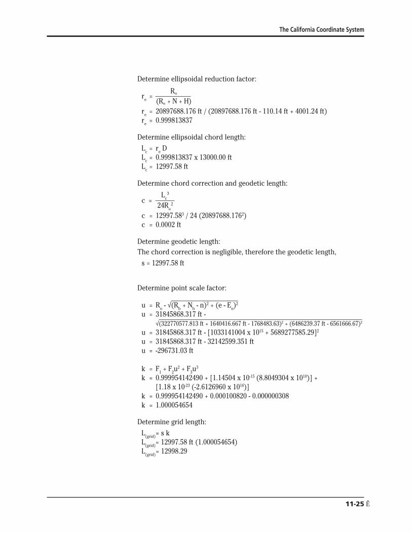
The California Coordinate System
Determine ellipsoidal reduction factor
Ra
e r =(Ra + N + H)
re = 20897688176 ft (20897688176 ft - 11014 ft + 400124 ft) r = 0999813837 e
Determine ellipsoidal chord length
L = r D c e
L = 0999813837 x 1300000 ft c
L = 1299758 ft c
Determine chord correction and geodetic length
L 3
c = c
24R 2 a
c = 12997583 24 (208976881762) c = 00002 ft
Determine geodetic length The chord correction is negligible therefore the geodetic length
s = 1299758 ft
Determine point scale factor
u = R o - radic(Rb + Nb - n)2 + (e - Eo)2
u = 31845868317 ft shyradic(322770577813 ft + 1640416667 ft - 176848363)2 + (648623937 ft - 656166667)2
u = 31845868317 ft - [1033141004 x 1015 + 568927758529]2
u = 31845868317 ft - 32142599351 ft u = -29673103 ft
k = F1 + F2u2 + F3u
3
k = 0999954142490 + [114504 x 10-15 (88049304 x 1010)] + [118 x 10-23 (-26126960 x 1016)]
k = 0999954142490 + 0000100820 - 0000000308 k = 1000054654
Determine grid length
L = s k(grid)
L = 1299758 ft (1000054654) (grid)
L = 1299829 (grid)
11-25Ecirc
Caltrans LSLSIT Video Exam Preparation Course
8
Determine combined factor
cf = re k = (0999813837) 1000054654 = 0999868481
Reducing measured distance Determine radius of curvature of ellipsoid
r oR plusmn = a k o
R a plusmn = 20896729860 ft0999954142490 R plusmn = 20897688176 ft a
Determine ellipsoidal reduction factor
R a
e r = (Ra + N + H)
re = 20897688176 ft(20897688176 ft + 0 + 5200 ft) r = 09997512306 e
Determine ellipsoidal chord length
L = r D c e
Lc = (09997512306) (6000000 ft) L = 5998507 ft c
Determine chord correction
L3 c c = 24R2
a
c = 59985073(24)(208976881762) c = 0000021 ft
Determine geodetic length
The chord correction is negligible therefore the geodetic length s = 5998507 ft
Determine point scale factor
Scale factor for 32deg 36 from Project Table = 10000356 2060 diff = (0333) (-00000037) = -00000012 k = 10000344
Determine grid length
L = s k (grid)
L = (5998507 ft) (10000344)(grid)
L = 5998713 ft(grid)
11-26
The California Coordinate System
Determine combined factor
cf = r k e
cf = (09997512306) (10000344) cf = 09997856
Determine grid length
L = cf (D)(grid)
L = 09997856 x 600000 ft(grid)
L = 5998714 ft(grid)
9 Convert grid length to ground length Determine point scale factor
ΔB= B - B o
ΔB= 325166666667deg - 333339229447deg ΔB= -08172562780deg
u = ΔB [L1 + ΔB (L2 + ΔB (L3 + (-004335871457)))] u = ΔB [L1 + ΔB (L2 + ΔB(184962412854))] u = ΔB [L1 + ΔB (L2 + (-151161693099))] u = ΔB [L1 + ΔB (142206306901)] u = ΔB [L1 + (-116218997086)] u = ΔB [3638502731] u = -2973589199 ft
k = F1 + F2u2 + F3u
3
k = 0999954142490 + (114504 x 10-15) (-29735891992) + (118 x 10-23) (-29735891993)
k = 100005507933
Determine geodetic length
L(grid)= s k 200000000 ft = s x 100005507933 s = 200000000 ft100005507933 s = 199988985 ft
Determine radius of curvature of the ellipsoid
oR plusmn =r
a k o
Ra plusmn = 20896729860 ft 0999954142490 R plusmn = 20897688176 ft a
11-27Ecirc
Caltrans LSLSIT Video Exam Preparation Course
Determine chord correction L3
c c = 24R2 a
c = 1999889853[(24) (208976881762)] use geodetic length as approximate ellipsoidal chord c = 0763 ft
Determine ellipsoidal chord length
s = L + c c
L + 0763 ft = 199988985 ft c
L = 199988222 ft c
Determine ellipsoidal reduction factor
Rare = (Ra + N + H)
re = 20897688176 ft(20897688176 ft + 0 + 3800) r = 099981819476 e
Determine level ground length
L = r D c e
199988222 ft = 099981819476 x D D = 199988222 ft099981819476 D = 200024587
11-28Ecirc
The California Coordinate System
Appendix 1 State of California Public Resources Code Division 8 Surveying and Mapping Chapter 1 California Coordinate System
Section 8801 California Coordinate System Defined
(a) The system of plane coordinates which has been established by the United States Coast and Geodetic Survey for defining and stating the positions or locations of points on the surface of the earth within the State of California is based on the North American Datum of 1927 and is identified as the ldquoCalifornia Coordinate Systemrdquo After January 1 1987 this system shall be known as the ldquoCalifornia Coordinate System of 1927rdquo
(b) The system of plane coordinates which has been established by the National Geodetic Survey for defining and stating the positions or locations of points on the surface of the earth within the State of California and which is based on the North American Datum of 1983 shall be known as the ldquoCalifornia Coordinate System of 1983rdquo
(c) As used in this chapter (1) ldquoNAD27rdquo means the North American Datum of 1927 (2) ldquoCCS27rdquo means the California Coordinate System of 1927 (3) ldquoNAD83rdquo means the North American Datum of 1983 (4) ldquoCCS83rdquo means the California Coordinate System of 1983 (5) ldquoUSCampGSrdquo means the United States Coast and Geodetic Survey (6) ldquoNGSrdquo means the National Geodetic Survey (7) ldquoFGCCrdquo means the Federal Geodetic Control Committee
(d) The use of the term ldquoState Plane Coordinatesrdquo refers only to CCS27 and CCS83 coordinates
Section 8802 Delineation of Zones
For CCS27 the state is divided into seven zones For CCS83 the state is divided into six zones Zone 7 of CCS27 which encompasses Los Angeles County is eliminated and the area is included in Zone 5
11-29Ecirc
Caltrans LSLSIT Video Exam Preparation Course
Each zone of CCS27 is a Lambert conformal conic projection based on Clarkersquos Spheroid of 1866 which is the basis of NAD27 The points of control of zones one to six inclusive bear the coordinates Northing (y) = 00000 feet and Easting (x) = 2000000 feet The point of control of Zone 7 bears the coordinates Northing (y) = 416092674 feet and Easting (x) = 418669258 feet
Each zone of CCS83 is a Lambert conformal conic projection based on the Geodetic Reference System of 1980 which is the basis of NAD83 The point of control of each of the six zones bear the coordinates Northing (y) = 500000 meters and Easting (x) = 2000000 meters
The area included in the following counties constitutes Zone 1 of CCS27 and CCS83 Del Norte Humboldt Lassen Modoc Plumas Shasta Siskiyou Tehama and Trinity
The area included in the following counties constitutes Zone 2 of CCS27 and CCS83 Alpine Amador Butte Colusa El Dorado Glenn Lake Mendocino Napa Nevada Placer Sacramento Sierra Solano Sonoma Sutter Yolo Yuba
The area included in the following counties constitutes Zone 3 of CCS27 and CCS83 Alameda Calaveras Contra Costa Madera Marin Mariposa Merced Mono San Francisco San Joaquin San Mateo Santa Clara Santa Cruz Stanislaus and Tuolumne
The area included in the following counties constitutes Zone 4 of CCS27 and CCS83 Fresno Inyo Kings Monterey San Benito and Tulare
The area included in the following counties and Channel Islands constitutes Zone 5 of CCS27 Kern San Bernardino San Luis Obispo Santa Barbara (excepting Santa Barbara Island) and Ventura (excepting San Nicholas Island) and the Channel Islands of Santa Cruz Santa Rosa San Miguel and Anacapa
The area included in the following counties and Channel Islands constitutes Zone 5 of CCS83 Kern Los Angeles (excepting San Clemente and Santa Catalina Islands) San Bernardino San Luis Obispo Santa Barbara (excepting Santa Barbara Island) and Ventura excepting San Nicholas Island) and the Channel Islands of Santa Cruz Santa Rosa San Miguel and Anacapa
The area included in the following counties and Channel Islands constitutes Zone 6 of CCS27 and CCS83 Imperial Orange Riverside and San Diego and the Channel Islands of San Clemente Santa Catalina Santa Barbara and San Nicholas
The area included in Los Angeles County constitutes Zone 7 of CCS27
11-30
The California Coordinate System
Section 8803 Definition of Zone 1
Zone 1 coordinates shall be named and on any map on which they are used they shall be designated as ldquoCCS27 Zone 1 or CCS83 Zone 1rdquo
On their respective spheroids of reference (1) the standard parallels of CCS27 Zone 1 and CCS83 Zone 1 are at north latitudes 40 degrees 00 minutes and 41 degrees 40 minutes along which parallels the scale shall be exact and (2) the point of control of coordinates is at the intersection of the zonersquos central meridian which is at 122 degrees 00 minutes west longitude with the parallel 39 degrees 20 minutes north latitude
Section 8804 Definition of Zone 2
Zone 2 coordinates shall be named and on any map on which they are used they shall be designated as ldquoCCS27 Zone 2 or CCS83 Zone 2rdquo
On their respective spheroids of reference (1) the standard parallels of CCS27 Zone 2 and CCS83 Zone 2 are at north latitudes 38 degrees 20 minutes and 39 degrees 50 minutes along which parallels the scale shall be exact and (2) the point of control of coordinates is at the intersection of the zonersquos central meridian which is at 122 degrees 00 minutes west longitude with the parallel 37 degrees 40 minutes north latitude
Section 8805 Definition of Zone 3
Zone 3 coordinates shall be named and on any map on which they are used they shall be designated as ldquoCCS27 Zone 3 or CCS83 Zone 3rdquo
On their respective spheroids of reference (1) the standard parallels of CCS27 Zone 3 and CCS83 Zone 3 are at north latitudes 37 degrees 04 minutes and 38 degrees 26 minutes along which parallels the scale shall be exact and (2) the point of control of coordinates is at the intersection of the zonersquos central meridian which is at 120 degrees 30 minutes west longitude with the parallel 36 degrees 30 minutes north latitude
Section 8806 Definition of Zone 4
Zone 4 coordinates shall be named and on any map on which they are used they shall be designated as ldquoCCS27 Zone 4 or CCS83 Zone 4rdquo
On their respective spheroids of reference (1) the standard parallels of CCS27 Zone 4 and CCS83 Zone 4 are at north latitudes 36 degrees 00 minutes and 37 degrees 15 minutes along which parallels the scale shall be exact and (2) the point of control of coordinates is at the intersection of the zonersquos central meridian which is at 119 degrees 00 minutes west longitude with the parallel 35 degrees 20 minutes north latitude
11-31Ecirc
Caltrans LSLSIT Video Exam Preparation Course
Section 8807 Definition of Zone 5
Zone 5 coordinates shall be named and on any map on which they are used they shall be designated as ldquoCCS27 Zone 5 or CCS83 Zone 5rdquo
On their respective spheroids of reference (1) the standard parallels of CCS27 Zone 5 and CCS83 Zone 5 are at north latitudes 34 degrees 02 minutes and 35 degrees 28 minutes along which parallels the scale shall be exact and (2) the point of control of coordinates is at the intersection of the zonersquos central meridian which is at 118 degrees 00 minutes west longitude with the parallel 33 degrees 30 minutes north latitude
Section 8808 Definition of Zone 6
Zone 6 coordinates shall be named and on any map on which they are used they shall be designated as ldquoCCS27 Zone 6 or CCS83 Zone 6rdquo
On their respective spheroids of reference (1) the standard parallels of CCS27 Zone 6 and CCS83 Zone 6 are at north latitudes 32 degrees 47 minutes and 33 degrees 53 minutes along which parallels the scale shall be exact and (2) the point of control of coordinates is at the intersection of the zonersquos central meridian which is at 116 degrees 15 minutes west longitude with the parallel 32 degrees 10 minutes north latitude
Section 8809 Definition of Zone 7
Zone 7 coordinates shall be named and on any map on which they are used they shall be designated as ldquoCCS27 Zone 7rdquo
On its respective spheroid of reference (1) the standard parallels of CCS27 Zone 7 are at north latitudes 33 degrees 52 minutes and 34 degrees 25 minutes along which parallels the scale shall be exact and (2) the point of control of coordinates is at the intersection of the zonersquos central meridian which is at 118 degrees 20 minutes west longitude with the parallel 34 degrees 08 minutes north latitude
Section 8810 Definition of US Survey Foot and Coordinates
The plane coordinates of a point on the earthrsquos surface to be used in expressing the position or location of the point in the appropriate zone of CCS27 or CCS83 shall consist of two distances expressed in feet and decimals of a foot or meters and decimals of a meter When the values are expressed in feet the ldquoUS Survey footrdquo (one foot = 12003937 meters) shall be used as the standard foot for CCS27 and CCS83 One of these distances to be known as the ldquoEast x-coordinaterdquo shall give the distance east of the Y axis the other to be known as the ldquoNorth y-coordinaterdquo shall give the distance north of the X axis The Y axis of any zone shall be parallel with the
11-32
The California Coordinate System
central meridian of that zone The X axis of any zone shall be at right angles to the central meridian of that zone
Section 8811 Sources of Plane Coordinates
The state plane coordinates of a point in any zone shall be based upon the plane coordinates of published horizontal control stations or derived from published horizontal control stations of the USCampGS and the NGS or their successors
Section 8813 Requires Accuracy of Stations and Data Required
The CCS27 and CCS83 shall be based on monumented first- and second-order stations which have been published by USCampGS and NGS or their successors The geodetic positions of CCS27 and CCS83 stations which are used to increase the density of control and which purport to be of first- or second-order accuracy shall have been surveyed in conformity with first- or second-order survey standards and specifications in effect at the time of the survey as defined by the Federal Geodetic Control Committee Any survey or map which is to be based on state plane coordinates shall show established field-measured connections to at least two stations of corresponding accuracy or better whose credentials are based upon published stations of USCampGS or NGS or their successors If an FGCC order of accuracy is claimed for a survey or a map it shall be justified by additional written data that shows equipment procedures closures adjustments and a control diagram
Section 8814 Use of Coordinates and Constructive Notice
State plane coordinates may be used for property identification on any map survey conveyance or other instrument which delineates or affects the title to real property or which delineates describes or refers to the property or any part thereof However to constitute when recorded constructive notice thereof under the recording laws the delineating describing or referring to the property or part thereof shall also refer to data appearing of record in any office the records of which constitute constructive notice under the recording laws That record data shall be sufficient to identify the property without recourse to those coordinates and in case of conflict between them the references to that recorded data shall be controlling for the purpose of determining constructive notice under the recording laws
Section 8815 Identification of California Coordinate System
The use of the term ldquoCalifornia Coordinate Systemrdquo on any map or document or any field notes shall be suffixed either with ldquo27rdquo (shown as ldquoCCS27rdquo) for coordinates based on NAD27 or with ldquo83rdquo (shown as ldquoCCS83rdquo) for coordinates based on NAD83
11-33Ecirc
Caltrans LSLSIT Video Exam Preparation Course
Section 8816 Use Optional
The use of the State Plane Coordinates by any person corporation or governmental agency engaged in land surveying or mapping is optional
Section 8817 CCS83 Use After January 1 1995
Prior to January 1 1995 use of State Plane Coordinates for new projects may be based either on CCS27 or CCS83 On or after January 1 1995 when State Plane Coordinates are used on new surveys and new mapping projects the use shall be limited to CCS83
Section 8818 Land Titles Referred to CCS27
This chapter does not impair or invalidate land titles legal descriptions or jurisdictional or land boundaries and further this chapter does not impair or invalidate references to or the use of CCS27 coordinates except as provided in Section 8817
Section 8819 Use of New Technologies
This chapter does not prohibit the use of new geodetic surveying technologies for which FGCC specifications have not yet been published except that if first- or second-order accuracy is claimed for any of the resulting monumented stations the state plane coordinates shall conform to FGCC accuracy standards
11-34
The California Coordinate System
Appendix 2
Symbols and Notations a = geodetic azimuth the clockwise angle between geodetic north and
the geodetic line to the object observed
+ = the plane convergence angle the major component of the difference between geodetic azimuth and grid azimuth also sometimes called mapping angle
o = arc to chord correction also known as second term or ldquot - Trdquo (A correction applied to long lines of precise surveys to compensate for distortion of straight lines when projected onto the grid This correction is usually minute and can be neglected for most courses under five miles long)
a = 6378137 m (exact) or 209256044742 ft the equatorial radius of the GRS80 ellipsoid
b = 6356752314140347 m = 208554448840 ft = the semiminor axis of the GRS80 ellipsoid
B = north geodetic latitude of a station also noted as oslash
Bb = north geodetic latitude of the parallel passing through grid origin a tabled constant
Bn = north geodetic latitude of the northerly standard parallel where the cone intersects the ellipsoid (Line of exact scale)
Bo = the latitude of the central parallel passing through the projection origin a tabled constant for each zone also noted as _o
Bs = north geodetic latitude of the southerly standard parallel where the cone intersects the ellipsoid (Line of exact scale)
cf = combined factor for simultaneously applying average ellipsoidal reduction and scale factors
D = ground level horizontal measured distance
Eo = easting of projection origin and central meridian 6561666667 ft or 20000000000 m for all zones
e2 = 0006694380022903416 = the square of the first eccentricity of the GRS80 ellipsoid
e ft2 = 0006739496775481622 = the square of the second eccentricity of the GRS80 ellipsoid
11-35Ecirc
Caltrans LSLSIT Video Exam Preparation Course
F1 F2 F3 = polynomial coefficients tabled with the zone constants
G1 G2 G3 G4 = polynomial coefficients for inverse conversion tabled with the zone constants
h = geodetic height elevation using the ellipsoid for its datum Related to MSL datum by the formula h = N + H
H = elevation using the geoid for its datum this is approximately elevation based on mean sea level
k = point grid scale factor
K = mapping radius on the cone at the equatorial plane of the ellipsoid
ko = grid scale factor of the central parallel Bo a tabled constant
L = west geodetic longitude of station also noted as A
Lc = ellipsoidal chord length
L(grid) = grid length distance between two points on the grid plane
Lo = longitude of the central meridian passing through the projection and grid origin a tabled constant also noted as A o
Ls = measured slope length
L1 L2 L3 L4 = polynomial coefficients for direct computation tabled with the zone constants
Mo = radius of curvature of the ellipsoid in the meridian at the projection origin scaled to the grid
N = geoid separation or height the distance at a station from the geoid to the ellipsoid it is negative within the contiguous 48 states
Nb = northing of grid base a tabled constant equalling 1640416667 ft or 5000000000 m for all zones
No = northing of the projection origin a tabled constant
p = 1f = flattening-1 = 2982572221008827 for GRS80
R = mapping radius through a station
R a = radius of curvature of the ellipsoid in the azimuth
Rb = mapping radius through the grid base a tabled constant
re = ellipsoidal reduction factor also known as elevation factor
ro = geometric mean radius of the ellipsoid at the projection origin scaled to the grid
11-36
The California Coordinate System
Ro = mapping radius through the projection origin a tabled constant
s = geodetic length the ellipsoidal arc length of a line
sinBo = sine of the latitude of the projection origin which is also the ratio between + and longitude in decimals of a degree a tabled constant
t = grid azimuth the clockwise angle at a station between the grid meridian (grid north) and the grid line to the observed object (All grid meridians are straight and parallel Grid azimuths are related to geodetic azimuths by the formula t = a - + + ogt
T = projected geodetic azimuth (Azimuth of a straight line of the ellipsoid when projected onto the grid is slightly curved)
u = radial distance on the projection from the station to the central parallel Ro - R
Constants for the Geodetic Reference System of 1980 GRS80 Ellipsoid
a = 6378137 m (exact) = 209256044742 ft = the equatorial radius of the ellipsoid
b = 6356752314140347 m = 208554448840 ft = the semiminor axis
p = 1f = 2982572221008827 = flattening-1
e2 = 0006694380022903416 = the square of the first eccentricity
e ft2 = 0006739496775481622 = the square of the second eccentricity
11-37Ecirc
Caltrans LSLSIT Video Exam Preparation Course
Appendix 3 North American Datum 1983 (NAD83) ndash California Coordinate System 1983 (CCS83)
CALIFORNIA ZONE 1 CA01 ZONE 0401 Meters US Survey Feet Bs = 40deg 00 N Bs = 40deg 00 N Bn = 41deg 40 N B = 41deg 40 N Bb = 39deg 20 N Bb
n
= 39deg 20 N Lo = 122deg 00 W Lo = 122deg 00 W Nb = 5000000000 m Nb = 1640416667 ft Eo = 20000000000 m E = 6561666667 ft o
Bo = 408351061249deg N B = 408351061249deg N o SinBo = 0653884305400 SinB = 0653884305400 o Rb = 75565546408 m Rb = 24791796351 ft Ro = 73898020597 m R = 24244708924 ft o No = 6667525811 m N = 2187504093 ft o K = 122878263052 m K = 40314310136 ft ko = 0999894636561 k = 0999894636561 o Mo = 63620672798 m M = 20872882401 ft o ro = 6374328 m ro = 20913107780 ft
L1 = 1110390203 L1 = 3643005191 L2 = 965524 L2 = 316772 L3 = 563491 L3 = 184872 L4 = 0021275 L4 = 0069800
G1 = 9005843038E-06 G1 = 2744986448E-06 G2 = -705240E-15 G2 = -655192E-16 G3 = -370393E-20 G3 = -104884E-21 G4 = -11142E-27 G4 = -96167E-30
F1 = 0999894636561 F1 = 0999894636561 F2 = 123062E-14 F2 = 114329E-15 F3 = 547E-22 F3 = 155E-23
The customary limits of the zone are from 39deg 20 N to 42deg 20 N
11-38
The California Coordinate System
North American Datum 1983 (NAD83) ndash California Coordinate System 1983 (CCS83)
CALIFORNIA ZONE 2 CA02 ZONE 0402
Meters US Survey Feet B = 38deg 20 N B = 38deg 20 N s s
B = 39deg 50 N B = 39deg 50 N n n
Bb = 37deg 40 N Bb = 37deg 40 N L = 122deg 00 W L = 122deg 00 W o o
Nb = 5000000000 m Nb = 1640416667 ft E = 20000000000 m E = 6561666667 ft o o
B = 390846839219deg N B = 390846839219deg N o o
SinB = 0630468335285 SinB = 0630468335285 o o
Rb = 80197889307 m Rb = 26311590850 ft R = 78623814027 m R = 25795162985 ft o o
N = 6574075280 m N = 2156844531 ft o o
K = 125203516538 m K = 41077187051 ft k = 0999914672977 k = 0999914672977 o o
M = 63602683937 m M = 20866980555 ft o o
r = 6373169 m r = 20909305294 ft o o
L1 = 1110076240 L1 = 3641975131 L2 = 954628 L2 = 313198 L3 = 563874 L3 = 184998 L4 = 0019988 L4 = 0065577
G1 = 9008390180E-06 G1 = 2745762818E-06 G2 = -697872E-15 G2 = -648347E-16 G3 = -371084E-20 G3 = -105080E-21 G4 = -10411E-27 G4 = -89858E-30
F1 = 0999914672977 F1 = 0999914672977 F2 = 123106E-14 F2 = 114370E-15 F3 = 514E-22 F3 = 146E-23
The customary limits of the zone are from 37deg 40 N to 40deg 30 N
11-39Ecirc
Caltrans LSLSIT Video Exam Preparation Course
North American Datum 1983 (NAD83) ndash California Coordinate System 1983 (CCS83)
CALIFORNIA ZONE 3 CA03 ZONE 0403
Meters US Survey Feet B = 37deg 04 N B = 37deg 04 N
s s
Bn = 38deg 26 N Bn = 38deg 26 N Bb = 36deg 30 N Bb = 36deg 30 N L = 120deg 30 W L = 120deg 30 W
o o
Nb = 5000000000 m Nb = 1640416667 ft E = 20000000000 m E = 6561666667 ft
o o
B = 377510694363deg N B = 377510694363deg N o o
SinBo = 0612232038295 SinBo = 0612232038295 Rb = 83857751723 m Rb = 27512330711 ft R = 82469303684 m R = 27056804050 ft
o o
N = 6388448039 m N = 2095943327 ft o o
K = 127245749735 m K = 41747209726 ft k = 0999929178853 k = 0999929178853
o o
M = 63589096841 m M = 20862522855 ft o o
ro = 6372292 m ro = 20906428003 ft
L1 = 1109839104 L1 = 3641197127 L2 = 943943 L2 = 309692 L3 = 564142 L3 = 185086 L4 = 0019048 L4 = 0062493
G1 = 9010315015E-06 G1 = 2746349509E-06 G2 = -690503E-15 G2 = -641501E-16 G3 = -371614E-20 G3 = -105230E-21 G4 = -98819E-28 G4 = -85291E-30
F1 = 0999929178853 F1 = 0999929178853 F2 = 123137E-14 F2 = 114398E-15 F3 = 489E-22 F3 = 138E-23
The customary limits of the zone are from 36deg 30 N to 39deg 00 N
11-40
The California Coordinate System
North American Datum 1983 (NAD83) ndash California Coordinate System 1983 (CCS83)
CALIFORNIA ZONE 4 CA04 ZONE 0404
Meters US Survey Feet B = 36deg 00 N B = 36deg 00 N s s
B = 37deg 15 N B = 37deg 15 N n n
Bb = 35deg 20 N Bb = 35deg 20 N L = 119deg 00 W L = 119deg 00 W o o
Nb = 5000000000 m Nb = 1640416667 ft E = 20000000000 m E = 6561666667 ft o o
B = 366258593071deg N B = 366258593071deg N o o
SinB = 0596587149880 SinB = 0596587149880 o o
Rb = 87332273793 m Rb = 28652263494 ft R = 85898068935 m R = 28181724783 ft o o
N = 6434204858 m N = 2110955377 ft o o
K = 129169860281 m K = 42378478327 ft k = 0999940761703 k = 0999940761703 o o
M = 63577728978 m M = 20858793249 ft o o
r = 6371557 m r = 20904016591 ft o o
L1 = 1109640696 L1 = 3640546183 L2 = 933334 L2 = 306211 L3 = 564410 L3 = 185174 L4 = 0018382 L4 = 0060308
G1 = 9011926076E-06 G1 = 2746840562E-06 G2 = -683121E-15 G2 = -634643E-16 G3 = -372043E-20 G3 = -105351E-21 G4 = -94223E-28 G4 = -81324E-30
F1 = 0999940761703 F1 = 0999940761703 F2 = 123168E-14 F2 = 114427E-15 F3 = 470E-22 F3 = 133E-23
The customary limits of the zone are from 35deg 20 N to 38deg 00 N
11-41Ecirc
Caltrans LSLSIT Video Exam Preparation Course
North American Datum 1983 (NAD83) ndash California Coordinate System 1983 (CCS83)
CALIFORNIA ZONE 5 CA05 ZONE 0405
Meters US Survey Feet B = 34deg 02 N B = 34deg 02 N s s
B = 35deg 28 N B = 35deg 28 N n n
Bb = 33deg 30 N Bb = 33deg 30 N L = 118deg 00 W L = 118deg 00 W o o
Nb = 5000000000 m Nb = 1640416667 ft E = 20000000000 m E = 6561666667 ft o o
B = 347510553142deg N B = 347510553142deg N o o
SinB = 0570011896174 SinB = 0570011896174 o o
Rb = 93417561389 m Rb = 30648744932 ft R = 92029831099 m R = 30193453753 ft o o
N = 6387730290 m N = 2095707846 ft o o
K = 132826248345 m K = 43578078311 ft k = 0999922127209 k = 0999922127209 o o
M = 63556709697 m M = 20851897173 ft o o
r = 6370113 m r = 20899279068 ft o o
L1 = 1109273840 L1 = 3639342590 L2 = 912439 L2 = 299356 L3 = 564805 L3 = 185303 L4 = 0017445 L4 = 0057234
G1 = 9014906468E-06 G1 = 2747748987E-06 G2 = -668534E-15 G2 = -621091E-16 G3 = -372796E-20 G3 = -105565E-21 G4 = -86394E-28 G4 = -74567E-30
F1 = 0999922127209 F1 = 0999922127209 F2 = 123221E-14 F2 = 114477E-15 F3 = 441E-22 F3 = 125E-23
The customary limits of the zone are from 33deg 30 N to 36deg 20 N
11-42
The California Coordinate System
North American Datum 1983 (NAD83) ndash California Coordinate System 1983 (CCS83)
CALIFORNIA ZONE 6 CA06 ZONE 0406
Meters US Survey Feet B = 32deg 47 N B = 32deg 47 N s s
B = 33deg 53 N B = 33deg 53 N n n
Bb = 32deg 10 N Bb = 32deg 10 N L = 116deg 15 W L = 116deg 15 W o o
Nb = 5000000000 m Nb = 1640416667 ft E = 20000000000 m E = 6561666667 ft o o
B = 333339229447deg N B = 333339229447deg N o o
SinB = 0549517575763 SinB = 0549517575763 o o
Rb = 98360917896 m Rb = 32270577813 ft R = 97066400762 m R = 31845868317 ft o o
N = 6294517134 m N = 2065126163 ft o o
K = 136020267133 m K = 44625982642 ft k = 0999954142490 k = 0999954142490 o o
M = 63544072007 m M = 20847750958 ft o o
r = 6369336 m r = 20896729860 ft o o
L1 = 1109053274 L1 = 3638618950 L2 = 894188 L2 = 293368 L3 = 565087 L3 = 185396 L4 = 0016171 L4 = 0053054
G1 = 9016699372E-06 G1 = 2748295465E-06 G2 = -655499E-15 G2 = -608981E-16 G3 = -373318E-20 G3 = -105713E-21 G4 = -82753E-28 G4 = -71424E-30
F1 = 0999954142490 F1 = 0999954142490 F2 = 123251E-14 F2 = 114504E-15 F3 = 415E-22 F3 = 118E-23
The customary limits of the zone are from 32deg 10 N to 34deg 30 N
11-43Ecirc
Caltrans LSLSIT Video Exam Preparation Course
References Alexander I A and Alexander R J (1989) ldquoProjection Tables California
Coordinate System NAD83rdquo California Land Surveyors Association Special Publication No 5588
Burkholder E F (1984) ldquoGeometrical Parameters of the Geodetic Reference System 1980rdquo Surveying and Mapping Vol 44 No 4 pp 339shy340
Fronczek C J (1980) ldquoUse of Calibration Base Linesrdquo NOAA Technical Memorandum NOS NGS- 10 National Geodetic Information Center NOAA Rockville MD 20852
Meade B K (1987) ldquoProgram for Computing Universal Mercator (UTM) Coordinates for Latitudes North or South and Longitudes East or Westrdquo Surveying and Mapping Vol 47 No 1 pp 37-49
Stem J E (1989) ldquoState Plane Coordinate System of 1983rdquo NOAA Manual NOS NGS 5 National Geodetic Information Center NOAA Rockville MD 20852
Stoughton H W and Berry R M (1985) ldquoSimple Algorithms for Calculation of Scale Factors for Plane Coordinate Systems (1927 NAD and 1983 NAD)rdquo Surveying and Mapping Vol 45 No 3 pp 247-259
Vincenty T (1985) ldquoPrecise Determination of the Scale Factor from Lambert Conical Projection Coordinatesrdquo Surveying and Mapping Vol 45 No 4 pp 315-318
Vincenty T (1986) ldquoGeometric Reduction of Measured Linesrdquo Surveying and Mapping Vol 46 No 3 pp 225-229
Vincenty T (1986) ldquoUse of Polynomial Coefficients in Conversions of Coordinates on the Lambert Conformal Conic Projectionrdquo Surveying and Mapping Vol 46 No 1 pp 15-18
Vincenty T (1986) ldquoLambert Conformal Conic Projection Arc-to-chord Correctionrdquo Surveying and Mapping Vol 46 No 2 pp 163-167
Vincenty T (1986) ldquoApplication of the Chord Method to Solutions of Geodetic Linesrdquo Surveying and Mapping Vol 46 No 4 pp 287-292
State Plane Coordinate System of 1983 by James E Stem is an excellent source of information concerning NAD83 procedures for the surveyor It thoroughly deals with corrections to lengths and azimuths It and other publications are available by phone The National Geodetic Information Center number for phone orders is currently (301) 443-8631 They accept credit cards and have a listing of their publications which they will mail free of charge
11-44
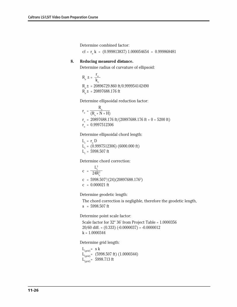
Caltrans LSLSIT Video Exam Preparation Course
8
Determine combined factor
cf = re k = (0999813837) 1000054654 = 0999868481
Reducing measured distance Determine radius of curvature of ellipsoid
r oR plusmn = a k o
R a plusmn = 20896729860 ft0999954142490 R plusmn = 20897688176 ft a
Determine ellipsoidal reduction factor
R a
e r = (Ra + N + H)
re = 20897688176 ft(20897688176 ft + 0 + 5200 ft) r = 09997512306 e
Determine ellipsoidal chord length
L = r D c e
Lc = (09997512306) (6000000 ft) L = 5998507 ft c
Determine chord correction
L3 c c = 24R2
a
c = 59985073(24)(208976881762) c = 0000021 ft
Determine geodetic length
The chord correction is negligible therefore the geodetic length s = 5998507 ft
Determine point scale factor
Scale factor for 32deg 36 from Project Table = 10000356 2060 diff = (0333) (-00000037) = -00000012 k = 10000344
Determine grid length
L = s k (grid)
L = (5998507 ft) (10000344)(grid)
L = 5998713 ft(grid)
11-26
The California Coordinate System
Determine combined factor
cf = r k e
cf = (09997512306) (10000344) cf = 09997856
Determine grid length
L = cf (D)(grid)
L = 09997856 x 600000 ft(grid)
L = 5998714 ft(grid)
9 Convert grid length to ground length Determine point scale factor
ΔB= B - B o
ΔB= 325166666667deg - 333339229447deg ΔB= -08172562780deg
u = ΔB [L1 + ΔB (L2 + ΔB (L3 + (-004335871457)))] u = ΔB [L1 + ΔB (L2 + ΔB(184962412854))] u = ΔB [L1 + ΔB (L2 + (-151161693099))] u = ΔB [L1 + ΔB (142206306901)] u = ΔB [L1 + (-116218997086)] u = ΔB [3638502731] u = -2973589199 ft
k = F1 + F2u2 + F3u
3
k = 0999954142490 + (114504 x 10-15) (-29735891992) + (118 x 10-23) (-29735891993)
k = 100005507933
Determine geodetic length
L(grid)= s k 200000000 ft = s x 100005507933 s = 200000000 ft100005507933 s = 199988985 ft
Determine radius of curvature of the ellipsoid
oR plusmn =r
a k o
Ra plusmn = 20896729860 ft 0999954142490 R plusmn = 20897688176 ft a
11-27Ecirc
Caltrans LSLSIT Video Exam Preparation Course
Determine chord correction L3
c c = 24R2 a
c = 1999889853[(24) (208976881762)] use geodetic length as approximate ellipsoidal chord c = 0763 ft
Determine ellipsoidal chord length
s = L + c c
L + 0763 ft = 199988985 ft c
L = 199988222 ft c
Determine ellipsoidal reduction factor
Rare = (Ra + N + H)
re = 20897688176 ft(20897688176 ft + 0 + 3800) r = 099981819476 e
Determine level ground length
L = r D c e
199988222 ft = 099981819476 x D D = 199988222 ft099981819476 D = 200024587
11-28Ecirc
The California Coordinate System
Appendix 1 State of California Public Resources Code Division 8 Surveying and Mapping Chapter 1 California Coordinate System
Section 8801 California Coordinate System Defined
(a) The system of plane coordinates which has been established by the United States Coast and Geodetic Survey for defining and stating the positions or locations of points on the surface of the earth within the State of California is based on the North American Datum of 1927 and is identified as the ldquoCalifornia Coordinate Systemrdquo After January 1 1987 this system shall be known as the ldquoCalifornia Coordinate System of 1927rdquo
(b) The system of plane coordinates which has been established by the National Geodetic Survey for defining and stating the positions or locations of points on the surface of the earth within the State of California and which is based on the North American Datum of 1983 shall be known as the ldquoCalifornia Coordinate System of 1983rdquo
(c) As used in this chapter (1) ldquoNAD27rdquo means the North American Datum of 1927 (2) ldquoCCS27rdquo means the California Coordinate System of 1927 (3) ldquoNAD83rdquo means the North American Datum of 1983 (4) ldquoCCS83rdquo means the California Coordinate System of 1983 (5) ldquoUSCampGSrdquo means the United States Coast and Geodetic Survey (6) ldquoNGSrdquo means the National Geodetic Survey (7) ldquoFGCCrdquo means the Federal Geodetic Control Committee
(d) The use of the term ldquoState Plane Coordinatesrdquo refers only to CCS27 and CCS83 coordinates
Section 8802 Delineation of Zones
For CCS27 the state is divided into seven zones For CCS83 the state is divided into six zones Zone 7 of CCS27 which encompasses Los Angeles County is eliminated and the area is included in Zone 5
11-29Ecirc
Caltrans LSLSIT Video Exam Preparation Course
Each zone of CCS27 is a Lambert conformal conic projection based on Clarkersquos Spheroid of 1866 which is the basis of NAD27 The points of control of zones one to six inclusive bear the coordinates Northing (y) = 00000 feet and Easting (x) = 2000000 feet The point of control of Zone 7 bears the coordinates Northing (y) = 416092674 feet and Easting (x) = 418669258 feet
Each zone of CCS83 is a Lambert conformal conic projection based on the Geodetic Reference System of 1980 which is the basis of NAD83 The point of control of each of the six zones bear the coordinates Northing (y) = 500000 meters and Easting (x) = 2000000 meters
The area included in the following counties constitutes Zone 1 of CCS27 and CCS83 Del Norte Humboldt Lassen Modoc Plumas Shasta Siskiyou Tehama and Trinity
The area included in the following counties constitutes Zone 2 of CCS27 and CCS83 Alpine Amador Butte Colusa El Dorado Glenn Lake Mendocino Napa Nevada Placer Sacramento Sierra Solano Sonoma Sutter Yolo Yuba
The area included in the following counties constitutes Zone 3 of CCS27 and CCS83 Alameda Calaveras Contra Costa Madera Marin Mariposa Merced Mono San Francisco San Joaquin San Mateo Santa Clara Santa Cruz Stanislaus and Tuolumne
The area included in the following counties constitutes Zone 4 of CCS27 and CCS83 Fresno Inyo Kings Monterey San Benito and Tulare
The area included in the following counties and Channel Islands constitutes Zone 5 of CCS27 Kern San Bernardino San Luis Obispo Santa Barbara (excepting Santa Barbara Island) and Ventura (excepting San Nicholas Island) and the Channel Islands of Santa Cruz Santa Rosa San Miguel and Anacapa
The area included in the following counties and Channel Islands constitutes Zone 5 of CCS83 Kern Los Angeles (excepting San Clemente and Santa Catalina Islands) San Bernardino San Luis Obispo Santa Barbara (excepting Santa Barbara Island) and Ventura excepting San Nicholas Island) and the Channel Islands of Santa Cruz Santa Rosa San Miguel and Anacapa
The area included in the following counties and Channel Islands constitutes Zone 6 of CCS27 and CCS83 Imperial Orange Riverside and San Diego and the Channel Islands of San Clemente Santa Catalina Santa Barbara and San Nicholas
The area included in Los Angeles County constitutes Zone 7 of CCS27
11-30
The California Coordinate System
Section 8803 Definition of Zone 1
Zone 1 coordinates shall be named and on any map on which they are used they shall be designated as ldquoCCS27 Zone 1 or CCS83 Zone 1rdquo
On their respective spheroids of reference (1) the standard parallels of CCS27 Zone 1 and CCS83 Zone 1 are at north latitudes 40 degrees 00 minutes and 41 degrees 40 minutes along which parallels the scale shall be exact and (2) the point of control of coordinates is at the intersection of the zonersquos central meridian which is at 122 degrees 00 minutes west longitude with the parallel 39 degrees 20 minutes north latitude
Section 8804 Definition of Zone 2
Zone 2 coordinates shall be named and on any map on which they are used they shall be designated as ldquoCCS27 Zone 2 or CCS83 Zone 2rdquo
On their respective spheroids of reference (1) the standard parallels of CCS27 Zone 2 and CCS83 Zone 2 are at north latitudes 38 degrees 20 minutes and 39 degrees 50 minutes along which parallels the scale shall be exact and (2) the point of control of coordinates is at the intersection of the zonersquos central meridian which is at 122 degrees 00 minutes west longitude with the parallel 37 degrees 40 minutes north latitude
Section 8805 Definition of Zone 3
Zone 3 coordinates shall be named and on any map on which they are used they shall be designated as ldquoCCS27 Zone 3 or CCS83 Zone 3rdquo
On their respective spheroids of reference (1) the standard parallels of CCS27 Zone 3 and CCS83 Zone 3 are at north latitudes 37 degrees 04 minutes and 38 degrees 26 minutes along which parallels the scale shall be exact and (2) the point of control of coordinates is at the intersection of the zonersquos central meridian which is at 120 degrees 30 minutes west longitude with the parallel 36 degrees 30 minutes north latitude
Section 8806 Definition of Zone 4
Zone 4 coordinates shall be named and on any map on which they are used they shall be designated as ldquoCCS27 Zone 4 or CCS83 Zone 4rdquo
On their respective spheroids of reference (1) the standard parallels of CCS27 Zone 4 and CCS83 Zone 4 are at north latitudes 36 degrees 00 minutes and 37 degrees 15 minutes along which parallels the scale shall be exact and (2) the point of control of coordinates is at the intersection of the zonersquos central meridian which is at 119 degrees 00 minutes west longitude with the parallel 35 degrees 20 minutes north latitude
11-31Ecirc
Caltrans LSLSIT Video Exam Preparation Course
Section 8807 Definition of Zone 5
Zone 5 coordinates shall be named and on any map on which they are used they shall be designated as ldquoCCS27 Zone 5 or CCS83 Zone 5rdquo
On their respective spheroids of reference (1) the standard parallels of CCS27 Zone 5 and CCS83 Zone 5 are at north latitudes 34 degrees 02 minutes and 35 degrees 28 minutes along which parallels the scale shall be exact and (2) the point of control of coordinates is at the intersection of the zonersquos central meridian which is at 118 degrees 00 minutes west longitude with the parallel 33 degrees 30 minutes north latitude
Section 8808 Definition of Zone 6
Zone 6 coordinates shall be named and on any map on which they are used they shall be designated as ldquoCCS27 Zone 6 or CCS83 Zone 6rdquo
On their respective spheroids of reference (1) the standard parallels of CCS27 Zone 6 and CCS83 Zone 6 are at north latitudes 32 degrees 47 minutes and 33 degrees 53 minutes along which parallels the scale shall be exact and (2) the point of control of coordinates is at the intersection of the zonersquos central meridian which is at 116 degrees 15 minutes west longitude with the parallel 32 degrees 10 minutes north latitude
Section 8809 Definition of Zone 7
Zone 7 coordinates shall be named and on any map on which they are used they shall be designated as ldquoCCS27 Zone 7rdquo
On its respective spheroid of reference (1) the standard parallels of CCS27 Zone 7 are at north latitudes 33 degrees 52 minutes and 34 degrees 25 minutes along which parallels the scale shall be exact and (2) the point of control of coordinates is at the intersection of the zonersquos central meridian which is at 118 degrees 20 minutes west longitude with the parallel 34 degrees 08 minutes north latitude
Section 8810 Definition of US Survey Foot and Coordinates
The plane coordinates of a point on the earthrsquos surface to be used in expressing the position or location of the point in the appropriate zone of CCS27 or CCS83 shall consist of two distances expressed in feet and decimals of a foot or meters and decimals of a meter When the values are expressed in feet the ldquoUS Survey footrdquo (one foot = 12003937 meters) shall be used as the standard foot for CCS27 and CCS83 One of these distances to be known as the ldquoEast x-coordinaterdquo shall give the distance east of the Y axis the other to be known as the ldquoNorth y-coordinaterdquo shall give the distance north of the X axis The Y axis of any zone shall be parallel with the
11-32
The California Coordinate System
central meridian of that zone The X axis of any zone shall be at right angles to the central meridian of that zone
Section 8811 Sources of Plane Coordinates
The state plane coordinates of a point in any zone shall be based upon the plane coordinates of published horizontal control stations or derived from published horizontal control stations of the USCampGS and the NGS or their successors
Section 8813 Requires Accuracy of Stations and Data Required
The CCS27 and CCS83 shall be based on monumented first- and second-order stations which have been published by USCampGS and NGS or their successors The geodetic positions of CCS27 and CCS83 stations which are used to increase the density of control and which purport to be of first- or second-order accuracy shall have been surveyed in conformity with first- or second-order survey standards and specifications in effect at the time of the survey as defined by the Federal Geodetic Control Committee Any survey or map which is to be based on state plane coordinates shall show established field-measured connections to at least two stations of corresponding accuracy or better whose credentials are based upon published stations of USCampGS or NGS or their successors If an FGCC order of accuracy is claimed for a survey or a map it shall be justified by additional written data that shows equipment procedures closures adjustments and a control diagram
Section 8814 Use of Coordinates and Constructive Notice
State plane coordinates may be used for property identification on any map survey conveyance or other instrument which delineates or affects the title to real property or which delineates describes or refers to the property or any part thereof However to constitute when recorded constructive notice thereof under the recording laws the delineating describing or referring to the property or part thereof shall also refer to data appearing of record in any office the records of which constitute constructive notice under the recording laws That record data shall be sufficient to identify the property without recourse to those coordinates and in case of conflict between them the references to that recorded data shall be controlling for the purpose of determining constructive notice under the recording laws
Section 8815 Identification of California Coordinate System
The use of the term ldquoCalifornia Coordinate Systemrdquo on any map or document or any field notes shall be suffixed either with ldquo27rdquo (shown as ldquoCCS27rdquo) for coordinates based on NAD27 or with ldquo83rdquo (shown as ldquoCCS83rdquo) for coordinates based on NAD83
11-33Ecirc
Caltrans LSLSIT Video Exam Preparation Course
Section 8816 Use Optional
The use of the State Plane Coordinates by any person corporation or governmental agency engaged in land surveying or mapping is optional
Section 8817 CCS83 Use After January 1 1995
Prior to January 1 1995 use of State Plane Coordinates for new projects may be based either on CCS27 or CCS83 On or after January 1 1995 when State Plane Coordinates are used on new surveys and new mapping projects the use shall be limited to CCS83
Section 8818 Land Titles Referred to CCS27
This chapter does not impair or invalidate land titles legal descriptions or jurisdictional or land boundaries and further this chapter does not impair or invalidate references to or the use of CCS27 coordinates except as provided in Section 8817
Section 8819 Use of New Technologies
This chapter does not prohibit the use of new geodetic surveying technologies for which FGCC specifications have not yet been published except that if first- or second-order accuracy is claimed for any of the resulting monumented stations the state plane coordinates shall conform to FGCC accuracy standards
11-34
The California Coordinate System
Appendix 2
Symbols and Notations a = geodetic azimuth the clockwise angle between geodetic north and
the geodetic line to the object observed
+ = the plane convergence angle the major component of the difference between geodetic azimuth and grid azimuth also sometimes called mapping angle
o = arc to chord correction also known as second term or ldquot - Trdquo (A correction applied to long lines of precise surveys to compensate for distortion of straight lines when projected onto the grid This correction is usually minute and can be neglected for most courses under five miles long)
a = 6378137 m (exact) or 209256044742 ft the equatorial radius of the GRS80 ellipsoid
b = 6356752314140347 m = 208554448840 ft = the semiminor axis of the GRS80 ellipsoid
B = north geodetic latitude of a station also noted as oslash
Bb = north geodetic latitude of the parallel passing through grid origin a tabled constant
Bn = north geodetic latitude of the northerly standard parallel where the cone intersects the ellipsoid (Line of exact scale)
Bo = the latitude of the central parallel passing through the projection origin a tabled constant for each zone also noted as _o
Bs = north geodetic latitude of the southerly standard parallel where the cone intersects the ellipsoid (Line of exact scale)
cf = combined factor for simultaneously applying average ellipsoidal reduction and scale factors
D = ground level horizontal measured distance
Eo = easting of projection origin and central meridian 6561666667 ft or 20000000000 m for all zones
e2 = 0006694380022903416 = the square of the first eccentricity of the GRS80 ellipsoid
e ft2 = 0006739496775481622 = the square of the second eccentricity of the GRS80 ellipsoid
11-35Ecirc
Caltrans LSLSIT Video Exam Preparation Course
F1 F2 F3 = polynomial coefficients tabled with the zone constants
G1 G2 G3 G4 = polynomial coefficients for inverse conversion tabled with the zone constants
h = geodetic height elevation using the ellipsoid for its datum Related to MSL datum by the formula h = N + H
H = elevation using the geoid for its datum this is approximately elevation based on mean sea level
k = point grid scale factor
K = mapping radius on the cone at the equatorial plane of the ellipsoid
ko = grid scale factor of the central parallel Bo a tabled constant
L = west geodetic longitude of station also noted as A
Lc = ellipsoidal chord length
L(grid) = grid length distance between two points on the grid plane
Lo = longitude of the central meridian passing through the projection and grid origin a tabled constant also noted as A o
Ls = measured slope length
L1 L2 L3 L4 = polynomial coefficients for direct computation tabled with the zone constants
Mo = radius of curvature of the ellipsoid in the meridian at the projection origin scaled to the grid
N = geoid separation or height the distance at a station from the geoid to the ellipsoid it is negative within the contiguous 48 states
Nb = northing of grid base a tabled constant equalling 1640416667 ft or 5000000000 m for all zones
No = northing of the projection origin a tabled constant
p = 1f = flattening-1 = 2982572221008827 for GRS80
R = mapping radius through a station
R a = radius of curvature of the ellipsoid in the azimuth
Rb = mapping radius through the grid base a tabled constant
re = ellipsoidal reduction factor also known as elevation factor
ro = geometric mean radius of the ellipsoid at the projection origin scaled to the grid
11-36
The California Coordinate System
Ro = mapping radius through the projection origin a tabled constant
s = geodetic length the ellipsoidal arc length of a line
sinBo = sine of the latitude of the projection origin which is also the ratio between + and longitude in decimals of a degree a tabled constant
t = grid azimuth the clockwise angle at a station between the grid meridian (grid north) and the grid line to the observed object (All grid meridians are straight and parallel Grid azimuths are related to geodetic azimuths by the formula t = a - + + ogt
T = projected geodetic azimuth (Azimuth of a straight line of the ellipsoid when projected onto the grid is slightly curved)
u = radial distance on the projection from the station to the central parallel Ro - R
Constants for the Geodetic Reference System of 1980 GRS80 Ellipsoid
a = 6378137 m (exact) = 209256044742 ft = the equatorial radius of the ellipsoid
b = 6356752314140347 m = 208554448840 ft = the semiminor axis
p = 1f = 2982572221008827 = flattening-1
e2 = 0006694380022903416 = the square of the first eccentricity
e ft2 = 0006739496775481622 = the square of the second eccentricity
11-37Ecirc
Caltrans LSLSIT Video Exam Preparation Course
Appendix 3 North American Datum 1983 (NAD83) ndash California Coordinate System 1983 (CCS83)
CALIFORNIA ZONE 1 CA01 ZONE 0401 Meters US Survey Feet Bs = 40deg 00 N Bs = 40deg 00 N Bn = 41deg 40 N B = 41deg 40 N Bb = 39deg 20 N Bb
n
= 39deg 20 N Lo = 122deg 00 W Lo = 122deg 00 W Nb = 5000000000 m Nb = 1640416667 ft Eo = 20000000000 m E = 6561666667 ft o
Bo = 408351061249deg N B = 408351061249deg N o SinBo = 0653884305400 SinB = 0653884305400 o Rb = 75565546408 m Rb = 24791796351 ft Ro = 73898020597 m R = 24244708924 ft o No = 6667525811 m N = 2187504093 ft o K = 122878263052 m K = 40314310136 ft ko = 0999894636561 k = 0999894636561 o Mo = 63620672798 m M = 20872882401 ft o ro = 6374328 m ro = 20913107780 ft
L1 = 1110390203 L1 = 3643005191 L2 = 965524 L2 = 316772 L3 = 563491 L3 = 184872 L4 = 0021275 L4 = 0069800
G1 = 9005843038E-06 G1 = 2744986448E-06 G2 = -705240E-15 G2 = -655192E-16 G3 = -370393E-20 G3 = -104884E-21 G4 = -11142E-27 G4 = -96167E-30
F1 = 0999894636561 F1 = 0999894636561 F2 = 123062E-14 F2 = 114329E-15 F3 = 547E-22 F3 = 155E-23
The customary limits of the zone are from 39deg 20 N to 42deg 20 N
11-38
The California Coordinate System
North American Datum 1983 (NAD83) ndash California Coordinate System 1983 (CCS83)
CALIFORNIA ZONE 2 CA02 ZONE 0402
Meters US Survey Feet B = 38deg 20 N B = 38deg 20 N s s
B = 39deg 50 N B = 39deg 50 N n n
Bb = 37deg 40 N Bb = 37deg 40 N L = 122deg 00 W L = 122deg 00 W o o
Nb = 5000000000 m Nb = 1640416667 ft E = 20000000000 m E = 6561666667 ft o o
B = 390846839219deg N B = 390846839219deg N o o
SinB = 0630468335285 SinB = 0630468335285 o o
Rb = 80197889307 m Rb = 26311590850 ft R = 78623814027 m R = 25795162985 ft o o
N = 6574075280 m N = 2156844531 ft o o
K = 125203516538 m K = 41077187051 ft k = 0999914672977 k = 0999914672977 o o
M = 63602683937 m M = 20866980555 ft o o
r = 6373169 m r = 20909305294 ft o o
L1 = 1110076240 L1 = 3641975131 L2 = 954628 L2 = 313198 L3 = 563874 L3 = 184998 L4 = 0019988 L4 = 0065577
G1 = 9008390180E-06 G1 = 2745762818E-06 G2 = -697872E-15 G2 = -648347E-16 G3 = -371084E-20 G3 = -105080E-21 G4 = -10411E-27 G4 = -89858E-30
F1 = 0999914672977 F1 = 0999914672977 F2 = 123106E-14 F2 = 114370E-15 F3 = 514E-22 F3 = 146E-23
The customary limits of the zone are from 37deg 40 N to 40deg 30 N
11-39Ecirc
Caltrans LSLSIT Video Exam Preparation Course
North American Datum 1983 (NAD83) ndash California Coordinate System 1983 (CCS83)
CALIFORNIA ZONE 3 CA03 ZONE 0403
Meters US Survey Feet B = 37deg 04 N B = 37deg 04 N
s s
Bn = 38deg 26 N Bn = 38deg 26 N Bb = 36deg 30 N Bb = 36deg 30 N L = 120deg 30 W L = 120deg 30 W
o o
Nb = 5000000000 m Nb = 1640416667 ft E = 20000000000 m E = 6561666667 ft
o o
B = 377510694363deg N B = 377510694363deg N o o
SinBo = 0612232038295 SinBo = 0612232038295 Rb = 83857751723 m Rb = 27512330711 ft R = 82469303684 m R = 27056804050 ft
o o
N = 6388448039 m N = 2095943327 ft o o
K = 127245749735 m K = 41747209726 ft k = 0999929178853 k = 0999929178853
o o
M = 63589096841 m M = 20862522855 ft o o
ro = 6372292 m ro = 20906428003 ft
L1 = 1109839104 L1 = 3641197127 L2 = 943943 L2 = 309692 L3 = 564142 L3 = 185086 L4 = 0019048 L4 = 0062493
G1 = 9010315015E-06 G1 = 2746349509E-06 G2 = -690503E-15 G2 = -641501E-16 G3 = -371614E-20 G3 = -105230E-21 G4 = -98819E-28 G4 = -85291E-30
F1 = 0999929178853 F1 = 0999929178853 F2 = 123137E-14 F2 = 114398E-15 F3 = 489E-22 F3 = 138E-23
The customary limits of the zone are from 36deg 30 N to 39deg 00 N
11-40
The California Coordinate System
North American Datum 1983 (NAD83) ndash California Coordinate System 1983 (CCS83)
CALIFORNIA ZONE 4 CA04 ZONE 0404
Meters US Survey Feet B = 36deg 00 N B = 36deg 00 N s s
B = 37deg 15 N B = 37deg 15 N n n
Bb = 35deg 20 N Bb = 35deg 20 N L = 119deg 00 W L = 119deg 00 W o o
Nb = 5000000000 m Nb = 1640416667 ft E = 20000000000 m E = 6561666667 ft o o
B = 366258593071deg N B = 366258593071deg N o o
SinB = 0596587149880 SinB = 0596587149880 o o
Rb = 87332273793 m Rb = 28652263494 ft R = 85898068935 m R = 28181724783 ft o o
N = 6434204858 m N = 2110955377 ft o o
K = 129169860281 m K = 42378478327 ft k = 0999940761703 k = 0999940761703 o o
M = 63577728978 m M = 20858793249 ft o o
r = 6371557 m r = 20904016591 ft o o
L1 = 1109640696 L1 = 3640546183 L2 = 933334 L2 = 306211 L3 = 564410 L3 = 185174 L4 = 0018382 L4 = 0060308
G1 = 9011926076E-06 G1 = 2746840562E-06 G2 = -683121E-15 G2 = -634643E-16 G3 = -372043E-20 G3 = -105351E-21 G4 = -94223E-28 G4 = -81324E-30
F1 = 0999940761703 F1 = 0999940761703 F2 = 123168E-14 F2 = 114427E-15 F3 = 470E-22 F3 = 133E-23
The customary limits of the zone are from 35deg 20 N to 38deg 00 N
11-41Ecirc
Caltrans LSLSIT Video Exam Preparation Course
North American Datum 1983 (NAD83) ndash California Coordinate System 1983 (CCS83)
CALIFORNIA ZONE 5 CA05 ZONE 0405
Meters US Survey Feet B = 34deg 02 N B = 34deg 02 N s s
B = 35deg 28 N B = 35deg 28 N n n
Bb = 33deg 30 N Bb = 33deg 30 N L = 118deg 00 W L = 118deg 00 W o o
Nb = 5000000000 m Nb = 1640416667 ft E = 20000000000 m E = 6561666667 ft o o
B = 347510553142deg N B = 347510553142deg N o o
SinB = 0570011896174 SinB = 0570011896174 o o
Rb = 93417561389 m Rb = 30648744932 ft R = 92029831099 m R = 30193453753 ft o o
N = 6387730290 m N = 2095707846 ft o o
K = 132826248345 m K = 43578078311 ft k = 0999922127209 k = 0999922127209 o o
M = 63556709697 m M = 20851897173 ft o o
r = 6370113 m r = 20899279068 ft o o
L1 = 1109273840 L1 = 3639342590 L2 = 912439 L2 = 299356 L3 = 564805 L3 = 185303 L4 = 0017445 L4 = 0057234
G1 = 9014906468E-06 G1 = 2747748987E-06 G2 = -668534E-15 G2 = -621091E-16 G3 = -372796E-20 G3 = -105565E-21 G4 = -86394E-28 G4 = -74567E-30
F1 = 0999922127209 F1 = 0999922127209 F2 = 123221E-14 F2 = 114477E-15 F3 = 441E-22 F3 = 125E-23
The customary limits of the zone are from 33deg 30 N to 36deg 20 N
11-42
The California Coordinate System
North American Datum 1983 (NAD83) ndash California Coordinate System 1983 (CCS83)
CALIFORNIA ZONE 6 CA06 ZONE 0406
Meters US Survey Feet B = 32deg 47 N B = 32deg 47 N s s
B = 33deg 53 N B = 33deg 53 N n n
Bb = 32deg 10 N Bb = 32deg 10 N L = 116deg 15 W L = 116deg 15 W o o
Nb = 5000000000 m Nb = 1640416667 ft E = 20000000000 m E = 6561666667 ft o o
B = 333339229447deg N B = 333339229447deg N o o
SinB = 0549517575763 SinB = 0549517575763 o o
Rb = 98360917896 m Rb = 32270577813 ft R = 97066400762 m R = 31845868317 ft o o
N = 6294517134 m N = 2065126163 ft o o
K = 136020267133 m K = 44625982642 ft k = 0999954142490 k = 0999954142490 o o
M = 63544072007 m M = 20847750958 ft o o
r = 6369336 m r = 20896729860 ft o o
L1 = 1109053274 L1 = 3638618950 L2 = 894188 L2 = 293368 L3 = 565087 L3 = 185396 L4 = 0016171 L4 = 0053054
G1 = 9016699372E-06 G1 = 2748295465E-06 G2 = -655499E-15 G2 = -608981E-16 G3 = -373318E-20 G3 = -105713E-21 G4 = -82753E-28 G4 = -71424E-30
F1 = 0999954142490 F1 = 0999954142490 F2 = 123251E-14 F2 = 114504E-15 F3 = 415E-22 F3 = 118E-23
The customary limits of the zone are from 32deg 10 N to 34deg 30 N
11-43Ecirc
Caltrans LSLSIT Video Exam Preparation Course
References Alexander I A and Alexander R J (1989) ldquoProjection Tables California
Coordinate System NAD83rdquo California Land Surveyors Association Special Publication No 5588
Burkholder E F (1984) ldquoGeometrical Parameters of the Geodetic Reference System 1980rdquo Surveying and Mapping Vol 44 No 4 pp 339shy340
Fronczek C J (1980) ldquoUse of Calibration Base Linesrdquo NOAA Technical Memorandum NOS NGS- 10 National Geodetic Information Center NOAA Rockville MD 20852
Meade B K (1987) ldquoProgram for Computing Universal Mercator (UTM) Coordinates for Latitudes North or South and Longitudes East or Westrdquo Surveying and Mapping Vol 47 No 1 pp 37-49
Stem J E (1989) ldquoState Plane Coordinate System of 1983rdquo NOAA Manual NOS NGS 5 National Geodetic Information Center NOAA Rockville MD 20852
Stoughton H W and Berry R M (1985) ldquoSimple Algorithms for Calculation of Scale Factors for Plane Coordinate Systems (1927 NAD and 1983 NAD)rdquo Surveying and Mapping Vol 45 No 3 pp 247-259
Vincenty T (1985) ldquoPrecise Determination of the Scale Factor from Lambert Conical Projection Coordinatesrdquo Surveying and Mapping Vol 45 No 4 pp 315-318
Vincenty T (1986) ldquoGeometric Reduction of Measured Linesrdquo Surveying and Mapping Vol 46 No 3 pp 225-229
Vincenty T (1986) ldquoUse of Polynomial Coefficients in Conversions of Coordinates on the Lambert Conformal Conic Projectionrdquo Surveying and Mapping Vol 46 No 1 pp 15-18
Vincenty T (1986) ldquoLambert Conformal Conic Projection Arc-to-chord Correctionrdquo Surveying and Mapping Vol 46 No 2 pp 163-167
Vincenty T (1986) ldquoApplication of the Chord Method to Solutions of Geodetic Linesrdquo Surveying and Mapping Vol 46 No 4 pp 287-292
State Plane Coordinate System of 1983 by James E Stem is an excellent source of information concerning NAD83 procedures for the surveyor It thoroughly deals with corrections to lengths and azimuths It and other publications are available by phone The National Geodetic Information Center number for phone orders is currently (301) 443-8631 They accept credit cards and have a listing of their publications which they will mail free of charge
11-44

The California Coordinate System
Determine combined factor
cf = r k e
cf = (09997512306) (10000344) cf = 09997856
Determine grid length
L = cf (D)(grid)
L = 09997856 x 600000 ft(grid)
L = 5998714 ft(grid)
9 Convert grid length to ground length Determine point scale factor
ΔB= B - B o
ΔB= 325166666667deg - 333339229447deg ΔB= -08172562780deg
u = ΔB [L1 + ΔB (L2 + ΔB (L3 + (-004335871457)))] u = ΔB [L1 + ΔB (L2 + ΔB(184962412854))] u = ΔB [L1 + ΔB (L2 + (-151161693099))] u = ΔB [L1 + ΔB (142206306901)] u = ΔB [L1 + (-116218997086)] u = ΔB [3638502731] u = -2973589199 ft
k = F1 + F2u2 + F3u
3
k = 0999954142490 + (114504 x 10-15) (-29735891992) + (118 x 10-23) (-29735891993)
k = 100005507933
Determine geodetic length
L(grid)= s k 200000000 ft = s x 100005507933 s = 200000000 ft100005507933 s = 199988985 ft
Determine radius of curvature of the ellipsoid
oR plusmn =r
a k o
Ra plusmn = 20896729860 ft 0999954142490 R plusmn = 20897688176 ft a
11-27Ecirc
Caltrans LSLSIT Video Exam Preparation Course
Determine chord correction L3
c c = 24R2 a
c = 1999889853[(24) (208976881762)] use geodetic length as approximate ellipsoidal chord c = 0763 ft
Determine ellipsoidal chord length
s = L + c c
L + 0763 ft = 199988985 ft c
L = 199988222 ft c
Determine ellipsoidal reduction factor
Rare = (Ra + N + H)
re = 20897688176 ft(20897688176 ft + 0 + 3800) r = 099981819476 e
Determine level ground length
L = r D c e
199988222 ft = 099981819476 x D D = 199988222 ft099981819476 D = 200024587
11-28Ecirc
The California Coordinate System
Appendix 1 State of California Public Resources Code Division 8 Surveying and Mapping Chapter 1 California Coordinate System
Section 8801 California Coordinate System Defined
(a) The system of plane coordinates which has been established by the United States Coast and Geodetic Survey for defining and stating the positions or locations of points on the surface of the earth within the State of California is based on the North American Datum of 1927 and is identified as the ldquoCalifornia Coordinate Systemrdquo After January 1 1987 this system shall be known as the ldquoCalifornia Coordinate System of 1927rdquo
(b) The system of plane coordinates which has been established by the National Geodetic Survey for defining and stating the positions or locations of points on the surface of the earth within the State of California and which is based on the North American Datum of 1983 shall be known as the ldquoCalifornia Coordinate System of 1983rdquo
(c) As used in this chapter (1) ldquoNAD27rdquo means the North American Datum of 1927 (2) ldquoCCS27rdquo means the California Coordinate System of 1927 (3) ldquoNAD83rdquo means the North American Datum of 1983 (4) ldquoCCS83rdquo means the California Coordinate System of 1983 (5) ldquoUSCampGSrdquo means the United States Coast and Geodetic Survey (6) ldquoNGSrdquo means the National Geodetic Survey (7) ldquoFGCCrdquo means the Federal Geodetic Control Committee
(d) The use of the term ldquoState Plane Coordinatesrdquo refers only to CCS27 and CCS83 coordinates
Section 8802 Delineation of Zones
For CCS27 the state is divided into seven zones For CCS83 the state is divided into six zones Zone 7 of CCS27 which encompasses Los Angeles County is eliminated and the area is included in Zone 5
11-29Ecirc
Caltrans LSLSIT Video Exam Preparation Course
Each zone of CCS27 is a Lambert conformal conic projection based on Clarkersquos Spheroid of 1866 which is the basis of NAD27 The points of control of zones one to six inclusive bear the coordinates Northing (y) = 00000 feet and Easting (x) = 2000000 feet The point of control of Zone 7 bears the coordinates Northing (y) = 416092674 feet and Easting (x) = 418669258 feet
Each zone of CCS83 is a Lambert conformal conic projection based on the Geodetic Reference System of 1980 which is the basis of NAD83 The point of control of each of the six zones bear the coordinates Northing (y) = 500000 meters and Easting (x) = 2000000 meters
The area included in the following counties constitutes Zone 1 of CCS27 and CCS83 Del Norte Humboldt Lassen Modoc Plumas Shasta Siskiyou Tehama and Trinity
The area included in the following counties constitutes Zone 2 of CCS27 and CCS83 Alpine Amador Butte Colusa El Dorado Glenn Lake Mendocino Napa Nevada Placer Sacramento Sierra Solano Sonoma Sutter Yolo Yuba
The area included in the following counties constitutes Zone 3 of CCS27 and CCS83 Alameda Calaveras Contra Costa Madera Marin Mariposa Merced Mono San Francisco San Joaquin San Mateo Santa Clara Santa Cruz Stanislaus and Tuolumne
The area included in the following counties constitutes Zone 4 of CCS27 and CCS83 Fresno Inyo Kings Monterey San Benito and Tulare
The area included in the following counties and Channel Islands constitutes Zone 5 of CCS27 Kern San Bernardino San Luis Obispo Santa Barbara (excepting Santa Barbara Island) and Ventura (excepting San Nicholas Island) and the Channel Islands of Santa Cruz Santa Rosa San Miguel and Anacapa
The area included in the following counties and Channel Islands constitutes Zone 5 of CCS83 Kern Los Angeles (excepting San Clemente and Santa Catalina Islands) San Bernardino San Luis Obispo Santa Barbara (excepting Santa Barbara Island) and Ventura excepting San Nicholas Island) and the Channel Islands of Santa Cruz Santa Rosa San Miguel and Anacapa
The area included in the following counties and Channel Islands constitutes Zone 6 of CCS27 and CCS83 Imperial Orange Riverside and San Diego and the Channel Islands of San Clemente Santa Catalina Santa Barbara and San Nicholas
The area included in Los Angeles County constitutes Zone 7 of CCS27
11-30
The California Coordinate System
Section 8803 Definition of Zone 1
Zone 1 coordinates shall be named and on any map on which they are used they shall be designated as ldquoCCS27 Zone 1 or CCS83 Zone 1rdquo
On their respective spheroids of reference (1) the standard parallels of CCS27 Zone 1 and CCS83 Zone 1 are at north latitudes 40 degrees 00 minutes and 41 degrees 40 minutes along which parallels the scale shall be exact and (2) the point of control of coordinates is at the intersection of the zonersquos central meridian which is at 122 degrees 00 minutes west longitude with the parallel 39 degrees 20 minutes north latitude
Section 8804 Definition of Zone 2
Zone 2 coordinates shall be named and on any map on which they are used they shall be designated as ldquoCCS27 Zone 2 or CCS83 Zone 2rdquo
On their respective spheroids of reference (1) the standard parallels of CCS27 Zone 2 and CCS83 Zone 2 are at north latitudes 38 degrees 20 minutes and 39 degrees 50 minutes along which parallels the scale shall be exact and (2) the point of control of coordinates is at the intersection of the zonersquos central meridian which is at 122 degrees 00 minutes west longitude with the parallel 37 degrees 40 minutes north latitude
Section 8805 Definition of Zone 3
Zone 3 coordinates shall be named and on any map on which they are used they shall be designated as ldquoCCS27 Zone 3 or CCS83 Zone 3rdquo
On their respective spheroids of reference (1) the standard parallels of CCS27 Zone 3 and CCS83 Zone 3 are at north latitudes 37 degrees 04 minutes and 38 degrees 26 minutes along which parallels the scale shall be exact and (2) the point of control of coordinates is at the intersection of the zonersquos central meridian which is at 120 degrees 30 minutes west longitude with the parallel 36 degrees 30 minutes north latitude
Section 8806 Definition of Zone 4
Zone 4 coordinates shall be named and on any map on which they are used they shall be designated as ldquoCCS27 Zone 4 or CCS83 Zone 4rdquo
On their respective spheroids of reference (1) the standard parallels of CCS27 Zone 4 and CCS83 Zone 4 are at north latitudes 36 degrees 00 minutes and 37 degrees 15 minutes along which parallels the scale shall be exact and (2) the point of control of coordinates is at the intersection of the zonersquos central meridian which is at 119 degrees 00 minutes west longitude with the parallel 35 degrees 20 minutes north latitude
11-31Ecirc
Caltrans LSLSIT Video Exam Preparation Course
Section 8807 Definition of Zone 5
Zone 5 coordinates shall be named and on any map on which they are used they shall be designated as ldquoCCS27 Zone 5 or CCS83 Zone 5rdquo
On their respective spheroids of reference (1) the standard parallels of CCS27 Zone 5 and CCS83 Zone 5 are at north latitudes 34 degrees 02 minutes and 35 degrees 28 minutes along which parallels the scale shall be exact and (2) the point of control of coordinates is at the intersection of the zonersquos central meridian which is at 118 degrees 00 minutes west longitude with the parallel 33 degrees 30 minutes north latitude
Section 8808 Definition of Zone 6
Zone 6 coordinates shall be named and on any map on which they are used they shall be designated as ldquoCCS27 Zone 6 or CCS83 Zone 6rdquo
On their respective spheroids of reference (1) the standard parallels of CCS27 Zone 6 and CCS83 Zone 6 are at north latitudes 32 degrees 47 minutes and 33 degrees 53 minutes along which parallels the scale shall be exact and (2) the point of control of coordinates is at the intersection of the zonersquos central meridian which is at 116 degrees 15 minutes west longitude with the parallel 32 degrees 10 minutes north latitude
Section 8809 Definition of Zone 7
Zone 7 coordinates shall be named and on any map on which they are used they shall be designated as ldquoCCS27 Zone 7rdquo
On its respective spheroid of reference (1) the standard parallels of CCS27 Zone 7 are at north latitudes 33 degrees 52 minutes and 34 degrees 25 minutes along which parallels the scale shall be exact and (2) the point of control of coordinates is at the intersection of the zonersquos central meridian which is at 118 degrees 20 minutes west longitude with the parallel 34 degrees 08 minutes north latitude
Section 8810 Definition of US Survey Foot and Coordinates
The plane coordinates of a point on the earthrsquos surface to be used in expressing the position or location of the point in the appropriate zone of CCS27 or CCS83 shall consist of two distances expressed in feet and decimals of a foot or meters and decimals of a meter When the values are expressed in feet the ldquoUS Survey footrdquo (one foot = 12003937 meters) shall be used as the standard foot for CCS27 and CCS83 One of these distances to be known as the ldquoEast x-coordinaterdquo shall give the distance east of the Y axis the other to be known as the ldquoNorth y-coordinaterdquo shall give the distance north of the X axis The Y axis of any zone shall be parallel with the
11-32
The California Coordinate System
central meridian of that zone The X axis of any zone shall be at right angles to the central meridian of that zone
Section 8811 Sources of Plane Coordinates
The state plane coordinates of a point in any zone shall be based upon the plane coordinates of published horizontal control stations or derived from published horizontal control stations of the USCampGS and the NGS or their successors
Section 8813 Requires Accuracy of Stations and Data Required
The CCS27 and CCS83 shall be based on monumented first- and second-order stations which have been published by USCampGS and NGS or their successors The geodetic positions of CCS27 and CCS83 stations which are used to increase the density of control and which purport to be of first- or second-order accuracy shall have been surveyed in conformity with first- or second-order survey standards and specifications in effect at the time of the survey as defined by the Federal Geodetic Control Committee Any survey or map which is to be based on state plane coordinates shall show established field-measured connections to at least two stations of corresponding accuracy or better whose credentials are based upon published stations of USCampGS or NGS or their successors If an FGCC order of accuracy is claimed for a survey or a map it shall be justified by additional written data that shows equipment procedures closures adjustments and a control diagram
Section 8814 Use of Coordinates and Constructive Notice
State plane coordinates may be used for property identification on any map survey conveyance or other instrument which delineates or affects the title to real property or which delineates describes or refers to the property or any part thereof However to constitute when recorded constructive notice thereof under the recording laws the delineating describing or referring to the property or part thereof shall also refer to data appearing of record in any office the records of which constitute constructive notice under the recording laws That record data shall be sufficient to identify the property without recourse to those coordinates and in case of conflict between them the references to that recorded data shall be controlling for the purpose of determining constructive notice under the recording laws
Section 8815 Identification of California Coordinate System
The use of the term ldquoCalifornia Coordinate Systemrdquo on any map or document or any field notes shall be suffixed either with ldquo27rdquo (shown as ldquoCCS27rdquo) for coordinates based on NAD27 or with ldquo83rdquo (shown as ldquoCCS83rdquo) for coordinates based on NAD83
11-33Ecirc
Caltrans LSLSIT Video Exam Preparation Course
Section 8816 Use Optional
The use of the State Plane Coordinates by any person corporation or governmental agency engaged in land surveying or mapping is optional
Section 8817 CCS83 Use After January 1 1995
Prior to January 1 1995 use of State Plane Coordinates for new projects may be based either on CCS27 or CCS83 On or after January 1 1995 when State Plane Coordinates are used on new surveys and new mapping projects the use shall be limited to CCS83
Section 8818 Land Titles Referred to CCS27
This chapter does not impair or invalidate land titles legal descriptions or jurisdictional or land boundaries and further this chapter does not impair or invalidate references to or the use of CCS27 coordinates except as provided in Section 8817
Section 8819 Use of New Technologies
This chapter does not prohibit the use of new geodetic surveying technologies for which FGCC specifications have not yet been published except that if first- or second-order accuracy is claimed for any of the resulting monumented stations the state plane coordinates shall conform to FGCC accuracy standards
11-34
The California Coordinate System
Appendix 2
Symbols and Notations a = geodetic azimuth the clockwise angle between geodetic north and
the geodetic line to the object observed
+ = the plane convergence angle the major component of the difference between geodetic azimuth and grid azimuth also sometimes called mapping angle
o = arc to chord correction also known as second term or ldquot - Trdquo (A correction applied to long lines of precise surveys to compensate for distortion of straight lines when projected onto the grid This correction is usually minute and can be neglected for most courses under five miles long)
a = 6378137 m (exact) or 209256044742 ft the equatorial radius of the GRS80 ellipsoid
b = 6356752314140347 m = 208554448840 ft = the semiminor axis of the GRS80 ellipsoid
B = north geodetic latitude of a station also noted as oslash
Bb = north geodetic latitude of the parallel passing through grid origin a tabled constant
Bn = north geodetic latitude of the northerly standard parallel where the cone intersects the ellipsoid (Line of exact scale)
Bo = the latitude of the central parallel passing through the projection origin a tabled constant for each zone also noted as _o
Bs = north geodetic latitude of the southerly standard parallel where the cone intersects the ellipsoid (Line of exact scale)
cf = combined factor for simultaneously applying average ellipsoidal reduction and scale factors
D = ground level horizontal measured distance
Eo = easting of projection origin and central meridian 6561666667 ft or 20000000000 m for all zones
e2 = 0006694380022903416 = the square of the first eccentricity of the GRS80 ellipsoid
e ft2 = 0006739496775481622 = the square of the second eccentricity of the GRS80 ellipsoid
11-35Ecirc
Caltrans LSLSIT Video Exam Preparation Course
F1 F2 F3 = polynomial coefficients tabled with the zone constants
G1 G2 G3 G4 = polynomial coefficients for inverse conversion tabled with the zone constants
h = geodetic height elevation using the ellipsoid for its datum Related to MSL datum by the formula h = N + H
H = elevation using the geoid for its datum this is approximately elevation based on mean sea level
k = point grid scale factor
K = mapping radius on the cone at the equatorial plane of the ellipsoid
ko = grid scale factor of the central parallel Bo a tabled constant
L = west geodetic longitude of station also noted as A
Lc = ellipsoidal chord length
L(grid) = grid length distance between two points on the grid plane
Lo = longitude of the central meridian passing through the projection and grid origin a tabled constant also noted as A o
Ls = measured slope length
L1 L2 L3 L4 = polynomial coefficients for direct computation tabled with the zone constants
Mo = radius of curvature of the ellipsoid in the meridian at the projection origin scaled to the grid
N = geoid separation or height the distance at a station from the geoid to the ellipsoid it is negative within the contiguous 48 states
Nb = northing of grid base a tabled constant equalling 1640416667 ft or 5000000000 m for all zones
No = northing of the projection origin a tabled constant
p = 1f = flattening-1 = 2982572221008827 for GRS80
R = mapping radius through a station
R a = radius of curvature of the ellipsoid in the azimuth
Rb = mapping radius through the grid base a tabled constant
re = ellipsoidal reduction factor also known as elevation factor
ro = geometric mean radius of the ellipsoid at the projection origin scaled to the grid
11-36
The California Coordinate System
Ro = mapping radius through the projection origin a tabled constant
s = geodetic length the ellipsoidal arc length of a line
sinBo = sine of the latitude of the projection origin which is also the ratio between + and longitude in decimals of a degree a tabled constant
t = grid azimuth the clockwise angle at a station between the grid meridian (grid north) and the grid line to the observed object (All grid meridians are straight and parallel Grid azimuths are related to geodetic azimuths by the formula t = a - + + ogt
T = projected geodetic azimuth (Azimuth of a straight line of the ellipsoid when projected onto the grid is slightly curved)
u = radial distance on the projection from the station to the central parallel Ro - R
Constants for the Geodetic Reference System of 1980 GRS80 Ellipsoid
a = 6378137 m (exact) = 209256044742 ft = the equatorial radius of the ellipsoid
b = 6356752314140347 m = 208554448840 ft = the semiminor axis
p = 1f = 2982572221008827 = flattening-1
e2 = 0006694380022903416 = the square of the first eccentricity
e ft2 = 0006739496775481622 = the square of the second eccentricity
11-37Ecirc
Caltrans LSLSIT Video Exam Preparation Course
Appendix 3 North American Datum 1983 (NAD83) ndash California Coordinate System 1983 (CCS83)
CALIFORNIA ZONE 1 CA01 ZONE 0401 Meters US Survey Feet Bs = 40deg 00 N Bs = 40deg 00 N Bn = 41deg 40 N B = 41deg 40 N Bb = 39deg 20 N Bb
n
= 39deg 20 N Lo = 122deg 00 W Lo = 122deg 00 W Nb = 5000000000 m Nb = 1640416667 ft Eo = 20000000000 m E = 6561666667 ft o
Bo = 408351061249deg N B = 408351061249deg N o SinBo = 0653884305400 SinB = 0653884305400 o Rb = 75565546408 m Rb = 24791796351 ft Ro = 73898020597 m R = 24244708924 ft o No = 6667525811 m N = 2187504093 ft o K = 122878263052 m K = 40314310136 ft ko = 0999894636561 k = 0999894636561 o Mo = 63620672798 m M = 20872882401 ft o ro = 6374328 m ro = 20913107780 ft
L1 = 1110390203 L1 = 3643005191 L2 = 965524 L2 = 316772 L3 = 563491 L3 = 184872 L4 = 0021275 L4 = 0069800
G1 = 9005843038E-06 G1 = 2744986448E-06 G2 = -705240E-15 G2 = -655192E-16 G3 = -370393E-20 G3 = -104884E-21 G4 = -11142E-27 G4 = -96167E-30
F1 = 0999894636561 F1 = 0999894636561 F2 = 123062E-14 F2 = 114329E-15 F3 = 547E-22 F3 = 155E-23
The customary limits of the zone are from 39deg 20 N to 42deg 20 N
11-38
The California Coordinate System
North American Datum 1983 (NAD83) ndash California Coordinate System 1983 (CCS83)
CALIFORNIA ZONE 2 CA02 ZONE 0402
Meters US Survey Feet B = 38deg 20 N B = 38deg 20 N s s
B = 39deg 50 N B = 39deg 50 N n n
Bb = 37deg 40 N Bb = 37deg 40 N L = 122deg 00 W L = 122deg 00 W o o
Nb = 5000000000 m Nb = 1640416667 ft E = 20000000000 m E = 6561666667 ft o o
B = 390846839219deg N B = 390846839219deg N o o
SinB = 0630468335285 SinB = 0630468335285 o o
Rb = 80197889307 m Rb = 26311590850 ft R = 78623814027 m R = 25795162985 ft o o
N = 6574075280 m N = 2156844531 ft o o
K = 125203516538 m K = 41077187051 ft k = 0999914672977 k = 0999914672977 o o
M = 63602683937 m M = 20866980555 ft o o
r = 6373169 m r = 20909305294 ft o o
L1 = 1110076240 L1 = 3641975131 L2 = 954628 L2 = 313198 L3 = 563874 L3 = 184998 L4 = 0019988 L4 = 0065577
G1 = 9008390180E-06 G1 = 2745762818E-06 G2 = -697872E-15 G2 = -648347E-16 G3 = -371084E-20 G3 = -105080E-21 G4 = -10411E-27 G4 = -89858E-30
F1 = 0999914672977 F1 = 0999914672977 F2 = 123106E-14 F2 = 114370E-15 F3 = 514E-22 F3 = 146E-23
The customary limits of the zone are from 37deg 40 N to 40deg 30 N
11-39Ecirc
Caltrans LSLSIT Video Exam Preparation Course
North American Datum 1983 (NAD83) ndash California Coordinate System 1983 (CCS83)
CALIFORNIA ZONE 3 CA03 ZONE 0403
Meters US Survey Feet B = 37deg 04 N B = 37deg 04 N
s s
Bn = 38deg 26 N Bn = 38deg 26 N Bb = 36deg 30 N Bb = 36deg 30 N L = 120deg 30 W L = 120deg 30 W
o o
Nb = 5000000000 m Nb = 1640416667 ft E = 20000000000 m E = 6561666667 ft
o o
B = 377510694363deg N B = 377510694363deg N o o
SinBo = 0612232038295 SinBo = 0612232038295 Rb = 83857751723 m Rb = 27512330711 ft R = 82469303684 m R = 27056804050 ft
o o
N = 6388448039 m N = 2095943327 ft o o
K = 127245749735 m K = 41747209726 ft k = 0999929178853 k = 0999929178853
o o
M = 63589096841 m M = 20862522855 ft o o
ro = 6372292 m ro = 20906428003 ft
L1 = 1109839104 L1 = 3641197127 L2 = 943943 L2 = 309692 L3 = 564142 L3 = 185086 L4 = 0019048 L4 = 0062493
G1 = 9010315015E-06 G1 = 2746349509E-06 G2 = -690503E-15 G2 = -641501E-16 G3 = -371614E-20 G3 = -105230E-21 G4 = -98819E-28 G4 = -85291E-30
F1 = 0999929178853 F1 = 0999929178853 F2 = 123137E-14 F2 = 114398E-15 F3 = 489E-22 F3 = 138E-23
The customary limits of the zone are from 36deg 30 N to 39deg 00 N
11-40
The California Coordinate System
North American Datum 1983 (NAD83) ndash California Coordinate System 1983 (CCS83)
CALIFORNIA ZONE 4 CA04 ZONE 0404
Meters US Survey Feet B = 36deg 00 N B = 36deg 00 N s s
B = 37deg 15 N B = 37deg 15 N n n
Bb = 35deg 20 N Bb = 35deg 20 N L = 119deg 00 W L = 119deg 00 W o o
Nb = 5000000000 m Nb = 1640416667 ft E = 20000000000 m E = 6561666667 ft o o
B = 366258593071deg N B = 366258593071deg N o o
SinB = 0596587149880 SinB = 0596587149880 o o
Rb = 87332273793 m Rb = 28652263494 ft R = 85898068935 m R = 28181724783 ft o o
N = 6434204858 m N = 2110955377 ft o o
K = 129169860281 m K = 42378478327 ft k = 0999940761703 k = 0999940761703 o o
M = 63577728978 m M = 20858793249 ft o o
r = 6371557 m r = 20904016591 ft o o
L1 = 1109640696 L1 = 3640546183 L2 = 933334 L2 = 306211 L3 = 564410 L3 = 185174 L4 = 0018382 L4 = 0060308
G1 = 9011926076E-06 G1 = 2746840562E-06 G2 = -683121E-15 G2 = -634643E-16 G3 = -372043E-20 G3 = -105351E-21 G4 = -94223E-28 G4 = -81324E-30
F1 = 0999940761703 F1 = 0999940761703 F2 = 123168E-14 F2 = 114427E-15 F3 = 470E-22 F3 = 133E-23
The customary limits of the zone are from 35deg 20 N to 38deg 00 N
11-41Ecirc
Caltrans LSLSIT Video Exam Preparation Course
North American Datum 1983 (NAD83) ndash California Coordinate System 1983 (CCS83)
CALIFORNIA ZONE 5 CA05 ZONE 0405
Meters US Survey Feet B = 34deg 02 N B = 34deg 02 N s s
B = 35deg 28 N B = 35deg 28 N n n
Bb = 33deg 30 N Bb = 33deg 30 N L = 118deg 00 W L = 118deg 00 W o o
Nb = 5000000000 m Nb = 1640416667 ft E = 20000000000 m E = 6561666667 ft o o
B = 347510553142deg N B = 347510553142deg N o o
SinB = 0570011896174 SinB = 0570011896174 o o
Rb = 93417561389 m Rb = 30648744932 ft R = 92029831099 m R = 30193453753 ft o o
N = 6387730290 m N = 2095707846 ft o o
K = 132826248345 m K = 43578078311 ft k = 0999922127209 k = 0999922127209 o o
M = 63556709697 m M = 20851897173 ft o o
r = 6370113 m r = 20899279068 ft o o
L1 = 1109273840 L1 = 3639342590 L2 = 912439 L2 = 299356 L3 = 564805 L3 = 185303 L4 = 0017445 L4 = 0057234
G1 = 9014906468E-06 G1 = 2747748987E-06 G2 = -668534E-15 G2 = -621091E-16 G3 = -372796E-20 G3 = -105565E-21 G4 = -86394E-28 G4 = -74567E-30
F1 = 0999922127209 F1 = 0999922127209 F2 = 123221E-14 F2 = 114477E-15 F3 = 441E-22 F3 = 125E-23
The customary limits of the zone are from 33deg 30 N to 36deg 20 N
11-42
The California Coordinate System
North American Datum 1983 (NAD83) ndash California Coordinate System 1983 (CCS83)
CALIFORNIA ZONE 6 CA06 ZONE 0406
Meters US Survey Feet B = 32deg 47 N B = 32deg 47 N s s
B = 33deg 53 N B = 33deg 53 N n n
Bb = 32deg 10 N Bb = 32deg 10 N L = 116deg 15 W L = 116deg 15 W o o
Nb = 5000000000 m Nb = 1640416667 ft E = 20000000000 m E = 6561666667 ft o o
B = 333339229447deg N B = 333339229447deg N o o
SinB = 0549517575763 SinB = 0549517575763 o o
Rb = 98360917896 m Rb = 32270577813 ft R = 97066400762 m R = 31845868317 ft o o
N = 6294517134 m N = 2065126163 ft o o
K = 136020267133 m K = 44625982642 ft k = 0999954142490 k = 0999954142490 o o
M = 63544072007 m M = 20847750958 ft o o
r = 6369336 m r = 20896729860 ft o o
L1 = 1109053274 L1 = 3638618950 L2 = 894188 L2 = 293368 L3 = 565087 L3 = 185396 L4 = 0016171 L4 = 0053054
G1 = 9016699372E-06 G1 = 2748295465E-06 G2 = -655499E-15 G2 = -608981E-16 G3 = -373318E-20 G3 = -105713E-21 G4 = -82753E-28 G4 = -71424E-30
F1 = 0999954142490 F1 = 0999954142490 F2 = 123251E-14 F2 = 114504E-15 F3 = 415E-22 F3 = 118E-23
The customary limits of the zone are from 32deg 10 N to 34deg 30 N
11-43Ecirc
Caltrans LSLSIT Video Exam Preparation Course
References Alexander I A and Alexander R J (1989) ldquoProjection Tables California
Coordinate System NAD83rdquo California Land Surveyors Association Special Publication No 5588
Burkholder E F (1984) ldquoGeometrical Parameters of the Geodetic Reference System 1980rdquo Surveying and Mapping Vol 44 No 4 pp 339shy340
Fronczek C J (1980) ldquoUse of Calibration Base Linesrdquo NOAA Technical Memorandum NOS NGS- 10 National Geodetic Information Center NOAA Rockville MD 20852
Meade B K (1987) ldquoProgram for Computing Universal Mercator (UTM) Coordinates for Latitudes North or South and Longitudes East or Westrdquo Surveying and Mapping Vol 47 No 1 pp 37-49
Stem J E (1989) ldquoState Plane Coordinate System of 1983rdquo NOAA Manual NOS NGS 5 National Geodetic Information Center NOAA Rockville MD 20852
Stoughton H W and Berry R M (1985) ldquoSimple Algorithms for Calculation of Scale Factors for Plane Coordinate Systems (1927 NAD and 1983 NAD)rdquo Surveying and Mapping Vol 45 No 3 pp 247-259
Vincenty T (1985) ldquoPrecise Determination of the Scale Factor from Lambert Conical Projection Coordinatesrdquo Surveying and Mapping Vol 45 No 4 pp 315-318
Vincenty T (1986) ldquoGeometric Reduction of Measured Linesrdquo Surveying and Mapping Vol 46 No 3 pp 225-229
Vincenty T (1986) ldquoUse of Polynomial Coefficients in Conversions of Coordinates on the Lambert Conformal Conic Projectionrdquo Surveying and Mapping Vol 46 No 1 pp 15-18
Vincenty T (1986) ldquoLambert Conformal Conic Projection Arc-to-chord Correctionrdquo Surveying and Mapping Vol 46 No 2 pp 163-167
Vincenty T (1986) ldquoApplication of the Chord Method to Solutions of Geodetic Linesrdquo Surveying and Mapping Vol 46 No 4 pp 287-292
State Plane Coordinate System of 1983 by James E Stem is an excellent source of information concerning NAD83 procedures for the surveyor It thoroughly deals with corrections to lengths and azimuths It and other publications are available by phone The National Geodetic Information Center number for phone orders is currently (301) 443-8631 They accept credit cards and have a listing of their publications which they will mail free of charge
11-44

Caltrans LSLSIT Video Exam Preparation Course
Determine chord correction L3
c c = 24R2 a
c = 1999889853[(24) (208976881762)] use geodetic length as approximate ellipsoidal chord c = 0763 ft
Determine ellipsoidal chord length
s = L + c c
L + 0763 ft = 199988985 ft c
L = 199988222 ft c
Determine ellipsoidal reduction factor
Rare = (Ra + N + H)
re = 20897688176 ft(20897688176 ft + 0 + 3800) r = 099981819476 e
Determine level ground length
L = r D c e
199988222 ft = 099981819476 x D D = 199988222 ft099981819476 D = 200024587
11-28Ecirc
The California Coordinate System
Appendix 1 State of California Public Resources Code Division 8 Surveying and Mapping Chapter 1 California Coordinate System
Section 8801 California Coordinate System Defined
(a) The system of plane coordinates which has been established by the United States Coast and Geodetic Survey for defining and stating the positions or locations of points on the surface of the earth within the State of California is based on the North American Datum of 1927 and is identified as the ldquoCalifornia Coordinate Systemrdquo After January 1 1987 this system shall be known as the ldquoCalifornia Coordinate System of 1927rdquo
(b) The system of plane coordinates which has been established by the National Geodetic Survey for defining and stating the positions or locations of points on the surface of the earth within the State of California and which is based on the North American Datum of 1983 shall be known as the ldquoCalifornia Coordinate System of 1983rdquo
(c) As used in this chapter (1) ldquoNAD27rdquo means the North American Datum of 1927 (2) ldquoCCS27rdquo means the California Coordinate System of 1927 (3) ldquoNAD83rdquo means the North American Datum of 1983 (4) ldquoCCS83rdquo means the California Coordinate System of 1983 (5) ldquoUSCampGSrdquo means the United States Coast and Geodetic Survey (6) ldquoNGSrdquo means the National Geodetic Survey (7) ldquoFGCCrdquo means the Federal Geodetic Control Committee
(d) The use of the term ldquoState Plane Coordinatesrdquo refers only to CCS27 and CCS83 coordinates
Section 8802 Delineation of Zones
For CCS27 the state is divided into seven zones For CCS83 the state is divided into six zones Zone 7 of CCS27 which encompasses Los Angeles County is eliminated and the area is included in Zone 5
11-29Ecirc
Caltrans LSLSIT Video Exam Preparation Course
Each zone of CCS27 is a Lambert conformal conic projection based on Clarkersquos Spheroid of 1866 which is the basis of NAD27 The points of control of zones one to six inclusive bear the coordinates Northing (y) = 00000 feet and Easting (x) = 2000000 feet The point of control of Zone 7 bears the coordinates Northing (y) = 416092674 feet and Easting (x) = 418669258 feet
Each zone of CCS83 is a Lambert conformal conic projection based on the Geodetic Reference System of 1980 which is the basis of NAD83 The point of control of each of the six zones bear the coordinates Northing (y) = 500000 meters and Easting (x) = 2000000 meters
The area included in the following counties constitutes Zone 1 of CCS27 and CCS83 Del Norte Humboldt Lassen Modoc Plumas Shasta Siskiyou Tehama and Trinity
The area included in the following counties constitutes Zone 2 of CCS27 and CCS83 Alpine Amador Butte Colusa El Dorado Glenn Lake Mendocino Napa Nevada Placer Sacramento Sierra Solano Sonoma Sutter Yolo Yuba
The area included in the following counties constitutes Zone 3 of CCS27 and CCS83 Alameda Calaveras Contra Costa Madera Marin Mariposa Merced Mono San Francisco San Joaquin San Mateo Santa Clara Santa Cruz Stanislaus and Tuolumne
The area included in the following counties constitutes Zone 4 of CCS27 and CCS83 Fresno Inyo Kings Monterey San Benito and Tulare
The area included in the following counties and Channel Islands constitutes Zone 5 of CCS27 Kern San Bernardino San Luis Obispo Santa Barbara (excepting Santa Barbara Island) and Ventura (excepting San Nicholas Island) and the Channel Islands of Santa Cruz Santa Rosa San Miguel and Anacapa
The area included in the following counties and Channel Islands constitutes Zone 5 of CCS83 Kern Los Angeles (excepting San Clemente and Santa Catalina Islands) San Bernardino San Luis Obispo Santa Barbara (excepting Santa Barbara Island) and Ventura excepting San Nicholas Island) and the Channel Islands of Santa Cruz Santa Rosa San Miguel and Anacapa
The area included in the following counties and Channel Islands constitutes Zone 6 of CCS27 and CCS83 Imperial Orange Riverside and San Diego and the Channel Islands of San Clemente Santa Catalina Santa Barbara and San Nicholas
The area included in Los Angeles County constitutes Zone 7 of CCS27
11-30
The California Coordinate System
Section 8803 Definition of Zone 1
Zone 1 coordinates shall be named and on any map on which they are used they shall be designated as ldquoCCS27 Zone 1 or CCS83 Zone 1rdquo
On their respective spheroids of reference (1) the standard parallels of CCS27 Zone 1 and CCS83 Zone 1 are at north latitudes 40 degrees 00 minutes and 41 degrees 40 minutes along which parallels the scale shall be exact and (2) the point of control of coordinates is at the intersection of the zonersquos central meridian which is at 122 degrees 00 minutes west longitude with the parallel 39 degrees 20 minutes north latitude
Section 8804 Definition of Zone 2
Zone 2 coordinates shall be named and on any map on which they are used they shall be designated as ldquoCCS27 Zone 2 or CCS83 Zone 2rdquo
On their respective spheroids of reference (1) the standard parallels of CCS27 Zone 2 and CCS83 Zone 2 are at north latitudes 38 degrees 20 minutes and 39 degrees 50 minutes along which parallels the scale shall be exact and (2) the point of control of coordinates is at the intersection of the zonersquos central meridian which is at 122 degrees 00 minutes west longitude with the parallel 37 degrees 40 minutes north latitude
Section 8805 Definition of Zone 3
Zone 3 coordinates shall be named and on any map on which they are used they shall be designated as ldquoCCS27 Zone 3 or CCS83 Zone 3rdquo
On their respective spheroids of reference (1) the standard parallels of CCS27 Zone 3 and CCS83 Zone 3 are at north latitudes 37 degrees 04 minutes and 38 degrees 26 minutes along which parallels the scale shall be exact and (2) the point of control of coordinates is at the intersection of the zonersquos central meridian which is at 120 degrees 30 minutes west longitude with the parallel 36 degrees 30 minutes north latitude
Section 8806 Definition of Zone 4
Zone 4 coordinates shall be named and on any map on which they are used they shall be designated as ldquoCCS27 Zone 4 or CCS83 Zone 4rdquo
On their respective spheroids of reference (1) the standard parallels of CCS27 Zone 4 and CCS83 Zone 4 are at north latitudes 36 degrees 00 minutes and 37 degrees 15 minutes along which parallels the scale shall be exact and (2) the point of control of coordinates is at the intersection of the zonersquos central meridian which is at 119 degrees 00 minutes west longitude with the parallel 35 degrees 20 minutes north latitude
11-31Ecirc
Caltrans LSLSIT Video Exam Preparation Course
Section 8807 Definition of Zone 5
Zone 5 coordinates shall be named and on any map on which they are used they shall be designated as ldquoCCS27 Zone 5 or CCS83 Zone 5rdquo
On their respective spheroids of reference (1) the standard parallels of CCS27 Zone 5 and CCS83 Zone 5 are at north latitudes 34 degrees 02 minutes and 35 degrees 28 minutes along which parallels the scale shall be exact and (2) the point of control of coordinates is at the intersection of the zonersquos central meridian which is at 118 degrees 00 minutes west longitude with the parallel 33 degrees 30 minutes north latitude
Section 8808 Definition of Zone 6
Zone 6 coordinates shall be named and on any map on which they are used they shall be designated as ldquoCCS27 Zone 6 or CCS83 Zone 6rdquo
On their respective spheroids of reference (1) the standard parallels of CCS27 Zone 6 and CCS83 Zone 6 are at north latitudes 32 degrees 47 minutes and 33 degrees 53 minutes along which parallels the scale shall be exact and (2) the point of control of coordinates is at the intersection of the zonersquos central meridian which is at 116 degrees 15 minutes west longitude with the parallel 32 degrees 10 minutes north latitude
Section 8809 Definition of Zone 7
Zone 7 coordinates shall be named and on any map on which they are used they shall be designated as ldquoCCS27 Zone 7rdquo
On its respective spheroid of reference (1) the standard parallels of CCS27 Zone 7 are at north latitudes 33 degrees 52 minutes and 34 degrees 25 minutes along which parallels the scale shall be exact and (2) the point of control of coordinates is at the intersection of the zonersquos central meridian which is at 118 degrees 20 minutes west longitude with the parallel 34 degrees 08 minutes north latitude
Section 8810 Definition of US Survey Foot and Coordinates
The plane coordinates of a point on the earthrsquos surface to be used in expressing the position or location of the point in the appropriate zone of CCS27 or CCS83 shall consist of two distances expressed in feet and decimals of a foot or meters and decimals of a meter When the values are expressed in feet the ldquoUS Survey footrdquo (one foot = 12003937 meters) shall be used as the standard foot for CCS27 and CCS83 One of these distances to be known as the ldquoEast x-coordinaterdquo shall give the distance east of the Y axis the other to be known as the ldquoNorth y-coordinaterdquo shall give the distance north of the X axis The Y axis of any zone shall be parallel with the
11-32
The California Coordinate System
central meridian of that zone The X axis of any zone shall be at right angles to the central meridian of that zone
Section 8811 Sources of Plane Coordinates
The state plane coordinates of a point in any zone shall be based upon the plane coordinates of published horizontal control stations or derived from published horizontal control stations of the USCampGS and the NGS or their successors
Section 8813 Requires Accuracy of Stations and Data Required
The CCS27 and CCS83 shall be based on monumented first- and second-order stations which have been published by USCampGS and NGS or their successors The geodetic positions of CCS27 and CCS83 stations which are used to increase the density of control and which purport to be of first- or second-order accuracy shall have been surveyed in conformity with first- or second-order survey standards and specifications in effect at the time of the survey as defined by the Federal Geodetic Control Committee Any survey or map which is to be based on state plane coordinates shall show established field-measured connections to at least two stations of corresponding accuracy or better whose credentials are based upon published stations of USCampGS or NGS or their successors If an FGCC order of accuracy is claimed for a survey or a map it shall be justified by additional written data that shows equipment procedures closures adjustments and a control diagram
Section 8814 Use of Coordinates and Constructive Notice
State plane coordinates may be used for property identification on any map survey conveyance or other instrument which delineates or affects the title to real property or which delineates describes or refers to the property or any part thereof However to constitute when recorded constructive notice thereof under the recording laws the delineating describing or referring to the property or part thereof shall also refer to data appearing of record in any office the records of which constitute constructive notice under the recording laws That record data shall be sufficient to identify the property without recourse to those coordinates and in case of conflict between them the references to that recorded data shall be controlling for the purpose of determining constructive notice under the recording laws
Section 8815 Identification of California Coordinate System
The use of the term ldquoCalifornia Coordinate Systemrdquo on any map or document or any field notes shall be suffixed either with ldquo27rdquo (shown as ldquoCCS27rdquo) for coordinates based on NAD27 or with ldquo83rdquo (shown as ldquoCCS83rdquo) for coordinates based on NAD83
11-33Ecirc
Caltrans LSLSIT Video Exam Preparation Course
Section 8816 Use Optional
The use of the State Plane Coordinates by any person corporation or governmental agency engaged in land surveying or mapping is optional
Section 8817 CCS83 Use After January 1 1995
Prior to January 1 1995 use of State Plane Coordinates for new projects may be based either on CCS27 or CCS83 On or after January 1 1995 when State Plane Coordinates are used on new surveys and new mapping projects the use shall be limited to CCS83
Section 8818 Land Titles Referred to CCS27
This chapter does not impair or invalidate land titles legal descriptions or jurisdictional or land boundaries and further this chapter does not impair or invalidate references to or the use of CCS27 coordinates except as provided in Section 8817
Section 8819 Use of New Technologies
This chapter does not prohibit the use of new geodetic surveying technologies for which FGCC specifications have not yet been published except that if first- or second-order accuracy is claimed for any of the resulting monumented stations the state plane coordinates shall conform to FGCC accuracy standards
11-34
The California Coordinate System
Appendix 2
Symbols and Notations a = geodetic azimuth the clockwise angle between geodetic north and
the geodetic line to the object observed
+ = the plane convergence angle the major component of the difference between geodetic azimuth and grid azimuth also sometimes called mapping angle
o = arc to chord correction also known as second term or ldquot - Trdquo (A correction applied to long lines of precise surveys to compensate for distortion of straight lines when projected onto the grid This correction is usually minute and can be neglected for most courses under five miles long)
a = 6378137 m (exact) or 209256044742 ft the equatorial radius of the GRS80 ellipsoid
b = 6356752314140347 m = 208554448840 ft = the semiminor axis of the GRS80 ellipsoid
B = north geodetic latitude of a station also noted as oslash
Bb = north geodetic latitude of the parallel passing through grid origin a tabled constant
Bn = north geodetic latitude of the northerly standard parallel where the cone intersects the ellipsoid (Line of exact scale)
Bo = the latitude of the central parallel passing through the projection origin a tabled constant for each zone also noted as _o
Bs = north geodetic latitude of the southerly standard parallel where the cone intersects the ellipsoid (Line of exact scale)
cf = combined factor for simultaneously applying average ellipsoidal reduction and scale factors
D = ground level horizontal measured distance
Eo = easting of projection origin and central meridian 6561666667 ft or 20000000000 m for all zones
e2 = 0006694380022903416 = the square of the first eccentricity of the GRS80 ellipsoid
e ft2 = 0006739496775481622 = the square of the second eccentricity of the GRS80 ellipsoid
11-35Ecirc
Caltrans LSLSIT Video Exam Preparation Course
F1 F2 F3 = polynomial coefficients tabled with the zone constants
G1 G2 G3 G4 = polynomial coefficients for inverse conversion tabled with the zone constants
h = geodetic height elevation using the ellipsoid for its datum Related to MSL datum by the formula h = N + H
H = elevation using the geoid for its datum this is approximately elevation based on mean sea level
k = point grid scale factor
K = mapping radius on the cone at the equatorial plane of the ellipsoid
ko = grid scale factor of the central parallel Bo a tabled constant
L = west geodetic longitude of station also noted as A
Lc = ellipsoidal chord length
L(grid) = grid length distance between two points on the grid plane
Lo = longitude of the central meridian passing through the projection and grid origin a tabled constant also noted as A o
Ls = measured slope length
L1 L2 L3 L4 = polynomial coefficients for direct computation tabled with the zone constants
Mo = radius of curvature of the ellipsoid in the meridian at the projection origin scaled to the grid
N = geoid separation or height the distance at a station from the geoid to the ellipsoid it is negative within the contiguous 48 states
Nb = northing of grid base a tabled constant equalling 1640416667 ft or 5000000000 m for all zones
No = northing of the projection origin a tabled constant
p = 1f = flattening-1 = 2982572221008827 for GRS80
R = mapping radius through a station
R a = radius of curvature of the ellipsoid in the azimuth
Rb = mapping radius through the grid base a tabled constant
re = ellipsoidal reduction factor also known as elevation factor
ro = geometric mean radius of the ellipsoid at the projection origin scaled to the grid
11-36
The California Coordinate System
Ro = mapping radius through the projection origin a tabled constant
s = geodetic length the ellipsoidal arc length of a line
sinBo = sine of the latitude of the projection origin which is also the ratio between + and longitude in decimals of a degree a tabled constant
t = grid azimuth the clockwise angle at a station between the grid meridian (grid north) and the grid line to the observed object (All grid meridians are straight and parallel Grid azimuths are related to geodetic azimuths by the formula t = a - + + ogt
T = projected geodetic azimuth (Azimuth of a straight line of the ellipsoid when projected onto the grid is slightly curved)
u = radial distance on the projection from the station to the central parallel Ro - R
Constants for the Geodetic Reference System of 1980 GRS80 Ellipsoid
a = 6378137 m (exact) = 209256044742 ft = the equatorial radius of the ellipsoid
b = 6356752314140347 m = 208554448840 ft = the semiminor axis
p = 1f = 2982572221008827 = flattening-1
e2 = 0006694380022903416 = the square of the first eccentricity
e ft2 = 0006739496775481622 = the square of the second eccentricity
11-37Ecirc
Caltrans LSLSIT Video Exam Preparation Course
Appendix 3 North American Datum 1983 (NAD83) ndash California Coordinate System 1983 (CCS83)
CALIFORNIA ZONE 1 CA01 ZONE 0401 Meters US Survey Feet Bs = 40deg 00 N Bs = 40deg 00 N Bn = 41deg 40 N B = 41deg 40 N Bb = 39deg 20 N Bb
n
= 39deg 20 N Lo = 122deg 00 W Lo = 122deg 00 W Nb = 5000000000 m Nb = 1640416667 ft Eo = 20000000000 m E = 6561666667 ft o
Bo = 408351061249deg N B = 408351061249deg N o SinBo = 0653884305400 SinB = 0653884305400 o Rb = 75565546408 m Rb = 24791796351 ft Ro = 73898020597 m R = 24244708924 ft o No = 6667525811 m N = 2187504093 ft o K = 122878263052 m K = 40314310136 ft ko = 0999894636561 k = 0999894636561 o Mo = 63620672798 m M = 20872882401 ft o ro = 6374328 m ro = 20913107780 ft
L1 = 1110390203 L1 = 3643005191 L2 = 965524 L2 = 316772 L3 = 563491 L3 = 184872 L4 = 0021275 L4 = 0069800
G1 = 9005843038E-06 G1 = 2744986448E-06 G2 = -705240E-15 G2 = -655192E-16 G3 = -370393E-20 G3 = -104884E-21 G4 = -11142E-27 G4 = -96167E-30
F1 = 0999894636561 F1 = 0999894636561 F2 = 123062E-14 F2 = 114329E-15 F3 = 547E-22 F3 = 155E-23
The customary limits of the zone are from 39deg 20 N to 42deg 20 N
11-38
The California Coordinate System
North American Datum 1983 (NAD83) ndash California Coordinate System 1983 (CCS83)
CALIFORNIA ZONE 2 CA02 ZONE 0402
Meters US Survey Feet B = 38deg 20 N B = 38deg 20 N s s
B = 39deg 50 N B = 39deg 50 N n n
Bb = 37deg 40 N Bb = 37deg 40 N L = 122deg 00 W L = 122deg 00 W o o
Nb = 5000000000 m Nb = 1640416667 ft E = 20000000000 m E = 6561666667 ft o o
B = 390846839219deg N B = 390846839219deg N o o
SinB = 0630468335285 SinB = 0630468335285 o o
Rb = 80197889307 m Rb = 26311590850 ft R = 78623814027 m R = 25795162985 ft o o
N = 6574075280 m N = 2156844531 ft o o
K = 125203516538 m K = 41077187051 ft k = 0999914672977 k = 0999914672977 o o
M = 63602683937 m M = 20866980555 ft o o
r = 6373169 m r = 20909305294 ft o o
L1 = 1110076240 L1 = 3641975131 L2 = 954628 L2 = 313198 L3 = 563874 L3 = 184998 L4 = 0019988 L4 = 0065577
G1 = 9008390180E-06 G1 = 2745762818E-06 G2 = -697872E-15 G2 = -648347E-16 G3 = -371084E-20 G3 = -105080E-21 G4 = -10411E-27 G4 = -89858E-30
F1 = 0999914672977 F1 = 0999914672977 F2 = 123106E-14 F2 = 114370E-15 F3 = 514E-22 F3 = 146E-23
The customary limits of the zone are from 37deg 40 N to 40deg 30 N
11-39Ecirc
Caltrans LSLSIT Video Exam Preparation Course
North American Datum 1983 (NAD83) ndash California Coordinate System 1983 (CCS83)
CALIFORNIA ZONE 3 CA03 ZONE 0403
Meters US Survey Feet B = 37deg 04 N B = 37deg 04 N
s s
Bn = 38deg 26 N Bn = 38deg 26 N Bb = 36deg 30 N Bb = 36deg 30 N L = 120deg 30 W L = 120deg 30 W
o o
Nb = 5000000000 m Nb = 1640416667 ft E = 20000000000 m E = 6561666667 ft
o o
B = 377510694363deg N B = 377510694363deg N o o
SinBo = 0612232038295 SinBo = 0612232038295 Rb = 83857751723 m Rb = 27512330711 ft R = 82469303684 m R = 27056804050 ft
o o
N = 6388448039 m N = 2095943327 ft o o
K = 127245749735 m K = 41747209726 ft k = 0999929178853 k = 0999929178853
o o
M = 63589096841 m M = 20862522855 ft o o
ro = 6372292 m ro = 20906428003 ft
L1 = 1109839104 L1 = 3641197127 L2 = 943943 L2 = 309692 L3 = 564142 L3 = 185086 L4 = 0019048 L4 = 0062493
G1 = 9010315015E-06 G1 = 2746349509E-06 G2 = -690503E-15 G2 = -641501E-16 G3 = -371614E-20 G3 = -105230E-21 G4 = -98819E-28 G4 = -85291E-30
F1 = 0999929178853 F1 = 0999929178853 F2 = 123137E-14 F2 = 114398E-15 F3 = 489E-22 F3 = 138E-23
The customary limits of the zone are from 36deg 30 N to 39deg 00 N
11-40
The California Coordinate System
North American Datum 1983 (NAD83) ndash California Coordinate System 1983 (CCS83)
CALIFORNIA ZONE 4 CA04 ZONE 0404
Meters US Survey Feet B = 36deg 00 N B = 36deg 00 N s s
B = 37deg 15 N B = 37deg 15 N n n
Bb = 35deg 20 N Bb = 35deg 20 N L = 119deg 00 W L = 119deg 00 W o o
Nb = 5000000000 m Nb = 1640416667 ft E = 20000000000 m E = 6561666667 ft o o
B = 366258593071deg N B = 366258593071deg N o o
SinB = 0596587149880 SinB = 0596587149880 o o
Rb = 87332273793 m Rb = 28652263494 ft R = 85898068935 m R = 28181724783 ft o o
N = 6434204858 m N = 2110955377 ft o o
K = 129169860281 m K = 42378478327 ft k = 0999940761703 k = 0999940761703 o o
M = 63577728978 m M = 20858793249 ft o o
r = 6371557 m r = 20904016591 ft o o
L1 = 1109640696 L1 = 3640546183 L2 = 933334 L2 = 306211 L3 = 564410 L3 = 185174 L4 = 0018382 L4 = 0060308
G1 = 9011926076E-06 G1 = 2746840562E-06 G2 = -683121E-15 G2 = -634643E-16 G3 = -372043E-20 G3 = -105351E-21 G4 = -94223E-28 G4 = -81324E-30
F1 = 0999940761703 F1 = 0999940761703 F2 = 123168E-14 F2 = 114427E-15 F3 = 470E-22 F3 = 133E-23
The customary limits of the zone are from 35deg 20 N to 38deg 00 N
11-41Ecirc
Caltrans LSLSIT Video Exam Preparation Course
North American Datum 1983 (NAD83) ndash California Coordinate System 1983 (CCS83)
CALIFORNIA ZONE 5 CA05 ZONE 0405
Meters US Survey Feet B = 34deg 02 N B = 34deg 02 N s s
B = 35deg 28 N B = 35deg 28 N n n
Bb = 33deg 30 N Bb = 33deg 30 N L = 118deg 00 W L = 118deg 00 W o o
Nb = 5000000000 m Nb = 1640416667 ft E = 20000000000 m E = 6561666667 ft o o
B = 347510553142deg N B = 347510553142deg N o o
SinB = 0570011896174 SinB = 0570011896174 o o
Rb = 93417561389 m Rb = 30648744932 ft R = 92029831099 m R = 30193453753 ft o o
N = 6387730290 m N = 2095707846 ft o o
K = 132826248345 m K = 43578078311 ft k = 0999922127209 k = 0999922127209 o o
M = 63556709697 m M = 20851897173 ft o o
r = 6370113 m r = 20899279068 ft o o
L1 = 1109273840 L1 = 3639342590 L2 = 912439 L2 = 299356 L3 = 564805 L3 = 185303 L4 = 0017445 L4 = 0057234
G1 = 9014906468E-06 G1 = 2747748987E-06 G2 = -668534E-15 G2 = -621091E-16 G3 = -372796E-20 G3 = -105565E-21 G4 = -86394E-28 G4 = -74567E-30
F1 = 0999922127209 F1 = 0999922127209 F2 = 123221E-14 F2 = 114477E-15 F3 = 441E-22 F3 = 125E-23
The customary limits of the zone are from 33deg 30 N to 36deg 20 N
11-42
The California Coordinate System
North American Datum 1983 (NAD83) ndash California Coordinate System 1983 (CCS83)
CALIFORNIA ZONE 6 CA06 ZONE 0406
Meters US Survey Feet B = 32deg 47 N B = 32deg 47 N s s
B = 33deg 53 N B = 33deg 53 N n n
Bb = 32deg 10 N Bb = 32deg 10 N L = 116deg 15 W L = 116deg 15 W o o
Nb = 5000000000 m Nb = 1640416667 ft E = 20000000000 m E = 6561666667 ft o o
B = 333339229447deg N B = 333339229447deg N o o
SinB = 0549517575763 SinB = 0549517575763 o o
Rb = 98360917896 m Rb = 32270577813 ft R = 97066400762 m R = 31845868317 ft o o
N = 6294517134 m N = 2065126163 ft o o
K = 136020267133 m K = 44625982642 ft k = 0999954142490 k = 0999954142490 o o
M = 63544072007 m M = 20847750958 ft o o
r = 6369336 m r = 20896729860 ft o o
L1 = 1109053274 L1 = 3638618950 L2 = 894188 L2 = 293368 L3 = 565087 L3 = 185396 L4 = 0016171 L4 = 0053054
G1 = 9016699372E-06 G1 = 2748295465E-06 G2 = -655499E-15 G2 = -608981E-16 G3 = -373318E-20 G3 = -105713E-21 G4 = -82753E-28 G4 = -71424E-30
F1 = 0999954142490 F1 = 0999954142490 F2 = 123251E-14 F2 = 114504E-15 F3 = 415E-22 F3 = 118E-23
The customary limits of the zone are from 32deg 10 N to 34deg 30 N
11-43Ecirc
Caltrans LSLSIT Video Exam Preparation Course
References Alexander I A and Alexander R J (1989) ldquoProjection Tables California
Coordinate System NAD83rdquo California Land Surveyors Association Special Publication No 5588
Burkholder E F (1984) ldquoGeometrical Parameters of the Geodetic Reference System 1980rdquo Surveying and Mapping Vol 44 No 4 pp 339shy340
Fronczek C J (1980) ldquoUse of Calibration Base Linesrdquo NOAA Technical Memorandum NOS NGS- 10 National Geodetic Information Center NOAA Rockville MD 20852
Meade B K (1987) ldquoProgram for Computing Universal Mercator (UTM) Coordinates for Latitudes North or South and Longitudes East or Westrdquo Surveying and Mapping Vol 47 No 1 pp 37-49
Stem J E (1989) ldquoState Plane Coordinate System of 1983rdquo NOAA Manual NOS NGS 5 National Geodetic Information Center NOAA Rockville MD 20852
Stoughton H W and Berry R M (1985) ldquoSimple Algorithms for Calculation of Scale Factors for Plane Coordinate Systems (1927 NAD and 1983 NAD)rdquo Surveying and Mapping Vol 45 No 3 pp 247-259
Vincenty T (1985) ldquoPrecise Determination of the Scale Factor from Lambert Conical Projection Coordinatesrdquo Surveying and Mapping Vol 45 No 4 pp 315-318
Vincenty T (1986) ldquoGeometric Reduction of Measured Linesrdquo Surveying and Mapping Vol 46 No 3 pp 225-229
Vincenty T (1986) ldquoUse of Polynomial Coefficients in Conversions of Coordinates on the Lambert Conformal Conic Projectionrdquo Surveying and Mapping Vol 46 No 1 pp 15-18
Vincenty T (1986) ldquoLambert Conformal Conic Projection Arc-to-chord Correctionrdquo Surveying and Mapping Vol 46 No 2 pp 163-167
Vincenty T (1986) ldquoApplication of the Chord Method to Solutions of Geodetic Linesrdquo Surveying and Mapping Vol 46 No 4 pp 287-292
State Plane Coordinate System of 1983 by James E Stem is an excellent source of information concerning NAD83 procedures for the surveyor It thoroughly deals with corrections to lengths and azimuths It and other publications are available by phone The National Geodetic Information Center number for phone orders is currently (301) 443-8631 They accept credit cards and have a listing of their publications which they will mail free of charge
11-44

The California Coordinate System
Appendix 1 State of California Public Resources Code Division 8 Surveying and Mapping Chapter 1 California Coordinate System
Section 8801 California Coordinate System Defined
(a) The system of plane coordinates which has been established by the United States Coast and Geodetic Survey for defining and stating the positions or locations of points on the surface of the earth within the State of California is based on the North American Datum of 1927 and is identified as the ldquoCalifornia Coordinate Systemrdquo After January 1 1987 this system shall be known as the ldquoCalifornia Coordinate System of 1927rdquo
(b) The system of plane coordinates which has been established by the National Geodetic Survey for defining and stating the positions or locations of points on the surface of the earth within the State of California and which is based on the North American Datum of 1983 shall be known as the ldquoCalifornia Coordinate System of 1983rdquo
(c) As used in this chapter (1) ldquoNAD27rdquo means the North American Datum of 1927 (2) ldquoCCS27rdquo means the California Coordinate System of 1927 (3) ldquoNAD83rdquo means the North American Datum of 1983 (4) ldquoCCS83rdquo means the California Coordinate System of 1983 (5) ldquoUSCampGSrdquo means the United States Coast and Geodetic Survey (6) ldquoNGSrdquo means the National Geodetic Survey (7) ldquoFGCCrdquo means the Federal Geodetic Control Committee
(d) The use of the term ldquoState Plane Coordinatesrdquo refers only to CCS27 and CCS83 coordinates
Section 8802 Delineation of Zones
For CCS27 the state is divided into seven zones For CCS83 the state is divided into six zones Zone 7 of CCS27 which encompasses Los Angeles County is eliminated and the area is included in Zone 5
11-29Ecirc
Caltrans LSLSIT Video Exam Preparation Course
Each zone of CCS27 is a Lambert conformal conic projection based on Clarkersquos Spheroid of 1866 which is the basis of NAD27 The points of control of zones one to six inclusive bear the coordinates Northing (y) = 00000 feet and Easting (x) = 2000000 feet The point of control of Zone 7 bears the coordinates Northing (y) = 416092674 feet and Easting (x) = 418669258 feet
Each zone of CCS83 is a Lambert conformal conic projection based on the Geodetic Reference System of 1980 which is the basis of NAD83 The point of control of each of the six zones bear the coordinates Northing (y) = 500000 meters and Easting (x) = 2000000 meters
The area included in the following counties constitutes Zone 1 of CCS27 and CCS83 Del Norte Humboldt Lassen Modoc Plumas Shasta Siskiyou Tehama and Trinity
The area included in the following counties constitutes Zone 2 of CCS27 and CCS83 Alpine Amador Butte Colusa El Dorado Glenn Lake Mendocino Napa Nevada Placer Sacramento Sierra Solano Sonoma Sutter Yolo Yuba
The area included in the following counties constitutes Zone 3 of CCS27 and CCS83 Alameda Calaveras Contra Costa Madera Marin Mariposa Merced Mono San Francisco San Joaquin San Mateo Santa Clara Santa Cruz Stanislaus and Tuolumne
The area included in the following counties constitutes Zone 4 of CCS27 and CCS83 Fresno Inyo Kings Monterey San Benito and Tulare
The area included in the following counties and Channel Islands constitutes Zone 5 of CCS27 Kern San Bernardino San Luis Obispo Santa Barbara (excepting Santa Barbara Island) and Ventura (excepting San Nicholas Island) and the Channel Islands of Santa Cruz Santa Rosa San Miguel and Anacapa
The area included in the following counties and Channel Islands constitutes Zone 5 of CCS83 Kern Los Angeles (excepting San Clemente and Santa Catalina Islands) San Bernardino San Luis Obispo Santa Barbara (excepting Santa Barbara Island) and Ventura excepting San Nicholas Island) and the Channel Islands of Santa Cruz Santa Rosa San Miguel and Anacapa
The area included in the following counties and Channel Islands constitutes Zone 6 of CCS27 and CCS83 Imperial Orange Riverside and San Diego and the Channel Islands of San Clemente Santa Catalina Santa Barbara and San Nicholas
The area included in Los Angeles County constitutes Zone 7 of CCS27
11-30
The California Coordinate System
Section 8803 Definition of Zone 1
Zone 1 coordinates shall be named and on any map on which they are used they shall be designated as ldquoCCS27 Zone 1 or CCS83 Zone 1rdquo
On their respective spheroids of reference (1) the standard parallels of CCS27 Zone 1 and CCS83 Zone 1 are at north latitudes 40 degrees 00 minutes and 41 degrees 40 minutes along which parallels the scale shall be exact and (2) the point of control of coordinates is at the intersection of the zonersquos central meridian which is at 122 degrees 00 minutes west longitude with the parallel 39 degrees 20 minutes north latitude
Section 8804 Definition of Zone 2
Zone 2 coordinates shall be named and on any map on which they are used they shall be designated as ldquoCCS27 Zone 2 or CCS83 Zone 2rdquo
On their respective spheroids of reference (1) the standard parallels of CCS27 Zone 2 and CCS83 Zone 2 are at north latitudes 38 degrees 20 minutes and 39 degrees 50 minutes along which parallels the scale shall be exact and (2) the point of control of coordinates is at the intersection of the zonersquos central meridian which is at 122 degrees 00 minutes west longitude with the parallel 37 degrees 40 minutes north latitude
Section 8805 Definition of Zone 3
Zone 3 coordinates shall be named and on any map on which they are used they shall be designated as ldquoCCS27 Zone 3 or CCS83 Zone 3rdquo
On their respective spheroids of reference (1) the standard parallels of CCS27 Zone 3 and CCS83 Zone 3 are at north latitudes 37 degrees 04 minutes and 38 degrees 26 minutes along which parallels the scale shall be exact and (2) the point of control of coordinates is at the intersection of the zonersquos central meridian which is at 120 degrees 30 minutes west longitude with the parallel 36 degrees 30 minutes north latitude
Section 8806 Definition of Zone 4
Zone 4 coordinates shall be named and on any map on which they are used they shall be designated as ldquoCCS27 Zone 4 or CCS83 Zone 4rdquo
On their respective spheroids of reference (1) the standard parallels of CCS27 Zone 4 and CCS83 Zone 4 are at north latitudes 36 degrees 00 minutes and 37 degrees 15 minutes along which parallels the scale shall be exact and (2) the point of control of coordinates is at the intersection of the zonersquos central meridian which is at 119 degrees 00 minutes west longitude with the parallel 35 degrees 20 minutes north latitude
11-31Ecirc
Caltrans LSLSIT Video Exam Preparation Course
Section 8807 Definition of Zone 5
Zone 5 coordinates shall be named and on any map on which they are used they shall be designated as ldquoCCS27 Zone 5 or CCS83 Zone 5rdquo
On their respective spheroids of reference (1) the standard parallels of CCS27 Zone 5 and CCS83 Zone 5 are at north latitudes 34 degrees 02 minutes and 35 degrees 28 minutes along which parallels the scale shall be exact and (2) the point of control of coordinates is at the intersection of the zonersquos central meridian which is at 118 degrees 00 minutes west longitude with the parallel 33 degrees 30 minutes north latitude
Section 8808 Definition of Zone 6
Zone 6 coordinates shall be named and on any map on which they are used they shall be designated as ldquoCCS27 Zone 6 or CCS83 Zone 6rdquo
On their respective spheroids of reference (1) the standard parallels of CCS27 Zone 6 and CCS83 Zone 6 are at north latitudes 32 degrees 47 minutes and 33 degrees 53 minutes along which parallels the scale shall be exact and (2) the point of control of coordinates is at the intersection of the zonersquos central meridian which is at 116 degrees 15 minutes west longitude with the parallel 32 degrees 10 minutes north latitude
Section 8809 Definition of Zone 7
Zone 7 coordinates shall be named and on any map on which they are used they shall be designated as ldquoCCS27 Zone 7rdquo
On its respective spheroid of reference (1) the standard parallels of CCS27 Zone 7 are at north latitudes 33 degrees 52 minutes and 34 degrees 25 minutes along which parallels the scale shall be exact and (2) the point of control of coordinates is at the intersection of the zonersquos central meridian which is at 118 degrees 20 minutes west longitude with the parallel 34 degrees 08 minutes north latitude
Section 8810 Definition of US Survey Foot and Coordinates
The plane coordinates of a point on the earthrsquos surface to be used in expressing the position or location of the point in the appropriate zone of CCS27 or CCS83 shall consist of two distances expressed in feet and decimals of a foot or meters and decimals of a meter When the values are expressed in feet the ldquoUS Survey footrdquo (one foot = 12003937 meters) shall be used as the standard foot for CCS27 and CCS83 One of these distances to be known as the ldquoEast x-coordinaterdquo shall give the distance east of the Y axis the other to be known as the ldquoNorth y-coordinaterdquo shall give the distance north of the X axis The Y axis of any zone shall be parallel with the
11-32
The California Coordinate System
central meridian of that zone The X axis of any zone shall be at right angles to the central meridian of that zone
Section 8811 Sources of Plane Coordinates
The state plane coordinates of a point in any zone shall be based upon the plane coordinates of published horizontal control stations or derived from published horizontal control stations of the USCampGS and the NGS or their successors
Section 8813 Requires Accuracy of Stations and Data Required
The CCS27 and CCS83 shall be based on monumented first- and second-order stations which have been published by USCampGS and NGS or their successors The geodetic positions of CCS27 and CCS83 stations which are used to increase the density of control and which purport to be of first- or second-order accuracy shall have been surveyed in conformity with first- or second-order survey standards and specifications in effect at the time of the survey as defined by the Federal Geodetic Control Committee Any survey or map which is to be based on state plane coordinates shall show established field-measured connections to at least two stations of corresponding accuracy or better whose credentials are based upon published stations of USCampGS or NGS or their successors If an FGCC order of accuracy is claimed for a survey or a map it shall be justified by additional written data that shows equipment procedures closures adjustments and a control diagram
Section 8814 Use of Coordinates and Constructive Notice
State plane coordinates may be used for property identification on any map survey conveyance or other instrument which delineates or affects the title to real property or which delineates describes or refers to the property or any part thereof However to constitute when recorded constructive notice thereof under the recording laws the delineating describing or referring to the property or part thereof shall also refer to data appearing of record in any office the records of which constitute constructive notice under the recording laws That record data shall be sufficient to identify the property without recourse to those coordinates and in case of conflict between them the references to that recorded data shall be controlling for the purpose of determining constructive notice under the recording laws
Section 8815 Identification of California Coordinate System
The use of the term ldquoCalifornia Coordinate Systemrdquo on any map or document or any field notes shall be suffixed either with ldquo27rdquo (shown as ldquoCCS27rdquo) for coordinates based on NAD27 or with ldquo83rdquo (shown as ldquoCCS83rdquo) for coordinates based on NAD83
11-33Ecirc
Caltrans LSLSIT Video Exam Preparation Course
Section 8816 Use Optional
The use of the State Plane Coordinates by any person corporation or governmental agency engaged in land surveying or mapping is optional
Section 8817 CCS83 Use After January 1 1995
Prior to January 1 1995 use of State Plane Coordinates for new projects may be based either on CCS27 or CCS83 On or after January 1 1995 when State Plane Coordinates are used on new surveys and new mapping projects the use shall be limited to CCS83
Section 8818 Land Titles Referred to CCS27
This chapter does not impair or invalidate land titles legal descriptions or jurisdictional or land boundaries and further this chapter does not impair or invalidate references to or the use of CCS27 coordinates except as provided in Section 8817
Section 8819 Use of New Technologies
This chapter does not prohibit the use of new geodetic surveying technologies for which FGCC specifications have not yet been published except that if first- or second-order accuracy is claimed for any of the resulting monumented stations the state plane coordinates shall conform to FGCC accuracy standards
11-34
The California Coordinate System
Appendix 2
Symbols and Notations a = geodetic azimuth the clockwise angle between geodetic north and
the geodetic line to the object observed
+ = the plane convergence angle the major component of the difference between geodetic azimuth and grid azimuth also sometimes called mapping angle
o = arc to chord correction also known as second term or ldquot - Trdquo (A correction applied to long lines of precise surveys to compensate for distortion of straight lines when projected onto the grid This correction is usually minute and can be neglected for most courses under five miles long)
a = 6378137 m (exact) or 209256044742 ft the equatorial radius of the GRS80 ellipsoid
b = 6356752314140347 m = 208554448840 ft = the semiminor axis of the GRS80 ellipsoid
B = north geodetic latitude of a station also noted as oslash
Bb = north geodetic latitude of the parallel passing through grid origin a tabled constant
Bn = north geodetic latitude of the northerly standard parallel where the cone intersects the ellipsoid (Line of exact scale)
Bo = the latitude of the central parallel passing through the projection origin a tabled constant for each zone also noted as _o
Bs = north geodetic latitude of the southerly standard parallel where the cone intersects the ellipsoid (Line of exact scale)
cf = combined factor for simultaneously applying average ellipsoidal reduction and scale factors
D = ground level horizontal measured distance
Eo = easting of projection origin and central meridian 6561666667 ft or 20000000000 m for all zones
e2 = 0006694380022903416 = the square of the first eccentricity of the GRS80 ellipsoid
e ft2 = 0006739496775481622 = the square of the second eccentricity of the GRS80 ellipsoid
11-35Ecirc
Caltrans LSLSIT Video Exam Preparation Course
F1 F2 F3 = polynomial coefficients tabled with the zone constants
G1 G2 G3 G4 = polynomial coefficients for inverse conversion tabled with the zone constants
h = geodetic height elevation using the ellipsoid for its datum Related to MSL datum by the formula h = N + H
H = elevation using the geoid for its datum this is approximately elevation based on mean sea level
k = point grid scale factor
K = mapping radius on the cone at the equatorial plane of the ellipsoid
ko = grid scale factor of the central parallel Bo a tabled constant
L = west geodetic longitude of station also noted as A
Lc = ellipsoidal chord length
L(grid) = grid length distance between two points on the grid plane
Lo = longitude of the central meridian passing through the projection and grid origin a tabled constant also noted as A o
Ls = measured slope length
L1 L2 L3 L4 = polynomial coefficients for direct computation tabled with the zone constants
Mo = radius of curvature of the ellipsoid in the meridian at the projection origin scaled to the grid
N = geoid separation or height the distance at a station from the geoid to the ellipsoid it is negative within the contiguous 48 states
Nb = northing of grid base a tabled constant equalling 1640416667 ft or 5000000000 m for all zones
No = northing of the projection origin a tabled constant
p = 1f = flattening-1 = 2982572221008827 for GRS80
R = mapping radius through a station
R a = radius of curvature of the ellipsoid in the azimuth
Rb = mapping radius through the grid base a tabled constant
re = ellipsoidal reduction factor also known as elevation factor
ro = geometric mean radius of the ellipsoid at the projection origin scaled to the grid
11-36
The California Coordinate System
Ro = mapping radius through the projection origin a tabled constant
s = geodetic length the ellipsoidal arc length of a line
sinBo = sine of the latitude of the projection origin which is also the ratio between + and longitude in decimals of a degree a tabled constant
t = grid azimuth the clockwise angle at a station between the grid meridian (grid north) and the grid line to the observed object (All grid meridians are straight and parallel Grid azimuths are related to geodetic azimuths by the formula t = a - + + ogt
T = projected geodetic azimuth (Azimuth of a straight line of the ellipsoid when projected onto the grid is slightly curved)
u = radial distance on the projection from the station to the central parallel Ro - R
Constants for the Geodetic Reference System of 1980 GRS80 Ellipsoid
a = 6378137 m (exact) = 209256044742 ft = the equatorial radius of the ellipsoid
b = 6356752314140347 m = 208554448840 ft = the semiminor axis
p = 1f = 2982572221008827 = flattening-1
e2 = 0006694380022903416 = the square of the first eccentricity
e ft2 = 0006739496775481622 = the square of the second eccentricity
11-37Ecirc
Caltrans LSLSIT Video Exam Preparation Course
Appendix 3 North American Datum 1983 (NAD83) ndash California Coordinate System 1983 (CCS83)
CALIFORNIA ZONE 1 CA01 ZONE 0401 Meters US Survey Feet Bs = 40deg 00 N Bs = 40deg 00 N Bn = 41deg 40 N B = 41deg 40 N Bb = 39deg 20 N Bb
n
= 39deg 20 N Lo = 122deg 00 W Lo = 122deg 00 W Nb = 5000000000 m Nb = 1640416667 ft Eo = 20000000000 m E = 6561666667 ft o
Bo = 408351061249deg N B = 408351061249deg N o SinBo = 0653884305400 SinB = 0653884305400 o Rb = 75565546408 m Rb = 24791796351 ft Ro = 73898020597 m R = 24244708924 ft o No = 6667525811 m N = 2187504093 ft o K = 122878263052 m K = 40314310136 ft ko = 0999894636561 k = 0999894636561 o Mo = 63620672798 m M = 20872882401 ft o ro = 6374328 m ro = 20913107780 ft
L1 = 1110390203 L1 = 3643005191 L2 = 965524 L2 = 316772 L3 = 563491 L3 = 184872 L4 = 0021275 L4 = 0069800
G1 = 9005843038E-06 G1 = 2744986448E-06 G2 = -705240E-15 G2 = -655192E-16 G3 = -370393E-20 G3 = -104884E-21 G4 = -11142E-27 G4 = -96167E-30
F1 = 0999894636561 F1 = 0999894636561 F2 = 123062E-14 F2 = 114329E-15 F3 = 547E-22 F3 = 155E-23
The customary limits of the zone are from 39deg 20 N to 42deg 20 N
11-38
The California Coordinate System
North American Datum 1983 (NAD83) ndash California Coordinate System 1983 (CCS83)
CALIFORNIA ZONE 2 CA02 ZONE 0402
Meters US Survey Feet B = 38deg 20 N B = 38deg 20 N s s
B = 39deg 50 N B = 39deg 50 N n n
Bb = 37deg 40 N Bb = 37deg 40 N L = 122deg 00 W L = 122deg 00 W o o
Nb = 5000000000 m Nb = 1640416667 ft E = 20000000000 m E = 6561666667 ft o o
B = 390846839219deg N B = 390846839219deg N o o
SinB = 0630468335285 SinB = 0630468335285 o o
Rb = 80197889307 m Rb = 26311590850 ft R = 78623814027 m R = 25795162985 ft o o
N = 6574075280 m N = 2156844531 ft o o
K = 125203516538 m K = 41077187051 ft k = 0999914672977 k = 0999914672977 o o
M = 63602683937 m M = 20866980555 ft o o
r = 6373169 m r = 20909305294 ft o o
L1 = 1110076240 L1 = 3641975131 L2 = 954628 L2 = 313198 L3 = 563874 L3 = 184998 L4 = 0019988 L4 = 0065577
G1 = 9008390180E-06 G1 = 2745762818E-06 G2 = -697872E-15 G2 = -648347E-16 G3 = -371084E-20 G3 = -105080E-21 G4 = -10411E-27 G4 = -89858E-30
F1 = 0999914672977 F1 = 0999914672977 F2 = 123106E-14 F2 = 114370E-15 F3 = 514E-22 F3 = 146E-23
The customary limits of the zone are from 37deg 40 N to 40deg 30 N
11-39Ecirc
Caltrans LSLSIT Video Exam Preparation Course
North American Datum 1983 (NAD83) ndash California Coordinate System 1983 (CCS83)
CALIFORNIA ZONE 3 CA03 ZONE 0403
Meters US Survey Feet B = 37deg 04 N B = 37deg 04 N
s s
Bn = 38deg 26 N Bn = 38deg 26 N Bb = 36deg 30 N Bb = 36deg 30 N L = 120deg 30 W L = 120deg 30 W
o o
Nb = 5000000000 m Nb = 1640416667 ft E = 20000000000 m E = 6561666667 ft
o o
B = 377510694363deg N B = 377510694363deg N o o
SinBo = 0612232038295 SinBo = 0612232038295 Rb = 83857751723 m Rb = 27512330711 ft R = 82469303684 m R = 27056804050 ft
o o
N = 6388448039 m N = 2095943327 ft o o
K = 127245749735 m K = 41747209726 ft k = 0999929178853 k = 0999929178853
o o
M = 63589096841 m M = 20862522855 ft o o
ro = 6372292 m ro = 20906428003 ft
L1 = 1109839104 L1 = 3641197127 L2 = 943943 L2 = 309692 L3 = 564142 L3 = 185086 L4 = 0019048 L4 = 0062493
G1 = 9010315015E-06 G1 = 2746349509E-06 G2 = -690503E-15 G2 = -641501E-16 G3 = -371614E-20 G3 = -105230E-21 G4 = -98819E-28 G4 = -85291E-30
F1 = 0999929178853 F1 = 0999929178853 F2 = 123137E-14 F2 = 114398E-15 F3 = 489E-22 F3 = 138E-23
The customary limits of the zone are from 36deg 30 N to 39deg 00 N
11-40
The California Coordinate System
North American Datum 1983 (NAD83) ndash California Coordinate System 1983 (CCS83)
CALIFORNIA ZONE 4 CA04 ZONE 0404
Meters US Survey Feet B = 36deg 00 N B = 36deg 00 N s s
B = 37deg 15 N B = 37deg 15 N n n
Bb = 35deg 20 N Bb = 35deg 20 N L = 119deg 00 W L = 119deg 00 W o o
Nb = 5000000000 m Nb = 1640416667 ft E = 20000000000 m E = 6561666667 ft o o
B = 366258593071deg N B = 366258593071deg N o o
SinB = 0596587149880 SinB = 0596587149880 o o
Rb = 87332273793 m Rb = 28652263494 ft R = 85898068935 m R = 28181724783 ft o o
N = 6434204858 m N = 2110955377 ft o o
K = 129169860281 m K = 42378478327 ft k = 0999940761703 k = 0999940761703 o o
M = 63577728978 m M = 20858793249 ft o o
r = 6371557 m r = 20904016591 ft o o
L1 = 1109640696 L1 = 3640546183 L2 = 933334 L2 = 306211 L3 = 564410 L3 = 185174 L4 = 0018382 L4 = 0060308
G1 = 9011926076E-06 G1 = 2746840562E-06 G2 = -683121E-15 G2 = -634643E-16 G3 = -372043E-20 G3 = -105351E-21 G4 = -94223E-28 G4 = -81324E-30
F1 = 0999940761703 F1 = 0999940761703 F2 = 123168E-14 F2 = 114427E-15 F3 = 470E-22 F3 = 133E-23
The customary limits of the zone are from 35deg 20 N to 38deg 00 N
11-41Ecirc
Caltrans LSLSIT Video Exam Preparation Course
North American Datum 1983 (NAD83) ndash California Coordinate System 1983 (CCS83)
CALIFORNIA ZONE 5 CA05 ZONE 0405
Meters US Survey Feet B = 34deg 02 N B = 34deg 02 N s s
B = 35deg 28 N B = 35deg 28 N n n
Bb = 33deg 30 N Bb = 33deg 30 N L = 118deg 00 W L = 118deg 00 W o o
Nb = 5000000000 m Nb = 1640416667 ft E = 20000000000 m E = 6561666667 ft o o
B = 347510553142deg N B = 347510553142deg N o o
SinB = 0570011896174 SinB = 0570011896174 o o
Rb = 93417561389 m Rb = 30648744932 ft R = 92029831099 m R = 30193453753 ft o o
N = 6387730290 m N = 2095707846 ft o o
K = 132826248345 m K = 43578078311 ft k = 0999922127209 k = 0999922127209 o o
M = 63556709697 m M = 20851897173 ft o o
r = 6370113 m r = 20899279068 ft o o
L1 = 1109273840 L1 = 3639342590 L2 = 912439 L2 = 299356 L3 = 564805 L3 = 185303 L4 = 0017445 L4 = 0057234
G1 = 9014906468E-06 G1 = 2747748987E-06 G2 = -668534E-15 G2 = -621091E-16 G3 = -372796E-20 G3 = -105565E-21 G4 = -86394E-28 G4 = -74567E-30
F1 = 0999922127209 F1 = 0999922127209 F2 = 123221E-14 F2 = 114477E-15 F3 = 441E-22 F3 = 125E-23
The customary limits of the zone are from 33deg 30 N to 36deg 20 N
11-42
The California Coordinate System
North American Datum 1983 (NAD83) ndash California Coordinate System 1983 (CCS83)
CALIFORNIA ZONE 6 CA06 ZONE 0406
Meters US Survey Feet B = 32deg 47 N B = 32deg 47 N s s
B = 33deg 53 N B = 33deg 53 N n n
Bb = 32deg 10 N Bb = 32deg 10 N L = 116deg 15 W L = 116deg 15 W o o
Nb = 5000000000 m Nb = 1640416667 ft E = 20000000000 m E = 6561666667 ft o o
B = 333339229447deg N B = 333339229447deg N o o
SinB = 0549517575763 SinB = 0549517575763 o o
Rb = 98360917896 m Rb = 32270577813 ft R = 97066400762 m R = 31845868317 ft o o
N = 6294517134 m N = 2065126163 ft o o
K = 136020267133 m K = 44625982642 ft k = 0999954142490 k = 0999954142490 o o
M = 63544072007 m M = 20847750958 ft o o
r = 6369336 m r = 20896729860 ft o o
L1 = 1109053274 L1 = 3638618950 L2 = 894188 L2 = 293368 L3 = 565087 L3 = 185396 L4 = 0016171 L4 = 0053054
G1 = 9016699372E-06 G1 = 2748295465E-06 G2 = -655499E-15 G2 = -608981E-16 G3 = -373318E-20 G3 = -105713E-21 G4 = -82753E-28 G4 = -71424E-30
F1 = 0999954142490 F1 = 0999954142490 F2 = 123251E-14 F2 = 114504E-15 F3 = 415E-22 F3 = 118E-23
The customary limits of the zone are from 32deg 10 N to 34deg 30 N
11-43Ecirc
Caltrans LSLSIT Video Exam Preparation Course
References Alexander I A and Alexander R J (1989) ldquoProjection Tables California
Coordinate System NAD83rdquo California Land Surveyors Association Special Publication No 5588
Burkholder E F (1984) ldquoGeometrical Parameters of the Geodetic Reference System 1980rdquo Surveying and Mapping Vol 44 No 4 pp 339shy340
Fronczek C J (1980) ldquoUse of Calibration Base Linesrdquo NOAA Technical Memorandum NOS NGS- 10 National Geodetic Information Center NOAA Rockville MD 20852
Meade B K (1987) ldquoProgram for Computing Universal Mercator (UTM) Coordinates for Latitudes North or South and Longitudes East or Westrdquo Surveying and Mapping Vol 47 No 1 pp 37-49
Stem J E (1989) ldquoState Plane Coordinate System of 1983rdquo NOAA Manual NOS NGS 5 National Geodetic Information Center NOAA Rockville MD 20852
Stoughton H W and Berry R M (1985) ldquoSimple Algorithms for Calculation of Scale Factors for Plane Coordinate Systems (1927 NAD and 1983 NAD)rdquo Surveying and Mapping Vol 45 No 3 pp 247-259
Vincenty T (1985) ldquoPrecise Determination of the Scale Factor from Lambert Conical Projection Coordinatesrdquo Surveying and Mapping Vol 45 No 4 pp 315-318
Vincenty T (1986) ldquoGeometric Reduction of Measured Linesrdquo Surveying and Mapping Vol 46 No 3 pp 225-229
Vincenty T (1986) ldquoUse of Polynomial Coefficients in Conversions of Coordinates on the Lambert Conformal Conic Projectionrdquo Surveying and Mapping Vol 46 No 1 pp 15-18
Vincenty T (1986) ldquoLambert Conformal Conic Projection Arc-to-chord Correctionrdquo Surveying and Mapping Vol 46 No 2 pp 163-167
Vincenty T (1986) ldquoApplication of the Chord Method to Solutions of Geodetic Linesrdquo Surveying and Mapping Vol 46 No 4 pp 287-292
State Plane Coordinate System of 1983 by James E Stem is an excellent source of information concerning NAD83 procedures for the surveyor It thoroughly deals with corrections to lengths and azimuths It and other publications are available by phone The National Geodetic Information Center number for phone orders is currently (301) 443-8631 They accept credit cards and have a listing of their publications which they will mail free of charge
11-44

Caltrans LSLSIT Video Exam Preparation Course
Each zone of CCS27 is a Lambert conformal conic projection based on Clarkersquos Spheroid of 1866 which is the basis of NAD27 The points of control of zones one to six inclusive bear the coordinates Northing (y) = 00000 feet and Easting (x) = 2000000 feet The point of control of Zone 7 bears the coordinates Northing (y) = 416092674 feet and Easting (x) = 418669258 feet
Each zone of CCS83 is a Lambert conformal conic projection based on the Geodetic Reference System of 1980 which is the basis of NAD83 The point of control of each of the six zones bear the coordinates Northing (y) = 500000 meters and Easting (x) = 2000000 meters
The area included in the following counties constitutes Zone 1 of CCS27 and CCS83 Del Norte Humboldt Lassen Modoc Plumas Shasta Siskiyou Tehama and Trinity
The area included in the following counties constitutes Zone 2 of CCS27 and CCS83 Alpine Amador Butte Colusa El Dorado Glenn Lake Mendocino Napa Nevada Placer Sacramento Sierra Solano Sonoma Sutter Yolo Yuba
The area included in the following counties constitutes Zone 3 of CCS27 and CCS83 Alameda Calaveras Contra Costa Madera Marin Mariposa Merced Mono San Francisco San Joaquin San Mateo Santa Clara Santa Cruz Stanislaus and Tuolumne
The area included in the following counties constitutes Zone 4 of CCS27 and CCS83 Fresno Inyo Kings Monterey San Benito and Tulare
The area included in the following counties and Channel Islands constitutes Zone 5 of CCS27 Kern San Bernardino San Luis Obispo Santa Barbara (excepting Santa Barbara Island) and Ventura (excepting San Nicholas Island) and the Channel Islands of Santa Cruz Santa Rosa San Miguel and Anacapa
The area included in the following counties and Channel Islands constitutes Zone 5 of CCS83 Kern Los Angeles (excepting San Clemente and Santa Catalina Islands) San Bernardino San Luis Obispo Santa Barbara (excepting Santa Barbara Island) and Ventura excepting San Nicholas Island) and the Channel Islands of Santa Cruz Santa Rosa San Miguel and Anacapa
The area included in the following counties and Channel Islands constitutes Zone 6 of CCS27 and CCS83 Imperial Orange Riverside and San Diego and the Channel Islands of San Clemente Santa Catalina Santa Barbara and San Nicholas
The area included in Los Angeles County constitutes Zone 7 of CCS27
11-30
The California Coordinate System
Section 8803 Definition of Zone 1
Zone 1 coordinates shall be named and on any map on which they are used they shall be designated as ldquoCCS27 Zone 1 or CCS83 Zone 1rdquo
On their respective spheroids of reference (1) the standard parallels of CCS27 Zone 1 and CCS83 Zone 1 are at north latitudes 40 degrees 00 minutes and 41 degrees 40 minutes along which parallels the scale shall be exact and (2) the point of control of coordinates is at the intersection of the zonersquos central meridian which is at 122 degrees 00 minutes west longitude with the parallel 39 degrees 20 minutes north latitude
Section 8804 Definition of Zone 2
Zone 2 coordinates shall be named and on any map on which they are used they shall be designated as ldquoCCS27 Zone 2 or CCS83 Zone 2rdquo
On their respective spheroids of reference (1) the standard parallels of CCS27 Zone 2 and CCS83 Zone 2 are at north latitudes 38 degrees 20 minutes and 39 degrees 50 minutes along which parallels the scale shall be exact and (2) the point of control of coordinates is at the intersection of the zonersquos central meridian which is at 122 degrees 00 minutes west longitude with the parallel 37 degrees 40 minutes north latitude
Section 8805 Definition of Zone 3
Zone 3 coordinates shall be named and on any map on which they are used they shall be designated as ldquoCCS27 Zone 3 or CCS83 Zone 3rdquo
On their respective spheroids of reference (1) the standard parallels of CCS27 Zone 3 and CCS83 Zone 3 are at north latitudes 37 degrees 04 minutes and 38 degrees 26 minutes along which parallels the scale shall be exact and (2) the point of control of coordinates is at the intersection of the zonersquos central meridian which is at 120 degrees 30 minutes west longitude with the parallel 36 degrees 30 minutes north latitude
Section 8806 Definition of Zone 4
Zone 4 coordinates shall be named and on any map on which they are used they shall be designated as ldquoCCS27 Zone 4 or CCS83 Zone 4rdquo
On their respective spheroids of reference (1) the standard parallels of CCS27 Zone 4 and CCS83 Zone 4 are at north latitudes 36 degrees 00 minutes and 37 degrees 15 minutes along which parallels the scale shall be exact and (2) the point of control of coordinates is at the intersection of the zonersquos central meridian which is at 119 degrees 00 minutes west longitude with the parallel 35 degrees 20 minutes north latitude
11-31Ecirc
Caltrans LSLSIT Video Exam Preparation Course
Section 8807 Definition of Zone 5
Zone 5 coordinates shall be named and on any map on which they are used they shall be designated as ldquoCCS27 Zone 5 or CCS83 Zone 5rdquo
On their respective spheroids of reference (1) the standard parallels of CCS27 Zone 5 and CCS83 Zone 5 are at north latitudes 34 degrees 02 minutes and 35 degrees 28 minutes along which parallels the scale shall be exact and (2) the point of control of coordinates is at the intersection of the zonersquos central meridian which is at 118 degrees 00 minutes west longitude with the parallel 33 degrees 30 minutes north latitude
Section 8808 Definition of Zone 6
Zone 6 coordinates shall be named and on any map on which they are used they shall be designated as ldquoCCS27 Zone 6 or CCS83 Zone 6rdquo
On their respective spheroids of reference (1) the standard parallels of CCS27 Zone 6 and CCS83 Zone 6 are at north latitudes 32 degrees 47 minutes and 33 degrees 53 minutes along which parallels the scale shall be exact and (2) the point of control of coordinates is at the intersection of the zonersquos central meridian which is at 116 degrees 15 minutes west longitude with the parallel 32 degrees 10 minutes north latitude
Section 8809 Definition of Zone 7
Zone 7 coordinates shall be named and on any map on which they are used they shall be designated as ldquoCCS27 Zone 7rdquo
On its respective spheroid of reference (1) the standard parallels of CCS27 Zone 7 are at north latitudes 33 degrees 52 minutes and 34 degrees 25 minutes along which parallels the scale shall be exact and (2) the point of control of coordinates is at the intersection of the zonersquos central meridian which is at 118 degrees 20 minutes west longitude with the parallel 34 degrees 08 minutes north latitude
Section 8810 Definition of US Survey Foot and Coordinates
The plane coordinates of a point on the earthrsquos surface to be used in expressing the position or location of the point in the appropriate zone of CCS27 or CCS83 shall consist of two distances expressed in feet and decimals of a foot or meters and decimals of a meter When the values are expressed in feet the ldquoUS Survey footrdquo (one foot = 12003937 meters) shall be used as the standard foot for CCS27 and CCS83 One of these distances to be known as the ldquoEast x-coordinaterdquo shall give the distance east of the Y axis the other to be known as the ldquoNorth y-coordinaterdquo shall give the distance north of the X axis The Y axis of any zone shall be parallel with the
11-32
The California Coordinate System
central meridian of that zone The X axis of any zone shall be at right angles to the central meridian of that zone
Section 8811 Sources of Plane Coordinates
The state plane coordinates of a point in any zone shall be based upon the plane coordinates of published horizontal control stations or derived from published horizontal control stations of the USCampGS and the NGS or their successors
Section 8813 Requires Accuracy of Stations and Data Required
The CCS27 and CCS83 shall be based on monumented first- and second-order stations which have been published by USCampGS and NGS or their successors The geodetic positions of CCS27 and CCS83 stations which are used to increase the density of control and which purport to be of first- or second-order accuracy shall have been surveyed in conformity with first- or second-order survey standards and specifications in effect at the time of the survey as defined by the Federal Geodetic Control Committee Any survey or map which is to be based on state plane coordinates shall show established field-measured connections to at least two stations of corresponding accuracy or better whose credentials are based upon published stations of USCampGS or NGS or their successors If an FGCC order of accuracy is claimed for a survey or a map it shall be justified by additional written data that shows equipment procedures closures adjustments and a control diagram
Section 8814 Use of Coordinates and Constructive Notice
State plane coordinates may be used for property identification on any map survey conveyance or other instrument which delineates or affects the title to real property or which delineates describes or refers to the property or any part thereof However to constitute when recorded constructive notice thereof under the recording laws the delineating describing or referring to the property or part thereof shall also refer to data appearing of record in any office the records of which constitute constructive notice under the recording laws That record data shall be sufficient to identify the property without recourse to those coordinates and in case of conflict between them the references to that recorded data shall be controlling for the purpose of determining constructive notice under the recording laws
Section 8815 Identification of California Coordinate System
The use of the term ldquoCalifornia Coordinate Systemrdquo on any map or document or any field notes shall be suffixed either with ldquo27rdquo (shown as ldquoCCS27rdquo) for coordinates based on NAD27 or with ldquo83rdquo (shown as ldquoCCS83rdquo) for coordinates based on NAD83
11-33Ecirc
Caltrans LSLSIT Video Exam Preparation Course
Section 8816 Use Optional
The use of the State Plane Coordinates by any person corporation or governmental agency engaged in land surveying or mapping is optional
Section 8817 CCS83 Use After January 1 1995
Prior to January 1 1995 use of State Plane Coordinates for new projects may be based either on CCS27 or CCS83 On or after January 1 1995 when State Plane Coordinates are used on new surveys and new mapping projects the use shall be limited to CCS83
Section 8818 Land Titles Referred to CCS27
This chapter does not impair or invalidate land titles legal descriptions or jurisdictional or land boundaries and further this chapter does not impair or invalidate references to or the use of CCS27 coordinates except as provided in Section 8817
Section 8819 Use of New Technologies
This chapter does not prohibit the use of new geodetic surveying technologies for which FGCC specifications have not yet been published except that if first- or second-order accuracy is claimed for any of the resulting monumented stations the state plane coordinates shall conform to FGCC accuracy standards
11-34
The California Coordinate System
Appendix 2
Symbols and Notations a = geodetic azimuth the clockwise angle between geodetic north and
the geodetic line to the object observed
+ = the plane convergence angle the major component of the difference between geodetic azimuth and grid azimuth also sometimes called mapping angle
o = arc to chord correction also known as second term or ldquot - Trdquo (A correction applied to long lines of precise surveys to compensate for distortion of straight lines when projected onto the grid This correction is usually minute and can be neglected for most courses under five miles long)
a = 6378137 m (exact) or 209256044742 ft the equatorial radius of the GRS80 ellipsoid
b = 6356752314140347 m = 208554448840 ft = the semiminor axis of the GRS80 ellipsoid
B = north geodetic latitude of a station also noted as oslash
Bb = north geodetic latitude of the parallel passing through grid origin a tabled constant
Bn = north geodetic latitude of the northerly standard parallel where the cone intersects the ellipsoid (Line of exact scale)
Bo = the latitude of the central parallel passing through the projection origin a tabled constant for each zone also noted as _o
Bs = north geodetic latitude of the southerly standard parallel where the cone intersects the ellipsoid (Line of exact scale)
cf = combined factor for simultaneously applying average ellipsoidal reduction and scale factors
D = ground level horizontal measured distance
Eo = easting of projection origin and central meridian 6561666667 ft or 20000000000 m for all zones
e2 = 0006694380022903416 = the square of the first eccentricity of the GRS80 ellipsoid
e ft2 = 0006739496775481622 = the square of the second eccentricity of the GRS80 ellipsoid
11-35Ecirc
Caltrans LSLSIT Video Exam Preparation Course
F1 F2 F3 = polynomial coefficients tabled with the zone constants
G1 G2 G3 G4 = polynomial coefficients for inverse conversion tabled with the zone constants
h = geodetic height elevation using the ellipsoid for its datum Related to MSL datum by the formula h = N + H
H = elevation using the geoid for its datum this is approximately elevation based on mean sea level
k = point grid scale factor
K = mapping radius on the cone at the equatorial plane of the ellipsoid
ko = grid scale factor of the central parallel Bo a tabled constant
L = west geodetic longitude of station also noted as A
Lc = ellipsoidal chord length
L(grid) = grid length distance between two points on the grid plane
Lo = longitude of the central meridian passing through the projection and grid origin a tabled constant also noted as A o
Ls = measured slope length
L1 L2 L3 L4 = polynomial coefficients for direct computation tabled with the zone constants
Mo = radius of curvature of the ellipsoid in the meridian at the projection origin scaled to the grid
N = geoid separation or height the distance at a station from the geoid to the ellipsoid it is negative within the contiguous 48 states
Nb = northing of grid base a tabled constant equalling 1640416667 ft or 5000000000 m for all zones
No = northing of the projection origin a tabled constant
p = 1f = flattening-1 = 2982572221008827 for GRS80
R = mapping radius through a station
R a = radius of curvature of the ellipsoid in the azimuth
Rb = mapping radius through the grid base a tabled constant
re = ellipsoidal reduction factor also known as elevation factor
ro = geometric mean radius of the ellipsoid at the projection origin scaled to the grid
11-36
The California Coordinate System
Ro = mapping radius through the projection origin a tabled constant
s = geodetic length the ellipsoidal arc length of a line
sinBo = sine of the latitude of the projection origin which is also the ratio between + and longitude in decimals of a degree a tabled constant
t = grid azimuth the clockwise angle at a station between the grid meridian (grid north) and the grid line to the observed object (All grid meridians are straight and parallel Grid azimuths are related to geodetic azimuths by the formula t = a - + + ogt
T = projected geodetic azimuth (Azimuth of a straight line of the ellipsoid when projected onto the grid is slightly curved)
u = radial distance on the projection from the station to the central parallel Ro - R
Constants for the Geodetic Reference System of 1980 GRS80 Ellipsoid
a = 6378137 m (exact) = 209256044742 ft = the equatorial radius of the ellipsoid
b = 6356752314140347 m = 208554448840 ft = the semiminor axis
p = 1f = 2982572221008827 = flattening-1
e2 = 0006694380022903416 = the square of the first eccentricity
e ft2 = 0006739496775481622 = the square of the second eccentricity
11-37Ecirc
Caltrans LSLSIT Video Exam Preparation Course
Appendix 3 North American Datum 1983 (NAD83) ndash California Coordinate System 1983 (CCS83)
CALIFORNIA ZONE 1 CA01 ZONE 0401 Meters US Survey Feet Bs = 40deg 00 N Bs = 40deg 00 N Bn = 41deg 40 N B = 41deg 40 N Bb = 39deg 20 N Bb
n
= 39deg 20 N Lo = 122deg 00 W Lo = 122deg 00 W Nb = 5000000000 m Nb = 1640416667 ft Eo = 20000000000 m E = 6561666667 ft o
Bo = 408351061249deg N B = 408351061249deg N o SinBo = 0653884305400 SinB = 0653884305400 o Rb = 75565546408 m Rb = 24791796351 ft Ro = 73898020597 m R = 24244708924 ft o No = 6667525811 m N = 2187504093 ft o K = 122878263052 m K = 40314310136 ft ko = 0999894636561 k = 0999894636561 o Mo = 63620672798 m M = 20872882401 ft o ro = 6374328 m ro = 20913107780 ft
L1 = 1110390203 L1 = 3643005191 L2 = 965524 L2 = 316772 L3 = 563491 L3 = 184872 L4 = 0021275 L4 = 0069800
G1 = 9005843038E-06 G1 = 2744986448E-06 G2 = -705240E-15 G2 = -655192E-16 G3 = -370393E-20 G3 = -104884E-21 G4 = -11142E-27 G4 = -96167E-30
F1 = 0999894636561 F1 = 0999894636561 F2 = 123062E-14 F2 = 114329E-15 F3 = 547E-22 F3 = 155E-23
The customary limits of the zone are from 39deg 20 N to 42deg 20 N
11-38
The California Coordinate System
North American Datum 1983 (NAD83) ndash California Coordinate System 1983 (CCS83)
CALIFORNIA ZONE 2 CA02 ZONE 0402
Meters US Survey Feet B = 38deg 20 N B = 38deg 20 N s s
B = 39deg 50 N B = 39deg 50 N n n
Bb = 37deg 40 N Bb = 37deg 40 N L = 122deg 00 W L = 122deg 00 W o o
Nb = 5000000000 m Nb = 1640416667 ft E = 20000000000 m E = 6561666667 ft o o
B = 390846839219deg N B = 390846839219deg N o o
SinB = 0630468335285 SinB = 0630468335285 o o
Rb = 80197889307 m Rb = 26311590850 ft R = 78623814027 m R = 25795162985 ft o o
N = 6574075280 m N = 2156844531 ft o o
K = 125203516538 m K = 41077187051 ft k = 0999914672977 k = 0999914672977 o o
M = 63602683937 m M = 20866980555 ft o o
r = 6373169 m r = 20909305294 ft o o
L1 = 1110076240 L1 = 3641975131 L2 = 954628 L2 = 313198 L3 = 563874 L3 = 184998 L4 = 0019988 L4 = 0065577
G1 = 9008390180E-06 G1 = 2745762818E-06 G2 = -697872E-15 G2 = -648347E-16 G3 = -371084E-20 G3 = -105080E-21 G4 = -10411E-27 G4 = -89858E-30
F1 = 0999914672977 F1 = 0999914672977 F2 = 123106E-14 F2 = 114370E-15 F3 = 514E-22 F3 = 146E-23
The customary limits of the zone are from 37deg 40 N to 40deg 30 N
11-39Ecirc
Caltrans LSLSIT Video Exam Preparation Course
North American Datum 1983 (NAD83) ndash California Coordinate System 1983 (CCS83)
CALIFORNIA ZONE 3 CA03 ZONE 0403
Meters US Survey Feet B = 37deg 04 N B = 37deg 04 N
s s
Bn = 38deg 26 N Bn = 38deg 26 N Bb = 36deg 30 N Bb = 36deg 30 N L = 120deg 30 W L = 120deg 30 W
o o
Nb = 5000000000 m Nb = 1640416667 ft E = 20000000000 m E = 6561666667 ft
o o
B = 377510694363deg N B = 377510694363deg N o o
SinBo = 0612232038295 SinBo = 0612232038295 Rb = 83857751723 m Rb = 27512330711 ft R = 82469303684 m R = 27056804050 ft
o o
N = 6388448039 m N = 2095943327 ft o o
K = 127245749735 m K = 41747209726 ft k = 0999929178853 k = 0999929178853
o o
M = 63589096841 m M = 20862522855 ft o o
ro = 6372292 m ro = 20906428003 ft
L1 = 1109839104 L1 = 3641197127 L2 = 943943 L2 = 309692 L3 = 564142 L3 = 185086 L4 = 0019048 L4 = 0062493
G1 = 9010315015E-06 G1 = 2746349509E-06 G2 = -690503E-15 G2 = -641501E-16 G3 = -371614E-20 G3 = -105230E-21 G4 = -98819E-28 G4 = -85291E-30
F1 = 0999929178853 F1 = 0999929178853 F2 = 123137E-14 F2 = 114398E-15 F3 = 489E-22 F3 = 138E-23
The customary limits of the zone are from 36deg 30 N to 39deg 00 N
11-40
The California Coordinate System
North American Datum 1983 (NAD83) ndash California Coordinate System 1983 (CCS83)
CALIFORNIA ZONE 4 CA04 ZONE 0404
Meters US Survey Feet B = 36deg 00 N B = 36deg 00 N s s
B = 37deg 15 N B = 37deg 15 N n n
Bb = 35deg 20 N Bb = 35deg 20 N L = 119deg 00 W L = 119deg 00 W o o
Nb = 5000000000 m Nb = 1640416667 ft E = 20000000000 m E = 6561666667 ft o o
B = 366258593071deg N B = 366258593071deg N o o
SinB = 0596587149880 SinB = 0596587149880 o o
Rb = 87332273793 m Rb = 28652263494 ft R = 85898068935 m R = 28181724783 ft o o
N = 6434204858 m N = 2110955377 ft o o
K = 129169860281 m K = 42378478327 ft k = 0999940761703 k = 0999940761703 o o
M = 63577728978 m M = 20858793249 ft o o
r = 6371557 m r = 20904016591 ft o o
L1 = 1109640696 L1 = 3640546183 L2 = 933334 L2 = 306211 L3 = 564410 L3 = 185174 L4 = 0018382 L4 = 0060308
G1 = 9011926076E-06 G1 = 2746840562E-06 G2 = -683121E-15 G2 = -634643E-16 G3 = -372043E-20 G3 = -105351E-21 G4 = -94223E-28 G4 = -81324E-30
F1 = 0999940761703 F1 = 0999940761703 F2 = 123168E-14 F2 = 114427E-15 F3 = 470E-22 F3 = 133E-23
The customary limits of the zone are from 35deg 20 N to 38deg 00 N
11-41Ecirc
Caltrans LSLSIT Video Exam Preparation Course
North American Datum 1983 (NAD83) ndash California Coordinate System 1983 (CCS83)
CALIFORNIA ZONE 5 CA05 ZONE 0405
Meters US Survey Feet B = 34deg 02 N B = 34deg 02 N s s
B = 35deg 28 N B = 35deg 28 N n n
Bb = 33deg 30 N Bb = 33deg 30 N L = 118deg 00 W L = 118deg 00 W o o
Nb = 5000000000 m Nb = 1640416667 ft E = 20000000000 m E = 6561666667 ft o o
B = 347510553142deg N B = 347510553142deg N o o
SinB = 0570011896174 SinB = 0570011896174 o o
Rb = 93417561389 m Rb = 30648744932 ft R = 92029831099 m R = 30193453753 ft o o
N = 6387730290 m N = 2095707846 ft o o
K = 132826248345 m K = 43578078311 ft k = 0999922127209 k = 0999922127209 o o
M = 63556709697 m M = 20851897173 ft o o
r = 6370113 m r = 20899279068 ft o o
L1 = 1109273840 L1 = 3639342590 L2 = 912439 L2 = 299356 L3 = 564805 L3 = 185303 L4 = 0017445 L4 = 0057234
G1 = 9014906468E-06 G1 = 2747748987E-06 G2 = -668534E-15 G2 = -621091E-16 G3 = -372796E-20 G3 = -105565E-21 G4 = -86394E-28 G4 = -74567E-30
F1 = 0999922127209 F1 = 0999922127209 F2 = 123221E-14 F2 = 114477E-15 F3 = 441E-22 F3 = 125E-23
The customary limits of the zone are from 33deg 30 N to 36deg 20 N
11-42
The California Coordinate System
North American Datum 1983 (NAD83) ndash California Coordinate System 1983 (CCS83)
CALIFORNIA ZONE 6 CA06 ZONE 0406
Meters US Survey Feet B = 32deg 47 N B = 32deg 47 N s s
B = 33deg 53 N B = 33deg 53 N n n
Bb = 32deg 10 N Bb = 32deg 10 N L = 116deg 15 W L = 116deg 15 W o o
Nb = 5000000000 m Nb = 1640416667 ft E = 20000000000 m E = 6561666667 ft o o
B = 333339229447deg N B = 333339229447deg N o o
SinB = 0549517575763 SinB = 0549517575763 o o
Rb = 98360917896 m Rb = 32270577813 ft R = 97066400762 m R = 31845868317 ft o o
N = 6294517134 m N = 2065126163 ft o o
K = 136020267133 m K = 44625982642 ft k = 0999954142490 k = 0999954142490 o o
M = 63544072007 m M = 20847750958 ft o o
r = 6369336 m r = 20896729860 ft o o
L1 = 1109053274 L1 = 3638618950 L2 = 894188 L2 = 293368 L3 = 565087 L3 = 185396 L4 = 0016171 L4 = 0053054
G1 = 9016699372E-06 G1 = 2748295465E-06 G2 = -655499E-15 G2 = -608981E-16 G3 = -373318E-20 G3 = -105713E-21 G4 = -82753E-28 G4 = -71424E-30
F1 = 0999954142490 F1 = 0999954142490 F2 = 123251E-14 F2 = 114504E-15 F3 = 415E-22 F3 = 118E-23
The customary limits of the zone are from 32deg 10 N to 34deg 30 N
11-43Ecirc
Caltrans LSLSIT Video Exam Preparation Course
References Alexander I A and Alexander R J (1989) ldquoProjection Tables California
Coordinate System NAD83rdquo California Land Surveyors Association Special Publication No 5588
Burkholder E F (1984) ldquoGeometrical Parameters of the Geodetic Reference System 1980rdquo Surveying and Mapping Vol 44 No 4 pp 339shy340
Fronczek C J (1980) ldquoUse of Calibration Base Linesrdquo NOAA Technical Memorandum NOS NGS- 10 National Geodetic Information Center NOAA Rockville MD 20852
Meade B K (1987) ldquoProgram for Computing Universal Mercator (UTM) Coordinates for Latitudes North or South and Longitudes East or Westrdquo Surveying and Mapping Vol 47 No 1 pp 37-49
Stem J E (1989) ldquoState Plane Coordinate System of 1983rdquo NOAA Manual NOS NGS 5 National Geodetic Information Center NOAA Rockville MD 20852
Stoughton H W and Berry R M (1985) ldquoSimple Algorithms for Calculation of Scale Factors for Plane Coordinate Systems (1927 NAD and 1983 NAD)rdquo Surveying and Mapping Vol 45 No 3 pp 247-259
Vincenty T (1985) ldquoPrecise Determination of the Scale Factor from Lambert Conical Projection Coordinatesrdquo Surveying and Mapping Vol 45 No 4 pp 315-318
Vincenty T (1986) ldquoGeometric Reduction of Measured Linesrdquo Surveying and Mapping Vol 46 No 3 pp 225-229
Vincenty T (1986) ldquoUse of Polynomial Coefficients in Conversions of Coordinates on the Lambert Conformal Conic Projectionrdquo Surveying and Mapping Vol 46 No 1 pp 15-18
Vincenty T (1986) ldquoLambert Conformal Conic Projection Arc-to-chord Correctionrdquo Surveying and Mapping Vol 46 No 2 pp 163-167
Vincenty T (1986) ldquoApplication of the Chord Method to Solutions of Geodetic Linesrdquo Surveying and Mapping Vol 46 No 4 pp 287-292
State Plane Coordinate System of 1983 by James E Stem is an excellent source of information concerning NAD83 procedures for the surveyor It thoroughly deals with corrections to lengths and azimuths It and other publications are available by phone The National Geodetic Information Center number for phone orders is currently (301) 443-8631 They accept credit cards and have a listing of their publications which they will mail free of charge
11-44

The California Coordinate System
Section 8803 Definition of Zone 1
Zone 1 coordinates shall be named and on any map on which they are used they shall be designated as ldquoCCS27 Zone 1 or CCS83 Zone 1rdquo
On their respective spheroids of reference (1) the standard parallels of CCS27 Zone 1 and CCS83 Zone 1 are at north latitudes 40 degrees 00 minutes and 41 degrees 40 minutes along which parallels the scale shall be exact and (2) the point of control of coordinates is at the intersection of the zonersquos central meridian which is at 122 degrees 00 minutes west longitude with the parallel 39 degrees 20 minutes north latitude
Section 8804 Definition of Zone 2
Zone 2 coordinates shall be named and on any map on which they are used they shall be designated as ldquoCCS27 Zone 2 or CCS83 Zone 2rdquo
On their respective spheroids of reference (1) the standard parallels of CCS27 Zone 2 and CCS83 Zone 2 are at north latitudes 38 degrees 20 minutes and 39 degrees 50 minutes along which parallels the scale shall be exact and (2) the point of control of coordinates is at the intersection of the zonersquos central meridian which is at 122 degrees 00 minutes west longitude with the parallel 37 degrees 40 minutes north latitude
Section 8805 Definition of Zone 3
Zone 3 coordinates shall be named and on any map on which they are used they shall be designated as ldquoCCS27 Zone 3 or CCS83 Zone 3rdquo
On their respective spheroids of reference (1) the standard parallels of CCS27 Zone 3 and CCS83 Zone 3 are at north latitudes 37 degrees 04 minutes and 38 degrees 26 minutes along which parallels the scale shall be exact and (2) the point of control of coordinates is at the intersection of the zonersquos central meridian which is at 120 degrees 30 minutes west longitude with the parallel 36 degrees 30 minutes north latitude
Section 8806 Definition of Zone 4
Zone 4 coordinates shall be named and on any map on which they are used they shall be designated as ldquoCCS27 Zone 4 or CCS83 Zone 4rdquo
On their respective spheroids of reference (1) the standard parallels of CCS27 Zone 4 and CCS83 Zone 4 are at north latitudes 36 degrees 00 minutes and 37 degrees 15 minutes along which parallels the scale shall be exact and (2) the point of control of coordinates is at the intersection of the zonersquos central meridian which is at 119 degrees 00 minutes west longitude with the parallel 35 degrees 20 minutes north latitude
11-31Ecirc
Caltrans LSLSIT Video Exam Preparation Course
Section 8807 Definition of Zone 5
Zone 5 coordinates shall be named and on any map on which they are used they shall be designated as ldquoCCS27 Zone 5 or CCS83 Zone 5rdquo
On their respective spheroids of reference (1) the standard parallels of CCS27 Zone 5 and CCS83 Zone 5 are at north latitudes 34 degrees 02 minutes and 35 degrees 28 minutes along which parallels the scale shall be exact and (2) the point of control of coordinates is at the intersection of the zonersquos central meridian which is at 118 degrees 00 minutes west longitude with the parallel 33 degrees 30 minutes north latitude
Section 8808 Definition of Zone 6
Zone 6 coordinates shall be named and on any map on which they are used they shall be designated as ldquoCCS27 Zone 6 or CCS83 Zone 6rdquo
On their respective spheroids of reference (1) the standard parallels of CCS27 Zone 6 and CCS83 Zone 6 are at north latitudes 32 degrees 47 minutes and 33 degrees 53 minutes along which parallels the scale shall be exact and (2) the point of control of coordinates is at the intersection of the zonersquos central meridian which is at 116 degrees 15 minutes west longitude with the parallel 32 degrees 10 minutes north latitude
Section 8809 Definition of Zone 7
Zone 7 coordinates shall be named and on any map on which they are used they shall be designated as ldquoCCS27 Zone 7rdquo
On its respective spheroid of reference (1) the standard parallels of CCS27 Zone 7 are at north latitudes 33 degrees 52 minutes and 34 degrees 25 minutes along which parallels the scale shall be exact and (2) the point of control of coordinates is at the intersection of the zonersquos central meridian which is at 118 degrees 20 minutes west longitude with the parallel 34 degrees 08 minutes north latitude
Section 8810 Definition of US Survey Foot and Coordinates
The plane coordinates of a point on the earthrsquos surface to be used in expressing the position or location of the point in the appropriate zone of CCS27 or CCS83 shall consist of two distances expressed in feet and decimals of a foot or meters and decimals of a meter When the values are expressed in feet the ldquoUS Survey footrdquo (one foot = 12003937 meters) shall be used as the standard foot for CCS27 and CCS83 One of these distances to be known as the ldquoEast x-coordinaterdquo shall give the distance east of the Y axis the other to be known as the ldquoNorth y-coordinaterdquo shall give the distance north of the X axis The Y axis of any zone shall be parallel with the
11-32
The California Coordinate System
central meridian of that zone The X axis of any zone shall be at right angles to the central meridian of that zone
Section 8811 Sources of Plane Coordinates
The state plane coordinates of a point in any zone shall be based upon the plane coordinates of published horizontal control stations or derived from published horizontal control stations of the USCampGS and the NGS or their successors
Section 8813 Requires Accuracy of Stations and Data Required
The CCS27 and CCS83 shall be based on monumented first- and second-order stations which have been published by USCampGS and NGS or their successors The geodetic positions of CCS27 and CCS83 stations which are used to increase the density of control and which purport to be of first- or second-order accuracy shall have been surveyed in conformity with first- or second-order survey standards and specifications in effect at the time of the survey as defined by the Federal Geodetic Control Committee Any survey or map which is to be based on state plane coordinates shall show established field-measured connections to at least two stations of corresponding accuracy or better whose credentials are based upon published stations of USCampGS or NGS or their successors If an FGCC order of accuracy is claimed for a survey or a map it shall be justified by additional written data that shows equipment procedures closures adjustments and a control diagram
Section 8814 Use of Coordinates and Constructive Notice
State plane coordinates may be used for property identification on any map survey conveyance or other instrument which delineates or affects the title to real property or which delineates describes or refers to the property or any part thereof However to constitute when recorded constructive notice thereof under the recording laws the delineating describing or referring to the property or part thereof shall also refer to data appearing of record in any office the records of which constitute constructive notice under the recording laws That record data shall be sufficient to identify the property without recourse to those coordinates and in case of conflict between them the references to that recorded data shall be controlling for the purpose of determining constructive notice under the recording laws
Section 8815 Identification of California Coordinate System
The use of the term ldquoCalifornia Coordinate Systemrdquo on any map or document or any field notes shall be suffixed either with ldquo27rdquo (shown as ldquoCCS27rdquo) for coordinates based on NAD27 or with ldquo83rdquo (shown as ldquoCCS83rdquo) for coordinates based on NAD83
11-33Ecirc
Caltrans LSLSIT Video Exam Preparation Course
Section 8816 Use Optional
The use of the State Plane Coordinates by any person corporation or governmental agency engaged in land surveying or mapping is optional
Section 8817 CCS83 Use After January 1 1995
Prior to January 1 1995 use of State Plane Coordinates for new projects may be based either on CCS27 or CCS83 On or after January 1 1995 when State Plane Coordinates are used on new surveys and new mapping projects the use shall be limited to CCS83
Section 8818 Land Titles Referred to CCS27
This chapter does not impair or invalidate land titles legal descriptions or jurisdictional or land boundaries and further this chapter does not impair or invalidate references to or the use of CCS27 coordinates except as provided in Section 8817
Section 8819 Use of New Technologies
This chapter does not prohibit the use of new geodetic surveying technologies for which FGCC specifications have not yet been published except that if first- or second-order accuracy is claimed for any of the resulting monumented stations the state plane coordinates shall conform to FGCC accuracy standards
11-34
The California Coordinate System
Appendix 2
Symbols and Notations a = geodetic azimuth the clockwise angle between geodetic north and
the geodetic line to the object observed
+ = the plane convergence angle the major component of the difference between geodetic azimuth and grid azimuth also sometimes called mapping angle
o = arc to chord correction also known as second term or ldquot - Trdquo (A correction applied to long lines of precise surveys to compensate for distortion of straight lines when projected onto the grid This correction is usually minute and can be neglected for most courses under five miles long)
a = 6378137 m (exact) or 209256044742 ft the equatorial radius of the GRS80 ellipsoid
b = 6356752314140347 m = 208554448840 ft = the semiminor axis of the GRS80 ellipsoid
B = north geodetic latitude of a station also noted as oslash
Bb = north geodetic latitude of the parallel passing through grid origin a tabled constant
Bn = north geodetic latitude of the northerly standard parallel where the cone intersects the ellipsoid (Line of exact scale)
Bo = the latitude of the central parallel passing through the projection origin a tabled constant for each zone also noted as _o
Bs = north geodetic latitude of the southerly standard parallel where the cone intersects the ellipsoid (Line of exact scale)
cf = combined factor for simultaneously applying average ellipsoidal reduction and scale factors
D = ground level horizontal measured distance
Eo = easting of projection origin and central meridian 6561666667 ft or 20000000000 m for all zones
e2 = 0006694380022903416 = the square of the first eccentricity of the GRS80 ellipsoid
e ft2 = 0006739496775481622 = the square of the second eccentricity of the GRS80 ellipsoid
11-35Ecirc
Caltrans LSLSIT Video Exam Preparation Course
F1 F2 F3 = polynomial coefficients tabled with the zone constants
G1 G2 G3 G4 = polynomial coefficients for inverse conversion tabled with the zone constants
h = geodetic height elevation using the ellipsoid for its datum Related to MSL datum by the formula h = N + H
H = elevation using the geoid for its datum this is approximately elevation based on mean sea level
k = point grid scale factor
K = mapping radius on the cone at the equatorial plane of the ellipsoid
ko = grid scale factor of the central parallel Bo a tabled constant
L = west geodetic longitude of station also noted as A
Lc = ellipsoidal chord length
L(grid) = grid length distance between two points on the grid plane
Lo = longitude of the central meridian passing through the projection and grid origin a tabled constant also noted as A o
Ls = measured slope length
L1 L2 L3 L4 = polynomial coefficients for direct computation tabled with the zone constants
Mo = radius of curvature of the ellipsoid in the meridian at the projection origin scaled to the grid
N = geoid separation or height the distance at a station from the geoid to the ellipsoid it is negative within the contiguous 48 states
Nb = northing of grid base a tabled constant equalling 1640416667 ft or 5000000000 m for all zones
No = northing of the projection origin a tabled constant
p = 1f = flattening-1 = 2982572221008827 for GRS80
R = mapping radius through a station
R a = radius of curvature of the ellipsoid in the azimuth
Rb = mapping radius through the grid base a tabled constant
re = ellipsoidal reduction factor also known as elevation factor
ro = geometric mean radius of the ellipsoid at the projection origin scaled to the grid
11-36
The California Coordinate System
Ro = mapping radius through the projection origin a tabled constant
s = geodetic length the ellipsoidal arc length of a line
sinBo = sine of the latitude of the projection origin which is also the ratio between + and longitude in decimals of a degree a tabled constant
t = grid azimuth the clockwise angle at a station between the grid meridian (grid north) and the grid line to the observed object (All grid meridians are straight and parallel Grid azimuths are related to geodetic azimuths by the formula t = a - + + ogt
T = projected geodetic azimuth (Azimuth of a straight line of the ellipsoid when projected onto the grid is slightly curved)
u = radial distance on the projection from the station to the central parallel Ro - R
Constants for the Geodetic Reference System of 1980 GRS80 Ellipsoid
a = 6378137 m (exact) = 209256044742 ft = the equatorial radius of the ellipsoid
b = 6356752314140347 m = 208554448840 ft = the semiminor axis
p = 1f = 2982572221008827 = flattening-1
e2 = 0006694380022903416 = the square of the first eccentricity
e ft2 = 0006739496775481622 = the square of the second eccentricity
11-37Ecirc
Caltrans LSLSIT Video Exam Preparation Course
Appendix 3 North American Datum 1983 (NAD83) ndash California Coordinate System 1983 (CCS83)
CALIFORNIA ZONE 1 CA01 ZONE 0401 Meters US Survey Feet Bs = 40deg 00 N Bs = 40deg 00 N Bn = 41deg 40 N B = 41deg 40 N Bb = 39deg 20 N Bb
n
= 39deg 20 N Lo = 122deg 00 W Lo = 122deg 00 W Nb = 5000000000 m Nb = 1640416667 ft Eo = 20000000000 m E = 6561666667 ft o
Bo = 408351061249deg N B = 408351061249deg N o SinBo = 0653884305400 SinB = 0653884305400 o Rb = 75565546408 m Rb = 24791796351 ft Ro = 73898020597 m R = 24244708924 ft o No = 6667525811 m N = 2187504093 ft o K = 122878263052 m K = 40314310136 ft ko = 0999894636561 k = 0999894636561 o Mo = 63620672798 m M = 20872882401 ft o ro = 6374328 m ro = 20913107780 ft
L1 = 1110390203 L1 = 3643005191 L2 = 965524 L2 = 316772 L3 = 563491 L3 = 184872 L4 = 0021275 L4 = 0069800
G1 = 9005843038E-06 G1 = 2744986448E-06 G2 = -705240E-15 G2 = -655192E-16 G3 = -370393E-20 G3 = -104884E-21 G4 = -11142E-27 G4 = -96167E-30
F1 = 0999894636561 F1 = 0999894636561 F2 = 123062E-14 F2 = 114329E-15 F3 = 547E-22 F3 = 155E-23
The customary limits of the zone are from 39deg 20 N to 42deg 20 N
11-38
The California Coordinate System
North American Datum 1983 (NAD83) ndash California Coordinate System 1983 (CCS83)
CALIFORNIA ZONE 2 CA02 ZONE 0402
Meters US Survey Feet B = 38deg 20 N B = 38deg 20 N s s
B = 39deg 50 N B = 39deg 50 N n n
Bb = 37deg 40 N Bb = 37deg 40 N L = 122deg 00 W L = 122deg 00 W o o
Nb = 5000000000 m Nb = 1640416667 ft E = 20000000000 m E = 6561666667 ft o o
B = 390846839219deg N B = 390846839219deg N o o
SinB = 0630468335285 SinB = 0630468335285 o o
Rb = 80197889307 m Rb = 26311590850 ft R = 78623814027 m R = 25795162985 ft o o
N = 6574075280 m N = 2156844531 ft o o
K = 125203516538 m K = 41077187051 ft k = 0999914672977 k = 0999914672977 o o
M = 63602683937 m M = 20866980555 ft o o
r = 6373169 m r = 20909305294 ft o o
L1 = 1110076240 L1 = 3641975131 L2 = 954628 L2 = 313198 L3 = 563874 L3 = 184998 L4 = 0019988 L4 = 0065577
G1 = 9008390180E-06 G1 = 2745762818E-06 G2 = -697872E-15 G2 = -648347E-16 G3 = -371084E-20 G3 = -105080E-21 G4 = -10411E-27 G4 = -89858E-30
F1 = 0999914672977 F1 = 0999914672977 F2 = 123106E-14 F2 = 114370E-15 F3 = 514E-22 F3 = 146E-23
The customary limits of the zone are from 37deg 40 N to 40deg 30 N
11-39Ecirc
Caltrans LSLSIT Video Exam Preparation Course
North American Datum 1983 (NAD83) ndash California Coordinate System 1983 (CCS83)
CALIFORNIA ZONE 3 CA03 ZONE 0403
Meters US Survey Feet B = 37deg 04 N B = 37deg 04 N
s s
Bn = 38deg 26 N Bn = 38deg 26 N Bb = 36deg 30 N Bb = 36deg 30 N L = 120deg 30 W L = 120deg 30 W
o o
Nb = 5000000000 m Nb = 1640416667 ft E = 20000000000 m E = 6561666667 ft
o o
B = 377510694363deg N B = 377510694363deg N o o
SinBo = 0612232038295 SinBo = 0612232038295 Rb = 83857751723 m Rb = 27512330711 ft R = 82469303684 m R = 27056804050 ft
o o
N = 6388448039 m N = 2095943327 ft o o
K = 127245749735 m K = 41747209726 ft k = 0999929178853 k = 0999929178853
o o
M = 63589096841 m M = 20862522855 ft o o
ro = 6372292 m ro = 20906428003 ft
L1 = 1109839104 L1 = 3641197127 L2 = 943943 L2 = 309692 L3 = 564142 L3 = 185086 L4 = 0019048 L4 = 0062493
G1 = 9010315015E-06 G1 = 2746349509E-06 G2 = -690503E-15 G2 = -641501E-16 G3 = -371614E-20 G3 = -105230E-21 G4 = -98819E-28 G4 = -85291E-30
F1 = 0999929178853 F1 = 0999929178853 F2 = 123137E-14 F2 = 114398E-15 F3 = 489E-22 F3 = 138E-23
The customary limits of the zone are from 36deg 30 N to 39deg 00 N
11-40
The California Coordinate System
North American Datum 1983 (NAD83) ndash California Coordinate System 1983 (CCS83)
CALIFORNIA ZONE 4 CA04 ZONE 0404
Meters US Survey Feet B = 36deg 00 N B = 36deg 00 N s s
B = 37deg 15 N B = 37deg 15 N n n
Bb = 35deg 20 N Bb = 35deg 20 N L = 119deg 00 W L = 119deg 00 W o o
Nb = 5000000000 m Nb = 1640416667 ft E = 20000000000 m E = 6561666667 ft o o
B = 366258593071deg N B = 366258593071deg N o o
SinB = 0596587149880 SinB = 0596587149880 o o
Rb = 87332273793 m Rb = 28652263494 ft R = 85898068935 m R = 28181724783 ft o o
N = 6434204858 m N = 2110955377 ft o o
K = 129169860281 m K = 42378478327 ft k = 0999940761703 k = 0999940761703 o o
M = 63577728978 m M = 20858793249 ft o o
r = 6371557 m r = 20904016591 ft o o
L1 = 1109640696 L1 = 3640546183 L2 = 933334 L2 = 306211 L3 = 564410 L3 = 185174 L4 = 0018382 L4 = 0060308
G1 = 9011926076E-06 G1 = 2746840562E-06 G2 = -683121E-15 G2 = -634643E-16 G3 = -372043E-20 G3 = -105351E-21 G4 = -94223E-28 G4 = -81324E-30
F1 = 0999940761703 F1 = 0999940761703 F2 = 123168E-14 F2 = 114427E-15 F3 = 470E-22 F3 = 133E-23
The customary limits of the zone are from 35deg 20 N to 38deg 00 N
11-41Ecirc
Caltrans LSLSIT Video Exam Preparation Course
North American Datum 1983 (NAD83) ndash California Coordinate System 1983 (CCS83)
CALIFORNIA ZONE 5 CA05 ZONE 0405
Meters US Survey Feet B = 34deg 02 N B = 34deg 02 N s s
B = 35deg 28 N B = 35deg 28 N n n
Bb = 33deg 30 N Bb = 33deg 30 N L = 118deg 00 W L = 118deg 00 W o o
Nb = 5000000000 m Nb = 1640416667 ft E = 20000000000 m E = 6561666667 ft o o
B = 347510553142deg N B = 347510553142deg N o o
SinB = 0570011896174 SinB = 0570011896174 o o
Rb = 93417561389 m Rb = 30648744932 ft R = 92029831099 m R = 30193453753 ft o o
N = 6387730290 m N = 2095707846 ft o o
K = 132826248345 m K = 43578078311 ft k = 0999922127209 k = 0999922127209 o o
M = 63556709697 m M = 20851897173 ft o o
r = 6370113 m r = 20899279068 ft o o
L1 = 1109273840 L1 = 3639342590 L2 = 912439 L2 = 299356 L3 = 564805 L3 = 185303 L4 = 0017445 L4 = 0057234
G1 = 9014906468E-06 G1 = 2747748987E-06 G2 = -668534E-15 G2 = -621091E-16 G3 = -372796E-20 G3 = -105565E-21 G4 = -86394E-28 G4 = -74567E-30
F1 = 0999922127209 F1 = 0999922127209 F2 = 123221E-14 F2 = 114477E-15 F3 = 441E-22 F3 = 125E-23
The customary limits of the zone are from 33deg 30 N to 36deg 20 N
11-42
The California Coordinate System
North American Datum 1983 (NAD83) ndash California Coordinate System 1983 (CCS83)
CALIFORNIA ZONE 6 CA06 ZONE 0406
Meters US Survey Feet B = 32deg 47 N B = 32deg 47 N s s
B = 33deg 53 N B = 33deg 53 N n n
Bb = 32deg 10 N Bb = 32deg 10 N L = 116deg 15 W L = 116deg 15 W o o
Nb = 5000000000 m Nb = 1640416667 ft E = 20000000000 m E = 6561666667 ft o o
B = 333339229447deg N B = 333339229447deg N o o
SinB = 0549517575763 SinB = 0549517575763 o o
Rb = 98360917896 m Rb = 32270577813 ft R = 97066400762 m R = 31845868317 ft o o
N = 6294517134 m N = 2065126163 ft o o
K = 136020267133 m K = 44625982642 ft k = 0999954142490 k = 0999954142490 o o
M = 63544072007 m M = 20847750958 ft o o
r = 6369336 m r = 20896729860 ft o o
L1 = 1109053274 L1 = 3638618950 L2 = 894188 L2 = 293368 L3 = 565087 L3 = 185396 L4 = 0016171 L4 = 0053054
G1 = 9016699372E-06 G1 = 2748295465E-06 G2 = -655499E-15 G2 = -608981E-16 G3 = -373318E-20 G3 = -105713E-21 G4 = -82753E-28 G4 = -71424E-30
F1 = 0999954142490 F1 = 0999954142490 F2 = 123251E-14 F2 = 114504E-15 F3 = 415E-22 F3 = 118E-23
The customary limits of the zone are from 32deg 10 N to 34deg 30 N
11-43Ecirc
Caltrans LSLSIT Video Exam Preparation Course
References Alexander I A and Alexander R J (1989) ldquoProjection Tables California
Coordinate System NAD83rdquo California Land Surveyors Association Special Publication No 5588
Burkholder E F (1984) ldquoGeometrical Parameters of the Geodetic Reference System 1980rdquo Surveying and Mapping Vol 44 No 4 pp 339shy340
Fronczek C J (1980) ldquoUse of Calibration Base Linesrdquo NOAA Technical Memorandum NOS NGS- 10 National Geodetic Information Center NOAA Rockville MD 20852
Meade B K (1987) ldquoProgram for Computing Universal Mercator (UTM) Coordinates for Latitudes North or South and Longitudes East or Westrdquo Surveying and Mapping Vol 47 No 1 pp 37-49
Stem J E (1989) ldquoState Plane Coordinate System of 1983rdquo NOAA Manual NOS NGS 5 National Geodetic Information Center NOAA Rockville MD 20852
Stoughton H W and Berry R M (1985) ldquoSimple Algorithms for Calculation of Scale Factors for Plane Coordinate Systems (1927 NAD and 1983 NAD)rdquo Surveying and Mapping Vol 45 No 3 pp 247-259
Vincenty T (1985) ldquoPrecise Determination of the Scale Factor from Lambert Conical Projection Coordinatesrdquo Surveying and Mapping Vol 45 No 4 pp 315-318
Vincenty T (1986) ldquoGeometric Reduction of Measured Linesrdquo Surveying and Mapping Vol 46 No 3 pp 225-229
Vincenty T (1986) ldquoUse of Polynomial Coefficients in Conversions of Coordinates on the Lambert Conformal Conic Projectionrdquo Surveying and Mapping Vol 46 No 1 pp 15-18
Vincenty T (1986) ldquoLambert Conformal Conic Projection Arc-to-chord Correctionrdquo Surveying and Mapping Vol 46 No 2 pp 163-167
Vincenty T (1986) ldquoApplication of the Chord Method to Solutions of Geodetic Linesrdquo Surveying and Mapping Vol 46 No 4 pp 287-292
State Plane Coordinate System of 1983 by James E Stem is an excellent source of information concerning NAD83 procedures for the surveyor It thoroughly deals with corrections to lengths and azimuths It and other publications are available by phone The National Geodetic Information Center number for phone orders is currently (301) 443-8631 They accept credit cards and have a listing of their publications which they will mail free of charge
11-44

Caltrans LSLSIT Video Exam Preparation Course
Section 8807 Definition of Zone 5
Zone 5 coordinates shall be named and on any map on which they are used they shall be designated as ldquoCCS27 Zone 5 or CCS83 Zone 5rdquo
On their respective spheroids of reference (1) the standard parallels of CCS27 Zone 5 and CCS83 Zone 5 are at north latitudes 34 degrees 02 minutes and 35 degrees 28 minutes along which parallels the scale shall be exact and (2) the point of control of coordinates is at the intersection of the zonersquos central meridian which is at 118 degrees 00 minutes west longitude with the parallel 33 degrees 30 minutes north latitude
Section 8808 Definition of Zone 6
Zone 6 coordinates shall be named and on any map on which they are used they shall be designated as ldquoCCS27 Zone 6 or CCS83 Zone 6rdquo
On their respective spheroids of reference (1) the standard parallels of CCS27 Zone 6 and CCS83 Zone 6 are at north latitudes 32 degrees 47 minutes and 33 degrees 53 minutes along which parallels the scale shall be exact and (2) the point of control of coordinates is at the intersection of the zonersquos central meridian which is at 116 degrees 15 minutes west longitude with the parallel 32 degrees 10 minutes north latitude
Section 8809 Definition of Zone 7
Zone 7 coordinates shall be named and on any map on which they are used they shall be designated as ldquoCCS27 Zone 7rdquo
On its respective spheroid of reference (1) the standard parallels of CCS27 Zone 7 are at north latitudes 33 degrees 52 minutes and 34 degrees 25 minutes along which parallels the scale shall be exact and (2) the point of control of coordinates is at the intersection of the zonersquos central meridian which is at 118 degrees 20 minutes west longitude with the parallel 34 degrees 08 minutes north latitude
Section 8810 Definition of US Survey Foot and Coordinates
The plane coordinates of a point on the earthrsquos surface to be used in expressing the position or location of the point in the appropriate zone of CCS27 or CCS83 shall consist of two distances expressed in feet and decimals of a foot or meters and decimals of a meter When the values are expressed in feet the ldquoUS Survey footrdquo (one foot = 12003937 meters) shall be used as the standard foot for CCS27 and CCS83 One of these distances to be known as the ldquoEast x-coordinaterdquo shall give the distance east of the Y axis the other to be known as the ldquoNorth y-coordinaterdquo shall give the distance north of the X axis The Y axis of any zone shall be parallel with the
11-32
The California Coordinate System
central meridian of that zone The X axis of any zone shall be at right angles to the central meridian of that zone
Section 8811 Sources of Plane Coordinates
The state plane coordinates of a point in any zone shall be based upon the plane coordinates of published horizontal control stations or derived from published horizontal control stations of the USCampGS and the NGS or their successors
Section 8813 Requires Accuracy of Stations and Data Required
The CCS27 and CCS83 shall be based on monumented first- and second-order stations which have been published by USCampGS and NGS or their successors The geodetic positions of CCS27 and CCS83 stations which are used to increase the density of control and which purport to be of first- or second-order accuracy shall have been surveyed in conformity with first- or second-order survey standards and specifications in effect at the time of the survey as defined by the Federal Geodetic Control Committee Any survey or map which is to be based on state plane coordinates shall show established field-measured connections to at least two stations of corresponding accuracy or better whose credentials are based upon published stations of USCampGS or NGS or their successors If an FGCC order of accuracy is claimed for a survey or a map it shall be justified by additional written data that shows equipment procedures closures adjustments and a control diagram
Section 8814 Use of Coordinates and Constructive Notice
State plane coordinates may be used for property identification on any map survey conveyance or other instrument which delineates or affects the title to real property or which delineates describes or refers to the property or any part thereof However to constitute when recorded constructive notice thereof under the recording laws the delineating describing or referring to the property or part thereof shall also refer to data appearing of record in any office the records of which constitute constructive notice under the recording laws That record data shall be sufficient to identify the property without recourse to those coordinates and in case of conflict between them the references to that recorded data shall be controlling for the purpose of determining constructive notice under the recording laws
Section 8815 Identification of California Coordinate System
The use of the term ldquoCalifornia Coordinate Systemrdquo on any map or document or any field notes shall be suffixed either with ldquo27rdquo (shown as ldquoCCS27rdquo) for coordinates based on NAD27 or with ldquo83rdquo (shown as ldquoCCS83rdquo) for coordinates based on NAD83
11-33Ecirc
Caltrans LSLSIT Video Exam Preparation Course
Section 8816 Use Optional
The use of the State Plane Coordinates by any person corporation or governmental agency engaged in land surveying or mapping is optional
Section 8817 CCS83 Use After January 1 1995
Prior to January 1 1995 use of State Plane Coordinates for new projects may be based either on CCS27 or CCS83 On or after January 1 1995 when State Plane Coordinates are used on new surveys and new mapping projects the use shall be limited to CCS83
Section 8818 Land Titles Referred to CCS27
This chapter does not impair or invalidate land titles legal descriptions or jurisdictional or land boundaries and further this chapter does not impair or invalidate references to or the use of CCS27 coordinates except as provided in Section 8817
Section 8819 Use of New Technologies
This chapter does not prohibit the use of new geodetic surveying technologies for which FGCC specifications have not yet been published except that if first- or second-order accuracy is claimed for any of the resulting monumented stations the state plane coordinates shall conform to FGCC accuracy standards
11-34
The California Coordinate System
Appendix 2
Symbols and Notations a = geodetic azimuth the clockwise angle between geodetic north and
the geodetic line to the object observed
+ = the plane convergence angle the major component of the difference between geodetic azimuth and grid azimuth also sometimes called mapping angle
o = arc to chord correction also known as second term or ldquot - Trdquo (A correction applied to long lines of precise surveys to compensate for distortion of straight lines when projected onto the grid This correction is usually minute and can be neglected for most courses under five miles long)
a = 6378137 m (exact) or 209256044742 ft the equatorial radius of the GRS80 ellipsoid
b = 6356752314140347 m = 208554448840 ft = the semiminor axis of the GRS80 ellipsoid
B = north geodetic latitude of a station also noted as oslash
Bb = north geodetic latitude of the parallel passing through grid origin a tabled constant
Bn = north geodetic latitude of the northerly standard parallel where the cone intersects the ellipsoid (Line of exact scale)
Bo = the latitude of the central parallel passing through the projection origin a tabled constant for each zone also noted as _o
Bs = north geodetic latitude of the southerly standard parallel where the cone intersects the ellipsoid (Line of exact scale)
cf = combined factor for simultaneously applying average ellipsoidal reduction and scale factors
D = ground level horizontal measured distance
Eo = easting of projection origin and central meridian 6561666667 ft or 20000000000 m for all zones
e2 = 0006694380022903416 = the square of the first eccentricity of the GRS80 ellipsoid
e ft2 = 0006739496775481622 = the square of the second eccentricity of the GRS80 ellipsoid
11-35Ecirc
Caltrans LSLSIT Video Exam Preparation Course
F1 F2 F3 = polynomial coefficients tabled with the zone constants
G1 G2 G3 G4 = polynomial coefficients for inverse conversion tabled with the zone constants
h = geodetic height elevation using the ellipsoid for its datum Related to MSL datum by the formula h = N + H
H = elevation using the geoid for its datum this is approximately elevation based on mean sea level
k = point grid scale factor
K = mapping radius on the cone at the equatorial plane of the ellipsoid
ko = grid scale factor of the central parallel Bo a tabled constant
L = west geodetic longitude of station also noted as A
Lc = ellipsoidal chord length
L(grid) = grid length distance between two points on the grid plane
Lo = longitude of the central meridian passing through the projection and grid origin a tabled constant also noted as A o
Ls = measured slope length
L1 L2 L3 L4 = polynomial coefficients for direct computation tabled with the zone constants
Mo = radius of curvature of the ellipsoid in the meridian at the projection origin scaled to the grid
N = geoid separation or height the distance at a station from the geoid to the ellipsoid it is negative within the contiguous 48 states
Nb = northing of grid base a tabled constant equalling 1640416667 ft or 5000000000 m for all zones
No = northing of the projection origin a tabled constant
p = 1f = flattening-1 = 2982572221008827 for GRS80
R = mapping radius through a station
R a = radius of curvature of the ellipsoid in the azimuth
Rb = mapping radius through the grid base a tabled constant
re = ellipsoidal reduction factor also known as elevation factor
ro = geometric mean radius of the ellipsoid at the projection origin scaled to the grid
11-36
The California Coordinate System
Ro = mapping radius through the projection origin a tabled constant
s = geodetic length the ellipsoidal arc length of a line
sinBo = sine of the latitude of the projection origin which is also the ratio between + and longitude in decimals of a degree a tabled constant
t = grid azimuth the clockwise angle at a station between the grid meridian (grid north) and the grid line to the observed object (All grid meridians are straight and parallel Grid azimuths are related to geodetic azimuths by the formula t = a - + + ogt
T = projected geodetic azimuth (Azimuth of a straight line of the ellipsoid when projected onto the grid is slightly curved)
u = radial distance on the projection from the station to the central parallel Ro - R
Constants for the Geodetic Reference System of 1980 GRS80 Ellipsoid
a = 6378137 m (exact) = 209256044742 ft = the equatorial radius of the ellipsoid
b = 6356752314140347 m = 208554448840 ft = the semiminor axis
p = 1f = 2982572221008827 = flattening-1
e2 = 0006694380022903416 = the square of the first eccentricity
e ft2 = 0006739496775481622 = the square of the second eccentricity
11-37Ecirc
Caltrans LSLSIT Video Exam Preparation Course
Appendix 3 North American Datum 1983 (NAD83) ndash California Coordinate System 1983 (CCS83)
CALIFORNIA ZONE 1 CA01 ZONE 0401 Meters US Survey Feet Bs = 40deg 00 N Bs = 40deg 00 N Bn = 41deg 40 N B = 41deg 40 N Bb = 39deg 20 N Bb
n
= 39deg 20 N Lo = 122deg 00 W Lo = 122deg 00 W Nb = 5000000000 m Nb = 1640416667 ft Eo = 20000000000 m E = 6561666667 ft o
Bo = 408351061249deg N B = 408351061249deg N o SinBo = 0653884305400 SinB = 0653884305400 o Rb = 75565546408 m Rb = 24791796351 ft Ro = 73898020597 m R = 24244708924 ft o No = 6667525811 m N = 2187504093 ft o K = 122878263052 m K = 40314310136 ft ko = 0999894636561 k = 0999894636561 o Mo = 63620672798 m M = 20872882401 ft o ro = 6374328 m ro = 20913107780 ft
L1 = 1110390203 L1 = 3643005191 L2 = 965524 L2 = 316772 L3 = 563491 L3 = 184872 L4 = 0021275 L4 = 0069800
G1 = 9005843038E-06 G1 = 2744986448E-06 G2 = -705240E-15 G2 = -655192E-16 G3 = -370393E-20 G3 = -104884E-21 G4 = -11142E-27 G4 = -96167E-30
F1 = 0999894636561 F1 = 0999894636561 F2 = 123062E-14 F2 = 114329E-15 F3 = 547E-22 F3 = 155E-23
The customary limits of the zone are from 39deg 20 N to 42deg 20 N
11-38
The California Coordinate System
North American Datum 1983 (NAD83) ndash California Coordinate System 1983 (CCS83)
CALIFORNIA ZONE 2 CA02 ZONE 0402
Meters US Survey Feet B = 38deg 20 N B = 38deg 20 N s s
B = 39deg 50 N B = 39deg 50 N n n
Bb = 37deg 40 N Bb = 37deg 40 N L = 122deg 00 W L = 122deg 00 W o o
Nb = 5000000000 m Nb = 1640416667 ft E = 20000000000 m E = 6561666667 ft o o
B = 390846839219deg N B = 390846839219deg N o o
SinB = 0630468335285 SinB = 0630468335285 o o
Rb = 80197889307 m Rb = 26311590850 ft R = 78623814027 m R = 25795162985 ft o o
N = 6574075280 m N = 2156844531 ft o o
K = 125203516538 m K = 41077187051 ft k = 0999914672977 k = 0999914672977 o o
M = 63602683937 m M = 20866980555 ft o o
r = 6373169 m r = 20909305294 ft o o
L1 = 1110076240 L1 = 3641975131 L2 = 954628 L2 = 313198 L3 = 563874 L3 = 184998 L4 = 0019988 L4 = 0065577
G1 = 9008390180E-06 G1 = 2745762818E-06 G2 = -697872E-15 G2 = -648347E-16 G3 = -371084E-20 G3 = -105080E-21 G4 = -10411E-27 G4 = -89858E-30
F1 = 0999914672977 F1 = 0999914672977 F2 = 123106E-14 F2 = 114370E-15 F3 = 514E-22 F3 = 146E-23
The customary limits of the zone are from 37deg 40 N to 40deg 30 N
11-39Ecirc
Caltrans LSLSIT Video Exam Preparation Course
North American Datum 1983 (NAD83) ndash California Coordinate System 1983 (CCS83)
CALIFORNIA ZONE 3 CA03 ZONE 0403
Meters US Survey Feet B = 37deg 04 N B = 37deg 04 N
s s
Bn = 38deg 26 N Bn = 38deg 26 N Bb = 36deg 30 N Bb = 36deg 30 N L = 120deg 30 W L = 120deg 30 W
o o
Nb = 5000000000 m Nb = 1640416667 ft E = 20000000000 m E = 6561666667 ft
o o
B = 377510694363deg N B = 377510694363deg N o o
SinBo = 0612232038295 SinBo = 0612232038295 Rb = 83857751723 m Rb = 27512330711 ft R = 82469303684 m R = 27056804050 ft
o o
N = 6388448039 m N = 2095943327 ft o o
K = 127245749735 m K = 41747209726 ft k = 0999929178853 k = 0999929178853
o o
M = 63589096841 m M = 20862522855 ft o o
ro = 6372292 m ro = 20906428003 ft
L1 = 1109839104 L1 = 3641197127 L2 = 943943 L2 = 309692 L3 = 564142 L3 = 185086 L4 = 0019048 L4 = 0062493
G1 = 9010315015E-06 G1 = 2746349509E-06 G2 = -690503E-15 G2 = -641501E-16 G3 = -371614E-20 G3 = -105230E-21 G4 = -98819E-28 G4 = -85291E-30
F1 = 0999929178853 F1 = 0999929178853 F2 = 123137E-14 F2 = 114398E-15 F3 = 489E-22 F3 = 138E-23
The customary limits of the zone are from 36deg 30 N to 39deg 00 N
11-40
The California Coordinate System
North American Datum 1983 (NAD83) ndash California Coordinate System 1983 (CCS83)
CALIFORNIA ZONE 4 CA04 ZONE 0404
Meters US Survey Feet B = 36deg 00 N B = 36deg 00 N s s
B = 37deg 15 N B = 37deg 15 N n n
Bb = 35deg 20 N Bb = 35deg 20 N L = 119deg 00 W L = 119deg 00 W o o
Nb = 5000000000 m Nb = 1640416667 ft E = 20000000000 m E = 6561666667 ft o o
B = 366258593071deg N B = 366258593071deg N o o
SinB = 0596587149880 SinB = 0596587149880 o o
Rb = 87332273793 m Rb = 28652263494 ft R = 85898068935 m R = 28181724783 ft o o
N = 6434204858 m N = 2110955377 ft o o
K = 129169860281 m K = 42378478327 ft k = 0999940761703 k = 0999940761703 o o
M = 63577728978 m M = 20858793249 ft o o
r = 6371557 m r = 20904016591 ft o o
L1 = 1109640696 L1 = 3640546183 L2 = 933334 L2 = 306211 L3 = 564410 L3 = 185174 L4 = 0018382 L4 = 0060308
G1 = 9011926076E-06 G1 = 2746840562E-06 G2 = -683121E-15 G2 = -634643E-16 G3 = -372043E-20 G3 = -105351E-21 G4 = -94223E-28 G4 = -81324E-30
F1 = 0999940761703 F1 = 0999940761703 F2 = 123168E-14 F2 = 114427E-15 F3 = 470E-22 F3 = 133E-23
The customary limits of the zone are from 35deg 20 N to 38deg 00 N
11-41Ecirc
Caltrans LSLSIT Video Exam Preparation Course
North American Datum 1983 (NAD83) ndash California Coordinate System 1983 (CCS83)
CALIFORNIA ZONE 5 CA05 ZONE 0405
Meters US Survey Feet B = 34deg 02 N B = 34deg 02 N s s
B = 35deg 28 N B = 35deg 28 N n n
Bb = 33deg 30 N Bb = 33deg 30 N L = 118deg 00 W L = 118deg 00 W o o
Nb = 5000000000 m Nb = 1640416667 ft E = 20000000000 m E = 6561666667 ft o o
B = 347510553142deg N B = 347510553142deg N o o
SinB = 0570011896174 SinB = 0570011896174 o o
Rb = 93417561389 m Rb = 30648744932 ft R = 92029831099 m R = 30193453753 ft o o
N = 6387730290 m N = 2095707846 ft o o
K = 132826248345 m K = 43578078311 ft k = 0999922127209 k = 0999922127209 o o
M = 63556709697 m M = 20851897173 ft o o
r = 6370113 m r = 20899279068 ft o o
L1 = 1109273840 L1 = 3639342590 L2 = 912439 L2 = 299356 L3 = 564805 L3 = 185303 L4 = 0017445 L4 = 0057234
G1 = 9014906468E-06 G1 = 2747748987E-06 G2 = -668534E-15 G2 = -621091E-16 G3 = -372796E-20 G3 = -105565E-21 G4 = -86394E-28 G4 = -74567E-30
F1 = 0999922127209 F1 = 0999922127209 F2 = 123221E-14 F2 = 114477E-15 F3 = 441E-22 F3 = 125E-23
The customary limits of the zone are from 33deg 30 N to 36deg 20 N
11-42
The California Coordinate System
North American Datum 1983 (NAD83) ndash California Coordinate System 1983 (CCS83)
CALIFORNIA ZONE 6 CA06 ZONE 0406
Meters US Survey Feet B = 32deg 47 N B = 32deg 47 N s s
B = 33deg 53 N B = 33deg 53 N n n
Bb = 32deg 10 N Bb = 32deg 10 N L = 116deg 15 W L = 116deg 15 W o o
Nb = 5000000000 m Nb = 1640416667 ft E = 20000000000 m E = 6561666667 ft o o
B = 333339229447deg N B = 333339229447deg N o o
SinB = 0549517575763 SinB = 0549517575763 o o
Rb = 98360917896 m Rb = 32270577813 ft R = 97066400762 m R = 31845868317 ft o o
N = 6294517134 m N = 2065126163 ft o o
K = 136020267133 m K = 44625982642 ft k = 0999954142490 k = 0999954142490 o o
M = 63544072007 m M = 20847750958 ft o o
r = 6369336 m r = 20896729860 ft o o
L1 = 1109053274 L1 = 3638618950 L2 = 894188 L2 = 293368 L3 = 565087 L3 = 185396 L4 = 0016171 L4 = 0053054
G1 = 9016699372E-06 G1 = 2748295465E-06 G2 = -655499E-15 G2 = -608981E-16 G3 = -373318E-20 G3 = -105713E-21 G4 = -82753E-28 G4 = -71424E-30
F1 = 0999954142490 F1 = 0999954142490 F2 = 123251E-14 F2 = 114504E-15 F3 = 415E-22 F3 = 118E-23
The customary limits of the zone are from 32deg 10 N to 34deg 30 N
11-43Ecirc
Caltrans LSLSIT Video Exam Preparation Course
References Alexander I A and Alexander R J (1989) ldquoProjection Tables California
Coordinate System NAD83rdquo California Land Surveyors Association Special Publication No 5588
Burkholder E F (1984) ldquoGeometrical Parameters of the Geodetic Reference System 1980rdquo Surveying and Mapping Vol 44 No 4 pp 339shy340
Fronczek C J (1980) ldquoUse of Calibration Base Linesrdquo NOAA Technical Memorandum NOS NGS- 10 National Geodetic Information Center NOAA Rockville MD 20852
Meade B K (1987) ldquoProgram for Computing Universal Mercator (UTM) Coordinates for Latitudes North or South and Longitudes East or Westrdquo Surveying and Mapping Vol 47 No 1 pp 37-49
Stem J E (1989) ldquoState Plane Coordinate System of 1983rdquo NOAA Manual NOS NGS 5 National Geodetic Information Center NOAA Rockville MD 20852
Stoughton H W and Berry R M (1985) ldquoSimple Algorithms for Calculation of Scale Factors for Plane Coordinate Systems (1927 NAD and 1983 NAD)rdquo Surveying and Mapping Vol 45 No 3 pp 247-259
Vincenty T (1985) ldquoPrecise Determination of the Scale Factor from Lambert Conical Projection Coordinatesrdquo Surveying and Mapping Vol 45 No 4 pp 315-318
Vincenty T (1986) ldquoGeometric Reduction of Measured Linesrdquo Surveying and Mapping Vol 46 No 3 pp 225-229
Vincenty T (1986) ldquoUse of Polynomial Coefficients in Conversions of Coordinates on the Lambert Conformal Conic Projectionrdquo Surveying and Mapping Vol 46 No 1 pp 15-18
Vincenty T (1986) ldquoLambert Conformal Conic Projection Arc-to-chord Correctionrdquo Surveying and Mapping Vol 46 No 2 pp 163-167
Vincenty T (1986) ldquoApplication of the Chord Method to Solutions of Geodetic Linesrdquo Surveying and Mapping Vol 46 No 4 pp 287-292
State Plane Coordinate System of 1983 by James E Stem is an excellent source of information concerning NAD83 procedures for the surveyor It thoroughly deals with corrections to lengths and azimuths It and other publications are available by phone The National Geodetic Information Center number for phone orders is currently (301) 443-8631 They accept credit cards and have a listing of their publications which they will mail free of charge
11-44

The California Coordinate System
central meridian of that zone The X axis of any zone shall be at right angles to the central meridian of that zone
Section 8811 Sources of Plane Coordinates
The state plane coordinates of a point in any zone shall be based upon the plane coordinates of published horizontal control stations or derived from published horizontal control stations of the USCampGS and the NGS or their successors
Section 8813 Requires Accuracy of Stations and Data Required
The CCS27 and CCS83 shall be based on monumented first- and second-order stations which have been published by USCampGS and NGS or their successors The geodetic positions of CCS27 and CCS83 stations which are used to increase the density of control and which purport to be of first- or second-order accuracy shall have been surveyed in conformity with first- or second-order survey standards and specifications in effect at the time of the survey as defined by the Federal Geodetic Control Committee Any survey or map which is to be based on state plane coordinates shall show established field-measured connections to at least two stations of corresponding accuracy or better whose credentials are based upon published stations of USCampGS or NGS or their successors If an FGCC order of accuracy is claimed for a survey or a map it shall be justified by additional written data that shows equipment procedures closures adjustments and a control diagram
Section 8814 Use of Coordinates and Constructive Notice
State plane coordinates may be used for property identification on any map survey conveyance or other instrument which delineates or affects the title to real property or which delineates describes or refers to the property or any part thereof However to constitute when recorded constructive notice thereof under the recording laws the delineating describing or referring to the property or part thereof shall also refer to data appearing of record in any office the records of which constitute constructive notice under the recording laws That record data shall be sufficient to identify the property without recourse to those coordinates and in case of conflict between them the references to that recorded data shall be controlling for the purpose of determining constructive notice under the recording laws
Section 8815 Identification of California Coordinate System
The use of the term ldquoCalifornia Coordinate Systemrdquo on any map or document or any field notes shall be suffixed either with ldquo27rdquo (shown as ldquoCCS27rdquo) for coordinates based on NAD27 or with ldquo83rdquo (shown as ldquoCCS83rdquo) for coordinates based on NAD83
11-33Ecirc
Caltrans LSLSIT Video Exam Preparation Course
Section 8816 Use Optional
The use of the State Plane Coordinates by any person corporation or governmental agency engaged in land surveying or mapping is optional
Section 8817 CCS83 Use After January 1 1995
Prior to January 1 1995 use of State Plane Coordinates for new projects may be based either on CCS27 or CCS83 On or after January 1 1995 when State Plane Coordinates are used on new surveys and new mapping projects the use shall be limited to CCS83
Section 8818 Land Titles Referred to CCS27
This chapter does not impair or invalidate land titles legal descriptions or jurisdictional or land boundaries and further this chapter does not impair or invalidate references to or the use of CCS27 coordinates except as provided in Section 8817
Section 8819 Use of New Technologies
This chapter does not prohibit the use of new geodetic surveying technologies for which FGCC specifications have not yet been published except that if first- or second-order accuracy is claimed for any of the resulting monumented stations the state plane coordinates shall conform to FGCC accuracy standards
11-34
The California Coordinate System
Appendix 2
Symbols and Notations a = geodetic azimuth the clockwise angle between geodetic north and
the geodetic line to the object observed
+ = the plane convergence angle the major component of the difference between geodetic azimuth and grid azimuth also sometimes called mapping angle
o = arc to chord correction also known as second term or ldquot - Trdquo (A correction applied to long lines of precise surveys to compensate for distortion of straight lines when projected onto the grid This correction is usually minute and can be neglected for most courses under five miles long)
a = 6378137 m (exact) or 209256044742 ft the equatorial radius of the GRS80 ellipsoid
b = 6356752314140347 m = 208554448840 ft = the semiminor axis of the GRS80 ellipsoid
B = north geodetic latitude of a station also noted as oslash
Bb = north geodetic latitude of the parallel passing through grid origin a tabled constant
Bn = north geodetic latitude of the northerly standard parallel where the cone intersects the ellipsoid (Line of exact scale)
Bo = the latitude of the central parallel passing through the projection origin a tabled constant for each zone also noted as _o
Bs = north geodetic latitude of the southerly standard parallel where the cone intersects the ellipsoid (Line of exact scale)
cf = combined factor for simultaneously applying average ellipsoidal reduction and scale factors
D = ground level horizontal measured distance
Eo = easting of projection origin and central meridian 6561666667 ft or 20000000000 m for all zones
e2 = 0006694380022903416 = the square of the first eccentricity of the GRS80 ellipsoid
e ft2 = 0006739496775481622 = the square of the second eccentricity of the GRS80 ellipsoid
11-35Ecirc
Caltrans LSLSIT Video Exam Preparation Course
F1 F2 F3 = polynomial coefficients tabled with the zone constants
G1 G2 G3 G4 = polynomial coefficients for inverse conversion tabled with the zone constants
h = geodetic height elevation using the ellipsoid for its datum Related to MSL datum by the formula h = N + H
H = elevation using the geoid for its datum this is approximately elevation based on mean sea level
k = point grid scale factor
K = mapping radius on the cone at the equatorial plane of the ellipsoid
ko = grid scale factor of the central parallel Bo a tabled constant
L = west geodetic longitude of station also noted as A
Lc = ellipsoidal chord length
L(grid) = grid length distance between two points on the grid plane
Lo = longitude of the central meridian passing through the projection and grid origin a tabled constant also noted as A o
Ls = measured slope length
L1 L2 L3 L4 = polynomial coefficients for direct computation tabled with the zone constants
Mo = radius of curvature of the ellipsoid in the meridian at the projection origin scaled to the grid
N = geoid separation or height the distance at a station from the geoid to the ellipsoid it is negative within the contiguous 48 states
Nb = northing of grid base a tabled constant equalling 1640416667 ft or 5000000000 m for all zones
No = northing of the projection origin a tabled constant
p = 1f = flattening-1 = 2982572221008827 for GRS80
R = mapping radius through a station
R a = radius of curvature of the ellipsoid in the azimuth
Rb = mapping radius through the grid base a tabled constant
re = ellipsoidal reduction factor also known as elevation factor
ro = geometric mean radius of the ellipsoid at the projection origin scaled to the grid
11-36
The California Coordinate System
Ro = mapping radius through the projection origin a tabled constant
s = geodetic length the ellipsoidal arc length of a line
sinBo = sine of the latitude of the projection origin which is also the ratio between + and longitude in decimals of a degree a tabled constant
t = grid azimuth the clockwise angle at a station between the grid meridian (grid north) and the grid line to the observed object (All grid meridians are straight and parallel Grid azimuths are related to geodetic azimuths by the formula t = a - + + ogt
T = projected geodetic azimuth (Azimuth of a straight line of the ellipsoid when projected onto the grid is slightly curved)
u = radial distance on the projection from the station to the central parallel Ro - R
Constants for the Geodetic Reference System of 1980 GRS80 Ellipsoid
a = 6378137 m (exact) = 209256044742 ft = the equatorial radius of the ellipsoid
b = 6356752314140347 m = 208554448840 ft = the semiminor axis
p = 1f = 2982572221008827 = flattening-1
e2 = 0006694380022903416 = the square of the first eccentricity
e ft2 = 0006739496775481622 = the square of the second eccentricity
11-37Ecirc
Caltrans LSLSIT Video Exam Preparation Course
Appendix 3 North American Datum 1983 (NAD83) ndash California Coordinate System 1983 (CCS83)
CALIFORNIA ZONE 1 CA01 ZONE 0401 Meters US Survey Feet Bs = 40deg 00 N Bs = 40deg 00 N Bn = 41deg 40 N B = 41deg 40 N Bb = 39deg 20 N Bb
n
= 39deg 20 N Lo = 122deg 00 W Lo = 122deg 00 W Nb = 5000000000 m Nb = 1640416667 ft Eo = 20000000000 m E = 6561666667 ft o
Bo = 408351061249deg N B = 408351061249deg N o SinBo = 0653884305400 SinB = 0653884305400 o Rb = 75565546408 m Rb = 24791796351 ft Ro = 73898020597 m R = 24244708924 ft o No = 6667525811 m N = 2187504093 ft o K = 122878263052 m K = 40314310136 ft ko = 0999894636561 k = 0999894636561 o Mo = 63620672798 m M = 20872882401 ft o ro = 6374328 m ro = 20913107780 ft
L1 = 1110390203 L1 = 3643005191 L2 = 965524 L2 = 316772 L3 = 563491 L3 = 184872 L4 = 0021275 L4 = 0069800
G1 = 9005843038E-06 G1 = 2744986448E-06 G2 = -705240E-15 G2 = -655192E-16 G3 = -370393E-20 G3 = -104884E-21 G4 = -11142E-27 G4 = -96167E-30
F1 = 0999894636561 F1 = 0999894636561 F2 = 123062E-14 F2 = 114329E-15 F3 = 547E-22 F3 = 155E-23
The customary limits of the zone are from 39deg 20 N to 42deg 20 N
11-38
The California Coordinate System
North American Datum 1983 (NAD83) ndash California Coordinate System 1983 (CCS83)
CALIFORNIA ZONE 2 CA02 ZONE 0402
Meters US Survey Feet B = 38deg 20 N B = 38deg 20 N s s
B = 39deg 50 N B = 39deg 50 N n n
Bb = 37deg 40 N Bb = 37deg 40 N L = 122deg 00 W L = 122deg 00 W o o
Nb = 5000000000 m Nb = 1640416667 ft E = 20000000000 m E = 6561666667 ft o o
B = 390846839219deg N B = 390846839219deg N o o
SinB = 0630468335285 SinB = 0630468335285 o o
Rb = 80197889307 m Rb = 26311590850 ft R = 78623814027 m R = 25795162985 ft o o
N = 6574075280 m N = 2156844531 ft o o
K = 125203516538 m K = 41077187051 ft k = 0999914672977 k = 0999914672977 o o
M = 63602683937 m M = 20866980555 ft o o
r = 6373169 m r = 20909305294 ft o o
L1 = 1110076240 L1 = 3641975131 L2 = 954628 L2 = 313198 L3 = 563874 L3 = 184998 L4 = 0019988 L4 = 0065577
G1 = 9008390180E-06 G1 = 2745762818E-06 G2 = -697872E-15 G2 = -648347E-16 G3 = -371084E-20 G3 = -105080E-21 G4 = -10411E-27 G4 = -89858E-30
F1 = 0999914672977 F1 = 0999914672977 F2 = 123106E-14 F2 = 114370E-15 F3 = 514E-22 F3 = 146E-23
The customary limits of the zone are from 37deg 40 N to 40deg 30 N
11-39Ecirc
Caltrans LSLSIT Video Exam Preparation Course
North American Datum 1983 (NAD83) ndash California Coordinate System 1983 (CCS83)
CALIFORNIA ZONE 3 CA03 ZONE 0403
Meters US Survey Feet B = 37deg 04 N B = 37deg 04 N
s s
Bn = 38deg 26 N Bn = 38deg 26 N Bb = 36deg 30 N Bb = 36deg 30 N L = 120deg 30 W L = 120deg 30 W
o o
Nb = 5000000000 m Nb = 1640416667 ft E = 20000000000 m E = 6561666667 ft
o o
B = 377510694363deg N B = 377510694363deg N o o
SinBo = 0612232038295 SinBo = 0612232038295 Rb = 83857751723 m Rb = 27512330711 ft R = 82469303684 m R = 27056804050 ft
o o
N = 6388448039 m N = 2095943327 ft o o
K = 127245749735 m K = 41747209726 ft k = 0999929178853 k = 0999929178853
o o
M = 63589096841 m M = 20862522855 ft o o
ro = 6372292 m ro = 20906428003 ft
L1 = 1109839104 L1 = 3641197127 L2 = 943943 L2 = 309692 L3 = 564142 L3 = 185086 L4 = 0019048 L4 = 0062493
G1 = 9010315015E-06 G1 = 2746349509E-06 G2 = -690503E-15 G2 = -641501E-16 G3 = -371614E-20 G3 = -105230E-21 G4 = -98819E-28 G4 = -85291E-30
F1 = 0999929178853 F1 = 0999929178853 F2 = 123137E-14 F2 = 114398E-15 F3 = 489E-22 F3 = 138E-23
The customary limits of the zone are from 36deg 30 N to 39deg 00 N
11-40
The California Coordinate System
North American Datum 1983 (NAD83) ndash California Coordinate System 1983 (CCS83)
CALIFORNIA ZONE 4 CA04 ZONE 0404
Meters US Survey Feet B = 36deg 00 N B = 36deg 00 N s s
B = 37deg 15 N B = 37deg 15 N n n
Bb = 35deg 20 N Bb = 35deg 20 N L = 119deg 00 W L = 119deg 00 W o o
Nb = 5000000000 m Nb = 1640416667 ft E = 20000000000 m E = 6561666667 ft o o
B = 366258593071deg N B = 366258593071deg N o o
SinB = 0596587149880 SinB = 0596587149880 o o
Rb = 87332273793 m Rb = 28652263494 ft R = 85898068935 m R = 28181724783 ft o o
N = 6434204858 m N = 2110955377 ft o o
K = 129169860281 m K = 42378478327 ft k = 0999940761703 k = 0999940761703 o o
M = 63577728978 m M = 20858793249 ft o o
r = 6371557 m r = 20904016591 ft o o
L1 = 1109640696 L1 = 3640546183 L2 = 933334 L2 = 306211 L3 = 564410 L3 = 185174 L4 = 0018382 L4 = 0060308
G1 = 9011926076E-06 G1 = 2746840562E-06 G2 = -683121E-15 G2 = -634643E-16 G3 = -372043E-20 G3 = -105351E-21 G4 = -94223E-28 G4 = -81324E-30
F1 = 0999940761703 F1 = 0999940761703 F2 = 123168E-14 F2 = 114427E-15 F3 = 470E-22 F3 = 133E-23
The customary limits of the zone are from 35deg 20 N to 38deg 00 N
11-41Ecirc
Caltrans LSLSIT Video Exam Preparation Course
North American Datum 1983 (NAD83) ndash California Coordinate System 1983 (CCS83)
CALIFORNIA ZONE 5 CA05 ZONE 0405
Meters US Survey Feet B = 34deg 02 N B = 34deg 02 N s s
B = 35deg 28 N B = 35deg 28 N n n
Bb = 33deg 30 N Bb = 33deg 30 N L = 118deg 00 W L = 118deg 00 W o o
Nb = 5000000000 m Nb = 1640416667 ft E = 20000000000 m E = 6561666667 ft o o
B = 347510553142deg N B = 347510553142deg N o o
SinB = 0570011896174 SinB = 0570011896174 o o
Rb = 93417561389 m Rb = 30648744932 ft R = 92029831099 m R = 30193453753 ft o o
N = 6387730290 m N = 2095707846 ft o o
K = 132826248345 m K = 43578078311 ft k = 0999922127209 k = 0999922127209 o o
M = 63556709697 m M = 20851897173 ft o o
r = 6370113 m r = 20899279068 ft o o
L1 = 1109273840 L1 = 3639342590 L2 = 912439 L2 = 299356 L3 = 564805 L3 = 185303 L4 = 0017445 L4 = 0057234
G1 = 9014906468E-06 G1 = 2747748987E-06 G2 = -668534E-15 G2 = -621091E-16 G3 = -372796E-20 G3 = -105565E-21 G4 = -86394E-28 G4 = -74567E-30
F1 = 0999922127209 F1 = 0999922127209 F2 = 123221E-14 F2 = 114477E-15 F3 = 441E-22 F3 = 125E-23
The customary limits of the zone are from 33deg 30 N to 36deg 20 N
11-42
The California Coordinate System
North American Datum 1983 (NAD83) ndash California Coordinate System 1983 (CCS83)
CALIFORNIA ZONE 6 CA06 ZONE 0406
Meters US Survey Feet B = 32deg 47 N B = 32deg 47 N s s
B = 33deg 53 N B = 33deg 53 N n n
Bb = 32deg 10 N Bb = 32deg 10 N L = 116deg 15 W L = 116deg 15 W o o
Nb = 5000000000 m Nb = 1640416667 ft E = 20000000000 m E = 6561666667 ft o o
B = 333339229447deg N B = 333339229447deg N o o
SinB = 0549517575763 SinB = 0549517575763 o o
Rb = 98360917896 m Rb = 32270577813 ft R = 97066400762 m R = 31845868317 ft o o
N = 6294517134 m N = 2065126163 ft o o
K = 136020267133 m K = 44625982642 ft k = 0999954142490 k = 0999954142490 o o
M = 63544072007 m M = 20847750958 ft o o
r = 6369336 m r = 20896729860 ft o o
L1 = 1109053274 L1 = 3638618950 L2 = 894188 L2 = 293368 L3 = 565087 L3 = 185396 L4 = 0016171 L4 = 0053054
G1 = 9016699372E-06 G1 = 2748295465E-06 G2 = -655499E-15 G2 = -608981E-16 G3 = -373318E-20 G3 = -105713E-21 G4 = -82753E-28 G4 = -71424E-30
F1 = 0999954142490 F1 = 0999954142490 F2 = 123251E-14 F2 = 114504E-15 F3 = 415E-22 F3 = 118E-23
The customary limits of the zone are from 32deg 10 N to 34deg 30 N
11-43Ecirc
Caltrans LSLSIT Video Exam Preparation Course
References Alexander I A and Alexander R J (1989) ldquoProjection Tables California
Coordinate System NAD83rdquo California Land Surveyors Association Special Publication No 5588
Burkholder E F (1984) ldquoGeometrical Parameters of the Geodetic Reference System 1980rdquo Surveying and Mapping Vol 44 No 4 pp 339shy340
Fronczek C J (1980) ldquoUse of Calibration Base Linesrdquo NOAA Technical Memorandum NOS NGS- 10 National Geodetic Information Center NOAA Rockville MD 20852
Meade B K (1987) ldquoProgram for Computing Universal Mercator (UTM) Coordinates for Latitudes North or South and Longitudes East or Westrdquo Surveying and Mapping Vol 47 No 1 pp 37-49
Stem J E (1989) ldquoState Plane Coordinate System of 1983rdquo NOAA Manual NOS NGS 5 National Geodetic Information Center NOAA Rockville MD 20852
Stoughton H W and Berry R M (1985) ldquoSimple Algorithms for Calculation of Scale Factors for Plane Coordinate Systems (1927 NAD and 1983 NAD)rdquo Surveying and Mapping Vol 45 No 3 pp 247-259
Vincenty T (1985) ldquoPrecise Determination of the Scale Factor from Lambert Conical Projection Coordinatesrdquo Surveying and Mapping Vol 45 No 4 pp 315-318
Vincenty T (1986) ldquoGeometric Reduction of Measured Linesrdquo Surveying and Mapping Vol 46 No 3 pp 225-229
Vincenty T (1986) ldquoUse of Polynomial Coefficients in Conversions of Coordinates on the Lambert Conformal Conic Projectionrdquo Surveying and Mapping Vol 46 No 1 pp 15-18
Vincenty T (1986) ldquoLambert Conformal Conic Projection Arc-to-chord Correctionrdquo Surveying and Mapping Vol 46 No 2 pp 163-167
Vincenty T (1986) ldquoApplication of the Chord Method to Solutions of Geodetic Linesrdquo Surveying and Mapping Vol 46 No 4 pp 287-292
State Plane Coordinate System of 1983 by James E Stem is an excellent source of information concerning NAD83 procedures for the surveyor It thoroughly deals with corrections to lengths and azimuths It and other publications are available by phone The National Geodetic Information Center number for phone orders is currently (301) 443-8631 They accept credit cards and have a listing of their publications which they will mail free of charge
11-44

Caltrans LSLSIT Video Exam Preparation Course
Section 8816 Use Optional
The use of the State Plane Coordinates by any person corporation or governmental agency engaged in land surveying or mapping is optional
Section 8817 CCS83 Use After January 1 1995
Prior to January 1 1995 use of State Plane Coordinates for new projects may be based either on CCS27 or CCS83 On or after January 1 1995 when State Plane Coordinates are used on new surveys and new mapping projects the use shall be limited to CCS83
Section 8818 Land Titles Referred to CCS27
This chapter does not impair or invalidate land titles legal descriptions or jurisdictional or land boundaries and further this chapter does not impair or invalidate references to or the use of CCS27 coordinates except as provided in Section 8817
Section 8819 Use of New Technologies
This chapter does not prohibit the use of new geodetic surveying technologies for which FGCC specifications have not yet been published except that if first- or second-order accuracy is claimed for any of the resulting monumented stations the state plane coordinates shall conform to FGCC accuracy standards
11-34
The California Coordinate System
Appendix 2
Symbols and Notations a = geodetic azimuth the clockwise angle between geodetic north and
the geodetic line to the object observed
+ = the plane convergence angle the major component of the difference between geodetic azimuth and grid azimuth also sometimes called mapping angle
o = arc to chord correction also known as second term or ldquot - Trdquo (A correction applied to long lines of precise surveys to compensate for distortion of straight lines when projected onto the grid This correction is usually minute and can be neglected for most courses under five miles long)
a = 6378137 m (exact) or 209256044742 ft the equatorial radius of the GRS80 ellipsoid
b = 6356752314140347 m = 208554448840 ft = the semiminor axis of the GRS80 ellipsoid
B = north geodetic latitude of a station also noted as oslash
Bb = north geodetic latitude of the parallel passing through grid origin a tabled constant
Bn = north geodetic latitude of the northerly standard parallel where the cone intersects the ellipsoid (Line of exact scale)
Bo = the latitude of the central parallel passing through the projection origin a tabled constant for each zone also noted as _o
Bs = north geodetic latitude of the southerly standard parallel where the cone intersects the ellipsoid (Line of exact scale)
cf = combined factor for simultaneously applying average ellipsoidal reduction and scale factors
D = ground level horizontal measured distance
Eo = easting of projection origin and central meridian 6561666667 ft or 20000000000 m for all zones
e2 = 0006694380022903416 = the square of the first eccentricity of the GRS80 ellipsoid
e ft2 = 0006739496775481622 = the square of the second eccentricity of the GRS80 ellipsoid
11-35Ecirc
Caltrans LSLSIT Video Exam Preparation Course
F1 F2 F3 = polynomial coefficients tabled with the zone constants
G1 G2 G3 G4 = polynomial coefficients for inverse conversion tabled with the zone constants
h = geodetic height elevation using the ellipsoid for its datum Related to MSL datum by the formula h = N + H
H = elevation using the geoid for its datum this is approximately elevation based on mean sea level
k = point grid scale factor
K = mapping radius on the cone at the equatorial plane of the ellipsoid
ko = grid scale factor of the central parallel Bo a tabled constant
L = west geodetic longitude of station also noted as A
Lc = ellipsoidal chord length
L(grid) = grid length distance between two points on the grid plane
Lo = longitude of the central meridian passing through the projection and grid origin a tabled constant also noted as A o
Ls = measured slope length
L1 L2 L3 L4 = polynomial coefficients for direct computation tabled with the zone constants
Mo = radius of curvature of the ellipsoid in the meridian at the projection origin scaled to the grid
N = geoid separation or height the distance at a station from the geoid to the ellipsoid it is negative within the contiguous 48 states
Nb = northing of grid base a tabled constant equalling 1640416667 ft or 5000000000 m for all zones
No = northing of the projection origin a tabled constant
p = 1f = flattening-1 = 2982572221008827 for GRS80
R = mapping radius through a station
R a = radius of curvature of the ellipsoid in the azimuth
Rb = mapping radius through the grid base a tabled constant
re = ellipsoidal reduction factor also known as elevation factor
ro = geometric mean radius of the ellipsoid at the projection origin scaled to the grid
11-36
The California Coordinate System
Ro = mapping radius through the projection origin a tabled constant
s = geodetic length the ellipsoidal arc length of a line
sinBo = sine of the latitude of the projection origin which is also the ratio between + and longitude in decimals of a degree a tabled constant
t = grid azimuth the clockwise angle at a station between the grid meridian (grid north) and the grid line to the observed object (All grid meridians are straight and parallel Grid azimuths are related to geodetic azimuths by the formula t = a - + + ogt
T = projected geodetic azimuth (Azimuth of a straight line of the ellipsoid when projected onto the grid is slightly curved)
u = radial distance on the projection from the station to the central parallel Ro - R
Constants for the Geodetic Reference System of 1980 GRS80 Ellipsoid
a = 6378137 m (exact) = 209256044742 ft = the equatorial radius of the ellipsoid
b = 6356752314140347 m = 208554448840 ft = the semiminor axis
p = 1f = 2982572221008827 = flattening-1
e2 = 0006694380022903416 = the square of the first eccentricity
e ft2 = 0006739496775481622 = the square of the second eccentricity
11-37Ecirc
Caltrans LSLSIT Video Exam Preparation Course
Appendix 3 North American Datum 1983 (NAD83) ndash California Coordinate System 1983 (CCS83)
CALIFORNIA ZONE 1 CA01 ZONE 0401 Meters US Survey Feet Bs = 40deg 00 N Bs = 40deg 00 N Bn = 41deg 40 N B = 41deg 40 N Bb = 39deg 20 N Bb
n
= 39deg 20 N Lo = 122deg 00 W Lo = 122deg 00 W Nb = 5000000000 m Nb = 1640416667 ft Eo = 20000000000 m E = 6561666667 ft o
Bo = 408351061249deg N B = 408351061249deg N o SinBo = 0653884305400 SinB = 0653884305400 o Rb = 75565546408 m Rb = 24791796351 ft Ro = 73898020597 m R = 24244708924 ft o No = 6667525811 m N = 2187504093 ft o K = 122878263052 m K = 40314310136 ft ko = 0999894636561 k = 0999894636561 o Mo = 63620672798 m M = 20872882401 ft o ro = 6374328 m ro = 20913107780 ft
L1 = 1110390203 L1 = 3643005191 L2 = 965524 L2 = 316772 L3 = 563491 L3 = 184872 L4 = 0021275 L4 = 0069800
G1 = 9005843038E-06 G1 = 2744986448E-06 G2 = -705240E-15 G2 = -655192E-16 G3 = -370393E-20 G3 = -104884E-21 G4 = -11142E-27 G4 = -96167E-30
F1 = 0999894636561 F1 = 0999894636561 F2 = 123062E-14 F2 = 114329E-15 F3 = 547E-22 F3 = 155E-23
The customary limits of the zone are from 39deg 20 N to 42deg 20 N
11-38
The California Coordinate System
North American Datum 1983 (NAD83) ndash California Coordinate System 1983 (CCS83)
CALIFORNIA ZONE 2 CA02 ZONE 0402
Meters US Survey Feet B = 38deg 20 N B = 38deg 20 N s s
B = 39deg 50 N B = 39deg 50 N n n
Bb = 37deg 40 N Bb = 37deg 40 N L = 122deg 00 W L = 122deg 00 W o o
Nb = 5000000000 m Nb = 1640416667 ft E = 20000000000 m E = 6561666667 ft o o
B = 390846839219deg N B = 390846839219deg N o o
SinB = 0630468335285 SinB = 0630468335285 o o
Rb = 80197889307 m Rb = 26311590850 ft R = 78623814027 m R = 25795162985 ft o o
N = 6574075280 m N = 2156844531 ft o o
K = 125203516538 m K = 41077187051 ft k = 0999914672977 k = 0999914672977 o o
M = 63602683937 m M = 20866980555 ft o o
r = 6373169 m r = 20909305294 ft o o
L1 = 1110076240 L1 = 3641975131 L2 = 954628 L2 = 313198 L3 = 563874 L3 = 184998 L4 = 0019988 L4 = 0065577
G1 = 9008390180E-06 G1 = 2745762818E-06 G2 = -697872E-15 G2 = -648347E-16 G3 = -371084E-20 G3 = -105080E-21 G4 = -10411E-27 G4 = -89858E-30
F1 = 0999914672977 F1 = 0999914672977 F2 = 123106E-14 F2 = 114370E-15 F3 = 514E-22 F3 = 146E-23
The customary limits of the zone are from 37deg 40 N to 40deg 30 N
11-39Ecirc
Caltrans LSLSIT Video Exam Preparation Course
North American Datum 1983 (NAD83) ndash California Coordinate System 1983 (CCS83)
CALIFORNIA ZONE 3 CA03 ZONE 0403
Meters US Survey Feet B = 37deg 04 N B = 37deg 04 N
s s
Bn = 38deg 26 N Bn = 38deg 26 N Bb = 36deg 30 N Bb = 36deg 30 N L = 120deg 30 W L = 120deg 30 W
o o
Nb = 5000000000 m Nb = 1640416667 ft E = 20000000000 m E = 6561666667 ft
o o
B = 377510694363deg N B = 377510694363deg N o o
SinBo = 0612232038295 SinBo = 0612232038295 Rb = 83857751723 m Rb = 27512330711 ft R = 82469303684 m R = 27056804050 ft
o o
N = 6388448039 m N = 2095943327 ft o o
K = 127245749735 m K = 41747209726 ft k = 0999929178853 k = 0999929178853
o o
M = 63589096841 m M = 20862522855 ft o o
ro = 6372292 m ro = 20906428003 ft
L1 = 1109839104 L1 = 3641197127 L2 = 943943 L2 = 309692 L3 = 564142 L3 = 185086 L4 = 0019048 L4 = 0062493
G1 = 9010315015E-06 G1 = 2746349509E-06 G2 = -690503E-15 G2 = -641501E-16 G3 = -371614E-20 G3 = -105230E-21 G4 = -98819E-28 G4 = -85291E-30
F1 = 0999929178853 F1 = 0999929178853 F2 = 123137E-14 F2 = 114398E-15 F3 = 489E-22 F3 = 138E-23
The customary limits of the zone are from 36deg 30 N to 39deg 00 N
11-40
The California Coordinate System
North American Datum 1983 (NAD83) ndash California Coordinate System 1983 (CCS83)
CALIFORNIA ZONE 4 CA04 ZONE 0404
Meters US Survey Feet B = 36deg 00 N B = 36deg 00 N s s
B = 37deg 15 N B = 37deg 15 N n n
Bb = 35deg 20 N Bb = 35deg 20 N L = 119deg 00 W L = 119deg 00 W o o
Nb = 5000000000 m Nb = 1640416667 ft E = 20000000000 m E = 6561666667 ft o o
B = 366258593071deg N B = 366258593071deg N o o
SinB = 0596587149880 SinB = 0596587149880 o o
Rb = 87332273793 m Rb = 28652263494 ft R = 85898068935 m R = 28181724783 ft o o
N = 6434204858 m N = 2110955377 ft o o
K = 129169860281 m K = 42378478327 ft k = 0999940761703 k = 0999940761703 o o
M = 63577728978 m M = 20858793249 ft o o
r = 6371557 m r = 20904016591 ft o o
L1 = 1109640696 L1 = 3640546183 L2 = 933334 L2 = 306211 L3 = 564410 L3 = 185174 L4 = 0018382 L4 = 0060308
G1 = 9011926076E-06 G1 = 2746840562E-06 G2 = -683121E-15 G2 = -634643E-16 G3 = -372043E-20 G3 = -105351E-21 G4 = -94223E-28 G4 = -81324E-30
F1 = 0999940761703 F1 = 0999940761703 F2 = 123168E-14 F2 = 114427E-15 F3 = 470E-22 F3 = 133E-23
The customary limits of the zone are from 35deg 20 N to 38deg 00 N
11-41Ecirc
Caltrans LSLSIT Video Exam Preparation Course
North American Datum 1983 (NAD83) ndash California Coordinate System 1983 (CCS83)
CALIFORNIA ZONE 5 CA05 ZONE 0405
Meters US Survey Feet B = 34deg 02 N B = 34deg 02 N s s
B = 35deg 28 N B = 35deg 28 N n n
Bb = 33deg 30 N Bb = 33deg 30 N L = 118deg 00 W L = 118deg 00 W o o
Nb = 5000000000 m Nb = 1640416667 ft E = 20000000000 m E = 6561666667 ft o o
B = 347510553142deg N B = 347510553142deg N o o
SinB = 0570011896174 SinB = 0570011896174 o o
Rb = 93417561389 m Rb = 30648744932 ft R = 92029831099 m R = 30193453753 ft o o
N = 6387730290 m N = 2095707846 ft o o
K = 132826248345 m K = 43578078311 ft k = 0999922127209 k = 0999922127209 o o
M = 63556709697 m M = 20851897173 ft o o
r = 6370113 m r = 20899279068 ft o o
L1 = 1109273840 L1 = 3639342590 L2 = 912439 L2 = 299356 L3 = 564805 L3 = 185303 L4 = 0017445 L4 = 0057234
G1 = 9014906468E-06 G1 = 2747748987E-06 G2 = -668534E-15 G2 = -621091E-16 G3 = -372796E-20 G3 = -105565E-21 G4 = -86394E-28 G4 = -74567E-30
F1 = 0999922127209 F1 = 0999922127209 F2 = 123221E-14 F2 = 114477E-15 F3 = 441E-22 F3 = 125E-23
The customary limits of the zone are from 33deg 30 N to 36deg 20 N
11-42
The California Coordinate System
North American Datum 1983 (NAD83) ndash California Coordinate System 1983 (CCS83)
CALIFORNIA ZONE 6 CA06 ZONE 0406
Meters US Survey Feet B = 32deg 47 N B = 32deg 47 N s s
B = 33deg 53 N B = 33deg 53 N n n
Bb = 32deg 10 N Bb = 32deg 10 N L = 116deg 15 W L = 116deg 15 W o o
Nb = 5000000000 m Nb = 1640416667 ft E = 20000000000 m E = 6561666667 ft o o
B = 333339229447deg N B = 333339229447deg N o o
SinB = 0549517575763 SinB = 0549517575763 o o
Rb = 98360917896 m Rb = 32270577813 ft R = 97066400762 m R = 31845868317 ft o o
N = 6294517134 m N = 2065126163 ft o o
K = 136020267133 m K = 44625982642 ft k = 0999954142490 k = 0999954142490 o o
M = 63544072007 m M = 20847750958 ft o o
r = 6369336 m r = 20896729860 ft o o
L1 = 1109053274 L1 = 3638618950 L2 = 894188 L2 = 293368 L3 = 565087 L3 = 185396 L4 = 0016171 L4 = 0053054
G1 = 9016699372E-06 G1 = 2748295465E-06 G2 = -655499E-15 G2 = -608981E-16 G3 = -373318E-20 G3 = -105713E-21 G4 = -82753E-28 G4 = -71424E-30
F1 = 0999954142490 F1 = 0999954142490 F2 = 123251E-14 F2 = 114504E-15 F3 = 415E-22 F3 = 118E-23
The customary limits of the zone are from 32deg 10 N to 34deg 30 N
11-43Ecirc
Caltrans LSLSIT Video Exam Preparation Course
References Alexander I A and Alexander R J (1989) ldquoProjection Tables California
Coordinate System NAD83rdquo California Land Surveyors Association Special Publication No 5588
Burkholder E F (1984) ldquoGeometrical Parameters of the Geodetic Reference System 1980rdquo Surveying and Mapping Vol 44 No 4 pp 339shy340
Fronczek C J (1980) ldquoUse of Calibration Base Linesrdquo NOAA Technical Memorandum NOS NGS- 10 National Geodetic Information Center NOAA Rockville MD 20852
Meade B K (1987) ldquoProgram for Computing Universal Mercator (UTM) Coordinates for Latitudes North or South and Longitudes East or Westrdquo Surveying and Mapping Vol 47 No 1 pp 37-49
Stem J E (1989) ldquoState Plane Coordinate System of 1983rdquo NOAA Manual NOS NGS 5 National Geodetic Information Center NOAA Rockville MD 20852
Stoughton H W and Berry R M (1985) ldquoSimple Algorithms for Calculation of Scale Factors for Plane Coordinate Systems (1927 NAD and 1983 NAD)rdquo Surveying and Mapping Vol 45 No 3 pp 247-259
Vincenty T (1985) ldquoPrecise Determination of the Scale Factor from Lambert Conical Projection Coordinatesrdquo Surveying and Mapping Vol 45 No 4 pp 315-318
Vincenty T (1986) ldquoGeometric Reduction of Measured Linesrdquo Surveying and Mapping Vol 46 No 3 pp 225-229
Vincenty T (1986) ldquoUse of Polynomial Coefficients in Conversions of Coordinates on the Lambert Conformal Conic Projectionrdquo Surveying and Mapping Vol 46 No 1 pp 15-18
Vincenty T (1986) ldquoLambert Conformal Conic Projection Arc-to-chord Correctionrdquo Surveying and Mapping Vol 46 No 2 pp 163-167
Vincenty T (1986) ldquoApplication of the Chord Method to Solutions of Geodetic Linesrdquo Surveying and Mapping Vol 46 No 4 pp 287-292
State Plane Coordinate System of 1983 by James E Stem is an excellent source of information concerning NAD83 procedures for the surveyor It thoroughly deals with corrections to lengths and azimuths It and other publications are available by phone The National Geodetic Information Center number for phone orders is currently (301) 443-8631 They accept credit cards and have a listing of their publications which they will mail free of charge
11-44

The California Coordinate System
Appendix 2
Symbols and Notations a = geodetic azimuth the clockwise angle between geodetic north and
the geodetic line to the object observed
+ = the plane convergence angle the major component of the difference between geodetic azimuth and grid azimuth also sometimes called mapping angle
o = arc to chord correction also known as second term or ldquot - Trdquo (A correction applied to long lines of precise surveys to compensate for distortion of straight lines when projected onto the grid This correction is usually minute and can be neglected for most courses under five miles long)
a = 6378137 m (exact) or 209256044742 ft the equatorial radius of the GRS80 ellipsoid
b = 6356752314140347 m = 208554448840 ft = the semiminor axis of the GRS80 ellipsoid
B = north geodetic latitude of a station also noted as oslash
Bb = north geodetic latitude of the parallel passing through grid origin a tabled constant
Bn = north geodetic latitude of the northerly standard parallel where the cone intersects the ellipsoid (Line of exact scale)
Bo = the latitude of the central parallel passing through the projection origin a tabled constant for each zone also noted as _o
Bs = north geodetic latitude of the southerly standard parallel where the cone intersects the ellipsoid (Line of exact scale)
cf = combined factor for simultaneously applying average ellipsoidal reduction and scale factors
D = ground level horizontal measured distance
Eo = easting of projection origin and central meridian 6561666667 ft or 20000000000 m for all zones
e2 = 0006694380022903416 = the square of the first eccentricity of the GRS80 ellipsoid
e ft2 = 0006739496775481622 = the square of the second eccentricity of the GRS80 ellipsoid
11-35Ecirc
Caltrans LSLSIT Video Exam Preparation Course
F1 F2 F3 = polynomial coefficients tabled with the zone constants
G1 G2 G3 G4 = polynomial coefficients for inverse conversion tabled with the zone constants
h = geodetic height elevation using the ellipsoid for its datum Related to MSL datum by the formula h = N + H
H = elevation using the geoid for its datum this is approximately elevation based on mean sea level
k = point grid scale factor
K = mapping radius on the cone at the equatorial plane of the ellipsoid
ko = grid scale factor of the central parallel Bo a tabled constant
L = west geodetic longitude of station also noted as A
Lc = ellipsoidal chord length
L(grid) = grid length distance between two points on the grid plane
Lo = longitude of the central meridian passing through the projection and grid origin a tabled constant also noted as A o
Ls = measured slope length
L1 L2 L3 L4 = polynomial coefficients for direct computation tabled with the zone constants
Mo = radius of curvature of the ellipsoid in the meridian at the projection origin scaled to the grid
N = geoid separation or height the distance at a station from the geoid to the ellipsoid it is negative within the contiguous 48 states
Nb = northing of grid base a tabled constant equalling 1640416667 ft or 5000000000 m for all zones
No = northing of the projection origin a tabled constant
p = 1f = flattening-1 = 2982572221008827 for GRS80
R = mapping radius through a station
R a = radius of curvature of the ellipsoid in the azimuth
Rb = mapping radius through the grid base a tabled constant
re = ellipsoidal reduction factor also known as elevation factor
ro = geometric mean radius of the ellipsoid at the projection origin scaled to the grid
11-36
The California Coordinate System
Ro = mapping radius through the projection origin a tabled constant
s = geodetic length the ellipsoidal arc length of a line
sinBo = sine of the latitude of the projection origin which is also the ratio between + and longitude in decimals of a degree a tabled constant
t = grid azimuth the clockwise angle at a station between the grid meridian (grid north) and the grid line to the observed object (All grid meridians are straight and parallel Grid azimuths are related to geodetic azimuths by the formula t = a - + + ogt
T = projected geodetic azimuth (Azimuth of a straight line of the ellipsoid when projected onto the grid is slightly curved)
u = radial distance on the projection from the station to the central parallel Ro - R
Constants for the Geodetic Reference System of 1980 GRS80 Ellipsoid
a = 6378137 m (exact) = 209256044742 ft = the equatorial radius of the ellipsoid
b = 6356752314140347 m = 208554448840 ft = the semiminor axis
p = 1f = 2982572221008827 = flattening-1
e2 = 0006694380022903416 = the square of the first eccentricity
e ft2 = 0006739496775481622 = the square of the second eccentricity
11-37Ecirc
Caltrans LSLSIT Video Exam Preparation Course
Appendix 3 North American Datum 1983 (NAD83) ndash California Coordinate System 1983 (CCS83)
CALIFORNIA ZONE 1 CA01 ZONE 0401 Meters US Survey Feet Bs = 40deg 00 N Bs = 40deg 00 N Bn = 41deg 40 N B = 41deg 40 N Bb = 39deg 20 N Bb
n
= 39deg 20 N Lo = 122deg 00 W Lo = 122deg 00 W Nb = 5000000000 m Nb = 1640416667 ft Eo = 20000000000 m E = 6561666667 ft o
Bo = 408351061249deg N B = 408351061249deg N o SinBo = 0653884305400 SinB = 0653884305400 o Rb = 75565546408 m Rb = 24791796351 ft Ro = 73898020597 m R = 24244708924 ft o No = 6667525811 m N = 2187504093 ft o K = 122878263052 m K = 40314310136 ft ko = 0999894636561 k = 0999894636561 o Mo = 63620672798 m M = 20872882401 ft o ro = 6374328 m ro = 20913107780 ft
L1 = 1110390203 L1 = 3643005191 L2 = 965524 L2 = 316772 L3 = 563491 L3 = 184872 L4 = 0021275 L4 = 0069800
G1 = 9005843038E-06 G1 = 2744986448E-06 G2 = -705240E-15 G2 = -655192E-16 G3 = -370393E-20 G3 = -104884E-21 G4 = -11142E-27 G4 = -96167E-30
F1 = 0999894636561 F1 = 0999894636561 F2 = 123062E-14 F2 = 114329E-15 F3 = 547E-22 F3 = 155E-23
The customary limits of the zone are from 39deg 20 N to 42deg 20 N
11-38
The California Coordinate System
North American Datum 1983 (NAD83) ndash California Coordinate System 1983 (CCS83)
CALIFORNIA ZONE 2 CA02 ZONE 0402
Meters US Survey Feet B = 38deg 20 N B = 38deg 20 N s s
B = 39deg 50 N B = 39deg 50 N n n
Bb = 37deg 40 N Bb = 37deg 40 N L = 122deg 00 W L = 122deg 00 W o o
Nb = 5000000000 m Nb = 1640416667 ft E = 20000000000 m E = 6561666667 ft o o
B = 390846839219deg N B = 390846839219deg N o o
SinB = 0630468335285 SinB = 0630468335285 o o
Rb = 80197889307 m Rb = 26311590850 ft R = 78623814027 m R = 25795162985 ft o o
N = 6574075280 m N = 2156844531 ft o o
K = 125203516538 m K = 41077187051 ft k = 0999914672977 k = 0999914672977 o o
M = 63602683937 m M = 20866980555 ft o o
r = 6373169 m r = 20909305294 ft o o
L1 = 1110076240 L1 = 3641975131 L2 = 954628 L2 = 313198 L3 = 563874 L3 = 184998 L4 = 0019988 L4 = 0065577
G1 = 9008390180E-06 G1 = 2745762818E-06 G2 = -697872E-15 G2 = -648347E-16 G3 = -371084E-20 G3 = -105080E-21 G4 = -10411E-27 G4 = -89858E-30
F1 = 0999914672977 F1 = 0999914672977 F2 = 123106E-14 F2 = 114370E-15 F3 = 514E-22 F3 = 146E-23
The customary limits of the zone are from 37deg 40 N to 40deg 30 N
11-39Ecirc
Caltrans LSLSIT Video Exam Preparation Course
North American Datum 1983 (NAD83) ndash California Coordinate System 1983 (CCS83)
CALIFORNIA ZONE 3 CA03 ZONE 0403
Meters US Survey Feet B = 37deg 04 N B = 37deg 04 N
s s
Bn = 38deg 26 N Bn = 38deg 26 N Bb = 36deg 30 N Bb = 36deg 30 N L = 120deg 30 W L = 120deg 30 W
o o
Nb = 5000000000 m Nb = 1640416667 ft E = 20000000000 m E = 6561666667 ft
o o
B = 377510694363deg N B = 377510694363deg N o o
SinBo = 0612232038295 SinBo = 0612232038295 Rb = 83857751723 m Rb = 27512330711 ft R = 82469303684 m R = 27056804050 ft
o o
N = 6388448039 m N = 2095943327 ft o o
K = 127245749735 m K = 41747209726 ft k = 0999929178853 k = 0999929178853
o o
M = 63589096841 m M = 20862522855 ft o o
ro = 6372292 m ro = 20906428003 ft
L1 = 1109839104 L1 = 3641197127 L2 = 943943 L2 = 309692 L3 = 564142 L3 = 185086 L4 = 0019048 L4 = 0062493
G1 = 9010315015E-06 G1 = 2746349509E-06 G2 = -690503E-15 G2 = -641501E-16 G3 = -371614E-20 G3 = -105230E-21 G4 = -98819E-28 G4 = -85291E-30
F1 = 0999929178853 F1 = 0999929178853 F2 = 123137E-14 F2 = 114398E-15 F3 = 489E-22 F3 = 138E-23
The customary limits of the zone are from 36deg 30 N to 39deg 00 N
11-40
The California Coordinate System
North American Datum 1983 (NAD83) ndash California Coordinate System 1983 (CCS83)
CALIFORNIA ZONE 4 CA04 ZONE 0404
Meters US Survey Feet B = 36deg 00 N B = 36deg 00 N s s
B = 37deg 15 N B = 37deg 15 N n n
Bb = 35deg 20 N Bb = 35deg 20 N L = 119deg 00 W L = 119deg 00 W o o
Nb = 5000000000 m Nb = 1640416667 ft E = 20000000000 m E = 6561666667 ft o o
B = 366258593071deg N B = 366258593071deg N o o
SinB = 0596587149880 SinB = 0596587149880 o o
Rb = 87332273793 m Rb = 28652263494 ft R = 85898068935 m R = 28181724783 ft o o
N = 6434204858 m N = 2110955377 ft o o
K = 129169860281 m K = 42378478327 ft k = 0999940761703 k = 0999940761703 o o
M = 63577728978 m M = 20858793249 ft o o
r = 6371557 m r = 20904016591 ft o o
L1 = 1109640696 L1 = 3640546183 L2 = 933334 L2 = 306211 L3 = 564410 L3 = 185174 L4 = 0018382 L4 = 0060308
G1 = 9011926076E-06 G1 = 2746840562E-06 G2 = -683121E-15 G2 = -634643E-16 G3 = -372043E-20 G3 = -105351E-21 G4 = -94223E-28 G4 = -81324E-30
F1 = 0999940761703 F1 = 0999940761703 F2 = 123168E-14 F2 = 114427E-15 F3 = 470E-22 F3 = 133E-23
The customary limits of the zone are from 35deg 20 N to 38deg 00 N
11-41Ecirc
Caltrans LSLSIT Video Exam Preparation Course
North American Datum 1983 (NAD83) ndash California Coordinate System 1983 (CCS83)
CALIFORNIA ZONE 5 CA05 ZONE 0405
Meters US Survey Feet B = 34deg 02 N B = 34deg 02 N s s
B = 35deg 28 N B = 35deg 28 N n n
Bb = 33deg 30 N Bb = 33deg 30 N L = 118deg 00 W L = 118deg 00 W o o
Nb = 5000000000 m Nb = 1640416667 ft E = 20000000000 m E = 6561666667 ft o o
B = 347510553142deg N B = 347510553142deg N o o
SinB = 0570011896174 SinB = 0570011896174 o o
Rb = 93417561389 m Rb = 30648744932 ft R = 92029831099 m R = 30193453753 ft o o
N = 6387730290 m N = 2095707846 ft o o
K = 132826248345 m K = 43578078311 ft k = 0999922127209 k = 0999922127209 o o
M = 63556709697 m M = 20851897173 ft o o
r = 6370113 m r = 20899279068 ft o o
L1 = 1109273840 L1 = 3639342590 L2 = 912439 L2 = 299356 L3 = 564805 L3 = 185303 L4 = 0017445 L4 = 0057234
G1 = 9014906468E-06 G1 = 2747748987E-06 G2 = -668534E-15 G2 = -621091E-16 G3 = -372796E-20 G3 = -105565E-21 G4 = -86394E-28 G4 = -74567E-30
F1 = 0999922127209 F1 = 0999922127209 F2 = 123221E-14 F2 = 114477E-15 F3 = 441E-22 F3 = 125E-23
The customary limits of the zone are from 33deg 30 N to 36deg 20 N
11-42
The California Coordinate System
North American Datum 1983 (NAD83) ndash California Coordinate System 1983 (CCS83)
CALIFORNIA ZONE 6 CA06 ZONE 0406
Meters US Survey Feet B = 32deg 47 N B = 32deg 47 N s s
B = 33deg 53 N B = 33deg 53 N n n
Bb = 32deg 10 N Bb = 32deg 10 N L = 116deg 15 W L = 116deg 15 W o o
Nb = 5000000000 m Nb = 1640416667 ft E = 20000000000 m E = 6561666667 ft o o
B = 333339229447deg N B = 333339229447deg N o o
SinB = 0549517575763 SinB = 0549517575763 o o
Rb = 98360917896 m Rb = 32270577813 ft R = 97066400762 m R = 31845868317 ft o o
N = 6294517134 m N = 2065126163 ft o o
K = 136020267133 m K = 44625982642 ft k = 0999954142490 k = 0999954142490 o o
M = 63544072007 m M = 20847750958 ft o o
r = 6369336 m r = 20896729860 ft o o
L1 = 1109053274 L1 = 3638618950 L2 = 894188 L2 = 293368 L3 = 565087 L3 = 185396 L4 = 0016171 L4 = 0053054
G1 = 9016699372E-06 G1 = 2748295465E-06 G2 = -655499E-15 G2 = -608981E-16 G3 = -373318E-20 G3 = -105713E-21 G4 = -82753E-28 G4 = -71424E-30
F1 = 0999954142490 F1 = 0999954142490 F2 = 123251E-14 F2 = 114504E-15 F3 = 415E-22 F3 = 118E-23
The customary limits of the zone are from 32deg 10 N to 34deg 30 N
11-43Ecirc
Caltrans LSLSIT Video Exam Preparation Course
References Alexander I A and Alexander R J (1989) ldquoProjection Tables California
Coordinate System NAD83rdquo California Land Surveyors Association Special Publication No 5588
Burkholder E F (1984) ldquoGeometrical Parameters of the Geodetic Reference System 1980rdquo Surveying and Mapping Vol 44 No 4 pp 339shy340
Fronczek C J (1980) ldquoUse of Calibration Base Linesrdquo NOAA Technical Memorandum NOS NGS- 10 National Geodetic Information Center NOAA Rockville MD 20852
Meade B K (1987) ldquoProgram for Computing Universal Mercator (UTM) Coordinates for Latitudes North or South and Longitudes East or Westrdquo Surveying and Mapping Vol 47 No 1 pp 37-49
Stem J E (1989) ldquoState Plane Coordinate System of 1983rdquo NOAA Manual NOS NGS 5 National Geodetic Information Center NOAA Rockville MD 20852
Stoughton H W and Berry R M (1985) ldquoSimple Algorithms for Calculation of Scale Factors for Plane Coordinate Systems (1927 NAD and 1983 NAD)rdquo Surveying and Mapping Vol 45 No 3 pp 247-259
Vincenty T (1985) ldquoPrecise Determination of the Scale Factor from Lambert Conical Projection Coordinatesrdquo Surveying and Mapping Vol 45 No 4 pp 315-318
Vincenty T (1986) ldquoGeometric Reduction of Measured Linesrdquo Surveying and Mapping Vol 46 No 3 pp 225-229
Vincenty T (1986) ldquoUse of Polynomial Coefficients in Conversions of Coordinates on the Lambert Conformal Conic Projectionrdquo Surveying and Mapping Vol 46 No 1 pp 15-18
Vincenty T (1986) ldquoLambert Conformal Conic Projection Arc-to-chord Correctionrdquo Surveying and Mapping Vol 46 No 2 pp 163-167
Vincenty T (1986) ldquoApplication of the Chord Method to Solutions of Geodetic Linesrdquo Surveying and Mapping Vol 46 No 4 pp 287-292
State Plane Coordinate System of 1983 by James E Stem is an excellent source of information concerning NAD83 procedures for the surveyor It thoroughly deals with corrections to lengths and azimuths It and other publications are available by phone The National Geodetic Information Center number for phone orders is currently (301) 443-8631 They accept credit cards and have a listing of their publications which they will mail free of charge
11-44

Caltrans LSLSIT Video Exam Preparation Course
F1 F2 F3 = polynomial coefficients tabled with the zone constants
G1 G2 G3 G4 = polynomial coefficients for inverse conversion tabled with the zone constants
h = geodetic height elevation using the ellipsoid for its datum Related to MSL datum by the formula h = N + H
H = elevation using the geoid for its datum this is approximately elevation based on mean sea level
k = point grid scale factor
K = mapping radius on the cone at the equatorial plane of the ellipsoid
ko = grid scale factor of the central parallel Bo a tabled constant
L = west geodetic longitude of station also noted as A
Lc = ellipsoidal chord length
L(grid) = grid length distance between two points on the grid plane
Lo = longitude of the central meridian passing through the projection and grid origin a tabled constant also noted as A o
Ls = measured slope length
L1 L2 L3 L4 = polynomial coefficients for direct computation tabled with the zone constants
Mo = radius of curvature of the ellipsoid in the meridian at the projection origin scaled to the grid
N = geoid separation or height the distance at a station from the geoid to the ellipsoid it is negative within the contiguous 48 states
Nb = northing of grid base a tabled constant equalling 1640416667 ft or 5000000000 m for all zones
No = northing of the projection origin a tabled constant
p = 1f = flattening-1 = 2982572221008827 for GRS80
R = mapping radius through a station
R a = radius of curvature of the ellipsoid in the azimuth
Rb = mapping radius through the grid base a tabled constant
re = ellipsoidal reduction factor also known as elevation factor
ro = geometric mean radius of the ellipsoid at the projection origin scaled to the grid
11-36
The California Coordinate System
Ro = mapping radius through the projection origin a tabled constant
s = geodetic length the ellipsoidal arc length of a line
sinBo = sine of the latitude of the projection origin which is also the ratio between + and longitude in decimals of a degree a tabled constant
t = grid azimuth the clockwise angle at a station between the grid meridian (grid north) and the grid line to the observed object (All grid meridians are straight and parallel Grid azimuths are related to geodetic azimuths by the formula t = a - + + ogt
T = projected geodetic azimuth (Azimuth of a straight line of the ellipsoid when projected onto the grid is slightly curved)
u = radial distance on the projection from the station to the central parallel Ro - R
Constants for the Geodetic Reference System of 1980 GRS80 Ellipsoid
a = 6378137 m (exact) = 209256044742 ft = the equatorial radius of the ellipsoid
b = 6356752314140347 m = 208554448840 ft = the semiminor axis
p = 1f = 2982572221008827 = flattening-1
e2 = 0006694380022903416 = the square of the first eccentricity
e ft2 = 0006739496775481622 = the square of the second eccentricity
11-37Ecirc
Caltrans LSLSIT Video Exam Preparation Course
Appendix 3 North American Datum 1983 (NAD83) ndash California Coordinate System 1983 (CCS83)
CALIFORNIA ZONE 1 CA01 ZONE 0401 Meters US Survey Feet Bs = 40deg 00 N Bs = 40deg 00 N Bn = 41deg 40 N B = 41deg 40 N Bb = 39deg 20 N Bb
n
= 39deg 20 N Lo = 122deg 00 W Lo = 122deg 00 W Nb = 5000000000 m Nb = 1640416667 ft Eo = 20000000000 m E = 6561666667 ft o
Bo = 408351061249deg N B = 408351061249deg N o SinBo = 0653884305400 SinB = 0653884305400 o Rb = 75565546408 m Rb = 24791796351 ft Ro = 73898020597 m R = 24244708924 ft o No = 6667525811 m N = 2187504093 ft o K = 122878263052 m K = 40314310136 ft ko = 0999894636561 k = 0999894636561 o Mo = 63620672798 m M = 20872882401 ft o ro = 6374328 m ro = 20913107780 ft
L1 = 1110390203 L1 = 3643005191 L2 = 965524 L2 = 316772 L3 = 563491 L3 = 184872 L4 = 0021275 L4 = 0069800
G1 = 9005843038E-06 G1 = 2744986448E-06 G2 = -705240E-15 G2 = -655192E-16 G3 = -370393E-20 G3 = -104884E-21 G4 = -11142E-27 G4 = -96167E-30
F1 = 0999894636561 F1 = 0999894636561 F2 = 123062E-14 F2 = 114329E-15 F3 = 547E-22 F3 = 155E-23
The customary limits of the zone are from 39deg 20 N to 42deg 20 N
11-38
The California Coordinate System
North American Datum 1983 (NAD83) ndash California Coordinate System 1983 (CCS83)
CALIFORNIA ZONE 2 CA02 ZONE 0402
Meters US Survey Feet B = 38deg 20 N B = 38deg 20 N s s
B = 39deg 50 N B = 39deg 50 N n n
Bb = 37deg 40 N Bb = 37deg 40 N L = 122deg 00 W L = 122deg 00 W o o
Nb = 5000000000 m Nb = 1640416667 ft E = 20000000000 m E = 6561666667 ft o o
B = 390846839219deg N B = 390846839219deg N o o
SinB = 0630468335285 SinB = 0630468335285 o o
Rb = 80197889307 m Rb = 26311590850 ft R = 78623814027 m R = 25795162985 ft o o
N = 6574075280 m N = 2156844531 ft o o
K = 125203516538 m K = 41077187051 ft k = 0999914672977 k = 0999914672977 o o
M = 63602683937 m M = 20866980555 ft o o
r = 6373169 m r = 20909305294 ft o o
L1 = 1110076240 L1 = 3641975131 L2 = 954628 L2 = 313198 L3 = 563874 L3 = 184998 L4 = 0019988 L4 = 0065577
G1 = 9008390180E-06 G1 = 2745762818E-06 G2 = -697872E-15 G2 = -648347E-16 G3 = -371084E-20 G3 = -105080E-21 G4 = -10411E-27 G4 = -89858E-30
F1 = 0999914672977 F1 = 0999914672977 F2 = 123106E-14 F2 = 114370E-15 F3 = 514E-22 F3 = 146E-23
The customary limits of the zone are from 37deg 40 N to 40deg 30 N
11-39Ecirc
Caltrans LSLSIT Video Exam Preparation Course
North American Datum 1983 (NAD83) ndash California Coordinate System 1983 (CCS83)
CALIFORNIA ZONE 3 CA03 ZONE 0403
Meters US Survey Feet B = 37deg 04 N B = 37deg 04 N
s s
Bn = 38deg 26 N Bn = 38deg 26 N Bb = 36deg 30 N Bb = 36deg 30 N L = 120deg 30 W L = 120deg 30 W
o o
Nb = 5000000000 m Nb = 1640416667 ft E = 20000000000 m E = 6561666667 ft
o o
B = 377510694363deg N B = 377510694363deg N o o
SinBo = 0612232038295 SinBo = 0612232038295 Rb = 83857751723 m Rb = 27512330711 ft R = 82469303684 m R = 27056804050 ft
o o
N = 6388448039 m N = 2095943327 ft o o
K = 127245749735 m K = 41747209726 ft k = 0999929178853 k = 0999929178853
o o
M = 63589096841 m M = 20862522855 ft o o
ro = 6372292 m ro = 20906428003 ft
L1 = 1109839104 L1 = 3641197127 L2 = 943943 L2 = 309692 L3 = 564142 L3 = 185086 L4 = 0019048 L4 = 0062493
G1 = 9010315015E-06 G1 = 2746349509E-06 G2 = -690503E-15 G2 = -641501E-16 G3 = -371614E-20 G3 = -105230E-21 G4 = -98819E-28 G4 = -85291E-30
F1 = 0999929178853 F1 = 0999929178853 F2 = 123137E-14 F2 = 114398E-15 F3 = 489E-22 F3 = 138E-23
The customary limits of the zone are from 36deg 30 N to 39deg 00 N
11-40
The California Coordinate System
North American Datum 1983 (NAD83) ndash California Coordinate System 1983 (CCS83)
CALIFORNIA ZONE 4 CA04 ZONE 0404
Meters US Survey Feet B = 36deg 00 N B = 36deg 00 N s s
B = 37deg 15 N B = 37deg 15 N n n
Bb = 35deg 20 N Bb = 35deg 20 N L = 119deg 00 W L = 119deg 00 W o o
Nb = 5000000000 m Nb = 1640416667 ft E = 20000000000 m E = 6561666667 ft o o
B = 366258593071deg N B = 366258593071deg N o o
SinB = 0596587149880 SinB = 0596587149880 o o
Rb = 87332273793 m Rb = 28652263494 ft R = 85898068935 m R = 28181724783 ft o o
N = 6434204858 m N = 2110955377 ft o o
K = 129169860281 m K = 42378478327 ft k = 0999940761703 k = 0999940761703 o o
M = 63577728978 m M = 20858793249 ft o o
r = 6371557 m r = 20904016591 ft o o
L1 = 1109640696 L1 = 3640546183 L2 = 933334 L2 = 306211 L3 = 564410 L3 = 185174 L4 = 0018382 L4 = 0060308
G1 = 9011926076E-06 G1 = 2746840562E-06 G2 = -683121E-15 G2 = -634643E-16 G3 = -372043E-20 G3 = -105351E-21 G4 = -94223E-28 G4 = -81324E-30
F1 = 0999940761703 F1 = 0999940761703 F2 = 123168E-14 F2 = 114427E-15 F3 = 470E-22 F3 = 133E-23
The customary limits of the zone are from 35deg 20 N to 38deg 00 N
11-41Ecirc
Caltrans LSLSIT Video Exam Preparation Course
North American Datum 1983 (NAD83) ndash California Coordinate System 1983 (CCS83)
CALIFORNIA ZONE 5 CA05 ZONE 0405
Meters US Survey Feet B = 34deg 02 N B = 34deg 02 N s s
B = 35deg 28 N B = 35deg 28 N n n
Bb = 33deg 30 N Bb = 33deg 30 N L = 118deg 00 W L = 118deg 00 W o o
Nb = 5000000000 m Nb = 1640416667 ft E = 20000000000 m E = 6561666667 ft o o
B = 347510553142deg N B = 347510553142deg N o o
SinB = 0570011896174 SinB = 0570011896174 o o
Rb = 93417561389 m Rb = 30648744932 ft R = 92029831099 m R = 30193453753 ft o o
N = 6387730290 m N = 2095707846 ft o o
K = 132826248345 m K = 43578078311 ft k = 0999922127209 k = 0999922127209 o o
M = 63556709697 m M = 20851897173 ft o o
r = 6370113 m r = 20899279068 ft o o
L1 = 1109273840 L1 = 3639342590 L2 = 912439 L2 = 299356 L3 = 564805 L3 = 185303 L4 = 0017445 L4 = 0057234
G1 = 9014906468E-06 G1 = 2747748987E-06 G2 = -668534E-15 G2 = -621091E-16 G3 = -372796E-20 G3 = -105565E-21 G4 = -86394E-28 G4 = -74567E-30
F1 = 0999922127209 F1 = 0999922127209 F2 = 123221E-14 F2 = 114477E-15 F3 = 441E-22 F3 = 125E-23
The customary limits of the zone are from 33deg 30 N to 36deg 20 N
11-42
The California Coordinate System
North American Datum 1983 (NAD83) ndash California Coordinate System 1983 (CCS83)
CALIFORNIA ZONE 6 CA06 ZONE 0406
Meters US Survey Feet B = 32deg 47 N B = 32deg 47 N s s
B = 33deg 53 N B = 33deg 53 N n n
Bb = 32deg 10 N Bb = 32deg 10 N L = 116deg 15 W L = 116deg 15 W o o
Nb = 5000000000 m Nb = 1640416667 ft E = 20000000000 m E = 6561666667 ft o o
B = 333339229447deg N B = 333339229447deg N o o
SinB = 0549517575763 SinB = 0549517575763 o o
Rb = 98360917896 m Rb = 32270577813 ft R = 97066400762 m R = 31845868317 ft o o
N = 6294517134 m N = 2065126163 ft o o
K = 136020267133 m K = 44625982642 ft k = 0999954142490 k = 0999954142490 o o
M = 63544072007 m M = 20847750958 ft o o
r = 6369336 m r = 20896729860 ft o o
L1 = 1109053274 L1 = 3638618950 L2 = 894188 L2 = 293368 L3 = 565087 L3 = 185396 L4 = 0016171 L4 = 0053054
G1 = 9016699372E-06 G1 = 2748295465E-06 G2 = -655499E-15 G2 = -608981E-16 G3 = -373318E-20 G3 = -105713E-21 G4 = -82753E-28 G4 = -71424E-30
F1 = 0999954142490 F1 = 0999954142490 F2 = 123251E-14 F2 = 114504E-15 F3 = 415E-22 F3 = 118E-23
The customary limits of the zone are from 32deg 10 N to 34deg 30 N
11-43Ecirc
Caltrans LSLSIT Video Exam Preparation Course
References Alexander I A and Alexander R J (1989) ldquoProjection Tables California
Coordinate System NAD83rdquo California Land Surveyors Association Special Publication No 5588
Burkholder E F (1984) ldquoGeometrical Parameters of the Geodetic Reference System 1980rdquo Surveying and Mapping Vol 44 No 4 pp 339shy340
Fronczek C J (1980) ldquoUse of Calibration Base Linesrdquo NOAA Technical Memorandum NOS NGS- 10 National Geodetic Information Center NOAA Rockville MD 20852
Meade B K (1987) ldquoProgram for Computing Universal Mercator (UTM) Coordinates for Latitudes North or South and Longitudes East or Westrdquo Surveying and Mapping Vol 47 No 1 pp 37-49
Stem J E (1989) ldquoState Plane Coordinate System of 1983rdquo NOAA Manual NOS NGS 5 National Geodetic Information Center NOAA Rockville MD 20852
Stoughton H W and Berry R M (1985) ldquoSimple Algorithms for Calculation of Scale Factors for Plane Coordinate Systems (1927 NAD and 1983 NAD)rdquo Surveying and Mapping Vol 45 No 3 pp 247-259
Vincenty T (1985) ldquoPrecise Determination of the Scale Factor from Lambert Conical Projection Coordinatesrdquo Surveying and Mapping Vol 45 No 4 pp 315-318
Vincenty T (1986) ldquoGeometric Reduction of Measured Linesrdquo Surveying and Mapping Vol 46 No 3 pp 225-229
Vincenty T (1986) ldquoUse of Polynomial Coefficients in Conversions of Coordinates on the Lambert Conformal Conic Projectionrdquo Surveying and Mapping Vol 46 No 1 pp 15-18
Vincenty T (1986) ldquoLambert Conformal Conic Projection Arc-to-chord Correctionrdquo Surveying and Mapping Vol 46 No 2 pp 163-167
Vincenty T (1986) ldquoApplication of the Chord Method to Solutions of Geodetic Linesrdquo Surveying and Mapping Vol 46 No 4 pp 287-292
State Plane Coordinate System of 1983 by James E Stem is an excellent source of information concerning NAD83 procedures for the surveyor It thoroughly deals with corrections to lengths and azimuths It and other publications are available by phone The National Geodetic Information Center number for phone orders is currently (301) 443-8631 They accept credit cards and have a listing of their publications which they will mail free of charge
11-44

The California Coordinate System
Ro = mapping radius through the projection origin a tabled constant
s = geodetic length the ellipsoidal arc length of a line
sinBo = sine of the latitude of the projection origin which is also the ratio between + and longitude in decimals of a degree a tabled constant
t = grid azimuth the clockwise angle at a station between the grid meridian (grid north) and the grid line to the observed object (All grid meridians are straight and parallel Grid azimuths are related to geodetic azimuths by the formula t = a - + + ogt
T = projected geodetic azimuth (Azimuth of a straight line of the ellipsoid when projected onto the grid is slightly curved)
u = radial distance on the projection from the station to the central parallel Ro - R
Constants for the Geodetic Reference System of 1980 GRS80 Ellipsoid
a = 6378137 m (exact) = 209256044742 ft = the equatorial radius of the ellipsoid
b = 6356752314140347 m = 208554448840 ft = the semiminor axis
p = 1f = 2982572221008827 = flattening-1
e2 = 0006694380022903416 = the square of the first eccentricity
e ft2 = 0006739496775481622 = the square of the second eccentricity
11-37Ecirc
Caltrans LSLSIT Video Exam Preparation Course
Appendix 3 North American Datum 1983 (NAD83) ndash California Coordinate System 1983 (CCS83)
CALIFORNIA ZONE 1 CA01 ZONE 0401 Meters US Survey Feet Bs = 40deg 00 N Bs = 40deg 00 N Bn = 41deg 40 N B = 41deg 40 N Bb = 39deg 20 N Bb
n
= 39deg 20 N Lo = 122deg 00 W Lo = 122deg 00 W Nb = 5000000000 m Nb = 1640416667 ft Eo = 20000000000 m E = 6561666667 ft o
Bo = 408351061249deg N B = 408351061249deg N o SinBo = 0653884305400 SinB = 0653884305400 o Rb = 75565546408 m Rb = 24791796351 ft Ro = 73898020597 m R = 24244708924 ft o No = 6667525811 m N = 2187504093 ft o K = 122878263052 m K = 40314310136 ft ko = 0999894636561 k = 0999894636561 o Mo = 63620672798 m M = 20872882401 ft o ro = 6374328 m ro = 20913107780 ft
L1 = 1110390203 L1 = 3643005191 L2 = 965524 L2 = 316772 L3 = 563491 L3 = 184872 L4 = 0021275 L4 = 0069800
G1 = 9005843038E-06 G1 = 2744986448E-06 G2 = -705240E-15 G2 = -655192E-16 G3 = -370393E-20 G3 = -104884E-21 G4 = -11142E-27 G4 = -96167E-30
F1 = 0999894636561 F1 = 0999894636561 F2 = 123062E-14 F2 = 114329E-15 F3 = 547E-22 F3 = 155E-23
The customary limits of the zone are from 39deg 20 N to 42deg 20 N
11-38
The California Coordinate System
North American Datum 1983 (NAD83) ndash California Coordinate System 1983 (CCS83)
CALIFORNIA ZONE 2 CA02 ZONE 0402
Meters US Survey Feet B = 38deg 20 N B = 38deg 20 N s s
B = 39deg 50 N B = 39deg 50 N n n
Bb = 37deg 40 N Bb = 37deg 40 N L = 122deg 00 W L = 122deg 00 W o o
Nb = 5000000000 m Nb = 1640416667 ft E = 20000000000 m E = 6561666667 ft o o
B = 390846839219deg N B = 390846839219deg N o o
SinB = 0630468335285 SinB = 0630468335285 o o
Rb = 80197889307 m Rb = 26311590850 ft R = 78623814027 m R = 25795162985 ft o o
N = 6574075280 m N = 2156844531 ft o o
K = 125203516538 m K = 41077187051 ft k = 0999914672977 k = 0999914672977 o o
M = 63602683937 m M = 20866980555 ft o o
r = 6373169 m r = 20909305294 ft o o
L1 = 1110076240 L1 = 3641975131 L2 = 954628 L2 = 313198 L3 = 563874 L3 = 184998 L4 = 0019988 L4 = 0065577
G1 = 9008390180E-06 G1 = 2745762818E-06 G2 = -697872E-15 G2 = -648347E-16 G3 = -371084E-20 G3 = -105080E-21 G4 = -10411E-27 G4 = -89858E-30
F1 = 0999914672977 F1 = 0999914672977 F2 = 123106E-14 F2 = 114370E-15 F3 = 514E-22 F3 = 146E-23
The customary limits of the zone are from 37deg 40 N to 40deg 30 N
11-39Ecirc
Caltrans LSLSIT Video Exam Preparation Course
North American Datum 1983 (NAD83) ndash California Coordinate System 1983 (CCS83)
CALIFORNIA ZONE 3 CA03 ZONE 0403
Meters US Survey Feet B = 37deg 04 N B = 37deg 04 N
s s
Bn = 38deg 26 N Bn = 38deg 26 N Bb = 36deg 30 N Bb = 36deg 30 N L = 120deg 30 W L = 120deg 30 W
o o
Nb = 5000000000 m Nb = 1640416667 ft E = 20000000000 m E = 6561666667 ft
o o
B = 377510694363deg N B = 377510694363deg N o o
SinBo = 0612232038295 SinBo = 0612232038295 Rb = 83857751723 m Rb = 27512330711 ft R = 82469303684 m R = 27056804050 ft
o o
N = 6388448039 m N = 2095943327 ft o o
K = 127245749735 m K = 41747209726 ft k = 0999929178853 k = 0999929178853
o o
M = 63589096841 m M = 20862522855 ft o o
ro = 6372292 m ro = 20906428003 ft
L1 = 1109839104 L1 = 3641197127 L2 = 943943 L2 = 309692 L3 = 564142 L3 = 185086 L4 = 0019048 L4 = 0062493
G1 = 9010315015E-06 G1 = 2746349509E-06 G2 = -690503E-15 G2 = -641501E-16 G3 = -371614E-20 G3 = -105230E-21 G4 = -98819E-28 G4 = -85291E-30
F1 = 0999929178853 F1 = 0999929178853 F2 = 123137E-14 F2 = 114398E-15 F3 = 489E-22 F3 = 138E-23
The customary limits of the zone are from 36deg 30 N to 39deg 00 N
11-40
The California Coordinate System
North American Datum 1983 (NAD83) ndash California Coordinate System 1983 (CCS83)
CALIFORNIA ZONE 4 CA04 ZONE 0404
Meters US Survey Feet B = 36deg 00 N B = 36deg 00 N s s
B = 37deg 15 N B = 37deg 15 N n n
Bb = 35deg 20 N Bb = 35deg 20 N L = 119deg 00 W L = 119deg 00 W o o
Nb = 5000000000 m Nb = 1640416667 ft E = 20000000000 m E = 6561666667 ft o o
B = 366258593071deg N B = 366258593071deg N o o
SinB = 0596587149880 SinB = 0596587149880 o o
Rb = 87332273793 m Rb = 28652263494 ft R = 85898068935 m R = 28181724783 ft o o
N = 6434204858 m N = 2110955377 ft o o
K = 129169860281 m K = 42378478327 ft k = 0999940761703 k = 0999940761703 o o
M = 63577728978 m M = 20858793249 ft o o
r = 6371557 m r = 20904016591 ft o o
L1 = 1109640696 L1 = 3640546183 L2 = 933334 L2 = 306211 L3 = 564410 L3 = 185174 L4 = 0018382 L4 = 0060308
G1 = 9011926076E-06 G1 = 2746840562E-06 G2 = -683121E-15 G2 = -634643E-16 G3 = -372043E-20 G3 = -105351E-21 G4 = -94223E-28 G4 = -81324E-30
F1 = 0999940761703 F1 = 0999940761703 F2 = 123168E-14 F2 = 114427E-15 F3 = 470E-22 F3 = 133E-23
The customary limits of the zone are from 35deg 20 N to 38deg 00 N
11-41Ecirc
Caltrans LSLSIT Video Exam Preparation Course
North American Datum 1983 (NAD83) ndash California Coordinate System 1983 (CCS83)
CALIFORNIA ZONE 5 CA05 ZONE 0405
Meters US Survey Feet B = 34deg 02 N B = 34deg 02 N s s
B = 35deg 28 N B = 35deg 28 N n n
Bb = 33deg 30 N Bb = 33deg 30 N L = 118deg 00 W L = 118deg 00 W o o
Nb = 5000000000 m Nb = 1640416667 ft E = 20000000000 m E = 6561666667 ft o o
B = 347510553142deg N B = 347510553142deg N o o
SinB = 0570011896174 SinB = 0570011896174 o o
Rb = 93417561389 m Rb = 30648744932 ft R = 92029831099 m R = 30193453753 ft o o
N = 6387730290 m N = 2095707846 ft o o
K = 132826248345 m K = 43578078311 ft k = 0999922127209 k = 0999922127209 o o
M = 63556709697 m M = 20851897173 ft o o
r = 6370113 m r = 20899279068 ft o o
L1 = 1109273840 L1 = 3639342590 L2 = 912439 L2 = 299356 L3 = 564805 L3 = 185303 L4 = 0017445 L4 = 0057234
G1 = 9014906468E-06 G1 = 2747748987E-06 G2 = -668534E-15 G2 = -621091E-16 G3 = -372796E-20 G3 = -105565E-21 G4 = -86394E-28 G4 = -74567E-30
F1 = 0999922127209 F1 = 0999922127209 F2 = 123221E-14 F2 = 114477E-15 F3 = 441E-22 F3 = 125E-23
The customary limits of the zone are from 33deg 30 N to 36deg 20 N
11-42
The California Coordinate System
North American Datum 1983 (NAD83) ndash California Coordinate System 1983 (CCS83)
CALIFORNIA ZONE 6 CA06 ZONE 0406
Meters US Survey Feet B = 32deg 47 N B = 32deg 47 N s s
B = 33deg 53 N B = 33deg 53 N n n
Bb = 32deg 10 N Bb = 32deg 10 N L = 116deg 15 W L = 116deg 15 W o o
Nb = 5000000000 m Nb = 1640416667 ft E = 20000000000 m E = 6561666667 ft o o
B = 333339229447deg N B = 333339229447deg N o o
SinB = 0549517575763 SinB = 0549517575763 o o
Rb = 98360917896 m Rb = 32270577813 ft R = 97066400762 m R = 31845868317 ft o o
N = 6294517134 m N = 2065126163 ft o o
K = 136020267133 m K = 44625982642 ft k = 0999954142490 k = 0999954142490 o o
M = 63544072007 m M = 20847750958 ft o o
r = 6369336 m r = 20896729860 ft o o
L1 = 1109053274 L1 = 3638618950 L2 = 894188 L2 = 293368 L3 = 565087 L3 = 185396 L4 = 0016171 L4 = 0053054
G1 = 9016699372E-06 G1 = 2748295465E-06 G2 = -655499E-15 G2 = -608981E-16 G3 = -373318E-20 G3 = -105713E-21 G4 = -82753E-28 G4 = -71424E-30
F1 = 0999954142490 F1 = 0999954142490 F2 = 123251E-14 F2 = 114504E-15 F3 = 415E-22 F3 = 118E-23
The customary limits of the zone are from 32deg 10 N to 34deg 30 N
11-43Ecirc
Caltrans LSLSIT Video Exam Preparation Course
References Alexander I A and Alexander R J (1989) ldquoProjection Tables California
Coordinate System NAD83rdquo California Land Surveyors Association Special Publication No 5588
Burkholder E F (1984) ldquoGeometrical Parameters of the Geodetic Reference System 1980rdquo Surveying and Mapping Vol 44 No 4 pp 339shy340
Fronczek C J (1980) ldquoUse of Calibration Base Linesrdquo NOAA Technical Memorandum NOS NGS- 10 National Geodetic Information Center NOAA Rockville MD 20852
Meade B K (1987) ldquoProgram for Computing Universal Mercator (UTM) Coordinates for Latitudes North or South and Longitudes East or Westrdquo Surveying and Mapping Vol 47 No 1 pp 37-49
Stem J E (1989) ldquoState Plane Coordinate System of 1983rdquo NOAA Manual NOS NGS 5 National Geodetic Information Center NOAA Rockville MD 20852
Stoughton H W and Berry R M (1985) ldquoSimple Algorithms for Calculation of Scale Factors for Plane Coordinate Systems (1927 NAD and 1983 NAD)rdquo Surveying and Mapping Vol 45 No 3 pp 247-259
Vincenty T (1985) ldquoPrecise Determination of the Scale Factor from Lambert Conical Projection Coordinatesrdquo Surveying and Mapping Vol 45 No 4 pp 315-318
Vincenty T (1986) ldquoGeometric Reduction of Measured Linesrdquo Surveying and Mapping Vol 46 No 3 pp 225-229
Vincenty T (1986) ldquoUse of Polynomial Coefficients in Conversions of Coordinates on the Lambert Conformal Conic Projectionrdquo Surveying and Mapping Vol 46 No 1 pp 15-18
Vincenty T (1986) ldquoLambert Conformal Conic Projection Arc-to-chord Correctionrdquo Surveying and Mapping Vol 46 No 2 pp 163-167
Vincenty T (1986) ldquoApplication of the Chord Method to Solutions of Geodetic Linesrdquo Surveying and Mapping Vol 46 No 4 pp 287-292
State Plane Coordinate System of 1983 by James E Stem is an excellent source of information concerning NAD83 procedures for the surveyor It thoroughly deals with corrections to lengths and azimuths It and other publications are available by phone The National Geodetic Information Center number for phone orders is currently (301) 443-8631 They accept credit cards and have a listing of their publications which they will mail free of charge
11-44

Caltrans LSLSIT Video Exam Preparation Course
Appendix 3 North American Datum 1983 (NAD83) ndash California Coordinate System 1983 (CCS83)
CALIFORNIA ZONE 1 CA01 ZONE 0401 Meters US Survey Feet Bs = 40deg 00 N Bs = 40deg 00 N Bn = 41deg 40 N B = 41deg 40 N Bb = 39deg 20 N Bb
n
= 39deg 20 N Lo = 122deg 00 W Lo = 122deg 00 W Nb = 5000000000 m Nb = 1640416667 ft Eo = 20000000000 m E = 6561666667 ft o
Bo = 408351061249deg N B = 408351061249deg N o SinBo = 0653884305400 SinB = 0653884305400 o Rb = 75565546408 m Rb = 24791796351 ft Ro = 73898020597 m R = 24244708924 ft o No = 6667525811 m N = 2187504093 ft o K = 122878263052 m K = 40314310136 ft ko = 0999894636561 k = 0999894636561 o Mo = 63620672798 m M = 20872882401 ft o ro = 6374328 m ro = 20913107780 ft
L1 = 1110390203 L1 = 3643005191 L2 = 965524 L2 = 316772 L3 = 563491 L3 = 184872 L4 = 0021275 L4 = 0069800
G1 = 9005843038E-06 G1 = 2744986448E-06 G2 = -705240E-15 G2 = -655192E-16 G3 = -370393E-20 G3 = -104884E-21 G4 = -11142E-27 G4 = -96167E-30
F1 = 0999894636561 F1 = 0999894636561 F2 = 123062E-14 F2 = 114329E-15 F3 = 547E-22 F3 = 155E-23
The customary limits of the zone are from 39deg 20 N to 42deg 20 N
11-38
The California Coordinate System
North American Datum 1983 (NAD83) ndash California Coordinate System 1983 (CCS83)
CALIFORNIA ZONE 2 CA02 ZONE 0402
Meters US Survey Feet B = 38deg 20 N B = 38deg 20 N s s
B = 39deg 50 N B = 39deg 50 N n n
Bb = 37deg 40 N Bb = 37deg 40 N L = 122deg 00 W L = 122deg 00 W o o
Nb = 5000000000 m Nb = 1640416667 ft E = 20000000000 m E = 6561666667 ft o o
B = 390846839219deg N B = 390846839219deg N o o
SinB = 0630468335285 SinB = 0630468335285 o o
Rb = 80197889307 m Rb = 26311590850 ft R = 78623814027 m R = 25795162985 ft o o
N = 6574075280 m N = 2156844531 ft o o
K = 125203516538 m K = 41077187051 ft k = 0999914672977 k = 0999914672977 o o
M = 63602683937 m M = 20866980555 ft o o
r = 6373169 m r = 20909305294 ft o o
L1 = 1110076240 L1 = 3641975131 L2 = 954628 L2 = 313198 L3 = 563874 L3 = 184998 L4 = 0019988 L4 = 0065577
G1 = 9008390180E-06 G1 = 2745762818E-06 G2 = -697872E-15 G2 = -648347E-16 G3 = -371084E-20 G3 = -105080E-21 G4 = -10411E-27 G4 = -89858E-30
F1 = 0999914672977 F1 = 0999914672977 F2 = 123106E-14 F2 = 114370E-15 F3 = 514E-22 F3 = 146E-23
The customary limits of the zone are from 37deg 40 N to 40deg 30 N
11-39Ecirc
Caltrans LSLSIT Video Exam Preparation Course
North American Datum 1983 (NAD83) ndash California Coordinate System 1983 (CCS83)
CALIFORNIA ZONE 3 CA03 ZONE 0403
Meters US Survey Feet B = 37deg 04 N B = 37deg 04 N
s s
Bn = 38deg 26 N Bn = 38deg 26 N Bb = 36deg 30 N Bb = 36deg 30 N L = 120deg 30 W L = 120deg 30 W
o o
Nb = 5000000000 m Nb = 1640416667 ft E = 20000000000 m E = 6561666667 ft
o o
B = 377510694363deg N B = 377510694363deg N o o
SinBo = 0612232038295 SinBo = 0612232038295 Rb = 83857751723 m Rb = 27512330711 ft R = 82469303684 m R = 27056804050 ft
o o
N = 6388448039 m N = 2095943327 ft o o
K = 127245749735 m K = 41747209726 ft k = 0999929178853 k = 0999929178853
o o
M = 63589096841 m M = 20862522855 ft o o
ro = 6372292 m ro = 20906428003 ft
L1 = 1109839104 L1 = 3641197127 L2 = 943943 L2 = 309692 L3 = 564142 L3 = 185086 L4 = 0019048 L4 = 0062493
G1 = 9010315015E-06 G1 = 2746349509E-06 G2 = -690503E-15 G2 = -641501E-16 G3 = -371614E-20 G3 = -105230E-21 G4 = -98819E-28 G4 = -85291E-30
F1 = 0999929178853 F1 = 0999929178853 F2 = 123137E-14 F2 = 114398E-15 F3 = 489E-22 F3 = 138E-23
The customary limits of the zone are from 36deg 30 N to 39deg 00 N
11-40
The California Coordinate System
North American Datum 1983 (NAD83) ndash California Coordinate System 1983 (CCS83)
CALIFORNIA ZONE 4 CA04 ZONE 0404
Meters US Survey Feet B = 36deg 00 N B = 36deg 00 N s s
B = 37deg 15 N B = 37deg 15 N n n
Bb = 35deg 20 N Bb = 35deg 20 N L = 119deg 00 W L = 119deg 00 W o o
Nb = 5000000000 m Nb = 1640416667 ft E = 20000000000 m E = 6561666667 ft o o
B = 366258593071deg N B = 366258593071deg N o o
SinB = 0596587149880 SinB = 0596587149880 o o
Rb = 87332273793 m Rb = 28652263494 ft R = 85898068935 m R = 28181724783 ft o o
N = 6434204858 m N = 2110955377 ft o o
K = 129169860281 m K = 42378478327 ft k = 0999940761703 k = 0999940761703 o o
M = 63577728978 m M = 20858793249 ft o o
r = 6371557 m r = 20904016591 ft o o
L1 = 1109640696 L1 = 3640546183 L2 = 933334 L2 = 306211 L3 = 564410 L3 = 185174 L4 = 0018382 L4 = 0060308
G1 = 9011926076E-06 G1 = 2746840562E-06 G2 = -683121E-15 G2 = -634643E-16 G3 = -372043E-20 G3 = -105351E-21 G4 = -94223E-28 G4 = -81324E-30
F1 = 0999940761703 F1 = 0999940761703 F2 = 123168E-14 F2 = 114427E-15 F3 = 470E-22 F3 = 133E-23
The customary limits of the zone are from 35deg 20 N to 38deg 00 N
11-41Ecirc
Caltrans LSLSIT Video Exam Preparation Course
North American Datum 1983 (NAD83) ndash California Coordinate System 1983 (CCS83)
CALIFORNIA ZONE 5 CA05 ZONE 0405
Meters US Survey Feet B = 34deg 02 N B = 34deg 02 N s s
B = 35deg 28 N B = 35deg 28 N n n
Bb = 33deg 30 N Bb = 33deg 30 N L = 118deg 00 W L = 118deg 00 W o o
Nb = 5000000000 m Nb = 1640416667 ft E = 20000000000 m E = 6561666667 ft o o
B = 347510553142deg N B = 347510553142deg N o o
SinB = 0570011896174 SinB = 0570011896174 o o
Rb = 93417561389 m Rb = 30648744932 ft R = 92029831099 m R = 30193453753 ft o o
N = 6387730290 m N = 2095707846 ft o o
K = 132826248345 m K = 43578078311 ft k = 0999922127209 k = 0999922127209 o o
M = 63556709697 m M = 20851897173 ft o o
r = 6370113 m r = 20899279068 ft o o
L1 = 1109273840 L1 = 3639342590 L2 = 912439 L2 = 299356 L3 = 564805 L3 = 185303 L4 = 0017445 L4 = 0057234
G1 = 9014906468E-06 G1 = 2747748987E-06 G2 = -668534E-15 G2 = -621091E-16 G3 = -372796E-20 G3 = -105565E-21 G4 = -86394E-28 G4 = -74567E-30
F1 = 0999922127209 F1 = 0999922127209 F2 = 123221E-14 F2 = 114477E-15 F3 = 441E-22 F3 = 125E-23
The customary limits of the zone are from 33deg 30 N to 36deg 20 N
11-42
The California Coordinate System
North American Datum 1983 (NAD83) ndash California Coordinate System 1983 (CCS83)
CALIFORNIA ZONE 6 CA06 ZONE 0406
Meters US Survey Feet B = 32deg 47 N B = 32deg 47 N s s
B = 33deg 53 N B = 33deg 53 N n n
Bb = 32deg 10 N Bb = 32deg 10 N L = 116deg 15 W L = 116deg 15 W o o
Nb = 5000000000 m Nb = 1640416667 ft E = 20000000000 m E = 6561666667 ft o o
B = 333339229447deg N B = 333339229447deg N o o
SinB = 0549517575763 SinB = 0549517575763 o o
Rb = 98360917896 m Rb = 32270577813 ft R = 97066400762 m R = 31845868317 ft o o
N = 6294517134 m N = 2065126163 ft o o
K = 136020267133 m K = 44625982642 ft k = 0999954142490 k = 0999954142490 o o
M = 63544072007 m M = 20847750958 ft o o
r = 6369336 m r = 20896729860 ft o o
L1 = 1109053274 L1 = 3638618950 L2 = 894188 L2 = 293368 L3 = 565087 L3 = 185396 L4 = 0016171 L4 = 0053054
G1 = 9016699372E-06 G1 = 2748295465E-06 G2 = -655499E-15 G2 = -608981E-16 G3 = -373318E-20 G3 = -105713E-21 G4 = -82753E-28 G4 = -71424E-30
F1 = 0999954142490 F1 = 0999954142490 F2 = 123251E-14 F2 = 114504E-15 F3 = 415E-22 F3 = 118E-23
The customary limits of the zone are from 32deg 10 N to 34deg 30 N
11-43Ecirc
Caltrans LSLSIT Video Exam Preparation Course
References Alexander I A and Alexander R J (1989) ldquoProjection Tables California
Coordinate System NAD83rdquo California Land Surveyors Association Special Publication No 5588
Burkholder E F (1984) ldquoGeometrical Parameters of the Geodetic Reference System 1980rdquo Surveying and Mapping Vol 44 No 4 pp 339shy340
Fronczek C J (1980) ldquoUse of Calibration Base Linesrdquo NOAA Technical Memorandum NOS NGS- 10 National Geodetic Information Center NOAA Rockville MD 20852
Meade B K (1987) ldquoProgram for Computing Universal Mercator (UTM) Coordinates for Latitudes North or South and Longitudes East or Westrdquo Surveying and Mapping Vol 47 No 1 pp 37-49
Stem J E (1989) ldquoState Plane Coordinate System of 1983rdquo NOAA Manual NOS NGS 5 National Geodetic Information Center NOAA Rockville MD 20852
Stoughton H W and Berry R M (1985) ldquoSimple Algorithms for Calculation of Scale Factors for Plane Coordinate Systems (1927 NAD and 1983 NAD)rdquo Surveying and Mapping Vol 45 No 3 pp 247-259
Vincenty T (1985) ldquoPrecise Determination of the Scale Factor from Lambert Conical Projection Coordinatesrdquo Surveying and Mapping Vol 45 No 4 pp 315-318
Vincenty T (1986) ldquoGeometric Reduction of Measured Linesrdquo Surveying and Mapping Vol 46 No 3 pp 225-229
Vincenty T (1986) ldquoUse of Polynomial Coefficients in Conversions of Coordinates on the Lambert Conformal Conic Projectionrdquo Surveying and Mapping Vol 46 No 1 pp 15-18
Vincenty T (1986) ldquoLambert Conformal Conic Projection Arc-to-chord Correctionrdquo Surveying and Mapping Vol 46 No 2 pp 163-167
Vincenty T (1986) ldquoApplication of the Chord Method to Solutions of Geodetic Linesrdquo Surveying and Mapping Vol 46 No 4 pp 287-292
State Plane Coordinate System of 1983 by James E Stem is an excellent source of information concerning NAD83 procedures for the surveyor It thoroughly deals with corrections to lengths and azimuths It and other publications are available by phone The National Geodetic Information Center number for phone orders is currently (301) 443-8631 They accept credit cards and have a listing of their publications which they will mail free of charge
11-44

The California Coordinate System
North American Datum 1983 (NAD83) ndash California Coordinate System 1983 (CCS83)
CALIFORNIA ZONE 2 CA02 ZONE 0402
Meters US Survey Feet B = 38deg 20 N B = 38deg 20 N s s
B = 39deg 50 N B = 39deg 50 N n n
Bb = 37deg 40 N Bb = 37deg 40 N L = 122deg 00 W L = 122deg 00 W o o
Nb = 5000000000 m Nb = 1640416667 ft E = 20000000000 m E = 6561666667 ft o o
B = 390846839219deg N B = 390846839219deg N o o
SinB = 0630468335285 SinB = 0630468335285 o o
Rb = 80197889307 m Rb = 26311590850 ft R = 78623814027 m R = 25795162985 ft o o
N = 6574075280 m N = 2156844531 ft o o
K = 125203516538 m K = 41077187051 ft k = 0999914672977 k = 0999914672977 o o
M = 63602683937 m M = 20866980555 ft o o
r = 6373169 m r = 20909305294 ft o o
L1 = 1110076240 L1 = 3641975131 L2 = 954628 L2 = 313198 L3 = 563874 L3 = 184998 L4 = 0019988 L4 = 0065577
G1 = 9008390180E-06 G1 = 2745762818E-06 G2 = -697872E-15 G2 = -648347E-16 G3 = -371084E-20 G3 = -105080E-21 G4 = -10411E-27 G4 = -89858E-30
F1 = 0999914672977 F1 = 0999914672977 F2 = 123106E-14 F2 = 114370E-15 F3 = 514E-22 F3 = 146E-23
The customary limits of the zone are from 37deg 40 N to 40deg 30 N
11-39Ecirc
Caltrans LSLSIT Video Exam Preparation Course
North American Datum 1983 (NAD83) ndash California Coordinate System 1983 (CCS83)
CALIFORNIA ZONE 3 CA03 ZONE 0403
Meters US Survey Feet B = 37deg 04 N B = 37deg 04 N
s s
Bn = 38deg 26 N Bn = 38deg 26 N Bb = 36deg 30 N Bb = 36deg 30 N L = 120deg 30 W L = 120deg 30 W
o o
Nb = 5000000000 m Nb = 1640416667 ft E = 20000000000 m E = 6561666667 ft
o o
B = 377510694363deg N B = 377510694363deg N o o
SinBo = 0612232038295 SinBo = 0612232038295 Rb = 83857751723 m Rb = 27512330711 ft R = 82469303684 m R = 27056804050 ft
o o
N = 6388448039 m N = 2095943327 ft o o
K = 127245749735 m K = 41747209726 ft k = 0999929178853 k = 0999929178853
o o
M = 63589096841 m M = 20862522855 ft o o
ro = 6372292 m ro = 20906428003 ft
L1 = 1109839104 L1 = 3641197127 L2 = 943943 L2 = 309692 L3 = 564142 L3 = 185086 L4 = 0019048 L4 = 0062493
G1 = 9010315015E-06 G1 = 2746349509E-06 G2 = -690503E-15 G2 = -641501E-16 G3 = -371614E-20 G3 = -105230E-21 G4 = -98819E-28 G4 = -85291E-30
F1 = 0999929178853 F1 = 0999929178853 F2 = 123137E-14 F2 = 114398E-15 F3 = 489E-22 F3 = 138E-23
The customary limits of the zone are from 36deg 30 N to 39deg 00 N
11-40
The California Coordinate System
North American Datum 1983 (NAD83) ndash California Coordinate System 1983 (CCS83)
CALIFORNIA ZONE 4 CA04 ZONE 0404
Meters US Survey Feet B = 36deg 00 N B = 36deg 00 N s s
B = 37deg 15 N B = 37deg 15 N n n
Bb = 35deg 20 N Bb = 35deg 20 N L = 119deg 00 W L = 119deg 00 W o o
Nb = 5000000000 m Nb = 1640416667 ft E = 20000000000 m E = 6561666667 ft o o
B = 366258593071deg N B = 366258593071deg N o o
SinB = 0596587149880 SinB = 0596587149880 o o
Rb = 87332273793 m Rb = 28652263494 ft R = 85898068935 m R = 28181724783 ft o o
N = 6434204858 m N = 2110955377 ft o o
K = 129169860281 m K = 42378478327 ft k = 0999940761703 k = 0999940761703 o o
M = 63577728978 m M = 20858793249 ft o o
r = 6371557 m r = 20904016591 ft o o
L1 = 1109640696 L1 = 3640546183 L2 = 933334 L2 = 306211 L3 = 564410 L3 = 185174 L4 = 0018382 L4 = 0060308
G1 = 9011926076E-06 G1 = 2746840562E-06 G2 = -683121E-15 G2 = -634643E-16 G3 = -372043E-20 G3 = -105351E-21 G4 = -94223E-28 G4 = -81324E-30
F1 = 0999940761703 F1 = 0999940761703 F2 = 123168E-14 F2 = 114427E-15 F3 = 470E-22 F3 = 133E-23
The customary limits of the zone are from 35deg 20 N to 38deg 00 N
11-41Ecirc
Caltrans LSLSIT Video Exam Preparation Course
North American Datum 1983 (NAD83) ndash California Coordinate System 1983 (CCS83)
CALIFORNIA ZONE 5 CA05 ZONE 0405
Meters US Survey Feet B = 34deg 02 N B = 34deg 02 N s s
B = 35deg 28 N B = 35deg 28 N n n
Bb = 33deg 30 N Bb = 33deg 30 N L = 118deg 00 W L = 118deg 00 W o o
Nb = 5000000000 m Nb = 1640416667 ft E = 20000000000 m E = 6561666667 ft o o
B = 347510553142deg N B = 347510553142deg N o o
SinB = 0570011896174 SinB = 0570011896174 o o
Rb = 93417561389 m Rb = 30648744932 ft R = 92029831099 m R = 30193453753 ft o o
N = 6387730290 m N = 2095707846 ft o o
K = 132826248345 m K = 43578078311 ft k = 0999922127209 k = 0999922127209 o o
M = 63556709697 m M = 20851897173 ft o o
r = 6370113 m r = 20899279068 ft o o
L1 = 1109273840 L1 = 3639342590 L2 = 912439 L2 = 299356 L3 = 564805 L3 = 185303 L4 = 0017445 L4 = 0057234
G1 = 9014906468E-06 G1 = 2747748987E-06 G2 = -668534E-15 G2 = -621091E-16 G3 = -372796E-20 G3 = -105565E-21 G4 = -86394E-28 G4 = -74567E-30
F1 = 0999922127209 F1 = 0999922127209 F2 = 123221E-14 F2 = 114477E-15 F3 = 441E-22 F3 = 125E-23
The customary limits of the zone are from 33deg 30 N to 36deg 20 N
11-42
The California Coordinate System
North American Datum 1983 (NAD83) ndash California Coordinate System 1983 (CCS83)
CALIFORNIA ZONE 6 CA06 ZONE 0406
Meters US Survey Feet B = 32deg 47 N B = 32deg 47 N s s
B = 33deg 53 N B = 33deg 53 N n n
Bb = 32deg 10 N Bb = 32deg 10 N L = 116deg 15 W L = 116deg 15 W o o
Nb = 5000000000 m Nb = 1640416667 ft E = 20000000000 m E = 6561666667 ft o o
B = 333339229447deg N B = 333339229447deg N o o
SinB = 0549517575763 SinB = 0549517575763 o o
Rb = 98360917896 m Rb = 32270577813 ft R = 97066400762 m R = 31845868317 ft o o
N = 6294517134 m N = 2065126163 ft o o
K = 136020267133 m K = 44625982642 ft k = 0999954142490 k = 0999954142490 o o
M = 63544072007 m M = 20847750958 ft o o
r = 6369336 m r = 20896729860 ft o o
L1 = 1109053274 L1 = 3638618950 L2 = 894188 L2 = 293368 L3 = 565087 L3 = 185396 L4 = 0016171 L4 = 0053054
G1 = 9016699372E-06 G1 = 2748295465E-06 G2 = -655499E-15 G2 = -608981E-16 G3 = -373318E-20 G3 = -105713E-21 G4 = -82753E-28 G4 = -71424E-30
F1 = 0999954142490 F1 = 0999954142490 F2 = 123251E-14 F2 = 114504E-15 F3 = 415E-22 F3 = 118E-23
The customary limits of the zone are from 32deg 10 N to 34deg 30 N
11-43Ecirc
Caltrans LSLSIT Video Exam Preparation Course
References Alexander I A and Alexander R J (1989) ldquoProjection Tables California
Coordinate System NAD83rdquo California Land Surveyors Association Special Publication No 5588
Burkholder E F (1984) ldquoGeometrical Parameters of the Geodetic Reference System 1980rdquo Surveying and Mapping Vol 44 No 4 pp 339shy340
Fronczek C J (1980) ldquoUse of Calibration Base Linesrdquo NOAA Technical Memorandum NOS NGS- 10 National Geodetic Information Center NOAA Rockville MD 20852
Meade B K (1987) ldquoProgram for Computing Universal Mercator (UTM) Coordinates for Latitudes North or South and Longitudes East or Westrdquo Surveying and Mapping Vol 47 No 1 pp 37-49
Stem J E (1989) ldquoState Plane Coordinate System of 1983rdquo NOAA Manual NOS NGS 5 National Geodetic Information Center NOAA Rockville MD 20852
Stoughton H W and Berry R M (1985) ldquoSimple Algorithms for Calculation of Scale Factors for Plane Coordinate Systems (1927 NAD and 1983 NAD)rdquo Surveying and Mapping Vol 45 No 3 pp 247-259
Vincenty T (1985) ldquoPrecise Determination of the Scale Factor from Lambert Conical Projection Coordinatesrdquo Surveying and Mapping Vol 45 No 4 pp 315-318
Vincenty T (1986) ldquoGeometric Reduction of Measured Linesrdquo Surveying and Mapping Vol 46 No 3 pp 225-229
Vincenty T (1986) ldquoUse of Polynomial Coefficients in Conversions of Coordinates on the Lambert Conformal Conic Projectionrdquo Surveying and Mapping Vol 46 No 1 pp 15-18
Vincenty T (1986) ldquoLambert Conformal Conic Projection Arc-to-chord Correctionrdquo Surveying and Mapping Vol 46 No 2 pp 163-167
Vincenty T (1986) ldquoApplication of the Chord Method to Solutions of Geodetic Linesrdquo Surveying and Mapping Vol 46 No 4 pp 287-292
State Plane Coordinate System of 1983 by James E Stem is an excellent source of information concerning NAD83 procedures for the surveyor It thoroughly deals with corrections to lengths and azimuths It and other publications are available by phone The National Geodetic Information Center number for phone orders is currently (301) 443-8631 They accept credit cards and have a listing of their publications which they will mail free of charge
11-44
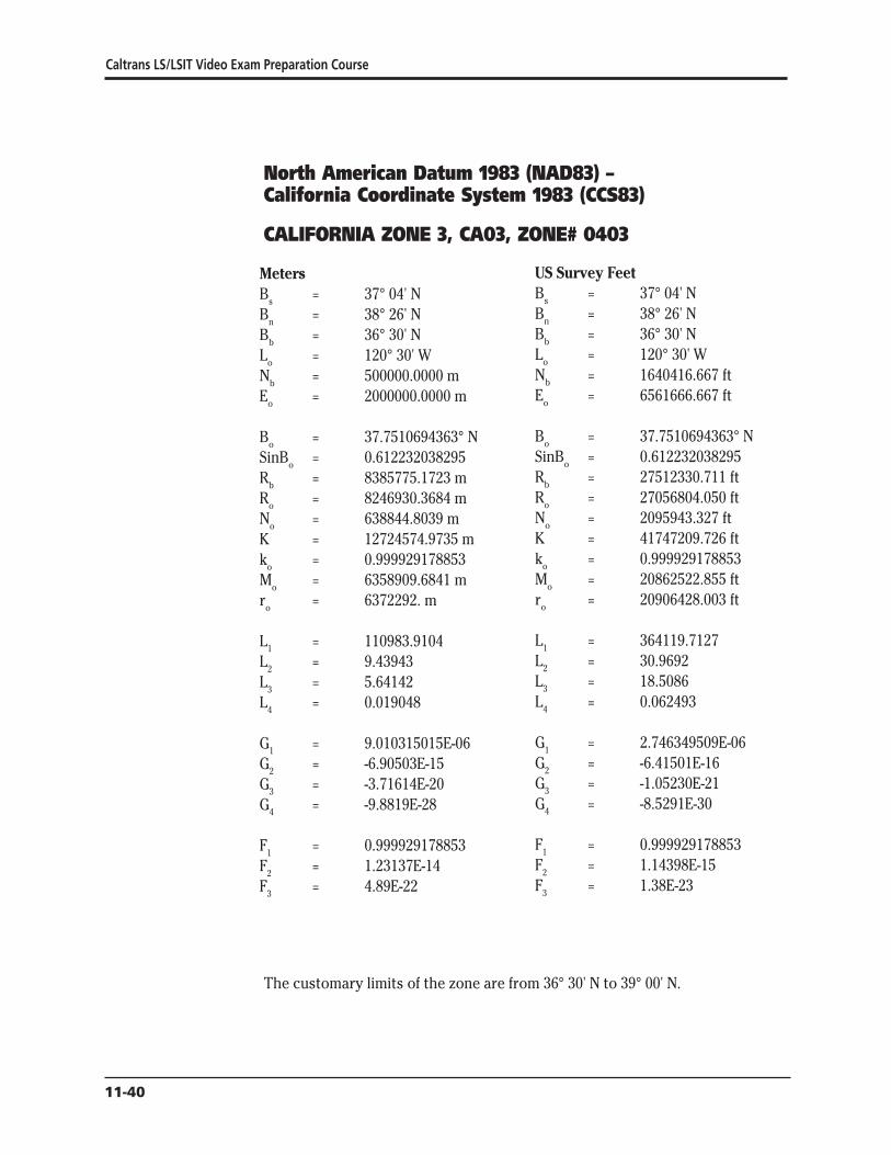
Caltrans LSLSIT Video Exam Preparation Course
North American Datum 1983 (NAD83) ndash California Coordinate System 1983 (CCS83)
CALIFORNIA ZONE 3 CA03 ZONE 0403
Meters US Survey Feet B = 37deg 04 N B = 37deg 04 N
s s
Bn = 38deg 26 N Bn = 38deg 26 N Bb = 36deg 30 N Bb = 36deg 30 N L = 120deg 30 W L = 120deg 30 W
o o
Nb = 5000000000 m Nb = 1640416667 ft E = 20000000000 m E = 6561666667 ft
o o
B = 377510694363deg N B = 377510694363deg N o o
SinBo = 0612232038295 SinBo = 0612232038295 Rb = 83857751723 m Rb = 27512330711 ft R = 82469303684 m R = 27056804050 ft
o o
N = 6388448039 m N = 2095943327 ft o o
K = 127245749735 m K = 41747209726 ft k = 0999929178853 k = 0999929178853
o o
M = 63589096841 m M = 20862522855 ft o o
ro = 6372292 m ro = 20906428003 ft
L1 = 1109839104 L1 = 3641197127 L2 = 943943 L2 = 309692 L3 = 564142 L3 = 185086 L4 = 0019048 L4 = 0062493
G1 = 9010315015E-06 G1 = 2746349509E-06 G2 = -690503E-15 G2 = -641501E-16 G3 = -371614E-20 G3 = -105230E-21 G4 = -98819E-28 G4 = -85291E-30
F1 = 0999929178853 F1 = 0999929178853 F2 = 123137E-14 F2 = 114398E-15 F3 = 489E-22 F3 = 138E-23
The customary limits of the zone are from 36deg 30 N to 39deg 00 N
11-40
The California Coordinate System
North American Datum 1983 (NAD83) ndash California Coordinate System 1983 (CCS83)
CALIFORNIA ZONE 4 CA04 ZONE 0404
Meters US Survey Feet B = 36deg 00 N B = 36deg 00 N s s
B = 37deg 15 N B = 37deg 15 N n n
Bb = 35deg 20 N Bb = 35deg 20 N L = 119deg 00 W L = 119deg 00 W o o
Nb = 5000000000 m Nb = 1640416667 ft E = 20000000000 m E = 6561666667 ft o o
B = 366258593071deg N B = 366258593071deg N o o
SinB = 0596587149880 SinB = 0596587149880 o o
Rb = 87332273793 m Rb = 28652263494 ft R = 85898068935 m R = 28181724783 ft o o
N = 6434204858 m N = 2110955377 ft o o
K = 129169860281 m K = 42378478327 ft k = 0999940761703 k = 0999940761703 o o
M = 63577728978 m M = 20858793249 ft o o
r = 6371557 m r = 20904016591 ft o o
L1 = 1109640696 L1 = 3640546183 L2 = 933334 L2 = 306211 L3 = 564410 L3 = 185174 L4 = 0018382 L4 = 0060308
G1 = 9011926076E-06 G1 = 2746840562E-06 G2 = -683121E-15 G2 = -634643E-16 G3 = -372043E-20 G3 = -105351E-21 G4 = -94223E-28 G4 = -81324E-30
F1 = 0999940761703 F1 = 0999940761703 F2 = 123168E-14 F2 = 114427E-15 F3 = 470E-22 F3 = 133E-23
The customary limits of the zone are from 35deg 20 N to 38deg 00 N
11-41Ecirc
Caltrans LSLSIT Video Exam Preparation Course
North American Datum 1983 (NAD83) ndash California Coordinate System 1983 (CCS83)
CALIFORNIA ZONE 5 CA05 ZONE 0405
Meters US Survey Feet B = 34deg 02 N B = 34deg 02 N s s
B = 35deg 28 N B = 35deg 28 N n n
Bb = 33deg 30 N Bb = 33deg 30 N L = 118deg 00 W L = 118deg 00 W o o
Nb = 5000000000 m Nb = 1640416667 ft E = 20000000000 m E = 6561666667 ft o o
B = 347510553142deg N B = 347510553142deg N o o
SinB = 0570011896174 SinB = 0570011896174 o o
Rb = 93417561389 m Rb = 30648744932 ft R = 92029831099 m R = 30193453753 ft o o
N = 6387730290 m N = 2095707846 ft o o
K = 132826248345 m K = 43578078311 ft k = 0999922127209 k = 0999922127209 o o
M = 63556709697 m M = 20851897173 ft o o
r = 6370113 m r = 20899279068 ft o o
L1 = 1109273840 L1 = 3639342590 L2 = 912439 L2 = 299356 L3 = 564805 L3 = 185303 L4 = 0017445 L4 = 0057234
G1 = 9014906468E-06 G1 = 2747748987E-06 G2 = -668534E-15 G2 = -621091E-16 G3 = -372796E-20 G3 = -105565E-21 G4 = -86394E-28 G4 = -74567E-30
F1 = 0999922127209 F1 = 0999922127209 F2 = 123221E-14 F2 = 114477E-15 F3 = 441E-22 F3 = 125E-23
The customary limits of the zone are from 33deg 30 N to 36deg 20 N
11-42
The California Coordinate System
North American Datum 1983 (NAD83) ndash California Coordinate System 1983 (CCS83)
CALIFORNIA ZONE 6 CA06 ZONE 0406
Meters US Survey Feet B = 32deg 47 N B = 32deg 47 N s s
B = 33deg 53 N B = 33deg 53 N n n
Bb = 32deg 10 N Bb = 32deg 10 N L = 116deg 15 W L = 116deg 15 W o o
Nb = 5000000000 m Nb = 1640416667 ft E = 20000000000 m E = 6561666667 ft o o
B = 333339229447deg N B = 333339229447deg N o o
SinB = 0549517575763 SinB = 0549517575763 o o
Rb = 98360917896 m Rb = 32270577813 ft R = 97066400762 m R = 31845868317 ft o o
N = 6294517134 m N = 2065126163 ft o o
K = 136020267133 m K = 44625982642 ft k = 0999954142490 k = 0999954142490 o o
M = 63544072007 m M = 20847750958 ft o o
r = 6369336 m r = 20896729860 ft o o
L1 = 1109053274 L1 = 3638618950 L2 = 894188 L2 = 293368 L3 = 565087 L3 = 185396 L4 = 0016171 L4 = 0053054
G1 = 9016699372E-06 G1 = 2748295465E-06 G2 = -655499E-15 G2 = -608981E-16 G3 = -373318E-20 G3 = -105713E-21 G4 = -82753E-28 G4 = -71424E-30
F1 = 0999954142490 F1 = 0999954142490 F2 = 123251E-14 F2 = 114504E-15 F3 = 415E-22 F3 = 118E-23
The customary limits of the zone are from 32deg 10 N to 34deg 30 N
11-43Ecirc
Caltrans LSLSIT Video Exam Preparation Course
References Alexander I A and Alexander R J (1989) ldquoProjection Tables California
Coordinate System NAD83rdquo California Land Surveyors Association Special Publication No 5588
Burkholder E F (1984) ldquoGeometrical Parameters of the Geodetic Reference System 1980rdquo Surveying and Mapping Vol 44 No 4 pp 339shy340
Fronczek C J (1980) ldquoUse of Calibration Base Linesrdquo NOAA Technical Memorandum NOS NGS- 10 National Geodetic Information Center NOAA Rockville MD 20852
Meade B K (1987) ldquoProgram for Computing Universal Mercator (UTM) Coordinates for Latitudes North or South and Longitudes East or Westrdquo Surveying and Mapping Vol 47 No 1 pp 37-49
Stem J E (1989) ldquoState Plane Coordinate System of 1983rdquo NOAA Manual NOS NGS 5 National Geodetic Information Center NOAA Rockville MD 20852
Stoughton H W and Berry R M (1985) ldquoSimple Algorithms for Calculation of Scale Factors for Plane Coordinate Systems (1927 NAD and 1983 NAD)rdquo Surveying and Mapping Vol 45 No 3 pp 247-259
Vincenty T (1985) ldquoPrecise Determination of the Scale Factor from Lambert Conical Projection Coordinatesrdquo Surveying and Mapping Vol 45 No 4 pp 315-318
Vincenty T (1986) ldquoGeometric Reduction of Measured Linesrdquo Surveying and Mapping Vol 46 No 3 pp 225-229
Vincenty T (1986) ldquoUse of Polynomial Coefficients in Conversions of Coordinates on the Lambert Conformal Conic Projectionrdquo Surveying and Mapping Vol 46 No 1 pp 15-18
Vincenty T (1986) ldquoLambert Conformal Conic Projection Arc-to-chord Correctionrdquo Surveying and Mapping Vol 46 No 2 pp 163-167
Vincenty T (1986) ldquoApplication of the Chord Method to Solutions of Geodetic Linesrdquo Surveying and Mapping Vol 46 No 4 pp 287-292
State Plane Coordinate System of 1983 by James E Stem is an excellent source of information concerning NAD83 procedures for the surveyor It thoroughly deals with corrections to lengths and azimuths It and other publications are available by phone The National Geodetic Information Center number for phone orders is currently (301) 443-8631 They accept credit cards and have a listing of their publications which they will mail free of charge
11-44

The California Coordinate System
North American Datum 1983 (NAD83) ndash California Coordinate System 1983 (CCS83)
CALIFORNIA ZONE 4 CA04 ZONE 0404
Meters US Survey Feet B = 36deg 00 N B = 36deg 00 N s s
B = 37deg 15 N B = 37deg 15 N n n
Bb = 35deg 20 N Bb = 35deg 20 N L = 119deg 00 W L = 119deg 00 W o o
Nb = 5000000000 m Nb = 1640416667 ft E = 20000000000 m E = 6561666667 ft o o
B = 366258593071deg N B = 366258593071deg N o o
SinB = 0596587149880 SinB = 0596587149880 o o
Rb = 87332273793 m Rb = 28652263494 ft R = 85898068935 m R = 28181724783 ft o o
N = 6434204858 m N = 2110955377 ft o o
K = 129169860281 m K = 42378478327 ft k = 0999940761703 k = 0999940761703 o o
M = 63577728978 m M = 20858793249 ft o o
r = 6371557 m r = 20904016591 ft o o
L1 = 1109640696 L1 = 3640546183 L2 = 933334 L2 = 306211 L3 = 564410 L3 = 185174 L4 = 0018382 L4 = 0060308
G1 = 9011926076E-06 G1 = 2746840562E-06 G2 = -683121E-15 G2 = -634643E-16 G3 = -372043E-20 G3 = -105351E-21 G4 = -94223E-28 G4 = -81324E-30
F1 = 0999940761703 F1 = 0999940761703 F2 = 123168E-14 F2 = 114427E-15 F3 = 470E-22 F3 = 133E-23
The customary limits of the zone are from 35deg 20 N to 38deg 00 N
11-41Ecirc
Caltrans LSLSIT Video Exam Preparation Course
North American Datum 1983 (NAD83) ndash California Coordinate System 1983 (CCS83)
CALIFORNIA ZONE 5 CA05 ZONE 0405
Meters US Survey Feet B = 34deg 02 N B = 34deg 02 N s s
B = 35deg 28 N B = 35deg 28 N n n
Bb = 33deg 30 N Bb = 33deg 30 N L = 118deg 00 W L = 118deg 00 W o o
Nb = 5000000000 m Nb = 1640416667 ft E = 20000000000 m E = 6561666667 ft o o
B = 347510553142deg N B = 347510553142deg N o o
SinB = 0570011896174 SinB = 0570011896174 o o
Rb = 93417561389 m Rb = 30648744932 ft R = 92029831099 m R = 30193453753 ft o o
N = 6387730290 m N = 2095707846 ft o o
K = 132826248345 m K = 43578078311 ft k = 0999922127209 k = 0999922127209 o o
M = 63556709697 m M = 20851897173 ft o o
r = 6370113 m r = 20899279068 ft o o
L1 = 1109273840 L1 = 3639342590 L2 = 912439 L2 = 299356 L3 = 564805 L3 = 185303 L4 = 0017445 L4 = 0057234
G1 = 9014906468E-06 G1 = 2747748987E-06 G2 = -668534E-15 G2 = -621091E-16 G3 = -372796E-20 G3 = -105565E-21 G4 = -86394E-28 G4 = -74567E-30
F1 = 0999922127209 F1 = 0999922127209 F2 = 123221E-14 F2 = 114477E-15 F3 = 441E-22 F3 = 125E-23
The customary limits of the zone are from 33deg 30 N to 36deg 20 N
11-42
The California Coordinate System
North American Datum 1983 (NAD83) ndash California Coordinate System 1983 (CCS83)
CALIFORNIA ZONE 6 CA06 ZONE 0406
Meters US Survey Feet B = 32deg 47 N B = 32deg 47 N s s
B = 33deg 53 N B = 33deg 53 N n n
Bb = 32deg 10 N Bb = 32deg 10 N L = 116deg 15 W L = 116deg 15 W o o
Nb = 5000000000 m Nb = 1640416667 ft E = 20000000000 m E = 6561666667 ft o o
B = 333339229447deg N B = 333339229447deg N o o
SinB = 0549517575763 SinB = 0549517575763 o o
Rb = 98360917896 m Rb = 32270577813 ft R = 97066400762 m R = 31845868317 ft o o
N = 6294517134 m N = 2065126163 ft o o
K = 136020267133 m K = 44625982642 ft k = 0999954142490 k = 0999954142490 o o
M = 63544072007 m M = 20847750958 ft o o
r = 6369336 m r = 20896729860 ft o o
L1 = 1109053274 L1 = 3638618950 L2 = 894188 L2 = 293368 L3 = 565087 L3 = 185396 L4 = 0016171 L4 = 0053054
G1 = 9016699372E-06 G1 = 2748295465E-06 G2 = -655499E-15 G2 = -608981E-16 G3 = -373318E-20 G3 = -105713E-21 G4 = -82753E-28 G4 = -71424E-30
F1 = 0999954142490 F1 = 0999954142490 F2 = 123251E-14 F2 = 114504E-15 F3 = 415E-22 F3 = 118E-23
The customary limits of the zone are from 32deg 10 N to 34deg 30 N
11-43Ecirc
Caltrans LSLSIT Video Exam Preparation Course
References Alexander I A and Alexander R J (1989) ldquoProjection Tables California
Coordinate System NAD83rdquo California Land Surveyors Association Special Publication No 5588
Burkholder E F (1984) ldquoGeometrical Parameters of the Geodetic Reference System 1980rdquo Surveying and Mapping Vol 44 No 4 pp 339shy340
Fronczek C J (1980) ldquoUse of Calibration Base Linesrdquo NOAA Technical Memorandum NOS NGS- 10 National Geodetic Information Center NOAA Rockville MD 20852
Meade B K (1987) ldquoProgram for Computing Universal Mercator (UTM) Coordinates for Latitudes North or South and Longitudes East or Westrdquo Surveying and Mapping Vol 47 No 1 pp 37-49
Stem J E (1989) ldquoState Plane Coordinate System of 1983rdquo NOAA Manual NOS NGS 5 National Geodetic Information Center NOAA Rockville MD 20852
Stoughton H W and Berry R M (1985) ldquoSimple Algorithms for Calculation of Scale Factors for Plane Coordinate Systems (1927 NAD and 1983 NAD)rdquo Surveying and Mapping Vol 45 No 3 pp 247-259
Vincenty T (1985) ldquoPrecise Determination of the Scale Factor from Lambert Conical Projection Coordinatesrdquo Surveying and Mapping Vol 45 No 4 pp 315-318
Vincenty T (1986) ldquoGeometric Reduction of Measured Linesrdquo Surveying and Mapping Vol 46 No 3 pp 225-229
Vincenty T (1986) ldquoUse of Polynomial Coefficients in Conversions of Coordinates on the Lambert Conformal Conic Projectionrdquo Surveying and Mapping Vol 46 No 1 pp 15-18
Vincenty T (1986) ldquoLambert Conformal Conic Projection Arc-to-chord Correctionrdquo Surveying and Mapping Vol 46 No 2 pp 163-167
Vincenty T (1986) ldquoApplication of the Chord Method to Solutions of Geodetic Linesrdquo Surveying and Mapping Vol 46 No 4 pp 287-292
State Plane Coordinate System of 1983 by James E Stem is an excellent source of information concerning NAD83 procedures for the surveyor It thoroughly deals with corrections to lengths and azimuths It and other publications are available by phone The National Geodetic Information Center number for phone orders is currently (301) 443-8631 They accept credit cards and have a listing of their publications which they will mail free of charge
11-44
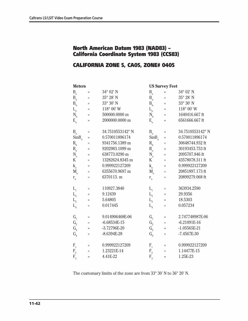
Caltrans LSLSIT Video Exam Preparation Course
North American Datum 1983 (NAD83) ndash California Coordinate System 1983 (CCS83)
CALIFORNIA ZONE 5 CA05 ZONE 0405
Meters US Survey Feet B = 34deg 02 N B = 34deg 02 N s s
B = 35deg 28 N B = 35deg 28 N n n
Bb = 33deg 30 N Bb = 33deg 30 N L = 118deg 00 W L = 118deg 00 W o o
Nb = 5000000000 m Nb = 1640416667 ft E = 20000000000 m E = 6561666667 ft o o
B = 347510553142deg N B = 347510553142deg N o o
SinB = 0570011896174 SinB = 0570011896174 o o
Rb = 93417561389 m Rb = 30648744932 ft R = 92029831099 m R = 30193453753 ft o o
N = 6387730290 m N = 2095707846 ft o o
K = 132826248345 m K = 43578078311 ft k = 0999922127209 k = 0999922127209 o o
M = 63556709697 m M = 20851897173 ft o o
r = 6370113 m r = 20899279068 ft o o
L1 = 1109273840 L1 = 3639342590 L2 = 912439 L2 = 299356 L3 = 564805 L3 = 185303 L4 = 0017445 L4 = 0057234
G1 = 9014906468E-06 G1 = 2747748987E-06 G2 = -668534E-15 G2 = -621091E-16 G3 = -372796E-20 G3 = -105565E-21 G4 = -86394E-28 G4 = -74567E-30
F1 = 0999922127209 F1 = 0999922127209 F2 = 123221E-14 F2 = 114477E-15 F3 = 441E-22 F3 = 125E-23
The customary limits of the zone are from 33deg 30 N to 36deg 20 N
11-42
The California Coordinate System
North American Datum 1983 (NAD83) ndash California Coordinate System 1983 (CCS83)
CALIFORNIA ZONE 6 CA06 ZONE 0406
Meters US Survey Feet B = 32deg 47 N B = 32deg 47 N s s
B = 33deg 53 N B = 33deg 53 N n n
Bb = 32deg 10 N Bb = 32deg 10 N L = 116deg 15 W L = 116deg 15 W o o
Nb = 5000000000 m Nb = 1640416667 ft E = 20000000000 m E = 6561666667 ft o o
B = 333339229447deg N B = 333339229447deg N o o
SinB = 0549517575763 SinB = 0549517575763 o o
Rb = 98360917896 m Rb = 32270577813 ft R = 97066400762 m R = 31845868317 ft o o
N = 6294517134 m N = 2065126163 ft o o
K = 136020267133 m K = 44625982642 ft k = 0999954142490 k = 0999954142490 o o
M = 63544072007 m M = 20847750958 ft o o
r = 6369336 m r = 20896729860 ft o o
L1 = 1109053274 L1 = 3638618950 L2 = 894188 L2 = 293368 L3 = 565087 L3 = 185396 L4 = 0016171 L4 = 0053054
G1 = 9016699372E-06 G1 = 2748295465E-06 G2 = -655499E-15 G2 = -608981E-16 G3 = -373318E-20 G3 = -105713E-21 G4 = -82753E-28 G4 = -71424E-30
F1 = 0999954142490 F1 = 0999954142490 F2 = 123251E-14 F2 = 114504E-15 F3 = 415E-22 F3 = 118E-23
The customary limits of the zone are from 32deg 10 N to 34deg 30 N
11-43Ecirc
Caltrans LSLSIT Video Exam Preparation Course
References Alexander I A and Alexander R J (1989) ldquoProjection Tables California
Coordinate System NAD83rdquo California Land Surveyors Association Special Publication No 5588
Burkholder E F (1984) ldquoGeometrical Parameters of the Geodetic Reference System 1980rdquo Surveying and Mapping Vol 44 No 4 pp 339shy340
Fronczek C J (1980) ldquoUse of Calibration Base Linesrdquo NOAA Technical Memorandum NOS NGS- 10 National Geodetic Information Center NOAA Rockville MD 20852
Meade B K (1987) ldquoProgram for Computing Universal Mercator (UTM) Coordinates for Latitudes North or South and Longitudes East or Westrdquo Surveying and Mapping Vol 47 No 1 pp 37-49
Stem J E (1989) ldquoState Plane Coordinate System of 1983rdquo NOAA Manual NOS NGS 5 National Geodetic Information Center NOAA Rockville MD 20852
Stoughton H W and Berry R M (1985) ldquoSimple Algorithms for Calculation of Scale Factors for Plane Coordinate Systems (1927 NAD and 1983 NAD)rdquo Surveying and Mapping Vol 45 No 3 pp 247-259
Vincenty T (1985) ldquoPrecise Determination of the Scale Factor from Lambert Conical Projection Coordinatesrdquo Surveying and Mapping Vol 45 No 4 pp 315-318
Vincenty T (1986) ldquoGeometric Reduction of Measured Linesrdquo Surveying and Mapping Vol 46 No 3 pp 225-229
Vincenty T (1986) ldquoUse of Polynomial Coefficients in Conversions of Coordinates on the Lambert Conformal Conic Projectionrdquo Surveying and Mapping Vol 46 No 1 pp 15-18
Vincenty T (1986) ldquoLambert Conformal Conic Projection Arc-to-chord Correctionrdquo Surveying and Mapping Vol 46 No 2 pp 163-167
Vincenty T (1986) ldquoApplication of the Chord Method to Solutions of Geodetic Linesrdquo Surveying and Mapping Vol 46 No 4 pp 287-292
State Plane Coordinate System of 1983 by James E Stem is an excellent source of information concerning NAD83 procedures for the surveyor It thoroughly deals with corrections to lengths and azimuths It and other publications are available by phone The National Geodetic Information Center number for phone orders is currently (301) 443-8631 They accept credit cards and have a listing of their publications which they will mail free of charge
11-44
Top Related