


![Disaster Relief Project[3]](https://static.fdocuments.us/doc/165x107/55d4d7e4bb61eb74748b45ba/disaster-relief-project3.jpg)


Languages
Pages
Legal


1. Regionalization theories and database 1. Regionalization theories and database
4. Natural disaster relief regionalization of China4. Natural disaster relief regionalization of China
Section 2 The Natural Disaster Relief Regionalization of China Section 2 The Natural Disaster Relief Regionalization of China
3. Urban natural disaster regionalization of China3. Urban natural disaster regionalization of China
2. Agricultural disaster regionalization of China 2. Agricultural disaster regionalization of China

China (rural, urban) natural disaster regionalization map
China (rural, urban) natural disaster regionalization map
Regionalization map of China natural disaster relief
Regionalization map of China natural disaster relief
Final Aim: Establish the national regionalization system for natural disaster aidsFinal Aim: Establish the national regionalization system for natural disaster aids
The database of China natural
disaster and aids
GIS technique
GIS technique
The database of social and economic eigenvalue
of China
China administrative region
China administrative region
Theory 1 Disaster system theory
Theory 2 Regional. theory
Theory 2 Regional. theory
Theory 3 Geographic information map theory
Project Thoughts

1. Regionalization theories and database
Disaster systems theory D = A∩B∩CTheory of territorial differentiation Zonality: latitude direction, ocean and land, altitude
Non-zonality: geology, landform Geographic information map theory
Map+ chart: express the relation change
Disaster systems theory D = A∩B∩CTheory of territorial differentiation Zonality: latitude direction, ocean and land, altitude
Non-zonality: geology, landform Geographic information map theory
Map+ chart: express the relation change
1.1 Regionalization theories1.1 Regionalization theories

1.2 The principles of regionalization 1.2 The principles of regionalization
Comprehension and main factor principle
Territorial conjugation principle
Integrality of county administrative boundaries principle
Quantitative and Tupu interaction principle
Dynamic, manipulation and practicability principle
Comprehension and main factor principle
Territorial conjugation principle
Integrality of county administrative boundaries principle
Quantitative and Tupu interaction principle
Dynamic, manipulation and practicability principle

Attribute data
Space data
Ch
ina
adm
inistrative
region m
aps
Ch
ina
adm
inistrative
region m
aps
China natural disaster newspaper database China natural disaster newspaper database
China natural disaster formative factors database China natural disaster formative factors database
China natural disaster effects database China natural disaster effects database
China natural disaster reduction information database China natural disaster reduction information database
China urban social and economic database China urban social and economic database
China social and economic databaseChina social and economic database
The databas
e of China
natural disaster
and relief
The databas
e of China
natural disaster
and relief
Featu
re cod
e
1.3 The whole structure of the database 1.3 The whole structure of the database

Database construction (systematic database)
Regionalization index——derivate database
Foundation——original database
Disasterrelief
region
Feature chart of disaster
relief region
Feature chart of disaster
relief region
Regionalization result ——systematic database
MapMap

2. Natural disaster regionalization of China
-Agricultural disaster regionalization of China
2.1 Regionalizaiton system indexes
Hazard –formative environment
Hazard –formativeFactors
Hazard-affected Bodies
Stability of Hazard –formative environment
Risk of Hazard –formativeFactors
Vulnerability of Hazard-affected Bodies
Natural disaster effects
Topography,relief, vegetation,soil,hydrography and climate
Intensity,frequency,effected arrange and recur period
Population,land use,capital density,preventing and defending disaster level
Effected population, disastrousPopulation,death population,area affected,
disastrous area,affected area of crop growth,collapsed buildings

自然灾害“自下而上”与“自上而下”系统
2.2 Method and approach of regionalization
Natural disaster “bottom-up” and “up-bottom” systems
Principle
Method
Classification
Process
Scale
Regional differentia rule of hazard-formative environment
Regional differentia rule of hazard-affected bodies and hazard-affected factors
Regional differentia rule of hazard effectsRegional differentia rule of
hazard-affected bodies and hazard-affected factors
Divide up-bottom Combine bottom-up
Hazard region Hazard district Hazard zone Basic unit of regionalization Basic unit of disaster
Whole country Province or region Town or village

hazard-formative
environmenthazard-affected bodies
hazard-formative
factors
Administrative Division borderline
Natural disaster effects
database
Natural disaster system complex map Authority disaster effects data
Natural disaster type map Adjacency index and distance index of disaster type map
Basic units of natural disaster regionalization
Adjacency index and distance index of basic units
Division strategy of disaster zones
comprehensive regionalization plan of regional natural disaster
Natural disaster district division (un-demarcation)
Middle scale macroscopically differentiated law of natural disaster
Disaster large region division (un-demarcation)
Large scale macroscopically differentiated law of natural disaster
① Spatial overlapping ① Split ① Spatial matching
②Evaluate ③Fragment collection
④Calculate
⑤Combine
⑥ Calculate
⑦ Combine
Collect
Name
⑩Divide
⑩Divide
⑨Divide
⑧Divide
Combine from bottom to top
Divide from top to bottom

2.3 Classification system of regionalization
Classification
First level
Second level
Third level
Fourth level
Fifth level
System of natural regionalization System of natural disaster regionalization
Natural region
Natural district
Natural zone
Landscape type
Land type
Natural disaster region
Natural disaster district
Natural disaster zone
Basic units of natural disaster regionalization
Type of natural disasters

2.4 Comprehensive regionalization of agricultural natural disaster in China
South China Sea Islands

3.1 Regionalization method and technique flow 3.1 Regionalization method and technique flow
3 Natural disaster regionalization of China ——Urban natural disaster regionalization China
3 Natural disaster regionalization of China ——Urban natural disaster regionalization China
Urban natural disaster regionalization map
Synthetic intensity Synthetic level
Urbanization map Urbanization map Natural disaster map Natural disaster map Prior
knowledge
Model

Comprehensive urbanization index Comprehensive urbanization index
3.2 Regionalization assessment of comprehensive urbanization level 3.2 Regionalization assessment of comprehensive urbanization level
Urbanization
map
Urbanization
map

3.3 Disaster intensity sub-area of major cities 3.3 Disaster intensity sub-area of major cities
Structural
damage
Earthquake
Flood
CityCity
Land slide and debris flow
Typhoon
Dust-storm

Regionalization of Urban Integrated Disaster Intensity Regionalization of Urban Integrated Disaster Intensity
Natural disaster
map
Natural disaster
map

3.4 Regionalization map of urban natural disaster 3.4 Regionalization map of urban natural disaster
legendThird-level boundary
Second-level boundaryFirst-level boundary

3.5 Regionalization characteristics table of Chinese urban natural disaster 3.5 Regionalization characteristics table of Chinese urban natural disaster
Regional name
AreaCounty
Regionalization characteristics table of Chinese urban natural disaster(based on county boundary, first level regionalization )
PopulationAgricultural population
(ten thousand persons)
Non-agricultural population
(ten thousand persons)Number of cities
Area of built –up area(km2)
Urban population
(ten thousand persons)
Urban population density(person/km2)
Synthetical ability
of land traffic
Urban index
of lamplight
Integrated urbanization level index
Coastal urban disaster area
Eastern urban disaster area
Western urban disaster area
Total
Regionalization characteristics table of Chinese urban natural disaster(based on county boundary, first level regionalization )
Regional name
Coastal urban disaster area
Eastern urban disaster area
Western urban disaster area
Total
Hazard intensity
index of flood
Hazard intensity
index of earthquake
Hazard intensity
index of typhoon
Hazard intensity index of
debris flow and landslide
Hazard intensity index of
debris sand storm
Urban disaster type(arranged by intensity)
Flood
Flood
Flood
Earthquake
Typhoon
Typhoon
Typhoon
Typhoon
Landslide
Landslide
Landslide
Landslide
Sand storm
Sand storm
Sand storm
Sand storm
Earthquake
Earthquake
Earthquake
Flood
Integrated natural disaster
intensity index
Integrated index

4 China natural disaster aid regionalization 4 China natural disaster aid regionalization
Earthquake sub-areaEarthquake sub-area
Drought sub-area Drought sub-area
Frost sub-areaFrost sub-area
Flood sub-areaFlood sub-area
Typhoon sub-areaTyphoon sub-area
Snow damage sub-area Snow damage sub-area 2 Emergency
capability
2 Emergency capability
1 Disaster preparedness capability
1 Disaster preparedness capability
3Recovery capability 3Recovery capability
5Natural disaster
relief regionalization
Agriculture disaster regionalizationAgriculture disaster regionalization Urban disaster regionalization Urban disaster regionalization
Mud slide sub-areaMud slide sub-area
Dust-storm sub-area Dust-storm sub-area What to help? What to help?
How to help? How to help?
Who help? Who help?

Acquaintance thinking
Concept
Construct
Disaster preparation ability index
Material storage
for Disaster
Relief
Arithmetic
Choose Index
Assessment result earthquake
mud slide
flood
drought
dust-storm
typhoon
snow damage
frost damage
Summer
Winter
Index table of disaster preparedness
materials
Regionalization map of disaster
preparedness materials
4.1 Pre-disaster Response
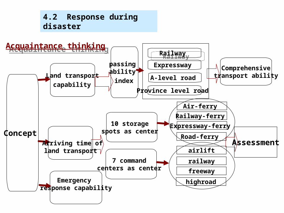
Acquaintance thinking Acquaintance thinking
Concept
Land transport
capability
Railway Railway
passing ability
index
Comprehensive transport ability
10 storage spots as center
7 command centers as center
Arriving time of land transport
Expressway
A-level road
Province level road
Air-ferry
Railway-ferry
Expressway-ferry
Road-ferry
airlift
railway
freeway
highroad
Assessment
Emergency response capability
4.2 Response during disaster

Recovery capability——autocorrelation analysis (Haining, R, 1990) Recovery capability——autocorrelation analysis (Haining, R, 1990)
Average crop production per land(A1)Average crop production per land(A1)
Bed number of unit area (A2) Bed number of unit area (A2)
Average deposit account of urban and rural citizens (A3) Average deposit account of urban and rural citizens (A3)
Basic construction investment (A6) Basic construction investment (A6)
Model:
Zi ∑= XijKAj
( i = 1, 2, …,2337 ; j = 1, 2, … 7 )
Zi : The recovery capability of No.i county
Xij : No.j factor score of No.i county
KAj : The contribution rate of No.j factor
(7 factors contribution rate is as following: 0.045 , 0.159 , 0.176,0.185 , 0.162 , 0.139 , 0.134 )
Average financial income per person(A5)Average financial income per person(A5)
7 indexes
Average financial income per land(A4)Average financial income per land(A4)
Comprehensive traffic ability(A7)Comprehensive traffic ability(A7)
4.3 Post-disaster response

Earthquake relief Earthquake relief
4.4 Relief scheme for single disaster type
China flood relief China flood relief
China drought relief China drought relief
Dust-storm relief Dust-storm relief
Typhoon relief Typhoon relief
Snow damage relief Snow damage relief
Frost damage relief
Frost damage relief

Mud slide sub-areaMud slide sub-area
Earthquake sub-areaEarthquake sub-area
Typhoon sub-areaTyphoon sub-area
Flood sub-areaFlood sub-area
Snow damage sub-areaSnow damage sub-area
Frost sub-areaFrost sub-area
Drought sub-areaDrought sub-area
Intensity evaluation
Dust-storm sub-area Dust-storm sub-area
Disaster preparedness capability index
Land traffic index of emergent material
Recovery and re-constructionability index
Relief Comprehensive
responsecapability
index
Disaster intensity——
relief responsecapability index
Disaster intensity——
relief responsecapability index
Comprehensive natural disaster intensity level
4.5 Comprehensive relief regionalization scheme
Acquaintance thinking-Auto-correlation method
Acquaintance thinking-Auto-correlation method

Natural disaster relief regionalization map of ChinaNatural disaster relief regionalization map of China
Legend
International storage baseNational storage baseAdded national storage baseAdded local storage base
County administrative division boundarySecond-level region boundaryFirst-level region boundary
Beijing
Urumchi
Hetian
Gaize
Gomud
Lasa
Lanzhou
Chengdu
XichangGuiyang
Kunming
NanningGuangzhou
Haikou
Nanchang
Enshi
Xi’an
Tianjin
TaiyuanJinan
Zhengzhou
Hefei
Chaozhou
Qiqihar
Xilinhaote
Shanghai
Taibei

Regionalization characteristics table of China natural disaster relief
Regional name Number of counnties
Area(km2)
(based on county boundary, first level regionalization )
Population(persons)
Agricultural population(persons)
Non-agricultural population(persons)
Intensity index of earthquake disaster
Intensity index of landslide and debris flow
Intensity index flood
Intensity index drought
Intensity index typhoon
Intensity index sand storm
Harbin relief area
Shenyang relief area
Tianjin relief area
Zhengzhou relief area
Hefei relief area
Fuzhou relief area
Guangzhou relief area
Xi’an relief area
Wuhan relief area
Changsha relief area
Nanning relief area
Lanzhou relief area
Chengdu relief area
Kunming relief area
Urumchi relief area
Lasa relief area
Total

Regionalization in teaching material——“China Geography” ( p379 )
··
Complementary
China territorial planning and management regionalization
Boundary of regionsBoundary of districts

Coastal region Backland region Devious region
Jing-Jin-Ji-Lu region
Liaoning region Hei-Ji region
Yu-Jin-Shan region
Meng-Ning west huang river region
Xinjiang region
Qin Hai region
Hu-Su-Zhe region Wan-e region Sichuan region
Tai-Min-Yue-Guang region
Guangxi region
Xiang-Gan region
Yun-Gui region
Tibet region

Keep integrality of province boundary
Keep integrality of province boundary
10 regions combined into 8 regions10 regions combined into 8 regions
The regionalization foundation of China Geography
Satellite image of China(Resource regionalization of China)
Top Related