zz:::z^^ -...
60
• "• ~ ""~ 4 "" ] F-1-A T 27N R..27E Plat No §8 t fount , PhiIliP s STATE OF MONTANA j C ° Unty a WATE R CONSERVATION BOARD p h o t o N o ^-27...SWr:23.... 7fc2J.3... ; Farm Checked. Date...lP/2/6 7 mter Resourc , s Survey 7W- 2 12..8Vfc26..8Vfc2S..7VV-23l4 \ By B..... Kosena "^®"' * Wellington D. Rankin (Deceased). Address Helena ;! Legal Land Owner weiiiny . r -1+ Address Helena A-1103 teenjamD-^.-QliiliES Wii<^™Xsej:reek -2/2/07 \ 400*~Yesn Rankin Ditch Li_il^-L , NOTE: R-Dcnotcs Regular Irrigation. F—Flood Irrigation. Adequate Supply: Yes No Explain.. —"ZIZZ IZII. Remarks "••*'jess''Burnsl^ : ZZ'ZZZ ZZZ'ZZ'Z :;ZZ:T:::—"i^ ::::::::::zz:::z^^ . • 1 Information F r o m : [-7T-—F^atNo 80 Two 28HR^2?g.,ll Plat No...89 .... Tw^.^TM Rge.2SE.JI Plat No.. Twp Rge P^lal lolil Twp.;:S Se.2BE.ii Plat No ,.„. Twp^ Rge \ Plat No Twp Rge-.-j ...Jaok.Galt
Transcript of zz:::z^^ -...

• "• ~ ""~4"" ]
F-1-A T 27N R..27E P l a t No §8 tfount , PhiI l iP s STATE OF MONTANA jC ° U n t y a
W A T E R CONSERVATION BOARD p h o t o N o ^-27...SWr:23....7fc2J.3... ;
Farm Checked. Date...lP/2/67 m t e r R e s o u r c , s S u r v e y 7W-212..8Vfc26..8Vfc2S..7VV-23l4 \
By B.....Kosena "^®"'* Wellington D. Rankin (Deceased). Address Helena ;!
Legal Land Owner weiiiny. r -1+ Address Helena
A-1103 teenjamD-^.-QliiliES Wii<^™Xsej:reek -2/2/07 \ 400*~Yesn Rankin Ditch Li_il^-L ,
NOTE: R-Dcnotcs Regular Irrigation. F—Flood Irrigation.
Adequate Supply: Yes No Explain.. — " Z I Z Z IZII.Remarks
"••*'jess''Burnsl^ : Z Z ' Z Z Z Z Z Z ' Z Z ' Z
:;ZZ:T:::—"i^ ::::::::::zz:::z^^. • 1 Information From:
[-7T-—F^atNo 80 Two 28HR^2?g.,ll Plat No...89.... Tw . TM Rge.2SE.JI Plat No.. Twp RgeP ^ l a l lolil Twp.;:S Se.2BE.ii P l a t No ,.„. Twp Rge \ Plat No Twp Rge-.-j ...Jaok.Galt

; •• • . xtvpr*x -
r i i i i i t i | ¥^r] H^rt7xi~i ri i t t i • [ n trrTT"TTT433!nij
rrH—Mi j±j Li.J 1..4.-J i LLttj1 4 1 1 «p 1 2f I j 22 1 1 2J5 1 -|--2p I
1 30 1 i 4 1 1 4 1 ! 4 j f ' I8 1 1 t""2f ~~f~~ ;
....... 1 3 '; 1 3k \ : 3? I 1 3^ I \ V? j j i sp I
\ ; i I I I I j j j I j j 1 I I | j I ! I
Land Ownership - - -

clunty...PhillifiS S T A T E 0 F MONTANA T"2-™ R a Z E H a t N o J j a
i n / l , / r 7 WATER CONSERVATION BOARD p 7Vj-138 |Farm Checked: Date...lQ/],3/67 ^ B e s o u r c e s g u r v e y
P ^ o No ^
By B...Kosena ^ilS*' j
Legal Land Owner Clara. Taylor Address....Malta \
Operator Iaylor...Bros.. AddreSs....Podspn
W a t e r is de l i ve r ed b y : - 1. Private System; 2. Ditch Company, 3. State Project; 4. Federal Project; 5. Irrigation District
I jApp^No^ i NAME OF ^PBO^WATOR j N M | E OF STREAM | ngte'VASS'ty Ynchn I n USC <W«l"En?lTvJJJdC"y) TJoT " ' F IriTTci-cs '" '"*«"
JtLl27§J_CLaEa_E..Jlayiox _lLJa»_CQiLLfifi . JSl/l/AQ Mi. Siock
NOTE: R Denotes Regular Irrigation. F—Flood Irrigation.
Adequate Supply: Yes No Explain"'•*-• Remarks
ZZ.ZZZZ"Z'ZZZZZZ"ZZZZZIIZZIIZZ. River Basin l.Milic.BiverI Also in- Plat No..9.8.... Twp.26N . Rge27E.. | Plat No Twp Rge I Plat No Twp Rge I Information
Plat No Twp Rge i Plat No Twp Rge j Plat No Twp Rge | Ery.i.0...T3y.l.P.?.
I

H , , ,. ,.,.... . ... , . . . _ . . . . _ _. .. - . . , . . . . . . — . . - - . . . - . . . . , , . . • - - . . . : p . „ ..-.. ^^_^_- , - ..•<,.,.,...t...j I . W , I I - J I I **nw»*-.i.-iiU.ftiaii2fcfriJ
I __ j | £ j_ __j _,_j__J ! j , j _ .._,..]
H i ii • I i h i i . li; i ; li.. i I- i U i — t i t . ™I_ SB •*•*• TjJ I 'y xy 1 : Xp ; ' — j " '"ly 1 i It* j T jjjl-.™^™ ... _
I l|) j j 20 1 1 2-JL— ] j 22 1 -| 2fr I ]--2^ f I
• 1 3u • I Zy • , iji ' ; I if" ; I iB i ' j ztr-—7-— a
B - ;• 31 : 1 3^ 1 1 3 ; 1 3 I - i 3& j 1 86 f I
H i : - I f : i !* !" ! i \ I ' I '• T"H \ \ \ I : : • I 1 1 1 1 ''• ''•• '•• \ \ \
H Land Ownership _

F.,-A . T. 27N R..27E Plat No §§.....x Dh-i 11 i -,c STATE OF MONTANA j
C 0 U n t y H f t U M * ; WATER CONSERVATION BOARD P h o t o No...8y fc2 Bfel |Farm Checked: Date...lO/l3/67. Water Resources Survey !
By .B.....Kas.ena °^ss" !y Dodspn ;
Legal Land Owner .Thomas..-/U-Xaylor. -" •T, , T l n T Address
Operator ••; Ihoraas..A,.Tavxpr —"•—"" 4. Fode ra l P r o j e c t ; 5. Irrigation D.s . r ic^Water is delivered b y : - '10Private System; 2. D.tch Company, ^ ^
D1g«. NO. I TO wnoHjacBgD ^ — - ^ TTTH/Ol hjSDO Yes iTavlor-aamB, Sites_& L_l F - - 28 1 0JfcSaSLJLl£§ni5-lalcg jBicLJjarnuSpj^-C^- j f l _ L f ~ |P^e_SysterQ L — - -
NOTE: R-Denotcs Regular Irrigation. F-Flood Irrigation.
Adequate Supply: Yes No Explain '"ZZZZIZZZZZZZ1. ""'.Remarks
ZZIZZZZIZ'^ZZIIIIIZIZ ZZZZZIZZIZZZj^^^^ZZm^-^1^' — — 1 information From:
| ^ *• ™ g p g ^ I g ^ ^ ^ : : : H ^-m-
; N ^ ^ — —^^PP^T 1 1^!
-- •
f«- • ,-^^1^v™^>-'t i-diJ i j " t t 'J"-- i . i^t. '^ i>. '^ 'a- l ' "-^i- ' ---- '- ' '^ " • ' ' ' * " ' " • ' • • • ' * " ' ' " il
H Land Owuersh'.p - " | |

• County Phillips. STATE OF MONTANA T"""-" P - 2 7 E P l a t N o - 8 S \,
I Farm Checked: Date...lO/l3./67. W A T E R CONSERVATION BOARD p h o t o ^ m m f• Water Resources Survey i'I By B.....Kos.ena °^5"' j
I Legal Land Owner U.S.A. ' Address '••
I Operator Address ;H Water is delivered by:— 1. Private System; 2. Ditch Company; 3. State Project; 4. Federal Project; 5. Irrigation District :
H I A|ip. No. I NAME OK APPROPRIATOR 1 VAMP n>' c T D n n Date App! Mlncr'h ,„ „ „ NAME OF DITCH ZZ. Present Irrlsablo IB Decree No. I TO wnoivr DECKEBI) | " " ' " * o t STREAM | Pate Priority Inches | '" U s c (Water Delivered By) No. "'* Irr. Acres Acres
I .OS63 l _ U tS^ tu U^JTr ih^-Vi i idJ tane-e i»_2 / l l / ia_&1LStaf f ik . P. R. 145 . j e s t
H NOTE: R—Denotes Regular Irrigation. F—Flood Irrigation. j
H Ariequate Supply: Yes No ExplainH v- Remarks
• River Basin Milk-.JRiver
H I Also in: Plat No Twp Rge |l P\at No Two Rge IjPlat No Twp Rge I Inf°rmation From:II Plat No Twp Rge jj Plat No Twp Rge || Plat No Twp Rge Field Survey

• i 1 1 1 I " I i I " ~ n i i i", 1H I i. j i 1 i i i i | -4- * i | L _ i... i. . flj
I ^4j[j^fflmM^ri IB — - - 4 — j — ! If 'j \ if | j if \ r 11 1?—p 1
B ! lj> j 1 20 j- 1 21- j | 2 5 1 -| 28' j 1 zk I I
B i i i r i i i "i i i I r i i rr~'~• 80 i t -2J> r ! 2JJ i 1—Sir i "} -26 j T~"2$ !--••
B 1 i ! 1 ! i I i ! 1 . I I I I I ! ! xI p i i n lTi i I LETI i ;rttI r"i i t i ! i i ! "i i I t i i f t• -—•! 31 '•• 32 i 1 3 ! i i 3 4 ! i 3B ! i SB '••:
• i :...; ! I I. I 1 1. .1 I j I ! ; 1
I L . _ " I....;..1 11..1! i l ' l i l 1[ . : . : :B __ _ _

i
, , ._ . . , •.,.. . , ' f t t W i h i i m j ^ M A , - . . . . . . . . . . . . . . - - . . . , . . . , . , . . . . . . , _ . . . , . ^ ^ . ' j . i — • . . - : . _ . . . : — ™ W * . I
F 1-A
County Phillips. STATE OF MONTANA T™ R - 2 S f i P l a t N o • "_ _. , , _ , in/iA/A7 WATER CONSERVATION BOARD XT „,., _„ „,.. , , „.,, _a
Farm Checked: Date....lP/.l.P/P.7 Photo No...»M7.S3j...8y.-.3.1i...8.Wr23.5...Water Resources Survey 7W-206; 7W-209; 7W-210;
By .Archie , ^ ^ , 7W-2.1.1.:...7W-.J139Legal Land Owner Wellington..D...Rankin Address Helena
Operator Be i n g ..Sold...tp.Burns Address .•Water is delivered by:—C. 1..'Private System; 2. Ditch Company; 3. State Project; 4. Federal Project; 5. Irrigation District
I A|ip. No. I NAME OK APPKOI'KIATOR i , . . , . „ _.. , . - .„ , , , . , Date App. Miner's .„ ...„ I NAME OF DITCH ZZZ 1TJZ Present Irrlgablr IDecree No. I TO WHOM DECREED aAMfc ot STUKAM D a t c P r l o r l t y inchcs '" use | (Water Delivered By) No. " '* Irr. Acres Acres
•K-X-X A-1099 I Mary Gaff IVJild Horse Creek 7 /25/03 I 400 Yes I Burns Dikes S Ditches 1_R/E*** _A-11Q3_I Ben:iamin D. P h i l l i p s _^ " ' " 5/10/98 3,000 _Yas ". '1 " L_ Jj/Ei
- -K-X-X A-1104 I Beaiamin D. P h i l l i p s " ^ ^ 6 /15/01 . feSOO Yes " '1 1'. 1_ R/& 215-QQ-L,328J.*** A-1093 I Edward Dent ' ! _ _ ! ! " 1/28/03 200 .Xss. " " " L_ S/ZJ I*** A-1105 I Sarah Phillips "_ 1_^1 6/17/QPS MO VP^ " ' . " L__R/E.**« _A=1Q9BJ James_W..._Gillani " ^ L _ ^ 3j2&/SsSJ~A&L -fes. " 1: !! L _ JBL/EJ,
•)H<_A-_1032_LX!aniei_J.._P_hillips__ Li t t le Warm 3prjng Cr . 7/97/01 160 YPS T.itt.lP Warm Spr. Res R l _ ^ f e jI , Burns Dit.nh . LJ -y^ j?^^ •
** .iriPlojir .Herbert. l._£einbxake " " " " 4/3/99 300 I Yes " 'l !!. !; '2 L_ R / F ) s bdEffl.. 169.J)_ 1** JclQaa^JobrjLAllary !!„__!! " 21 5/19/05 _iQ0_ VPS " " " " " i R / F { - i** _A-103L';LBer)iarni.n_D. ^hiniES..__L_!1 " ^/22/QQ__Q.on_ JXes !! " 1 ". l_ R/E/ . \
* Jr_lO01_LjQSephine_Caple±± Rig Warm Spring Creek 10./5/00 600 Stock- '____. ]"x
JAr_44.Q_..iB_.._D^_PilillipS -" ^-t] fr\\[t'-finYP& 8/90/03 I9jft~.ffit.nnlf niri nitrhpc; (not, in lifip] 1 R/F!-15 .Ari.9.9. -! John..G.3.Rle±t " '1 " I O / I / O O fioo Siock- _!; 1 l—t^/F- — Q ^ L _ Sfia^L.*^A—14lOa-4-JohrFCapratt- ~ " " """" ""••"- " llo726.-/eoJ--^e8-lstoc^4-'J !i -• •"rtr=~J_I-Jfe^l— |
NOTE: R—Denotes Regular Irrigation. F—Flood Irrigation.
Adequate Supply: Yes No Explain i'..E!CfcenSi.C!n...Qf...\ya1;fiE..Riabt..fj:oni..Elat...a8.....&..Ixr^ !Remarks...*... ..Lqt.pf..p.ld p.itc.he.s_.frp.ni..Big...V,'arrn...Sprin3..Cree ;.Real good...potential !
*?•*......tot..of...old.Ditches..frprri. these..V!ater..Ri.ght.s .t.hs.t...c.an..fc.e....us.e.d...go.o.d...potential.
...**.Wat.e.r...8il;.Qr.e.d...in.little...V/a.rra..SRring...Res.....than..+. Ditch..Res.»..ia..Se.c-...29...Iir...in..l^/M7..par.t...Sec....29.j..SWSW..par.t...&..fflS\V...pait... |
..Sec.,...2.O^..^^SE...par.t^..SESE..p.ar.t^...S•iM..p.art...S.ec.....l9.^
...Cr.eek..r.un5..intQ...it..than..it..irr.....ffiNVI..par.tS£ffi.par.tIffiaEpar±SVflEpart}..&..l^
..part...NWSEfiart.!:iSE..part.MK!E...Rart..ffi^^^^*«* .V(ater...siDie.d..in...two..Res»...ane...in.^
..tv/o..D.itch,too..irr....iri.^-lE..paxt..SfiC*..a}..NI'«.pai±...Se.c....9.}..S!!lSM..Sec.....4}..^^...^..SVJNEpar-tStlNEpar.trEffipaiU3\yNEpar.t..Sec...S»
' River Basin Mi lk .River
i Also in: Plat No Twp Rge | Plat No Twp Rge Plat No Twp Rge Information From:Plat No Twp Rge ! Plat No Twp Rge Plat No Twp Rge Japk Gpft
1 — •"•" " I I "••" I i 1 : " I ' I ? I
| | • e I -•• & i •< | 1 8 — | i |—3 — r — •. I I
W H+jj i j I fH [jffl^^j-fi II - -.. . ~"i I I H \ t I i I i~i i t i - J — j ~ v- II I *j» i - i? ) j~-ij* I - -if \ v i* j- *—3f-~i— j
I I I I i \ 1 1 ! I ,. i L.-J | L 4 - - UI ! i ! ; \ 1 I i i i 1 1 1 jI -pj j —| -2p | | 8 J - | \ 22 •; 2p-—]• |--2f j — |I - ! 30 t Sp j 2^ i \ -5i|f i i -2j* j | — . 2 ^ - - i — . . . .
I - 31 —\—3i t— 1 3 ; ; -3^ S -{•• Zf j ] JIJB \
I Land Ownership _ ,

I
It F-l-A f
C o u n t y STATE OF MONTANA T R P l a t N o !
~ , . „ 4 WATER CONSERVATION BOARD _, t . ,i Farm Checked: Date Photo No
Water Resources SurveyBy iggfci
Legal Land Owner Address-
Operator Address :
Water is delivered by:— 1. Private System; 2. Ditch Company; 3. State Project; 4. Federal Project; 5. Irrigation District
| App. No. I NAME OF AI'PROPIUATOR I V A M U nv C T D B . U Date APP. Miner's Tn II(;. I NAME OF ^ITCH j n / p Present IrrieablcDecree No. | TO WHOM DECREED | N A M E oh illit.AM D a t c P r l o r | t y Inches "* " s c | (Water Delivered By) No. | K / * Irr. Acres Acres
A-ini4 I Emma Phil lips |Biq Warm Sp-.-inq Creek 6/2/98 200 Stock I
i., ft A-1013 I John Patois '1 " " " 12/8/04 1 400 Yes Burns Ditch 1 R/F 53.00 30.0
I ,
• j
| Ij i
. j
FH==::^-F==^=r:^ I —=,^^=l|• NOTE: R—Denotes Regular Irrigation. F—Flood Irrigation. I
• Adequate Supply: Yes No Explain• ',._ Remarks
River Basin
Also in: Plat No Twp Rge | Plat No Twp Rge Plat No Twp Rge Information From:Plat No Twp Rge | Plat No Twp Rge Plat No Twp Rge

•
_ . . . , _ „ , . . . • • . . - • . . , . - • > • ! .•• , L ' j . • ! - •—!• • . - • . . ! . •« ' .• ; .•».u(.<iV> l i :« ' . j^Vi! j i \ f t t t i ' tSf i i3a!
F-l-A
County PhilliP.S. S T A T E 0 F M 0 N T A N A T..27N.....R..28E Plat No .83....
Farm Checked: Date....lP/16/CT W A T E R CONSERVATION BOARD p h o t o N o . 8Wr.28..&.8^3QWater Resources Survey
By Archie aglg*'
Legal Land Owner .S±3.te Address
Operator Burns Address
Water is delivered by:— 1. Private System; 2. Ditch Company; 3. State Project; 4. Federal Project; 5. Irrigation District
I A|)p. No. I NAME OF AI'PROPRIATOR i MAMV m OTIJFAM i Date App. Miner's .„ „ „ I NAME OF DITCH ZZZ 7/r Present I IrrigableDecree No. | TO WHOM DECREED | ™ " "' S1IH-.AM | D a t e priority Inches '" u s c | (Water Delivered By) No. "•'" Irr. Acres | Acres
A-440 I B. D. Phillips Big Warm Spring Creek R/?0/03 193ROC St.nr.lr niri nit.rhps (not in use'_1 E_._-k$92-JjLohn Sapleii. BigJara_Spring_CrejB]£_ iQ/i/oo ^nn stock 1 F_i _ _g .^£L£_A-1000 I John Caplett Big Warm Soring Creek 10/26/00 600 Stock 1 R •_
I I ~~ ~ ~
TZIZIIL zzzz..i7iiiiriz ~~ zz zzNOTE: K—Denotes Regular Irrigation. F—Flood Irrigation.
Adequate Supply: Yes No Explain- Remarks
River Basin Milk.Mve.r.
Also in: Plat No. Twp Rge \ Plat No Twp Rge |l Plat No Twp Rge Information From:Plat No Twp Rge i Plat No Twp Rge || Plat No Twp Rge Jack Goft

8 ziiiz ziizt ziz'zz iii+it itiiizLJiz I• i I i I I j j I | ......| U i ) ! u..i L I^ • ^ B :, ni.. : ... .......i Q .. .1.. , . .„ !...„ Q ' j 1ft t . 1 1 ' ..rlD...-!.. aB
H ' ! ! • i " I s ! i i i T * f • -if i *? i •H H B • i : I : : ' i j • j i - i t MJ|
pHH ' i j i ; j i 1 : \ \ '] ' j } I j | I * ^E
I ~ I I I H t" M ! H "1 1 i H—j—• Xtii.: ij i )4 i i 4 j i !f I i_..ti..;H j I 1 I i I \ I i 1 i 1 j j I I S I
n IN i !....[ l I i i L i i I i i 1• I I ! j f I I I I M l M l IIHB ! ! i I i J I...! 1 1 L.J ...I J. I i ...i JH I ! i i I i j I M i M M l ] i 1
I j j | 1 | 1 ! J 1 1 1 1 1 1 j | 1__L_H 1 30 i I -2^ | 1 2JJ ] ! 2Jf \ - [ -2^ j ]—2^—f—
I .;:;; m rM hm; [^ hr^WM ! 3; ; 1 3^ \ j 3? ! \ 3^ \ '4 3^ \ 1 3|S }
I 1 1 i ; 1 1 1 1 1 1 1 1 1 1 \ i 1 1 1 1 1 i r r 1HI Land Ownership _
I ::.:::zizz:zz::ii::::::::izzii:z

1 i• County....MlIifiS STATE OF MONTANA T..27JN R..2SS Plat No .89 I
I Farm Checked: Date...J.O/13/S! W A T E R CONSERVATION BOARD Photo No...7W,139. j I• Water Resources Survey > 9I By Aichifi. .@»< I I
I Legal Land Owner Eugenia..R...Tay.lor Address Minn,. { I
I Operator Xgylox.Brqs. Address Malta ; IH Water is delivered b y : — 1. Private System; 2. Ditch Company; 3. State Project; 4. Federal Project; 5. Irrigation District ; I
H I App. No. | NAME OK APPKOPKIATOU I *CAI»V r*c CI>»I?AU Date App. I Miner's I -„ -. i NAME OF DITCH I I .TTr- Present I lrrlKnbtc I •• •• Decree NilJ TO W H O M UECKEED >AMK OF 5TKEAM | Date Prlnrlty | Inches [ l n " s c | (Water Delivered By) | No. | n/t Itr. Acres Acres . B
• A-792 I C. E. T a y l o r ~ School Coulee 6/26/99 400 Mo ~ | I
H NOTE: R—Denotes Regular Irrigation. F— Flood Irrigation. : I
I Adequate Supply. Y e s No Explain ]H Remarks..-. j
I 'Z~Z1ZJ...^^LZIZZZZZZ1.S'^'Z^''.ZZZZIZ~^^^ .'.'. Miik..Riyer.."".'....".'..." ' 1..• I Also in: Plat No Twp Rge l| Plat No Twp..~ Rge |i Plat No Twp Rge Information From:I PlatNo Twp Rge ji Plat No Twp Rge -j Plat No Twp Rge Eryin Taylor

^M '• ^^^^^^^^^^^^^^^^^^^^M^BBiB^BBMil^^^^BB^^^^^^^M^^^^^^^^^^^^^^^^»«^^^^^-_^^_
I \ IR ; I \ _...;. ^ ..; _H ]....... j „ | ......: ' __j. I
B \ \ \ \ \ \ \ ' I • 1 ' ! I 1 i ! I
^ H •—.-.•— j ; ^ , . . . - 1 . . ^ . , ^ " ' : " ' ; . j | J I . ** " ' I "" | - ~- H
• i *j* | t if \ * ^ I [ lf i I % " ' • • ] • j—i —p- I
• -| 10 1 J -20 j- 1 21 j 1 22 \ --[ 2S- I -] U I I
I i 3JD 1 i -2^) i j 2$ i [ 2Jf I -\ -2J8- j |—2%-—4— I
B --•! 3 1 - ! \ 3J2 | j 3? I j 3>t I V 3^ I \ S6 t I
H Land Ownership ^ _ •

• • Tan/i-Ksnz f 5
I County....P.hillips STATE 0 F M O N T A N A T--2-™ R--2aE p l a t No...9.Q | fl• , l n / i ,M-7 WATER CONSERVATION BOARD _. , .. . , , 1 1• Farm Checked: Date....lQ/ll/.6.7 Photo No AH \ •• Water Resources Survey ' : •
B By AESMs "^g*1 I
B Legal Land Owner Loyal..S,...B.e.a,tr.ice...Bp.yc.e Address Malta. I
B Operator Loyal. .S...Bo.y.ca Address Malta IB Water is delivered by: £j-y Private System; 2. Ditch Company; 3. State Project; 4. Federal Project; 5. Irrigation District •Hj I App. No. I NAME OF APPROPRIATOR 1 „ . . , „ nv „ „ , . . . , I)ate App. Miner's ,_, , , o . NAME OF DITCH R / F Present Irrigable •H Decree No. | TO WHOM DECREED I NAMfc Of STREAM | Dale priority | Inches | l n U s c (Water Delivered By) No. R / F Irr. Acres | Acres •5 _ArlQQ2_l_ChaiJ.es_Qoiirloi..S Rjg Warm Spring Creek R/9R/01 600 YOB Boyce P lug Datp$ ] L_ 1B _AnIQQ.8_I.Richard L, Howerton Big VJarm Spring Creek 8/15/00 600 Yes Boyce P lug Dams L__F_;18B^_QQ_ CL BB A-1010 I William B. Lusk [Bj.g Warm Spring Creek S/SO/OO 600 Yas Rnyr.e P lug Darns ] E_i IB J^oi6±MarxJk~Slair__ jBag_Wanii-SpKing_Qr.efik ]£/l/oj 6QCL Yeg BoYce Plug Dams 3 E_142,QQ a»D_ 1B I __| . L— ^-133Q 1• _ArJ,295JrErnej_H,._vaikias jSanfj3iLd_Caulfie_ ZAll/l/3Q AU_|Sioak_j I
fl ~A^)98 lisabel B. Caplett MaHarSLSDring.£Ee£.k__"lO/l/OO 600 Yes Boyce Plug Dams ] FT 200.00 30.0 BB _A-1012_l Eliaer '.'.'illjams ^Bic. Warm Soring Creek j / l5/QQ_ 1,000 Yes Boyce Plug Dams ] E2 . - - - . ; |• i ' 1 m .S2Q aa m
H NOTE: R—Denotes Regular Irrigation. F—Flood Irrigation. fl
H Adequate Supply: Yes No Explain 1H " Remarks Land..on..Cie.Qk...is. fair.ly...f.la.t. use...o£..rock..dartts...ia.Cr.eak...to..iaisa..viater...ov.GE...land.-during..spr.ing..x.un-o.£f., I
H ...A-r.998 irx- Creek: bo t tom land Sec....19. IB ...&T.1D19 irr. !! '! !' Sec....l9...a..2O 1• ...A.T.10.10. irr. " " V Sec....29...&...28..d...Z7. |• ....A-lQQa irr . " !! !' Sec...2&.A..27. 1B . . .AT.10 .Q2 irr. !! !' " Sec....2a..S...2Z 1
H River Basin Milk.,Riv.er I
B I Also in: Plat No.lQO. Twp...26H Rge...29El|Plat No Twp Rge Plat No Twp Rge 1 ^formation From: |H Plat No....,82.. Twp...2.6N. Rge...29EJ|Plat No Twp Rge Plat No Twp Rge Loyal. S,..Bp.y.ce. . 1

I | \ t 1 1 1 ] \ I H i7t~ r^~- \~-f\- \ I
I • 1 4 i 1 4 \ 1 4 t S 4 ' i " 1 * H -i»-"|-- I
H j 3b I j - ^ ' —T 2 ^ '~~~ —~\ 2P i l-'-2jp j i -2^ \~- I
• Land Ownership •

• TJ\ r*^________i^_________-y^^^^
Ii*^»_...^V^.__.«.™-...:._-.-_-. - .,.._ -_. - - •.-.- ,,,,.,.,.., - .... v.,,..-.. ,•.-.•••••.... .^av-:ii*v,^,ivie:av;v;«:«:i^^i^iiiiSS^sS^:
F-l-A
County....PMlLlP5 STATE OF MONTANA T..27JN R..29.5. Plat No SQL.... \
„ , , . - . mftT/n WATER CONSERVATION BOARD _, t „ ... !Farm Checked: Date...lQ/IL/67. "- Photo No All
Water Resources SurveyBy Arable *_!_$*• [Legal Land Owner U.S.A.. Address •
Operator Address IWater is delivered by:— 1. Private System; 2. Ditch Company; 3. State Project; 4. Federal Project; 5. Irrigation District ;
I App. No. | N A M E OF APPROPR1ATOU <v wiv nv crnPAM Date App. Miner's I n iItn I NAME OF D1TCM „ , - Present Irrigableripcrcr No.I T o WHOM DEcltEEP " " " ' "' °^'"'-Ai" Date Priority Inches '" " " I (Water Delivered By) No. R / f Irr. Acres Acres !
A-.1424 I U fS. A- U . T . MiU- Rivpr 11 / i4 / f i? i All StockA-1496 I U.S.A- U.T.. Rpavpr Crpsk q/91 /fiO Al 1 St.nnlf •A-J961 I U.S.A. TV;r> VipTis Hrwipst.aari Walls "7/7/61 1 5n.Rt.nnk :A-1200 I Edward C. Horton Unnamed Coulee l O / i / 3 0 Al l Stock :
A-1457 1 U.S.A. U . T . Beaver Creek Q/91 / f i9 Al 1 .Stnrlt :
JhliiLlJi.S_^. LU:J._Spzinn_Cre£lj b.l/14/63- _A1I_ Stoci' ;_&J478 I U.S.A. U . T . nsavm- r.reek q /17 /69 All R+.nr.k •-
I .I • f
_. i '_ ; 'i
"i * • \
,'_1J '_ '. ,._.„: r.... _.; ; T" ~_ ::NOTE: It—Denotes Regular Irrigation. F—Flood Irrigation.
Adequate Supply: "Yes No E x p l a i nRemarks
River Basin IAi_c..Riv.er.
I Also in: Pla t N o Twp Rge | Plat No Twp Rge Plat No Twp Rge I Information From:Plat No Twp Rge I Plat No Twp Rge Plat No Twp Rge Field
I — — ^ ^ ^ ^ - ^ ^ _ - ^ _ —
I | ..].... | | .1 1 1 | I....: Ml I | ! I Li LI• I I ! I i i l l ' i
! J I I I .. ' J I I . . . M ! i !. ;
~ [ ! I I I I" 1 1 1 1 i I P I T " ;
1 1 1 I I I I .. I. i i ! L I I " i l l'" ! ; I j j j | ~ i j ' i j i " 1 "| I J I
: «... \ ! o i „,.,.] Q I ,„ i l h . i i l h : ' \Q i-..
" 'i ! i ' i i ! I s ! T s ^ i f | | T !j . i... 1 _.L._.i ! I i 1 .'u i I ! i i J.
" M l I I I I I I M l I I I 1 1 1! i i i i i ! i l ! i t i l . i I . \I ! I i i i 1 i ! I ] "I I i t ~ T T ~
l T f c : 1(3 , I . .. I ...Ti» ...i... .... ' .....IJi ...I M.L l.U I ^ 4 . .ttt_,.AJ i'p ! t i? ' i xy' ; j -»p I ' f ! ™x|r""T
' i i 1 1 1 . . L_i .i. .. i j J I I
I 1 , I : IT I 1 "I Ml I I M l I1 —i 19 j [-4) ] 2 I- I j 22 ! "" 2 I—I {--2 ,• I
I j 30 j | -29—! 2J3 i - 1 2 ' \ —j—20—j 1—26—|—
9 i ; i i I i i \ \ ; ; I I : ; j
B Land Ownership

B County Phillips. STATE OF MONTANA T..27JN R..29JE Plat No 9.0..... | •
• „ „. , . n , , . / , . / , , WATER CONSERVATION BOARD _, . M „,,.., | I• Farm Checkea: Date... 10/11/6.7. . Photo No fiW-34. A •H Water Resources Survey 1 |
• By Archie "^HS*1 \ I
D Legal Land O w n e r .y.«.§.«A». Address , fl
• Operator .WiU.WL.Dp.U Address Malta IH Water is delivered by: 1. Private System; 2. Ditch Company; 3. State Project; 4. Federal Project; 5. Irrigation District HH I API>. No. I NA.ME OK APPROPB1ATOR i . . . „ , n P c T B F A M Date Ajip. Miner's ,„ „«„ I NAME OK DITCH Z^Z Present Irrlsablc I 1 IH Decree No. | TO WHOM DECREED | NAMfc OF STREAM D a t e priof1;y Inches | '" u s 0 | (Water Delivered By) No. K / t lrr. Acres Acres •
H A-1265 I Leyi A, Shelton Unnamed Dry Cpulee i n / i / i A All Mo Old Pikes S. D i t c h e s ] E D F-S-0 fl
n NOTE: R—Denotes Regular Irrigation. F—Flood Irrigation. B
H . Adequate Supply: Yes No Explain I• I '-•-• Remarks • I
• "li.drMtches///!ffiM;riJ!iii".HiS ' "..."1Z1.11..I.1..! '.'..'... I
H River Basin Wilk.Mver I
B 1 Also in: P l a t No Twp Rge (Plat No Twp Rge Plat No Twp Rge I Information From: IH P la t No Twp Rge I Plat No Twp Rge | Plat No Twp Rge Wil l ie Doll 1
i
. .j _ | ! I .. . | | I, i \ 1 ._^ I 8 .| i j I _, 1 _ I
1 i i i i I n i i i i i i i i i i. LI 1 i 1 I t I J j j. ! I J I M ;
j "i i i r i j i i r i i • i i i r i i| 1 1 i * | I *j I | *f 1 j ^ | { if r
H i ; : • i i i • : i i I i i i i i IH ' ! ' '•''•''. i ! • 1 ! I = I i i
fib j -19 ! \ 20 1 ! 2i- 1 22 1 - i 2JJ- I -f---2Jt IH J I i ; j I i I I j j j i j_ j i <
H | 8J) i j 20 [ I Zp | 1 2J? 1 -\ 2jB j j - - 8 ^ |—
B H I ': \ I i j i i i l ; i ! ! ! i i !
WM " 1 I i * 1 t j ! ! [ ! j : '" j ! T ] t
H - - ; 31 ; f 3^ i 1 3 ? ! I & I ) 3 5 i \ 3j5 ?^ H i I 1 •• • ^ I I ' i i ! : i • : ' '•
j H ! : ' | | j i ! ! ; I 'I i V I ] ' * |
^ B Land Ownership _ _
_ .-. . J

•i^^fes.^, . , , .^ ,.,„., ..,..,„-- .,..:,.., , .>..:.„....,„ ,.-,.•• ...V:,,W,,-.,..,..,,, , , , - , , • . , , , . . . „ , , , ^ ^ l
• F-l-A | I
I County....PbilliBS STATE OF MONTANA T..ZIN R..29JE Plat No...9.Q I 1
I Farm Checked: Datc . lO/ l l /6 .7 . W A T E R CONSERVATiON BOARD Photo Na . J fc2Da^a t l t fZ , | 1• Water Resources Survey | •I By Archie ° jH&»' ...7M-145. | I
I Legal Land Owner U«5.«A.. Address if I
I Operator Lo.y.al..5.»..Boy.ce. Address Malta \ BI Water is delivered by:— '1.1. 'Private System; 2. Ditch Company; 3. State Project; 4. Federal Project; 5. Irrigation District !• •
• 1 App. No. | NAME OK APPROPIUATOR i VAMP nv QT»PAM i Date App. Miner's 1 .„ . . . . NAME OF DITCH Z H I n / c . I Present Irrigable I I HH Decree Nil. | TO WHOM DECREED | ' * " ' ol " " " " 1 Date Priority Inches I n u s c (Water Delivered By) No. R ' F Irr. Acres Acres ' H
B ft-qqa I Isahsi B . Capip-r.t. faig V|arm Spring Oppk 10 / i /Qn ftOO VPQ [Bnvce Plug Dams 1 F 10.00 0 \ I• ; _ftlQ12_l_ElaifiEjailliaias " " " " 8 /15 /00 i ,000 YP-R " " " 1 E \ II " A-1010 I William. B . Lugk '1 " " " 8 / 2 0 / 0 0 600 Yes " " " ] E : I• JhlQaa_l Richard^L^-Hcaaeiton , Jl '1. 1 R / I R / O O fion V P ^ " " " 3 E 22. D _ _ ">, 1• A-1002 I ChariPS Cpur t f i i s '1 " " " R/9R/m fiOO Yog " " " L__E | I
HJ NOTE: R—Denotes Regular Irrigation. F—Flood Irrigation. I I
I Adequate Supply: Yes No Explain , 1H ~ - ' Remarks \ I
H River Basin Milk. .River ! I
• Also in: Plat No Twp Rge jj Plat No Twp Rge ]Plat No Twp Rge Information From: ; I• Plat No Twp Rge |'lPlat No Twp Rge |Plat No Twp Rge ..Loyal..S.....Boyce j I

t . . . . . . • • .
I I I I I I I . I 1 . 1 1 ' I I I I ] I I 1 1 J :" I I f f ' ! ! ! ! n I"""'"~ 1 1 1 i 1 1 1 i i i I i • ••[ i I i" 1 i i T i i i i i i i i i i r r r • \
I I I ! i 1 | 1 i i ! I i ! i I ! ii i ! i l l . . ! ! ....! ! ...j i j 1 ! I
I j ; [ ' i I '•• j i | "' ] | ' j i"" I [ 'f 11 7! j \ & I | & I - I l b — lit I I l a 4 — !
I l l M l I i i i l l ! ! I I I i
i l i i " j ! I I I ! i i I i P I I Ii j i i I ! ! ! I i ! i :
_ i i i i j i i i | I j. ] | _j [.._._!..._...) I \ : i '• \ \ '• i I : : : i \ \
i l l 1 1 1 1 i ! i ! i II | i iI i I f i j | | I ! I I [ j I | |
a" j f '20 | j 21 1 j 22 ] j 2b- j I <k II ...i i I I... j I j I._...[ j I I. I... I.... i
I I P i l l i l l M l i l l 1 1 1! 1 ...[_J [ [ I i I . . ! I. !.. i . ! i ii i I i l l I I I i l l i I T ~
j SQ I I -2p [ — 1 28 j j 2jT I j 2j8 j j—2p--4~ iI I ! , . . i . . . I I . . . ! i ! I ! i ! i
I i '! " 1 1 i " 1 ' f i 1 i i f "' I—!—i—! i—M i—J ' i h-H ! : i I
j [ : ] ] I I ; J ; ! ! j : 1 • ! !i 3J ' f 3^ \ j 33 1 1 2k ! 1 35 1 1 86 v <I ; : i l l I i i I I I i l l \ '•• : !
1 1 i j I I I l 1 1 i i 1 1 1 i 1 1 1 1 1 j 1 1 1 !Land Ownership \
i1\
"" ~ ~ I

I• T37N-R30d; MB»«alwi.i»»:iav;iv«a'i*^2j»»u««,as.i..-i.~»-..,--- .„..«.,. .......... - - ..: - i - . , ••- .-.,.,...,._ ,.....,.. •..:.„.. ,...j&itagaSfftaMftB;S „••- -..•.V;a.5'---Ai5Sgg5a:sr«gMBSaS^ j B J
• County Phillips. STATE QF M 0 N T A N A T..2.7.N R.....3.QE... Plat No .9.1 | •
i Farm Checked: Date....lD/24/6.7. W A T E R CONSERVATION BOARD p h o t o N o m m % J y t ^ I IB Water Resources Survey f, •
• By ArR.bi.e. »^^>' | H
I Legal Land Owner Arthur..N...Fender Address.....1:1!.?!*?. \ ' •
• Operator Arthur..N^..Fender Address Malfea | | HB Water is delivered by.— i^lJPrivate System; 2. Ditch Company; 3. State Project; 4. Federal Project; 5. Irrigation District : j l
I App. No. I NAME OF APPUOPKIATOR j , „ . , „.. . . , . . „ Date App. Miner's .„ . . . . NAME OK DITCH H H . . .„ I Present Irtleablc I V HDecree No. I TO WHOM DECBEED | * " " * o f " " ' 1 ' ' | Dale Priority | Inches | *" u*e (Water Delivered By) No. " ' f | Irr. Acres Acres j H
A-864 I Robert Lee Sowers Smith Coulee , 9/s/03 200 Yes Fender Dikes & Ditches 1 F s! j ^ \ B* Use-ridht Arthur W. Fender ;i.T. BP^VPT CTPPIC ** m a Yes Fender Diversion Dikes L__JELil • 9
I , (» Paras 8. Ditches j. \ H
I NOTE: R—Denotes Regular Irrigation. F—Flood Irrigation. •
H Adequate Supply: Yes No Explain B
H Remarks... ..*!*..P.esr1...in..use..19. y e a r s Piyersion..dike...sprea.4.flpod_iy{3tjer...Qy'ex..land». '. 9
I '..A7aw".'.irx7.'.''.'!'.'.SWSWy.p.ar'tr..S^ : |
H ...*..Irr.....NIMV..par.t Sl'MV .part .tffiNE..par.t...Sec...24 .
H River Basin ':r'ii.H..My.er
H I Also in: Plat No. .92... Twp.27H. RgeSlB.. | Plat No Twp Rge j Plat No Twp Rge Information From:I j Plat No Twp Rge i Plat No Twp Rge | Plat No Twp Rge [ ..totlMr.N,...F.ender.
• • ' • ' !

\ F * ^
1
I IJ | | I i j _| L I L.J...J j | I 1 1 J !I I I | ' _ . ] „ . . i . \ I j i ! i » . 1§ "") S I I 1 1 1" 1 1 1 f 1 " [ j 1 :I I | | [ I [_ | j.._ j i_l_l i I '. L...I |_ :B n. .'• i ....a ! _ i..«....<i i « A......ih.~..i -...I .1 h J :-....X0 ——i.—...,
I 7i i 1 s ! j I | i | '• i f I f II j j j "1 ~'| j~ I" 1 ! i" j " j " i "t " |—"j--j"--I •"•••{ i 1 1 ! i t" t i I i I ~i I f ~~r~
I zrix Til: itti: ::ti:r :zl:Tt: ' H
B j a j> ! \ -2p j 2i~ { j 22 1 —•••] 2k I —j—a i -j
• • I' oU j : " * " i i ^ p i ' ' ; £j • 1 - P j ' " • Z y J
i -- I- 31 \ 'j -32 } 1 3? S j 3k 1 1 35 1 | SjS v
H Land Ownership ._

I f IB - - w _ _ — . . . . - . . - . . - . _ . . _ ...,-- ~ • •-..-• -_--. .^•.^.r.-^j%v^y:'yn\k<<.^J'S^i^^6a4^S^, I
• -i County. Ph.U.U&s STATE 0 F M 0 N T A N A T..27M R..3QE Plat No...91 I I
U...J. „ _. , , _ t 'n/^/er, WATER CONSERVATION BOARD _. , A7 . , , ! IB Farm Checked: Date....i.P/.24/6.7. Photo No Ai.l j I• , Water Resources Survey ; •
I '" By Ax.chi.e. a^**>' \ 1
B Legal Land Owner Ro.y..R.v..Sperice;r Address Malta j I
I Operator 3qy..R....Sp!?rKer Address Malta ; IH Water is delivered by:— '• Private System; 2. Ditch Company; 3. State Project; 4. Federal Project; 5. Irrigation District I• I App. No. I NAME OK APPBOPRIATOK i V A M V O P c ™ , , , , Date App. I Miner's I .„ ,,„„ I NAME OF DITCH I I n . ' rrescnt Irritable I i IH nrcrcc Nn. | TO WHOM DECBEEIl I >AWfc OF STRl-.AM | Dale ITIorlty | Inches | '" u s 0 | (Water uollvcred By) | No. | R / F Irr. Acres Acres : •
• ** _Ar_551 ^^.5aQr.ge.£^Sowexs_-_._ijQtin_3r^avrL.Coiilfifi_ s/a/Qa L^OiLXes__|_Spsrac£x_Di±che.s ] E... -JLJL88 I• ** A-549 i B. D. Phillips John Brawn Coulee 8/19/03 LO,OOC Yes Spencer pitches ] E * I• -ic863 IJiffiCJtJliiBhie SmiJth-Couleja iaQ6 40oTYeR (Ipart.) Sppnr-PT nit.nhps 1 F * IIH A-361 ! F-rnma Phill ips Smith Coulee 8/1/07 6,00C Yes \part) Spppasr Dit.rhpg 1 E * IB * A-424 I 8. P. Phillips Z|3jjir.5:fc.-_C-.Qulej5 B/19/03 (,,fAC. Y<*s ^poncsr ni+rh^s 1 E * . II JrXiSL JMllXasr.. l i^acrat te l . .a l lL JLe_av.er_Cx£ak 1/22/31-1 4QC Stock . fl• A-120 i William '.V...Par£jvt.t?l aJj. Begyer Cie^k 7/23/91 4QnKt.r>c-k I• A-j30__J_Emma_PhiUips. . Eeaatex J*te.ek_ . 8/]/07 Aom^ ( r | a r +) %^nc^-r n-;.+chPs L_ _I iL26 j I• J\-544. _J.Ale_ F_.... Jesisso. J$3 lwmJScy Lea 6/09/35 Anst.nnk- , fl
H NOTE: R—Denotes Regular Irrigation. F— Flood Irrigation. i l
9 Adequate Supply: Yes No Explain j l
• ...**. Water, .stoxs.c. Nelson Res...Sec.. 2B,..29., .3.2,..33.....then...to...ditciies..tha.t..can..go..S....to..land..in..T,-.-26N..~-.R»...30E..Qr..£ast...tft..landsl• ..in..!?.P?v3.3,...34,..3.5,J...26 - T. .27N. - . R. 30E. and ..to..Res....in..SVf.;:..Sec.,..34..t.han.. Ea.S.t.. I
• ...I'!E?E car t Sec... 34 j.HlVSn. part HgNV/. p a r t Sec... 35.;i.l..SV&..par.t...Se.c.,...26i. I
I ...*../r.^M..9?.0...V>e. used, through ...same., d i t c h e s .as../r.5M...&.ATM9lv/hen...ne.e.d.efi..5yph..as...lasj;. .yeax...Vi'heri..Nel.s.on..B.es.....Bi:Di:e.. I
• ..Ne.ispn Res. i s put bu£ is ^ I
I River Basin Miik.Biy.ejr.
m j Also in: Plai No .101. Twp.26H.. Rge.30E..|! Plat No Twp Rge j|Plat No Twp Rge I Information From:• j Plat No Twp Rge ii Plat No Twp Rge [Plat No Twp Rge .B.QY..R,.. Spencei;

- • • • • • • • • ; • " • ' " n i
I" I i I I—I l i | ' |~i 1 j 1 '• J 1 LJ. U *" ' "M
—TTTI i i L |.._...i i J i ] L..L..1 u:: ^ ) jqin | - •4Hroiii:
1 i ; 1 r TT] t n 1~i j \ M M-1 -j- -4*4*=^ - |- H I H~ i I i r hT~T"_ A, I [—Jf «• ]--~l^ | j~™lj» | [ lP~~\ I "|~~ifr-"|..- i i V - • • — — r j" •• ••••—•• •j——"i . j | j t : ' I i : :
M M l~| j j i j 1 [ I I Li. J! A | j . 2 j , 1 | 2 | | afc | " - j 21 J j - * j i |
1 i 1 I I j j i I ! j—!—I——I—\—i— :" M : I ! 1 M i I LJ S. J I !...„ ':
I —!— i t r | t i i i n i j •I so i —I—aW—I— \ 2 | i *k i - i 2 * \ ~-2f--r !| • i i l l ! i > I i i I j _ _ i I S ^ . :
I i i ! i I i ] i i j •-•-] ^ j j j ;
~ t - p — M !~ t i n~ i \ \.\ • i jI—Si i 3^ \ 1 38 i ! n 1 8p j I SJ5 p -
: | | I l i i l l 1 j I I i i _ I
I , '"' 1 s i I' 1 1 1 Ll n r_J I M I M ULand Ownership - -

• ^ «= y • mi,, „ _ _ |7| iMM,.n
JI —.._ County STATE 0 F MONTANA T R P l a t N o II - — v - r\ VA n . WATER CONSERVATION BOARD ! IH Farm Checked: Date Photo No , H• Water Resources Survey B
I By •©$>>' ; I• Legal Land Owner Address •
B Operator Address 1H Water is delivered by:— 1- Private System; 2. Ditch Company; 3. State Project; 4. Federal Project; 5. Irrigation District . I• I App. No. I NAME OK APPROPRIATOR«tf VIAI» n* e T B r . , . i Date Api>. I Miner's ,„ .... I NAME OK DITCH I JTT7! present I Irrigable i I• Decree No. I TO WHOM PECKEED JKP N-VMH Of S T R E A M | Dal" PrlSrlty \ Inchei | '" U c \ (Water Uellvcri!d By) j No, B / F Irr. Acres | Acres •
H NOTE: It—Denotes Regular Irrigation. F—Flood Irrigation. I
B Adequate Supply: Yes No Explain I9 Remarks I
• ..The... irrigated, .land, t h a t I have..shown. in I . . 2 7 N - P.. 3.0.E ...as..iJx.-...i5..ie.ing..r.eleveled,...tJiere...w6ai...be..more..di£Qh?t5...on..i.and I• sloughs are gone or w i l l be Nelson Darn put bu- t is being r e b u i l t . . . S.ame..higJj..JeY.6i...as...befffl5e.« 1
B Spe.D.q.er...Lancl,
H River Basin
B I Also in: Plat No . Twp Rge II Plat No Twp Rge II Plat No Twp Rge I Information From:• Plat No Twp Rge ji Plat No Twp Rge !j Plat No Twp Rge

I County.....Phillips STATE OF MONTANA T..27.M....R.3.QE plat No .9.1 f
I tr nu , A rs . m/oA/A- WATER CONSERVATION BOARD _. t .. ... !• Farm Checked: Date....l.0/2.4/.6./. Photo No...All =• Water Resources Survey ';• Bv Archie afiSStoi
H J - * J • "^ssias^ * •
I L e g a l Land Owner .U.».?.«AK Address I
I Operator Address ]I Water is delivered by:— 1. Private System; 2. Ditch Company; 3. State Project; 4. Federal Project; 5. Irrigation DistrictH 1 App. No. I NAME OK APPKOPRIATOR . . . . , „ n v CTT>B-»M Date App. I Miner's I l n ,Tel, I NAME OF DITCH „, . , Present lrrienblf 1• Decree No. | TO WHOM DECHEE1I | >AJIH. m 5IKIAM D a t c P r | o r i l y | [r,ches '" u s l : \ (Water Delivered By) No. n / h Irr. Acres Acres5 A-863 I :.'.ary Ritchie " Smith..Coulee 1906 4Oo" Ho ~ " [I v A-B61 1 Emma Phillips Smith Coulee 8/i/0? O l ) 0 I Ho II " A-549 I B. D. Phillips John Drawn Coulee 8/19/03 10,00cl No I I• A-130 I ET.-ia Phillips Beaver Creek B/l/07 400 No jl• A-1266 I Ben Sinranton Unnamed Coulee 9/8/30 All Ko I• _A-_1423_ijU.Ji1A_. y^T^MUs^River ij7l-37&aI_AlL Siask , IH _ArJ46S_LUiS-i. U.T. Beaver Creek 9/21/62 AH Stock .II A-1430 I U.S.A. U.T, Beaver Creek 9/17/62 AH Stock jljI _A-142P_I_U,SJA? U.T. Beaver Creek [9/l7/v2 1 All Stock | . i
H NOTE: R—Denotes Regular Irrigation. F—Flood Irrigation. I
I i~ Adequate Supply: Yes No Explain I• Remarks I
I : River Basin tiilk.Bives
• I Also in: Plat No Twp Rge I Plat No Twp Rge jPlatNo Twp Rge Information From:• Plat No Twp Rge j Plat No Twp Rge [Plat No Twp Rge -Field

I
IU I i 1 i rT\ "X~l " T t T ~~t~J~ \
~ M i i f i M i f I i i rr !1 j i ; ! | ! 1 f I I I | j :-i:- I L • !
t i | t i 1 t i [ ~~ **~]~ *f j *f-f~ ;B , I | I | ~? i l l i I ) i " j " j I i , i
I ~~f ! I " t"~t ( i i { i M I i • r i ~ i ~ ~ '"' '•I i ^ j -j if |- j if I j--*f | \ i f -~t—••• i |» I
• 1 1) i j- -2J) ! 2 :~ ) j a J | j 2 } | -^" -% I * !
I 30 ; 1—2|H— j 2 I ! »i? | •{ -2! 1 |—2 r~4—
B --L-51 : 3^ \ j 3^ | 1 3 ^ | 35 ! ] 36 }
H i ' • i i i l i i i i i ! • : ;
H i ' • i ! : i i i \ \ \ i i i • i !
H L a n d O w n e r s h i p _. _

I\ i l r i A t e » « * - i « A W ^ - ^ ,- ,.- :- - . ,,,,,,.»,., ,-:,;., ,,,,,v.,,,,,,V.,:.^
I"F-I-A ICounty....Ehillips S T A T E 0 F MONTANA T..27N._ .H..30E P i a t No...Sl IFarm Checked: Date 10/24/67 WATER CONSERVATION BOARD p h o t o ^ „ . [
Water Resources Survey ••
By Archie . . ! . =@&°' :
Legal Land Owner U...S...&- Address
Operator Arthur...Header. Address .l.5al:t.a4...lJontana IWater is delivered by: 1. Private System; 2. Ditch Company; 3. Slate Project; 4. Federal Project; 5. Irrigation District I1 App. No. I NAME OK APPROPRIATOR j , , „ » „„ „ „ . , , i Date App. Miner's ,„ „.„ I NAME OF DITCH H Z R / p I Present I Irrigable I I
• Decieo No. I TO WHOM DECREED > * M t o t STREAM j p»t<- Priority Inches I n " s c | (Water Dollvcred By) | No. K/t Irr. Acres Acres I
I A-864 I Rpfrt, Let? SQWBTS Smith Coulee q/s/03 ?0Q YRS FpnrW niVac; R ni-tf-hoc 1 F _ _ 2 II
I NOTE: R—Denotes Regular Irrigation. F—Flood Irrigation. j
H . Adequate Supply: Yes No Explain jI v- Remarks !
H River Basin MUk..RiYe.r.
I j Also in: Plat No Twp Rge I Plat No Twp Rge | Plat No Twp Rge Information From:I Plat No Twp Rge Plat No Twp Rge | Plat No Twp Rge Ar.fih.ur Fe.nde.r
I i
I 144 i I - - 4. I -1 1 1-4-1 1 '4 \- \ -44-14 1H I i 1 i 1 i i i 1 E• i a 1 i. tt ~ . 1 ! ~. a 1. a L 1 ;^m —^ ! a' " y •• j •• o r 1 ~ • 1 ! o : • a i r ~ x - * ~ — . - *| ^ H *-.—...»—.-•••-; ; - ^« (• _ ^ •• J-«• — _• — ^ -( J — £ • —. • — _•••• ^
• I I 1 i ! .. L ....1 ... L I .1 !. 1 !. J L J.. i .. f• '" 1 1 1 •" I" T V M l ! ' ! i " ! ' i I I ' l l !• J | i i .| j 1......4 i j 1 1 1........] i i. 1 ;
I 4 1 ; I I I t I \ 4 1 H t: r hH" ! II ! i i 1 ! i i l l i i ; l | i i l l ! 1
ft j ib \ 1 29 |- j 2 | \ 1 22 j 2k I —1—2W I ;
H ! 3Q \ j -2J> r i Z? I - i 'if i "1 2JB~-} f--2^ T— '
j ^ B __ I •,. ,\ 1 1 i. • ; ; ; • I j ..: j I j j
• ••—• r - 31 • ; 1 3^ \ 1 3j* 1 1 3|i t j 3^ j fv-SJS \
H | ! ' :. : ! I :: ! 1 1 ! [ i \ \ i f *
H | Land Ownership , _

• County Phil l ips STATE OF MONTANA T - 2 ™ R j : i g P l a t N° 2 2 - - f I
I Farm Checked: Date...lO/25/ffl W A T E R CONSERVATION BOARD p h o t o N o ^ ^ ^ ^ M . | I• Water Resources Survey { •
• By Archie *tggi&»< .B)hA9. ! I
H Legal Land Owner IeoJnaxd...&..Ma.delyn..Andexs.Qa Address....M.al£.a. ; I
• j Operator .Le.Qnaxd..Andeis.Qn Address.....y.?.lfe! ; IRE Water is delivered by:— Cl-)Private System; 2. Ditch Company; 3. State Project; 4. Federal Project; 5. Irrigation District : IB I Ann. No. ; NAMK OK APPBOPB1ATOR I VAMW nv C T R P A M i Date App. Miner's In fI.^ I NAME OF DITCH I . n/x? Present Irrleablc I : •• Docrcc No. | TO WHOM DECREED j NAMb OV STREAM [ Date Pfloilly | Inchti | '" " s c 1 (Water Delivered By) I No. | K / F | irr. Acres Aeres I
I Use-riqhfe Leonard Anders_on Unnamed Coulee * 3.94? Yes Anderson Dike 1 E. 28 : I
H NOTE: R—Denotes Regular Irrigation. F—Flood Irrigation.
H Adequate Supply: Yes No ExplainH •— Remarks
• ^'1ZZZZZZ.Z''Z'Z. ZZZZ'Z.~Z.'. '..'. '..'. '.'........ '...'.'.'.' .'. .' River Basin HUk.iUves [.ZZZ1ZZ. .'....I I Also in: Plat No Twp Rge l| Plat No Twp Rge Plat No "... Twp Rge j Information From:• Plat No Twp Rge jjPlat No Twp Rge Plat No Twp Rge | JLeonaird ..Anderson I

L__.. \ i ' i i l i ' i u J n i i ^ l a h m l f b , ,. - _..,..,_ . . „ •. .. . . . . . .- _ . . . . - .. . . . . . - . . . . •--..- -'• ••* .-,...-.*.,^- -, . . . . . . .i-iJ,.,;-.ia.ii<.j-iu.WiOrtm«jJ;n*ii»!i. H
I _J | i M ] _ ,_i ] ] i ,: \__J_ | I
I f'"1 S" " I I j ] j ] I ! I [ I I i f ' ; I
V , 19 1 20 | | 2f j 1 22 \ " j 23- | t"-'2*
I SO I -2|> \ j Zf ] 1 2Jf \ - f 4p j i—afe—7—
• -— !••• 31 ; | 3^ j ; 3? I i 3k j - j 35 \ 1 86 \ I
B Land Ownership _ _

l ' • . • • . . - • • • •
. . . . : . . . ^ _ _
F-l-A
County....PMlUp.S STATE O F M 0 N T A N A T..27N R..3: E Plat No 9.2....
Farm Checked: Date...lQ/24/&7. W A T E R CONSERVATION BOARD ^ No..mhM.^193.t..mi9A ! =Water Resources Survey ;
By Archie 0 ^ g t e , :
Legal Land Owner Ax.±hur...li....F.en.der. Address.....Malt.?.
Operator AE±hur...H»..Eender Address... ..Malta iWater is delivered by:—t^ 1.'-'Private System; 2. Ditch Company; 3. State Project; 4. Federal Project; 5. Irrigation District j
I App. No. I NAME OF AI'PROPBIATOB i , , , „ , „ „ q T R P A M i Date App. I Miner's .„ „ . . NAME OF DITCH ZZZ TJZ Present | Irrigable I !Decree No. | TO WHOM DECREED | NAMfc o t STREAM | Date Priority | Inches [ '" " " (Water Delivered By) No. R / F Irr. Acres Acres i
* Jj£_e LJfirthut-Jii_EBX)deE I ",T, Be?v°T HTPPV 194S__1 I Yes [Fender Dams - Dikes - 1 E..__153 II Ditch •
I " "" "" " ~ ""' ' :
I i ~ T r I 1 1 I :NOTE: K—Denotes Regular Irrigation. F—Flood Irrigation.Adequate Supply: Yes N o Explain i
--- Remarks :
I ...*..Drain3.ge...inJfluth ha l / f .pf/Sec,.Jl3..is...use [
• ...*» All...U.I....iii..Sfic.....La...i.l7...S..20.Lar.e..usfid...to...irx-...3^ds..ia..av^...pait..SEIE..r^ fflVSVLpar.t..MESW..parl ;
• ...SWSW..par.t..i!ESVL.par.t...S\VSE...part..SESE..par.t..Sec.»..20..S...]^ffi7..par.t..MM...part..SM»..29, :
• River Basin Md,l.i<;..Riy.er
I I Also in: Plat No. .91... Twp.27N., Rge30E..Jj Plat No Twp Rge J Plat No Twp Rge I Information From:B Plat No T w p Rge jj Plat No Twp Rge Plat No Twp Rge to.th.Ur N. Feadex

B ' ' 1 • tm
H : nr I ; , n j _...».i Q.^, !_....„ L....,1A.«...^«. ™J .i.jl i 1O. L I
• —|—i^ •• -i__i|r....-..| Y~I$ | 1 af--| r •% -*.-~ia_-.
B ••• -j.y I 21) ; p' * i — t • 2?u j • [•• £»& : — t "• « « • f
I ! 3f) I I ty f j 2^ i - : 2f i - [ -20 1 j—2^ r—
jg •• •"• "i I • " "i \ ^ k }•••* j " " : i.««.....j I —i -.j ._. « i
I 1 31 : 4 32 \ i 3? \ ••-! 3>t j "| 35 \ i 33 \^ B : >r , . j ;> _j • | • • • • _• •, • . . „ • _'; __ • . , „ . . , „
• Land Ownership „ _...

1 " : ' • . . . . . : „ ; _
F-l-A j
County .Phillips STATE OF MONTANA T.27JN R..31E Plat No .9.2
Farm Checked: D.te...lD/29/fi!! W A T E R CONSERVATION BOARD p h o t o N o . ^ I 9 0 ; J f c m .Water Resources Survey j
By Archie t ^ g t e , 7.W-15S.J...7.W-15.6 |
Legal Land Owner Fv.rr.es.t..&,....Ke.sJ,er Address....Malta !
Operator . / F.orxe<it..£. ...Kaslfir. Address....MaltaWatex" is delivered by:— (l:)Private Sysiem; 2. Ditch Company; 3. State Project; 4. Federal Project; 5. Irrigation District j
I App No! i NAME OF ArrROPItlATOR i . . . , , „ n t . CTRS-AM i Date Api>. j Minor's I .„ .,„, I NAME OF DITCH _ I „,.! present Irritable I IDeer.••• Ni>. i TO WHOM DECREE!) .>AMfc o f siKh.AM I Date Priority [ Inches | '" u s c | (Water Urllvcrcd By) | No. | n/t Irr. Acres Acres |
* _.JU.s.e_. -.J_£orrfistJL^_Kesler |.-..U-X.__ae2veiL_Creek I959__l Wn I 0 100 i*» _ U s e I-Jorrest E^Jfesler I U.T. Beaver Creek 1948 . .Yes Fender Dikes & Ditches __1__F__22 i
! '__ I ^ " ^ ^ - - ^ ^ ^ . ^ -. - ^
K z z z "zzzzirizii — ~ ~ • - - —- —_ ~—
zr~ \zz 1 LZNOTE: R—Denotes Regular Irrigation. F—Flood Irrigation.
Adequa te Supply: Yes No ExplainRemarks j
zz.'zzzr .'zz z......... z. z^ .z'^zzzzz~^^ \...*..irr.. 3V,7E...part..WiNE. part .Sec...28..&..SENE..Sec...29 - !
. . . j
...**...lVater..frD,Ti..F.ender...dikes..8..Ditches...einp.tie.s..Qn..i(eslfir..land Er^E..par.t...Sec...29 :
River Basin Milk..River
Also in: Plat No Twp Rge jlPiat No Twp Rge J| Plat No Twp Rge I Information From: iPlat No Twp flge || Plat No Twp Rye j: Plat No Twp Rge F o r r e s t E, Kesler \

.' ._.'. 1 ' _ II j
j 1 " * I j I i j I j I I j I I 1"i~i 1 " i j~~'H i"Ti 1 "--|—~T~
• «S i . K . . . . . . . j i... . i . fl.__ a _ i. A ,; O f w t 4 t ; «? : 4 } *
I i i I i t I I I i _ I I [__i i i " 1 -~" m i i " r i i'"""I I I i J..! LI L L L L . 1 Li Li ! i M l ! I i • ! i i i I i I
"T"i i | * i " ! 1 i ' i f j ' i I T
~ i i i "-] T r~ i 1 1 |- [~| -• i ™ — - - - | — j —i i i T T i ! i I i i i I |;.i; ~ 1 T i
~~i i "i ~| r i" i i ! n T~I ! ""'••"! T"- i if I -| r r- ] I if I j-~iji I —H*~j 1—a*—i—
! ! ! T ™* " ! "**'"| 1 7 ~| :""" 1" ;"'"**~ '" "";'" ** •y~™—'f — -p—•—
I I \ I 1 " " " ' | ! ] j i """ '"" " " "* 1 | | "
1 19 ! I -20 i f 21- i - 1 22 4 SB—• -I—-2* ••••
__ J I I _ j j j i i I _J M _ I j i_ L
I i i I i i i i r M I i ! i I |! 30 i I •- -2? L— j—28 J r 2? I ™\ -2J3 j - \~"Zp"-\— I
| i ! 1 1 \ 1 i I ~ I" | 1 | | ' ;--]—[-- k-i : ; M l | ! i M l M i ! I !I'" I'" ! | i 1 f ! I n I i I ! j 1 !
••— ; 3 1 ; i 32 r i 3 8 i ! 3 4 ! ~\ 85 i i 36 ?| ; .. ; ! i I I j i ! j j j I ! ! 1 1I . i ! ! j i l l I • '• \ : i ! : • i
1 j • I i,. i '• \ i ' ' i ' I i I I I ; • j | • j i ILand Ownership , __

• ' • ' " • • - - • . . - : . ' ' •
F-l-A
County P M U i p S STATE OF MONTANA T - ^ " R - S I E - Plat NO....S2. i
. . . , _ , in/9>s/fi7 WATER CONSERVATION BOARD „, , .T _ . „ ,.,. . , - !c ., .n Checked: Date .A.y/.4?/P.(. Photo No..7xt-158.i.Mb.lS>3. j
Water Resources Survey |
By te.n.ie *gg&< j
Legal Land Owner Hars...Schroeder....5(f. Ppug.Thompson Address....Schrpec!sr...-..Zprtmanj..Montana i
Operator Boy.g..ThorriDS.on Address....Malta iWatsr is delivered by:— (J.^Private System: 2. Ditch Company, 3. State Project; 4. Federal Project; 5. Irrigation District ;
App. No. j NAME OK A P P R O P R I A T O R i \:\^ti.. riK- M . I ] B * M I Date App. j Miner's I | R f l c - 1 NAME OF DITCH I _ | „ , , . Present IrrigableDecree No. | TO WHOM DBCREEI) j NAMb. OF STREAM | nalc Priority | Inches | '" " ! i C | (Water Delivered By) I Mo. I R / F Irr. Acres Acres
* _Use___LlJ.oiig_Th.oi!iBS.an I Horse P a s t u r e Coulee 1955 Yes__Thompson Diversion Dik& 1 F 45* x _Us.s. !_.&oug_I!io.rnps_an j U.T. Beaver Creek 3 12_55 Yes rhompson Diversion Dike 1 F 59
_ i ^i
c IT; I ~'] | | I I I I I | I '
NOTE: K—Denotes Regular Irrigation. F—Flood Irrigation.
Adequate Supply: Yes No ExplainRemarks
;'.*.Jrr..'..E£iiE'.p^
/^.iiir^V.SESVrpar^
:i.ii.z:ii;;:;ir;iy;;;z;;;i".';;;:ii.z.iI Also in: Plat No..l02.. Twp..26K. Rge31E...ji Plat No Twp Rge |; Plat No .~Twp Rge I Information From:
Plat No Twp Rge I; Plat No Twp Ylge 11 Plat No Twp Rge Doyg Thompson

I I ' | | I l | I I | I | j 1 I j I I 1 • I I II i;4 hit:- :~f \ H4 H : fcr iI i I ! ! I i T" i l l i i T i i i.• i j j I i . ! . i i l l 1 i I j j j \
H i. .. . ._ L.i J L.J J ! L j i I| ... ! . 7 - , i 8 I - i 9 T- ]—»j»—| If | | ~ - 1 ^ ~ 4 » ~ |I ~" "; -.-. j - - p -- t j - j — | -|"~j j j |-~ •• j
! ! .; ! j I M i 1...1 ! ! L I—i_ M! r ! "t i i i i i s r i i i i i T r i
i i i H I i l l M l R ~ I I I ':s i i ~i i \ I" ] t - i f—-4 I •• i j f- ;
j I j i I I | j { .1 i._.j _..._ j j L.J L- !
i I i i i I i i ! I I I I i ! I i I I ii !... ! i L I i ! L...J i ! !... i. J __L,_ '
T ; ; i l l I I I 1 1 1 I I I I I S I1 3b I I ty I- i 2b i " ! 2J7""i - j 2J5- | I— Zp—t— •\ ! ! I I .! I I I .. I . I I.... |. I I I ' ;I ! i i i l I T i I T" !" i j F I i '"" "•• ;! i : I I I I I ! 1 M | 1 j ! I i- • iI r i i I ! I I ! r h i t ! i~ i 1 . i
-—•! 31 i 32 \ 1 33 ! i Sit ' 1 3S—I— r 36 • :I : I | j i I ! ! ! i i ! I ! :
Land Ownership
• ___ _ •. .._,.^x«»i.i»i-»il!JrtSSS>i
I County Phillips STATE Q F M O N T A N A T..27.N R..3JE Hat No...9.2 |
1 Farm Chocked: Date....lP/l9/67 W A T ^ R CONSERVATION BOARD ^ No,Mh49^QyhM.^hl9l, !H Waier Resources SurveyI By AroMSi «^* , . 7VH..9.25..7W-156 ;s
Legal Land Owner y.»S»A. Address
Operator AddressWater is delivered by:— 1. Private System; 2. Ditch Company; 3. State Project; 4. Federal Project; 5. Irrigation District
I Ami. No. I NAME OF Al'PROI'RIATOR i . . , , „ . . . , -„„ .« , Date App. Miner's ._ „.. I NAME OF DITCH i I „ , „ Present Irritable IDecree No. I TO WHOM DECREED | .>AMK »> aiKKAM Date Priority Inches '" " ' | (Water Delivered By) No. | " ' * lrr. Acres Acres
JC.1435 LJLKS.A. I U-T.._Beayer Creek LU/14/63 I All Stock 1 " 1_A_-_1461_L_U,S_.A, . U.X,-Bgjyer_Creek__.. \9/21%2— —ALLSlaskJtl4Z5_L.iI«S.,A, | U . T . Beaver Creek 9/17/62 _A1L. SlocJj ..AJ422.L_U.S^A Lli«.X-_BBairer_Creek J 2 / a / 6 1 _ All StocicLJfcd39.1_L_U.S^A. ILL.Ki lk -Rive r ijjjbl-_ All Stock _ .
i
i ^ I
" j" 2. __"!"__""" 1 ~ ~~.-L 11 i_ 1 _ 1 "j "_ 1 I , CIZ
I NOTE: R—Ucnotcs Regular Irrigation. F—Flood Irrigation. •
Adequate Supply: Yes No Explain iRemarks I
i
River Basin HiIk..Riv:er
I A i s o i n : p i a t No Twp Rge j! Plat No Twp Rge || Plat No Twp Rge Information From:Plat No Twp Rge i; Plat No Twp Rge j Plat No Twp Rge Fiejri

I \ ; . . . • •
I ' I ! i I t i I I 1 I " ! t 1 1 : : I ! 1 1 1
H-i f -'-HTH H - i M+Hj„ a . L A ... _ i j. a . .. i % L_ q
"1 1 t".. " 1 i i I ! .. 1 . L S" i i r i i " r [ i T T r i :
i !.. j l i ...I L. L i .! ] !..._ i i .! 1 J |
I ! I M i i I i M l M l M l: fj». : '-.... a, ..(... - i—. a i .. —.. u....HA — .-j _...;... n . . .s . . : . . . 10...-i™
•"" i " i ! T i "• I " 1 I 1 . ! IT ! *i '• '• ! ] i '' > i I I ! i i !
I ' I I j ! I I j I • I i ! 1 j I ! !i l l I I ! I l l 1 1 1 i ' i * i
"*"""; !"" I —..p..-... | . t«_ j . .*.~......^ j y..._... | . _ . . , —..j „.„... «_u..j.._i,,«,«_..„
• ! '1? ! • *?" ! I ~*F I ' ' ' I r 1 if r T "I I i I I ! i i ! I ! i I I i ! !
i i i n T n I h n n i r r rI I I L.I ...1 L i I . L I J L.I...I I. L I| 19 1 \ -20 1 f-21 ! ! 22 '! - 2& ! ~t~"2* }! i ! M i M i I i i ! I i i i
" I I j i i i i j i i i i n i n rI I ! S i _l .1 1. I . j ! 1 . ] I !.. L i _ L
: i I r i i ! i i V i r ! i '••• I ~ T i ~i 30 i [ 29 f j 2jJ | - | 2if i - j 2i3 j 4—2p—t—i I : 1 i . I I I I i [ ! ! ! I i l l ;.t i \ ! }••• ! ! j s i i™!"" r i ! i r r~i i •' i ' 1 1 | ! i I i ' ' ! I T ? ?! i i ! ! i I i ! ! i ! I l l I ! !
- ;- 31 1 32 | i 3? ; 1 3jl ! f 3p r j 86 t| ', ; i ] j | | i | ; | | .j | _\ I I
Land Ownership _ _

I II •
I County...PMU.ip§ S T A T E 0 F M 0 N T A N A T - C T R-31g- P l a t No...92 '•
I Farm Checked: Date...lO/24/CT W A T E R CONSERVATION BOARD ^ ^ M 3 j m
B Water Resources Survey !• By...&C.cMe «^g*'
I Legal Land Owner .y..S»A». Address
I Operator .Mbur...N,.. Fender Mdress .&telta.j..Mfirjta.na• Water is delivered by.— 1. Private System; 2. Ditch Company; 3. State Project; 4. Federal Project; 5. Irrigation District
n i App. No. I NAME OV AITROPMATOK i V A M W nw , ™ e i ™ i Date Apy>. I Miner's I ,„ , , „ NAME OF BITCH I , , / F Present Itrltablc IU nclroe No. I TO WHOM DECREED | NAMb O> STUB AM j pate Priority | Inrhcs | I n U s 0 (Water Dellvcri-d By) | So. " / F lrr. Acres Acres
ft _U.?e I_A,_N ,_Fend_er LL.Il._EfisyLex_.Qre£k 194S YfiS_ E£ncleiJiaraa_=_Dikes_r J E 14 6
H NOTE: R—Denotes Regular Itrigatlon. F—Flood Irrigation.
I Adequate Supply: Yes No ExplainB Remarks
• r.Z..'.7Z"ZZ...""Z'"."'.' '...' River Basin Milk.Riyer
1 i Also in: Plat No Twp Rge i Plat No Twp Rge V.Plat No Twp Rge I Information From:• Plat No.... Twp Rge i Plat No Twp Rge !;PIat No Twp Rge Arthur N.. .Fender
I

: ; . • ;
_ , , ^... _ . ,_ . . . . . . . . . . . _.. .. . ....,_.._. -.,.... -.— .....j.-ifc.-.-. ;-..-ii..wi..Lt * . .*., ;* '•vJ--iiiti»v*i>i"'>J**l>Il»a<'lii*.;. ^ R
n | i i i , I L J | I i I .] [ _,_J jJ I J _ ,.__,__. a t X J ]i 1 I i l l _ J \
~" i i i f r" rr\ i H~ i i r r i-4 j i i \ J !- 1 4-4-4 L j L....1 L...
M i j ! ! | f | I I I - I i l lj i ! _.l _! L -....l_....i ! L_ j L_. L_i _i
'1 i i 1 1 1 M i I I 1 1 1 M l_| i i I I I i i i I I I I I T _ I I" I i i I I r 1 1 "1 1 F T " ~ I I "" F"
i -t'to ; . „ '< . j tt .... i . 1 .lit i I tir..»....i u ,i.U — . i.». ...™ .~~JtXt-. ».^.^. -
1 l?" \ I *? I ' i Jr 1 "i -F 1 i f ! * r! i i i l l i I i ! i I I ! I
1 i [ n [ n I TTi n i ~T w: I ; [ I )..._..] j I |__) [ [ ! L_..L...L.
^ L i i f\ . mmtmm tin ' : nj., i ; (TYO-- • 1 ™.«...J a n . („. .„. !„.. n'Jt ..'
^ B j 1 1 ' £,\} ' j ' " j 62. j I £ s : j ' 6SJ I I Jj* ]
B j ! i { i [ I i 1 I... L j j I I I i i
I ! 3D \ }•- -2i> I i 2 ^ i J—2JT \ -j- -2J3 J |—2^—|—
^B ! i • i ; ! • ! i i l l i I ! : ' j
• -- ; 31- ; I Zi. \ 1 33 i 1 3Ji ! 1 85 | 1 SjS \H : I ! S I ! \ \ \ ; i I i ! ; :'t^ ! ' ' i l l : I ; I t ! f i ) " i i "*
B Land Ownership _

^ 7 ,
I ..; _ ;
• County....PM.U.ipS STATE OF MONTANA T"2-™ R" 3 1 E P l a t N o %Z II w ,-v , J « in/o*/<w WATER CONSERVATION BOARD _. 4 w ,,.,,.,„ I• Farm Checked: Date....3.P/2?/67 Photo No...7Jfel60. •• Water Resources Survey I
• By Archie. <agig*' I
I Legal Land Owner .y.i.?.s.A». Address I
B Operator .Oo.ug...ThQmRS.o.n Address Mal.t.3.,... Montana |H Water is delivered by:—yl.JPrivate System; 2. Ditch Company; 3. State Project; 4. Federal Project; 5. Irrigation District 19• 1 A|ip. No. I NAME OF AFPROPRlATOn i „ , , , , „„ __„• - . , , i Dati App. | Miner's I ,„ •,„. I NAME OF DITCH | I n/i? Present Irricablc I I• J Dicreo No. | TO WHOM DECHEKI) | .>Aiilfc ut STUt.AM | D a t c priority | inches | '" ">p | (Water Delivered Hy) I No. | "'* Irr. Acres I Acres I •
I Use 1 Doug Thompson U . T . Beaver 8. Horse 1955 Yes Thompson Dikes 1 F_ _ _ JL2 j IH !. I Past.vrre Cou1f?p \4
B NOTE: R—Denotes Regular Irrigation. F—Flood Irrigation.
H Adequate Supply: Yes No ExplainB ~— Remarks
B River Basin MiUc.Riv.er I
• j Also in: Plat No Twp Rge |i Plat No Twp Rge Ij Plat N' Twp Rge Information From: II j Plat No Twp Rge il Plat No Twp Rge jl Plat No Twp Rge | DaUg...Thomp5.Qa

1I ^ | _ ...... ,-r.:.;i,,,..--v«*; ^^^^
I - i t i t - 4J4I IlljIII^lt i t l II " [ 1 i i i I r \" 1 —"v~i i f ( i i F 1I r t 1 1 i r i i \ *M " *f r t TV I
| •! l b i \ -2P \ | 2V | i 22 -j - - ' j 28- ]• •••] 2 * | I
I I sj) i \~-fy \ ! 2 ^ i - ; 2|? \ -\ -2p j- i-...2^~-U-... I
• --!- 31 : } 3? \ 1 3JS i i 3jl- 1 "i Sf \ \ 3 v I
H Land Ownership „ _ M
• F-l-A
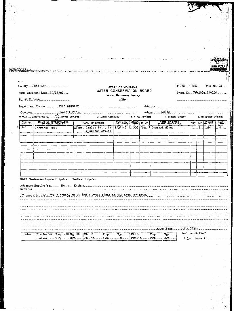
• County Phillips. STATE OF MONTANA T..21N R..32E Plat No.,.9.3 ':
Farm Checked: Date...lO/ia/d7. W A T E R CONSERVATION BOARD p h o t o ^ mmi..KtlM.Water Resources Survey :<
By...Ai..S,..D.ave. *&&»< - \
Legal Land Owner Jv.e.n..Bla;t.t.e.r. Address •
Operator .QX3Xar.t...Br.QS.. Address .Malta :
Water is delivered by:— A J Private System; 2. Ditch Company; 3. f.tate Project; 4. Federal Project; 5. Irrigation District
I App. No. I NAME OK APPKOPRIATOR i VAMI> np < n r < l l Da,> App. H^lncr's I .„ . . . . 1 NAME OF DITCH ZZZ tl/tr I Present ! JrriU'Jblc IDecree No. I TO WHOM DECREED " " ' " f " '" '" '" Date t.-.'nrlt; | Inches '" """ | (Water DrHvcrcd By) No. K / r lrr. Acre. I Acres
* A-5 ' ;-inrence Bell 1 Albert Cpulej Trib. to 3/26/46 j 2Oo" Yes Oxarart dikes 1 F 44 0I Trueblood Coulee |
NOTE: R—Denotes Regular Irrigation. F—Flood Irrigation. 1
Adequate Supply: Yes No -. Explain IRemarks I
...?Lox»r&rt..Sos,...are..planning on H^ I
River Basin MiiLSLiYSE
I Also in: Plat No..24.... Twp...27J:J. Rge33E.. ] Plat No Twp Rge I Plat No Twp Rge 1 Information From:Plat No Twp Rge I Plat No Twp Rge | Plat No Twp Rge Allan 9?i a r . a r t
r . . . . . . .
|.J ] ! I.J | | 1 S- U | U J 1 1 1 i 1 Li i I* t i i T i i r i n i t ". r t r 1
i i i n i n i i i I s i i r r ri l l I I I 1 1 1 I I I 1 1 1 i l l
" I t ! M ! M l M i i l l M i
! ! I ! 1 t t ] i [ T1 1 1 ! t TV; : = i | i ! j | ; i i i j i i •
I ! I i I ' i I I I I I I I I " L11~ ! i t T ! 1 T ~"! ! '! 1' I ! ) * 1
i ! i i ! i 1 i I ! ! ! S - ' S \! *f 1 " t"'"1? i ; a f 1 i *f 1 ] 1f' i i& ri i i ! i ! i i i .. I i .,i . I ! 11 1 ! "i \ T I I \'"T) [ - I • •• ! Ii j ; , S j i i i I i j j j | I I i
I I ! ] I- I \ H I -H+H H + f hj IS) j } -2Q i i 21- f | 22 ! j 2S | i-...2*-~|—•'I i I i j ! 1 i ! j I ! i l l ! i
f i i I i i i i i ( n i i i i i i~T 1 ! ; ! ! I l l ! ; | ! * ! j |
I i i .1 . I I i i ...i | I j I ! I I _ ± _I I i M I 1 ! M l M l ! ' I
1 3Q ; f -2J> ! 1 2jJ t i 2? I f 2(5- j j -~2B— [—•
-- \ 31 : 1 3^ I j 3b I ! 3^ ! i S^ 1 ! 36 ':i : : i i ! i ! i ! i \ i l l : • !
I 1 ; ; M i M M I I 1 M I M i I M SLand Ownership _ .".

I
I •m^^Mm^^^^^-^^^.^.'-.-- • : . . : . . • . - • - • — • • • . - • • • • • • • • • • • - • - . • • - • . . - , . . . - « . , . , . • • . , • - . . . - - . • - . . • , . , - • • . / , • • . ^ . . - . . • ^ . - i . ^ v ^ . i . ^ . v ^ ^ - w w ^ i ^ a f e s
K.I-A 1 j
County....Phillips STATE OF MONTANA T..27M.....R..32E Plat No 93
, n / /,- WATilR CONSERVATION BOARD _n 5Farm Checked: Date....lP/..../&7 Photo No...7Wr7.0*...7fcfi8
Water Resources Survey I IBy...Al.A..Dave. ° « ^ ' | ILegal Land Owner La«iS...&..LflWiSS-..He!fdeS3n Address ;
Operator V....Q...Zov;..Jx.. Address J.felta :Water is d e l i v e r e d by:— 1- Private System; 2. itch Company; 3. State Project; 4. Federal Project: 5. Irrigation District i
I A^n vn—T XTAIMP nv APPllOPKIATOR [ V\MW np <s—»PAM I °» t e AW»* Miner's . .. ' NAME OF DITCH I n / P I Present XTilBubte • 1l»crn No I TO WHOM DECREED I NAME OF S,REAM | Date Priority | Inches | I o " " (Water Pcllvered By) No. | " / F Irr. Acres Acres , I
Jc43fl-_ LLssi is Jtetriegen L-Elat_Gi8fik [&J)/S& &lLStacLj i—'. . :
jfcll1B_l_Lewis_HedS36D lijnDaiagd-GQiilfie ' .Sjljm AlLSlofik-L I—;A-1195 I Lewis Herdogen jjnnamed Coulee "^/i/47 9.00 Stock •
l-lXVliri^iisJteviswi-l. 'luppafflgd Cpulg^ 12/27/47 I 2Q0.^tockl7 l _ 0 UL— . !ilb_U^laJAiJtoJ:ai^__JIiitt 1 !J^J^lJIsv^7j5^S3SAZZI-1. Jte&djjaulee llllmL 2fiS Stasis. _ J
NOTE: R—Denotes Regular Irrigation. F—Flood Irrigation. ;j
Adequate Supply : Yes No Explain !Remarks |]
•. zizzi~izzirzz~"iiizzzzz~.. zzzzzzzzzzzzzzzzzzzzz. iRiver Basin Milk JUver -.. ]
I Also in: Plat No Twp Rge~..|!Flat No Twp R«e ||PiatNo Twp Rge I Information Frcm:Plat No Twp Rge jj Plat No Twp Rge '; Plat No Twp Rge yj. C...Row.....Jr. |
|
|
I
I

s . . . ..._..: : • •
K I I I I i I I i i i i ! i i I j
I I); 1 1 ;; 1 1 r ij i tii t t f H~. i i ; n I n r r rr [ r i i r ~I I ! ! t t I I ! t i~"ti i I • H~t~| i ; I | _} | ] i-..i L -U4 i L | |—i—{—
|B i*—I— I i f---| i ijj t j 4 ~"* i-K~i" — t " - * ? —
» a ) I | 2Q I |--21- ] 1 22 1 -j 2B I -]--2|l \
S I Sj) | I -2 •• 4 j 2^ I ••! 'i.\ 1 -j -2 3- j j -~2£-~4—
B •- I ?.)" ••• 1 3 2 i | 3 ? I •—» ; 1 3J—I \ Sis v
H Land Ownership _

. _ _ . ;
F-l-A . !
County...:..Phillipjs S T A T f e 0 F M0NTANA T..?7i....R.32E plat No...9.3 ;
„ , , „ t , n / 1 o / f t 7 WATER CONSERVATION BOARD „ t „ o,,, „Farm Checked: Date....iO/.A.8/67 Photo No...8.\fc5.5
Water Resources Survey
By A1...5oith 4g3»»
Legal Land Owner .Frank..£,..iAjdrens .Martin Address Malta
Operator AddressWater is delivered by:— Cl.JPnvaie System; 2. Ditch Company; 3. Slate Project; 4. Federal Project; 5. Irrigation DistrictI App. No. I NAME of APPK.OPRJATOR i VAMP DF W u t . n i Date App. Miner's! , „ , . „ . i NAME OF DITCH I „ . - I Present Irrigable I
Decree No.! TO WHOM DfcCKEEU j SAMb OF STREAM | Date Priority | inches | l n U s t I (Hater Delivered B y ) No. | n/t Irr. Acres Acres
-At28g_l_Clay_Hales I VMgon Box Coulee ._ 3/13/36 I All I Yes Kales dikes iTT" 7? 0A-114 i Clay Hales Bea-.-qr Creek 5/9/35 320 | No
| I • ' • ' j
I _ l ,
r - "~ ~ • - - j — - - - p _ rI I . ^ ;
____^^^ j - — - j "~ :„ _ _ ] _ " \ " ~~ _ ' ' 1 _" L L •
X T ~" ~" "" ~i • ~ T ~ I 1 \ 1 11NOTE: R—lenotcs Rei;ular Irrigation. F—Flood Irrigation..Adequate Supply: Yes No..:./ Explain jRemarks ;
River Basin iiiik.R.iye.j;
I Also In: Plat No T w p Rge |j Plat No Twp Rge ||Plat No Twp Rgc I Information From:Plat No T w p Rge !i Plat No Twp Rge !| Plat No Twp Rge I Frank Martin

- .-• .'. - • . . - . . • I
I I I i 1 I I 1 , i u i j I I . i 1 i LH i il
I- <i \ [ * !- < \ f-1- H i H —t— ! I
I j s _ ! S !__ i ] i__i— ! I i i I
._ i .1 1 [ [ \ I | 1 J_ ] ] ...] j L ] |_ \
~ i i I f •"4 i~" -"-]••-•••^ 1 j ip-1 -r-H 1 1 if~-i ;
i ! i 1 1 L i—i—1 j 1—I _ 1 _ i—i—i i
I 11 i r n i"Ti 111 i. j. j i i i v •i *f [ -| *f t i *f i i at i t t T " • m~~ ! 1
#i i-i i i ffl i -TM-tffl i| -l-p ! } 20 i ] 2t j ~ j - -22—| - -- 2p | -•]--if \ | I
1 1 30 ; !•- -21> \ 1 2? i ' i-" 2? •"! ~| • -2&- j |—2^--}—
• ••-•;• 3 1 -••• | - " 3 ^ | j 3? ( \ 3 b \ j 8 5 • i \ 8 6 ; 1
I Land Ownership .. _

i . .. . . . . . . . . . . . , _. . . — • -.- . . . ........ . — -i-i...,rt. . ,~^.i——*UA*_.'.*UifWJii^.'J
F-i-A
County Phil l ips STATE OF MONTANA T.27M R..3.2E Plat No...93.
Farm Checked: Date...iO/l8/67. W A T E R CONSERVATION BOARD p h o t o N Q ^ ^ ^Water Resources Survey
Bv Al..$ntt.t,b agg*' ..aVm5&}-7.Vfc-.l65s...lfi6
ILegal Land Owner J.....:..l,...£....Le.eila..Qxaj:sr.t Address Mal t3
Open.tiy Address
Water is delivered by: '• Private System; 2. Ditch Company; 3. State Project; 4. Federal Project; 5. Irrigation District
_6=9Z2_J-J.._: V..0xas:ar± Lj&dn_i,abe.Co.uis.? LQ^/^JiH^C-Ye^^arart^ikes L L _ J L J _ 2 & 8 _ . _ . _ 0
_ U s e i_V'ill|an_(ta_rtenir!on i iagon Jox_Cou.lee _19_35 \ | Yes.. Oxar.art d i k e s 1_..F 3L Q
Jfcl2<&.L>L_iL-0xararL .UnnamedJcoulee 11/^4/^7 An [""YPF. Oxarart. dam & d i k e s ] E__225 J3
NOTE; R—Denotes Regular Irrigation. F—Flood Irrigation.
Adequate Supply: Yes No. Expla inRemarks
.'.' River Basin ihlk.MVSX
I I S in: Plat No. 103 Twp.. 26K RgeOSc.-il Plat No..~.*Twp Rge 'j Plat No Twp Rge I Information From:I Flat No T\vp.. . Rge '^lat No Twp Rge :;PUNo Twp Rge j A1lan..QjOT.ar.t £5.9.0.).

H __ j I _ j ] l A. i j I _ ^ _ i _._3 1
BB jii ' f -t'tj...~L i..-...*ii£. i . ... ;;...-...i.k \ L .i.u..„...,!«..„..„ .......IR , -..i......... fln| •*" i'o ! T * • 1 ' ; * v i " s •*? 1 > * r ! * i ^ ^ ' •^B ; : ' I i ! *• ! : : ' 1 ! ' ! 1 •
| IP I | *j> | ) 2f | | 22 \ -•] «B | — 2k j I
• | 3j> ; \ -29 i j 2^ I | 2JP ! - j -2 5 1 {-25—\ 1
H •••-••; 31 : j 3? \ | 3 ? \ | 3^ j -•) S 5 — I 3|3 1
H Land Ownership _ 8

i~i~**.jji<~~*...^~.: . - - - . - - . . . . . - . . . - . . . . . - . . : . . . . - . . . - •:•.••:<••••••• •• -•.--.«i^-r/-•.•:.•'...•.• •••v&*:.i^^ii*MHi£i8&iB&iilii
f
K-l-A
County....Ebillips S T A T E 0 F MONTANA T..2.7N.....R..32E Plat No .93.....
_ . . . „ , .„/,„/„ WATER CONSERVATION B O A R D _. ( _T _,,. ._ , 1 B ,Farm Checked: Date....lO/2Q/67 . Photo No...7.Vfcl84.it..l86
Water Resources SurveyBy Al...Sraith «c@§toi ..8W-5.3
Legal Land Owner Ecanc&S.. .Slad& Address Malta
Operator AddressWater is delivered by:— (l.'Private System; 2. Ditch Company; 3. State Project; 4. Federal Project; 5. Irrigation District
1 Ann. No. [ NAME OF APPROtMtlATOR I VAMI.' nv c-ri?i?AM D»te A|>p. Miner's ln ¥Tc-. 1 NAME OF DITCH I w/K- Present IrrigableDecree No. | TO WHOM DECREED ; JiAMfc OF S.TKI.AM Date Prlorlly Icchca I n v s c \ QVatcr Pellverea By) No. | R/" Irr. Acres Acres
Use LErances_Slade !_DJ.H^S^_Cie.ek TQfifi I I Ypg I sinrfp riil?ps 1 L__8 0
I I ^-^^.
NOTE: R—Denotes Regular Irrigation. 'F—Flood Irrigation.
Adequate Supply: Yes No.^.. ExplainRemarks
River Basin liilk.. 'rlivei.
I Ahoin: Plat No Twp Rge I! Plat No Twp Rge | Plat No Twp Rge I Information From:Plat No Twp Rge ;! Plat No Twp Rge | Flat No Twp Rge F r a n c i s S lade

I I I j ] I . . J [....I. „.!_„..! ;| I • J I I J. I MM
I _j:l..:iz :T.1: _ i:: 4: L I ... 11 ; \AB _ i j 1 \ [ 1 1 { i .1 I .j 1 ...I i |. L._ i
I \-A i I f i I- i I- \ 4~~ -j A I f--ia--j— ;I j I ! i ! I i i i 1 ! X - » i * | I I £ ;
• ~ T ! ' T 1 I 1 1 I I I I i I [ I :• • 1$ i t i7~-i i i s i 1 * >•-• i ^ i|i- i—1^—I— ;
• _ i ! ] ! __! ! !...._. j I j j_ l i M __j_ 1__L_ :
I 1 1 1 ! i I L....I I j !..„..{ I I I j I L :
I i ab I } 20 1 { 21 1 j 2^ i - j 2k I -1 2* |--- :^H j I • • i I i 1 ! j I ' ! ! : '' ' I
• I St) j } I p \ 1 2^ I 1 2Jf--4 •; ip-~ { - -\ ]--2fe-4— . ;
B • - -;••• 3 1 -•• • sk i i 3 ? S \ 3 s - ; \ 3 5 \ 1 3 6 vB f l I ! '• I 1 : 1 : 'i I I • • :
H I t< i M ':,,,'; i • 1 | I n . , 1 . - - '' - I I : I \ I
H Land Ownership ^ _
IB t

r v« .
""' "" 7 " ~ •""" ~~:rW. , . • _ , . -.. . . u - . . • • . . . ' • • • ! ; , -v , . * • • * . • : / • w > ^ ~ r f « w > ^ ^
j«..*.,*«,~~™.~~. _ - jj
F-l-A I
County .MI.Ua? STATE 0 F M o N T A N A T.27N....R.3.2E Plat No 23.... |
r,u , _• T, * WATER CONSERVATION BOARD „ t M 7W . , , IFarm Checked: Date Photo No...7ibl6fe J
Water Resources Survey jBy AJ. A.P.ay.e =^^°" |
I Legai Land Owner State...o£..IAoatana Address }
I Operator j,..JAk..Dxarart Address...i!.a.lta |I Water is delivered by:— 1. Private System; 2. Ditch Company, 3. State Project; 4. Federal Project; S. Irrigation District \
I I App. No. I NAME OF APPHOPRIATOR i VAMV np «TRUAM Dtte App. I Miner's ,_ „,. NAME OF DITCH o/p I Present I Irrlcablc I 1• Decree No. | TO WHOM DECBEEU j NAME OF STREAM | Date Priority | Inches | '" "" (Water Pcllvorca By) No. K / F Irr. Acres Acres j
I * See Motel Grave Coulee IS 0 •
I NOTE: It—Denotes Regular Irrigation. F—Flood Irrigation. j
R Adequate Supply: Yes No...\. Explain i• '••-• B e m a r k s
I ...*..0.X3EaA-t...v.5!es...hi.s. appropriated .water...to...irrigat.e..this..land..
B River Basin Milk..RiY.ex
I Also in: Plat No Twp Rge Plat No Twp Rge Plat No Twp Rge Information Fro.m: 1H Plat No Twp Rge Plat No Twp Rge Plat No Twp Rge j € \,\f Oxarart I

i ._ 1 _ _ „ : : „ ' _ '.._ „ _ __ _ _
m I I l - t •! I I - J I - I i | i i J 1— 6 t 6 - -~4 8 \- - i a - 4 — —_ 1 i ! J t I L ! ! _ 1 _ L
I 1 i | i 1 i i i M l I Ii ! i i I I .1 ! J I ! I iNM i I I I i l l M i I I I • I - I FI I [ ..! l . . I I LJ .... L..J I . ! 1 I . 1
" 1 1 T M l i M M i 1 1 1 S 1 1i i ! I M I • i i 1 i I i I j i
~ ! I ! t I t i i i I I I ! -•-(•• -•p. ! 1 i i T l " i 1 1 i i i *f " i f \
1 1 1 M i i l l M l I I 1 I Si l l I I I . . ] J i i . j I .1 . . . JI ! ! | " i I ' ' I I i ! i i " | I | i
I I ! M l I M ! ; I i l l I ) i"1 ; i Si ! 1 11 I'M ITTr^F IH i i i ! 1 • 1 1 1 ! L I i I i iJ :• ! i i ! i i ! ! ! ! ! ! ! ! i ! ! ! :
• 1 30 i j- - 2|> f | 2p ] - --! 2j? j - j - -2S | j~"2£ }— || ; I i [ 1 i 1 . ] I „...! .i. I. } i I I I i j
j I ;—U|-| H-4—*f4—1 M4-" ' 1 I !-— |- 3 1 • \ 3^ \ 1 3? i ! 3ji ; 1 Zp \ SjS :
j • : ! ': i l i i i i i i l l '•
Land Ownership

J - •• - ^ _
• ' • ;
; : " ~ ~ • •:;,_]V
F-l-A • |
County Phillips S T A T E o y M 0 N T A N A T..27N R .32E Plat No .9.3
_. , . _ , i n / 1 Q / A 7 WATER CONSERVATION BOARD _. . . . m =,. 7W-ia6Farm Checked: Date...I0/1.9/67. . Photo No...9Mr?.v>.3....<>fc.4-.HS
Water Resources Survey 1By Al . Smith « ^ , , ...7.W-188 j
Legal Land Owner U»S.,A. Address....B.?.lJ.?. .'.
Operator Address !Water is delivered by. 1. Private System; 2. Ditch Company; 3. State Project; 4. Federal Project; 5. Irrigation District !
I App. No. I NAME OF APFROPMATOR j VAMP m n n s i M i Date App. Miner's ,_ „.„ NAME OF DITCH „.„. I Present Irrleablc"! IDecree No. | TO WHOM DECKEED | " " " u f " " ' " " ' | Date Priority | Inches '" " s c | (Water Delivered By) No. K'r Irr. Acres Ae=-cs !A-1489 I U.S.A. I U.T. Beaver Creek TFtl/bZ All Stock I PR- 4 2 H Z !A-1381 I U.S.A. U.T. Beaver Creek "6/20/61 All Stock Black Cow R. R. j
"~ A-13S2 I U.S.A. U.T. Beaver Creek 6/20/61 All Stock Glory Hole R. R. jA-1383 ! U.S.A. U.T. Beaver Creek ' 6/20/61 All Stock Black Bull R. R. I
NOTE: R—Denotes ReBular Irrigation. F—Flood Irrigation. j
Adequate Supply: Yes No.A. Explain i1— Remarks \
i
Also in: Plat No Twp Rge | Plat No Twp Rge Plat No Twp Rge Information From:
Plat No Twp Rge I Plat No Twp Rge Plat No Twp Rge F ie ld Survey

• •
I
i
|
I i j i I n i i i i i i i n r~i...I. i ] ....! ..i i » I
I I i fJ I . . 6 . .J_4 . « 1 1 i Li L__
i i i i J i " i , ] i i i i i s rrri l l i i I ! ! i l l i ! i • i i II i i i l l !_ .. ! . I ...J j . . . . | I I . . . I . I _. I
i i i i r ' i " M i s i i "• r i i i i [! ! i i i i J 1 Mi I '• ! i
i i i f I i r s i i n 1 1 [ i n I"'" i I I i 1 1 1 S I i i- j |- j" -~-y-~.j
*j> i j i? j I *? t I *f i [ *f-| *f-p •i 1 1 1 t 1 1 1 1 ; \ M h t i I Tj | | | i | | j 1 1 ] ! | | ! I J..4..J
10 ! i -20 1 1 21 t 1 22 1 j 28 1 -}--2i |M i i | I. I ! L ]_J J !. i L. 1... i
M l i l l I l i 1 1 1 1 1 i I "1 i II L I .! I I i 1 1 I I I I I....! 1 L J1 3 ) ! j H& f i 2b 1 1 2? \ -4 -2JJ I l--2fe }••-•••I ; 1 1 1 ' ! i • j • i I i j i i
- - | 3^ \ 1 3^ \ \ 3b i 1 3ji I | 35 ; i 36 \
I ! ; ! ! I i i i i i ! ! i j • i •
Land Ownership