YOUR GUIDE TO GAMP FANNIN - Camp Fannin AssociationYOUR GUIDE TO GAMP FANNIN The most historically...
10
YOUR GUIDE TO GAMP FANNIN The most historically significant World War II military site located in East Texas was Camp Fannin. This Army Infantry Replacement Training Center was fully operational from March, L943 until June,1946. At its peak, almost 30,000 persons lived andlor worked at the Center. Most were young men who had been drafted and were basic infantry trainees. Though a half century has passed since the last training cycle ended, the Prisoners of War repatriated and the returning combat veterans sepa- rated,thgre is still some remaining evidence of this impressive facility which once sprawled over more than 14,000 acres. To reach the site of Camp Fannin from Tyler, travel northeast onU.S. 27ll Texas 155. Along the way you will pass the unmarked location of Camp Fannin-Gate 1, which is located 1.8 miles south of a point where Texas 155 joins U.S.2ll. Gate2, which was the entrance to the Base Hospital, (A) is near the present entrance of The University of Texas Health Center at Tyler which has been built on the site of the Camp Fannin Station Hospital. Occupying over 600 acres of the original camp, UTHCT has evolved into a modern state university medical and research center from its origin as a state tuberculosis hospital which once utilized - after Camp Fannin was closed - the original buildings of the station. The tall brick smoke stack of the boiler room, once a landmark that towered well above any nearby camp buildings, along with a few remodeled hospital barracks, are al1 that remain of the original hospital buildings. A Camp Fannin cofiImemorative plaque, dedicated in Novembet 1993, is located in front of the stack.
Transcript of YOUR GUIDE TO GAMP FANNIN - Camp Fannin AssociationYOUR GUIDE TO GAMP FANNIN The most historically...
YOUR GUIDE TO GAMPFANNIN
The most historically significant World War II military site located in East
Texas was Camp Fannin. This Army Infantry Replacement Training Center was fully
operational from March, L943 until June,1946. At its peak, almost 30,000 persons
lived andlor worked at the Center. Most were young men who had been drafted and
were basic infantry trainees. Though a half century has passed since the last training
cycle ended, the Prisoners of War repatriated and the returning combat veterans sepa-
rated,thgre is still some remaining evidence of this impressive facility which once
sprawled over more than 14,000 acres.
To reach the site of Camp Fannin from Tyler, travel northeast onU.S. 27ll
Texas 155. Along the way you will pass the unmarked location of Camp Fannin-Gate
1, which is located 1.8 miles south of a point where Texas 155 joins U.S.2ll. Gate2,
which was the entrance to the Base Hospital, (A) is near the present entrance of The
University of Texas Health Center at Tyler which has been built on the site of the
Camp Fannin Station Hospital. Occupying over 600 acres of the original camp,
UTHCT has evolved into a modern state university medical and research center from
its origin as a state tuberculosis hospital which once utilized - after Camp Fannin was
closed - the original buildings of the station.
The tall brick smoke stack of the boiler room, once a landmark that towered
well above any nearby camp buildings, along with a few remodeled hospital barracks,
are al1 that remain of the original hospital buildings. A Camp Fannin cofiImemorative
plaque, dedicated in Novembet 1993, is located in front of the stack.
4
As you leave the Health Center grounds, and travel north on Texas 155,
you will be on the grounds of Ca*p Fannin. This is where the 11th, 15th and
Special Training Regiments were located. Drive slowly and you may be able to
define the locations of Rounseville Road and Daniel Avenue, the main streets from
which troops of the 1lth and 15th Regiments accessed their Mess Halls, Theaters,
Churches and P.X. Foundations of buildings of the Battalions and Companies are
in evidence throughout this area.
Continuing on Texas 155, turn left when you reach County Road 334,
(Center Church and Cemetery Road) and you will be on what was Chapman Road.
This was the road over which some of the troops marched to and from the ranges.
It borlers the locations of the 1lth Regiment-Battalions 5L,52,53 and 54 as well
as the 15th Regiment-Battalions 83 and 84. (B) It has been slightly rerouted to pass
diagonally through the area of the 81st and 82nd Battalions. The camp water tower
is located on the north side of the road about fifty yards east of the Center Church.
When you arrive at Center Church, turn right on County Road 336 and
you will be on a road which was quite near one of the rifle ranges. Just after
passing County Road 337, if you look carefully to the right, you may be able to see
the location of the pits of Range 1. A few hundred feet to the east of C.R. 336,
although not discernable, there is a north/south access road and the Range Road
(D) which ran several miles in an east-west direction following a circuitous path to
Lawhon Road. An access road appears to follow apafi of the Range Road west
from Texas 155.
If you proceed north on County Road 336, you will find it segmented by
Interstate Highway 20. Some who trained here will remember that C.R. 336 was
also the road to the bivouac area on the southeast shore of Pinedale Lake. (G)
Though not25 miles as promised - or threatened - by our drill sergeants, it could be
made into a hike of any elected distance by marching back and forth across the roads
and traits within the camp area. (H)
If you wish to follow the path of C.R. 336 to the bivouac site, follow the road
until it becomes a dirt road, turns to the left (west), and, after travelling I mile, it
intersects with Farm to Market Road 2015. Turn right, cross Interstate 20, and turn
right (east) at the next intersection - just beyond I-20. Continue following C.R. 336,
which again turns north after one mile. Go past Harris Church, cross C.R. 313, and
continue on C.R. 336 until it again intersects F.M. 2015. After traveling a short dis-
tance north on F.M. 2015, turn left on C.R. 347 placrng you one mile from the
Pinedale Lake bivouac site (G). The total distance, as the crow flies, is less than five
miles. (Believe it or not, this is the exact route you may have marched!)
,.\ ,L 'L '\Lrwww
To drive through and explore the area where the lzth,13th and 14th Regi-
ments'barracks and other camp buildings were located, travel Texas 155 north, past
Center Church Road (formerly Chapman Road). Turn right on F.R. 3210 (the next
intersection), this was once Friedline Road. You will find that many of the streets in
this section of the Camp Fannin area still bear their war-time names. For instance,
Massey, Constantin and Lawhon Avenues are all original names and can still be identi-
fied. (C) Numbered streets bordered battalion locations and many of these are evident
and well marked. When found, they will help those who were assigned to training
battalions in this area locate their barracks sites and/or other points of interest.
on uS 271, near the actual l0cation of the Main Gate, there is an
Historical Marker which gives a brief historical sketch of Camp Fannin. Those
6
who were members of the W.A.A.C will recall that their barracks was just inside
the main entrance.
Camp Fannin covered an expanse of real estate. Although it is not pos-
sible to drive the exact perimeter of the more than 14,000 acres covered by this
training facility, those who wish to tour the area within the boundaries of the Camp
can follow U.S. Route2Tl to County Road 353, turn left and continue north for
1.75 miles. At this point, the Camp Fannin boundary was configured by property
lines that extended directly west for 2 miles to a point on County Rd 343 where the
Camp Sewage Disposal Station, (E) which is still in use by the residents of the
area, can be seen. Gate 6 was located approximately .75 miles from Route 271 and
accessed.a road which ran parallel to Interstate 20. The marshlands, which sur-
round the course of Harris Creek, suggests that no access road existed that con-
nected Gate 6 with one of the main roads through the Camp. It is possible that this
gate provided an alternate access to the security patrol road surrounding the P.O.W.
compound which was located east of Lawhon Rd (CR 343) near the present I-20.
,.\ ,L ''\ ''LwwwrJ
To continue your tour, exit offU.S. 271 onto F.R. 3270, go north on FR
3311. This will take you through the St Louis and Southwestern Railroad Marshal-
lingYard where supply warehouses and the troop arrival and departure area were
located. Several of the original warehouse buildings are still in use as small manu-
facturing sites and/or warehouses. The original Camp Depot has been relocated to
this area and can be easily identified. Continue northward on FR 33ll past the site
of the P.O.W. Compound, which will be to your right just before crossing
7
over I-20, then past the Sewage Treatment Plant (E)- on your left - cross over TX 155
to CR 343 pastthe intersection of C.R. 313 where Gate 8 was located to County Road
345. C.R .345, was the northern most boundary of Camp Fannin. For those who may
have visited the town of Winona, it is a short distance to the east.
To stay within Camp Fannin turn left, (west), on C.R. 345 until it ends at F.M.
2015. The location of Gate 9 was a short distance north of this point. Turn left on
F.M. 2015 (south), to C.R. 347 . lf you turn right on CR 347, (west), you will be on
one of the two roads which led to the main bivouac area on the east shore of Pinedale
Lake. The land is now private property, and the lake is neither visible nor accessible.
However, if you could continue straight ahead at the point where CR 347 turns right,
you would be on the knoll above the lake where a week was spent running combat
maneuvers during the day and camping out under your shelter half at night. As I
recall our Company Commanders lecture, "putting all of our training into practice."
There is no passable perimeter road now available to vehicles on the western boundary
of Camp Fannin. The western edge of the property extended due south from a point
northwest of pinedale Lake for 4.55 miles, then indented a few hundred feet to the east
- then again continued south for an additional 1.1 miles.
Leave C.R. 347 and continue south on F.M. 20L5 to C.R. 313 which accessed
Gate 10 on the western edge of Camp Fannin. Further south, Gate 11 was at the head
of one of the two access roads leading to the camp ammunition bunkers from F.M.
2015. As you continue in a southeasterly direction on F.M. 20L5 you will exit the
camp area ator near the location of Gate 11.
10
. Approximately .5 miles further south you will again intersect with Texas
155 and U.S. 271. Turn right to return to Tyler or left to travel north to Texas 155
or Interstate 20.
If you tour the available roads within the boundaries of Camp Fannin, you
will cover lot of territory. We hope you will find the trip both enjoyable and re-
warding.
The maps and descriptive text have been prepared to help visiting veterans
who trained at this Infantry Replacement Training Center, as well as others who
have interest in the history of Camp Fannin, find specific locations.
.Please remember that Camp Fannin is on lands that are now PRIVATE
PROPERTY and must be observed as such. You may view locations from the
roads but must have owners or management permission to enter specific areas. Ifyou fail to observe the limitations of privacy, you may be charged with trespass-
ing.
i
tllrrI I I f .r I i
Historical Note: After a short period. during which it served as a Separation Center, Camp Fannin
was offi.cially deactivated June 15, 1946.
11
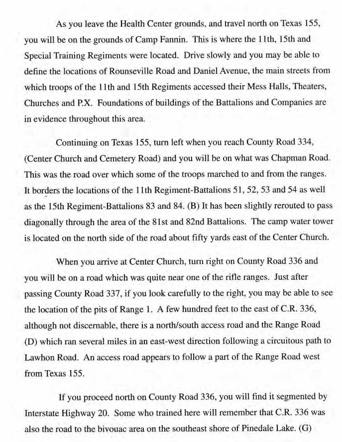
Map 1.
fs marked to represent an easy to follow guide (see pages 8-9) of Camp
Fannin which was once one of the largest Infantry Replacement Tbaining Camps
in the United States. If you were stationed here, we hope that it wiII help you find
those locations you recall from the 40's. The Smith County Historical Society
located in downtown Tller at 125 College Avenue has larger, more detailed maps
as well as many artifacts which were a part of the history of this site. You are
encouraged to visit this display.
Gate numbers define the Iocations of the 12 Gates which allowed entry to
Camp Fannin.
B./C.
Map Letters Define:
The University of Texas Health Center which is constructed on the site of the
Carnp Fannin Station Hospital. A commemorative plaque has been placed on
the road which is adjacent to the brick smoke stack which was the location of
the main boiler room of the original station hospital.
The area of the training battalions shown on the Map.TheWAAC barracks
were located just inside the Main Gate. The POW Internment Camp was
located southeast of the point where County Road 343 crosses Interstate 20.
Designates the area location of the Ranges and the Range Road that extended
from County Road 343 n an irregular east-west direction. All practice ranges
were aligned along this road.
The site of the Base Sewage Disposal System, which is still in use. The facility
has been expanded and modernized during 1994-95.
D.
E.
t2
The pock marks from shrapnel are visible on a bridge crossing Wiggrns Creek at
this location.
Pinedale Lake, which was the main bivouac area.
Hitts Lake, (Greys Lake during Camp Fannin tenure) which was also utilized as
a bivouac area.
The camp ammunition storage bunkers.
Please recognize that some locations can not be seen from public roads
because they are located on property which is now private.
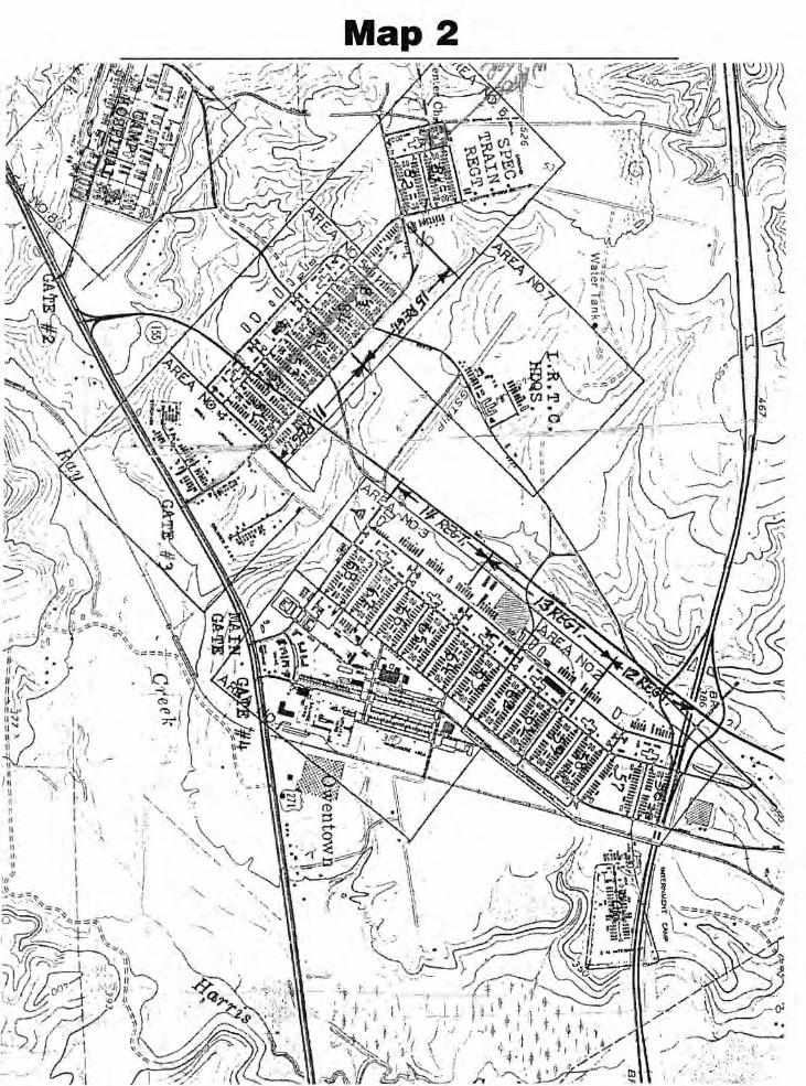
Mry2.
This map (page 14) is identified as a 1944 Site Plan of Camp Fannin.
Identification of the areas where Tfaining Regiments and Battalions were located
have been inserted in a form that may aid visitors in the identification of specific
locations.
Other Publications.
Camp Fannin Texas...A 50 Year Perspective, which was written by Gordon
Neilson and is considered to be the most definitive and accurate of histories related to
Camp Fannin. Those interested in the area are encouraged to obtain a copy of this
publication, available at The University of Texas Health Center and the Smith County
Hirtori"ul Society, or by mail from the Camp Fannin Association for $15.
Material in this booklet has been compiled by A. D. Wendt who trained in the
last cycle of Co B, 53 Bn, 11th Regiment and who left the area four days before
Christmas 1945.
F.
G.
H.
t3
I
Map 2
7:"fI .-
;--, I r.IiJ ,r
{.\\,,',, i
\'r'Ht,i \ ! Ha a'ilt \ i \'.J. I L \
il" \.sy
, r\J
\"\-)\-
i
"*,.','
i11
!}ti
il{1,.1i
tl -
tl. ,{r\l!*l't'IIt l\.["
+
.. ::!,
k...,.1-l
k*i? -, ,
-.t t
.l 1\,.lt J
i! .,i
*,1,',
i l-ttl1il, I!i ".
/.,r,.
:."_".]
l;Ii. ,
ii {\ ..n'f-il i r ..Lrti ."lttu, Iriv Itr\ \tiJ[,r'.tl '
ln ,
1[
ililll
[!
'il.Ni
it-t
{ff\t],il
1,\
. ';,
t\ " :,- ..3..