York County Long Range Transportation Plan -...
118
York County Long Range Transportation Plan 2009 - 2035 Prepared by York County Planning Commmission YAMPO Adopted June 25, 2009 York County Commissioners Adopted - July 8, 2009
-
Upload
nguyenhuong -
Category
Documents
-
view
217 -
download
3
Transcript of York County Long Range Transportation Plan -...

York CountyLong Range
Transportation Plan2009 - 2035
Prepared by York County Planning Commmission
YAMPO Adopted June 25, 2009York County Commissioners Adopted - July 8, 2009

PAGE INTENTIONALLY BLANK

2009-2035
YORK COUNTY
LONG RANGE
TRANSPORTATION
PLAN
This report was funded in part through grant[s] from the
Federal Highway Administration [and Federal Transit Administration],
U.S. Department of Transportation. The views and opinions of the authors[or agency] expressed herein do not necessarily state or reflect those of the
U. S. Department of Transportation.”
York County Planning Commission
28 East Market StreetYork, Pennsylvania
June 25, 2009

Page Intentionally Blank
TABLE OF CONTENTSPage
Chapter I - Introduction
What is the York Area Metropolitan Planning Organization (YAMPO) and
How Does It Help You?. . . . . . . . . . . . . . . . . . . . . . . . . . . . . . . . . . . . . . . . . . . . . . . . . 3Overview of the Long Rang Transportation Plan. . . . . . . . . . . . . . . . . . . . . . . . . . . . . . . . . . . 3
Federal and State Requirements for the Long Range Transportation Plan. . . . . . . . . . . . . . . . 4
One Document, Two Purposes. . . . . . . . . . . . . . . . . . . . . . . . . . . . . . . . . . . . . . . . . . . . . . . . 5Overview of Process. . . . . . . . . . . . . . . . . . . . . . . . . . . . . . . . . . . . . . . . . . . . . . . . . . . . . . . . 6
Public Involvement. . . . . . . . . . . . . . . . . . . . . . . . . . . . . . . . . . . . . . . . . . . . . . . . . . . . . . . . . 6
Chapter II - Factors, Goals, Principles and Plans
2003-2023 Long Range Transportation Plan Recommended Actions. . . . . . . . . . . . . . . . . . 11
Chapter III - Inventory
York County Population Projections. . . . . . . . . . . . . . . . . . . . . . . . . . . . . . . . . . . . . . . . . . . 15
York County Demographics. . . . . . . . . . . . . . . . . . . . . . . . . . . . . . . . . . . . . . . . . . . . . . . . . 15
Map 1 - 2000 Inter-County Journey to Work Flow. . . . . . . . . . . . . . . . . . . . . . . . . . . . . . . . 18York County Roadway Functional Classification System. . . . . . . . . . . . . . . . . . . . . . . . . . . 20
York County Bridges.. . . . . . . . . . . . . . . . . . . . . . . . . . . . . . . . . . . . . . . . . . . . . . . . . . . . . . 23
York County Transit. . . . . . . . . . . . . . . . . . . . . . . . . . . . . . . . . . . . . . . . . . . . . . . . . . . . . . . 24York County Park and Ride Facilities. . . . . . . . . . . . . . . . . . . . . . . . . . . . . . . . . . . . . . . . . . 25
York County Railroads. . . . . . . . . . . . . . . . . . . . . . . . . . . . . . . . . . . . . . . . . . . . . . . . . . . . . 26
York County Bicycle Routes. . . . . . . . . . . . . . . . . . . . . . . . . . . . . . . . . . . . . . . . . . . . . . . . . 27York County Air Transportation. . . . . . . . . . . . . . . . . . . . . . . . . . . . . . . . . . . . . . . . . . . . . . 29
Ongoing Regional Efforts. . . . . . . . . . . . . . . . . . . . . . . . . . . . . . . . . . . . . . . . . . . . . . . . . . . 30
Map 2 - Functional Classification . . . . . . . . . . . . . . . . . . . . . . . . . . . . . . . . . . . . . . . . . . . . . 33Map 3 - Bridges . . . . . . . . . . . . . . . . . . . . . . . . . . . . . . . . . . . . . . . . . . . . . . . . . . . . . . . . . . 34
Map 4 - Transit . . . . . . . . . . . . . . . . . . . . . . . . . . . . . . . . . . . . . . . . . . . . . . . . . . . . . . . . . . 35
Map 5 - Park & Ride. . . . . . . . . . . . . . . . . . . . . . . . . . . . . . . . . . . . . . . . . . . . . . . . . . . . . . . 37Map 6 - Railroad Map. . . . . . . . . . . . . . . . . . . . . . . . . . . . . . . . . . . . . . . . . . . . . . . . . . . . . . 38
Map 7 - Bike Routes. . . . . . . . . . . . . . . . . . . . . . . . . . . . . . . . . . . . . . . . . . . . . . . . . . . . . . . 39
Map 8 - Airports. . . . . . . . . . . . . . . . . . . . . . . . . . . . . . . . . . . . . . . . . . . . . . . . . . . . . . . . . . 40
Chapter IV - Identified Needs
Air Quality. . . . . . . . . . . . . . . . . . . . . . . . . . . . . . . . . . . . . . . . . . . . . . . . . . . . . . . . . . . . . . 45
Aviation. . . . . . . . . . . . . . . . . . . . . . . . . . . . . . . . . . . . . . . . . . . . . . . . . . . . . . . . . . . . . . . . 46
Bridges. . . . . . . . . . . . . . . . . . . . . . . . . . . . . . . . . . . . . . . . . . . . . . . . . . . . . . . . . . . . . . . . . 47Capacity (Congestion Management). . . . . . . . . . . . . . . . . . . . . . . . . . . . . . . . . . . . . . . . . . . 48
Enhancements. . . . . . . . . . . . . . . . . . . . . . . . . . . . . . . . . . . . . . . . . . . . . . . . . . . . . . . . . . . . 49
Maintenance. . . . . . . . . . . . . . . . . . . . . . . . . . . . . . . . . . . . . . . . . . . . . . . . . . . . . . . . . . . . . 50Rail. . . . . . . . . . . . . . . . . . . . . . . . . . . . . . . . . . . . . . . . . . . . . . . . . . . . . . . . . . . . . . . . . . . . 51
Security. . . . . . . . . . . . . . . . . . . . . . . . . . . . . . . . . . . . . . . . . . . . . . . . . . . . . . . . . . . . . . . . . 52

TABLE OF CONTENTSPage
Safety . . . . . . . . . . . . . . . . . . . . . . . . . . . . . . . . . . . . . . . . . . . . . . . . . . . . . . . . . . . . . . . . . . . 53Transit . . . . . . . . . . . . . . . . . . . . . . . . . . . . . . . . . . . . . . . . . . . . . . . . . . . . . . . . . . . . . . . . . . 54
Chapter V - Future Funding Decision
Public Participation . . . . . . . . . . . . . . . . . . . . . . . . . . . . . . . . . . . . . . . . . . . . . . . . . . . . . . . . 59Identified Needs . . . . . . . . . . . . . . . . . . . . . . . . . . . . . . . . . . . . . . . . . . . . . . . . . . . . . . . . . . . 61Funding Projections . . . . . . . . . . . . . . . . . . . . . . . . . . . . . . . . . . . . . . . . . . . . . . . . . . . . . . . . 61Historic Funding . . . . . . . . . . . . . . . . . . . . . . . . . . . . . . . . . . . . . . . . . . . . . . . . . . . . . . . . . . 62Allocation of Future YAMPO Funding . . . . . . . . . . . . . . . . . . . . . . . . . . . . . . . . . . . . . . . . . 63
Chapter VI - Project Selection Process
The Selection Process . . . . . . . . . . . . . . . . . . . . . . . . . . . . . . . . . . . . . . . . . . . . . . . . . . . . . . 69Map 10 - 2009-2035 Long Range Transportation Plan Road Maintenance Groups . . . . . . . 78Public Participation . . . . . . . . . . . . . . . . . . . . . . . . . . . . . . . . . . . . . . . . . . . . . . . . . . . . . . . . 83
Chapter VII - Reduce the Funding Gap
Paths to Reduce the Bridge Funding Gap . . . . . . . . . . . . . . . . . . . . . . . . . . . . . . . . . . . . . . . 87Paths to Reduce the Capacity Funding Gap . . . . . . . . . . . . . . . . . . . . . . . . . . . . . . . . . . . . . . 87Paths to Reduce the Enhancements Funding Gap . . . . . . . . . . . . . . . . . . . . . . . . . . . . . . . . . 88Paths to Reduce the Maintenance Funding Gap . . . . . . . . . . . . . . . . . . . . . . . . . . . . . . . . . . 89Paths to Reduce the Security Funding Gap . . . . . . . . . . . . . . . . . . . . . . . . . . . . . . . . . . . . . . 89
Chapter VIII - Work Elements
2009-2035 Future Work Elements . . . . . . . . . . . . . . . . . . . . . . . . . . . . . . . . . . . . . . . . . . . . . 93
Chapter IX - Additional Transportation Modes and Issues
Tourism . . . . . . . . . . . . . . . . . . . . . . . . . . . . . . . . . . . . . . . . . . . . . . . . . . . . . . . . . . . . . . . . 101Environment . . . . . . . . . . . . . . . . . . . . . . . . . . . . . . . . . . . . . . . . . . . . . . . . . . . . . . . . . . . . . 101Greenhouse Gas Emissions and Climate Change . . . . . . . . . . . . . . . . . . . . . . . . . . . . . . . . 103Coordinated Public Transit/Human Service Transportation Plan . . . . . . . . . . . . . . . . . . . . 104Pipeline Transportation/Transmission Operations . . . . . . . . . . . . . . . . . . . . . . . . . . . . . . . . 105
Chapter X - Capital Improvements
(In order to reduce costs, the Appendices will be provided upon request.)
Appendix A - Public Participation . . . . . . . . . . . . . . . . . . . . . . . . . . . . . . . . . . . . . . . . . . . . . 113
Appendix B - Funding Projections . . . . . . . . . . . . . . . . . . . . . . . . . . . . . . . . . . . . . . . . . . . . . 245
Appendix C - Acronyms . . . . . . . . . . . . . . . . . . . . . . . . . . . . . . . . . . . . . . . . . . . . . . . . . . . . . 249

CHAPTER I
Introduction

Page Intentionally Blank

Introduction 3
Chapter IIntroduction
What is the York Area Metropolitan Planning Organization (YAMPO) and HowDoes It Help You?
Established in 1964, the York Area Metropolitan Planning Organization (YAMPO) was chartered,
by the Pennsylvania Department of Transportation (PennDOT). The Charter was to recognize theYAMPO as the federally-designated and certified Metropolitan Planning Organization (MPO). The
YAMPO is responsible for conducting a continuing, comprehensive and cooperative (3C) process
for transportation planning, programming, and decision-making within York County.
The YAMPO is governed by an eight member board composed of state, county, city, transit, and
state and federal legislative representatives, as well as various participating, non-voting membersand Federal agency observers. The York County Planning Commission (YCPC) and PennDOT
District 8-0 are the primary staffs that conduct work on behalf of the YAMPO.
One of the main responsibilities of MPOs nationwide is the planning and programming of
transportation needs for the long term. This is accomplished through the development of a Long
Range Transportation Plan, which is the purpose of this document.
Overview of the Long Rang Transportation Plan
The 2009-2035 Long Range Transportation Plan (Plan) was adopted by the YAMPO on June, 25,2009 and adopted by the York County Board of Commissioners on July 8, 2009, following a 32-
month planning process. The purpose of this Plan is to develop a coordinated effort to implement
transportation improvements that attempt to achieve York County’s future goals that are supportedby public consensus of York County’s physical, social, economic, and institutional environments.
It is also a requirement of the U.S. Department of Transportation which is charged with certifying
MPO plans and programs.
This Plan is the umbrella document that serves as the basis for the Transportation Improvement
Program (TIP), a capital program of highway, bridge, and public transit projects. In addition toproviding a basis for construction projects, this Plan is used to identify special projects to utilize
planning funds.
This Plan is also used on an annual basis to develop the annual work plan for the YAMPO staff
through the Unified Planning Work Program (UPWP). The UPWP identifies work tasks that will
accomplish objectives and implement policies of this Plan. In addition, this Plan identifies otherstakeholders that can help achieve the objectives and follow through with policies of the Plan.
York County Long Range Transportation Plan
Introduction4
This Plan is also used to evaluate the consistency of the transportation element of municipal and
multi-municipal comprehensive plans. Municipalities can also use the Plan to identify where future
infrastructure improvements can or can not support future development. Finally, YAMPO’s 2009 -2035 Long Range Transportation Plan serves as an educational guide and informational resource
for the citizens, businesses, and institutions in York County and the region.
This Plan strives to be consistent, coordinated, and complimentary to plans prepared by York
County, municipal governments, and the policies of the statewide transportation plan and other
relevant statewide policies.
Federal and State Requirements for the Long Range Transportation Plan
The “Safe Accountable Flexible Efficient Transportation Equity Act - Legacy for Users”(SAFETEA-LU) was signed into law in August 2005 by President Bush. This Federal transportation
legislation provided funding for highways, highway safety, and public transportation totaling a
minimum of $244.1 billion, which represents the largest surface transportation investment in ournation’s history. SAFETEA-LU requires a state or MPO to plan for future improvements prior to
using any federal funding included in the legislation.
SAFETEA-LU continues many of the transportation planning processes contained in the two
previous transportation bills, the “Intermodal Surface Transportation Efficiency Act of 1991" and
the “Transportation Equity Act for the 21 Century,” but it has instituted some additionalst
requirements. The first two bills integrated the planning and programming process and required
plans to evaluate all modes of transportation in addition to several planning factors. Some of the new
requirements add flexibility and efficiency to existing requirements, while others include new areasof emphasis. Safety and security are identified as separate items to be considered in the metropolitan
planning process. Public involvement and consultation requirements have been expanded along with
adding environmental mitigation.
In addition, all MPOs are required to have a long range transportation plan that covers a minimum
of 20 years at all times and is financially constrained between recommended projects and projectedrevenues. Finally, York County does not meet Federal air quality standards for ozone and fine
particle pollution. The “Clean Air Act Amendments of 1990“ require YAMPO to demonstrate that
projects and programs in the Long Range Plan do not cumulatively harm air quality.
This Plan also serves as the transportation plan component of the York County Comprehensive Plan
and must meet requirements of Article III of the Pennsylvania Municipalities Planning Code (MPC).The MPC requires that comprehensive plans account for the following transportation requirements:
the movement of people and goods, short- and long-range plan implementation strategies, and the
general location and extent of transportation facilities. Public meetings/hearings are also requiredprior to the adoption of the plan component.

York County Long Range Transportation Plan
Introduction 5
Growth TrendsGrowth Management
Environmental ResourcesInventory
Natural Areas InventoryOpen Space and Greenways Plan
Water Resources PlanAgricultural Land Protection Plan
Housing PlanCommunity Facilities
Economic Development PlanHazard Mitigation Plan
Used in Development
2009-2035 Long RangeTransportation Plan
2009-2035 Long RangeTransportation Plan
One Document, Two Purposes
This Plan serves two separate purposes; it serves as the Federal requirement for the YAMPO, andit serves as the transportation component of the York County Comprehensive Plan. The Board ofthe YCPC is responsible for the development of the County Comprehensive Plan and has deferredthe development of the transportation component of the Comprehensive Plan to the YAMPO, sincethat is its focus area. In return, the YAMPO utilizes several com ponents of the CountyComprehensive Plan to supplem ent and provi de guidance to the transportation decision-m akingprocess for the development of this Plan as shown in Figure 1.
Figure 1
One Plan, Two Purposes
York County Board ofCommissioners
York County Planning Commission
PA Municipalities Planning CodeRequirements
U.S. DOT
PennDOT
York Area Metropolitan PlanningOrganization (YAMPO)
Federal TransportationLegislation Requirements
Red - Approval Body, Blue - Recommendation Body, Green - Oversight Body
Yo
rk C
ou
nty
Co
mp
reh
ensi
ve

York County Long Range Transportation Plan
Introduction6
Overview of Process
This Plan process comprises five main steps of development, as follows:
- Inventory and Need Identification - The need for the infrastructure was developed by tensubcommittees and was identified without regard to the entity responsible for funding the need
or available funding.
- Prioritization and Policy Statements - Based on need and available funding, categories of thetransportation system were assigned ranges of investment. In addition, policies were developed
to reduce the need when YAMPO and York County funding sources were not available or
appropriate. - Project Selection - Criteria was developed to concentrate limited funding on the best projects.
Criteria was based on meeting the principles of the York County Comprehensive Plan,
Pennsylvania Mobility Plan, Keystone Principles, Smart Transportation and SAFETEA-LU.- Air Quality Conformity - Analysis of the impact the future transportation projects will have
on Ozone and Particulate Matter 2.5 was evaluated to ensure conditions would not deteriorate.
- Implementation - Identification of work tasks to be completed by YAMPO and otherstakeholders.
Public Involvement
There are no black and white decisions in planning for a community. Every professional opinion will
have another professional opinion contrary to the first. The most important part of an effective
planning process is the ability to reach the public and understand the vision that the residents havefor the area and the price they are willing to pay for that vision. The Long Range Transportation Plan
process attempted to involve the public in decision making throughout the development of the Plan.
The following are the public involvement opportunities within the development of the Long RangeTransportation Plan. A more detailed explanation and the results of each public involvement action
is included in the appropriate chapter. Each opportunity was developed based on the YAMPO Public
Involvement Plan (PIP).
- Receive Feedback: Collected public opinion that identified which areas of the transportation
system are the most important and should receive funding. This was gathered prior to anydecisions and the results were included in the decision making process.
- Receive Feedback: After each subcommittee identified project selection criteria and other
policies to reduce the need for capital funding, public opinion was collected as to whether theyagree or disagree with the criteria developed.
- Inform: After completion of the draft plan, the full document was available for review and
comment by the public. Comments were taken into consideration by the YAMPO, prior toadoption.
CHAPTER II
Factors, Goals, Principles and Plans

Page Intentionally Blank

Factors, Goals, Principles and Plans 9
Chapter IIFactors, Goals, Principles and Plans
Instead of adopting goals and objectives just for this Plan, goals and objectives were reviewed from
other documents produced for York County, Pennsylvania and the United States. The factors, goals,principles and plans listed below help shape the direction of this Plan.
SAFETEA-LU requires that the YAMPO 2009 - 2035 Long Range Transportation Plan take thefollowing planning factors into consideration when developing long range plans:
1. Support the economic vitality of the metropolitan area, especially by enabling globalcompetitiveness, productivity, and efficiency.
2. Increase the safety of the transportation system for motorized and non-motorized users.
3. Increase the security of the transportation system for motorized and non-motorized users. 4. Increase the accessibility and mobility options available to people and for freight.
5. Protect and enhance the environment, promote energy conservation and improved quality of
life.6. Enhance the integration and connectivity of the transportation system, across and between
modes, for people and freight.
7. Promote efficient system management and operation. 8. Emphasize the preservation of the existing transportation system.
In addition to the Federal factors, the Commonwealth of Pennsylvania has developed three othervisioning documents/principles to guide Pennsylvania. The first is the Keystone Principles for
Growth, Investment and Resource Conservation, which lay-out general goals and objectives for
economic development and resource conservation agreed upon by the agencies and programs thatparticipated in their development. The Keystone Principles were adopted by the Economic
Development Cabinet in 2005 and are as follows:
1. Redevelop First.
2. Provide Efficient Infrastructure.
3. Concentrate Development.4. Increase Job Opportunities.
5. Foster Sustainable Businesses.
6. Restore and Enhance the Environment.7. Enhance Recreational and Heritage Resources.
8. Expand Housing Opportunities.
9. Plan Regionally; Implement Locally.10. Be Fair.
The second Commonwealth document deals directly with transportation and is called thePennsylvania Mobility Plan. The Mobility Plan was adopted in 2007 by the Pennsylvania
Department of Transportation (PennDOT). The goals and objectives for implementing the Mobility
Plan are as follows:

York County Long Range Transportation Plan
Factors, Goals, Principles and Plans10
1. Move People and goods safely and securely.
2. Improve quality of life by linking transportation, land use, economic development, and
environmental stewardship.3. Develop and sustain quality transportation infrastructure.
4. Provide mobility for people, goods, and commerce.
5. Maximize the benefit of transportation investments.
A third set of statewide guiding principles were developed in a joint effort between PennDOT and
the New Jersey Department of Transportation. Smart Transportation is the common name for theseprinciples. Smart Transportation means incorporating financial constraints, community needs, and
aspirations, land use, and environmental constraints during project development while finding the
appropriate balance between regional/statewide traffic movements and local/community desires.PennDOT has developed the following ten interrelated Smart Transportation principles to keep the
Commonwealth’s transportation network on a sustainable path:
1. Money counts.
2. Choose projects with high value-to-price ratio.
3. Enhance the local network.4. Look beyond level-of-service.
5. Safety first, and maybe safety only.
6. Accommodate all modes.7. Leverage and preserve existing investments.
8. Build towns and not sprawl.
9. Understand the context; plan and design within the context.10. Develop local governments as strong land use partners.
Another document, the York County Comprehensive Plan, was also used to provide guidance andinput into the future of the transportation system within York County. The different elements of the
York County Comprehensive Plan are as follows:
1. Growth Trends
2. Growth Management Plan
3. Environmental Resource Inventory4. Natural Areas Inventory
5. Open Space and Greenways Plan
6. Water Resources Plan7. Agricultural Land Protection Plan
8. Housing Plan
9. Community Facilities10. Hazard Mitigation Plan
11. Economic Development Plan

York County Long Range Transportation Plan
Factors, Goals, Principles and Plans 11
All five documents were instrumental in the development of this Plan. These documents were used
to identify the transportation needs of York County; identify funding ranges by transportation
category; prepare transportation policies; and develop project selection criteria. The goals,objectives, principles, and plans that were instrumental in developing specific actions, criterion or
policy are identified with the appropriate recommendation in Chapter VI, Project Selection.
2003-2023 Long Range Transportation Plan Recommended Actions
A plan is only as successful as the implementation of the recommended actions. The 2003 - 2023
Long Range Transportation Plan Report Card lists each recommended action from the 2003 - 2023Long Range Transportation Plan and identifies whether the action was addressed or not addressed.
The following is a summary of the report card.
There were a total of 49 actions identified in the 2003-2023 Long Range Transportation Plan. Figure
2, titled Status of Recommendations, identifies the status of the recommended actions. Chapter VIII,
Work Elements, identifies actions recommended to be completed from the 2009 - 2035 Long RangeTransportation Plan.

Page Intentionally Blank

CHAPTER III
Inventory

Page Intentionally Blank

Inventory 15
Chapter IIIInventory
Every journey begins with the first step. As the process for the development of this Plan was
outlined in Chapter I, the journey begins here with the inventory of the people, places, and thingsas they relate to transportation in York County. In the following sections, you will find information
about people, facilities, assets, their movements, and their locations. This information is utilized in
determining the future transportation needs of our area in Chapter IV.
York County Population Projections
Population Projections
There are many methods to projecting future population levels. The method currently in use by the
YCPC is a “bottom-up” approach, using historic population figures, recent census estimates,housing, and building permit data, along side proposed new dwelling unit information from YCPC
Municipal/Current plan reviews and Municipal/Current staff comprehensive plan data. The
municipal projections are then totaled for the York County projections. These population projectionsare updated as new estimate figures, plan review information, and building permit data becomes
available. The following projections are from the YCPC, May 2008 population projections.
2010 2020 2030 2040
York County Totals 441,963 484,909 528,024 573,797
York County Demographics
Population
Most of the following demographic information comes from the York County Growth Trends report
(YCPC, 2008), which is a component of the York County Comprehensive Plan. This report providesadditional information, details, and analysis of the information provided below.
The population of York County at the 2000 Census was 381,751 and shows an increase of 42,177people from the 1990 Census.
The county’s population is almost evenly split along gender lines with 49.2% male and 50.8%female.
In the 2000 Census, 98.9% of the York County respondents self-identified as being of one race andonly 1.1% as being of two or more races. Figure 3, York County Racial Distribution, 2000, shows
the racial distribution of the County's population, as recorded in 2000. As noted, only data for the
respondents that identified as "one race" are shown.

York County Long Range Transportation Plan
Inventory16
Source: US Census Bureau - American Community Survey,
2005 - York County Growth Trends
Income
The median household income for YorkCounty, per the 2005 American
Community Survey, was $48,911. This is
an 8% increase over York County'smedian household income in 2000
($45,268). These values put York County
just above the median household incomelevels for the Commonwealth of
Pennsylvania as a whole. Figure 4 shows
York County’s median household incomefor 2005 compared to neighboring
counties, the Com m onwealth of
Pennsylvania (solid yellow line) and theState of Maryland (solid orange line).
York County Long Range Transportation Plan
Inventory 17
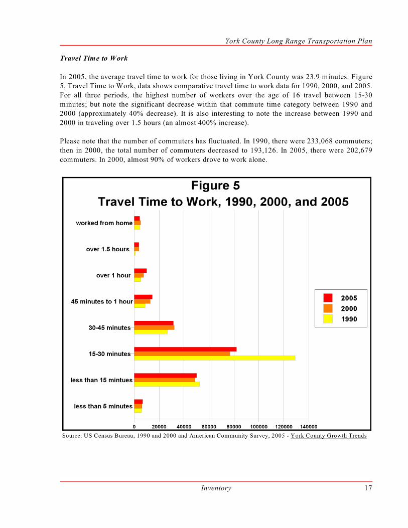
Travel Time to Work
In 2005, the average travel time to work for those living in York County was 23.9 minutes. Figure5, Travel Time to Work, data shows comparative travel time to work data for 1990, 2000, and 2005.
For all three periods, the highest number of workers over the age of 16 travel between 15-30
minutes; but note the significant decrease within that commute time category between 1990 and2000 (approximately 40% decrease). It is also interesting to note the increase between 1990 and
2000 in traveling over 1.5 hours (an almost 400% increase).
Please note that the number of commuters has fluctuated. In 1990, there were 233,068 commuters;
then in 2000, the total number of commuters decreased to 193,126. In 2005, there were 202,679
commuters. In 2000, almost 90% of workers drove to work alone.
Source: US Census Bureau, 1990 and 2000 and American Community Survey, 2005 - York County Growth Trends

York County Long Range Transportation Plan
Inventory18
Journey to Work Flow
The Census also collects data related to the journey to work. Map 1, 2000 Inter-County Journey to
Work Flow, shows that there are 193,126 persons age 16 and over in the commuter work flow in
York County. A total of 142,104 persons reside and work in York County and 51,022 countyresidents work outside York County. The map shows interesting data regarding the journey to work
flow to adjacent counties in Pennsylvania and in Maryland. Looking at the data more broadly is even
more telling. Of the 51,022 York County residents who work outside the County, 66% work in othercounties in Pennsylvania while 32% commute to a county in Maryland. Just about 2% work in a
state other than Maryland or Pennsylvania and a small number of York County residents (72
persons) reported working in another country.
Map 1 - 2000 Inter-County Journey to Work Flow

York County Long Range Transportation Plan
Inventory 19
Means of Transportation to Work
The US Census Bureau collects information on the mode of transportation taken to work. Figure 6,Means of Transportation to Work, shows that of the 193,126 workers (ages 16 years and older) that
provided an answer to this question, 181,121 reported car, truck or van as their transportation to
work. This represents 93.8% of the total respondents. Of those who drove a car, truck or van, 89.9%drove alone.
Source: York County Growth Trends

York County Long Range Transportation Plan
Inventory20
Vehicles
An interesting aspect to consider is the number of registered vehicles in York County. Table 1 showsthe 2005 data by registered vehicle class. This data is from PennDOT and has been compiled by the
Center for Rural Pennsylvania. The total number of passenger vehicles represents over two-thirds
of the total registered vehicles for 2005.
Table 1: York County, Registered Vehicles by Class, 2005
Passenger
SpecialMobile
Equipmentand Farm
Equipment
HouseCars
Motorcycles
MotorizedPedacyclesand motor-
drivencycles
SchoolBuses,Buses,Taxisand
Limos
Trailersand
Trucks
Other(ambulances,hearses, etc.)
TotalRegisteredPassengerVehicles
270,994 652 1,848 15,733 293 1,255 122,548 147 413,470
Source: York County Growth Trends
Increasing popula tion
means more passenger
vehicles on the road, asillustrated in Figure 7.
Although the total number
of passenger vehiclesgrows with population, the
ratio over the six-year
period (1.65 vehicles perperson in 2000 to 1.50
vehicles per person in
2005) has declined.
But passenger vehicles are
not the only vehicles onthe road. Table 1 shows
the same information as
Figure 7 for other vehicles.
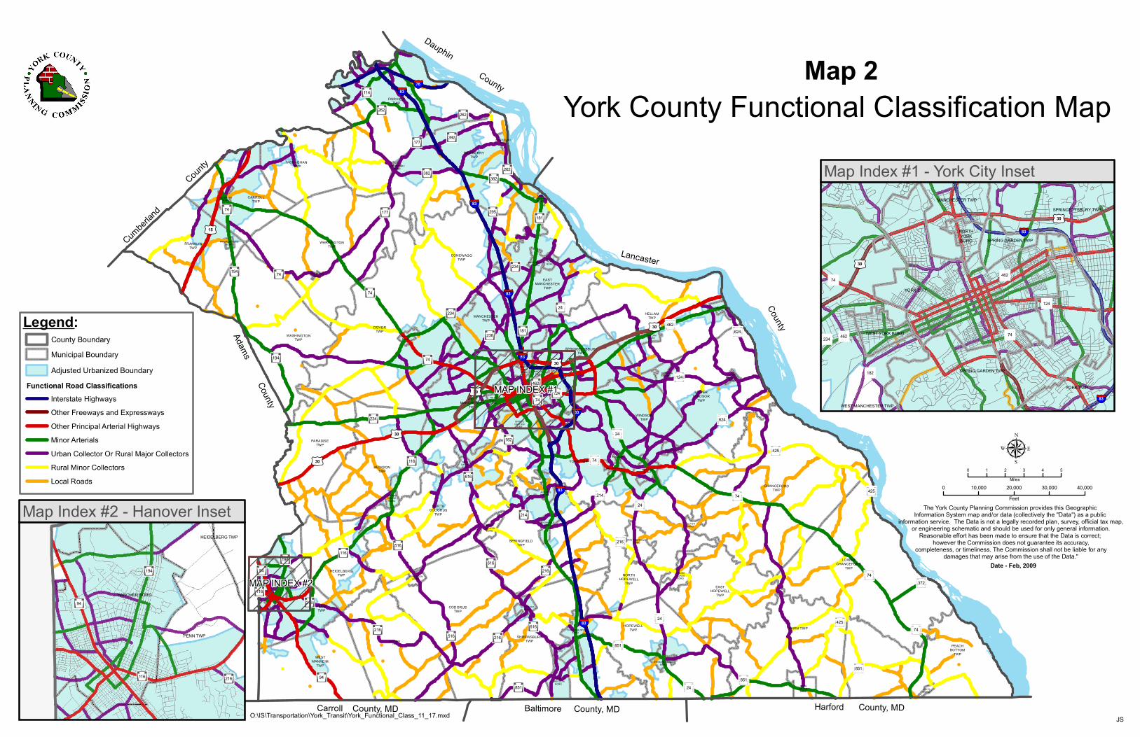
York County Roadway Functional Classification System
Functional Classification Map - Map 2 illustrates the different functional classes of roads in York
County. The information describes how the roads are classified for various administrative, design,
and reporting purposes and also details the location and physical characteristics of each activeroadway segment.

York County Long Range Transportation Plan
Inventory 21
According to the Federal Highway Administration of the United States Department of
Transportation, “functional classification is the process by which streets and roads are grouped into
classes, or systems, according to the character of service they are intended to provide. Basic to thisprocess is the recognition that individual roads and streets do not serve travel independently in any
major way. Rather, most travel involves movement through a network of roads. It becomes
necessary then to determine how this travel can be channelized within the highway or street networkin a logical and efficient manner. Functional classification defines the nature of this channelization
process by defining the part that any particular street or road should play in serving through a
highway network.”
Functional Classification Systems in Urban and Rural Areas
The four functional classification categories are 1) principal arterial streets, 2) minor arterial streets,
3) collector streets, and 4) local streets. Additionally, because of the differences in the nature and
intensity of land use, development patterns and population density between urban and rural areas,the four categories are usually further divided into urban and rural areas. Table 2, below, shows the
functional classification categories with the linear miles of roadway in York County for each
category, according to Pennsylvania Highway Statistics published by PennDOT.
Table 2 - Linear Road Miles, by Functional Classification
Functional
Classification
Interstate
Highways
Other
Freeways &
Expressway
s
Other
Principal
Arterial
Highways
Minor
Arterials
Urban
Collectors/
Rural Major
Collectors
Rural
Minor
Collectors
Local
RoadsTotal
Linear Miles 46.0 9.9 78.9 2 13.4 396.8 2 09.3 2,798.1 3,752.4
The Urban Functional Classification System
Urban Principal Arterial System - This system of streets and highways serves the major centersof activity of a metropolitan area. These roads are the highest traffic volume corridors, are used for
the longest trip desires, and carry a high proportion of the total urban area travel on a minimum of
lane miles. The system is integrated, both internally and between major rural connections. Theprincipal arterial system carries the major portion of trips entering and leaving the urban area, as
well as most of the through movements desiring to bypass the central city. In addition, significant
intra-area travel, such as between central business districts and outlying residential areas, betweenmajor inner-city communities, or between major suburban centers, is served by this system.
Because of the nature of the travel served by the urban principal arterial system, almost all fully andpartially controlled access facilities will be part of this functional system. However, this system is
not restricted to controlled access routes. To preserve the identification of controlled access
facilities, the urban principal arterial system is stratified as follows: 1) Interstate, 2) other freewaysand expressways, and 3) other principal arterial system (with no control of access).
Urban Minor Arterial Street System - The urban minor arterial street system interconnects withand augments the urban principal arterial system and provides service to trips of moderate length
York County Long Range Transportation Plan
Inventory22
at a somewhat lower level of travel mobility than the principal arterial. This system also distributes
travel to geographic areas smaller than those identified with the higher system.
The urban minor arterial street system includes all urban arterial streets not classified as a principal
and contains facilities that place more emphasis on land access than the higher system, and offers
a lower level of traffic mobility. This system includes urban connections to rural collector roadswhere such connections have not been classified as an urban principal arterial.
Urban Collector Street System - The urban collector street system provides both land accessservice and traffic circulation within residential neighborhoods, and commercial and industrial areas.
It differs from the arterial system in that facilities on the collector system penetrate residential
neighborhoods, distributing trips from the arterial through the area to the ultimate destination.Conversely, the collector street also collects traffic from the local streets in residential
neighborhoods and channels it into the arterial system. In the central business district, and in other
areas of like development, and traffic density, the urban collector system includes the street grid thatforms a logical entity for traffic circulation.
Urban Local Street System - The urban local street system comprises all facilities not on one ofthe higher systems. It serves primarily to provide direct access to abutting land and access to the
higher order systems. It offers the lowest level of mobility and usually discourages service to
through traffic movement.
The Rural Functional Classification System
Rural Principal Arterial System - Within the rural principle arterial system, there are two
subsystems. The first subsystem is the Interstate System, which consists of all presently designated
routes of the current Interstate System. The second subsystem consists of all non-Interstate principalarterial highways and is referred to as other principal arterial system.
Rural Minor Arterial System - The rural minor arterial highway system, in conjunction with therural principal arterial system, forms a rural network. There are three main characteristics of a rural
minor arterial highway system.
First, the system links cities and towns (as well as other generators, such as a major resort or an area
capable of attracting travel over similarly long distances) and forms an integrated network providing
interstate and inter-county service. Second, the system is spaced at intervals that are consistent withpopulation density, so that all developed areas are within reasonable distance of an arterial highway.
Third, the system provides service to corridors with trip lengths and travel density greater than those
predominately served by a rural collector or local system. Rural minor arterial highways, therefore,constitute routes whose design provides for relatively high overall travel speeds, with minimum
interference to through movement.
Rural Collector Road System - The rural collector routes generally serve travel of primarily intra-
county rather than statewide importance and constitute those routes on whose predominate travel
distances are shorter than on arterial routes. Consequently, more moderate speeds may be typical,

York County Long Range Transportation Plan
Inventory 23
on the average. Rural collector routes can be further broken down into the two following
subclassifications:
- Major Collector Roads - These routes provide service to larger towns not directly served
by higher systems, as well as, other traffic generators of equivalent inter-county importance,
such as county parks and important agricultural areas. These routes will link these places withnearby larger towns or cities, or with routes of higher classification. Also, major collector
roads serve important intra-county travel corridors.
- Minor Collector Roads - These routes are spaced at intervals consistent with population
density, so to collect traffic from local roads and bring all developed areas within a reasonable
distance of a collector road. Minor collector roads provide service to the remaining smallercommunities and also link the locally important traffic generators with more remote areas.
Rural Local Road System - The rural local road system primarily provides access to adjacent landand provides service to travel over relatively short distances as compared with collector roads or
other highway systems. Local roads will constitute the rural mileage not classified as part of the
principal arterial highway, minor arterial, or collector road systems.
York County Bridges
Bridge Map - Map 3 identifies the location, ownership, and current status of the bridges in York
County.
Bridges
The bridges of York County range from brand new bridges to bridges that were built a century or
more ago. Within the County, bridges can be categorized by ownership as state, county, or
municipal. In total, there are over 900 bridges throughout York County.
One of the issues that is currently being addressed in York County, as well as around the State and
Country, is the issue of structurally deficient bridges. An important goal for PennDOT, as well asthe York Area Metropolitan Planning Organization, is to reduce the number of structurally deficient
bridges in York County.
There are several categories for rating the structural integrity of a bridge. Those categories include;
the deck, the superstructure, the substructure, structural evaluation, and waterway adequacy. A poor
rating in any of these categories could result in a bridge being considered structurally deficient.While a bridge may be classified as structurally deficient, it does not necessarily mean that a bridge
is unsafe. Bridges that are deemed unsafe in any way are posted with weight/height restrictions or
are closed.
State Bridges - In York County, there are over 650 State bridges. These bridges are located on
municipal roads, State Routes, U.S. Routes, and Interstate Highways and play an important role inthe transportation system of York County. Of the 650 plus State bridges over 8 foot, 149 are rated

York County Long Range Transportation Plan
Inventory24
as structurally deficient. Thirty-four of the 149 structurally deficient bridges are being addressed on
the YAMPO 2009 - 2012 Transportation Improvement Program (TIP). Structurally deficient bridges
will continually be addressed over the life of this Plan.
County Bridges - The County of York owns approximately 100 bridges and is responsible for the
inspection, maintenance and repair of these bridges. The County uses liquid fuels funding, whichis allocated by the state, to maintain the bridge system. There are also a few historical bridges, which
are not currently in use, that are owned by the County. Those historical bridges can be purchased
from the County and put to use in low-volume traffic areas or as pedestrian bridges.
Municipal Bridges - Municipal bridges that are greater than 20 feet in length are eligible to be
included in the Bridge Maintenance System (BMS). Currently, there are over 110 bridges that areowned by local municipalities and are included in the BMS. Bridges included in the BMS are
eligible for state and federal funding. These municipal bridges play a key role in the local road
network by connecting communities and providing an adequate infrastructure to the residents andbusinesses of York County.
Bridges will continue to be added to the York County transportation system. As such, it is importantthat these bridges, as well as the current bridges, continually be maintained and upgraded to meet
the demands of the users of the system.
York County Transit
Transit/Bus Routes Map - Map 4 was created with information provided by York County
Transportation Authority (YCTA) and Capital Area Transit (CAT). The map shows the fixed routesoffered in York County by both rabbittransit and CAT.
York County Transportation Authority (YCTA) - YCTA is the primary provider of publictransportation services for York County. YCTA, operating under the name rabbittransit, provides
a wide range of transportation services to the South Central Pennsylvania region.
Over 6,000 people daily (2.1 million trips annually) depend on rabbittransit to provide transportation
to and from work, medical facilities, school, and other activities. In addition to the public bus service
that operates twelve routes in York and three routes in Hanover, rabbittransit offers Shared Rideprograms for senior citizens, park and ride lots, employer subsidized shuttles, rabbitexpress service,
and Paratransit services.
rabbittranist continues to grow; from the size of it’s fleet, to the services offered, to the number of
people using the services. In fact, many services have recently been expanded to accommodate the
growing demand for public transit. A few examples would include the York College Green Machineand the rabbitexpress. In fact, the rabbitexpress has gone from a pilot program to a successful route,
and with the addition of a fourth bus, there will be daily round trips provided to the Harrisburg area.
Just recently, there is also an express route offered into Maryland. This new route is a pilot programand will make weekday trips from the City of York, with stops to park and ride lots along I-83, into

York County Long Range Transportation Plan
Inventory 25
Maryland, with stops at industrial parks and Maryland Transit Authority light rail stations at Hunt
Valley and Timonium.
Capital Area Transit (CAT) - CAT is the public transit authority for the greater Harrisburg Area
and provides weekday service for commuters in the northern tier of York County. Currently, there
are two routes that CAT runs into York County. New Cumberland Army Depot is the location ofa stop on a route that runs through New Cumberland Borough and then into the city of Harrisburg.
The other route stops in Dillsburg to pick-up commuters to the Harrisburg area. As the cost of
commuting continues to rise, these routes will play an important role for those individuals travelingto Harrisburg.
The CAT routes also serve as a link to other modes of transportation, with routes that can connectcommuters to Harrisburg International Airport, Amtrak, and Capitol Trailways/Greyhound. The
rabbitexpress to Harrisburg also provides a transfer to the entire CAT system at the CAT Transfer
Center in the City of Harrisburg.
York County Park and Ride Facilities
Park and Ride Map - Map 5 shows the location of park and ride lots throughout York County. New
locations will be added over time as the need increases for transit and ride sharing.
Park and Ride Facilities
Park and ride lots are locations where people can leave their vehicles in order to use public
transportation or participate in carpools or vanpools. Lots are typically located in convenient
locations throughout the County.
In York County, there are three official park and ride locations. Those lots are located off of I-83
in Shrewsbury Township, Newberry Township, and Manchester Township. In Shrewsbury, the parkand ride lot is located on State Route 851 just east of the I-83 Exit 4 interchange. This lot typically
has approximately 39 vehicles parked there each day. The lot in Newberry Township is located off
of I-83 at Exit 33 Yocumtown. Recent numbers show that approximately 58 vehicles per day areusing this lot. The lot in Manchester Township is located off of I-83 at Exit 24 Emigsville. There
are approximately 35 cars per day parked in this lot. These counts show that all three lots are close
to capacity on a daily basis.
There are several non-official park and ride lots located throughout York County, with the majority
of the facilities located along I-83 and U.S. Route 30. Some of the locations are gravel areas adjacentto the road and others are shopping center parking lots. None of the locations are signed as a park
and ride lot. While not officially designated, these locations still provide parking options for
commuters and play a significant role in reducing the number of vehicles on the roadway. Thenumber of vehicles at these lots are identified to help determine the need for park and ride locations
throughout the County.
York County Long Range Transportation Plan
Inventory26
York County Railroads
Railroad Map - Map 6 illustrates the location of the rail lines, the ownership of the line and the statusof the rail line. The map also includes the location of rail and trucking facilities to give an overall
picture of how goods are moved in and through York County.
Rail Freight
In York County, there are several rail freight providers that are responsible for the movement of
goods and services in and out of the county. These rail freight providers play an important role inYork County’s transportation system by reducing the number of trucks on the roadways and by
connecting local companies with suppliers and retailers across Pennsylvania and the United States.
York Railway Company (YRC) is a leading owner and operator of short line and regional freight
railroads serving more that 800 customers on nearly 10,000 miles of track in five different countries.
The York Railway Company (YRC), a subsidiary of Genesee & Wyoming Inc., operates 42 milesof track through the center of York County. YRC operates mainline track that links the City of York
with the Hanover Area.
YCR serves companies that produce paper goods, agricultural goods, building products as well as
companies that specialize in distribution. Most of the products being shipped by YRC are being
delivered to the area in the form of coal, limestone, food grade oils, petroleum products, foodproducts, paper, and agricultural products.
YCR also operates or provides service to two inter-modal facilities within York County. The LincolnYard located in West Manchester Township is a terminal where goods and products are transferred
from rail to truck, as well as the ES3 warehouse located along Loucks Mill Road in Spring Garden
Township.
Norfolk Southern Corporation is a Virginia-based holding company that owns the Norfolk Southern
Railway Company. This railroad system’s lines include more than 31,300 miles of track in 25 states.In York County, Norfolk Southern has approximately 30 miles of track and links with other rail lines
and inter-modal facilities.
At the southern end of the Norfolk Southern line in York County is the Windsor Yard. This facility
serves as a classification yard, as well as a inter-modal transfer station, for products ranging from
construction materials to automotive products. The Windsor Yard also connects to Poorhouse Yard,which serves as an area where Norfolk Southern Railway and YorkRail transfer freight cars. The
Norfolk Southern line runs north towards Harrisburg and eventually connects to the Enola Yard and
destinations across the Southern and Midwestern United States, as well as parts of Canada.
CSX Corporation, based in Richmond, Virginia, is an international transportation company offering
a variety of rail, container-shipping, inter-modal, and trucking. CSX provides services over 32,000miles of track in 23 states in the Eastern and Southern U.S. and in Canada. In York County, CSX
operates on approximately 15 miles of track and links with the York Railway operated lines. The
CSX line operates in the southwestern corner of York County.

York County Long Range Transportation Plan
Inventory 27
CSX provides rail service to Hanover Terminal Incorporated, located just outside of Hanover
Borough in Penn Township. Hanover Terminal Incorporated is a distribution and storage center for
grocery products serving national markets. This terminal is capable of simultaneously serving bothrail freight and trucks.
York County Bicycle Routes
Bicycle Routes Map - Map 7 shows the location of State bicycle routes and potential Countybikeway corridors.
Bikeways, Greenways and Trails
York County has plenty to offer when it comes to pedestrian and bikeway corridors. There are
numerous trails, greenways, and bicycle routes spread throughout the county. These corridorsprovide bicycle/pedestrian connections north to south and east to west. The role of these corridors
is important not only in serving as a mode of transportation, but also in preserving open space,
environmentally sensitive, and historical areas throughout York County.
State Bicycle Routes - There are two routes located in York County that are Bicycle PA routes. The
“S” route is an east-west route that runs across the state from Pittsburgh to Philadelphia. The “S”Route runs from the Adams County line along PA Route 234 into West Manchester Township.
There, the route picks up PA Route 462 through the City of York to the Susquehanna River and into
Lancaster County.
The “J” Route is a north-south route that runs from the Maryland border with York County all the
way to the New York border with Bradford County. In York County, the southern end of the routefollows the Heritage Rail Trail County Park from the Maryland State line into the City of York.
There, the route picks up PA Route 462 to North George Street and into Manchester and Mount
Wolf Boroughs. The “J” route continues north towards the Susquehanna River onto Brunner Islandand then into York Haven Borough. The route zig-zags its way through the northeastern portion of
the County until it reaches Goldsboro Borough. There the route picks up PA Route 382 and
continues along that road until it exits York County into New Cumberland, Cumberland Countynear the Capital City Airport.
County Bicycle Routes - The County bicycle routes are identified in a 2001 study completed forYork County, which resulted in the Comprehensive Bikeway Plan and Implementation Strategy. The
goal was to encourage development of a county-wide system of bikeways connecting the places
people live with centers of employment, education, and commerce. As result, corridors wereidentified as recreational, commuter or both. Most of the identified corridors follow the many State
highways found throughout York County, while the rest of the bikeway corridors follow lesser
classified roadways and established trail corridors.
Recreational Trails and Greenways - In York County, there are several recreational trails and
greenways. York County received funding to develop a trail plan by the York County Rail Trail

York County Long Range Transportation Plan
Inventory28
Authority. The York County Comprehensive Plan Open Space and Greenways Plan component
provides detailed information about these areas throughout the County.
Heritage Rail Trail County Park - This trail starts in the City of York and follows the old North
Central Railroad line south to the Maryland line, where it becomes the NCR Trail. The trail is
operated, maintained, and policed by the York County Parks Department and Recreation Rangers.Trail users will find connections to; Seven Valleys, Glen Rock, Railroad and New Freedom
Boroughs; and Hanover Junction and New Freedom Train Station historic sites.
The Heritage Rail Trail also provides a link to public transit, as it connects with rabbittransit’s
Downtown Transfer Center. At the downtown transfer center, there are lockers available to bicyclists
for safe storage of their bicycles as they use the transit system to access destinations in the GreaterYork area.
Currently, the YCRTA is working on providing a northern extension of the trail. This extension willprovide a link from the City of York to John Rudy County Park in East Manchester Township. It is
estimated that the second of four phases will be completed sometime in 2010. The trail will provide
a viable alternative to motorized transportation for key destinations such as Rudy County Park,Harley-Davidson Motor Co., York College, Central York HS, and Sovereign Bank Stadium.
Also, YCRTA continues it’s effort in providing a link between York City and Hanover Boroughalong the old York-Hanover Trolley line. In 2008, the first phase of this project was completed as
two sections of the trail were opened to the public. Phase one of the project included a one-mile
stretch of trail from the Jackson Township Sewer Authority to a parking area near Hosiery Alley inSpring Grove Borough and a one and half mile stretch from Moul Avenue in Hanover Borough to
Cherry Tree Court near the Penn/Heidelberg Township border. The next step in this project is for
a study to be completed to further investigate the development of additional sections along thishistoric line. The trail will provide a viable alternative to motorized transportation for key
destinations such as BAE Systems, Glatfelter Co., Moul Borough Park, and Hanover School district
campus.
York County Long Range Transportation Plan
Inventory 29
York County Air Transportation
Airport Map - Map 8 shows the location of the public use airports located in York County. Map 8also contains the location of airports in neighboring counties that help service the aviation needs of
York County.
Air Transportation
The aviation needs of York County are diverse and as such, there are many options to fulfill thoseneeds. York County is the home to several recreational and private air facilities, as well as facilities
that service more commercial interests. Existing airports serving York County include such facilities
as Capital City Airport (CXY), Harrisburg International Airport (MDT), York Airport (THV) nearThomasville in Jackson Township, as well as Philadelphia International (PIA), and Baltimore-
Washington International (BWI).
Capital City Airport - Located in the northeast corner of York County, this 273-acre facility serves
the business communities of Dauphin, Cumberland, and York counties. CXY is owned and operated
by the Susquehanna Area Regional Airport Authority (SARAA) and is the designated alternate forHarrisburg International Airport (MDT). CXY averages more than 57,000 corporate, charter, and
private aircraft operations every year. In addition, a study conducted by the Pennsylvania
Department of Transportation in 2000, concluded that CXY related activities generate nearly $24million dollars a year in total economic output into the regional economy. Capital City Airport is
considered a full-service, fixed-base operation, and offers training in the form of a flight school,
piston and turbine aircraft maintenance and avionics.
Harrisburg International Airport - Located in Dauphin County, this aviation facility serves the
commercial interest of the residents and businesses of Dauphin, Cumberland and York Counties.Harrisburg International Airport is considered a multi-modal transportation center. The facility links
with cargo shipping (FedEx, UPS, and DHL), bus and taxi service, as well as provides
approximately 2,500 public parking spaces for air travelers.
York Airport - This privately owned airport is located approximately seven miles southwest of the
City of York, in Thomasville, Jackson Township, PA along U.S. Route 30. This 66-acre facility isclassified as a business service airport by the PennDOT Bureau of Aviation and is home to nearly
100 aircraft. For a 12-month period ending in August 2008, the York Airport experienced 139 daily
aircraft operations. The facility is also home to a restaurant and a fixed-base operation. The fixed-base operation provides fueling, maintenance service, and hangar rentals to customers of the airport.
Other Aviation Facilities in York County - Baublitz Airport in Brogue and Bermudian ValleyAirpark in Kralltown are single turf runways approximately one-half mile in length and exclusively
serve recreational aircraft. Kampel Airport in Wellsville is a 2,400-foot turf runway used for
recreational aircraft. Shoestring Aviation Airport located in Stewartstown is an airport designatedfor ultralight aircraft only.
York County Long Range Transportation Plan
Inventory30
Ongoing Regional Efforts
South Central Pennsylvania Regional Goods Movement Study
Several area Metropolitan Planning Organizations (MPO) worked together to form a task force to
better understand freight movement in the South Central Pennsylvania Region. The task force thencommissioned a comprehensive study to assess current and future goods movement issues and to
develop recommendations and policies to improve or enhance such services. YCPC, on behalf of
the YAMPO, participated in and contributed to this study.
The South Central Pennsylvania Regional Goods Movement Study (RGMS) was completed in 2006
and outlines the importance of goods movement within the region. The Study collected data thathighlights the unique role this region plays in statewide, nationwide, and worldwide commerce. The
freight industry in the region continues to grow and produce local job opportunities. With continued
growth comes many challenges, especially for the transportation system. The Study identifiedprojects and opportunities that will help address some of these challenges.
Another result of the RGMS is the development of a forum. The Regional Goods Movement Forumconsists of public and private sector stakeholders that range from MPO representatives, County
planners, rail sector representatives, trucking industry representatives, shippers, and representatives
from PennDOT. This Forum meets on a regular basis to discuss the challenges that face the freightindustry and to make recommendations on the opportunities and challenges regarding goods
movement.
Commuter Services
Commuter Services of South Central Pennsylvania, also known as the Susquehanna RegionalTransportation Partnership (SRTP), is a professionally-staffed organization funded by Federal
Congestion Mitigation and Air Quality (CMAQ) funds. The SRTP Board is composed of MPO,
transit authority and chamber of commerce membership representing seven counties in south centralPennsylvania. Late in 2008, the SRTP Board approved the addition of Berks County to its
membership. In the process of updating its by-laws, SRTP will also be changing its name and its
operating name of Commuter Services of South Central PA to Commuter Services of PA.
The staff members work to reduce traffic congestion by helping commuters with a free service to
help them find transportation alternatives (e.g., carpooling), other than driving alone, and byreaching out to employers so they can help their workforce find those options. Using alternatives
also helps improve air quality, and fewer cars in rush hour can also mean safer highways.
In September of 2008, Commuter Services reached a milestone of 10,000 commuters registered on
their on-line ride-matching database and expect to top 12,000 commuters registered in the database
sometime in 2009. Individuals that are registered in the database will find at least one match 60percent of the time, with some finding as many as ten potential matches. The continued success of
SRTP’s outreach programs has helped in reducing the number of vehicle miles traveled by residents.

York County Long Range Transportation Plan
Inventory 31
The success of Commuter Services is not only evident by the number of commuters registered in
their database, but by the number of locations throughout the South Central Pennsylvania area that
are looking to join. Several counties have expressed interest in bringing the services offered byCommuter Services to their respective areas.

Page Intentionally Blank
Cumber
land
County
Carroll County, MD Baltimore County, MD
Adams County
Dauphin County
Lancaster
County
Harford County, MDDELTABORO
FAWNGROVEBORO
NEWFREEDOM
BORO
STEWARTSTOWNBORO
RAILROADBORO
WESTMANHEIM
TWP
SHREWSBURYBORO
PEACHBOTTOM
TWP
GLEN ROCKBORO
HOPEWELLTWP FAWN TWP
MANHEIMTWP
JEFFERSONBORO
SHREWSBURYTWP
HANOVERBORO
CROSSROADSBORO
CODORUSTWP
EASTHOPEWELL
TWP
PENN TWP
WINTERSTOWNBORO
HEIDELBERGTWP
SEVENVALLEYS
BORO
FELTONBORO
LOGANVILLEBORO
NORTHHOPEWELL
TWP
JACOBUSBOROSPRING
GROVEBORO
SPRINGFIELDTWP
LOWERCHANCEFORD
TWP
DALLASTOWNBORO
NEWSALEMBORO
RED LIONBORO
YOE BORO
NORTHCODORUS
TWP
WINDSORBORO
JACKSONTWP
CHANCEFORDTWP
WESTYORKBORO
YORK TWP
PARADISETWP
WINDSORTWPSPRING
GARDENTWP
EASTPROSPECT
BORO
NORTHYORKBORO
SPRINGGARDEN
TWP YORKANABORO
YORKCITY
WESTMANCHESTER
TWP
DOVERBORO
HALLAMBORO
LOWERWINDSOR
TWP
SPRINGETTSBURYTWP
WRIGHTSVILLEBORO
MANCHESTERTWP
WELLSVILLEBORO
HELLAMTWP
MOUNTWOLFBOROMANCHESTER
BORO
WASHINGTONTWP
FRANKLINTOWNBORO
DOVERTWP
CONEWAGOTWP
FRANKLINTWP
EASTMANCHESTER
TWP
YORKHAVENBORO
WARRINGTONTWP
DILLSBURGBORO
LEWISBERRYBORO
CARROLLTWP
GOLDSBOROBORO
MONAGHAN TWP
NEWBERRYTWP
FAIRVIEWTWP
§̈¦83
§̈¦83
§̈¦83
§̈¦83
§̈¦83
§̈¦83
§̈¦76
§̈¦83
£¤30
£¤30
£¤15
£¤30
£¤30
£¤30
616
262
24
624
234
124
24
177
181
516
194
216
114
94
624
462
94
24
74
182
74
177
234
851
238
216
382
462
74
372
194
216
851851
42574
74
516
392
214
262
382
24
74
74
116
616
194
74
616
124
116
262
216
216
214
116
234
851
181
425
295
425
24
74
MAP INDEX #1
MAP INDEX #2
Map Index #1 - York City Inset
The York County Planning Commission provides this Geographic Information System map and/or data (collectively the "Data") as a public
information service. The Data is not a legally recorded plan, survey, official tax map,or engineering schematic and should be used for only general information.
Reasonable effort has been made to ensure that the Data is correct; however the Commission does not guarantee its accuracy,
completeness, or timeliness. The Commission shall not be liable for anydamages that may arise from the use of the Data."
0 1 2 3 4 5Miles
0 10,000 20,000 30,000 40,000Feet
µ
JS
Date - Feb, 2009
O:\IS\Transportation\York_Transit\York_Functional_Class_11_17.mxd
York County Functional Classification Map
Map Index #2 - Hanover Inset
Legend:
Functional Road Classifications
County BoundaryMunicipal Boundary
Interstate Highways
Other Principal Arterial HighwaysMinor Arterials
Local Roads
Other Freeways and Expressways
Adjusted Urbanized Boundary
Urban Collector Or Rural Major CollectorsRural Minor Collectors
MANCHESTER TWPSPRINGETTSBURY TWP
WEST MANCHESTER TWP
YORK CITY
SPRING GARDEN TWPNORTHYORKBORO
SPRING GARDEN TWP
YORK TWP
WEST YORK BORO
£¤30
£¤30
124
234
462
462
74
74
182
§̈¦83
§̈¦83
194
116
94
216
HEIDELBERG TWP
PENN TWP
HANOVER BORO
Map 2

Cumber
land
County
Carroll County, MD Baltimore County, MD
Adams County
Dauphin County
Lancaster
County
Harford County, MD
")
")
")
")
")
")
")
")
")")
")
")
")")
")
")")
")
")
")")
")")")")
")
")
")
")
")
")")
")
")
")
")
")
")
")")
")
")
")")
")
")
")
")
") ")
")
") ")")
")
")
")")
")
")
")
")
")
")
")")")")")
")
")
")")
")
")
")
")
")
")
")
")
")
")")
")")
")
")
")
")
")") ")")")")")
")
")
")
")
")
")
")")
")
")
")
")
")
")
")
")
")
!(
!(
!(
!(
!(
!(
!(
!( !(
!(
!(
!(!(
!(
!(!(
!(
!(
!(
!(
!(!(
!(
!(!(
!(
!(
!(!(!(!(!(!(!(
!(!(!(
!(
!(
!(
!(
!(
!(
!(
!(!(!(
!(!(
!( !(
!(!(
!(
!(!(!(
!(
!(
!(
!(
!(
!(!(
!(
!(!(
!(!(!(
!(
!(
!(
!(
!(
!(
!(
!(
!(!(
!(
!(
!(!(
!(!(
!(
!(
!(!(
!(
!(
!(!(
!(
!(
!(
!(
!(
!(
#*
#*
#*
#*
#*#*
#*
#*
#*
#*
#*#*#*
#*
#*
#*
#*
#*
#*#*#*
#*#*
#*#*#*
#*
#*#*
#*#* #*#*#*#* #*#*#*#*#*
#*#*#*#*#*
#*#*
#*
#*
#*
#*
#*
#*
#*
#*
#*
#*#*#*#*#*#*
#*
#*
#*
#*#*
#*
#*#*#*
#*#*#*
#*#*#*
#*#*#*
#*
#*
#*#*
#*
#*
#*#*
#*
#*#*#*#*#*#*#*#*#*#*
#*#*#*
#*
#*
#*
#*
#*
#*#*
#*
#*
#*
#*
#*
#*#*#*#*
#*
#*
#*
#*
#*
#* #*
#*
#*
#*#*
#*#*
#*
#*
#*
#*#*
#* #*#*
#*
#*#*
#*#*
#*
#*
#*
#*#*
#*
#*
#*#*
#*
#*
#*
#*#*
#*
#*
#*
#*
#*
#*#*#*
#*
#*
#*
#*
#*
#*
#*
#*#*
#*#* #*
#*
#*#*
#*#*
#*
#*
#*
#*
#*
#*#*#*#*
#*#*#*
#*
#* #*#* #*
#*
#*#*
#*#*#* #*
#*
#*
#*
#*
#*#*#*
#*#*
#*
#*#*#*
#*#*#*
#*#*
#*#*#*
#*
#*#*
#*
#*
#*
#* #*
#*#*
#*#*
#*#*
#*#*
#*
#*
#*#*
#*
#*
#*
#*#*
#*
#*
#*#*
#*
#*
#*#*
#*#*#*
#*
#*
#*
#*#*
#*#* #*#*
#*
#*
#*
#*
#*
#*
#*
#*#*
#*
#*
#*
#*
#* #*
#*
#*
#*#* #*
#*#*#*
#*#*
#*
#*#*#*#*
#*
#*
#*
#*
#*
#*#*
#*
#*
#*
#*#*
#*#* #*
#*
#*
#*
#*
#*
#*
#*
#*
#*
#* #*#*
#*
#*#*#*#*
#*#*
#*
#*#*
#*#*
#*
#*
#*#*#*#*
#*
#*
#*
#*
#*
#*#*
#*
#*
#*
#*#*
#*
#*
#*
#*
#*
#*
#*
#*
#*
#*
#*#*
#*#*
#*#*
#*
#*
#*#*
#*
#*#*
#*
#*
#*
#*#*
#*
#*
#*#*
#*
#*#*
#*
#*
#*#*
#*
#*
#*
#*
#*#*
#*#*
#*#*
#*
#*
#*#*
#*#*#*
#*
#*
#*
#*
#*
#*#*
#*#*#*
#*
#*
#*#*#*#*
#*#*#*
#*
#* #*
#*
#*#*
#*
#*#* #*
#*#*#*#*
#*
#*
#*#*
#*
#*
#*
#*
#*
#*#*#*
#*#*
#*
#*
#*
#*
#*
#*
#*
#*
#*#*
#*#*
#*
#*
#*
#*#*#*
#*
#*
#*
#*
#*
#*#*
#*
#*
#*
#*
#*
#*#*
#*
#*#*
#*#*#*
#*
#*#*
#*
#*
#*
#*
#*#*
#*#*
#*#*
#*
#*#*
#*#*
#*#*
#*
#*
#*#*
#*
#*#*
#*#*#*
#*
#*
#*
#*
#*
#*
#*#*
#*
#*
#*#*
#*
#*
#*
#*#*
#*
#*#*
#*
#*
#* #*
#*
#*
#*
#*
#*
#*
#*
#*
#*#*
#*
#*
#*
#*
#*
#*#* #*
#*
#*
#*
#*
#*#*
#*#*
#*
#*
#*#*
#*
#*
#*
#*
#*
#*
#*
#*
#*
#*
#*#*
#*
#*#*#*
#*#*#*
#*
#*
#*
#*
#*
#*
#*#*
#*#*#*#*#*#*
#*
#*
#*
#*
#*
#*
#*
#*
#*
#*
#*
#*
#*
#*
#*
#*
#*
#*
#*#*
#*
#*
#*
#*
#*
#*
#*
#*#*#*
#*
#*#*
#*
#*
#*
#*
DELTABORO
FAWNGROVEBORO
NEWFREEDOM
BORO
STEWARTSTOWNBORO
RAILROADBORO
WESTMANHEIM
TWP
SHREWSBURYBORO
PEACHBOTTOM
TWP
GLEN ROCKBORO
HOPEWELLTWP FAWN TWPMANHEIM
TWP
JEFFERSONBORO
SHREWSBURYTWP
HANOVERBORO
CROSSROADSBORO
CODORUSTWP
EASTHOPEWELL
TWPPENN TWP
WINTERSTOWNBORO
HEIDELBERGTWP
SEVENVALLEYS
BORO
FELTONBORO
LOGANVILLEBORO
NORTHHOPEWELL
TWP
JACOBUSBOROSPRING
GROVEBORO
SPRINGFIELDTWP
LOWERCHANCEFORD
TWP
DALLASTOWNBORO
NEWSALEMBORO RED LION
BORO
YOE BORO
NORTHCODORUS
TWP
WINDSORBOROJACKSON
TWP
CHANCEFORDTWP
WESTYORKBORO
YORK TWP
PARADISETWP
WINDSORTWPSPRING
GARDENTWP
EASTPROSPECT
BORO
NORTHYORKBORO
SPRINGGARDEN
TWP YORKANABORO
YORKCITY
WESTMANCHESTER
TWP
DOVERBORO
HALLAMBORO
LOWERWINDSOR
TWP
SPRINGETTSBURYTWP
WRIGHTSVILLEBORO
MANCHESTERTWP
WELLSVILLEBORO
HELLAMTWP
MOUNTWOLFBOROMANCHESTER
BORO
WASHINGTONTWP
FRANKLINTOWNBORO
DOVERTWP
CONEWAGOTWP
FRANKLINTWP
EASTMANCHESTER
TWP
YORKHAVENBORO
WARRINGTONTWP
DILLSBURGBORO
LEWISBERRYBORO
CARROLLTWP
GOLDSBOROBORO
MONAGHAN TWP
NEWBERRYTWP
FAIRVIEWTWP
§̈¦83
§̈¦83
§̈¦83
§̈¦76
§̈¦83
£¤30
£¤30
£¤30
£¤15
£¤30
214
181
425
74
616
262
24
624
234
124
24
177
181
116
516194
114
392
24
94
624
462
94
74
182
74
214
177
382
234
851
216
238
462
74
372
194
216
851 851
124
425
74
74
516
382
382
24
74
216
74
116
616
194
74
616
262
216
216
116
234
851
295
425
24
")
")
")
")
")
")")") ") ")")
")
")
")
!(
!(
!(
!(!(!(
!(!(
!(
#*#*
#*
#*#*
#*
#*
#*
#*#*#*#* #*
#*
#* #*
#*
#*
#*
#*
#*#*
#*
#*
#*#*#*#*#*#*#*#*
#*#*
#*
#*
#*#*
#*
#*
#*
#*
#*
#*
#*
#*
#*
#*
#*
#*
#*
#*
#*
#*
#*
#*
#*
#*
#*
#*
#*
#*
#*
#*
#*#*
#*
#* #*
#*
#*
#*
#*
#*
#*
#*#*#*
#*
#*
#*
#*
#*
#*
#*
124
74
182
74
462
462
£¤30
§̈¦83
§̈¦83
YORK TWP
SPRING GARDEN TWP
NORTHYORKBORO
YORK CITY
SPRINGETTSBURY TWPMANCHESTER TWP
WEST MANCHESTER TWP
WESTYORKBORO
")
")
") ")
")
#*
#*
#*
#*
#*
#*
#*
#*
#*
#*#*
194
116
194
94
216
94
HANOVER BOROPENN TWP
HEIDELBERG TWP
MAP INDEX #1
MAP INDEX #2
Map Index #2 - Hanover Inset
Map Index #1 - York City Inset
The York County Planning Commission provides this Geographic Information System map and/or data (collectively the "Data") as a public
information service. The Data is not a legally recorded plan, survey, official tax map,or engineering schematic and should be used for only general information.
Reasonable effort has been made to ensure that the Data is correct; however the Commission does not guarantee its accuracy,
completeness, or timeliness. The Commission shall not be liable for anydamages that may arise from the use of the Data."
0 1 2 3 4 5Miles
0 9,900 19,800 29,700 39,600Feet
µ
JS
0 1 20.5Miles
0 1 20.5Miles
Date - Sept. 30th, 2008
York County Bridge Map
O:\IS\Transportation\York_Transit\York_Bridge_11_17.mxd
Legend:
State RoadUS Route
County BoundaryMunicipal BoundaryRoads
InterstateState Bridge
ClosedOpenPosted
Municipal Bridge
")
ClosedOpenPosted
County Bridge
!(
ClosedOpenPosted
#*
#*
#*
!(
!(
")
")
Map 3

Cumber
land
County
Carroll County, MD Baltimore County, MD
Adams County
Dauphin County
Lancaster
County
Harford County, MDDELTABORO
FAWNGROVEBORO
NEWFREEDOM
BORO
STEWARTSTOWNBORO
RAILROADBORO
WESTMANHEIM
TWP
SHREWSBURYBORO
PEACHBOTTOM
TWP
GLEN ROCKBORO
HOPEWELLTWP FAWN TWP
MANHEIMTWP
JEFFERSONBORO
SHREWSBURYTWP
HANOVERBORO
CROSSROADSBORO
CODORUSTWP
EASTHOPEWELL
TWP
PENN TWP
WINTERSTOWNBORO
HEIDELBERGTWP
SEVENVALLEYS
BORO
FELTONBORO
LOGANVILLEBORO
NORTHHOPEWELL
TWP
JACOBUSBOROSPRING
GROVEBORO
SPRINGFIELDTWP
LOWERCHANCEFORD
TWP
DALLASTOWNBORO
NEWSALEMBORO RED LION
BORO
YOE BORO
NORTHCODORUS
TWP
WINDSORBORO
JACKSONTWP
CHANCEFORDTWP
WESTYORKBORO
YORK TWP
PARADISETWP
WINDSORTWPSPRING
GARDENTWP
EASTPROSPECT
BORO
NORTHYORKBORO
SPRINGGARDEN
TWP YORKANABORO
YORKCITY
WESTMANCHESTER
TWP
DOVERBORO
HALLAMBORO
LOWERWINDSOR
TWP
SPRINGETTSBURYTWP
WRIGHTSVILLEBORO
MANCHESTERTWP
WELLSVILLEBORO
HELLAMTWP
MOUNTWOLFBOROMANCHESTER
BORO
WASHINGTONTWP
FRANKLINTOWNBORO
DOVERTWP
CONEWAGOTWP
FRANKLINTWP
EASTMANCHESTER
TWP
YORKHAVENBORO
WARRINGTONTWP
DILLSBURGBORO
LEWISBERRYBORO
CARROLLTWP
GOLDSBOROBORO
MONAGHAN TWP
NEWBERRYTWP
FAIRVIEWTWP
£¤30
£¤30
£¤30
£¤15
£¤30
§̈¦83
§̈¦83
§̈¦83
§̈¦76
§̈¦83
214
181
425
74
616
262
24
624
234
124
24
177
181
516
194
114
392
24
94
624
462
94
74
182
74
214
177
382
234
851
216
238462
74
372
194
216
851851
124
42574
74
516
382
382
24
74
216
74
116
616
194
74
616
262
216
216
116
234
851
295
425
24
116
Transfer Center
£¤30£¤30
£¤30
§̈¦83
§̈¦83
§̈¦83
WESTYORKBORO
YORK TWP
SPRING GARDEN TWP
NORTHYORKBORO
YORK CITY
WEST MANCHESTER TWP
SPRINGETTSBURY TWPMANCHESTER TWP
74
234
462
462
124
74
182
74462
238
194
116
194
94
216
94
HANOVER BOROPENN TWP
HEIDELBERG TWP
MAP INDEX #1
MAP INDEX #2
Map Index #2 - Hanover Inset
Map Index #1 - York City Inset
York County Transit System
The York County Planning Commission provides this Geographic Information System map and/or data (collectively the "Data") as a public
information service. The Data is not a legally recorded plan, survey, official tax map,or engineering schematic and should be used for only general information.
Reasonable effort has been made to ensure that the Data is correct; however the Commission does not guarantee its accuracy,
completeness, or timeliness. The Commission shall not be liable for anydamages that may arise from the use of the Data."
0 1 2 3 4 5Miles
0 9,800 19,600 29,400 39,200Feet
µ
JSO:\IS\Transportation\York_Transit\York_Transit_11_17.mxd
Date - Feb, 2009
-CAT Transfer Center (2nd & Market St.)-Train Station (5th & Market St.)-Capitol Building (Forester & Commonwealth)-HACC Campus
Express Service Continues to the following Destinations:
rabbittransit continues to Columbia Borough where service
junctions with Red Rose TransitLegend:
Interstate
State Road
US Route
County Boundary
Municipal BoundaryRoads
Transit Route
York/Harrisburg Express RouteCAT Route
_̂
Map 4

PAGE INTENTIONALLY BLANK
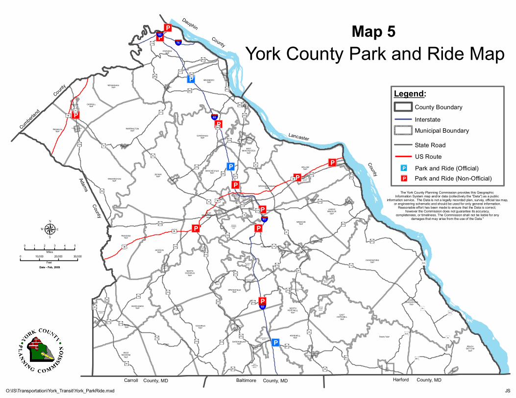
Cumberla
nd
County
Carroll County, MD Baltimore County, MD
Adams County
Dauphin County
LancasterCounty
Harford County, MD
Æü
Æü
Æü
Æü Æü
Æü
Æü
Æü
Æü
Æü
Æü
ÆüÆü
Æü
DELTABORO
FAWNGROVEBORO
NEWFREEDOM
BORO
STEWARTSTOWNBORO
RAILROADBORO
WESTMANHEIM
TWP
SHREWSBURYBORO
PEACHBOTTOM
TWP
GLEN ROCKBORO
HOPEWELLTWP FAWN TWP
MANHEIMTWP
JEFF ERSONBORO
SHREWSBURYTWP
HANOVERBORO
CRO SSRO ADSBORO
CODORUSTWP
EASTHOPEWELL
TWP
PENN TWP
WINTERSTOWNBORO
HEIDELBERGTWP
SEVENVALLEYS
BORO
FELTO NBORO
LOGANVILLEBORO
NORTHHOPEWELL
TWP
JACOBUSBOROSPRING
GROVEBORO
SPRINGFIELDTWP
LOWERCHANCEFORD
TWP
DALLAST OWNBORO
NEWSALEMBORO
RED LIONBORO
YOE BORO
NORTHCODORUS
TWP
WINDSORBORO
JACKSONTWP
CHANCEFORDTWP
WESTYORKBORO
YORK TWP
PARADISETWP
WINDSORTWPSPRING
GARDENTWP
EASTPROSPECT
BORO
NO RTHYORKBORO
SPRINGGARDEN
TWP YORKANABORO
YORKCITY
WESTMANCHESTER
TWP
DO VERBORO
HALLAMBORO
LOWERWINDSOR
TWP
SPRINGETTSBURYTWP
WRIGHT SVILLEBORO
MANCHESTERTWP
WELLSVILLEBORO
HELLAMTWP
MOUNTWOLFBOROMANCHESTER
BORO
WASHINGTONTWP
FRANKLINT OWNBORO
DOVERTWP
CONEWAGOTWP
FRANKLINTWP
EASTMANCHESTER
TWP
YORKHAVENBORO
WARRINGTONTWP
DILLSBURGBORO
LEWISBERRYBORO
CARROLLTWP
GOLDSBOROBORO
MONAGHAN TWP
NEWBERRYTWP
FAIRVIEWTWP
£¤30
£¤30
£¤30
£¤15
£¤30
24
214
181
425
74
114
616
262
24
624
234
124
24
177
181
116
516
194
392
24
94
624234
462
94
74
182
74
214
177
382
851
238
216
462
74
372
194
216
851
851
124
42574
74
516
382
382
74
216
74
116
616
194
74
616
262
216
216
116
234
851
295
425
24
§̈¦83
§̈¦83
§̈¦83
§̈¦76
§̈¦83
The York County Planning Commission provides this Geographic Information System map and/or data (collectively the "Data") as a public
information service. The Data is not a legally recorded plan, survey, official tax map,or engineering schematic and should be used for only general information.
Reasonable effort has been made to ensure that the Data is correct; however the Commission does not guarantee its accuracy,
completeness, or timeliness. The Commission shall not be liable for anydamages that may arise from the use of the Data."
0 1 2 3 4 5Miles
0 10,000 20,000 30,000Feet
µ
JS
Date - Feb, 2009
O:\IS\Transportation\York_Transit\York_ParkRide.mxd
York County Park and Ride MapMap 5
Legend:
Interstate
State RoadUS Route
County Boundary
Municipal Boundary
Park and Ride (Official)Æü
Park and Ride (Non-Official)Æü
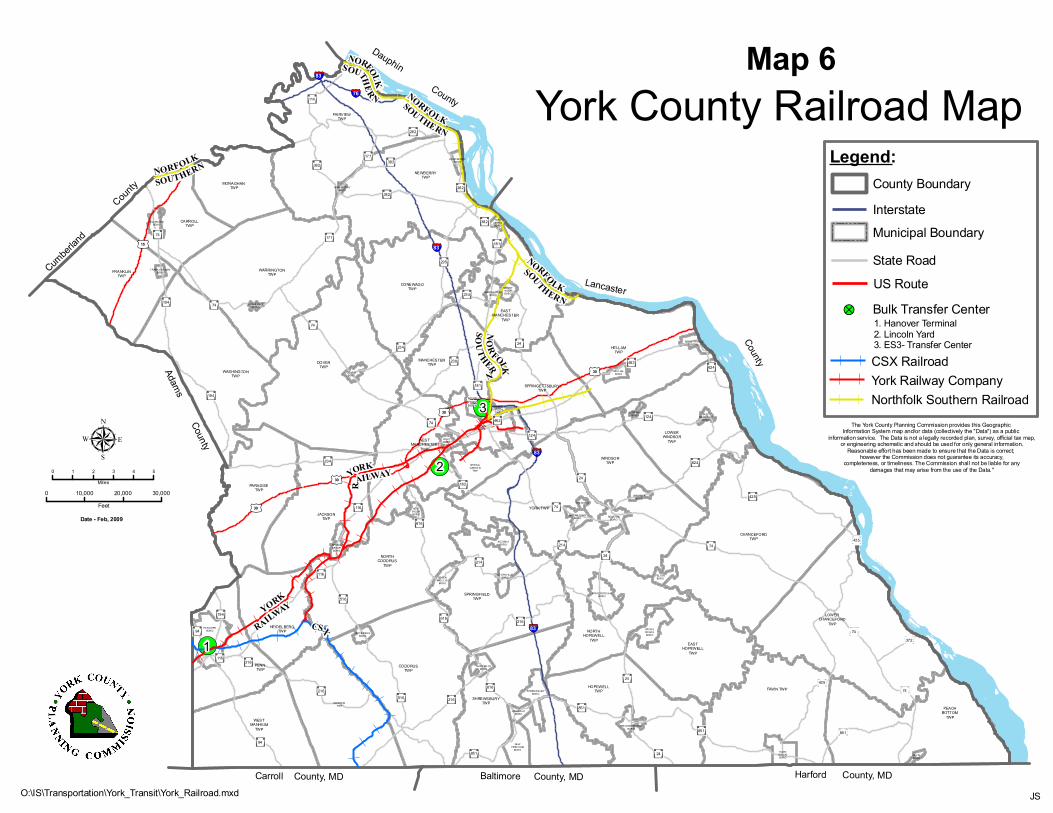
!(
!(
!(
Cumber
land
County
Carroll County, MD Baltimore County, MD
Adams County
Dauphin County
LancasterCounty
Harford County, MD
1
2
3
DELTABORO
FAWNGROVEBORO
NEWFREEDOM
BORO
STEWARTSTOWNBORO
RAILROADBORO
WESTMANHEIM
TWP
SHREWSBURYBORO
PEACHBOTTOM
TWP
GLEN RO CKBORO
HOPEWELLTWP FAWN TWP
MANHEIMTWP
JEFFERSO NBORO
SHREWSBURYTWP
HANOVERBORO CROSS
RO ADSBORO
CODORUSTWP
EASTHOPEWELL
TWP
PENN TWP
WINTERSTO WNBORO
HEIDELBERGTWP
SEVENVALLEYS
BORO
FELTONBORO
LO GANVILLEBORO
NORTHHOPEWELL
TWP
JACOBUSBOROSPRING
GROVEBORO
SPRINGFIELDTWP
LOWERCHANCEFORD
TWP
DALLASTOWNBORO
NEWSALEMBORO
RED LIONBORO
YOE BORO
NORTHCODORUS
TWP
WINDSO RBORO
JACKSONTWP
CHANCEFORDTWP
WESTYORKBORO
YORK TWP
PARADISETWP
WINDSORTWPSPRING
GARDENTWP
EASTPROSPECT
BORO
NO RTHYORKBORO SPRING
GARDENTWP YORKANA
BORO
YORKCITY
WESTMANCHESTER
TWP
DO VERBORO
HALLAMBORO
LOWERWINDSOR
TWP
SPRINGETTSBURYTWP
WRIGHTSVILLEBORO
MANCHESTERTWP
WELLSVILLEBORO
HELLAMTWP
MOUNTWOLFBOROMANCHEST ER
BORO
WASHINGTONTWP
FRANKLINTOWNBORO
DOVERTWP
CONEWAGOTWP
FRANKLINTWP
EASTMANCHESTER
TWP
YORKHAVENBORO
WARRINGTONTWP
DILLSBURGBORO
LEWISBERRYBORO
CARROLLTWP
GOLDSBOROBORO
MONAGHAN TWP
NEWBERRYTWP
FAIRVIEWTWP
24
295
214425
181
425
74
114
616
24
262
24
624
234
124
24
177
181
116
516
194
392
24
94
624234
462
94
74
182
74
214
177
425
382
851
238 462
74
372
194
216
851
851
124
74516
382
382
74
216
74
116
616
194
74
616
262
216
216
116
234
851
§̈¦83
§̈¦83
§̈¦83
§̈¦83
§̈¦76
£¤30
£¤15
£¤30
£¤30
£¤30
NORFOLK
SOUTHERN
YORK
RAILWAY
NORFOLK
SOUTHERN
NORFOLK SOUTHERN
CSX
YORK
RAILWAY
NORFOLK
SOUTHERN
NORFOLK SOUTHERN
0 1 2 3 4 5Miles
0 10,000 20,000 30,000Feet
µ
JS
Date - Feb, 2009
O:\IS\Transportation\York_Transit\York_Railroad.mxd
York County Railroad MapMap 6
The York County Planning Commission provides this Geographic Information System map and/or data (collectively the "Data") as a public
information service. The Data is not a legally recorded plan, survey, official tax map,or engineering schematic and should be used for only general information.
Reasonable effort has been made to ensure that the Data is correct; however the Commission does not guarantee its accuracy,
completeness, or timeliness. The Commission shall not be liable for anydamages that may arise from the use of the Data."
Legend:
Interstate
State RoadUS Route
County Boundary
Municipal Boundary
!? Bulk Transfer Center
CSX Railroad
1. Hanover Terminal2. Lincoln Yard3. ES3- Transfer Center
York Railway CompanyNorthfolk Southern Railroad
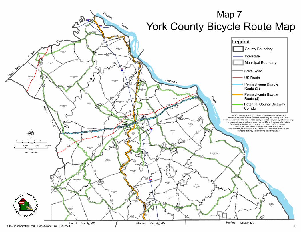
Cumber
land
County
Carroll County, MD Baltimore County, MD
Adams County
Dauphin County
LancasterCounty
Harford County, MDDELTABORO
FAWNGROVEBORO
NEWFREEDOM
BORO
STEWARTSTOWNBORO
RAILROADBORO
WESTMANHEIM
TWP
SHREWSBURYBORO
PEACHBOTTOM
TWP
GLEN ROCKBORO
HOPEWELLTWP FAWN TWP
MANHEIMTWP
JEFFERSONBORO
SHREWSBURYTWP
HANOVERBORO
CROSSROADSBORO
CODORUSTWP
EASTHOPEWELL
TWP
PENN TWP
WINTERSTOWNBORO
HEIDELBERGTWP
SEVENVALLEYS
BORO
FELTONBORO
LOGANVILLEBORO
NORTHHOPEWELL
TWP
JACOBUSBOROSPRING
GROVEBORO
SPRINGFIELDTWP
LOWERCHANCEFORD
TWP
DALLASTOWNBORO
NEWSALEMBORO
RED LIONBORO
YOE BORO
NORTHCODORUS
TWP
WINDSORBORO
JACKSONTWP
CHANCEFORDTWP
WESTYORKBORO
YORK TWP
PARADISETWP
WINDSORTWPSPRING
GARDENTWP
EASTPROSPECT
BORO
NORTHYORKBORO
SPRINGGARDEN
TWP YORKANABORO
YORKCITY
WESTMANCHESTER
TWP
DOVERBORO
HALLAMBORO
LOWERWINDSOR
TWP
SPRINGETTSBURYTWP
WRIGHTSVILLEBORO
MANCHESTERTWP
WELLSVILLEBORO
HELLAMTWP
MOUNTWOLFBOROMANCHESTER
BORO
WASHINGTONTWP
FRANKLINTOWNBORO
DOVERTWP
CONEWAGOTWP
FRANKLINTWP
EASTMANCHESTER
TWP
YORKHAVENBORO
WARRINGTONTWP
DILLSBURGBORO
LEWISBERRYBORO
CARROLLTWP
GOLDSBOROBORO
MONAGHAN TWP
NEWBERRYTWP
FAIRVIEWTWP
£¤30
£¤30
£¤30
£¤15
£¤30
24
214
181
425
74
114
616
262
24
624
234
124
24
177
181
116
516
194
392
24
94
624234
462
94
74
182
74
214
177
382
851
238 462
74
372
194
216
851
851
124
42574
516
382
382
74
216
74
116
616
194
74
616
262
216
216
116
234
851
295
425
24
§̈¦83
§̈¦83
§̈¦76
§̈¦83
§̈¦83
The York County Planning Commission provides this Geographic Information System map and/or data (collectively the "Data") as a public
information service. The Data is not a legally recorded plan, survey, official tax map,or engineering schematic and should be used for only general information.
Reasonable effort has been made to ensure that the Data is correct; however the Commission does not guarantee its accuracy,
completeness, or timeliness. The Commission shall not be liable for anydamages that may arise from the use of the Data."
0 1 2 3 4 5Miles
0 10,000 20,000 30,000Feet
µ
JS
Date - Feb, 2009
O:\IS\Transportation\York_Transit\York_Bike_Trail.mxd
York County Bicycle Route MapLegend:
Interstate
State RoadUS Route
County Boundary
Municipal Boundary
Pennsylvania Bicycle Route (J)Potential County Bikeway Corridor
Pennsylvania Bicycle Route (S)
Map 7

Cumber
land
C
ounty
Carroll County, MD Baltimore County, MD
Adams County
Dauphin County
LancasterCounty
Harford County, MD
p
p
p
p
p
p p
p
p
p
DELTABORO
FAWNGROVEBORO
NEWFREEDOM
BORO
STEWARTSTOWNBORO
RAILROADBORO
WESTMANHEIM
TWP
SHREWSBURYBORO
PEACHBOTTOM
TWP
GLEN ROCKBORO
HOPEWELLTWP FAWN TWP
MANHEIMTWP
JEFFERSONBORO
SHREWSBURYTWP
HANOVERBORO
CROSSROADSBORO
CODORUSTWP
EASTHOPEWELL
TWP
PENN TWP
WINTERSTOWNBORO
HEIDELBERGTWP
SEVENVALLEYS
BORO
FELTONBORO
LOGANVILLEBORO
NORTHHOPEWELL
TWP
JACOBUSBOROSPRING
GROVEBORO
SPRINGFIELDTWP
LOWERCHANCEFORD
TWP
DALLASTOWNBORO
NEWSALEMBORO RED LION
BORO
YOE BORO
NORTHCODORUS
TWP
WINDSORBORO
JACKSONTWP
CHANCEFORDTWP
WESTYORKBORO
YORK TWP
PARADISETWP
WINDSORTWPSPRING
GARDENTWP
EASTPROSPECT
BORO
NORTHYORKBORO
SPRINGGARDEN
TWP YORKANABORO
YORKCITY
WESTMANCHESTER
TWP
DOVERBORO
HALLAMBORO
LOWERWINDSOR
TWP
SPRINGETTSBURYTWP
WRIGHTSVILLEBORO
MANCHESTERTWP
WELLSVILLEBORO
HELLAMTWP
MOUNTWOLFBOROMANCHESTER
BORO
WASHINGTONTWP
FRANKLINTOWNBORO
DOVERTWP
CONEWAGOTWP
FRANKLINTWP
EASTMANCHESTER
TWP
YORKHAVENBORO
WARRINGTONTWP
DILLSBURGBORO
LEWISBERRYBORO
CARROLLTWP
GOLDSBOROBORO
MONAGHAN TWP
NEWBERRYTWP
FAIRVIEWTWP
£¤30
£¤30
£¤15
£¤30
£¤30
§̈¦83
§̈¦83
§̈¦83
§̈¦83
§̈¦76
HarrisburgInternationalAirport
CapitalCity
Airport
DonegalSpringsAirport
McGinnessFieldAirport
HanoverAirport Shoestring
AviationAirport
YorkAirport
BermudianValleyAirpark
KampelAirport
BaublitzAirport
181
425
114
616
24
124
181
516
194
392
24
94
624234
462
94
182
74
214
177
382
851
238 462
74
74
372
24
851
177
851
124
42574
516
216
74
116
194
194
74
616
262
216
116
234
851
295
425
74
0 1 2 3 4 5Miles
0 10,000 20,000 30,000Feet
µ
JSO:\IS\Transportation\York_Transit\York_Airport.mxd
York County Airport Map
The York County Planning Commission provides this Geographic Information System map and/or data (collectively the "Data") as a public
information service. The Data is not a legally recorded plan, survey, official tax map,or engineering schematic and should be used for only general information.
Reasonable effort has been made to ensure that the Data is correct; however the Commission does not guarantee its accuracy,
completeness, or timeliness. The Commission shall not be liable for anydamages that may arise from the use of the Data."
Date - Feb, 2009
Legend:
Interstate
State RoadUS Route
County Boundary
Municipal Boundary
p Public Use Airports
Map 8

CHAPTER IV
Identified Needs

Page Intentionally Blank

Identified Needs 43
Chapter IVIdentified Needs
When planning into the future, the first step is identifying where you are now. That step wascompleted in Chapter III through the inventory section. The second step is to identify what the needs
will be in the future and to estimate their cost. This chapter reviews the process used to identify
future needs and the results of the process.
Identifying the needs was one task that involved the public. Subcommittees were organized to
represent each area of the transportation system. This was the first opportunity for the YAMPO toinvolve individuals and organizations that traditionally have not been involved in the planning
process. Altogether, fifty-two people outside the staff of the YCPC, PennDOT, and rabbittransit
were involved. The members of each subcommittee are listed in this chapter, together with asummary of the subcommittee findings.
Each of the ten subcommittees operated independently; however, each subcommittee adhered to thefollowing guidelines:
- The needs were evaluated between the years of 2009-2035 (27 years).- Needs were not constrained to just the responsibility of the YAMPO and the County of York.
- The needs were not constrained by available or projected financial resources.
- The need was identified as quantitative or qualitative, with an emphasis on quantitative withsupporting data.
- Future need also was reflected in future dollars. A 10% annual inflation factor was used to
identify future need. Although the inflation factor is high for inflation, it will also account forengineering, right-of-way, utility relocation, and contingencies. For an example of the effect of
inflation on cost, please see Figure 8.
$11,918,177
1,000,000
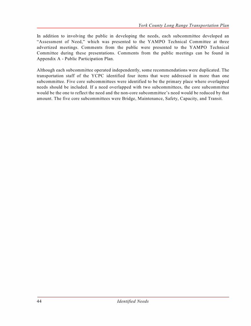
York County Long Range Transportation Plan
Identified Needs44
In addition to involving the public in developing the needs, each subcommittee developed an
“Assessment of Need,” which was presented to the YAMPO Technical Committee at three
advertized meetings. Comments from the public were presented to the YAMPO TechnicalCommittee during these presentations. Comments from the public meetings can be found in
Appendix A - Public Participation Plan.
Although each subcommittee operated independently, some recommendations were duplicated. The
transportation staff of the YCPC identified four items that were addressed in more than one
subcommittee. Five core subcommittees were identified to be the primary place where overlappedneeds should be included. If a need overlapped with two subcommittees, the core subcommittee
would be the one to reflect the need and the non-core subcommittee’s need would be reduced by that
amount. The five core subcommittees were Bridge, Maintenance, Safety, Capacity, and Transit.
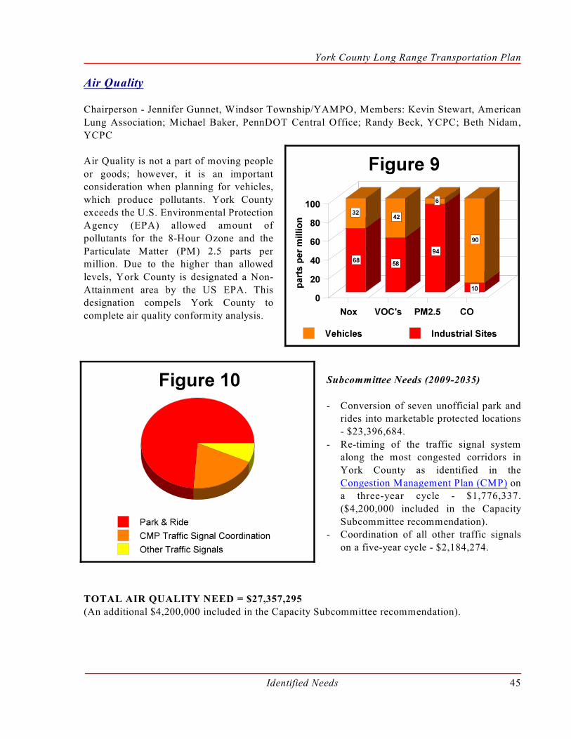
York County Long Range Transportation Plan
Identified Needs 45
Air Quality
Chairperson - Jennifer Gunnet, Windsor Township/YAMPO, Members: Kevin Stewart, American
Lung Association; Michael Baker, PennDOT Central Office; Randy Beck, YCPC; Beth Nidam,
YCPC
Air Quality is not a part of moving people
or goods; however, it is an importantconsideration when planning for vehicles,
which produce pollutants. York County
exceeds the U.S. Environmental ProtectionAgency (EPA) allowed amount of
pollutants for the 8-Hour Ozone and the
Particulate Matter (PM) 2.5 parts permillion. Due to the higher than allowed
levels, York County is designated a Non-
Attainment area by the US EPA. Thisdesignation compels York County to
complete air quality conformity analysis.
Subcommittee Needs (2009-2035)
- Conversion of seven unofficial park andrides into marketable protected locations
- $23,396,684.
- Re-timing of the traffic signal systemalong the most congested corridors in
York County as identified in the
Congestion Management Plan (CMP) ona three-year cycle - $1,776,337.
($4,200,000 included in the Capacity
Subcommittee recommendation). - Coordination of all other traffic signals
on a five-year cycle - $2,184,274.
TOTAL AIR QUALITY NEED = $27,357,295(An additional $4,200,000 included in the Capacity Subcommittee recommendation).

York County Long Range Transportation Plan
Identified Needs46
Aviation
Chairperson - Donald Bubb P.E., YCPC/YAMPO, Members: Dave Spaulding, Susquehanna
Regional Airport Authority; Tim Tate, York Airport; Robert Donato, Bermudian Valley Airpark;
Kenetha Hansen, York County Economic Development Corporation, and Air TransportationAuthority of York County; Tom Tomczyk, PennDOT Bureau of Aviation; Greg Vaughn, PennDOT
District 8-0; Jeph Rebert, YCPC
The Aviation Subcommittee was tasked with identifying the needs for scheduled, business and
recreational public use airports that serve residents of York County. The locations of these airports
are shown on Map 8. The Subcommittee process identified the following needs and associated cost.
Subcommittee Needs (2009-2035)
- Land development plan review within a three-mile radius of airports where municipal Airport
Hazard Zoning is not in place - $540,000.
- Completing a transportation access study for Harrisburg International Airport (HIA) - $300,000.- Completing a transportation access study for York Airport (THV) - $150,000.
- Installation of directional wayfinding signs to HIA, Capital City Airport (CXY), and (THV) -
$120,000.- Capital improvements through the PennDOT Airport Capital Improvement Program (ACIP)
within the airport boundaries of CXY and THV - $12,046,000.
TOTAL AVIATION NEED = $13,156,000
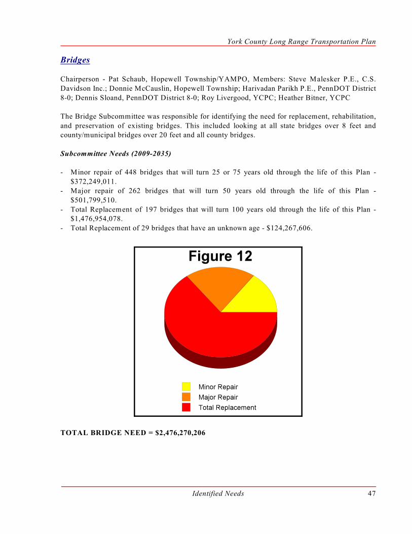
York County Long Range Transportation Plan
Identified Needs 47
Bridges
Chairperson - Pat Schaub, Hopewell Township/YAMPO, Members: Steve Malesker P.E., C.S.
Davidson Inc.; Donnie McCauslin, Hopewell Township; Harivadan Parikh P.E., PennDOT District
8-0; Dennis Sloand, PennDOT District 8-0; Roy Livergood, YCPC; Heather Bitner, YCPC
The Bridge Subcommittee was responsible for identifying the need for replacement, rehabilitation,
and preservation of existing bridges. This included looking at all state bridges over 8 feet andcounty/municipal bridges over 20 feet and all county bridges.
Subcommittee Needs (2009-2035)
- Minor repair of 448 bridges that will turn 25 or 75 years old through the life of this Plan -
$372,249,011.- Major repair of 262 bridges that will turn 50 years old through the life of this Plan -
$501,799,510.
- Total Replacement of 197 bridges that will turn 100 years old through the life of this Plan -$1,476,954,078.
- Total Replacement of 29 bridges that have an unknown age - $124,267,606.
TOTAL BRIDGE NEED = $2,476,270,206

York County Long Range Transportation Plan
Identified Needs48
Capacity (Congestion Management)
Chairperson - Kelly Palmer, West Manchester Township/YAMPO, Members: Tim Kinsley, Kinsley
Properties; Earl Shuckman, Shrewsbury Township; Sam Snyder, Yoe Borough; Brian Hare P.E.,
PennDOT Central Office; Glenn Longstreth, Pennsylvania Motor Trucking Association; TomAustin, Transportation Resource Group, Inc.; Richard McCoy, US Fish and Wildlife; Dennis Sloand,
PennDOT Planning and Programming; Will Clark, YCPC
The Capacity Subcommittee identified projects that would reduce 2035 projected congestion on the
roadway by providing additional capacity to the network.
Subcommittee Needs (2009-2035)
- Completing projects programmed on the 2007 Transportation Improvement Program -$157,683,803.
- Completing projects programmed in the 2003-2023 Long Range Transportation Plan -
$82,521,000.- Re-timing of the 179 traffic signal lights located less then 1,000 feet from another traffic signal
light on a three-year cycle - $8,390,252.
- Implement a coordinated traffic signal system for the eight signalized intersections that are notcurrently coordinated and are less than 1,000 feet from another signal - $1,085,414.
- Widening of 80.92 miles of roadway projected to have a high 2,035 volume to capacity ratio -
$1,866,769,351.- Major increases to capacity at ten intersections - $271,353,574.
- Modifications to five interchange locations - $814,060,721.
- Completing projects submitted by municipalities since 1999 - $78,778,499.- Completing projects included in the Pennsylvania Turnpike Commission Ten-Year Capital
Investment Plan - $59,400,000.
TOTAL CAPACITY NEED = $3,340,042,614

York County Long Range Transportation Plan
Identified Needs 49
Enhancements
Chairperson - Jim Gross, York City/YAMPO, Members: Joe Stafford, Bicycle Access Council;
Robin Ricketts, PANA; Barbara Kovacs, York City Health Bureau; John Sanford, Dallastown Area
School District; Gwen Loose, York County Rail Trail Authority; Jonathon Pinkerton,Lancaster/York Heritage Region; Stewart Graybill, Red Lion Borough; Kevin Alvernez, WellSpan
Health; Dave Holcombe, PennDOT District 8-0; Anne Walko, YCPC; Will Clark, YCPC
The Enhancement Subcommittee was responsible for planning for non-traditional transportation
projects. This category includes bicycles, pedestrians, viewsheds, downtown streetscapes, historic
preservation, archaeological planning, and environmental protection.
Subcommittee Needs (2009-2035)
- Install missing sidewalks within one and a half miles of all elementary and middle schools and
two miles around all high schools - $3,697,241,932.
- Construct a multi-use trail along all rail corridors - $220,715,327.- Implement streetscapes within commercial or mixed use areas within Boroughs and York City -
$3,196,166,166.
- Complete inventory and identification of need for the other areas of the enhancement category.No cost identified.
TOTAL ENHANCEMENT NEED = $7,114,123,425

York County Long Range Transportation Plan
Identified Needs50
Maintenance
Chairperson - Mike Fleming, Fairview Township/YAMPO. Members: Representative Ron Miller,
PA House of Representatives; Missy Werner, Ron Miller’s Office; Dan Shaw, Red Lion Borough;
Rick LeVan, PennDOT District 8-0; Dennis Sloand, PennDOT District 8-0; Richard Roman P.E.,PennDOT District 8-0; Don Bubb P.E., YCPC; Beth Nidam, YCPC
The Maintenance Subcommittee was responsible for determining the future need of maintaining allroutine work needed to keep the highway system (i.e., state and local) in satisfactory condition. This
included pavement maintenance, roadway drainage system maintenance, pavement markings,
signage, roadside vegetation/mowing, and traffic signal maintenance. Two routine tasks not includedare snow removal and routine maintenance on bridges.
Subcommittee Needs (2009-2035)
- Pavement management of 1,342 miles of state-owned or federally-eligible roads, which would
include resurfacing, pavement markings, drainage system repairs or other upgrades -$6,875,925,509.
- Based on 2006 data, pavement management of 2,469 miles of local roads included resurfacing,
pavement markings, drainage system repairs or other upgrades - $4,551,602,716.- Repair or replacement of signs outside of a pavement management project - $204,567,279.
- Maintenance of the 294 traffic signals in operation, as of 2007 - $215,400,467.
TOTAL MAINTENANCE NEED = $11,783,598,384

York County Long Range Transportation Plan
Identified Needs 51
Rail
Chairperson - Felicia Dell, YCPC/YAMPO , Members: Tom Baron, CSX; Ron Bender,
Pennsylvania Public Utility Commission; Dan Brady, Hanover Area Chamber of Commerce;
Michael Bull, Federal Railroad Administration; Rick Crawford, Norfolk Southern Railway Corp.;Kristen Gessner McCaughlin, PennDOT Central Office; Dave Hart, Pennsylvania Public Utility
Commission; Kevin Hodge, Rock Commercial Real Estate; Don Kress, Codorus Creek Railway;
Don Masemer, Hanover Terminal Inc.; Dennis Mead, ES3, LLC; Representative Ron Miller, PAHouse of Representatives; Blanda Nace, York County Economic Development Corp.; Michael
Smeltzer, Manufacture’s Association of South Central PA; Kim Smith, Genesee and Wyoming, Inc.;
Greg Vaughn P.E., PennDOT District 8-0; Jeph Rebert, YCPC; Joseph Marczyk, YCPC
The Rail Subcommittee looked at the movement of freight along rail corridors. They identified the
long term maintenance cost for the current system identified on Map 6 in Chapter III, as well asfuture expansion opportunities.
Subcommittee Needs (2009-2035)
- Required Maintenance Costs for Class II railroads - $192,717,488.
- Activation of existing unused rail sidings. No cost identified.- Construction of new rail sidings. No cost identified.
TOTAL RAIL NEED = $192,717,488

York County Long Range Transportation Plan
Identified Needs52
Security
Chairperson - Robert Reilly, Congressman Todd Platts’ Office/YAMPO, Members: George Giangi,
South Central PA Counter Terrorism Task Force; Kay Carman, York County Office of Emergency
Management; Gloria Shipley, rabbittransit; Michael Shanabrook, York City Office of EmergencyManagement; Michael Fetrow, York County Office of Emergency Management; Scott Nazar, P.E.
PennDOT District 8-0 Office; Robert Medina, York County Human Services Department; Michael
Hampton, West Manheim Township, Office of Emergency Management; Barry Staub, PA StatePolice - Loganville Barracks; Roy Livergood, YCPC; Jeph Rebert, YCPC
The Security Subcommittee was to address and evaluate security and incident management needsfor the County’s entire transportation system, rather than individual transportation modes. Issues to
be addressed include risk assessment, evacuation transportation, critical facilities, Intelligent
Transportation Systems (ITS), and Emergency Planning Zones (EPZs) for Nuclear Plant Facilitieswere evaluated.
Subcommittee Needs (2009-2035)
- Increase the height clearance for bridges over I-83. ($69,842,000 Included in the Bridge
Subcommittee recommendation).- Increase the height clearance for bridges over US 30. ($83,200,000 Included in the Bridge
Subcommittee recommendation).
- Install the ITS infrastructure identified in the PennDOT ITS architecture plan. $7,750,000- Model of transportation constraints within EPZs - $100,000.
- Conduct a Risk Vulnerability Assessment Team (RVAT) evaluation of York County’s Security
Needs/Emergency Management Preparedness. The assessment is performed at no cost on behalfof the U.S. Department of Homeland Security and Pennsylvania State Police.
TOTAL SECURITY NEED = $7,850,000
(An additional $153,042,000 included in the Bridge Subcommittee recommendation).
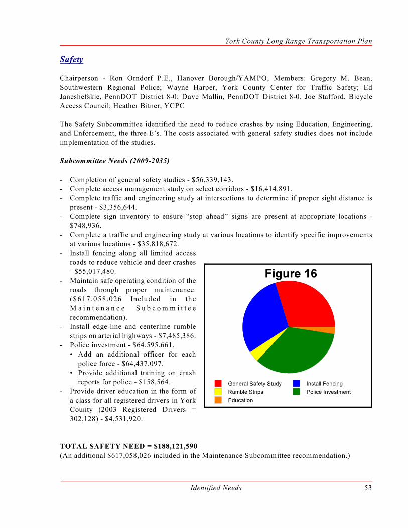
York County Long Range Transportation Plan
Identified Needs 53
Safety
Chairperson - Ron Orndorf P.E., Hanover Borough/YAMPO, Members: Gregory M. Bean,
Southwestern Regional Police; Wayne Harper, York County Center for Traffic Safety; Ed
Janeshefskie, PennDOT District 8-0; Dave Mallin, PennDOT District 8-0; Joe Stafford, BicycleAccess Council; Heather Bitner, YCPC
The Safety Subcommittee identified the need to reduce crashes by using Education, Engineering,and Enforcement, the three E’s. The costs associated with general safety studies does not include
implementation of the studies.
Subcommittee Needs (2009-2035)
- Completion of general safety studies - $56,339,143.- Complete access management study on select corridors - $16,414,891.
- Complete traffic and engineering study at intersections to determine if proper sight distance is
present - $3,356,644.- Complete sign inventory to ensure “stop ahead” signs are present at appropriate locations -
$748,936.
- Complete a traffic and engineering study at various locations to identify specific improvementsat various locations - $35,818,672.
- Install fencing along all limited access
roads to reduce vehicle and deer crashes- $55,017,480.
- Maintain safe operating condition of the
roads through proper maintenance.($617,058,026 Included in the
M a i n t e n a n c e S u b c o m m i t t e e
recommendation).- Install edge-line and centerline rumble
strips on arterial highways - $7,485,386.
- Police investment - $64,595,661.• Add an additional officer for each
police force - $64,437,097.
• Provide additional training on crashreports for police - $158,564.
- Provide driver education in the form of
a class for all registered drivers in YorkCounty (2003 Registered Drivers =
302,128) - $4,531,920.
TOTAL SAFETY NEED = $188,121,590
(An additional $617,058,026 included in the Maintenance Subcommittee recommendation.)

York County Long Range Transportation Plan
Identified Needs54
Transit
Chairperson - Richard Farr, CM rabbittransit/YAMPO, Members: Bob Jensenius, York County
Chamber of Commerce; John Ward, Capital Area Transit and Modern Transit Partnership; Brandy
Heilman, South Central PA Commuter Services; Lou Diehl, Center for Independent LivingOpportunities; Jenna Reedy, rabbittransit; Melissa Hess, The Performance Group; Joshua Bennet,
Capital Trailways; Mike Wagner, York County Area Agency on Aging; Dr. Judith Basset, York
County Human Services Department; Greg Vaughan, PennDOT District 8-0; Jeph Rebert, YCPC
The Transit Subcommittee was to address the need of the public transit system; as well as other
transportation alternatives (e.g. including car pooling and vanpooling).
Subcommittee Needs (2009-2035)
- Maintenance of existing system in terms of capital and operation funding - $685,600,000.
- Demand management - $3,200,000.
• A coordinator with Commuter Services of South Central Pennsylvania that is focused onYork County - $1,600,000.
• Establishment of ten subsidized vanpools - $1,600,000.
- Commuter Transit Services - $8,840,000.• Expansion of the Harrisburg express bus service and routine bus replacements - $2,970,000.
• Begin new express service into Maryland and routine bus replacements - $4,045,000.
• Lancaster and Adams express bus service and routine bus replacements - $1,725,000.• Intra-County express bus service - $100,000.
- Signal light prioritization along Congestion Management System corridors. ($200,000 included
in the Capacity Subcommittee recommendation).- Expansion of the existing transit transfer center - $1,500,000.
- Purchasing hybrid buses as replacements for the core routes (eight buses) - $4,080,000.
- Paratransit service expansion to address gaps in the YAMPO Transit/Human ServiceCoordinated Plan - $45,000.
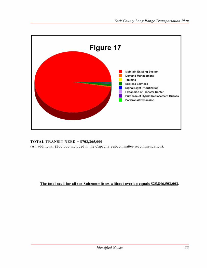
York County Long Range Transportation Plan
Identified Needs 55
TOTAL TRANSIT NEED = $703,265,000
(An additional $200,000 included in the Capacity Subcommittee recommendation).
The total need for all ten Subcommittees without overlap equals $25,846,502,002.

Page Intentionally Blank

CHAPTER V
Future Funding Decision

Page Intentionally Blank

Future Funding Decision 59
Chapter VFuture Funding Decision
One of the major steps in developing a long range transportation plan is prioritizing and planningwhere the majority of the future investment should be allocated. On December 6 , 2007 theth
YAMPO Technical Committee held a work session to discuss different future funding splits to
determine the best mix of transportation funding over the next 27 years. The Task Forcerecommendation was based on public participation, the identified need, funding projections, and
historic funding based on project type.
Public Participation
In order to gauge the transportation priorities of York County, residents were asked to complete a
“Transportation Madness” Survey (Figure 18). The survey was designed to indicate a priority levelamong the transportation categories that corresponded with the following Subcommittees: Bridges,
Capacity, Enhancements, Maintenance, Rail Freight, Safety, Security, and Transit. Refer to
Appendix A - Public Participation for a full page version of Transportation Madness.
Figure 18

York County Long Range Transportation Plan
Future Funding Decision60
A priority list was compiled by using the 308 survey responses. The list was then weighted by
assigning a point for each time a category was chosen. Figure 19 shows the categories in order ofmost points received with the total number of points listed in parentheses beside the category title.
This figure also details the frequency that a category “won” first/second, third/fourth, fifth/six, or
seventh/eighth place.
Clearly, public opinion identified Maintenance, Capacity, and Safety as the top three transportation
priorities. However, to ensure that these decisions were based on a foundation of facts, a focus groupsession was conducted to provide information to a sample set of residents. The focus group was
provided with the information that was produced by each of the ten subcommittees.
The Focus Group identified one clear difference. Bridges were more important than the
Transportation Madness results identified. However, the Transportation Madness Survey was
conducted prior to the Minneapolis bridge collapse in August 2007 and the Focus Group wasconducted afterward. Since that time, there has been a large amount of public education through the
media concerning the status of bridges throughout Pennsylvania and the nation. The Focus Group
York County Long Range Transportation Plan
Future Funding Decision 61
participants collectively, when faced with severe financial limitations, chose to fund bridges, safety
engineering solutions, I-83 interchange upgrades, completion of projects currently on the TIP andLRTP, signal coordination, and transit’s maintenance of existing services. Overall the Focus Group
was not interested in funding enhancement projects, security projects, air quality stand-alone
projects or transit projects other than maintenance and use of alternative fuels.
Identified Needs
The identified need for each of the ten subcommittees is included in Chapter IV beginning on page43.
Funding Projections
The YAMPO looked at existing funding and developed a projection for 2009-2035. Each category
of existing funding was looked at and projected based on what is known or anticipated about that
specific funding category. This step in the process is a requirement of the YAMPO, although not onedecision about increasing or securing funding is made at the YAMPO level. There are many factors
that will change the composition of future revenue sources for transportation including the
following;
- Pennsylvania passed legislation concerning the tolling of I-80 and the following projections are
based on the tolling of I-80, which is still working towards Federal approval, which has not beenapproved.
- The projections also include funding levels based on the historic taxes generated from the
gasoline tax, which decreased in 2008. The dip in gas tax effects both state and federal revenuesources.
- SAFTEA-LU, Federal Transportation Legislation is set to expire on September 30, 2009, and
a new Federal Transportation Legislation will be created. This legislation is expected to havenew ideas on raising money since a goal is to move away from petroleum-based fuels.
With the previous three items taken into consideration, along with other considerations unknown,Figure 20 identifies the projected future revenue for York County, Pennsylvania, over the next 27
years. Preparation of this financial plan included a review of historical data, recent trends, and other
relevant materials. A total of $3.8 billion was identified for transportation investments within YorkCounty over the next 27 years.
Figure 20 shows the entire $3.8 billion split into formula driven and discretionary/competitivefunding categories. Funding that comes to York County through a formula is more secure than
funding that is distributed to York County through a discretionary/competitive processes. Over 79%
of the funding projected to come into York County over the next 27 years will be through a formulaallocation. The other 21% will be received for specific projects that are competing against other
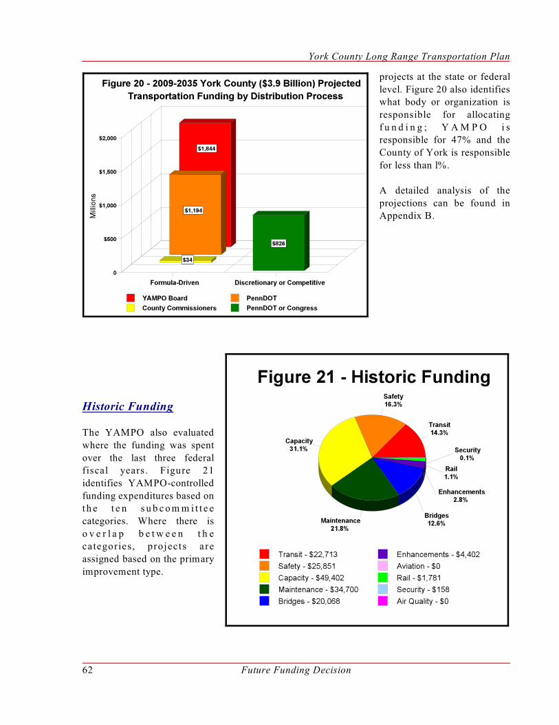
York County Long Range Transportation Plan
Future Funding Decision62
projects at the state or federal
level. Figure 20 also identifieswhat body or organization is
responsible for allocating
f u n d i n g ; Y A M P O i sresponsible for 47% and the
County of York is responsible
for less than l%.
A detailed analysis of the
projections can be found inAppendix B.
Historic Funding
The YAMPO also evaluated
where the funding was spent
over the last three federalfiscal years. Figure 21
identifies YAMPO-controlled
funding expenditures based ont h e t e n s u b c o m m i t t e e
categories. Where there is
o v e r l a p b e t w e e n t h ecategories , projects a re
assigned based on the primary
improvement type.

York County Long Range Transportation Plan
Future Funding Decision 63
Allocation of Future YAMPO Funding
Using all the previously identified data, the Long Range Transportation Plan Task Force reviewed
five different future funding wheels to determine the best mixture of transportation funding over thenext 27 years. This mixture constituted their recommendation for the best transportation system
within limited financial resources. The five different funding wheels were based on public input,
accomplishing PennDOT goals, the proportional need identified by the subcommittees andmaintaining the same percentages that have actually been spent over the last three years.
Figure 22 identifies the ranges that the Task Force recommended YAMPO and other fundingpartners fund in each category over the next 27 years. The identified amounts would not be a year-
by-year guidance, but a total distribution over the next 27 years. These ranges allocate more than
75% of all funding to maintaining the existing transportation network.

York County Long Range Transportation Plan
Future Funding Decision64
The following is a description of what could be accomplished with the minimum amount of the $1.8
Billion (Identified in Figure 20) of YAMPO controlled funding in each range.
TRANSIT ($258,201,433)
rabbittransit receives a portion of their operating budget from TIP-related funds. The TIP share of
the 2009-2035 projected operation cost of the existing system is $261,000,000. The remaining funds
would come from other state and local sources. The amount at the low end of the range would resultin a shortfall in funding of the existing system. The upper limit of the range would allow funding
for expansion of the existing system including the intra-county express service routes.
SAFETY ($92,214,797)
At the lower end of the range, it is anticipated that approximately 80% of engineering-causedcrashes could be addressed . This would not include crashes where the primary cause is something
other than the design or maintenance of the roadway. In addition, many other crash locations will
be addressed by capacity or maintenance type projects.
CAPACITY ($295,087,352)
All capacity projects ($157,683,803) started on the current 2007 TIP could be completed with the
proposed allocation. In addition, 5.9 miles (7% of need) of roadway could be widened, or 11 major
intersection improvements (73% of need) could be completed.
Capacity was considered as a category of what funding was remaining. The Task Force prioritized
funding of the existing system prior to expanding the transportation system. Also, the capacity needshould be reduced through avenues other than construction.
MAINTENANCE ($645,503,581)
When this level of funding is combined with PennDOT’s York County Maintenance Budget,
projected through the life of this Plan, approximately 2,248 miles of roadway could be paved, usingan average cost per mile and 2007 prices. The Maintenance Subcommittee’s pavement management
program calls for paving 2,555 miles of cycled roadway during these 27 years at 2007 prices. With
this level of funding, 88% of the pavement management cycle could be accomplished.
BRIDGES ($3313,530,311)
If the bridge projects were split evenly between the minor rehabilitations, major rehabilitations, and
replacements, approximately 12% of the need identified in this Plan would be met. The Bridge
Subcommittee recommends 216 bridges for replacement over the next 27 years; at this fundinglevel, 29 of them will be replaced.

York County Long Range Transportation Plan
Future Funding Decision 65
ENHANCEMENTS ($34,551,000)
The Federal-designated amount for enhancements is identified by formula. The emphasis for the
Task Force was not how many, but what type of projects. The type of projects that will be funded
in the future will need to meet strict criteria. If the maximum of 5% was used, and all the moneywent to trails over the next 27 years, a total of 62 miles could be completed. If all the money went
to streetscapes or sidewalks, a total of 8 miles of streetscapes or 66 miles of sidewalks could be
completed.
AVIATION ($0)
Aviation does not currently receive funding through the YAMPO process and no funding is
identified for the future.
RAIL ($16,465,000)
The federal-designated amount for railroad crossing improvements is identified by formula. Theupper limit does provide for funding of future projects. Funding will be allocated to these projects
on a project-by-project basis. When the MPO identifies a beneficial project, funding will be
allocated.
SECURITY ($0)
Security was not allocated specific funding due to limited resources for other projects. The Task
Force recommended that selection criteria should be incorporated into the other categories that
provide additional support for projects that have security benefits.
AIR QUALITY ($0)
Many projects that are completed under categories other than Air Quality have pollution reducing
or air quality benefits. Fiscal constraints being what they are, the Task Force discussions pointed out
that air quality benefits are a secondary benefit and an important project criterion.
Since these were the minimum amounts of funding in each range, the total is 90%, an additional10% ($184,429,595) is flexible within the proposed ranges.

Page Intentionally Blank
CHAPTER VI
Project Selection Process

Page Intentionally Blank
Project Selection Process 69
Chapter VIProject Selection Process
One of the goals of this Plan is to develop a process that helps guide the decision makers to selectprojects that meet the identified goals. Chapter II identifies the goals included in SAFETEA-LU,
Keystone Principles, PennDOT Mobility Plan, Smart Transportation Principles, and the other
elements of the York County Comprehensive Plan. The process included in this chapter referencesChapter II to identify whether the selection criterion meets the goals of that specific document.
The Selection Process
This process is designed to assist in selecting transportation projects and not be the “black box” that
will select the final project. A quote from PennDOT’s Mobility Plan reads, “ ...project development
decisions must always be made by people, not spreadsheets, weighing a range of criteria that is oftensubjective, not easily quantified, and adjusted for unique situations. Project prioritization is not a
mechanical process. It cannot and should not be overly prescriptive or inflexible. “
The project selection criteria set forth in this Chapter are listed under each appropriate subcommittee
and the same criterion can be included in one or more subcommittee processes.
Some subcommittees have several levels of criteria. The first level is an absolute and this is the first
step that a project is evaluated against. The project only moves forward if the answer to each
question is “yes.” The second step is a weighted criteria that considers criteria at different values.Some weighted data is not currently collected and should be considered in the future when the
information is collected. The third level is after the project is selected there may be items that the
sponsor or municipality needs to complete to receive funding.
The YAMPO, however, does not plan or program projects with the primary and/or only purpose of
improving air quality. Thus, project selection criteria were not developed for transportation projectswith the sole intent of improving air quality. Air quality benefits, however, must be a weighted
factor in the project selection criteria for all other transportation categories, except Safety. No
transportation candidate project should be selected that adds to York County’s air pollution levels.
Unique to the area of Air Quality is the Congestion Mitigation and Air Quality (CMAQ) funding
source that is set aside for Air Quality beneficial projects. These federally-allocated funds haveselection criteria already developed in the SAFETEA-LU, Interim Program Guidance. Annually,
YAMPO should evaluate the level of funding available. If any CMAQ funding is available, the
transportation projects that have passed through the project selection process for CMAQ fundingshould be ranked according to the cost-effectiveness, or CMAQ-dollar to Air Quality benefit, of
each project. The highest ranking project should then be promoted.
Criterion were not developed for Aviation or Security since those categories were not identified with
a funding allocation in Chapter V.
York County Long Range Transportation Plan
Project Selection Process70
SAFE
TEA
-LU
KEY
STO
NE
PRIN
CIP
LES
PEN
ND
OT
MO
BIL
ITY
PLA
N
SMA
RT
TRA
NSP
OR
TATI
ON
CO
UN
TY C
OM
P PL
AN CAPACITY
CRITERIA
CAPACITY - LEVEL 1 : ABSOLUTE
/ / / 1. Is the project located wi thin a m unicipality adopted growth area andconsistent within the current York County Growth Management Plan?
/ / / 2. Is the project on a Level II or III CMS corridor or intersection?
/ / / / 3.Does the project have at least two full hours of travel time measurementsoperating below level of service of “c? ” They do not need to beconsecutive hours.
/ / / / 4.
Does the new alignment or roadway project avoid impacts to high hazardlocations or environmentally sensitive areas as identified by the YorkCounty Hazard Mitigation Plan and the York Cou nty Natural AreasInventory, respectively?
/ / / 5. Does the project i mprove the response tim e or access for em ergencyvehicles?
CAPACITY - LEVEL 2: WEIGHTED CRITERIA
/ / / / 1.Economic Development (Subjective - Y es or N o) (High) - D oes theproject meet the goal s and objectives of the York County Econom icDevelopment Plan?
/ / / 2.Level of Service (High) - Is the total time of delay for hours of operationworse then LOS “C” (Multiply the volume for each movement the timedelay for each movement)?
/ / / 3. Air Quality Benefit (Low) - What is the measurement from an air qualitytoxin quantifying software?

York County Long Range Transportation Plan
SAFE
TEA
-LU
KEY
STO
NE
PRIN
CIP
LES
PEN
ND
OT
MO
BIL
ITY
PLA
N
SMA
RT
TRA
NSP
OR
TATI
ON
CO
UN
TY C
OM
P PL
AN CAPACITY
CRITERIA
Project Selection Process 71
/ / 4.Cost Benefit Ratio (High) - What is the cost associated to YAMPO (allphases) divided by the difference in total time of delay between the buildand no build scenarios of the project?
/ 5. Coordination with other proj ects (High) - Can this project m eet anobjective of another subcommittee?
/ / / / 6. Freight Movem ent (Subjective - Ye s or No) (Medium ) - Does thisproject reduce bottlenecks in freight movement?
/ / / / 7. Does the project increase efficiency of the existing network withoutadditional right-of-way? (Yes or No) (High)
CAPACITY - LEVEL 2: FUTURE WEIGHTED CRITERIA
/ 1. What is the forecasted volume-to-capacity ratio of the 10- and 20-yearbuild scenarios as identified by the transportation model? (Medium)
CAPACITY - LEVEL 3: FINAL ABSOLUTE NEEDS TO MEET
/ / / / / 1.Has the m unicipality adopted proper land use tools (i.e. official m ap,access m anagement ordinance, etc...) appropriate for protecting orreducing the cost of the transportation investment.
/ / / / 2. Have solutions, other than increasing roadway capacity, been exploredto fix the problem?
York County Long Range Transportation Plan
Project Selection Process72
SAFE
TEA
-LU
KEY
STO
NE
PRIN
CIP
LES
PEN
ND
OT
MO
BIL
ITY
PLA
N
SMA
RT
TRA
NSP
OR
TATI
ON
CO
UN
TY C
OM
P PL
AN ENHANCEMENTS
CRITERIA
ENHANCEMENTS- LEVEL 1:ABSOLUTE
/ / 1.For Safe Route To School Project s - Doe s the application includeeducation through the school district at the school t he project isbenefitting?
/ / 2. For Safe Route To School Projects - Is the School District walki ngpolicy consistent with the location of the physical improvements?
/ / / / 3.
For All Projects - Does the project avoid im pacts to high hazardlocations or environmentally sensitive areas as identified by the YorkCounty Hazard Mitigation Plan and the York County Natural AreasInventory?
/ / / 4. For All Projects - Are all pre-const ruction costs using Non-YAMPOfunding sources?
/ / 5. For All Projects - Is the cost of yearly routine maintenance known andaccepted by the responsible party?
/ / 6. Has the appropriate public involvem ent outreach occ urred and is itcurrent?
ENHANCEMENTS - LEVEL 2: WEIGHTED CRITERIA
/ / 1. Cost/Benefit Ratio - W hat is the ratio of total YAMPO expenditurecompared to the annual users? (Medium)
/ / 2. Will coordination of this project with other projects reduce cost? (Yesor No) (Medium)
/ / / / 3. Does the project protect envi ronmentally sensitive areas through thepurchase of property or project development? (High)
/ 4. Is the project concept fully developed? (High)
/ 5. Has the right-of-way been acquired based on federal regulations?(High)
/ / / / / 6. For Mobility/Safety Projects - Does the project connect two types ofland use to create a connection? (Yes or No)
/ / / 7. For Mobility/Safety Projects - Does the project provide a connection toanother mode besides the primary mode? (Yes or No) (Medium)

York County Long Range Transportation Plan
SAFE
TEA
-LU
KEY
STO
NE
PRIN
CIP
LES
PEN
ND
OT
MO
BIL
ITY
PLA
N
SMA
RT
TRA
NSP
OR
TATI
ON
CO
UN
TY C
OM
P PL
AN ENHANCEMENTS
CRITERIA
Project Selection Process 73
/ / 8.For Mobility/Saf ety Projects - Is the project part of an overalltransportation corridor improvement and identified as an element of thesolution in a separate transportation study? (Yes or No) (Medium)
/ 9. For Beautification/Recreation/Envi ronmental Projects - Does theproject protect and/or enhance documented historic properties? (Low)
/ / 10. For Beautificat ion/Recreation/Environmental Projects - Does theproject connect to an existing recreational trail? (Low)
ENHANCEMENTS - LEVEL 3: FINAL ABSOLUTE NEEDS TO MEET
/ / 1. Is there a separate contract if the m unicipal engineer of record isawarded pre-construction contract?
/ 2. Has additional scoping of the pr oject been com pleted prior to finalapproval?
York County Long Range Transportation Plan
Project Selection Process74
SAFE
TEA
-LU
KEY
STO
NE
PRIN
CIP
LES
PEN
ND
OT
MO
BIL
ITY
PLA
N
SMA
RT
TRA
NSP
OR
TATI
ON
CO
UN
TY C
OM
P PL
AN SAFETY
CRITERIA
SAFETY - LEVEL 1 ABSOLUTE
/ / / / 1.
Is t he corridor or intersection a top 25 candidate project from thePennDOT District 8-0 Highway Safety Plan or through the YCPC staffrecommendation of transportation studies such as Traffic Impact/CorridorStudies or municipal submissions?
A total of five preferred locations will be chosen for field scoping before proceeding to Level 1, Criteria 2.
/ / / / 2. Can the crash cluster identified in the field scoping be corrected by theproposed improvement solution?
SAFETY - LEVEL 2 WEIGHTED CRITERIA
/ / / / 1. Current Project (High) - Is the project located within the lim its of aplanned municipally- or TIP-funded project?
/ / / 2.
Cost Benefit Ratio (High) - What is the cost associated to YAMPO (allphases) divided by the number of crashes in the movement (not overallintersection) being addressed by improvement (relative to highest projectratio)?
/ / / 3.Type of Crash - W hat type of crashes are attem pting to be correctedthrough these actions? Angle (Medium ) Hit Fixed Object ( Medium)Head-on (Low) Rear, (Low)
/ / / 4. Deliverability (Medium) - Does the complexity of the project allow forproper implementation?
/ / / 5. Other Plans (Low) - Is the project identified in municipal/county plans?
SAFETY - LEVEL 2 FUTURE WEIGHTED CRITERIA
/ / 1. Non-Reportable Crash Rate - W hat is the r atio of reportable to non-reportable crashes?
SAFETY - LEVEL 3 FINAL ABSOLUTE NEEDS TO MEET
/ 1. If funding, other than state or f ederal is committed to the project, is anMOU with the YAMPO signed?

York County Long Range Transportation Plan
Project Selection Process 75
SAFE
TEA
-LU
KEY
STO
NE
PRIN
CIP
LES
PEN
ND
OT
MO
BIL
ITY
PLA
N
SMA
RT
TRA
NSP
OR
TATI
ON
CO
UN
TY C
OM
P PL
AN RAIL
CRITERIA
RAIL - LEVEL 1 : ABSOLUTE
/ 1. Funding - Are matching funds available or are funds currently in place toproceed with the project?
/ / / / 2. Does the project provide a dequate infrastructure to safely transportindustry standard minimum weight of rail cars?
/ / / / 3.Environmental - Does the project avoid or mitigate high hazard locationsand avoid adversely im pacting environm entally se nsitive areas,productive agricultural lands or significant historic sites?
RAIL - LEVEL 2 WEIGHTED CRITERIA
/ / / / 1.
Growth Management - Does the project contribute to the improvement ofthe inf rastructure within designated growth area or rehabilitate/reuseexisting buildings or improve/enhance community revitalization efforts?(High)
/ / / 2. Congestion Miti gation - Does the project alleviate truck traffic onroadways? (High)
/ / / / 3.Economic Developm ent - Does the project cont ribute to creatingpermanent jobs, producing a positive impact on local labor markets andprovide suitable wages and job training? (Medium)
/ / / 4.
Green Technology - Is the business or project energy efficient; use energyconservation standards; produce, sell or use renewable energy; promoteinnovation in energy production and use; or e xpand renewable energysources or clean power? (Low)
/ / / / 5. Safety - Will the project contribute to reducing the risk of derailments?(Medium)
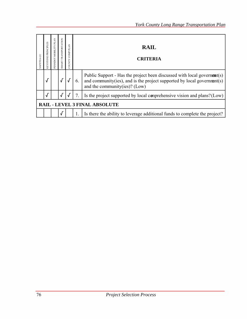
York County Long Range Transportation Plan
SAFE
TEA
-LU
KEY
STO
NE
PRIN
CIP
LES
PEN
ND
OT
MO
BIL
ITY
PLA
N
SMA
RT
TRA
NSP
OR
TATI
ON
CO
UN
TY C
OM
P PL
AN RAIL
CRITERIA
Project Selection Process76
/ / / 6.Public Support - Has the project been discussed with local government(s)and community(ies), and is the project supported by local government(s)and the community(ies)? (Low)
/ / / 7. Is the project supported by local comprehensive vision and plans? (Low)
RAIL - LEVEL 3 FINAL ABSOLUTE
/ 1. Is there the ability to leverage additional funds to complete the project?

York County Long Range Transportation Plan
Project Selection Process 77
SAFE
TEA
-LU
KEY
STO
NE
PRIN
CIP
LES
PEN
ND
OT
MO
BIL
ITY
PLA
N
SMA
RT
TRA
NSP
OR
TATI
ON
CO
UN
TY C
OM
P PL
AN MAINTENANCE
CRITERIA
MAINTENANCE- LEVEL 2 : WEIGHTED
/ / / / / 1. Pavement Management Cycle (High) - Is the project inside or outsidethe projected pavement management cycle?
/ / / / 2. Road Function - Is the project in Roa d Group A (High), Group B(Medium) or Group C (Low)?*
/ / / 3. AADT (High) - W hat is the Annu al Average Daily Traffic (AADT)volume for the project road segments?
/ / / 4. Current IRI (Medium ) - Wha t is the current International RoughnessIndex (IRI) measurement of the project road segments?
/ / / / 5.Change in IRI (High) - What is the change in IRI measurement (currentIRI numeric measurement minus previous IRI numeric measurement) forthe project road segments?
/ / / / 6. Field View ( High) - W hat does the field view of the project showregarding the condition and the general area of the project segments?
/ / / / / 7. Road Condition Crash (High) - What is the number of crashes that areattributed to pavement condition?
/ / / / 8.Public Perce ption (Low) - W hat is the num ber of com plaints aboutroadway conditions as reported by municipal- and state-elected officialsor municipal managers?
/ / / / 9. Environmental I mpact Issues (Medium ) - W hat is the num ber ofcomplaints about roadway water runoff creating environmental impacts?
/ / / / 10.Anticipated TIP/Community Development Block Grant (CDBG) or HOPProjects (Yes or No) (Medium) - Is the project tim e sensitive tocoordinate with another project?
/ / / / 11. Utility Scheduling (Yes or No) (M edium) - Is the project beingcoordinating with a utility project?
MAINTENANCE - LEVEL 3: FINAL ABSOLUTE NEEDS TO MEET
/ / / 1. Fairness Factor - Is there an equal distribution of projects throughout theCounty?
* The state roadways of York County are broken into three groups. Please see the following and Map 10.

York County Long Range Transportation Plan
Project Selection Process78
The State-owned roadway network is classifi ed into different levels of function. The followingclassifications will be used for the Maintenance selection criteria number 2.
Group A: The National Highway System roadways (NHS) and the red and blue detour routes forI-83. These roads are considered Priority #1. (High)02
Group B: Roadways, not in Group A, with a 2-digit State Route (SR) number that are not on theNHS, 3-digit SR number with AADT greater than or equal to 10,000, and 4-digit SR number withAADT greater or equal to 10,000. These roads are considered Priority #2. (Medium)
Group C: Roadways, not in Group A or Group B, with both 3-digit or 4-digit SR num bers withAADT less than 10,000. These roads are considered Priority #3. (Low)
Map 10 2009-2035 Long Range Transportation Plan
Road Maintenance Groups

York County Long Range Transportation Plan
Project Selection Process 79
SAFE
TEA
-LU
KEY
STO
NE
PRIN
CIP
LES
PEN
ND
OT
MO
BIL
ITY
PLA
N
SMA
RT
TRA
NSP
OR
TATI
ON
CO
UN
TY C
OM
P PL
AN BRIDGES
CRITERIA
BRIDGES - LEVEL 1: ABSOLUTE NEEDS TO MEET
/ / / / / 1. Is the bridge structurally deficient or a preservation project?
/ / / / 2. For County and Local Bridges - Is the anticipated cost of replacem entover one million federal dollars in the year of construction?
BRIDGES - LEVEL 2:WEIGHTED CRITERIA
/ / / / / 1. Functional Classification (High) - Is the bridge posted in such a mannerthat will effect the function of the roadway?
/ / / / / 2. Change in Sufficiency Rating (High) - What is the percent change in thesufficiency rating over the last five years?
/ / / / / 3. For Local Bridges - Maintenance (Medium ) - Has the bri dge beenmaintained regularly?
/ / / / 4. Annual Average Daily Traffic (AADT) (Medium) - What is the AADTon the bridge?
/ / / / 5. Flooding (Low) - Are there any f looding issues associated with thebridge?
/ / / / 6. Emergency Services (Tiebreaker) - W hich bridge im pacts/serves thegreater number of homes in regards to emergency services?
BRIDGES - LEVEL 2: FUTURE CRITERIA
/ / / / / 1. Emergency Response (Low) - Are there any emergency responseissues with the bridge?
BRIDGES - LEVEL 3: FINAL ABSOLUTE NEEDS TO MEET
/ / / / 1.Has a resolution been completed by the governing body com mittingproper percentage for each phase of the project cost or 100% ofpreconstruction; this includes design, right-of-way and utility relocation?

York County Long Range Transportation Plan
SAFE
TEA
-LU
KEY
STO
NE
PRIN
CIP
LES
PEN
ND
OT
MO
BIL
ITY
PLA
N
SMA
RT
TRA
NSP
OR
TATI
ON
CO
UN
TY C
OM
P PL
AN BRIDGES
CRITERIA
Project Selection Process80
/ / 2. For Local Bridges - Has a project tim eline been com pleted andsubmitted as part of the resolution?
/ 3. For Local Bridges - Has a separate contract for the project been enteredinto by the municipality and for the project engineer?
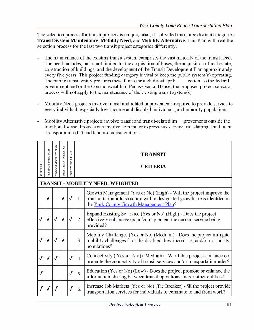
York County Long Range Transportation Plan
Project Selection Process 81
The selection process for transit projects is unique, in that, it is divided into three distinct categories:Transit System Maintenance, Mobility Need, and Mobility Alternative. This Plan will treat theselection process for the last two transit project categories differently.
- The maintenance of the existing transit system comprises the vast majority of the transit need.The need includes, but is not limited to, the acquisition of buses, the acquisition of real estate,construction of buildings, and the development of the Transit Development Plan approximatelyevery five years. This project funding category is vital to keep the public system(s) operating.The public transit entity procures these funds through direct appli cation t o the federalgovernment and/or the Commonwealth of Pennsylvania. Hence, the proposed project selectionprocess will not apply to the maintenance of the existing transit system(s).
- Mobility Need projects involve transit and related improvements required to provide service toevery individual, especially low-income and disabled individuals, and minority populations.
- Mobility Alternative projects involve transit and transit-related im provements outside thetraditional sense. Projects can involve com muter express bus se rvice, ridesharing, IntelligentTransportation (IT) and land use considerations.
SAFE
TEA
-LU
KEY
STO
NE
PRIN
CIP
LES
PEN
ND
OT
MO
BIL
ITY
PLA
N
SMA
RT
TRA
NSP
OR
TATI
ON
CO
UN
TY C
OM
P PL
AN TRANSIT
CRITERIA
TRANSIT - MOBILITY NEED: WEIGHTED
/ / / 1.Growth Management (Yes or No) (High) - Will the project improve thetransportation infrastructure within designated growth areas identified inthe York County Growth Management Plan?
/ / / / / 2.Expand Existing Se rvice (Yes or No) (High) - Does the projecteffectively enhance/expand/com plement the current service beingprovided?
/ / / / 3.Mobility Challenges (Yes or No) (Medium) - Does the project mitigatemobility challenges f or the disabled, low-incom e, and/or m inoritypopulations?
/ / / / 4. Connectivity ( Yes o r N o) ( Medium) - W ill th e p roject e nhance o rpromote the connectivity of transit services and/or transportation modes?
/ / 5. Education (Yes or No) (Low) - Does the project promote or enhance theinformation-sharing between transit operations and/or other entities?
/ / / / 6. Increase Job Markets (Yes or No) (Tie Breaker) - Will the project providetransportation services for individuals to commute to and from work?

York County Long Range Transportation Plan
Project Selection Process82
TRANSIT - MOBILITY ALTERNATIVE: WEIGHTED
/ / / / 1. Reduce Single Occupancy Vehicles ( SOVs) (High) - Has the projectproven to reduce the number of SOVs on the County’s roadways?
/ / / 2. Intelligent Transportation (IT) (High) - Does the project employ IT andIT System Architecture to improve or enhance transit or related services?
/ / / 3.Growth Management (Yes or No) (High) - Will the project improve thetransportation infrastructure within the designated growth areas identifiedin the York County Growth Management Plan?
/ / / / / 4. Expand Existing Service (Yes or No) (High) - Will the project effectivelyenhance/expand/complement the current service being?
/ / / / / 5. Connectivity (Yes or No) (Medium ) - Does the project enhance orpromote the connectivity of transit services and/or transportation modes?
/ 6.Education (Yes or No) (Low) - Will the project promote or enhance thecoordination/cooperation information sharing between transit operationsand/or other entities?
/ / / / 7. Air Quality (Tie Breaker) - Has the project been proven to reduce theVehicle Miles Traveled (VMT)?
/ / / / 8. Increase Job Markets (Yes or No) (Tie Breaker) - Will the project providetransportation services for individuals to commute to and from work?

York County Long Range Transportation Plan
Project Selection Process 83
Public Participation
In order to ensure the YAMPO was weighing the selection criteria in a manner that represented thepublic view, an electronic survey was conducted. The survey was sent to over 1,400 people throughe-mail and was available on the YCPC website. The survey was open from January 5, 2009 t oFebruary 2, 2009. During that time, over 650 people completed all or part of the survey.
The results of the survey can be found in Appendix A. The results of the survey identified that themajority of the selection criteria developed by the YAMPO was verified by the public. However,there were two criteria weights modified due to the results of the public comment period.
Table 3 - Two Criteria Weights Modified
CriterionYAMPOOriginalWeight
PublicInput
FinalWeight
Maintenance - Current IRI High Medium Medium
Maintenance - Road Condition Crash Medium High High
Transit- Connectivity of Transit Service Low Medium-High Medium
In addition, there were som e criteria that the public weighted differently than the YAMPO.However, the YAMPO will still use the original weight due to additional facts that the YAMPO hasavailable for decision-making. The safety criterion for the type of crash to be fixed will rank theangle and hit fixed object as m edium and head-on and r ear-ends as low, even though the publicopinion identified head-on as the number one and hit fixed object as the fourth type to fix. The crashdata for York County identify that hit fixe d object crashes are m ore likely to result in a seriousinjury or fatality than a head-on crash.

Page Intentionally Blank
CHAPTER VII
Reduce the Funding Gap

Page Intentionally Blank
Reduce the Funding Gap 87
Chapter VIIReduce the Funding Gap
The $27 billion need identified in Chapter IV outpaces the $4 billion funding identified in ChapterV. This results in a funding gap at the state and federal level; therefore decisions need to be made
to close the funding gap. As part of the selection criteria public involvement process, identified in
Chapter VI, the public was asked questions concerning how to close the funding gap by evaluating15 different revenue increases. Only an increase in the annual vehicle registration fee and a traffic
impact fee for new construction were supported by more than 50% of the 575 responses to the
question. Due to public support, it appears that raising revenue will only close a portion of thefunding gap. Full survey results can be found in Appendix A.
Each subcommittee that had a gap between projected funding and projected need also identifiedways to close the funding gap other than raising more revenue. The methods revolved around better
planning and coordination, reduction of the need by reducing demand, policy development, and
working with other funding sources to supplement federal and state transportation funding. Thefollowing ideas are divided into the appropriate funding subcommittees.
Paths to Reduce the Bridge Funding Gap
1. County and Municipal - Implement a ten-year plan that addresses preventative maintenance and
preservation treatments to avoid more costly reconstruction projects. Evaluate the possibility of
eliminating some bridges.
2. County and Municipal - Promote funding for local bridges through general funds, Pennsylvania
Infrastructure Bank (PIB) loans, Hazard Mitigation Grant Funds, Pennsylvania Historic MuseumCommission, and agility programs (state and local level).
3. Municipal - Promote educational instruction through the Local Technical Assistance Program(LTAP) to municipalities on preventive maintenance of bridges, as well as how to repair/replace
bridges using municipal employees.
4. State - Evaluate the possibility of eliminating some bridges.
Paths to Reduce the Capacity Funding Gap
1. Recommend that all municipalities adopt provisions to require Traffic Impact Study (TIS)
ordinances. Of the 72 municipalities, 31 currently require a TIS in their ordinance for certain
types of development. The traffic impact study defines the impact and possible funding forspecific capacity projects needed to mitigate new traffic associated with development.
York County Long Range Transportation Plan
Reduce the Funding Gap88
- Develop transportation growth factors specifically for York County instead of identifyingtraffic growth rates from a statewide database. Local data will identify a more realistic impact
growth is having on the transportation system.
2. Monitor the project delivery process and streamline project delivery through the National
Environmental Protection Act (NEPA) by reducing duplication of environmental work in
planning and project development.
3. Identify other opportunities to reduce single occupancy vehicles.
- Susquehanna Regional Transportation Partnership (Commuter Services of South Central
Pennsylvania), transit, ridesharing.
4. Implement ITS beneficial projects within the major transportation network to provide real time
opportunities for travel choices.
- Monitor signal timing to utilize computerized traffic signal systems to move traffic more
efficiently.
5. Include transit as part of option for improvements on corridors.
6. Encourage municipalities to develop more than local streets in their development patternsthrough the Official Map adoption process and street connectivity ordinances.
7. Encourage municipalities to adopt Traffic Impact Fee ordinances to enable them to collectimpact fees from developers.
Paths to Reduce the Enhancements Funding Gap
1. Municipal Subdivision and Land Development Ordinance recommendations.
a.Requiring schools to have pedestrian and bicycle access.
b.Pedestrian and bicycle access should be evaluated within commercial and industrial locations.
2. Coordinate funding efforts with other funding programs (i.e. Community Development Block
Grants, Department of Conservation and Natural Resources).
- Identify opportunities for public private partnerships.
3. Encourage municipalities to adopt Recreation Plans and corresponding recreation impact fee todevelop non-vehicular mobility options within the municipality.
York County Long Range Transportation Plan
Reduce the Funding Gap 89
4. All project development should continue to use the PennDOT bicycle and pedestrian checklistfor all project development.
5. Include pedestrian and bicycle mobility projects in Official Maps Ordinances.
6. Develop pedestrian and bicycle trails within operational or abandoned corridors.
Paths to Reduce the Maintenance Funding Gap
1. Implement a pavement preservation program through asset management practices.
2. Streamline and monitor the project delivery process.
3. Coordinate with utility companies to find a more efficient method of accomplishing utilityrelocations to facilitate timely project delivery.
4. Develop stringent policies and regulations regarding the construction and maintenance ofpavement cuts, such as utility cuts through the PennDOT HOP process.
5. Coordinate with utility companies/authorities, specifically during large utility infrastructurereplacements, and also municipal public works planning and projects.
6. Better coordination with other projects such as TIP projects, CDGB projects, HOP work andother development projects.
7. Evaluate lowest volume state roads for turn-back to municipalities to reduce the need for morecostly PennDOT maintenance.
Paths to Reduce the Security Funding Gap
1 Incorporate the proper security designs into projects near or within the “Medium to High” hazard
areas as identified in the Hazard Risk Matrix of the York County Hazard Mitigation Plan or the
Risk and Vulnerability Assessment Team (RVAT) Study.
2. The YAMPO should explore non-MPO and county funding sources in order to finance
transportation improvements programmed for the Long Range Transportation Plan, including,but not limited to Buffer Zone Protection (BZP) Funds.

Page Intentionally Blank

CHAPTER VIII
Work Elements

Page Intentionally Blank
Work Elements 93
Chapter VIIIWork Elements
2009-2035 Future Work Elements
The last step in the Long Range Transportation Plan development process is the identification of
work tasks to be completed by YAMPO and other stakeholders. While many transportation planningobjectives are accomplished solely through the work of the YAMPO staff, planning for the future
of York County’s transportation needs often requires the combined efforts of not only YAMPO staff
but also legislators, municipalities, county, and state agencies, utility companies, and private citizengroups. Just as the transportation network itself both serves and impacts the strata of our society
from economic development to emergency management to the environment, transportation planning
must find the balance between the concerns, interests, needs, and available funding by involving allof the parties throughout the entire process.
Tables 4 and 5 list the work tasks that have been identified through the development of the previouschapters of this Plan. These tasks will collect the data, evaluate, and analyze the information in order
to accomplish the objectives and implement the policies that have been developed. Table 4 depicts
those tasks where the YAMPO staff will accomplish the work and/or take the lead for theaccomplishment of those tasks. These elements are listed in priority group order; however, there is
no ranking of tasks within each priority group. Table 5 depicts those tasks that belong to YAMPO
partners (other YCPC departments, rabbittransit, PennDOT, County of York departments, policedepartments, municipalities, and their municipal engineers, utility companies, school districts,
railroads, etc.). These elements are not listed in any particular order and would be supported by
YAMPO if another agency would apply for funding to complete these tasks.
The future work tasks for the YAMPO staff will be scheduled annually in the work plan through the
Unified Planning Work Program (UPWP). The UPWP identifies the individual work tasks that guideand direct planning efforts during a given period of time. In addition to the long-range tasks, Federal
Highway Administration (FHWA) and PennDOT identify federal and state planning priorities for
local planners that address current issues.
The future UPWP tasks listed below do not include those tasks considered to be continuous
operating procedures for the daily business of YAMPO by its staff. These tasks include TIP updates,UPWP annual development, MPO meetings, individual project development, public meetings, and
air quality conformity requirements.
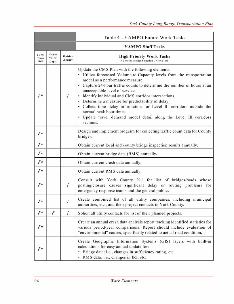
York County Long Range Transportation Plan
Work Elements94
Table 4 - YAMPO Future Work Tasks
YAMPO Staff Tasks
YCPC
Trans
Staff
Other
YCPC
Dept.
Outside
AgencyHigh Priority Work Tasks(* denotes Project Selection Criteria task)
/* /
Update the CMS Plan with the following elements:
• Utilize forecasted Volume-to-Capacity levels from the transportationmodel as a performance measure.
• Capture 24-hour traffic counts to determine the number of hours at an
unacceptable level of service.• Identify individual and CMS corridor intersections.
• Determine a measure for predictability of delay.
• Collect time delay information for Level III corridors outside thenormal peak hour times.
• Update travel demand model detail along the Level III corridors
sections.
/*Design and implement program for collecting traffic count data for Countybridges.
/* Obtain current local and county bridge inspection results annually.
/* Obtain current bridge data (BMS) annually.
/* Obtain current crash data annually.
/* Obtain current RMS data annually.
/* /
Consult with York County 911 for list of bridges/roads whose
posting/closure causes significant delay or routing problems for
emergency response teams and the general public.
/* /Create combined list of all utility companies, including municipalauthorities, etc., and their project contacts in York County.
/* / / Solicit all utility contacts for list of their planned projects.
/*
Create an annual crash data analysis report tracking identified statistics for
various period-year comparisons. Report should include evaluation of
“environmental” causes, specifically related to actual road condition.
/*
Create Geographic Information Systems (GIS) layers with built-incalculations for easy annual update for:
• Bridge data: i.e., changes in sufficiency rating, etc.
• RMS data: i.e., changes in IRI, etc.
York County Long Range Transportation Plan
YAMPO Staff Tasks
YCPC
Trans
Staff
Other
YCPC
Dept.
Outside
AgencyHigh Priority Work Tasks(* denotes Project Selection Criteria task)
Work Elements 95
/*Develop an inventory and GIS map of flow-constricting bridges that are
identified in Stormwater Management (Act 167) plans.
/* / Develop a GIS map of major road designated detour routes.
/* /
Develop an inventory and GIS map that designates significant areas of the
county, such as natural areas, environmentally sensitive areas, historicallysignificant areas, utility locations, and no-build areas such as quarries, and
cemeteries, etc. The purpose of this inventory and map is to identify “red
zone” areas or cautionary areas of the county where transportation projectsshould be avoided, if possible, and other alternatives considered. Should
no alternative be viable, the project in the “red zone” will need additional
impact assessments.
/* /
Develop an inventory and GIS map of historically significant sitesthroughout the County, including bridges, using National Historic
designations (district and sites) and municipal and regional
Comprehensive Plans.
/* /
Hold an annual meeting with regional police chiefs to exchange crashlocation information/concerns and discuss the possibility of routine
collection of non-reportable crash data by Global Positioning Systems
(GPS).
/Develop a York County Official Map Ordinance identifying projects onthe current YAMPO TIP.
/Develop a target list of priority corridors for access management ordinance
implementation.
/Develop an inventory and GIS map of bridges that could be voluntarily
closed instead of repaired and/or replaced.
/ / Develop a ten-year Capital Improvement Plan for County-owned bridges.
/Undertake a major evaluation of the York County FunctionalClassification System Map.
/Continue to promote safety-oriented projects for future updates of the
Capital Improvement Plan (CIP).
/Continue to support PennDOT in collection of HPMS sample sections and
traffic count collection annually.

York County Long Range Transportation Plan
YAMPO Staff Tasks
YCPC
Trans
Staff
Other
YCPC
Dept.
Outside
AgencyHigh Priority Work Tasks(* denotes Project Selection Criteria task)
Work Elements96
/
Develop a special annual MPO meeting with non-passenger-vehicle
partners in York County to exchange current information, projects, and
concerns in order to promote more coordinated efforts toward similargoals.
/ Formalize the annual report cards for MPO actions and projects.
/ /
Municipal outreach on topics such as long-range pavement preservation
plans for local roads, corridor access management ordinances, planning for
railroad operations, traffic impact fee ordinances, bridge maintenance, andimprovements programs, bicycle/pedestrian access plans for municipal
comprehensive plans through various outreach modes:
• topical Planning Perspectives newsletters• LTAP and other available technology transfer and educational classes
• follow-up presentations at municipal meetings
• outreach to targeted municipalities
Medium Priority Work Tasks
/ /
Coordinate a “standard” or model transportation planning andprogramming effort for municipal comprehensive planning projects with
YCPC Long Range Planning’s Municipal Consulting Program.
/ /Develop an inventory and routine inspection program for all local bridges
8-20 feet in length.
/
Accurately map and model detour routes within the ten-mile EmergencyPlanning Zone (EPZ) to identify potential bottleneck areas.
/ /Coordinate with police departments concerning problem intersections
and/or corridors for causal evaluation.
/ / /Develop a How to be the Local Lead guidebook for municipalities
involved in federally- or state-funded projects.
/Test large scale transportation alternatives employing the transportationmodel and rank these alternatives.
/Implement a schedule for continued collection of data from park and ride
areas around the County.

York County Long Range Transportation Plan
Work Elements 97
YAMPO Staff Tasks
YCPC
Trans
Staff
Other
YCPC
Dept.
Outside
Agency Medium Priority Work Tasks
/ / /
Define what a reasonable proposal for restoring rail service along the York
County Heritage Rail Trail would include (i.e., investment cost, customer
base, interaction with the existing Heritage Rail Trail County Park).
/
Evaluate current roadway “ownership” throughout York County:• lowest volume (AADT) roads for possible turn back to municipality
• roads currently owned by municipalities that are regional in nature as
possible vacations to the state
Low Priority Work Tasks
/ /Complete a study to identify the need for the unquantifiable enhancementprojects.
/ Analyze pedestrian/bicycle crash locations.
/ /Expand the County Existing & Potential Bikeway Corridors Plan to
include all non-motorized mobility options.
/ / Conduct a growth factor study to be used in traffic impact studies. (TIS)
Table 5 - YAMPO Partner Future Work Task
Other
YCPC
Dept.
Outside
Agency YAMPO Partner Tasks
/Conduct periodic analysis/evaluation of County employee parkingpolicies.
/Complete a comprehensive study of traffic signals to check if they are up
to current standards: LED lights, black plates, larger signal heads, etc.
/Develop population projections for a 30-year horizon to the municipal
level or model Transportation Analysis Zone (TAZ) level, if possible.
/Study stop sign intersections with crashes for sight distance issues for“Stop Ahead” signs.
/ Inventory sign reflectivity.
/
Identify and prioritize missing links of sidewalks/trails by working with
school districts to develop a pedestrian master plan as part of the
municipal comprehensive plan.

York County Long Range Transportation Plan
OtherYCPCDept.
OutsideAgency YAMPO Partner Tasks
Work Elements98
/Identify and prioritize missing links of sidewalks/trails within 1/4 mile ofthe f ixed route transit service with attention paid to Americans withDisabilities Act (ADA) requirements.
/Identify rail rights-of-way, along with former and potential siding sites forpreservation for future rail use.
/Develop best practices booklet for the implementation of TransportationEnhancements (TE)/Safe Routes to School (SR2S) projects within YorkCounty.
/Procure and develop educational resources, such a s newsletters andwebsites, for com munity organizations, school districts, andmunicipalities to use in teaching and to promote pedestrian activity.
/
Develop a GIS m ap showing pipeline- utility lines with red/green zonefuture expansion opportunities: green zone areas denoting e xpansionpossibilities and red zone areas denoting areas that are not acceptable forutility expansion.
/Coordinate training opportunities for police departm ents with regard touniform completion of crash reports.
/ /Coordinate with existing com mittees/groups to participate in i ncidentmanagement planning throughout the County, specifically with the Countyof York and the York County Office of Emergency Management.
/ /Coordinate with existing committees/groups to participate in Hom elandSecurity initiatives, including im plementing the Risk and VulnerabilityAssessment Team (RVAT).
/List and evaluate m easures for increased transit route efficiency: queuejumpers, bus ways, and High Occupancy Vehicle (HOV) lanes, bus pull-offs, tight corridors, etc.
/Evaluate potential ridership/demand for Express Bus Service East andWest.
/Evaluate potential ridership/demand for transit service for Country ClubRd/Rathton Rd corridor serving York College, York Hospital, Penn State,and 550 Lofts housing development.

CHAPTER IX
Additional TransportationModes and Issues

Page Intentionally Blank
Additional Transportation Modes and Issues 101
Chapter IXAdditional Transportation Modes and Issues
Tourism
Transportation plays an important role in the tourism industry. Since most people perceive placesof interest being somewhere other than where they live, some form of transportation must get them
to their destination. York County provides many tourist destinations. Proper directional signing is
a key component to addressing tourism needs. A local wayfinding program is currently beingworked on jointly by PennDOT, Lancaster and York Counties. This program will provide uniform
informational signing across the region.
Environment
The Safe, Accountable, Flexible, Efficient Transportation Act: A Legacy for Users (SAFETEA-LU)
established new requirements for the preparation of long range transportation plans. One of thesenew requirements is that plans include a discussion of potential environmental mitigation activities
associated with proposed development and potential implementation strategies for such activities.
In general terms, environmental mitigation activities are strategies, policies, programs, actions, and
activities that, over time, will serve to protect, avoid, minimize, or compensate (by replacing or
providing substitute resources) the impacts to, or disruption of, elements of the human and naturalenvironment associated with the implementation of a long range transportation plan. The human and
natural environment includes, for example, neighborhoods and communities, homes and businesses,
cultural resources, parks and recreation areas, wetlands and water sources, forested and other naturalareas, agricultural areas, endangered and threatened species, and ambient air.
Protection and Avoidance
The York County Growth Management Plan Component of the York County Comprehensive Plan
presents an overall county-wide framework for growth, and provides a mechanism for working withmunicipalities to determine the specific location, pattern and timing of future development through
the delineation of growth areas, and the identification of important agricultural and resource areas.
The following three goals are identified in the York County Growth Management Plan:
1. To protect and preserve important natural resources.
2. To direct growth and development to appropriate locations. 3. To facilitate coordinated planning at all levels of government.
Chapter VI of this Plan identifies selection criteria that aid in selecting transportation projects; helpprotect the environment; meet these three goals. One of the selection criterion used for both capacity
and rail projects is whether the project is located within the growth area identified in the York
County Growth Management Plan.

York County Long Range Transportation Plan
Additional Transportation Modes and Issues102
Another transportation project selection criterion deals with air quality benefits. Using the selectioncriterion that identify air quality beneficial transportation projects is another example of
transportation decisions that solve transportation issues and protect the environment.
The York County Comprehensive Plan has two other plan components that will influence
transportation decisions. The York County Natural Areas Inventory (NAI) and the York County
Hazard Mitigation Plan identify environmentally sensitive areas and high hazard locations whichwill be used in selecting transportation projects. In the case of new project alignments, not including
widenings or realignments the project will need to avoid the environmentally sensitive areas or high
hazard locations identified in the York County Comprehensive Plan. NAI is a document compiledand written by the Pennsylvania Science Office of The Nature Conservancy and updated by YCPC
Staff. It contains information on the locations of rare, threatened, and endangered species, and of
the highest quality natural areas in the County.
Flooding caused by transportation infrastructure, especially bridges, is another selection criterion
that will be evaluated when projects are selected. If two structurally deficient bridges are candidatesto be replaced and one effects flooding and the other does not, the selection criterion will
recommend that the bridge causing flooding problems be fixed first. Existing and future stormwater
management plans (Act 167) will be used to identify bridges that contribute to flooding issues.
Minimize
When transportation infrastructure needs to be replaced or updated in a environmentally sensitive
area, PennDOT will work with appropriate partner agencies to coordinate improvements to avoid
impacts. An example of this is the coordination that has taken place in the early stages of the I-83,Exit 18 project between the Army Corps of Engineers and PennDOT concerning the potential
impacts to Mill Creek.
Mitigation
Through design, it may be determined that an environmental resource will be impacted. At thatpoint, the proper steps should be taken to mitigate the impact. To take the first step in facilitating
the environmental mitigation process and ensure environmental review at the highest possible levels,
YAMPO staff presented proposed selection criteria and the environmental data to be used inselecting transportation projects to PennDOT’s Agency Coordinating Committee (ACM) at their
January 24, 2007, and December 3, 2008, meetings. This is the first step in discussing possible
mitigation solutions. YAMPO staff also presented the proposed scope of work to the ACM at theirJanuary 24, 2007 ACM meeting. At that meeting, a representative of the US Fish and Wildlife
Service requested to become a member of the Capacity subcommittee.
The ACM was established by PennDOT to ensure that projects throughout Pennsylvania that require
extended environmental review times are identified as early as possible in the transportation
planning process. The ACM is composed of agencies that are responsible for land use management,natural resources, environmental protection, conservation, and historic preservation throughout
Pennsylvania.

York County Long Range Transportation Plan
Additional Transportation Modes and Issues 103
The ACM meets, as needed, on a monthly basis to coordinate between PennDOT and other
transportation planning agencies in the Commonwealth and federal and state resources agencies.
ACM participants include:
• US Army Corps of Engineers
• US Environmental Protection Agency (EPA)• US Fish and Wildlife Service
• US Department of Agriculture, Natural Resources Conservation Service
• National Marine Fisheries Service• Pennsylvania Department of Environmental Protection (PADEP)
• Pennsylvania Department of Conservation and Natural Resources (PADCNR)
• Pennsylvania Fish and Boat Commission • Pennsylvania Game Commission
• Pennsylvania Department of Agriculture
• Pennsylvania Historical and Museum Commission• Pennsylvania Department of Community and Economic Development (PADCED)
In addition to coordination, there are hard steps that can be taken to mitigate future impacts toenvironmental resources. Wetland banking (Establishment of wetlands to be used as credits when
disturbing other wetlands) is something that the YAMPO contributed to in years past and will
continue to purchase appropriate wetland banks prior to impacting wetlands in the future. Using thatspecific past experience, consideration should be given to other land banks for impacts to state game
lands, county, and municipal parks, enlarging or linking existing endangered species habitat, and
working with preservation societies or others to find a new location for historic bridges and otherstructures that will be impacted by transportation projects.
Greenhouse Gas Emissions and Climate Change
Since the earliest days of ozone and particulate matter designation areas, YAMPO has fully
complied with the requirements of transportation conformity of the Clean Air Act, working toward
meeting the National Ambient Air Quality Standards (NAAQS), and tracking precursor pollutants,also known as Mobile Source Air Toxins (MSATS). As mentioned in Chapters IV, V, and VII, air
quality is an overall concern for all of our transportation projects. The most current air quality
information for York County can be found in the State of the Air report published by the AmericanLung Association. The PADEP’s website (www.dep.state.pa.us) also serves as a data source.
Recently, the issue of greenhouse gas emission levels and its impacts, specifically related to climatechange, has generated a great deal of planning attention. Across the nation, both the federal
government and various states have been measuring these emissions, gaging impacts such as rising
temperatures and sea levels, running predictor scenarios, and formulating both preventative andadaptation policies.
York County Long Range Transportation Plan
Additional Transportation Modes and Issues104
Certainly, we would be remiss not to include any information about greenhouse gases and climatechange, and their effect of these things on York County. However, currently there is very little
pertinent information available to us. At this time, York County does not have a detailed, targeted
plan for lowering greenhouse gas emissions; however, several initiatives, including no-idlingpolicies and supporting commuter services as mentioned in Chapter III, are ongoing.
Most of our neighboring states, those with many miles of coastline concerns, have climate changeinitiatives already in place. The Federal government is continuing its work on the “Cap and Trade”
legislation to control and limit greenhouse gas emission levels.
In 2008, PADEP formed the Climate Change Advisory Council that includes a Land Use and
Transportation Subcommittee. This group is currently writing a series of work plans to lower
Pennsylvania’s greenhouse gas emissions that, after approval, will be submitted to the PennsylvaniaLegislature for action. Both the PADEP (www.dep.state.pa.us) and Environment Protection Agency
(http://www.epa.gov/) websites provide a great deal of information on greenhouse gas emissions,
climate change, and impacts.
Coordinated Public Transit/Human Service Transportation Plan
The SAFETEA-LU, signed into law on August 10, 2005, requires that a coordinated plan for transitbe developed for each region. A coordinated public transit/human service transportation plan
identifies the transportation needs of individuals with disabilities, older adults and people with low
income; and provides strategies for meeting those local needs; and prioritize transportation servicesfor funding and implementation.
A diverse group of stakeholders were invited to assist with the following:
• Conduct an assessment of available services (public, private, and nonprofit).
• Identify transportation needs for individuals with disabilities, older adults, and people withlow income.
• Develop strategies and/or activities to address the identified gaps and achieve efficiencies,
where possible, in service delivery. • Identify priorities for implementing the strategies/activities based on resources, time, and
feasibility for implementation.
The group of stakeholders will serve as a steering committee, on behalf of the YAMPO to
specifically deal with issues related to transit and human services transportation coordination. The
committee will meet on an as-needed basis to identify needs; develop strategy; and assist withprogram implementation.
Strategies and activities derived from the YAMPO Coordinated Public Transit/Human ServiceTransportation Plan may afford the opportunity to be funded through the Section 5310, Job Access
and Reverse Commute (JARC) and New Freedom programs.
York County Long Range Transportation Plan
Additional Transportation Modes and Issues 105
Pipeline Transportation/Transmission Operations
Known as the “hidden giant” of America’s transportation system, pipelines are the irreplaceablecores of United States petroleum transportation and the key to meeting domestic petroleum demand.
Approximately 2.4 million miles of pipeline traverse the United States, supplying 65% of the
nation’s energy. Oil and its petroleum derivatives (i.e., classified as hazardous liquid transportation)pipelines transport two-thirds of the petroleum shipped in the United States. Natural gas (does not
include liquified natural gas [LNG]) pipelines transmit nearly all natural gas products from the
source to the consumer. Given the skyrocketing cost and geographic limitations of transporting suchproducts via highways, railways, and waterways, pipeline transportation may be the most
economical way to move these products from its sources to markets across the country.
Both liquid petroleum (a.k.a., hazardous liquid) and natural gas pipelines travel through York
County. The liquid petroleum pipelines are in the northern and central areas of the county. They
carry refined petroleum products from either the Midwest or the Southwest to the Mid-Atlantic andNew England regions of the country. The natural gas lines here traverse the northwestern, central,
southwestern and southeastern areas of the county. The origin and destination of transmitting this
product are somewhat similar to the petroleum lines.
Three petroleum companies own and operate liquid petroleum pipelines in York County, as follows:
• Buckeye Partners, LP (Laurel Pipeline Company) - Based out of Ohio, Buckeye Partners
operates an interstate pipeline that traverses northern Fairview Township, just south of the PA
Turnpike (I-76). The name of the pipeline changes from Buckeye to the Laurel PipelineCompany when it enters York County. This company is a subsidiary of Buckeye Partners.
Petroleum products, such as diesel fuel, gasoline, and fuel oil are typically transported through
this conduit. No product dispensing terminals or junctions are located along the length of the linein York County. Such stations, however, are found at various locations within both Cumberland
and Dauphin Counties.
• Sunoco Pipeline, LP - This product line is a segment of the Company’s “Eastern Pipeline
System.” Two pipelines are found in the County. One line traverse northern Fairview Township,
south of the PA Turnpike (I-76), and the other parallels U. S. Route 30 from AbbottstownBorough, Adams County, to the Susquehanna River. These lines transport refined petroleum
products, such as gasoline, fuel oil, and kerosene, from its refinery in Toledo, Ohio, to markets
in the Northeast. According to the information received about this operation, no junctions orproduct dispensing terminals are located along the length of this line in York County.
• Texas Eastern Products Pipeline Company (TEPPCO) - TEPPCO owns and operates thispipeline. The pipeline traverses northern Fairview Township roughly paralleling the PA
Turnpike (I-76). It transports refined petroleum products, such as butane and propane, from its
refinery in Baytown, Texas. Again, from the information received about this line, no junctionsand dispensing terminals appear to be located along this segment in York County.
York County Long Range Transportation Plan
Additional Transportation Modes and Issues106
Four companies own and operate natural gas pipelines in York County, as follows:
• Texas Eastern Transmission, LP (TETCO)/Spectra Energy - Newly acquired by the Spectra
Corporation, this gas transmission trunk line traverses the north-central area of York Countyfrom Washington Township to the Susquehanna River. No feeder branches are located along the
length of the line in York County. However, this conduit does connect with a TETCO/UGI
pipeline junction/compressor station directly across the Susquehanna River in Marietta,Lancaster County. TETCO is also proposing and currently developing a new line from the
station in Marietta to Peach Bottom Township, York County. TETCO not only transports its own
product, but it also transports products for other natural gas suppliers, such as the Columbia GasCompany, through a cooperative service agreement.
• Columbia Gas Transmission Corporation - Owned by the Columbia Gas Company of Ohio,these interstate natural gas trunk lines traverse the Dillsburg, Greater York, Hanover, and
Shrewsbury areas of the County. These lines provide interstate transport of natural gas to
markets in the northeast. Moreover, natural gas from these lines is also redirected from theselines to the local consumer through an intricate network of distribution and service lines.
• The Williams Company, Incorporated (TRANSCO) - Owned by TRANSCO, a subsidiaryof the Williams Companies, Incorporated, this pipeline traverses Peach Bottom and Lower
Chanceford Township before traveling northeast across the Susquehanna River to Lancaster
County. This line functions as a trunk line conduit for the transmission of the product from theTexas Gulf Coast to destinations in the Northeast. It is not distributed via feeder system to
consumers locally. One compressor station, Station 195, is found within Peach Bottom
Township.
• Columbia Gas of Pennsylvania - Again, owned by the Columbia Gas Company of Ohio, this
company operates distribution and service pipelines through York County. The service linestransmit natural gas directly to the local consumer.
No direct federal subsidies are available for the construction and maintenance of pipeline facilities.However, the federal government has granted pipeline companies the power of eminent domain to
acquire right-of-way for alignment or realignment of these conveyances. Despite funding
availability, federal and state oversight of the construction and operation of thesetransportation/transmission conduits is mandated. The following agencies oversee the construction,
operation and safety of both hazardous liquid, and natural gas pipelines:
• U. S. Department of Transportation, Office of Pipeline Safety (OPS)/Pipeline and Hazardous
Materials Safety Administration (PHMSA) - The OPS is the federal safety authority ensuring
the safe, reliable, and environmentally-sound operation of the Nation’s pipeline transportationsystem. PHMSA, acting through OPS, administers the department’s national regulatory program
to assure the safe transportation of natural gas, petroleum, and other hazardous materials by
pipeline. OPS develops regulations and other approaches to risk management to assure safetyin design, construction, testing, operation, maintenance, and emergency response of pipeline

York County Long Range Transportation Plan
Additional Transportation Modes and Issues 107
facilities. The entire program is funded through a user fee assessed on a per-mile basis on eachpipeline operator OPS regulates. Specifically, these agencies oversee the following:
- Construction and operation of all interstate hazardous liquid pipeline facilities (e.g., oil andgasoline).
- Abandonment of existing hazardous liquid facilities.
- Administration of safety standards for all hazardous liquid and natural gas pipelines.
• Federal Energy Regulatory Commission (FERC) - Charged by Congress, FERC functions as an
independent agency that regulates the interstate transmission of natural gas, oil, and electricity.FERC also regulates natural gas and hydroelectric power projects. Specifically, the Commission
oversees the following:
- Planning and construction of new interstate natural gas facilities (e.g., pipelines and
compressor stations).
- Abandonment of existing natural gas facilities.- Regulation of rates and practices of natural gas and hazardous liquid petroleum companies
engaged in interstate transportation of such substances.
• Pennsylvania Public Utility Commission - The PAPUC handles the Commonwealth’s oversight
of natural gas pipeline operations, as they are classified as utilities. Specifically, the
Commission’s Gas Division oversees the construction and operation of local natural gasdistribution and service pipelines, such as the ones operated by Columbia Gas of PA.
• Pennsylvania Department of Transportation (PennDOT) - PennDOT plays a very small role inthe oversight of pipeline transportation/transmission. However, it does become involved in the
construction or relocation of these conduits, especially when they are to cross/travel underneath
state roads. This function is overseen by the Utility Services Division (Utility Relocation Unit)of PennDOT (Central Office) and the Utility Administrator for each PennDOT Engineering
District.
• Other federal agencies overseeing these operations:
- Occupational and Safety Hazard Administration (OSHA)- Environmental Protection Agency (EPA)
- Interstate Commerce Commission (ICC)
- Transportation Security Agency of the U. S Department of Homeland Security

Page Intentionally Blank

CHAPTER X
Capital Improvements

Page Intentionally Blank

Capital Improvements 111
Chapter XCapital Improvements
To be consistent with SAFTEA-LU this Plan needs to address a minimum of a 20-year planninghorizon. Throughout the subcommittee work detailed in Chapter IV and the rest of the document,
the planning horizon was 2009-2035: a total of 27 years. This will ensure consistency until the next
update of the long range transportation plan in 2013, which will still have a 22-year horizon.
Due to the dynamic nature of funding and project delivery, the YAMPO has adopted a new approach
and a separate document, entitled YAMPO Capital Improvements Plan (CIP), that identifies thecapital investments planned for the county and will serve as the CIP for the 2009-2035 Long Range
Transportation Plan. This will meet the 20-year time horizon required by federal law, but allows for
more timely updates of the document outside the normal updates of this Plan. The first four yearsof the CIP are identified in the Transportation Improvement Program (TIP), which is routinely
modified based on cost savings or increases in construction bids, project delays, and
increases/decreases in projected funding or policy decisions. Any major changes identified as addinga new project or a cost increase more than $2 million, require YAMPO approval.
The next 27 years are identified in the CIP in the time frames, as shown in the following table.Within each time frame, a cost requirement will be placed on which projects to be shown in order
to maintain fiscal constraint when completing large construction projects.
Table 6 - Time Frames of CIP
Type of
Document
LONG RANGE TRANSPORTATION PLAN
12-YEAR PROGRAMTIP
Size of
Project
(Cost)
ALL PROJECTSPROJECTS OVER $5
MILLION TOTAL
PROJECTS OVER $10
MILLION TOTAL
Federal
Fiscal Year2009 2010 2011 2012 2013- 2014 2015- 2016 2017- 2020 2021-2027 2028-2035
The majority of the projected funding for the next 27 years identified in the CIP remains in a general
line item, rather than being allocated to a specific project. Based on the decisions made in ChapterV, the CIP places funding into project areas (i.e. safety, maintenance, transit, etc.). The selection
criteria identified in Chapter VI will be used to select projects from those specific areas in the first
six years of the CIP.

York County Long Range Transportation Plan
Capital Improvements112
Some basic elements of the CIP are provided below:
- The CIP will be modified and amended at the same time a TIP amendment is approved at a
YAMPO meeting. - Cost estimates are factored by the year of expenditure or inflation is calculated to the year the
funds are anticipated to be expended.
- A list of unprogrammed candidate projects are listed.- The projected funding is obtained from Chapter V.
- Regionally significant projects are identified and will be modeled for air quality conformity if
the project scope is modified.
Another element of long range transportation planning required by federal law is air quality
conformity analysis. Due to the approach the YAMPO is taking with the CIP, the Air QualityConformity Analysis Report for the YAMPO will be a stand-alone document as well. Please refer
to the most recent version of the YAMPO Air Quality Conformity Report for conformity
determination for this Plan.