Yokosuka/Urashima “Cruise Report” YK12-16 · One of two was attached as down-looking setting...
33
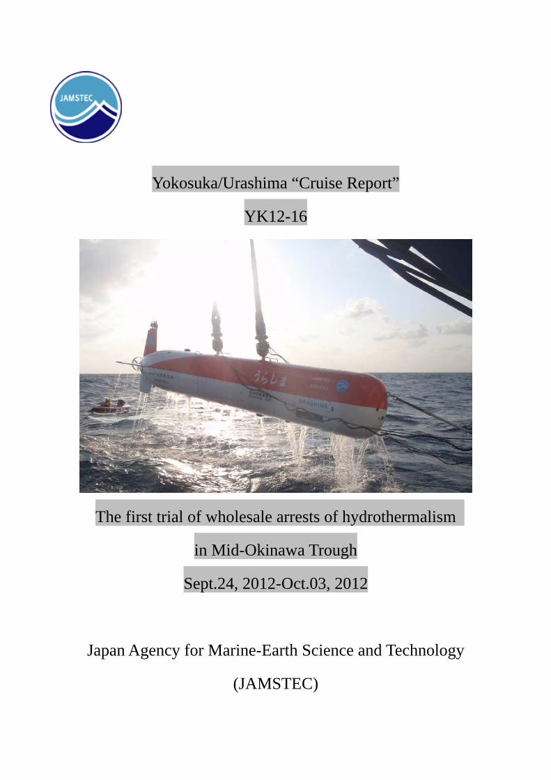
Yokosuka/Urashima “Cruise Report” YK12-16 The first trial of wholesale arrests of hydrothermalism in Mid-Okinawa Trough Sept.24, 2012-Oct.03, 2012 Japan Agency for Marine-Earth Science and Technology (JAMSTEC)
Transcript of Yokosuka/Urashima “Cruise Report” YK12-16 · One of two was attached as down-looking setting...
Yokosuka/Urashima “Cruise Report”
YK12-16
The first trial of wholesale arrests of hydrothermalism
in Mid-Okinawa Trough
Sept.24, 2012-Oct.03, 2012
Japan Agency for Marine-Earth Science and Technology
(JAMSTEC)
● Contents ● 1. Cruise information 2. Scientific party 3. Introduction
3.1 Objectives 3.2 Backgrounds
4. Operations 4.1 Methods and equipments
4.2 Dive information 4.3 Seabeam survey
4.4 SCS seismic 5. Future Plan and Data QC, etc.
6. References cited 7. Notice on using 8. Acknowledgements Appendices
A-1: List of Participants
A-2: Ship Log
A-3: General description of AUV Urashima
A-4: General Information of SCS survey
A-5: Payload assemblages in Urashima dives
A-6: Survey Plans
A-7: survey tracks on their plan
Notice on Using This Report
This cruise report is a preliminary documentation as of the end of the cruise.
This report may not be corrected even if changes on contents may be found after its publication.
This report may also be changed without notice. Data on this cruise report may be raw or
unprocessed. If you are going to use or refer to the data written on this report, please contact the
Chief Scientist (H. Kumagai) for latest information.
Users of data or results on this cruise report are requested to submit their results to the Data
Management Group of JAMSTEC.
- 1 -
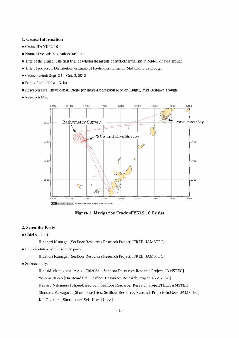
1. Cruise Information ● Cruise ID: YK12-16
● Name of vessel: Yokosuka/Urashima
● Title of the cruise: The first trial of wholesale arrests of hydrothermalism in Mid-Okinawa Trough
● Title of proposal: Distribution estimate of Hydrothermalism in Mid-Okinawa Trough
● Cruise period: Sept. 24 – Oct. 3, 2012
● Ports of call: Naha - Naha
● Research area: Iheya-Small Ridge (or Iheya-Depression Median Ridge), Mid Okinawa Trough
● Research Map
Figure 1: Navigation Track of YK12-16 Cruise
2. Scientific Party ● Chief scientist:
Hidenori Kumagai [Seafloor Resources Research Project/ IFREE, JAMSTEC]
● Representative of the science party:
Hidenori Kumagai [Seafloor Resources Research Project/ IFREE, JAMSTEC]
● Science party:
Hideaki Machiyama [Assoc. Chief Sci., Seafloor Resources Research Project, JAMSTEC]
Yoshiro Nishio [On-Board Sci., Seafloor Resources Research Project, JAMSTEC]
Kentaro Nakamura [Shore-based Sci., Seafloor Resources Research Project/PEL, JAMSTEC]
Shinsuke Kawagucci [Shore-based Sci., Seafloor Resources Research Project/BioGeos, JAMSTEC]
Kei Okamura [Shore-based Sci., Kochi Univ.]
Satsukawa-Bay Bathymetry Survey
SCS and Dive Survey

- 2 -
Takafumi Kasaya [Shore-based Sci., Seafloor Resources Research Project/ IFREE, JAMSTEC]
Takeshi Tsuji [Shore-based Sci., Seafloor Resources Research Project, JAMSTEC/ Univ. Kyushu]
Miho Asada [Shore-based Sci., Seafloor Resources Research Project/IFREE, JAMSTEC]
Yuka Masaki [Shore-based Sci., Seafloor Resources Research Project/IFREE, JAMSTEC]
Further details are in Appendix A-1.
3. Introduction 3.1. Objectives
In order to start some quantitative evaluation for seafloor resources (metal/metal sulfide), current status of the
seafloor resource research is quite insufficient. To overwhelm this situation, less-biased systematic recognition of the
seafloor hydrothermalism is required. As the first step, a total capture of hydrothermal activity in particular area is needed.
However, traditional method of discovery to any hydrothermal activities seems not to be suitable for this demand. Thus,
we planned a methodological trial using couples of remote-sensing sensors without water sampling.
3.2 Backgrounds
Mid Okinawa Trough is the first discovery area of hydrothermalism in Western Pacific in mid-80s (Kimura et
al., 1987). After the discovery, extensive dive or deep-tow survey were carried out in late 80s and early 90s to locate
hydrothermalism. The hydrothermal sites found by those explorations are relatively shallow, shallower than 2000m W.D.,
Shinkai2000 was mainly used even though Shinkai6500 be in service. After the retirement of shinkai2000, rather limited
dive surveys were carried out besides the two vicinity areas (Izena cauldron and Iheya-North knoll). Recent rapid
growing interests in sea floor resources, hydrothremalism in Mid Okinawa Trough attracts much more interests as
potential sites for metal sulfide resources in public. In this context, Iheya-North Knoll and Izena-Hole have been much
extensively studied these a few years. In contrast, the earliest known hydrothermal sites on Iheya-small Ridge have not
studied intensively to date. It may relate to the rather low temperature activity compared to the above described two sites.
However, in terms of the amounts of resources, active vent areas may be young, which seems to be disadvantage to
obtain precipitated sulfides. On the other hand, an old and inactive vent areas may face to its termination due to the
self-sealing of their fluid path, which may result in the rather large piles of deposits.
Thus, in this cruise, a total capture of hydrothermal activity in the study area was planned because some large-size
hydrothermal sulfide deposits have been anticipated in Mid-Okinawa Trough. As the first step, mapping of acoustic
scattering in water column coupled with chemical and physical sensing was carried out at Iheya-small ridge (or
Iheya-Depression Median Ridge) by using AUV Urashima. Further, Single channel seismic survey (SCS survey) was
also conducted in order to investigate shallow sedimental/crustal structure being fluid/water path for hydrothermal
activities.
In the studied area, there is a well known hydrothermal field, the CLAM site, 27.55°N, 126.97°E The area was
extensively studied on their fluid chemistry, geological nature and biota in late 1980s to early 1990s (cf. Tanaka et
al.,1989; Gamo et al., 1991). Its recent activity was observed at Dive#1183 of HyperDolphin in NT10-17 cruise
(Observer: K. Fujikura).

- 3 -
4. Operation This expedition was planned as a 10-days cruise including seven Urashima dives and 1-day SCS survey; the
original proposal consisted of 15 Urasima-dives and a 2-day SCS. The cruise commenced from Naha-port on 24th
September, 2012 and headed to the survey area. The first dive in this cruise was done on 25th September (Dive #149). On
the evening of 25th September, an extreme typhoon 1217 approached to the survey area, then, SCS survey was carried
out besides the AUV dive survey. During the SCS survey, fifth track of seven planned ones, the survey ceased and the
vessel started escape from the typhoon. The evacuation lasted four days at/around Koniya-Bay near Amami-O shima. The
vessel returned the survey area on the evening of 1st October to start the regional bathymetric survey. On 2nd October,
the second Urashima-AUV dive was carried out in the vicinity of the previous dive. The expedition was ended on 3rd
October at Naha port (Figure 1). Detailed cruise (ship) log are in Appendix A-2.
4.1 Methods and equipments
In this cruise, a detailed seafloor survey using AUV Urashima and a SCS sub seafloor structural survey were
conducted.
Although the standard method to locate some hydrothermal activities are a series of CTD-casts and following
ROV/HOV survey to confirm the active vents, such method is time and manpower consuming. Thus, in this survey, an
acoustic-base method coupling w/ chemical and (geo-) physical sensors were applied (Kumagai et al., 2010). Basic
properties of AUV-Urahsima are in appendix A-3.
Figure 2: SCS survey tracks proposed (solid purple lines). Red box is the proposed survey area.
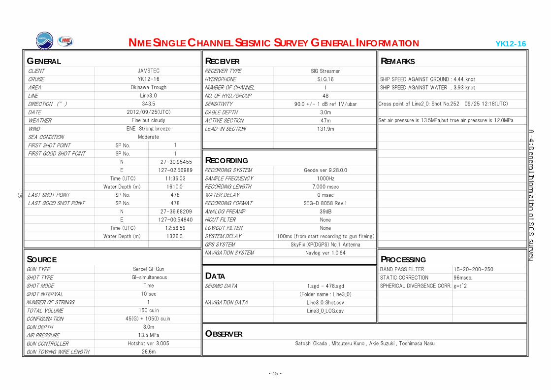
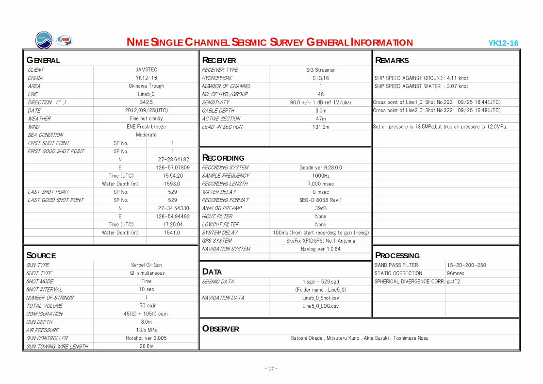
In order to obtain shallow sub seafloor structure, SCS survey was planned on the five across ridge lines and
two along ridge lines (Figure 2). Detailed assemblages of the SCS survey are in appendix A-4.
For the AUV survey, besides the standard acoustic apparatus on Urashima (i.e. SeaBat7125 MBES,
Edgetech2000M Side Scan Sonar/Sub Bottom Profiler), following equipments were applied as the payloads: three
components fluxgate magnetometer, turbidity meters and Oxidation-Reduction Potential sensor (ORP sensor).
Assemblage of sensors in each dive is in Appendix A-5. Instrumental details of equipments are as follows.
- 4 -
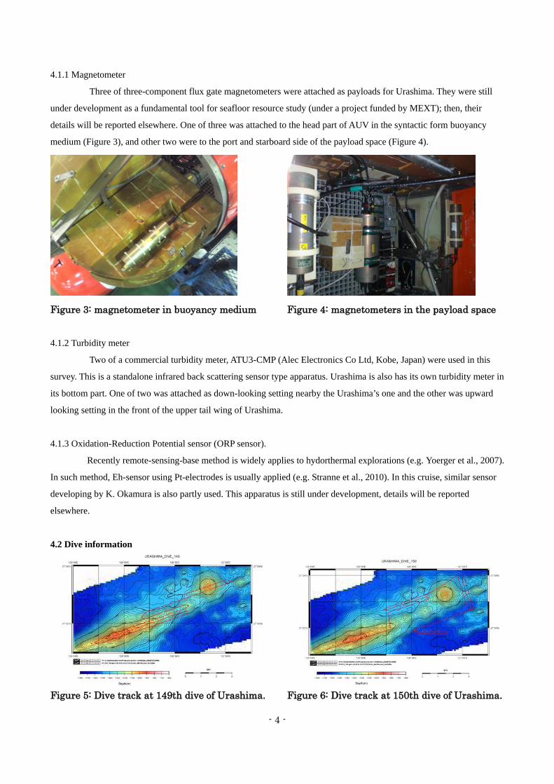
4.1.1 Magnetometer
Three of three-component flux gate magnetometers were attached as payloads for Urashima. They were still
under development as a fundamental tool for seafloor resource study (under a project funded by MEXT); then, their
details will be reported elsewhere. One of three was attached to the head part of AUV in the syntactic form buoyancy
medium (Figure 3), and other two were to the port and starboard side of the payload space (Figure 4).
Figure 3: magnetometer in buoyancy medium
Figure 4: magnetometers in the payload space
4.1.2 Turbidity meter
Two of a commercial turbidity meter, ATU3-CMP (Alec Electronics Co Ltd, Kobe, Japan) were used in this
survey. This is a standalone infrared back scattering sensor type apparatus. Urashima is also has its own turbidity meter in
its bottom part. One of two was attached as down-looking setting nearby the Urashima’s one and the other was upward
looking setting in the front of the upper tail wing of Urashima.
4.1.3 Oxidation-Reduction Potential sensor (ORP sensor).
Recently remote-sensing-base method is widely applies to hydorthermal explorations (e.g. Yoerger et al., 2007).
In such method, Eh-sensor using Pt-electrodes is usually applied (e.g. Stranne et al., 2010). In this cruise, similar sensor
developing by K. Okamura is also partly used. This apparatus is still under development, details will be reported
elsewhere.
4.2 Dive information
Figure 5: Dive track at 149th dive of Urashima.
Figure 6: Dive track at 150th dive of Urashima.
- 5 -
Two dives were carried out in this cruise; Dive#149 and #150. Details are as follows.
4.2.1 Dive # 149
Date: Sept. 25, 2012
Location: Natsushima 86-2 Knoll, Iheya-small Ridge;
Start of survey: 08:40 (JST), 27°31.382’N, 126°54.829’E, WD= 1054m
End of survey: 16:17(JST), 27°32.955’N, 126°58.154’E, WD= 1395m
Natsushima 86-2 Knoll is 2 miles southwestward from the well known hydrothermal area, “CLAM
(Calyptogena) site.” The Natsushima 86-2 Knoll is a linear-shaped one, which trends ENE-WSW and of which top
water depth is approx. 950m on gridded seabeam map (Figure 5). Only one dive survey has been carried out by J.
Naka as the 233th dive of Shinkai2000. Although some pillow lava fragments were obtained by dredging, none of
such outcrops were observed. Instead, basaltic breccias and scoria were widely covered on the hillcrest (Kimura et
al., 1987).
Survey Plan:
The survey starts from the southern frank of Natsushima 86-2 Knoll, where estimated water depth is 1160m.
AUV keeps its altitude 80-100m from the seafloor and heads towards 72°N. At the saddle point between the small
associated hills, AUV will transfer into the northern next survey lines with 0.1 mile interval. Following the parallel seven
survey lines with three miles in each length, AUV proceeds to the 1.9 mile extension of the survey line ENE-ward which
covers on a conical cone with base diameter is approx. 1 mile and with altitude 400m (Appendix A-6). On the western
flank of the cone, the well known CLAM site develops. These initially proposed survey tracks exceed 32 miles in total
that is equivalent to roughly 2days survey of Urashima; typical survey length of Urashima is approx. 30km in
length/dive.
Acoustic sensing with geophysical and chemical sensors was planned in the whole sections of survey lines.
Neither water sampling nor visual imagery is included.
Observation:
Due to the severe weather forecast, some survey lines were forced to be skipped. Thus, AUV got into the
second survey line originally planned, which made a shift of 0.1knautical mile northward as the commencement. In
addition, as a result of follow a contingency plan in case for no more dive survey is available, the northwestern quadrant,
western part of 5th-7th of lines of the survey plan of Natsushima 86-2 Knoll was skipped and AUV proceeded into the
northeastern extension area of the survey tracks. Here, the well-known CLAM-site is just north of the end of track
(Figure 5; Appendix A-7).
Numerous acoustic anomalies were widely recorded within the water column part of the Side Scan Sonar
thorough the dive track. There is very limited number of the filamentous-shape echo only on the western part of the
second line, however, dense foggy scattering were much widely observed compared to the Iheya-North Knoll
hydrothermal site (Kumagai et al., 2010). Even well known CLAM site is outside the survey area, temperature and
red-ox anomalies were clearly recognized accompanied with acoustic anomalies on eastern part of the survey tracks.
Because some spider-net-like material adhered on the vertical fin and turbidity meter was found at the retrieval of AUV
(see Figure 7), no clear anomaly on the turbidity record was recognized; it may cause the sudden increase of the

- 6 -
measured value of #3 turbidity meter recorded at 11:01 (JST).
Figure 7: spider-net-like material adhered on the window of left-handed turbidity meter
4.2.2 Dive # 150:
Date: Oct. 2, 2012
Location: Natsushima 86-2 Knoll and 126°59.3’E Knoll, Iheya-small Ridge;
Start of survey: 08:52 (JST), 27°31.382’N, 126°54.829’E, WD= 1054m
End of survey: 16:18(JST), 27°32.955’N, 126°58.154’E, WD= 1580m
As well as the previous dive, this dive also dedicated to locate hydrothermal activity in the studied area. Due to
the very limited opportunity of the AUV dive in this expedition, we made AUV fly on the potential points where
hydrothermal activity anticipated as many as possible (Appendix A-6).
Natsushima 86-2 Knoll is 2 miles southwestward from the well known hydrothermal area, “CLAM
(Calyptogena) site.” The Natsushima 86-2 Knoll is a linear-shaped one, which trends ENE-WSW and of which top
water depth is approx. 950m on gridded seabeam map (Figure 5). Only one dive survey has been carried out by J.
Naka as the 233th dive of Shinkai2000. Although some pillow lava fragments were obtained by dredging, none of
such outcrops were observed. Instead, basaltic breccias and scoria were widely covered on the hillcrest (Kimura et
al., 1987).
Survey Plan:
The survey also starts from the southern frank of Natsushima 86-2 Knoll; the first line of this dive is 0.1
nautical miles southward from the southernmost survey line of the previous dive (on the southernmost line originally
planned in the previous dive, dive #149), where estimated water depth is 1160m. AUV also keeps its altitude 80-100m
from the seafloor and heads towards 72°N to confirm some acoustic anomalies found in the starboard side at the previous
dive. At the saddle point between the small associated hills, AUV will transfer into the northern survey lines. Those next
three survey lines have 0.1 mile interval each other that fully cover above the area of CLAM site. The AUV flies on the
northern frank of the conical cone, then, covers on the eastern saddle point between the small associating knoll by similar
three NNW-SSE trending tracks 1.2 miles in length having 0.1 miles in intervals. These initially proposed survey tracks
was as long as 15 miles in total that is equivalent to roughly 5 hours survey of Urashima; thus the finishing these
proposed track, AUV head to the some waypoints to be investigated in the southern flank and deep of the eastern cone,

- 7 -
126°59.3’ Knoll (Figure 6).
Acoustic sensing with geophysical sensors was in the whole sections of survey lines (ORP sensor was not
available). No water sampling or visual imagery were planned.
Observation:
Numerous acoustic anomalies, typically foggy ones, were also widely recorded within the water column part
of the Side Scan Sonar thorough the dive track as well as the previous dive (Dive #149). It was also partly associated
with the temperature and/or turbidity anomalies. After the finishing the planned lines beforehand, one more line was set
to fly on the two small cones found in the southern depression of the 126°59.3’ Knoll; one of which a rather high crustal
heatflow was recorded (Kinoshita et al., 1995).
4.3 Seabeam survey
To conduct the AUV dive operation, a set of MNBES survey using SeaBeam 2112 of R/V Yokosuka was
carried out although MNBES bathymetry has been obtained in KR01-09 Cruise (Chief. Sci. K. Takai). The original plan
of the regional seabeam survey focuses on the continental slope, however, the severe T1217 forces R/V Yokosuka to
evacuate in Satsukawa Bay of Amami-Oshima. Instead, the scientific party decided to fill the blank of seabeam
bathymetry near the dive survey area (see Figure 8
as the modified plan of survey lines). The eastern
boundary of the survey line was determined to
overlap significantly (up to 5 minutes in longitude)
to the data area of KR01-09.
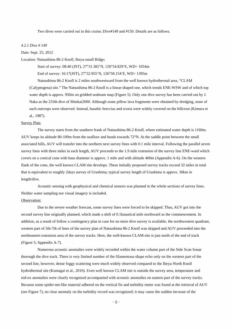
Figure 8: Modified lines for bathymetric survey shown as a couple of solid lines. Contours are on the gridded data both from satellite gravimetry and from KR01-09 bathymetry. 4.4 SCS seismic
Across ridge SCS seismic survey was carried out in this cruise (Figure 9). In all five tracks, well recognized
reflection from the seafloor was clearly recorded except for the part of ridge flanks and top under ridge-perpendicular
geometry. In the basin area with flat topography, some clear reflections were also recognized within the thick sediments
associated with frequent normal-fault-like sharp displacements. Further descriptions and investigations will be carried out
later.
- 8 -
Figure 9: SCS tracks surveyed drawn on the newly obtained bathymetry in the cruise.
5. Future Plan and Data QC, etc.
QC of magnetometer will be carried on land by shore-based scientific team led by T. Kasaya. The result will
also be submitted by T. Kasaya. QC of ORP sensor data will be done w/ technical development by K. Okamura. After the
standard post processing of Urashima MNBES and SSS/SBP, these acoustic data will be investigated by M. Asada and
her collaborators. SCS seismic data will be investigated by T. Tsuji for tectonic interpretations. Final compilation
including turbidity data will be done by H. Kumagai. Brief summary will be submitted to G-cubed by H. Kumagai.
Position of potential hydrothermal activity is used for future pin-point dive survey to evaluate the total mass of the
hydrothermal deposits by SRRP, JAMSTEC; K. Nakamura and S. Kawagucci may lead further surveys.
6. References cited
T. Gamo et al. (2001) Chemical charactersitics of newly discovered black-smoker fluids and associated hydrothermal
plumes at the Rodriguez Triple Junction, Central Indian Ridge, Earth Planet. Sci. Lett., 193, 371-379.
T. Gamo, H. Sakai, J. Ishibashi, T. Oomori, H. Chiba, K. Shitashima, K. Nakashima, Y. Tanaka and H. Masuda (1991)
Growth mechanism of the hydrothermal mounds at the CLAM site, mid Okinawa Trough, inferred from their
morphological, mineralogical and chemical characteristics. JAMSTEC Deepsea Res., 7, 163-184.
Kimura, M., Kato, Y. et al. (1987) Submersible Shinkai2000 Study on the central rift in the middle Okinawa Trough,
- 9 -
JAMSTEC Deepsea Res., 3, 165-196.
Kinoshita, M. (1995) Localized heat flow anomalies in the middle Okinawa Trough associated with hydrothermal
circulation, In "Biogeochemical Processes and Ocean Flux in the Western Pacific" (Eds. H. Sakai and Y Nozaki),
pp. 537-559, by Terra Scientific Publishing Company (TERRAPUB), Tokyo, 1995.
Kumagai, H. Tsukioka, S. et al. (2010) Data Brief: Hydrothermal plumes imaged by high-resolution side-scan sonar on a
cruising AUV, Geophys. Geochem. Geosyst., 10(12), paper # Q12013, doi: 10.1029/2010GC003337.
Stranne, C., R. A. Sohn, B. Liljebladh and K.-i. Nakamura (2010) Analysis and modeling of hydrothermal plume data
acquired from the 85°E segment of the Gakkel Ridge, J. Geophys. Res., 115, C06028,
doi:10.1029/2009JC005776 .
Tanaka T., K. Mitsuzawa and H. Hotta (1989) "SHINKAI 2000" Diving Surveys in the East of Iheya Small Ridge in the
Central Okinawa Trough, JAMSTEC Deepsea Res., 5, 267-282 (in Japanese w/ English abstr.).
Yoerger, D.R., A.M. Bradley, M. Jakuba, C.R. German, T. Shank, and M. Tivey (2007) Autonomous and Remotely
Operated Vehicle Technology for Hydrothermal Vent Discovery, Exploration, and SamplingOceanography, 20(1),
152–161, http://dx.doi.org/10.5670/oceanog.2007.89.
7. Notice on Using This cruise report is a preliminary documentation as of the end of the cruise. This report may not be corrected
even if changes on contents may be found after its publication. This report may also be changed without notice. Data on
this cruise report may be raw or unprocessed. If you are going to use or refer to the data written on this report, please
contact the Chief Scientist (H. Kumagai) for latest information. Users of data or results on this cruise report are requested
to submit their results to the Data Management Group of JAMSTEC.
8. Acknowledgements
Here we express our sincere appreciation for the excellent support and assistance by Captain Ukekura and his
crew, and the Operation Manager of Urashima, Kazuhiro Chiba, and his AUV team throughout the cruise. We also thank
the JAMSTEC Cruise Management Division, Seafloor Resources Research Project and all shore-based colleagues on
their supports.
- 10 -
Appendix A-1: List of participants 1.Research group Hidenori Kumagai Japan Agency for Marine-Earth Science and Technology Hideaki Machiyama Japan Agency for Marine-Earth Science and Technology Yoshiro Nishio Japan Agency for Marine-Earth Science and Technology Satoshi Okada Nippon Marine Enterprise Mitsuteru Kuno Nippon Marine Enterprise Satomi Minamizawa Nippon Marine Enterprise Akie Suzuki Nippon Marine Enterprise Toshimasa Nasu Nippon Marine Enterprise
2.Operation team of the AUV URASHIMA Operation Manager Kazuhiro Chiba 1stSubmersible staff Shinobu Omika 1stSubmersible staff Keita Matsumoto 2nd Submersible staff Akihisa Ishikawa 2nd Submersible staff Takuma Onishi 2nd Submersible staff Masaya Katagiri
3.Captain and crew of the R/V YOKOSUKA Captain Eiko Ukekura Chief Officer Yasuhiko Sammori 2nd Officer Shozo Fujii 3rd Officer Motoi Katsumata Chief Engineer Eiji Sakaguchi 1st Engineer Kimio Matsukawa 2nd Engineer Daisuke Gibu 3rd Engineer Kota Kataoka Chief Radio officer Takehito Hattori 2nd Electronic Operator Yosuke Komaki 3rd Electronic Operator Ryousuke Komatsu Boat Swain Masanori Ohata Able Seaman Kazumi Ogasawara Able Seaman Yuki Yoshino Able Seaman Hiroaki Murase Able Seaman Takuya Miyashita
- 11 -
Sailor Shinsuke Uzuki Sailor Toru Nakanishi No.1 Oiler Kozo Miura Oiler Katsuyuki Miyazaki Oiler Hiroyuki Oishi Oiler Yoshinori Kawai Assistant Oiler Makoto Kozaki Assistant Oiler Eiji Aratake Assistant Oiler Naoto Mitsuo Chief Steward Sueto Sasaki Steward Shigeto Ariyama Steward Yoshinobu Hasatani Steward Tatsunari Onoue Steward Seiji Honda

YK12-16 Shipboard Log(24. Sep, 2012 - 15. Oct, 2012)
Appendix A-2 Okinawa trough
- 12 -
日付Date
時間Local Time
内容Note
特記事項Description
本船位置/気象/海象Position/Weather/Wind/Sea condition
24-Sep-12 Sail out, proceeding to research area 09/24 12:00(UTC+9h)13:00 Boarded. 26-14.3N, 127-40.8E14:00 Let go all shore line, left NAHA. NAHA-SHIN KO15:32 Hoisted up “AUV-URASHIMA” . Cloudy15:43 Launched above “AUV-URASHIMA” & started her operation test. ENE-3 (Gentle breeze)16:09 Hoisted up above “AUV-URASHIMA” . 2 (Sea smooth)16:18 Recovered “AUV-URASHIMA” & finished her operation test. 1 (Low swell sea)17:25 Com’ced proceeding to research area. For OKINAWA TROUGH Visibly: 7'
19:00-19:30 Carried out onboard education & training for scientists.21:10 Arrived at research area.21:33 Releaced XBT. 27-15.7885N,127-11.4483E
25-Sep-12 Dive URASHIMA(#149) & SCS Survey (Line3) 09/25 12:00(UTC+9h)3:03-5:13 Carried out MBES mapping survey. 27-31.5N, 126-55.4E
6:00 Arrived at dive point. OKINAWA TROUGH6:47 Hoisted up “AUV-URASHIMA” . Fine but clowdy6:55 Launched above “AUV-URASHIMA” . ENE-5 (Fresh breeze)6:58 “AUV-URASHIMA” dove & started her operation(#149). 4 (Sea moderate)
17:01 Refloated “AUV-URASHIMA” . 3 (Moderate short)17:19 Hoisted up above “AUV-URASHIMA” . Visibly: 7'17:30 Recovered “AUV-URASHIMA” & finished her operation(#149).
17:55-19:36 Carried out MBES mapping survey.19:45-19:58 Lounched GI gun.20:01-20:04 Lounched streamer cable.
20:35 Com’ced SCS survey on line 3.21:56 Cleaed out line 3.22:36 Com’ced SCS survey on line 4.
26-Sep-12 SCS survey(Line4,Line5,Line6 and Line7) 09/26 12:00(UTC+9h)0:05 Cleaed out line 4. 27-55.8N, 127-55.5E0:54 Com’ced SCS survey on line 5. WEST OFF AMAMI OSHIMA2:25 Cleaed out line 5. Fine but clowdy3:15 Com’ced SCS survey on line 6. ENE-6 (Strong breeze)4:45 Cleaed out line 6. 5 (Sea rough)5:27 Com’ced SCS survey on line 7. 4 (Moderate average)6:52 Cleaed out line 7 & finished SCS survey. Visibly: 7'
6:58-7:08 Recovered GI gun.7:11-7:18 Recovered streamer cable.
7:20 Com'ced proceeding to KONIYAWAN .18:00 Let go anchor arrived at KONIYAWAN.
27-Sep-12 Anchoring at KONIYAWAN 09/27 12:00(UTC+9h)13:24 Hoisted up “AUV-URASHIMA” . 28-07.7N, 129-17.7E13:31 Launched above “AUV-URASHIMA” & started her operation test. KONIYAWAN15:02 Hoisted up above “AUV-URASHIMA” . Fine but clowdy15:10 Recovered “AUV-URASHIMA” & finished her operation test. ENE-5 (Fresh breeze)
16:00-16:50 Scientist meeting. 3 (Sea slight)1 (Low swell sea)Visibly: 7'
28-Sep-12 Anchoring at KONIYAWAN 09/28 12:00(UTC+9h)9:00-9:30 On bord seminar. 28-07.7N, 129-17.7E
KONIYAWANOvercastENE-5 (Fresh breeze)3 (Sea slight)1 (Low swell sea)Visibly: 5'
29-Sep-12 Anchoring at KONIYAWAN 09/29 12:00(UTC+9h)28-07.7N, 129-17.7EKONIYAWANOvercastEAST-6 (Strong breeze)4 (Sea moderate)2 (Low swell long)Visibly: 5'
30-Sep-12 Anchoring at KONIYAWAN 09/30 12:00(UTC+9h)28-07.7N, 129-17.7EKONIYAWANFine but clowdyNW-6 (Strong breeze)4 (Sea moderate)1 (Low swell sea)Visibly: 7'
01-Oct-12 Proceeding to research area. 10/01 12:00(UTC+9h)6:45-6:48 Brought up anchor,left KONIYAWAN proceeding to research area. For OKINAWA TROUGH 27-55.2N, 128-10.4E
16:45 Arrived at survey area. WEST OFF AMAMI OSHIMA16:54 Com’ced MBES mapping survey. Fine but clowdy
NW-4 (Moderate breeze)3 (Sea slight)2 (Low swell long)Visibly: 7'
02-Oct-12 Dive URASHIMA(#150) 10/02 12:00(UTC+9h)1:04 Finished MBES mapping survey. 27-33.2N, 126-58.6E1:42 Releaced XBT. 27-28.2049N,126-50.4764 OKINAWA TROUGH
2:18-4:00 Carried out MBES mapping survey. Fine but clowdy7:13 Hoisted up “AUV-URASHIMA”. NNW-4 (Moderate breeze)7:21 Launched above “AUV-URASHIMA”. 3 (Sea slight)7:28 “AUV-URASHIMA” dove & started her operation(#150). 2 (Low swell long)
16:49 Refloated “AUV-URASHIMA”. Visibly: 7'17:12 Hoisted up above “AUV-URASHIMA”.17:20 Recovered “AUV-URASHIMA” & finished her operation(#150).18:40 Proceeded to MBES mapping survey area.18:47 Arrived at above area & com'ced MBES mapping survey.
03-Oct-12 Arrived at NAHA 10/03 12:00(UTC+9h)0:02 Finished MBES mapping survey & left from reserch area for NAHA. NAHA-SHIN KO9:00 arrived at NAHA.
12:00 disembarked from YOKOSUKA.
Concluded YK12-16 cruise.
- 13 -
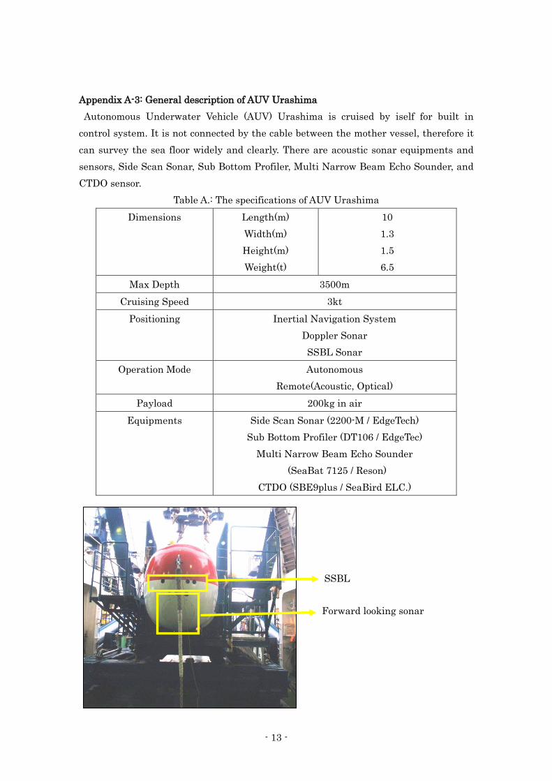
Appendix A-3: General description of AUV Urashima Autonomous Underwater Vehicle (AUV) Urashima is cruised by iself for built in control system. It is not connected by the cable between the mother vessel, therefore it can survey the sea floor widely and clearly. There are acoustic sonar equipments and sensors, Side Scan Sonar, Sub Bottom Profiler, Multi Narrow Beam Echo Sounder, and CTDO sensor.
Table A.: The specifications of AUV Urashima Dimensions Length(m)
Width(m) Height(m) Weight(t)
10 1.3 1.5 6.5
Max Depth 3500m Cruising Speed 3kt
Positioning Inertial Navigation System Doppler Sonar SSBL Sonar
Operation Mode Autonomous Remote(Acoustic, Optical)
Payload 200kg in air Equipments Side Scan Sonar (2200-M / EdgeTech)
Sub Bottom Profiler (DT106 / EdgeTec) Multi Narrow Beam Echo Sounder
(SeaBat 7125 / Reson) CTDO (SBE9plus / SeaBird ELC.)
SSBL
Forward looking sonar

- 14 -
Fig.A.1 Equipments of AUV Urashima
(DVL)
Side scan sonar (SSS)
Sub bottom profiler (SBP) Multi Narrow Beam Echo Sounder (MBES)
CTDO
YK12-16
CLIENT RECEIVER TYPE SIG Streamer
CRUISE HYDROPHONE S.I.G.16 SHIP SPEED AGAINST GROUND : 4.44 knot
AREA NUMBER OF CHANNEL 1 SHIP SPEED AGAINST WATER : 3.93 knot
LINE NO. OF HYD./GROUP 48
DIRECTION (°) SENSITIVITY 90.0 +/- 1 dB ref 1V/ubar
DATE CABLE DEPTH 3.0m
WEATHER ACTIVE SECTION 47m
WIND LEAD-IN SECTION 131.9m
SEA CONDITION
FIRST SHOT POINT SP No. 1
FIRST GOOD SHOT POINT SP No. 1
N 27-30.95455
E 127-02.56989 RECORDING SYSTEM Geode ver 9.28.0.0
Time (UTC) 11:35:03 SAMPLE FREQUENCY 1000Hz
Water Depth (m) 1610 0 RECORDING LENGTH 7 000 msec
JAMSTEC
YK12-16
Okinawa Trough
NME SINGLE CHANNEL SEISMIC SURVEY GENERAL INFORMATION
GENERAL RECEIVER REMARKS
2012/09/25(UTC)
Fine but cloudy
ENE Strong breeze
Line3_0
343.5 Cross point of Line2_0: Shot No.252 09/25 12:18(UTC)
Moderate
RECORDING
Set air pressure is 13.5MPa,but true air pressure is 12.0MPa.
Water Depth (m) 1610.0 RECORDING LENGTH 7,000 msec
LAST SHOT POINT SP No. 478 WATER DELAY 0 msec
LAST GOOD SHOT POINT SP No. 478 RECORDING FORMAT SEG-D 8058 Rev.1
N 27-36.68209 ANALOG PREAMP 39dB
E 127-00.54840 HICUT FILTER None
Time (UTC) 12:56:59 LOWCUT FILTER None
Water Depth (m) 1326.0 SYSTEM DELAY 100ms (from start recording to gun fireing)
GPS SYSTEM SkyFix XP(DGPS) No.1 Antenna
NAVIGATION SYSTEM Navlog ver 1.0.64
GUN TYPE BAND PASS FILTER 15-20-200-250
SHOT TYPE STATIC CORRECTION 96msec.
SHOT MODE SEISMIC DATA 1.sgd - 478.sgd SPHERICAL DIVERGENCE CORR. g=t^2
SHOT INTERVAL (Folder name : Line3_0)
NUMBER OF STRINGS NAVIGATION DATA Line3_0_Shot.csv
TOTAL VOLUME Line3_0_LOG.csv
CONFIGURATION
GUN DEPTH
AIR PRESSURE
GUN CONTROLLER
GUN TOWING WIRE LENGTH
SOURCE PROCESSING
13.5 MPa
Hotshot ver 3.005
Sercel GI-Gun
DATA GI-simultaneous
Time
Satoshi Okada , Mitsuteru Kuno , Akie Suzuki , Toshimasa Nasu
10 sec
1
26.6m
150 cu.in
45(G) + 105(I) cu.in
3.0m
OBSERVER
- 1
5 -
A-4: G
eneral In
form
ation o
f SC
S su
rvey
- 15 -

YK12-16
CLIENT RECEIVER TYPE SIG Streamer
CRUISE HYDROPHONE S.I.G.16 SHIP SPEED AGAINST GROUND : 4.27 knot
AREA NUMBER OF CHANNEL 1 SHIP SPEED AGAINST WATER : 5.06 knot
LINE NO. OF HYD./GROUP 48
DIRECTION (°) SENSITIVITY 90.0 +/- 1 dB ref 1V/ubar
DATE CABLE DEPTH 3.0m
WEATHER ACTIVE SECTION 47m
WIND LEAD-IN SECTION 131.9m
SEA CONDITION
FIRST SHOT POINT SP No. 1
FIRST GOOD SHOT POINT SP No. 1
N 27-35.79918
E 126-57.79037 RECORDING SYSTEM Geode ver 9.28.0.0
Time (UTC) 13:36:53 SAMPLE FREQUENCY 1000Hz
Water Depth (m) 1535 0 RECORDING LENGTH 7 000 msec
JAMSTEC
YK12-16
Okinawa Trough
NME SINGLE CHANNEL SEISMIC SURVEY GENERAL INFORMATION
GENERAL RECEIVER REMARKS
2012/09/25(UTC) Cross point of Line1_0: Shot No.260 09/25 14:21(UTC)
ine but cloudy
ENE Fresh breeze
Line4_0
163.8 Cross point of Line2_0: Shot No.230 09/25 14:16(UTC)
Moderate
RECORDING
Set air pressure is 13.5MPa,but true air pressure is 12.0MPa.
Water Depth (m) 1535.0 RECORDING LENGTH 7,000 msec
LAST SHOT POINT SP No. 518 WATER DELAY 0 msec
LAST GOOD SHOT POINT SP No. 518 RECORDING FORMAT SEG-D 8058 Rev.1
N 27-29.84676 ANALOG PREAMP 39dB
E 126-59.85489 HICUT FILTER None
Time (UTC) 15:05:41 LOWCUT FILTER None
Water Depth (m) 1600.0 SYSTEM DELAY 100ms (from start recording to gun fireing)
GPS SYSTEM SkyFix XP(DGPS) No.1 Antenna
NAVIGATION SYSTEM Navlog ver 1.0.64
GUN TYPE BAND PASS FILTER 15-20-200-250
SHOT TYPE STATIC CORRECTION 96msec.
SHOT MODE SEISMIC DATA 1.sgd - 518.sgd SPHERICAL DIVERGENCE CORR. g=t^2
SHOT INTERVAL (Folder name : Line4_0)
NUMBER OF STRINGS NAVIGATION DATA Line4_0_Shot.csv
TOTAL VOLUME Line4_0_LOG.csv
CONFIGURATION
GUN DEPTH
AIR PRESSURE
GUN CONTROLLER
GUN TOWING WIRE LENGTH
SOURCE PROCESSING
13.5 MPa
Hotshot ver 3.005
Sercel GI-Gun
DATA GI-simultaneous
Time
Satoshi Okada , Mitsuteru Kuno , Akie Suzuki , Toshimasa Nasu
10 sec
1
26.6m
150 cu.in
45(G) + 105(I) cu.in
3.0m
OBSERVER
- 16 -
YK12-16
CLIENT RECEIVER TYPE SIG Streamer
CRUISE HYDROPHONE S.I.G.16 SHIP SPEED AGAINST GROUND : 4.11 knot
AREA NUMBER OF CHANNEL 1 SHIP SPEED AGAINST WATER : 3.07 knot
LINE NO. OF HYD./GROUP 48
DIRECTION (°) SENSITIVITY 90.0 +/- 1 dB ref 1V/ubar
DATE CABLE DEPTH 3.0m
WEATHER ACTIVE SECTION 47m
WIND LEAD-IN SECTION 131.9m
SEA CONDITION
FIRST SHOT POINT SP No. 1
FIRST GOOD SHOT POINT SP No. 1
N 27-28.64182
E 126-57.07809 RECORDING SYSTEM Geode ver 9.28.0.0
Time (UTC) 15:54:20 SAMPLE FREQUENCY 1000Hz
Water Depth (m) 1593 0 RECORDING LENGTH 7 000 msec
JAMSTEC
YK12-16
Okinawa Trough
NME SINGLE CHANNEL SEISMIC SURVEY GENERAL INFORMATION
GENERAL RECEIVER REMARKS
2012/09/25(UTC) Cross point of Line2_0: Shot No.322 09/25 16:49(UTC)
Fine but cloudy
ENE Fresh breeze
Line5_0
342.5 Cross point of Line1_0: Shot No.293 09/25 16:44(UTC)
Moderate
RECORDING
Set air pressure is 13.5MPa,but true air pressure is 12.0MPa.
Water Depth (m) 1593.0 RECORDING LENGTH 7,000 msec
LAST SHOT POINT SP No. 529 WATER DELAY 0 msec
LAST GOOD SHOT POINT SP No. 529 RECORDING FORMAT SEG-D 8058 Rev.1
N 27-34.54330 ANALOG PREAMP 39dB
E 126-54.94492 HICUT FILTER None
Time (UTC) 17:25:04 LOWCUT FILTER None
Water Depth (m) 1541.0 SYSTEM DELAY 100ms (from start recording to gun fireing)
GPS SYSTEM SkyFix XP(DGPS) No.1 Antenna
NAVIGATION SYSTEM Navlog ver 1.0.64
GUN TYPE BAND PASS FILTER 15-20-200-250
SHOT TYPE STATIC CORRECTION 96msec.
SHOT MODE SEISMIC DATA 1.sgd - 529.sgd SPHERICAL DIVERGENCE CORR. g=t^2
SHOT INTERVAL (Folder name : Line5_0)
NUMBER OF STRINGS NAVIGATION DATA Line5_0_Shot.csv
TOTAL VOLUME Line5_0_LOG.csv
CONFIGURATION
GUN DEPTH
AIR PRESSURE
GUN CONTROLLER
GUN TOWING WIRE LENGTH
SOURCE PROCESSING
13.5 MPa
Hotshot ver 3.005
Sercel GI-Gun
DATA GI-simultaneous
Time
Satoshi Okada , Mitsuteru Kuno , Akie Suzuki , Toshimasa Nasu
10 sec
1
26.6m
150 cu.in
45(G) + 105(I) cu.in
3.0m
OBSERVER
- 17 -

YK12-16
CLIENT RECEIVER TYPE SIG Streamer
CRUISE HYDROPHONE S.I.G.16 SHIP SPEED AGAINST GROUND : 4.09 knot
AREA NUMBER OF CHANNEL 1 SHIP SPEED AGAINST WATER : 4.98 knot
LINE NO. OF HYD./GROUP 48
DIRECTION (°) SENSITIVITY 90.0 +/- 1 dB ref 1V/ubar
DATE CABLE DEPTH 3.0m
WEATHER ACTIVE SECTION 47m
WIND LEAD-IN SECTION 131.9m
SEA CONDITION
FIRST SHOT POINT SP No. 1
FIRST GOOD SHOT POINT SP No. 1
N 27-33.65753
E 126-52.18918 RECORDING SYSTEM Geode ver 9.28.0.0
Time (UTC) 18:15:21 SAMPLE FREQUENCY 1000Hz
Water Depth (m) 1538 0 RECORDING LENGTH 7 000 msec
JAMSTEC
YK12-16
Okinawa Trough
NME SINGLE CHANNEL SEISMIC SURVEY GENERAL INFORMATION
GENERAL RECEIVER REMARKS
2012/09/25(UTC)
Fine but cloudy
East Strong breeze
Line6_0
163.6 Cross point of Line2_0: Shot No.236 09/25 18:55(UTC)
Moderate
RECORDING
Set air pressure is 13.5MPa,but true air pressure is 12.0MPa.
Water Depth (m) 1538.0 RECORDING LENGTH 7,000 msec
LAST SHOT POINT SP No. 528 WATER DELAY 0 msec
LAST GOOD SHOT POINT SP No. 522 RECORDING FORMAT SEG-D 8058 Rev.1
N 27-27.92690 ANALOG PREAMP 39dB
E 126-54.22943 HICUT FILTER None
Time (UTC) 19:44:54 LOWCUT FILTER None
Water Depth (m) 1609.0 SYSTEM DELAY 100ms (from start recording to gun fireing)
GPS SYSTEM SkyFix XP(DGPS) No.1 Antenna
NAVIGATION SYSTEM Navlog ver 1.0.64
GUN TYPE BAND PASS FILTER 15-20-200-250
SHOT TYPE STATIC CORRECTION 96msec.
SHOT MODE SEISMIC DATA 1.sgd - 528.sgd SPHERICAL DIVERGENCE CORR. g=t^2
SHOT INTERVAL (Folder name : Line6_0)
NUMBER OF STRINGS NAVIGATION DATA Line6_0_Shot.csv
TOTAL VOLUME Line6_0_LOG.csv
CONFIGURATION
GUN DEPTH
AIR PRESSURE
GUN CONTROLLER
GUN TOWING WIRE LENGTH
SOURCE PROCESSING
13.5 MPa
Hotshot ver 3.005
Sercel GI-Gun
DATA GI-simultaneous
Time
Satoshi Okada , Mitsuteru Kuno , Akie Suzuki , Toshimasa Nasu
10 sec
1
26.6m
150 cu.in
45(G) + 105(I) cu.in
3.0m
OBSERVER
- 18 -
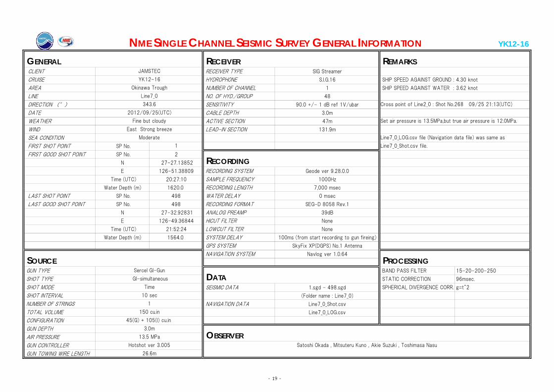
YK12-16
CLIENT RECEIVER TYPE SIG Streamer
CRUISE HYDROPHONE S.I.G.16 SHIP SPEED AGAINST GROUND : 4.30 knot
AREA NUMBER OF CHANNEL 1 SHIP SPEED AGAINST WATER : 3.62 knot
LINE NO. OF HYD./GROUP 48
DIRECTION (°) SENSITIVITY 90.0 +/- 1 dB ref 1V/ubar
DATE CABLE DEPTH 3.0m
WEATHER ACTIVE SECTION 47m
WIND LEAD-IN SECTION 131.9m
SEA CONDITION
FIRST SHOT POINT SP No. 1
FIRST GOOD SHOT POINT SP No. 2
N 27-27.13852
E 126-51.38809 RECORDING SYSTEM Geode ver 9.28.0.0
Time (UTC) 20:27:10 SAMPLE FREQUENCY 1000Hz
Water Depth (m) 1620 0 RECORDING LENGTH 7 000 msec
JAMSTEC
YK12-16
Okinawa Trough
NME SINGLE CHANNEL SEISMIC SURVEY GENERAL INFORMATION
GENERAL RECEIVER REMARKS
2012/09/25(UTC)
Fine but cloudy
East Strong breeze
Line7_0
343.6 Cross point of Line2_0 : Shot No.268 09/25 21:13(UTC)
Moderate
RECORDING
Line7_0_LOG.csv file (Navigation data file) was same as
Line7_0_Shot.csv file.
Set air pressure is 13.5MPa,but true air pressure is 12.0MPa.
Water Depth (m) 1620.0 RECORDING LENGTH 7,000 msec
LAST SHOT POINT SP No. 498 WATER DELAY 0 msec
LAST GOOD SHOT POINT SP No. 498 RECORDING FORMAT SEG-D 8058 Rev.1
N 27-32.92831 ANALOG PREAMP 39dB
E 126-49.36844 HICUT FILTER None
Time (UTC) 21:52:24 LOWCUT FILTER None
Water Depth (m) 1564.0 SYSTEM DELAY 100ms (from start recording to gun fireing)
GPS SYSTEM SkyFix XP(DGPS) No.1 Antenna
NAVIGATION SYSTEM Navlog ver 1.0.64
GUN TYPE BAND PASS FILTER 15-20-200-250
SHOT TYPE STATIC CORRECTION 96msec.
SHOT MODE SEISMIC DATA 1.sgd - 498.sgd SPHERICAL DIVERGENCE CORR. g=t^2
SHOT INTERVAL (Folder name : Line7_0)
NUMBER OF STRINGS NAVIGATION DATA Line7_0_Shot.csv
TOTAL VOLUME Line7_0_LOG.csv
CONFIGURATION
GUN DEPTH
AIR PRESSURE
GUN CONTROLLER
GUN TOWING WIRE LENGTH
SOURCE PROCESSING
13.5 MPa
Hotshot ver 3.005
Sercel GI-Gun
DATA GI-simultaneous
Time
Satoshi Okada , Mitsuteru Kuno , Akie Suzuki , Toshimasa Nasu
10 sec
1
26.6m
150 cu.in
45(G) + 105(I) cu.in
3.0m
OBSERVER
- 19 -
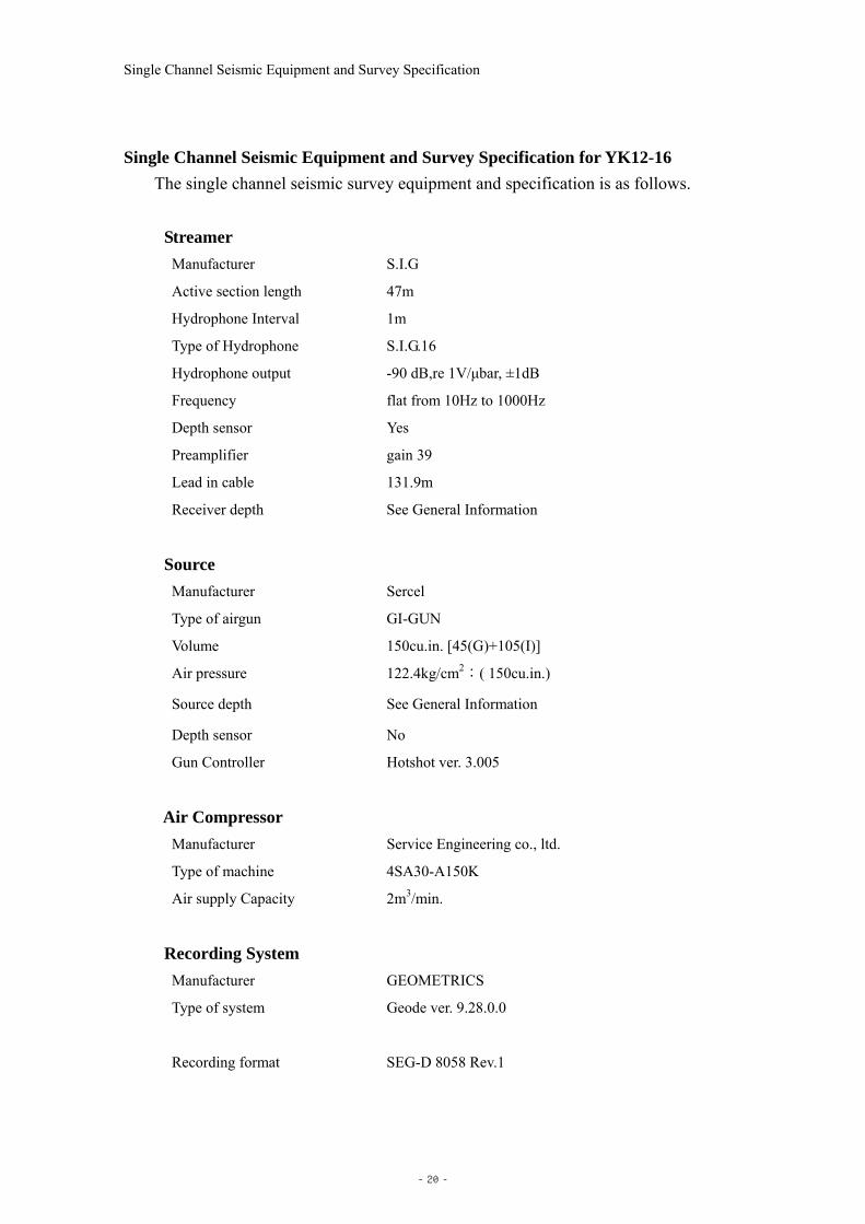
Single Channel Seismic Equipment and Survey Specification
Single Channel Seismic Equipment and Survey Specification for YK12-16 The single channel seismic survey equipment and specification is as follows.
Streamer
Manufacturer S.I.G
Active section length 47m
Hydrophone Interval 1m
Type of Hydrophone S.I.G.16
Hydrophone output -90 dB,re 1V/μbar, ±1dB
Frequency flat from 10Hz to 1000Hz
Depth sensor Yes
Preamplifier gain 39
Lead in cable 131.9m
Receiver depth See General Information
Source
Manufacturer Sercel
Type of airgun GI-GUN
Volume 150cu.in. [45(G)+105(I)]
Air pressure 122.4kg/cm2:( 150cu.in.)
Source depth See General Information
Depth sensor No
Gun Controller Hotshot ver. 3.005
Air Compressor
Manufacturer Service Engineering co., ltd.
Type of machine 4SA30-A150K
Air supply Capacity 2m3/min.
Recording System
Manufacturer GEOMETRICS
Type of system Geode ver. 9.28.0.0
Recording format SEG-D 8058 Rev.1
- 20 -

Single Channel Seismic Equipment and Survey Specification
Recording length 7,000msec
Water Delay 0msec
Sample rate 1msec
High cut filter None
Low cut filter None
Recording media Hard Disk
GPS System
Manufacturer Fugro
Type of system SkyFix XP MultiFix6
DGPS Reference Station Multi Reference Station (ALL)
GPS System
Manufacturer MARIMEX JAPAN
Type of system Nav log ver. 1.0.64
Shot Point Geometry
Time mode shooting See General Information
Geodetic Parameter
Spheroid WGS84
Semi-major Axis 6,378,137m
Inverse Flattening 298.26
Projection U.T.M
Zone52
- 21 -
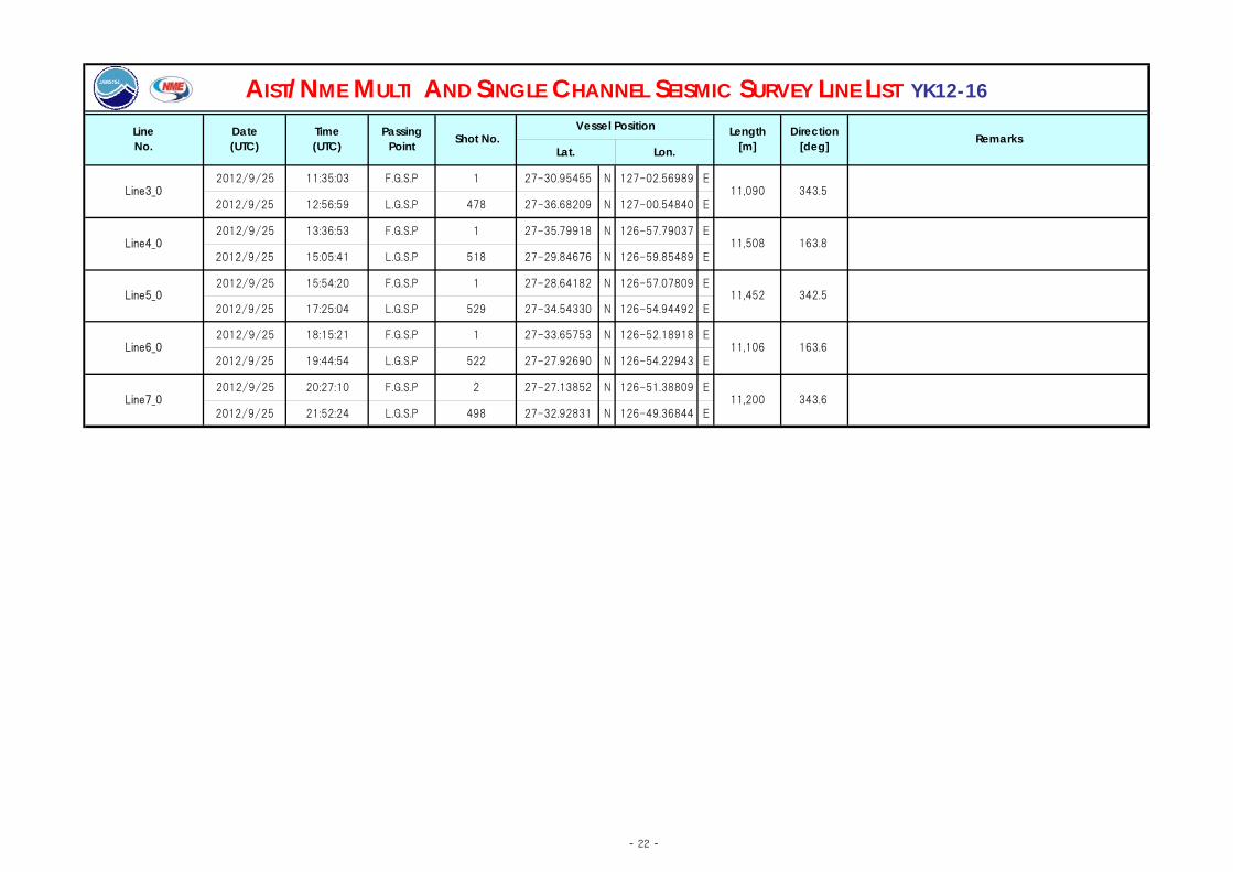
2012/9/25 11:35:03 F.G.S.P 1 27-30.95455 N 127-02.56989 E
2012/9/25 12:56:59 L.G.S.P 478 27-36.68209 N 127-00.54840 E
2012/9/25 13:36:53 F.G.S.P 1 27-35.79918 N 126-57.79037 E
2012/9/25 15:05:41 L.G.S.P 518 27-29.84676 N 126-59.85489 E
2012/9/25 15:54:20 F.G.S.P 1 27-28.64182 N 126-57.07809 E
2012/9/25 17:25:04 L.G.S.P 529 27-34.54330 N 126-54.94492 E
2012/9/25 18:15:21 F.G.S.P 1 27-33.65753 N 126-52.18918 E
2012/9/25 19:44:54 L.G.S.P 522 27-27.92690 N 126-54.22943 E
2012/9/25 20:27:10 F.G.S.P 2 27-27.13852 N 126-51.38809 E
2012/9/25 21:52:24 L.G.S.P 498 27-32.92831 N 126-49.36844 ELine7_0 11,200 343.6
Line5_0 11,452 342.5
Line6_0 11,106 163.6
Lon.
Direction[deg]
11,508 163.8
AIST/NME MULTI AND SINGLE CHANNEL SEISMIC SURVEY LINE LIST YK12-16
RemarksTime(UTC) Lat.
LineNo.
Date(UTC)
PassingPoint Shot No.
Vessel Position Length[m]
11,090 343.5Line3_0
Line4_0
- 22 -
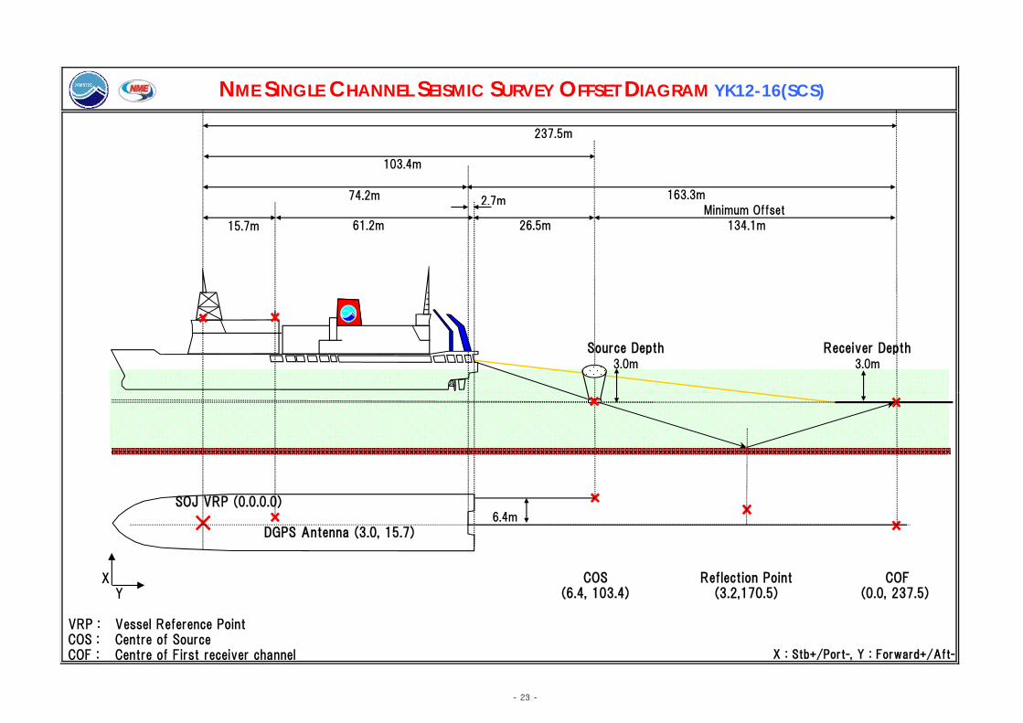
74.2m
15.7m
3.0m 3.0m
Source Depth Receiver Depth
163.3m
Minimum Offset
61.2m 26.5m 134.1m
NME SINGLE CHANNEL SEISMIC SURVEY OFFSET DIAGRAM YK12-16(SCS)
237.5m
103.4m
2.7m
SOJ VRP (0.0.0.0)6.4m
DGPS Antenna (3.0, 15.7)
XY
VRP : Vessel Reference Point COS : Centre of Source COF : Centre of First receiver channel
(6.4, 103.4) (3.2,170.5) (0.0, 237.5)
X : Stb+/Port-, Y : Forward+/Aft-
COS Reflection Point COF
- 23 -

URASHIMA Dive149 FG3成分磁力計
センサー FG1:左舷側
センサー FG2右舷側
※FG3は未使用(予備)
耐圧容器 センサー FG4:船首側
- 24 -
Appe
ndix A
-5 P
ayload asse
mblage
s in U
rashim
a dives

URASHIMA Dive149
濁度計 酸化還元電位センサー
濁度計2番(黄色) 濁度計3番(緑色) - 25 -

URASHIMA Dive150 FG3成分磁力計
センサー FG1:左舷側
センサー FG2右舷側
※FG3は未使用(予備)
耐圧容器 センサー FG4:船首側
- 26 -
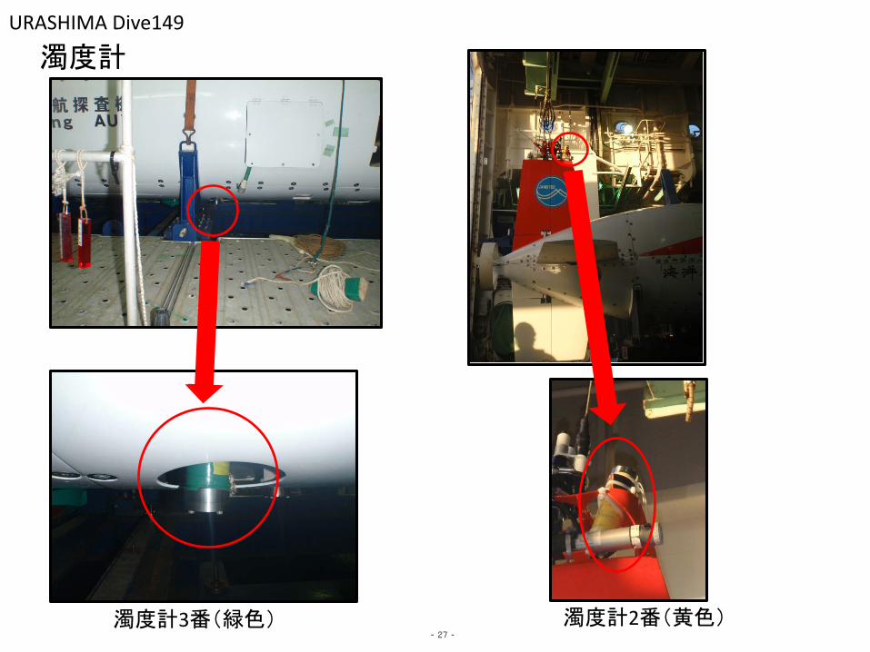
URASHIMA Dive149
濁度計
濁度計3番(緑色) 濁度計2番(黄色) - 27 -

−1600
−1600
−1600
−1600
−1500
−1500
−1500
−1500
−1500
−1500
−1500
−1500
−1500
−1500
−1500
−1500
−1500
−1400
−1400
−1400
−1400
−1400
−1400
−1400
−1400
−1400
−1400
−1300−1300
−1300
−1300
−1300
−1300
−1300
−1300
−1200
−12
00
−1200
−1200
−1100
−1100
−1100
−1100
−1000
−1000
126˚55.00'E
126˚55.00'E
126˚56.00'E
126˚56.00'E
126˚57.00'E
126˚57.00'E
126˚58.00'E
126˚58.00'E
126˚59.00'E
126˚59.00'E
127˚00.00'E
127˚00.00'E
27˚31.00'N 27˚31.00'N
27˚32.00'N 27˚32.00'N
27˚33.00'N 27˚33.00'N
27˚34.00'N 27˚34.00'N
1
2
3
4
5
6
7
8
9
10
11
12
13
14
17
18
19
20
21
22
23
24
25
26
27
XY Origin Lat 27−32.00000N Lon 126−57.00000E Center Lat 27−32.50000N Lon 126−57.50000E Grid_File:KR01−09_200m.grd ContourInt:20m Datum WGS−84 Proj.MER (2012−09−25)
Urashima#149DIVE OKINAWA−TORAHU
(UR)Lat 27−34.36875N Lon 127−00.68897E (LL)Lat 27−30.63225N Lon 126−54.31203E
( 1 /30000 )
0
3.0
KM
- 28 -
A-6 S
urve
y Plan
s

−1600
−1600
−1600
−1600
−1500
−1500
−1500
−1500
−1500
−1500
−1500
−1500
−1500
−1500
−1500
−1500
−1400
−1400
−1400
−1400
−1400
−1400
−1400
−1400
−1400
−1400
−1400
−1300
−1300
−1300
−1300
−1300
−1300
−1300
−1300
−1200
−1200
−1200
−1200
−1200
−1100
−1100
−1100
−1100
−1000
126˚54.00'E
126˚54.00'E
126˚55.00'E
126˚55.00'E
126˚56.00'E
126˚56.00'E
126˚57.00'E
126˚57.00'E
126˚58.00'E
126˚58.00'E
126˚59.00'E
126˚59.00'E
127˚00.00'E
127˚00.00'E
127˚01.00'E
127˚01.00'E
27˚30.00'N 27˚30.00'N
27˚31.00'N 27˚31.00'N
27˚32.00'N 27˚32.00'N
27˚33.00'N 27˚33.00'N
27˚34.00'N 27˚34.00'N
1
2
3
4
5
6
7
8
9
10 11
12 13
14
XY Origin Lat 27−32.00000N Lon 126−57.00000E Center Lat 27−32.00000N Lon 126−57.50000E Grid_File:YK1216_100.grd ContourInt:20m Datum WGS−84 Proj.MER (2012−10 −02)
Urashima#150DIVE OKINAWA−TROUGH
(UR)Lat 27−34.49151N Lon 127−01.75179E (LL)Lat 27−29.50949N Lon 126−53.24921E
( 1 /40000 )
0
4.0
KM
- 29 -

−1600
−1600
−1500
−1500
−1500
−1500
−1500−1500
−1500
−1500
−1500
−1500
−1500
−1500
−1400
−1400
−1400
−1400
−1400
−1400
−1400
−1400
−14
00
−1400
−1300
−1300
−1300
−1300
−1300
−1300
−1300
−1200
−1200
−1200
−1200
−1100
−1100
−1100
−1100
−1000
126˚55.00'E
126˚55.00'E
126˚56.00'E
126˚56.00'E
126˚57.00'E
126˚57.00'E
126˚58.00'E
126˚58.00'E
126˚59.00'E
126˚59.00'E
127˚00.00'E
127˚00.00'E
27˚31.00'N 27˚31.00'N
27˚32.00'N 27˚32.00'N
27˚33.00'N 27˚33.00'N
27˚34.00'N 27˚34.00'N
1
2
3
4
5
6
7
8
9
10
11
12
13
14
17
18
19
20
21
22
23
24
25
26
27
XY Origin Lat 27−32.00000N Lon 126−57.00000E Center Lat 27−32.50000N Lon 126−57.50000E Grid_File:KR01−09_200m.grd ContourInt:20m Datum WGS−84 Proj.MER (2012−09−25)
Urashima#149DIVE OKINAWA−TOROUGH
(UR)Lat 27−34.36875N Lon 127−00.68897E (LL)Lat 27−30.63225N Lon 126−54.31203E
( 1 /30000 )
0
3.0
KM
- 30 -
A-7 su
rvey trac
ks on th
eir plan

−1600
−1600
−1600
−1600
−1500
−1500
−1500
−1500
−1500
−1500
−1500
−1500
−1500
−1500
−1500
−1500
−1400
−1400
−1400
−1400
−1400
−1400
−1400
−1400
−1400
−1400
−1400
−1300
−1300
−1300
−1300
−1300
−1300
−1300
−1300
−1200
−1200
−1200
−1200
−1200
−1100
−1100
−1100
−1100
−1000
126˚54.00'E
126˚54.00'E
126˚55.00'E
126˚55.00'E
126˚56.00'E
126˚56.00'E
126˚57.00'E
126˚57.00'E
126˚58.00'E
126˚58.00'E
126˚59.00'E
126˚59.00'E
127˚00.00'E
127˚00.00'E
127˚01.00'E
127˚01.00'E
27˚30.00'N 27˚30.00'N
27˚31.00'N 27˚31.00'N
27˚32.00'N 27˚32.00'N
27˚33.00'N 27˚33.00'N
27˚34.00'N 27˚34.00'N
1
2
3
4
5
6
7
8
9
10 11
12 13
14
XY Origin Lat 27−32.00000N Lon 126−57.00000E Center Lat 27−32.00000N Lon 126−57.50000E Grid_File:YK1216_100.grd ContourInt:20m Datum WGS−84 Proj.MER (2012−10 −02)
Urashima#150DIVE OKINAWA−TROUGH
(UR)Lat 27−34.49151N Lon 127−01.75179E (LL)Lat 27−29.50949N Lon 126−53.24921E
( 1 /40000 )
0
4.0
KM
- 31 -


![[Transformers Setting] Looking for Ideas, Thoughts, And Nifty Stuff](https://static.fdocuments.us/doc/165x107/577cd26e1a28ab9e78956d57/transformers-setting-looking-for-ideas-thoughts-and-nifty-stuff.jpg)