Yange Kep Bidi Brochure
2
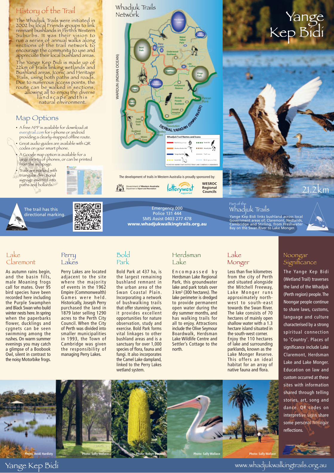
Emergency 000 Police 131 444 SMS Assist 0403 277 478 www.whadjukwalkingtrails.org.au Yange Kep Bidi links bushland across local Government areas of; Claremont, Nedlands, Cambridge and Stirling, from Freshwater Bay on the Swan River to Lake Monger. Whadjuk Trails Part of the 21.2km Yange Kep Bidi History of the Trail The Whadjuk Trails were initiated in 2002 by local Friends groups to link remnant bushlands in Perth’s Western Suburbs. It was their vision to run a series of annual walks along sections of the trail network to encourage the community to use and appreciate their local bushland areas. The Yange Kep Bidi is made up of 22km of trails linking wetlands and Bushland areas, Iconic and Heritage Trails, using both paths and roads. Due to numerous access points, the route can be walked in sections, allowing all to enjoy the diverse l a n d s c a p e and t h i s natural environment. The development of trails in Western Australia is proudly sponsored by: WESROC Regional Councils Map Options • A free APP is available for download at everytrail.com for i-phone or android providing a clearly-mapped offline route. • Great audio guides are available with QR codes on your smart phone. • A Google map option is available for a large variety of phones, or can be printed from the webpage. • Trails are marked with triangular directional signage inserted into paths and bollards. The trail has this directional marking. Photo: Sally Wallace PLEASE BE AWARE THAT DOTTED TRAILS ARE CURRENTLY UNMARKED Wardun Beelier Bidi Yange Kep Bidi Karda Bidi W hadju k T r a and I c ons Bush to Karak Bidi Waarlitj Bidi T r a il L E x i t i Whadjuk Trails Network WARDUN (INDIAN OCEAN) Pelican Point Chidley Point Point Resolution Yange Kep Bidi www.whadjukwalkingtrails.org.au As autumn rains begin, and the basin fills, male Moaning frogs call for mates. Over 95 bird species have been recorded here including the Purple Swamphen and Black Swan who build winter nests here. In spring when the paperbarks flower, ducklings and cygnets can be seen swimming among the rushes. On warm summer evenings you may catch a glimpse of a Boobook Owl, silent in contrast to the noisy Motorbike frogs. Perry Lakes are located adjacent to the site where the majority of events in the 1962 Empire (Commonwealth) Games were held. Historically, Joseph Perry purchased the land in 1879 later selling 1290 acres to the Perth City Council. When the City of Perth was divided into smaller municipalities in 1993, the Town of Cambridge was given the responsibility of managing Perry Lakes. Bold Park at 437 ha, is the largest remaining bushland remnant in the urban area of the Swan Coastal Plain. Incorporating a network of bushwalking trails that offer stunning views, it provides excellent opportunities for nature observation, study and exercise. Bold Park forms vital linkages to other bushland areas and is a sanctuary for over 1,000 species of flora, fauna and fungi. It also incorporates the Camel Lake dampland, linked to the Perry Lakes wetland system. Encompassed by Herdsman Lake Regional Park, this groundwater lake and park totals over 3 km² (300 hectares). The lake perimeter is dredged to provide permanent open water during the dry summer months, and has walking trails for all to enjoy. Attractions include the Olive Seymour Boardwalk, Herdsman Lake Wildlife Centre and Settler’s Cottage to the north. Less than five kilometres from the city of Perth and situated alongside the Mitchell Freeway, Lake Monger runs approximately north- west to south-east towards the Swan River. The lake consists of 70 hectares of mainly open shallow water with a 1.3 hectare island situated in the south-west corner. Enjoy the 110 hectares of lake and surrounding parklands, known as the Lake Monger Reserve. This offers an ideal habitat for an array of native fauna and flora. Lake Claremont Perry Lakes Bold Park Herdsman Lake Lake Monger Photo: Heidi Hardisty Photo: Sally Wallace Photo: Sally Wallace Noongar Significance Photo: Robyn Benken Photo: Sally Wallace The Yange Kep Bidi (Wetland Trail) traverses the land of the Whadjuk (Perth region) people. The Noongar people continue to share laws, customs, language and culture characterised by a strong spiritual connection to ‘Country’. Places of significance include Lake Claremont, Herdsman Lake and Lake Monger. Education on law and custom occurred at these sites with information shared through telling stories, art, song and dance. QR codes on interpretive signs share some personal Noongar reflections.
Transcript of Yange Kep Bidi Brochure
Emergency 000Police 131 444
SMS Assist 0403 277 478www.whadjukwalkingtrails.org.au
Yange Kep Bidi links bushland across local Government areas of; Claremont, Nedlands, Cambridge and Stirling, from Freshwater Bay on the Swan River to Lake Monger.
Whadjuk TrailsPart of the
21.2km
YangeKep Bidi
History of the TrailThe Whadjuk Trails were initiated in2002 by local Friends groups to linkremnant bushlands in Perth’s WesternSuburbs. I t was their v is ion torun a series of annual walks alongsections of the trai l network to encourage the community to use andappreciate their local bushland areas.The Yange Kep Bidi is made up of22km of trails linking wetlands andBushland areas, Iconic and HeritageTrails, using both paths and roads.Due to numerous access points, theroute can be walked in sections,
allowing all to enjoy the diversel a n d s c a p e and t h i s natural environment.
The development of trails in Western Australia is proudly sponsored by:
WESROCRegionalCouncils
Map Options• A free APP is available for download at
everytrail.com for i-phone or android providing a clearly-mapped offl ine route.
• Great audio guides are available with QR codes on your smart phone.
• A Google map option is available for a large variety of phones, or can be printed from the webpage.
• Trails are marked with triangular directional signage inserted into paths and bollards.
The trail has thisdirectional marking.
route can be walked in sections,allowing all to enjoy the diverse
Phot
o: S
ally
Wal
lace
PLEASE BE AWARE THAT DOTTED TRAILS ARE CURRENTLY UNMARKED
Wardun Beelier Bidi
Yange Kep Bidi
Karda Bidi
Whadjuk Tra and Icons
Bush to Karak Bidi
Waarlitj Bidi
Trail L
Existi
Whadjuk TrailsNetwork
WAR
DU
N (I
ND
IAN
OC
EAN
)
DERBABAB L YAYAY RIGAN (SWAWAWN
RIVE
R)
PelicanPoint
ChidleyPoint
PointResolution
Yange Kep Bidi www.whadjukwalkingtrails.org.au
As autumn rains begin, and the bas in f i l l s, male Moaning f rogs call for mates. Over 95 bird species have been recorded here including the Purple Swamphen and Black Swan who build winter nests here. In spring when the paperbarks flower, ducklings and cygnets can be seen swimming among the rushes. On warm summer evenings you may catch a glimpse of a Boobook Owl, silent in contrast to the noisy Motorbike frogs.
Perry Lakes are locatedadjacent to the s i te whe re t he ma jo r i t y of events in the 1962 Empire (Commonwealth) G a m e s w e r e h e l d . Historically, Joseph Perry purchased the land in 1879 later selling 1290 acres to the Perth City Council. When the City of Perth was divided into smaller municipalities in 1993, the Town of Cambridge was given the responsibi l i ty of managing Perry Lakes.
Bold Park at 437 ha, is the largest remaining bushland remnant in the urban area of the S wan Coas t a l P l a i n . Incorporating a network of bushwalking trai ls that offer stunning views, i t p rov ides exce l lent opportunities for nature observation, study and exercise. Bold Park forms vital linkages to other bushland areas and is a sanctuary for over 1,000 species of fl ora, fauna and fungi. It also incorporates the Camel Lake dampland, linked to the Perry Lakes wetland system.
E n c o m p a s s e d b y Herdsman Lake Regional Park, this groundwater lake and park totals over 3 km² (300 hectares). The lake perimeter is dredged to provide permanent open water during the dry summer months, and has walking trails for all to enjoy. Attractions include the Olive Seymour Boardwalk, Herdsman Lake Wildlife Centre and Settler’s Cottage to the north.
Less than fi ve kilometresfrom the city of Perth and situated alongside the Mitchell Freeway, L a ke M o n g e r r u n s approximately north-w e s t t o s o u t h - e a s t towards the Swan River. The lake consists of 70 hectares of mainly open shallow water with a 1.3 hectare island situated in the south-west corner.Enjoy the 110 hectares of lake and surrounding parklands, known as theLake Monger Reserve. Th i s o f fe r s an idea l habitat for an array of native fauna and fl ora.
LakeClaremont
PerryLakes
BoldPark
HerdsmanLake
Lake Monger
Photo: Heidi Hardisty Photo: Sally Wallace Photo: Sally Wallace
NoongarSignifi cance
Photo: Robyn Benken Photo: Sally Wallace
The Yange Kep B id i
(Wetland Trail) traverses
the land of the Whadjuk
(Perth region) people. The
Noongar people continue
to share laws, customs,
language and culture
characterised by a strong
sp i r i tua l connect ion
to ‘Country’. Places of
signifi cance include Lake
Claremont, Herdsman
Lake and Lake Monger.
Education on law and
custom occurred at these
sites with information
shared through telling
stories, art, song and
dance. QR codes on
interpretive signs share
some personal Noongar
refl ections.
Ind
ian
Oce
an
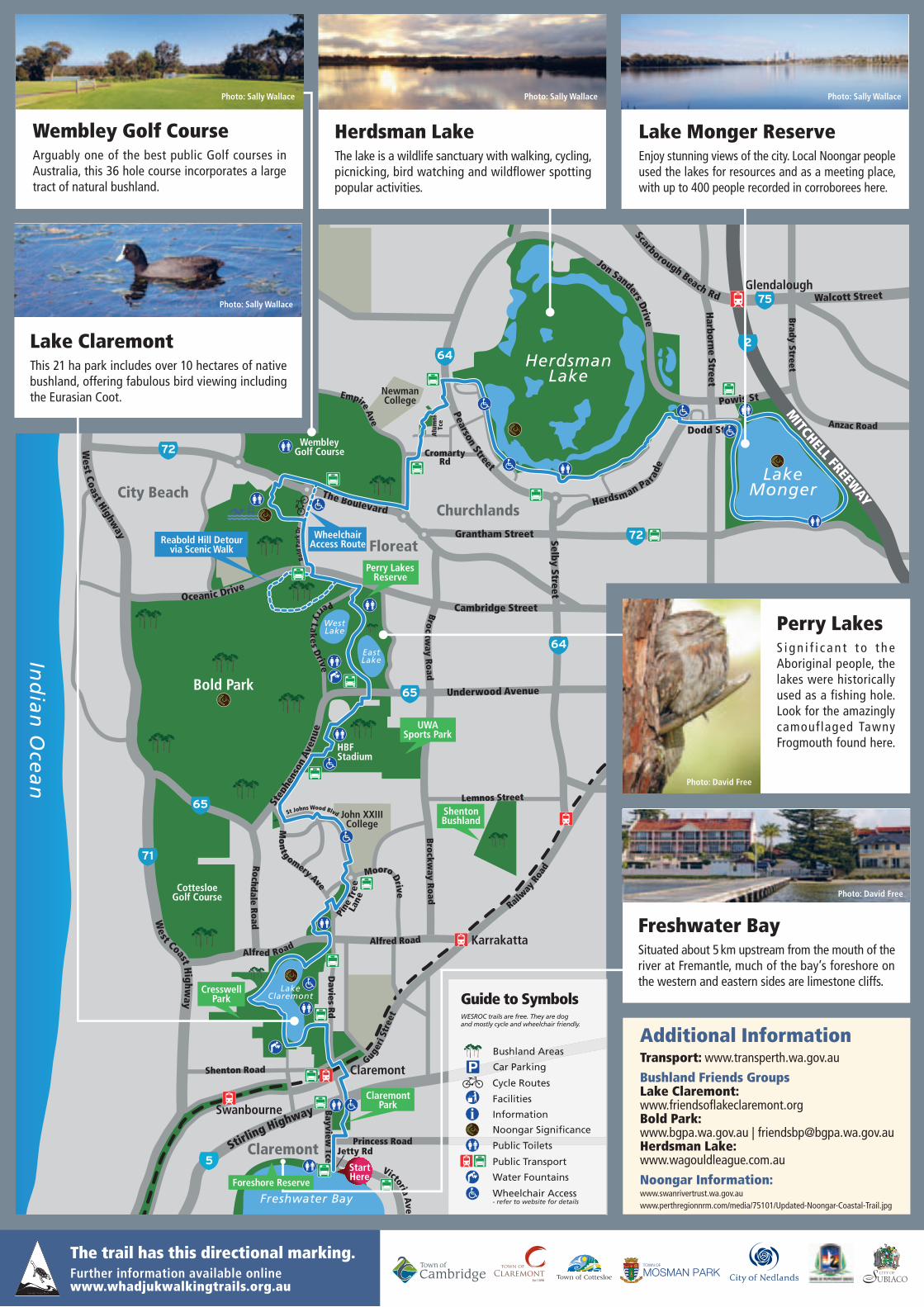
WembleyGolf Course
HerdsmanLake
Bold Park
CottesloeGolf Course
Underwood Avenue
Floreat
City Beach
John XXIIICollege
EastLake
WestLake
Cambridge StreetOceanic Drive
Princess Road
Bayview Tce Stirl
ing Highway
Shenton RoadGuge
ri S
tree
t
Railw
ay R
oad
Davies R
d
LakeClaremont
Mo
ntgomery Ave
St Johns Wood Blvd
Pine
Tre
e
Lan
e
Mooro Drive
Rochd
ale Road
Alfred Road Alfred Road
Step
hens
on A
venu
e
HBFStadium
Perry Lak
es Drive
The Boulevard
Grantham Street
Claremont
Selby Street
Pearson Street
Herdsman Parade
LakeMonger
Empire Ave
Brockw
ay Road Brockw
ay Road
West Coast Highw
ay West Coast H
ighway
NewmanCollege Powis St
Dodd St
Churchlands
Jon Sanders Drive
CromartyRd
Claremont
Swanbourne
Freshwater Bay
Karrakatta
Lemnos Street
Harborne Street
Scarborough Beach Rd Walcott Street
Brady Street Anzac Road
Glendalough
Jetty Rd
Alu
mni
Tc
e
Victoria Ave
Bold
Par
k D
r
ShentonBushland
Perry LakesReserve
StartHere
CresswellPark
65
65
71
5
72
72
64
64
UWASports Park
ClaremontPark
Foreshore Reserve
Reabold Hill Detourvia Scenic Walk
WheelchairAccess Route
75
2
MITCHELL FREEW
AY
Perry LakesS i g n i f i c a n t t o t h e Aboriginal people, the lakes were historically used as a fishing hole. Look for the amazingly camouflaged Tawny Frogmouth found here.
Freshwater BaySituated about 5 km upstream from the mouth of the river at Fremantle, much of the bay’s foreshore on the western and eastern sides are limestone cliffs.
Photo: David Free
Photo: David Free
Wembley Golf CourseArguably one of the best public Golf courses in Australia, this 36 hole course incorporates a large tract of natural bushland.
Herdsman LakeThe lake is a wildlife sanctuary with walking, cycling, picnicking, bird watching and wildfl ower spotting popular activities.
Lake Monger ReserveEnjoy stunning views of the city. Local Noongar people used the lakes for resources and as a meeting place, with up to 400 people recorded in corroborees here.
Photo: Sally Wallace Photo: Sally WallacePhoto: Sally Wallace
Additional InformationTransport: www.transperth.wa.gov.au
Bushland Friends GroupsLake Claremont: www.friendsofl akeclaremont.orgBold Park: www.bgpa.wa.gov.au | [email protected] Lake: www.wagouldleague.com.au
Noongar Information: www.swanrivertrust.wa.gov.auwww.perthregionnrm.com/media/75101/Updated-Noongar-Coastal-Trail.jpg
Bushland Areas
Car Parking
Cycle Routes
Facilities
Information
Noongar Signifi cance
Public Toilets
Public Transport
Water Fountains
Wheelchair Access- refer to website for details
Guide to SymbolsWESROC trails are free. They are dog and mostly cycle and wheelchair friendly.
The trail has this directional marking.Further information available online www.whadjukwalkingtrails.org.au
Lake ClaremontThis 21 ha park includes over 10 hectares of native bushland, offering fabulous bird viewing including the Eurasian Coot.
Photo: Sally Wallace
Photo: David Free
Foreshore Reserve