ʔəy ̓alməxʷ / Iy ̓álmexw LANDS TRANSPORTATION
5
OPEN HOUSE #3 ʔəy ̓alməxʷ / Iy ̓álmexw Policy Planning Program JERICHO LANDS Vancouver has an integrated transportation network that moves people and goods through the city and the region, providing options for travel by walking, cycling, taking transit or driving. TRANSPORTATION Jericho Beach Park Trimble Park McBride Park Hastings Mill Park Almond Park Camosun Park Westmount Park Locarno Beach Park Spanish Banks Beach Park Pacific Spirit Regional Park cific Spirit gional Park Valdez Park Carnarvon Park Trafalgar Park Connaught Park Kitsilano Beach Park Jean Beaty Park Point Grey Road Park Tatlow Park Volunteer Park Margaret Piggot Park Delamont Park Quadra West Park W 5th Ave W 6th Ave W 7th Ave W 9th Ave W 11th Ave W 13th Ave W 14th Ave W 15th Ave W 2nd Ave W 3rd Ave W 1st Ave Trimble St Sasamat St Tolmie St Belmont Ave Drummond Dr Courtenay St Camosun St Wallace St Dunbar St Collingwood St Waterloo St Trutch St Balaclava St Canravon St Mackenzie St W 5th Ave W 6th Ave W 7th Ave W 2nd Ave W 3rd Ave W 1st Ave W 11th Ave W 13th Ave W 14th Ave W 15th Ave W 8th Ave W 17th Ave W 18th Ave W 19th Ave W 20th Ave W 21st Ave W 22nd Ave W 23rd Ave W 24th Ave W 10th Ave W 10th Ave W 12th Ave W 16th Ave Discovery St Blanca St NW Marine Dr Crown St Highbury St Alma St W 8th Ave W 4th Ave Blenheim St Macdonald St W Broadway W 4th Ave Point Grey Rd Dunbar St W 4th Ave W 8th Ave Arbustus St Cornwall Ave Jericho Lands 4, 7, 32 42 4, 44, 84, 258 9, 14 99 99 4, 14, 9, 258 7 2 32 4, 7, 84, 258 2, 32, 258 16 33, 25 Burrard Inlet Future Arbutus SkyTrain Station Existing Transportation Network ʔəy ̓ alməxʷ / Iy ̓ álmexw / Jericho Lands are within walking distance of significant destinations, including Jericho Beach and the high streets along West 4th Ave and West 10th Ave. The overall site slopes upwards from its low point at the northeast corner to the southwest. WALKING The City’s cycling network includes the all ages and abilities (AAA) connection along Point Grey Road, connecting Jericho Beach to other neighbourhoods. CYCLING TransLink provides service in the general vicinity through numerous bus routes, including the 99 B-Line, the busiest bus route in Canada or the US. Frequent transit service, every 15 minutes throughout the day, is also provided on 4th and 16th Avenues. TRANSIT The street network around ʔəy ̓ alməxʷ / Iy ̓ álmexw / Jericho Lands is a developed grid, with major east- west connections along 4th and 10th Avenues, as well as north-south connections on Alma and Blanca Streets. It provides local neighbourhood access as well as service to larger destinations, such as Jericho Beach, Spanish Banks, and UBC. STREETS Parks Project Site Bus Network Greenways 99 B-Line Future Broadway SkyTrain Extension Bike Routes Frequent Transit Network (FTN) - a network of corridors that have transit service every 15 minutes or better Legend Existing Transportation Network Around the Site SECTION 6
Transcript of ʔəy ̓alməxʷ / Iy ̓álmexw LANDS TRANSPORTATION
OPEN HOUSE #3
ʔəy ̓alməxʷ / Iy ̓álmexw
Policy Planning Program
JERICHOLANDS
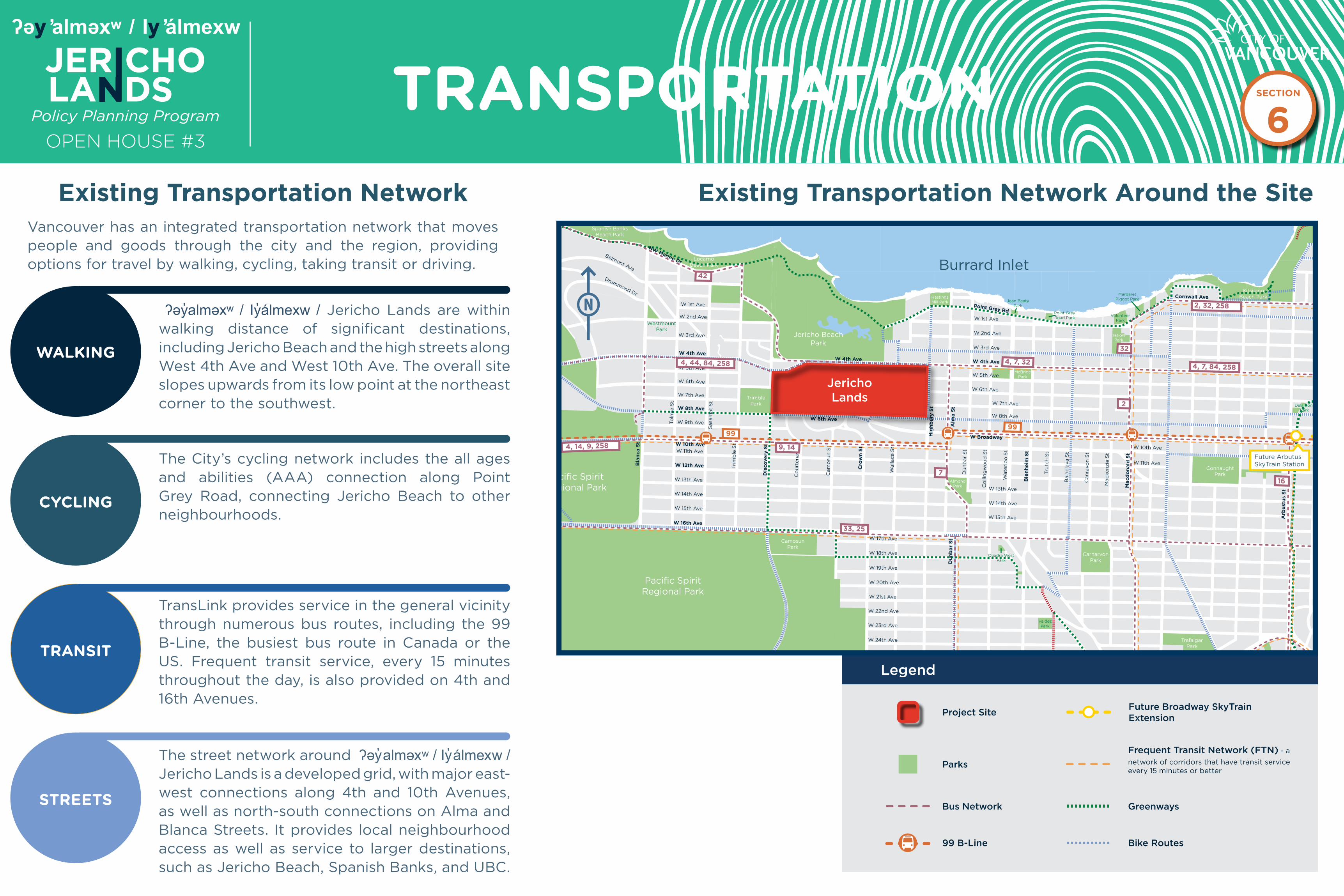
Vancouver has an integrated transportation network that moves people and goods through the city and the region, providing options for travel by walking, cycling, taking transit or driving.
TRANSPORTATIONBurrard Inlet
False Creek
Jericho BeachPark
TrimblePark
McBridePark
HastingsMill Park
AlmondPark
CamosunPark
WestmountPark
LocarnoBeach Park
Spanish BanksBeach Park
Pacific SpiritRegional Park
Pacific SpiritRegional Park
ChaldecottPark
MemorialWest Park
ValdezPark
CarnarvonPark
TrafalgarPark
BalaclavaPark
ConnaughtPark
KitsilanoBeach Park
Jean BeatyPark
Point GreyRoad Park
TatlowPark
VolunteerPark
MargaretPiggot Park
VanierPark
ShaughnessyPark
GranvillePark
QuilchenaPark
Prince ofWales Park
AngusPark
MusqueamPark
MalkinPark
ElmPark
KerrisdaleCentennial
Park
KerrisdalePark
DelamontPark
Maple GrovePark
McCleeryPark
VandusenBotanicalGarden
Oak MeadowsPark
Queen ElizabethPark
DevonshirePark
BraemarPark
DouglasPark
HeatherPark
MontgomeryPark
TisdallPark
ColumbiaPark
HillcrestPark
WillowPark
CharlesonPark
ChoklitPark
GranvilleLoop Park
SutcliffePark
SeaforthPeace Park
Quadra WestPark
Pacific SpiritRegional Park
W 5th Ave
W 6th Ave
W 7th Ave
W 9th Ave
W 11th Ave
W 13th Ave
W 14th Ave
W 15th Ave
W 2nd Ave
W 3rd Ave
W 1st Ave
Tri
mb
le S
t
Sasa
mat
St
Tolm
ie S
t
Belmont Ave
Drummond Dr
Co
urt
en
ay S
t
Cam
osu
n S
t
Walla
ce S
t
Du
nb
ar
St
Co
llin
gw
oo
d S
t
Wate
rlo
o S
t
Tru
tch
St
Bala
cla
va S
t
Can
ravo
n S
t
Macken
zie
St
W 5th Ave
W 6th Ave
W 7th Ave
W 2nd Ave
W 3rd Ave
W 1st Ave
W 11th Ave
W 13th Ave
W 14th Ave
W 15th Ave
W 8th Ave
W 17th Ave
W 18th Ave
W 19th Ave
W 20th Ave
W 21st Ave
W 22nd Ave
W 23rd Ave
W 24th Ave
W 27th Ave
W 29 th Ave
W 30th Ave
W 31st Ave
W 32nd Ave
W 33rd Ave
W 34st Ave
W 35th Ave
W 36th Ave
W 37th Ave
W 38th Ave
W 39th Ave
W 10th AveW 10th Ave
W 12th Ave
W 16th Ave
Dis
co
ve
ry S
t
Bla
nca S
t
NW Marine Dr
Cro
wn
St
Hig
hb
ury
St
Alm
a S
t
W 8th Ave
W 4th Ave
Ble
nh
eim
St
Macd
on
ald
St
W Broadway
W 4th Ave
Point Grey Rd
Du
nb
ar
St
W 4th Ave
W 8th Ave
W King Edward Ave
W 41st Ave
SW Marine Dr
W 33rd Ave
Arb
ust
us
St
Bu
rrard
St
Gra
nvil
le S
t
Oak S
t
Cornwall Ave
Cam
bie
St
JerichoLands
Project Site
Parks
Future BroadwaySkyTrain Extension
Bus Network Greenways
99 B-Line Bike Routes
Frequent Transit Network (FTN) - a network of corridors that have transit service every 15 minutes or better
4, 7, 32
42
44, 84
4, 44, 84, 258
9, 14
9999
4, 14, 9, 258
7
2
32
4, 7, 84, 258
2, 32, 258
16
33, 25
Burrard Inlet
Future Arbutus SkyTrain Station
Existing Transportation Network
ʔəy̓alməxʷ / Iy̓álmexw / Jericho Lands are within walking distance of significant destinations, including Jericho Beach and the high streets along West 4th Ave and West 10th Ave. The overall site slopes upwards from its low point at the northeast corner to the southwest.
WALKING
The City’s cycling network includes the all ages and abilities (AAA) connection along Point Grey Road, connecting Jericho Beach to other neighbourhoods.
CYCLING
TransLink provides service in the general vicinity through numerous bus routes, including the 99 B-Line, the busiest bus route in Canada or the US. Frequent transit service, every 15 minutes throughout the day, is also provided on 4th and 16th Avenues.
TRANSIT
The street network around ʔəy̓alməxʷ / Iy̓álmexw / Jericho Lands is a developed grid, with major east-west connections along 4th and 10th Avenues, as well as north-south connections on Alma and Blanca Streets. It provides local neighbourhood access as well as service to larger destinations, such as Jericho Beach, Spanish Banks, and UBC.
STREETS
Parks
Project Site
Bus Network Greenways
99 B-Line
Future Broadway SkyTrain Extension
Bike Routes
Frequent Transit Network (FTN) - a
network of corridors that have transit service every 15 minutes or better
Legend
Existing Transportation Network Around the Site
SECTION
6

OPEN HOUSE #3
ʔəy ̓alməxʷ / Iy ̓álmexw
Policy Planning Program
JERICHOLANDS
POTENTIAL SKYTRAIN STATION
v
With the upcoming SkyTrain extension to Arbutus to be completed in 2025, TransLink is studying a potential Millennium Line UBC Extension to better connect the region and meet transit demand all along the Broadway Corridor today and well into the future.
The study will help TransLink confirm the objectives of a potential SkyTrain extension, and evaluate possible route options and station locations.
Millennium Line UBC Extension
Potential Station Locations on the Jericho Lands
The Broadway Subway Project is a direct extension of the existing Millennium Line to a new terminus at Arbutus Street.
Scheduled to open in 2025, the province of British Columbia is delivering this project in partnership with TransLink and the City of Vancouver.
Continuing from VCC–Clark Station on an elevated guideway for 700 metres, the extension will then travel underground along Broadway for 5 km.
The Broadway Subway includes 6 new underground stations. Future investments are anticipated to further extend the Millennium Line beyond Arbutus Street to UBC’s Point Grey campus. Until that time, B-Line bus service will continue between Arbutus Street and UBC.
Construction on the Broadway Subway Project is underway. For more information, please visit broadwaysubway.ca.
Broadway Subway Project
Station location options are being considered to potentially serve the Jericho Lands
site as part of this study. The triangle shaped boundary (in the image on the left)
represents the area on the Jericho Lands site where a station would be technically
feasible, subject to further study and analysis.
The two Conceptual Site Plans illustrate the station at the same location, more central
to the site. This location is within the station feasibility boundary, but is subject to
change as the study continues and decisions are made on the Millennium Line UBC
Extension.
Potential StationLocation Boundary
SECTION
6
OPEN HOUSE #3
ʔəy ̓alməxʷ / Iy ̓álmexw
Policy Planning Program
JERICHOLANDS
Burrard Inlet
False Creek
Fire HallNo. 19
Fire HallNo. 12
University ofBritish Columbia
Jericho BeachPark
TrimblePark
McBridePark
HastingsMill Park
AlmondPark
CamosunPark
WestmountPark
LocarnoBeach Park
Spanish BanksBeach Park
Pacific SpiritRegional Park
Pacific SpiritRegional Park
ChaldecottPark
MemorialWest Park
ValdezPark
CarnarvonPark
TrafalgarPark
BalaclavaPark
ConnaughtPark
KitsilanoBeach Park
Jean BeatyPark
Point GreyRoad Park
TatlowPark
VolunteerPark
MargaretPiggot Park
VanierPark
ShaughnessyPark
GranvillePark
QuilchenaPark
Prince ofWales Park
AngusPark
MusqueamPark
MalkinPark
ElmPark
KerrisdaleCentennial
Park
KerrisdalePark
DelamontPark
Maple GrovePark
McCleeryPark
VandusenBotanicalGarden
Oak MeadowsPark
Queen ElizabethPark
DevonshirePark
BraemarPark
DouglasPark
HeatherPark
MontgomeryPark
TisdallPark
ColumbiaPark
HillcrestPark
WillowPark
CharlesonPark
ChoklitPark
GranvilleLoop Park
SutcliffePark
SeaforthPeace Park
Quadra WestPark
Pacific SpiritRegional Park
St. George’sJunior School
Queen ElizabethSchool Annex
St. George’sSenior School
SouthlandsElementary
Crofton HouseSchool
KerrisdaleElementary
Point GreySecondary
QuilchenaElementary
Prince of WalesSecondary
TrafalgarElementary
Henry HudsonElementary
St. AugustineElementary
St. John’sSchool
Lord TennysonElementary
VancouverSchool Board
ShaughnessyElementary
Little FlowerAcademy
York HouseSchool
Maple GroveElementary
MageeSecondary
VancouverCollege
Eric HamberSecondary
Emily CarrElementary
Vancouver TalmudTorah School
Edith CavellElementary
Blessed SacramentElementary
L’EcoleBilingue
Sir William OslerElementary
Annie B. JamiesonElementary
King DavidHigh School
ImmaculateConception
Catholic School
General GordonElementary
KitsilanoSecondary
Carnarvon CommunityElementary
Lord KitchenerElementary
FraserAcademy
Queen ElizabethElementary
Queen MaryElementary
Our Lady ofPerpetual Help
Catholic School
BayviewElementary
University HillElementary
Norma RosePoint School
University HillSecondary
Lord ByngSecondary
Jules QuesnelElementary
KitsilanoCommunity Centre
St JamesCommunity Square
BrockHouse
West Point GreyCommunity Centre
Jericho ArtsCentre
AberthauMansion
Hastings MillStore Museum
West PointGrey Academy
Jericho HillCentre & Gymnasium
W 5th Ave
W 6th Ave
W 7th Ave
W 9th Ave
W 11th Ave
W 13th Ave
W 14th Ave
W 15th Ave
W 2nd Ave
W 3rd Ave
W 1st Ave
Tri
mb
le S
t
Sasa
mat
St
Tolm
ie S
t
Belmont Ave
Drummond Dr
Co
urt
en
ay S
t
Cam
osu
n S
t
Walla
ce S
t
Du
nb
ar
St
Co
llin
gw
oo
d S
t
Wate
rlo
o S
t
Tru
tch
St
Bala
cla
va S
t
Can
ravo
n S
t
Macken
zie
St
W 5th Ave
W 6th Ave
W 7th Ave
W 2nd Ave
W 3rd Ave
W 1st Ave
W 11th Ave
W 13th Ave
W 14th Ave
W 15th Ave
W 8th Ave
W 17th Ave
W 18th Ave
W 19th Ave
W 20th Ave
W 21st Ave
W 22nd Ave
W 23rd Ave
W 24th Ave
W 27th Ave
W 29 th Ave
W 30th Ave
W 31st Ave
W 32nd Ave
W 33rd Ave
W 34st Ave
W 35th Ave
W 36th Ave
W 37th Ave
W 38th Ave
W 39th Ave
W 10th AveW 10th Ave
W 12th Ave
W 16th Ave
Dis
co
ve
ry S
t
Bla
nca S
t
NW Marine Dr
Cro
wn
St
Hig
hb
ury
St
Alm
a S
t
W 8th Ave
W 4th Ave
Ble
nh
eim
St
Macd
on
ald
St
W Broadway
W 4th Ave
Point Grey Rd
Du
nb
ar
St
W 4th Ave
W 8th Ave
W King Edward Ave
W 41st Ave
SW Marine Dr
W 33rd Ave
Arb
ust
us
St
Bu
rrard
St
Gra
nvil
le S
t
Oak S
t
Cornwall Ave
Cam
bie
St
West Point Grey Library
Kitsilano Library
JerichoLands
SCHOOLS
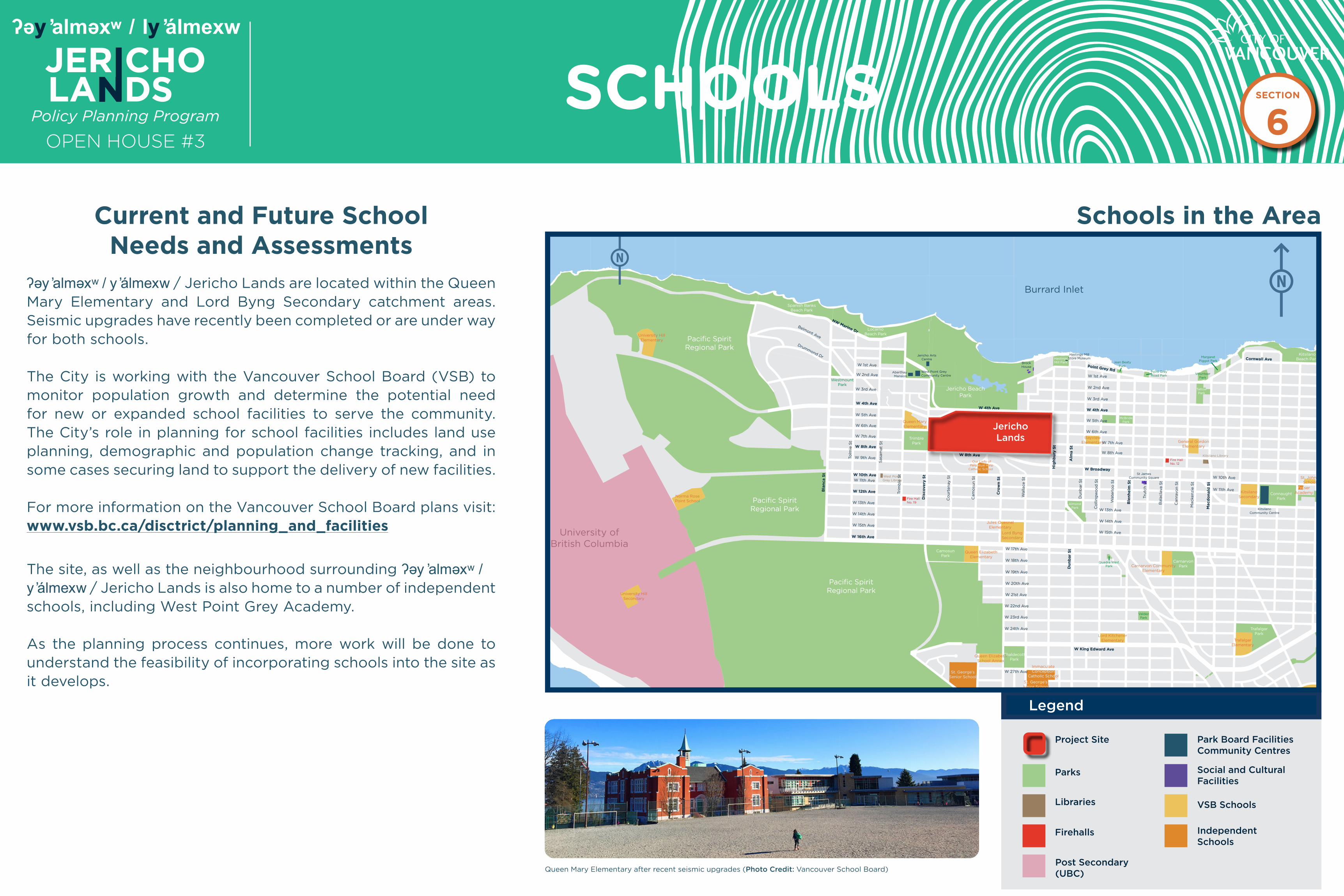
ʔəy ̓alməxʷ / y ̓álmexw / Jericho Lands are located within the Queen Mary Elementary and Lord Byng Secondary catchment areas. Seismic upgrades have recently been completed or are under way for both schools.
The City is working with the Vancouver School Board (VSB) to monitor population growth and determine the potential need for new or expanded school facilities to serve the community. The City’s role in planning for school facilities includes land use planning, demographic and population change tracking, and in some cases securing land to support the delivery of new facilities.
For more information on the Vancouver School Board plans visit: www.vsb.bc.ca/disctrict/planning_and_facilities
Queen Mary Elementary after recent seismic upgrades (Photo Credit: Vancouver School Board)
The site, as well as the neighbourhood surrounding ʔəy ̓alməxʷ / y ̓álmexw / Jericho Lands is also home to a number of independent schools, including West Point Grey Academy.
As the planning process continues, more work will be done to understand the feasibility of incorporating schools into the site as it develops.
Schools in the Area
Project Site
Parks
Libraries VSB Schools
Park Board Facilities Community Centres
Post Secondary (UBC)
Firehalls
Legend
Independent Schools
Social and Cultural Facilities
Current and Future School Needs and Assessments
SECTION
6
OPEN HOUSE #3
ʔəy ̓alməxʷ / Iy ̓álmexw
Policy Planning Program
JERICHOLANDS
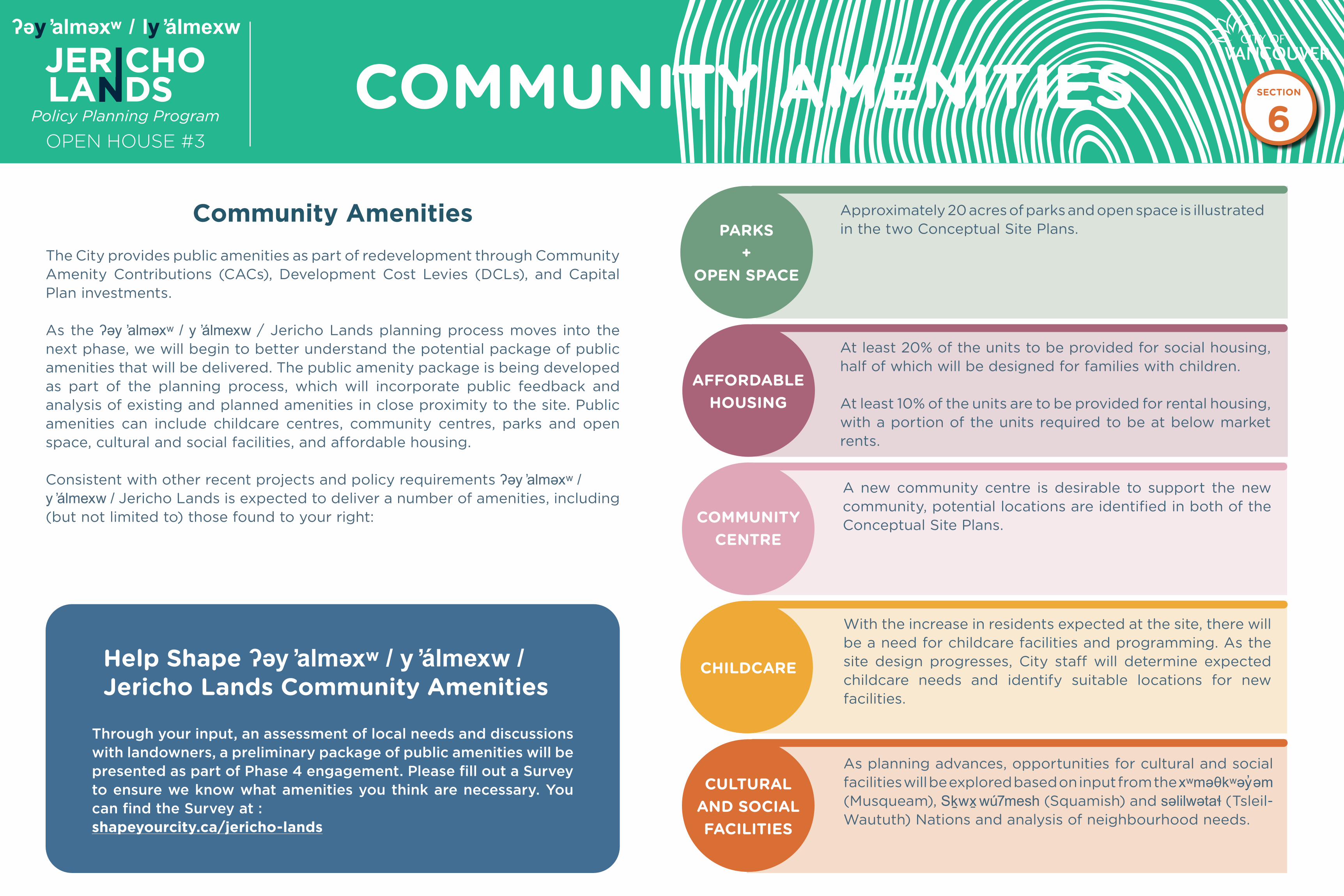
The City provides public amenities as part of redevelopment through Community Amenity Contributions (CACs), Development Cost Levies (DCLs), and Capital Plan investments.
As the ʔəy ̓alməxʷ / y ̓álmexw / Jericho Lands planning process moves into the next phase, we will begin to better understand the potential package of public amenities that will be delivered. The public amenity package is being developed as part of the planning process, which will incorporate public feedback and analysis of existing and planned amenities in close proximity to the site. Public amenities can include childcare centres, community centres, parks and open space, cultural and social facilities, and affordable housing.
Consistent with other recent projects and policy requirements ʔəy ̓alməxʷ / y ̓álmexw / Jericho Lands is expected to deliver a number of amenities, including (but not limited to) those found to your right:
Community Amenities
COMMUNITY AMENITIES Approximately 20 acres of parks and open space is illustrated in the two Conceptual Site Plans.PARKS
+ OPEN SPACE
At least 20% of the units to be provided for social housing, half of which will be designed for families with children.
At least 10% of the units are to be provided for rental housing, with a portion of the units required to be at below market rents.
AFFORDABLEHOUSING
COMMUNITY CENTRE
A new community centre is desirable to support the new community, potential locations are identified in both of the Conceptual Site Plans.
With the increase in residents expected at the site, there will be a need for childcare facilities and programming. As the site design progresses, City staff will determine expected childcare needs and identify suitable locations for new facilities.
CHILDCARE
CULTURAL AND SOCIAL FACILITIES
As planning advances, opportunities for cultural and social facilities will be explored based on input from the xʷməθkʷəy̓əm (Musqueam), Sḵwx̱ wú7mesh (Squamish) and səlilwətaɬ (Tsleil-Waututh) Nations and analysis of neighbourhood needs.
Through your input, an assessment of local needs and discussions with landowners, a preliminary package of public amenities will be presented as part of Phase 4 engagement. Please fill out a Survey to ensure we know what amenities you think are necessary. You can find the Survey at : shapeyourcity.ca/jericho-lands
Help Shape ʔəy ̓alməxʷ / y ̓álmexw / Jericho Lands Community Amenities
SECTION
6

OPEN HOUSE #3
ʔəy ̓alməxʷ / Iy ̓álmexw
Policy Planning Program
JERICHOLANDS WHAT’S NEXT
What’s next?
Key Opportunities to Shape the Plan
Fall / Winter 2018Phase 1: Background Phase
Spring / Summer 2019Phase 1: Information Gathering
Fall / Winter 2020Phase 2: Confirm draft Guiding Principles and Emerging Ideas
Winter 2022Phase 3: Preferred Site Concept +Emerging Policies
Spring 2022Phase 4: Refine Concept +Draft Policy Statement
We Are HereFall 2021Phase 3: Site Concepts DevelopmentPhase 3 (virtual) Kick-off event, comment form, Talk to a Team Member engagement, online feedback, and Jericho Lands Working Group.
Summer 2022Phase 4: Policy Statement and Report to Council
Talk to a Team Member: Register online for a time to talk to City staff and the project team.
Fill out a Survey online.
You can also write to us at: [email protected]
Join our email list by clicking Register at the top right corner of the project web page to be notified of future public events and project updates.
Visit the website to learn and join in on future events and tell us what you think about our progress.
Stay involved
Share Your Thoughts and Stay Informed
Share your feedback and stay up to date with ʔəy ̓alməxʷ / y ̓álmexw / Jericho Lands planning program on our project website: shapeyourcity.ca/jericholands
On the project website you can:
Fill out the Survey
Please let us know what you think about the two conceptual site plan options.
Fill out the Survey available on our project web page, here: shapeyourcity.ca/jericho-landsYour feedback will be used to help shape a preferred concept plan.
We want to hear from you
Come visit us at our temporary pop-up remote office at 2070 Alma Street. Between Tuesday, October 19 and Wednesday, November 10, City staff will be hosting remote office hours in the neighbourhood. We will be available by-appointment to discuss the Jericho Lands Conceptual Site Plan Options and answer any questions you may have about them. Drop-ins may be accommodated if space is available.
To learn more visit our project web page at shapeyourcity.ca/jericho-lands for the up-to-date information, and to register.
Talk With a Team Member
SECTION
6