
XX International Symposium Modern technologies, education and professional practice in geodesy and...
20
XX XX International Symposium International Symposium Modern technologies Modern technologies , , education and professional practice in geodesy and education and professional practice in geodesy and related areas related areas , 23–24 , 23–24 September September , 2010 , 2010 Albena Resort Albena Resort , , Varna Varna SDAA SDAA – – NEW STAGE IN THE DEVELOPMENT NEW STAGE IN THE DEVELOPMENT OF THE INFORMATION POLICY IN BULGARIA OF THE INFORMATION POLICY IN BULGARIA MINISTRY OF TRANSPORT MINISTRY OF TRANSPORT , , INFORMATION TECHNOLOGY AND INFORMATION TECHNOLOGY AND COMMUNICATIONS COMMUNICATIONS EXECUTIVE AGENCY EXECUTIVE AGENCY “ ELECTRONIC COMMUNICATION NETWORKS AND INFORMATION SYSTEMS ELECTRONIC COMMUNICATION NETWORKS AND INFORMATION SYSTEMS ” ”
-
Upload
oliver-conley -
Category
Documents
-
view
213 -
download
0
Transcript of XX International Symposium Modern technologies, education and professional practice in geodesy and...

XX XX International SymposiumInternational SymposiumModern technologiesModern technologies, , education and professional practice in education and professional practice in
geodesy and related areasgeodesy and related areas, 23–24 , 23–24 SeptemberSeptember, 2010 , 2010 Albena ResortAlbena Resort, , VarnaVarna
SDAASDAA – – NEW STAGE IN THE DEVELOPMENT NEW STAGE IN THE DEVELOPMENT OF THE INFORMATION POLICY IN BULGARIAOF THE INFORMATION POLICY IN BULGARIA
MINISTRY OF TRANSPORTMINISTRY OF TRANSPORT, , INFORMATION TECHNOLOGY AND INFORMATION TECHNOLOGY AND COMMUNICATIONSCOMMUNICATIONS
EXECUTIVE AGENCY EXECUTIVE AGENCY ““ELECTRONIC COMMUNICATION NETWORKS AND ELECTRONIC COMMUNICATION NETWORKS AND INFORMATION SYSTEMSINFORMATION SYSTEMS” ”
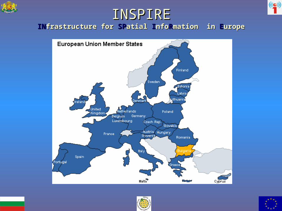
INSPIREINSPIREIINNfrastructure for frastructure for SSPPatial atial IInfonfoRRmation mation in in EEuropeurope

INSPIREINSPIREIINNfrastructure for frastructure for SSPPatial atial IInfonfoRRmation mation in in EEuropeurope
DirectiveDirective 2007/2/ЕО 2007/2/ЕО
INSPIRE enters into force onINSPIRE enters into force on15 15 May May 20072007
INSPIRE INSPIRE defines common rules for the establishment of infrastructures for spatial information in defines common rules for the establishment of infrastructures for spatial information in EuropeEurope;;
INSPIREINSPIRE is based on an infrastructure for existing spatial information managed by the Member is based on an infrastructure for existing spatial information managed by the Member StatesStates;;
INSPIRE INSPIRE is distributed infrastructureis distributed infrastructure;;
NSPIRE NSPIRE does not set requirements for the collection of new spatial datadoes not set requirements for the collection of new spatial data;;
INSPIRE INSPIRE does not affect the existence or ownership of public authorities’ intellectual property does not affect the existence or ownership of public authorities’ intellectual property rightsrights;;
INSPIRE provides for data sharing and establishment of infrastructures for spatial information at INSPIRE provides for data sharing and establishment of infrastructures for spatial information at European levelEuropean level..
VISION OF THE INSPIRE DIRECTIVEVISION OF THE INSPIRE DIRECTIVE 2007/2/ЕО2007/2/ЕО
The DirectiveThe Directive pertains to existing data in electronic form that are pertains to existing data in electronic form that are maintained at a level making theme efficient to a maximum extentmaintained at a level making theme efficient to a maximum extent..
The DirectiveThe Directive stipulates the possibility stipulates the possibility to combine spatial data from to combine spatial data from different sources across the Community in a consistent way and share different sources across the Community in a consistent way and share them between different users and applicationsthem between different users and applications..
The spatial informationThe spatial information, , necessary for taking adequate management necessary for taking adequate management decisions at all levels should be reached under conditions that do not decisions at all levels should be reached under conditions that do not prevent its wide useprevent its wide use..
The spatial information should be easy to discover and meet the needs The spatial information should be easy to discover and meet the needs for specific use or the conditions that allow it to be acquired and usedfor specific use or the conditions that allow it to be acquired and used..
The spatial data should be easy to understand and interpret that will The spatial data should be easy to understand and interpret that will result in diligent documentation and visualisation in a suitable context result in diligent documentation and visualisation in a suitable context chosen by the user of such datachosen by the user of such data..

The infrastructureThe infrastructure forfor spatial informationspatial information include:include:
-- metadatametadata;;-- spatial data sets and services;spatial data sets and services;- network services and technologies- network services and technologies;;- agreements on sharing, access and use- agreements on sharing, access and use; ; - coordination and monitoring mechanisms- coordination and monitoring mechanisms; ; - processes and procedures- processes and procedures..

The infrastructure for spatial information in the European Community should assist environmental policies and policies or activities that may have an impact on the environment.
Annex I
1. Coordinate reference systems.
2. Geographical grid systems.
3. Geographical names.
4. Administrative units.
5. Addresses.
6. Cadastral parcels.
7. Transport networks.
8. Hydrography.
9. Protected sites.
The data, related to those policies are grouped by themes defined in Annex I, II and III.

AnnexAnnex II II 1. 1. ReliefRelief 2. 2. Land coverLand cover
3. 3. Ortho imageryOrtho imagery4. 4. GeologyGeology
AnnexAnnex III III1. 1. Statistical unitsStatistical units2. 2. BuildingsBuildings3. 3. SoilSoil4. 4. Land useLand use5. 5. Human health and safetyHuman health and safety6. 6. Utility and governmental servicesUtility and governmental services7. 7. Environmental monitoring facilitiesEnvironmental monitoring facilities8. 8. Production and industrial facilitiesProduction and industrial facilities9. 9. Agricultural and aquaculture facilitiesAgricultural and aquaculture facilities10. 10. Population distributionPopulation distribution –– demographydemography1111. Area management. Area management//restrictionrestriction//regulation zonesregulation zones and reporting unitsand reporting units12. 12. Natural risk zonesNatural risk zones13. 13. Atmospheric conditionsAtmospheric conditions14. 14. Meteorological geographical featuresMeteorological geographical features15. 15. Oceanographic geographical featuresOceanographic geographical features16. 16. Sea regionsSea regions17. 17. Bio-geographical regionsBio-geographical regions18. 18. Habitats and biotopesHabitats and biotopes19. 19. Species distributionSpecies distribution20. 20. Energy resourcesEnergy resources21. Mineral resources21. Mineral resources

88
EUROPEAN GEO-PORTAL
INSPIRE
Community policy of establishing infrastructures for spatial information
COORDINATING BODY
EUROPEAN COMMISSION
DIRECTIVE INSPIRE
NATIONAL LEGISLATION
NATIONAL PORTAL FOR SPATIAL DATA
MINISTRIES
PRODUCED METADATA FOR SPATIAL DATA SETS AND
SERVICES – DECEMBER 2010
MUNICIPAL AND REGIONAL
ADMINISTRATIONS
STANDARDIZE DATA ACCORDING TO ISO, OGC,
STRUCTURE UNDER INSPIRE
THIRD PARTIES
ISSUES
1. REGULATIONS2. TECHNICAL GUIDELINES 3. TECHNICAL SPECIFICATIONS4. IMPLEMENTING RULES5. OTHER DOCUMENTS
CREATES
REQ
UEST
S FO
R SE
RVIC
ES
PRO
VISI
ON
OF
SERV
ICES
REPORTING FOR IMPLEMENTATION
TRANSPOSED INTO
AND CONTROLS
PRODUCED MANDATORY SERVICES WITH DATA AND
METADATA
SHARING AGREEMENTS
MANDATORY ACTIVITIES
REQUESTS FOR SERVICES
AGENCIES

99
SPATIAL DATA SPATIAL DATA ACCESS ACTACCESS ACT
1. 1. SDAASDAA pertains to existing data in electronic format, that pertains to existing data in electronic format, that are held on behalf of a public authorityare held on behalf of a public authority, , having been having been produced, or being managed and updated by that authority, produced, or being managed and updated by that authority, and fall within the scope of its public tasksand fall within the scope of its public tasks;;
2. 2. SDAASDAA pertains to existing data in electronic format, that pertains to existing data in electronic format, that have been produced and are being managed and updated by have been produced and are being managed and updated by third parties, providing public servicesthird parties, providing public services;;
3. 3. SDAASDAA gives definitions of terms and notions in order to gives definitions of terms and notions in order to standardize the terminology and content with which the EU standardize the terminology and content with which the EU Member States will work in the process of establishing the Member States will work in the process of establishing the European European infrastructureinfrastructure for for spatial informationspatial information;;
4. 4. SDAASDAA defines the basic requirements on establishing the defines the basic requirements on establishing the national spatial data national spatial data infrastructure, as defined ininfrastructure, as defined in DirectiveDirective 2007/2/ЕО 2007/2/ЕО INSPIREINSPIRE, , abiding by the requirements on abiding by the requirements on harmonization of the national legislation with the European harmonization of the national legislation with the European legislationlegislation;;
5. 5. SDAASDAA defines the regulatory and control mechanisms defines the regulatory and control mechanisms regarding the establishment of the spatial data infrastructure regarding the establishment of the spatial data infrastructure and the corresponding administrative and penal liabilities of and the corresponding administrative and penal liabilities of entities responsible for the implementation of the Actentities responsible for the implementation of the Act..

1010
Chapter OneChapter One: : GENERAL PROVISIONSGENERAL PROVISIONS
Chapter TwoChapter Two: : INFRASTRUCTURE FOR SPATIAL INFRASTRUCTURE FOR SPATIAL INFORMATIONINFORMATIONSectionSection І: І: Spatial dataSpatial dataSectionSection ІІ: ІІ: MetadataMetadataSectionSection ІІІ: ІІІ: National portal for spatial dataNational portal for spatial data
Chapter ThreeChapter Three: : SPATIAL DATA SERVICESSPATIAL DATA SERVICESSectionSection І: І: ServicesServicesSectionSection ІІ: ІІ: Interoperability and standardsInteroperability and standards
Chapter FourChapter Four: : REGULATION AND CONTROLREGULATION AND CONTROL
Chapter FiveChapter Five: : ADMINISTRATIVE AND PENAL ADMINISTRATIVE AND PENAL LIABILITIESLIABILITIES
ADDITIONAL PROVISIONSADDITIONAL PROVISIONS
TRANSITIONAL AND FINAL PROVISIONSTRANSITIONAL AND FINAL PROVISIONS
AnnexesAnnexes 1, 2 1, 2 andand 3. 3.
SPATIAL DATA SPATIAL DATA ACCESS ACTACCESS ACT

1111
ArticleArticle 4. (1) 4. (1) This Act shall be implemented by the executive power This Act shall be implemented by the executive power
authorities, local self-government authorities and organizations that, authorities, local self-government authorities and organizations that, by virtue of normative acts, collect, produce and maintain updated by virtue of normative acts, collect, produce and maintain updated spatial data bases in connection with the implementation of their spatial data bases in connection with the implementation of their authorities and provide public servicesauthorities and provide public services. .
(2) (2) Third partiesThird parties, , other than the entities under other than the entities under ArticleArticle 1, 1, can provide can provide spatial data and services, produced and maintained by them, within spatial data and services, produced and maintained by them, within the infrastructure forthe infrastructure for spatial informationspatial information..

1212
ArticleArticle 4. (5) 4. (5) The exchange of spatial data sets and services shall be The exchange of spatial data sets and services shall be carried out through the National portal for spatial data.carried out through the National portal for spatial data.ArticleArticle 12. (1) 12. (1) The National portal for spatial data shall provide The National portal for spatial data shall provide access to spatial data sets, metadata and spatial data servicesaccess to spatial data sets, metadata and spatial data services of of various sources in a unified way.various sources in a unified way.(2) Лицата по (2) Лицата по ArticleArticle 4, 4, para.para. 1 1 andand 2 2 provide access to the spatial provide access to the spatial data setsdata sets, , metadatametadata and spatial data servicesand spatial data services through the National through the National portal for spatial dataportal for spatial data..(3) (3) The National portal for spatial data shall provide services related The National portal for spatial data shall provide services related to reference data sets.to reference data sets.(4) (4) The National portal for spatial data shall be established and The National portal for spatial data shall be established and operated by theoperated by the Executive Agency "Electronic Communication Executive Agency "Electronic Communication Networks and Information Systems"Networks and Information Systems" to the minister of transportto the minister of transport, , information technologies and communications.information technologies and communications.
1313
ArticleArticle 19. (1) 19. (1) The minister of transport, information technology and The minister of transport, information technology and communicationscommunications shall pursue the state policy in the field of shall pursue the state policy in the field of spatial spatial data infrastructuredata infrastructure. . ArticleArticle 20. (1) 20. (1) The minister of transport, information technology and The minister of transport, information technology and communicationscommunications shall perform the functions of a national contact shall perform the functions of a national contact body with the European Commission on issues related to the body with the European Commission on issues related to the harmonization of the conditions for access to the national data sets harmonization of the conditions for access to the national data sets on the part of the European Union.on the part of the European Union.ArticleArticle 21. (1) 21. (1) The minister of transport, information technology and The minister of transport, information technology and communicationscommunications shall be the regulatory and control body for shall be the regulatory and control body for regulation and control of the spatial data regulation and control of the spatial data infrastructureinfrastructure. . ArticleArticle 23. 23. While exercising his authorities under this Act, the While exercising his authorities under this Act, the minister of transportminister of transport, , information technologies and communicationsinformation technologies and communications shall be assisted byshall be assisted by: : 1. 1. Executive Agency "Electronic Communication Networks and Executive Agency "Electronic Communication Networks and Information Systems"Information Systems";;2. 2. Interdepartmental Council on Spatial Data, hereinafter called Interdepartmental Council on Spatial Data, hereinafter called “Interdepartmental Council”.“Interdepartmental Council”.

1414
REGULATIONSREGULATIONS
RegulationRegulation No 1205/2008No 1205/2008 ofof 3 3 DecemberDecember 2008 2008 implementing Directive 2007/2/EC of the European implementing Directive 2007/2/EC of the European Parliament and of the Council as regards metadataParliament and of the Council as regards metadata;;
RegulationRegulation NoNo 976/2009976/2009 ofof 19 19 October 2009 October 2009 implementing Directive 2007/2/EC of the European implementing Directive 2007/2/EC of the European Parliament and of the Council as regards the Network Parliament and of the Council as regards the Network ServicesServices;;
RegulationRegulation No No 268/2010268/2010 ofof 29 29 March 2010 March 2010 implementing Directive 2007/2/EC of the European implementing Directive 2007/2/EC of the European Parliament and of the Council as regards the access to Parliament and of the Council as regards the access to spatial data sets and services of the Member States by spatial data sets and services of the Member States by Community institutions and bodies under harmonised Community institutions and bodies under harmonised conditionsconditions;;
DecisionDecision No No 2009/442/EC2009/442/EC ofof 5 5 June 2009 June 2009 implementing Directive 2007/2/EC of the European implementing Directive 2007/2/EC of the European Parliament and of the Council as regards monitoring and Parliament and of the Council as regards monitoring and reportingreporting..

1515
DRAFT DRAFT COMMISSION COMMISSION
REGULATIONSREGULATIONS
Draft Commission RegulationDraft Commission Regulation amending Regulation amending Regulation (EC) (EC) No 976/2009No 976/2009 as regards download services and as regards download services and transformation servicestransformation services - - 14.12.200914.12.2009
Draft Commission Regulation on Draft Commission Regulation on implementing implementing Directive 2007/2/EC of the European Parliament Directive 2007/2/EC of the European Parliament and of the Council as regards interoperability of and of the Council as regards interoperability of spatial data sets and servicesspatial data sets and services - - 14.12.200914.12.2009
Draft Commission Regulation Draft Commission Regulation amending Regulation amending Regulation (EU) (EU) No 976/2010No 976/2010 implementing Directive implementing Directive 2007/2/EC of the European Parliament and of the 2007/2/EC of the European Parliament and of the Council as regards interoperability of spatial data Council as regards interoperability of spatial data sets and servicessets and services - - 17.06.201017.06.2010

1616
TECHNICAL TECHNICAL GUIDESGUIDES
Guidelines for encoding spatial dataGuidelines for encoding spatial data (D.2.7, V.3.2) (D.2.7, V.3.2) 02.08.2010 02.08.2010
INSPIRE INSPIRE Generic conceptual modelGeneric conceptual model (D 2.5, V.3.3) (D 2.5, V.3.3) 18.06.2010 18.06.2010
Definition of annex themes and scopeDefinition of annex themes and scope (D 2.3, (D 2.3, V.3.0) V.3.0) 03.10.2008 03.10.2008
Methodology for the development of data Methodology for the development of data specificationsspecifications: : baseline version baseline version (D 2.6, Version (D 2.6, Version 3.0) 3.0) 20.06.200820.06.2008
• Implementing rules onImplementing rules on ddownload ownload sserviceservices;;• Implementing rules onImplementing rules on ttransformation ransformation sserviceservices;;• Implementing rules onImplementing rules on INSPIRE spatial data INSPIRE spatial data
services;services;• Implementing rules on monitoring and reportingImplementing rules on monitoring and reporting
IMPLEMENTING IMPLEMENTING RULESRULES

1717
DATA DATA SPECIFICATIONSSPECIFICATIONS
Data specificationData specification onon addressesaddresses, v.3.0.1 - , v.3.0.1 - 03.05.2010 03.05.2010
Data specificationData specification onon protected sitesprotected sites, v.3.1.0 , v.3.1.0 - - 03.05.201003.05.2010
Data specificationData specification onon administrative unitsadministrative units, , v.3.0.1- v.3.0.1- 03.05.201003.05.2010
Data specificationData specification onon cadastral parcelscadastral parcels, , v.3.0.1 - v.3.0.1 - 03.05.201003.05.2010
Data specificationData specification onon geographical grid geographical grid systemssystems, v.3.0.1 - , v.3.0.1 - 03.05.201003.05.2010
Data specificationData specification onon hydrographhydrograph, v.3.0.1- , v.3.0.1- 03.05.2010 03.05.2010
Data specificationData specification onon transport networkstransport networks, , v.3.1 -v.3.1 -03.05.2010 03.05.2010
Data specificationData specification onon coordinate reference coordinate reference systemssystems, v.3.1 - , v.3.1 - 03.05.201003.05.2010
Data specificationData specification onon geographical namesgeographical names, , v.3.0.1 - v.3.0.1 - 03.05.201003.05.2010

1818
MILESTONESMILESTONES
MILESTONE DATEMILESTONE DATE DESCRIPTIONDESCRIPTION
15 15 May May 20102010 Implementation of provisions for monitoring and Implementation of provisions for monitoring and reportingreporting
03 03 December December 20102010 Availability of Availability of metadatametadata for spatial data in for spatial data in accordance with accordance with AnnexAnnex I andI and IIII
19 October 19 October 20112011 Implementation of Regulation as regards to the Implementation of Regulation as regards to the access to spatial data sets and services of the access to spatial data sets and services of the Member States by Community institutions and Member States by Community institutions and bodies under harmonized conditionsbodies under harmonized conditions
09 09 November November 20112011 Operational discovery and view servicesOperational discovery and view services
June June 20122012 Newly collected and extensively restructured Newly collected and extensively restructured available spatial data sets from available spatial data sets from AnnexAnnex II
December December 20122012 Operational transformation and download servicesOperational transformation and download services

1919
IMPENDING TASKSIMPENDING TASKS
1. 1. To create a national concept on the establishment of an To create a national concept on the establishment of an infrastructureinfrastructure for spatial information on the national portal for access for spatial information on the national portal for access to spatial datato spatial data;;
2. 2. Each state structure should make a survey on the available spatial Each state structure should make a survey on the available spatial data and their compliance with the requirements of the Spatial Data data and their compliance with the requirements of the Spatial Data Access Act and the effective Regulations of the EC;Access Act and the effective Regulations of the EC;
3. 3. Setting up state expert capacity for establishment and operation of Setting up state expert capacity for establishment and operation of thetheinfrastructureinfrastructure for spatial data and for ensuring its sustainability;for spatial data and for ensuring its sustainability;
4. 4. Drafting a Roadmap, including stages and deadlines for establishing Drafting a Roadmap, including stages and deadlines for establishing the the infrastructureinfrastructure for for spatial informationspatial information, , conforming to the deadlines conforming to the deadlines in the Regulations.in the Regulations.

THANK YOU FOR YOUR ATTENTIONTHANK YOU FOR YOUR ATTENTION!!
LILYANA TURNALIEVALILYANA TURNALIEVA
HEAD OF SPATIAL DATA DEPARTMENTHEAD OF SPATIAL DATA DEPARTMENTEEА “ЕСА “ЕСNISNIS”, МТ”, МТIIТСТС
[email protected]@esmis.government.bg