XISTING CONDITIONS REPORT · 2015-05-21 · Existing Conditions Report Page | 1 1.0 INTRODUCTION...
40
EXISTING CONDITIONS REPORT FOR THE BRIDGE BOULEVARD CORRIDOR REDEVELOPMENT PLAN PREPARED FOR : BERNALILLO COUNTY PUBLIC WORKS DIVISION 2400 BROADWAY SE ALBUQUERQUE, NM 87102 PREPARED BY: HDR E NGINEERING, I NC. 2155 LOUISIANA BLVD NE, SUITE 9500 ALBUQUERQUE, NM 87110 Revised May 2013
Transcript of XISTING CONDITIONS REPORT · 2015-05-21 · Existing Conditions Report Page | 1 1.0 INTRODUCTION...

EXISTING CONDITIONS REPORT FOR THE BRIDGE BOULEVARD CORRIDOR REDEVELOPMENT PLAN
PREPARED FOR: BERNALILLO COUNTY PUBLIC WORKS DIVISION 2400 BROADWAY SE ALBUQUERQUE, NM 87102 PREPARED BY: HDR ENGINEERING, INC. 2155 LOUISIANA BLVD NE, SUITE 9500 ALBUQUERQUE, NM 87110
Revised May 2013

Existing Conditions Report Page | i
CONTENTS 1.0 Introduction .......................................................................................................................................................... 1
1.1 Background ...................................................................................................................................................... 1 1.2 Project Location .............................................................................................................................................. 1
2.0 Project Purpose and Need ............................................................................................................................... 2 3.0 Alternatives............................................................................................................................................................ 4
3.1 Main Street Alternative................................................................................................................................. 4 3.2 Flexible Lanes Alternative ........................................................................................................................... 5 3.3 Boulevard Alternative .................................................................................................................................. 5 3.4 Preferred Option ............................................................................................................................................. 6
4.0 Existing Environmental Conditions .............................................................................................................. 7 4.1 General Project Setting ................................................................................................................................ 7 4.2 Traffic Operations ........................................................................................................................................... 8 4.3 Land Use ......................................................................................................................................................... 10 4.4 Social and Economic Conditions ........................................................................................................... 12 4.5 Visual Resources ........................................................................................................................................... 17 4.6 Cultural Resources....................................................................................................................................... 17 4.7 Acquisitions and Relocations .................................................................................................................. 18 4.8 Specially Designated Areas ...................................................................................................................... 18 4.9 Noise ................................................................................................................................................................ 19 4.10 Air Quality ....................................................................................................................................................... 19 4.11 Hazardous Materials ................................................................................................................................... 20 4.12 Surface Water and Wetlands ................................................................................................................... 23 4.13 Biological Resources ................................................................................................................................... 23 4.14 Preliminary Identification of Potential Impacts ................................................................................ 28
5.0 Public and Agency Outreach ....................................................................................................................... 35 5.1 Key Issues and Concerns ........................................................................................................................... 36
6.0 Next Steps ........................................................................................................................................................... 36

Page | ii Existing Conditions Report
FIGURES Figure 1. Project Area ....................................................................................................................................................... 3 Figure 2. Main Street Typical Section ......................................................................................................................... 4 Figure 3. Flexible Lanes Typical Section .................................................................................................................... 5 Figure 4. Boulevard Typical Section ............................................................................................................................ 6 Figure 5. PNM Distribution Lines............................................................................................................................... 12 Figure 6. Environmental Justice Analysis Boundaries ....................................................................................... 13 Figure 7. Schools and Public Facilities ..................................................................................................................... 16 Figure 8. EDR Findings .................................................................................................................................................. 23
TABLES Table 1. Bridge Boulevard Corridor Income Distribution ................................................................................. 14 Table 2. Bridge Boulevard Corridor Ethnicity ....................................................................................................... 14 Table 3. EDR Listing of Findings ................................................................................................................................ 21 Table 4. Threatened and Endangered Species List for Bernalillo County................................................... 25 Table 5. Matrix of preliminary identification of potential impacts ............................................................... 28

Existing Conditions Report Page | 1
1.0 INTRODUCTION
1.1 BACKGROUND Bernalillo County (County) was awarded a $500,000 TIGER II/Community Challenge Planning grant from the U.S. Department of Housing and Urban Development (HUD) and U.S. Department of Transportation (DOT), Federal Highway Administration (FHWA), to develop a long-range redevelopment plan that integrates housing, economic development, land use planning, and transportation infrastructure improvement strategies. The Bridge Boulevard Corridor Redevelopment Plan planning project incorporates each of those disciplines into one plan.
FHWA has provided $328,125 in TIGER II funding for the study and conceptual design. Funding for design and construction in the amount of $22.9 million has been identified in the Transportation Improvement Program (TIP) beginning in informational year 2016. Additional funding sources may include Bernalillo County and other public and private entities.
The National Environmental Policy Act of 1969 (NEPA) requires a systematic, interdisciplinary approach to planning and project implementation. It emphasizes that the environmental impacts of federally-funded projects must be given serious consideration in the decision-making process. Environmental documentation consistent with NEPA and other applicable laws and regulations is required on federally-funded projects unless there is a specific exemption or exclusion related to the nature of the project. Environmental studies, resource identification, the development of plans and strategies, and engineering design and costs are specifically exempted from HUD NEPA regulations pursuant to 58 CFR 34(a)(1) and (8) and the 2010 Cooperative Agreement between the FHWA and Bernalillo County for the Tiger II grant states that: “no NEPA decision can be made by FHWA until the recipient has identified that full funding is reasonably available for completion of all phases of the project.”
This report provides a preliminary baseline overview of environmental conditions and documents literature and existing database searches and limited field survey and reconnaissance work performed to identify natural and cultural resources, environmentally sensitive areas, and sensitive communities. The information provided in this report will allow for seamless integration into the NEPA process once funding is secured and design phases begin.
1.2 PROJECT LOCATION Bridge Boulevard is a major travel corridor that carries approximately 30,000 cars, trucks, and buses per day across the Rio Grande. It is one of the few east-west river crossings in the South Valley that connects the rapidly growing Southwest Mesa with the destinations on the east side of the Rio Grande and one of only nine river crossings in the Albuquerque Metropolitan Area. Bridge Boulevard is mostly within unincorporated Bernalillo County, New Mexico, with a portion of the
Page | 2 Existing Conditions Report
project area lying within Albuquerque city limits. The project limits are Bridge Boulevard SW from the Barelas Bridge to Coors Boulevard. The project area follows the Tower Road alignment from Old Coors to Coors Boulevard. The project area is shown in Figure 1.
2.0 PROJECT PURPOSE AND NEED Transportation system improvements to Bridge Boulevard would help to maintain acceptable traffic flow, increase public safety, and enhance mobility for all users in the corridor. In addition, transportation system and mobility infrastructure improvements would directly support sustainable development, as identified in the associated Bridge Boulevard Corridor Redevelopment Plan.
Roadway and mobility improvements are needed because:
Bridge Blvd is the fourth most congested roadway in the Albuquerque Metropolitan Area and Bridge Blvd between Five Points Road and Barelas Bridge is expected to exceed capacity by 2035.
Crash rates along Bridge Blvd are almost 50% above the regional average.
Current roadway design does not support mobility for all users, including pedestrian, bicycle or transit modes of transportation.
Existing roadway design does not create an atmosphere than encourages a sense of place associated with vibrant, mixed-use neighborhoods.

Existing Conditions Report Page | 3
Figure 1. Project Area

Page | 4 Existing Conditions Report
3.0 ALTERNATIVES
3.1 MAIN STREET ALTERNATIVE The “Bridge as a Main Street” cross section makes use of the existing right-of-way width while providing facilities for transit, isolated parking, pedestrians and bicycles. A raised median was added to provide improved access control and driver expectation for vehicles accessing and departing from Bridge Boulevard. It could also provide opportunities for pedestrian refuge islands for mid-block crossings. The narrower lanes have a calming effect on vehicular traffic and will tend to slow down traffic. This option provides the future opportunity to reserve one of the general purpose lanes as a bus/HOV lane during peak hours. This will help to encourage the use of the transit system or carpooling. However, there will have to be considerable improvements in the transit headways and routes in order to support this configuration.
This alternative acknowledges that travel times and congestion in the corridor will increase over time and was developed with Bridge as a destination in mind. This alternative will be modeled with roundabouts at two key locations within the corridor, Isleta and Five Points, to determine feasibility. It is anticipated that improved operation of these intersections will help to alleviate the congestion due to lack of capacity increases. These improvements can be implemented with a limited amount of additional right-of-way that will likely be restricted to the intersections. The roundabouts also provide opportunities for the surrounding land use modifications to be successfully implemented.
Figure 2. Main Street Typical Section
Existing Conditions Report Page | 5
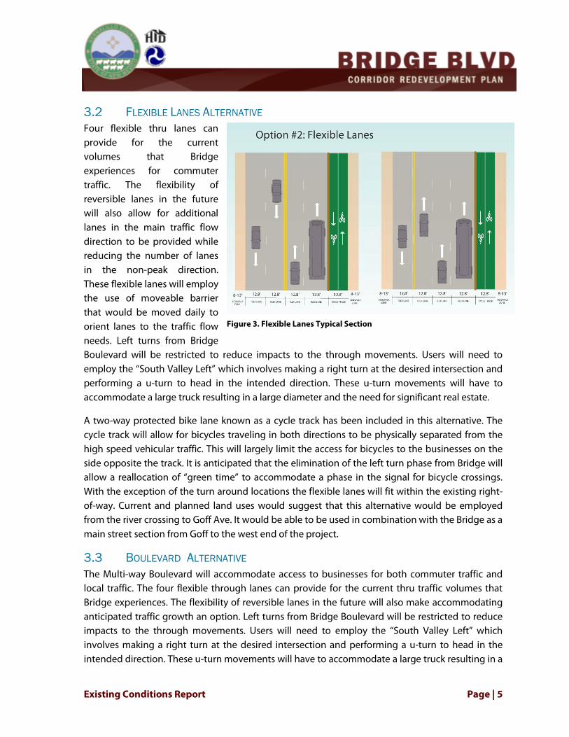
3.2 FLEXIBLE LANES ALTERNATIVE Four flexible thru lanes can provide for the current volumes that Bridge experiences for commuter traffic. The flexibility of reversible lanes in the future will also allow for additional lanes in the main traffic flow direction to be provided while reducing the number of lanes in the non-peak direction. These flexible lanes will employ the use of moveable barrier that would be moved daily to orient lanes to the traffic flow needs. Left turns from Bridge Boulevard will be restricted to reduce impacts to the through movements. Users will need to employ the “South Valley Left” which involves making a right turn at the desired intersection and performing a u-turn to head in the intended direction. These u-turn movements will have to accommodate a large truck resulting in a large diameter and the need for significant real estate.
A two-way protected bike lane known as a cycle track has been included in this alternative. The cycle track will allow for bicycles traveling in both directions to be physically separated from the high speed vehicular traffic. This will largely limit the access for bicycles to the businesses on the side opposite the track. It is anticipated that the elimination of the left turn phase from Bridge will allow a reallocation of “green time” to accommodate a phase in the signal for bicycle crossings. With the exception of the turn around locations the flexible lanes will fit within the existing right-of-way. Current and planned land uses would suggest that this alternative would be employed from the river crossing to Goff Ave. It would be able to be used in combination with the Bridge as a main street section from Goff to the west end of the project.
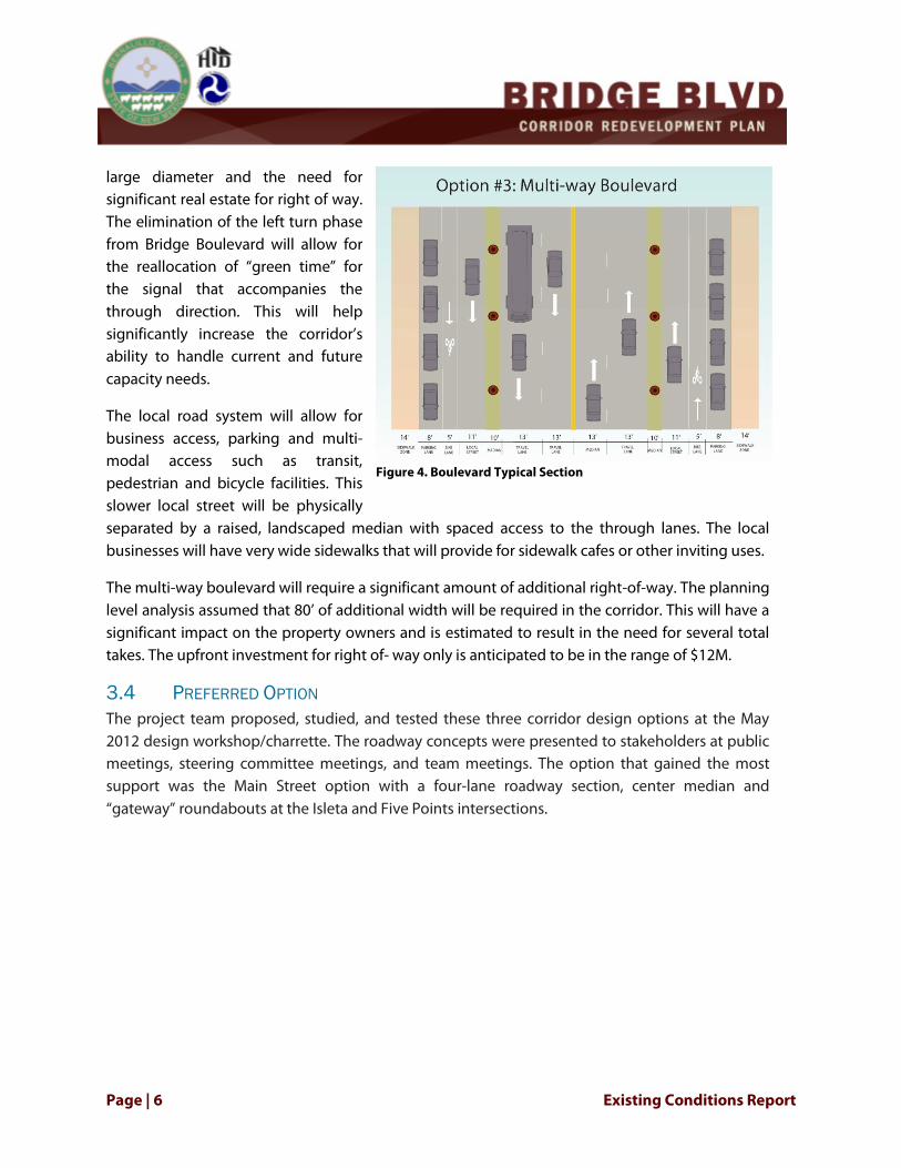
3.3 BOULEVARD ALTERNATIVE The Multi-way Boulevard will accommodate access to businesses for both commuter traffic and local traffic. The four flexible through lanes can provide for the current thru traffic volumes that Bridge experiences. The flexibility of reversible lanes in the future will also make accommodating anticipated traffic growth an option. Left turns from Bridge Boulevard will be restricted to reduce impacts to the through movements. Users will need to employ the “South Valley Left” which involves making a right turn at the desired intersection and performing a u-turn to head in the intended direction. These u-turn movements will have to accommodate a large truck resulting in a
Figure 3. Flexible Lanes Typical Section
Page | 6 Existing Conditions Report
large diameter and the need for significant real estate for right of way. The elimination of the left turn phase from Bridge Boulevard will allow for the reallocation of “green time” for the signal that accompanies the through direction. This will help significantly increase the corridor’s ability to handle current and future capacity needs.
The local road system will allow for business access, parking and multi-modal access such as transit, pedestrian and bicycle facilities. This slower local street will be physically separated by a raised, landscaped median with spaced access to the through lanes. The local businesses will have very wide sidewalks that will provide for sidewalk cafes or other inviting uses.
The multi-way boulevard will require a significant amount of additional right-of-way. The planning level analysis assumed that 80’ of additional width will be required in the corridor. This will have a significant impact on the property owners and is estimated to result in the need for several total takes. The upfront investment for right of- way only is anticipated to be in the range of $12M.
3.4 PREFERRED OPTION The project team proposed, studied, and tested these three corridor design options at the May 2012 design workshop/charrette. The roadway concepts were presented to stakeholders at public meetings, steering committee meetings, and team meetings. The option that gained the most support was the Main Street option with a four-lane roadway section, center median and “gateway” roundabouts at the Isleta and Five Points intersections.
Figure 4. Boulevard Typical Section

Existing Conditions Report Page | 7
4.0 EXISTING ENVIRONMENTAL CONDITIONS The following sections describe existing environmental conditions. Information pertaining to environmental conditions was assembled from several sources, including field inspections, review of public records and databases, consultation with interested agencies, and public input. Quantitative and qualitative methods have been used to evaluate the project impacts for a wide range of resources.
4.1 GENERAL PROJECT SETTING
4.1.1 CLIMATE The Albuquerque Reach of the Rio Grande is classified as semi-arid. The lowest mean annual temperatures occur during January (34.2OF) and its highest annual mean occurs in July (78.5OF). Characteristically, as in other semi-arid areas, the majority of the precipitation falls during the summer “monsoon” season or as winter snow. The average annual precipitation is 8.9 in, with 5.6 in falling between July and October. Relative humidity averages 51 percent for the year and less than 20 percent during the hotter summer afternoons. During the winter months winds generally blow from the north and south during the summer months. The Albuquerque metropolitan area on average has 167 cloud free days and 111 partly cloudy days per year.
4.1.2 PHYSIOGRAPHY AND GEOLOGY The project lies within the Rio Grande Rift Valley which extends more than 500 miles from central Colorado through New Mexico (Crawford et.al., 1993). The Rio Grande Rift Valley is part of the Albuquerque Basin which lies within the Middle Rio Grande Valley. The Albuquerque Basin is approximately 3060 mi2 (7925 km2) in area and lies between the Colorado Plateau, Great Plains, and the Sacramento section of the Basin and Range provinces (Connell, 2004). Rio Grande headwaters begin in the San Juan Mountains of southern Colorado, the river flows south dividing the state of New Mexico. Starting at El Paso, Texas the Rio Grande then forms the international boundary between the United States and Mexico. The Rio Grande is approximately 2,000 miles long and drains approximately 181,000 mi2 of land (Bullard and Wells, 1992).
The current physiographic features within the Middle Rio Grande can be attributed to intercontinental rifting during the late Cenozoic Era (approximately 36.6 million years ago). The Albuquerque Basin and the Sandia-Manzano uplifts are part of the Rio Grande Rift system (Woodard, 1982). As the Rio Grande rift formed it was filled with sediments, gravels and boulders primarily derived from the uplifting of the Sandia and Manzano Mountains to the east. Rift fill in the Albuquerque Basin has been characterized as the Santa Fe Group geologic formation. The Sandia and Manzano mountains run parallel to the rift zone; with a peak elevation of 10,678 feet down to the foothills which average 6,400 feet in elevation. From the foothills down to the Rio Grande floodplain (5-10 miles) the elevation drops another 1,400 feet. The western flank of the Rio
Page | 8 Existing Conditions Report
Grande rift is characterized as gently sloping plains, covered in windblown sands, with an abrupt drop forming mesas or bluffs which overlook the Rio Grande Valley.
4.1.3 SOILS NRCS soil data for the western project area, from Tower Road to Old Coors Drive consist of Madurez-Wink association (MWA), Bluepoint loamy fine sand (BCC), and Bluepoint-Kokan association (BKD). These soils are generally well drained and can be found typically in flood plains or alluvial flats. The MWA soils parent materials include alluvium derived from igneous and sedimentary rock, the BCC and BKD type soils parent materials are typically sandy alluvium and /or eolian sands.
East of Old Coors Dr the soils are Agua silty clay loam (Ag), Brazito fine sandy loam (Br), Brazito silty clay loam (Bs), Gila loam (Gb), Glendale loam (Gk), Torrifluvents (TP), Vinton sandy loam (VbA) and Vinton clay loam (Vc). The well-drained to excessively-drained soils are Ag, Bs, Gb, Gk, VbA and Vc. Conversely Br and TP are classified as poorly drained soils. The Ag parent materials include recent alluvium derived from igneous and sedimentary rock. The other soils, Br, Bs, Gb, Gk, TP, VbA and Vc are typically derived from alluvial fans and/or flood plains (USDA, 1977).
4.2 TRAFFIC OPERATIONS An inventory and analysis of the existing transportation system within the Corridor and potential tools and strategies for improvements were outlined in the Bridge Boulevard Corridor Redevelopment Plan Transportation Assessment. Currently, the road network immediately surrounding Bridge Boulevard has limited connectivity, forcing most traffic onto Bridge Boulevard for east-west travel.
The segment of Bridge Boulevard that makes up the project are is classified by the Mid-Region Council of Governments (MRCOG) as a principal arterial. It a four lane roadway with a continuous center turn lane from Old Coors to Isleta. As one of nine river crossings serving the Albuquerque Metropolitan Planning Area (AMPA), the roadway experiences heavy congestion between Sunset Road and 8th Street, carrying approximately 30,000 vehicles per day. There is no access control in the project area the posted speed for the majority of the project corridor is 35 miles per hour (mph). The posted speed is 40 mph west of Goff. Except for the intersection at Isleta, all intersections are currently operating at an acceptable level of service.
The Bridge Boulevard Congestion Management Plan Corridor, as defined by MRCOG, is projected to see a 15% increase in population and a 54% increase in employment by 2035 (MRCOG 2011). As a result, it is estimated that Bridge Boulevard will exceed motor vehicle capacity through most of the corridor and will be severely congested by 2035.

Existing Conditions Report Page | 9
4.2.1 SAFETY Crash rates along Bridge Blvd are almost 50% above the regional average. Between 2007 and 2009, there were 354 reported crashes, 4 of which involved bicyclists and 2 that involved pedestrians, with no trends amongst the bicycle and pedestrian crash locations. The majority of crashes occurred near busier the intersections: Isleta Boulevard (94 crashes), Goff Boulevard (52 crashes), La Vega Drive (48 crashes) and Sunset Boulevard/Five Points Road (47 crashes). There were no fatal crashes, 76 injury crashes, and 278 property damage only crashes. Approximately 53% of all the crashes were rear end crashes while 16% were same direction sideswipe and 12% were turning crashes.
4.2.2 PEDESTRIAN, BICYCLE, AND TRANSIT ACCOMMODATIONS The corridor has a network of historic acequias that serve the agricultural lands near the Rio Grande and are used as paths and trails by the community, although the South Valley has low walking and bicycling rates compared with Albuquerque, Bernalillo County, and the North Valley. Since 2000, bicycle commuting has increased while walk commuting has decreased (BCPWD 2011).
The project team and agency stakeholders conducted a bike and pedestrian safety audit in January 2012 to evaluate the physical conditions of bicycle and pedestrian facilities in the corridor. Most of the roadway provides bike lanes/shoulders of varying widths and sidewalks; however, visibility issues in some locations create an unsafe environment. With the exception of Isleta Boulevard, sidewalks from the corridor are discontinuous, providing limited access to destinations in proximity of Bridge Boulevard. Other findings for facilities along Bridge Boulevard include:
• Sidewalks are heaving in some areas and have holes where signposts were removed. • Sidewalks are partially blocked in many areas by bollards, utility poles or bus stop
benches. • A level path is not maintained across many driveways. • Faded/outdated signal heads make it difficult to view pedestrian signal indications. • Pedestrian push buttons are small and don’t meet ADA requirements. • Pedestrian walk time at signalized intersections appears to be shorter than necessary. • Lack of stop lines on cross streets do little to encourage drivers to stop behind crosswalk. • There is only one bus shelter along the corridor just west of the bridge and two bus stop
benches along the corridor. • The width of the bike lane is generally 5 feet from center of lane line to the outside edge
of gutter, but in some locations it is as narrow as 3.5-4 feet where expansion joints created obstacles for cyclists.
• A few traffic signal pull box lids were broken, creating a tripping hazard.

Page | 10 Existing Conditions Report
Transit is a critical mode of transportation in the Bridge Boulevard corridor for residents without a vehicle or living with disproportional housing and transportation costs (H+T). The current service frequencies and route structures are oriented to transit “dependent” riders housing and destinations. The services provide a general coverage of major destinations. Bridge Boulevard is primarily served by Route 54 (Figure 2). This route operates east and west from Old Coors across the Rio Grande to 4th Street. While the current route configuration provides transit service through several neighborhoods, it does not provide direct east-west access west of Old Coors Boulevard. Route 53, which is primarily a north-south route, runs along the corridor for a shorter segment, from Isleta Boulevard to 8th Street. Routes 51 and 155 provide key north-south connections from or across Bridge to Central Avenue - ABQ Ride’s most heavily traveled route with 40-45% of the system-wide ridership. Coors Boulevard is also designated as a Premium Quality Corridor by the Westside Long Range Transit Plan, reflecting a “Transit First” policy with the goal of providing linkages among transit centers.
4.3 LAND USE Land uses along the Bridge Boulevard corridor reflect the agricultural heritage of the area and its legacy as the primary route into the South Valley. Existing land uses make up of a diverse mix of categories from single family residential to agricultural, to commercial and light industrial. Uses vary from one end of the corridor to the other. The west end of the corridor is characterized by light industrial and contractor yards, while the section heading east from approximately Old Coors Drive to nearly Goff Boulevard is dominated by single family residential lots. A mix of residential and commercial uses predominantly make up the rest of the corridor, from Goff Boulevard to the bridge, with a higher concentration of restaurants and automotive repair shops. Larger concentrations of commercial uses are largely centered near the major intersections with Goff Boulevard, Sunset Road, and Isleta Boulevard.
Most of Bridge Boulevard contains zoning that was established when the roadway was primarily residential with some neighborhood commercial uses. Consequently, Bridge Boulevard has a disproportionate amount of residential zoning, interspersed with commercial zoning. The corridor as a whole is underutilized. Much of the existing development along the corridor is low density and auto-oriented. Many land uses are characterized by significant setbacks from Bridge Boulevard and large parking lots. The right-of-way is constrained on the east end of the corridor. With the widening of Bridge Boulevard in the 1980’s some older structures, largely located near the intersection with Isleta Boulevard, contain minimal setback from the street, with entrances opening onto five foot sidewalks. Right of way utilization throughout the corridor reinforces the auto-centric patterns with narrow sidewalks, little buffer from travel lanes for pedestrians, lack of street trees and pedestrian-scale lighting.

Existing Conditions Report Page | 11
Recent planning processes and adopted plans identified the community's desire for appropriate development in the Bridge Boulevard corridor. In addition to the Bridge Boulevard Corridor Redevelopment Plan, the following sector plans have been reviewed for consistency with the proposed project:
Bernalillo County/City of Albuquerque Comprehensive Plan identified Bridge Boulevard as a boundary between the Established Urban Area and the Semi-Urban Area.
The Southwest Area Plan (2000) included the entire southwest area of Bernalillo County. The plan recommended that detailed studies be conducted for Bridge Boulevard to help identify economic development potential and strategies. It also recognized the need for corridor and Village Center planning to include mixed-use and higher density development to promote walkability and improved transit service.
Isleta Boulevard and Village Centers Sector Development Plan (2008) was prepared to guide appropriate development in semi-rural and urban areas and provide a mixture of suitable uses in a quickly developing area.
Bridge Boulevard Village Center and Corridor Plan (2010) provided guidance to protect and improve characteristics and land use patterns for a portion of Bridge Boulevard, from the east side drain to Goff Avenue. This plan established zoning and design criteria for commercial and residential zoning. It also provided design standards for signage and lighting within the plan area.
PNM has numerous electric distribution lines within the plan boundary (Figure 5). These facilities are an important part of the existing infrastructure system in the area and protection from encroachment is critical for continued reliable electric service in the Plan area.

Page | 12 Existing Conditions Report
4.4 SOCIAL AND ECONOMIC CONDITIONS
4.4.1 ENVIRONMENTAL JUSTICE In compliance with the Executive Order (EO) 12898, Environmental Justice, and Title VI of the Civil Rights Act of 1964, it is FHWA policy to avoid disproportionately high and adverse impacts on low-income or minority population groups. For the purposes of assessing potential environmental justice issues within the study area, 2010 U.S. Census data for census tracts 23, 24.02, 43, 44.01, and 47.40 (Figure 6) were examined and compared to data for all of Bernalillo County.
Data show that approximately 31% of individuals in the Bridge Boulevard Corridor area were below 2010 poverty level guidelines in 2010, compared to 25% of individuals in Bernalillo County and 28% of individuals in New Mexico. (Table 1).
The majority of residents in the Bridge Boulevard Corridor are Hispanic or Latino (84%), compared to 48% of individuals in Bernalillo County and 46% of individuals in the state of New Mexico (Table 2.)
Figure 5. PNM Distribution Lines

Existing Conditions Report Page | 13
Minority representation in the study area exceeds the 50 percent minority threshold identified by the federal Council on Environmental Quality and block groups in the study area have a low-income population exceeding 25 percent. Therefore, the entire study area is considered a potential environmental justice area.
EO 12898 requires federal agencies to work to ensure greater public participation in the decision-making process. In addition, CEQ guidance suggests that federal agencies should acknowledge and seek to overcome linguistic, cultural, institutional, geographic, and other barriers to meaningful participation. Efforts to include all populations in the planning process has included a distribution of a residential survey in both English and Spanish with in-person interviews of random respondents by bilingual staffers, distribution and advertisement of bilingual meeting notices, attendance at neighborhood meetings, and conducting meetings at centrally-located community centers. A focus group was also held for Spanish-speaking residents and business owners.
Figure 6. Environmental Justice Analysis Boundaries

Page | 14 Existing Conditions Report
Table 1. Bridge Boulevard Corridor Income Distribution
Bridge Boulevard Corridor
Bernalillo County New Mexico
Less than $10,000 1286 11% 21205 8% 70119 9%
$10,000 to $24,999 2305 20% 43733 17% 146,286 19%
$25,000 to $34,999 2003 18% 30949 12% 89,929 12%
$35,000 to $50,000 2302 20% 38885 15% 114,925 15%
$50,000 to $75,000 2219 20% 47995 19% 135,040 18%
$75,000 to $99,999 750 7% 29554 11% 82,370 11%
$100,000 to $149,999 347 3% 28906 11% 75,645 10%
$150,000 or more 100 1% 17938 7% 41,798 6%
Source: American Community Survey, 2010
Table 2. Bridge Boulevard Corridor Ethnicity
Bridge Boulevard Corridor
Bernalillo County New Mexico
Total: 32,686 662,564 2,059,179
Not Hispanic of Latino 5,140 16% 345,475 52% 1,105,776 54%
Hispanic or Latino 27,546 84% 317,089 48% 953,403 46%
Source, U.S. Census Bureau, 2010
4.4.2 COMMUNITIES AND NEIGHBORHOODS There eleven neighborhood associations in the immediate study area and most also participate in larger associations such as the Southwest Alliance of Neighborhoods and South Valley Coalition. Neighborhood associations in the area include:
• Alamosa • Vecinos del Bosque • Yakima • Wildwood Lane • Armijo • Atrisco • Stinson Tower • Conita Real • Poplar Lane • Los Altos Civic • Tapia Meadows

Existing Conditions Report Page | 15
Residents of each of these neighborhoods have been active in public participation processes on a variety of issues. In some neighborhoods, the cultural identity and historic importance of the area is a strong element of community pride. Many families have lived in these neighborhoods for generations and there is an emphasis on maintaining the history and culture of the neighborhoods, improving facilities, and providing an environmentally safe area to live and play. The importance of community identity and cohesion has been a common discussion with stakeholders during the community outreach process.
Pedestrian connectivity between neighborhoods, commercial areas, and surrounding neighborhoods and schools is limited, particularly for east-west movement. (Figure 7). Schools near the project area include Valle Vista Elementary School, Alamosa Elementary School, Atrisco Elementary School, and Armijo Elementary School. There is also a School on Wheels Alternative Study School on the Corridor at Hartline. This school provides a high school education and marketable job skills to students between the ages of 16 and 18. Albuquerque Public Schools has indicated that any residential units developed within the plan area will impact Valle Vista, Atrisco, Kit Carson, and Armijo Elementary Schools, Ernie Pyle Middle School, and Rio Grande High School. Currently, all three schools have excess capacity. The Corridor offers little in terms of recreational opportunities and areas for incidental social interactions. Bernalillo County’s Gateway Park is the only open space directly on the corridor. The banks of the acequias and nearby Bosque are used as walking trails. There are three community centers in the area, but not on the Corridor itself. The South Valley Multi-Purpose Senior Center, located near the study area, promotes and educates the community about the history of the area. The Westside Community Center, located on Isleta Boulevard south of the project area, provides fitness facilities and after-school programs. The Alamosa Community Center, to the west of the project area, provides a health and social service center, a child and family development services program and a public library. The Alamosa Center has a gymnasium, outdoor basketball courts, arts and crafts room, fitness center and an outdoor amphitheater/performance space.

Page | 16 Existing Conditions Report
Community infrastructure and design of the built environment can affect health behaviors and environmental exposure. The design of the built environment can offer opportunities for residents to engage in healthy behaviors such as active transportation that reduce some chronic illnesses such as diabetes, asthma, cardiovascular disease, and obesity. Generally, the Bridge Boulevard Corridor and surrounding areas have a higher rate of premature deaths from chronic diseases (165.9 to 206 deaths per 100,000) than the rest of Bernalillo County (Place Matters 2005).
The Bridge Boulevard Corridor area has been identified by the US Department of Agriculture (USDA) as a “food desert”. Residents of food desert neighborhoods may have a difficult time accessing affordable and nutritious food because they more than a mile away from a supermarket or large grocery store and do not have easy access to transportation (USDA 2011).
Additionally, reported crime rates in unincorporated Bernalillo County are higher than the rest of the County, although reported crime rate is declining approximately 9% annually (EPS 2012).
Figure 7. Schools and Public Facilities

Existing Conditions Report Page | 17
4.5 VISUAL RESOURCES Visual resources refer to all objects (manmade and natural, moving and stationary) and features (e.g., land forms and water bodies) that are visible on a landscape. These resources add to or detract from the scenic quality of the landscape, that is, the visual appeal of the landscape. A visual impact is the creation of an intrusion or perceptible contrast that affects the scenic quality of a landscape. A visual impact can be perceived by an individual or group as either positive or negative, depending on a variety of factors or conditions (e.g., personal experience, time of day, and weather/seasonal conditions).
The visual evaluation area includes the Bridge Boulevard right-of-way (ROW), existing land uses, and surrounding visible landscapes. Representative land uses along the Bridge Boulevard ROW include commercial uses, including automotive repair shops and retail, residential, light industrial and contractor yards, agricultural fields, and vacant lots. It has become apparent that aesthetics along the corridor is an important issue, as more comments have been received by stakeholders on this topic to date than any other. A divide exists as to whether the appearance of the area should be changed through the establishment of design standards or reinforced and celebrated as unique to the area.
Visual assets beyond the corridor include natural landscapes. To the east, the Sandia and Manzano Ranges extend in a generally north-south direction and consists of uplifted, fault-block mountains. These mountain ranges are the most distinct elements to the east of the region and dominate the eastern horizon. Immediately to the east of the project area the Rio Grande river valley and bosque is set against views of downtown Albuquerque with the Sandia Mountains in the background. West of the project area is the mesa escarpment. From the east end of the project area, volcanoes to the west of Albuquerque are visible, as is the mesa escarpment.
4.6 CULTURAL RESOURCES Van Citters: Historic Preservation LLC performed a Historic Resource Characterization of the Bridge Boulevard Corridor in March and April, 2012. The characterization of the historic resources found within the study area entailed a Class I file search for archaeological resources previously surveyed and a windshield survey of the neighborhoods and adjacent commercial, industrial, and agricultural areas within the project boundaries. Secondary sources were used for the development of a brief historic context for the buildings and landscapes. Historic properties along the Bridge Boulevard Corridor include or may include:
• The portion of Bridge Boulevard that was a part of the Camino Real Tierra de Adentro (National Historic Trail Camino Real National Scenic Byway) and historic Route 66 (Route 66 National Scenic Byway)

Page | 18 Existing Conditions Report
• Acequias that are a part of the MRGCD historic district: Arenal Main Canal, the Ranchos de Atrisco Acequia, Arenal Acequia, the Atrisco Acequia, the Atrisco Riverside Drain, and the Isleta Drain
• Resources that have yet to be evaluated o Vernacular buildings and resources, such as Five Points Church, some
residences, and agricultural fields o 1996 Auto-Oriented Commercial Development historic context o Landscape features such as Five Points Road and Gatewood Road, which
connected the villages of Armijo and Atrisco
The project area is within the boundaries of the original 1692 Atrisco land grant, a relatively intact Spanish colonial grant that is one of the few that has been continuously owned by the original settlers and their heirs. Because of the longevity of the land grant, the project area has over 300 years of Hispanic heritage. The project area has had many land uses during this time, including residential uses, agricultural lands, free grazing common areas, and commercial development. A search of the New Mexico Cultural Resource Information System was completed and there were no documented archaeological resources along the Corridor.
The Barelas Bridge was a critical crossing as part of the Camino Real Tierra de Adentro and a portion of Bridge Boulevard was designated as Route 66. In addition to Bridge Boulevard itself, most of the properties currently of potential historical interest are associated with auto-oriented commercial development and a number of vernacular residential buildings scattered along the corridor. Most of the residential buildings appear to lack historic integrity or were constructed fairly recently; however, it is recommended that a number of New Mexico Vernacular buildings, remaining agricultural fields, and other resources that could be associated with the Auto-oriented Commercial Development historic context be evaluated for National Register of Historic Places eligibility.
4.7 ACQUISITIONS AND RELOCATIONS Property acquisition and relocations are governed by the Uniform Relocation Assistance and Real Property Acquisition Act of 1970 (Uniform Act). This law provides for the fair, consistent, and equitable treatment of persons and businesses affected by federal actions requiring acquisition and relocations. Any acquisitions or relocations would comply with this law.
4.8 SPECIALLY DESIGNATED AREAS
4.8.1 FLOODPLAINS Federal Emergency Management Agency (FEMA) has conducted a flood mapping study for the Albuquerque reach of the Rio Grande. The study detailed and includes estimated water surface elevations for the 100-year flood event. The project area appears on Flood Insurance Rate Map (FIRMS) numbers 35001C0329CG and 35001C0333G. Current FEMA regulations require that any

Existing Conditions Report Page | 19
work done to or in a flood plain need to be assessed to determine if there are negative impacts to the flood plain and mitigate any negative impacts. There are several areas that flood along Bridge Blvd and Tower Rd noted within the FIRM Panels. These inundation areas are not connected to the primary Rio Grande floodway and flood plain; there are levees in place to hold back flood waters from the Rio Grande. The inundation areas are associated with low lying areas and ponds on the landside of the levees. Project planning will ensure that construction minimizes impacts to floodplain areas and mitigates where necessary.
4.8.2 SECTION 4(F) AND SECTION 6(F) PROPERTIES Section 4(f) of the Department of Transportation Act of 1966 restricts the use of public parks, recreational areas, wildlife refuges or significant historic sites for transportation projects. Section 4(f) properties in the Corridor:
• Bridge Boulevard itself, as a part of the Camino Real de Tierra Adentro and Route 66 • Six acequias that are a part of the MRGCD Historic District • Gateway Park at Bridge and Isleta Boulevard and • School on Wheels at Bridge and Hartline
Federal law also restricts the use of lands acquired with funding authorized under Section 6(f) of the Land and Water Conservation Fund Act of 1965. There are no Section 6(f) properties in on or adjacent to Bridge Boulevard.
4.8.3 PRIME FARMLAND The U.S. Department of Agriculture, Natural Resource Conservation Service (NRCS), defines prime farmland as those lands whose value is derived from their general advantage as cropland due to soil and water conditions. According to the NRCS, there are no prime or unique farmlands in or adjacent to the project area.
4.9 NOISE Existing noise levels in the project area are typical of urban and semi-rural environments. Ambient noise levels are primarily defined by local and commercial road traffic. Some increase in ambient noise levels are expected from construction-related activities; however noise levels would remain far below state and federal standards for public safety and would not persist beyond completion of the planned construction work.
4.10 AIR QUALITY Bernalillo County is within the State of New Mexico’s Air Quality Control Region 6 (Environmental Protection Agency (EPA) Region 153) (NMED 1997). The County is in attainment status for National Air Quality Standards for priority pollutants (particulate matter, sulfur oxides, nitrogen dioxide, carbon monoxide, ozone, and lead), meaning that ambient air quality meets or exceeds state and federal standards. Generally, the only air pollutant of concern in the area is carbon monoxide. In

Page | 20 Existing Conditions Report
1978, Albuquerque/Bernalillo County was designated as a non-attainment area for carbon monoxide. However, in 1996, after four consecutive years without any exceedances (1992-1995), EPA re-designated Albuquerque/Bernalillo County to attainment/maintenance status. This designation refers to former non-attainment areas that have successfully reduced pollutant concentrations to meet the ambient standards, and now have maintenance plans to keep air pollutants in check.
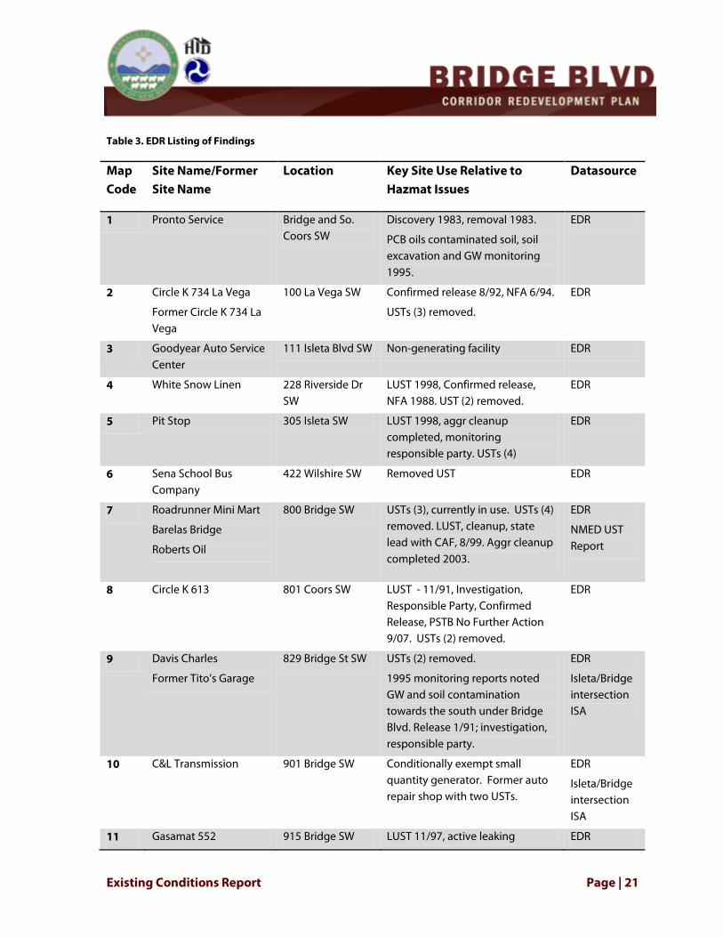
4.11 HAZARDOUS MATERIALS Contamination of soil or water with hazardous materials is a serious concern for potential project construction due to the liability associated with cleanup, as well as health and safety considerations. The Environmental Data Resources, Inc. (EDR) database was consulted for a preliminary list of Recognized Environmental Concerns (RECs) or Historic Recognized Environmental Concerns (HREC) in the project area. Site visits were not performed. An Initial Site Assessment or Phase I Environmental Site Assessment that complies with ASTM Standard (ASTME 1527—05) and NMDOT Hazardous Materials Assessment Handbook (2010) is recommended between the 30% and 60% design phase. Key findings from the EDR database search are recorded in Table 3 and illustrated on Figure 8.
Existing Conditions Report Page | 21
Table 3. EDR Listing of Findings
Map Code
Site Name/Former Site Name
Location Key Site Use Relative to Hazmat Issues
Datasource
1 Pronto Service Bridge and So. Coors SW
Discovery 1983, removal 1983.
PCB oils contaminated soil, soil excavation and GW monitoring 1995.
EDR
2 Circle K 734 La Vega
Former Circle K 734 La Vega
100 La Vega SW Confirmed release 8/92, NFA 6/94.
USTs (3) removed.
EDR
3 Goodyear Auto Service Center
111 Isleta Blvd SW Non-generating facility EDR
4 White Snow Linen 228 Riverside Dr SW
LUST 1998, Confirmed release, NFA 1988. UST (2) removed.
EDR
5 Pit Stop 305 Isleta SW LUST 1998, aggr cleanup completed, monitoring responsible party. USTs (4)
EDR
6 Sena School Bus Company
422 Wilshire SW Removed UST EDR
7 Roadrunner Mini Mart
Barelas Bridge
Roberts Oil
800 Bridge SW USTs (3), currently in use. USTs (4) removed. LUST, cleanup, state lead with CAF, 8/99. Aggr cleanup completed 2003.
EDR
NMED UST Report
8 Circle K 613 801 Coors SW LUST - 11/91, Investigation, Responsible Party, Confirmed Release, PSTB No Further Action 9/07. USTs (2) removed.
EDR
9 Davis Charles
Former Tito’s Garage
829 Bridge St SW USTs (2) removed.
1995 monitoring reports noted GW and soil contamination towards the south under Bridge Blvd. Release 1/91; investigation, responsible party.
EDR
Isleta/Bridge intersection ISA
10 C&L Transmission 901 Bridge SW Conditionally exempt small quantity generator. Former auto repair shop with two USTs.
EDR
Isleta/Bridge intersection ISA
11 Gasamat 552 915 Bridge SW LUST 11/97, active leaking EDR

Page | 22 Existing Conditions Report
Map Code
Site Name/Former Site Name
Location Key Site Use Relative to Hazmat Issues
Datasource
petroleum site, cleanup, monitoring, responsible party, NFA 2009.
Isleta/Bridge intersection ISA
12 Chavez Auto Salvage 922 Atrisco Dr SW Conditionally exempt small quantity generator
EDR
13 Eagle One Automotive 932 Old Coors SW Conditionally Exempt Small Quantity Generator; No violations found.
EDR
14 Roberts Oil J 1001 Coors Blvd SW
LUST, Release 9/97; cleanup responsible party. USTs (2) removed; USTs (2) currently in use.
EDR
15 Eloys Phillips 66 1010 Coors SW USTs (4) removed. EDR
16 Diamond Shamrock No 1213
1100 Coors SW UST (3) currently in use EDR
17 Herrera School Buses and Coaches
1140 Sunset SW LUST, aggr cleanup completed, state lead, CAF. USTs (3) currently in use
EDR
18 Food processing plant
Bueno Foods
1224 Airway Rd SW
UST (1) removed.
Confirmed release 9/91. NFA 8/94.
EDR
19 Former Giant d/b/a Gasman 7445
Atex 212 (GASHO)
1312 Bridge SW UST (3) removed.
LUST, Release 1/91, Aggr cleanup completed, st lease, CAF
EDR
20 American Auto Body 1543 Bridge SW Non-generator EDR
21 Rodgers Plumbing and Heating
1570 Bridge Blvd SW
Conditionally exempt small quantity generator; UST (1) removed
EDR
22 Former RAS 67535
Roman’s service Center
1700 Bridge SW USTs (5) removed
USTs (5) currently in use
EDR
23 Plaza Cleaners 1720 F Bridge SW Non-generator; dry cleaner, no violations
EDR
24 Art’s Automotive and Starter Repair
2115 Bridge SW USTs (2) removed EDR
25 Waycor 4400 Tower SW Toxics release 2006, 2008. In comp.
EDR

Existing Conditions Report Page | 23
Figure 8. EDR Findings
4.12 SURFACE WATER AND WETLANDS The Rio Grande lies just beyond the eastern boundary of the project area and the active floodplain is largely confined between earthen levees. The project area crosses six acequias owned and Maintained by the Middle Rio Grande Conservancy District. The historic acequias are still in use for irrigation and flood control.
Wetlands are defined by the US Army Corps of Engineers (USACE): “areas inundated or saturated by surface or ground water at a frequency and duration sufficient to support, and under normal circumstances do support, a prevalence of vegetation typically adapted for life in saturated soil conditions.” (http://www.spa.usace.army.mil/reg/Program_Overview.pdf). No wetlands were observed based on the three essential characteristics as defined by the US Army Corps Wetland Delineation Manual: (1) hydrophytic vegetation, (2) hydric soils, and (3) wetland hydrology.
4.13 BIOLOGICAL RESOURCES In August 2012, a qualified Wildlife Biologist conducted a field surveillance of the Bridge Boulevard Corridor and 50 feet off the Corridor in each direction at the six acequias that cross Bridge

Page | 24 Existing Conditions Report
Boulevard to determine the presence of vegetation, noxious weeds, wildlife habitat, and threatened and endangered species. The Biological Memorandum is provided as Appendix A.
4.13.1 VEGETATION Six acequias cross Bridge Boulevard and have maintenance roads on both sides of the existing ditches. No rare plants were observed. Project disturbance to vegetation would primarily be limited to plants growing on ditch banks. Plant species observed included puncturevine (goathead), sticky gumweed, horsetail, Russian thistle, broom snakeweed, ground cherry and globemallow. During normal ditch maintenance, ditch bank vegetation is mowed or uprooted. Therefore, removal of these plants during construction would not be considered a significant or adverse environmental impact.
4.13.2 NOXIOUS WEEDS Noxious weeds are undesirable, non-native plant species that have negative impacts upon crops, native plant communities, livestock, and the management of natural or agricultural systems. The New Mexico Department of Agriculture has targeted numerous noxious weeds for control or eradication pursuant to the Noxious Weed Management Act of 1998. New Mexico’s noxious weed list is classified into the following three divisions, all of which are non-native to New Mexico:
Class A weeds are species that currently are not present in New Mexico or have limited distribution. Preventing new infestations of these species and eradicating existing infestations is the highest priority.
Class B weeds are species that are limited to portions of the state. In areas that are not infested, these species should be treated as Class A weeds. In areas with severe infestations, management plans should be designed to contain the infestation and stop any further spread.
Class C weeds are species that are wide-spread in the state. Management decisions for these species should be determined at the local level based on feasibility of control and level of infestation.
No noxious weeds were observed during field surveillance.
4.13.3 WILDLIFE Wildlife use in the residential portions of the project area is limited by the disturbed condition of the ground cover and proximity of suburban residences and activity. Much of the area within the city and county limits has been converted to urban or residential land uses. The acequias do not provide suitable habitat for wildlife and no species were observed.
4.13.4 MIGRATORY BIRDS The Migratory Bird Treaty Act of 1918 (MBTA) protects against the “taking” of migratory birds, their nests, and their eggs except as permitted by the United States Fish and Wildlife Service (USFWS). No high quality habitat for migratory birds was observed in the Corridor during the field survey.

Existing Conditions Report Page | 25
Due to the traffic and urban setting of the roadway, it would be expected that migratory birds would utilize the Rio Grande to the east of the project area.
4.13.5 THREATENED AND ENDANGERED SPECIES A number of Threatened and Endangered (T&E) Species are listed on the Biota Information System of New Mexico (BISON-M) federal and state species status list for Bernalillo County, shown on Table 4. However, no T&E species or suitable habitat(s) were observed in the project area.
Table 4. Threatened and Endangered Species List for Bernalillo County
Common Name Scientific Name Status Observed Habitat Present
Chub, Rio Grande Gila pandora State NM: Sensitive taxa (informal)
No No
Minnow, Silvery, Rio Grande
Hybognathus amarus Federal: Critical Hab. Designated (NM) Federal: Endangered State NM: Endangered
No No
Black-Hawk, Common Buteogallus anthracinus anthracinus (NM)
Federal: FWS Species of Concern State NM: Threatened
No No
Cormorant, Neotropic Phalacrocorax brasilianus
State NM: Threatened No No
Cuckoo, Yellow-billed Coccyzus americanus occidentalis (western pop)
Federal: Candidate State NM: Sensitive taxa (informal)
No No
Eagle, Bald Haliaeetus leucocephalus alascanus (NM)
State NM: Threatened No No
Falcon, Aplomado Falco femoralis septentrionalis (NM)
Federal: Endangered State NM: Endangered
No No
Falcon, Peregrine Falco peregrinus anatum Federal: FWS Species
of Concern State NM: Threatened
No No
Falcon, Peregrine, Arctic
Falco peregrinus tundrius Federal: FWS Species of Concern State NM: Threatened
No No
Flycatcher, Willow, SW.
Empidonax traillii extimus
Federal: Critical Hab. Designated (NM) Federal: Endangered State NM: Endangered
No No
Goshawk, Northern Accipiter gentilis atricapillus (NM,AZ);apache (NM,AZ)
Federal: FWS Species of Concern State NM: Sensitive taxa (informal)
No No
Hummingbird, Broad- Cynanthus latirostris State NM: Threatened No No
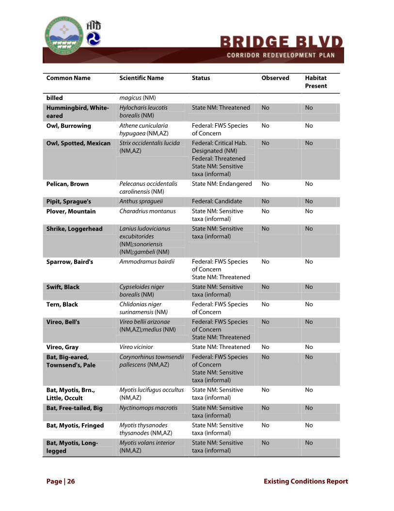
Page | 26 Existing Conditions Report
Common Name Scientific Name Status Observed Habitat Present
billed magicus (NM)
Hummingbird, White-eared
Hylocharis leucotis borealis (NM)
State NM: Threatened No No
Owl, Burrowing Athene cunicularia hypugaea (NM,AZ)
Federal: FWS Species of Concern
No No
Owl, Spotted, Mexican Strix occidentalis lucida (NM,AZ)
Federal: Critical Hab. Designated (NM) Federal: Threatened State NM: Sensitive taxa (informal)
No No
Pelican, Brown Pelecanus occidentalis carolinensis (NM)
State NM: Endangered No No
Pipit, Sprague's Anthus spragueii Federal: Candidate No No
Plover, Mountain Charadrius montanus State NM: Sensitive
taxa (informal) No No
Shrike, Loggerhead Lanius ludovicianus excubitorides (NM);sonoriensis (NM);gambeli (NM)
State NM: Sensitive taxa (informal)
No No
Sparrow, Baird's Ammodramus bairdii Federal: FWS Species
of Concern State NM: Threatened
No No
Swift, Black Cypseloides niger borealis (NM)
State NM: Sensitive taxa (informal)
No No
Tern, Black Chlidonias niger surinamensis (NM)
Federal: FWS Species of Concern
No No
Vireo, Bell's Vireo bellii arizonae (NM,AZ);medius (NM)
Federal: FWS Species of Concern State NM: Threatened
No No
Vireo, Gray Vireo vicinior State NM: Threatened No No
Bat, Big-eared, Townsend's, Pale
Corynorhinus townsendii pallescens (NM,AZ)
Federal: FWS Species of Concern State NM: Sensitive taxa (informal)
No No
Bat, Myotis, Brn., Little, Occult
Myotis lucifugus occultus (NM,AZ)
State NM: Sensitive taxa (informal)
No No
Bat, Free-tailed, Big Nyctinomops macrotis State NM: Sensitive
taxa (informal) No No
Bat, Myotis, Fringed Myotis thysanodes thysanodes (NM,AZ)
State NM: Sensitive taxa (informal)
No No
Bat, Myotis, Long-legged
Myotis volans interior (NM,AZ)
State NM: Sensitive taxa (informal)
No No

Existing Conditions Report Page | 27
Common Name Scientific Name Status Observed Habitat Present
Bat, Myotis, Small-footed, W.
Myotis ciliolabrum melanorhinus (NM,AZ)
State NM: Sensitive taxa (informal)
No No
Bat, Spotted Euderma maculatum State NM: Threatened No No
Bat, Myotis, Yuma Myotis yumanensis yumanensis (NM,AZ)
State NM: Sensitive taxa (informal)
No No
Prairie Dog, Gunnison's, prairie populations
Cynomys gunnisoni gunnisoni (NM);zuniensis (NM)
State NM: Sensitive taxa (informal)
Prairie Dog, Gunnison's, montane populations
Cynomys gunnisoni gunnisoni (NM);zuniensis (NM)
Federal: Candidate State NM: Sensitive taxa (informal)
No No
Fox, Red Vulpes vulpes fulva (NM);macroura (NM)
State NM: Sensitive taxa (informal)
No No
Mouse, Jumping, Meadow
Zapus hudsonius luteus (NM,AZ)
Federal: Candidate State NM: Endangered
No No
Ringtail Bassariscus astutus arizonensis (NM,AZ);flavus (NM);yumanensis (AZ);nevadensis (AZ)
State NM: Sensitive taxa (informal)
No No
Skunk, Hog-nosed, Common
Conepatus leuconotus mearnsi (NM);venaticus (NM,AZ)
State NM: Sensitive taxa (informal)
No No
Skunk, Spotted, Western
Spilogale gracilis State NM: Sensitive taxa (informal)
No No
Mountainsnail, Socorro
Oreohelix neomexicana State NM: Sensitive taxa (informal)
No No
Page | 28 Existing Conditions Report
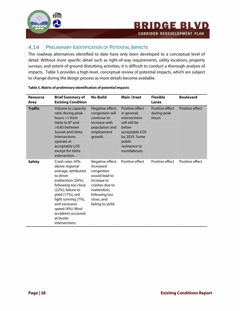
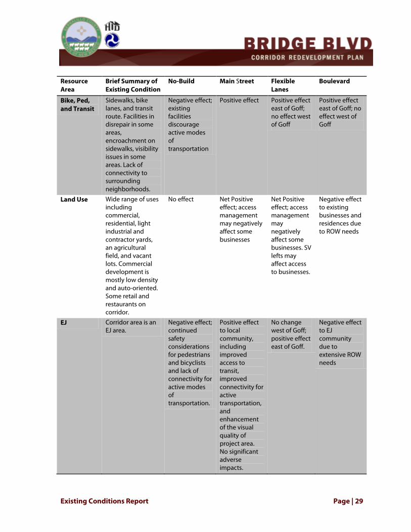
4.14 PRELIMINARY IDENTIFICATION OF POTENTIAL IMPACTS The roadway alternatives identified to date have only been developed to a conceptual level of detail. Without more specific detail such as right-of-way requirements, utility locations, property surveys, and extent of ground disturbing activities, it is difficult to conduct a thorough analysis of impacts. Table 5 provides a high-level, conceptual review of potential impacts, which are subject to change during the design process as more details become available.
Table 5. Matrix of preliminary identification of potential impacts
Resource Area
Brief Summary of Existing Condition
No-Build Main Street Flexible Lanes
Boulevard
Traffic Volume to capacity ratio during peak hours >1 from Isleta to 8th and >0.85 between Sunset and Isleta. Intersections operate at acceptable LOS except for Isleta intersection.
Negative effect; congestion will continue to increase with population and employment growth.
Positive effect in general; intersections will still be below acceptable LOS by 2035. Some public resistance to roundabouts.
Positive effect during peak hours
Positive effect
Safety Crash rates 50% above regional average, attributed to driver inattention (26%), following too close (22%), failure to yield (17%), red light running (7%), and excessive speed (4%). Most accidents occurred at busier intersections.
Negative effect; increased congestion would lead to increase in crashes due to inattention, following too close, and failing to yield.
Positive effect Positive effect Positive effect
Existing Conditions Report Page | 29
Resource Area
Brief Summary of Existing Condition
No-Build Main Street Flexible Lanes
Boulevard
Bike, Ped, and Transit
Sidewalks, bike lanes, and transit route. Facilities in disrepair in some areas, encroachment on sidewalks, visibility issues in some areas. Lack of connectivity to surrounding neighborhoods.
Negative effect; existing facilities discourage active modes of transportation
Positive effect Positive effect east of Goff; no effect west of Goff
Positive effect east of Goff; no effect west of Goff
Land Use Wide range of uses including commercial, residential, light industrial and contractor yards, an agricultural field, and vacant lots. Commercial development is mostly low density and auto-oriented. Some retail and restaurants on corridor.
No effect Net Positive effect; access management may negatively affect some businesses
Net Positive effect; access management may negatively affect some businesses. SV lefts may affect access to businesses.
Negative effect to existing businesses and residences due to ROW needs
EJ Corridor area is an EJ area.
Negative effect; continued safety considerations for pedestrians and bicyclists and lack of connectivity for active modes of transportation.
Positive effect to local community, including improved access to transit, improved connectivity for active transportation, and enhancement of the visual quality of project area. No significant adverse impacts.
No change west of Goff; positive effect east of Goff.
Negative effect to EJ community due to extensive ROW needs

Page | 30 Existing Conditions Report
Resource Area
Brief Summary of Existing Condition
No-Build Main Street Flexible Lanes
Boulevard
Community Cohesion
Community cohesion and social interaction
• Quality of life – increased rates of asthma, diabetes, heart disease. Perception of high crime rates. 22% of all crimes reported in unincorporated BernCo are located in corridor. Reported crime rate is declining approximately 9% annually.
• Little in terms of recreational opportunities. Gateway park only open “green” space on corridor. Few areas for incidental social interactions. Community centers present off corridor (Westside, Alamosa, SV Multi-Purpose Senior Center)
• Limited pedestrian/bicycle connectivity between neighborhoods, commercial areas and surrounding neighborhoods, and schools.
Negative effect Positive effect No change west of Goff; positive effect east of Goff.
No change west of Goff; positive effect east of Goff.

Existing Conditions Report Page | 31
Resource Area
Brief Summary of Existing Condition
No-Build Main Street Flexible Lanes
Boulevard
Visual Resources
Little landscaping, expansive natural background views of mesa, escarpment, volcanoes, bosque, downtown, and Sandia and Manzano ranges.
No effect Positive effect; landscaping will improve aesthetics of existing roadway.
Positive effect; landscaping will improve aesthetics of existing roadway.
ROW requirements would change character and look of corridor.
Cultural Resources
Bridge Blvd (as part of historic Rte 66 and Camino Real)
Six acequias that are a part of the MRGCD historic district
Potential for vernacular buildings and resources associated with 1996 Auto-Oriented Commercial Development Historic Context: buildings and ag fields.
No effect Evaluation for eligibility for NRHP should be conducted after selection of proposed alternative to determine appropriate mitigation measures with regard to alignment, takings, and vibration.
Evaluation for eligibility for NRHP should be conducted after selection of proposed alternative to determine appropriate mitigation measures with regard to alignment, takings, and vibration.
Evaluation for eligibility for NRHP should be conducted after selection of proposed alternative to determine appropriate mitigation measures with regard to alignment, takings, and vibration.

Page | 32 Existing Conditions Report
Resource Area
Brief Summary of Existing Condition
No-Build Main Street Flexible Lanes
Boulevard
Acquisitions and Relocations
No effect Approximately 19 parcels affected; Utility relocations required. Relocations will be at the requestor’s expense and will be subject to PNM’s review of all technical needs, issues and safety clearances for its electric power systems.
Minor effect to parcels; Utility relocations required. Relocations will be at the requestor’s expense and will be subject to PNM’s review of all technical needs, issues and safety clearances for its electric power systems.
Approximately 131 parcels affected; Utility relocations required. Relocations will be at the requestor’s expense and will be subject to PNM’s review of all technical needs, issues and safety clearances for its electric power systems.
Floodplains Several areas zoned AH - Areas subject to inundation by 1-percent-annual-chance shallow flooding (usually areas of ponding) where average depths are between one and three feet. Inundation areas are not connected to the primary Rio Grande floodway and flood plain because of existing levees.
No effect Project planning will ensure that construction minimizes impacts to floodplains areas and mitigates where necessary.
Project planning will ensure that construction minimizes impacts to floodplains areas and mitigates where necessary.
Project planning will ensure that construction minimizes impacts to floodplains areas and mitigates where necessary.

Existing Conditions Report Page | 33
Resource Area
Brief Summary of Existing Condition
No-Build Main Street Flexible Lanes
Boulevard
Section 4(f) Bridge Blvd (as part of historic Rte 66 and Camino Real)
School on Wheels
Gateway Park
Six acequias that are a part of the MRGCD historic district
No effect No take for School on Wheels or acequias; Section 4(f) impacts to Bridge Blvd and Gateway Park TBD.
Section 4(f) impacts to Bridge Blvd and acequias TBD.
Takes with regards to School on Wheels and Gateway Park. Impact to Bridge Blvd TBD. Impacts to acequias could be mitigated with a net positive benefit.
Section 6(f) None n/a n/a n/a n/a
Prime and Unique Farmland
None n/a n/a n/a n/a
Noise Typical of urban and semi-rural environments. Ambient noise levels are primarily defined by local and commercial road traffic.
Negative effect Will not induce travel demand; Positive effect by reducing stop and go traffic.
No effect to residential areas.
May induce travel demand; negative effect to sensitive receptors in residential areas.
Air Quality The County is in attainment status for National Air Quality Standards for priority pollutants (particulate matter, sulfur oxides, nitrogen dioxide, carbon monoxide, ozone, and lead), meaning that ambient air quality meets or exceeds State and Federal standards.
Negative effect Positive effect by reducing stop and go traffic and encouraging active modes of transportation to reduce car dependency.
Positive effect; safe pedestrian and bicycle facilities may reduce car dependency.
May induce travel demand. Offset by traffic flow?
Safe pedestrian and bicycle facilities may reduce car dependency.

Page | 34 Existing Conditions Report
Resource Area
Brief Summary of Existing Condition
No-Build Main Street Flexible Lanes
Boulevard
Hazardous Materials
25 RECs and Historic RECs noted within .25 of roadway.
No effect Phase I ISA will need to be conducted between 30-60% design phase.
Phase I ISA will need to be conducted between 30-60% design phase.
Phase I ISA will need to be conducted between 30-60% design phase.
Surface Water
Six acequias; Rio Grande to east of
No effect BMPs would be employed
BMPs would be employed
BMPs would be employed
Wetlands None n/a n/a n/a n/a
Vegetation No rare plants observed.
n/a n/a n/a n/a
Noxious Weeds
None observed n/a n/a n/a n/a
Wildlife No suitable habitat No effect Construction at east end of project area should be conducted outside of nesting season to avoid impacts to birds and species in west Bosque.
Construction at east end of project area should be conducted outside of nesting season to avoid impacts to birds and species in west Bosque.
Construction at east end of project area should be conducted outside of nesting season to avoid impacts to birds and species in west Bosque.
Migratory birds
None observed; lack of suitable habitat
No effect Construction at east end of project area should be conducted outside of nesting season to avoid impacts to birds and species in west Bosque.
Construction at east end of project area should be conducted outside of nesting season to avoid impacts to birds and species in west Bosque.
Construction at east end of project area should be conducted outside of nesting season to avoid impacts to birds and species in west Bosque.

Existing Conditions Report Page | 35
Resource Area
Brief Summary of Existing Condition
No-Build Main Street Flexible Lanes
Boulevard
T&E Species No suitable habitat No effect Construction at east end of project area should be conducted outside of nesting season to avoid impacts to birds and species in west Bosque.
Construction at east end of project area should be conducted outside of nesting season to avoid impacts to birds and species in west Bosque.
Construction at east end of project area should be conducted outside of nesting season to avoid impacts to birds and species in west Bosque.
5.0 PUBLIC AND AGENCY OUTREACH Core Bernalillo County staff from the Public Works, Zoning, Building and Planning, Economic Development, and Housing departments were charged with deciding on the final recommendations to be submitted to Bernalillo County governing bodies. Significant inter-departmental coordination has been crucial to this planning process. County staff has met regularly with the consultant team to monitor progress of data collection, assist with concept development and refinement, and participate in public outreach activities.
As a community that cherishes its rich history and wants to preserve the legacy it leaves for future generations, it has been critical to integrate the public into the planning process. The project team developed a robust framework of public participation to support the planning process and invite involvement from a broad range of groups within the community throughout the development of the Plan. A summary of agency and public coordination efforts is provided in a Public Involvement and Community Outreach Summary Report, which will be an appendix to the Bridge Boulevard Corridor Redevelopment Plan. The basic framework called for creating multiple and varied opportunities for the public to learn about the project and offer input and feedback throughout the planning process. Community members have been invited to participate in the development of the vision and plan through the following activities:
• Public meetings at key milestones • Presentations to neighborhood associations • Attendance at local events, such as South Valley Pride Day and Gateway Park dedication • Residential survey • Business owner interviews • Intensive design workshop or charrette • Focus groups for youth, businesses, and Spanish-speaking residents

Page | 36 Existing Conditions Report
Residents, business owners, and the traveling public were invited to participate in meetings through newspaper articles and advertisements, posters placed in local businesses and community centers, announcements at local group meetings, television news coverage, and mailings to properties immediately adjacent to the Corridor and the interested parties list.
In addition to general public outreach, Commissioner Art De La Cruz and the project team identified and invited representatives from partner agencies, local businesses, and neighborhoods to participate in a Steering Committee. Invitees included representatives of the FHWA, HUD, MRCOG, Rio Grande Community Development Corporation (RGCDC), City of Albuquerque (COA), and a number of neighborhood and business representatives. Committee members were asked to commit to monthly meetings, serve as a spokesperson and means of communication between the Steering Committee and the committee member’s agency or neighborhood and networks, and participate in sub-committees to discuss transportation, economic development, housing, and environmental health and safety. The Steering Committee met on a monthly basis for over a year. Out of these meetings came a shared understanding of the core goals for the project and a consensus on how to move forward into implementation.
5.1 KEY ISSUES AND CONCERNS Key issues and concerns that have been identified by members of the public include:
1. Respecting the character of the South Valley - celebrate the agricultural tradition, open space, and acequias
2. Maintaining authenticity 3. Aesthetics 4. Balance traffic between commuting needs and retail needs 5. Roundabouts 6. Right-of-Way requirements 7. Access from Five Points to Bridge Boulevard 8. Access to and from Bridge Boulevard west of Old Coors Road 9. Access to businesses 10. Senior housing 11. Zoning within Village Centers
6.0 NEXT STEPS Roadway improvements will be completed in phases as funding becomes available. During this planning process, roadway conceptual designs were developed and an initial review of existing environmental conditions were considered. No decision has been made on intersection configurations. The conceptual designs and existing conditions documentation will be carried forward into project design processes prior to construction. The project design process includes

Existing Conditions Report Page | 37
preliminary design, environmental documentation and clearance, and final design. During the preliminary design and environmental design process, the roadway improvement concepts are reviewed to a greater level of detail for feasibility and constructability. The analysis includes detailed topographic surveys, alignment studies, cultural resources and biological surveys, drainage studies, hazardous materials investigations. Public meetings are held throughout the design process to provide early and continuing opportunities for stakeholders to be involved in the identification of social, economic, and environmental impacts and offer input on the design considerations. During the design process, details of the conceptual roadway plans may change based on results of the detailed studies, public input, and further agency and utility coordination.