X-WALD - European Commission · - the radar signal processing chain and the weather classification...
14
X-WALD Avionic X-band Weather signal modeling and processing vALidation through real Data acquisition and analysis State of the art – Background All civil airplanes and military transport aircrafts are equipped with avionic weather radars (AWR). Current AWRs allow different functionalities concerning the detection of dangerous weather phenomena. Typical and possible methods and systems so far developed, both for ground-based and for airborne applications, to detect dangerous weather zones and to be implemented in future weather radar systems are: (1) conventional radar, that is, non-coherent radar, which is able to measure radar reflectivity only, disregarding signal polarization features; (2) coherent (Doppler) radar, that can measure Doppler spectrum parameters; (3) polarimetric radar, which takes into account signal polarization to improve system performance characteristics. The maximum amount of information can be obtained by the Doppler- polarimetric radar, that combines both Doppler and polarimetric diversity to improve detection performances. Single polarization radar permits to detect only the intensity of the meteorological phenomenon, which is anyway related, if such intensity is remarkable, to harsh and dangerous conditions, like hailstorms and strong turbulence. Polarimetric radars can provide more refined information about the type of precipitation once the model of specific hydrometeor (rain, snow or hail) is known. Polarimetry is commonly exploited in ground-based meteorological radar for weather forecasting. Existing airborne polarimetric radars are mainly used for research purposes, as in the case of the NASA Airborne Rain Mapping Radar (ARMAR), to remotely sense the weather phenomena, without supporting flight hazard assessment. In the framework of the CLEANSKY program and specifically in the Clean Sky Systems for Green Operations (SGO) Integrated Technological Demonstrator (ITD), the use of a polarimetric avionic radar has been proposed in the Management of Trajectory and Mission (MTM) study to get more accurate information about unforecasted weather phenomena. The goal is to optimize the skipping trajectories so as to minimize the noise pollution and emissions during each flight phase of the airplane. To this purpose, two projects (CLEOPATRA and KLEAN) have been sponsored by the JU-SGO aimed at developing an avionic polarimetric radar signal simulator (CleoSim), implementing and testing polarimetric signal processing (AWR processing (AWRP), AWR post-processing (AWRPP)) and trajectory optimization algorithms on an EFB (Electronic Flight Bag). An EFB is an electronic display system designed to replace the traditional pilot flight bag and to reduce or eliminate the need for paper and other referencematerial in the cockpit. For the JU- SGO MTM activities, the use of a polarimetric radar simulator has been considered due to the unavailability of commercial and/or experimental avionic polarimetric radars among the JU-SGO members and by the unavailability of commercial systems. The advantage of the simulator is that any kind of weather scenario can be generated, which is of great importance to extensively test signal processing and trajectory optimization algorithms. Obviously, algorithm performance analysis results and implementation of the algorithm on an EFB are strictly dependent on the reliability of the polarimetric radar simulator. In this context, the availability of real data in a well-monitored scenario would be of great importance to test the quality of the simulator as well as the capability of the algorithms. Objectives the MAIN objectives of the project were to plan and run ad hoc measurements finalized to optimize, test and validate: 1 the CleoSim radar signal simulator, 2 the radar signal processing and weather classification algorithms implemented on an EFB in the KLEAN project, 3 the EFB GUI interfaces for the advanced display of weather classifications and decision-making advices developed in KLEAN To achieve this goal, the following objectives have been pursued: - X-BAND polarimetric radar overview, selection and acquisition. The radar has been mounted on the nose of airborne platforms for gathering data in presence of weather events in compliance with the JU-SGO goals, - planning the ad hoc measurement campaign in well-monitored selected scenarios - experiments conduction and data acquisition, - optimization and validation of the avionic polarimetric radar signal simulator (CleoSim), - optimization and validation of the EFB weather radar signal processing and trajectory optimization algorithms (KLEAN project) - Refinement of the EFB GUI in accordance with the needs resulting from the experimental data analysis - EFB SW refinement and implementation to a level TRL5 (Technology Readiness Level 5)
-
Upload
vuonghuong -
Category
Documents
-
view
216 -
download
0
Transcript of X-WALD - European Commission · - the radar signal processing chain and the weather classification...
X-WALD Avionic X-band Weather signal modeling and processing vALidation through real Data acquisition and analysis State of the art – Background All civil airplanes and military transport aircrafts are equipped with avionic weather radars (AWR). Current AWRs allow different functionalities concerning the detection of dangerous weather phenomena. Typical and possible methods and systems so far developed, both for ground-based and for airborne applications, to detect dangerous weather zones and to be implemented in future weather radar systems are: (1) conventional radar, that is, non-coherent radar, which is able to measure radar reflectivity only, disregarding signal polarization features; (2) coherent (Doppler) radar, that can measure Doppler spectrum parameters; (3) polarimetric radar, which takes into account signal polarization to improve system performance characteristics. The maximum amount of information can be obtained by the Doppler-polarimetric radar, that combines both Doppler and polarimetric diversity to improve detection performances. Single polarization radar permits to detect only the intensity of the meteorological phenomenon, which is anyway related, if such intensity is remarkable, to harsh and dangerous conditions, like hailstorms and strong turbulence. Polarimetric radars can provide more refined information about the type of precipitation once the model of specific hydrometeor (rain, snow or hail) is known. Polarimetry is commonly exploited in ground-based meteorological radar for weather forecasting. Existing airborne polarimetric radars are mainly used for research purposes, as in the case of the NASA Airborne Rain Mapping Radar (ARMAR), to remotely sense the weather phenomena, without supporting flight hazard assessment. In the framework of the CLEANSKY program and specifically in the Clean Sky Systems for Green Operations (SGO) Integrated Technological Demonstrator (ITD), the use of a polarimetric avionic radar has been proposed in the Management of Trajectory and Mission (MTM) study to get more accurate information about unforecasted weather phenomena. The goal is to optimize the skipping trajectories so as to minimize the noise pollution and emissions during each flight phase of the airplane. To this purpose, two projects (CLEOPATRA and KLEAN) have been sponsored by the JU-SGO aimed at developing an avionic polarimetric radar signal simulator (CleoSim), implementing and testing polarimetric signal processing (AWR processing (AWRP), AWR post-processing (AWRPP)) and trajectory optimization algorithms on an EFB (Electronic
Flight Bag). An EFB is an electronic display system designed to replace the traditional pilot flight bag and to reduce or eliminate the need for paper and other referencematerial in the cockpit. For the JU-SGO MTM activities, the use of a polarimetric radar simulator has been considered due to the unavailability of commercial and/or experimental avionic polarimetric radars among the JU-SGO members and by the unavailability of commercial systems. The advantage of the simulator is that any kind of weather scenario can be generated, which is of great importance to extensively test signal processing and trajectory optimization algorithms. Obviously, algorithm performance analysis results and implementation of the algorithm on an EFB are strictly dependent on the reliability of the polarimetric radar simulator. In this context, the availability of real data in a well-monitored scenario would be of great importance to test the quality of the simulator as well as the capability of the algorithms. Objectives the MAIN objectives of the project were to plan and run ad hoc measurements finalized to optimize, test and validate: 1 the CleoSim radar signal simulator, 2 the radar signal processing and weather
classification algorithms implemented on an EFB in the KLEAN project,
3 the EFB GUI interfaces for the advanced display of weather classifications and decision-making advices developed in KLEAN
To achieve this goal, the following objectives have been pursued:
- X-BAND polarimetric radar overview, selection and acquisition. The radar has been mounted on the nose of airborne platforms for gathering data in presence of weather events in compliance with the JU-SGO goals,
- planning the ad hoc measurement campaign in well-monitored selected scenarios
- experiments conduction and data acquisition, - optimization and validation of the avionic
polarimetric radar signal simulator (CleoSim), - optimization and validation of the EFB weather
radar signal processing and trajectory optimization algorithms (KLEAN project)
- Refinement of the EFB GUI in accordance with the needs resulting from the experimental data analysis
- EFB SW refinement and implementation to a level TRL5 (Technology Readiness Level 5)

Description of work The X-WALD project has been implemented through the following eight Work Packages, those numbered from 3 to 7 concerning research and development activities: WP1 - Project management: primarily aimed at providing a structured system for the full administrative and technical management of the project, addressing all methods of risk management, quality assurance and confidentiality including Intellectual Property Rights (IPR) handling. WP2– Analysis of the signal models, processing algorithms and EFB implementation: this WP is aimed at finding out what are the critical aspects and limitations in reliability of the simulator and algorithms, as possibly caused by the inaccuracy of models and absence of real data. WP3 – X-band avionic polarimetric radar selection and acquisition. Tthe goals of this WP were: an overview of the existing X-band airborne polarimetric radar, the selection of the radar, the radar updating in order to fulfil the expected performance and the definition of the modalities of the radar acquisition. WP4– Measurement campaign planning. This WP included the following activities: the definition of the measurement scenario, the selection of the areas where the trials could be run, the selection of the airborne platforms, the definition and selection of auxiliary sensors. WP5 – Experiment and data acquisition. This WP aimed at carrying out all activities related to the preparation and execution of the experiments. The radar was installed in the nose of the airborne platforms in order to reproduce the avionic radar operating conditions. WP6 – Meteorological signal models assessment and optimization. Tthis WP concerned the validation and optimization of the polarimetric signal simulator making use of real data gathered during the experiments. WP7 – EFB processing algorithms assessment and optimization. This WP aimed at the testing and the optimization of the SW tools inside the EFB: the Advanced Weather Radar processing (AWRP), the AWR Post-Processing (AWRPP) for feature extraction, identification and classification of weather, the Q-AI trajectory optimization algorithm and the advanced GUI interfaces. WP8 – Exploitation and dissemination. This WP outlined how to develop the exploitation and the dissemination of the XWALD results in the SGO CLEANSKY program, in other European projects (FP7, H2020. etc), manufacturing industries and in the technical and scientific community, following Clean Sky JU directives.
Results a) Timeline & main milestones Set t0=1 January 2014 Milestone no., Milestone Name, delivery date MS1, Kick off meeting, t0 MS2, Release of the X-WALD SoW, t0+6 MS3, Avionic radar selection and acquisition, t0+13 MS4, Measurement campaign planning, t0+9 MS5, Experiments, t0+25 MS6, Validation and optimization of signal models,
t0+28 MS7 Validation of EFB algorithms, t0+28 MS8 KLEN SW tool refinement, t0+28 MS9 Workshop and exhibitions t0+31 b) Environmental benefits The use of on board polarimetric weather radar increases the weather event awareness. Therefore it could be possible to reduce the flight detours for escaping bad weather event in the cases the polarimetric post processor weather classification algorithm classifies them as non-dangerous. The trajectory computed by the trajectory optimization tool using the polarimetric weather radar classification allows the reduction of the emissions of CO2 and NOx when compared to those of trajectories computed with non polarimetric radar. c) Maturity of works performed The X-WALD project allowed to assembly a prototype of polarimetric radar for running the first European polarimetric weather radar measurements to be used for the validation and the optimization of: - the radar signal software simulator, - the radar signal processing chain and the
weather classification algorithms, - the EFB KLEAN TOOL: polarimetric weather
radar signal processing and trajectory optimization algorithms.
The radar signal software simulator is ready to be used for simulating the polarimetric outputs of airborne polarimetric weather radars in any weather condition. The polarimetric weather radar signal processing and the trajectory optimization algorithms reached the TRL5. The polarimetric radar prototpye is ready for a wide measurement campaign whose objective is to collect a significant all-weather statistical dataset for assessing the operative performance of of the KLEAN SW TOOL.

Picture, Illustration
Investigated avionic X-band weather radar sensors available on the market. All of them are
characterized by single polarization feature, and, therefore, none of them was suitable for
XWALD
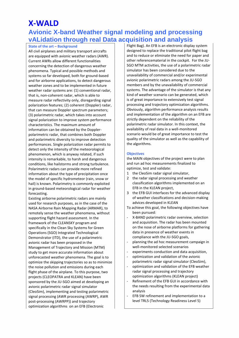
Upgrades implemented by MetaSensing in its radar sensor at X band for adapting its detection
performance to the one expected for the XWALD project.

Radar installation and certification on the DA-42 at Diamond facilities, in Austria. From top
left, clockwise: CAD study of potential location for different radar subsystems; actual
implementation in the front nose; avionics instrumentation monitored during RFI tests for
certification; mechanical check of installation for certification.
Radar installation onboard the Piaggio P-166.

Nose pod-equipped DA42 at the airport of Teuge (NL) during the first XWALD measurement
campaign.
Nose pod-equipped P-166 at the airport of Terni (IT) during the second XWALD
measurement campaign.
Acquisition flight of March 11, 2016, in Italy: on the left, meteorological situation showing
lightning events; on the right, performed trajectory.
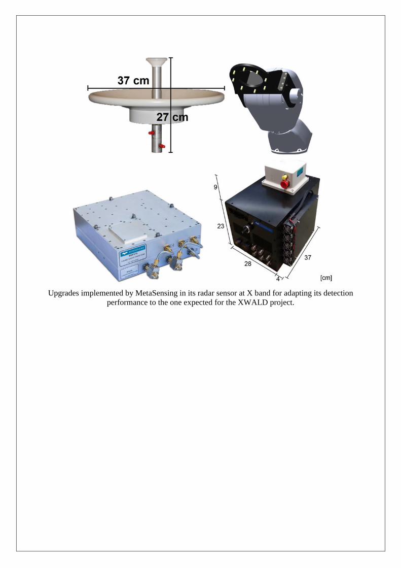
Acquisition flight trajectories of 15 (top) and 16 (bottom) March 2016
Scenarios observed during the 15 (left) and 16 (right) March 2016 flights

Example of Range-Doppler spectrograms processed from data acquired during the flights on
15 (top) and 16 (bottom) March 2016. In both cases, the four polarimetric channels are
shown.

Radar illuminated region
Example of measured radar observables.
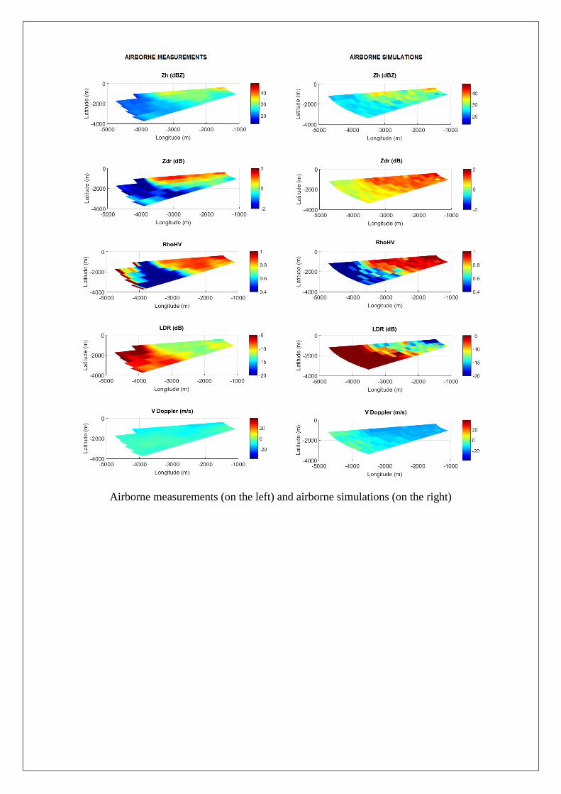
Airborne measurements (on the left) and airborne simulations (on the right)
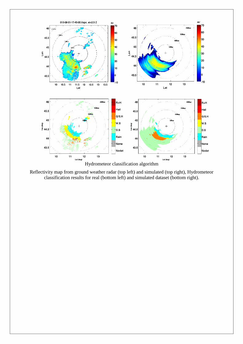
Hydrometeor classification algorithm
Reflectivity map from ground weather radar (top left) and simulated (top right), Hydrometeor
classification results for real (bottom left) and simulated dataset (bottom right).

The EFB GUI main screen soon after the no flight zone event (left), and after (right)
presentation of routes and waypoints (planned route and its waypoints are all in green, the Q-
AI proposed route and its waypoints are in magenta. The WP button switches on/off the
visibility of labels.

EFB screen - Comparison of zoom level 1 (left) and level 2 (center). Circles are at 40 and nm.
Red arrows (left) indicates the 1 Hz red lines blinking corresponding to risk area
EFB screen - Adaptive presentation of “risk zone” (red contour) and “safe zone” (yellow
contour) using geographical (left) and aircraft based (right) reference system. Hydrometeor
classification colours: red-hail, brown-snow, green-rain.

Project Summary
Acronym : XWALD
Name of proposal: Avionic X-band Weather signal modeling and processing vALidation
through real Data acquisition and analysis
Technical domain:
Involved ITD ITD-SGO
Grant Agreement: 619236
Instrument: Clean Sky JU
Total Cost: 999512
Clean Sky contribution: 656012
Call: JTI-CS-2013-02-SGO-03-022
Starting date: 01-01-2014
Ending date: 30-04-2016
Duration: 28 m
Coordinator contact details: Fabrizio Berizzi
CONSORZIO NAZIONALE INTERUNIVERSITARIO PER LE
TELECOMUNICAZIONI
Tel: +39 335 6813113
Fax: +39 050 2217535
E-mail: [email protected]
Project website address: http://xwald.cnit.it/
Project Officer: Antonio Vecchio
Participating members 1) CONSORZIO NAZIONALE INTERUNIVERSITARIO PER LE
TELECOMUNICAZIONI
2) INGEGNERIA DEI SISTEMI
3) METASENSING
4) POLITECNICO DI MILANO