Www.mtri.org Nancy HF French, Don McKenzie, Tyler Erickson Poster # 301 with on-line demo –...
10
www.mtri.org Nancy HF French, Don McKenzie, Tyler Erickson Poster # 301 with on-line demo – Wednesday Development and use of the Wildland Fire Emissions Information System for quantifying and mapping fire emissions for North America
-
date post
22-Dec-2015 -
Category
Documents
-
view
216 -
download
0
Transcript of Www.mtri.org Nancy HF French, Don McKenzie, Tyler Erickson Poster # 301 with on-line demo –...

www.mtri.org
Nancy HF French, Don McKenzie, Tyler Erickson
Poster # 301 with on-line demo – Wednesday
Development and use of the Wildland Fire Emissions Information System for quantifying and mapping fire emissions for North America

Fire & Carbon
GFED: The global amount of carbon combusted through fires is about 2.0 Pg C year-1, or about 22% of global fossil fuel emissions.van der Werf et al. 2010. Atmos. Chem. Phys. Discuss.,10:16153-16230, www.atmos-chem-phys-discuss.net/10/16153/2010/
CBM-CFS3: From 1990 to 2006 Canada’s managed forest was a Carbon Sink on average, but it was a Carbon Sourcein years with large burned area. Kurz, W.A. et al. 2008. PNAS 105:1551-1555.
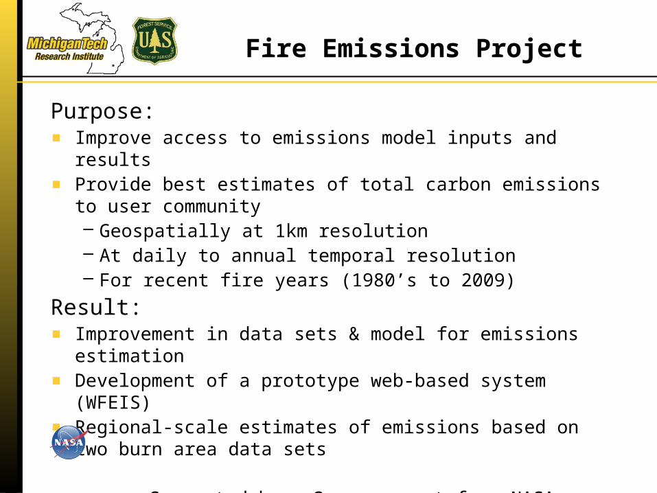
Fire Emissions Project
Purpose:Improve access to emissions model inputs and resultsProvide best estimates of total carbon emissions to user community– Geospatially at 1km resolution– At daily to annual temporal resolution– For recent fire years (1980’s to 2009)
Result:Improvement in data sets & model for emissions estimation Development of a prototype web-based system (WFEIS)Regional-scale estimates of emissions based on two burn area data sets
Supported by a 3-year grant from NASA Carbon Cycle Science Program – Applied Sciences Program

4
WFEIS Project Team
Nancy French, Mike Billmire
Tyler Erickson, Ben Koziol
Don McKenzie
Roger D. Ottmar
Ernesto Alvarado
William de Groot
Eric S. Kasischke
Pacific Northwest Research Station, USDA Forest Service
Department of Geography, University of Maryland
Great Lakes Forestry Centre, Canadian Forest Service

WFEIS Estimation of Fire Emissions
Daily weather → Fuel moisture
Location and day of fire
Fuel (vegetation) type (FCCS)
Fuel load (biomass) and fire behavior
Consumption & Emissions model
(Consume)
Output: Spatial representation of emissions

WFEIS Web-accessible Framework
Method #1:WFEIS Emissions Calculator:http://wfeis.mtri.org/
Method #2:WFEIS responds to queries submitted via properly encoded URL requests (it implements a RESTful Web API).
The WFEIS website allows for two approaches for making fuel consumption and emissions estimates

Django Web Framework
Spatial Database
Backend
RESTful Interface
User Interface
Python Scripts
HTTP Access
Web BrowserAccess
CONSUME
WFEIS Framework
URL-formatted QUERY
http://wfeis.mtri.org/api/emissions/fuelbed=fccs1km/burnedarea=mtbs/ecoregion=western/1000hr_FM=None/Duff_FM=None/CanopyPerConsume=None/PercentBlack=50/combustion_stage=total/stratum=total/output_units=tonnes/emistype=carbon/map.kml?DRNG=2002-07-01,2002-07-31&ROI=StateProvince,usa-OR

WFEIS Output
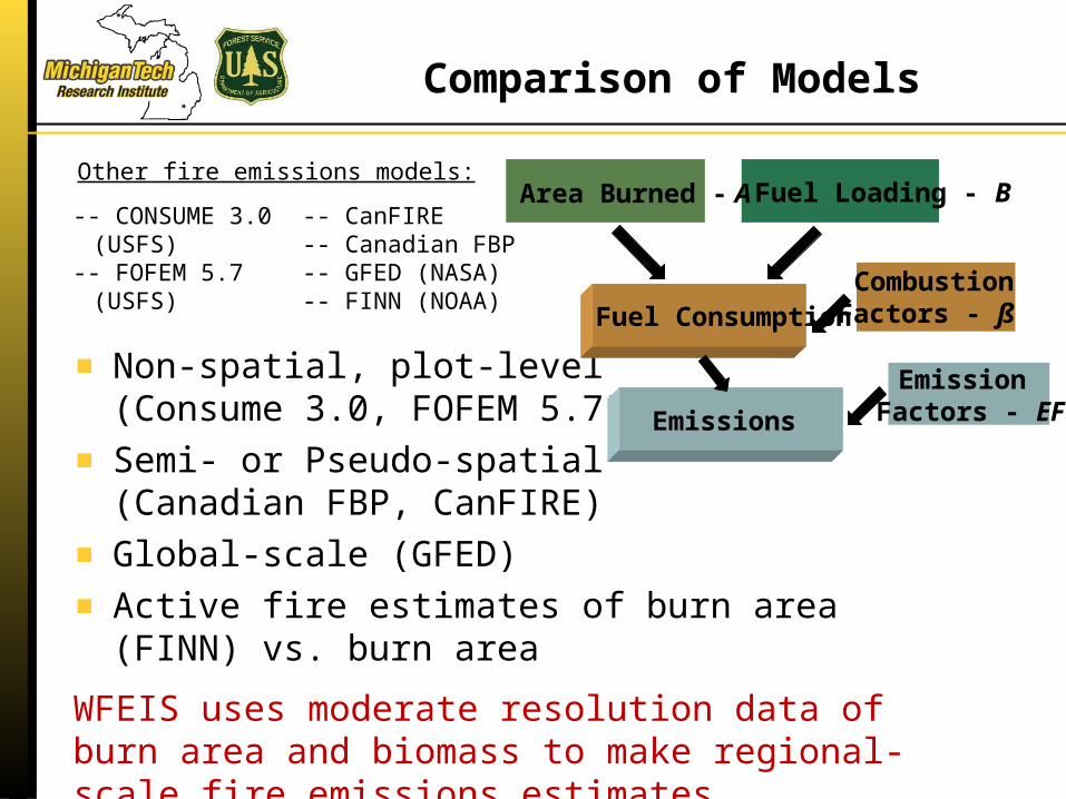
Comparison of Models
Non-spatial, plot-level(Consume 3.0, FOFEM 5.7)
Semi- or Pseudo-spatial (Canadian FBP, CanFIRE)
Global-scale (GFED)
Active fire estimates of burn area (FINN) vs. burn area
WFEIS uses moderate resolution data of burn area and biomass to make regional-scale fire emissions estimates
-- CONSUME 3.0 (USFS)
-- FOFEM 5.7 (USFS)
-- CanFIRE
-- Canadian FBP-- GFED (NASA)-- FINN (NOAA)
Other fire emissions models:
CombustionFactors - ß
Area Burned - A
Fuel Consumption
Emission Factors - EF
Emissions
Fuel Loading - B

Comparison of Models
Five fire events: -- 2002 Biscuit fire in southern Oregon-- 2003 Montreal Lake central Saskatchewan-- 2004 Boundary fire in interior Alaska-- San Diego County, California 2003 and 2007
Results:-- Models generally agree (within 25% of each other) but vary due to model assumptions
-- Vegetation fuel density, structure, and condition (fuel moisture) are important drivers of emissions variability
-- Global-scale GFED modeled emissions are consistent with landscape/regional-scale estimates
0.00
0.50
1.00
1.50
2.00
2.50
3.00
3.50
10.15 (SanDiego
07)
17.76 (SanDiego
03)
28.55 (Montreal
Lake)
33.89 (Boundary)
89.97 (Biscuit)
Are
a N
orm
aliz
ed C
arbo
n Em
issi
ons
(kg
m-2
)
Fuel Loading (kg m-2)
French, N.H.F. et al. (2011), "Model comparisons for estimating carbon emissions from North American wildland fire," Journal of Geophysical Research, 116, G00K05.