www Unmannedairspace · 2019-06-17 · Airbus Skyways In February 2016, Airbus Helicopters signed a...
35
UNMANNED AIR SYSTEM TRAFFIC MANAGEMENT DIRECTORY –JUNE 2019. V1 The Unmanned Air System Traffic Management (UTM) directory by www.Unmannedairspace.info The following directory is a listing of available UTM systems, networks and components and is supplied free of charge to www.unmannedairspace.info website visitors for information purposes only. The directory is under constant review and will be updated and enlarged. Information is supplied directly by suppliers, with data edited to remove unverifiable claims. The publisher accepts no responsibility for the information supplied. Website sources for the data plus further contact information are given alongside product and services descriptions. Company/ organisation Product Description Website Aeronyde UTM system Aeronyde is developing a complete system of hardware and software for self-flying vehicles to work safely and autonomously in urban areas. The system makes autonomous flight safe, secure, and scalable by giving unmanned aerial vehicles (UAVs) the intelligence to make the right choice in the right moment. • Real-time data analysis to contextually apply sequencing, tasking, local environment, and weather. • Machine learning to build situational awareness. • Live flight and testing in our research and development centres. The company builds, maintains and operate an end-to-end system of hardware and software, and offer customized access to public and private groups. • Autonomous flying vehicles and processors • Airspace and flight path management • Unmanned traffic management (UTM) system • User interface and training programmes https://www.aeronyde .com/system/ AirShare AirShare AirShare is the UTM system in New Zealand operated by Airways, Callaghan Innovation, UAVNZ, and the CAA. The basic AirShare service was put in place in 2015 as an aid to ATC to support the growing number of requests to fly UAVs in controlled airspace, and was essentially a web front end that enabled operators to see where they can/can’t fly, apply for access to controlled airspace, and receive approval or denial to fly. In 2018 Airways developed a new business model, and in 2019 the new service was launched giving drone operators new apps and tools, so the ANSP could see where they are flying with real-time separation alerts. For ATC this means greater awareness of UAV traffic in controlled airspace as well as venturing into controlled airspace, and https://www.airshare.c o.nz/
Transcript of www Unmannedairspace · 2019-06-17 · Airbus Skyways In February 2016, Airbus Helicopters signed a...

UNMANNED AIR SYSTEM TRAFFIC MANAGEMENT DIRECTORY –JUNE 2019. V1
The Unmanned Air System Traffic Management (UTM) directory by
www.Unmannedairspace.info The following directory is a listing of available UTM systems, networks and components and is supplied free of charge to www.unmannedairspace.info
website visitors for information purposes only. The directory is under constant review and will be updated and enlarged. Information is supplied directly by
suppliers, with data edited to remove unverifiable claims. The publisher accepts no responsibility for the information supplied. Website sources for the data
plus further contact information are given alongside product and services descriptions.
Company/ organisation Product Description Website Aeronyde
UTM system
Aeronyde is developing a complete system of hardware and software for self-flying vehicles to work safely and autonomously in urban areas. The system makes autonomous flight safe, secure, and scalable by giving unmanned aerial vehicles (UAVs) the intelligence to make the right choice in the right moment. • Real-time data analysis to contextually apply sequencing, tasking, local environment, and weather. • Machine learning to build situational awareness. • Live flight and testing in our research and development centres. The company builds, maintains and operate an end-to-end system of hardware and software, and offer customized access to public and private groups. • Autonomous flying vehicles and processors • Airspace and flight path management • Unmanned traffic management (UTM) system • User interface and training programmes
https://www.aeronyde.com/system/
AirShare AirShare AirShare is the UTM system in New Zealand operated by Airways, Callaghan Innovation, UAVNZ, and the CAA. The basic AirShare service was put in place in 2015 as an aid to ATC to support the growing number of requests to fly UAVs in controlled airspace, and was essentially a web front end that enabled operators to see where they can/can’t fly, apply for access to controlled airspace, and receive approval or denial to fly. In 2018 Airways developed a new business model, and in 2019 the new service was launched giving drone operators new apps and tools, so the ANSP could see where they are flying with real-time separation alerts. For ATC this means greater awareness of UAV traffic in controlled airspace as well as venturing into controlled airspace, and
https://www.airshare.co.nz/

UNMANNED AIR SYSTEM TRAFFIC MANAGEMENT DIRECTORY –JUNE 2019. V1
providing drone operators with a filtered view of UAV flights that they need to be aware of. The UTM system is integrated with Leidos ATM, enabling approved flights into controlled airspace to be incorporated into the ATCs dashboard as an electronic flight strip.
Air Space Drone (ASD)
FLYSAFE ASD provides a platform to manage airspace by integrating aircraft flying at low altitude. Elements include: 1. Situational Awareness - Dedicated mapping, real-time location, flight compliance brief: aeronautical information, rules, weather, etc. 2. Administrative procedures - Drone registration, airspace authorisations 3. Data processing - Flight archive, Flight Feedback and optimisation 4. Airspace management - Airspace zones definition 5. Separate manned and unmanned aircraft operating within a managed airspace
https://www.airspacedrone.com/en/
Airbus Skyways In February 2016, Airbus Helicopters signed a contract with the Civil Aviation Authority of Singapore (CAAS) allowing Airbus to test a drone parcel delivery service on the campus of the National University of Singapore (NUS) in mid-2017. For testing and assessing this new concept Airbus is working together with the Airbus Defence and Space team, who created an operation management system which is the base for the overall infrastructure that we have developed. Skyways constitutes a delivery solution that aims to provide efficient delivery of small parcels to students and faculties using drones. After this pilot test, the company is hopeful that commercial projects will be possible to launch in the Asian city and to extend the testing to passenger transport. The Skyways drone is a fully autonomous octocopter that carries air transport containers located on its underside and flies an equally fully automated route called ‘aerial corridors’ landing on a designated landing pad where it is automatically unloaded. The customer receives a delivery notification on their smartphone saying their parcel is ready for picking up at the parcel station.
http://airbus-xo.com/skyways-urban-last-mile-delivery/
Airbus Altiscope The Airbus A3 Altiscope future ATM framework simulator allows ANSPs and other ATM stakeholders to plan for future mixes of manned and unmanned aircraft. Altiscope uses a simulator built for evaluating ATM policy options and operational models that can enable all forms of airborne traffic in a wide range of geographies and jurisdictions. For example, it allows airspace planners to evaluate how urban air mobility vehicles, cargo drones, and commercial aircraft interact in the vicinity of shipping and logistics hubs or explore rules demonstrating the safety and feasibility of utilizing UAS in rural areas for transporting medical aid. The tool allows airspace planners to focus on evaluating different options for the new rules of the air and aren’t specifically tied to any particular ATM architecture.
https://www.airbus-sv.com/
UNMANNED AIR SYSTEM TRAFFIC MANAGEMENT DIRECTORY –JUNE 2019. V1
AirMap Airspace information and services
The AirMap platform powers the vast majority of the world's drones, providing a comprehensive, reliable, and real-time airspace information and services. Millions of drones and hundreds of drone manufacturers and developers rely on the platform to access and share the data they need to fly safely in low-altitude airspace. AirMap's data and services are embedded into drones, ground control stations, and flight apps by top drone makers, such as DJI, Intel, senseFly, 3DR, and Aeryon Labs – expanding the reach of AirMap's technology and solutions throughout the entire drone ecosystem. AirMap has also emerged as a leader in worldwide efforts to build technologies for UTM, the regulatory and technological framework that will facilitate data exchange and air traffic control for drones, and eventually, flying cars. More than 125 airports use AirMap's airspace management dashboard to open surrounding airspace to drones, view past and current drone flights, accept digital flight notices, and communicate with drone operators. The AirMap platform also provides solutions for geofencing, remote identification of drones, and sophisticated in-flight de-confliction.
https://www.airmap.com/
AiRXOS UTM system AiRXOS “delivers a digital Unmanned Aircraft System ecosystem designed for the next generation of air traffic management. In supporting the creation of Unmanned Traffic Management systems, AiRXOS helps organizations, cities, states and local governments meet the increasing demand for sophisticated UTM capabilities and safe, efficient UAS operations between manned and unmanned traffic.”
https://www.airxos.io/wp-content/uploads/2018/06/Airxos_Infographic.pdf
Alphabet X Lab Project Wing Google’s Alphabet X Lab’s Project Wing is building the next generation of delivery drones and developing an unmanned airspace traffic management platform that will enable its fleet of drones to safely share the sky with other operators. The aircraft can fly pre-planned routes on demand using sensors and software to detect and avoid one another in real time. They fly up to 400 feet above the ground and safely deliver fragile packages to a spot the size of a doorstep. In September 2016, Project Wing tested its aerial delivery system and more recently its unmanned air traffic management platform at an FAA-approved test site run by the Virginia Tech Mid-Atlantic Aviation Partnership.+5
https://x.company/projects/wing/
Altitude Angel Guardian UTM
GuardianUTM uses cloud technologies to provide secure, robust unmanned aerial system traffic management (UTM) capabilities to any drone, anywhere at any time. It supports both recreational and professional drone operators, while being built for internet-scale secure operations. GuardianUTM incorporates dynamic airspace management to provide safe integration for all airspace users, and works both with - and crucially, without - the need for filing flight plans in advance. Built using open standards and protocols, GuardianUTM supports the integration of unmanned systems into the airspace today, tomorrow and well into the future of fully automated
https://www.altitudeangel.com/GuardianUTM

UNMANNED AIR SYSTEM TRAFFIC MANAGEMENT DIRECTORY –JUNE 2019. V1
flight. It is customisable and modular with modules available to track manned aviation, cooperative and non-cooperative drones as well as mix in individual sensor data such as radar.
Amazon Prime Air
UTM system - best equipped, best served
Access for manned aircraft is determined by capabilities. For example, communication and navigation equipage is required for transit through controlled airspace and to gain access to certain airports. Amazon believes a similar model of determining access—one focused on Determining Safe Access with a Best-Equipped, Best-Served Model for sUAS, segregated blocks of airspace below 500 feet and away from most manned aviation operations—is the best pathway for safe and scalable sUAS operations. Once performance levels have been established, the operator’s ConOps requirements will determine whether or not the operator is granted airspace access and can safely perform the designated mission. Four Classes for Safe Operations Operators seeking broad airspace access in multiple environments will need to have highly equipped vehicles. They will also need to minimize interaction with lesser-equipped small unmanned aerial vehicles, as well as the occasional manned aircraft flying at low altitude.
https://www.amazon.com/Amazon-Prime-Air/b?node=8037720011
Analytical Graphics Inc
UTM system AGI develops commercial modelling and analysis software for land, sea, air and space systems which is used by more than 50,000 engineers, operators and analysts worldwide. AGI is leveraging almost 30 years of situational awareness software development to expand its foray into UTM services. AGI’s UTM services address the needs of commercial and beyond line-of-sight UAS operators by providing air navigation services including airspace management, real-time flight monitoring, and de-confliction.
http://www.agi.com
UNMANNED AIR SYSTEM TRAFFIC MANAGEMENT DIRECTORY –JUNE 2019. V1
ANRA DroneOSS™ ANRA provide operators with the DroneOSS™ operational platform which is fully functional and compliant with FAA and other applicable regulations for drone flight management and their mobile applications. This includes flight planning, airspace management, data analytics, compliance, drone management, resource management, maintenance information and much more. The solution provides operators and analysts access to the Command and Control for one or multiple UAV operations at any given time. The control can be delegated to users at multiple geographical locations using the Cloud based Control Station. An on-board module enables analysts to get access to the EO/IR or other sensors in real time over the encrypted links coming down to local or cloud based control station. The data also gets archived in the secure cloud for additional post processing and analytics. This can be used for simultaneous command and control functionality as well as communications for line of sight (LOS) and beyond line of sight (BLOS) operations. The system supports complete autonomous flight operations including auto takeoff and landing as well as camera and sensor control. The integrated flight planning feature supports both fixed wing and multi-rotor aircraft. If the drone based radar is enabled, ANRA can enable all of the subscribers to use Over The Horizon radar (“OTH” or “BTH”) to ‘view’ what is in range.
http://www.anratechnologies.com/home/service-view/
Ariascend Remote identification system
The company has proposed a remote identification technology and framework to allow authorities and citizens to identify drones in air. In November of 2015, AriAscend shared documents and e-mails that outlined a proposal for in-air identification of unmanned aircraft systems (“UAS”) with the Federal Aviation Administration, EPIC, DJI, the University of Southern Denmark, Loretta Alkalay, and others.
http://www.ariascend.com
Astral Aerial UTM system for Africa
https://www.expouav.com/news/latest/astral-aerial-solutions-developing-utm-system-africa/

UNMANNED AIR SYSTEM TRAFFIC MANAGEMENT DIRECTORY –JUNE 2019. V1
Astral Aerial’s UTM system seeks to provide safe UAV operations in Africa by creating virtual highways and routes for drones of different sizes and missions to safely operate while providing pilots with information such as airspace restrictions, NOTAMs and weather. Most importantly, its ultimate objective is to be integrated into the national airspace and provide better oversight for regulators to facilitate ease of growing the UAV industry. Initially, the company is rolling out a Low Altitude Authorization and Notification Capability (LAANC) version of the UTM. The low altitude authorizations will integrate drone registrations with the Kenya Civil Aviation Authority (KCAA), handle licensing of pilots and most importantly perform airspace authorisation for drone missions. The application will enable pilots to reserve airspace and interact with maps to know geo-fenced areas, obstacles/terrain and other drone activities. KCAA and relevant airport authorities will then be able to approve the applied flight plans. As the company iterates the LAANC, it is prototyping the use of GSM technology for live tracking.
ATA, LLC and Harris
ATA-Harris LAANC
ATA, LLC has partnered with Harris Corporation to jointly develop a Low Altitude Authorization and Notification Capability (LAANC) application and has obtained all FAA-required approvals to offer the service. The ATA-Harris LAANC has all the functionalities required by the FAA but also incorporates unique features, such as free-form drawing, which gives pilots the flexibility to define desired operational areas,” according to a company press release. “This creates efficient flight plans that minimize the use of airspace to facilitate FAA approvals. The LAANC application has been in limited operational testing since Harris became an approved USS in July 2018, but it is now broadly available to new beta customers.” ATA is focused on leveraging advanced data science capabilities in geospatial analysis, semantic integration and automation to address the data-intensive elements of operating drones for commercial and public use.
www.ata-llc.com and www.ata-llc.com/us.
UNMANNED AIR SYSTEM TRAFFIC MANAGEMENT DIRECTORY –JUNE 2019. V1
Civil Aviation Administration of China (CAAC)
UOMS Details on the development of China’s Civil UAS Aviation Operation Management System (UOMS) have been published by Blyenburgh & Co as part of the proceedings of the EU-China APP Drone Workshop https://rpas-regulations.com/community-info/china-eu-china-app-drone-workshop-180606-08/ which was held between 6-8 June 2018 in Shenzhen, China. In a presentation by Dr Jianping Zhang, of the ATM Engineering Technical Research Institute, Civil Aviation Administration of China () the UOMS UTM traffic management system will be integrated within the CAAC’s General Aviation Flight Service (GAFS) system and current ATM system. The UOMS concept has the following elements: • Airspace configuration (Static geo-fencing) • Flight plan approval • Flight surveillance and alarm • Dynamic geo-fencing and alarm data push • Low airway control • Traffic capacity and flow management According to the presentation: “Information exchange between GAFS and UOMS should be based on the principle of “complete exchange” as follows: GAFS should transmit to the UOMS all general aviation flight plans and real-time flight data….UOMS should transmit to GAFS all flight plans (except open operations) received by UOMS and real-time UAS flight data. In terms of linking the UOMS network to the ATM system: “Current ATM should transmit to UOMS the flight path of the transport aircraft in terminal (approach) control area, in order to provide the basis for the required task approval and real-time collision risk alarm for UOMS. Due to natural physical isolation, ATM does not need to transmit the en-route flight path of the commercial flight. UOMS should transmit to current ATM all flight plans (except open operations) received by UOMS and real-time UAS flight data, including real-time latitude and longitude, altitude, speed, course, flight identification and so on.” Commercial drones apply to fly via the U-Cloud (www.u-cloud.cn) system. Operations are supported by three types of ground control stations – take-off, en-route and landing. “Ground stations and current ATM control systems interact through the link relay of the RPAS itself. The RPAS switches over multiple crews (ground station control team) during operation.”
https://rpas-regulations.com/wp-content/uploads/2018/06/1.2-Day1_0910-1010_CAAC-SRI_Zhang-Jianping_UOMS-_EN.pdf
Colibrex Drone-Flight-Check
Based on the company’s expertise towards dynamic databases and licensing processes, together with LS telcom, Colibrex has launched Drone-Flight-Check, a drone information and drone traffic management database & app for enhanced safety and regulation. Further services and products
http://www.colibrex.com/en/drone-management/

UNMANNED AIR SYSTEM TRAFFIC MANAGEMENT DIRECTORY –JUNE 2019. V1
from technology partners in the field of drone identification and drone surveillance round up the company’s activities towards drone management.
Converge Control Tower AI-based software so drones can take on the dull, dirty and dangerous work, allowing businesses to focus on their customers. A LAANC supplier.
www.control-tower.co
CS Group BOREADES In June 2019 CS Group announced a strategic partnership with Air Space Drone (ASD), a French start-up specialising in unmanned air traffic management (UTM) at low altitude, on 16 June 2019. The partnership combines ASD’s Flysafe aeronautical platform which displays low-level air traffic, with the BOREADES command and control system developed by CS. The aim is to detect and identify malicious drones in a secure area using CS Group’s anti-drone system which is used by military and security forces. CS Director of Defense & Security Frédéric Dussart said the partnership will improve identification of potential threats in response to the explosion of drone traffic.
www.c-s.fr/Le-Groupe-CS-Air-Space-Drone-signent-un-partenariat-strategique-pour-offrir-la-premiere-solution-globale-integrant-la_a932.html
D-Flight D-Flight UTM system
D-Flight is the company created by ENAV in November 2018 to develop the U-space platform for the provision of UTM services. The Company's capital is held 60% by ENAV and 40% by an industrial team led by Leonardo in partnership with Telespazio and IDS-Ingegneria Dei Sistemi. ENAV, through D-Flight, aims to make the traditional air traffic coexist with the needs of the new type of traffic, allowing the use of drones for an increasing number of services also of public utility, ensuring the highest levels of safety. D-Flight will release the U-space services progressively, according to a roadmap that anticipates the European program and the ongoing regulatory process, recently launched by the European Air Safety Agency (EASA). Some basic services are already available on the www.d-flight.it portal, in particular the professional drone registration service and the "geoawareness" service, which allows to understand if at a certain point in time Italian territory is possible to fly and what are the flight conditions, based on the regulations in force.
https://www.d-flight.it/en/node/49
DJI Decentralised UTM, drone identification systems and Aeroscope.
AeroScope is a comprehensive drone detection platform that rapidly identifies UAV communication links, gathering information such as flight status, paths, and other information in real-time. This monitoring data stream helps users make an informed response as soon as possible.
https://www.dji.com/uk/aeroscope
UNMANNED AIR SYSTEM TRAFFIC MANAGEMENT DIRECTORY –JUNE 2019. V1
At the International Civil Aviation Organization (ICAO) Drone Enable conference in Montreal DJI announced a new approach to developing first generation UAS traffic management (UTM) systems relying on current technologies and local communications protocols. In a whitepaper launched at the event the drone maker outlined its vision of a future UTM system without many of the central control functions featured in other UTM concepts. “UAS are also moving at far slower speeds in their typical operations, allowing time for collision avoiding courses to be exchanged among them locally,” says the paper. “In addition, multi-rotor drones, which currently account for the vast majority of civilian UAS operations, have the ability to stop forward motion and hover, if necessary. These unique characteristics of UAS weigh in favour of on-board anti-collision technologies (OATS) as the primary mechanism for collision avoidance, with network traffic planning only required in areas of high congestion.” In another whitepaper on the electronic identification framework for small drones, DJI argued that rather than force drones to transmit identification information over wireless networks to a centralized server…. “an identifier, such as a registration number, together with position information about the drone, and perhaps some voluntary information if the operator wishes, is transmitted from the drone, and is available to all receivers that are within range…This localized approach is preferred to networked solutions, which raise a number of concerns. A networked solution requires network connectivity, most typically via mobile phone. There are various locations that lack reliable data signals, which would thwart the ID system, as well as provide an excuse to a non-compliant operator. A networked solution also inherently raises the possibility that all UAS operations will be tracked and recorded for future unknown exploitation, including enforcement quotas or business espionage. A networked system is also susceptible to system-wide hacking, or the creation by detractors of false entries of drone operations that do not exist.”
DLR Blueprint Concept for Urban Airspace Integration
The German Aerospace Center (Deutsches Zentrum für Luft- und Raumfahrt; DLR) has developed a concept that brings unmanned aircraft of all classes together with conventional aeroplanes and helicopters within urban airspace. The DLR concept, in the form of the Blueprint Concept for Urban Airspace Integration, addresses this very issue. "At the heart of the concept is the versatile assessment of every single aircraft according to its technical equipment and dimensions," says Dagi Geister, who leads the Unmanned Aircraft Systems expert group at the DLR Institute of Flight Guidance. "Drones that are well equipped in terms of navigational systems, Detect-and-Avoid sensors and communications and monitoring capabilities could fly in great numbers within a specific airspace segment. But if drones with inferior technology start to be used elsewhere, only a few flights will be permitted within a large area.” In principle, however, the new concept allows all airspace users to fly, regardless of how technically sophisticated they are. As part of the concept, the versatile classification of technical and aeronautical features is visually represented in an easy-
http://www.dlr.de/dlr/en/desktopdefault.aspx/tabid-10204/296_read-25547/#/gallery/29441
UNMANNED AIR SYSTEM TRAFFIC MANAGEMENT DIRECTORY –JUNE 2019. V1
to-grasp way using multidimensional polygons that provide an individual overview of each aircraft. The bigger the aircraft and the more restricted its technical equipment in terms of navigation, communications and the ability to detect other airspace users (whether cooperative or not), the larger the polygon. The better the aircraft’s overall performance, the smaller the resulting polygon. All aircraft are assigned a risk-minimised flight path. According to the concept, flight paths within the 'U-Space', as airspace close to the ground will be called, will be assigned via a central U-Space service. Aircraft that register prior to taking off will receive a full simulated and risk-minimised flight path in advance via this service, taking into account airspace users that are already airborne. Critical areas on the ground, such as those with large gatherings of people, will be avoided. This will result in a flight route with as few deviations as possible from the ideal path
Drone Aviator Openskkye Drone Aviator is a software development firm that develops security technology solutions for the drone industry. Drone Aviator offers OpenSkkye, an application that enables drone pilots to find places to fly and connect with the other pilots.
http://openskkye.com/
DroneLogbook DroneLogbook
The platform integrates business operations with regulatory obligations. DroneLogbook reduces the burden by automating many of these tasks:
Generate compliance (FAA, CAA, CASA, CAD, EASA, DGAC, TBST) reports in seconds.
Create documentation electronically (Authorization Forms, POA etc)
Create custom checklist and risk assessment forms
Map flight areas and check safety status with Airmap Airspace Intelligence
Import flight log files or automatically push your flight data from 3rd party apps. Show exactly where, when and how the mission was executed
Attach documentation to flights to track compliance
Project folders with all flights & documentation in a single folder to better manage operations and compliance
Notification and tracking of maintenance tasks
Create custom reports in seconds Operate offline and sync when online
https://www.dronelogbook.com
UNMANNED AIR SYSTEM TRAFFIC MANAGEMENT DIRECTORY –JUNE 2019. V1
Drone Radar DAMS Around 1,100 drone operators are daily using DroneRadar’s airspace status and flight authorisation tool; the DAMS (Drone Awareness and Monitoring System) is now fully integrated within the airspace planning system of the national air navigation service provider, the Polish Air Navigation Services Agency (PANSA). The smart phone/tablet based tool has three major functions:
It analyzes the airspace environment based on aeronautical data supplied by AIP Poland, airspace use plan and NOTAMs illustrating the airspace situation with three green, yellow, red lights to show the availability of airspace in terms of time and place.
Second, it offers the possibility of two-way non-verbal communication between air traffic services (ATS) and the drone operator, providing exchange of information on flight approvals and updates.
Third, it provides an automated, bi-directional emergency response service where the air traffic service operators can inform drone users about a requirement for immediate landing – where emergency helicopter operations are required, for example, or where the drone operator can report a loss of control over the drone. This information is transmitted electronically to the PAZP services
At the start of 2018 the tool was processing around 60,000 airspace availability checks a month.
https://droneradar.eu
Droniq DFS/Deutche Telecom
Droniq was launched publicly on 29 May 2019. It is a technical platform to track drones, enabling drone flights beyond the visual line of sight (BVLOS). According to a DFS/Deutsche Telecom press release the two companies have developed a technology that uses the mobile communications network to track unmanned aircraft systems (UAS). “This puts in place one of the central preconditions to be able to safely operate drones across larger distances, and not just in close vicinity to the pilot…This system processes the position data of drones and displays them together with the tracking data of manned aircraft. In this way, a complete air situation display is created. The UTM system also offers additional functions for the safe operation of drones in German airspace, including registration, mission planning and an automated process for obtaining any permissions required for a particular mission”. The hardware needed at the moment is made up of a special modem with an integrated SIM card, the so-called hook-on device. After this device is hooked on, or mounted, on the drone, it can transmit the position of the drone and its identification to the UTM system using the mobile communications network. In addition to these basic data, the network can also be used to transfer other information, such as image and survey data in real time. Droniq’s goal is to develop the product into a purely digital solution. This will require drone manufacturers to equip their
https://droniq.de/en
UNMANNED AIR SYSTEM TRAFFIC MANAGEMENT DIRECTORY –JUNE 2019. V1
drones with an LTE module as standard. Then users would only have to activate the SIM card to be able to use the UTM system. At first, Droniq will focus on the German market, the home market for DFS and Deutsche Telekom. Then a phased expansion across Europe is planned. Droniq’s primary target market is commercial users in the infrastructure, surveying and agricultural sectors which intend on flying drones beyond the visual line of sight. Other potential users include the police, fire and rescue services as well as users from the general aviation environment. Training courses for drone operators and individual consultancy services are already part of Droniq’s portfolio.
Dronsystems DroNav DroNav by DronSystems is a Highly Automated Air Traffic Management System for Small UAVs Operating at Low Altitudes. The platform is a self-learning complex, based on software and hardware elements, operating in distributed computing environment, offering multiple levels of redundancy, fail-safe algorithms for conflict prevention/resolution and assets management. The system is easily deployable, scalable, and allows safe management of concurrent operations of a large number of UAVs in the same airspace. DroNav is being designed as a universal platform, connecting various stakeholders (operators, regulators, law enforcement agencies, product developers) and capable of providing interoperability of different systems and airspace users in a unified environment
https://www.dronsystems.com/
European Commission
U-Space Following a request by the European Commission, the Single European Sky Air traffic management Research Joint Undertaking – whose role is to develop the new generation European air traffic management system – has unveiled its blueprint to make drone use in low-level airspace safe, secure and environmentally friendly. This "U-Space" covers altitudes of up to 150 metres. Registration of drones and drone operators, their e-identification and geo-fencing should be in place by 2019. The U-Space should be: • Safe: safety at low altitude levels will be just as good as that for traditional manned aviation. The concept is to develop a system similar to that of Air Traffic Management for manned aviation. • Automated: the system will provide information for highly automated or autonomous drones to fly safely and avoid obstacles or collisions. • Up and running by 2019: for the basic services like registration, e-identification and geo-fencing. However, further U-Space services and their corresponding standards will need to be developed in the future.
http://europa.eu/rapid/press-release_IP-17-1605_en.htm
UNMANNED AIR SYSTEM TRAFFIC MANAGEMENT DIRECTORY –JUNE 2019. V1
The European Aviation Safety Agency (EASA) is working with Member States and industry to produce effective EU-wide safety rules that are proportionate to the risk of the operation. These rules will implement the EU's basic aviation safety regulation which the European Parliament and the Council (i.e. the EU Member States) are expected to adopt in the coming months. The Commission, through the SESAR Joint Undertaking, will finance a range of drone projects, focusing on the integration of drones into the aviation system. Finally, an expert group will be established to act as a sounding board for the further development of European drone policy. Delivering services in urban areas, collection of data for a wide range of industries, infrastructure inspections, precision agriculture, transportation and logistics are just some of the possible applications of this technology. Current common European rules only cover drones weighing above 150 kilograms. Below this threshold, Member States are responsible to regulate. While national rules allow expertise to grow, they often diverge and cause a fragmentation of the EU internal market. Such fragmentation hampers the development of new products, the swift introduction of technologies and may also create safety risks. In December 2015, the Commission therefore proposed to create an EU-wide framework for drones as part of its Aviation Strategy. This requires the establishment of a regulatory framework, including standards, and the safe integration of drones into the airspace, on which today's blueprint delivers.

UNMANNED AIR SYSTEM TRAFFIC MANAGEMENT DIRECTORY –JUNE 2019. V1
The progressive deployment of U-space is linked to the increasing availability of blocks of services and enabling technologies. Over time, U-space services will evolve as the level of automation of the drone increases, and advanced forms of interaction with the environment are enabled (including manned and unmanned aircraft) mainly through digital information and data exchange. • U1 U-space foundation services provide e-registration, e-identification and geofencing. • U2 U-space initial services support the management of drone operations and may include flight planning, flight approval, tracking, airspace dynamic information, and procedural interfaces with air traffic control. • U3 U-space advanced services support more complex operations in dense areas and may include capacity management and assistance for conflict detection. Indeed, the availability of automated ‘detect and avoid’ (DAA) functionalities, in addition to more reliable means of communication, will lead to a significant increase of operations in all environments.

UNMANNED AIR SYSTEM TRAFFIC MANAGEMENT DIRECTORY –JUNE 2019. V1
• U4 U-space full services, particularly services offering integrated interfaces with manned aviation, support the full operational capability of U-space and will rely on very high level of automation, connectivity and digitalisation for both the drone and the U-space system Three services have already been identified as “foundation services”: electronic registration (e-registration), electronic identification (e-identification) and geofencing. Current initiatives envisage that electronic registration is mandatory for drone operators (except operators of drones weighing below 250 grams), as well as some classes of drones used in the open category, and all drones used in the specific category. Electronic identification will allow authorities to identify a drone flying and link it to information stored in the registry; the identification supports safety and security requirements, as well as law-enforcement procedures.
Exponent Technology Services
UTM portal The Exponent UTM portal caters to aviation regulator’s need to integrate drones within civilian approved airspace. Coupled with Exponent’s SkyCommander Tracker, the portal allows authorities to manage a host of UAV/RPAS flight operation functions such as UAV/RPAS, Pilot, NOC management & Billing from a single operational console. Overlaid with dedicated ADS-B civil air traffic data – UAV/RPAS separation data can be monitored in near real time, with automated alerts generated based upon customizable metrics as defined by the regulator. Data is stored and available for audit as a flight replay or as a data export for integration with 3rd party tools. Reports can be generated at the flight level or aggregated over time, pilot, RPAS, alert type or any combination of the above to provide a comprehensive analytical tool to study RPAS/UAV and ultimately pilot behaviours. The portal has built in extensibility to allow enterprise deploy their own applications via API to enable payload data visualization and analytics.
http://exponent-ts.com/expertise/

UNMANNED AIR SYSTEM TRAFFIC MANAGEMENT DIRECTORY –JUNE 2019. V1
FOCA SUSI The Swiss Federal Office of Civil Aviation (FOCA) has launched the Swiss U-Space Implementation (SUSI) platform in April 2019 with initial member partners skyguide, AirMap, Swisscom, INVOLI, Wing, senseFly and Auterion. Under the Swiss U-Space concept the programme is divided in a centralized and a competitive environment. “The Flight Information Management Service (FIMS) is the U-Space component that skyguide will build and manage centrally to support U-Space operations. The FIMS will provide centralization and allocation of airspace to and from relevant stakeholders, exchange relevant information with neighbouring ANSPs and other relevant stakeholders, centralize and consolidate registration information.” Other functions will be provided by UTM service providers, or “USPs”. These are entities that support safe and efficient operations by providing services to the operator A USP is connected to the FIMS and acts as a communication bridge between federated U-Space actors to support operators abilities to meet some regulatory and operational requirements for UAS operations. USP services support operations planning, aircraft de-confliction, conformance monitoring, and emergency information dissemination. USPs may provide additional value-added services depending on the U-Space user needs. According to FOCA: “The U-Space is a set of services and specific procedures enabling a safe, efficient, sustainable and secure integration of UAS into airspace. These services rely on a high level of digitalisation and automation of functions, which enable complex operations with low human workload. Harmonized standards worldwide are key for a dynamic drone sector, as legal certainty is needed to enable investment. According to the European Commission, the drone industry will represent up to 10 percent of the aviation market within the next 10 years what explains the objective of Europe to be at the forefront of setting global standards in the domain. Moreover, the European Commission identified that “the infrastructure, software and data to build a U-Space are already available. The challenge is to integrate the existing building blocks into a genuine efficient system and, at the same time, tackle safety, security and environmental concerns” (Commissioner Bulc presents plans for the creation of a European drone services market, European Commission, 2016). “In Switzerland, the implementation of the different technologies required is already ongoing. This work is inspired by the US Federal Aviation Administration’s (FAA) UTM concept of operations and the work of Concept of Operation for European UTM System (CORUS) and has resulted in the current Swiss U-Space Concept of Operation (SUSCO).
https://www.bazl.admin.ch/bazl/en/home/good-to-know/drones-and-aircraft-models/u-space.html
UNMANNED AIR SYSTEM TRAFFIC MANAGEMENT DIRECTORY –JUNE 2019. V1
“A Memorandum of Cooperation (MoC) governs the interaction between the different stakeholders. Any such entity fulfilling the roles set forth therein and intending to positively contribute to the development of the Swiss U-Space can apply to join the SUSI. “The users of the U-Space are not expected to be part of the SUSI. However, users with special needs like the police, the military, Helicopter Emergency Medical Services (HEMS) and others are included in a special user group under the UAS-Integration program and provide their requirements to the SUSI.“
GLVI UrbanATM UrbanATM is a modular, redundant and expandable system. Services can be implemented gradually - depending on traffic density and following demand. UrbanATM is designed for urban environments - for areas without clear lines-of-sight, and with atmospheric disturbances e.g. fog, rain, or dust. The system is particularly designed to work with high traffic densities. It does not distinguish between remotely piloted and software-in-control unmanned aircraft. It takes into account both airspace users that cooperate with the system, and such that don’t - like pedestrians, leisure drones, or birds.
http://www.urbanatm.de/
Gryphon Sensors Skylight, Mobile Skylight, R1400 3-D Active Electronically Scanned Array (AESA) air surveillance radar, S1200 2-D Active Electronically Scanned Array (AESA) direction finder, Skylight Airspace
Gryphon Sensors Skylight system uses multiple ground-based sensors to detect cooperative and non-cooperative targets in the airspace, providing intelligent situational awareness for integration and security. Mobile Skylight is a new standard in drone security and unmanned aircraft system (UAS) traffic management. Featuring an array of self-contained sensors, it serves as a complete mobile command centre for many applications. Contained in a van, Mobile Skylight features 4×4 off-road capability and can be taken anywhere without a commercial driver’s license. Gryphon Sensors R1400 is a 3-D Active Electronically Scanned Array (AESA) air surveillance radar designed specifically for the detection of small, low-flying targets. The R1400 provides rapid, precise detection and tracking of airborne targets, including small unmanned aircraft systems (UAS), general aviation, birds and other cooperative or non-cooperative targets of interest. It provides accurate target position and velocity in a configurable hemispherical volume of coverage: 360 degrees in azimuth and 90 degrees in elevation. The S1200 is a 2-D Active Electronically Scanned Array (AESA) direction finder that monitors the signals in the relevant frequency bands for the rapid and precise detection and tracking of small unmanned aircraft systems (sUAS). It uses an extensive library of drone control signal profiles in order to detect and classify these types of signals. This passive sensor reliably and automatically detects the remote control of a commercial microdrone within a 5 km radius. The company also offers a variety of high-resolution, slew-to-cue, optical tracking cameras used to get eyes on the target. Used for visual identification and optical tracking, this sensor is especially useful in the classification of non-cooperative targets like
http://gryphonsensors.com/

UNMANNED AIR SYSTEM TRAFFIC MANAGEMENT DIRECTORY –JUNE 2019. V1
Monitor Interface
birds, general aviation, etc. It uses both thermal and EO lenses to view airborne targets up to 3km in range — with 360° pan and 180° tilt rotations. The SAMI (Skylight Airspace Monitor Interface) gives a complete airspace picture.
Harris UTM system Harris provides safety-critical, aviation-grade solutions that integrate small UAS in the National Airspace System (NAS). Solutions incorporate NAS-wide air traffic surveillance data feeds from the FAA, commercially-available cooperative and non-cooperative surveillance sensors, software services for UAS operations support, display systems, and engineering services. Harris technologies enable safe and routine Beyond Visual Line of Sight (BVLOS) operations for small UAS in a complex and crowded airspace. A LAANC supplier
https://www.harris.com/solution/unmanned-aerial-systems-uas
Hionos SignalPack, Pulsar
SignalPack is a component aimed at drone manufacturers. It solves international regulatory compliance issues by managing positioning, signalling and performance restrictions. SignalPack features automatic identification and fly zones restriction. It is compatible with all drones, either already on the market or soon to be released. Identification, signalling and capacity limitation: SignalPack meets France's news safety laws pertaining to civilian drones. Pulsar is a highly reliable autopilot system, compliant with international aeronautical standards. It enables the use of drones in places where safety is critical. Autonomous take off, cruising and landing: Pulsar provides all features necessary for a fully automated flight. It embeds Fail-Safe mechanisms for maximum safety. Pulsar connects to any equipment required for a project: delivery, camera...
https://www.hionos.com/#home1
IDS DREAMS DREAMS is a SWIM compliant, web-based system conceived for low altitude airspace management and for the provision of information services. DREAMS enables Air Navigation Service Providers (ANSP), private VLL airspace service providers and major UAS operators to register, identify, authorize, track, notify and manage UAS flights. DREAMS system implements a large set of capabilities needed to integrate small UAS into low altitude airspace, from strategic planning to post operations analysis. The system acts as a single point of entry for all the stakeholders involved in the management of UAS traffic, such as UAS operators and recreational users, VLL manned airspace users, aviation authorities, ATC, airport operators, local authorities, etc., through the provision of tailored services and interfaces, enabling common situational awareness across multiple domains for the entire UAS aviation community. DREAMS is conceived
https://www.idscorporation.com/news/ids-present-advanced-air-traffic-management-support-systems-world-atm-congress/

UNMANNED AIR SYSTEM TRAFFIC MANAGEMENT DIRECTORY –JUNE 2019. V1
to cover the complete spectrum of functionalities needed to integrate sUAS into low altitude airspace: • Vehicle Registration & Identification – sUAS registration processes, including automatic unique ID assignment and QR code generation for identification and tracking • No-fly zone and airspace management and reservation – creation and management of no-fly zones; allow “special” users to make requests for airspace/corridors reservations. • Flight planning definition and management – operation planning supported by an interactive 2D/3D map; prompt automatic notification in case of issues impacting planned operations. • Flight validation and scheduling – validation and authorization (where required) of sUAS submitted flights in order to ensure that the mission can be operated in a safe manner. • Flight Awareness, Notification & UAS Tracking – integrated display of UAS mission area/plan, real-time UAV position reports, no-fly zones and other relevant overlays; notification to UTM stakeholders and ATC of potentially dangerous situations in order to allow for timely interventions. • Airspace occupancy prediction & DCB – quantify UAS traffic demand and notify UTM supervisor of potential overload situations that need to be managed. • Recording, playback and investigation – playback of UAS traffic data and statistical report generation for post-operation analysis, anomalous event investigation and verification of regulatory or operational non-compliance events.
Indra UTM Connect and Indra/AirMap UTM solution
Though the UTM Connect platform, local authorities may monitor, influence and manage drone traffic in the lower altitude airspace under their responsibility. Users can access the platform though the Web as well as mobile phones or tablets, and it provides an API connectivity to allow its integration with third-party systems (operational flight mission, fleet management, emergency management. Depending on the needs, the UTM Hub and Connect can be combined in order to establish a personalized platform that will look forwards to meeting our client’s highest expectations. In March 2019 Indra and AirMap signed a collaboration agreement to jointly develop UTM technologies. The two companies plan to align AirMap’s expertise with UTM platforms managing drone traffic at low-altitude (below 150 metres) with Indra’s UTM/ATM solutions and anti-drone protection systems. According to a company press release: “Both companies develop their technologies under an open architecture that will make the integration of third-party systems and applications easier and will provide the scalability necessary to adapt to the needs of each client, whether it is a town council or the authority responsible for managing the traffic of an entire country.“
https://www.indracompany.com/en/utm-connect
UNMANNED AIR SYSTEM TRAFFIC MANAGEMENT DIRECTORY –JUNE 2019. V1
Meanwhile in April 2019 Norwegian industry/academic cluster consisting of Indra, the University of South-Eastern Norway, and Andøya Space Center has embarked upon a project to accelerate deployment of a UTM system partnering with Indra. According to an Indra press release the project has been named Pilot-T and will investigate the definition of traffic corridors for unmanned flight, the integration of various electronic and optical sensors into the system, communication requirements, integrity and safety, as well as effective HMI models. It will be concluded in 2021.
Intel RealSense and Mission Control
Intel’s advance automation and obstacle avoidance and pilot assistance function software is powered by Intel RealSense™ technology, flight planning automation with Intel Mission Control software and automatic change detection with Intel Insight Platform. These technologies will enhance the abilities of Intel drone solutions for commercial applications. Intel Mission Control software allows Intel to fly the fully-automated mission, assisted by Intel indoor location technology for position. In addition to existing strategic engagements with companies such as Topcon, Airbus and Volocopter, Intel has expanded its ecosystem relationships to include DELAIR, Honeywell, Pix4D, Bentley, Cyberhawk, Aeroprotechnik and HUVRdata among many others, to bring these new platforms to the market.
https://newsroom.intel.com/news/intel-auvsi-xponential-2017-intel-takes-flight-new-capabilities-solutions/

UNMANNED AIR SYSTEM TRAFFIC MANAGEMENT DIRECTORY –JUNE 2019. V1
Involi Involi.live involi.live collects real time LAATD (Low Altitude Air Traffic Data) from ADS-B (Automatic Dependent Surveillance & Broadcast) and aircraft transponders, processes it and transmits it to the UTM system so anyone flying and connected to the system can have that information on-board in real time. The solution is to scale-down and adapt the concept of the control tower to the use case of drones, by creating unmanned micro control towers to detect the position of aircraft. This has the advantage of enabling integration of all latest technologies in such devices, while taking out from the loop the weakest element of the equation: the human. The data gathered from a network of micro control towers will be made available in real-time on a platform. In this way, the information on surrounding air traffic could be used by any air traffic connected to it, to automatically and efficiently.
http://www.involi.com/how-it-works.html
Japan UTM consortium
UTM system A conglomeration of companies and agencies which aims to create a new industrial “drone innovation space”. Has developed a roadmap of technologies; in March 2017 carried out a large-scale drone operation demonstration of multiple operators in Minami-Soma City, Fukushima Prefecture. The aim is to incorporate Japanese systems and technologies into “international standards” targeted by NASA’s UTM.
http://www.jutm.org/
Kittyhawk Flight planning tool
Kittyhawk unifies the mission, aircraft and data to empower safe and effective drone operations. Based in San Francisco, the company develops real-time flight operations and management solutions for professional pilots and fleet managers across a multitude of missions. Leading companies and organizations in media, insurance, oil and gas, education, law enforcement, fire and emergency management all rely on Kittyhawk for their end-to-end drone operations.
https://kittyhawk.io.
Kongsberg Geospatial
Emergency Operations Airspace Management System (EOAMS)
Kongsberg Geospatial, an Ottawa-based developer of geospatial software technology, is developing an Emergency Operations Airspace Management System (EOAMS) for evaluation by Canadian government agencies for safely managing drones at emergency and disaster scenes. The EOAMS is a portable display that interfaces with a variety of local sensors, including radar and Automatic Dependence Surveillance – Broadcast (ADS-B) receivers to give a clear picture of the airspace around disaster areas. It is intended to allow first responders to safely use unmanned aerial vehicles (UAVs) to survey the area, without risking collision with other emergency aircraft, including water bombers or rescue and police helicopters. The system would also provide a warning to first responders if unapproved UAVs approach the area – providing a degree of
https://www.kongsberggeospatial.com/company/news-media/100-govt-of-canada-awards-uas-airspace-management-system-contract-to-kongsberg-geospatial

UNMANNED AIR SYSTEM TRAFFIC MANAGEMENT DIRECTORY –JUNE 2019. V1
protection against what is becoming an increasing problem with the proliferation of small consumer camera drones at fires and accident scenes. The new EOAMS will be based on Kongsberg Geospatial’s IRIS UAS™ airspace visualization system. The IRIS spatial awareness system evolved from technology originally developed for air traffic management display systems, and for supporting flight operations for military UAV systems like the US Navy Triton Global Hawk. The system has been developed for safely operating UAVs beyond visual line-of-sight (BVLOS), and has been adopted by the FAA ASSURE group for use in research toward developing regulations for commercial BVLOS operations in the United States.
Leonardo Automated UTM system
Leonardo is ready to deploy an automated UTM system, relying on new technologies, to efficiently and safely manage drone traffic in VLL airspace. The system can provide public register of drones, communication, route and mission planning, conformance monitoring, dynamic geo-fencing, ground based safety nets and contingency management. The cooperative drones have to be equipped with: • self-identification and self- positioning facilities • communication facilities to transmit to the UTM system position data and equipment status. The UTM functionalities are implemented in a scalable cloud platform in order to offer Cloud Service Applications to the various UTM stakeholders. The system is designed as a “Platform as a Service”, able to integrate additional SW solutions such as payload cloud data storage, thus offering full functional applications as “Software as a Service”. The software components are virtualized and included in a Cloud Architecture using the open source Apache CloudStack platform. The Communication Gateway manages the links with all UTM stakeholders and their secure authentication and the pre-flight mission requests are validated by the Public UAV and Pilots Registry (and by the Mission Safety Processor). During the mission the position reports received from drones are filtered and forwarded in ASTERIX to the VLL Data Fusion processor that combines them in a single scenario with other data coming from adjacent UTM or ATM systems and distributes them to remote users through the Communication Gateway. The Mission Safety Processor uses drones mission data and other relevant information to check flights safety both in medium and short-term, monitoring separation among drones, among drones and aircraft and with respect to restricted portions of airspace. Depending on the safety rules, it either warns the involved stakeholders or acts directly one the drone Flight Management System to activate the “Return To Home” embedded function, when available. Both unprocessed and processed data are recorded by Recording & Data Reduction, allowing, for example, to retrieve all the missions executed by a given drone and/or pilot, to perform infringements/ incidents investigation, to make statistics for billing and airspace configuration improvement. The UTM Working Position is a Java application to remotely manage the geographic volumes and to display the VLL airspace traffic on an Open Source Geographic Information System (OpenStreetMap).
Http://leonardocompa
ny.com
LibrePilot Autonomous Flight, Auto Takeoff, Auto Land and Return to Base
The LibrePilot open source project was founded in July 2015. It focuses on research and development of software and hardware to be used in a variety of applications including vehicle control and stabilization, unmanned autonomous vehicles and robotics. One of the project’s primary goals is to provide an open and collaborative environment making it the home for development of innovative ideas. LibrePilot welcomes and encourages exchange and collaboration with other projects, like adding support for existing hardware or software in collaboration under the spirit of open source. LibrePilot finds its roots in the OpenPilot project and the founding members are all long-standing contributors in that project. Drone applications include Autonomous Flight, Auto Takeoff, Auto Land and Return to Base
https://www.librepilot.org/site/index.html
UNMANNED AIR SYSTEM TRAFFIC MANAGEMENT DIRECTORY –JUNE 2019. V1
LMT Innovations UTM system based on 5G communications
Latvia’s LMT Innovations – a branch of a mobile telephone operator in Latvia – reports is it is working on developing a new UTM system based on 5G communications to allow for beyond visual line of sight (BVLOS) operations. Some of the planned functionality of the platform includes:
safe LLA (low level altitude) communication network for UAS
population density information
UAS tracking
a detect and avoid system
real-time communication throughout all the flight (BVLOS) “For drone integration into airspace to happen smoothly and safely, all UASs used for both commercial and recreational purposes will have to use the UTM platform to provide information on their flight plan and ongoing fights. Telecommunication operators are in a unique position to inject data available to them, thereby adding an additional layer of both data and coverage to provide heightened security. In developing this project we’ve come to the understanding that there are many stakeholders that are interested and involved in creating an excellent UTM infrastructure. That’s why we are currently open to collaboration with partners interested in developing new ideas, experimenting, iterating, and working together to implement the vision of a mobile network-enabled UTM solution.”
https://innovations.lmt.lv/en/projects/mobile-network-enabled-utm-platform?utm_source=Twitter.com&utm_medium=CPC&utm_campaign=D_Brand_LMT_TW_MWC2019-Home%20TV_Twitter.com
Lufthansa Systems
Drone Solutions
Without a permit, drones are prohibited from flying in close proximity to major international airports, regional airports or military airfields. The app informs drone users about these kinds of zones. Data for the app are drawn from the Lufthansa Systems Lido/SkyData database. Lido/SkyData holds ARINC-424 data that are updated every 28 days. The dataset covers navigational items like airports, heliports, runways, waypoints, navaids, airspaces and airways plus flight procedures. Drone Solutions can also access other relevant aviation information such as chart data with details of streets, cities or the surrounding landscape, obstacle data covering power lines or tall buildings, plus weather reports. These information are based on the certified data that Lufthansa Systems also uses for its own navigation solutions, for example. One special feature in the new app warns drone owners if an aircraft such as a rescue helicopter could enter the zone where the owner’s drone is flying, thus preventing potential collisions. The app is also helpful for regulators, as it gives them an at-a-glance overview of where drones are flying, plus reports about unauthorized flights. With the aid of an algorithm built into the app, they can also issue automated flight permits. This not only simplifies their processes and saves regulators time but also increases airspace safety.
https://www.lhsystems.com/tags/drone-solutions

UNMANNED AIR SYSTEM TRAFFIC MANAGEMENT DIRECTORY –JUNE 2019. V1
Nanjing Technical University
Traffic Management of Unmanned Aircraft Systems
To ensure that traffic is regulated across the whole of Singapore, a possible solution is the establishment of coordinating stations for UAV traffic. These stations can then track all the UAVs that are in the air, schedule the traffic flow, monitor their speeds and ensure a safe separation between the UAVs. Currently, restricted airspace and zones where UAV operations are prohibited have already been identified, such as near airports and military facilities. The researchers will test out several concepts, such as geofencing. The idea is to set up virtual fences where UAVs can be automatically routed around a restricted geographical location such as the airport. Another important research area will be collision detection. UAVs will need to have sensors that enable detection and avoidance of collision with another UAV. This will allow UAVs to follow a set of actions to avoid any mid-air incidents, such as flying above, below, or around other UAVs. This multidisciplinary research initiative will bring together faculty and researchers from different fields in NTU, from aerospace engineering and air traffic management to robotics and electronic engineering. Spanning a period of four years, the project which will also tap on industry experts, is expected to complete its initial phase of conceptual design and software simulation by end 2017. This is followed by actual test bedding of solutions using UAVs developed by NTU that can be used for relevant applications in 2018.
http://media.ntu.edu.sg/NewsReleases/Pages/newsdetail.aspx?news=20327ba4-b019-4a38-a86f-47e64d89ba0d
NASA Safeguard The Safeguard system monitors and enforces conformance to a set of rules defined prior to flight (e.g., geospatial stay-out or stay-in regions, speed limits, altitude limits). Safeguard operates independently of the UAS autopilot and is strategically designed in a way that can be realized by a small set of verifiable functions to simplify compliance with regulatory standards for commercial aircraft. A framework is described that decouples the system from any other devices on the UAS as well as introduces complementary positioning source(s) for applications that require integrity and availability beyond what the Global Positioning System (GPS) can provide. Additionally, the high level logic embedded within the software is presented, as well as the steps being taken toward verification and validation (V&V) of proper functionality.
https://ntrs.nasa.gov/search.jsp?R=20160012239

UNMANNED AIR SYSTEM TRAFFIC MANAGEMENT DIRECTORY –JUNE 2019. V1
NASA UTM system Engineers at NASA’s Ames Research Center in Moffett Field, California, are developing UTM cloud-based software tools in four segments of progressively more capable levels. They design each “technical capability level” for a different operational environment that requires development of proposed uses, software, procedures and policies to enable safe operation, with Technical Capability Level One focusing on a rural environment. UTM TCL1 concluded field testing in August 2015 and is undergoing additional testing at an FAA site. Technologies in this activity addressed operations for agriculture, firefighting and infrastructure monitoring, with a focus on geofencing, altitude "rules of the road" and scheduling of vehicle trajectories. UTM TCL2, completed in October 2016, leveraged TCL1 results and focused on beyond visual line-of-sight operations in sparsely populated areas. Researchers tested technologies that allowed dynamic adjustments to availability of airspace and contingency management. UTM TCL3, scheduled for Spring 2018, will leverage TCL2 results and focus on testing technologies that maintain safe spacing between cooperative (responsive) and non-cooperative (non-responsive) UAS over moderately populated areas. UTM TCL4, with dates to be determined, will leverage TCL3 results and focus on UAS operations in higher-density urban areas for tasks such as news gathering and package delivery. It will also test technologies that could be used to manage large-scale contingencies. NASA's UTM technologies research and development is taking place in collaboration with the FAA. Results of research in the form of airspace integration requirements are expected to be transferred from NASA to the FAA in 2019 for their further testing. With continued development, the Technical Capability Level One system would enable UAS operators to file flight plans reserving airspace for their operations and provide situational awareness about other operations planned in the area.
https://www.nasa.gov/feature/ames/first-steps-toward-drone-traffic-management
UNMANNED AIR SYSTEM TRAFFIC MANAGEMENT DIRECTORY –JUNE 2019. V1
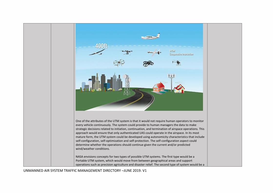
One of the attributes of the UTM system is that it would not require human operators to monitor every vehicle continuously. The system could provide to human managers the data to make strategic decisions related to initiation, continuation, and termination of airspace operations. This approach would ensure that only authenticated UAS could operate in the airspace. In its most mature form, the UTM system could be developed using autonomicity characteristics that include self-configuration, self-optimization and self-protection. The self-configuration aspect could determine whether the operations should continue given the current and/or predicted wind/weather conditions. NASA envisions concepts for two types of possible UTM systems. The first type would be a Portable UTM system, which would move from between geographical areas and support operations such as precision agriculture and disaster relief. The second type of system would be a

UNMANNED AIR SYSTEM TRAFFIC MANAGEMENT DIRECTORY –JUNE 2019. V1
Persistent UTM system, which would support low-altitude operations and provide continuous coverage for a geographical area. Either system would require persistent communication, navigation, and surveillance (CNS) coverage to track, ensure, and monitor conformance.
NATS DroneAssist Drone Assist, powered by Altitude Angel and available for free on Android and iOS presents drone pilots with an interactive map of areas of airspace used by commercial air traffic. It also contains a ‘Fly Now’ feature that shares the user’s drone flight location with other app users, and the wider drone community, helping to reduce the risk of a drone related incident in the UK’s airspace. The app also includes the location of ground based hazards that might pose a safety or privacy risk, such as power lines, schools or sports venues.
http://www.nats.aero/news/new-app-to-help-drone-pilots-comply-with-uk-rules/
NLR and everis UTM/ATM system development
At the 2019 World ATM Congress The Netherlands Aerospace Centre (NLR) and everis Aerospace, Defense and Security (everis ADS) signed a cooperation agreement to work together on UTM and ATM concepts. According to a company press release: “This collaboration brings together the experience of NLR, a worldwide leading research and innovation institution in ATM, and the expertise of everis ADS, a company specialized in the development of differential solutions based on the integration of innovative technologies. The deal has been reached so that both organizations can work together on new CNS/ATM (Communications, Navigation and Surveillance, and Air Traffic Management) solutions and services, as well as UTM/U-space solutions, areas in which they have a broad understanding.”
https://www.nlr.org/

UNMANNED AIR SYSTEM TRAFFIC MANAGEMENT DIRECTORY –JUNE 2019. V1
NTT DATA airpalette® NTT DATA Corporation launched the drone traffic management software package “airpalette® UTM” to drone-utilizing businesses and local governments in November 2017. The software package enables simultaneous remote control of multiple drones of different models, thus improving the efficiency of infrastructure inspections and disaster responses that would be dangerous and time consuming for human workers to conduct. The airpalette UTM software package consists of two functions: an “FOS” (Flight Operation System) drone operation control function that enables simultaneous remote operations*1 of multiple drones and a “UTM core” (UAS Traffic Management core) unmanned aircraft traffic management function that centralizes the management of position information of multiple drones operating in a certain airspace. The FOS function enables simultaneous remote operation of multiple drones and helps improve the efficiency of activities conducted by workers involved in infrastructure inspections, disaster responses, etc. The UTM core function centralizes the management of position information and the like of multiple drones operating in a certain airspace. By detecting possibilities of midair collisions and entry into a no-fly zone and by providing such information to drone operators, this function realizes enhanced airspace safety.
http://www.nttdata.com/global/en/news-center/others/2017/111500.html
Numerica Collision avoidance system
The company provides dynamic air space management for UAS integration within the national air space. • Robust solution considers uncertainty in aircraft type, performance, and flight path, as well as uncertainty from noisy sensor measurements when determining collision risk. • Modelling dynamics of aircraft flight allows useful risk predictions over long time horizons (60-180 seconds) that provide pilots time to respond while controlling the rate of false alarms. • Solution is agnostic to sensing modality and can be adapted to cooperative sensors (ADS-B), ground-based or air-borne radar, or optical sensors, as demanded by platform and mission
http://www.numerica.us/defense/unmanned-systems/#collision-avoidance-system
UNMANNED AIR SYSTEM TRAFFIC MANAGEMENT DIRECTORY –JUNE 2019. V1
OneSky AlphaOne, OneSky Connect
OneSky provides flight-awareness solutions for drone pilots and drone operators. AlphaOne is a Micro Control Tower for professional drone operators, allowing air traffic detection within a range of 10 km. The company has scaled down and adapted the concept of control tower to the use case of drones, by creating unmanned micro control towers to detect the position of aircraft. The data gathered from a network of micro control towers will be made available in real-time on a platform. In this way, the information on surrounding air traffic could be used by any air traffic connected to it, to automatically and efficiently avoid collisions. Collision avoidance is only the first application of this new technology. Statistics on the use of sky, optimization of flights, search & rescue operations and much more could be achieved thanks to the data collected by this network. OneSky Connect is an internet platform to display the position of surrounding air traffic. By connecting to the online platform drone operators will have the following data automatically injected in their drone system: • Air traffic equipped with ADS-B, Transponder and FLARM • Geofencing depending on your mission • Automatic collision avoidance The data is available via an internet connection (ethernet, wi-fi, or mobile)
http://www.oneskyconnect.com/
ONERA Low Level RPAS Traffic Management (LLRTM)
ONERA has designed the LLRTM to address two safety issues: the risk of RPAS versus manned aircraft conflict. LLRTM system provides a set of capabilities: all traffic monitoring and RPAS traffic management in uncontrolled airspace; all traffic monitoring and coordination with ATC in controlled airspace; ground-based system to manage RPAS operations below 500 ft (class E/G), using a combination of sensors: airborne collaborative alerting system, ground sensor to detect non-cooperative traffic, role of human actors.
https://www.eurocontrol.int/sites/default/files/events/presentation/art-workshop-rpas-and-their-impact-on-atm-3-dubot.pdf
PANSA PansaUTM Poland’s air navigation service provider PANSA is implementing the Unmanned Traffic Management System – PansaUTM. PansaUTM is a digitalized and automated concept of UAV traffic management, which consists of PANSA operational solutions and a system part provided by the technological partner HAWK-E and Droneradar, integrated with flight planning and management and e-registration module dFPL (drone Flight Plan) and the widely used Droneradar application. The PansaUTM system was introduced to the public during the 2019 World ATM Congress in Madrid and the 2019 JARUS Plenary Session in Katowice. It is being implemented at the PANSA headquarters, 15 civil towers, five FIS sectors and 17 military towers in Poland. Its implementation in Warsaw FIR is aimed to accommodate of all UAV operations demands for both in Visual and Beyond Visual Line of Sight.
www.pansa.pl https://wac2019pansa.pl/business/
UNMANNED AIR SYSTEM TRAFFIC MANAGEMENT DIRECTORY –JUNE 2019. V1
Precision Hawk LATAS Ground, LATAS Air and location tracking
LATAS Ground: the company’s 3D ground obstacle database gives the drone operator visibility of trees, buildings, power lines and other hazards that could cause damage to the aircraft. LATAS Air: LATAS displays live, FAA radar feeds to US drone operators. With real-time aircraft traffic in 128 countries, operators can receive notifications when manned aircraft trajectories create a potential hazard for a drone's area of operation. Easy to understand no fly zones, airspace classes, geofences and temporary restrictions are included. The system also provides flight data to the insurance provider to receive preferred rates based on flight history. LATAS is being flown under the FAA Pathfinder Program and the NASA UTM Program. In addition, LATAS is partnered with Harris and satellite imagery provider DigitalGlobe. Live Location Tracking: Telemetry data is transferred twice per second to track a drone during flight. For flights in areas without cellular coverage, LATAS will store and upload missing flight information upon reconnection. The mounting kit allows the device to be mounted to any drone and track real-time positioning, heading, speed and altitude for a safer flight.
http://www.flylatas.com
Skygrid UAM UTM platform
A company and technology under development by Boeing and SparkCognition that will enable the future of urban aerial mobility. Based in Austin, Texas, SkyGrid will develop a software platform to ensure the safe, secure integration of autonomous cargo and passenger air vehicles in the global airspace. Using blockchain technology, AI-enabled dynamic traffic routing, data analytics and cybersecurity features, SkyGrid's platform will go beyond unmanned aircraft systems (UAS) traffic management (UTM). The platform will enable SkyGrid customers to safely perform a broad range of missions and services using UAS, including package delivery, industrial inspections and emergency assistance.
https://www.prnewswire.com/news-releases/boeing-and-sparkcognition-to-launch-joint-venture-skygrid-300753426.html
Skyward Airspace Map and drone operating software
With Skyward's technology, Verizon will streamline the management of drone operations through one platform designed to handle end-to-end activities such as mission planning, complex workflow, FAA compliance support, supplying information about restricted airspace and pilot credentialing, drone registration and provisioning rate plans for drones on Verizon's network. All of this is designed to help developers and businesses create and manage a wide-range of services backed by Verizon's mobile private network, secure cloud interconnect and data analytics capabilities.
https://skyward.io/commercial-drone-software/

UNMANNED AIR SYSTEM TRAFFIC MANAGEMENT DIRECTORY –JUNE 2019. V1
Terra Drone UTM system based on mobile telecommunications networks
Terra Drone is a Japanese industrial drone service provider which is setting up UTM systems based on partnerships with telecom providers. In November 2017 Terra Drone announced it was collaborating with LG U+, a South Korean cellular carrier owned by LG Corporation to provide its “U+ Smart Drone UTM System,” which enables a drone to fly safely for disaster monitoring and logistic transport in BVLOS (beyond visual line of sight) and at night. In December 2017 Terra Drone and KDDI Corporation, a Japanese telecommunications operator have succeeded in a fully autonomous flight experiment of “Smart Drone” using a 3D map and drone port, say the organisations. As a result of the experiment, the world’s first long-distance drone flight of about 6.3 km via the drone port which enables a drone to recharge automatically, successfully returned to the landing site after spraying terraced ponds with pesticide. Terra Drone and KDDI aim to establish an infrastructure that enables secure long-distance autonomous flight utilizing Smart Drone and the mobile communication network. This demonstration is an experiment for safe flight altitude setting on the 3D map and automatic charging by drone port, which verified that the long-distance autonomous drone flight is technically possible.
KDDI and Terra Drone have worked together to develop the “4G LTE control system”, which allows operators to control drones via LTE network. This system also helps drone businesses by managing the information on each drone and operator and providing detailed flight logs of each flight. Flight
https://www.terra-drone.net/

UNMANNED AIR SYSTEM TRAFFIC MANAGEMENT DIRECTORY –JUNE 2019. V1
plans will be created via the system by setting altitude of each optional flight point and flight forms between the points on an online map. During the flight, control instructions based on the flight plan are transmitted to a drone through LTE network. Automatic flights following set flight plans are not the only things this system can do. This system allows operators to watch real-time flights images through “Live View Area” in order to control drones remotely by sight. This system also can grasp electromagnetic wave conditions and go off alarm when a drone is in a low electric field. This allows the drone to respond to a sudden changes of a flight route and a forced return in case of emergency. Furthermore, through this system operators can monitor and control images taken by the drone and communication of the survey data KDDI has also partnered with Terra Drone and Zenrin, a Japanese map publisher to jointly developed the “Smart Drones Platform,” which realizes safe drone flight using the mobile communication network and 3D map for autonomous drone flight and set a secure flight altitude automatically. 3D map enables a drone to cognize altitude differences of topography such as mountains and hills, buildings, and Terra Drone and KDDI accomplished automatic discrimination of difference in elevation of more than 100m in this experiment. The drone port developed by Prodrone Co., Ltd., an industrial drone platform manufacturer, has the automatic landing function based on image recognition which enables long-distance flight via Drone Port. In the future, when Smart Long-distance autonomous flight infrastructure of smart drone using this mobile communication network has established, this platform will be active in the fields of not only agriculture but also surveying topography and equipment, security of facilities, disaster monitoring and delivery to remote areas.
Thales ECOsystem/ Soarizon
Thales is merging together its capabilities to enter the commercial drone market, by launching an innovative software solution that combines end-to-end drone operations through a single, trusted platform. Meanwhile, Thales and Unifly have Joined forces to satisfy the growing need for UTM. The companies will leverage Thales’s expertise in air traffic management, system integration and cyber security as well as Unifly’s dedicated focus on drone management to provide the premier UTM application. The solution will incorporate Unifly’s Validation Engine, a sophisticated software application that conducts real-time validation of drone flight plans, into Thales ECOsystem, a decision support platform for improved aviation operations.
https://www.thalesgroup.com/en/ecosystem
UNMANNED AIR SYSTEM TRAFFIC MANAGEMENT DIRECTORY –JUNE 2019. V1
TBS FLARM TBS FLARM is the “first broadly used global traffic information, collision avoidance, and remote identification system for UAV, fully interoperable with 35k+ manned aircraft globally. Different to ADS-B or any other solution, FLARM is truly cooperative, widely used in light aircraft, and dominates the lower airspace outside major airports….” says the company. With TBS's FLARM software update, tens of thousands of UAVs will in the next weeks join the already large FLARM ecosystem.
http://www.team-blacksheep.com/products/prod:flarm_aviation
UASSidekick Flight Service system
UASidekick is a LAANC-connected app that is integrated with the FAA Flight Service system UASidekick is developed by aviation pilots for the UAS pilot. As a key component the UAS Operational Area (UOA) submission facilitated by this app is the avenue for UAV pilots, both hobbyist and 107 commercial operators, to provide information about their UAV flights to everyone who operates in National Airspace System. This service provided by Flight Services performs a similar situational awareness enhancement function as Notices To Airman (NOTAM).
https://www.uasidekick.com/
uAvionix ADS-B transcievers/receives, Mode-S transponders, navigation systems
uAvionix develops the world’s smallest, lightest and most affordable ADS-B transceivers, transponders, and GPS receivers. Based in Palo Alto, uAvionix has gathered a cross-disciplinary team of experts in embedded RF engineering, sUAS operations and compliance, hardware, software, and cloud services.
https://www.uavionix.com/news/uavionix-joins-forces-with-foreflight-to-bring-low-cost-ads-b-to-general-aviation/
Unifly Launchpad, Pro app, Sentry and Connect
The Unifly platform consists of four products, each geared to a different set of customers. The free app Launchpad enables users to check if they are allowed to fly at a given location. The Pro app helps professional users to manage their drones, flights and operations. The Sentry application helps ANSP (air navigation service providers) and government officials to keep track of the drones in their airspace, and to manage no-fly zones. The Connect application makes it possible for manufacturers to explore and integrate the API. At the World ATM Congress 2019 Unifly launched an e-Identification and tracking solution for drones called BLIP. The device works in a completely independent fashion, with its own power source and sensors for position, altitude, temperature, pressure, speed and direction. As soon as the pilot attaches it to a drone, it is ready for use.
https://www.unifly.aero/products
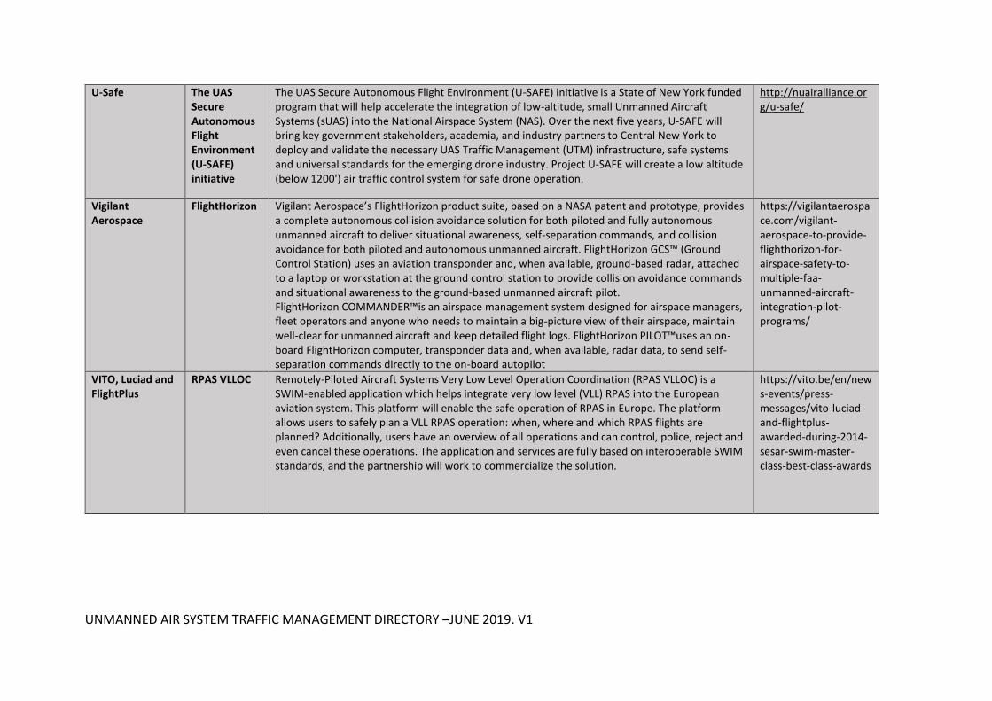
UNMANNED AIR SYSTEM TRAFFIC MANAGEMENT DIRECTORY –JUNE 2019. V1
U-Safe The UAS Secure Autonomous Flight Environment (U-SAFE) initiative
The UAS Secure Autonomous Flight Environment (U-SAFE) initiative is a State of New York funded program that will help accelerate the integration of low-altitude, small Unmanned Aircraft Systems (sUAS) into the National Airspace System (NAS). Over the next five years, U-SAFE will bring key government stakeholders, academia, and industry partners to Central New York to deploy and validate the necessary UAS Traffic Management (UTM) infrastructure, safe systems and universal standards for the emerging drone industry. Project U-SAFE will create a low altitude (below 1200') air traffic control system for safe drone operation.
http://nuairalliance.org/u-safe/
Vigilant Aerospace
FlightHorizon Vigilant Aerospace’s FlightHorizon product suite, based on a NASA patent and prototype, provides a complete autonomous collision avoidance solution for both piloted and fully autonomous unmanned aircraft to deliver situational awareness, self-separation commands, and collision avoidance for both piloted and autonomous unmanned aircraft. FlightHorizon GCS™ (Ground Control Station) uses an aviation transponder and, when available, ground-based radar, attached to a laptop or workstation at the ground control station to provide collision avoidance commands and situational awareness to the ground-based unmanned aircraft pilot. FlightHorizon COMMANDER™is an airspace management system designed for airspace managers, fleet operators and anyone who needs to maintain a big-picture view of their airspace, maintain well-clear for unmanned aircraft and keep detailed flight logs. FlightHorizon PILOT™uses an on-board FlightHorizon computer, transponder data and, when available, radar data, to send self-separation commands directly to the on-board autopilot
https://vigilantaerospace.com/vigilant-aerospace-to-provide-flighthorizon-for-airspace-safety-to-multiple-faa-unmanned-aircraft-integration-pilot-programs/
VITO, Luciad and FlightPlus
RPAS VLLOC
Remotely-Piloted Aircraft Systems Very Low Level Operation Coordination (RPAS VLLOC) is a SWIM-enabled application which helps integrate very low level (VLL) RPAS into the European aviation system. This platform will enable the safe operation of RPAS in Europe. The platform allows users to safely plan a VLL RPAS operation: when, where and which RPAS flights are planned? Additionally, users have an overview of all operations and can control, police, reject and even cancel these operations. The application and services are fully based on interoperable SWIM standards, and the partnership will work to commercialize the solution.
https://vito.be/en/news-events/press-messages/vito-luciad-and-flightplus-awarded-during-2014-sesar-swim-master-class-best-class-awards

UNMANNED AIR SYSTEM TRAFFIC MANAGEMENT DIRECTORY –JUNE 2019. V1
Vorpal VigilAir VigilAir, Vorpal’s flagship product, is an RF-based drone situational awareness solution. VigilAir detects, geolocates and tracks drones with extreme sensitivity and accuracy to provide high clarity drone situational awareness. VigilAir is comprised of several RF sensors (4 as a minimum) deployed in the Area of Interest, and a clouded server acting as a command and control centre. Distances of few kilometers between sensors and unlimited system scalability provide wide and efficient coverage, in both urban and rural areas. The solution enables the accurate detection, geolocation and tracking of both drone and operator, providing users with actionable intelligence and zero false alarms. VigilAir is a fully passive system (RF reception only) and can be operated from fixed installations or deployed ad-hoc in its ruggedized version. Founded in 2009, Vorpal Ltd. has accumulated experience in realizing advanced signal processing and analysis solutions, with in-house proprietary knowledge and algorithms. Aided by experience in military-grade Signal Intelligence (SIGINT), Vorpal designs and deploys advanced, highly accurate geolocation solutions. Headquartered in Tel-Aviv, Israel, Vorpal operates globally in the Aviation, Military and HLS, Critical Infrastructures and UAS Traffic Management (UTM) markets. Country: Israel Website:
/www.vorpal-corp.com/
Wright Technologies
UTM blockchain system
Adelaide-based Wright Technologies aims to conduct field trials of its Blockchain-based drone identification and tracking system before the end of the year.
https://www.wrighttech.co/